
Fort Myers Beach City Zoning Code
ARTICLE III
- ZONING DISTRICT REGULATIONS
Sec. 34-611.- Zoning districts established.
Land and water within Town of Fort Myers Beach is divided into zoning districts as set forth in this article in order to classify, regulate and restrict the location of buildings erected or structurally altered for specific uses, to regulate the use of land, to regulate and limit the height and bulk of buildings hereafter erected or structurally altered, to regulate and determine the area of yards and other open space about buildings, to regulate the intensity of land use, and to promote the orderly growth of the town, in compliance with the goals, objectives and policies set forth in the Fort Myers Beach Comprehensive Plan.
Sec. 34-612. - Types and general purpose of districts.
There are three basic types of zoning districts provided for in this article: conventional zoning districts, redevelopment districts, and planned development (PD) districts. The general purpose of each type of zoning district is to implement the goals, objectives and policies of the Fort Myers Beach Comprehensive Plan, as well as to provide protection to the public health, safety and welfare through the regulation of land use.
(1)
Conventional districts. Conventional zoning districts are districts within which land use is controlled primarily through the regulation of the height and bulk of buildings and structures, the minimum area and dimensions of lots and setback requirements. Use regulations for the conventional districts are provided in Table 34-2 and other regulations are provided in Table 34-3 and division 4 of this article.
(2)
Redevelopment districts. Redevelopment districts differ from conventional zoning districts in that they implement specific redevelopment concepts established in the Fort Myers Beach Comprehensive Plan. For each of the five redevelopment districts, use regulations are provided in Table 34-2 and the more specific property development regulations are provided in division 5 of this article.
(3)
PD, planned development districts. In certain circumstances, landowners may choose or be required to rezone their land to a planned development (PD) district. The purpose of the two planned development districts is to provide a degree of flexibility for a landowner to propose the development of land in a manner that differs from the specific provisions of this code. A planned development, once approved through the rezoning process, can only be developed in accordance with the master concept plan and special conditions that are contained in the resolution approving the planned development. Use and property development regulations for planned development districts are provided in division 6 of this article.
Sec. 34-613. - Designation of district boundaries.
(a) Major revisions to this chapter were approved by the Town of Fort Myers Beach in 2003, including the establishment of new zoning districts and the assignment of all land in the town to one of these zoning districts.
(1)
The new zoning district assignments were shown on the interim zoning map contained in Exhibit A of Ordinance No. 03-03. The new zoning district assignments took effect on March 3, 2003, the date that Ordinance No. 03-03 was adopted. Previous approvals of variances, special exceptions, special permits, and other zoning actions that did not change zoning district boundaries were not shown on the interim zoning map due to its scale but were not affected by the adoption of the interim zoning map. These approvals were still indicated on the current zoning maps that were being maintained for the town by Lee County.
(2)
On May 17, 2004, the town council approved Resolution No. 04-16 adopting a new official zoning map of the town as described in § 34-614 of this chapter that reflected these new zoning districts and other zoning approvals that remained in effect, such as variances, special exceptions, and special permits.
(3)
Also on May 17, 2004, the town council approved Resolution No. 04-17 adopting a historic zoning map of the town as described in § 34-616 of this chapter.
(b)
The boundaries of each zoning district as shown on the interim zoning map, the official zoning map as described in § 34-614 of this chapter, the current zoning map as described in § 34-615 of this chapter, and the historic zoning map as described in § 34-616 of this chapter shall be as much a part of this chapter as if fully described in this chapter.
(c)
There is no right to rely solely on the interim, official, current, or historic zoning maps to vest development or private rights. In addition to the zoning districts shown on these maps, development rights may be limited by other factors such as the Fort Myers Beach Comprehensive Plan; conditions on zoning resolutions for planned development districts, special exceptions, special permits, or variances; and the precise terms of prior administrative approvals.
Sec. 34-614. - Official zoning map.
(a)
Generally. The official zoning map of the town consists of computer-generated maps which are adopted by the town council by resolution. The first official zoning map was adopted by the town council on May 17, 2004 through Resolution No. 04-16.
(1)
The first official zoning map reflected the new zoning district boundaries adopted in 2003 through the interim zoning map (see § 34-613 of this chapter) plus two additional zoning district boundary changes adopted by separate resolutions through April 1, 2004.
(2)
The first official zoning map also reflected approvals of variances, special exceptions, special permits, and similar approvals from the previous zoning map, which had been approved by Lee County Resolution No. 94-03-27 on March 16, 1994 and subsequently amended by incremental decisions by officials of Lee County and the Town of Fort Myers Beach through April 1, 2004.
(3)
When adopting official zoning maps, the town council may delete from the previous maps references to past approvals that are believed to have expired or which have become obsolete due to changed regulations or conditions. However, the deletion of such approvals from the official zoning map does not affect any rights that landowners may have under explicit terms of this code (see § 34-616 of this chapter).
(b)
District boundaries. The boundaries of each district shall be shown on the official zoning map, and the district symbols shall be used to designate each district.
(c)
Other boundaries. The perimeter of legal descriptions affected by variances, special exceptions, planned developments, and similar approvals shall be noted with a symbol or key number referencing additional zoning information, which may include the nature of the action, the hearing date, and any special conditions that were imposed.
(d)
Mapping conventions. For mapping purposes only, a boundary line may be drawn to the centerline of a street or body of water.
(e)
Errors. If it is determined that an error exists in the official zoning map, the town council may adopt a correction to the error by resolution at an advertised public hearing.
(f)
Public availability. The official zoning map shall be part of the public records of the town.
(g)
Records management. The director shall retain a copy of the official zoning maps adopted under § 34-614 of this chapter consistent with statutory record-keeping requirements.
Sec. 34-615. - Current zoning map.
(a)
Description. The current zoning map of the town consists of computer-generated maps depicting the same information on the official zoning map as it has been subsequently modified by rezonings, zoning amendments, special exceptions, variances, administrative decisions, mapping corrections, etc., that have been entered into the computer data base since the most recent adoption of the official zoning maps. For purposes of this section, the term "mapping corrections" means corrections applied to the current zoning map to provide an accurate reflection of the legal description affected by a duly adopted zoning resolution.
(b)
Printed copies. Printed copies of the current zoning map should contain the following statement: "This current zoning map represents the official zoning map plus all rezonings, special exceptions, variances, and administrative amendments approved as of (date)."
(c)
Public availability. The current zoning map shall be part of the public records of the town and may be inspected at Town Hall or purchased from the Lee County Property Appraiser in downtown Fort Myers.
(d)
Changes.
(1)
No changes or amendments to the official or current zoning maps shall be made except in compliance and conformity with all the procedures of this chapter, including the correction of errors resulting from clerical or drafting mistakes. Changes in district boundaries or other subject matter portrayed on the official zoning map shall be made promptly on copies of the current zoning map after official adoption of the amendment. All amendments and changes approved by the town council or other authorized bodies shall become effective at the end of the appeal period specified in article II of this chapter. The filing of an appeal stays the effectiveness of the change. If no appeal is filed the director shall forthwith authorize the approved changes to be made on copies of the current zoning map.
(2)
Changes to the current zoning map authorized by the town will be entered into the computer data base and then reflected on the current zoning map in the following manner:
a.
The property affected by a zoning district change, special exception, variance, or other approval shall be noted with a symbol or key number referencing additional zoning information.
b.
The additional zoning information may include the resolution number, any change of zoning district, the nature of any other action, the hearing date, and any special conditions that were imposed.
Sec. 34-616. - Historic zoning map.
A historic zoning map was approved by the town council through Resolution No. 04-17 on May 17, 2004. This historic zoning map reflects the zoning districts that applied to all properties immediately prior to the adoption of Ordinance No. 03-03 and all variances, special exceptions, special permits, and similar approvals that had been approved by Lee County or the Town of Fort Myers Beach prior to the adoption of Ordinance No. 03-03. This map provides a historic record of past zoning actions and prior zoning status that may affect the nonconforming status of certain properties within the town. This map also includes key numbers that are explained by detailed notes that provide a history of prior rezonings, variances, special exceptions, special permits, and similar approvals that had been approved before Ordinance No. 03-03 was adopted on March 3, 2003.
Sec. 34-617. - Rules for interpretation of district boundaries.
(a)
When uncertainty exists as to the boundaries of districts of the official or current zoning map, the following rules shall apply:
(1)
Boundaries following centerlines. Boundaries indicated as approximately following the centerlines of streets or bodies of water shall be construed to follow such centerlines.
(2)
Boundaries following lot or tract lines. Boundaries indicated as approximately following lot lines or tract lines shall be construed as following such lines.
(3)
Boundaries following shorelines. Boundaries indicated as approximately following the centerlines of waterbodies shall be construed to follow such centerlines. In the event of change in the shoreline due to natural causes, land created through accretion shall automatically be classified as EC until and unless a zoning district change is applied for and approved in accordance with procedures set forth in this chapter.
(4)
Vacated lands. here a public road, street, alley, or other form of right-of-way is officially vacated, the regulations applicable to the property to which the vacated lands attach shall also apply to such vacated lands.
(5)
Accreted lands. Where land accretes through natural or artificial processes, except for incidental fill behind a seawall authorized by ch. 26 of this code, the accreted land shall be classified as EC unless reclassified by public hearing in accordance with this chapter.
(6)
Uncertainties. Where physical or cultural features existing on the ground are at variance with those shown on the official or current zoning map, or in case any other uncertainty exists as to the proper location of district boundaries, the director shall interpret the intent of the official or current zoning map as to the proper location of the district boundaries.
(b)
When a parcel is split by two or more zoning districts, the property development regulations for the largest proportional district prevail. However, each portion of the parcel is limited to only the permitted uses allowed on that portion, plus their allowable accessory uses. Accessory uses including parking lots may not be placed on portions of parcels that do not contain the principal use to which they are incidental and subordinate. Docks, however, are governed by the regulations for the upland property to which they are attached. See also § 34-1174 of this chapter.
Sec. 34-619.- The Fort Myers Beach Comprehensive Plan.
(a)
The Fort Myers Beach Comprehensive Plan is the document adopted by the town council in accordance with F.S. ch. 163 to guide and regulate all land development activities within the town (see § 1-11 of this chapter). All development orders (including rezonings), as defined in F.S. § 163.3164(7) shall be consistent with the goals, objectives, polices and standards in this plan. Where there are apparent conflicts between this plan and any regulations in this code, this plan will prevail.
(b)
The Fort Myers Beach Comprehensive Plan contains a future land use map which divides the town into eight distinct categories:
(1)
Low density;
(2)
Mixed residential;
(3)
Boulevard;
(4)
Pedestrian commercial;
(5)
Marina;
(6)
Recreation;
(7)
Wetlands;
(8)
Tidal water.
The future land use map also contains a platted overlay which is applied in certain locations in addition to one of these eight categories. All development must be consistent with the future land use map, the definitions of the land use categories in the text of the plan, and the remainder of the text of the Fort Myers Beach Comprehensive Plan.
(c)
Some of the zoning districts in this article may describe uses, densities, or intensities that are not permitted in particular future land use map categories. Property may not be rezoned to a district that is inconsistent with the applicable future land use map category or with the remainder of the text of the Fort Myers Beach Comprehensive Plan.
Sec. 34-620. - Allowable uses of land generally.
(a)
This division describes allowable land uses in the Town of Fort Myers Beach, most of which are defined in § 34-2 of this chapter, and then groups these uses with compatible uses having similar impacts. These "use groups and sub-groups" (see Table 34-1) are the basis for defining the allowable uses in the various zoning districts (see Table 34-2). Other regulations for individual zoning districts are contained in divisions 4, 5, and 6 of this article.
(b)
The director is authorized to determine that some land uses that are not specifically described in this division are permitted in a particular zoning district based upon the expected impacts of the most similar uses described in this division and their assignment to the various districts.
(c)
The director may determine that the expected impacts of a land use that is not specifically described in this division cannot safely be assumed to match another use described in this division. In such a case, the director shall require that a property be rezoned into a planned development zoning district (see division 6 of this article) before that land use may be permitted.
(d)
In every case, the following land uses can only be permitted through approval of a suitable planned development zoning district:
(1)
Boat dealers (except as a marina accessory use);
(2)
Building material sales;
(3)
Continuing care facility (see § 34-1414 of this chapter);
(4)
Contractor's shop;
(5)
Contractor's storage yard;
(6)
Hospital;
(7)
Parking garage (see § 34-2015(2)c. of this chapter);
(8)
Storage, open (except as a marina accessory use);
(9)
Vehicle and equipment dealers.
(e)
Planned development zoning districts are also required by the Fort Myers Beach Comprehensive Plan in the following situations:
(1)
For new or expanded commercial activities other than those permitted by the current zoning district for land in the mixed residential category on the future land use map (see Policies 4-B-4 and 4-C-3).
(2)
For new or expanded commercial activities other than those permitted by the current zoning district for land in the boulevard category on the future land use map (see Policies 4-B-5 and 4-C-3 and §§ 34-701—34-930 of this chapter).
(3)
For consideration of extra building height in certain circumstances (see Policy 4-C-4 and § 34-631(b)(5) of this chapter).
(4)
For the transfer of residential and hotel/motel development rights from one parcel to another (see Policy 4-C-8 and § 34-632(6) of this chapter).
(5)
For guest units that exceed the thresholds established in § 34-1803(a) of this chapter.
(6)
For pre-disaster buildback of buildings that exceed the current density or height limits (see Policy 4-E-1 and § 34-3237 of this chapter).
(f)
In no case may a land use that is not permitted by the Fort Myers Beach Comprehensive Plan be approved within the town, even if requested through the planned development process. Examples of prohibited uses are:
(1)
New or expanded cruise ships and similar uses that draw large amounts of vehicular traffic (see Policy 4-B-7).
(2)
New or expanded industrial uses (see Policy 4-B-12.iv.), which includes boatyards, manufacturing, and processing and warehousing.
(3)
Development seaward of the 1978 coastal construction control line (see Policy 5-D-1.v.), except for minor structures as provided in § 34-1575 of this chapter.
(g)
Other uses prohibited within the town are as follows:
(1)
New or expanded drive-through lanes for restaurants (as a result of town Ordinance No. 00-13).
(2)
New or expanded mobile home subdivisions and parks (see §§ 34-1921 and 34-1922).
(3)
New or expanded recreational vehicle subdivisions and parks (see §§ 34-2351 and 34-2352).
Sec. 34-621. - Allowable uses of land described.
(a)
Applicability. No land, body of water, or structure shall be used or permitted to be used and no structure shall hereafter be erected, constructed, moved, altered, or maintained in any conventional or redevelopment zoning district for any purpose other than as provided in Tables 34-1 and 34-2 and in accordance with the property development regulations tables set forth in this article for the zoning district in which the property is located, except as may be specifically provided for in article V of this chapter pertaining to nonconforming uses, or in § 34-620 of this chapter pertaining to uses not specifically listed in Table 34-1.
(1)
All uses of land, water, and structures are subject to the Fort Myers Beach Comprehensive Plan and its future land use map, and therefore may not be permitted in all land use categories.
(2)
All uses of land, water and structures are subject to the specific use and property development regulations set forth for the district in which located, as well as all general provisions and all applicable supplemental regulations set forth in this chapter. Except as may be specifically provided for elsewhere in this chapter, deviations from the property development regulations may only be granted in accordance with the procedures established in § 34-932(b) of this chapter for deviations in planned development zoning districts and in § 34-87 of this chapter for variances in conventional and redevelopment zoning districts.
(3)
Allowable uses in planned development zoning districts shall be determined at the time of each rezoning in accordance with § 34-933 of this chapter.
(b)
Use tables. Table 34-1 of this article lists specific uses followed by a symbol indicating whether the use is permitted by right (P), special exception (SE), administrative approval (AA), existing only (EO), or temporary use permit (TP). In all instances, unless specifically noted to the contrary, the symbols used in the use regulations tables shall have the following meaning:
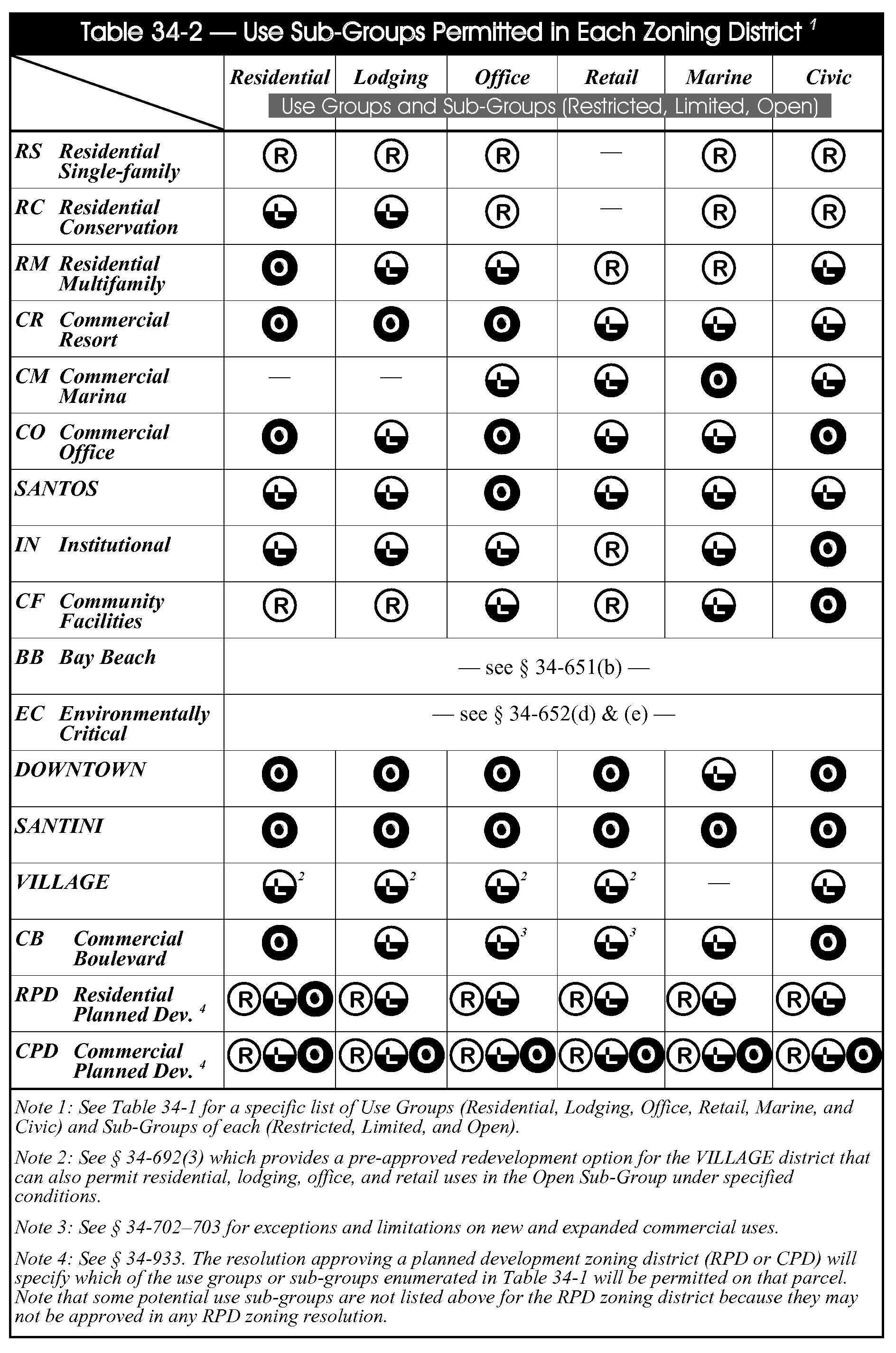
Sec. 34-622. - Uses groups and sub-groups.
(a)
Allowable land uses are assigned by Table 34-1 to one of six use groups:
(1)
Residential;
(2)
Lodging;
(3)
Office;
(4)
Retail;
(5)
Marine;
(6)
Civic.
(b)
Within each use group, Table 34-1 also assigns each allowable land use to one of three sub-groups:
(1)
R - Restricted;
(2)
L - Limited (which includes all R uses);
(3)
O - Open (which includes all R and L uses);
(c)
Within each use sub-group, uses are divided into two categories:
(1)
Principal uses are the primary purposes for which land is being used. Allowable principal uses are listed first.
(2)
Accessory uses are allowable only in conjunction with an allowable principal use, and only when the accessory use is incidental and subordinate to the principal use.
(d)
Table 34-2 assigns these use sub-groups to the zoning districts provided by this code. However, uses in planned development zoning districts are further restricted in accordance with § 34-933 of this chapter.
(e)
To determine the allowable land uses on a particular lot:
(1)
First, consult the zoning map to determine the lot's current zoning district (see division 1 of this article).
(2)
Consult Table 34-2 to determine which use sub-groups are allowable in that zoning district.
(3)
Consult Table 34-1 to determine which individual land uses can be placed in each allowable sub-group. Note that the subgroups are cumulative, with all restricted uses incorporated into limited, and all restricted and limited uses incorporated into open.
(4)
See § 34-2 of this chapter for definitions of the individual land uses.
(f)
To determine which zoning districts will permit a specific land use:
(1)
First, consult the definitions in § 34-2 of this chapter to determine the appropriate terminology to describe the specific land use.
(2)
Consult Table 34-1 to determine which use sub-group (or sub-groups) include the desired land use.
(3)
Consult Table 34-2 to determine which zoning districts allow that use sub-group.
(4)
Consult the zoning map to determine which land has been assigned to those zoning districts.
Secs. 34-623—34-630. - Reserved.
(Ord. No. 15-11, § 2, 1-4-2016; Ord. No. 15-12, § 2, 1-19-2016)
(Ord. No. 24-26, § 2(Exh. B), 10-28-2024)
Sec. 34-631.- Building height.
(a)
Methods of measurement. Maximum building heights specified in this code are measured in two ways, as shown in Figure 34-1-a. Both measurement methods apply to each building.
(1)
Measured in stories, the height includes enclosed or unenclosed space at ground level as the first story, provided it is six feet or more in height.
a.
Space within a roofline that is entirely non-habitable shall not be considered to be a separate story, for example overhead space enclosed by a cathedral ceiling, cupola, or similar roof enclosure.
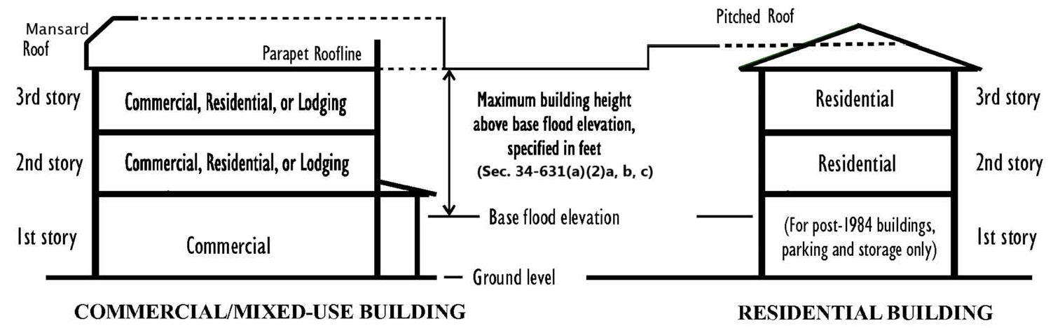
Figure 34-1-a
(2)
Measured in feet, the height of a building shall be the vertical distance measured from one foot above the base flood elevation (BFE), (up to three feet above the BFE if the developer chooses to elevate the first living level more than the required minimum) to the following point on each roof type:
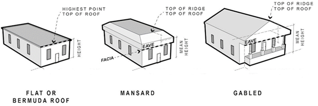
a.
Flat or Bermuda roof, the high point is the highest point on the roof, the roof itself or parapet walls;
b.
Mansard roof, the high point is the mean height between the eave and highest part of the roof;
c.
Gable, hip and gambrel roof, the high point is the mean height between eaves and ridge.
(3)
Specific height regulations are provided for each zoning district.
a.
For conventional zoning districts, see Table 34-3 in division 4 of this chapter.
b.
For redevelopment zoning districts, see individual districts in division 5 of this chapter.
c.
For planned development zoning districts, see division 6 of this chapter.
(b)
Exceptions to height regulations.
(1)
For structures to receive an additional five feet of height above the current building height regulations:
a.
The third story (second story above BFE) must be set back an additional five feet from the required property line setback; and
b.
The third story must not begin more than 15 feet above base flood elevation; and
c.
Roof overhangs may not protrude more than three feet into the additional required setback. Balconies may not encroach the additional setback; and
d.
Vegetation in side yards will be limited to trees and low shrubs, which will not block the view corridor above six feet along beach and bay front properties.
(2)
For structures to receive an additional story. The overall height shall not exceed five feet of height above the current building height regulations and the following requirements shall apply:
a.
The primary structure setbacks for the building shall be increased by five feet on all sides or the first floor; and one or more of the following:
1.
Below flood must be unenclosed other than a maximum 300 square feet enclosure for parking, storage, or upper level access.
i.
Including a signed declaration of restrictive covenant in a form acceptable to the town shall be recorded in the Lee County Public Records prior to issuance of the certificate of occupancy stating the ground floor, below flood, may never be enclosed.
2.
All requirements for the five-foot increase in height shall apply.
4.
The fourth story (third story above BFE) must be set back ten feet from all of the required property line setbacks.
5.
Roof overhangs may not protrude into the additional required setback.
6.
Vegetation in side yards will be limited to trees and low shrubs, which will not block the view corridor above six feet along beach and bay front property.
7.
Limit to the imprevoius surface area to no more than 60 percent of the site by signed declaration of restrictive covenant in a form acceptable to the town shall be recorded in the Lee County Public Records prior to issuance of the certificate of occupancy.
(3)
Mechanical or structural appurtenances such as elevator and stairwell enclosures, air conditioning equipment, and antennas may also extend above the height limit provided these appurtenances:
a.
Do not exceed 250 square feet per type; and
b.
Screening is provided as required by this code (see, for example, § 6-2(f) of this LDC for rooftop mechanical equipment).
(4)
When properties are being rebuilt pursuant to the buildback regulations in § 34-3237 and 34-3238 of this chapter, specific height regulations in those sections may supersede the height regulations established for that property's zoning district.
(5)
In those few cases where individual parcels of land are so surrounded by tall buildings on lots that are contiguous (or directly across a street) that the height regulations in this chapter would be unreasonable, landowners may seek relief through the planned development rezoning process, which requires a public hearing and notification of adjacent property owners. The town will approve, modify, or deny such requests after evaluating the level of unfairness that would result from the specific circumstances and the degree the specific proposal conforms with all aspects of this comprehensive plan, including its land use and design policies, pedestrian orientation, and natural resource criteria. Particular attention would be paid to any permanent view corridors to gulf or bay waters that could be provided in exchange for allowing a building to be taller than the height limits in this chapter. In each case, the town shall balance the public benefits of the standard height limit against other public benefits that would result from the specific proposal.
(6)
For amateur radio antennas/towers, see § 34-1175 of this chapter. For communication towers and commercial antennas, see §§ 34-1441—34-1550 of this chapter).
(c)
Space at ground level.
(1)
Commercial space below the base flood elevation (at ground level) requires dry-floodproofing of the building (see §§ 6-401—6-474 of this LDC).
(2)
Space below the base flood elevation in new residential buildings may be used only for parking and limited storage (see §§ 6-401—6-474 of this LDC).
(Ord. No. 20-19, § 4, 1-19-2021)
Sec. 34-632. - Density.
Residential density cannot exceed the maximum levels established in the Fort Myers Beach Comprehensive Plan. Additional dwelling units are not allowed in the "marina" or "tidal waters" categories on the comprehensive plan's future land use map; live-aboards are permitted in accordance with § 34-1861 of this chapter.
(1)
Formula for computing density. The maximum number of dwelling units allowed on a parcel of land is computed by taking the maximum number of dwelling units per acre the comprehensive plan allows on that parcel and multiplying it by the site's lot area in acres, with the result rounded down to the nearest whole number (except as provided in subsection (3) below).
(2)
Determining lot area. For purposes of this section, a site's lot area includes the gross acreage within the site's private property line, minus wetlands, canals or other waterbodies that extend beyond the site, minus all primarily commercial and other nonresidential land, and minus any land designated "recreation" on the comprehensive plan's future land use map. For any site with wetlands or land designated "recreation," the maximum number of dwelling units shall be increased by one unit per 20 acres of such land.
(3)
Existing subdivisions. In existing subdivisions where lots are smaller than 15,000 square feet each:
a.
Residential densities may be computed based on the actual lot size plus one-half the width of adjoining streets and waterbodies, but in no case may more than 35 feet be counted as the allowance for one-half of an adjoining waterbody.
b.
Computed densities greater than 1.5 DU/acre may be rounded up to two dwelling units where two-family and multifamily dwelling units are permitted.
c.
This method for determining densities cannot be used for:
1.
Three or more lots that are being combined into a development project; or
2.
Any lot that was created after December 31, 1995, as described in § 34-3272 of this chapter.
(4)
Mixed-use buildings. Residential densities may be computed without deleting any acreage for commercial uses that are located on other floors of mixed-use buildings. However, any acreage used primarily for commercial purposes cannot be included in computations of residential density.
(5)
Adjustments to density computations. The following rules shall apply when measuring density for living units or guest units that may not also qualify as dwelling units:
a.
When permitted on a property, certain other land uses such as assisted living facilities and hotels/motels are limited by using equivalency factors between those uses and dwelling units, such as provided in §§ 34-1415 and 34-1803 of this chapter.
b.
For density purposes, each living unit shall count as one dwelling unit except where this code explicitly provides a different measure for measuring density (see, for example, § 34-1178(d) of this chapter regarding accessory apartments in owner-occupied homes).
c.
Lock-off accommodations in multiple-family buildings and timeshare units are living units and are calculated as separate dwelling units for density purposes.
d.
Live-aboards are considered to be living units but not dwelling units as defined by the Fort Myers Beach Comprehensive Plan. Where live-aboards are permitted in accordance with § 34-1861 of this chapter, they are not subject to residential density computations.
(6)
Density transfers. The town council may, at its discretion, permit the transfer of residential and hotel/motel development rights from one parcel to another if the following conditions established by Policy 4-C-8 of the comprehensive plan are met:
a.
The transfer is clearly in the public interest, as determined by the town council;
b.
The parcels affected by the transfer are in close proximity to each other;
c.
The density of residential or hotel/motel units being transferred is based upon allowable density levels in the comprehensive plan category from which the density is being transferred;
d.
The transfer is approved through the planned development rezoning process; and
e.
Binding permanent restrictions are placed on the property from which development rights have been transferred to guarantee the permanence of the transfer.
Sec. 34-633. - Intensity and floor area ratios.
Another measure of building intensity used in this code is the floor area ratio (FAR), which means the gross floor area of all buildings on a site divided by the site's lot area.
(1)
For purposes of this section, gross floor area includes the total floor area of all stories of a building within the surrounding exterior walls (whether the walls are solid or screened), plus all area below an elevated building that is six feet or more in height, plus all stories of covered parking, but not including any area whose roof is screened rather than solid (such as swimming pool enclosures).
(2)
For purposes of this section, a site's lot area includes the gross square footage within the site's private property line, minus wetlands, canals or other waterbodies, and minus any land designated "recreation" on the comprehensive plan's future land use map.
Sec. 34-634. - Intensity and building coverage.
Another measure of building intensity used in this code is building coverage, which means the horizontal area of all principal and accessory buildings on a site divided by the site's lot area.
(1)
For purposes of this section, horizontal area means the area within the surrounding exterior walls (whether the walls are solid or screened). The term "horizontal area" does not include any area occupied by unroofed structures such as driveways, sidewalks, patios, outside stairways, or open swimming pools, and does not include any area whose roof is screened rather than solid such as swimming pool enclosures.
(2)
For purposes of this section, a site's lot area includes the gross square footage within the site's private property line, minus wetlands, canals, or other waterbodies, and minus any land designated "recreation" on the comprehensive plan's future land use map.
Sec. 34-635. - Commercial design standards.
Except where this code specifically provides otherwise, the commercial design standards (see §§ 34-991—34-1010 of this chapter) apply to all commercial and mixed-use buildings or portions thereof that are being newly built, and to "substantial improvements" to such buildings as defined in § 6-405 of this LDC, on properties that are zoned in any of the following zoning districts:
(1)
Santos (§ 34-648);
(2)
Downtown (§§ 34-671—34-680);
(3)
Santini (§§ 34-681—34-690);
(4)
Village (§§ 34-691—34-700);
(5)
CB (§§ 34-701—34-710); and
(6)
CPD (commercial planned development) (§§ 34-951—34-960).
Sec. 34-636. - Parcelization or subdivision of existing buildings.
(a)
Two-family building. All of the following requirements must be satisfied before the required limited review development order can be issued for further parcelization or subdivision of land in the RC zoning district into separate lots and/or separating two lawfully existing dwelling units into individual parcels:
(1)
The building cannot exceed the density limits of the Fort Myers Beach Comprehensive Plan as they would apply to vacant land and the lots resulting from the subdivision must each conform to the dimensional regulations for lot size in the RC zoning district (see Table 34-3).
(2)
Existing buildings do not need to be brought into compliance with floodplain requirements for new development, as provided in article IV of ch. 6 of this code.
(3)
The entire building must meet the coastal construction requirements that apply to new development, as provided in article III of ch. 6 of this LDC and in state regulations. Due to these requirements, habitable major structures and most minor structures must be located landward of the 1978 coastal construction control line (see § 6-366 of this LDC).
(4)
The individual dwelling units must be separated by walls with at least one-hour fire resistance rating as defined by the Florida Building Code.
(5)
The development must meet all other requirements of this code, including Table 34-2.
(b)
Multiple-family building. All of the following requirements must be satisfied before the required limited review development order can be issued for further parcelization or subdivision of lawfully existing dwelling units:
(1)
The number of dwelling units in the existing building may exceed the density limits of the Fort Myers Beach Comprehensive Plan as they would apply to vacant land, but may not exceed the number of lawfully permitted units. The burden to demonstrate the lawful nature of the units is on the applicant. If the number of dwelling units exceeds the density limitations of the Fort Myers Beach Comprehensive Plan as they would apply to vacant land, the interior square footage of the building, as defined in § 34-3238(2)d.1. of this chapter, may not be increased, but may be exchanged on a square-foot for square-foot basis to provide larger but fewer dwelling units within the same interior area.
(2)
Existing buildings do not need to be brought into compliance with floodplain requirements for new development as provided in article IV of ch. 6 of this code. Owners of an existing building that cannot comply with these requirements may seek to replace the building by obtaining approval for pre-disaster buildback in accordance with § 34-3237 of this chapter.
(3)
The entire building must meet the coastal construction requirements that apply to new development, as provided in article III of ch. 6 of this LDC and in state regulations. Due to these requirements, habitable major structures and most minor structures must be located landward of the 1978 coastal construction control line (see § 6-366 of this LDC).
(4)
The individual dwelling units must be separated by walls with at least one-hour fire resistance rating as defined by the Florida Building Code.
(5)
The development must meet all other requirements of this code, including Table 34-2.
(c)
Hotels/motels. The special parcelization requirements in this section that apply to two-family and multiple-family buildings do not apply to hotels/motels that are being parcelized.
Note— Ord. No. 07-04, which amended § 34-636, stated the following: SECTION 3. PARCELIZATION. Anything in Chapter 34 of the Land Development Code notwithstanding, a change in the nature or form of the ownership of any property or properties, within any zoning or land use category, shall not in and of itself constitute parcelization of such property or properties or development thereof necessitating the approval thereof pursuant to the provisions of the Land Development Code. The provisions hereof shall supersede all provisions of Charter 34 of the Land Development Code inconsistent herewith.
Sec. 34-637. - Minimum lot sizes.
(a)
All lot area, width, and depth dimensions in this code are mandatory minimums for newly created lots.
(1)
Minimum lot areas, width, and depths are specified for various zoning districts.
a.
For all conventional zoning districts, see Table 34-3.
b.
For redevelopment zoning districts, as described for the individual districts in division 5 of this article.
c.
For PD districts, see §§ 34-943 and 34-953 of this chapter.
(2)
Definitions and methods of measuring lot widths and depths are provided in § 34-2 of this LDC.
(b)
Where two or more dwelling units or guest units are proposed for a single lot or combination of lots, the lot(s) must also be large enough to comply with the density limitations of the Fort Myers Beach Comprehensive Plan, as computed in accordance with § 34-632 of this chapter.
(c)
Division 4 of article V of this chapter defines nonconforming lots, which may be smaller than the minimum lot areas, widths, and/or depths specified in this code.
(1)
Certain nonconforming residential lots are subject to the smaller minimum lot areas, widths and depths that are found in § 34-3274 of this chapter.
(2)
Certain nonconforming commercial lots are subject to the smaller minimum lot areas, widths and depths that are found in § 34-3277 of this chapter.
(d)
Essential services and essential service equipment shall not be required to meet the minimum required lot dimensions for the district wherein located (see § 34-1617 of this chapter).
Sec. 34-638. - Minimum setbacks.
(a)
Generally. Most zoning districts require minimum setbacks between all buildings and structures and the street, the side lot line, the rear lot line, and any waterbody.
(1)
Setbacks are minimum horizontal distances between a property line and the nearest point of all structures that ensure a minimum area without buildings. Detailed definitions are provided under "setback" in § 34-2 of this LDC.
a.
Where an unusual lot configuration or orientation makes it unclear which property lines are street, side, or rear lot lines, the director will establish street, side, and rear lot lines for setback purposes after taking into account existing buildings on the same block as well as the intent of this code. Where access is provided by a shared driveway rather than a street, the director may determine that no street setback applies to that lot.
b.
Once established through this process, the same setbacks will be applied by the director to other lots on that block.
(2)
There are two types of side setbacks:
a.
Side setbacks - waterfront lots. Larger side setbacks are required for waterfront lots, defined as lots that immediately adjoin a tidally influenced body of water, whether artificial or natural (see definitions in § 34-2 of this LDC).
b.
Side setbacks - non-waterfront lots. Smaller side setbacks are required for all other lots.
(3)
The distinction between street setback lines and build-to lines is explained in § 34-662 of this chapter.
(4)
Corner lot street setbacks. Corner lots, as defined in section 34-2, shall have a front street setback, a side street setback, a standard side setback and a standard rear setback, as defined in Table 34-3, Dimensional Regulations in Conventional Zoning Districts.
a.
Front street setback. The front street setback will be the typical required street setback as defined in Table 34-3. Any corner lot on Estero Boulevard, must treat the Estero Boulevard frontage as the front street setback. Any corner lot not on Estero Boulevard may choose the front street which best allows development of the property and meets all other Code requirements. The rear setback shall be opposite of the front street setback.
b.
Side street setback. The side street setback width will vary depending on the width of the lot. Lot width is measured from the side street property line to the side property line (opposite from the side street property line). See subsection 34-638(d)(6).
(5)
Certain exceptions to minimum setbacks are provided in subsection (d) below.
(b)
Where to find minimum setback dimensions. Minimum setback dimensions are specified as follows:
(1)
For principal buildings:
a.
For all conventional zoning districts, see Table 34-3.
b.
For redevelopment zoning districts, as described for the individual districts in division 5 of this article.
c.
For RPD districts, see § 34-943 of this chapter.
d.
For CPD districts, see § 34-953 of this chapter.
(2)
For accessory buildings, see §§ 34-1174—34-1176 of this chapter.
(c)
Additional wetlands buffers. New development must maintain a 75-foot separation between wetlands and buildings or other impervious surfaces, in accordance with Policy 4-C-12 of the Fort Myers Beach Comprehensive Plan.
(1)
This requirement does not apply to lawfully existing subdivided lots.
(2)
This requirement also does not apply to a previously approved development order to the extent it cannot reasonably be modified to comply with this requirement (see ch. 15 of the Fort Myers Beach Comprehensive Plan for details).
(d)
Exceptions to setbacks and dimensions. In addition to the following general exceptions to minimum setbacks, commercial buildings that are subject to the commercial design standards may encroach into certain setbacks as provided in §§ 34-991—34-1010 of this chapter.
(1)
Exceptions to all setbacks.
a.
Administrative setback variances. Under certain limited circumstances, administrative variances can be granted to minimum setbacks as provided in § 34-268 of this chapter.
b.
Overhangs. An overhang which is part of a building may be permitted to encroach into any setback as long as the overhang does not extend more than three feet into the setback and does not permit any balcony, porch, or living space located above the overhang to extend into the setback.
c.
Shutters. A shutter which is attached to a building may be permitted to encroach one foot into the setbacks.
d.
Awnings and canopies.
1.
Awnings and canopies which are attached to a building may be permitted to encroach three feet into the setbacks, as long as their location does not interfere with traffic, ingress and egress, or life safety equipment.
2.
For purposes of this section, awnings and canopies may be attached to a nonconforming building and shall not be considered an extension or enlargement of a nonconformity, as long as the building is properly zoned for its use and the conditions as set forth in this section are met.
e.
Essential services. Essential services and essential service equipment shall not be required to meet the minimum setbacks for the district wherein located (see § 34-1617 of this chapter).
f.
Two-family dwelling units. If a two-family dwelling unit is on a lot of sufficient size to allow it to be subdivided into a separate lot under each dwelling unit (see Table 34-3), the side setback regulations in this section shall not be interpreted to forbid such subdivision. Existing two-family buildings that are being subdivided must be separated by not less than one-hour fire resistance.
g.
Mechanical equipment. Mechanical equipment such as air conditioners, generators, service panels, meters, and pool equipment, associated with new homes, may encroach up to three feet into rear and waterbody primary structure setbacks but must meet the same street and side setbacks as the building it serves.
1.
On lots where the side setbacks are not equal on both sides, mechanical equipment may not be placed on the side of the house with the smaller setback unless the smaller setback is 20 feet wide or more.
2.
For existing homes, mechanical equipment may be replaced or elevated in the original location it was installed, in conformance with prior regulations.
3.
New, elevated, mechanical equipment, for existing homes, may be located or relocated into the rear, side or side street setback. The equipment may encroach no more than three feet or the same encroachment of the existing equipment, whichever is greater. An access ladder may be installed which encroaches no more than three feet into the side yard or side street setback and is removable or movable.
(2)
Exceptions to street setbacks. Certain structures are exempt from the street setback requirements as follows. See also § 34-1174 of this chapter.
a.
Build-to lines. Some zoning districts do not have any street setback requirements but instead have build-to lines, as described in § 34-662 of this chapter. Awnings, canopies, balconies, bay windows, porches, stoops, arcades, and colonnades may extend forward of the build-to line provided that they comply with the commercial design standards (see § 34-995(e) of this chapter).
b.
Porches, balconies and stoops. Porches, balconies and stoops may encroach into the street setback ten feet or half the width of the street setback, whichever is less, on the first living level of residential buildings, provided that:
1.
Any walls, screened areas, or railings in the setback zone extend no higher than 42 inches above the floor of the porch, balcony or stoop.
2.
Reserved.
3.
Porches, balconies and stoops, which extend into the street setback, may not exceed 35 feet in width.
c.
Mail and newspaper delivery boxes. Mail and newspaper delivery boxes may be placed in accordance with U.S. Postal Service regulations; however, the support for a mail or newspaper delivery box must be of a suitable breakaway or yielding design, and any mail or newspaper delivery box placed in an unsafe or hazardous location can be removed by the government agency with jurisdiction over the right-of-way at the property owner's expense.
d.
Bus shelters, bus stop benches and bicycle racks. Bus shelters, bus stop benches, and bicycle racks may be located in any district without regard for minimum setbacks, provided the location of the structure is approved by the town manager. No advertising is permitted on bus stop benches.
e.
Telephone booths. Telephone booths and pay telephone stations may be located in any zoning district that permits multifamily or commercial uses without regard for minimum setbacks; provided that the location shall be approved by the director.
(3)
Waterbody setbacks.
a.
Gulf of Mexico. Except as provided in this section or elsewhere in this code, no building or structure shall be placed closer to the Gulf of Mexico than set forth in ch. 6, articles III and IV of this LDC, or 50 feet from mean high-water, whichever is the most restrictive. See also special regulations for the EC zoning district in § 34-652 of this chapter and the coastal zone restrictions in § 34-1575 of this chapter.
b.
Other bodies of water. Except as provided in this section or elsewhere in this chapter, no building or structure shall be placed closer than 25 feet to a property line adjacent to a canal, bay, or other waterbody. For purposes of measuring setbacks from a canal, bay, or other body of water, the following will also be used:
1.
If the body of water is subject to tidal changes, the setback will be measured from the mean high-water line.
2.
If the body of water is not subject to tidal changes, the setback will be measured from the control elevation of the body of water if known, or from the ordinary high-water line if unknown.
3.
In addition to the property line setback, if the property has a seawall, a minimum setback of five feet will be measured from the seaward side of the seawall, not including the seawall cap.
4.
If property lines encroach into the waterbody, then no more than five feet shall be applied to the setback measurement.
5.
If plats or legal descriptions of property reference water bodies as boundaries, the mean high-water line shall be utilized, unless otherwise stated in those legal descriptions or survey.
c.
Exceptions for certain accessory structures. Certain accessory buildings and structures may be permitted closer to a body of water as follows:
1.
Fences and walls. See division 17 of this article.
2.
Shoreline structures. See § 34-1863 and ch. 26 of this LDC.
3.
Nonroofed structures. Swimming pools, tennis courts, patios, decks, and other nonroofed accessory structures or facilities which are not enclosed, except by fence, or which are enclosed on at least three sides with open-mesh screening from a height of 3½ feet above grade to the top of the enclosure, shall be permitted up to but not closer than:
(i)
Five feet from a seawalled canal or seawalled natural body of water;
(ii)
Ten feet from a nonseawalled artificial body of water; or
(iii)
Twenty-five feet from a nonseawalled natural body of water;
whichever is greater. Enclosures with any two or more sides enclosed by opaque material shall be required to comply with the setbacks set forth in subsections (d)(3)a. and (d)(3)b. of this section.
4.
Roofed structures.
(i)
Accessory structures with roofs intended to be impervious to weather and which are structurally built as part of the principal structure shall be required to comply with the setbacks set forth in subsections (a) and (b) of this section.
(ii)
Accessory structures with roofs intended to be impervious to weather and which are not structurally built as part of the principal structure may be permitted up to but not closer than 25 feet to a natural body of water, and ten feet to an artificial body of water.
(4)
Exceptions for certain nonconforming lots.
a.
Certain nonconforming mobile home lots in the village zoning district are subject to the modified side and rear setback requirements that are found in § 34-694 of this chapter.
b.
Certain nonconforming commercial lots are subject to the modified side and rear setback requirements that are found in § 34-3277 of this chapter.
(5)
Additional street setbacks for single-family and two-family homes exceeding 65 feet in width in the RS, RC and RM zoning district.
a.
Single-family and two-family homes exceeding 65 feet in width, shall have additional street setback requirements.
1.
No more than 65 feet of the structure may be constructed between the street setback line (25 feet from right-of-way property line) and 37 feet from the street property line. Any portion of the structure exceeding 65 feet in width shall be set back an additional 12 feet (37 feet from the right-of-way property line).
(i)
For corner lots, the additional 12-foot setback requirement applies to the front street setback.
(ii)
For corner lots, the additional setback may be reduced for the side street setback. The side street additional setback shall apply to the length of the home, exceeding 65 feet, that fronts on the side street. The additional setback from the side street shall be based on the width of the lot from the side street property line to the opposite side property line.
Properties 50 feet or less in width shall have an additional setback of three feet.
Properties greater than 50 feet in width to 85 feet in width shall have an additional setback of six feet.
Properties greater than 85 feet in width shall have an additional setback of 12 feet.
2.
No more than 80 percent of the portion of the structure between the street setback line (25 feet from right-of-way property line) and 37 feet from the street property line may be taller than one story above flood elevation. Any portion of the building behind the 37-foot front setback may be built to the maximum buildable height for that zoning district.
3.
The 65 feet of building between the 25-foot street setback and 37 feet from the street property line, must be constructed as at least two separate projections. The front façade may not be a continuous wall without setback changes. See Figure 34-2.
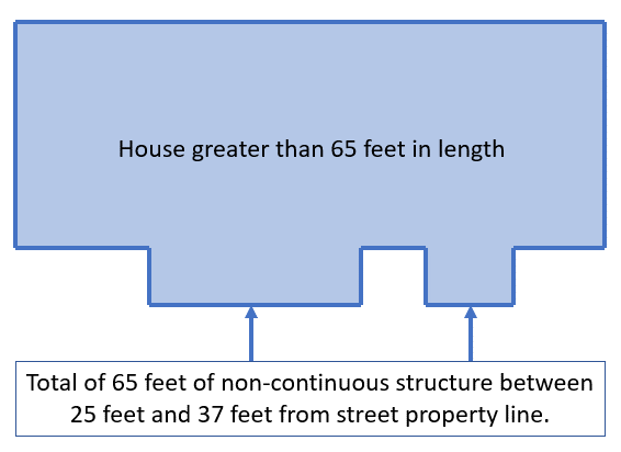
Figure 34-2
b.
Exemption from additional setbacks for open ground level. A residential structure greater than 65 feet in width will be exempt from the additional front and side setback requirements found in § 34-638(d)(5), if the ground-level enclosed or screened area is limited to no more than 30 feet in width, as viewed from the ROW. The enclosed area may extend the full depth of the house but limited in width to 30 feet.
(6)
Corner lot street setbacks. Corner lots, as defined in section 34-2, shall have two street setbacks which may vary depending on lot width, a standard side setback and a standard rear setback shall apply, as defined in Table 34-3, Dimensional Regulations in Conventional Zoning Districts.
a.
Front street setback: For single-family and two-family homes in the RS, RC and RM zoning districts will be 25 feet. Any corner lot on Estero Boulevard, must treat the Estero Boulevard frontage as the front street setback. Any corner lot not on Estero Boulevard may choose the front and side street which best allows development of the property and meets all other Code requirements. The rear setback shall be opposite of the front street setback.
b.
Side street setback: For single-family and two-family homes in the RS, RC and RM zoning districts. The side street setback will vary between ten feet and 20 feet depending on the width of the lot, measured from the side street property line and the side property line (opposite from the side street property line).
1.
Properties that measure 50 feet or less shall have a ten-foot side street setback.
(i)
Proposed layout must indicate how parked cars will be maintained out of the right-of-way, if the property will be accessed from this side.
2.
Properties that measure greater than 50 feet up to 75 feet shall have a 15-foot side street setback.
(i)
Proposed layout must indicate how parked cars will be maintained out of the right-of-way, if the property will be accessed from this side.
3.
Properties that are greater than 75 feet shall have a 20-foot side street setback.
(Ord. No. 20-08, § 2, 4-6-2020; Ord. No. 20-19, § 4, 1-19-2021; Ord. No. 22-01, § 2, 2-7-2022; Ord. No. 23-02, § 2(Exh. A), 2-21-2023)
Sec. 34-639. - Permitting survey requirements.
(a)
Survey required. In order to demonstrate compliance with applicable regulations of this division, the applicant or contractor must provide, the following, as illustrated in the chart below, Illustration Chart 1:
(1)
A boundary and topographic survey at the time of building permit application;
(2)
A foundation survey;
(3)
An as-built survey prior to issuance of a certificate of occupancy or a certificate of completion;
(4)
Survey of height, when building permit plans call for construction within five feet of the height limitation in the applicable zoning district;
(5)
Survey must depict 1978 and 1991 Coastal Construction Control Line, where applicable.
(b)
Types of permits requiring survey submission:
(1)
New construction;
(2)
Room addition;
(3)
Swimming pools and spas, and other impervious surfaces;
(4)
Accessory buildings and structures;
(5)
Fences;
(6)
Driveways.
(c)
Waiver of survey requirements. The director has discretion to review waiver requests under certain situations:
(1)
When proposed construction does not change the building envelope or height;
(2)
In-kind replacement of materials and elevations for driveways;
(3)
Fences that are clearly within the applicant's property boundary and any errors are solely the responsibility of the owner;
(4)
When proposed improvements are exempt from other sections of this Land Development Code.
(d)
As-built survey. Upon completion of a project which changes the building envelope, building height, site grading and stormwater, or infrastructure, an as-built survey shall be required.
Illustration Chart 1:
1 Only when a stormwater plan was required for permit approval.
(Ord. No. 17-10, § 2(Exh. A), 6-19-2017; Ord. No. 20-15, § 2, 10-5-2020)
Sec. 34-641.- General purpose.
The purpose of conventional zoning districts is to control land use in a uniform way throughout each zoning district, with similar use and dimensional regulations applying to all parcels within that district. Article IV of this chapter also contains supplemental regulations that apply to multiple zoning districts.
Sec. 34-642. - RS (Residential Single-family) zoning district.
(a)
The purpose of the RS zoning district is to provide stable neighborhoods where single-family detached homes are the predominant land use.
(b)
In the RS zoning district, allowable uses are defined in Table 34-2 and property development regulations are contained in Table 34-3.
Sec. 34-643. - RC (Residential Conservation) zoning district.
(a)
The purpose of the RC zoning district is to recognize certain older neighborhoods that had been zoned for duplex, multifamily, or mobile homes purposes prior to incorporation of the town. Some lots in this district are large enough to accommodate a second dwelling unit (see Table 34-3 and §§ 34-632, 34-1177 and 34-1178 of this chapter).
(b)
In the RC zoning district, allowable uses are defined in Table 34-2 and property development regulations are contained in Table 34-3.
Sec. 34-644. - RM (Residential Multifamily) zoning district.
(a)
The purpose of the RM zoning district is to designate suitable locations for a wide variety of multifamily residences.
(b)
In the RM zoning district, allowable uses are defined in Table 34-2 and property development regulations are contained in Table 34-3.
Sec. 34-645. - CR (Commercial Resort) zoning district.
(a)
The purpose of the CR zoning district is to designate suitable locations for motels, resorts, and related services.
(b)
In the CR zoning district, allowable uses are defined in Table 34-2 and property development regulations are contained in Table 34-3.
Sec. 34-646. - CM (Commercial Marina) zoning district.
(a)
The purpose of the CM zoning district is to allow commercial marinas in suitable waterfront locations to provide boaters with access to the water and related services.
(b)
In the CM zoning district, allowable uses are defined in Table 34-2 and property development regulations are contained in Table 34-3.
Sec. 34-647. - CO (Commercial Office) zoning district.
(a)
The purpose of the CO zoning district is to allow office uses on land that is visible to the traveling public or on land that can serve as a transition between commercial and residential uses.
(b)
In the CO zoning district, allowable uses are defined in Table 34-2 and property development regulations are contained in Table 34-3.
Sec. 34-648. - Santos zoning district.
(a)
The purpose of the Santos zoning district is [to] allow a mixture of residential and low-intensity commercial uses that will separate the intense commercial uses along Estero Boulevard from the residential portions of the Venetian Gardens subdivision. This zoning district implements the recommendations of the Santos/Palermo Circle Planning Study (February, 1999) and Policy 4-C-11 of the Fort Myers Beach Comprehensive Plan.
(b)
In the Santos zoning district, allowable uses are defined in Table 34-2 and property development regulations are contained in Table 34-3.
(c)
In addition to these restrictions on allowable uses and dimensional requirements, the commercial design standards found in §§ 34-991—34-1010 of this chapter apply to all commercial and mixed-use buildings or portions thereof that are being newly built and to "substantial improvements" to such buildings as defined in § 6-405 of this LDC.
Sec. 34-649. - IN (Institutional) zoning district.
(a)
The purpose of the IN zoning district is to provide suitable regulations for churches, civic buildings, schools and government buildings.
(b)
In the IN zoning district, allowable uses are defined in Table 34-2 and property development regulations are contained in Table 34-3.
Sec. 34-650. - CF (Community Facilities) zoning district.
(a)
The purpose of the CF zoning district is to provide suitable regulations for parks and nature preserves.
(b)
In the CF zoning district, allowable uses are defined in Table 34-2 and property development regulations are contained in Table 34-3.
Sec. 34-651. - BB (Bay Beach) zoning district.
(a)
The purpose of the BB zoning district is to implement the binding agreement that settled litigation over development rights in Bay Beach and to recognize prior rights granted for the construction and use of docks.
(b)
Land uses in the BB zoning district shall conform to all requirements of the stipulated settlement agreement between Stardial Investments Company and the Town of Fort Myers Beach, dated February 23, 2001, a copy of which is recorded in O.R. Book 3414, Pages 4775—4786, as amended in O.R. Book 3414, Pages 4787—4789, and including any future amendments to this agreement. Land uses in the BB zoning district must also conform to DRI development order #12-9394-124 regarding dock construction that was issued by Lee County on December 5, 1994, notice of which is recorded in O.R. Book 2586, Pages 1851—1854.
(1)
Allowable land uses include those uses in lawful existence as of February 23, 2001, and those additional uses as defined in the settlement agreement and in the DRI development order.
(2)
Building size and placement shall be governed by the regulations in this code, including the property development regulations in the RM district, except where specifically superseded by terms of the settlement agreement.
(3)
Replacement buildings cannot exceed the height, square footage of floor and parking areas, and all other measurable parameters of the original buildings. See buildback regulations in §§ 34-3237—34-3238.
Sec. 34-652. - Environmentally Critical (EC) zoning district.
(a)
Purpose. The purpose of the EC zoning district is to designate beaches and significant wetlands whose preservation is deemed critical to the Town of Fort Myers Beach through its comprehensive plan, including:
(1)
Beaches that have been designated in the "Recreation" category on the future land use map; and
(2)
Wetlands that have been correctly designated in the "Wetlands" category on the future land use map.
(b)
Intent. The application of the EC district is intended to prevent public harm by precluding the use of land for purposes for which it is unsuited in its natural state and which injures the rights of others or otherwise adversely affects a defined public interest.
(c)
Accretion. Accretions of beaches or wetlands, whether by natural causes or through beach renourishment or approved filling, may be permitted in the EC zoning district, with appropriate easements as may be required by regulatory agencies.
(d)
Permitted uses and structures. In the EC district, no land or water use shall be permitted by right except for those uses and developments described below and consistent with the Fort Myers Beach Comprehensive Plan for uses in wetlands and beaches, as applicable, including:
(1)
Boating, with no motors permitted except electric trolling motors.
(2)
Fishing.
(3)
Removal of intrusive, exotic species or diseased or dead trees, and pest control.
(4)
Outdoor education, in keeping with the intent of the district.
(5)
Passive recreation activities on public property. These activities and uses include passive recreation that may require temporary structures but no alteration of the natural landscape. Any temporary structure used in conjunction with such uses must comply with all provisions of this Land Development Code (for instance, see chapters 14 and 27).
(6)
Outdoor accessory uses, including the rental of beach furniture, when accessory to a multifamily residential or resort building located adjacent to the Gulf of Mexico containing more than 50 dwelling units.
(7)
Wildlife management, as wildlife preserves.
(8)
Expansion of area designated for the consumption and service of alcoholic beverages, subject to the regulations in § 34-1264(g)(1).
(9)
Temporary, movable structures on private property that do not alter the natural environment, landscape or obstruct pedestrian traffic. Artificial lighting and signs are prohibited unless the lighting or signage complies with §§ 14-5 or 27-51 of this LDC.
(10)
Temporary, movable structures that are part of a permitted special event in accordance with § 14-11 of this LDC.
(11)
Licensed beach vendor rental equipment or a temporary movable structure permitted in accordance with § 14-5, ch. 27, and § 34-3151 of this LDC.
a.
During the sea turtle nesting season (May 1 through October 31) temporary, movable structures may not be moved across the beach unless:
1.
The movement is after 9:00 a.m., or after completion of daily monitoring for turtle nesting activity by a FWCC-authorized marine turtle permit holder, whichever occurs first; and
2.
The movement does not disturb any sea turtle or sea turtle nest.
(12)
On-grade, pathways through a dune, not to exceed 40 inches in width, subject to compliance with all applicable state and local environmental regulations. No more than one pathway per property.
(e)
Special exception uses and structures. Upon a finding that the proposed use or structure is consistent with the standards set forth in § 34-88 of this LDC, as well as all other applicable town regulations, the town council may approve with or without conditions as a special exception the following structures or uses:
(1)
Accessory structures, which are accessory to a use permitted by special exception in the EC district.
(2)
Nature study center, noncommercial, and its customary accessory uses.
(3)
Reconstruction or renewal of any part of an existing building for the purpose of its maintenance or to correct damage to existing primary structures, which encroach into the EC district and their customary accessory uses. In accordance with § 6-366(b) of this Land Development Code.
(4)
Minor structures, which shall be located as close to the landward edge of the EC zoning district line as possible and must minimize adverse effects on the beach and dune system.
(5)
Artificial lighting, in compliance with sea turtle lighting regulations.
(6)
Perpendicular dune walkovers on property, when required to protect indigenous plant communities and when elevation change exists, in accordance with § 10-415(b) and subsection (f), below.
(7)
Signs, as approved by a planned development.
(f)
Additional regulations.
(1)
Article I in ch. 14 pertaining to beach and dune management; and
(2)
Any dune walkover must be state approved and constructed consistent with the following requirements:
a.
Walkovers must be placed perpendicular to the dune or no more than 30 degrees from perpendicular. New walkovers cannot be placed closer than 150 feet to the nearest walkover.
b
Walkovers must be supported on posts embedded to a sufficient depth to provide structural stability. These posts may not be encased in concrete.
c.
Walkovers cannot exceed four feet in width when serving single-family homes or six feet in width otherwise. Alternate widths require a variance.
d.
Walkovers must be elevated at least two feet, and no more than three feet, above the highest point of the dune and dune vegetation and must extend to the seaward toe of any existing dune and dune vegetation.
e.
Walkovers must be constructed in a manner that minimizes short-term disturbance of the dune system. Any dune vegetation destroyed during construction must be replaced with similar native vegetation that is suitable for beach and dune stabilization and increases either plant density or area of plantings.
f.
Walkovers may not be constructed during the sea turtle nesting season (May 1 through October 31).
g.
Walkovers may not be attached to any other structures.
(3)
Article IV of ch. 14 pertaining to wetlands protection; and
(4)
Coastal zone regulations in § 34-1575 of this LDC.
(Ord. No. 12-03, § 2(Exh. A), 9-4-2012; Ord. No. 15-12, § 2, 1-19-2016; Ord. No. 20-02, § 2, 2-18-2020; Ord. No. 20-19, § 4, 1-19-2021; Ord. No. 22-01, § 2, 2-7-2022; Ord. No. 23-02, § 2(Exh. B), 2-21-2023; Ord. No. 23-12, 2(Exh. A), 6-20-2023; Ord. No. 23-13, § 2(Exh. A), 10-16-2023; Ord. No. 24-24, § 2(Exh. A), 9-23-2024)
Sec. 34-991.- Purpose and intent.
The purposes of design regulations for commercial buildings include:
(1)
Encouraging traditional building forms that reinforce the pedestrian orientation and desired visual quality of the Town of Fort Myers Beach.
(2)
Creating usable outdoor space through the arrangement of compatible commercial buildings along street frontages.
(3)
Encouraging buildings of compatible type and scale to have creative ornamentation using varied architectural styles.
(4)
Enhancing the town's business districts as attractive destinations for recreation, entertainment and shopping.
(5)
Maintaining and enhancing the town's sense of place and its property values.
(6)
Implementing the design concepts in the Fort Myers Beach Comprehensive Plan.
Sec. 34-992. - Applicability and compliance.
(a)
Applicability. Except where this code specifically provides otherwise, these commercial design standards apply to all commercial and mixed-use buildings or portions thereof that are being newly built, and to "substantial improvements" to such buildings as defined in § 6-405 of this LDC, on properties that are zoned in any of the following zoning districts:
(1)
Santos (§ 34-648);
(2)
Downtown (§§ 34-671—34-680);
(3)
Santini (§§ 34-681—34-690);
(4)
Village (§§ 34-691—34-700);
(5)
CB (§§ 34-701—34-710); and
(6)
CPD (commercial planned development) (§§ 34-951—34-960).
(b)
Commercial buildings on properties with a zoning resolution that incorporated specific architectural elevations shall be required to comply with these standards to the extent that the standards are not inconsistent with the approved elevations.
(c)
Commercial buildings such as hotels that will not contain commercial uses below base flood elevation shall not be required to comply with the ground-floor window and retail standards except along Old San Carlos Boulevard (see § 34-676(b)(2) of this chapter. However, the principal facades of these buildings must screen under-building parking areas in a manner acceptable to the town manager or designee.
(d)
Compliance determinations. Compliance with these standards shall be determined as follows:
(1)
An applicant may seek conceptual or final approval of a specific building and site design during the commercial planned development rezoning process (see § 34-931 of this chapter). The resolution approving a commercial planned development may include specific site plans and building elevations and shall specify the extent to which these plans and elevations have or have not been determined to meet these commercial design standards and whether any deviations to these standards have been granted.
(2)
Unless final approval has been granted pursuant to subsection (1), the town manager shall make a determination of substantial compliance with these standards before a development order can be issued pursuant to ch. 10 of this code, or before a building permit can be issued if a development order is not applicable.
a.
Compliance determinations of the town manager are administrative decisions which may be appealed in accordance with article II of this chapter.
b.
The town manager shall provide written notice of each compliance determination to the town council within five calendar days. The town council, by majority vote at a public meeting within 30 days of the compliance determination, may file an appeal that will be heard by the town council in conformance with the procedures and standards in § 34-86 of this chapter.
c.
Compliance determinations made by the town manager shall not become effective until the 30-day appeal period has passed without an appeal having been filed.
(e)
Variances and deviations. Requests to vary from a substantive provision of these standards may be filed using the variance procedures and evaluated using the findings in § 34-87 of this chapter, or may be requested during planned development rezonings as a deviation as described in § 34-932(b) of this chapter. The following are acceptable justifications for deviations from these commercial design standards (in addition to the general requirements of § 34-932(b) of this chapter):
(1)
The proposed substitution of materials or function accomplishes substantially the same goals as the required provisions in these standards and would make an equal or greater contribution to the public realm of the Town of Fort Myers Beach; or
(2)
The proposed building is a civic building, which is expected to be more visually prominent than a typical commercial building.
Sec. 34-993. - Definitions.
Arcade means a series of columns topped by arches that support a permanent roof over a sidewalk.
Awning means a flexible roof-like cover that extends out from an exterior wall and shields a window, doorway, sidewalk, or other space below from the elements.
Balcony means a cantilevered, open, unroofed portion of an upper floor extending beyond (or indented into) a building's exterior wall.
Bay window means a series of windows which project beyond the wall of a building to form an alcove within.
Canopy means an awning-like projection from a wall that is made of rigid materials and is permanently attached to the principal facade of a building.
Civic building means a building that is allowed greater design flexibility due the prominence of its function and often its location. For purposes of these standards, civic buildings include buildings operated by governmental entities and certain privately owned buildings that serve religious, charitable, cultural, educational, or other public purposes.
Colonnade is similar to an arcade except that it is supported by vertical columns without arches.
Commercial building means, for purposes of these standards, any building used in whole or in part for any of the following uses: retail, office, hotel or motel rooms, institutional uses, commercial storage, restaurants, bars, and similar uses.
Cornice means a decorative horizontal feature that projects outward near the top of an exterior wall.
Courtyard means an unroofed area surrounded by buildings.
Expression line means a decorative horizontal feature that projects outward from an exterior wall to delineate the top of the first story of a building.
Facade, principal means the exterior wall of a building that is roughly parallel to a right-of-way or which faces a plaza or public park, and also that portion of a building's side wall that faces a pedestrian way or parking lot. Along the east side of Old San Carlos Boulevard only, the rear wall of buildings shall also be considered a principal facade whenever it is visible from the Matanzas Pass Sky Bridge.
Lintel means a structural or merely decorative horizontal member spanning a window opening.
Plaza means an unroofed public open space designed for pedestrians that is open to public sidewalks on at least one side.
Sill means is a piece of wood, stone, concrete, or similar material protruding from the bottom of a window frame.
Stoop means a small, elevated entrance platform or staircase leading to the entrance of a building.
(Ord. No. 14-05, § 2(Exh. A), 11-17-2014; Ord. No. 20-19, § 3, 1-19-2021)
Sec. 34-994. - Exterior walls.
(a)
Generally. These standards require commercial buildings to have traditional pedestrian-oriented exteriors and to be clad with typical Florida building materials that are durable and appropriate to the visual environment and climate. Design flexibility and creativity is encouraged using ornamentation from a wide variety of architectural styles.
(b)
Finish materials for walls. Exterior walls are the most visible part of most buildings. Their exterior finishes shall be as follows:
(1)
Any of the following materials may be used for exterior walls and for columns, arches and piers:
a.
Concrete block with stucco (CBS);
b.
Reinforced concrete (with smooth finish or with stucco);
c.
Natural stone or brick;
d.
Wood, pressure-treated or naturally decay-resistant species.
(2)
Exterior walls may also be covered with fiber-reinforced cement panels or boards, or with cast (simulated) stone or brick.
(3)
Synthetic stucco (an exterior cladding system with a stucco-like outer finish applied over insulating boards) may be used as an exterior wall covering except on principal facades.
(4)
Other materials for exterior walls may be used only if approved as a deviation from this section through the planned development rezoning process or when explicit approval has been granted to vary from these regulations (see § 34-992 of this chapter).
(5)
Fastenings that are required to dry-floodproof the first story of commercial buildings shall be integrated into the design of principal facades or be visually unobtrusive.
(c)
Types of exterior walls. Principal facades are defined in § 34-993 above, and their requirements are described in § 34-995, below. Exterior walls that are not defined as principal facades require a lesser degree of finish and transparency, but must meet the following requirements:
(1)
Transparent windows must cover at least 30 percent of the wall area below the expression line and at least ten percent of the wall area between the expression line and the cornice. These requirements shall not apply to walls facing and roughly parallel to rear lot lines, or to side walls being built closer than five feet to a side lot line if the adjoining lot also has a building with a side wall closer than five feet to the same side lot line. However, some rear and side walls qualify as principal facades in accordance with § 34-993 above, and must meet the more stringent requirements of § 34-995, below.
(2)
All windows must have their glazing set back at least three inches from the surface plane of the wall, or set back at least two inches when wood frame construction is used.
(3)
Rectangular window openings shall be oriented vertically (except for transom windows).
Sec. 34-995. - Principal facade walls.
(a)
Facade elements. Principal facades are the primary faces of buildings. Being in full public view, they shall be given special architectural treatment.
(1)
All principal facades shall have a prominent cornice and expression line, a working entrance, and windows (except for side-wall facades where entrances are not required).
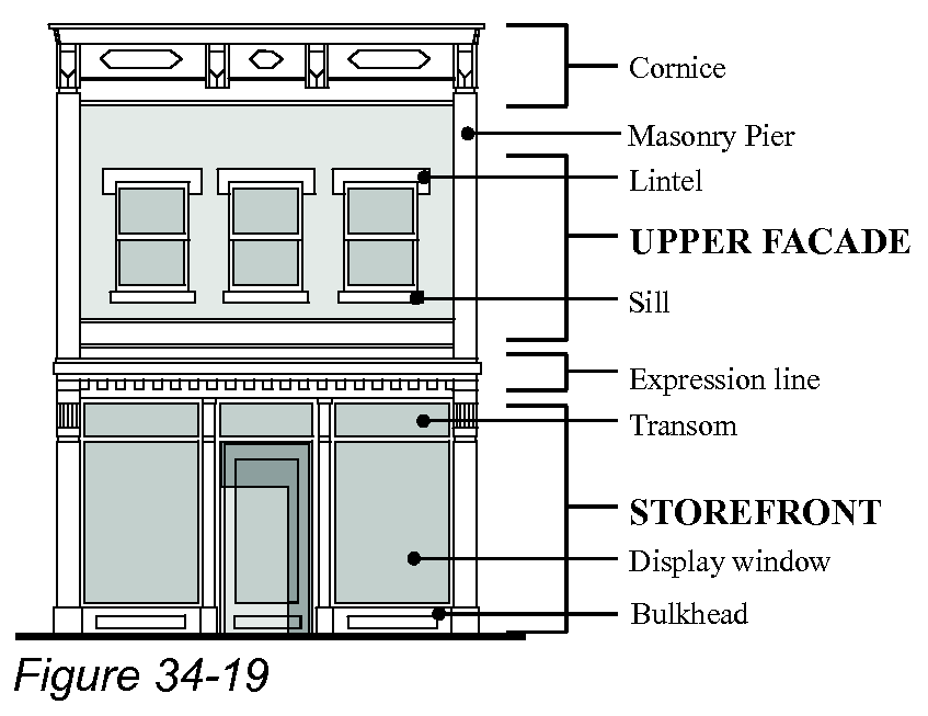
(2)
Buildings wider than 75 feet shall incorporate vertical elements in the principal facade to mimic smaller-scale development.
(3)
Principal facades facing a primary street, plaza, or public park may not have blank walls (without doors or windows) greater than ten feet in length.
(4)
Expression lines and cornices shall be a decorative molding or jog in the surface plane of the building that extend at least three inches out from the principal facade, or a permanent canopy may serve as an expression line.
(5)
Awnings may not hide or substitute for required features such as expression lines and cornices.
(6)
Entrances and windows are addressed in subsections (b) and (c) below.
(b)
Entrances. A primary entrance and views into the first floor of commercial buildings are fundamental to creating an interesting and safe pedestrian environment.
(1)
The primary entrance to all buildings shall face the street.
(2)
Corner buildings shall have their primary entrance face either the intersection or the street of greater importance.
(3)
Additional ground floor retail spaces within the same building shall all have their respective primary entrances face streets unless the retail spaces do not adjoin an exterior wall along a street.
(4)
Where building frontages exceed 50 feet, operable doors or entrances with public access shall be provided along streets at intervals averaging no greater than 50 feet.
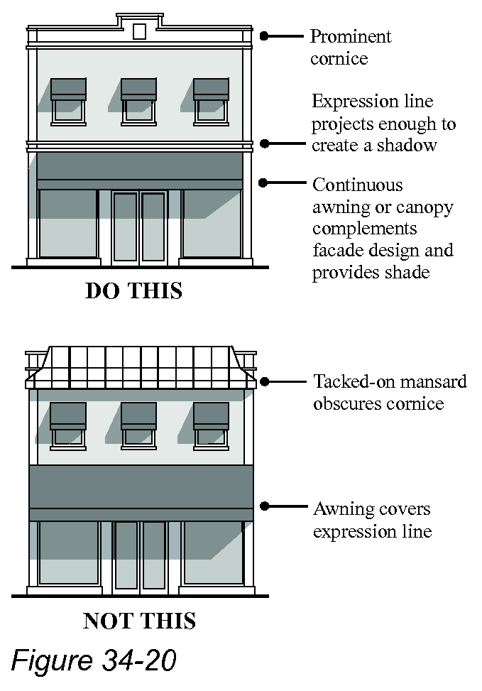
(c)
Windows. Every principal facade must contain transparent windows on each story.
(1)
All windows.
a.
Rectangular window openings on principal facades shall be oriented vertically (except for transom windows).
b.
All windows must:
1.
Contain visible sills and lintels on the exterior of the wall; and
2.
Have their glazing set back at least three inches from the surface plane of the wall, or set back at least two inches when wood frame construction is used.
c.
Glass in windows and doors, whether integrally tinted or with applied film, must transmit at least 50 percent of visible daylight.
d.
See subsection (e)(1) of this section regarding awnings.
(2)
First-story windows. In order to provide clear views inward and to provide natural surveillance of exterior spaces, the first story of every commercial building's principal facade shall have transparent windows meeting the following requirements:
a.
Window openings shall cover at least 60 percent of the wall area below the expression line;
b.
The bottoms of the window opening can be no higher than 30 inches from sidewalk level; and
c.
These windows shall be maintained so that they provide continuous view of interior spaces lit from within. Private interior spaces such as offices may use operable interior blinds for privacy.
(3)
Upper-story windows.
a.
All stories above the first story of every commercial building's principal facade shall contain between 15 percent and 75 percent of the wall area with transparent windows.
b.
No single pane of glass may exceed 36 square feet in area.
(d)
Corner buildings. For buildings located at the intersection of two streets, the corner of the building at the intersection may be angled, curved, or chamfered. The distance from the corner shall not exceed 20 feet measured from the intersection of the right-of-way lines to the end of the angled or curved wall segment, unless a greater amount is required by the visibility triangles in § 34-662(b)(4) of this chapter.
(e)
Facade projections. Facade projections add visual interest to buildings. Some projections also provide protection from sun and rain for those passing by, others provide additional floor space for the building. The following types of facade projections are permitted as indicated below. At least one of these facade projections is required on each principal facade of all commercial buildings. Along both sides of Old San Carlos Boulevard, a continuous awning or canopy is required over the sidewalk except where the sidewalk is being shaded by an arcade or colonnade.
(1)
Awnings and canopies.
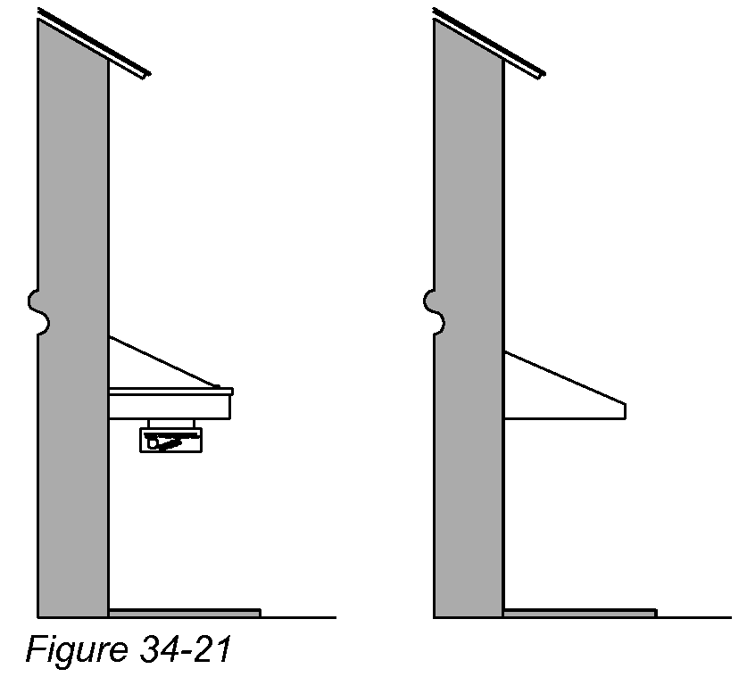
a.
Awnings and canopies may extend forward of the build-to line (see § 34-662 of this chapter) and may encroach into a street right-of-way.
b.
Awning or canopies extending from the first story cannot exceed the following dimensions:
1.
Depth: Five feet (minimum) and strongly overlapping the sidewalk, but no closer than two feet to an existing or planned curb (see subsection (e) of this section regarding Old San Carlos Boulevard).
2.
Height: The lowest point on an awning or canopy shall be between nine feet and 12 feet above sidewalk level.
3.
Length: Twenty-five percent to 100 percent of the front of the building.
c.
There are no minimum or maximum dimensions for awnings or canopies extending from a second story or higher.
d.
Awnings shall be covered with fabric. High-gloss or plasticized fabrics are prohibited. Backlighting of awnings is prohibited.
(2)
Balconies.
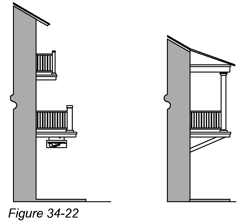
a.
Balconies may extend forward of the build-to line (see § 34-662 of this chapter) and may encroach into a street right-of-way.
b.
Balconies cannot exceed the following dimensions:
1.
Depth: Six feet minimum for second story balconies; and no closer than twp feet to the existing or planned curb.
2.
Height: Ten feet minimum if overhanging a sidewalk.
3.
Length: Twenty-five percent to 100 percent of the front of the building.
4.
Top of railing: Two and three-fourths-inch minimum.
c.
Balconies may have roofs, but are required to be open, un-air conditioned parts of the buildings.
d.
On corners, balconies may wrap around to the side of the building.
(3)
Bay windows.
a.
Bay windows may extend forward of the build-to line (see § 34-662 of this chapter) but may not encroach into a street right-of-way.
b.
Awning or canopies extending from the first story cannot exceed the following dimensions:
1.
Depth: Three feet (minimum).
2.
Height: Ten feet minimum above sidewalk.
3.
Length: Six feet minimum.
c.
Bay windows shall have the same details required for principal facades: sills, lintels, cornices, and expression lines.
(4)
Porches.
a.
Front porches may extend forward of the build-to line (see § 34-662 of this chapter) but may not encroach into a street right-of-way.
b.
Front porches cannot exceed the following dimensions:
1.
Depth: Eight feet (minimum).
2.
Length: Twenty-five percent to 90 percent of the front of the building; however, no more than 25 percent of the floor area of a porch shall be screened if the porch extends forward of the build-to line.
3.
Top of railing: Two and three-fourths-inch minimum.
c.
Front porches may have multi-story verandas and/or balconies above.
d.
Front porches are required to be open, un-air conditioned parts of a building.
(5)
Stoops.
a.
Stoops may extend forward of the build-to line (see § 34-662 of this chapter) but may not encroach into a street right-of-way or sidewalk without specific approval by the town.
b.
Stoops cannot exceed the following dimensions:
1.
Depth: Six feet (minimum).
2.
Length: Five feet (minimum).
c.
Stoops may be roofed or unroofed but may not be screened or otherwise enclosed.
(6)
Arcades and colonnades.
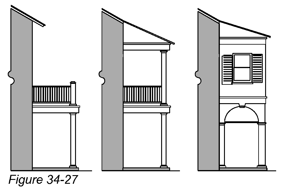
a.
Arcades and colonnades may extend forward of the build-to line (see § 34-662 of this chapter) and may encroach into a street right-of-way if explicit permission is granted by the town.
b.
Arcades and colonnades cannot exceed the following dimensions:
1.
Depth: Seven feet minimum from the building front to the inside face of the column.
2.
No part of the column shall be closer than two feet to the existing or planned curb.
3.
Height: Ten feet minimum above sidewalk.
4.
Length: Seventy-five percent to 100 percent of the front of the building.
5.
Top of porch railing: Two and three-fourths-inch minimum.
c.
Open multi-story verandas, awnings, balconies, and enclosed useable space can be constructed above the colonnade.
d.
Arcades and colonnades shall only be constructed where the minimum depth can be obtained.
e.
On corners, arcades and colonnades may wrap around to the side of the building.
f.
Columns shall be spaced no farther apart than they are tall.
g.
Minimum column dimensions with enclosed space above shall be eight inches.
h.
Minimum column dimension without enclosed space above:
1.
Rectangular columns: Six inches.
2.
Round columns: Six inches in diameter.
Sec. 34-996. - Roofs.
(a)
Definitions.
Dormer means a projection from a sloping roof that contains a window and its own roof.
Gable roof means a ridged roof forming a gable at both ends.
Hip roof means a roof with pitched ends and sides.
Mansard roof means a roof having two slopes with the lower slope steeper than the upper, or a single steep slope topped with a flat roof, enclosing the building's top floor. A modern variant is a partial sloped roof that is attached near the top of an exterior wall in place of a traditional cornice or parapet, creating the visual effect of a sloped roof on a flat-roofed building but without enclosing any floor space.
Parapet means a short vertical extension of a wall that rises above roof level, hiding the roof's edge and any roof-mounted mechanical equipment.
Shed roof means a pitched roof that has only one slope.
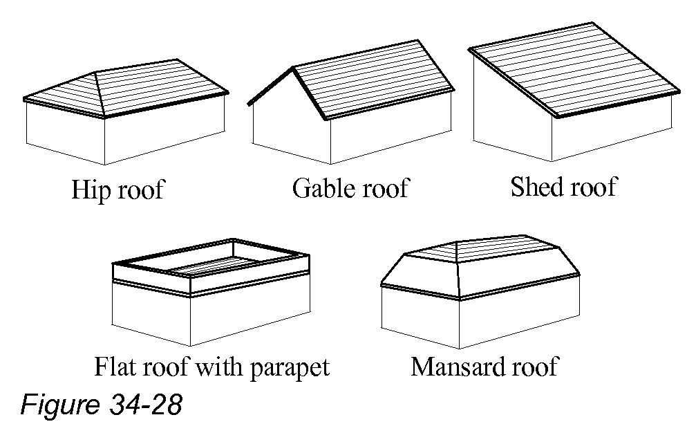
(b)
Roof types permitted. Commercial buildings may have any of the following roof types: hip roofs, gable roofs, shed roofs, flat roofs with parapets, or mansard roofs.
(1)
All flat roofs, and any shed roof with a slope of less than two inches vertical per 12 inches horizontal, must have their edges along all streets concealed with parapets.
(2)
All hip roofs and gable roofs, and any shed roof with a slope of more than two inches vertical per 12 inches horizontal, must have overhangs of at least 18 inches.
a.
Exposed rafter ends (or tabs) are encouraged.
b.
Wide overhangs are encouraged and can be supported with decorative brackets.
(3)
Mansard roofs are permitted only when the lowest sloped surface begins above a cornice line and then slopes upward and inward.
(4)
Small towers, cupolas, and widow's walks are encouraged (see § 34-631 of this chapter for maximum dimensions).
(5)
Dormers are permitted and encouraged on sloped roofs.
(6)
Skylight glazing must be flat to the pitch of the roof if the skylight is visible from a primary street, plaza, or public park.
(c)
Roofing materials permitted. Commercial building roofs may be constructed with one or more of the following roofing materials:
(1)
Metal:
a.
Steel (galvanized, enameled or terne-coated);
b.
Stainless steel;
c.
Copper;
d.
Aluminum.
(2)
Shingles:
a.
Asphalt (laminated dimensional shingles only);
b.
Fiber-reinforced cement;
c.
Metal (same as subsection (c)(1) above).
(3)
Tiles:
a.
Clay or terra cotta;
b.
Concrete.
(4)
Flat roofs:
a.
Any materials allowed by applicable building codes.
(5)
Gutters and downspouts:
a.
Metal (same as subsection (c)(1) above).
(d)
Other roof types and materials. Other types of roofs and roofing materials are prohibited unless explicitly approved in accordance with § 34-992 of this chapter.
Sec. 34-997. - Plazas and courtyards.
(a)
Generally. New commercial buildings are generally oriented to public sidewalks. This section addresses other public open spaces that also can affect the orientation of commercial buildings.
(b)
Plazas. This code contains "build-to lines" (see § 34-662 of this chapter) that require new commercial buildings to be placed near public sidewalks. These build-to regulations allow up to 25 percent of a building's frontage to be recessed ten feet. Plazas meeting the following requirements are permitted to be recessed further than the standard ten feet:
(1)
The plaza cannot exceed 25 percent of a building's frontage.
(2)
The plaza is strictly for pedestrian usage and cannot be used to park vehicles.
(3)
All building walls that surround the plaza must meet the design criteria for principal facades.
(c)
Courtyards. New commercial buildings that are on larger lots may include interior courtyards designed for public or private usage.
(1)
If vehicular circulation is allowed through a courtyard, the only parking permitted will be in parallel spaces.
(2)
Courtyards intended for public use are encouraged to have clear visual linkages between the courtyard and public sidewalks.
(d)
Pedestrian passages. Pedestrian passages, with or without a lane for vehicles, can be provided on private property to connect a courtyard to the sidewalk system, to provide walkways to parking lots behind buildings, or to provide additional retail frontages.
Sec. 34-661. - General purpose.
The purpose of the redevelopment zoning districts is to implement specific redevelopment concepts established in the Fort Myers Beach Comprehensive Plan and for other situations where conventional or planned development zoning districts are inappropriate. These districts require more detailed regulations than provided by conventional zoning districts, and use special terms as described in the following sections. Article IV of this chapter also contains supplemental regulations that apply to multiple zoning districts.
Sec. 34-662. - Build-to lines and setback lines.
(a)
Build-to and setback lines distinguished. Most redevelopment districts specify build-to lines for street frontages and setback lines for side and rear property lines.
(1)
A build-to line identifies the precise horizontal distance (or range of distances) from a street that the front of all primary structures must be built to, in order to create a fairly uniform line of buildings along streets.
(2)
A setback line identifies the minimum horizontal distance between a property line and the nearest point of all structures, in order to ensure a minimum area without buildings.
(b)
General requirements for build-to lines.
(1)
Build-to lines are illustrated conceptually on Figure 34-3.
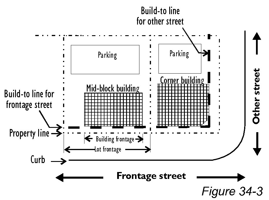
(2)
Where a build-to line is specified as a range (for instance, five to ten feet), this means that building fronts must fall within that range of distances from the front property line. Where there is a range, the front facade does not have to be parallel to the street or in a single plane, as long as the front facade remains within the range.
(3)
At least 75 percent of the building frontage is required to align with the build-to line. The remaining 25 percent may be recessed up to ten feet behind the build-to line, for instance to provide recessed pedestrian entrances or simply for architectural diversity. (See also § 34-997 of this chapter regarding plazas.)
(4)
Build-to lines are subject to adjustment to maintain visibility for vehicles exiting onto primary streets.
a.
Visibility triangles must be maintained on both sides of intersecting streets and exiting driveways as shown in Figures 34-4 and 34-5, or to provide equivalent visibility.
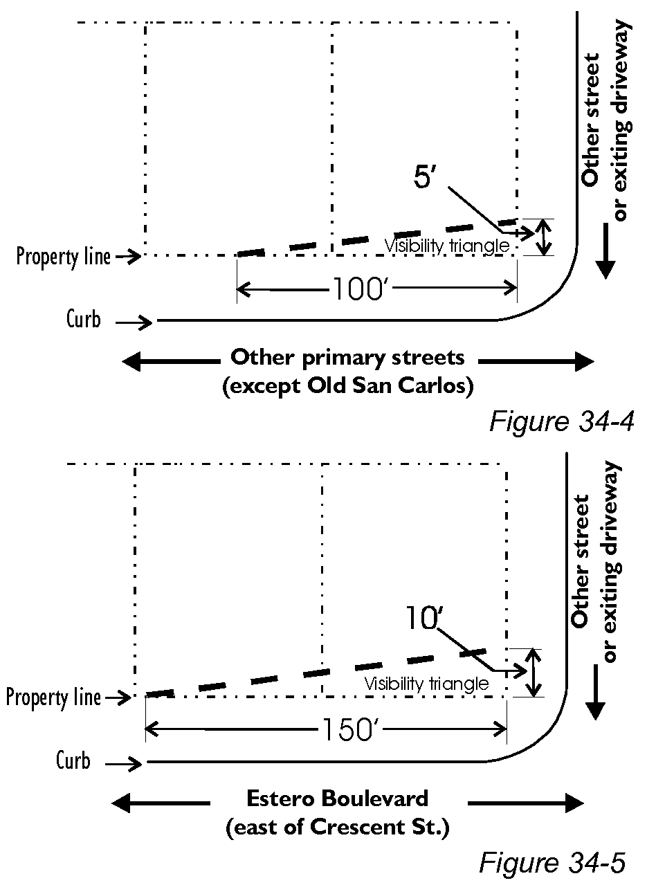
b.
Within these triangles, no buildings, shrubs, or low-hanging tree limbs may obstruct visibility between the height of two feet and six feet above ground. However, visibility triangles are not required at intersections with roundabouts or all-way stop signs.
(5)
Build-to line requirements may be adjusted by the director to avoid trees larger than eight inches in diameter (measured 54 inches above grade).
(6)
Upper stories are encouraged to remain in the same vertical plane as the first floor. Awnings, canopies, balconies, bay windows, porches, stoops, arcades, and colonnades are allowed on building exteriors provided that they comply with the commercial design standards (see § 34-995(e) of this chapter).
(7)
Build-to line requirements shall take precedence over any buffer or setback requirements imposed by other portions of this code.
(c)
General requirements for setback lines.
(1)
Setbacks from property lines. Minimum setbacks from property lines are defined for each zoning district. See § 34-638 of this chapter for general requirements on setbacks.
(2)
Setbacks from waterbodies. Minimum setbacks from waterbodies including the Gulf of Mexico are provided in § 34-638(d)(3) of this chapter.
Sec. 34-663. - Building frontages and lot frontages.
Building frontage is the length of a building facade that faces a street. Building frontages and lot frontages are illustrated on Figure 34-6.
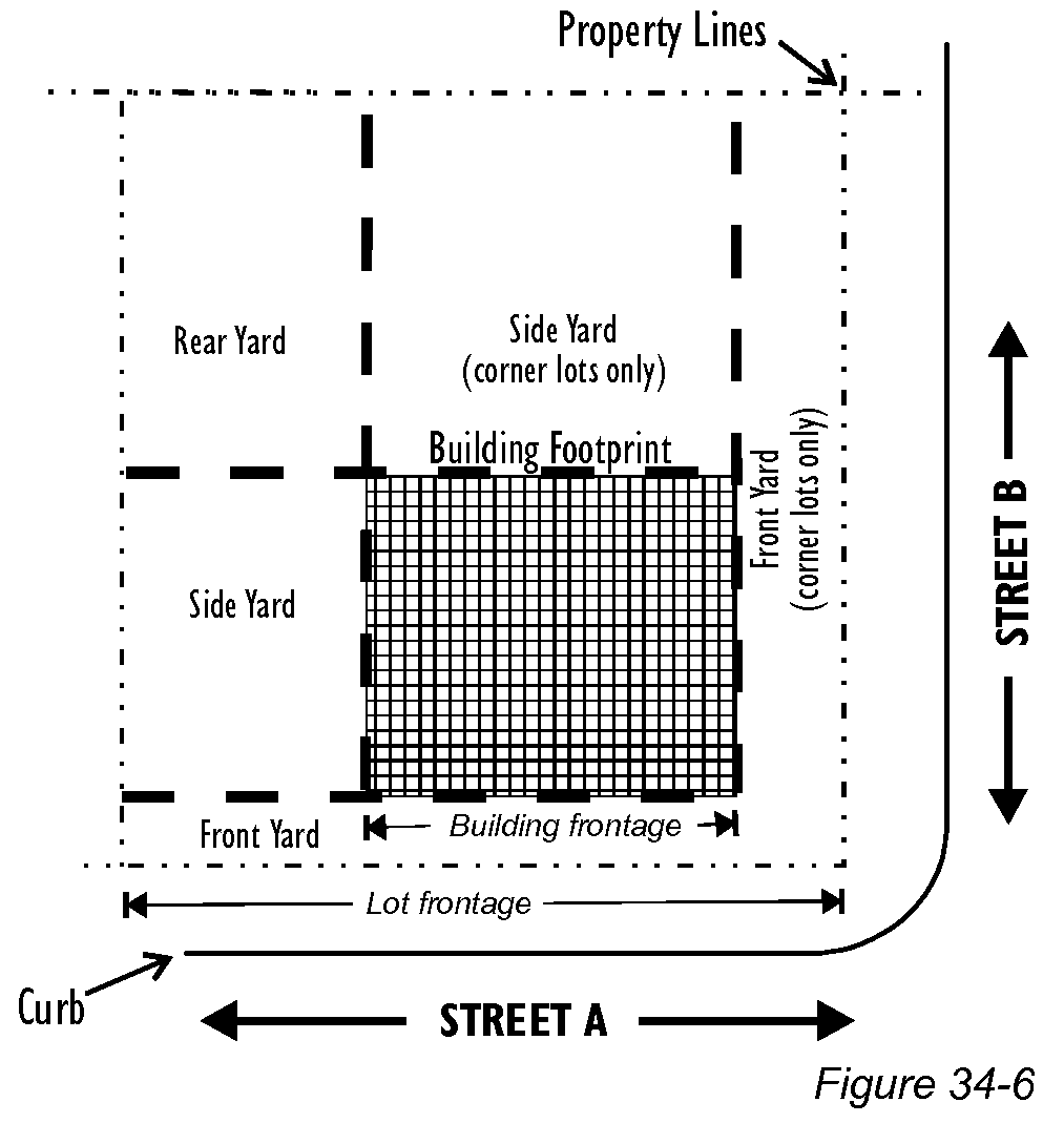
Sec. 34-664. - Commercial design standards.
Except where this code specifically provides otherwise, the commercial design standards (see §§ 34-991—34-1010 of this chapter) apply in all redevelopment zoning districts to all commercial and mixed-use buildings or portions thereof that are being newly built, and to "substantial improvements" to such buildings as defined in § 6-405 of this LDC.
Sec. 34-666. - Property development regulations.
In all redevelopment zoning districts, land use is controlled through the more specific property development regulations that are provided in the remainder of this division.
Sec. 34-671. - Purpose.
The purpose of the Downtown district is create the desired quality and character for the center of pedestrian-oriented commercial activities within the town. New commercial buildings are expected to accommodate pedestrians by providing storefronts near sidewalks and by offering shade and shelter along major streets. Old San Carlos Boulevard will serve as the town's "Main Street" and will be anchored by pedestrian plazas at each end.
Sec. 34-672. - District map and applicability.
(a)
The area indicated on Figure 34-7 is the outer perimeter of the Downtown district. Properties that have been zoned into a planned development (PD) district are governed by the terms of the PD zoning resolution rather than the requirements of the Downtown district, even if the property is shown on Figure 34-7.
(b)
Streets have been categorized into primary streets, secondary streets, and pedestrian plazas to guide the regulations for properties fronting each type of street.
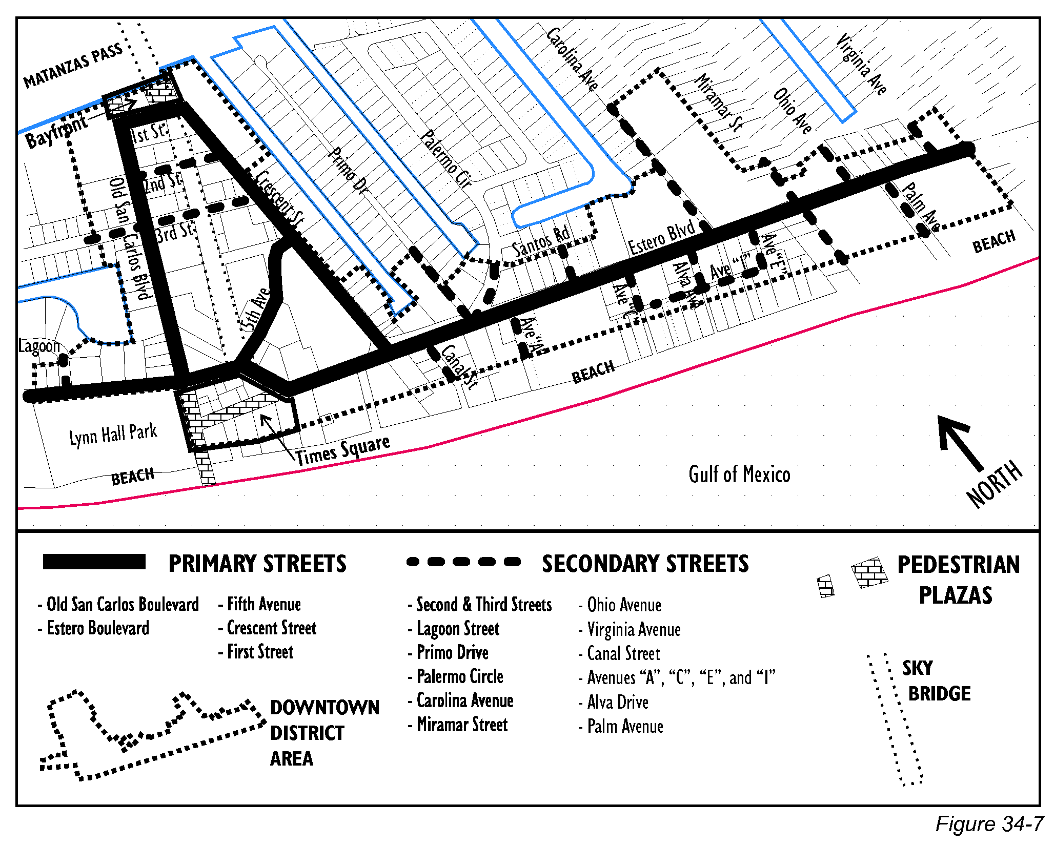
Sec. 34-673. - Allowable uses.
Sec. 34-674. - Building placement.
(a)
Build-to lines established. Build-to lines (see § 34-662 of this chapter) vary according to the streets and street types designated on Figure 34-7.
(1)
Build-to lines for all streets are five feet to ten feet from front property lines, except:
a.
Build-to lines are 0 feet for Old San Carlos Boulevard, all properties facing the Times Square and Bayfront pedestrian plazas, and Estero Boulevard west of the Sky Bridge.
b.
Built-to lines are 0 to five feet for all of First, Second, Third, and Fifth, and the south side of Estero Boulevard from the Sky Bridge to Miramar Street.
c.
Build to lines are 0—25 feet for single-family and two-family residential construction on secondary streets on the beach side of Estero Boulevard.
(2)
The adjustments to build-to lines to maintain visibility that are required by § 34-662(b)(4) of this chapter do not apply:
a.
To building fronts facing the Times Square or Bayfront pedestrian plazas; or
b.
To building fronts along Old San Carlos Boulevard, where wide sidewalks and on-street parking lanes will allow the necessary visibility.
(3)
Awnings, canopies, and marquees over sidewalks and pedestrian walkways are encouraged by the commercial design standards (§§ 34-991—34-1010 of this chapter) and are required along Old San Carlos Boulevard.
(4)
Enclosed habitable space may also be allowed over a public right-of-way if located over an arcade or colonnade that shades a public sidewalk (see § 34-995(e)(6) of this chapter), provided that specific permission is granted by the Town of Fort Myers Beach.
(b)
Setback lines established. Setback lines (see § 34-662 of this chapter) are established as follows:
(1)
For principal buildings:
a.
Minimum rear setbacks are 25 feet from rear property lines, except as follows:
1.
In Times Square, as defined on Figure 34-6, the minimum rear setback is ten feet.
2.
In areas where parking garages could be built, as defined on Figure 34-8, buildings shall be placed so as not to preclude future parking garages from being built on the interiors of these blocks. Along Old San Carlos Boulevard blocks with potential parking garages, this requirement means that principal buildings shall not extend further to the rear of lots than 50 feet back from the right-of-way for Old San Carlos Boulevard.
b.
Minimum side setbacks are five feet from side property lines, except they may be 0 feet for properties fronting on Old San Carlos, Estero Boulevard, and in Times Square.
c.
Minimum setbacks from waterbodies are set forth in § 34-638(d)(3) of this chapter.
d.
Minimum setbacks along those portions of properties abutting the town-owned parking lot between Old Carlos Boulevard and the Sky Bridge that had been platted as "Center Street" in Plat Book 9, Page 9 shall be the same as if those properties abutted any other private property.
(2)
For accessory structures, minimum setbacks are set forth in §§ 34-1171—34-1176.
(Ord. No. 23-11, § 2(Exh. A), 6-20-2023)
Sec. 34-675. - Building size.
(a)
Building frontage. Building frontage limits (see § 34-663 of this chapter) vary according to the street types designated on Figure 34-7:
(1)
For pedestrian plazas and primary streets except for Crescent Street and for Fifth Avenue east of the Sky Bridge, building frontages shall be at least 70 percent of the lot frontage.
(2)
For all other streets, building frontages shall be at least 35 percent of the lot frontage.
(3)
For multiple adjoining lots under single control, or for a single lot with multiple buildings, the percentages above apply to the combination of lot(s) and building(s).
(4)
Exception for properties between Estero Boulevard and the Gulf: The required building frontage percentage may be reduced to 35 percent for properties between Estero Boulevard and the Gulf of Mexico provided that the open space thus created allows open views to the Gulf of Mexico.
(b)
Building height. Building heights (see § 34-631 of this chapter) shall be limited to:
(1)
For properties that front on the following streets, a maximum of 30 feet above base flood elevation and no taller than three stories:
a.
Times Square and Bayfront pedestrian plazas (see Figure 34-7);
b.
North side of First Street;
c.
South side of Estero Boulevard between Old San Carlos Boulevard and the main pedestrian crossing;
d.
Carolina Avenue.
(2)
For properties that front on the following streets, a maximum of 30 feet above base flood elevation and no taller than three stories, elevated building are encouraged to limit enclosed space on the first story:
a.
Lagoon Street;
b.
Crescent Street;
c.
First, Second, Third, and Fifth (east of the Sky Bridge only);
d.
North side of Estero Boulevard west of Old San Carlos Boulevard and east of Crescent Street;
e.
Primo Drive;
f.
Palermo Circle;
g.
Miramar Street, north of Estero;
h.
Ohio Avenue;
i.
Virginia Avenue.
(3)
For properties that front on the following streets, a maximum of 40 feet above base flood elevation and no taller than three stories:
a.
Old San Carlos Boulevard between Fifth and First Streets;
b.
South side of First and both sides of Second and Third (west of the Sky Bridge only);
c.
South side of Estero Boulevard east of the main pedestrian crossing;
d.
Canal Street;
e.
Avenues A, C, E, and I;
f.
Alva Drive;
g.
Miramar Street, south of Estero;
h.
Palm Avenue.
(c)
Building intensity. Commercial and mixed-use building intensity shall be evaluated using floor area ratio (FAR). Detached single-family and two-family residence intensity shall be evaluated using building coverage (see § 34-634 of this chapter).
(1)
Floor area ratio (FAR). Floor area ratios (see § 34-633 of this chapter) shall not exceed:
a.
1.8 for properties fronting on Old San Carlos between Fifth and First Streets and fronting on the Times Square pedestrian plaza (see Figure 34-7).
b.
1.4 for properties fronting on Estero Boulevard and fronting on the Bayfront pedestrian plazas.
c.
1.0 for all other properties in the Downtown district.
(2)
Building coverage. Building coverage (See § 34-634 of this chapter) for detached single-family and two-family residences shall not exceed 40 percent.
(d)
Hotel rooms.
(1)
Along both sides of Old San Carlos Boulevard (properties between Fifth and First Streets that lie within 200 feet east and west of the centerline of Old San Carlos only), a property owner may substitute hotel rooms for allowable office space on upper floors without the limitations otherwise provided by the hotel-room equivalency factor found in § 34-1802 of this chapter. However, these hotel rooms must have at least 250 square feet per rentable unit.
(2)
In all other properties in the Downtown district, the number of hotel rooms are limited by the hotel-room equivalency factor found in § 34-1802 of this chapter.
(Ord. No. 24-08, § 2(Exh. A), 5-6-2024; Ord. No. 24-24, § 2(Exh. A), 9-23-2024)
Sec. 34-676. - Circulation and parking.
(a)
Off-street parking reductions. The Downtown district is planned as a "park-once" district, with preference given to pedestrian movement within the district. On-street parking will be provided by the town along Old San Carlos Boulevard and other public parking is available under the Sky Bridge. For these reasons, substantial reductions are allowed to the normal off-street parking requirements found in § 34-2020 of this chapter. The follow percentages shall be multiplied by the number of off-street parking spaces normally required by § 34-2020 of this chapter to determine the adjusted off-street parking requirements along various streets in the Downtown district:
(1)
Old San Carlos Boulevard, multiply by 50 percent.
(2)
Bayfront pedestrian plazas (see Figure 34-7), multiply by 50 percent. No parking spaces may be provided in the Bayfront pedestrian plaza, but the required spaces must be located within 750 feet in single-purpose, shared, or joint-use parking lots (see division 26 of this chapter).
(3)
Times Square pedestrian plazas (see Figure 34-7), multiply by 0 percent.
(4)
All other streets in the Downtown district, and all land on Crescent Street regardless of zoning district, multiply by 67 percent.
(b)
Parking lot locations. Off-street parking lots shall be placed in rear yards (see Figure 34-5).
(1)
Off-street parking lots are not permitted in front yards or side yards, except they may be placed in the side yards of buildings on properties that front the beach side of Estero Boulevard if the unbuilt area thus created allows open views to the Gulf of Mexico.
(2)
Off-street parking may be provided under commercial or mixed-use buildings along Old San Carlos Boulevard, provided that all under-building parking spaces are separated from sidewalks by usable commercial space at least 20 feet deep that meets all commercial building design guidelines in §§ 34-991—34-1010 of this chapter. Off-street parking may be provided under commercial or mixed-use buildings at other locations in accordance with § 34-992(c) of this chapter.
(c)
Parking lot interconnections. Rear-yard parking lots on properties fronting along Old San Carlos Boulevard shall be interconnected to eliminate or minimize driveways to Old San Carlos Boulevard.
(1)
To ensure the effective use of these connections, the first to develop shall be required to make an irrevocable offer of cross-access to the adjacent parcel (prior to issuance of a development order), and must design and build the parking lot to accommodate cross-access.
(2)
When adjacent owners seek development orders, they will also be required to reciprocate with a similar cross-access agreements and then must complete the physical connection.
(3)
Individual property owners shall control all rights to the use of their own parking spaces, but may choose to allow wider use of these spaces for a fee of their choosing or through reciprocal arrangements with other parties.
(d)
Driveway connections.
(1)
Properties fronting on Estero Boulevard. Existing driveways and parking spaces shall be relocated from Estero Boulevard to secondary streets, and new driveways shall connect only to secondary streets, except where these requirements would prohibit all reasonable access to a property.
(2)
Properties fronting on other primary streets.
a.
For properties fronting primary streets other than Estero Boulevard, driveways should be connected to secondary streets whenever possible.
b.
When a driveway onto a primary street is unavoidable, the driveway shall be shared with an adjoining property if that property also has access only to that primary street. Otherwise, the driveway shall be spaced as far as practical from other driveways or intersections.
(3)
Properties fronting only on secondary streets. Driveways may be connected to secondary streets, existing easements, or alleys.
(4)
Properties adjoining pedestrian plazas. Driveways and other vehicular access shall not be provided from pedestrian plazas.
(e)
Parking garages. The town has identified three potential locations for mid-block parking garages through its Old San Carlos Boulevard/Crescent Street Master Plan.
(1)
Each potential location is indicated in black on Figure 34-8. Construction of these parking garages is not required by this code, but the regulations for the Downtown district are designed to place new buildings on these sites so that they will not block a parking garage from being built there in the future.
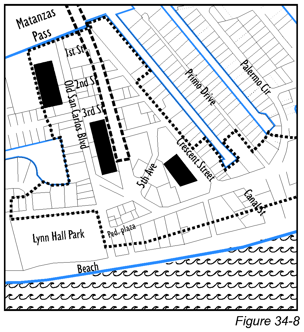
(2)
All levels of parking garages must be separated from primary streets and pedestrian plazas by a liner building that provides usable building space at least 20 feet deep (see Figure 34-9).
a.
Liner buildings must be two stories or more in height and must be at least as tall as the parking garage.
b.
Liner buildings may be detached from or attached to the parking garage.
c.
Parking garages and their liner buildings are required to meet the commercial design standards (see §§ 34-991—34-1010 of this chapter).
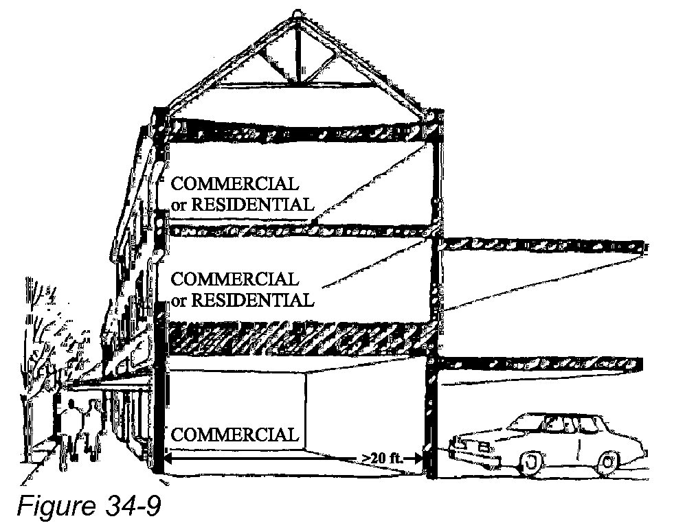
(3)
Access to a parking garage may be provided as follows:
a.
Access to a secondary street or road easement is preferred.
b.
Access to a primary street is not permitted except in unusual circumstances where no other access is feasible and when approved as a variance or deviation to this code.
c.
Access may not be provided across a pedestrian plaza.
(4)
Parking garages can be approved only by rezoning to the Commercial Planned Development zoning district.
(f)
Drive-through lanes. Drive-through lanes are generally not allowed in the Downtown district because traffic generated by drive-through lanes harms a pedestrian environment. The only exception to this rule is that Type 1 drive-throughs (see definition in § 34-2 of this LDC) may be approved by special exception on the north side of Estero Boulevard east of Palermo Circle. In this situation, the number of drive-through lanes is limited to two lanes, and they shall not be accessed directly, for either entrance or exit, from a separate driveway on Estero Boulevard; they may be accessed from any of the secondary streets or from a shared driveway on Estero Boulevard.
Sec. 34-677. - Additional requirements.
(a)
Commercial design standards. The commercial design standards (§§ 34-991—34-1010 of this chapter) shall apply to all commercial and mixed-use buildings, or portions thereof, that are being newly built, and to "substantial improvements" to such buildings as defined in § 6-405 of this LDC.
(b)
Open space and buffers. There are no minimum open space and buffer requirements in the Downtown district comparable to the standards found in ch. 10 of this LDC, except in three instances:
(1)
Portions of properties that lie east of Palermo Circle and more than 300 feet beyond the north edge of the Estero Boulevard right-of-way shall retain 50 percent of that portion as open space. This open space may be a stabilized sodded area useable for overflow parking.
(2)
Residential buffers are required between commercial or mixed-use buildings and single-family residential lots for properties on the north side of Estero Boulevard east of Palermo Circle. These buffers shall be constructed in accordance with the buffer requirements of ch. 10 of this code.
(3)
Buffers are required between any off-street parking lot and a public street in accordance with the buffer requirements of ch. 10 of this code.
(c)
Core area overlay district. An optional core area overlay district was adopted by the town by Ordinance No. 96-20. That district was replaced with the Downtown zoning district by Ordinance No. 03-03. Landowners who chose to be governed by the core area overlay district agreed in writing to be bound by its provisions for ten years. Compliance with this code, including all requirements of the Downtown zoning district, is deemed by the town as satisfying those agreements. However, all provisions of those agreements relating to off-site parking remain in full effect.
Sec. 34-678. - Outdoor display and sales of merchandise and food.
(a)
Generally. Merchandise, food, and beverages may be displayed or sold outdoors in the Downtown zoning district only in accordance with this section.
(b)
Purpose. The purpose of these regulations is to enhance the pedestrian environment of the town's business district through the creative use of outdoor spaces by providing businesses the opportunity to display a sample of their products and to sell food and beverages in a manner that enhances the public realm, creates an interesting and comfortable shopping and dining district, and maintains and improves the town's sense of place and property values.
(1)
Outdoor display of merchandise allows retailers an opportunity to inform and interest the public by offering a small sample of the products that are available inside. Outdoor display can also be appropriate for small retail products that are meant to be used outside, such as garden ornaments, windsocks and beach toys.
(2)
Outdoor display of merchandise is not intended to expand retail space or to assist in liquidating clearance or discarded items. The principal purpose of outdoor display in the Downtown district is to enliven sidewalks and pedestrian plazas by promoting pedestrian-oriented businesses, not to expand businesses or provide locations for freestanding businesses or for mobile vendors (which are regulated in § 34-3002).
(3)
Outdoor dining may be permitted between a restaurant and a street and is regulated by this section. The sale of alcoholic beverages outdoors is also regulated by state liquor laws and by § 34-1264 of this code.
(4)
See separate regulations for temporary outdoor displays during special events at § 34-2441 et seq.
(c)
Allowable locations for outdoor activities. Table 34-4 summarizes the allowable locations for outdoor display of merchandise and outdoor dining in the Downtown zoning district.
Table 34-4—Outdoor Activities in the Downtown Zoning District
(d)
Enclosed merchandise areas. Enclosed merchandise areas are exempt from this section except for the requirement that all merchandise and materials must be removed from the adjacent accessory area into the conventional building within 12 hours of issuance of a tropical storm or hurricane watch that includes the Downtown district. Retail store and personal services uses (permitted uses in the Downtown district) are permitted in the enclosed merchandise area.
(e)
Types of outdoor displays.
(1)
Clothing racks are limited to one support rod up to six feet long on which clothing is hung. Similar displays whose principle function is for the display of clothing, swim wear, and other garments shall be considered a clothing rack. Clothing racks are often mounted on wheels.
(2)
Specialized display racks are unique displays for a specific type of product. An example is a rack to hold beach toys or accessory items.
(3)
Freestanding mannequins are used to display clothing or swim wear.
(4)
Tables or freestanding shelves are limited to a two-foot by eight-foot area or a four-foot by four-foot area, and may not be more than three feet in height.
(5)
Freestanding product displays can be used for products such as lawn and garden accessories or windsocks that are appropriately displayed on their own.
(6)
Dining tables are used to serve food and beverages to the public.
(f)
Private property; location, and types of outdoor displays and dining tables. Retail businesses may sell their regular merchandise outdoors on private property between their stores and a street right-of-way only if the merchandise is placed on a raised porch (but not on a patio).
(1)
Porches and patios. Subsection (c) also indicates whether the outdoor display is permitted on a porch, patio, or either.
(2)
Permitted merchandise and types of outdoor display. The following types of merchandise may be displayed outdoors using the display types described in subsection (e):
a.
Art;
b.
Bathing suits and swim wear;
c.
Beach accessories (umbrellas, chairs, etc.); rental of beach equipment on the beach is regulated in § 14-5 of this code;
d.
Beach towels;
e.
Beach toys, rafts and floats;
f.
Clothing;
g.
Clothing accessories (jewelry, purses, etc.);
h.
Kites and windsocks;
i.
Lawn and garden accessories;
j.
Small retail items (souvenirs, suntan lotion, flowers, books, etc.).
(3)
Personal services including tattoos, temporary tattoos, hair braiding, and hair wrapping are not permitted outdoors.
(4)
Additional rules for outdoor displays of merchandise.
a.
A retail store wishing to display merchandise outdoors in the Downtown zoning district must obtain a permit for this use (see subsection (f)(6)) in addition to meeting all other requirements of this code.
b.
Merchandise that is displayed outdoors must be available for sale inside the store and the point of sale must be indoors.
c.
All outdoor displays must be brought indoors during any hours that the business is not open.
d.
Outdoor display may not be subleased to a separate business and is only allowed for the principal tenant of the building.
e.
Outdoor displays may contain no business or product identification signage whatsoever, each display may have one four-inch by six-inch sign to display prices.
f.
All outdoor displays must be non-motorized and movable by hand and may be no taller than ten feet.
g.
Merchandise may not be attached to the building or to a railing unless incorporated into an approved type of outdoor display, such as a specialized display rack, mannequin, or freestanding product display (see subsection (e)).
(5)
Outdoor dining. A restaurant wishing to provide outdoor seating between the restaurant and a street must obtain a permit for this use (see subsection (f)(6)) in addition to meeting all other requirements of this code. The seating must be located on a porch or patio as defined in this subsection. The sale of alcoholic beverages outdoors is regulated by state liquor laws and by § 34-1264 of this code.
(6)
Permit required. A permit is required for each business wishing to display merchandise outdoors or to place outdoor seating in conformance with this section.
a.
Permits may be issued for up to one year and shall expire each year on September 30.
b.
Permit applications may be filed at any time using forms available from Town Hall. Applications should be accompanied by photographs or drawings that clearly indicate the type, character, number, and size of outdoor displays or dining tables that are being proposed.
c.
Permits may be issued by the town manager. The town manager may also choose to refer an application to the town council for its consideration in lieu of administrative issuance or rejection.
d.
Permits may include modifications to the standards in this section to better accomplish the purposes set forth in subsection (b). Other reasonable conditions may also be imposed regarding the layout and physical design of porches, patios, specialized display racks, shelves, tables, and umbrellas.
(g)
Public property. No merchandise may be displayed outdoors on public property. Restaurants may extend their operations onto public sidewalks and plazas only as follows:
(1)
General location. These provisions are limited to the Times Square Pedestrian Plaza (see Figure 34-6) and other locations if explicitly approved by the town council.
(2)
Who may operate. Vending rights are available only to the owner of the private property that immediately abuts the sidewalk or pedestrian plaza, or in the case of leased property, only to the primary lessee; vending rights may not be further subleased.
(3)
Specific location. Vending rights can be used only in the area directly in front of the private property and lying between 90-degree extensions of the side property lines. Vending rights may extend onto public property only as far as specified in the annual permit and may be further modified by the town as necessary to provide adequate room for pedestrian movement and to ensure fair treatment for restaurants located on opposite sides of the Time Square Pedestrian Plaza.
(4)
Outdoor dining. No fixed or moveable equipment may be placed on a public sidewalk or plaza to sell or serve food except that tables, umbrellas, and chairs may be placed by restaurants for the use of their customers; no signage is permitted.
(5)
Permit required. Vending rights for dining on public property may be exercised only upon issuance of a permit by the town that sets forth the conditions of private use of a public sidewalk or plaza, including:
a.
Additional restrictions on the degree which tables, umbrellas, chairs and carts may interfere with pedestrian movement;
b.
Restrictions on the extent to which food not available in the abutting business may be sold;
c.
Requirements for keeping the area surrounding the tables or carts from debris and refuse at all times;
d.
Insurance requirements;
c.
Payment of fees established by the town for vending rights;
f.
Limitations on leasing of vending rights, if any; and
g.
Other reasonable conditions as determined by the town, including full approval right over the design of umbrellas, carts, tables, etc.
Permitting procedures and enforcement shall be the same as provided in subsection (f)(6).
(h)
Existing nonconforming outdoor display businesses. Businesses located in the Downtown zoning district that were in existence on or before January 1, 2014, and did not meet the technical requirements for an outdoor display permit shall be permitted to continue in business regardless of whether they previously or currently meet the specific requirements for outdoor display outlined above, subject to the following conditions:
(1)
The business must demonstrate that it was in existence at its current location on or before January 1, 2014;
(2)
The business must apply for and be issued and pay for an annual permit;
(3)
The business must remain at its current location and may only move or relocate to a legally conforming location;
(4)
The business can only be sold or transferred to another person or entity if the business is relocated to a conforming location and otherwise meets all requirements for outdoor display;
(5)
The business cannot increase in area or number of displays; and
(6)
If the business is closed or ceases to do business for a period of six months or more, the business can only re-open in a conforming location.
(Ord. No. 14-05, § 2(Exh. A), 11-17-2014)
Sec. 34-681. - Purpose.
The purpose of the Santini district is to provide alternative futures for the Santini Marina Plaza, either a continuation of the current marina and shopping center or their transformation into a pedestrian-oriented neighborhood center.
(1)
The existing stores and marina in the Santini district may continue in full operation and may be renovated or redeveloped in accordance with § 34-682 below.
(2)
As an alternative, the Santini district provides a second set of regulations (in § 34-683 of this chpater) that would allow the transformation of the shopping center and marina into a pedestrian-oriented neighborhood center:
a.
The Santini district can become a neighborhood center to serve visitors and the populous south end of the island in accordance with the design concepts in the Fort Myers Beach Comprehensive Plan (see Policies 3-C-1, 3-C-2, and 4-F-2-ii).
b.
The site could support additional mixed-use buildings if provided with shared parking, a pattern of smaller blocks, and an urban plaza.
c.
Full realization of this concept will require a partnership between the property owners and the town that will transform the adjoining portion of Estero Boulevard from a rural highway with deep swales into a street with shaded sidewalks and some on-street parking.
Sec. 34-682. - District map and applicability.
The area indicated on Figure 34-17 is the outer boundary of the Santini district.
(1)
Properties that are currently zoned in a planned development (PD) district are governed by the terms of the PD zoning resolution rather than the requirements of the Santini district, even if the property is shown on Figure 34-16.
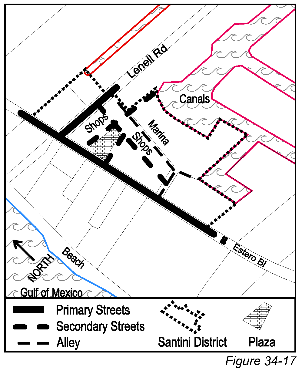
(2)
For properties zoned into the Santini district rather than in a PD district, the applicable regulations are as follows:
a.
Continued use of existing buildings. The regulations in this section apply to the continued use of existing buildings and structures for allowable uses as defined in Tables 34-1 and 34-2 for the Santini zoning district.
b.
Renovating, enlarging or replacing individual buildings.
1.
Existing buildings may be renovated, enlarged, or replaced as follows:
(i)
Physical enlargement of existing buildings is permitted provided that the improvements do not constitute a "substantial improvement" as that term is defined in § 6-405 of this code; and
(ii)
Replacements for existing buildings are permitted provided that they will not increase the existing floor area ratio, as that term is defined in § 34-633 of this chapter.
2.
Renovations, enlargements, and replacements to existing buildings are governed by the regulations for the CM zoning district as provided in Table 34-3 and by the other limitations in this section.
3.
The commercial design standards (§§ 34-991—34-1010 of this chapter) shall apply to all commercial and mixed-use buildings, or portions thereof, that are being newly built.
4.
Any specific deviations granted by prior CPD resolutions shall remain in effect for properties that are zoned into the Santini district.
(3)
Transformation of existing businesses into a neighborhood center. Physical enlargements of existing buildings that constitute a "substantial improvement" as that term is defined in § 6-405 of this chapter must be in the form of a neighborhood center as described in § 34-683 below.
Sec. 34-683. - Creation of neighborhood center.
(a)
Purpose. This section provides detailed regulations for the transformation of existing businesses into a neighborhood center.
(1)
This transformation may be required by § 34-682(3) of this chapter or may be chosen by any landowner in the Santini district.
(2)
Once this option is chosen or required, all subsections of this § 34-683 become mandatory requirements, except where they are clearly inapplicable to a given portion of the property.
(b)
Agreement for streetscape improvements. Landowners who choose to partially or fully develop their land in the Santini district into a neighborhood center may simultaneously request public streetscape improvements by entering into a development agreement with the town (see §§ 2-91—2-102 of this LDC).
(1)
This agreement would establish a public/private partnership for the necessary improvements, identifying responsibilities, timing, approximate costs, and funding.
(2)
This agreement would also contain a detailed plan for the redevelopment of the property consistent with the regulations in the remainder of this section.
(c)
Allowable uses. Allowable uses for the Santini zoning district are defined in Tables 34-1 and 34-2.
(d)
Streets. Secondary streets and alleys shall be laid out and dedicated to the public generally in accordance with Figure 34-17 to improve circulation for vehicles and pedestrians.
(e)
Plazas. An urban plaza at least one-half acre in size shall be provided along Estero Boulevard as a focal point for mixed-use buildings and as a public gathering place. This plaza may also be used for overflow parking.
(f)
Build-to lines established. Build-to lines (see § 34-662 of this chapter) vary according to the streets and street types designated on Figure 34-17.
(1)
Build-to lines for all primary streets and streets surrounding the plaza are 0 feet to five feet.
(2)
Build-to lines for all secondary streets are 0 feet to ten feet.
(3)
Awnings, canopies, and marquees over sidewalks and pedestrian walkways are encouraged by the commercial design standards (§§ 34-991—34-1010 of this chapter), especially along Estero Boulevard.
(4)
Compliance with build-to lines is not required for buildings that are used for the storage of boats or for marina accessory uses, or for any buildings extend closer than 40 feet to the waterfront.
(5)
Buildings used for the storage of boats or cars must be separated from Estero Boulevard by a liner building that provides usable building space at least 20 feet deep (see example in Figure 34-8).
a.
This requirement applies to all buildings that extend closer than 75 feet to Estero Boulevard.
b.
Liner buildings must be two stories or more in height.
c.
Liner buildings may be detached from or attached to building space used for the storage of boats or cars.
d.
Liner buildings must be constructed simultaneously with those portions of buildings that are subject to this requirement.
e.
Liner buildings and any visible portions of the principal facade of buildings that are used for the storage of boats or cars must meet the commercial design standards (see §§ 34-991—34-1010 of this chapter).
(g)
Setback lines. No minimum setbacks are required (see § 34-662 of this chapter).
(h)
Building frontage. Building frontage limits (see § 34-663 of this chapter) vary according to the street types designated on Figure 34-17:
(1)
For primary streets and streets surrounding the plaza, building frontages shall be at least 70 percent of the lot frontage.
(2)
For secondary streets, building frontages shall be at least 35 percent of the lot frontage.
(3)
For multiple adjoining lots under single control, or for a single lot with multiple buildings, the percentages above apply to the combination of lot(s) and building(s).
(4)
Phased redevelopment is permitted provided that a site plan is provided showing how the building frontage percentages will be met upon completion of the redevelopment
(i)
Building height. Building heights (see § 34-631 of this chapter) shall be limited to:
(1)
For parcels immediately abutting a plaza of at least one-half acre in size and for parcels immediately abutting canals, a maximum of 40 feet above base flood elevation and no taller than three stories.
(2)
For all other parcels, a maximum of 30 feet above base flood elevation and no taller than two stories.
(j)
Floor area ratio (FAR). Floor area ratios shall not exceed 1.0 (see § 34-633 of this chapter).
(k)
Residential density. Residential units can be constructed in the Santini district up to the maximum density allowed by the Fort Myers Beach Comprehensive Plan.
(l)
Residential intensity. Detached single-family and two-family residence building coverage shall not exceed 40 percent.
(m)
Guest units. Guest units may be substituted for dwelling units in accordance with the equivalency factors found in § 34-1802 of this chapter.
(n)
Reductions to minimum parking requirements. Neighborhood centers are "park-once" districts with preference given to pedestrian movement. The number of parking spaces normally required by § 34-2020 of this chapter shall be multiplied by 67 percent to determine the adjusted parking requirement for the Santini district. Adjoining on-street parking spaces may be counted toward this parking requirement.
(o)
Parking location. Off-street parking may be provided under commercial or mixed-use buildings provided that:
(1)
All under-building parking spaces must be separated from primary streets and the plaza by usable commercial space at least 20 feet deep that meets all commercial design guidelines; and
(2)
Driveways leading to under-building parking spaces must connect to a driveway, secondary street, or alley, and may not be accessed from a primary street or pedestrian plaza.
(p)
Commercial design standards. The commercial design standards (§§ 34-991—34-1010 of this chapter) shall apply to all commercial and mixed-use buildings, or portions thereof, that are being newly built, and to "substantial improvements" to such buildings as defined in § 6-405 of this LDC.
(Ord. No. 24-24, § 2(Exh. A), 9-23-2024)
Sec. 34-691. - Purpose.
The purpose of the Village district is to provide alternative futures for the Red Coconut and/or Gulf View Colony, either a continuation of the current land uses or their transformation into a traditional neighborhood pattern.
(1)
The existing residences and businesses in the Village district may continue in full operation and may be renovated in accordance with §§ 34-692 and 34-694 of this chapter.
(2)
As an alternative, the Village district provides a second set of regulations that would allow the transformation of either of the existing mobile home and recreational vehicle parks into more permanent and durable housing types in a traditional neighborhood pattern, in accordance with the design concepts in the Fort Myers Beach Comprehensive Plan.
Sec. 34-692. - District map and applicability.
The area indicated on Figure 34-18 is the outer boundary of the Village district.
(1)
Properties that have been zoned into a planned development (PD) district are governed by the terms of the PD zoning resolution rather than the requirements of the Village district, even if the property is shown on Figure 34-18.
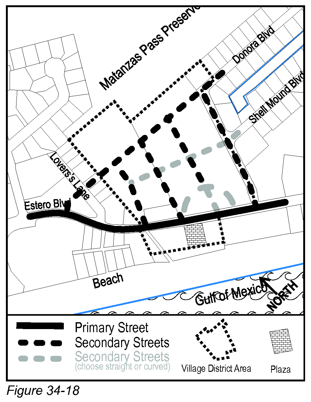
(2)
For properties zoned into the Village district rather than in a PD district, existing residences and businesses may continue in full operation and may be modified in accordance with the following regulations:
a.
Continued use of existing mobile homes and recreational vehicles. The continued use of existing mobile homes and recreational vehicles is permitted in accordance with § 34-694 below.
b.
Continued use of and renovations, enlargements, or replacement of existing permanent buildings.
c.
Existing permanent buildings may be renovated, enlarged, or replaced as follows:
1.
Renovations and/or physical enlargement are permitted provided the improvements do not constitute a "substantial improvement" as that term is defined in § 6-405 of this code; or
(i)
Replacement buildings are permitted provided that they do not increase the existing floor area ratio, as that term is defined in § 34-633 of this chapter; or
(ii)
Other renovations, enlargements, and/or replacements are permitted provided they comply with those regulations for the CB zoning district that are found in §§ 34-704—34-706 of this chapter.
2.
Allowable uses in these buildings are the same as provided in § 34-703(a) of this chapter for the CB zoning district.
3.
The commercial design standards (§§ 34-991—34-1010 of this chapter) shall apply to all commercial and mixed-use buildings that are visible from Estero Boulevard, or portions thereof, that are being newly built, and to "substantial improvements" to such buildings as defined in § 6-405 of this LDC.
(3)
Transformation of existing mobile home and recreational vehicle parks. Policies 3-A-5, 3-A-6, and 4-F-2-iii of the Fort Myers Beach Comprehensive Plan have authorized a pre-approved redevelopment option for land in the Village district.
a.
The following concepts are expected in this redevelopment process:
1.
Traditional neighborhood design emphasizing streets that are interconnected and dwellings with porches or balconies on the front, primary entrances visible from the street, and cars to the rear (except for on-street parking);
2.
Detached houses or cottages (with optional accessory apartments) abutting existing single-family homes;
3.
Low-rise townhouses or apartments allowed elsewhere on the site;
4.
Walkable narrow streets with shade trees that double as view corridors to the Preserve and Gulf;
5.
Open space that allows views to be maintained from Estero Boulevard to the Gulf;
6.
Mixed commercial and residential uses along the bay side of Estero Boulevard;
7.
Quiet internal street connections to the north and south;
8.
Significantly reduced density from the existing level of 27 RV/mobile homes per acre at the Red Coconut to a maximum level of 15 dwelling units per acre; and
9.
A site design that accommodates a publicly acquired access point to the Matanzas Pass Preserve.
b.
At the option of landowners in the Village district, a development order may be obtained to redevelop all or part of this property in accordance with the option described in more detail in § 34-693 below, and generally in accordance with either of the conceptual site plans found in the community design element of the Fort Myers Beach Comprehensive Plan. Until such time as this development order is obtained, the regulations in § 34-693 below shall have no effect.
Sec. 34-693. - Regulations to obtain development order for pre-approved redevelopment option.
(a)
Purpose. his section provides detailed regulations for the pre-approved redevelopment option if that option is chosen by landowners, as described in § 34-692(3) of this chapter.
(b)
Allowable uses. Allowable uses in the Village district are defined in Tables 34-1 and 34-2. If a development order is issued pursuant to § 34-692(3) of this chapter, the additional uses in the "Open" subgroup of Table 34-1 for the residential, lodging, office, and retail groups will be permitted on property that is subject to the development order.
(c)
Streets. Secondary streets shall be laid out and dedicated to the public generally in accordance with Figure 34-18 to improve circulation for vehicles and pedestrians.
(1)
Figure 34-18 provides two acceptable options for the new network of secondary streets.
(2)
Under either option, the street design must incorporate the extension of a through street from Donora Boulevard to Lovers Lane that will be permanently accessible by the public.
(d)
View corridor. A view corridor at least 50 feet wide shall be provided between Estero Boulevard and the Gulf as a focal point for abutting buildings and as part of a prominent visual corridor to the water. This view corridor need not be available for public use.
(e)
Build-to lines established. Build-to lines (see § 34-662 of this chapter) for all streets shall be 0 feet to ten feet.
(f)
Setback lines established. Setback lines (see § 34-662 of this chapter) are established as follows:
(1)
For principal buildings, minimum setbacks are as follows:
a.
Rear setbacks: 20 feet.
b.
Waterbody setbacks: see § 34-638(d)(3) of this chapter.
(2)
For accessory structures, minimum setbacks are set forth in §§ 34-1171—34-1176 of this chapter.
(g)
Building frontage. Building frontage limits (see § 34-663 of this chapter) vary according to the street types designated on Figure 34-18:
(1)
For primary streets, building frontages shall be at least 50 percent of the lot frontage. This percentage may be reduced to 35 percent for properties between Estero Boulevard and the Gulf of Mexico provided that the open space thus created allows open views to the Gulf.
(2)
For multiple adjoining lots under single control, or for a single lot with multiple buildings, the percentages above apply to the combination of lot(s) and building(s).
(h)
Building height. Building heights (see § 34-631 of this chapter) shall be limited to:
(1)
For properties that front on the bay side of Estero Boulevard and all streets other than Estero Boulevard, a maximum of 30 feet above base flood elevation and no taller than two stories. However, for mixed-use buildings and for elevated buildings without enclosed space on the first story, the maximum height is three stories (but still limited to 30 feet above base flood elevation).
(2)
For properties that front on the beach side of Estero Boulevard, a maximum of 40 feet above base flood elevation and no taller than three stories.
(i)
Building intensity. Commercial and mixed-use building intensity shall be evaluated using floor area ratio (FAR). Detached single-family and two-family residence intensity shall be evaluated using building coverage (see § 34-634 of this chapter).
(1)
Floor area ratio (FAR). Floor area ratios shall not exceed 1.2.
(2)
Building coverage. Building coverage (See § 34-634 of this chapter) for detached single-family and two-family residences shall not exceed 40 percent.
(j)
Residential density. Policy 4-F-2-iii of the Fort Myers Beach Comprehensive Plan allows up to 15 dwelling units per acre for redevelopment in accordance with this section. Any land used for roadway or access purposes may be included in this density computation.
(k)
Guest units. Guest units may be substituted for dwelling units in accordance with the equivalency factors found in § 34-1802 of this chapter.
(l)
Circulation and parking. Off-street parking may be provided under commercial or mixed-use buildings provided that:
(1)
All under-building parking spaces must be separated from primary streets and the plaza by usable commercial space at least 20 feet deep that meets all commercial building design guidelines; and
(2)
Driveways leading to under-building parking spaces must connect to a secondary street or an alley and may not be accessed from a primary street or pedestrian plaza.
(m)
Commercial design standards. The commercial design standards (§§ 34-991—34-1010 of this chapter) shall apply to all commercial and mixed-use buildings that are visible from Estero Boulevard, or portions thereof, that are being newly built, and to "substantial improvements" to such buildings as defined in § 6-405 of this LDC.
(Ord. No. 24-24, § 2(Exh. A), 9-23-2024)
Sec. 34-694. - Regulations for existing mobile homes and recreational vehicles.
(a)
Definitions. These phrases, when used in this subdivision, shall have the following meanings:
Park trailer means a transportable recreational vehicle which has a body width not exceeding 14 feet and which is built on a single chassis and is designed to provide seasonal or temporary living quarters when connected to utilities necessary for operation of installed fixtures and appliances. "Park trailers" have a statutory definition in F.S. § 320.01(b) which may change; the use of the term "park trailer" in this subdivision is intended to change with any such statutory changes so as to be consistent with state law.
Transient RV park means a recreational vehicle development designed, intended for, or used by relatively short-stay visitors (transient guests) who bring their transient recreational vehicle with them and remove it at the end of their visit. The individual recreational vehicle site is then ready for another visitor.
Transient recreational vehicle means a camping trailer, truck camper, motor home, travel trailer, motor home, or van conversion (as those terms are defined by F.S. § 320.01(b)) which is brought to the transient recreational vehicle park by the user and is removed from the park at the end of the user's visit. Park trailers are not considered to be transient recreational vehicles.
(b)
1987 site plan approvals. Lee County approved site plans for Gulf View Colony and Red Coconut in 1987 to formally acknowledge the right to replace mobile homes and nontransient recreational vehicles in portions of each park in accordance with previous regulations. These site plans were approved in accordance with Lee County Ordinance No. 86-36. The Town of Fort Myers Beach will continue to recognize those rights, which are incorporated into the regulations set forth in this section.
(1)
Sites in Gulf View Colony and Red Coconut shall not be reconfigured or reduced in dimension so as to increase the density.
(2)
Contiguous sites may be combined and redivided to create larger dimension sites as long as such recombination includes all parts of all sites, and allowable density is not increased, and all setback requirements are met.
(3)
The use of a recreational vehicle or park trailer by a permanent resident as a permanent residence, as the terms are defined in F.S. ch. 196, has been expressly prohibited since September 16, 1985. Persons who have established permanent residency within a recreational vehicle park as of September 16, 1985, are exempt from the residency provisions of this section, provided that the proof of residency was established by an affidavit filed with Lee County prior to October 31, 1985.
(4)
Permits shall also be issued for reroofing and roof repairs for any existing mobile home, park trailer, or recreational vehicle, regardless of lot size.
(c)
Gulf View Colony. A site plan for Gulf View Colony was approved by Lee County on February 11, 1987, which showed 59 mobile homes sites plus common recreational features. This plan was drawn by G. H. Taylor and was dated January 10, 1987.
(1)
Lee County approved the replacement of a mobile home or park trailer on all 59 sites. These sites were determined to have been in compliance with regulations that were in effect at the time of their creation.
(2)
Replacement of mobile homes or park trailers on these sites must meet the following regulations:
a.
All units shall have a minimum separation of ten feet between units (body to body) and appurtenances thereto. Each unit shall be permitted to have eaves which encroach not more than one foot into the ten-foot separation.
b.
Replacement mobile homes, park trailers, and additions must meet the floodplain elevation requirements of § 6-472(2) of this LDC, including the limitations on replacements where past flooding has caused "substantial damage" on specific sites.
c.
A move-on permit must be obtained in accordance with § 34-1923 of this chapter and the mobile home or park trailer must comply with the tie-down and skirting requirements of that section.
d.
One freestanding storage shed or utility room, not exceeding 120 feet in floor area and ten feet in height, may be permitted provided that:
1.
No storage shed or utility room shall be located closer than five feet to any side or rear lot line or closer than ten feet to any mobile home or park trailer under separate ownership; and
2.
The shed or room is properly tied down and complies with all building code requirements.
e.
Additions to mobile homes or park trailers may be permitted provided that:
1.
The addition shall not be located closer than five feet to any side or rear lot line or closer than ten feet to any mobile home, park trailer, or addition thereto under separate ownership.
2.
The total floor area of any additions, excluding open decks and stair landings, shall not exceed the total floor area of the mobile home or park trailer.
3.
The maximum height of additions shall not exceed the height of the mobile home or park trailer.
4.
Open decks, up to 120 square feet in area, may be permitted provided all setback requirements are met. Stair landings that are incorporated into a deck shall be calculated in the square footage of the deck.
5.
Stairs or stair landings, which are attached to an addition, and which are not incorporated into an open deck, may be permitted to encroach three feet into the side and rear setbacks. No stair landing shall exceed 12 square feet in area.
(d)
Red Coconut. Parts of a site plan for the Red Coconut were approved by Lee County on June 2, 1987. This plan was drawn by David Depew and was dated May 20, 1987.
(1)
Sites approved in 1987. Lee County approved the replacement and potential enlargement of a mobile home or park trailer on each of the following sites: A7-A9, A12-A15, B12, B14-B16, C1, C7, D1, D2, D6, D8-D17, E1-E16, E18-E20, F1—9, and G2-G12.
a.
These sites were determined to have been in compliance with regulations that were in effect at the time of their creation.
b.
Replacement mobile homes or park trailers on these sites must follow the same regulations as provided in subsection (c)(2) of this section; however, if a mobile home or park trailer incurs "substantial damage" as that term is defined in § 6-405 of this LDC, the landowner also has the option to merge that site into the transient RV park and use the site in accordance with subsection (d)(3) of this section.
(2)
Sites not approved in 1987. Some smaller sites that also contained a mobile home or non-transient recreational vehicle were not approved for larger units in 1987: AA, A1-A6, A10-A11, A16-A17, B1-B11, B13, C2-C6a, C8-C10, D3-D5, D7-D7A, E17, K2, P2-P3, Z2-Z3, and 1-6 on the bay side of Estero Boulevard. Units on these sites may be replaced only by a unit of equal or smaller size, in accordance with the following regulations:
a.
Any mobile home or non-transient recreational vehicle which has been lawfully placed on these sites may be replaced by a mobile home or park trailer of equal or smaller size. The director may use historical aerial photographs, or previous county or town permits if available, to verify that a replacement unit is not larger than a previous lawful unit. No additions which would cause the total size to exceed the size of the previous lawful unit will be permitted.
b.
Replacement mobile homes and park trailers must meet the floodplain elevation requirements of subsection (c)(2)b of this section; however, if a mobile home or park trailer incurs "substantial damage" as that term is defined in § 6-405 of this LDC, the landowner also has the option to merge that site into the transient RV park and use the site in accordance with subsection (d)(3) of this section.
c.
A move-on permit must be obtained in accordance with § 34-1923 of this chapter and the mobile home or park trailer must comply with the tie-down and skirting requirements of that section.
d.
One storage shed or utility room may be permitted if in compliance with subsection (c)(2)d of this section.
(3)
Transient RV park. The remainder of the sites shown on this plan may continue in operation as a transient RV park. These sites can be identified on the 1987 site plan as follows: on the Gulf of Mexico, sites 1-53; on the bay side of Estero Boulevard, sites CE1-CE7, CWOO-CW6, CRD, H1-H10, J1-J10, K1, K3-K18, L1-L4, M1-M4, N1-N14, P1, R1-R3, Y-Y-Y-Y, and Z1. The following regulations apply to these 147 sites:
a.
Transient recreational vehicles must comply with the floodplain regulations found in § 6-472(3) of this LDC.
b.
Additions may not be constructed onto transient recreational vehicles.
c.
Storage sheds and other accessory structures may not be placed on individual sites.
d.
All travel trailers, motor homes or camping trailers may not be left unattended for more than two weeks during the months of June through December. For purposes of this section only, the term "unattended"' shall be interpreted to mean that the owner of the unit has not provided for a person to be responsible for the unit in the event of a hurricane watch alert as set forth in the following subsection.
e.
All travel trailers, motor homes or camping trailers shall be tied down within 48 hours of the issuance of a hurricane watch for the town by the National Hurricane Center. Travel trailers, motor homes or camping trailers not tied down shall be removed from the county within 48 hours of such a hurricane watch, or placed within an approved off-lot storage area.
(Ord. No. 16-09, § 1, 12-19-2016)
Sec. 34-701. - Purpose.
The purpose of the CB (Commercial Boulevard) district is provide standards for existing commercial uses and certain other uses along those portions of Estero Boulevard where the "boulevard" classification of the Fort Myers Beach Comprehensive Plan promotes a mixed-use development pattern.
Sec. 34-702. - Applicability.
(a)
The regulations of this code section allow for the continuation of existing uses, plus additional uses listed in Table 34-2 and further defined in section 34-703.
(b)
The regulations of this code section allow for:
(1)
Continuation of existing buildings and structures,
(2)
Enlargement or expansion of existing structures, in compliance with all of the building placement, size, and design criteria of the CB zoning district regulations, and
(3)
Replacement in compliance with the building placement, size, and design criteria of the CB zoning district regulations.
(Ord. No. 21-07, § 2, 11-15-2021; Ord. No. 24-26, § 2(Exh. A), 10-28-2024)
Sec. 34-703. - Uses.
(a)
In the CB district, allowable uses are defined as any of the following:
(1)
Those uses defined in Table 34-2 for the CB district, with additional regulations as defined in § 34-703(b);
(2)
Continuation of the commercial uses that were previously allowed on the site, prior to the permit request. Evidence of the previous use may include websites, pictures, pamphlets, permits, tax receipts or similar documentation.
(b)
Any landowner wishing to place other new or expanded commercial uses on property that is zoned CB must comply with the following:
(1)
New outdoor entertainment is allowed with approval of a commercial special exception. Outdoor, for this section, includes any area that is not surrounded by permanent walls and windows;
(2)
New live entertainment is not permitted without approval of a special exception;
(3)
New outdoor seating areas must close at sunset unless approved by special exception.
(c)
Any landowner wishing to subdivide land that is zoned CB into residential homesites must comply with all of the setback, lot size, intensity, and density regulations for the RC zoning district as described in Table 34-3. Compliance with these regulations shall substitute for the building placement standards that are found in § 34-704 below, and for the intensity standard found in § 34-705(c) of this chapter.
(Ord. No. 24-26, § 2(Exh. A), 10-28-2024)
Sec. 34-704. - Building placement.
(a)
Build-to lines established.
(1)
Build-to lines for structures other than detached single-family and two-family residences (see § 34-662 of this chapter) for Estero Boulevard are established at five to ten feet from front property lines. Awnings, canopies, and marquees over sidewalks and pedestrian walkways are encouraged by the commercial design standards (§§ 34-991—34-1010 of this chapter).
(2)
Detached single-family and two-family residential structures build-to lines from Estero Bouledvard are established at five feet to 18 feet to allow additional setback for a driveway, if desired.
(b)
Setback lines established. Setback lines (see § 34-662 of this chapter) are established as follows:
(1)
For principal buildings:
a.
Minimum street setbacks for all streets other than Estero Boulevard are ten feet.
b.
Minimum rear setbacks are 20 feet from rear property lines.
c.
Minimum side setbacks are five feet from side property lines.
d.
Minimum setbacks from waterbodies are set forth in § 34-638(d)(3) of this chapter.
(2)
For accessory structures, minimum setbacks are set forth in §§ 34-1171—34-1176.
(Ord. No. 24-26, § 2(Exh. A), 10-28-2024)
Sec. 34-705. - Building size.
(a)
Building frontage. Building frontage limits (see § 34-663 of this chapter) are established as follows:
(1)
For Estero Boulevard, building frontages shall be at least 50 percent of the lot frontage. This percentage may be reduced to 35 percent for properties between Estero Boulevard and the Gulf of Mexico provided that the open space thus created allows open views to the Gulf of Mexico.
(2)
For multiple adjoining lots under single control, or for a single lot with multiple buildings, the percentages above apply to the combination of lot(s) and building(s).
(b)
Building height. Building heights (see § 34-631 of this chapter) shall be limited to:
(1)
For properties that front on the bay side of Estero Boulevard and all streets other than Estero Boulevard, a maximum of 30 feet above base flood elevation and no taller than three stories.
(2)
For properties that front on the beach side of Estero Boulevard, a maximum of 40 feet above base flood elevation and no taller than three stories.
(c)
Floor area ratio (FAR). Floor area ratios (see § 34-633 of this chapter) shall not exceed 1.0 for all structures other than detached single-family and two-family homes.
(d)
Building coverage. For detached single-family and two-family residences, building coverage (see § 34-634 of this chapter) shall not exceed 40 percent.
(Ord. No. 24-24, § 2(Exh. A), 9-23-2024; Ord. No. 24-26, § 2(Exh. A), 10-28-2024)
Sec. 34-706. - Circulation and parking.
(a)
Parking lot locations. Off-street parking lots shall be placed in side or rear yards (see Figure 34-5). Off-street parking lots are not permitted in front yards.
(b)
Under-building parking. Off-street parking may be provided under commercial or mixed-use buildings provided that all under-building parking spaces are screened in accordance with § 34-693(l) of this chapter.
(c)
Parking lot interconnections. Wherever physically possible, parking lots for abutting properties fronting along Estero Boulevard shall be interconnected to eliminate or minimize driveways to Estero Boulevard.
(1)
To ensure the effective use of these connections, the first to develop shall be required to make an irrevocable offer of cross-access to the adjacent parcel (prior to issuance of a development order), and must design and build the parking lot to accommodate cross-access.
(2)
When adjacent owners seek development orders, they will also be required to reciprocate with a similar cross-access agreements and then must complete the physical connection.
(3)
Individual property owners shall control all rights to the use of their own parking spaces, but may choose to allow wider use of these spaces for a fee of their choosing or through reciprocal arrangements with other parties.
(d)
Driveway connections for properties fronting on Estero Boulevard. Existing driveways and parking spaces shall be relocated from Estero Boulevard to other streets and new driveways shall connect only to other streets, except where these requirements would prohibit all reasonable access to a property. When a driveway onto Estero Boulevard is unavoidable, the driveway shall be shared with an adjoining property if that property also has access only to Estero Boulevard. Otherwise, the driveway shall be spaced as far as practical from other driveways or intersections.
(Ord. No. 21-07, § 2, 11-15-2021)
Sec. 34-707. - Commercial design standards.
Sec. 34-931. - Purpose and effect.
(a)
Purpose. The general purpose of planned development zoning districts is to provide a degree of flexibility for a landowner to propose the development of land in a manner that differs from the specific provisions of this code, and to allow the town council the ability to evaluate such a proposal relative to specific conditions on and around the site and as to its compliance with the Fort Myers Beach Comprehensive Plan.
(b)
Effect. A planned development, once approved through the rezoning process, can only be developed in accordance with the specific master concept plan and special conditions that are contained in the zoning resolution approving the planned development. See §§ 34-217—34-220 of this chapter for details on the effect of planned development zoning.
Sec. 34-932. - Regulation of land use in planned developments.
(a)
General requirements and special conditions. All uses of land, water, and structures permitted in a planned development shall be subject to:
(1)
The general requirements for planned developments;
(2)
All applicable regulations in this code, except where approval is granted to deviate from one or more of those regulations;
(3)
An adopted master concept plan; and
(4)
Various special conditions which may be formulated and applied to address unique aspects of the parcel in the protection of a bona fide public interest:
a.
The source of such conditions may include good planning practice as well as those specifications set forth in the application documents, plus policies and standards set forth in the Fort Myers Beach Comprehensive Plan.
b.
All special conditions shall be reasonably related to the proposed development and to any reasonably expected impacts on public services and facilities and the public safety, health and general welfare.
c.
Special conditions shall be adopted as part of the zoning resolution approving the planned development.
(b)
Deviations. To allow design flexibility in developing land, deviations from specific provisions of this code may be permitted where it can be demonstrated that the planned development will be enhanced and that the intent of such regulations to protect health, safety and welfare will be served. Other portions of this code may provide additional criteria for certain deviations (for example, see § 34-992(e) of this chapter, regarding deviations from commercial design standards). No deviation may be granted that is inconsistent with the comprehensive plan.
(1)
Requested deviations shall be set forth on the master concept plan or in the application and shall be accompanied by documentation including sample detail drawings.
(2)
Approved deviations shall be adopted as part of the zoning resolution approving the planned development.
(c)
Density or intensity of use. Density or intensity of use permitted in any planned development shall be determined by the town council in the zoning resolution in accordance with the following:
(1)
The density or intensity of the uses permitted or encouraged under the Fort Myers Beach Comprehensive Plan at that location; and
(2)
The nature of and the density and intensity of existing or proposed development surrounding the project.
(d)
Phasing. The town council may specify a phasing plan in the resolution in accordance with § 34-220 of this chapter.
(e)
Other requirements for planned developments.
(1)
Specific application requirements for planned development zoning districts are set forth in §§ 34-212—34-215 of this chapter.
(2)
Procedures to amend a planned development zoning district are set forth in § 34-214 and 34-219 of this chapter.
(3)
Other requirements for planned developments are found in §§ 34-211—34-410 of this chapter.
Sec. 34-933. - Allowable uses of land.
(a)
Proposed principal and accessory land uses must be listed on the proposed master concept plan, identifying such uses by citing the same uses allowed by a specific zoning district, or by citing the enumerated uses of one or more use groups or subgroups as found in Tables 34-1 and 34-2 of this article. Approved planned developments that used a different method for enumerating uses shall be interpreted in accordance with the use regulations in effect at the time of that approval.
(b)
Approved uses shall be adopted as part of the zoning resolution approving the planned development. Uses that are not specifically listed may also be permitted if, in the opinion of the director, the uses and their expected impacts are substantially similar to an approved use.
Sec. 34-941. - Intent of RPD (Residential Planned Development) zoning district.
The intent of the RPD district is to allow a landowner the ability to submit a specific proposal for a land development that is primarily residential in character and that complies with the Fort Myers Beach Comprehensive Plan, but which does not meet the specific requirements of a conventional or redevelopment zoning district.
Sec. 34-942. - Allowable uses of land.
Allowable principal and accessory land uses in an RPD zoning district shall be established in each zoning resolution in accordance with § 34-933 of this chapter. Certain of the use sub-groups enumerated in Table 34-1 are not available in RPD zoning districts; see footnotes under Table 34-2.
Sec. 34-943. - Building placement, size, design, and other property development regulations.
Building placement, size, design, and all other property development regulations in an RPD zoning district shall be the same as for the RM zoning district, unless the zoning resolution specifies otherwise. Exceptions are as follows:
(1)
Compliance with the master concept plan and any special conditions may provide additional restrictions.
(2)
Approved deviations may modify or eliminate restrictions that would otherwise apply.
Sec. 34-951. - Intent of CPD (Commercial Planned Development) zoning district.
The intent of the CPD district is to allow a landowner the ability to submit a specific proposal for a land development that is primarily nonresidential or mixed-use in character and that complies with the Fort Myers Beach Comprehensive Plan, but which does not meet all of the specific requirements of a conventional or redevelopment zoning district.
Sec. 34-952. - Allowable uses of land.
Allowable principal and accessory land uses in a CPD zoning district shall be established in each zoning resolution in accordance with § 34-933 of this chapter.
Sec. 34-953. - Building placement, size, design, and other property development regulations.
Building placement, size, design, and all other property development regulations in a CPD zoning district shall be the same as for the CR zoning district for CPDs that are primarily lodging, or for the CB zoning district for all other CPDs, unless the zoning resolution specifies otherwise. Exceptions are as follows:
(1)
Compliance with the master concept plan and any special conditions may provide additional restrictions.
(2)
Approved deviations may modify or eliminate restrictions that would otherwise apply.
Sec. 34-954. - Commercial design standards.
The commercial design standards (§§ 34-991—34-1010 of this chapter) shall apply to all commercial and mixed-use buildings or portions thereof that are being newly built, and to "substantial improvements" to such buildings as defined in § 6-405 of this LDC, on properties that are zoned CPD (commercial planned development).
Sec. 34-961. - Former MPD zoning district.
The MPD (mixed-use planned development) zoning district had been assigned to certain developments which had received zoning approval prior to major amendments to this code. MPD zoning was automatically converted to CPD zoning through revisions to this chapter which became effective on March 3, 2003. All rights and restrictions previously authorized by MPD zoning resolutions remain in full force and effect after the conversion to CPD zoning.
Sec. 34-962. - Former PUD zoning district.
The PUD (planned unit development) zoning district had been assigned to certain developments which had received preliminary or final approval as a planned unit development prior to 1985. PUD zoning was automatically converted to CPD zoning through revisions to this chapter which became effective on March 3, 2003. All rights and restrictions previously authorized by PUD zoning resolutions remain in full force and effect after the conversion to CPD zoning.