
Frederick City Zoning Code
Sec. 411
TRADITIONAL NEIGHBORHOOD DEVELOPMENT "TND"
Purpose: The Traditional Neighborhood Development (TND) option is designed to permit the development of land in a manner consistent with the historic and timeless principles of Frederick's existing neighborhoods. A TND combines a variety of housing types with commercial and civic uses in a compact, walkable neighborhood setting. TND's feature a highly interconnected street network and setbacks appropriate to create a public realm built on a human scale. A TND should be developed such that the street network recognizes and complements a site's topography and other natural features.
This section provides a "form-based" code framework to authorize TND's. It establishes minimum densities, build-to lines (maximum setbacks), and design standards to ensure that new development conforms to the Comprehensive Plan's principles for urban design. It also permits a limited number of cul-de-sacs and conventional building forms in order to provide market flexibility.
This section implements the following policies of the Comprehensive Plan:
• LU1.4 - Implement small area plans through urban design as well as recommended land use or redevelopment changes.
• LU.9.3 - Facilitate the development of communities that mix residential, institutional, commercial and office uses to provide convenience, increase opportunities for walking and transit service, and reduce the number and length of automobile trips. The non-residential uses in these communities should be compatible in design and scale with surrounding neighborhood development.
• LU.9.4 - Implement interconnections between neighborhoods, including more street grids and non-motorized pathways.
• LU.9.6 - Develop regulatory incentives for mixed use development that encourage the planned, coordinated development of mixed land uses on adjacent properties.
• LU.12.5 - Explore ways to retrofit certain existing neighborhoods with traditional neighborhood design aspects to enhance walkability.
• LU.13.4 - Consider providing incentives that encourage developers to achieve high-quality design and energy efficiency in new developments.
• T.4 - As part of the update to the City's development regulations, review and update existing standards for different types of roadways and bicycle and pedestrian facilities.
• T.7.2 - Improve the safety of pedestrian and bicycle travel through revised roadway design standards that accommodate all modes of transportation, reduce travel speeds on local and collector roads and/or employ traffic calming measures.
(a)
Applicability and Approval Procedures.
(1)
A TND may be approved in any zoning district except M1, M2 or MO.
(2)
A TND requires the approval of a Master Plan as provided in Section 310 of this Code.
(3)
The Master Plan for a TND is subject to the performance standards established in Section 407 of this Code in addition to the regulations established in this section.
(4)
All requirements of this Code not expressly eliminated or modified by this section apply to the TND.
(b)
Land Use and Density.
(1)
Density. The Master Plan must indicate the requested densities, in terms of number of units per gross residential acre and total number of dwelling units. The Subdivision Plat or Master Plan for a TND must comply with Table 411-1.
Table 411-1 Use and Density
Rules of Interpretation for Table 411-1:
Column (A): Applicable land use categories.
Column (B): The minimum percentage of the gross land area that must be devoted to the land use shown in Column (A).
Column (C): The maximum percentage of the gross land area that must be devoted to the land use is shown in Column (A).
Column (D): The minimum density for residential uses.
Column (E): The maximum density for residential uses.
Column (F): The minimum floor area ratio (FAR) for the particular use on an individual lot.
Column (G): The maximum floor area ratio (FAR) for the land use on an individual lot.
A dash (—) indicates that the standard does not apply.
(2)
Accessory Detached Dwelling Units are permitted on any lot designated for Detached Dwellings in accordance with Section 802 of this Code.
(3)
Commercial Buildings:
A.
The total square footage of commercial buildings in the development site must be at least 15,000 square feet.
B.
The square footage of commercial buildings for a TND that exceeds 375 dwelling units is computed as follows:
WSB = DU × 40, where
WSB = total gross square footage of commercial buildings
DU = total number of dwelling units
Example: A proposed TND has 600 dwelling units. The minimum square footage of commercial buildings is 24,000 square feet (600 × 40).
(c)
Design Standards.
(1)
Location.
A.
A TND may be located adjacent to, but must not be bisected by, an arterial street unless the street is designed to conform to the requirements of an avenue or main street (see Section 611 of this Code).
B.
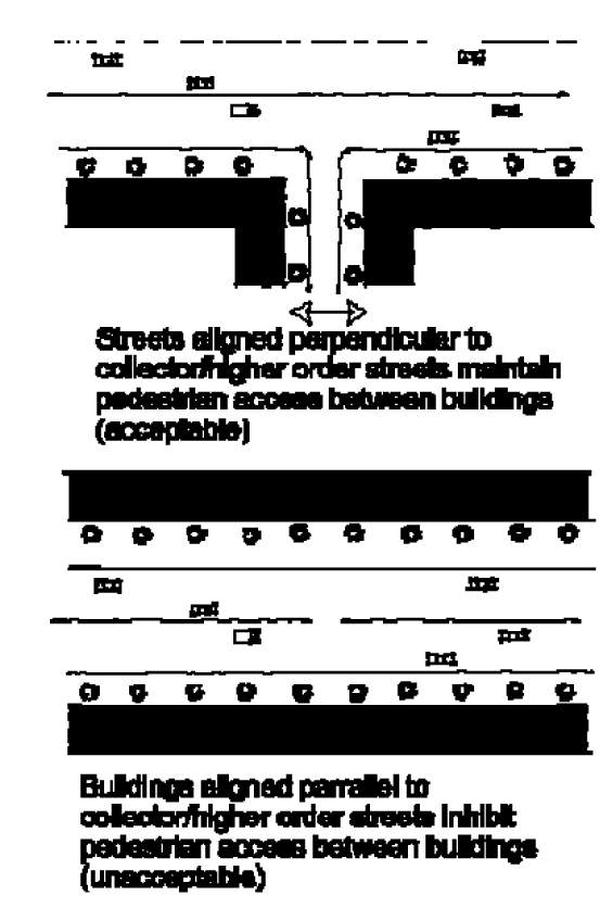
If a TND is located adjacent to a collector or higher classification street and the street is not designed to conform to the standards of an avenue or main street, the following criteria apply:
1.
The internal streets providing access to a TND must be aligned perpendicular to the collector or higher order street; and
2.
Building orientation along streets within the TND shall comply with subsection (g).
(2)
TND Subareas. The area covered under the Master Plan must be divided into the following subareas:
A. The Center Subarea.
B. The Neighborhood Subarea(s).
C. Parks and Open Space Subarea(s).
(A)
The Center Subarea.
1.
May include civic, retail, service, and multi-family uses;
2.
Shall only be located on a Main Street (as described in Section 611 of this Code);
3.
May face or surround the Square or Plaza;
4.
Must connect to the residential components of the community via a continuous system of sidewalks; and
(B)
The Neighborhood Subarea.
1.
Permitted land uses include multi-family and single-family attached and detached uses, small-scale retail and service uses, and public outdoor gathering places.
2.
All areas within a Neighborhood should be within a five-minute walking distance from edge to edge.
3.
A Neighborhood must be not less than ten acres or more than 40 acres in size, excluding greenbelts.
(C)
The Park and Open Space Subarea. The Plaza provides a community focal point and public gathering place, while the Greenbelt provides a clear edge to the community, open space for community residents, and natural areas for stormwater management. See subsection (c)(8).
(3)
Location of Uses.
A.
The location of uses is governed by street frontage, as follows:
Table 411-2 Traditional Neighborhood Development Use Location
Rules of Interpretation for Table 412-2: A "P" means that the use of building type is permitted. A dash ("—") means that the use or building type is not permitted. The street design standards are established in Section 611.
B.
Vistas. Prominent sites must be reserved for the following building types: (A) Civic Buildings, including government offices, libraries, museums, schools, or churches; (B) Hotels; or (C) Office Buildings. Buildings located on a prominent site must be at least two stories in height. A "prominent site" means the termination of a vista running from a Main Street, Boulevard, or Avenue and its intersection with an equal or lower order street.
(4)
Lot Arrangement.
A.
All lots must include frontage abutting a Street, except as provided in subsection (2) of this section.
B.
Twenty-five percent or fewer of the lots in designated neighborhood subareas may abut a park.
C.
A minimum percentage of dwelling units must be located within a five minute walk (1,320 feet) from the perimeter of a civic space as set forth in Table 411-3.
Table 411-3 TND Lot Distribution
D.
Blocks must have an average length not exceeding 400 feet, with no block exceeding 1,000 feet in length.
(5)
Dimensional Regulations.
A.
The minimum lot size and impervious surface ratio established in Section 405 of this Code may be modified by the Commission to more closely correspond with the setback and frontage standards established in Table 411-4.
B.
The setback for principal buildings must be as set forth in Table 411-4. The frontage and setback requirements do not apply to parks and open space. In order to allow for variations for unique uses, such as anchor retail tenants or auditoriums, the maximum frontage requirements in Column (C) must be computed as an average.
C.
The setback and lot coverage requirements for accessory structures per Section 803 may be modified within a TND provided:
1.
The distance between the principal structure and the accessory structure is a minimum of six feet; and
2.
The required distance between the structure and a public right-of-way is at least six feet; and
3.
The structure is not located within the sight distance triangle as described in Section 611 of this Code.
Table 411-4 Lot Dimensions and Setback for Principal Buildings
(6)
Building Design.
A.
Commercial Buildings may designate the entire building area above the ground floor or the second floor for residential use, subject to Section 838 (Mixed Use, Vertical). The applicant must submit floor plans identifying the use of each room.
B.
Building Orientation for commercial, mixed-use, and multi-family buildings shall be as follows:
1.
The buildings or structures that take access from the internal streets must face the internal streets.
2.
Buildings or structures may also be oriented to the collector or higher order streets. However, buildings or structures shall not be oriented exclusively to the collector or higher order streets. Orientation shall be based on the hierarchy of the adjacent road.
3.
Buildings must not be oriented such that the loading areas, rear, or unfinished portion of the façade faces the local streets or the collector or higher order streets.
4.
No rear yards shall face main streets, avenues, local roads or lanes.
C.
Buildings within a TND shall have the following design standards in accordance with Section 604:
Table 411-5 TND Building Design Standards
(7)
Transportation. See Street Improvement Standards (Section 611 of this Code). A TND shall use the specifications for Community Design Streets in Section 611(e). The Connectivity Ratio (see Section 611(j)) must be not less than 1.8.
(8)
Parks and Open Space.
A.
At least one of the following park types (referred to here as "Civic Spaces"), as defined in Section 608, must be included in any TND:
• Linear Park
• Green
• Square
• Park
• Playground or Tot Lot
• Plaza
• Dog Park
B.
No lot or dwelling unit within a TND shall be located further than the following distances from a civic space, measured from the exterior boundaries of the center and the exterior boundaries of the lot or building footprint:
Table 411-6 TND Civic Space Distancing Standards
(9)
Landscaping and Screening. The following standards of Section 605 do not apply to a TND:
A.
Landscape buffers and berms (Section 605(e)); and
B.
Parking lot interior landscaping requirements (Section 605(g)) for any parking area that is located in a rear yard or interior to a block.
(10)
Parking.
A.
The minimum parking space requirements of the Parking Standards (Section 607(b)) do not apply to a TND.
B.
Parking lots must be located at the rear of principal buildings or interior to a block.
C.
Parking lots and parking garages must not:
1.
Abut a street rights-of-way; or
2.
Occupy lots that terminate at a Vista (see subsection (c)(4), above).
D.
Loading areas must adjoin alleys or parking areas to the rear of the Principal Building.
E.
On-street metered and structured parking is permitted.
(d)
Traffic Impact Studies. The City hereby finds that the proximity of jobs and retail uses to housing in a TND development can achieve significant trip reductions produced by the internal capture of home-work and home-retail trips. The City further finds and determines that there is a compelling public interest to encourage new development to occur in accordance with the criteria set forth in this section. Accordingly, a Traffic Impact Study for a TND Master Plan filed pursuant to Article 12, Section 1203 may include a reduction in trips based on the following schedule:
Table 411-7 TND Trip Reductions for Traffic Studies
For purposes of computing the percentage established above, one dwelling unit or 800 square feet of non-residential space equals one equivalent unit.
(Supp. No. 4, Ord. No. G-07-3, § 2, 1-4-07)