
Fresno City Zoning Code
PART I
- GENERAL PROVISIONS
SEC. 15-101. - TITLE AND AUTHORITY.
Chapter 15 of the Fresno Municipal Code shall be known and cited as the "Citywide Development Code," "Development Code of the City of Fresno," "Development Code," "Code," or "Zoning Ordinance."
(Added Ord. 2015-39, § 1, eff. 1-9-16).
SEC. 15-102. - PURPOSE.
The purpose of this Development Code is to implement the General Plan and, if applicable, operative plans, to protect and promote the public health, safety, peace, comfort, convenience, prosperity, and general welfare of the City of Fresno. More specifically, the Development Code is adopted to achieve the following, consistent with the goals, objectives, and policies of the General Plan and any other operative plan:
A.
To provide a precise guide for the physical development of the city in a manner as to progressively achieve the arrangement of land uses depicted in the General Plan.
B.
To foster a harmonious and workable relationship among land uses and ensure compatible infill development.
C.
To support economic development and job creation.
D.
To provide for the housing needs of all economic segments of the community.
E.
To promote high quality architecture and sustainable design. Sustainable Design is a philosophy that seeks to maximize the quality of the built environment, while minimizing or eliminating negative impact to the natural environment.
F.
To promote the stability of existing land uses that conform to the General Plan, protecting them from inharmonious influences and harmful intrusions.
G.
To promote a safe and efficient traffic circulation system, including bicycle facilities and pedestrian amenities, and to support a multi-modal transportation system.
H.
To facilitate the appropriate location of community facilities, institutions, parks, and recreational areas.
I.
To protect and enhance real property values.
J.
To safeguard and enhance the appearance of the city.
K.
To define duties and powers of governing bodies and officials responsible for the implementation of this Code.
(Added Ord. 2015-39, § 1, eff. 1-9-16).
SEC. 15-103. - STRUCTURE OF DEVELOPMENT CODE REGULATIONS.
A.
Organization of Regulations. This Code consists of six parts:
1.
Part I: General Provisions
2.
Part II: Base and Overlay Districts
3.
Part III: Regulations Applying to Some or All Districts
4.
Part IV: Land Divisions
5.
Part V: Administration and Permits
6.
Part VI: General Terms and Definitions
B.
Types of Regulations. This Code contains five types of regulations controlling the use and development of property:
1.
Use Regulations. These regulations specify land uses permitted, conditionally permitted, or specifically prohibited in each zoning district, and include special requirements, if any, applicable to specific uses. Use regulations for base zoning districts and for overlay districts are in Part II of this Code. Certain regulations that are applicable in some or all districts, and performance standards which govern special uses, are in Part III.
2.
Development Standards. These regulations control the height, bulk, location, and appearance of structures. Development regulations for base zoning districts and for overlay districts are in Part II of this Code. Certain development regulations that are applicable to some or all districts are in Part III. These include regulations for specific uses, development and site regulations, performance standards, parking, and signage.
3.
Land Divisions. Also referred to as Subdivisions Regulations, these regulations control the division of land and specify the design, improvement, and survey data of subdivisions as well as the procedures to be followed to secure final approval for subdivision maps. Subdivision regulations are in Part IV.
4.
Administrative Regulations. These regulations contain detailed procedures for the administration of this Code, and include common procedures, processes, and standards for discretionary entitlement applications and other permits. Administrative regulations are in Part V.
5.
General Terms and Use Classifications. Part VI provides definitions and articulates use classifications and terms and definitions used in this Code.
(Added Ord. 2015-39, § 1, eff. 1-9-16).
SEC. 15-104. - APPLICABILITY.
A.
General Rules for Applicability of Development Code Regulations.
1.
Applicability to Property. This Development Code shall apply, to the extent permitted by State and Federal law, to all private property within the corporate limits of the City of Fresno, including all uses, structures, and land owned by any person, firm, corporation, or organization.
2.
Compliance with Regulations and Uses Expressly Prohibited. No land shall be used, and no structure shall be constructed, occupied, enlarged, altered, demolished, or moved in any zoning district, except in accordance with the provisions of this Code. Specific uses of land, buildings, and structures listed as prohibited in any zoning district are hereby declared to be detrimental to the public health, safety, and welfare. The enumeration of prohibited uses shall not by implication enlarge the scope of permitted uses; they are for purposes of clarity only. A proposed use within a zoning district must expressly be listed as a permitted use per the applicable base or overlay district, or determined to be such through the determination of the Director, in order to be authorized under the Development Code.
3.
Conflict of Standards. If there are found to be internal conflicts within this Code, the applicable standard shall be determined by the Review Authority.
B.
Relation to Other Regulations.
1.
Permit Streamlining Act. It is the intent of this Code to be consistent with the requirements of Government Code Section 65920 et seq. (the Permit Streamlining Act) and legislative judgments.
2.
Relation to Prior Ordinance. The provisions of this Code supersede all prior Zoning Ordinances and Development Codes codified in the Fresno Municipal Code and any amendments. No provision of this Code shall validate any land use or structure established, constructed, or maintained in violation of the prior Zoning Ordinance or Zoning Map, unless such validation is specifically authorized by this Code and is in conformance with all other applicable regulations.
3.
Application During Local Emergency. During a disaster or emergency declared and confirmed under Chapter 2, Article 5, Emergency Services Ordinance of the Fresno Municipal Code, a deviation from the provisions of the Development Code may be allowed. The City Council may also authorize a deviation from the Development Code during a disaster or emergency by resolution.
4.
Priority of Plans.
a.
In the event of a conflict between this Code and any operative plan, or between two operative plans, the conflict shall be resolved in the following order:
(a)
Fresno County Airport Land Use Compatibility Plan (as may be amended) adopted by the Fresno County Airport Land Use Commission pursuant to California Public Utilities Code Sections 21670-21679.5
(b)
Adopted Design Guidelines
(c)
Development Code
(d)
General Plan
(e)
Specific Plan
(f)
Concept Plan
(g)
Community Plan
(h)
Neighborhood Plan
(i)
Redevelopment Agency Guidelines
b.
To maintain and improve the consistency between plans, the adoption or amendment of a plan shall be accompanied by corresponding amendments to the General Plan and other plans which affect the same geographic area.
C.
Projects Approved Prior to the Adoption of this Code.
1.
Any building or structure for which a Building Permit has been issued may be completed and used in accordance with the plans, specifications, and permits on which said Building Permit was granted, provided at least one inspection has been requested and posted for the primary structure on the site where the permit is issued and provided construction is diligently pursued and completed within six months of permit issuance. No extensions of time except as provided for in the Building Code shall be granted for commencement of construction, unless the applicant has secured an allowed permit extension from the Development and Resource Management (DARM) Department.
2.
Any previously approved permit, entitlement, or subdivision map shall be honored, unless it expires.
D.
Pending Projects. Planning permit applications that are subject to the Permit Streamlining Act, that have been accepted by the City as complete within the meaning of the Permit Streamlining Act prior to the effective date of the Development Code, and which do not require a plan amendment, rezone, or other legislative decision, shall be subject to the Development Code requirements in effect as of the date the application was deemed complete, unless the applicant chooses to use the updated provisions of the Development Code in their entirety.
E.
Special Period for Text Amendments. A member of the public, the administration, or a Councilmember may return to Council within a special 180 day period with a text amendment to address something that may have been missed or to address an unforeseen consequence of adoption of this Code, without payment of fee. The 180-day period shall commence from the effective date of 1-3-2016.
F.
Designated Historic Properties. Any building or structure, including signs, that are identified and designated as a Historic Resource pursuant to the Historic Preservation Ordinance, may, at the discretion of the Review Authority and upon advice from the City Historic Preservation Specialist, be exempted from any and all property development standards of this Code, with the exception of those rules and regulations imposed in relation to an airport plan.
(Added Ord. 2015-39, § 1, eff. 1-9-16; Am. Ord. 2016-32, §§ 1, 44, eff. 10-21-16; Am. Ord. 2019-030, § 1, eff. 10-31-19).
SEC. 15-105. - SEVERABILITY.
If any section, subsection, paragraph, sentence, clause, or phrase of this Code is for any reason held to be later declared invalid or unconstitutional by the decision of any court of competent jurisdiction, such decision shall not affect the validity of the remaining portions of this Code. The City Council hereby declares that it would have passed this Code, and each article, section, subsection, sentence, clause, and phrase thereof, regardless of the fact that any one or more sections, subsections, sentences, clauses, or phrases be declared invalid or unconstitutional.
(Added Ord. 2015-39, § 1, eff. 1-9-16).
SEC. 15-106. - FEES.
The Council shall establish by resolution, and may amend and revise from time to time, the schedule of fees for processing the discretionary entitlement applications and other permits authorized or required by this Development Code. All fees shall be paid at the time an application is filed, and no processing shall commence until the fees are paid in full.
(Added Ord. 2015-39, § 1, eff. 1-9-16).
SEC. 15-107. - DISTRICTS ESTABLISHED.
The city shall be classified into districts or zones, the designation and regulation of which are set forth in this Code and as follows.
A.
Base Districts. Base districts into which the city is divided are established as shown in Table 15-107-A, Base Districts.
B.
Overlay Districts. Overlay Districts, one or more of which may be combined with a Base District, are established as shown in Table 15-107-B, Overlay Districts.
C.
References to Classes of Base Districts. Throughout this Code, the following references apply:
1.
"B District" or "Buffer District" means the following district: B.
2.
"R District" or "Residential District" means one or more of the following districts: RE, RS-1, RS-2, RS-3, RS-4, RS-5, RM-1, RM-2, RM-3, RM-MH.
3.
"RE District" or "Residential Estate District" means the following district: RE.
4.
"RS District" or "Residential Single-Unit District" means one or more of the following districts: RE, RS-1, RS-2, RS-3, RS-4, RS-5.
5.
"RM District" or "Residential Multi-Unit District" means one or more of the following districts: RM-1, RM-2, RM-3.
6.
"RM-MH District" or "Residential-Multi-Unit District-Mobile Home Park" means the following district: RM-MH.
7.
"Non-Residential District" means any base zoning district except the RE, RS, RM, and RM-MH districts.
8.
"MX District" or "Mixed-Use District" means one or more of the following districts: NMX, CMX, or RMX.
9.
"C District" or "Commercial District" means one or more of the following districts: CMS, CC, CR, CG, CH, CRC.
10.
"E District" or "Employment District" means one or more of the following: O, BP, RBP, IL, IH.
11.
"Industrial District" means one or more of the following districts: IL, IH.
12.
"PSP District" or "Public and Semi-Public District" means one or more of the following districts: OS, PR, PI.
13.
"Downtown District" or "DT District" means one or more of the following districts: DTN, DTG, DTC.
(Added Ord. 2015-39, § 1, eff. 1-9-16; Am. Ord. 2016-32, § 2, eff. 10-21-16; Am. Ord. 2018-25, § 1, eff. 6-11-18; Am. Ord. 2018-66, § 1, eff. 1-18-19; Am. Ord. 2025-024, §§ 1, 2, eff. 7-27-25).
SEC. 15-108. - OFFICIAL ZONING MAP AND DISTRICT BOUNDARIES.
The boundaries of the zoning districts established by this Code are not included in this Code, but are shown on the Official Zoning Map. The Official Zoning Map, together with all legends, symbols, notations, references, zoning district boundaries, map symbols, and other information on the maps, adopted by the Council, are hereby incorporated into this Code by reference, together with any amendments previously or hereafter adopted, as though they were fully included here.
A.
Application of Pre-Annexation Zoning. The City may apply pre-annexation zoning to unincorporated property located within the Sphere of Influence consistent with the Fresno General Plan. The pre-annexation zoning process shall comply with the provisions of Article 61, Concept Plans, Pre-Zoning, and Annexations. The zoning provisions and requirements so established shall become applicable at the same time that the annexation of such territory becomes effective, subject to compliance with any conditions of pre-annexation zoning requirements imposed by the City.
B.
Uncertainty of Boundaries. If an uncertainty exists as to the boundaries of any district shown on the Official Zoning Map, the following rules shall apply:
1.
Boundaries indicated as approximately following the centerlines of alleys, lanes, streets, highways, streams, or railroads shall be construed to follow such centerlines.
2.
Boundaries indicated as approximately following lot lines, City Limits, or extraterritorial boundary lines shall be construed as following such lines, limits, or boundaries.
3.
In the case of un-subdivided property or where a district boundary divides a lot and no dimensions are indicated, the following shall apply.
a.
Lots Greater than One Acre. The location of such boundary shall be determined by the use of the scale appearing on the Official Zoning Map.
b.
Lots Less than One Acre. The lot shall be deemed to be included within the more restrictive zone.
4.
Where any public street or alley is officially vacated or abandoned, the regulations applicable to each parcel of abutting property shall apply to that portion of such street or alley added thereto by virtue of such vacation or abandonment.
5.
Where any private right-of-way or easement of any railroad, railway, transportation, or public utility company is vacated or abandoned and said property is unclassified on the Official Zone Map the regulations applicable to each parcel of abutting property shall apply to that portion of such private right-of-way or easement.
6.
In the case of any remaining uncertainty, the Director shall determine the location of boundaries.
(Added Ord. 2015-39, § 1, eff. 1-9-16; Am. Ord. 2017-33, § 1, eff. 7-30-17).
SEC. 15-201. - PURPOSE.
The purpose of this article is to provide precision in the interpretation of the Development Code. The meaning and construction of words and phrases defined in this article apply throughout this Development Code, except where the context indicates a different meaning.
(Added Ord. 2015-39, § 1, eff. 1-9-16).
SEC. 15-202. - RULES FOR CONSTRUCTION OF LANGUAGE.
In interpreting the various provisions of this Development Code, the following rules of construction shall apply:
A.
The particular controls the general.
B.
Unless the context clearly indicates the contrary, the following conjunctions shall be interpreted as follows:
1.
"And" indicates that all connected words or provisions shall apply.
2.
"And/or" indicates that the connected words or provisions may apply singularly or in any combination.
3.
"Or" indicates that the connected words or provisions may apply singularly or in any combination.
4.
"Either … or" indicates that the connected words or provisions shall apply singularly, but not in combination.
C.
In case of conflict between the text and a diagram or graphic, the text controls.
D.
All references to departments, committees, commissions, or boards are to those of the City of Fresno, unless otherwise indicated.
E.
All references to public officials are to those of the City of Fresno, and include designees of such officials, unless otherwise indicated.
1.
All references to the Director shall mean the Director of Development and Resource Management, unless otherwise specified.
F.
All references to days are to calendar days, unless otherwise indicated. If a deadline falls on a weekend or holiday, or any other day on which the City offices are closed, it shall be extended to the next working day. The end of a time period shall be the close of business on the last day of the period.
G.
The words "shall," "will," "must," and "is to" are always mandatory and not discretionary. The words "should" or "may" are permissive.
H.
The present tense includes the past and future tenses, and the future tense includes the past.
I.
The singular number includes the plural, and the plural includes the singular.
J.
Sections and section headings contained herein shall not be deemed to govern, limit, modify, or in any manner affect the scope, meaning, or intent of any section.
(Added Ord. 2015-39, § 1, eff. 1-9-16).
SEC. 15-203. - RULES OF INTERPRETATION.
In the absence of an ordinance or resolution approved by the City Council, the Director, upon consultation with the City Attorney's Office, shall make the interpretation for any definition not expressly identified in, or provide clarification and interpretation of, this Development Code.
(Added Ord. 2015-39, § 1, eff. 1-9-16).
SEC. 15-301. - PURPOSE.
The purpose of this article is to explain how various measurements referred to in this Code are to be calculated.
(Added Ord. 2015-39, § 1, eff. 1-9-16).
SEC. 15-302. - GENERAL PROVISIONS.
For all calculations, the applicant shall be responsible for supplying drawings that illustrate the measurements that apply to a project. These drawings shall be drawn to scale and of sufficient detail to allow easy verification upon inspection by the Director.
(Added Ord. 2015-39, § 1, eff. 1-9-16).
SEC. 15-303. - FRACTIONS.
Whenever this Development Code requires consideration of distances, parking spaces, dwelling units or other aspects of development or the physical environment expressed in numerical quantities, and the result of a calculation contains a fraction of a whole number, the results will be rounded as follows:
A.
General Rounding. Fractions of one-half (0.5) or greater shall be rounded up to the nearest whole number and fractions of less than one-half (0.5) shall be rounded down to the nearest whole number, except as otherwise provided.
B.
Residential Rounding. The maximum number of residential units shall not exceed the maximums per the base district unless excepted as described in Subsection C below.
C.
Exception for State Affordable Housing Density Bonus. For projects eligible for bonus density pursuant to Government Code Section 65915 or any successor statute, and Article 22, Affordable Housing Density Bonus, any fractional number of permitted bonus density units shall be rounded up to the next whole number.
(Added Ord. 2015-39, § 1, eff. 1-9-16).
SEC. 15-304. - MEASURING DISTANCES.
A.
Measurements are Shortest Distance. When measuring a required distance, such as the minimum distance between a structure and a lot line, the measurement is made at the closest or shortest distance between the two objects.
B.
Distances are Measured Horizontally. When determining distances for setbacks and structure dimensions, all distances are measured along a horizontal plane from the appropriate line, edge of building, structure, storage area, parking area, or other object. These distances are not measured by following the topography or slope of the land.
C.
Measurements Involving a Structure. Measurements involving a structure are made to the closest support wall of the structure. Structures or portions of structures that are entirely underground are not included in measuring required distances.
D.
Measurement of Vehicle Stacking or Travel Areas. Measurement of a minimum travel distance for vehicles, such as garage entrance setbacks and stacking lane distances, are measured down the center of the vehicle travel area. For example, curving driveways and travel lanes are measured along the center arc of the driveway or traffic lane.
E.
Measuring Radius. When a specified land use is required to be located a minimum distance from another land use, the minimum distance is measured in a straight line from all points along the lot line of the subject project.
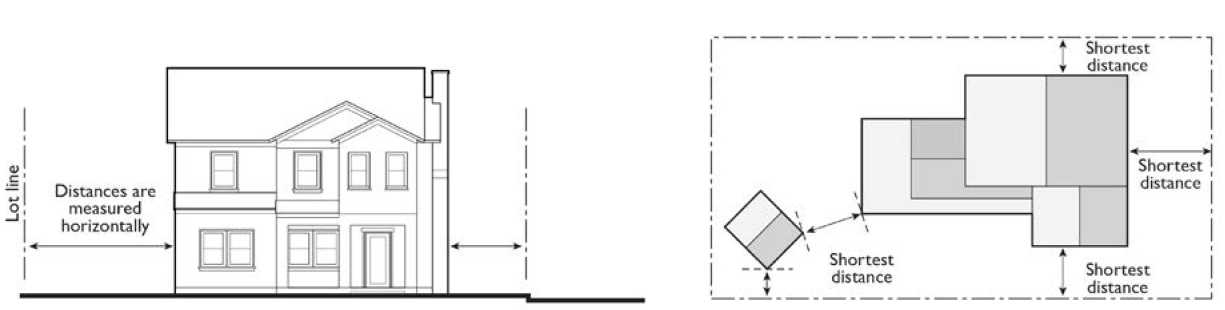
FIGURE 15-304: MEASURING DISTANCES
(Added Ord. 2015-39, § 1, eff. 1-9-16).
SEC. 15-305. - MEASURING HEIGHT.
A.
Measuring Building Height. Building height is measured from the average level of the highest and lowest points where the vertical plane of the exterior walls would touch the natural grade level of the site to the highest point on the roof.
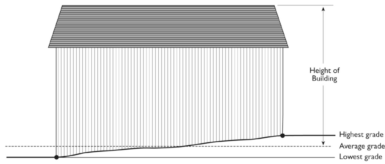
FIGURE 15-305-A: MEASURING BUILDING HEIGHT
B.
Measuring Height of Other Structures. The height of other structures such as fences is the vertical distance from the ground level immediately under the structure to the top of the structure. Special measurement provisions are also provided below.
1.
Measuring the Height of Fences on Retaining Walls. The height of a fence that is on top of a retaining wall is measured from the ground level on the highest side of the fence and wall.
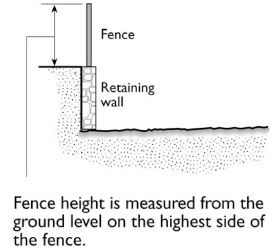
FIGURE 15-305-B.1: MEASURING HEIGHT OF FENCES ON RETAINING WALLS
2.
Measuring the Height of Decks. Deck height is determined by measuring from the natural grade of the ground to the top of the floor of the deck.
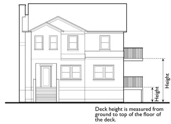
FIGURE 15-305-B.2: MEASURING HEIGHT OF DECKS
C.
Measuring the Number of Stories in a Building. In measuring the height of a building in stories, a balcony or mezzanine shall be counted as a full story if its floor area exceeds one-third of the total area of the nearest full floor directly below it or if it is enclosed on more than three sides, unless the Building Code provides for other balcony or mezzanine definitions based on building construction type and other factors.
(Added Ord. 2015-39, § 1, eff. 1-9-16).
SEC. 15-306. - MEASURING LOT WIDTH AND DEPTH.
A.
Lot Width. Lot width is the horizontal distance between the side lot lines, measured at right angles to the lot depth at a point midway between the front and rear lot lines.
B.
Lot Depth. Lot depth is measured along an imaginary straight line drawn from the midpoint of the front property line of the lot to the midpoint of the rear property line or to the most distant point on any other lot line where there is no rear lot line. Should the property line encroach into a street, the lot depth shall be measured from the front property line, after any dedications and/or street easements.
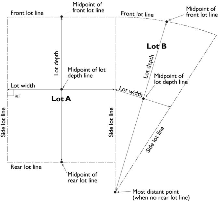
FIGURE 15-306: MEASURING LOT WIDTH AND DEPTH
(Added Ord. 2015-39, § 1, eff. 1-9-16).
SEC. 15-307. - DETERMINING AVERAGE SLOPE.
The average slope of a parcel is calculated using the following formula: S = 100(I)(L)/A, where:
S = Average slope (in percent)
I = Contour interval (in feet)
L = Total length of all contour lines on the parcel (in feet)
A = Area of subject parcel (in square feet)
(Added Ord. 2015-39, § 1, eff. 1-9-16).
SEC. 15-308. - DETERMINING FLOOR AREA.
The floor area of a building is the sum of the gross horizontal areas of all floors of a building or other enclosed structure.
A.
Included in Floor Area. Floor area includes, but is not limited to, habitable (as defined in the California Building Code) basements and cellars that are below the roof and within the outer surface of the main walls of principal or accessory buildings or the centerlines of party walls separating such buildings or portions thereof or within lines drawn parallel to and two feet within the roof line of any building without walls. In the case of a multi-story building that has covered or enclosed stairways, stairwells or elevator shafts, the horizontal area of such features shall be counted only once at the floor level of their greatest area of horizontal extent.
B.
Excluded from Floor Area. Floor area does not include mechanical, electrical, and communication equipment rooms that do not exceed two percent of the building's gross floor area; bay windows or other architectural projections where the vertical distance between the lowest surface of the projection and the finished floor is 30 inches or greater; areas that qualify as usable open space; and areas used for off-street parking spaces or loading spaces, driveways, ramps between floors of a multi-level parking garage, and maneuvering aisles that are located below the finished grade of the property.
C.
Non-Residential Uses. For non-residential uses, gross floor area includes pedestrian access interior walkways or corridors, interior courtyards, walkways, paseos, or corridors covered by a roof or skylight. Non-residential gross floor area does not include arcades, porticoes, and similar open areas that are located at or near street level and are accessible to the general public but are not designed or used as sales, display, storage, service, or production areas.
(Added Ord. 2015-39, § 1, eff. 1-9-16).
SEC. 15-309. - DETERMINING FLOOR AREA RATIO.
Floor area ratio (FAR) is the measure of the intensity of non-residential development. It is the ratio of the non-residential floor area, excluding the areas described below, of all principal and accessory buildings on a site to the site area. To calculate FAR, non-residential floor area is divided by site area, and typically expressed as a decimal. For example, if the non-residential floor area of all buildings on a site totals 20,000 square feet, and the site area is 10,000 square feet, the FAR is expressed as 2.0.
A.
Excluded from Floor Area in Calculating FAR.
1.
Basements. Usable basements and cellars below finished grade.
2.
Parking. Surface parking lots, subterranean parking garages, tuck-under parking areas, above ground parking garages, and other such facilities use for automobile parking.
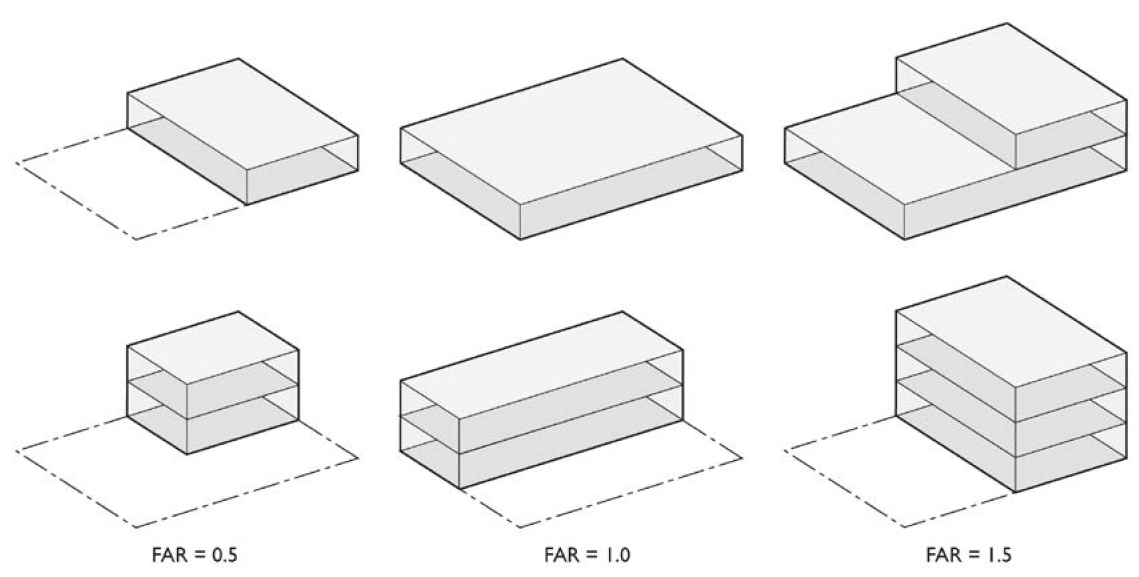
FIGURE 15-309: DETERMINING FLOOR AREA RATIO
(Added Ord. 2015-39, § 1, eff. 1-9-16).
SEC. 15-310. - DETERMINING RESIDENTIAL DENSITY.
Residential density measures the number of dwellings on a given unit of land. Residential density shall be calculated as follows:
A.
Residential Single-Unit Districts. In Residential Single-Unit districts, residential density shall be measured as follows:
1.
Large Sites. For sites with a pre-subdivided area greater than the Maximum Lot Size for the applicable District, residential density shall be measured in dwelling units per net acre of the subdivision. For example, if a project proposes 150 homes on a site with 30 net acres, it has a residential density of five dwelling units per acre (or five du/ac). The net acreage shall be calculated as the land area of a site remaining after dedication of all areas for major streets, schools, regional trails, certified wetlands or floodplains, and land underneath electric transmission lines. Second/Accessory Dwelling Units (ADUs) shall be excluded from this calculation.
2.
Small Sites. For sites with a pre-subdivided area equal to or less than the Maximum Lot Size for the applicable District, residential density shall be measured in dwelling units per subdivided residential lot. Second/Accessory Dwelling Units (ADUs) shall be excluded from this calculation.
B.
All Other Districts. In all other districts, residential density shall be measured in dwelling units per acre of the project's site area. For example, if a project proposes 15 dwellings on a three-acre site, it has a residential density of five dwelling units per acre (or five du/ac). Trails and natural features shall be excluded from this calculation. For mixed-use projects, the acreage of the entire project site shall be included in the calculation, including portions of the project site which feature only non-residential uses.
C.
Density Transfers. The number of units per acre prescribed in the applicable plans for an existing or proposed zone district shall not be transferred to another existing or proposed zone district, unless a transfer is approved through the processing of a Planned Development Permit which includes all zone districts involved in the proposed transfer.
(Added Ord. 2015-39, § 1, eff. 1-9-16; Am. Ord. 2017-33, § 2, eff. 7-30-17; Am. Ord. 2018-66, § 2, eff. 1-18-19; Am. Ord. 2025-024, § 3, eff. 7-27-25).
SEC. 15-311. - DETERMINING LOT COVERAGE.
Lot coverage is the ratio of the total footprint area of all structures on a lot to the net lot area, typically expressed as a percentage. The footprints of all principal and accessory structures, including garages, and carports shall be included in the lot coverage calculation, unless otherwise noted. The following structures shall be excluded from the calculation:
A.
Uncovered decks, patios, porches, landings, balconies, and unenclosed stairways;
B.
Eaves and roof overhangs;
C.
Trellises and similar structures;
D.
Outdoor swimming pools and hot tubs; and
E.
Up to one non-habitable accessory structure of less than 120 square feet in floor area and seven feet in height. Should there be multiple structures that do not exceed 120 square feet in floor area, only one such structure will be omitted for calculating the Lot Coverage.
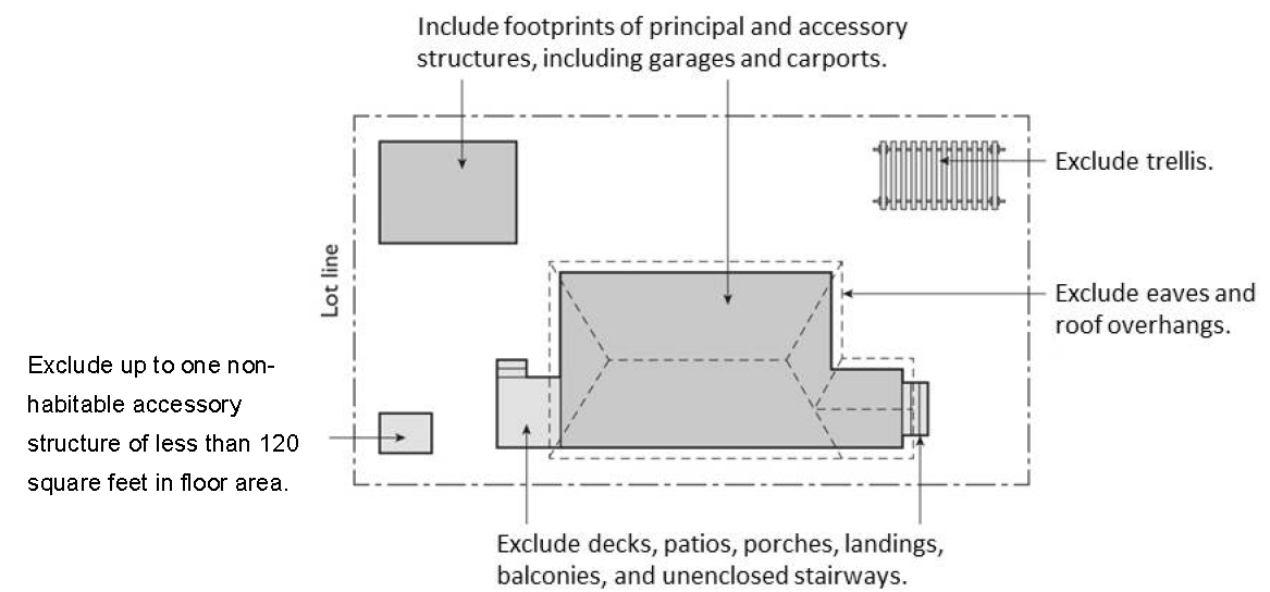
FIGURE 15-311: DETERMINING LOT COVERAGE
(Added Ord. 2015-39, § 1, eff. 1-9-16; Am. Ord. 2018-25, § 2, eff. 6-11-18).
SEC. 15-312. - DETERMINING LOT FRONTAGE.
A.
Corner Lot. The front of a lot shall be determined as follows:
1.
Downtown Districts: The frontage abutting the street with the highest Activity Classification per Section 15-1501-C shall be the front. If all adjacent streets have the same Activity Classification, then the street frontage with the narrowest dimension shall be the front.
2.
All Other Districts: The frontage abutting the street with the highest classification per the General Plan Circulation Map. If all adjacent streets have the same classification, then the street frontage with the narrowest dimension shall be the front.
3.
Exception: The Review Authority shall have the discretion to designate the front of a lot in a different manner if item 1 or 2 above would cause an undesirable visual or functional disruption.
B.
Through Lot (Double Frontage Lot). The front yard borders the street primarily used as frontage by neighboring lots.
(Added Ord. 2015-39, § 1, eff. 1-9-16; Am. Ord. 2017-33, § 3, eff. 7-30-17).
SEC. 15-313. - DETERMINING SETBACKS AND YARDS.
A setback line defining a required yard is parallel to and at the specified distance from the corresponding front, side, or rear property line. For regulations pertaining to projections or encroachments into required yards, refer to Section 15-2014.
A.
Front Setbacks. Front setbacks shall be measured from the back of the sidewalk (including instances where the back of the sidewalk lies within the project parcel) to the portion of the structure that is closest to the front of the lot. In the absence of a sidewalk, the minimum front setback shall be measured from the back of the curb. In the absence of a sidewalk and curb, minimum front setbacks shall be measured from the front property line.
B.
Garage Setbacks. In Residential Single-Unit Districts setbacks for garages shall be regulated and calculated separately from habitable space. However, the measurement to determine the garage setback shall be made in the same manner as Subsection A above.
C.
Side Setbacks. Side setbacks on interior lot lines shall be measured from the property line. When the side of the lot abuts a street, the measurement to determine the setback shall be made in the same manner as Subsection A above.
D.
Yards on Alleys. The following special regulations for determining setbacks apply when a lot abuts an alley.
1.
If a side lot line abuts an alley, the yard shall be considered an interior side yard rather than a corner side yard.
2.
In computing the minimum yard for any lot where such yard abuts an alley, no part of the width of the alley may be considered as part of the required yard.
E.
Yards Abutting Official Plan Lines. If a property abuts an Official Plan Line, the required setback shall be established from the Official Plan Line or the property line, whichever results in a greater setback.
F.
Regardless of the stated setback for a property, in no instance shall a building be allowed to encroach within an easement unless an easement encroachment has been authorized and a covenant recorded for that purpose.
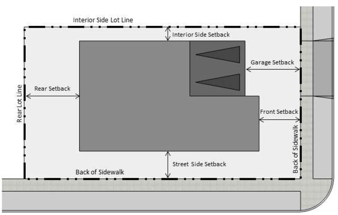
FIGURE 15-313: DETERMINING SETBACKS (YARDS)
(Added Ord. 2015-39, § 1, eff. 1-9-16; Am. Ord. 2016-32, § 3, eff. 10-21-16; Am. Ord. 2025-024, § 4, eff. 7-27-25).
SEC. 15-314. - MEASURING SIGNS.
The height of signs is measured in the same method as the height of other structures (See 15-305-B). Calculation of sign area is described in Article 26, Signs.
(Added Ord. 2015-39, § 1, eff. 1-9-16).
SEC. 15-315. - MEASURING PARKING LOT LANDSCAPING.
For the purpose of calculating required parking lot landscaping, parking lot areas are deemed to include parking and loading spaces as well as aisles, vehicle entry and exit areas, and any adjacent paved areas. The parking lot area does not include enclosed vehicle storage areas, carports, or parking structures.
(Added Ord. 2015-39, § 1, eff. 1-9-16).
SEC. 15-316. - MEASURING PEDESTRIAN CLEARANCE.
The minimum distance shall be measured from the edge of any table, chair, bench, planter, or other appurtenance used as part of an outdoor dining area to any obstruction within and/or the edge of the pedestrian area (e.g., sidewalks).
(Added Ord. 2015-39, § 1, eff. 1-9-16).
SEC. 15-317. - DETERMINING FRONTAGE COVERAGE.
Frontage coverage is the portion of the primary enclosed ground floor linear building façade that is located within the area between the minimum and maximum front setback. The following exceptions shall apply:
A.
Sites with frontage on multiple streets may not be required to meet the frontage coverage requirement along the streets with the lowest functional classification or the least visual prominence, at the discretion of the Review Authority, except in districts in which a minimum frontage coverage for the side street is specified.
B.
Required side and rear setbacks and residential transition setbacks shall be excluded from this calculation.
C.
Public plazas, parks, pedestrian passages, alleys, and cross streets (public or private) shall be excluded from this calculation.
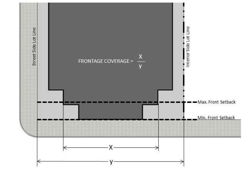
FIGURE 15-317: DETERMINING FRONTAGE COVERAGE
(Added Ord. 2015-39, § 1, eff. 1-9-16; Am. Ord. 2016-43, § 1, eff. 12-9-16).
Sec. 15-401. - Purpose.
The purpose of this article is to permit continued utility and economic viability of uses, structures, site features, and lots that were created lawfully prior to the adoption of this Code, but do not conform to its provisions, while preventing new non-conformities.
(Added Ord. 2015-39, § 1, eff. 1-9-16).
SEC. 15-402. - DETERMINATION OF NON-CONFORMING STATUS.
A use, structure, site feature, or lot shall be considered non-conforming if it was created prior to the adoption of this Code, or any amendment thereto, and does not conform to its provisions. The Director shall evaluate all available documentation to determine that non-conforming uses, structures, and site features shall have Legal Non-Conforming status or Illegal Non-Conforming status as follows:
A.
Legal Non-Conforming Status. A use, structure, or site feature shall be designated as having Legal Non-Conforming status if it was lawfully established under the regulations of the jurisdiction in which it was located at the time of its establishment and has continuously remained in compliance with all terms and conditions imposed upon the use, structure, or site feature upon its establishment or imposed upon it any time thereafter, based on evidence provided by the property owner, tenant, or applicant. Legal Non-Conforming status shall also be assigned if non-conformities were created by a public improvement, such as a street widening project.
B.
Illegal Non-Conforming Status. A use, structure, site feature, or lot shall be designated as having Illegal Non-Conforming status if it was not lawfully established under the regulations of the jurisdiction in which it was located at the time of its establishment or has not continuously remained in compliance with all terms and conditions imposed upon the use, structure, or site feature upon its establishment or imposed upon it any time thereafter.
(Added Ord. 2015-39, § 1, eff. 1-9-16).
SEC. 15-403. - ILLEGAL NON-CONFORMING USES, STRUCTURES, AND SITE FEATURES.
Nothing in this article shall be deemed to allow the use, change in use, repair, alteration, expansion, enlargement, or reconstruction of an Illegal Non-Conforming use, structure, or site feature. Any such Illegal Non-Conforming use shall be discontinued and any such Illegal Non-Conforming structure or site feature shall be removed.
(Added Ord. 2015-39, § 1, eff. 1-9-16).
SEC. 15-404. - LEGAL NON-CONFORMING USES.
A.
Continuation of Legal Non-Conforming Uses. Except as otherwise provided in this article, any Legal Non-Conforming use may be continued indefinitely. No Illegal Non-Conforming use shall be continued unless such use subsequently comes into conformity with the applicable provisions of this Code.
B.
Expansion of Legal Non-Conforming Uses. A Legal Non-Conforming use shall not be expanded unless a Conditional Use Permit is granted for such expansion. Prior to issuance of a Conditional Use Permit, it must be determined that at least one of the following three circumstances exists:
1.
The resultant use and/or project design will reduce current adverse impacts on adjacent properties and/or on the general public;
2.
The resultant use and/or project design will aid in the preservation of a historic resource; or
3.
The expansion of the use or the enlargement of a structure housing a non-conforming use is necessary to comply with a requirement imposed by law for the operation of the particular use, including, but not limited to, regulations for disabled access or seismic retrofit.
C.
Change of Legal Non-Conforming Use. A Legal Non-Conforming use shall not be changed to, or substituted for, another non-conforming use unless a Conditional Use Permit is granted for such change or substitution. To grant such a Conditional Use Permit the Director must first find that, in addition to the findings required by Section 15-404-B, the resultant use will be more consistent with the uses permitted in the district than the former use.
D.
Change of a Legal Non-Conforming Industrial Use. A Legal Non-Conforming Industrial Use shall not be changed to, or substituted for, another use other than to come into compliance with this Code.
E.
Change to a Conforming Use. When a Legal Non-Conforming use has been changed to a conforming use, the non-conforming use shall not be re-established thereafter, with the following exception: Within Residential Multi-Unit, Mixed-Use, or Commercial districts, structures which are determined by the Director to have been lawfully constructed as single-unit dwellings may be returned to single-unit use at any time. The Director shall base such a determination on evidence including building permits, County Assessor's data, building design and appearance, or other records which document that the building was originally constructed as a single-unit home.
F.
Abandonment of Legal Non-Conforming Uses.
1.
Residential Districts. A Legal Non-Conforming use shall not be re-established in any structure in a Residential District if such Legal Non-Conforming use has ceased for a consecutive six-month period.
2.
Mixed Use Districts. A Legal Non-Conforming use shall not be re-established in any structure if such Legal Non-Conforming use has ceased for a consecutive five-year period.
3.
All Other Districts. A Legal Non-Conforming use shall not be re-established in any structure if such Legal Non-Conforming use has ceased for a consecutive 12-month period within five years of January 3, 2016. Once the five year period from the effective date of this Code has passed, a Legal Non-Conforming Use shall not be re-established in any structure in a Non-Residential District if such Legal Non-Conforming Use has ceased for a consecutive period of 90 days or more.
(Added Ord. 2015-39, § 1, eff. 1-9-16; Am. Ord. 2016-32, § 4, eff. 10-21-16; Am. Ord. 2018-25, § 3, eff. 6-11-18; Am. Ord. 2025-024, § 5, eff. 7-27-25).
SEC. 15-405. - LEGAL NON-CONFORMING STRUCTURES AND SITE FEATURES.
A.
Applicability. This section shall apply to all Legal Non-Conforming buildings, fences, parking, landscaping, and other such physical improvements to a lot, with the exception of non-conforming signs, which are regulated by Article 26.
B.
Continuation of Existing Structures and Site Features. Except as otherwise stated in this article, any Legal Non-Conforming structure or site feature may be continued indefinitely. Any Illegal Non-Conforming structure or site feature shall be removed or modified to conform to the provisions of this Code.
C.
Completion of Structures or Site Features. The provisions of this article shall not be construed to preclude the completion of any structure or site feature upon which lawful construction has begun prior to the time of enactment of this Code or any amendment thereto, or prior to the time of inclusion in the city.
D.
Repair and Maintenance of Non-Conforming Structures or Site Features.
1.
Maintenance. A Legal Non-Conforming structure or site feature may be maintained as necessary to keep it in good working order.
2.
Repairs and Alterations. Notwithstanding the provisions of Section 15-404-B, any Legal Non-Conforming structure or site feature may be repaired and/or altered, provided that such repairs and alterations do not increase any non-conformity.
3.
Repair of Unsafe Structures or Site Feature. The provisions of this article shall not be construed to preclude the repair or alteration of any part of any structure or site feature declared to be unsafe by the Building Official when such repairs or alterations are for the purpose of restoring the structure or site feature to a safe condition.
E.
Enlargement of Non-Conforming Structures.
1.
Enlargement of Single-Unit Residential Structures. A legal non-conforming single-unit use or structure in a Non-Residential District may be enlarged, provided the addition does not reduce the number of parking spaces, alter the size of parking spaces, or the location and size of driveways; and the addition does not change the structure from single-unit use to multi-unit use. Such an expansion shall conform to the property development standards of either the Base District (and Overlay Districts, if applicable) for the site, or a Residential District which is appropriate to the size and configuration of the site at the discretion of the Review Authority.
2.
Enlargement of Other Legal Non-Conforming Structures and Site Features. A legal non-conforming structure or site feature being used for a conforming use may be enlarged or structurally altered if the new portion of the structure or site feature conforms to the regulations of the district in which it is located. If strict conformance with current setback requirements would cause unsightly or impractical site layouts, and a deviation from such requirements shall not cause impacts on neighboring uses, the Review Authority may exempt the enlargement of a legal non-conforming structure or site feature from setback requirements at their discretion. Unaltered portions of such structures or site features will be allowed to remain non-conforming. A Legal Non-Conforming structure or site feature housing or associated with a non-conforming use shall not be enlarged or altered except as put forth in Section 15-404-B.
F.
Replacement of Involuntarily Destroyed or Damaged Non-Conforming Structures or Site Features. Any Legal Non-Conforming structure or site feature that is destroyed or damaged by fire, flood, explosion, wind, earthquake, war, riot, or other public calamity or act of nature, may be replaced or reconstructed to the same size and extent as before the damage occurred, provided that rebuilding commences not later than one year after destruction, and so long thereafter as the Building Permit remains valid.
G.
Replacement of Voluntarily Demolished, Destroyed, or Damaged Non-Conforming Structures or Site Features. Any non-conforming structure or site feature which is demolished, destroyed, or damaged by means other than those listed in the Section 15-405-F shall not be reconstructed unless it complies with all provisions of the district in which the structure is located. Exceptions may be given where all of the following circumstances exist:
1.
The structure houses a conforming use;
2.
The structure or site feature is replaced or reconstructed to the same or a lesser size and extent as the original structure or site feature; and
3.
A Conditional Use Permit is granted, and the Director finds, in addition to the findings required by Section 15-404-B, that compliance with current standards is impractical and that the proposed reconstruction will conform to current standards to the greatest extent practical.
(Added Ord. 2015-39, § 1, eff. 1-9-16; Am. Ord. 2018-25, § 4, eff. 6-11-18; Am. Ord. 2025-024, § 6, eff. 7-27-25).
SEC. 15-406. - NON-CONFORMING LOTS.
A Non-Conforming lot or parcel may be used for development subject to compliance with all other provisions of this article and other applicable codes. A Non-Conforming lot may not be further reduced in area or dimension, except under the application of eminent domain.
(Added Ord. 2015-39, § 1, eff. 1-9-16).