
Gahanna City Zoning Code
CHAPTER 1101
Zoning Ordinance Introduction
Sections:
1101.01 - TITLE AND EFFECTIVE DATE.
Part Eleven of the City of Gahanna, Ohio Codified Ordinances shall be known as the Zoning Ordinance. The Zoning Ordinance is declared to be in force at the earliest date allowed by law.
(Ord. No. 0007-2024, § 2(Exh. A), 4-1-24)
1101.02 - PURPOSE AND INTENT.
The purpose of the Zoning Ordinance is to promote and protect the health, safety, comfort, convenience, and general welfare of the people. Furthermore, the requirements of the Zoning Ordinance are designed to advance the implementation of the land use plan.
(Ord. No. 0007-2024, § 2(Exh. A), 4-1-24)
1101.03 - APPLICABILITY.
(a)
Repeal of Prior Ordinance. This Zoning Ordinance replaces Sections 1101—1197, inclusive, and effectively repeals any prior zoning ordinance in effect in the City. All ordinances or parts of ordinances of the City, in conflict with any regulation, provision, amendment or supplement of this Zoning Ordinance are, to the extent of such conflict, hereby repealed.
Any enforcement action pending under the prior zoning ordinance at the date of enactment of this Zoning Ordinance shall continue, except when the violation subject to enforcement action is no longer applicable under the provisions of this Zoning Ordinance.
(b)
Jurisdiction of this Ordinance. The requirements of this Zoning Ordinance apply to all land within the geographic limits of the City.
(c)
Private Provisions—Agreements Maintained. The provisions of this Zoning Ordinance are not intended to nullify, abolish, or repeal any easement, covenant or other private agreement or restriction.
(d)
Application. Nothing in Part Eleven shall prevent the continuance of a nonconforming use as herein authorized, unless a discontinuance is necessary for the safety of life or property.
This Zoning Ordinance shall not require any change in the plans, construction, size, or designed use of a structure for which a valid zoning permit has been issued or lawfully approved before the effective date of this Zoning Ordinance.
(e)
Compliance Required. Compliance with this Zoning Ordinance is required. Failing to comply with the regulations of the Zoning Ordinance shall constitute a violation of its provisions.
(Ord. No. 0007-2024, § 2(Exh. A), 4-1-24)
1101.04 - CONFLICTING PROVISIONS.
Wherever the regulations of this Zoning Ordinance require a wider setback, a greater area of open space, a lower maximum height of a structure or a fewer number of stories, a lesser percentage of a lot to be occupied, a lower density of population, a more restricted use of land, or otherwise higher standards than are required in any other ordinance or regulation, the provisions of this Zoning Ordinance shall govern. If the requirements of the other ordinance or regulation is more restrictive, those requirements shall govern.
(Ord. No. 0007-2024, § 2(Exh. A), 4-1-24)
1101.05 - EXISTING PLANNED UNIT DEVELOPMENTS.
Any structure, lot, or use in a planned unit development (PUD) that exists prior to the enactment of this Zoning Ordinance and, through the enactment of this Zoning Ordinance, is assigned to a zoning district other than a planned unit development district shall conform to all requirements of the assigned zoning district and all other applicable requirements of this Zoning Ordinance.
(Ord. No. 0007-2024, § 2(Exh. A), 4-1-24)
1101.06 - SEVERABILITY.
If any section, subsection, sentence, clause or phrase of this Zoning Ordinance is for any reason held to be invalid, such decision shall not affect the validity of the remaining portions of this Zoning Ordinance.
(Ord. No. 0007-2024, § 2(Exh. A), 4-1-24)
1101.07 - MINIMUM REQUIREMENTS.
(a)
Except as hereinafter provided, no structure or part thereof shall be moved, erected, converted, enlarged, reconstructed, or structurally altered except in compliance with the regulations of this Zoning Ordinance.
(b)
No structure or land shall be used or occupied except in compliance with the regulations of this Zoning Ordinance.
(c)
No structure shall be erected or structurally altered except when such structure is located on a lot.
(Ord. No. 0007-2024, § 2(Exh. A), 4-1-24)
1101.08 - OFFICIAL ZONING MAP.
The city is divided into zoning districts as shown on the Zoning Map, which, together with all explanatory matter thereon, is adopted by reference and declared to be a part of this ordinance.
(a)
The Zoning Map shall be the final authority as to the current zoning status of lots in the city.
(b)
No changes of any nature shall be made in the Zoning Map or matter shown thereon except in accordance with the procedures set forth in this Zoning Ordinance. Any unauthorized change of whatever kind by any person or persons shall be considered a violation of this Zoning Ordinance and punishable as provided under this Zoning Ordinance.
(c)
The Zoning Map shall be maintained in an accurate manner and available to the public at the offices of the City's Designee and online on the City's website.
(d)
The following rules shall apply to the interpretation of zoning district boundaries on the Zoning Map:
(1)
Boundaries indicated as approximately following the centerlines of streets, highways, or alleys; platted lot lines; City limits; railroad lines; or the centerlines of streams, rivers, canals, lakes, or other bodies of water shall be construed as such.
(2)
Where district boundaries are shown as approximately parallel to the center line or street line of any street or other right-of-way, such district boundary shall be considered parallel thereto at the distance indicated on the Zoning Map. If no distance is given, such dimension shall be determined by the use of the scale shown on the Zoning Map.
(3)
Where a district boundary line divides a lot that was in single ownership at the time of passage of this Zoning Ordinance, the City may permit the extension of the regulations for either portion of the lot beyond the district line into the remaining portion of the lot.
(Ord. No. 0007-2024, § 2(Exh. A), 4-1-24)
1101.09 - RULES FOR INTERPRETING REGULATIONS.
(a)
Text and Graphics.
(1)
Text in this Zoning Ordinance are regulatory.
(2)
Graphics in this Zoning Ordinance are illustrative unless specifically described as regulatory.
(b)
Components of Lots.
(1)
Front lot line. A front lot line is any lot line that abuts a street right-of-way. A front lot line shall not abut an alley.
(2)
Side lot line. A side lot line is any lot line that is not a front lot line but shares at least one vertex with a front lot line.
(3)
Rear lot line. A rear lot line is any lot line that is not a front lot line or a side lot line.
(c)
Types of Lots.
(1)
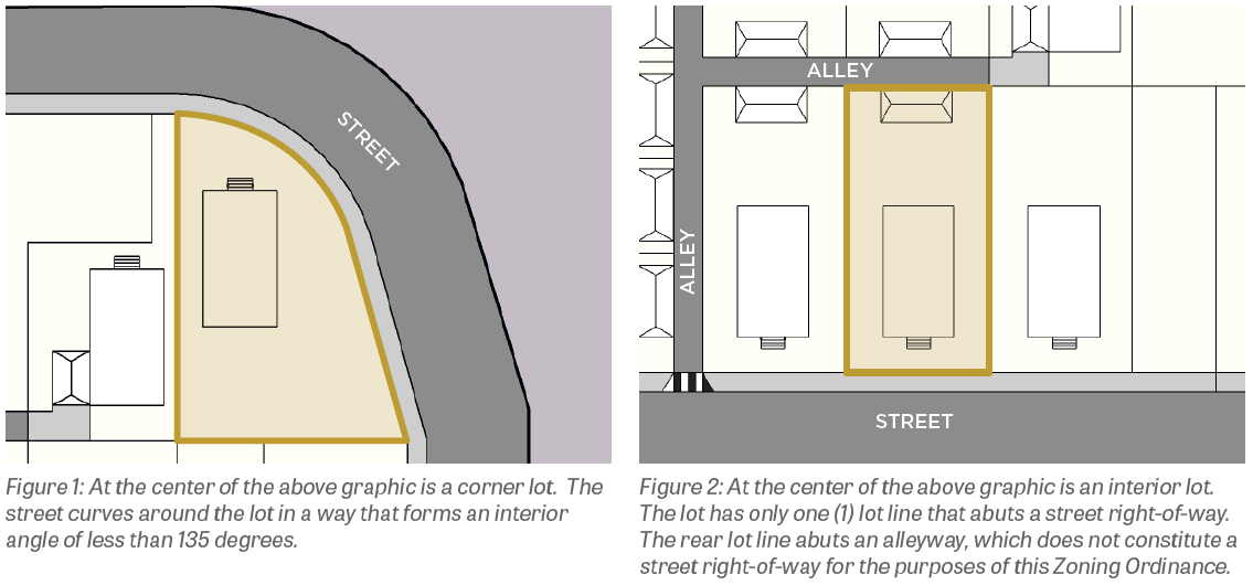
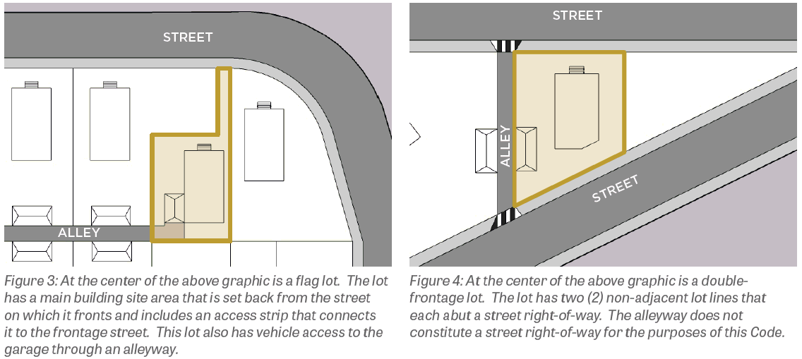
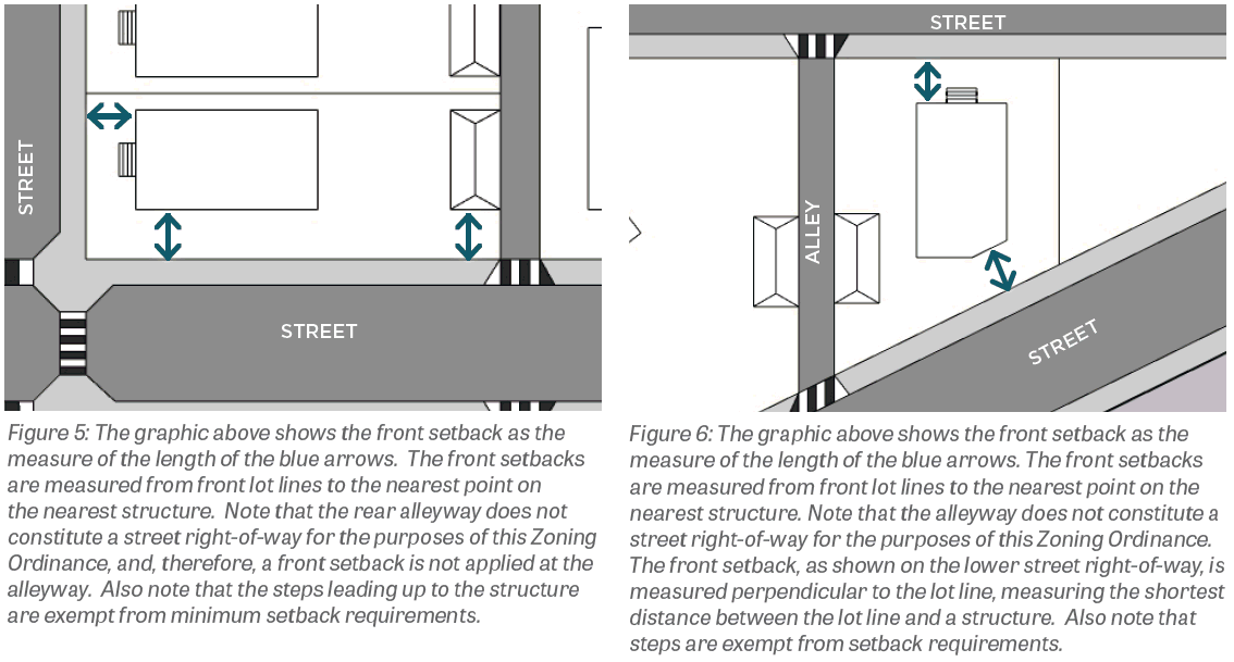
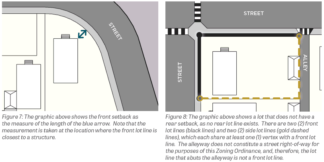
Corner lot. A corner lot is any lot that has one or multiple front lot lines that intersect or curve around the property at a 135-degree interior angle or less.
(2)
Interior lot. An interior lot is any lot that is not a corner lot or a through lot. In many cases, an interior lot has one front lot line, two side lot lines that abut neighboring lots, and a rear lot line that abuts a neighboring lot or an alleyway.
(3)
Through lot. A through lot is any interior lot that has more than one non-adjacent front lot line.
(4)
Flag lot. A flag lot is any interior lot so shaped that the main building site area is set back from the street on which it fronts and includes an access strip at any point connecting the main building site area to the frontage street. For this Zoning Ordinance, a flag lot also includes any lot that does not have a front lot line, but rather has ingress and egress through an alleyway or private easement.
(d)
Types of Lot Lines.
(1)
A lot line is a line dividing one lot from another or from a street or any public place.
(2)
A front lot line is any lot line dividing a lot from a public or private street and from which the required front setback is measured.
(3)
A side lot line is any lot line not considered a front lot line or rear lot line.
(4)
In the case of a regular lot, a rear lot line is the lot line which is most opposite from the front lot line; in the case of a corner lot with more than one front lot line, rear lot lines are all lot lines that are not front lot lines; in the case of an irregular or triangular-shaped lot, a rear lot line is a line ten feet in length within the lot parallel to and at the maximum distance from the front lot line.
(e)
Measuring Lot Dimensions.
(1)
Lot dimensions are measured in acres, square feet, feet, and inches.
(2)
A lot extends to its lot lines, which form the boundary between the lot and adjacent lots or rights-of-way.
(3)
Area dimensions are measured on a horizontal plane in plan view and do not consider topography or the actual area of the ground's surface.
(4)
Areas of lots occupied by easements, such as access or utility easements, contribute to total lot area and are considered in calculating percent building coverage and other standards.
(f)
Measuring Setbacks.
(1)
When measuring a required distance, such as a minimum setback, the measurement is made at the closest or shortest distance between a structure and a lot line.
(2)
Exceptions to setbacks. Exterior staircases, bay windows, fire escapes, chimneys, awnings, and other appurtenances deemed similar by the City, are exempt from minimum setback requirements.
(3)
Front setbacks on interior lots. Where a lot has only one front lot line, the front setback is the shortest distance between any point along the front lot line and any point on a structure on the lot.
(4)
Front setbacks on through lots. Where a lot borders two streets that do not intersect at a corner of the lot, such as in a through lot, two front lot lines will exist, one along each right-of-way. The required front setback must be provided for each street frontage that provides vehicular access. Rear yard setbacks shall apply to a front yard without vehicular access, and which clearly serves as a rear yard. In such a case, alleys do not constitute streets, and lot lines abutting alleys are not considered front lot lines and do not require front setbacks.
(5)
Front setbacks on corner lots. When a lot borders two or more streets that intersect at a corner(s) of the lot, such as in a corner lot, the front setback shall be provided for each street frontage. In such a case, alleys do not constitute streets, and lot lines abutting alleys are not considered front lot lines and do not require front setbacks.
(6)
Front setbacks on corner lots formed by curves. When a lot borders one street with an acute curve of 55 degrees or more so that the street creates two sides of the lot, the lot line(s) along that street shall be considered a front lot line, and a front setback shall be applied to the entire lot frontage.
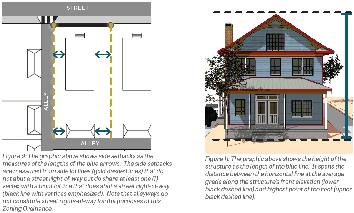
(7)
Side setbacks. A side setback is the shortest distance between a side lot line and a structure on the lot.
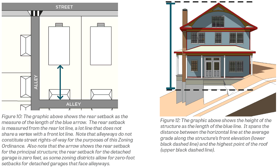
(8)
Rear setbacks. A rear setback is the shortest distance between a rear lot line and a structure on the lot.
(g)
Measuring Other Lot Standards.
(1)
Lot Frontage. Lot frontage is the length of all front lot lines.
(2)
Impervious coverage. Impervious coverage is the percent of the lot's horizontal plane that is occupied by impervious, man-made materials, including buildings, asphalt, concrete, swimming pools, barns, and carports, but excluding porous pavement, permeable pavers, decks with gaps between decking for drainage, lawn grasses, gardens, stormwater retention and detention basins, and other landscaping.
(3)
Structure Height. Structure height is measured as the distance between:
a.
A horizontal line at the average grade along the structure's front elevation; and,
b.
The highest point of the structure.
Chimneys, elevators, poles, spires, tanks, towers, and other similar projections may exceed the maximum structure height defined for a zoning district, provided that such projections do not exceed 120 percent of the maximum structure height defined in that zoning district. Spires and steeples on structures used for religious assembly shall not be subject to structure height limitations.
(h)
Residential Zones. For the purposes of interpreting zoning district regulations, a "residential zone" is a zoning district that limits its permitted uses to only dwelling uses and their customarily associated accessory uses. Such zoning districts are limited to Estate Residential, Small Lot Residential, Medium Lot Residential, Large Lot Residential, and Multi-Unit Residential.
(i)
Land Uses Not Listed. The City shall have the right to determine whether a use not listed herein is similar to a listed use and either permitted or conditionally permitted herein. In order to find that a use is similar to a listed use, the City shall find that such use is (1) similar in definition, (2) similar in impact to surrounding properties, and (3) promotes the objectives of the Gahanna Land Use Plan. The determination that a use not listed is similar to a listed use shall have no bearing on future determinations of similarity.
(j)
Interpretation of Terms and Words.
(1)
Terms are defined in Chapter 1123 Glossary.
(2)
Words used in the present tense include the future; the plural includes the singular; the word "lot" means the word "plot"; the word "shall" is intended to be mandatory; "occupied" or "used" shall be considered as though followed by the words "or intended, arranged or designed to be used or occupied".
(k)
Conjunctions. Where a regulation involves two or more items, conditions, provisions, or events which are connected by a conjunction—"and", "or", or "either... or"—the conjunction shall be interpreted as follows:
(1)
"And" indicates that all the connected items, conditions, provisions, or events shall apply.
(2)
"Or" indicates that the connected items, conditions, provisions, or events may apply singly or in any combination.
(3)
"Either... or" indicates that all the connected items, conditions, provisions, or events shall apply singly but not in combination.
(Ord. No. 0007-2024, § 2(Exh. A), 4-1-24; Ord. No. 0078-2024, § 1(Exh. A), 12-2-24)