
Gahanna City Zoning Code
CHAPTER 1103
Zoning Districts
Sections:
1103.01 - INTENT.
For the purpose of regulating and restricting the general location of structures and of premises to be used for trade, industry, residence and other specified uses within the city; for the purpose of regulating the height of structures hereafter erected or altered; for the purpose of regulating the bulk and location of structures hereafter erected or altered, including the percentage of lot occupancy, setback building lines, and the area of yards, courts and other open spaces, the city is hereby divided into zoning districts as follows in this chapter, and as shown on the Zoning Map on file with the Clerk of Council.
(Ord. No. 0007-2024, § 2(Exh. A), 4-1-24)
1103.02 - COMPLIANCE WITH REGULATIONS.
(a)
Use, height, location, area, and other regulations for each zoning district set forth by this Code shall apply uniformly to each class or kind of structure or land, except as hereinafter provided or as otherwise granted by action of the Planning Commission.
(b)
No structure or land shall be used or occupied and no structure or part thereof shall be erected, constructed, reconstructed, moved or structurally altered except in conformity with all of the regulations herein specified.
(c)
No lot existing at the effective date of this Code shall be changed in dimension or area except in conformity with the requirements set forth in this Code.
(d)
Lots created after the effective date of this Code shall meet the requirements set forth herein.
(Ord. No. 0007-2024, § 2(Exh. A), 4-1-24)
1103.03 - ZONING DISTRICT REGULATIONS.
Specific standards by zoning district are set forth in this chapter. Additional regulations are included elsewhere in the Code, including Chapter 1107 Design Guidelines and Chapter 1109 Site Elements.
Permitted uses and conditional uses for each zoning district are set forth in Chapter 1105 Uses. Any use not specifically listed shall only be allowed according to the regulations in Section 1105.01. Any use that is prohibited in a zoning district shall only be permitted according to the procedure outlined in Section 1117.04 Zoning Map or Text Amendments.
(Ord. No. 0007-2024, § 2(Exh. A), 4-1-24)
1103.04 - PURPOSE OF ZONING DISTRICTS.
Each zoning district intends to promote harmonious land uses within a geographic area through limitations on the use, placement, and scale of structures within that zoning district. One zoning designation may be applied to numerous, non-contiguous geographies across the city that share existing or desired development patterns.
(Ord. No. 0007-2024, § 2(Exh. A), 4-1-24)
1103.05 - LIST OF ZONING DISTRICTS.
The following table summarizes the zoning districts established in this Zoning Ordinance.
(Ord. No. 0007-2024, § 2(Exh. A), 4-1-24)
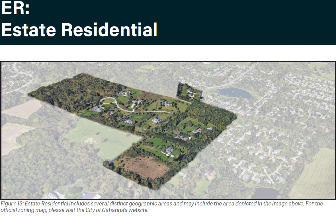
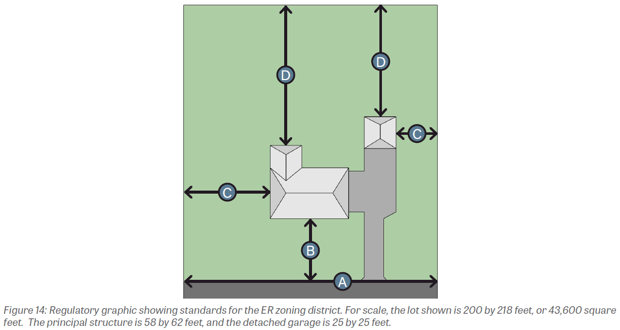
1103.06 - ESTATE RESIDENTIAL (ER).
(a)
Purpose. The establishment of the Estate Residential zoning district aims to promote semi-rural land uses important to the city's character, economy, and future. The development standards established under this zoning district are intended to promote attractiveness, order, and safety while allowing for individual architectural preferences.
(b)
Existing development. Land uses within Estate Residential zoning district vary across the city. Some areas, such as Hannah Park, have been developed as active recreational areas with ballfields and courts. Others consist of forest, such as Gahanna Woods Park. Finally, some Estate Residential-zoned areas have been developed with detached, one-unit dwellings on large lots, such as those north of Hamilton Court.
(c)
Desired development. The Estate Residential zoning district aims to preserve the semi-rural character of large lots. Minimum setbacks are intended to yield ample open space, peace, and privacy from adjacent users.
(d)
Uses. A list of principal and accessory uses applicable to this zoning district can be found in Section 1105.01.
(e)
Development standards. All development in the Estate Residential zoning district shall comply with the following district-specific standards. Generally applicable standards can be found in Chapter 1107 Design Guidelines and Chapter 1109 Site Elements.
(Ord. No. 0007-2024, § 2(Exh. A), 4-1-24)
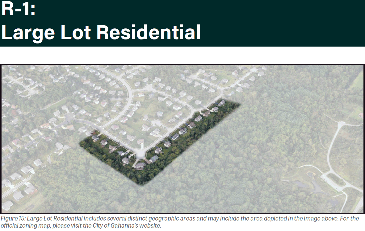
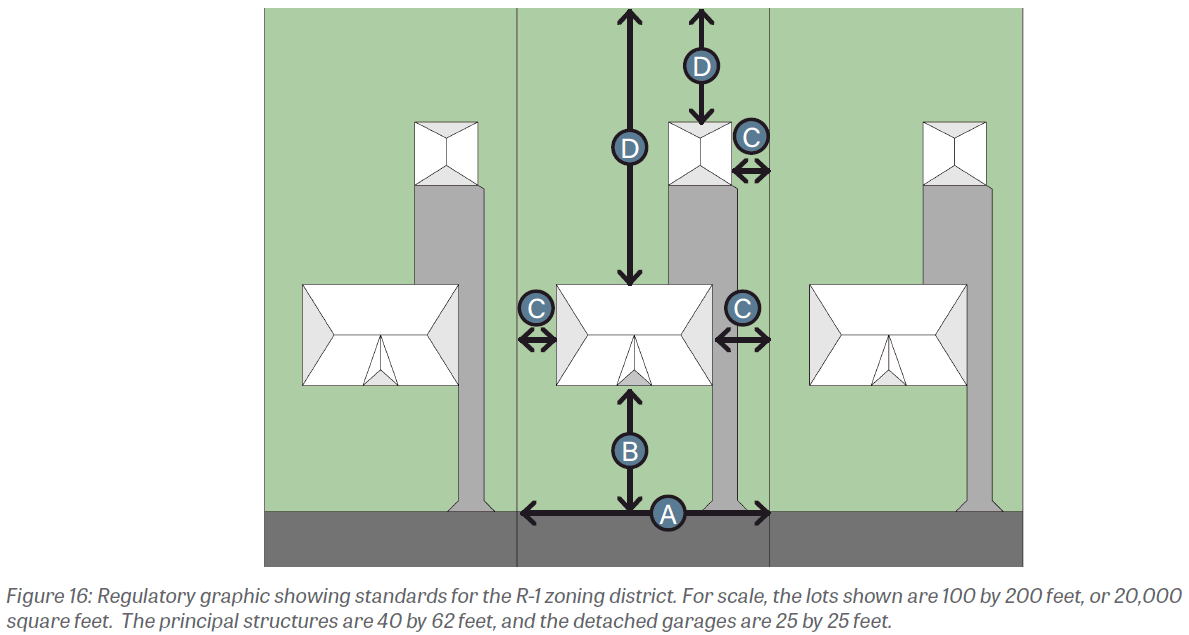
1103.07 - LARGE LOT RESIDENTIAL (R-1).
(a)
Purpose. The establishment of the Large Lot Residential Zoning district aims to protect existing one-unit residential land uses and allow for future new and infill development of such land uses. Lots in the Large Lot Residential zoning district have lot standards intended to preserve privacy between neighbors yet create a walkable, peaceable neighborhood environment.
(b)
Existing development. Land uses within Large Lot Residential zoning district consist primarily of detached houses in residential areas.
(c)
Desired development. The Large Lot Residential zoning district aims to preserve the residential neighborhood character of large lots. Lot standards are intended to create open space, peace, greenery and moderate privacy from adjacent users.
(d)
Uses. A list of principal and accessory uses applicable to this zoning district can be found in Section 1105.01.
(e)
Development standards. All development in the Large Lot Residential zoning district shall comply with the following district-specific standards. Generally applicable standards can be found in Chapter 1107 Design Guidelines and Chapter 1109 Site Elements.
(Ord. No. 0007-2024, § 2(Exh. A), 4-1-24)
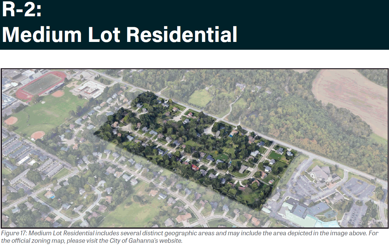
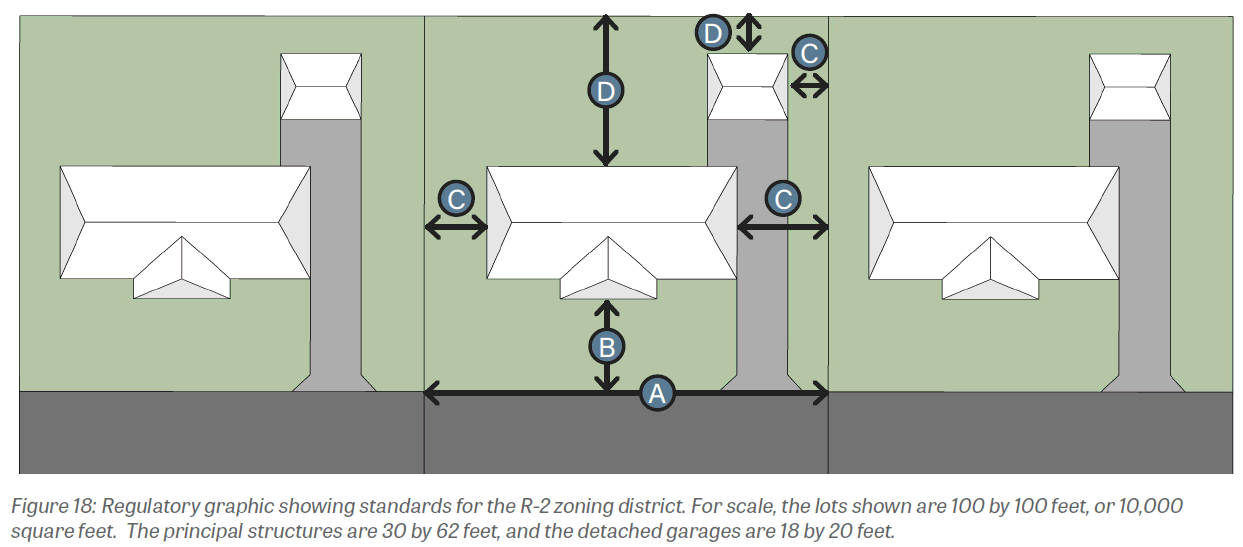
1103.08 - MEDIUM LOT RESIDENTIAL (R-2).
(a)
Purpose. The establishment of the Medium Lot Residential zoning district aims to designate areas of Gahanna for one-unit residential land uses and allow for future new and infill development of such land uses.
(b)
Existing development. Existing land uses within Medium Lot Residential zoning district consist primarily of detached, one-unit residential uses.
(c)
Desired development. The Medium Lot Residential zoning district aims to preserve the residential neighborhood character. Lot standards are intended to create open space, peace, greenery and privacy from adjacent users while also enhancing walkability. Desired development shall encourage walkable neighborhoods while preserving natural features and open space, objectives that were identified in the Gahanna Land Use Plan.
(d)
Uses. A list of principal and accessory uses applicable to this zoning district can be found in Section 1105.01.
(e)
Development standards. All development in the Medium Lot Residential zoning district shall comply with the following district-specific standards. Generally applicable standards can be found in Chapter 1107 Design Guidelines and Chapter 1109 Site Elements.
(Ord. No. 0007-2024, § 2(Exh. A), 4-1-24; Ord. No. 0070-2024, § 1(Exh. A), 12-2-24)
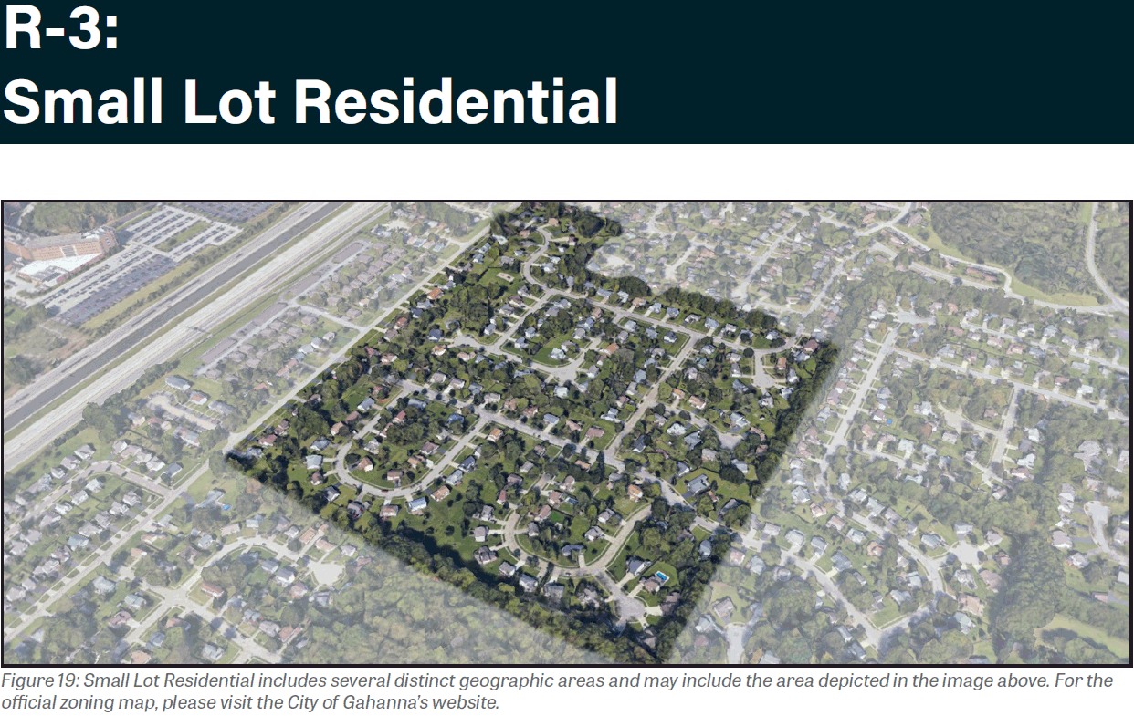
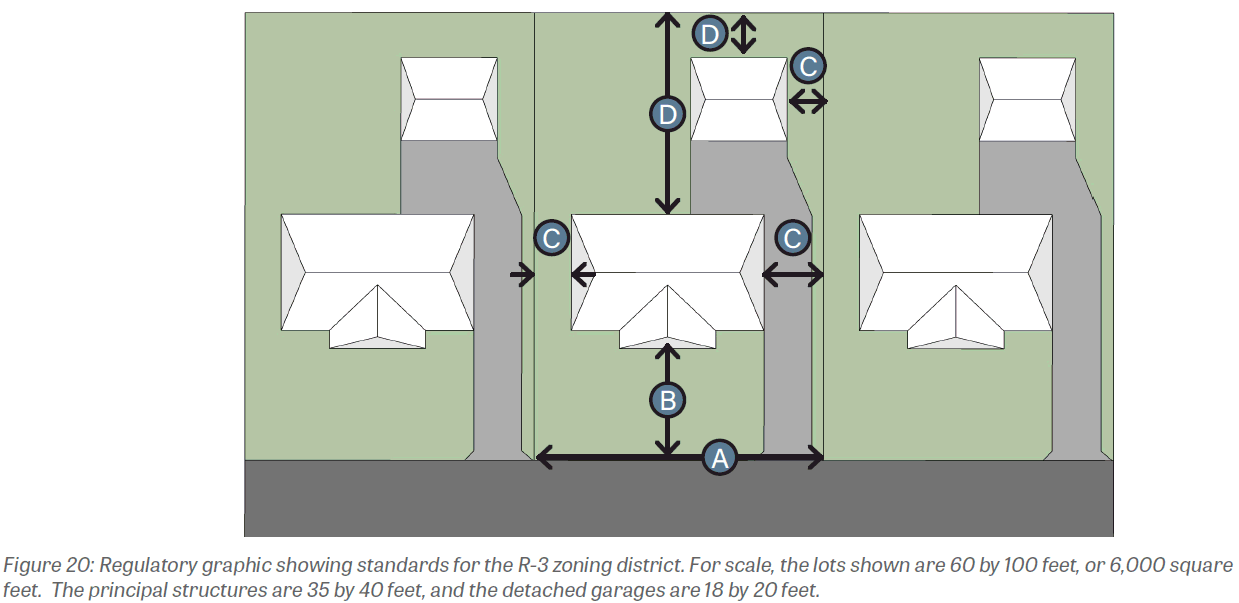
1103.09 - SMALL LOT RESIDENTIAL (R-3).
(a)
Purpose. The establishment of the Small Lot Residential zoning district aims to designate areas of Gahanna for residential land uses and allow for future new and infill development of such land uses. Small lots will help to accomplish housing goals identified in the Gahanna Land Use Plan, which expresses the need for smaller, lower maintenance homes to meet demand from both young and aged residents.
(b)
Existing development. Land uses within Small Lot Residential zoning district consist primarily of residential uses.
(c)
Desired development. The Small Lot Residential zoning district aims to preserve residential neighborhood character of small lots. Lot standards should increase walkability of neighborhoods and allow for lower maintenance demands.
(d)
Uses. A list of principal and accessory uses applicable to this zoning district can be found in Section 1105.01.
(e)
Development standards. All development in the Small Lot Residential zoning district shall comply with the following district-specific standards. Generally applicable standards can be found in Chapter 1107 Design Guidelines and Chapter 1109 Site Elements.
(Ord. No. 0007-2024, § 2(Exh. A), 4-1-24)
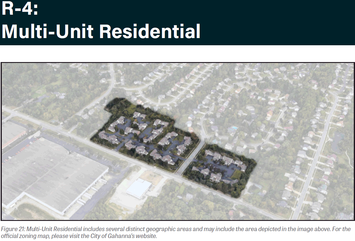
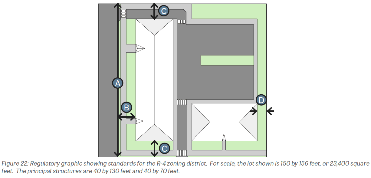
1103.10 - MULTI-UNIT RESIDENTIAL (R-4).
(a)
Purpose. The establishment of the Multi-Unit Residential zoning district aims to designate areas of Gahanna for multi-unit residential land uses and allow for future new and infill development of such land uses. In the Gahanna Land Use Plan, increasing apartment supply was identified as a need, and multi-unit residential uses may add to the supply of apartments.
(b)
Existing development. Land uses within Multi-Unit Residential zoning district consist primarily of residential uses, such as duplexes and multiplexes, some of which have multiple principal structures per lot.
(c)
Desired development. The Multi-Unit Residential zoning district aims to allow for continued use and encourage future development of multi-unit residential structures.
(d)
Uses. A list of principal and accessory uses applicable to this zoning district can be found in Section 1105.01.
(e)
Development standards. Multiple principal structures are allowed per lot in the Multi-Unit Residential zoning district, provided that all principal structures meet the applicable development standards. All development in the Multi-Unit Residential zoning district shall comply with the following district-specific standards. Generally applicable standards can be found in Chapter 1107 Design Guidelines and Chapter 1109 Site Elements.
(Ord. No. 0007-2024, § 2(Exh. A), 4-1-24)
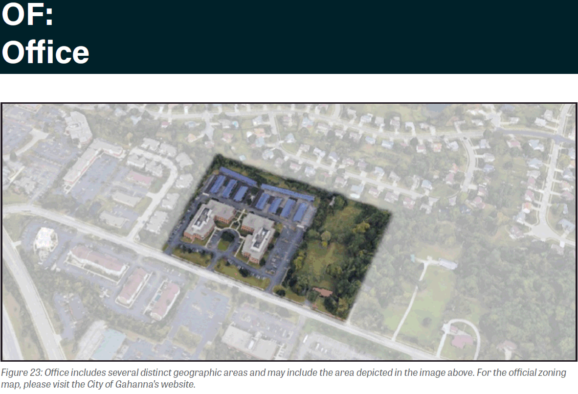
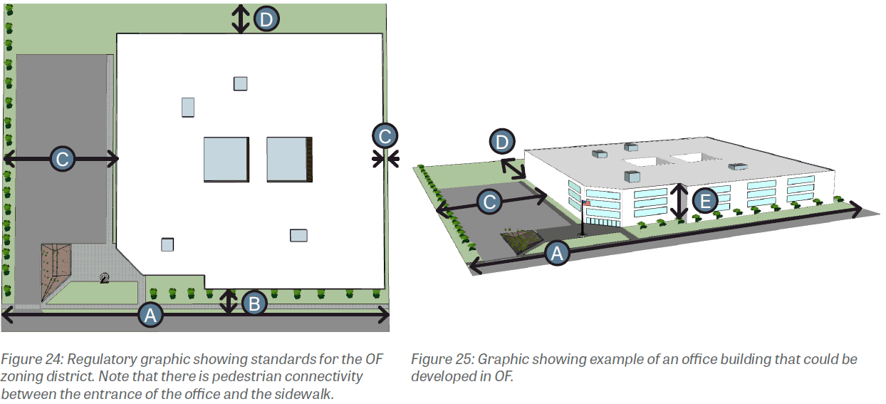
1103.11 - OFFICE (OF).
(a)
Purpose. The establishment of the Office zoning district aims to designate areas of Gahanna for office and institutional uses. In the Gahanna Land Use Plan, lots in the Office zoning district were recommended for professional office and mixed-use character. Improving the pedestrian experience around these uses will be a high priority to make such uses more accessible and desirable.
(b)
Existing development. Existing development in the Office zoning district includes a variety of uses, including library, apartment buildings, insurance sales, child care centers, medical centers, assisted living facility, and more.
(c)
Desired development. The Office zoning district aims to allow for continued use and encourage future development of a mix of uses. Based on recommendations from the Gahanna Land Use Plan, standards will work to increase the density of existing development and create a more walkable area.
(d)
Uses. A list of principal and accessory uses applicable to this zoning district can be found in Section 1105.01.
(e)
Development standards. The Office zoning district allows multiple principal structures per lot. All development in the Office zoning district shall comply with the following specific standards. Generally applicable standards can be found in Chapter 1107 Design Guidelines and Chapter 1109 Site Elements.
(Ord. No. 0007-2024, § 2(Exh. A), 4-1-24)
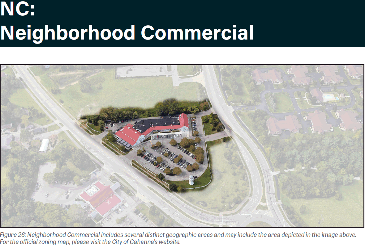
1103.12 - NEIGHBORHOOD COMMERCIAL (NC).
(a)
Purpose. The establishment of the Neighborhood Commercial zoning district aims to designate areas of Gahanna for neighborhood-scale commercial uses.
(b)
Existing development. Existing development in the Neighborhood Commercial zoning district include a variety of uses, such as a pizza shop, restaurant, dry cleaners, wine store, and clothier.
(c)
Desired development. The Neighborhood Commercial zoning district aims to allow for continued use and encourage future development of neighborhood-scale commercial centers.
(d)
Uses. A list of principal and accessory uses applicable to this zoning district can be found in Section 1105.01.
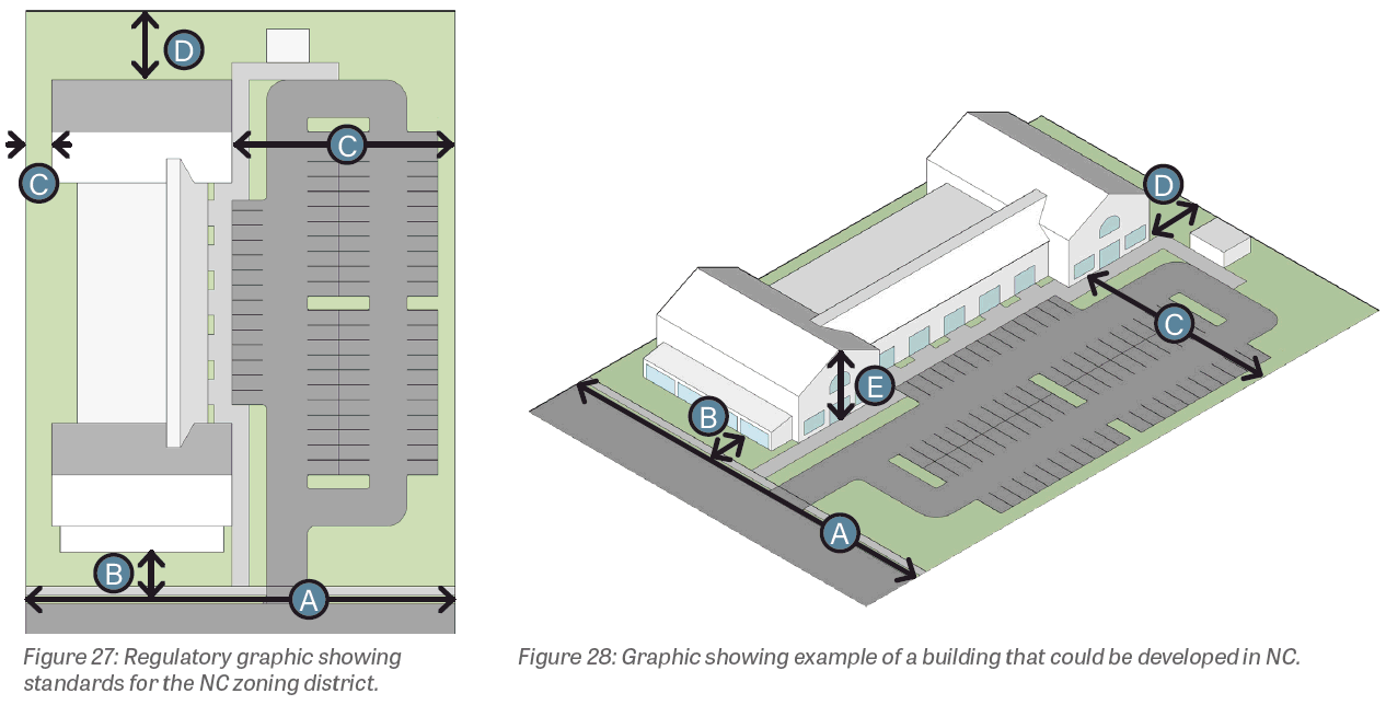
(e)
Development standards. All development in the Neighborhood Commercial zoning district shall comply with the following specific standards. Generally applicable standards can be found in Chapter 1107 Design Guidelines and Chapter 1109 Site Elements.
(Ord. No. 0007-2024, § 2(Exh. A), 4-1-24)
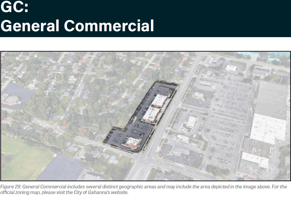
1103.13 - GENERAL COMMERCIAL (GC).
(a)
Purpose. The establishment of the General Commercial zoning district aims to designate areas of Gahanna for commercial, services, and office uses that serve the broader City's residents.
(b)
Existing development. Existing development in the General Commercial zoning district can include a variety of uses within a center or standalone buildings with a single use.
(c)
Desired development. The General Commercial zoning district aims to allow for continued use and encourage future development of small- and medium-scale commercial developments that serve a larger citywide or regional need.
(d)
Uses. A list of principal and accessory uses applicable to this zoning district can be found in Section 1105.01.
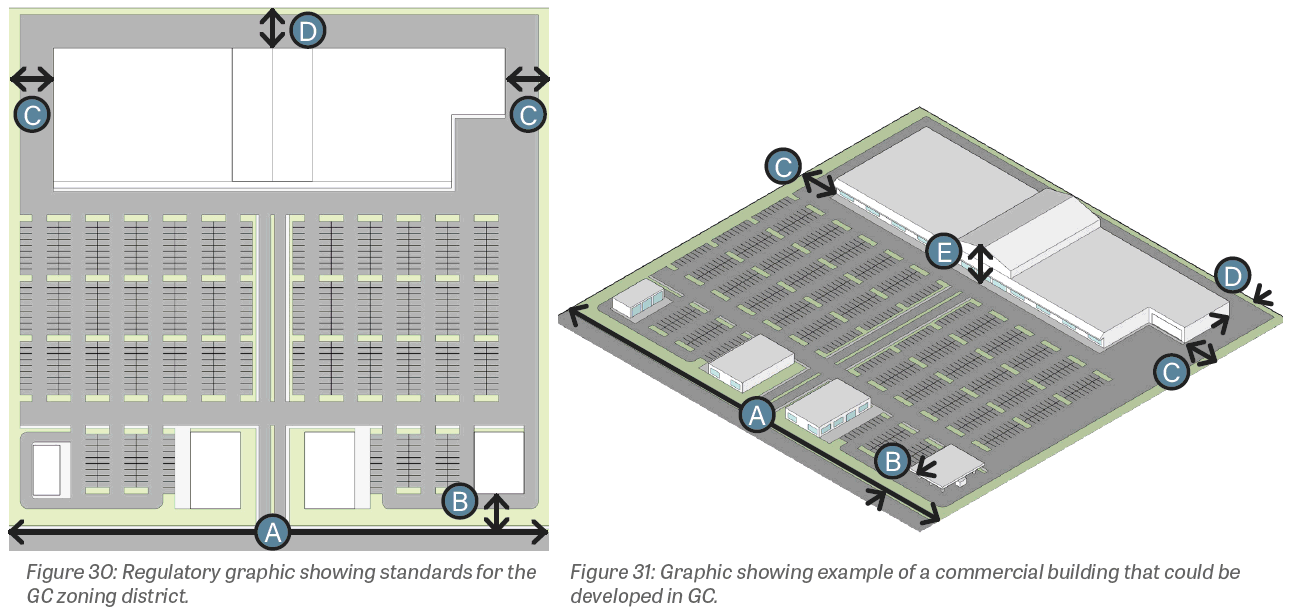
(e)
Development standards. All development in the General Commercial zoning district shall comply with the following specific standards. Generally applicable standards can be found in Chapter 1107 Design Guidelines and Chapter 1109 Site Elements.
(Ord. No. 0007-2024, § 2(Exh. A), 4-1-24)
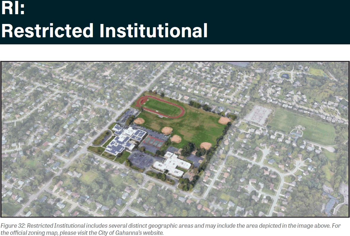
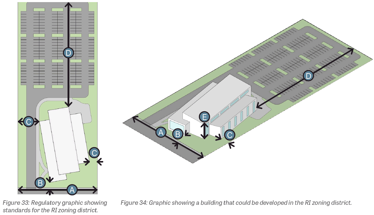
1103.14 - RESTRICTED INSTITUTIONAL (RI).
(a)
Purpose. The establishment of the Restricted Institutional zoning district aims to designate areas of Gahanna for institutional purposes, such as schools, churches, public administration buildings, and public parks. Developments address the street and invite the public to participate in civic matters.
(b)
Existing development. Existing development in the Restricted Institutional zoning district includes uses such as public and private schools, churches, cemeteries, and fire and police stations.
(c)
Desired development. The Restricted Institutional zoning district aims to encourage continued use and future development of institutional uses that are the foundation of community involvement, pride, and identity. Based on recommendations from the Gahanna Land Use Plan, standards should help achieve civic/ institutional character and should ensure pedestrian and bicycle connectivity, as well as ADA accessibility.
(d)
Uses. A list of principal and accessory uses applicable to this zoning district can be found in Section 1105.01.
(e)
Development standards. All development in the Restricted Institutional zoning district shall comply with the following specific standards. Generally applicable standards can be found in Chapter 1107 Design Guidelines and Chapter 1109 Site Elements.
(Ord. No. 0007-2024, § 2(Exh. A), 4-1-24)
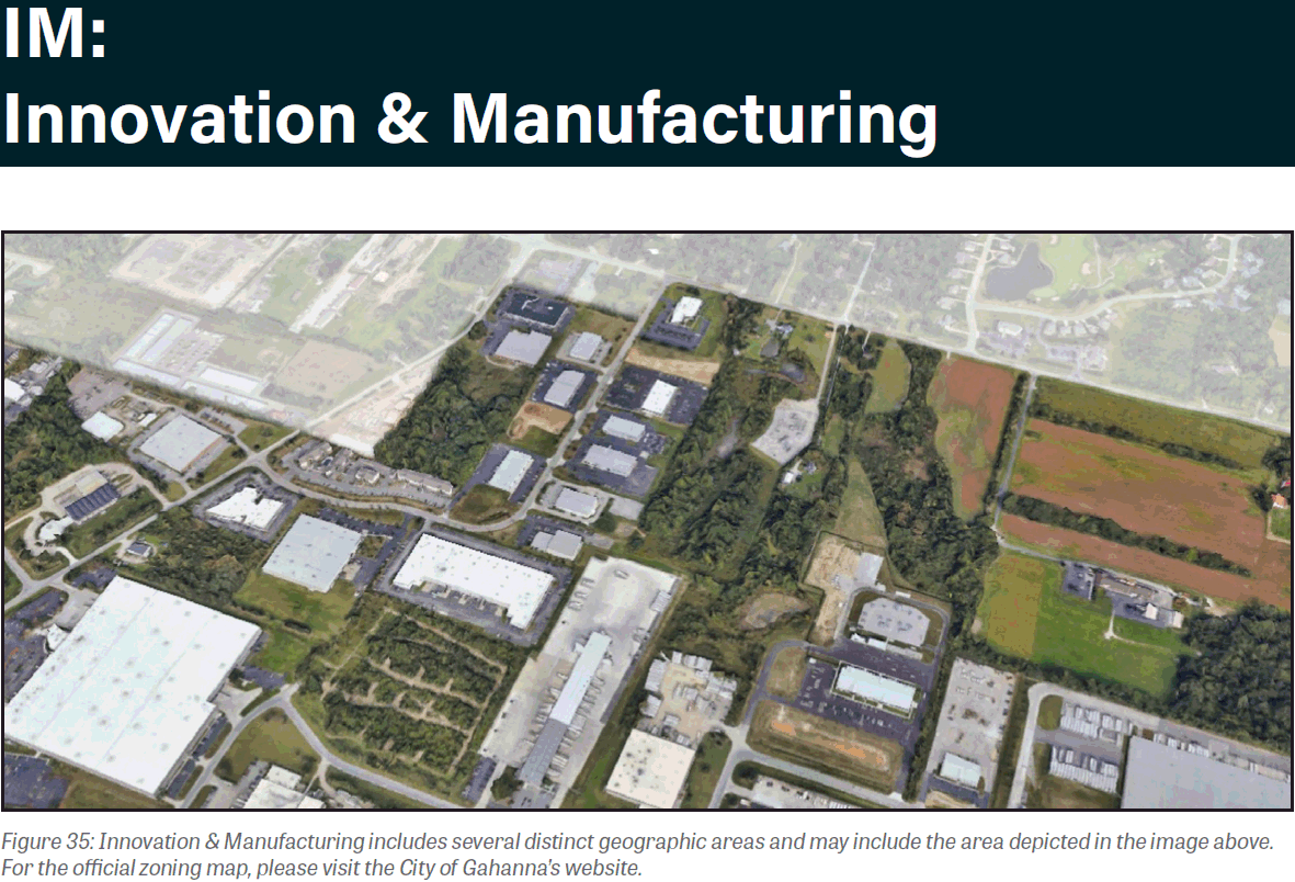
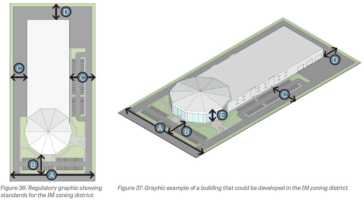
1103.15 - INNOVATION AND MANUFACTURING (IM).
(a)
Purpose. The establishment of the Innovation & Manufacturing zoning district aims to designate a specific area of Gahanna, south of Taylor Road and along I-270, for industrial, office, and research businesses and their associated enterprises. This zoning district is largely located in an area addressed in the Gahanna Land Use Plan as the South Gateway Focus Area, where pockets of vacant and underutilized land could be developed and where existing development could be intensified to build Gahanna's tax base and local employment.
(b)
Existing development. Existing development in the Innovation & Manufacturing zoning district includes uses such as logistics and shipping, manufacturing, medical services, hotels, brewing, offices, and recreational uses.
(c)
Desired development. The Innovation & Manufacturing zoning district aims to encourage continued use and future development of industrial and office uses. Based on recommendations from the Gahanna Land Use Plan, residential uses may be considered but should be limited to 20 percent of the mixed-use area.
(d)
Uses. A list of principal and accessory uses applicable to this zoning district can be found in Section 1105.01.
(e)
Development standards. All development in the Innovation & Manufacturing zoning district shall comply with the following specific standards. Generally applicable standards can be found in Chapter 1107 Design Guidelines and Chapter 1109 Site Elements.
(Ord. No. 0007-2024, § 2(Exh. A), 4-1-24)
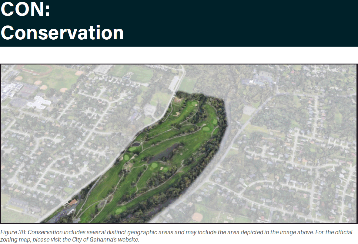
1103.16 - CONSERVATION (CON).
(a)
Purpose. The establishment of the Conservation zoning district aims to preserve greenspace and provide opportunities for recreation within Gahanna.
(b)
Existing development pattern. The Conservation zoning district comprises recreational uses, such as the preserved natural area along the Big Walnut Creek. Some pedestrian paths and other recreational amenities exist to enrich the experience of visitors.
(c)
Desired development pattern. The Conservation zoning district aims to further develop with pedestrian access points and connectivity, informational materials, and public art.
(d)
Uses. A list of principal and accessory uses applicable to this district can be found in Section 1105.01.
(e)
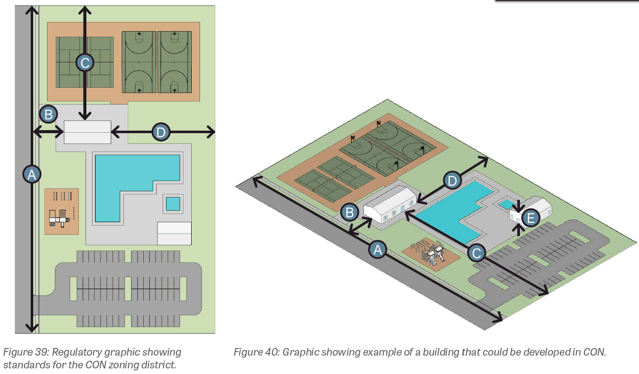
Development standards. All development in the Conservation zoning district shall comply with the following district-specific standards. Generally applicable standards can be found in Chapter 1107 Design Guidelines and Chapter 1109 Site Elements.
(Ord. No. 0007-2024, § 2(Exh. A), 4-1-24)
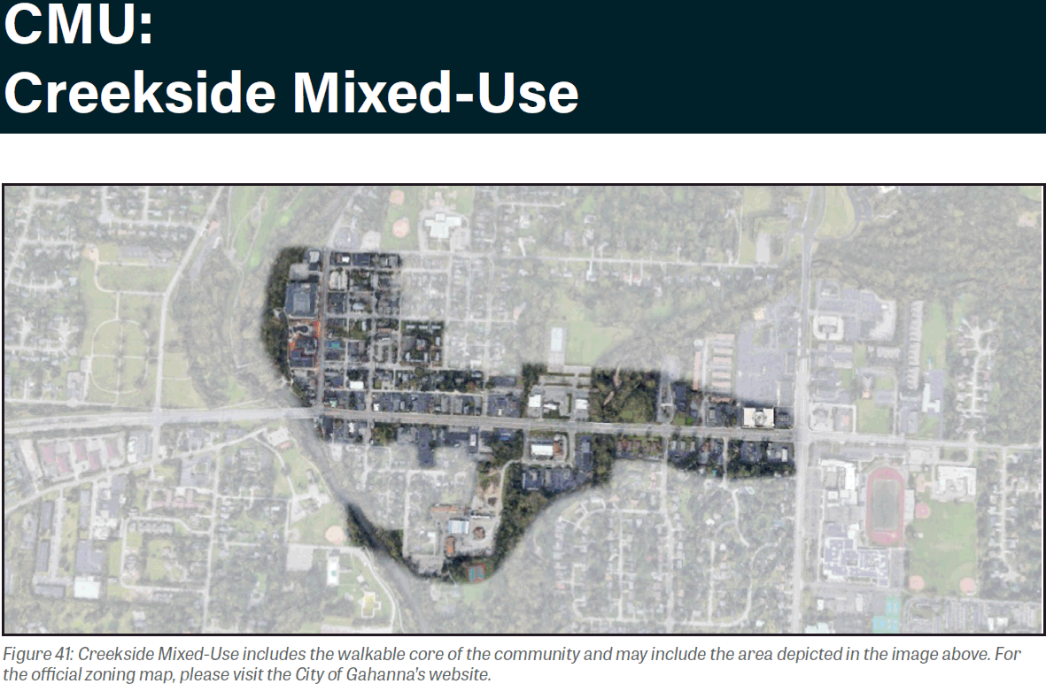
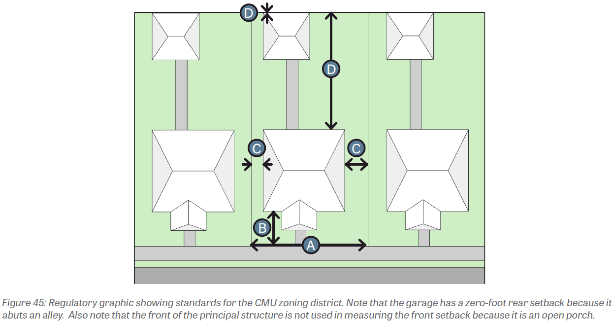
1103.17 - CREEKSIDE MIXED-USE (CMU).
(a)
Purpose. The establishment of the Creekside Mixed-Use District aims to promote a mixed-use district in the heart of downtown Gahanna. Small-scale shops, offices, restaurants, and residences will define this unique district. Residents and visitors will be welcomed with an old town feel and access to the natural areas adjacent to Big Walnut Creek.
(b)
Existing development. The Creekside Mixed-Use District consists of commercial, residential-style, and institutional structures, some built to the front lot line, with surface parking in the side, rear, and front yard areas. Building height varies, although most structures are one or two stories. Façade materials include brick, stone, metal, wood, stucco, and vinyl. Awnings, glazing, dining patios, overhanging eaves, porches and balconies, and landscaping are also present.
(c)
Desired development. The Creekside Mixed-Use District aims to allow for continued use and encourage future development of both commercial and residential uses. The design standards aim to elevate the design of the district, requiring quality façade materials, creating interesting building massing and visual order, and providing a more enjoyable pedestrian experience through the reduction of streetside parking areas, visible building equipment, and curb-cuts.
(d)
Uses. A list of principal and accessory uses applicable to this district can be found in Section 1105.01.
(e)
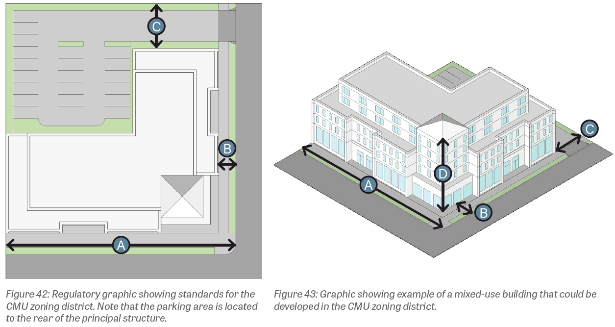
Development standards. All development in the Creekside Mixed-Use zoning district shall comply with the following district-specific standards. Generally applicable standards can be found in Chapter 1107 Design Guidelines and Chapter 1109 Site Elements.
(Ord. No. 0007-2024, § 2(Exh. A), 4-1-24)
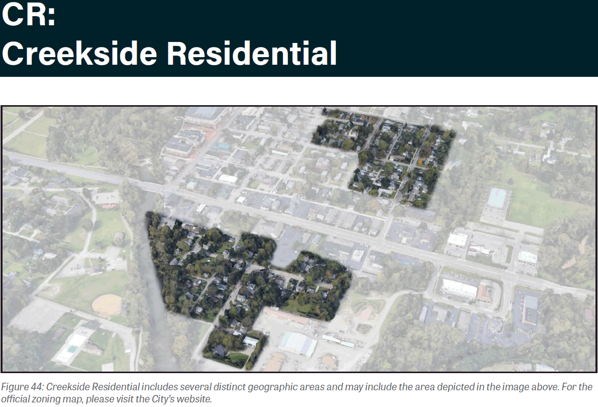
1103.18 - CREEKSIDE RESIDENTIAL (CR).
(a)
Purpose. The establishment of the Creekside Residential District aims to designate areas for medium density residential development with high-quality, pedestrian-oriented design.
(b)
Existing development. Residential uses comprise the majority of land uses within the Creekside Residential District.
(c)
Desired development. The Creekside Residential District aims to allow for continued use and encourage future development of residential structures. Based on recommendations from the Gahanna Land Use Plan, lot sizes and setbacks should allow for greater densities, which will better satisfy residents that seek smaller, lower maintenance properties close to neighborhood amenities.
(d)
Uses. A list of principal and accessory uses applicable to this district can be found in Section 1105.01.
(e)
Development standards. All development in the Creekside Residential zoning district shall comply with the following district-specific standards. Generally applicable standards can be found in Chapter 1107 Design Guidelines and Chapter 1109 Site Elements.
(Ord. No. 0007-2024, § 2(Exh. A), 4-1-24)
1103.19 - LIMITED OVERLAY DISTRICT.
(a)
Purpose. The Limited Overlay District is created as an alternative response to situations where the minimum development standards of an underlying zoning district are deemed inadequate to protect or maintain compatibility of land uses.
The Limited Overlay District is intended for restricted use where special circumstances or conditions fail to protect affected land uses.
The limitations placed within the Limited Overlay District to a property or properties shall apply to all parcels zoned under the Limited Overlay District and shall be deemed appropriate by the City where such limitations protect and preserve the welfare of the general public.
It is intended that an applicant for rezoning may voluntarily seek to commit the subject property and its owner to limitations and conditions not otherwise provided by the existing or proposed underlying zoning classification, or even any other zoning classification, by the establishment of a Limited Overlay.
This chapter provides the means to modify the application of the provisions of an underlying zoning district to a particular parcel or parcels by:
(1)
Limiting the permitted uses;
(2)
Increasing one or more of the minimum development standards; and,
(3)
Adding conditions for items not covered by the minimum development standards, or any of the above.
All standards of the underlying zoning district shall be applicable unless specifically amended by the Limited Overlay in the adopted ordinance for the subject parcel or parcels.
(b)
Applicable Zoning Districts. The Limited Overlay District may be used in combination with all zoning districts except ER, R-1, R-2, and R-3.
(c)
Application. Any person or persons desiring the establishment of a Limited Overlay District on any lot or lots proposed to be rezoned shall file an application in conformance with Chapter 1117 of this Zoning Ordinance.
(d)
Site Plan. The applicant shall provide a signed and dated application composed of the text and a site plan(s) for the Limited Overlay proposed, setting out the means for addressing the above stated purpose and specifically identifying the following:
(1)
Any limitation to be imposed on the normal range of permitted uses by the underlying zoning district;
(2)
Any increase in a minimum development standard for the underlying zoning district;
(3)
Any additional limitation or condition to be imposed and enforced; and,
(4)
The intended result to be obtained by any limitation or condition set out pursuant to the above.
The minimum standards of the underlying zoning district shall govern unless the development plan approved by Council specifically stipulates a more stringent standard. Such development plan shall be used only to increase standards and shall in no way be used or construed so as to grant a variance from or to decrease standards or requirements of the underlying zoning district.
(e)
Permitted Uses. Within a Limited Overlay District, the premises and/or buildings thereon shall only be used for any one or more of the uses permitted by the underlying zoning classification, unless the normal range of permitted uses is specifically limited by the development plan. If the development plan has a more restricted list of uses, then the development plan shall prevail. Conditional uses of the underlying zoning classification shall be considered permitted uses of the development plan only if those uses are specifically listed in the text of the development plan.
(f)
Development Standards. Any use of a lot subject to a Limited Overlay shall meet or exceed each minimum development standard of the underlying zoning classification and other provisions of the Zoning Ordinance unless more limited standards are specifically identified in the Limited Overlay development plan referenced in the ordinance passed by Council, in which event such more limited standards shall apply as promoting and maintaining the necessary uniformity of City planning.
The Limited Overlay standards shall comply with the following criteria:
(1)
Reasonably related to planning guidelines and/or to the accomplishment of specified goals;
(2)
Fair, protecting the legal rights for those affected;
(3)
Understandable for those in the marketplace; and,
(4)
Simple for effective interpretation and enforcement by the City.
There is no minimum or maximum size required for a parcel to be subject to a Limited Overlay except that the limitations thereof shall apply to the entire tax parcel and such Limited Overlay shall include at least one tax parcel. An application may include more than one tax parcel provided that all parcels in a specific application are contiguous to each other. Parcels separated only by a public right-of-way shall be considered contiguous.
(g)
Conditions and Limitations. Any use on a parcel subject to a Limited Overlay shall conform to each condition or limitation specifically identified and imposed in the development plan referenced in the ordinance passed by Council.
(h)
Amendment. All general procedures required for amending or determining a zoning designation shall be applied to an amendment of any Limited Overlay permitted use, development standard, condition or limitation.
(i)
Map Designation. Upon the establishment of a Limited Overlay on a particular parcel by ordinance of Council, the zoning map shall be amended to indicate that the parcel is subject to a Limited Overlay and its development plan by the addition to the appropriate initial and a hyphen, that is, "L-" preceding the symbolic designation of the underlying zoning district.
(Ord. No. 0007-2024, § 2(Exh. A), 4-1-24)