
Grand Lake City Zoning Code
ARTICLE 9
- LAND DEVELOPMENT REGULATIONS8
Note— Amending ordinances prior to 2018:
12-9-1 - Definitions.
The definitions for this Municipal Code Article shall be consistent with the definitions of the Municipal Code Zoning Regulations and Land Development Regulations.
12-9-2 - Major Land Use Development Review Procedures and Submittal Requirements.
(A)
The application for a Land Use Development shall be subject to a three-phased review process composed of the following:
1.
Sketch Plan.
2.
Preliminary Development Application.
3.
Final Development Application.
These processes may be combined for Subdivisions and Planned Developments at the applicant's request. Town Staff, the Planning Commission, and the Board of Trustees shall not review or take action on this application unless the applicant (its constituents or members) are current with the Town and all Town enterprises for all fees, assessments, charges, taxes, or amount due of any type.
(B)
Pre-Application Conference. Applicants are strongly encouraged to have a Pre-Application Conference with Town staff prior to Sketch Plan submittal. The Pre-Application conference with Town staff will help outline the process for review and submittal, as well as allow the opportunity for developer to receive adequate information from Town staff about development projects.
(C)
Sketch Plan. Prior to actual submission of the Preliminary Development Application, and prior to constructing any site improvements, each applicant shall confer with the Planning Commission at a regular meeting and other appropriate governmental departments and agencies in connection with the preparation of said application in order to obtain and exchange information. The Sketch Plan will enable the Town Planning Commission to render an informal preliminary review of the project and determine conditions which might affect Preliminary Development Application submission requirements. The general outlines of the proposal, evidenced schematically by sketch plans, are to be considered.
1.
Any materials prepared by the applicant to be used in discussions with the Planning Commission are to be submitted, by noon, to Town staff twenty-one (21) days in advance of the requested meeting date. Eleven (11) copies of all materials, including a CD of all submitted drawings in PDF format, and a deposit check payable to the Town of Grand Lake, as established set by Resolution by the Town Board of Trustees, need to be submitted in order to have a complete submission.
2.
The sketch plan should include the following items:
(a)
Land Use Development Application Deposit.
(b)
Written consent of each landowner whose properties are located within the development. The application shall be made by a person or entity having an interest in the property to be in the development and shall include the consent of all owners of or corporate interests in such property who are party to the development.
(c)
A map showing the general location of the development, the property boundaries of the proposed development, and the direction of True North.
(d)
A block, lot, street, and (if applicable) building layout indicating general scaled dimensions to an appropriate scale.
(e)
The sketch plan shall contain a description of the water distribution system contemplated for the proposed development, as well as the estimated total number of gallons per day of water to be required.
(f)
The sketch plan shall contain a description of the sewer collection system contemplated for the proposed development, as well as the estimated total number of gallons per day of sewage to be required.
(g)
The acreage and square footage of the entire tract.
(h)
The scale of the Sketch Plan shall be not less than one inch (1") equals two hundred (200) feet. Some variations from this will be acceptable in the case of large developments, provided the plans and design are clearly legible. The sketch plan shall include the name of the proposed development, and block and lot numbers. In the case of large developments requiring more than two (2) sheets at such a scale, an area plan showing the total area on a single sheet and at an appropriate scale shall also be submitted.
3.
At the time of review of the Sketch Plan, the Planning Commission shall discuss and establish requirements for public sites for schools, parks and other public uses.
4.
Either staff or the Planning Commission may furnish the applicant with written comments regarding said conference, to inform and assist the applicant prior to the preparation of the Preliminary Development Application.
5.
Within twelve (12) months of approval of the Sketch Plan, the developer shall officially submit one (1) copy of a complete Preliminary Development Application, together with all supporting documents, to the Grand Lake Planning Commission.
(D)
Preliminary Development Application. The Preliminary Development Application is intended to generate site plan information in the form of written statements and/or plats in order to provide adequate information for review by the Town and the general public. The completed application shall be known as the Preliminary Development Application.
1.
Purpose.
(a)
The purpose of this preliminary review is to check the proposed development against the design standards and improvement requirements stated herein. The Preliminary Development Application shall embrace all properties which are to be included in the proposed development and shall be sufficiently detailed to allow for an effective review.
(b)
Preliminary data should be prepared in graphic form avoiding time consuming final drafting techniques and detailed calculations. The degree of refinement for preliminary data is determined by the sensitivity of the design elements to changes in design constraints. It is advisable to build in "slack" in the preliminary design phase by not "pushing" minimum and maximum standards. Thorough analysis of the problems at this stage will expedite the review process of the Final Development Application and will prevent the repetition of expensive calculations and drafting required for the Final Development Application.
2.
Submission Requirements.
(a)
The written Preliminary Development Application shall contain the following in the following order:
1.
One (1) copy of title work including a statement of present and proposed ownership. This statement shall include the address of the applicant, all the property owners in the development, development signors for all public and/or private parcels, and any lien holders for all public and/or private parcels.
2.
Summary Statement of Proposal including the following:
(i)
Total acres and square feet to be developed.
(ii)
Total number of proposed dwelling units.
(iii)
Total number of square feet of non-residential floor space.
(iv)
Total number of off-street parking spaces, including those associated with single family residential use.
(v)
Estimated construction cost and proposed method of financing of the streets and related facilities, water distribution system, sewage collection system, storm drainage facilities, and such other facilities as may be necessary to complete the development plan.
3.
A narrative of the proposed handling of the increased drainage at the concentration points or of internal pattern changes. The drainage report shall include the supporting calculations for runoffs, times or concentration and flow capacity with all assumptions clearly stated and with proper justification when needed or requested.
4.
Statement of compliancy to the AFFORDABLE HOUSING REQUIREMENTS found in Municipal Code Section 12-10-3 including, but not limited to, number of proposed units, unit size, type and amenities, as well as a Local Employee Residence schedule for the development.
5.
Conversion Report, if applicable.
6.
Solar Orientation statement as outlined in Section 12-9-10(F)5(b) Solar Orientation.
7.
Open Space and Land Dedication statement, if applicable.
8.
Any additional information as may be required by the Planning Commission or staff to evaluate the character and impact of the proposed Development suggested at the time of Sketch Plan.
9.
Additional Written Documents for Developments: If a project is of minimal impact in the view of the Planning Commission, any of the following requirements may be waived. The applicant shall submit written statement which shall include, at a minimum, the following information, submitted in sequential order as listed:
(i)
A description of the character of the proposed development, the goals and objectives of the project, an explanation of the rationale behind the assumptions and choices made by the applicant, and an explanation of the manner in which it has been planned to conform to the Town's Comprehensive Plan.
(ii)
A development schedule indicating any sub-division platting sequences, the type of construction and approximate date(s) when construction of the Development or phases of said development can be expected to begin and to be completed, and the timing and construction of any public improvements.
(iii)
A description of the proposed open space to be provided at each stage of development; an explanation of how said open space shall be coordinated with surrounding developments; a statement explaining anticipated legal treatment of common ownership and maintenance of said open space areas.
(iv)
A description of proposed covenants, grants of easements or other restrictions to be imposed upon the use of the land, including common open spaces, buildings and other structures within the development.
(v)
A statement of the applicant's intentions with respect to the nature of future sales and/or leases of all portions of the Development.
(vi)
Quantitative data for the following: total number and type of dwelling units; number of bedrooms in each unit; parcel size; proposed lot coverage of buildings and structures; gross and net residential, commercial and industrial densities; total amount of open space (including a separate figure for usable or improved open space); and the total amount of non-residential construction (including a separate figure for commercial, institutional, or industrial facilities) with the amount of open space associated with these developments.
(vii)
Physiographic and environmental studies of the proposed site prepared and attested to by qualified professional authorities in the following fields: soil quality, slope and topography, geology, water rights and availability, surface and ground water conditions, and any impact on wildlife.
(viii)
A report detailing the traffic impact of the Development on the Town street system is to be represented in conjunction with this information.
(ix)
The proposed maximum height of all buildings within the Development.
(x)
Proof of legal, appropriated private water rights and/or source of proposed public water service. Proof of sewer service availability.
(b)
The drawn Preliminary Development Application shall include twenty-four inches by thirty-six inches (24" × 36") black-on-white or blue-on-white prints in a minimum scale of a fifty feet (50') equal to one inch (1"). Other smaller scales may be used with the permission of the Planning Commission. Applicants are encouraged to use more than one (1) sheet in order to avoid crowding of information on the sheet. Sheets are to be designated as sheet x of y sheets.
1.
The drawings will be contained within a space defined by a one and one-half-inch margin from the left side of the sheet and a one-half (½) inch margin from the other three (3) sheet edges. A two and one-half by three inch (2½" × 3") vertical box in the lower right-hand corner shall be provided for the use of the Grand County Clerk and Recorder.
2.
The drawings will contain the Development name, the words "Final Development Plan" or "Final Development Plat" underneath, scale (both numerical and graphical), north sign (north is to point to the top of the plat sheet) and date are required as well as last prior reception number of property transfer, original development name, if any, and the book and page references in the Grand County Records. The name of municipality, township, range, section and quarter-section, block and lot number (of the property under consideration) shall also be included, if applicable.
3.
A Development Application may be submitted in Sections covering representative and reasonable portions of the development tract. In such cases, submission shall include a map, indicating the Sections designated for the entire tract, and each sheet numbered accordingly, including title, legend, matchlines and other appropriate information. Where an entire parcel is not subdivided, if applicable, the developer must indicate his intended plans for disposition of the remainder of the parcel.
4.
The plats referred to herein shall be in conformance with these Regulations and the provisions of C.R.S. § 38-50-101, C.R.S. § 31-23-103, and C.R.S. § 31-23-105, 1973, as amended.
5.
At a minimum, Application Maps shall include:
(i)
General Location and Vicinity Map on a scale from 1" = 500' to 1" = 1,000' depicting:
1.
A Location and Vicinity Map showing the following information within a one-half (½) mile distance of the perimeter of the proposed plat.
2.
Total acreage and square feet of entire proposed development.
3.
Location of the development as a part of some larger development or tract of land and by reference to permanent survey monuments (pins, as set by a professional surveyor) with descriptions and ties, dimensions, angles, bearings, and similar data shall be shown on the plat as may be needed to determine boundary and lot closures. Primary control points and monuments shall be as specified by State law and shall actually exist in the field before final approval. Road intersections and ends shall be suitably monumented and ties filed with Town staff for engineering review prior to acceptance for maintenance.
4.
Names and addressed of the developer, the designer of the development, and the engineer and surveyor, both of whom shall be licensed by the State of Colorado Board of Registration for Professional Engineers and Land Surveyors.
5.
Date of preparation, map scale, and north sign.
6.
A traverse map of the monumented perimeter of the proposed development along with all survey notes of development perimeter and copies of all monument records. The traverse shall have an error of closure of not greater than one (1) part in ten thousand (10,000). A survey tie to the State co-ordinate system or other permanent marker established by the Town Surveyor is required if practical.
7.
Plan drawing shall also include items listed in Chapter 12-10 of the Town of Grand Lake's Municipal Code following the format for owner's and surveyor's signature blocks and dedication blocks.
(ii)
Existing Features Map.
1.
Location by survey of streams, washes, canals, irrigation laterals, private ditches, culverts, lakes, or other water features, including direction of flow, water level elevations, and typical depths and location and extent of areas subject to inundation by a 100-year storm.
2.
Information on land areas adjacent to the proposed development including land uses, zoning classifications, densities, circulation systems, public facilities, and unique natural features of the landscape.
3.
The existing site conditions, including contours at two-foot (2') or less intervals, water courses, flood plains (i.e., 100-year), unique natural features, and vegetation cover; and
4.
Abutting property lines within three hundred feet (300') of the development boundaries.
(iii)
Proposed Preliminary Site Plan Map.
1.
Preliminary Lot, Block, and Unit layout by reference to permanent survey monuments (pins, as set by a professional surveyor) with a tie to a section corner or a quarter-section corner, and with dashed lines for any portion or parcel outside of the proposed development:
2.
Lots and blocks numbered consecutively and scaled to the nearest foot.
3.
Units, buildings, structures, and other improvements scaled to the nearest square foot including written documentation of:
4.
Types of dwelling units; and
5.
Density per type; and
6.
Non-residential structures and non-residential facilities including shopping centers, community facilities, etc.; and
7.
Local employee residences.
(iv)
Preliminary Street Plan Map on a scale 1" = 50' with two-foot contours depicting:
1.
The plan must show alignment and graphic dimensions of right-of-way lines and widths, street name, lot lines, tangent lengths and bearings, curve radii, delta angles, curve lengths, chord lengths, stationing at all PC's and PT's intersection, structures, skew angles, curb lines, cross pans, drive cuts, curb returns and radii, location, type and size of appurtenant structures, such as bridges, culverts, traffic control devices (islands, striping, signs, etc.), and all other design features to enable construction in accordance with approved standards should be displayed. Where streets are to be temporarily stubbed at site or plat boundaries, the profiles should extend sufficiently beyond the boundary to assure the feasibility of a future extension that can conform to standards.
2.
Pedestrian and bicycle paths, on and off-street parking areas, loading areas, and major points of access to public rights-of-way (including major points of ingress and egress to the development) should all be shown. Notations of proposed ownership - public or private - should be included where appropriate.
(v)
Preliminary Drainage Plan Map utilizing two-foot contour intervals in areas where the predominant ground slope is less than ten percent (10%). A five-foot contour interval shall be used in areas where the predominant ground slope exceeds ten percent (10%). In cases where predominantly level topography occurs throughout a development a one-foot contour interval may be required. Elevation data shall be referenced to U.S.G.S. datum. The mapping accuracy shall be as specified by the American Society of Photogrammetry. The drainage system shall be designed for the Development by a registered professional engineer and shall be constructed in accordance with such design.
The Preliminary Drainage Plan should contain the following minimum data:
1.
Location by survey of streams, washes, canals, irrigation laterals, private ditches, culverts, lakes, or other water features, including direction of flow, water level elevations, and typical depths and location and extent of areas subject to inundation by a 100-year storm; and
2.
A basin contour map defining the drainage basins and illustrating the existing drainage patterns and concentration points with rough estimates of contributory acreage and runoff amounts; and
3.
A sketch of the proposed land development showing the consequent changes in the drainage patterns, concentration points and flooding limits with estimates of acreage, runoff coefficients and runoff amounts for the areas to be developed both now and in the future within each basin; and
4.
A drainage plan indicating general on-site facilities and proposed treatment and abatement of drainage to adjoining properties.
(vi)
Existing Utility Map.
The Existing Utility Map should contain the following minimum data:
1.
The location and principal dimensions and identification of all existing utility systems and public and private easements including sanitary sewers, storm sewers, and water, electric, gas, and telephone lines.
(vii)
Preliminary Utility Plan Map.
1.
Preliminary Development Applications and profiles of the proposed water and sewer facilities should be provided showing the location of all existing and/or proposed water and sewer and other utilities relative to the development. Indicate the size, type and other pertinent data for all existing and proposed utility improvements, including meter bank(s); and
2.
In the case of Townhouses and Condominiums all individual utility service lines (including) but not limited to: water; sewer; electric; telephone; and cable television must be separate to each unit within the development unless an acceptable alternative is approved by the Planning Commission.
(viii)
Preliminary Grading and Soil Erosion Plan Map.
1.
Such control plans and specifications shall be prepared by a registered professional engineer, using the State Conservation Standards.
(ix)
Preliminary Landscaping and Revegetation Plan Map.
(x)
Preliminary Open Space and Land Dedication Plan Map.
1.
Location and size in acres and square feet of sites to be reserved, conveyed or dedicated for parks, playgrounds, schools, or other public uses except streets and utility easements. The Planning Commission, upon consideration of Town circulation and facilities and the future requirements of the development, shall require the dedication of areas or sites of a character, extent, and location suitable for public use for public uses; and
2.
Location, function, size, ownership and manner of maintenance of common open space not otherwise reserved or dedicated for public use.
(xi)
Preliminary Snow Storage Plan Map.
(xii)
Preliminary Elevations.
(xiii)
Such other preliminary information as may be required by the Planning Commission in order to adequately review the plat as determined at the time of Sketch Plan.
(c)
Submission Deadline and Determination of Completeness.
1.
The applicant shall submit one (1) complete copy of the Preliminary Development Application documents by noon to Town staff at least twenty-one (21) days prior to the Commission meeting. Town Planning, Public Works and Water Departments will have fourteen (14) days to review and determine whether or not the application is complete.
(i)
Once determined complete, the applicant must submit an additional nineteen (19) copies, including a CD of all submitted drawings in PDF format, to Town staff. Staff may ask for additional copies if needed.
(ii)
If an application is deemed incomplete, after the deadline for submission, the application will not be presented to the Planning Commission.
2.
A receipt shall be issued to the developer for the Preliminary Development Application submission when it has been determined that the submission includes all the requirements set forth in these regulations. A poorly drawn or illegible plat is sufficient cause for its rejection. The date of the Planning Commission meeting to review the plans shall be specified on the receipt.
3.
Town Staff shall cause letters, advertising the time, date and location of the development public hearing, as well as copies of the Preliminary Development Application Maps and supporting documents, provided by the developer, to be distributed as follows:
Arapaho National Forest, Sulphur Ranger District (USFS)
Century Link of Colorado
Colorado Headwaters Land Trust
Colorado Parks and Wildlife (CPW)
Colorado River Water Conservancy District
Comcast of Colorado
Grand County Housing Authority
Grand County Library District
Grand County Planning and Zoning Department
Grand Lake Area Historical Society
Grand Lake Fire Protection District
Grand Lake Metropolitan Recreation District
Headwaters Trails Alliance
Mountain Parks Electric, Inc.
Northern Colorado Water Conservancy District
Rocky Mountain National Park (NPS)
Three Lakes Water and Sanitation District
Town of Grand Lake Water Department
U.S. Army Corps of Engineers
Western Area Power Administration
Xcel Energy
All other applicable entities as determined by the Planning Commission or Town Staff.
4.
Any entities to be excluded from this list of reviewing entities shall be specific to each application, and as determined by the Planning Commission or Town Staff.
5.
In order to be considered, all recommendations from the preceding listed entities shall be submitted to the Grand Lake Planning Commission no later than twenty-one (21) days from receipt of the plat.
3.
Planning Commission Review.
(a)
When a Preliminary Development Application has been officially submitted and received by the Town Planning Commission, it shall be placed on the agenda of the Town Planning Commission meeting next scheduled for development review. At this time, the Planning Commission shall set a Public Hearing for review of the development, provided that a minimum of twenty-eight (28) calendar days has elapsed between the official receipt of the material by the Planning Commission and the scheduled date of the Public Hearing.
1.
At least fifteen (15) days prior to the scheduled Public Hearing date, Town staff shall cause legal notice to run in a local newspaper of general circulation advertising the time, date and location of the development public hearing.
2.
At least twenty-one (21) days prior to the scheduled Public Hearing date, Town staff shall cause certified letters to be mailed to all property owners within two hundred (200') feet of any portion of the property proposed for the development indicating the time, date, and location of the development public hearing and the deadline to make written comment.
3.
At least twenty-one (21) days prior to the scheduled Public Hearing date, Town staff shall cause certified letters to be mailed to all development signors and lien holders for all public and/or private parcels of the real property within the development boundary, if applicable, indicating the time, date and location of the development public hearing and the deadline to make written comment.
(i)
Town staff shall also make written comments to the Planning Commission five (5) days in advance of both meeting dates.
(b)
The Town Planning Commission shall only approve those Preliminary Development Applications which it finds to be in accordance with the intent, standards and criteria specified in these Regulations and Grand Lake Municipal Code.
1.
The Planning Commission shall consider the application at the Public Hearing, and after weighing all evidence presented to it, shall either, in writing, approve said application as presented, approve said application subject to specified conditions, or disapprove it citing desired specific changes. The Planning Commission may continue the hearing to a time that is sufficient for the developer to amend the application.
(i)
Where specific changes in the Preliminary Development Application are required by the Planning Commission, a description of such changes shall be given in writing to the developer by Town Staff, as recommended by the Planning Commission, and notation of the required changes shall be entered in the official minutes of the Planning Commission.
(ii)
If the application is approved as presented or approved subject to conditions by the Planning Commission, said application may be submitted to the Board of Trustees for their review if the Planning Commission considers it necessary.
1.
If it is determined not necessary to submit the application to the Board of Trustees, the applicant may begin preparation of the Final Development Plan.
2.
Approval of the Preliminary Development Application shall be good for twelve (12) months. Thereafter, approval of the Preliminary Development Application will have expired unless a Final Development Application has been submitted or a mutually agreed upon extension has been granted by the Town Planning Commission. Any plat submitted for which Preliminary Development Application approval has been given in excess of twelve (12) months previous and for which no time extension has been granted shall be considered as a new Preliminary Development Application by the Planning Commission.
3.
Within five (5) days after review of the Preliminary Development Application at a public meeting, the Town Planning Commission shall send written notification to the Board of Trustees of its action.
(iii)
Upon denial of a Preliminary Development Application by the Planning Commission, the reasons for such denial shall be given to the developer in writing.
(E)
Final Development Application. The Final Development Application is intended to provide the specific design components of the Preliminary Development Application and for the review of additional items not required by the Preliminary Development Application. The completed application shall be known as the Final Development Application.
1.
No development shall be approved until such data, surveys, analyses, studies, plans, and designs have been submitted, reviewed, and found to meet all sound planning and engineering requirements of the Town of Grand Lake and the conditions contained in these regulations and all other applicable Sections of the Code of the Town.
2.
Final Development Application Submission Requirements. The Final Development Plan shall include all of the drawn and graphic information required in the Preliminary Development Application in its finalized, detailed form. In addition, the following items shall be submitted:
(a)
Any new items not submitted with the Preliminary Development Application; and
(b)
Any required dedication documentation and/or bonds; and
(c)
Final engineering plans for public roads:
1.
The profiles are to include ground lines, grade lines, vertical curves, curve lengths, calculated grades, elevation at PIVCs, BVCs, EVCs, intersections and other critical points, structures, and all other features required to enable construction in accordance with approved standards. The scale to be 1" = 50' horizontal and 1" = 1' to 1" = 5' vertical in flat and rolling terrain. The horizontal to vertical distortion is to be chosen to best depict the critical elevation aspects of the design. Where centerline grades at intersections are steep, curb return profiles are to be submitted showing necessary modifications to eliminate unsightly bumps or water retaining depressions that many times result.
2.
Detail should include orientation, line and grade, cross sections, dimensions, reinforcement schedules, materials, quality, specifications, etc.
3.
A structural section design report shall be submitted if a section other than the Town standard structure section is to be used. The design criteria set forth by the Town of Grand Lake shall be used in the preparation of the street construction plans and profiles.
(d)
Final engineering plans for utility systems:
1.
Plans and specifications based upon the approved Preliminary Development Application and associated reports are to be submitted detailing the design of final water, sanitary sewer, natural gas, telephone, electric and cable television facilities to be installed in the area included in the Final Development Application. In addition, final design is required of any off-site facilities related to the above-described utilities which may be considered an integral part of the utilities plan for the development.
2.
Water utility facilities design shall conform to the criteria set forth by the Town of Grand Lake.
(e)
Final engineering plans for storm drainage control systems:
1.
Plans and specifications based upon the approved Preliminary Development Application and associated reports are to be submitted detailing design of the final storm drainage system, including construction details and alignment of storm sewers, catch basins, manholes, ditches, slope protection, dams, energy dissipaters, etc.
2.
Flow line profiles and layout elevations shall be at minimum 100-foot stations, and natural ground elevations shown to indicate any significant irregularities for all proposed conduits, channels, structures, etc.
3.
Cross-sections of each water carrier shall be shown showing high water elevations and adjacent features which may be affected thereby.
4.
Construction details of curb, curb and gutter, valley gutter, driveway apron and ditch culvert, shall be included. Written approvals as may be required from other agencies or parties that may be affected by the drainage proposal shall also be submitted.
5.
The final drainage plan shall be prepared in conformance with the design criteria set forth by the Town of Grand Lake.
(f)
Where a portion of an existing easement is contiguous to a proposed easement or right-of-way of a new development, proof of the dedication of the existing easement or right-of-way; and
(g)
An exact copy of a certificate of a title insurance company or abstract of title suitably certified or certificate of title or title opinion submitted by an attorney which shall set forth the names of all owners of property included in the Plat and shall include a list of all mortgages, judgments, liens, easements, contracts and agreements of record, which shall affect the property covered by such plats; and
(h)
Master Declarations for each Local Employee Residence; and
(i)
A draft Improvement Agreement; and
(j)
Where a Home Owners Association or other entity is to be used for the administration and maintenance of private roads or open space and recreational facilities a binding and perpetual agreement in regard to maintenance and access control shall be submitted with the Final Development Application. Such agreement shall include provisions for:
1.
Adequate funding and self-enforcement by the Home Owners Association of the terms contained in the agreement.
2.
Continuous safety inspections and immediate follow-up maintenance to correct unsafe conditions.
3.
Receiving and processing complaints by authorized users of the private roads or open space and recreational facilities.
4.
Requiring written permission from the Board of Trustees of the Town of Grand Lake before the Association can be dissolved.
(k)
Any additional information as may be required by the Planning Commission or Board of Trustees necessary to evaluate the character and impact of the proposed Development.
3.
Submission Deadline and Determination of Completeness.
(a)
The applicant shall submit one (1) complete copy of the Preliminary Development Application documents, by noon, to Town staff and within twenty-one (21) days prior to the Planning Commission meeting. Town Planning, Public Works and Water Departments will have fourteen (14) days to review and determine whether or not the application is complete.
1.
Once determined complete, the applicant must submit an additional thirteen (13) copies, including a CD of all submitted drawings in PDF format, to Town staff. Staff may ask for additional copies if needed.
2.
If an application is deemed incomplete, the application will not be presented to the Planning Commission.
(b)
A receipt shall be issued to the developer for the Final Development Application submission when it has been determined that the submission includes all the requirements set forth in these regulations. A poorly drawn or illegible plat is sufficient cause for its rejection. The date of the Planning Commission meeting to review the plans shall be specified on the receipt.
4.
Planning Commission Review.
(a)
The Town Planning Commission shall review the Final Development Application at a regularly scheduled public meeting.
(b)
The Final Development Application submission shall conform in all major aspects to the Preliminary Development Application as previously reviewed and approved by the Planning Commission and shall incorporate all modifications required in its review. The Planning Commission, however, may approve a Final Development Application which has been modified to reflect improvements in design or changes which have occurred in its natural surroundings and environment since the time of Preliminary Development Application review and approval.
(c)
The Planning Commission may require or recommend changes or modifications to the Final Development Application in the public interest. The Final Development Plan may be deemed in substantial compliance with the Preliminary Development Application, provided modification by the applicant does not involve one (1) or more of the following:
1.
Violation of any provision of these Regulations;
2.
Varying the lot area requirement by more than ten percent (10%);
3.
A reduction of more than ten percent (10%) of the areas reserved for the common open space and/or usable open space;
4.
Increasing the floor areas proposed for non-residential use by more than ten percent (10%); and
5.
Increasing the total ground area covered by buildings by more than five percent (5%).
6.
Changes in use or increases in height or density.
(d)
After consideration of the application, the Planning Commission shall either, in writing and by resolution, approve said application as presented, approve said application subject to specified conditions, or disapprove it.
1.
Within five (5) days after review of the Final Development Application at the public meeting, the Town Planning Commission shall send written notification to the Board of Trustees.
5.
Board of Trustees Review.
(a)
After receipt of recommendation from the Planning Commission, but prior to any final action by the Board of Trustees, the developer shall submit all of the following items to Town staff in a form and manner acceptable as applicable:
1.
All Dedications, Reservations, or agreements concerning parks, school sites, and access roads are subject to Grand Lake Board of Trustees approval. Where such action involves another public agency, a letter of clearance from that agency shall accompany the Final Development Application.
2.
A signed warranty deed conveying seven percent (7%) of such land designated for public use or, at the discretion of the Board of Trustees, a certified check for an amount as may have been agreed to at the time the Preliminary Development Application was approved. The deed shall be accompanied by a title insurance policy or other evidence that the land is free and clear of all taxes, liens or other encumbrances.
3.
In the case of a Development an official signed deed dedicating or reserving certain tracts or the development rights to such tracts for local use as may have been agreed to at the time the Preliminary Development Application was approved. The deed shall be accompanied by a title insurance policy or other evidence that the land is free and clear of all taxes, liens or other encumbrances.
4.
A bond acceptable to the Town of Grand Lake, or in the alternative, a certified or suitable check equal to the total estimated construction cost of all required development improvements for the area included in the Final Development Application and all off-site improvements designated as an integral part of the improvements related to the Final Development Application shall accompany the Final Development application. Such improvements shall include but not necessarily be limited to streets, roads, paving, curb and gutter, sidewalks, storm sewers, sanitary sewers including collectors and outfall lines, water distribution and transmission lines, fire hydrants, street lights, street signs, traffic control devices, survey monuments, culverts, bridges and landscaping features.
5.
An executed copy of the Improvements Agreement and a signed agreement for inspection costs if required by the Town.
6.
When a new street will intersect with State Highway 34, a copy of the State Highway Permit shall be submitted.
(b)
The Town Board of Trustees shall review the Final Development Application within thirty-five (35) days of receipt of transmittal from the Planning Commission at a regularly scheduled public meeting. Failure of the Board of Trustees to review the application within thirty-five (35) days of such request shall be deemed a favorable approval of the Final Development Application and a Certificate shall be issued immediately thereafter to that effect, unless directed by the applicant to extend the 35-day requirement.
1.
If the Board of Trustees determines that the Final Development Application submission complies with the applicable requirements of these regulations, the Board of Trustees shall authorize the Mayor to endorse the Board of Trustees' Certification Block on the Plat.
(i)
The signing will be contingent on applicant submittal of:
1.
Development Assurances: The Planning Commission and Board of Trustees may require adequate assurance in a form and manner which it approves, that any public open space and any other public improvements shown in the Final Development Plan will be provided and developed. The Town may accept a bond, letter of credit, or other acceptable financial guarantee, in a form which complies with the provisions of the improvements agreement and in an amount sufficient to construct the public open space and improvements shown in the Final Development Application.
2.
The applicant shall provide a fourteen inches by eighteen inches (14" × 18") black line address mylar that includes the following: address(es) as assigned by the Town of Grand Lake, north arrow, name of the development, identification of legal description (lot & block, parcel, unit, etc.), road names and adjoining developments, for the Grand County Department of Planning and Zoning.
3.
The original reproducible drawing of the Final Development Application prepared in accordance with the requirements of this Article, and:
•
In the form of a black India ink Mylar or linen cloth that is capable of reproducing clear and sharp reproductions of all details, signatures, and notary seals.
•
No plats using sepia ink or pencil or containing stick-ons will be accepted.
•
All signatures on the plat are to be in black, permanent ink.
4.
The applicant shall provide a Compact Disc (CD) in AutoCAD.dwg or AutoCAD.dxf which includes the following as determined by administrative staff and/or Planning Commission: a north arrow, address(es) as assigned by the Town of Grand Lake, lots with dimensions and ties to monumentation, roads, easements, drainage and detention ponds, fire hydrants, sewer and water line layouts, water courses, legal description, bearings and distances, utility layouts, open space, building envelopes and topography for the Grand County GIS Department.
(ii)
The Board of Trustees shall not approve any major change or addition in the Final Development Application recommended by the Planning Commission until the proposed major change or addition has been referred to the Planning Commission for recommendations and a copy of said recommendations has been filed with the Board of Trustees. Failure of the Planning Commission to file said recommendations to the Board of Trustees within sixty (60) days after the reference shall be deemed to be approval of the proposed changes or additions. It shall be necessary for the Planning Commission to hold a public hearing on such major change or addition.
2.
If the Final Development Plan is approved subject to conditions, the formal acceptance and recording of such approval shall not be made until the applicant has obtained the signature of the Mayor of the Town on the Plat or Plan face. All conditions must be satisfied before any Town signatures are affixed thereto.
3.
The only basis for rejection of a final Development Application shall be its non-conformance to adopted rules, regulations and Sections of the Municipal Code currently in force and effect and the lack of conformance with the approved Preliminary Development Application.
(c)
The Board of Trustees shall record the Final Development Application with the Town Clerk within five (5) working days of approval of the Final Development Application by the Board of Trustees. The Town Clerk shall endorse the Clerk's Certificate on the Plat and immediately record the Plat with the appropriate County Clerk and Recorder.
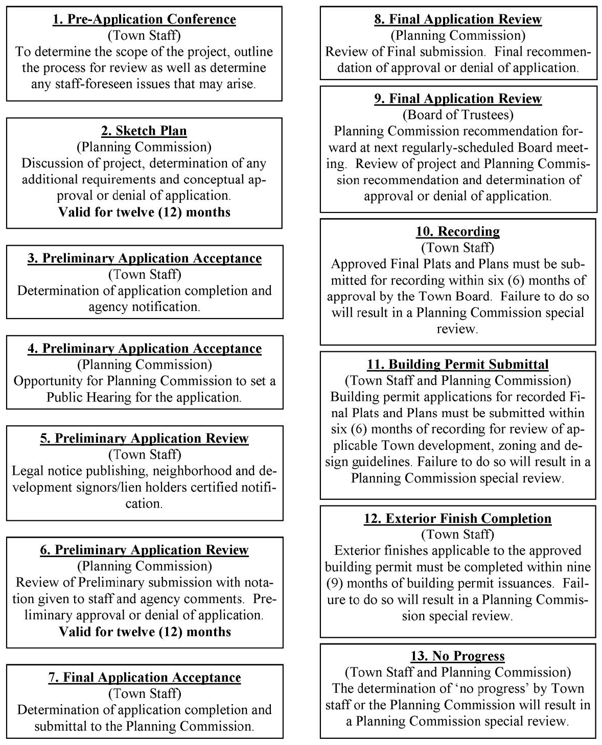
Land Use Procedure Flow Chart for Major Land Use Applications
The amount of time that it takes the Town to process a Major Land Use Application is determined by the amount of time it takes the applicant to prepare and submit information. The application process may take as little as six (6) months but may take much longer depending upon the pace of the applicant.
(Ord. No. 06-2019, 8-26-2019)
12-9-3 - Issuance of Development Overlay Designation.
(A)
If the Development Plan is granted final approval, the Board of Trustees shall, by Ordinance, adopt the approved PD Plan and authorize the rezoning of the subject property of PDD No. _______. Town Staff shall cause the Official Zoning Map overlay sheet to be marked as per the Town of Grand Lake Zoning Regulations.
(B)
The PD Overlay shall incorporate the approved Development Plan and any conditions imposed by the Planning Commission and the Board of Trustees and shall set forth the period of time within which the development provided in the PD Plan shall be completed. The PD Overlay, together with the Ordinance adopting the PD Plan and all accessory documents, shall be kept on file with Town Staff as a matter of public record; and a copy of the PD Plan and Plan Map(s) shall be recorded in the records of the Grand County Clerk and Recorder.
(C)
Upon filing and recording of the PD Plan(s), the terms and the provisions of the approved Plan incorporated therein shall govern and control the use and development of the property. Pending completion of the Development within the time provided in the PD Plan, the provisions of the approved PD Plan shall not be modified, released or revoked by either the landowner or the Town except in the manner and in accordance with the procedures set forth in these Regulations.
12-9-4 - Minor Development, Submission Requirements.
Minor developments shall follow all data submission requirements, procedures and drawing requirements required of this Article except as follows:
(A)
A Sketch Plan submittal is not required. Applicants are strongly encouraged to have a Pre-Application conference with Town staff prior to Preliminary Development Application submittal.
(B)
The information required in Section 12-9-2 shall be submitted at the time of Preliminary Development Application.
(C)
The Planning Commission or staff shall ask for comments from any entity listed in Section 12-10-2 as it deems appropriate.
(D)
The public hearing required in Section 12-9-2 for Preliminary Development Application will be required at Final Development Application Stage.
12-9-5 - Failure to Begin Development or Show Substantial Progress and Review.
(A)
Each approved Development overlay must contain a detailed development schedule, if applicable. At the developer's request, the Planning Commission may allow for an extension of the timeline. The Planning Commission may grant an extension for a period of time not to exceed six (6) months. The Town staff shall monitor this schedule, and failure of the developer to substantially adhere to it shall be cause for a Development Special Review by the Planning Commission. The Commission Special Review shall be commenced if one (1) or more of the following situations exist:
1.
Failure to record with the Grand County Recorder's Office within six (6) months of the Final Development Application Approval date by the Town Board of Trustees;
2.
An application for building permit has not been received within six (6) months after filing of the Final Development Application;
3.
The exterior finishes are not completed within nine (9) months of building permit issuance;
4.
In-activity or documented "no progress" as determined by either Town staff or the Planning Commission on any stage of the project for more than one (1) year after the last completed benchmark in the approved development.
(B)
Periodic Review of all On-going Developments - The Planning Commission may conduct an annual review of each project on or about the anniversary date of the Development approval. No fees will be charged to the developer for these reviews. Developers of projects may be asked by the Commission or staff to appear at this review and make a progress report. The commission will make a determination and note in the minutes as to whether adequate progress has been made by the developer. This periodic review may constitute a Land Use Development Special Review.
1.
The Land Use Development Special Review will be undertaken by the Planning Commission to determine if the developer can verify to the Commission that the original assumptions and plans of the Development are still appropriate.
(a)
In order to cover the Town's expenses for conducting a Land Use Development Special Review, the developer shall pay a deposit equivalent to eighty percent (80%) of the original deposit. In addition to direct collection, failure to pay fees will trigger other methods of securing payment, such as the denial of new building permits, or placing a stop-work order on existing building permits, may be utilized.
(b)
At this review, the development schedule shall be recommended to be formally amended and shall be forwarded to the Town Board of Trustees for their review of the amended development schedule. No development may proceed until these formal amendments and approvals are made.
(c)
After the Special Review has been undertaken and the Board of Trustees has found, determined, and declared that there is no realistic possibility that the Development can or will proceed as approved in the Final Development Application, the Board of Trustees may revoke the Final Plat or Plan by Resolution. Said Revocation may trigger penalty provisions of the Zoning Code due to non-conformance with the original base zoning.
12-9-6 - Procedure for Review of "As-Built" Plats.
(A)
Approved developments with construction of any type are required to have as-built drawings, in the form of an Improvement Survey Plat, approved by the Town. These drawings shall be submitted to Town staff for review and approval.
(B)
As-Built Plat Information.
1.
The first sheet(s) shall contain the same information as the approved development plat sheets with the title "As-Built Plats" at the top, with "Final Development Plat/Plan (prior reception number) Amendment" underneath.
2.
These drawings shall graphically and dimensionally depict the exact locations of building footprints and the development buildings into volumetric spaces and relationship of these footprints and spaces with the boundaries of the site and other appurtenances (including, but not limited to, parking, dedicated easements of record, utility easements, service lines and mains). All areas on the site are to be identified as general common, limited common elements, the units themselves, or reserved areas.
(a)
The Planning Commission Certificate block may be omitted; the Trustee's block is to be retained.
3.
The numerical designation of the individual parcels (volumetric of plane) which will be specifically referred to in deeds to the owners of the spaces or areas.
4.
Anything else required by state law.
(C)
Approval Procedure.
1.
In the case of townhouse and condominium airspace units of any type, after the final development plat has been approved and prior to the transfer of property, the developer shall pay the As-Built processing fee and submit the original and three (3) copies of the as-built materials to Town staff. Town staff shall review these materials and check the development site within fifteen (15) days of reception. If Town staff is satisfied that the proper dedications have been made, that all owners and interest holders and the Registered Land Surveyors have properly certified their approvals, and that all of the requirements of these regulations are met, Town staff shall so certify to the Mayor for his signature on behalf of the Town. Town staff shall then have the as-built materials, along with appropriate documents, recorded with the Grand County Clerk and Recorder.
2.
Should the Town staff determine that substantial differences exist between the approved and recorded development plat/plan and the as-built plat to warrant review by the Planning Commission, Town staff shall place the development in question on the agenda of the next Planning Commission meeting for discussion and review. The developer will be notified of the Planning Commission meeting and be asked to appear and discuss the concerns of Town staff. The results of these discussions may involve physical changes on the site or within buildings. In such cases, new as-built maps are to be drawn and resubmitted before final approval can be made.
(a)
As-built plats that have been discussed by the Commission may be referred to the Board of Trustees for their review, should circumstances dictate, before signature by the Mayor.
(b)
No approvals for final zoning inspections and sign-off will be given until after the review and final approval of as-built materials by Town staff, the Planning Commission and the Mayor of the Town.
12-9-7 - Amendments to Land Use Developments.
Amendments may be made to previously approved plats and plans by the Board of Trustees with recommendation by the Planning Commission. Amendments shall be constituted as a new development application and shall follow the provisions for standards and specifications set forth in this Section.
(A)
Deposit. Amendment applications will be required to pay a deposit, as set by the Town Board of Trustees.
(B)
Submission Requirements. Submission requirements for each project will vary, depending on the proposed amendment. Town staff will determine the sufficient submission requirements and make recommendation to the Planning Commission and Town Board of Trustees regarding a complete submission.
(C)
Amendments to Final Development Plans.
1.
Minor changes in the location of buildings, siting, and height of buildings and structures may be authorized by the Planning Commission without additional public hearings if required by engineering or other circumstances not foreseen at the time the Final Development Plan was approved. No change authorized by this subsection may cause any of the following:
(a)
A change in the use or character of the development;
(b)
An increase in overall coverage of structures;
(c)
An increase in the intensity and density of use;
(d)
An increase in the problems of traffic circulation and public utilities;
(e)
A reduction in approved open space;
(f)
A reduction of off-street parking and loading space;
(g)
A reduction in required pavement widths.
2.
All other changes in use, or rearrangements of lots, blocks, and building tracts, or any changes in the provision of common open spaces must be approved by the Board of Trustees after a report from the Town staff and recommendation by the Planning Commission. Such amendments may be made only if they are shown to be required by changes in conditions that have occurred since the Final Development Plan was approved or by changes in community policy. Any changes which are approved in the Final Development Plan must be recorded as amendments in accordance with the procedure established for the recording of the initial Final Development Plan documents with the exception that prior to making its recommendation to the Board of Trustees, the Planning Commission shall hold at least one (1) public hearing with the applicant being responsible for publishing notice of said hearing in the official publication of the Town of Grand Lake at least fifteen (15) days in advance of the hearing.
(D)
Amendments to Final Development Plats.
1.
The Planning Commission may recommend to the Board of Trustees amendments to the requirements of these Regulations after giving adequate public notice of a public meeting in a newspaper of general circulation. Town Staff shall set a public hearing date before the Board of Trustees, and notice of said hearing shall be published in the official newspaper of the Town at least fifteen (15) days prior to the time of the hearing. The Town Board of Trustees shall conduct the hearing and either adopt, adopt with modifications, or not approve the proposed amendments. A joint hearing of the two (2) bodies is appropriate. All amendment Ordinances must be authorized using the following form and published immediately upon adoption and included in any subsequent sale of these Regulations to the general public.
APPROVED AFTER PUBLIC HEARING by the Grand Lake Planning Commission the ___ day of ________, 20___.
______________________
Chairman
ATTEST:
______________________
Secretary
APPROVED BY the Board of Trustees of the Town of Grand Lake the ___ day of ________, 20___.
______________________
Mayor
ATTEST:
______________________
Town Clerk
12-9-8 - Land Use Development Variances.
(A)
Procedural Variances.
1.
The Planning Commission may grant a procedural variance by simple majority vote upon application of the Developer at any regular meeting of the Planning Commission regarding submission requirements for any land use development project.
(B)
Substantive Development Variance.
1.
All other Sections of this Article are hereby found, determined and declared to be matters of substance.
2.
A Developer may request a substantive variance from Land Use Procedures and Standards by filing a written request, with Town Staff, specifying the variance(s) being sought at least fourteen (14) days in advance of the next Planning Commission meeting. The Developer must prove to the Planning Commission's satisfaction that strict compliance with the requirements of these Land Use Procedures and Standards would result in extraordinary hardship to the developer because of unusual topography, or other conditions beyond his control or that these conditions would result in inhibiting the achievement of the objectives of this Article and that such substantive variance(s) will not have the effect of nullifying the intent and purpose of these Land Use Procedures and Standards or the Town of Grand Lake Master Plan.
3.
The Town shall cause a public notice to be published stating the legal description of the proposed development, the nature of the variance being sought, the name, address and telephone number of the Developer, and the date, time and place of the public hearing.
4.
The Town will also notify by certified letter, return receipt requested, all property owners within two hundred (200') feet of the property for which the variance is being sought. The information contained in the public notice shall be included in the letter.
5.
The Commission shall not recommend approval of variances unless it shall make findings based upon evidence presented to it in each specific case that:
(a)
The granting of the variance will not be detrimental to the public safety, health, or welfare or injurious to other property as located.
(b)
The conditions upon which the request for a variance is based are unique to the property for which the variance is sought and are not applicable generally to other property.
(c)
Because of the particular physical surroundings, shape or topographical conditions of the specific property involved, a particular hardship to the owner would result, as distinguished from a mere inconvenience, if the strict letter of these Regulations is carried out.
(d)
The variances will not in any manner vary the provisions of the Zoning Ordinance, Master Plan, or Official Map.
(e)
The variance is in conformity with all other criteria the Planning Commission sets by policy from time to time.
6.
Such variances, shall be granted only by affirmative vote of two-thirds (⅔) of the entire membership of the Planning Commission. The Planning Commission shall make recommendation, by Resolution, to the Town Board of Trustees. The Town Board of Trustees shall hear the variance request at their next regularly scheduled meeting.
(C)
Variances Deemed Inappropriate or Insignificant by Planning Commission.
1.
In the process of development review, the Planning Commission may, from time to time, identify certain requirements within this Article that are simply not appropriate or not applicable to the request at hand. In these cases, the Planning Commission may authorize a variance from any section of these Land Use Procedures and Standards on its own initiative.
2.
Prior to any action, the Planning Commission shall cause a Resolution to be drafted which shall:
(a)
Fully document the specific unique circumstances indicating the need for initiated variance;
(b)
The specific Sections of this Article for which a variance is being granted;
(c)
A determination of findings as per Section 12-9-8(B)1—(B)5; and,
(d)
A specific finding that the variance being granted is "because the requirements of the above named Sections are inappropriate to the instant case" or "the variance being granted has been found, determined and declared to be insignificant" or similar language.
3.
Initiated variances shall be granted only by the affirmative vote of two-thirds (⅔) of the entire membership of the Planning Commission. The Planning Commission shall make recommendation, by Resolution, to the Town Board of Trustees. The Town Board of Trustees shall hear the variance request at their next regularly scheduled meeting.
(D)
Substantive and Initiated Variances Require Town Board of Trustees Approval.
1.
The Town Board of Trustees shall have the final authority to grant or disapprove any and all substantive or Planning Commission initiated variances to these Land Use Procedures and Standards. The Board of Trustees shall cause a listing of the variances approved to be included in all Ordinances approving Final Plats.
2.
All said variances that are disapproved shall be included in a letter which shall be sent back to the Planning Commission and to the Developer within five (5) days after the Town Board of Trustees meeting in which the variances were disapproved. The Developer and the Planning Commission shall meet to revise the Final Plat accordingly.
12-9-9 - Violations and Penalties.
(A)
Whoever, being the owner, or agent of the owner, of any land located within a development transfers or sells or agrees to sell or negotiates to sell any land by reference to or exhibition of or by use of a Plan or Plat of a development before such Plan has been approved by the Grand Lake Planning Commission and Board of Trustees and recorded or filed in the Office of the Town Clerk, shall forfeit and pay a penalty of three hundred dollars ($300.00) for each lot or parcel so transferred or sold or agreed or negotiated to be sold. Each day of violation shall constitute a separate offense. The description of such Lot or Parcel by metes or bounds in the instrument of transfer or other document used in the process or selling or transferring shall not exempt the transaction from such penalties or from the remedies provided in this Section. The Town may enjoin such transfer or sale or agreement by action for injunction and may recover the said penalty by civil action in any Court of competent jurisdiction.
(B)
The Town Board of Trustees may withdraw approval of a Plan or Plat if and when it is determined that information provided by the developer, upon which such approval was based, is false or inaccurate.
12-9-10 - Standards.
(A)
Each new development of land in Grand Lake will, to some extent, affect the character and environmental appeal of the land, the cost of services and maintenance to the purchasers and the Town government, and the interests of investors in the land and surrounding areas. New developments shall provide safe, convenient travel routes to, from and within the development. Each lot or unit must provide a desirable setting for construction so that natural features of the land may be preserved, views and solar access protected, privacy permitted, and screening from traffic ways is possible. Provision must be made to meet area needs for flood and fire protection, sewage disposal and water.
(B)
The Planning Commission and the Town Board of Trustees will consider the cumulative impact of the developments of land in the area that have occurred in the past, as well as anticipated developments of land on Town services or any of the Standards described below and herein, and shall make such additional requirements that such impacts necessitate.
(C)
General Information.
1.
Special Site Considerations.
(a)
Steep, unstable or swampy land, and land subject to inadequate drainage, avalanche, or rock slides, and geological hazards shall be identified, and unless acceptable provisions are made for eliminating or controlling problems which may endanger health, life or property, such sites shall not be platted for improvements.
(b)
The Planning Commission may require the applicant to furnish appropriate technical data and other information necessary to determine the extent to which a proposed development of land is subject to flooding, located in a natural drainage channel, or subject to geological, fire, or other natural hazards. Technical data and other information requested by the Planning Commission will be prepared and certified by a professional qualified in the appropriate field of expertise. If it is determined that a proposed division of land or a portion thereof lies within a natural hazard area, the Planning Commission and Town Board of Trustees may set forth certain conditions, stipulations, standards and prohibitions which must be observed if a development of land is to be permitted.
(c)
When the Planning Commission requires review and comment by outside agencies, any fees levied by those agencies for their review will be paid by the applicant either directly to the agency or by remitting an extra fee to the Town to cover the cost.
2.
Dedications.
(a)
Dedication of rights-of-way for streets giving access to adjacent lands and adjoining dedicated streets, and drainage and utility easements, may be required.
(b)
Approval of a development of land under these Regulations shall not constitute acceptance by the Town of the roads, streets, or other public lands as indicated for dedication on the Plat or Plan. The dedication of any of these lands for Town use of any nature within the Town shall be accepted by the Town only by specific action of the Town Board of Trustees.
(c)
In addition, dedication of land or payment of fees in lieu of land dedications for public purposes as per of these Regulations is required before approval of the Final Plat or Plan by the Town Board of Trustees.
3.
Improvements Required.
(a)
In each proposed land development, the applicant and the Planning Commission shall agree on the type, location and extent of necessary public improvements depending on the characteristics of the proposed development and its relationship to the surrounding area. Improvements shall be made by the applicant at his expense according to standard specifications prepared by a qualified professional engineer and approved by the Town Board of Trustees.
1.
Permanent survey monuments shall be set as required by C.R.S. Title 38, Article 51, 1973, as amended. In addition, one-half inch (½") steel pins (or larger) shall be set at all lot corners. Affixed securely to the top of each such monument shall be the Colorado Registration number and land surveyor responsible for the establishment of said monument.
(b)
Improvements not specifically mentioned in these Regulations, but found appropriate and necessary due to unusual conditions found on the site, shall be constructed at the applicant's expense within such time and in conformance with such specifications as deemed necessary and appropriate by the Planning Commission and Town Board of Trustees. No plat or plan shall be signed by the Town Board of Trustees until the improvements required by these Regulations have been constructed and approved by the appropriate Town officials having jurisdiction over such improvements, or until assurance in the form of an acceptable Improvements Agreement with approved guarantees is given to the Town Board of Trustees that the required improvements will be completed.
4.
Responsibility for Improvements.
(a)
General Requirements. The following improvements shall be constructed at the expense of the Developer as stipulated in the Development Improvement Agreement in a manner approved by the Town Board of Trustees and in a manner which is consistent with sound construction and local standards. Where specific requirements are spelled out in other Sections of this Article of other applicable Articles the specific requirements shall apply:
1.
Road, grading and surfacing.
2.
Curbs, if required.
3.
Boardwalks, Sidewalks and Greenways, if required.
4.
Sanitary sewer laterals where required.
5.
Storm sewers or storm drainage system, as required.
6.
Water distribution system, where applicable.
7.
Street signs at all street intersections.
8.
Permanent reference points.
9.
Landscaping features.
10.
Other facilities as may be specified or required in the Municipal Code, by the Board of Trustees.
(b)
Improvement Agreement. No Final Plat or Plan shall be approved until the developer has submitted a Development Improvement Agreement or a contract approved by the Town, agreeing to construct the required improvements as shown in documents supporting the Preliminary Plan. Suitable collateral, in an amount stipulated in the Development Improvement Agreement, shall accompany the final plat submission, to ensure the completion of the improvements according to design and time specifications.
1.
At such time as the various improvements are completed, the developer may apply to the Town for partial or full release of the collateral, subject to approval of the Town upon inspection of the improvement. If the improvements are not constructed in accordance with all of the specifications the Town shall notify the developers of the non-compliance and discuss with the developers the reasons for the non-compliance and proposed schedules for correcting the non-compliance. Wherever the cost of improvements is covered by a performance bond, the developer and the bonding company shall be severally and jointly liable for completing the improvements according to specifications.
2.
If the Town determines that the developers will not construct any or all of the improvements in accordance with all of the specifications, the Town shall have the power to withdraw and employ from the bond or deposit as specified, such funds as may be necessary to construct the improvement or improvements in accordance with the specifications.
3.
To insure that improvements are constructed in accordance with Town standards, the Board of Trustees shall require the Developer to sign an agreement to reimburse the Town for the costs of inspection of said improvements. If the value of improvements in the Development Improvements Agreement is less than ten thousand ($10,000.00) dollars the Board of Trustees may elect to waive this provision upon motion of the Board of Trustees. These fees shall be due and upon demand of the Town. Failure of the Developer to pay these fees shall be cause for the Town to deny the issuance of building permits, water taps, or Certificates of Occupancy until all are paid.
4.
The Board of Trustees will not accept dedication of required improvements, nor release nor reduce a security agreement, until the Town Staff has submitted a certificate stating that all required improvements have been satisfactorily completed and until the developer's engineer or surveyor has certified to the Town of Grand Lake through submission of detailed "as-built" survey plat of the development, indicating location, dimensions, materials and other information required by the Planning Commission and Board of Trustees that the layout of the line and grade of all public improvements is in accordance with construction plans for the development and that a title insurance policy has been furnished to and approved by the Town Attorney indicating that the improvements shall have been completed, are ready for dedication to the Town, and are free and clear of any and all liens and encumbrances. Upon such approval and recommendation, the Board shall thereafter accept the improvements for dedication in accordance with the established procedure.
(c)
Release of Guarantee. From time to time as the required improvements in a development are completed, the developer shall apply in writing to the Town for a partial or full release of the bond, credit deposit letter, certified check, or other collateral. Such release requests shall not be made to the Town more frequently than once every month. Upon receipt of such application in writing, the Town or its agent shall inspect that portion of the improvement which has been completed.
1.
If the Town determines from such inspection that the improvements thus far completed have been made in accordance with the Final Plat and the requirements of these regulations, a portion of the bond, credit deposit letter, certified check, or other collateral sufficient to cover the improvements thus far completed less ten percent (10%) retainage shall be released.
2.
The retainage shall not be released until all required improvements have been made and a final inspection report from the Town Engineer has been received by the Board of Trustees recommending final acceptance of the improvements.
(D)
Block, Lot, and Additional Setbacks.
1.
Block Standards.
(a)
Blocks shall not exceed thirteen hundred twenty feet (1,320') in length nor be less than three hundred sixty feet (360') in length. The length of blocks shall be considered to be the distance from street centerline to opposite street centerline and shall be measured through adjacent back lot lines or through the center of the block. The total design should provide for convenient access and circulation for emergency vehicles. All blocks shall be abutted by a street or streets. Where blocks are longer than three hundred sixty feet (360') pedestrian walkways shall be provided to permit acceptable pedestrian access to abutting streets.
(b)
Service access to the interior of blocks may be permitted in certain instances, in which case such alleys must be indicated in the plan and plat.
(c)
Blocks shall have sufficient width for two (2) tiers of lots of appropriate depths. Exceptions to this prescribed block standard shall be permitted in blocks containing steep slopes or adjacent to major streets or streams and lakes.
2.
Lot Requirements and Standards.
(a)
Developments.
1.
Lot Requirements. There shall be no minimum lot width, setbacks, or lot area requirements in a PD. Setbacks and lot widths shall be as required by the Planning Commission to provide adequate access and fire protection and to ensure proper ventilation, light, solar access and air. The stream and lake setback requirements of the Zoning Regulations shall be adhered to the greatest degree possible as a priority item. Deviations from these water setbacks will be judged according to Shoreline and Surface Water Regulations of the Zoning Code.
2.
Lots created as part of a Development shall conform to the General Requirements and Standards as set forth in this section.
(b)
Subdivisions.
1.
Lot Requirements. The minimum lot width, setbacks and/or lot area requirements for a development shall conform to the Zoning Regulations of the Municipal Code. The stream and lake setback requirements of the Zoning Regulations shall be adhered to. Deviations from these water setbacks will be judged according to Shoreline and Surface Water Regulations of the Zoning Code.
2.
Lots created as part of a Development shall conform to the General Requirements and Standards as set forth in this section.
(c)
General Requirements and Standards.
1.
Lot Standards for Townhouses. Notwithstanding any other provisions contained in the Municipal Code, widths and frontage for townhouses are permitted to vary from the standards imposed by the Grand Lake Zoning Ordinance without requiring a variance proceeding before the Board of Adjustment. In making its recommendation, the Planning Commission shall encourage variations from the minimum lot sizes and widths which provide a variety and diversity in design while still protecting the unique features of the site and protecting the surrounding neighborhood.
2.
Lot Dimensions. Lot dimensions shall comply with the minimum standards of the Zoning Ordinance. Where lots are more than double the minimum required area for the zoning district, the Planning Commission may require that such lots be arranged so as to allow further development and the opening of future streets where they would be necessary to serve such potential lots, all in compliance with Municipal Code.
3.
Division of Lots. No lot shall be divided by a municipal or county boundary line, road, alley or other lot.
4.
Wedge-shaped Lots. In the case of wedge-shaped Lots, no Lot shall be less than forty feet (40') in width where the narrow side of the Lot is at the front property line.
5.
Lot Lines. Side Lot Lines shall be substantially at right angles or radial to street lines. Where lot lines are not at right angles to the street lines, this shall be indicated.
6.
Frontage on Public Street. All lots in developments shall front and have access on a public street.
7.
Lot Arrangement. The lot arrangement shall be such that there will be no foreseeable difficulties, for reasons of topography or other conditions, in securing building permits to build on all lots in compliance with Municipal Code and in providing driveway access to buildings on such lots from an approved street.
8.
Double Frontage Lots and Access to Lots.
(i)
Double Frontage Lots. Double frontage or reversed frontage lots shall be avoided except where necessary to provide separation of residential development from traffic arterials or to overcome specific disadvantages of topography and orientation.
(ii)
Access From Arterials. Lots shall not, in general, derive access exclusively from a major arterial street. Where driveway access from a major arterial may be necessary for several adjoining lots, the Planning Commission may require that such lots be served by a combined access drive in order to limit possible traffic hazard on such street. Driveways should not be designed and arranged so as to require vehicles to back into traffic on major arterials.
9.
Corner Lots. Dimensions of corner lots shall be large enough to allow for erection of buildings, observing the minimum front-yard setback from both streets.
(i)
Lots for residential use on corners shall have extra width to accommodate yard setbacks on both street frontages.
(ii)
When corner lots exist along street ROW(s) of greater than sixty (60) feet, the standard setbacks for each properties reserved or laid out for business, commercial, or industrial purposes shall be adequate to provide for the off-street parking and loading facilities required for the type of use and development contemplated as established in the Municipal Code.
10.
Lot Setback. Minimum building setbacks on the perimeter of such developments shall be in conformance with the Municipal Code.
11.
Lot Drainage. Lots shall be laid out so as to provide positive drainage away from all buildings and individual lots drainage shall be coordinated with the general storm drainage pattern for the area. Drainage shall be designed so as to avoid concentration of storm drainage water from each lot to adjacent lots.
3.
Additional Development Setbacks.
(a)
Where a development is adjacent to the State Highway 34 right-of-way, a permanent open space at least twenty feet (20') in width shall be required along the property line(s). This area shall be kept free of buildings and structures and contain permanently maintained landscaping, unless screened or protected by natural features. Parking areas may encroach up to five feet (5') into this setback.
(E)
Structures and other Built Features.
1.
Building.
(a)
Height. The height of buildings shall be governed by the limit defined in the existing zoning overlay. Height in excess of any of these existing limits may be granted, by a Board of Trustees variance. For those height variances outlined in Supplemental Setback, Height and Area Regulations of the Municipal Code the request shall be heard by the Town Board of Trustees with recommendation from the Planning Commission.
(b)
Spacing.
1.
Each Development shall provide reasonable visual and acoustical privacy for dwelling units. Fences, walks, barriers, landscaping, and sound reducing construction techniques shall be used as appropriate for the aesthetic enhancement of property and the privacy of its occupants, the screening of objectionable views or uses, and the reduction of noise. A minimum of twenty (20) feet must be maintained between buildings.
2.
All buildings will be located so as to take advantage of any passive or active solar gain as deemed appropriate by the developer in the interests of energy conservation.
(c)
Construction. The design and construction plans shall take into account characteristics of soils, slopes and potential geological hazards, in a manner intended to protect the health, safety, and welfare of potential users. These aspects of the plan must be accompanied by a detailed soil engineering report on the suitability of the area for the intended use and the necessary precautions needed to bring the area to a state of structural soundness before building permits may be issued.
2.
Additional Standards for Conversions of Leased or Rented Space of Any Type to Townhouses or Condominiums.
(a)
General. Due to the special nature of converting existing rental spaces to townhouses, condominiums or other types of airspace ownership arrangements, the following regulations will apply specifically to these types of development projects. Except where otherwise noted herein, all conversion projects will also comply with the design standards of this Section.
1.
Physical Standards for Conversion. A report on the physical elements of all structures and facilities shall be submitted with the Preliminary Development Application. This report is to be compiled by a licensed professional structural engineer and/or registered architect, as appropriate, and shall include but not be limited to the following:
(i)
Adequate Physical Condition.
1.
A report detailing the structural condition of all elements of the property including foundations, plumbing, utilities, walls, ceilings, windows, recreational facilities, sound transmission of each building, fireplaces, insulation, electrical system, mechanical equipment, space heating devices, and appliances. Regarding each element, the report shall state, to the best knowledge or estimate of the applicant, the current condition of each element and any substantial variation of the physical condition of said element from the current Municipal Code, Health, Fire and Building Electrical and Plumbing Codes in effect in Grand Lake on the date of inspection. The report shall identify any defective or unsafe element and set forth the proposed corrective measures to be employed.
2.
The developer shall provide to the Town and to any buyer of any unit before approval of the As-Built Plat written certification that all appliances, heating equipment and other mechanical equipment provided in the units are in operable working condition. At such time as the Owner's Association takes over management of the development, the developer shall provide written certification to the Town and to the Association that any mechanical equipment to be owned in common by the association is in operable working condition.
3.
A statement of repairs and improvements to be made by the developer necessary to meet the deficiencies in subsections (1) above.
4.
All necessary repairs and improvements will need to be completed before approval of a Certificate of Occupancy Permit is granted.
(ii)
Specific Physical Standards.
1.
Each conversion project will conform to the Grand Lake Building Code, the Plumbing and Electrical Codes including any exemptions provided therein, in effect at the date of application, and any other health and fire codes enforced in the Town.
2.
Each conversion project shall meet all the off-street parking requirements of the Municipal Code, unless otherwise provided.
3.
Each water using unit shall have a separate three-quarter (¾) inch (minimum) service line, meter, and curb stop. A plant investment fee is required for each new tap so created. Each dwelling unit shall be separately metered for electrical and other utilities.
4.
Each unit shall have at least two hundred (200) cubic feet of enclosed, weather-proofed and lockable storage space in addition to guest, linen, pantry and clothes closets provided. Such storage space may be located in any portion of the project, and no such space for any one (1) unit may be split between two (2) or more locations.
5.
All main buildings, structures, fences, patio enclosures, carports and garages, accessory buildings, sidewalks, landscaped areas and additional elements as required by the Planning Commission shall be refurbished and restored as necessary to achieve a high degree of appearance, quality and safety.
6.
All conversion projects will conform to minimum floor area and off-street parking requirements of the Municipal Code. In the case of conversions of hotels and motels to condo-hotel/motel rooms, equivalent required off-street parking must be provided within three hundred feet (300') of the project boundaries. The minimum floor area for condo-hotel/motel room projects shall be three hundred fifty (350) square feet.
7.
Open space requirements for each zone district shall apply to each conversion project. Developers of mixed use projects may follow the Mixed Use Open Space Schedule in the Zoning Regulations for the CT, C and RST Districts. Projects in the Town Core Area are eligible for open space negotiations with the Planning Commission.
2.
Notification to Residential Tenants.
(i)
A developer who converts a structure into condominium, townhouse or other individually owned airspace dwelling unit, immediately prior to Final Development Application submittal to the Grand Lake Planning Commission shall notify by certified receipt mail each residential tenant of the dwelling of such anticipated conversion and the anticipated date when the occupancy grade period as allowed by C.R.S. § 38-33-112 is to begin and end. Evidence of receipt of notice to convert by each tenant must be included with the Final Development Application.
1.
No building permit will be issued for purposes of building construction activity associated with the conversion project until all tenants have vacated the building according to the procedures required under these regulations and C.R.S. § 38-33-112. Evidence that the building is completely vacated will be signed statements of termination of occupancy by the tenants that they were properly notified and that the developer has complied with state law.
3.
Tenant's Right to Purchase.
(i)
Any present tenant or tenants of any unit shall be given a non-transferable right of first refusal to purchase the unit occupied at a price no greater than the price offered to the general public. The right of first refusal shall extend for at least forty-five (45) days from the date of notification of the tenant. This requirement shall not, in itself, create a vested right in the tenant.
3.
Additional Standards for Mobile Home Townhome Developments.
(a)
General.
1.
Generally, the standards pertaining to developments set forth in these Regulations and others of the Town of Grand Lake that apply to development, construction, alteration or extension will apply to a mobile home townhome development. However, standards herein which are more stringent shall control.
(i)
All buildings and utilities to be constructed, altered, or repaired in a mobile home townhome development must comply with all applicable codes adopted by the Town and the state including building, electrical, and plumbing.
(ii)
All mobile home townhome developments must provide for management and maintenance of all common elements through a homeowner's association as per requirements of these Regulations.
(iii)
HUD Seal: All mobile home townhomes must contain the U.S. Department of Housing and Urban Development (HUD) seal or subseal if a mobile home was constructed prior to the adoption of the HUD and Colorado Division of Housing seals. For those mobile home parks existing in the Town of Grand Lake prior to the adoption of these Regulations that wish to convert into a mobile home townhome development, all mobile homes contained within the development must either:
1.
Obtain such a seal or substantially conform to the requirements of said seal within five (5) years after the development is platted; or
2.
Be removed and replaced by a HUD certified seal mobile home.
(b)
Minimum Site. The minimum site for a mobile home townhome development is one (1) acre.
(c)
Density and Open Space. These standards are contained in the Municipal Code.
(d)
Landscaping. A minimum of ten percent (10%) of the open space area is to consist of landscaped buffers along the perimeter boundaries of the development to act as a visual and privacy screen for the development. Perimeter boundary landscaped setbacks shall be a minimum of fifteen feet (15') when developments face onto an internal road or cu-de-sac. Developments wishing to face onto a public street must get specific permission from the Planning Commission and conform to the setbacks in the Grand Lake zoning Ordinance. Landscaping in the remainder of the open space may consist of ground cover. The development developer will be responsible for the replacement of revegetation and landscape plantings for two (2) growing seasons after installation. Plants listed in Chapter 13: Urban Forestry Management, are encouraged.
(e)
Parking Areas, Drives, and Retaining Walls. Each unit shall have a minimum of two (2) standard off-street parking spaces available with parking areas defined with cribbing or similar materials and parking stalls clearly defined. Parking areas and drives are to be surfaced with Class C gravel to a depth of two inches (2") as a minimum. Any retaining walls of over four feet (4') in height which are used for slope stabilization, parking and drives shall be engineered and constructed as per the Chapter 9: Building Regulations.
(f)
A central trash deposit and pick-up area shall be provided for every fifteen (15) units in a development. The trash area shall be screened from public view.
(g)
The minimum base or pad size upon which mobile homes will be placed is one thousand two hundred (1,200) square feet. The remainder of the land area after open space and pad areas are deducted is to be used for parking, drives, trash areas and appurtenant (attached and detached) structures (screened porches, sheds, etc.) for the mobile home units. Walkways and a maximum of a six foot (6') by four foot (4') outside stair case and landing with canopy may be included as open space.
(h)
The minimum spacing between units including any appurtenant structures shall be twenty feet (20'). Mobile home townhome developments converting from mobile home parks existing prior to the adoption of these Regulations may have a fifteen foot (15') spacing between units upon specific recommendations of the Planning Commission.
4.
Bridges.
(a)
Bridges of primary benefit to the applicant, as determined by the Planning Commission and Board of Trustees, shall be constructed at the full expense of the applicant without reimbursement from the Town. The sharing of expenses for the construction of bridges not of primary benefit to the applicant as determined by the Planning Commission will be fixed by the improvements agreement between the Board of Trustees and the applicant. Said cost shall be charged to the applicant pro rata as the percentage of his land developed and so served.
1.
If any bridges are to be constructed within the Development on public or private ways (roads, streets, paths, etc.), these are to be built in full compliance with the dredge and fill laws of local, state and federal jurisdictions.
(F)
Standards and Regulations for Improvements within Rights-of-Way.
1.
General Standards and Regulations.
(a)
Street, Sidewalk and Boardwalk Plan. The arrangements, classification, extent, width, grade and location of all streets, sidewalks and boardwalks shall conform to the street, sidewalk and boardwalk plans and Municipal Code of the Town and shall be designed in relation to existing and planned streets, sidewalks and boardwalks topographical conditions, public convenience and safety, and the proposed uses of the land to be served by such streets, sidewalks and boardwalks. The construction standards are as follows:
1.
All street or highways shall be designed and constructed in accordance with the Street Development Standards of the Town of Grand Lake, adopted as a separate Article to this Code, and as amended from time to time.
(i)
All calculations and coefficients shall conform to requirements set forth in the Chapter 11: Article 2: Street Development Policies, Standards, and Specifications.
2.
All boardwalks and sidewalks shall be designed and constructed in accordance with the Chapter 11: Article 4: Boardwalks, Sidewalks, and Community Greenways.
2.
Additional Regulations.
(a)
All public and private streets are to be paved and shall be dedicated to the Town as utility easements where said easements are necessary. All streets are to be completed and paved before a certificate of occupancy (C.O.) is issued on a structure(s). This requirement may be waived for nine (9) months should weather conditions necessitate it. All improvement bonds, escrow funds, etc., are to be held by the Town until paving is complete. A fugitive dust control plan is to be included in the PD documents and implemented during construction.
1.
All private streets shall be conveyed to a private home or property owners association. If the private association or person(s) owning the private streets in the Development should in the future request that any private streets be changed to public streets, the private association or owner(s) will bear the full costs of reconstruction or any other action necessary to make the streets conform to the applicable standards for public streets. The private association or owner(s) shall also agree that these streets shall be made to conform and be dedicated to public use without compensation to the private association or owner(s).
(b)
Additional Standards.
1.
Development Abutting Major Rights-of-Way. Where a development abuts or contains an existing or proposed primary street or highway, the Planning Commission may require service streets, reverse frontage lots with screen planting in a reservation strip along the rear property line, deep lots with rear service alleys abutting the primary street or highway, or such other treatment as may be necessary for adequate protection of residential properties and for separation of through and local traffic.
2.
Development Containing Major Rights-of-Way. Where a development borders on or contains highway right-of-way, the Planning Commission may require a street approximately parallel to and on each side of such right-of-way, at a distance suitable for the appropriate use of the intervening land. Such land would be appropriately used for park purposes in residential districts, or for commercial or industrial purposes in non-residential districts. Such distances shall be determined with due regard for the requirements of approach grades and future grade separations.
3.
Intersections. Intersections of local streets with major streets shall be kept to a minimum.
4.
Street Names. Streets shall have the names of existing streets which are in alignment in the Town or in an adjoining county or municipality. There shall be no duplication of street names.
5.
Streets shall be designed to bear a logical relationship to the topography. All streets in new developments shall be paved with asphalt or concrete.
6.
Whenever streets are not aligned, off-sets shall be at least one hundred thirty-five feet (135'), centerline to centerline.
7.
Cul-de-sacs shall be permitted, provided they are not more than five hundred feet (500') in length and have a turnaround diameter of one hundred feet (100'), with a pavement diameter of ninety feet (90'). If the topography dictates the use of a longer cul-de-sac, the approval of the Planning Commission shall be obtained. The drainage easement shall be required between the cul-de-sac and the rear lot line of the lowest lot.
8.
A T-shaped and Y-shaped terminus may be provided in mountainside developments as an alternative to the circular turnaround. Where provided, the "wings" of the T or Y shall be at least twenty feet (20') deep, measured from the street boundary, and at least sixteen feet (16') wide exclusive of parking space. Curbs at the intersection of the street and the "wings" of the T or Y shall be rounded with a minimum radius of twenty feet (20').
9.
Dead end streets, with the exception of cul-de-sacs, shall be prohibited.
10.
Half streets shall be prohibited. This requirement supersedes those contained in Chapter 11: Article 2: Street Development Policies, Standards, and Specifications. When a proposed half street in one development is adjacent to another property, the approval of the adjacent owner shall be obtained and the entire street shall be platted and dedicated by the owners. The responsibility for acquiring the additional right-of-way shall be with the developer.
11.
Restriction of access shall be required when a development or portion thereof adjoins an arterial highway. Marginal access streets, reverse frontage with screen planting contained in a non-access reservation, deep lots or similar treatment shall be required to reduce the impact of traffic on residential properties and to avoid interference with the movement of the traffic on arterial highways.
12.
Traffic control and street name signs shall be installed at all intersections in the development, according to the street names approved by the Planning Commission and the Board of Trustees. All signs shall be in conformance with standards established by the Planning Commission and the Board of Trustees of the Town of Grand Lake.
13.
On all areas of land proposed for development whereon the general configuration of the undisturbed surface slopes fifteen percent (15%) or more in any direction, a grading plan showing revised contours for street construction shall be submitted. Such plan shall show the extent and percent slope of cut and fill areas created by street construction. Any proposed retaining structures shall be designed in detail. The Planning Commission may require wider roadbed widths for snow storage and guard rails where it feels these measures are appropriate. All cut and fill slopes and retaining structures shown as a result of street construction shall be located within the dedicated right-of-way proposed. No back slope shall exceed a ratio of one and one-half foot (1½') vertical to one foot (1') horizontal. A revegetation plan shall be submitted for all cut and fill slopes in excess of one foot (1') vertical to three feet (3') horizontal. Such plan shall use native or similar plants and include a cost estimate. The revegetation plan shall be implemented concurrently with street construction.
14.
Development road systems shall be designed with two (2) or more dedicated access roads for separate, multiple ingress and egress.
15.
Private streets shall afford abutting properties reasonably adequate access for entry by private and emergency vehicles and should be designed to standards at least equal to public streets.
16.
All public roads within a development shall be maintained (except for snow removal) by the developer for a period of one (1) year after which the developer may petition to have the Town formally accept the road into its street system for dedication and maintenance purposes. The Trustees will release the final fifty percent (50%) of the collateral required under the performance agreement when the road is determined to be in substantial compliance with Town road specifications.
17.
Widening and Realignment of Existing Roads. Where a development boarders an existing narrow road or when the Master Plan, Official Map, or zoning setback regulations indicate plans for realignment or widening a road that would require use of some of the land in the development, the applicant shall be required to improve and dedicate at his expense such areas for widening or realignment of such roads. Such frontage roads and streets shall be improved and dedicated by the applicant at his own expense to the full width as required by these Development Regulations. Land reserved for any road purposes may not be counted in satisfying yard or area requirements of the Municipal Code whether the land is to be dedicated to the Town in fee simple or an easement is granted to it.
3.
Bike Paths and Walking Paths.
(a)
Walking paths and/or bicycle path linkages will be required in accordance with the Master Plan pertaining to these amenities and/or in order to link up logically with established or planned ways in the Town or County in open spaces or developed areas. If no such Master Plan requirements or private development plans exist, the development shall include such pathways in development plans along logical routes recommended by the Planning Commission to serve residential, non-residential and recreational facilities provided in or adjacent to the development. Such pathways shall be dedicated via easements to the public or property owner's association and may be included in any open space requirement of these or other regulations.
1.
Where bicycle paths and walking paths exist side-by-side (closer than ten feet (10')), a clear separation shall define the two (2) either in grade (minimum of six inches (6")) or by other means. If separated by grade, the walking path shall be higher in elevation than the bicycle path.
2.
Where walking and/or bicycle paths and automobile roadways exist side-by-side (closer than ten feet (10') from the shoulder and/or pavement edge), they shall be separated by a grade elevation of seven inches (7") minimum with the walking and/or bicycle path being higher in elevation than the automobile roadways.
3.
The minimum width of all pathways is eight feet (8').
4.
Trails shall be posted with appropriate signage.
4.
Parking and Loading.
(a)
Parking shall be provided as per the off-street parking requirements found in the Town of Grand Lake Zoning Regulations. In addition, the Planning Commission may determine that storage areas for boats, trailers, campers and other recreational vehicles shall be required where the necessity for such facilities has been demonstrated and where such facilities will preserve the required off-street parking for the use of automobiles.
1.
Parking requirements in the Town Core area may be altered by the Planning Commission during its review of the Development Application. Alternative parking measures need to be considered, such as:
(i)
Availability of future public parking facilities in the Town and their location.
5.
Snow Storage and Solar Orientation.
(a)
Snow Storage.
1.
A snow storage plan designating adequate areas for the storage of plowed snow equivalent to a minimum of one-third (⅓) of the uncovered parking area and drive. The Condominium/Townhome/HOA Declarations shall provide for the removal of snow by the owners' association when storage areas are at capacity upon notice by the Town.
2.
A snow storage and/or removal plan shall be required for all parking, loading and drive areas. The number of required spaces shall not be reduced in order to store snow.
(b)
Solar Orientation.
1.
All developments subject to these Regulations should, in general, maximize solar access in building site planning in terms of street layouts, orientation of building sites on lots to the streets and avoidance of north facing slopes and windows.
(i)
Development shall fit and take advantage of topography and solar orientation to the end that good building sites are provided and utilities can be provided most economically.
(ii)
When the development abuts an area developed with or specified for high- or mid-rise buildings (or, in the case of a Development District, which will be developed with mid- or high-rise buildings), the location of open space wherever possible shall be such that it will protect shorter structures from shadows cast by taller buildings.
2.
In particular, at the time of submission of Preliminary Development Application the developer shall submit an energy statement which shall include the following:
(i)
A generalized narrative speaking to the solar aspects of the development either as a whole or discussed in parts. Discussion of such aspects as orientation to the sun, slope, vegetative cover and other relevant solar data is appropriate.
(ii)
A statement and shadow plan demonstrating that eighty percent (80%) of the lots are sized and designed so as to protect solar access to the base of a south facing wall of a theoretical building on December 21 between 9:00 a.m. and 4:00 p.m. while conforming to the lot sizes and setbacks of these and the Grand Lake Zoning Regulations.
1.
In the case of townhouses, apartments, condominiums and other mid- to high-rise developments, the above solar regulations apply on a building by building basis.
(iii)
A Statement indicating how the structures in the proposed development will protect snow and ice shed from neighboring structures and adjoining properties.
(iv)
Statements and clauses protecting solar access to the base of a south facing wall of any building shall be included in the protective covenants of any development. At the time of submission and approval of final development plats, protective covenants including the energy statement required by this Section shall be reviewed by the Planning Commission and Board of Trustees to determine compliance with the approved energy statement.
6.
Alley and Easement Standards.
(a)
Alley Standards.
1.
Alleys in residential developments shall be prohibited unless they are necessary to continue an existing pattern. All alleys shall be a minimum of twenty feet (20') wide.
2.
Alleys shall be provided in commercial and industrial areas, except that this provision may be waived when other provisions are made and approve for service.
(b)
Easement Standards.
1.
Plats shall convey easements of sufficient size and width for utility purposes to the Town along all streets, roads, alleys, parking and loading areas.
(i)
Easements shall follow rear and side lot lines whenever practical and shall have a minimum total width of twenty feet (20') apportioned equally in abutting properties when alleys are not provided.
(ii)
Such easements may be provided by ten foot (10') easements on each of the adjoining lots. Utility easements at different locations may be provided upon recommendation by the affected utility companies and approval of the Planning Commission.
(iii)
Where front line easements are required, a minimum of fifteen feet (15') shall be allocated as a utility easement. Perimeter easements shall not be less than fifteen feet (15') in width extending throughout the peripheral area of the development.
2.
Easements shall be designed so as to provide efficient installation of utilities. Special guying easements may be required at lot corners. Public utility installations shall be so located as to permit multiple installations within the easements. All utilities must be constructed within approved easements (except individual service lines). The developer shall establish final utility grades prior to utility installations.
3.
Right-of-access easements shall be provided in mountainside developments for access to any cut-and-fill slopes outside street rights-of-way.
4.
Where a development is traversed by a water course, drainage way, channel or stream, there shall be provided a storm water easement or drainage right-of-way conforming substantially with the lines of such water courses. Parallel streets or parkways may be required in connection therewith.
(G)
Utilities.
1.
Water Utility Design Standards. All water utility facilities shall be designed and constructed in accordance with the Water System Design Standards of the Town of Grand Lake.
2.
Sewer Utility Design Standards. All sewer utility facilities shall be designed and constructed in accordance with the recommendations set forth by Three Lakes Water and Sanitation District.
3.
Telephone and Electric Utilities. All telephone and electric utility facilities in new developments or in re-subdivided areas shall be placed underground.
(a)
The Planning Commission may require the placement of a public phone in the project as a safety precaution for occupants.
(H)
Environmental Protection.
1.
General Environmental Protection.
(a)
Construction will be in conformance with the Colorado Water Quality Control Act, C.R.S. Title 25, Article 8, 1973, as amended, Air Pollution Control Act, 1970, and C.R.S. Title 25, Article 7, 1973, as amended.
2.
Debris and Waste Standards.
(a)
General Provisions.
1.
No cut trees, timber, debris, earth, rocks, stones, soil, junk, rubbish, or other waste materials of any kind shall be buried in any land, or left or deposited on any lot or street at the time of the issuance of a Certificate of Occupancy, and the removal of same shall be required prior to issuance of any Certificate of Occupancy on a development. Nor shall any be left or deposited in any area of the development at the time of expiration of the performance bond or dedication of public improvements, whichever is sooner.
2.
No cut trees, timber, debris, earth, rocks, stones, soil, junk, rubbish, or other waste materials of any kind shall be stored on the Town rights-of-way during or after construction.
3.
Soils.
(a)
The Planning Commission may require a soils test and report for review if, in their opinion, problem soils exist on the site.
4.
Floodplain.
(a)
Any land subject to flooding or located in a natural drainage channel shall not be platted for occupancy until adequate provisions to eliminate or control hazards are made and approved by the Board of Trustees. To ensure the applications of the following regulations regarding development in designated flood plains:
1.
Construction of buildings shall not be permitted in a designated floodway with a return frequency more often than a one hundred (100) year storm.
2.
Building construction may occur in that portion of the designated floodway where the return frequency is between a one hundred (100) year and a maximum probable storm, provided all useable floor space is constructed two feet (2') above the designated maximum probable flood level, as indicated by a licensed architect or engineer.
3.
Where floodway velocities are generally determined to be under five feet (5') per second and maximum flood depth will not exceed three feet (3'), such uses as cultivated agriculture, nurseries, parks and recreation facilities and accessory parking may be permitted.
4.
Any use of land is prohibited where flooding would create a public health problem. This includes shallow wells, uncased deep wells, sanitary landfills, septic tank and on-lot sewage disposal systems, water treatment plants, also sewage disposal systems not completely protected from inundation.
5.
Trailer parks, mobile homes and similar uses shall not be permitted in any designated floodway.
6.
Any contemplated flood plain encroachment or channeling shall be thoroughly analyzed and its effect on stream flow determined before it is undertaken. Any construction, dumping, and filling operations in a designated floodway constitute an encroachment.
7.
Any use of land in a designated flood plain shall conform to any special requirements set forth in the Grand Lake Flood Damage section of this Code.
5.
Storm Drainage and Flood Plain Standards.
(a)
Complete drainage systems for the entire development area shall be designed by a professional engineer, licensed in the State of Colorado and qualified to perform such work and shall be shown graphically. All existing drainage features which are to be incorporated in the design shall be so identified. If the Final Plat is to be presented in sections, a general drainage plan for the entire area shall be presented with the first section and appropriate development stages for the drainage system for each section shall be indicated.
(b)
The drainage and flood plain systems shall be designed to ensure that surface runoff will not be created as a result of the development and be designed to:
1.
To permit the unimpeded flow of natural water courses.
2.
To ensure adequate drainage of all low points.
6.
Drainage Regulations and Standards.
(a)
The storm drainage and run-off system is to be designed for sufficient capacity to carry historical flow plus the increased run-off from all areas in its developed state; all drainage construction areas are to be re-landscaped. The Development may not divert historical incoming flows to adjacent properties nor create drainage flows in addition to historical flows to adjacent properties. All buildings will be provided with exterior drainage of run-off water from roofs, decks and snow storage areas in such a way so as not to increase run-off from historic flows onto adjacent properties or live streams.
(b)
The development shall ensure that surface runoff will not be created as a result of the development.
1.
The drainage plan shall utilize Best Management Practices (BMP's) wherever possible to avoid taxation to the Town's storm drainage system as well as neighboring property owners.
(i)
Items such as bio-retention cells, swales and French drains are strongly encouraged for new developments.
(ii)
Items such as percolation pits, settling ponds, infiltration galleries, sandtraps, grassed waterways and the ultimate maintenance of these items shall be addressed and resolved prior to final plat approval.
2.
The developer shall show evidence and plans to ensure that the proposed development will not result in degradation of streams. This condition shall apply both to the proposed development activities as well as the ultimate use of the land. No direct discharges to a creek, stream or river are allowed.
(i)
The drainage plan shall include techniques and measures to prevent erosion on the site as well as into any lakes and streams during construction.
(ii)
The drainage plan is to avoid point source drains from the development without design of catchment basins or other suitable means to reduce pollution and sedimentation of streams and lakes in the Grand Lake area.
(iii)
All proposed surface-drainage structures shall be indicated and all appropriate designs, details and dimensions necessary to clearly explain proposed construction materials and elevations shall be included in the drainage plans.
(iv)
The drainage system shall be designed to consider the drainage basin as a whole and shall accommodate not only runoff from the development area but also, where applicable, the system shall be designed to accommodate the runoff from those areas adjacent to and "upstream" from the development itself, as well as its effects on lands downstream. The drainage plan shall result in a theoretical zero increase over historical levels in run-off volumes and velocities as a result of the development.
3.
Drainage and erosion control structures shall be required to direct and control the flow of all permanent and seasonal water courses. Such structures shall be designed by a registered professional engineer with proficiency in the fields of hydrology hydraulics, and soils engineering. Further, such structures shall be designed to prevent heavy sedimentation within or erosion or overtopping of channels, or damage to the structure. Drainage structures shall be designed in a manner that will not:
(i)
Relocate the point at which channels cross the boundary line of the development.
(ii)
Increase the magnitude, depth, or velocity of flow at the point at which channels cross the boundary line of the development.
(c)
Curbs, gutters and sidewalks may be required where the Planning Commission deems them necessary for the proper drainage of storm water or for the protection of public safety and welfare.
7.
Steep Slopes.
(a)
Developments on slopes greater than twenty percent (20%) but less than forty percent (40%) will be required to have engineering studies prepared to determine the suitability of the geologic and soil structures for development and the types of mitigation measures improvements.
(b)
As a general policy, the Planning Commission will discourage developments on slopes over thirty percent (30%).
(c)
Development on slopes over forty percent (40%) is prohibited.
8.
Revegetation and Erosion Control.
(a)
Erosion control and revegetation plans are required for all developments. These plans will be designed to retain all soil on the construction site which is generated by the twenty-five (25) year, twenty-four (24) hour storm. All drainage from the site during construction must go through an erosion control device. Erosion can be controlled in a number of ways such as keeping the disturbed area small, quickly reestablishing disturbed areas, keeping storm water velocities low by minimizing disturbed and cut slope lengths and gradients, diversion of clean off-site water around the site or pipe through the site and retention of sediment within disturbed area.
1.
All graded and disturbed areas are to be reseeded and/or revegetated with native or drought-resistant plant species. Topsoil shall be saved and protected from erosion during construction and used for revegetation of disturbed areas. Revegetation must be guaranteed by performance agreement to be successful for two (2) growing seasons. Native or drought-resistant plants are to be used wherever possible.
(b)
A landscaping plan shall be submitted which shall indicate the treatment and materials used for all open spaces of the development. At a minimum, the landscape plan shall depict:
1.
The location, type of plant species, height and spacing of existing vegetation to be preserved; and
2.
The location, type of plant species, height and spacing of revegetation of disturbed areas; and
3.
The location, type of plant species, height and spacing of any other proposed plantings; and
4.
The proposed treatment of the perimeter of the development, including materials and techniques used such as screens, fences and walls; and
5.
The location for the placement and storage of trash on the site. All trash storage areas are to be completely screened from public view and readily accessible for pick-up; and
6.
Location of drip irrigation lines and water connection.
(c)
A landscape plan shall be required detailing the landscape design, plant species choices, and permanent maintenance provisions for open space of a minimum of fifteen percent (15%) of the gross land area of the site.
(d)
The developer will be responsible for the replacement of revegetation and landscape plantings for two (2) growing seasons after installation. Drought-resistant plant species are encouraged.
(I)
Other Development Improvements.
1.
Fencing.
(a)
Each developer and/or developer shall be required to furnish and install fences wherever the Planning Commission determines that a hazardous condition may exist. The fences shall be constructed according to standards established by the Town Staff and shall be noted as to height and material on the development plan.
(b)
Large linear or multi-family developments (greater than eight (8) lots or units) of over two (2) acres in size shall not be bordered by exterior opaque fences greater than three feet (3') in height.
(c)
Development boundary fences of any kind surrounding more than one (1) building are not encouraged in the Town of Grand Lake.
2.
Street Lights.
(a)
The Planning Commission may require the placement of street and security lights in the development as a safety precaution.
1.
Installation of street and security lights shall be required in accordance with design and specification approved by the Planning Commission.
2.
Lighting shall be pedestrian-scaled, down-cast and be 'Dark Sky' compliant.
3.
Open Space.
(a)
Residential Development. It is preferred that open space in residential developments be as provided by and consistent with the base overlay(s). Should the open space requirement be desired to be reduced, no more than five percent (5%) reduction from the base overlay will be allowed.
(b)
Commercial Developments. Open space in commercial developments shall, at a minimum, be provided by and as consistent with the Zoning Regulations or a minimum of fifteen percent (15%) of the gross commercial land area. This amount of open space may be further negotiated with the Planning Commission for developments located in the Town Core area, as defined by Comprehensive Plan Future Land Use Map.
(c)
Mixed Use Developments. Open space in a mixed use (must include residential in the mix) development shall, at a minimum, be provided and consistent with the Town of Grand Lake Zoning Regulations.
(d)
If the sequence of construction of various portions of the Final Development Plan is to occur in stages, then the open space and/or recreational facilities shall be developed in proportion to the number of dwelling units intended to be developed during any given stage of construction.
(e)
Natural Environmental Characteristics.
1.
Streams, lakes, other bodies or water, slopes in excess of twenty percent (20%), and flood plains may be included as open space. This calculation may not exceed one-third (⅓) of the total Open Space required. Land areas containing identified geologic hazards may not be included in the open space requirement.
2.
Any amount of common or public open space may be left in its natural state except where landscaping plans are required as long as the recreational needs of the residents of the development and the general public are being met in the opinion of the Planning Commission.
3.
The development shall be designed in a manner such that wherever possible it protects the environmental assets of the area including considerations of elements such as plant and wildlife, streams and lakes, scenic vistas, and other natural features.
(f)
Land Dedication. At the time of submission of the preliminary plan, the developer shall submit proposal for the dedication of land for public parks and school sites. Said proposal shall outline:
1.
Seven percent (7%) of the gross land area which shall be dedicated to the Town of Grand Lake for schools, parks, police and fire stations, or other public uses. This shall include the total size of the area to be dedicated.
2.
In the case of a multi-family development on land previously annexed to the Town and subdivided for multi-family use where land was dedicated or payment of fees in-lieu of dedicated lands (proof of dedication or payment must be provided) was made to the Town, whether or not such dedication was required at the time of previous development, no additional dedications or payment of fees need to be made unless the density has increased through rezoning. In areas previously subdivided for multi-family use in Grand County where dedications or fees in lieu were paid for schools, a fee of three and one-half percent (3.5%) or equivalent dedicated land will be made to the Town for public purposes. If the density has been increased through rezonings, then the difference needs to be dedicated or paid as the case may be.
(i)
If such circumstance is desirable to the developer, the developer shall provide a written request to the Town Board of Trustees for negotiation. A request for payment of cash does not guarantee seven percent (7%) land will not be required.
3.
At the discretion of the Board of Trustees the developer may provide a combination of subsections (1) and (2) above to satisfy the (Public) Open Space site requirement.
4.
Seven percent (7%) of the gross land area will not apply to developments that do not increase the density of the development.
5.
At the option of the Board of Trustees, the developer may, in lieu of such conveyance of land, pay to the Town of Grand Lake in cash or terms acceptable to the Board of Trustees, an amount equal to seven percent (7%) of the fair market value of the land as determined by an accepted appraisal on the date of the approval of the development, or determined by negotiation between the developer and the Board of Trustees. If the Town of Grand Lake and the developer fail to agree on the fair market value of the land, the fair market value shall be fixed and established by a qualified appraiser selected by the Town and the Developer.
(g)
Administration and Maintenance. The following provisions shall govern the administration of the common improvements and open space in all developments approved pursuant to these Regulations:
1.
A development shall be approved subject to the submission of legal instruments setting forth a plan or manner of permanent care and maintenance of all common improvements, open space, and other facilities provided by the Final Plat or Plan. No such instrument shall be accepted until approved by the Town Attorney as to legal form and effect, and the Planning Commission as to suitability for the proposed use of the common facilities open space and subject recreation facilities.
2.
The common open space and other facilities provided may be conveyed to a public agency or private association. If the common improvements, open space or recreational facilities are conveyed to a private association, the developer shall file as a part of the aforementioned instruments, a declaration of covenants and restrictions that will govern the association. Developers unfamiliar with these legal instruments should consult an attorney familiar with them.
(h)
Open space areas required by the Grand Lake Zoning Ordinance shall be established by dedication, reservation or conveyance. No such dedication, reservation or conveyance of open space shall be to the public or the Town of Grand Lake without specific written acceptance of such open space from the Board of Trustees of the Town of Grand Lake. If any dedication, reservation or conveyance is for the use of owners of units within the apartment house, condominium or townhouse area, then applicant shall provide for the creation of an owner's association with binding and perpetual powers of assessment for maintenance, improvements and upkeep of such areas. Articles of Incorporation, by-laws and other necessary documentation establishing the homeowner's association are to be submitted to the Planning Commission by the time it reviews the application. The owners of an apartment house shall be responsible for the upkeep in the apartment house area.
4.
Signs. All signs are to conform to the Sign Code with the following exception.
(J)
Elevations. Building elevation drawing shows the exterior views of the building, for each building face. Building elevation drawings show height relationships and exterior finish information. A building elevation drawing is required for each building face. Minimum information requirements for building elevations include, but are not limited to, the following: Title and scale; Height dimensions; Exterior finishes and materials; Roof slope/pitch; Window types; Roof venting; Exterior building components (walls, roof, doors, windows, etc.), and Attachment/relationship of existing buildings (where applicable).
(K)
Signature Certificates.
1.
NOTICE
PUBLIC NOTICE IS HEREBY GIVEN THAT ACCEPTANCE OF THIS PLATTED DEVELOPMENT BY THE TOWN OF GRAND LAKE DOES NOT CONSTITUTE AN ACCEPTANCE OF THE ROADS AND RIGHTS-OF-WAY REFLECTED HEREON FOR MAINTENANCE BY SAID TOWN. Until such roads and rights-of-way meet town road specifications and are specifically accepted by this town by recording with the clerk of this town an official "acceptance", THE MAINTENANCE, CONSTRUCTION, AND ALL OTHER MATTERS PERTAINING TO Or AFFECTING SAID ROADS AND RIGHTS-OF-WAY ARE THE SOLE RESPONSIBILITY OF the OWNERS OF THE LAND EMBRACED WITHIN THIS DEVELOPMENT. TOWN "ACCEPTANCE" OF THE ROADS AND RIGHTS-OF-WAY OF THIS PLATTED DEVELOPMENT SHALL NOT BE GIVEN UNLESS ALL UTILITIES PROPOSED TO BE INSTALLED IN SUCH ROADS HAVE BEEN CONSTRUCTED AND THE ROADS AND RIGHTS-OF-WAY COMPLETED THEREAFTER TO TOWN STANDARDS.
NOTICE IS FURTHER GIVEN THAT NO MORE THAN TEN PERCENT (10%) OF THE BUILDING PERMITS WILL BE ISSUED BY OFFICIALS OF THIS TOWN FOR IMPROVEMENTS OF ANY NATURE ON ANY PROPERTY REFLECTED ON THIS PLATTED DEVELOPMENT UNTIL SUCH TIME AS THE "ACCEPTANCE" AS HEREINABOVE-DESCRIBED HAS BEEN FILED FOR RECORD WITH THE CLERK OF THIS TOWN.
2.
DEDICATION
KNOW ALL MEN BY THESE PRESENTS:
THAT (Owner(s) and Lien Holder's Name) is/are the owner and lien holder of that real property situated in the Town of Grand Lake, Colorado, described as follows:
(LEGAL DESCRIPTION)
That the owner(s) and lien holder(s) have caused said real property to be laid out and surveyed as (Development Name) , and does hereby dedicate and set apart all of the streets, alleys, and other public ways and places as shown on the accompanying plat to the use of the public forever, and does hereby dedicate those portions of said real property which are indicated as easements on the accompanying plat as easements. Also that (Lien Holders Name) , who is the lien holder of the property, does not guarantee the accuracy of representations of existing fact set forth hereon.
IN WITNESS WHEREOF (Owner's and Lien Holder's Name has caused its/his/her name(s) to be hereunto subscribed this ___ day of ________, A.D., 20___.
ATTEST:
(Owner's Name)
(Lien Holder's Name)
STATE OF COLORADO )
) SS
COUNTY OF GRAND )
The foregoing instrument was acknowledged before me this ___ day of _______, A.D., 20___ by (Owner's and Lien Holder's Name) .
Witness my hand and official seal.
My Commission Expires: (date)
(SEAL)
(Notary's Name)
NOTARY PUBLIC
3.
SURVEYOR'S CERTIFICATE
I, (Surveyor's Name) , a duly registered Land Surveyor in the State of Colorado, do hereby certify that this plat of (Development Name) truly and correctly represents the results of a survey made by me or under my supervision, and that said plat complies with the requirements of Title 38, Article 50 and 51, Colorado Revised Statutes, 1973, and that the monuments required by said Statutes and by the Town of Grand Lake Development Regulations have been placed on the ground.
(Surveyor's Name)
(Surveyor's stamp and registration number shall appear with this Certificate)
4.
PLANNING COMMISSION CERTIFICATE
APPROVED THIS (Date) day of (Month) A.D., 20 (Year) , Town Planning Commission, Grand Lake, Colorado
(Chairman's Name)
Chairman
5.
TOWN BOARD OF TRUSTEES CERTIFICATE
APPROVED THIS (Date) day of (Month) A.D., 20 (Year) , by the Board of Trustees, Grand Lake, Colorado. This Approval does not guarantee that the size or soil or flooding conditions of any Lot shown hereon are such that a building permit shall be issued. This approval is with the understanding that all expenses involving necessary improvements for all utility services, street improvements, paving, grading, landscaping, curbs, gutters, street lights, street signs, and sidewalks shall be financed by others and not the Town of Grand Lake. Also, that the Town of Grand Lake does not assume any responsibility for the correctness or accuracy of any information disclosed on this plat nor any representations or information presented to the Town which induced the Town to give this certificate.
ATTEST
(Name of Town Clerk)
Town Clerk
(Name of Mayor)
Mayor
6.
CLERK'S CERTIFICATE
STATE OF COLORADO )
TOWN OF GRAND LAKE )
I hereby certify that this Instrument was filed in my Office at (Hour) o'clock (P/A).M., (Month) , (Date) , 20 (Year) , A.D., and is duly recorded.
(Name of Town Clerk)
Town Clerk
7.
OWNER'S STATEMENT
An owner's statement in the form that follows:
I, ___________, owner of the above-described property do hereby plat this parcel, and it will be known as __________________.
This plat represents a true and accurate division of this property and that this plat is for the purposes as set forth in the declaration dated ___________ and recorded in book ________ at page _______ in Grand County, Colorado records.
Owner's Signature
STATE OF COLORADO )
COUNTY OF GRAND )
The foregoing instrument was acknowledged before me this ___ day of _______, 20___, by ___________.
Witness my hand and official seal.
My commission expires:
(SEAL)
___________
Notary Public
(L)
Declarations and Covenants.
1.
When any division of property creates a condominium or townhouse that is an individual airspace together with an interest in common elements, a Condominium/Townhome/HOA Declaration shall be executed by the fee title owners and lien holders which shall include as a minimum the following:
(a)
The legal description of the real property submitted to condominium or townhouse ownership.
(b)
Defining the general and limited common elements and rights of owners thereto.
In time share or interval ownership projects, maintenance and improvement periods shall be interspersed between the time interval shares and outlined herein.
(c)
Provide for the condominium and as-built plats.
(d)
Provide for the legal description of the individual units.
(e)
Non-terminable assessments for costs of maintenance, improvement and upkeep of common areas.
(f)
Provide for written permission from the Board of Trustees of Grand Lake prior to dissolution of any homeowner's association.