
Grand Ledge City Zoning Code
ARTICLE I
- IN GENERAL
Sec. 46-1.- Conflict with other provisions.
Whenever any provision of this chapter imposes more stringent requirements, regulations, restrictions, or limitations than are imposed or required by the provisions of any other law or ordinance, then the provisions of this chapter shall govern.
(Code 2002, § 220-60)
Sec. 46-2. - Scope.
No building or structure, or part thereof, shall hereafter be erected, constructed or altered and maintained, and no new use or change shall be made or maintained of any building, structure or land, or part thereof, except in conformity with the provisions of this chapter.
(Code 2002, § 220-61)
Sec. 46-3. - Prior building permits.
Any building permit issued prior to the effective date of the ordinance from which this chapter is derived shall be valid, even though not conforming to the provisions of this chapter, provided that construction is commenced within 90 days after the date of permit issuance and that the entire building shall be completed according to the plans filed with the permit application within one year after the issuance of the building permit.
(Code 2002, § 220-62)
Sec. 46-4. - Parking and storage of recreational vehicles.
The parking or storage of recreational vehicles in residential districts shall be subject to the following:
(1)
Recreational vehicles shall not be occupied or inhabited.
(2)
One recreational vehicle may be parked or stored on an approved driveway but shall not be located within 25 feet of the front property line.
(3)
Two recreational vehicles may be parked or stored in a side or rear yard as long as the vehicles do not occupy more than 20 percent of the side and rear yard.
(4)
Recreational vehicles parked or stored in a side or rear year must be set back at least five feet from the side and rear property lines.
(5)
One recreational vehicle may be temporarily parked anywhere on an approved driveway for up to three consecutive days.
(6)
Street legal recreational vehicles, meaning recreational vehicles having whatever equipment or features required by law to allow operation on a public road at any time and without restriction, may be parked on the public street right-of-way for up to 24 hours, subject to compliance with the applicable provisions of section 42-66, parking on streets. Trailers, and equipment with and used for the transportation of recreational vehicles, when connected to a licensed, registered, and operable motor vehicle, may be parked on the public street right-of-way for up to 24 hours, subject to compliance with the applicable provisions of section 42-66, parking on streets.
(Code 2002, § 220-63; Ord. No. 593, § 1, 11-22-2021)
Editor's note— Ord. No. 593, § 1, adopted Nov. 22, 2021, changed the title of § 46-4 from "Storage of recreational equipment, trailers, or vehicles" to read as herein set out.
Sec. 46-5. - Accessory buildings, structures, and uses.
Accessory buildings, structures, and uses, except as otherwise permitted in this chapter, shall be subject to the following regulations:
(1)
Where an accessory building or structure is structurally attached to a main building, it shall be subject to, and must conform to, all yard regulations of this chapter, applicable to principal buildings.
(2)
Accessory buildings or structures may be erected in a rear yard or in a side yard which is in excess of the side yard setback unless otherwise provided in this chapter. Accessory buildings and structures are not permitted in a front yard.
(3)
In no instance shall an accessory building or structure exceed the ground floor area of the principal building.
(4)
In the case of double frontage lots, accessory buildings and structures shall observe front yard requirements on both street frontages wherever there are any principal buildings fronting on said streets in the same block or adjacent blocks.
(5)
Detached accessory buildings or structures in any residential district shall not exceed 14 feet measured to the eave line or 21 feet measured to the peak of the roof. However, in no case shall a detached accessory building or structure exceed the height of the principal structure on the lot.
(6)
Detached accessory buildings or structures shall not be closer than three feet to any side or rear lot line. In those instances where the rear lot line is coterminous with an alley right-of-way, the accessory building shall not be closer than one foot to such rear lot line. In no instance shall an accessory building be located within a dedicated easement right-of-way.
(7)
A single-family lot shall not have more than one accessory storage building or structure and one garage or detached carport.
(8)
Accessory buildings or structures shall be subject to the following floor area limitations:
(9)
A central air-conditioning unit shall be considered an accessory structure and may be placed on the site or lot as follows:
a.
One-family residential districts. Central air-conditioning units shall be permitted in a rear yard when placed immediately adjacent to the residence. They may be permitted in a side yard which is greater than the minimum required side yard and when they are placed immediately adjacent to the residence. Air conditioners in side yards shall be screened from view through the use of evergreen plant materials. Such plant materials shall be maintained in a healthy growing condition.
b.
One-family cluster uses and multiple-family residential districts. Central air-conditioning units shall be so screened as not to be viewed from an adjacent public or private street. When adjacent to a building, they shall be obscured from view through the use of materials identical to those used in the main building they are to serve. Where units are not directly adjacent to a building, screening may be accomplished through the use of evergreen material at least the same height of the air conditioner, and surrounding the air conditioner so as to fully obscure it from view.
c.
Nonresidential districts. Central air-conditioning units shall, in all instances, be placed in a rear yard when side yards are less than 20 feet in width. When placed in side yards of greater than 20 feet in width, they shall be screened from view through the use of materials identical to those used in the main building at the point of placement of the air conditioner. When placed on the roof of a structure, they shall be fully obscured from view and shall not exceed 15 percent of the roof area.
(10)
Antennas, regardless of shape, may be permitted as an accessory structure subject to all applicable setback requirements and the following conditions:
a.
Roof-mounted antennas are permitted subject to the following conditions:
1.
A roof-mounted antenna shall not exceed the maximum permitted height of the zoning district.
2.
A roof-mounted antenna shall be located closer to the rear of the highest roof pitch of the building than to the front.
b.
Ground-mounted antennas may be permitted subject to the following conditions:
1.
The maximum height permitted shall be 14 feet.
2.
Such antenna shall be located only in the rear yard area.
3.
Such antenna may not be located within an easement.
4.
View of such antenna from adjacent properties shall be softened by landscape plantings, or a combination of berms and plantings.
c.
In districts other than residential districts an antenna is permitted upon the roof of a main building upon the express written approval of the zoning administrator and subject to the height requirements of the district.
d.
Antennas intended for short wave radio reception or transmission shall be permitted subject to the provisions of this section including height. However, a telescoping antenna may exceed the height of 14 feet on a temporary basis.
e.
The foregoing conditions shall not apply to dish-type antennas that are less than one meter in diameter or diagonal dimension where application of such conditions will result in reception being impaired.
(11)
Freestanding solar panels shall be considered an accessory building and shall be subject to the requirements for such, together with all other applicable building codes and ordinances.
(12)
In all office and business districts, rooftop equipment and apparatus shall be screened from ground level by being housed in a penthouse or structure constructed of the same type of building materials used in the principal structure, or by building design.
(13)
Where uncertainty exists as to the intent of this section of this chapter, the board of appeals shall establish a standard which, in its opinion, fulfills the intent.
(Code 2002, § 220-64; Ord. No. 535, § 1, 08-22-2011)
Sec. 46-6. - Special land uses.
The uses hereinafter referred to possess unique characteristics making it impractical to include them in a specific use district. With the exception of group day care homes which shall only require approval by the planning commission, such uses may be permitted by the City Council after review by the planning commission. All uses under this section may be permitted and after public hearing, upon such conditions as are imposed after finding that the use is not injurious to the district and environs; is not contrary to the spirit and purpose of this chapter; is not incompatible with already existing uses in the area; would not interfere with the orderly development of the area; and would not be detrimental to the safety or convenience of vehicular or pedestrian traffic. These uses require special consideration since they service an area beyond the city, require sizable land areas and/or create potential control problems with respect to adjacent land use and use districts, traffic, noise, appearance, and general safety. Reference to those uses falling specifically within the intent of this section is as follows:
(1)
Drive-in theaters possess the unique characteristic of being used only after darkness, have structures which could exceed the height requirements of most zoning districts and causing heavy concentrations of vehicular traffic. Drive-in theaters may be permitted in the I-2 District subject to the following conditions:
a.
The proposed internal design shall receive approval from the zoning administrator and the city engineer as to adequacy of drainage, lighting and other technical aspects.
b.
Points of ingress and egress shall be available to the outdoor theater from an abutting major thoroughfare as defined in the city master plan.
c.
All points of entrance or exit for motor vehicles shall be located no closer than 200 feet from the intersection of any two streets or highways.
d.
All vehicles, waiting or standing to enter the facility, shall be provided off-street waiting space. A minimum of 50 stacking spaces shall be provided and no vehicle shall be permitted to wait or stand within a dedicated right-of-way.
e.
The theater shall be enclosed by a six-foot-high obscuring fence, wall, or berm on those sides abutting a residential, office, or business district or public street. On those sides abutting a residential district, a landscaped berm, six feet in height shall be created in accordance with section 46-7 and section 46-8.
f.
Drive-in picture screens shall not be permitted to face any public street and shall be located as to be out of the view from any major thoroughfare. The picture screen tower shall not exceed 65 feet in height.
(2)
Adult entertainment facilities.
a.
Intent. In the development and execution of this chapter, it is recognized that there are some uses which, because of their very nature, are recognized as having serious objectionable operational characteristics, particularly when several of them are concentrated under certain circumstances thereby having deleterious effects upon the adjacent areas. Special regulations of these uses is necessary to ensure that these adverse effects will not contribute to the blighting or downgrading of the surrounding neighborhood. These special regulations are itemized in this section. The primary control or regulation is for the purpose of preventing a concentration of these uses in any one area or next to residential zones.
b.
Definitions. The following words, terms, and phrases, when used in this section, shall have the meanings ascribed to them in this subsection, except where the context clearly indicates a different meaning:
Adult bookstore means an establishment having as a substantial or significant portion of its stock in trade, books, magazines, and other periodicals which are distinguished or characterized by their emphasis on matter depicting, describing or relating to specified sexual activities or specified anatomical areas (as defined below), or an establishment with a segment or section devoted to the sale or display of such material.
Adult mini-motion-picture theater means an enclosed building with a capacity for 50 or fewer persons used for presenting material distinguished or characterized by an emphasis on matter depicting, describing or relating to specified sexual activities or specified anatomical areas (as defined below) for observation by patrons therein.
Adult motion-picture theater means an enclosed building with a capacity of 50 or more persons used for presenting material distinguished or characterized by an emphasis on matter depicting, describing or relating to specified sexual activities or specified anatomical areas (as defined below) for observation by patrons therein.
Exotic cabaret means an establishment which features topless dancers, bottomless dancers, strippers, wet t-shirt contests, or similar entertainment.
Massage parlor means an enterprise of a nonmedical nature specializing in the manipulation of body tissues for remedial or hygienic purposes, as by rubbing, stroking, or kneading with the hand or instrument.
Specified anatomical areas means:
(1)
Less than completely and opaquely covered human genitals, pubic region, buttock, and female breast below a point immediately above the top of the areola.
(2)
Human male genitals in a discernibly turgid state, even if completely and opaquely covered.
Specified sexual activities means human genitals in a state of sexual stimulation or arousal, acts of human masturbation, sexual intercourse or sodomy, fondling or other erotic touching of human genitals, pubic region or buttock or female breast.
c.
Massage parlors, as defined in this chapter, shall only be permitted in the B-1 Highway Service Districts, subject further to the following requirements and conditions:
1.
The zoning lot shall not be adjacent to a one-family residential district.
2.
The zoning lot shall be so located as to abut a major thoroughfare right-of-way, and all ingress/egress to the site shall be directly from said major thoroughfare.
3.
Off-street parking shall be provided at a ratio of one space per 15 square feet of usable floor area in any waiting room, lobby, or similar use area plus one space per massage table or bench, plus one space per employee.
4.
All such establishments shall further comply with any other applicable codes or ordinances of the city.
d.
Adult bookstores, exotic cabaret, adult motion-picture theaters, adult mini-motion-picture theaters.
1.
Adult bookstores, exotic cabaret, adult motion-picture theaters and adult mini-motion-picture theaters defined above shall only be permitted in the B-1 Highway Service District subject to the conditions of the district and following additional requirements:
(i)
Not more than two such uses shall be permitted within 500 feet of each other.
(ii)
It shall be unlawful to establish any such uses in a B-1 District if the zoning lot is within 300 feet of a residentially-zoned district, school, or library.
2.
The City Council, after receiving a report and recommendation from the planning commission, may waive the locational provisions of this subsection if all of the following findings are made:
(i)
That the proposed use will not be injurious to nearby properties, and that the spirit and intent of this chapter will be observed.
(ii)
That the proposed use will not enlarge or encourage the development of a skid row area.
(iii)
That the establishment of an additional regulated use in the area will not be contrary to any program of neighborhood conservation.
(iv)
That all applicable regulations of this chapter will be observed.
(v)
That the proposed use of any adult bookstore, adult motion-picture theater, adult mini-motion-picture theater, or exotic cabaret within 300 feet of a residentially-zoned district, or that in the alternative, the provisions of subsection (2)d3 of this section have been met.
3.
It shall be unlawful to hereafter establish an adult bookstore, adult motion-picture theater, adult mini-motion-picture theater, or exotic cabaret within 300 feet of a residentially-zoned district. This prohibition shall be waived upon presenting to the city planning commission a validated petition requesting such waiver, signed by 51 percent of those persons owning homes or residing within 300 feet of the proposed location, as measured between nearest property lines. The following conditions shall apply:
(i)
The circulator of the petition requesting a waiver shall subscribe to an affidavit attesting to the fact that the circulator personally witnesses the signatures on the petition and that the same were affixed to the petition by the person whose name appeared thereon.
(ii)
The petition shall be a standardized form approved by the city. The petitioner shall obtain the forms from the zoning administrator or his assistant. Said forms shall be dated, numbered and all spaces pertaining to the identity of the petitioner, the proposed use, and the proposed location shall be filled in, signed by petitioner, and verified prior to their release to the petitioner.
(iii)
The petition shall be applicable to only one petitioner at one proposed location for one of the uses listed thereon. The petition shall be filed with the City Clerk within 90 days from the date signed by the first person on the petition.
(3)
Airports and related uses. Airports, landing fields and platforms, hangars, masts, and other facilities for the operation of aircraft may be permitted in I-1 and I-2 Districts and shall be subject to the following conditions:
a.
Plans for such facility shall be given approval by the Federal Aviation Agency prior to submittal to the planning commission for their review and action.
b.
The area of the clear zone (see FAA definition) shall be provided for within the land area under airport ownership.
(4)
Commercial television, telephone and radio towers, and microwave and TV transmitting towers. Radio and television towers, public utility microwaves and public utility TV transmitting towers, and their attendant facilities, shall be permitted in I-1 and I-2 Districts provided that the following conditions are met:
a.
Such towers shall be located centrally on a continuous parcel of land. To meet area requirements as noted below, land need not be under single ownership. However, the applicant must have development rights for all land in question and, except for the construction of a tower and related facilities, all such land shall remain undeveloped.
b.
Except as noted below, the distance of the tower from any property line shall be no less than the height of the tower.
c.
In the following instances the planning commission can allow the distance of a tower from any property line to be reduced:
1.
Such reduction can result in a setback equal to no less than 30 percent of the height of the tower.
2.
The applicant must certify that the tower is engineered to fall wholly within the subject parcel in the event of any structural failure.
(5)
Colleges, universities and other such institutions of higher learning, public and private, offering courses in general, technical, or religious education, and not operated for profit, shall be permitted in any use district, all subject to the following conditions:
a.
Buildings shall have setbacks of not less than 80 feet or as required by article XVI of this chapter, whichever is greater.
b.
Height of buildings in excess of the minimum requirements may be allowed by the planning commission. In no instance, however, shall the height of a building be greater than its distance from any property line.
c.
Those buildings to be used for servicing or maintenance, such as heating plants, garages, storage structures, and the like, shall not be located on the outer perimeter of the site where abutting property is zoned for residential purposes.
d.
Access to such sites shall be provided directly from a major thoroughfare.
e.
A minimum area of 40 acres of land is required.
(6)
Sewage treatment and disposal installations is subject to the following conditions:
a.
All uses shall be established and maintained in accordance with all applicable state statutes. If any of the requirements of this subsection are less than those in applicable state statutes, the state requirements shall prevail.
b.
Any use shall comply with all regulations for I-1 Industrial Districts.
c.
All operations shall be completely enclosed by a chain link fence not less than six feet high.
d.
All operations and structures shall be surrounded on all sides by a transition strip at least 200 feet in width within which grass, plant materials and structural screens shall be placed to minimize the appearance and odors of the installation. The planning commission shall approve all treatment of transition strips.
(7)
The excavation of peat, muck, sand, gravel, clay, shale, or other natural mineral deposits including the quarrying of rock minerals, except oil, may be authorized by the City Council following review and recommendation by the planning commission. The following procedures, conditions, and safeguards outlined below shall apply:
a.
All uses shall be established and maintained in accordance with all applicable state statutes. If any of the requirements of this subsection are less than those in applicable state statutes, the state requirements shall prevail.
b.
Topsoil shall not be stripped, excavated, or otherwise removed on any premises for sale or for any other use than on the premises on which the topsoil was originally located, except when as a product of an authorized excavation of other soils as provided in this section. This provision shall not be construed, however, to prohibit sod farm operations.
c.
In addition to a site plan, the applicant shall submit conceptual plans and proposals for the reuse of the property after completion of excavation. At a minimum, such plans are to provide rehabilitation of the excavated area so that the proposed site, when rehabilitated, shall be in a condition of being lacking in hazards and be inconspicuous and blend into the natural ground form of the area. Such plans shall be drawn at a scale of no less than one inch equals 100 feet and shall include proposed roads, uses, landscaping and topography drawn with two foot contour intervals. Cost estimates for the proposed improvements are required.
d.
The applicant shall file with the City Council a performance bond in such amounts the City Council shall deem sufficient to ensure completion of the work following excavation pursuant to the conditions as set forth in this section.
e.
No fixed machinery shall be erected or maintained within 50 feet of any property or street line.
f.
All uses shall be enclosed by a fence, adequate to prevent trespass, eight feet or more in height, for the entire periphery of the excavation area. The top of the slope of the excavation shall not be closer than 50 feet to the property line.
g.
No slope shall exceed an angle with the horizontal of 45 degrees.
h.
All slopes and banks shall be reasonably graded and treated to prevent erosion or any other potential deterioration.
i.
No building shall be erected on the premises, except as may be permitted elsewhere in this chapter, or except as temporary shelter for machinery and field office subject to approval by the planning commission.
j.
The planning commission shall establish routes for truck movement to and from the site in order to minimize the wear on public streets and to prevent hazards and damage to properties in the community. That portion of access roads within the area of operation shall be provided with a dustless surface.
k.
All permitted installations shall be maintained in a neat, orderly condition so as to prevent injury to single property, any individual, or to the city in general.
l.
Proper measures, as determined by the planning commission, shall be taken to minimize the nuisance of noise and flying dust or rock. Such measures may include, when considered necessary, limitations upon the practice of stockpiling of excavated materials on the site.
m.
When excavation and removal operations or either of them are completed, the excavated area shall be graded so that no gradients in disturbed earth shall be steeper than a slope of 3:1 (horizontal to vertical). A layer of arable topsoil, of a quality approved by the City Council, shall be spread over the excavated area, except exposed rock surfaces, to a minimum depth of four inches in accordance with an approved contour plan. The area shall be seeded with a perennial rye grass and maintained until the area is stabilized and approved by the planning commission.
n.
All areas within any single development shall be rehabilitated as they are worked out or abandoned so that they shall comply with the rehabilitation plan as approved by the issuance of the special use permit provided in subsection (7)b of this section.
o.
Any extension of quarrying operations beyond the property lines actually quarried at the effective date of the ordinance from which this chapter is derived shall be considered as a new operation and shall require a special use permit.
(8)
Automobile service stations, as defined in section 46-67, not including oil change facilities or automobile repair establishments, may be permitted in CBD and B-1 Districts with the issuance of a special land use permit which complies with the requirements of this section and all other applicable standards of the district in which it is located.
a.
Intent. It is the intent of this subsection to exercise a measure of control over service station buildings and their sites and to establish a basic set of standards within which individual solutions may be developed to meet the retail service needs of motor vehicles. The objectives of the regulations set forth in this section are to:
1.
Promote the type of development which will be comparable with other land use activities located in areas where service stations will be constructed.
2.
Control those aspects of service station design, site layout, and operation which may, unless regulated, be damaging to surrounding uses of land.
3.
Minimize the traffic congestion and safety hazards which are inherent in service station activity.
b.
Site development standards.
1.
Automobile service stations shall be subject to Article XVI of this chapter, limiting the height and bulk of buildings, the minimum lot size and minimum setback requirements of the district in which it is located. However, the service station building or buildings shall be set back 50 feet from all street right-of-way lines and in no case shall a service station building be located closer than 25 feet to any property line in a residential district.
2.
Automobile service stations located in the Central Business District (CBD) shall provide a landscaped lawn area, not less than five feet wide, directly abutting all property lines adjacent to public thoroughfares, excluding approved driveways. The lawn area shall be landscaped in accordance with section 46-8 and shall contain at least one tree for each 40 linear feet or fraction of frontage and one shrub for each ten linear feet or fraction of frontage abutting a public thoroughfare.
3.
Gasoline station canopies shall comply with the requirements of section 46-517.
4.
The requirements of section 46-15 shall apply. However, no more than two driveway approaches shall be permitted directly from any major thoroughfare and not more than one driveway approach from any minor street. In addition, a maximum of two drives may be permitted for interior parcels and three drives for corner parcels, subject to compliance with the spacing standards of section 46-15.
5.
The automobile service station site shall have at least one property line on a major thoroughfare.
6.
If retail sales of convenience goods are conducted on the premises, parking for such uses shall be computed and provided separately for that use.
7.
All equipment and activities associated with service station operations, except those in incidental use, such as air hoses, shall be kept within an enclosed building.
8.
Inoperative vehicles left on the site shall be stored overnight within an enclosed building or in an area screened by an opaque fence not less than six feet in height. Such inoperative vehicles may be stored on site for a maximum of 48 hours.
9.
There shall be no storage of loose body parts, trash, tires, supplies, or equipment outside of an enclosed building. Prohibited activities include, but are not limited to, the following: steam cleaning of vehicle interiors, repair, painting and/or detailing of automobile exteriors, engine overhauling, sales of new or used motor vehicles, or the parking of motor vehicles for a rental fee.
c.
Site plan review. Automobile service stations for which application for a special land use approval is made shall also be subject to site plan review in accordance with the requirements of section 46-20.
(9)
Group day care homes, as defined in 46-67, may be permitted by the planning commission as an accessory use to a principal residential use in the R-LD and R-MD, One-Family Residential Districts, R-HD, Multiple-Family Residential District, R-PC, Residential Planned Community District, OS, Office Service District and the CBD, Central Business District, with the issuance of a special land use permit which complies with the requirements of this section, all applicable standards of the district in which it is located, and the following conditions:
a.
The state licensee shall occupy the dwelling as a residence and shall operate the day care home.
b.
If the day care home is located on a major thoroughfare, the driveway shall be designed so that vehicles can exit the site without having to back onto the street.
c.
No signs shall be permitted.
d.
The group day care home shall not be located closer than 1,500 feet from another licensed group day care home. The distance required shall be measured from the nearest point of the property that has a license to operate a group day care home to the nearest point of the property for which a license is being sought.
e.
No more than two employees shall be permitted on the premises at any time. Employee vehicles must be parked on an approved parking area on the premises of the group day care home. The limitation on the number of employees does not include immediate family members of the licensee that are employees and occupy the dwelling as their primary residence.
f.
The facility provides and maintains on the lot not less than 900 square feet of outdoor play space.
g.
The outdoor play space shall be confined to the side and rear yards and shall be enclosed by a four-foot-high fence that complies with the requirements of section 46-9.
(Code 2002, § 220-65; Ord. No. 531, § 1, 10-11-2010; Ord. No. 602, § 1, 10-24-2022)
Sec. 46-7. - Landscaping.
For any development other than a single-family and two-family residence a detailed planting plan (landscape plan) shall be provided for any yard abutting a street and for any areas requiring a buffer or plantings by this chapter. Such plans shall be submitted for approval prior to the issuance of a building permit and shall be prepared in accordance with the following:
(1)
Planting plan specifications.
a.
Minimum scale of one inch equals 50 feet.
b.
Existing and proposed contours with contour interval not to exceed two feet.
c.
The planting plan shall indicate, to scale, the location, spacing and starting size for all proposed landscape material within the required buffer or landscaped area.
d.
Typical straight cross section including slope, height and width of berms and type of ground cover or height and type of construction for all proposed walls, including footings.
e.
Significant construction details to resolve specific site conditions, e.g., tree wells to preserve existing trees, culverts to maintain natural drainage patterns.
f.
Planting and staking details in either text or drawing form to ensure proper installation and establishment of proposed plant materials.
g.
A tree survey identifying the location and species of existing trees six inches or greater in caliper, measured at 12 inches off the ground, and identifying which trees are to be preserved.
h.
When determining the caliper of trees, measurements shall be taken at twelve inches off the ground.
(2)
Plant material sizes and spacing.
a.
Plant materials shall not be placed closer than four feet to the fence line or property line.
b.
Evergreen trees shall have a starting size of at least seven feet in height. When planted in informal groupings, they shall be spaced not more than 20 feet on center. When planted in rows, they shall be spaced not more than 12 feet on center.
c.
Narrow evergreens shall have a starting size of at least six feet in height. When planted in informal groupings, narrow evergreens shall be spaced not more than ten feet on center. When planted in rows, they shall be spaced not more than five feet on center.
d.
Deciduous trees shall have a minimum starting size of 3½ caliper inches. They shall be planted not more than 30 feet on center when placed in informal groupings.
e.
Shrubs shall have a starting size of at least 24 inches in height, and spread and planted not more than four feet on center.
(3)
Parking lot landscaping.
a.
In an I-1 or I-2 District, one tree for each 4,000 square feet of the total of the paved driveway and parking lot surface is required.
b.
In all other districts, one tree shall be required for each 3,000 square feet of paved driveway and parking lot surface, provided that no fewer than two trees are provided.
c.
Trees shall be distributed evenly throughout the parking area and each tree shall be provided with an open land area of not less than 150 square feet to provide area for infiltration and with a minimum diameter of six feet at the trunk of the tree for protection. If a sprinkled irrigation system is provided, the open land areas can be reduced to no less than 75 square feet. Tree plantings shall also be protected from automobiles with curbing or other suitable device.
(4)
Buffering. A landscape buffer, in accordance with the following specifications, shall be provided adjacent to all public rights-of-way, excluding approved driveways:
a.
A required buffer area shall have a minimum width of ten feet.
b.
All required buffer areas shall contain at least four shrubs for each 20 linear feet, or fraction of buffer area. If a screen wall, fence, or berm is used for all or part of the buffer area, a minimum of one shrub for each ten linear feet or fraction of wall, fence, or berm shall be provided.
c.
At least one tree for each 30 linear feet, or fraction of buffer area shall be provided.
d.
In the CBD district, this section shall only apply to sites where a parking lot adjoins a public right-of-way.
(5)
Existing trees. The preservation and incorporation of existing trees is strongly encouraged. Furthermore, the planning commission may require the preservation of existing trees, as part of the site plan review process, when such preservation can be reasonably accommodated. Where existing trees are used to satisfy the requirements of this section, the following requirements shall apply:
a.
Each tree preserved that is between 2.5 inches to 5.9 inches diameter in size shall be calculated as a credit for one required tree. Each tree greater than six inches shall be calculated as two credits for required trees.
b.
Paving or other site improvements shall not encroach upon the dripline of the existing tree to be preserved. During construction, tree protection fencing shall be placed ten feet beyond the dripline of the tree. The ground area within the fence line shall be maintained with vegetative landscape material or pervious surface cover. The planning commission may allow pedestrian pathways, driveways, or parking within the dripline upon determination that the setback from the trunk of the tree is suitable to reasonably ensure protection of the tree and the public. Storage of soils or other materials within the dripline is prohibited.
c.
If trees used to meet the minimum requirements of this chapter or those to be preserved as part of the site plan approval are cut down, damaged, or destroyed, a sufficient number of trees shall be planted to equal or exceed the diameter of the tree that was to be preserved. Each replacement tree shall be a minimum of 3½ caliper inches at 12 inches above ground level, and seven feet in height when planted. Replacement trees are required to be planted within six months from the date that the zoning administrator notifies the property owner that such replacement is required. The planning commission or zoning administrator may allow a property owner to plant up to 50 percent of the replacement trees on other public or private property in the city, with the written consent of the owner of the property on which the replacement trees are to be planted.
(6)
Maintenance. Landscaped areas and plant materials required by this chapter shall be kept free from refuse and debris. Plant materials, including lawn, shall be maintained in a healthy, growing condition with a neat and orderly appearance. If any plant materials required by this chapter die or become diseased, they shall be replaced within 30 days of written notice from the city or within an extended time period as specified in said notice.
(7)
Timing. The landscaping shall be planted within six months from the date of completion of the building or improvement, and shall thereafter be reasonably maintained with permanent plant materials to provide the necessary affect. Final certificate of occupancy shall be withheld until plantings have been installed and approved. A temporary certificate of occupancy may be issued in the interim.
Notes. This list of suggested plant material is not intended to be all-inclusive but rather suggests certain material which is suitable for landscaping purposes.
(Code 2002, § 220-66; Ord. No. 537, § 1, 2-27-2012)
Sec. 46-8. - Walls, fences, and berms.
(a)
For those zoning districts and uses listed below, there shall be provided and maintained on those sides abutting or adjacent to a residential district, an obscuring wall, fence, or landscaped berm as required below, unless otherwise determined by the planning commission under subsection (g) of this section. The planning commission may require the use of a berm rather than a wall or fence. In lieu of a required wall, fence, or berm, the planning commission may, in its review of the site plan, approve the use of other existing or proposed natural or manmade landscape features (such as evergreens spaced ten feet on center) that would produce substantially the same results in terms of screening, durability, and permanence.
(b)
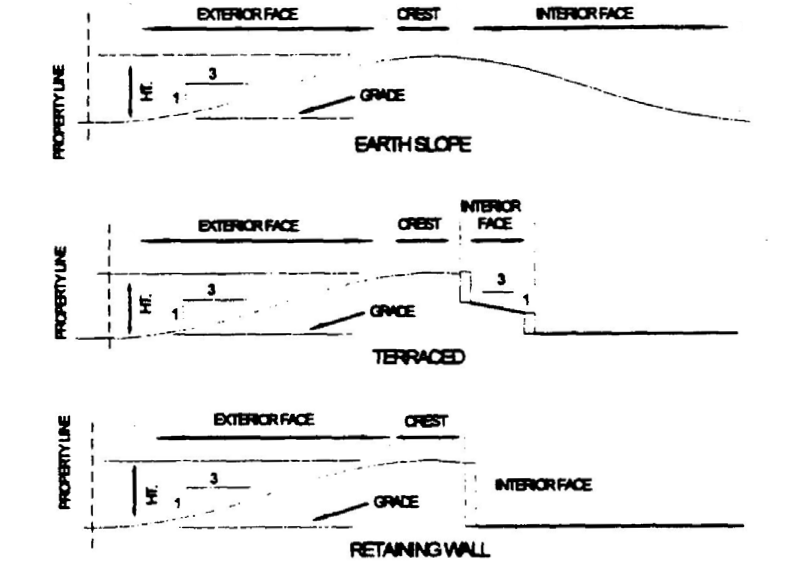
The height of the wall, fence, or berm shall be measured from the surface of the parking area or land on the nonresidential side of the wall, fence, or berm.
(c)
In the case of a variable wall, fence, or berm height as noted above, the extent of the obscuring wall, fence, or berm shall be determined by the planning commission on the basis of land usage; provided, further, that no wall, fence, or berm shall be less than the above required minimum, nor greater than the above required maximum.
(d)
Berms shall be landscaped in accordance with section 46-7.
All obscuring fences shall be constructed with new, durable, weather resistant, and easily maintained materials. Chain link and barbed wire fences are not permitted for screening purposes.
(e)
Required walls or fences shall be located along the lot line except in the following instances:
(1)
Where underground utilities interfere.
(2)
Where a landscaped street yard is required, the wall or fence shall be placed along the setback line.
(3)
A wall or fence may be located on the residential side of an alley when mutually agreeable to the property owners and if approved by the zoning board of appeals.
(f)
In those instances where the following conditions occur, the wall, fence, or berm may be waived by the planning commission:
(1)
The abutting or adjacent land is proposed on the city master plan of land use as a use other than residential.
(2)
The abutting or adjacent land is developed for a use other than residential.
(3)
The planning commission determines that the abutting or adjacent residential district will become nonresidential in the future.
(4)
The abutting or adjacent residential district has physical characteristics which preclude the necessity of a wall, fence, or berm. Such conditions include, but are not necessarily limited to:
a.
An abrupt rise in grade on the abutting or adjacent district.
b.
Heavily wooded or landscaped areas that will buffer as effectively as a wall or berm.
c.
Other natural or manmade features that will buffer the abutting or adjacent residential districts as effectively as a wall, fence, or berm.
(g)
Berms shall have a maximum slope of 3:1 (three-foot horizontal to one-foot vertical). All berms shall have a rounded crest, at least two feet in width and shall be constructed of clean fill.
(h)
Walls, fences, and berms shall have no openings for vehicular traffic or other purposes, except as otherwise provided in this chapter or approved by the planning commission.
(i)
All walls herein required shall be constructed to specifications approved by the building inspector. Walls shall be constructed of brick or have brick veneer on the side facing the residential district. A wall that is constructed of poured concrete which simulates standard brick facing is also acceptable. The top of the wall shall be finished or capped to provide positive drainage.
(j)
The planning commission may require that a wall be varied in height or stepped to match adjacent existing walls or to ensure that adequate sight distance is assured, provided that in no instance shall a required wall, fence, or berm be permitted to be less than 30 inches in height.
(Code 2002, § 220-67; Ord. No. 537, § 1, 2-27-2012)
Sec. 46-9. - Fences and hedges.
(a)
The issuance of an approved fence permit shall be required prior to commencing construction of a proposed fence or prior to replacing or rebuilding more than 50 percent of an existing fence. The zoning administrator or his designee shall examine all applications for fence permits, and if it appears that the application complies with all of the provisions of this chapter of this Code, does not appear to violate any other applicable law and all applicable fees have been paid, a fence permit shall be issued to the applicant. The applicant shall notify the zoning administrator or his designee when the fence has been completed, and the zoning administrator or his designee shall examine the construction to ensure that it complies with the standards of this chapter and the issued permit. Any permit granted under this section shall become null and void after six months from the date of granting such permit unless the zoning administrator or his designee has approved the construction after final inspection, prior to the expiration of the six-month period.
(b)
Nonconforming fences. Existing fences that do not comply with all provisions of this chapter may be replaced or reconstructed, as long as not more than 50 percent of the total fence on the property is replaced or reconstructed over the life of the original fence. Nothing herein is intended to prohibit general maintenance and minor repairs necessary to ensure that the fence is not a threat to the safety of persons or property.
(1)
Application. Application for a fence permit shall be made on forms provided by the zoning administrator or his designee and shall include the following information. A fence permit shall not be required for maintenance of existing fences, including the replacement or rebuilding of fence areas that comprise less than 50 percent of the existing fence.
a.
Name, address, and signature of applying landowner.
b.
A site drawing that shows the exact location of the proposed fence.
c.
The height of the proposed fence.
d.
The type of construction materials to be used.
e.
Estimated dates of construction.
f.
The name and address of the proposed contractors, if any, who will be constructing the fence.
g.
A drawing or other descriptive information detailing the type, style, and pattern of the proposed fence.
h.
If the proposed fence will be erected on a property line, the application shall be signed by the adjoining landowners. If the applicant is unable to obtain a neighbor's signature, such requirement may be waived by the zoning administrator.
i.
A drawing identifying the location of all other fences, to remain or to be eliminated, within ten feet of all property lines.
(2)
Fees. The fees for a fence permit shall be determined from time to time by resolution of the City Council.
(3)
Location.
a.
Front yard.
1.
When located within the front yard, fences and hedges shall have a maximum average height of 36 inches, measured from the finished grade at the property line, and shall be set back a minimum of one foot from the sidewalk. No part of a fence may exceed four feet in height in a front yard.
2.
When located within the front yard, fences shall be of an ornamental nature, including picket, split rail, or wrought-iron-style fencing, with at least 50 percent open spaces, uniformly distributed along the surface of the fence. Wire and chain link fencing is prohibited in front yards.
b.
In side or rear yards in residential districts, no fence or hedge shall exceed a height of six feet in any side or rear yard. In commercial and industrial districts, no fence shall exceed a height of eight feet in any side or rear yard.
c.
No fence shall be located in such a manner as to create a dead space between an existing fence or building and the proposed fence.
d.
No fence or hedge shall materially obstruct the vision of motorists at street intersections or at the intersection of a driveway and any street, sidewalk, or right-of-way line.
(4)
Dilapidated or dangerous fences. It shall be the duty of each property owner to ensure that all fences on the property are installed and maintained plumb, with adequate support and footings, and in a safe and sightly manner. The zoning administrator or his designee is hereby authorized to order the removal or repair of fences that are dangerous, damaged, paint peeled, or otherwise in violation of this chapter or state or federal law.
(5)
Swimming pool fences. Except as otherwise provided in this chapter, every swimming pool with a depth of 24 inches at any point and/or a volume of 150 cubic feet or more must be maintained within an adequate enclosure surrounding the pool area.
a.
The pool enclosure shall extend not less than four feet above the ground. All enclosures shall be self-closing and self-latching with latches placed at least four feet above the ground. No opening in a pool enclosure fence or gate shall be designed or maintained so as to permit access to the pool except under the supervision of the pool owner or by his permission.
b.
Pool enclosure fences shall be constructed so as to prohibit the passage of a sphere larger than four inches in diameter through any opening or under the fence. Pool enclosure fences shall be designed to withstand substantial (200 pounds per square foot) concentrated horizontal loads at any point in the fence.
(6)
Materials. Fences shall be constructed with substantial and durable materials, except that welded wire and barbed wire materials shall only be used in agricultural or industrial zones and except that electrified fencing, or material such as scrap wood, metal panels, extrusions, stampings, forgings, or other materials not intended to be used for standalone fences, shall not be permitted within or adjacent to any residential or business district, except as otherwise provided in this chapter.
(Code 2002, § 220-68; Ord. No. 530, § 1, 10-11-2010)
Sec. 46-10. - Floodplain regulation.
(a)
The purpose of these regulations is to protect those areas of the city which are subject to periodic inundation from floodwaters of the major rivers, their branches and tributaries within the city so that the reservoir capacity shall not be significantly reduced, thereby creating changes to areas previously not so endangered in time of high water, or to impede, retard, accelerate, or change the direction of the flow or carrying capacity of the river valley or to otherwise increase the possibility of flood. Said regulations, while permitting reasonable use of such properties, will help protect human life, safety, health, and general welfare, and prevent or minimize material or economic losses, through public aid and relief efforts occasioned by the unwise occupancy of such flood areas. All land and land uses within the floodplain area shall be subject to the requirements specified herein, in addition to the zoning district requirements of the zones which said lands are located.
(b)
The floodplain within the city is all of the land which would be inundated during the base (100-year) flood. The flood insurance rate map for the city (United States Department of Housing and Urban Development, Federal Insurance Administration, Community-Panel Number 260068 0005 A, effective January 2, 1981), serves as the official floodplain zoning map. This flood insurance rate map takes precedence over all prior maps and may be subject to alteration with any significant change in land use, including the indirect impact of such a change that seriously impedes, retards, accelerates, or changes the direction of flow or carrying capacity of the watercourse or which otherwise increases the possibility of flood. The official floodplain zoning map is on file at the office of the City Clerk.
(c)
Notwithstanding any other provisions of this chapter within the floodplain, no building or structure shall be erected, converted or structurally altered, and no land and/or structure shall be used, except for one or more of the following uses:
(1)
Open space uses, such as crop farming and gardening (not including related buildings), parks, playground, golf courses, nature preserves, bridle trails and nature paths, private and commercial recreation, and other similar open spaces.
(2)
Public rights-of-way, private drives and off-street parking uses, provided that all parking shall be at grade level and in conformance with the provision of this chapter.
(3)
Public utility facilities, provided that utilities are constructed or elevated to withstand flood damages and are as further regulated by this chapter.
(4)
Storage yards for material and equipment, not including flammable liquids, herbicides, pesticides, fertilizers or toxic agents.
(d)
Any use provided for within this chapter as permitted and regulated within the zoning district shall be permitted within the floodplain, provided:
(1)
The use pattern and the structure proposed to accomplish said use shall be so designed as to not significantly reduce the impoundment capacity of the floodplain and the flow of water by the use of stilts, cantilevering, or such other design techniques which will place the desired buildings above the intermediate regional flood high water level of the site in a safe manner so said structure or building will withstand the anticipated velocity of the floodwater, and not suffer flood damage.
(2)
All buildings substantially improved or newly constructed shall have a minimum floor elevation of the intermediate regional flood and shall further incorporate elevation for floodproofing of the structure and all attendant utility and sanitary facilities up to the level of the intermediate regional flood.
(e)
Prior to the issuance of a building permit for structures on/or adjacent to floodplain areas, the zoning administrator shall require the applicant for such permit to submit topographic data, engineering studies, proposed site plans, or other similar data needed to determine the possible effects of flooding on a proposed structure and/or the effect of the structure on the flow of water. All such required data shall be prepared by technically qualified persons. Review of the data submitted an application for special use permit shall be processed according to the procedures described in section 46-586, Notice of public hearing.
(f)
Dumping or backfilling in the floodplain areas with any material in any manner is prohibited unless, through compensating excavation and shaping of the floodplain, it is provided that the flow and natural impoundment capacity of the floodplain will be maintained or improved so that no significant or measurable change in flow or reduction in impoundment capacity of the floodplain would thereby result. Where there is dumping, backfilling, or excavation, in any manner, adequate site plan and engineering drawings shall be submitted to the zoning administrator which must effectively show the final results of such action.
(g)
It is the intent of this chapter to permit existing uses to continue in the floodplain until they are removed, but not to encourage their survival. It is recognized there exist within the floodplain, as defined by this chapter, lots and structures which were lawful before this chapter was passed or amended, which would be prohibited, regulated, or restricted under terms of this chapter or future amendments. Such uses are declared by this chapter to be incompatible with permitted uses in the floodplain. It is further the intent of this chapter that illegal uses shall not be enlarged upon, expanded, or extended, nor be used as grounds for adding other structures or uses prohibited in the floodplain.
(1)
Should a structure located in the floodplain, as defined by this chapter, be damaged by any means to an extent of more than 50 percent of the structure's precatastrophe market value, as recorded by the assessing officer, it shall not be reconstructed. The damage to the structure is the expenditure necessary to return the structure to its condition before destruction and shall be determined by the zoning administrator, who shall:
a.
Receive an estimate of the structural damage.
b.
Receive a figure representing the difference between the precatastrophe market value of the structure and the postcatastrophe value as determined by the assessing officer.
c.
Divide the sum of the figure derived in subsection (g)(1)a from the zoning administrator and in subsection (g)(1)b from the assessing officer by two.
(2)
Any building damaged by any means to an extent of less than 50 percent of the structure's precatastrophe market value, as recorded by the assessing officer, may be modified, repaired, or replaced, but any alterations must incorporate floodproofing of utility and sanitary facilities up to the level of the intermediate regional flood. The costs of said improvements for floodproofing shall not be included in determining the damage costs.
The board of appeals may permit reconstruction of a use if it is protected against flood damage, is not located in the floodway, and not allowing reconstruction would create undue hardship in the appellant.
(h)
Under no circumstances shall the city incur any liability whatsoever for the granting of any use or building in floodplain areas.
(Code 2002, § 220-69)
Sec. 46-11. - Lighting.
(a)
Unless otherwise exempted by this section, all lighting must comply with the following standards:
(1)
Lighting shall be shielded and directed downward to limit off-site glare to a level that does not create a nuisance, infringe on privacy, or negatively impact the enjoyment of surrounding properties.
(2)
Lighting shall not exceed an intensity of five footcandles within any site, nor shall it be less than one and one-half footcandles. For sites abutting a residential district or use, light intensity shall not exceed one-half footcandles at the property line. A maximum of ten footcandles is permitted within a site being used as a gasoline station or automobile dealership as long as the light intensity does not exceed the allowable intensities at the property line.
(3)
No sign illumination or other illuminated features shall be permitted to flash or move. Artificial light shall be maintained stationary and constant in intensity to prevent it from becoming a hazard in any public right-of-way by distracting or interfering with visibility of motorists or pedestrians. Digital sign messages may instantly change once every eight seconds or more.
(4)
Light poles/fixtures shall not exceed 25 feet in height.
(b)
The following are exempt from the lighting requirements of this article:
(1)
Sports field lighting, in use no later than 12:00 a.m.
(2)
Public parks, including pedestrian pathways.
(3)
Street lights and traffic signals.
(4)
Lighting for special events on publicly owned land and held on a temporary and intermittent basis, with approval from the governing agency having jurisdiction over the property.
(5)
Lighting for special events and privately owned property and held on a temporary and intermittent basis, subject to approval of a temporary waiver by the City Manager or their designee.
(Code 2002, § 220-70; Ord. No. 591, § 1, 9-27-2021)
Editor's note— Ord. No. 591, § 1, adopted Sept. 27, 2021, changed the title of § 46-11 from "Exterior lighting" to read as herein set out.
Sec. 46-12. - Corner clearance.
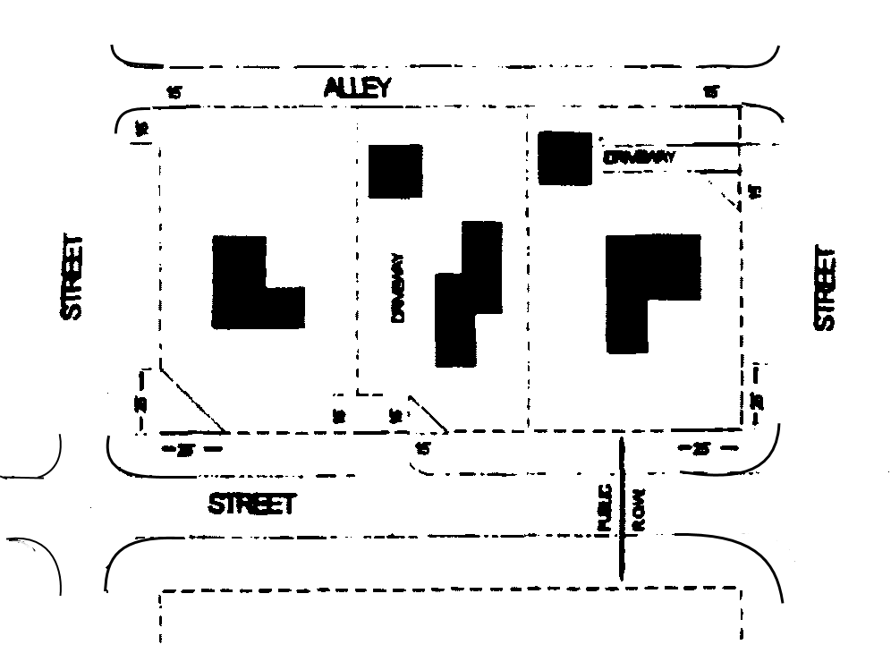
No fence, wall, shrubbery, sign, or other obstruction to vision above a height of two feet from the established street grades shall be permitted within the triangular area formed at the intersection of any street right-of-way lines by a straight line drawn between said right-of-way lines at a distance along each line of 25 feet from their point of intersection, nor shall such obstruction to vision be permitted at the intersection of any driveway or alley and a street right-of-way line within a triangular area formed at such intersection by a straight line drawn between the driveway or alley line and the street right-of-way line at a distance along each line of 15 feet from their point of intersection. In those instances where such triangular area cannot be constructed on the property in question, a 15-foot setback shall be required between the property line and the driveway or alley (see sketch).
(Code 2002, § 220-71)
Sec. 46-13. - Access to a street.
Any lot of record created after the effective date of the ordinance from which this chapter is derived shall have at least 20 feet of frontage on a public street. Any one lot of record created before the effective date of the ordinance from which this chapter is derived without any frontage on a public street shall not be occupied without access provided by an casement or other right-of-way no less than 20 feet wide.
(Code 2002, § 220-72; Ord. No. 552, § 1, 5-26-2015)
Sec. 46-14. - Residential entranceway.
In all residential districts, so-called entranceway structures, including, but not limited to, walls, columns and gates marking entrances to single-family neighborhoods or multiple-housing complexes, may be permitted and may be located in a required yard, except as provided in section 46-12, provided that such entranceway structures shall comply with all codes of the city and shall be approved by the zoning administrator and building inspector. Site plan review by the planning commission is not required.
(Code 2002, § 220-73)
Sec. 46-15. - Access management.
(a)
Generally. The standards of this section are intended to promote safe and efficient travel within the city; minimize disruptive and potentially hazardous traffic conflicts; separate traffic conflict areas by reducing the number of driveways; provide efficient spacing standards between driveways, and between driveways and intersections; protect the substantial public investment in the street system; and to ensure reasonable access to properties, though not always by the most direct route.
(b)
Standards. The following standards shall apply to all uses except residential developments involving fewer than five dwelling units. However, if it appears that there would be unusual difficulty encountered in meeting these requirements because of grade changes, existing or proposed intersections, driveways, bridges, or other land restrictions, the planning commission may waive or modify the requirements of this section, if recommended by the city engineer and, if located on a state trunkline, the state department of transportation.
(1)
Acceleration deceleration passing lanes:
a.
Driveways providing ingress and egress to all two-lane, paved major thoroughfares shall be provided with paved acceleration and deceleration lanes and passing lanes, if recommended by the city engineer and, if located on a state trunkline, the state department of transportation.
b.
Driveways providing ingress and egress to all three-lane, paved major thoroughfares shall be provided with paved acceleration and deceleration lanes, if recommended by the city engineer and, if located on a state trunkline, the state department of transportation.
c.
Driveways providing ingress and egress to roads of four or more lanes shall be provided with paved tapers or turning lanes, if recommended by the city engineer and, if located on a state trunkline, the state department of transportation.
d.
Required lanes or tapers shall be indicated schematically on the site plan and shall be constructed in accordance with the standards for such facilities as established by the city engineer, and, if located on a state trunkline, the state department of transportation.
(2)
Driveway spacing:
a.
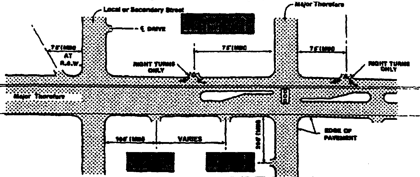
If a driveway curb radius extends beyond the frontage of the property, written consent from the affected adjacent property owner allowing the design shall be provided.
b.
Except where a center median or boulevard is provided, to reduce left-turn conflicts, new commercial driveways shall be aligned with those across the roadway where possible. If alignment is not possible, driveways should be offset a minimum of 150 feet from those on the opposite side of the roadway.
c.
Minimum driveway spacing requirements shall be determined based on posted speed limits along the parcel frontage, as indicated in the following table:
(c)
Distance from intersecting streets. Driveway spacing from an intersection shall be measured from the centerline of the driveway to the closest edge of the nearest travel lane on the intersecting street. The required minimum distance between a driveway and an intersecting street varies as follows:
(d)
Number of driveways. Where driveway spacing standards can be met (outlined in subsection (b) of this section), an individual parcel, or contiguous parcels under the same ownership shall be permitted one two-way driveway or a paired one-way driveway system wherein one driveway is designed, and appropriately marked, to accommodate ingress traffic and the other egress traffic. In the following instances, the planning commission may allow more than one driveway:
(1)
Developments that can demonstrate that the number of vehicle trip ends will exceed 3,000 during an average day (or will be used by 300 or more vehicles during the peak hour of traffic for either the thoroughfare or the use), and lacking access to a second street, a second driveway may be allowed along the major thoroughfare provided that the additional driveway can meet the spacing standards of subsection (b) of this section.
(2)
For parcels with arterial frontage of at least 300 feet, one additional driveway may be allowed, with another driveway allowed for each 300 feet of frontage thereafter, provided that these driveways meet the standards of subsection (b) of this section.
(3)
Where parcels have frontage on more than one street the planning commission may allow the provision of two drives; one to each street provided that the standards of subsections (b) and (c) of this section are met.
(e)
Alternative means of access. To reduce the number of curb cuts to the city's major thoroughfares, alternative means of access shall be encouraged in general. However, due to the driveway spacing standards specified in subsection (b) of this section, a shared driveway may be the only design solution that will be permitted. In such cases the following alternative means of access may apply:
(1)
Shared driveways. Sharing or joint use of a driveway by two or more property owners shall be encouraged. The shared driveway shall be constructed along the midpoint between the two properties. If a written easement is provided which allows traffic to travel across one parcel to access another, or access the public street, the driveway can be located entirely on one parcel.
(2)
Frontage roads.
a.
In cases where a frontage road exists, is recommended in a plan adopted by the planning commission and/or is proposed in an approved site plan for an adjoining lot or parcel, access shall be provided via such frontage road, rather than by direct connection to the major thoroughfare.
b.
In areas where frontage roads are planned, but adjacent properties have not yet developed, the site shall be designed to accommodate a future road. In such instances, the planning commission may temporarily grant individual parcels a direct connection to the adjacent major thoroughfare. A performance bond or other financial guarantee must be provided which ensures elimination of the temporary access upon completion of the service road. Occupancy permits shall not be issued until such financial guarantee has been submitted to the city.
(3)
Parking lot connections. All parking lots shall be designed in such a way as to allow for a connection to the parking lot of an existing or future use. Such connection shall be a minimum of 20 feet in width and shall be set back a minimum of 30 feet from the planned future right-of-way of adjacent roads.
(Code 2002, § 220-74; Ord. No. 552, § 1, 5-26-2015)
Sec. 46-16. - Performance standards.
Performance standards and requirements. Uses in all districts in the city, where permitted, shall comply with the following standards of performance. Generally accepted methods of collection and standard methods of chemical analysis shall be used in the application of these standards.
(1)
Displacement. No operation shall cause a displacement exceeding 0.003 of one inch as measured at the boundary property line. In addition, the following specific regulations shall apply:
a.
Stamping machines, punch presses, and press brakes must be placed on shock-absorbing mountings and on a suitable reinforced concrete footing. No machine shall be located beyond the capacity as prescribed by the manufacturer.
b.
For punch and stamp presses, other than hydraulic presses, up to 20 tons' capacity permitted when at least 200 feet from the nearest residential zone.
c.
For hydraulic presses, up to 150 tons' capacity permitted when at least 200 feet from nearest residential zone.
d.
All press brakes must be located at least 300 feet from a residential district.
(2)
Noise. Noise shall be muffled so as not to become objectionable due to intermittence, beat frequency, or shrillness. In all districts, noise, as measured at the boundary property line, may not exceed 85 dbA between the hours of 6:00 a.m. and 10:00 p.m. and shall not exceed 70 dbA between the hours of 10:00 p.m. and 6:00 a.m., and must comply with requirements of this Code. In I-2 Districts, noise shall not exceed 85 dbA and must also comply with all provisions of this Code.
(3)
Air contaminants. It shall be unlawful for any person, firm, or corporation to cause or permit to be discharged into the atmosphere from any single source of emission, smoke of a density equal to or darker than No. 2 of the Ringelmann chart except smoke of a density equal to but not darker than No. 2 of the Ringelmann chart may be emitted for not more than 3 minutes in any 30-minute period; smoke of a density equal to but not darker than No. three of the Ringelmann chart may be emitted for not more than three minutes in any 60-minute period, but such emissions shall not be permitted on more than three occasions during any 24-hour period.
(4)
Particulate matter and dust. Particulate matter or dust, as measured at the discharge stack emission point and by any generally accepted manner, shall not be emitted in excess of 0.3 grains per cubic foot of flue gases at a stack temperature of 500 degrees Fahrenheit. when the excess air does not exceed 50 percent at full load, except for periods of four minutes in any one-half hour, when it can equal but not exceed 0.5 grains per cubic foot of flue gases at a stack temperature of 500 degrees Fahrenheit. when the excess air does not exceed 50 percent at full load.
(5)
Odor. The emission of odors which are generally agreed to be obnoxious to any considerable number of persons at their place of residence or employment shall be prohibited.
(6)
Gases as measured at the property line. SO2 gas shall not exceed an average of 0.3 p.p.m. over a 24-hour period; provided, however, a maximum concentration of 0.8 ppm will be allowed for a one hour period out of a 24-hour period; H2S shall not exceed 0.1 ppm; fluorine shall not exceed 0.1 ppm; nitrous fumes shall not exceed five p.p.m; CO shall not exceed 15 ppm.
(7)
General requirements. In addition to subsections (3) through (6) of this section, there shall not be discharged from any source whatsoever such quantities of air contaminants or other material which cause injury, detriment, or nuisance to any considerable number of persons or to the public or which endanger the comfort, repose, health, or safety of any such persons or the public or which cause injury or damage to business or property.
(8)
Toxic or hazardous material. Any use permitted by this chapter shall be subject to the requirements and restrictions of federal, state, and municipal statutes such as, but not limited to: Act No. 64, PA 1979 (MCL 324.11101 et seq.); Act No. 641, PA 1978 (MCL 299.401 to 299.437, repealed by PA 1994, No. 451 (MCL 324.90101 et seq.)); Act No. 245, PA 1929 (MCL 323.1 to 323.13a, repealed by PA 1994, No. 451 (MCL 324.90101 et seq.)); Act No. 348, PA 1965 (MCL 336.11 to 336.36, repealed by PA 1994, No. 451 (MCL 324.90101 et seq.)); Act No. 127, PA 1970 (MCL 324.1701 et seq.); Act No. 207, PA 1941 (MCL 29.3b et seq.).
(9)
Glare, heat, and radioactive materials. Arc welding, acetylene torch cutting, or similar processes causing glare and heat shall be performed behind solid walls or frosted glass not less than 15 feet high as measured from the ground level adjacent to the structure concerned. Radioactive materials or harmful rays of any kind shall not be permitted to exceed quantities established as safe by the proper federal agency.
(10)
Fire and safety hazards. The storage and handling of flammable liquids, liquefied petroleum gases, and explosives shall comply with all state rules and regulations and as established by the Fire Prevention Act, Act 207, PA 1941, as amended (MCL 29.3b et seq.), and by applicable city codes. Further, all storage tanks of liquid materials above ground shall be located not less than 150 feet from all property lines, and shall be completely surrounded by earth embankments, dikes, or other type of retaining wall which will contain the total capacity of all tanks so enclosed. Bulk storage tanks of flammable liquids below ground shall be located not closer to the property line than the greatest depth to the bottom of the buried tank. In no instance shall the distance from the tank to the property line be less than 25 feet.
(Code 2002, § 220-75)
Sec. 46-17. - Waste receptacles.
A space for the location of waste receptacles shall be provided for each business, office, multiple-family, or industrial use. A space for waste receptacles shall be provided whether or not their use is intended and shall be located on-site, unless the property owner has legal access to a waste receptacle that is located in the same block, in reasonably close proximity to the subject property. Waste receptacles and enclosures may be permitted as accessory Use to any use except one-family and two-family residential. All waste receptacles shall comply with the provisions of section 46-5 and the following:
(1)
Waste receptacles must be clearly accessible to servicing vehicles.
(2)
A concrete pad, at least two feet greater than the dimension of the waste receptacle on all sides, shall be provided.
(3)
Waste receptacles shall be screened on all sides. Such screening shall be constructed of an earth mound, brick, or decorative concrete block material with a minimum height of six feet or one foot above the height of the enclosed dumpster, whichever is greater. Access gates must provide screening and may be of wood construction.
(4)
Waste receptacle enclosures may have a maze style pedestrian entrance or a pedestrian entrance with an opaque access gate.
(5)
The location of waste receptacles shall be indicated on the site plans and the location and screening shall be subject to approval of the zoning administrator, or of the planning commission when the planning commission reviews the site plan.
(6)
Waste receptacles and their screening enclosures shall be located in such a manner as to minimize impacts on adjacent properties by not obstructing or impeding views from windows, doorways, or outdoor gathering areas.
(7)
The location of waste receptacles shall be indicated on the site plans and the location and screening shall be subject to approval of the zoning administrator, or of the planning commission when the planning commission reviews the site plan.
(8)
Detail drawings or a note shall be provided on the plan to ensure that the above requirements are met.
This section shall not apply to portable trash containers intended for curbside pick-up.
(Code 2002, § 220-76; Ord. No. 545, § 1, 1-28-2013)
Sec. 46-18. - Access to major or collector thoroughfare.
For uses making reference to this section, vehicular access shall be provided only to an existing or planned major thoroughfare, or collector street; provided, however, that access driveways may be permitted to other than a major thoroughfare, or collector street, where such access is provided to a street where the property directly across the street between the driveway and the major thoroughfare, or collector street, is zoned for multiple-family use or any nonresidential uses, is developed with permanent uses other than single-family residences or is an area which, in the opinion of the planning commission, will be used for other than single-family purposes in the future. This exception shall apply only if the planning commission finds that there are special circumstances which indicate that there will be a substantial improvement in traffic safety by reducing the number of driveways to a thoroughfare.
(Code 2002, § 220-77)
Sec. 46-19. - Keeping of animals.
(a)
Household pets.
(1)
The keeping of household pets, including dogs, cats, fish, birds, hamsters, and other animals generally regarded as household pets, is permitted as an accessory use in any zoning district.
(2)
No more than three dogs, four months of age and older, shall be kept or housed in or at one dwelling unit.
(b)
Wild animals. The keeping of wild animals, as defined in this chapter, shall be prohibited in any residential or agricultural zoning district.
(Code 2002, § 220-79)
Sec. 46-20. - Site plan review.
(a)
Review and approval is required before a building permit may be issued for the construction of all structures and uses proposed in the city. Review and approval authority is as follows:
(1)
Administrative review and approval of a plot plan (see article XX, administration and enforcement) is required before a building permit may be issued for the following:
a.
A plot plan must be submitted for review and approval by the zoning administrator before issuance of a building permit by the building inspector for the construction of any single-family or two-family dwelling.
b.
A plot plan must be submitted for review and approval by the zoning administrator prior to issuance of a building permit for accessory structures and uses in any zoning district.
c.
A plot plan and necessary detail drawings must be submitted for review and approval by the zoning administrator before a permit will be issued for the erection or modification of a sign.
d.
A plot plan and necessary detail drawings must be submitted for review and approval by the zoning administrator prior to issuance of a building permit for structural and maintenance changes which do not expand a use.
e.
Review and approval by the zoning administrator is required before a permit may be issued for any temporary structure or use.
(2)
Review and approval by the planning commission is required before a building permit or certificate of occupancy may be issued for any of the following:
a.
Any building or use, authorized in any zoning district other than those items listed in subsection (a)(1) of this section.
b.
Any building or use in any district permitted subject to special conditions or special land use other than those items listed in subsection (a)(1) above.
(3)
The zoning administrator can, at his or her discretion, require review and recommendation by the planning commission of any item that would be otherwise approved administratively.
(b)
Site plans are to be reviewed in order to determine:
(1)
That the proposed use conforms to the uses permitted either by right, special conditions, or by special use permit in the respective zoning district.
(2)
That the dimensional arrangement of the site conforms to the required yard, setback, height, area, bulk, and site development requirements set forth in this chapter.
(3)
That there is a proper relationship between the existing and proposed streets in order to assure the safety and convenience of pedestrian and vehicular traffic and accessibility to emergency vehicles.
(4)
That the design, location, architecture, and fenestration of the proposed buildings and structures, as well as the location of all waste receptacle enclosures, fences, patios, parking, driveways, storm drainage facilities, grading, interior/exterior lighting, landscape, screening, buffering, and all other features of the site are situated and designed to minimize adverse effects upon owners and occupants of adjacent and surrounding properties.
(5)
That as many natural features of the site shall be preserved where they can be useful to the development on the site, furnish a barrier or buffer between the project and adjoining properties, or where preserving natural features contributes to the general safety, health, and appearance of the area, i.e., controlling erosion or the discharge of stormwaters, etc.
(6)
That any adverse effects of the proposed developments and activities emanating therefrom upon adjoining residents or owners shall be minimized by appropriate site design, building architecture, screening, fencing or landscaping.
(7)
That all buildings and structures are accessible to emergency vehicles.
(8)
That the site plan, as approved, is consistent with the intent and purpose of zoning which is to promote the public health, safety and general welfare to encourage the use of lands in accordance with their character and adaptability; to avoid the overcrowding of population, to lessen congestion on the public roads and streets, to reduce hazards of life and property and to facilitate the city future land use plan.
(c)
All site plans required to be reviewed by the planning commission and/or City Council shall be submitted to the zoning administrator along with a brief statement or description of the project and intended uses. Any covenants, master deeds, deed restrictions, restrictive covenants, use, and occupancy restrictions or joint parking agreements which may affect all or any part of the parcel shall also be submitted.
(d)
Site plans must be prepared by a licensed engineer or licensed land surveyor. Each site plan shall include the following information:
(1)
Basic plan requirements.
a.
Site plans shall be drawn to a scale of not less than one inch equals 50 feet if the subject property is less than three acres and one inch equals 100 feet if three acres or more.
b.
The name of the proposed development shall be clearly shown on the plan.
c.
The plan shall include the date, north point, and scale. A location map drawn to a scale of no less than one inch equals 2,000 feet shall be included on the plan.
d.
A copy of the legal description, including acreage, shall be included on the plan.
e.
The applicant's name, address, and telephone number or the names and addresses of the person responsible for the preparation of the site plan. If the applicant is not the owner of the project a statement signed by the owner shall be submitted attesting that the applicant is acting on behalf of the owner. In addition, the name, address, and telephone number of all persons, firms, or corporations with an ownership interest in the land shall be submitted.
f.
Twenty folded copies of the site plan shall be submitted.
(2)
Specific information.
a.
Existing and proposed lot lines and dimensions of the site including width, length, and frontage.
b.
Acreage of site inclusive and exclusive of road rights-of-way.
c.
Existing and proposed buildings.
d.
Required and proposed setbacks must be dimensioned on the plan.
e.
The existing zoning of the site and the zoning of all abutting parcels.
f.
Driveways, sidewalks, paths, parking spaces and aisles, loading and unloading areas, fire lanes, acceleration and deceleration lanes, traffic control devices including dimensions, materials, and radii. In addition, the plan must show the location and right-of-way widths of all abutting streets and alleys.
g.
The size and location of all proposed signs including regulatory and directional signs.
h.
The height, materials, and location of all fences, walls, and berms.
i.
The location, height, and shielding mechanisms for any proposed outdoor lighting.
j.
The location, size, shape, area, and width of all condominium units.
k.
A count of all proposed dwelling units and detailed floor plans shall be submitted for all multiple-family dwellings.
l.
The use and location of any structures on adjacent properties within 50 feet of the parcel.
m.
The boundary of any 100-year floodplain on or abutting the property.
n.
The location of any state-regulated wetland on site or within 20 feet of the site.
o.
Existing and proposed topographic contours on site and within 20 feet of the site at two-foot intervals, referenced to a USGS or NGVD benchmark.
p.
Grades at building corners and floor and roof elevations.
q.
The height of all proposed buildings and structures must be noted on the plan.
r.
Elevation drawings of the proposed building faces.
s.
Floor plans.
t.
The location and screening details of waste receptacles. Turning radii shall be shown on the plan to ensure that the waste receptacle is located in a manner that will allow access by service vehicles.
u.
The names of existing and proposed streets both on site and abutting the site.
v.
The type, location, and dimensions of all existing and proposed easements.
(3)
Landscape information. A landscape plan shall be submitted with each site plan and shall be prepared in accordance with the requirements of section 46-7.
(4)
Engineering details. The engineering details must be reviewed and approved by the City Engineer prior to final approval of the site plan.
a.
The location and details of all existing and proposed utilities, including, but not limited to, water lines, valves, hydrants, storm and sanitary sewer lines, together with clear delineation of all easements to be granted to the city or other agencies for installation, repair and maintenance of such utilities.
b.
A storm drainage and stormwater management plan, including drainage calculations and the location and details of all existing and proposed conduits, swales, drains, detention basins and other drainage facilities, located within or on property adjacent to the site.
c.
The use of city water and sewer services is required.
d.
Development projects must be designed and constructed in accordance with the requirements of the most current municipal standards, including all appendices and amendments thereto.
(5)
Compliance with chapter. Such other information as may be required by the zoning administrator or approval bodies to ensure compliance with this chapter and other city ordinances.
(6)
Certificate of occupancy. No final certificates of occupancy may be issued until the zoning administrator, fire chief, public works/service superintendents and the City Engineer have confirmed that the site has been developed in compliance with the approved site plan, per the requirements of their respective areas of authority and the City Manager confirms that the terms of the public infrastructure agreement, if applicable have been met.
(e)
The following requirements shall apply to all projects that are to be developed in phases:
(1)
The entire development shall be shown on the site plan with the phases clearly delineated.
(2)
The site plan for the development shall expire two years from date of approval for those phases that are not completed or actively under construction and proceeding meaningfully towards completion. The site plan approval may be extended by the planning commission for periods of two additional years until the entire development is complete.
(3)
The developer shall execute a public infrastructure agreement with the city and provide the financial guarantee to ensure completion of the required infrastructure prior to the commencement of any construction.
(4)
The city may require the installation of temporary infrastructure, including street connections and turn-arounds for emergency vehicle circulation and access. The city may also require the installation of utilities, sidewalks, lighting, and landscaping beyond the limits of the phase to be developed, if determined to be necessary for safety reasons or to mitigate any negative impacts of the proposed development on surrounding properties.
(5)
All water and sewer fees shall be paid in full for a project that is located on a single parcel of land, prior to issuance of the first building permit for any construction. This shall not apply to single condominium units that are located on separate parcels of land in a site condominium development but shall apply to condominium units that are located on a single parcel of land that may be owned collectively by the owners of the condominium units located thereon.
(f)
Conditional approval.
(1)
Reasonable conditions may be required with the approval of a site plan. The conditions may include, but are not limited to, conditions necessary to ensure that public services and facilities affected by a proposed land use or activity will be capable of accommodating increased service and facility loads caused by the land use or activity, to protect the natural environment and conserve natural resources and energy, to ensure compatibility with adjacent uses of land, and to promote the use of land in a socially and economically desirable manner. Conditions imposed shall meet all of the following requirements:
a.
Be designed to protect natural resources, the health, safety, and welfare and the social and economic well-being of those who will use the land use or activity under consideration, residents and landowners immediately adjacent to the proposed land use or activity, and the community as a whole.
b.
Be related to the valid exercise of the police power and purposes which are affected by the proposed use of activity.
c.
Be necessary to meet the intent and purpose of this chapter, be related to the standards established in this chapter for the land use or activity under consideration, and be necessary to ensure compliance with those standards.
(2)
The conditions imposed with respect to the approval of a site plan shall be recorded in the record of the approval action and shall remain unchanged except upon the mutual consent of the designated site plan approval body and the property owner. A record of conditions which are changed shall be maintained by the zoning administrator.
(3)
All subsequent actions relating to the activity authorized by the approved site plan shall be consistent with the plan unless a change conforming with this chapter is supported by mutual agreement between the property owner and the designated site plan approval body.
(g)
A copy of the approved site plan and all revised approved site plans shall be so marked and placed on file, along with copies of any and all permits requested for the property in question. Revisions of approved site plans can be made only by the designated body or officials who first gave initial approval.
(h)
Property which is the subject of site plan approval must be developed in strict compliance with the approved site plan and with any revisions, amendments, or modifications made thereto. Prior to the start of construction, survey stakes must be placed at the corners of the proposed building to be constructed under the approved permit. A survey stake identifying the first floor finished elevations shall also be required. Site plan approval is contingent upon the city manager and city attorney reviewing and approving a public infrastructure agreement for the property. If construction and development does not conform with the approved plan and the public infrastructure agreement, the approval thereof shall be revoked by the zoning administrator by written notice of such revocation posted upon the premises involved and mailed to the developer at his last known address. Upon revocation of such approval, all further construction activities shall cease upon the site, other than for the purpose of correcting the violation.
(i)
Post-construction as-built plans and surveys.
(1)
Within 30 calendar days from the date of completion of all new construction projects requiring site plan review and approval by the planning commission, the design professional shall submit signed as-built drawings of the utility and grading plans in pdf format to the zoning administrator.
(2)
The city may require a post-construction survey for any new construction, prior to issuance of a certificate of occupancy, if there is reasonable cause to suspect that it may not comply with the approved plan(s). Post-construction surveys shall be prepared by a licensed land surveyor or civil engineer, and shall include the following information:
a.
First floor finished elevations.
b.
Finished grades at all building corners and at all corners of the property.
c.
Topographic contours on and within 20 feet of the site at two-foot intervals, referenced to a USGS or NGVD benchmark.
(3)
If it is determined that the finished elevations of the building or the grading of the site is not consistent with the approved grading and drainage plans, all drainage control systems deemed necessary by the city engineer shall be installed to ensure that run-off from the site does not negatively impact adjoining parcels or infrastructure facilities, a final certificate of occupancy shall not be issued until the site has been inspected and found to be acceptable by the city engineer.
(j)
Fees for the review of site plans and inspections, as required in this section, shall be established, and may be amended from time to time, by resolution of the City Council.
(k)
The approval of any site plan under this provision shall expire one year after the date of such approval, unless actual construction and development have been commenced in accordance with said site plan prior thereto. If such construction and development is commenced within said one-year period, then such approval shall continue for a period of two years from the date thereof; provided, however, that should a lapse of more than six months in continuous substantial construction and development not occur, said approval shall expire. The building inspector shall not issue a building permit for any type of construction on the basis of the approved site plan after such approval has expired. Funds in escrow will be returned upon expiration of a site plan or completion of the project in a manner suitable to the building inspector.
(Code 2002, § 220-80; Ord. No. 570, § 1(220-80), 8-13-2018; Ord. No. 589, § 1, 7-26-2021; Ord. No. 601, § 1, 10-24-2022)
Sec. 46-21. - Architectural design standards.
The design for all new non-residential buildings in the CBD Central Business District, OS Office Service District, and B-1 Highway Service District must be approved by the planning commission as part of the site plan review and approval process. In evaluating building designs, the following minimum standards shall apply:
(1)
Exterior building material shall be composed of high-quality, durable, low maintenance materials such as brick, stone, glass, or tinted/textured concrete masonry units to the extent that said materials are consistent with other buildings in the surrounding area. The following materials are prohibited, except as architectural accent features covering not more than 25 percent of the exterior walls:
a.
Smooth-faced concrete block.
b.
Vinyl, wood, aluminum, or plastic siding.
c.
Steel, metal, plastic, or fiberglass panels.
d.
Synthetic stucco.
e.
Reflective glass.
(2)
Buildings shall be finished on all four sides with the same materials and detailing.
(3)
Pitched roofs, if provided, shall have a minimum pitch of 6/12. Architectural elements that add visual interest to the roof, such as dormers and masonry chimneys, are encouraged. Flat roofs shall require parapet screening and cornice detailing.
(4)
The front facade of the building containing the primary customer entrance must face the public street. The planning commission may waive this requirement for buildings located within a planned commercial development or where, through the use of shared access/parking facilities or other site characteristics, it is determined the front facade of the building would be more appropriately oriented in a different direction.
(5)
Overhead doors shall not face or be visible from the street, unless approved by the planning commission based upon a finding that the door is recessed back from the facade and properly screened from view of a street.
(6)
All mechanical equipment, including, but not limited to, heating, ventilating and air conditioning equipment, and antennas, shall be placed in an inconspicuous location and screened from view of the street and adjoining residential uses.
(7)
Buildings shall be designed to reduce massive scale and a uniform/impersonal appearance through the use of windows, inviting entryways, awnings, dormers, columns, and wall offsets. At least 25 percent of all building walls that face a public street and at least ten percent of all side walls that are visible from a public street must be covered by windows.
(8)
Buildings must be constructed and maintained in strict compliance with the design approved by the planning commission as part of the site plan review process.
(9)
The planning commission may waive or modify the requirements of these standards where circumstances exist that justify said waiver or modification.
(Ord. No. 559, § 1, 2-27-2017)

