
Greenfield Milwaukee County
City Zoning Code
City Zoning Code
PART 6
- DESIGN STANDARDS
21.06.0101 - Access to public streets.
This section sets forth vehicular access requirements for proposed site plans for developments which abut arterial, collector, and minor streets. This Code recognizes that public streets are a public investment that requires control mechanisms to assure both public safety and functional capacity. Proposed development for residential and nonresidential uses shall meet the following requirements:
A.
Access standards for all residential and nonresidential uses. All proposed site plans proposed for residential and/or nonresidential uses in residential and/or nonresidential zoning districts shall meet the following standards:
1.
Controlled access to public streets. Lot and parcel vehicular access points shall be permitted only at locations according to this Code and other City of Greenfield adopted plans, codes, ordinances. The Plan Commission may limit vehicular access to any adjoining arterial, collector, or minor street.
2.
Distance between vehicular access points. Within the MFR-1, MFR-2, MFR-3, C-1, C-2, C-3, C-4, C-5, O, BP, M-1, I, PR, and PUD Districts, the spacing of vehicular access points from arterial streets and highways to lots and parcels created after the effective date of this Code shall be determined as a function of arterial street and highway operating speeds. The minimum spacing between vehicular access points along such streets or highways, to the extent deemed practicable by the Plan Commission, shall be determined according to Table 21.06.0101(A). These spacings are based upon average vehicle acceleration and deceleration rates and are considered necessary to maintain safe traffic operation.
Table 21.06.0101(A)
ARTERIAL STREET AND HIGHWAY OPERATING SPEED AND MINIMUM
SPACING BETWEEN DIRECT VEHICULAR ACCESS POINTS
3.
Limitation of access to interstate, United States, State trunk, and County trunk highways. No new direct vehicular access shall be allowed to interstate, United States, State trunk, and County trunk highway public rights-of-way unless approved by the Wisconsin Department of Transportation, Milwaukee County Department of Public Works (Traffic Engineering Division), and the Plan Commission.
4.
Temporary access.
a.
City streets. On City streets, the Common Council may grant temporary access to properties and require their closure when access through adjoining properties is acquired upon recommendation by the Plan Commission. Such access shall be temporary, revocable, and subject to any conditions required and shall be issued for a period not to exceed twelve (12) months.
b.
County streets and highways. Temporary access to Milwaukee County street and highway rights-of-way are reviewed and may be approved by the Milwaukee County Department of Public Works, Traffic Engineering Division. It is the applicant's responsibility to obtain all necessary approvals from the Milwaukee County Department of Public Works, Traffic Engineering Division for all such temporary access points proposed before site plan approval by the City.
c.
State highways. Temporary accesses to State highway rights-of-way are reviewed and may be approved by the Wisconsin Department of Transportation. It is the applicant's responsibility to obtain all necessary approvals from the Wisconsin Department of Transportation for all such temporary access points proposed before site plan approval by the City.
5.
Area circulation plan may be required. The Plan Commission may require the preparation of an area circulation plan for the proposed development covering several properties in an area surrounding a proposed site plan. The delineation of the area for the preparation of an area circulation plan shall be determined by the Plan Commission upon recommendation of either the City Engineer or Zoning Administrator. Such a plan may require the sharing of access locations or temporary access. All landowners, except those with a previously approved site plan, shall be required to conform to such an area circulation plan once it is adopted by the Plan Commission as a component, or element, of the City of Greenfield Comprehensive Master Plan. The Plan Commission may require that such an area circulation plan be prepared based upon the conduct of a traffic impact analysis conducted by a licensed professional engineer with expertise in traffic engineering. The City Engineer and Zoning Administrator shall review all such studies and assist the Plan Commission.
6.
Vehicular nonaccess reservations required. The Plan Commission may require deed restrictions to be placed on a lot or parcel for which a site plan is proposed to limit vehicular access to abutting arterial, collector, or minor streets and highways. A landscaped bufferyard of an adequate bufferyard intensity level, as determined by the Plan Commission or by Division 21.06.0300 of this Code, shall be provided in vehicular nonaccess reservations along the property line abutting a public street right-of-way. In such situations, vehicular access to such lots may be provided by an abutting minor or collector street at designated access driveways. Such vehicular nonaccess reservations shall be graphically so noted on site plans or as a formal deed restriction formally filed with the Milwaukee County Register of Deeds before their final approval by the City.
7.
Arterial street and highway access and street intersections. No new direct public or private access shall be permitted to an arterial street or highway within one hundred fifteen (115) feet of the intersection of the right-of-way lines of another arterial street or highway.
8.
Minor streets and vehicular access point alignments. Minor streets and vehicular access points along both sides of a collector and/or arterial street shall be aligned to assist in reducing the number of driveways needed and to improve safety conditions related to access to the street system.
9.
Sight distance and driveway placement. Direct vehicular access placement on abutting collector and arterial streets and highways shall be such that an exiting vehicle has a minimum unobstructed sight distance according to Table 21.06.0101(B) based upon the operating design speed of the abutting collector or arterial street or highway.
Table 21.06.0101(B)
HIGHWAY DESIGN SPEED AND MINIMUM REQUIRED SIGHT
DISTANCE FOR DIRECT VEHICULAR ACCESS POINT
PLACEMENT
B.
Access standards for nonresidential and multiple-family residential uses. All site plans proposed for nonresidential and multiple-family residential uses in nonresidential and/or multiple-family residential zoning districts shall meet the following standards:
1.
Maximum number of vehicular access points per lot. Generally, along arterial streets and highways (including lots that abut the frontage roads of said rights-of-way), where the abutting street frontage is less than three hundred fifty (350) feet, a maximum of one (1) vehicular access point shall be permitted to a particular lot from each of any one (1) or two (2) abutting arterial streets and highways. One (1) additional driveway entrance along a single continuous lot with frontage greater than four hundred (400) feet may be permitted by the Plan Commission. When a shared vehicular access point is used by two (2) or more abutting lots, said shared vehicular access point shall be considered as one (1) single vehicular access point for each lot or parcel served.
2.
Provision of shared vehicular access points between lots. Vehicular access points planned to be located along property lines, or within five (5) feet of a property line, shall be shared vehicular access points with the abutting lot or parcel. The vehicular access point centerline may be the property line between two (2) lots or parcels of land or may be a mutually agreed upon land access easement.
21.06.0102 - Easements.
A.
Natural resource features protection/mitigation, conservation, landscape bufferyard, and utility easements required. The Plan Commission shall require natural resource features protection/mitigation, conservation, landscape bufferyard, and/or utility easements of widths deemed adequate for the intended purpose on each side of all rear lot lines and on side lot lines or across lots where necessary or advisable for natural resource feature protection, landscape bufferyards (see Division 21.06.0300 of this Code), electric power and communication lines, wires, conduits, storm and sanitary sewers, and gas, water, and other utility lines.
B.
Site traversed by watercourse, drainageway channel, or stream.
1.
Where a site is traversed by a watercourse, drainageway channel, or stream, an adequate drainageway or easement shall be provided as may be required by the City Engineer. The location, width, alignment, and improvement of such drainageway or easement shall be subject to the approval of the Plan Commission, and parallel streets or parkways may be required in connection therewith.
2.
Where necessary, stormwater drainage shall be maintained by landscaped open channels of adequate size and grade to hydraulically accommodate maximum potential volumes of flow. These design details are subject to review and approval by the City Engineer.
C.
Minimum width required for all utility easements. All utility easements shall be a minimum of twelve (12) feet in width where recommended by the City Engineer.
21.06.0103 - Stormwater management plan required.
A.
Stormwater management plan required.
1.
Stormwater drainage facilities shall be required which are adequate to serve the development. Such stormwater drainage facilities shall be in conformance (as applicable) with all applicable Milwaukee County and Milwaukee Metropolitan Sewerage District Codes and/or rules and regulations concerning stormwater management; and/or local master plans or adopted master plan components; or as required by the City of Greenfield based upon recommendation of the City Engineer.
2.
Stormwater drainage facilities may include curbs and gutters, catch basins and inlets, storm sewers, road ditches, open channels, water retention and detention structures, basins, and settling basins. All such facilities shall be of adequate size and grade to hydraulically accommodate the maximum potential volumes of flow and shall be so designed as to prevent and control soil erosion and sedimentation and to present no hazards to life or property.
B.
Contents of stormwater management plan.
1.
A stormwater management plan shall be prepared by a Wisconsin registered professional engineer that shall include, but not be limited to, the following:
a.
Existing and proposed topography at two (2) foot contour intervals of the proposed development.
b.
Proposed elevations of all streets, internal sidewalks, drives, and off-street parking areas.
c.
Proposed drainage swales.
d.
Proposed storm sewers, manholes, and inlets.
e.
Construction site erosion facilities.
2.
The following may be required by the City Engineer:
a.
A report and map(s) showing the drainage basin for the entire area where the development is located, including estimates of the total acreage in the drainage basin and percentage of the drainage basin within the proposed development.
b.
Location of any planned stormwater detention and/or retention basins and applicable calculations for their sizing and design.
c.
Calculations relating to the amount of runoff from the site of the proposed development before development and anticipated runoff following the development of the site.
C.
Unpaved street gutters. The following shall be applicable:
1.
Unpaved street gutters shall be permitted when adequate storm sewer systems are not available to serve the development.
2.
The developer is encouraged to use natural wetland plant materials where possible.
3.
Where the velocity of flow is greater than four (4) feet per second on soils having a severe or very severe erosion hazard and greater than six (6) feet per second on soils having moderate, slight, or very slight erosion hazard, the developer shall meander the waterway or install a paved invert or check dams, flumes, or other energy dissipating devices.
D.
Drainage facilities. The following shall be applicable:
1.
Stormwater drainage facilities shall, if required by the City Engineer, include stormwater detention and/or retention basins, structures, and settling basins necessary to prevent erosion and sedimentation where such facilities discharge into streams or lakes.
2.
The design criteria, the size, type, grades, and installation of all stormwater drains and sewers and other cross-section, invert and erosion control paving check dams, flumes, or other energy dissipating structures and seeding and/or sodding of open channels and unpaved road ditches proposed to be constructed shall be according to the plans and standard specifications approved by the City, including the City's "Site Development Standards," approved by the City.
E.
Storm sewers. When required by the City, the developer shall assume the cost of installing all required storm sewers. (Am. #Ord. No. 3024)
21.06.0104 - Building setback requirements along arterial streets and highways.
The following Table 21.06.0104 sets forth the minimum required building setbacks for lots or parcels that abut the indicated arterial streets and highways.
Table 21.06.0104
REQUIRED INCREASED BUILDING SETBACKS ALONG
ARTERIAL STREETS AND HIGHWAYS
(a)
Based upon the distance from the ultimate right-of-way width established by the adopted County jurisdictional highway plan and/or City of Greenfield Official Map.
(b)
Street yard setback of parcel/lot may be determined by adjacent parcel/lot building street yard setback.
21.06.0201 - Traffic visibility.
Corner cut-off distances for intersecting streets and/or alleys. In order to provide adequate vision clearance, no obstructions shall be permitted between the heights of two and one-half (2.5) feet and ten (10) feet above the plane through the mean curb grades within the triangular space formed by any two (2) existing or proposed intersecting street or alley right-of-way lines and a line joining points on such lines, located a minimum of thirty (30) feet from their intersection.
21.06.0202 - Off-street parking requirements.
In all districts no vacant land shall be occupied or used and no building shall be erected, enlarged, extended, or increased, or used including, but not limited to, use by a new use or changed use, until and in connection with every use, there shall be provided off-street parking stalls for all vehicles according to the following:
A.
Adequate access, drive widths, and driveway paving. (Am. #2870) The following shall apply:
1.
Adequate access to a public street shall be provided for each parking space.
2.
Each required off-street parking space shall open directly onto an aisle or driveway that is wide enough to provide safe and efficient means of vehicular access to the parking space.
3.
Driveways providing access to a public street shall be a minimum of twelve (12) feet in width for one-family and two-family residential dwellings, and a minimum of twenty-four (24) feet wide for all other non-residential uses and thirty (30) feet for all private streets.
4.
Except for one-family and two-family residential dwellings, one-way drives providing access to a public street shall be a minimum of fourteen (14) feet in width.
5.
With the construction of any new driveway, or the repaving of an existing driveway, it shall be paved with concrete, asphalt, brick, or porous pavement. Gravel and/or crushed stone driveways are prohibited.
6.
Any new driveway for a new single-family residential dwelling must be paved within one (1) year of occupancy with concrete, asphalt, brick, or porous pavement, which is consistent with the timing requirements of Section 15.23, Building Code, for the completion of landscaping in a new single-family dwelling parcel.
7.
If a single-family dwelling has an existing gravel or crushed stone driveway and undertakes a major renovation/improvement of their dwelling, then the paving of that driveway with concrete, asphalt, brick, or porous pavement shall be part of that overall improvement project. "Major" in this context means a dollar value which exceeds fifty (50) percent of the parcel's existing "improvement (building) assessed value."
8.
Except in R-3, R-3A, R-4A, and R-4B Districts, all driveways shall have at least a five (5) foot side yard setback.
B.
Minimum parking space size. (Am. #2796) The size of each parking space shall be not less than one hundred sixty-two (162) square feet nor less than nine (9) feet in width, exclusive of the space required for ingress and egress.
C.
Minimum required parking lot setbacks and screening/landscaping.
1.
General. (Am. #2796) Any building hereafter erected or structurally altered shall be provided with off-street parking spaces within the property line limits of the property being served, or within the limits of a common parking lot serving one (1) or more buildings, and in no case closer than ten (10) feet to the base setback line of the front yard and five (5) feet to the side and rear yards in the MFR-1, MFR-2, and all nonresidential zoning districts. This requirement may be satisfied by the use of shared or off-site parking per the provisions of [Section] 21.06.0203 below.
2.
Minimum screening and landscaping requirements to be met when off-street parking areas abut the R-1, R-2, R-2A, R-3, R-3A, R-4, R-4A, R-4B, MFR-1, MFR-2, MFR-3, and PUD Residential Districts. All off-street parking areas, except in the R-1, R-2, R-2A, R-3, R-3A, R-4, R-4A, R-4B, MFR-1, MFR-2, MFR-3, or PUD Residential Districts, shall be screened and maintained at the base setback from any abutting R-1, R-2, R-2A, R-3, R-3A, R-4, R-4A, R-4B, MFR-1, MFR-2, MFR-3, or PUD Residential Districts pursuant to the bufferyard and landscape requirements set forth in Division 21.06.0300 of this Code. All screening and plant materials shall be a minimum of six (6) feet in height at the time of installation.
3.
Minimum off-street parking setback when residential districts abut. In the MFR-1, MFR-2, MFR-3, or PUD Residential Districts, no parking stall or driveway shall be closer than six (6) feet to a side lot line of an abutting R-1, R-2, R-2A, R-3, R-3A, R-4, R-4A, R-4B, MFR-1, MFR-2, MFR-3, or PUD Residential District except where the Zoning Board of Appeals grants a variance.
4.
Minimum distance of truck parking from any residential zoning district. No truck exceeding four (4) tons shall be allowed to be parked within one hundred fifty (150) feet of any residential zoning district.
D.
Off-street parking area surfacing. (Am. #2796) All open, off-street loading and parking spaces shall be improved with a pavement of either asphalt or concrete and storm water drainage facilities as approved by the City Engineer. The use of permeable surfacing is permitted as approved by the City Engineer in conjunction with an approved Stormwater Management Plan. This paragraph shall not apply to single-family detached dwellings in the R-1, R-2, R-2A, R-3, or R-3A Districts or to single-family detached dwellings in the R-4, R-4A, R-4B, MFR-1, MFR-2, MFR-3, or PUD Residential Districts.
E.
Concrete curb required for all off-street parking areas. (Am. #2796) Concrete curb meeting City specifications shall be required for all off-street parking areas serving more than five (5) vehicles in all nonresidential zoning districts and in the MFR-1, MFR-2, MFR-3, and PUD Districts. This requirement shall also apply to the expansion of any existing off-street parking lot where the number of off-street parking spaces is increased by ten (10) spaces or more. Breaks, depressions or other inlets for stormwater flows are permitted where a landscaped area has been designed to function as a vegetated stormwater control measure, in conjunction with an approved Stormwater Management Plan.
F.
Off-street parking stalls. Off-street parking stalls shall be marked by painted lines or other approved material and shall be maintained to be legible at all times.
G.
Parking of trucks and equipment. (Am. #4003) No truck, trailer, or other equipment of a commercial or industrial nature shall be parked regularly on a lot or parcel in any zoning district except as hereinafter specifically provided. Any truck, trailer, or equipment regularly parked on a lot or parcel shall be associated with a business located on that parcel, and that business shall have a valid Occupancy Permit from the City of Greenfield. Any truck, trailer, or equipment regularly parked on a lot or parcel must be parked in painted or striped parking spaces. Notwithstanding the above, one commercial pickup or panel truck (excluding semi-trucks, tractor-trailers, container trucks, shipping containers, and intermodal trucks) not to exceed 4 tons may be parked in any residential district. Only one such commercial panel or pick-up truck shall be allowed per dwelling unit on a zoning lot.
H.
Landscaping. All public off-street parking areas that serve five (5) vehicles or more and are created or redesigned and rebuilt following the adoption of this Code shall be provided with accessory landscape areas meeting all applicable requirements of Division 21.06.0300 of this Code.
I.
Parking spaces for use by persons with disabilities. All open, off-street parking areas shall provide parking spaces for persons with disabilities meeting all applicable "Americans with Disabilities Act (ADA) Guidelines for Buildings and Facilities" as documented in the Federal Register, Vol. 56, No. 144, July 26, 1991 as amended. Unless conflicting with the above specified "Americans with Disabilities Act (ADA) Guidelines for Buildings and Facilities" requirements as amended, the following standards are applicable:
1.
Minimum required number of accessible off-street parking spaces for use by persons with disabilities. Table 21.06.0202(I)(1) shall apply. The minimum required number of accessible off-street parking spaces for use by persons with disabilities shall be considered as a part of the total off-street parking spaces required.
Table 21.06.0202(I)(1)
MINIMUM REQUIRED NUMBER OF ACCESSIBLE
OFF-STREET PARKING SPACES
2.
Minimum dimensions for off-street parking spaces provided for use by persons with disabilities. The minimum dimensions for all parking spaces provided for use by persons with disabilities shall be thirteen (13) feet wide by twenty feet (20) feet long for automobiles and sixteen (16) feet wide by twenty (20) feet long for vans.
3.
Distance to facility entrances for the location of off-street parking for persons with disabilities. Off-street parking spaces provided for persons with disabilities shall be as close as possible to an entrance that allows such persons to enter and leave the parking area without assistance.
4.
Signage of off-street parking spaces serving persons with disabilities. All parking spaces provided for disabled persons shall be marked by a sign that includes the international symbol for barrier-free environments and a statement informing the public that the parking space is reserved for use by disabled persons. Such signs shall comply with the requirements of the aforementioned "Americans with Disabilities Act (ADA) Guidelines for Buildings and Facilities" as amended and with Sections 346.50, 346.503, and 346.505 of the Wisconsin Statutes as amended.
J.
Prohibition of off-street parking outside of driveways in front yards of residential districts. (Am. #2796) No off-street parking in excess of two (2) spaces shall be allowed outside of the driveways in the front yards of the R-1, R-2, R-2A, R-3, R-3A, R-4, R-4A, and R-4B Districts. The use of permeable surfacing materials for such parking spaces is strongly encouraged.
21.06.0203 - Off-street parking space and on-site queuing requirements for use types.
A.
Minimum number of off-street parking spaces and on-site queuing required for uses. The minimum number of off-street parking spaces accessory to designated uses (except for a specific use that has a special ordinance with requirements for off-street parking in which event the special ordinance shall apply such as for a PUD District or as a condition of the granting of a Special Use Permit) shall be provided as set forth in Table 21.06.0203. Calculations resulting in fractional numbers of off-street parking and/or queuing spaces required shall be rounded to the next higher whole number.
Table 21.06.0203
OFF-STREET PARKING AND ON-SITE QUEUING
REQUIREMENTS FOR USE TYPES
B.
Uses not listed in Table 21.06.0203 and other uses. (Am. #2796) Parking spaces for Permitted Uses not listed in Table 21.06.0203 shall be provided according to requirements designated by the Plan Commission upon recommendation of the Zoning Administrator. For Special Uses, parking spaces for Special Uses not listed in Table 21.06.0203 shall be provided according to requirements designated by the Plan Commission upon recommendation of the Zoning Administrator and as may be required by the Common Council. The provisions for a use deemed similar by the Plan Commission may be applied. Applicants may submit data on parking space ratios and utilization from surveys of comparable uses for consideration by the Zoning Administrator and Plan Commission in determining such requirements.
C.
Employee parking. Parking spaces required on an employee basis as set forth in Table 21.06.0203 shall be based on the average number of employees on duty or residing, or both, on the premises at any one (1) time.
D.
Off-street parking requirements for mixed or combined uses located within the same building or on the same lot or parcel. (Am. #2796) As a matter of practice, the City of Greenfield finds that coordination of parking among mixed or combined uses is desirable to reduce the amount of paved surface on a site. Combinations of any of the uses set forth in Table 21.06.0203 may provide the total number of off-street parking stalls and/or queuing space required for each individual use, or may submit for Plan Commission approval a Shared Parking Analysis and Plan in accordance with the following:
1.
A Shared Parking Plan shall be submitted with site plan showing a complete and accurate description of the proposed uses, the floor area dedicated to each use, and the distance from each use to the proposed parking area. Uses participating in the shared parking plan must be located with one-quarter (¼) mile of the parking area.
2.
A Shared Parking Analysis shall be presented showing the parking demand for each individual use by time period, in the form of a matrix. The time periods shall include a weekday morning, weekday lunch time, weekday afternoon, weekday evening, Saturday midday and Saturday evening. If a use or uses experience significant seasonal variation, the analysis should be based on a peak period (i.e., summer, winter, special event). For each use, the matrix shall indicate the individual parking requirement corresponding to Table 22.06.0203, the expected demand for each time period analyzed (expressed as a percent of peak demand), and the resulting number of parking spaces required for that use at a particular time period. The largest number resulting shall be the maximum number of spaces required to be provided in the Shared Parking Plan. For example, in Table 21.06.0203(D)(2) below, the maximum period is the Weekday Evening, with 446 spaces required.
Table 21.06.0203(D)(2)
SHARED PARKING ANALYSIS FORMAT
3.
The Shared Parking Plan shall indicate any spaces that would be reserved or signed for a particular use (i.e., residential spaces within structures or garages, pick up and delivery vehicle spaces for restaurants, etc.). The locations of signed or reserved spaces shall be clearly related and proximate to the associated use, and shall be limited to the minimum number required to support the associated use. Sufficient spaces shall remain unmarked and unreserved to support the function of the Shared Parking Plan.
4.
The Shared Parking Plan and Matrix should be undertaken by a professional planner or engineer, and should be based on published shared parking guidance from the Urban Land Institute, Institute of Transportation Engineers, American Planning Association, or similar professional organization.
5.
Signed acknowledgement of the Shared Parking Plan, on a form prescribed by or sufficient to the Zoning Administrator, shall be required for each tenant, owner or operator of a use subject to the Plan prior to issuance of a Certificate of Occupancy.
6.
In the event of any change of use, or a change in the area or size of any use, the Shared Parking Plan shall be updated to reflect the change of use or area. If the revised number of parking spaces is equal to or less than the number available, the Zoning Administrator shall have the authority to approve an amendment to the Shared Parking Plan. If the number of parking spaces must be increased, approval of the Plan Commission is required.
E.
Off-site parking. (Cr. #2796) As a matter of policy the City of Greenfield finds that coordination of parking among sites, including provision for off-site parking, is desirable to reduce the amount of paved surface on a site, and to facilitate redevelopment and re-use of existing buildings and sites. The Plan Commission may approve an Off-Site Parking Plan if the following standards and conditions are met:
1.
The distance between the closest point of the off-site parking and the property on which the associated use or uses exists shall not exceed eight hundred (800) linear feet.
2.
In no case shall off-site parking for any nonresidential use be located in any Residential zoning districts.
3.
The applicant(s) shall provide an Off-Site Parking Plan, including an accurate site plan for all properties affected by the parking proposal. All property owners of lands included in the Off-Site Parking Plan shall sign a statement consenting to the application and Off-Site Parking Plan.
4.
A proposal for a Shared Parking Plan is allowed in combination with an Off-Site Parking Plan, so long as all applicable requirements and analyses are met.
5.
The total number of parking spaces provided shall be determined by adding the parking space needs per Table 21.06.0203, or through a Shared Parking Analysis per Table 21.06.0203(D)(2).
6.
The applicant shall record sufficient legal documents, acceptable to the City Attorney, to ensure that the off-site parking spaces shall be available for use by the user or users who are party to the Off-Site Parking Plan. Such documents shall be sufficient, in the opinion of the City Attorney, to ensure the ability of the off-site parking areas to serve the associated uses so long as the uses may exist, and to assure that upon termination of joint use, each subsequent use of the premises will provide off-street parking for its own use in accordance with the requirements of this Division.
F.
Reserved or 'banked' parking. (Cr. #2796) In the event an applicant can demonstrate to the Plan Commission that its present parking needs do not necessitate the construction of the number of parking spaces required herein, the Plan Commission may approve a plan requiring construction of a lesser number of spaces. In such an event, the site plan shall show a sufficient area reserved for future parking spaces to accommodate the maximum number required under this Section. The Plan Commission shall have the authority to order the property owner to construct the reserved parking spaces if, at the Zoning Administrator's recommendation and the Plan Commission's sole discretion, the need for additional spaces arises. When this provision is utilized, the site plan shall contain a statement, signed by the applicant in a form approved by the Zoning Administrator consenting to the provisions contained herein, a copy of which shall be filed in the City's Department of Neighborhood Services "Tax Key File" area.
21.06.0204 - Off-street parking lot design.
A.
Minimum width of off-street parking rows and aisles. (Am. #2796) The design of all off-street parking regulated by this Code shall be in conformance with the requirements set forth in Table 21.06.0204. With concurrence of the City Engineer, the Plan Commission shall have the authority to modify these requirements by no more than ten (10) percent.
B.
Required curbs, barriers, and overhangs. See Section 21.06.0310(C).
Table 21.06.0204
MINIMUM WIDTH OF OFF-STREET PARKING ROWS AND AISLES
21.06.0205 - Off-street loading requirements.
Off-street loading spaces accessory to designated uses shall be provided as follows:
A.
Location.
1.
All required loading spaces shall be on the same lot as the use served.
2.
No permitted or required loading space shall be within forty (40) feet of the nearest point of intersection of any two (2) streets.
3.
No loading space shall be in a required side yard abutting a residential zoning district, a residential portion of a PUD District, or a required front yard.
B.
Access. Each required off-street loading space shall be designed with appropriate means of vehicular access to a street or alley in a way that will least interfere with traffic movement. Loading spaces on lots located adjacent to public ways shall be so situated as to enable the vehicles to back into the loading dock from areas other than public ways. The blocking of loading spaces by other loading spaces, permanent or moveable structures of any type, including trash receptacles or compactors, shall be prohibited.
C.
Surfacing. All open off-street loading spaces shall be improved with pavement and storm water drainage facilities according to such standards set forth in Section 21.06.0202 of this Code.
D.
Computation. Where the total floor area of the use being served is less than two thousand (2,000) square feet, the required off-street loading spaces may be used to satisfy the requirements for any off-street parking spaces. Employee parking maneuver areas may also be used for access to loading docks and as truck standing areas.
E.
Repair and service. No motor vehicle repair work or service of any kind shall be permitted with loading facilities provided in any residential or nonresidential zoning districts.
F.
Maneuvering space required to service outdoor loading areas. Adequate off-street truck maneuvering area shall be provided on-site and not within any public street right-of-way or other public lands.
G.
Interference with fire exit or emergency access prohibited. Off-street loading facilities shall be designed so as not to interfere with any fire exits or emergency access facilities to either a building or site.
21.06.0206 - Off-street loading space design.
A.
Minimum size required of off-street loading spaces accessory to nonresidential uses in business and public and semi-public districts. The minimum size of off-street loading spaces accessory to nonresidential uses in the C-1, C-2, C-3, C-4, C-5, O, I, and PR Districts shall be ten (10) feet in width and twenty-five (25) feet in length, exclusive of aisle and maneuvering space, and it shall have a vertical clearance of not less than fifteen (15) feet. No loading space or dock shall extend into a public street right-of-way.
B.
Minimum required off-street loading spaces accessory to nonresidential uses in industrial districts. The minimum size of off-street loading spaces accessory to uses in the M-1 and BP Districts shall be a minimum of twelve (12) feet in width by fifty (50) feet in length, and have a vertical clearance of not less than fifteen (15) feet. No loading space or dock shall extend into a public street right-of-way.
Table 21.06.0206
MINIMUM NUMBER OF REQUIRED OFF-STREET LOADING SPACES
ACCESSORY TO NONRESIDENTIAL USES IN INDUSTRIAL DISTRICTS
AND RELATED MINIMUM DIMENSIONAL REQUIREMENTS
21.06.0207 - Driveways.
All driveways installed, altered, changed, replaced, or extended after the effective date of this Code shall meet the following requirements and also those set forth in Section 21.06.0101 of this Code.
A.
Islands. Islands between driveway openings shall be provided with a minimum of twelve (12) feet between all driveways and six (6) feet from all lot lines.
B.
Openings. Openings for vehicular ingress and egress shall not exceed thirty (30) feet at the street right-of-way line and forty (40) feet at the roadway.
C.
Vehicular entrances and exits. Vehicular entrances and exits to drive-in theaters; banks; restaurants; motels; funeral homes; vehicular sales, service, washing and repair stations; garages; and public parking lots shall be not less than two hundred (200) feet from any pedestrian entrance or exit to a school, college, university, church, hospital, park, playground, library, public emergency shelter, or other place of public assembly.
21.06.0208 - Highway access.
No direct private access shall be permitted to the existing or proposed rights-of-way of expressways nor to any controlled access arterial street without permission of the highway agency that has access control jurisdiction. Additional access requirements are set forth in greater detail in Section 21.06.0101 of this Code.
21.06.0209 - Area circulation plan required.
To minimize the number of vehicular access points on arterial and collector streets when development occurs in an area, the City may require an area circulation plan be prepared pursuant to the requirements set forth in Section 21.06.0101(A)(5) of this Code.
21.06.0210 - Snow storage requirements for off-street parking and loading areas.
A.
Snow storage plan required. Before the approval of any site plan for any off-street parking area that exceeds five (5) vehicles or a loading area that exceeds one (1) outdoor loading berth, a snow storage and/or removal plan shall be submitted to the Plan Commission for review and approval.
1.
Said snow storage plan shall adequately address, either graphically and/or in writing, the on-site storage of snow removed from said off-street parking or loading area or the removal from the site of such snow. Vegetated stormwater control areas shall not be specified for snow storage unless specifically designed and intended for this purpose. (Am. #2796)
2.
If the snow is to be physically removed from the site, the location of the proposed snow repository site shall be made known to the Plan Commission in writing.
3.
A determination shall be made by the Plan Commission if the proposed repository site is adequate to accommodate the proposed storage of snow.
4.
If the snow is proposed to be stored off-site, a letter of permission from the owner of the snow repository site shall be furnished the Plan Commission with the snow storage or removal plan.
B.
On-site snow storage standards for parking and loading areas. If an off-site snow repository is not used, adequate on-site snow storage shall be provided using the following standards:
1.
A maximum of ten (10) percent of the total required off-street parking spaces may be used as the snow storage area.
2.
The required snow storage area may be paved or not paved. In either case, adequate drainage of the snow storage area shall be provided to accommodate snowmelt, and no snowmelt shall drain on abutting properties.
3.
Required setbacks, yards, and bufferyards may be used to accommodate the required snow storage area. However, areas landscaped with shrubs and/or trees shall not be used as snow storage areas.
21.06.0301 - Applicability.
A.
Landscaping required. Landscaping is required in peripheral bufferyards, street bufferyards, for on-lot landscaping, in off-street parking areas, and in areas where vegetative mitigation (see Section 21.05.0103 of this Code) is required. The area and/or length of each, as required herein, must be measured to determine the amount of landscaping required.
B.
Exemptions and modifications. All developments shall meet the provisions of this division except as specifically exempted below:
1.
Residential development on existing lots of record in residential districts. Residential development on existing lots of record in the R-1, R-2, R-2A, R-3, R-3A, R-4, R-4A, R-4B, MFR-1, MFR-2, MFR-3, or PUD Districts as of the date of the adoption of this Code except that all single-family and two-family lots shall establish vegetative groundcover within eighteen (18) months after an Occupancy Permit is issued.
2.
Insufficient on-site dimensions. If insufficient dimensions exist on-site to achieve a sufficient level of landscaping, the standards set forth in this division may be reduced by up to thirty (30) percent by the Plan Commission.
3.
Floodplain, floodway, floodlands, and wetland areas. Areas located within FW, FF, GFP, and/or SW Districts (floodplains, floodways, floodlands, and wetlands) are exempt from the landscaping requirements set forth in this division.
4.
Stormwater management areas. (Cr. #2796) The standards in this division may be modified by the Plan Commission where vegetated stormwater control measures, as defined in Section 30.05 and approved as part of a Stormwater Management Plan under Section 30.09 of the Municipal Code, are proposed to be utilized within required landscaped areas. Such modifications shall be consistent with the standards set forth in [Section] 21.06.0300.
C.
Additions to buildings. Additions to buildings shall conform to the landscaping standards specified in this division. All off-street parking areas and bufferyards shall conform to the landscaping requirements of this division.
D.
Bufferyards to reduce nuisances between certain adjacent zoning districts. (Am. #2796) A bufferyard is a combination of a setback and a visual buffer or barrier, and is a yard or area together with the planting and/or landscape structure required thereon. The amount of land, the type of planting, and the amount of planting specified for each bufferyard requirement of this Code are designed to ameliorate nuisances between certain adjacent zoning districts. Bufferyards are also designed to ensure a desired character along public streets and roads. Where consistent with visual screening purposes, vegetated stormwater control measures also may be sited within bufferyards.
E.
Bufferyards required to separate different zoning districts. (Am. #2796) Bufferyards shall be required to separate different zoning districts from each other. Bufferyards function to eliminate or minimize potential nuisances such as dirt, litter, noise, glare of lights, signs, and unsightly buildings or parking areas, or to provide spacing to reduce adverse impacts of noise, odor, or danger from fires or explosions. Vegetated stormwater controls may be sited within bufferyards, where consistent with these functions.
21.06.0302 - Standard plant units.
All landscaping requirements are stated as to the number of standard plant units required. This section defines the standard plant unit and its alternatives. All required landscaping shall conform to one (1) or more of the plant unit alternatives of this section. The following Table 21.06.0302 specifies the plant unit alternatives. The five (5) alternative plant mixes are interchangeable. Where a year-round screen is required, alternative Unit A is preferred and may be required by the Plan Commission. Where vegetated stormwater control measures are used to satisfy the provisions of these landscaping requirements, in conjunction with an approved Stormwater Management Plan, plantings with a mature height of twelve (12) inches or more may be substituted for shrubs and evergreen shrubs in the plant mixes below. (Am. #2796)
Table 21.06.0302
PLANT UNIT TYPE ALTERNATIVES
*Note: Not to be used in off-street parking areas.
21.06.0303 - Credit for existing plant materials.
Credit for existing plant material will be allowed to offset required plant unit landscaping in the bufferyards and parking lots as follows:
A.
Existing vegetation may count toward the provision of required bufferyards. Existing trees and shrubs that can be preserved, where grading does not cut them off from a reasonable supply of water and where the area under the canopy remains undisturbed, shall count toward the plant requirements for bufferyard on a plant-for-plant basis. Where the bufferyard is to be left in a natural state no shrubs shall be required. If said existing vegetation which is intended to count toward the bufferyard requirements of this Code is located on an adjoining parcel or lot, a landscape easement or the required width shall be obtained from the adjoining property owner.
B.
Parking lots. Any existing trees six (6) feet in height or more shall be subtracted from the required area amount of parking lot landscaping on a tree-by-tree basis.
21.06.0304 - General landscaping requirements.
A.
Physical containment of landscaped areas. (Am. #2796) All landscaped areas located within or adjacent to a parking area or adjacent to a public street or sidewalk shall be designed to contain landscape materials and to prevent vehicular encroachment (i.e., by using continuous concrete curbing, railroad ties, headers, or depressed construction). Breaks, depressions or other inlets for stormwater flows are permitted where a landscaped area has been designed to function as a vegetated stormwater control measure, in conjunction with an approved Stormwater Management Plan.
B.
Artificial landscape materials. Artificial trees, shrubs, turf, or plants shall not be permitted as landscaping.
C.
Groundcover. (Am. #2796) The use of landscape fabrics under all areas landscaped with nonliving materials, except those areas designed and approved for stormwater management, is recommended to prevent weed growth.
D.
Irrigation. (Am. #2796) A permanent, on-site, outdoor water supply (underground or drip irrigation, hose bibs, etc.) that provides complete coverage to all new living landscaped areas is required, unless such a system would interfere with the function of an area designed and approved as a stormwater control measure. Watering systems shall be designed to water landscaped areas efficiently and to avoid irrigation of adjacent parking areas and access drives, sidewalks, buildings, and public streets. If hose bibs are used, they must be within one hundred fifty (150) feet of any landscaped area.
E.
Location. New vegetation shall be selected, planted, and maintained so that at maturity it will not interfere with utility lines, snow storage areas, vehicular parking, pedestrian circulation, traffic sight visibility at driveways and street intersections, and so that it will not cause damage or upheaval of sidewalks and pavement.
F.
Type of landscape plant materials. (Am. #2796) The City encourages the use of native plant materials (trees, shrubs, and groundcover) indigenous to southeastern Wisconsin. In shore buffer areas, these include native plants which are tolerant of both moisture and hydric soils. Vegetated stormwater control measures are encouraged to utilize plant lists and specifications published by the Wisconsin Department of Natural Resources.
G.
Installation. (Am. #2796)
1.
Timing of installation. Landscaping and watering devices shall be installed according to the approved landscape plan before issuance of a Zoning Permit or commencement of operations. The City of Greenfield will have the right to refuse approval of any project not meeting the provisions of this section. If necessary to accommodate phased planting of an approved vegetated stormwater control measure, a phasing plan extending no more than one (1) year beyond issuance of a Zoning Permit or commencement of operations may be approved by the City of Greenfield.
2.
Financial surety required. If approved landscaping and watering devices cannot be installed before occupancy or commencement of operations, a Zoning Permit may be issued by the City of Greenfield if the applicant provides an acceptable form of surety meeting the requirements set forth in Section 21.07.0105 of this Code. The application shall be accompanied by a complete estimate of the total cost of the approved landscaping and watering system improvements, and any vegetated stormwater control measures, prepared by a landscape architect. All landscape materials shall be guaranteed by the applicant, or applicant's contractor, for two (2) years. During said two (2) year guaranty period, the City of Greenfield shall retain thirty (30) percent of said surety.
3.
Return of financial surety. When it is determined that the landscaping and watering system, and all vegetated stormwater control measures, have been installed according to the approved plans, the City of Greenfield shall return the surety to the applicant.
H.
Maintenance.
1.
Responsibility for maintenance.
a.
Maintenance of all landscaping shall be the responsibility of the owner, lessee, heirs, assigns, agents, homeowners' association, or other liable entity of the property and shall consist of regular watering, pruning, mowing, fertilizing, and the removal and replacement of irrigation systems, and architectural features.
b.
The owner or liable entity in control of any private premises shall at all times maintain the premises free of litter and weeds.
c.
Maintenance of all vegetated stormwater control measures shall be consistent with the approved Stormwater Management Plan for the site as required in [Section] 30.09(1)(f) of the Municipal Code. (Cr. #2796)
2.
Landscape phasing. Future development areas within a phased development shall be maintained in a dust-free condition vegetated with ground cover.
3.
Plant replacement. Any plant materials included in an approved landscaping plan that do not survive a plant establishment period of two (2) years after installation shall be replaced with plant material(s) of the same or like species of equal size within the next planting season, but in any event, within six (6) months of the plant's death. Said replacement shall be made by the property owner or, in the case of landscape plant materials located within a landscape easement under the control of a homeowners' association, the homeowners' association shall be responsible for said replacement.
I.
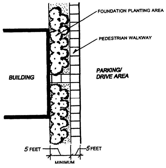
Foundation landscape plantings required along front building facade in all nonresidential districts. (Am. #2796) A minimum foundation landscape planting area of five (5) feet in width shall be required in the C-1, C-2, C-3, C-4, C-5, O, BP, M-1, I, PR, and PUD Districts as graphically indicated in Figure 21.06.0304(I). Vegetated stormwater control measures, and planter boxes may be sited within the required foundation landscape planting area, where approved in conjunction with a Stormwater Management Plan.
Figure 21.06.0304(I)
MINIMUM REQUIRED FOUNDATION LANDSCAPE PLANTING AREA
IN ALL NONRESIDENTIAL DISTRICTS
21.06.0305 - General bufferyard requirements.
A.
General.
1.
Bufferyard standards are listed in this section for peripheral bufferyards and for street bufferyards.
2.
Peripheral and street bufferyard standards are based on a required bufferyard intensity factor value. A variety of combinations of bufferyard width, planting intensity, and structural options (i.e., fences and earthen berms) may be selected from Table 21.06.0309 to reach the required bufferyard intensity level value. "Green Wall" treatments providing a vertical screening structure and vegetation are encouraged as a means of reaching the required intensity level value. A green wall is a wall, fence or other vertical structure partially or completely covered with vegetation that includes a growing medium, such as soil, and provision for irrigation. (Am. #2796)
3.
Peripheral bufferyards shall be along the outer perimeter of a lot or parcel, and shall extend to the lot or parcel boundary line. Peripheral bufferyards shall not be on any portion of an existing or dedicated public or private street or right-of-way.
4.
Required bufferyard plantings may be planted in natural-appearing groupings along the total length of the bufferyard and need not be spaced uniformly along said total bufferyard length.
5.
Vegetated stormwater control measures are encouraged to be incorporated into bufferyard plantings, where consistent with achieving the overall required bufferyard intensity level value. (Cr. #2796)
B.
Plant materials.
1.
For each bufferyard listed, a specific combination of canopy, shade, and understory trees; evergreen trees; and shrubs are required as indicated in Section 21.06.0302.
2.
All bufferyard areas shall be seeded with lawn or native groundcover unless such vegetation is already fully established.
3.
The exact placement of required plants and structures shall be the decision of the property developer.
4.
Plantings with a mature height of at least twelve (12) inches in an approved vegetated stormwater control measure may be substituted for required shrubs or evergreen shrubs. At the discretion of the Plan Commission, such plantings also may be substituted for understory trees. The required number of trees may be reduced by no more than twenty (20) percent if the Plan Commission finds that the required trees would interfere with the design and function of a vegetated stormwater control measure. The Plan Commission may require additional plantings or other screening to compensate for any such reduction. (Cr. #2796)
C.
Fences. Fences shall be constructed of rock, masonry, or wood. Chain link fences and chain link with slats shall be prohibited from use in required bufferyards. All fences used shall also meet the requirements for the construction of fences as set forth in Division 21.04.0800 of this Code.
D.
Height of required vegetation. Height of vegetation selected for required bufferyards shall be measured from the highest finished adjacent grade of the element to be screened.
E.
Berming. (Am. #2796) Earthen berms shall be designed to transition to existing surrounding grades, not to exceed a slope ratio of three to one (3:1), and shall be covered with plant material, groundcover, or partially rip-rapped to prevent erosion. Berms with vegetative cover shall be designed to retain irrigation water rather than encourage runoff. All earthen berms shall be safely designed to accommodate mowing when needed. Where berms would interfere with the placement, design or function of vegetated stormwater control measures, the use of fencing, trees or other screening is encouraged as an alternative to berms.
F.
Calculation of bufferyard requirements.
1.
Bufferyard requirements are calculated using the standards listed in this division for peripheral bufferyards and for street bufferyards as specified in Tables 21.06.0307 through 21.06.0309.
2.
Bufferyard standards listed in this section are to be calculated for every one hundred (100) linear feet of peripheral lot line boundary and/or street frontage present on a given lot.
3.
In instances where the zoning district boundary and/or street frontage is less than one hundred (100) feet, the required bufferyard planting shall be one (1) plant unit (see Table 21.06.0302).
4.
To determine the type of bufferyard required on a parcel, between two (2) parcels or lots, or between a parcel or lot and a street, the following procedures shall be used:
a.
Procedures for determining minimum required peripheral bufferyards:
(1)
Identify whether any portion or property line of the parcel or lot coincides with a zoning district boundary. If it does, determine the abutting zoning districts on both sides of the property line.
(2)
Refer to Table 21.06.0307 to determine the required bufferyard intensity factor needed to be achieved between the two (2) zoning districts.
(3)
Based upon the bufferyard intensity factor required, refer to the applicable Tables 21.06.0309(A) to 21.06.0309(E) to select the minimum number of plant materials (per 100 feet of bufferyard length), the bufferyard width, and required structure type combination by selecting the desired alternative bufferyard type.
(4)
Calculate the actual number of plants required by selecting the minimum number of plant materials (per 100 feet of bufferyard length) from the alternatives indicated the applicable Tables 21.06.0302(A) to 21.06.0309(E) and multiply by the hundreds of feet of bufferyard to be planted. Calculations resulting in fractional numbers of plant materials required shall be rounded to the next higher whole number.
(5)
Review Sections 21.06.0303 and 21.06.0304 of this Code for responsibility for installation of peripheral bufferyards.
b.
Street bufferyards.
(1)
Refer to Table 21.06.0308 to determine the required bufferyard intensity level factor.
(2)
Follow the calculation and procedures outlined in the preceding paragraph a.
G.
Noise buffer requirements for uses which abut freeways. The provision of noise buffers for land uses which abut freeways shall be as required by the Plan Commission based upon recommendation by the City Engineer. The determination of said freeway noise and the need for the provision of noise buffers (including type of buffer) shall be based upon an evaluation by the City Engineer (or an acoustic or sound engineer consultant to the City) using the U.S. Department of Housing and Urban Development, Office of Policy Development and Research, Noise Assessment Guidelines (HUD-PDR-735(1)) dated March 1984, as amended, or other guidelines acceptable to the City Engineer.
21.06.0306 - Limitations on bufferyard use.
A bufferyard may be used for passive recreation. It may contain pedestrian, or bike trails if:
A.
No plant material is eliminated;
B.
The total width of the bufferyard is maintained; and
C.
All other regulations of this Code are met. In no event, however, shall swimming pools, decks, drives, curbing, stormwater detention/retention ponds (other than vegetated control measures, as defined in Chapter 30 of the Municipal Code and approved in conjunction with a Stormwater Management Plan), tennis courts, sports fields, golf courses, parking lots, or other similar uses (as determined by the Plan Commission) be permitted in bufferyards. (Am. #2796)
21.06.0307 - Table of required peripheral bufferyards between zoning districts.
The minimum required bufferyard intensity level factor values for peripheral bufferyards between zoning districts set forth in the Table 21.06.0307 refer to the bufferyard width and plant unit standards set forth in Tables 21.06.0309(A) through 21.06.0309(E) of this division. Peripheral bufferyards are required between adjacent zoning districts. The abbreviations used in Table 21.06.0307 represent the City of Greenfield Zoning District designations used throughout this Code.
21.06.0308 - Table of required street bufferyards in all zoning districts.
A.
Compliance. Street bufferyard requirements set forth in this section and Table 21.06.0308 shall be met in all zoning districts for all new nonresidential development (including building and/or site improvements), additions to existing nonresidential development (including building and/or site improvements), all new multiple-family residential developments, all new Certified Survey Maps, all new Condominiums, and all new Subdivisions; and as may be required elsewhere in this Code.
B.
Exclusions (when street bufferyards are not required). The street bufferyard requirements set forth in this division shall not be required for the construction of single-family and two-family residential development located within existing platted Subdivisions (with an approved final plat), Certified Survey Maps, and Condominiums existing at the time of the adoption of this Code.
C.
Requirements. The numbers given in Table 21.06.0308 refer to the various bufferyard intensity level factors described in Table 21.06.0309 of this Code. Any combination of vegetation, structure(s), and width set forth in Tables 21.06.0309(A) through 21.06.0309(E) may be selected provided the required bufferyard intensity level factor is met as required by Table 21.06.0307 of this Code. The abbreviations used in Table 21.06.0308 represent the City of Greenfield Zoning District designations used throughout this Code.
Table 21.06.0307
MINIMUM REQUIRED BUFFERYARD INTENSITY LEVEL FACTOR VALUES OF PERIPHERAL BUFFERYARDS
BETWEEN ZONING DISTRICTS
;sz=8q;
(a) ;hg;As determined by each individual PUD Ordinance and/or PUD District approved plans.(b) ;hg;As determined by the underlying zoning district requirements using this Table.
Table 21.06.0308
STREET BUFFERYARDS:
MINIMUM REQUIRED BUFFERYARD INTENSITY LEVEL FACTORS (f)
(a)
As determined by each individual PUD Ordinance.
(b)
Street trees required at time of platting as required under the City Subdivision Ordinance.
(c)
Street trees required at time of platting as required under the City Subdivision Ordinance shall be in addition to any required arterial and/or collector street bufferyards.
(d)
See definition of "Street, Minor."
(e)
As required by the underlying zoning district.
(f)
See Section 21.06.0308B for exclusions to this requirement.
(g)
Only required for rear and/or side yards.
21.06.0309 - Minimum required bufferyard width and plant material standards.
The following Tables 21.06.0309(A) through 21.06.0309(E) set forth the minimum bufferyard width and plant material standards required for achieving required bufferyard intensity levels. Tables 21.06.0309(A) through 21.06.0309(E) are designed to allow for choice from a variety of alternative bufferyard widths and general landscape plant material types to meet the required bufferyard intensity levels required elsewhere in this division. Plantings with a mature height of twelve (12) inches or greater in a vegetated stormwater control measure that is part of an approved Stormwater Management Plan may be substituted for shrubs and evergreen shrubs. Such plantings also may substitute for understory trees, at the discretion of the Plan Commission. (Am. #2796)
Table 21.06.0309(A)
BUFFERYARD INTENSITY FACTOR 1:
ALTERNATIVE PLANT MATERIAL STANDARDS
(a)
See Table 21.06.0312(B) for minimum required plant material sizes.
Table 21.06.0309(B)
BUFFERYARD INTENSITY FACTOR 2:
ALTERNATIVE PLANT MATERIAL STANDARDS
(a)
See Table 21.06.0312(B) for minimum required plant material sizes.
Table 21.06.0309(C)
BUFFERYARD INTENSITY FACTOR 3:
ALTERNATIVE PLANT MATERIAL STANDARDS
(a)
See Table 21.06.0312(B) for minimum required plant material sizes.
Table 21.06.0309(D)
BUFFERYARD INTENSITY FACTOR 4:
ALTERNATIVE PLANT MATERIAL STANDARDS
(a)
See Table 21.06.0312(B) for minimum required plant material sizes.
Table 21.06.0309(E)
BUFFERYARD INTENSITY FACTOR 5:
ALTERNATIVE PLANT MATERIAL STANDARDS
(a)
See Table 21.06.0312(B) for minimum required plant material sizes.
21.06.0310 - Minimum landscaping standards for off-street parking areas and lots.
A.
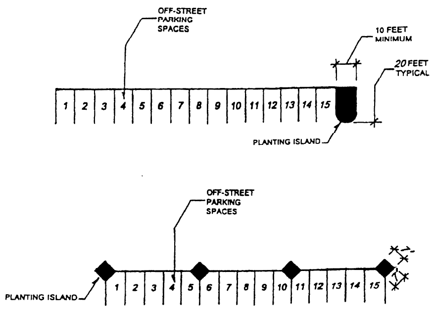
Minimum landscaping requirements for residential and nonresidential off-street parking areas and lots. (Am. #2796) Each residential and nonresidential off-street parking lot shall contain a minimum amount of landscaping within the parking lots and adjoining entrance drives and circulation drives as set forth in Table 21.06.0310(A). A specified number of landscape plant units shall be planted per fifteen (15) off-street parking spaces or fraction thereof as set forth in Table 21.06.310(A). Where the resulting number of required plant units is expressed in a fraction, the required number of landscape plant units shall be rounded to the next highest whole number. Figure 21.06.0310(A) graphically indicates two (2) alternative approaches to the provision of two hundred (200) square feet of the required planting island area.
The use of vegetated stormwater control measures and stormwater trees is encouraged to meet minimum landscaping requirements for off-street parking areas and lots. Plantings with a mature height of twelve (12) inches or greater in a vegetated stormwater control measure may be substituted for shrubs, evergreen shrubs, and understory trees, where approved by the Plan Commission and part of an approved Stormwater Management Plan.
Figure 21.06.0310(A) graphically indicates two (2) alternative approaches to the provision of two hundred (200) square feet of the required planting island area; however, where planting island areas are designed as vegetated stormwater control measures, the location, dimension and size of these areas should reflect the approved Stormwater Management Plan.
Table 21.06.0310(A)
MINIMUM LANDSCAPED AREA REQUIRED FOR
OFF-STREET PARKING SPACES
Figure 21.06.0310(A)
ALTERNATIVE APPROACHES TO THE PROVISION OF
TWO-HUNDRED (200) SQUARE FEET OF PLANTING ISLAND AREA
B.
Existing vegetation may count toward the provision of minimum off-street parking landscape requirements. Existing trees that can be preserved, where grading does not cut them off from a reasonable supply of water and where the area under the canopy remains undisturbed, shall count toward the plant requirements by measuring the area of the island. The minimum size of such an island shall be three hundred (300) square feet. Table 21.06.0310(A) specifies the minimum area requirements per twenty-four (24) required off-street parking spaces or fraction thereof.
C.
Curbs, barriers, and overhangs required to contain landscape areas. (Am. #2796) The curb or barrier around landscape areas may be used as a wheel-stop provided the area of vehicle overhang does not exceed two (2) feet and does not damage or interfere with the landscaping. Where vehicle overhangs abut required landscape areas, a minimum five (5) foot wide planter is required for a single vehicle overhang and an eight (8) foot wide planting area is required for a double vehicle overhang. Vehicle overhang into the public right-of-way is not permitted. Breaks, depressions or other inlets for stormwater flows are permitted around vegetated stormwater control measures that are part of an approved Stormwater Management Plan.
D.
Uses not permitted in required landscaped areas. Parking (except where vehicle overhang is permitted), buildings, and display of equipment or vehicles are not permitted in required landscaped areas.
E.
Required landscape materials not to constitute a driving hazard. To ensure that landscape materials do not constitute a driving hazard:
1.
Trees used to landscape parking islands shall have a clear trunk height of six (6) feet; and
2.
Mature shrubs, groundcover, or other landscaping material shall not exceed three (3) feet in height.
21.06.0311 - Minimum landscaping standards for multiple-family residential and nonresidential zoning district parcels and lots.
A.
Minimum on-site landscaping required. (Am. #2796) Each MFR-1, MFR-2, MFR-3, PUD (residential) District and all nonresidential zoning districts or lot in a new multiple-family or nonresidential development shall contain a minimum amount of landscaping in areas not designated as off-street parking under the provisions of Sections 21.06.0202 and 21.06.0310, bufferyard Sections 21.06.0305 through 21.06.0309 of this Code, or areas designated as buildings. Vegetated stormwater control measures may be counted towards the minimum on-site landscaping requirement, where these measures are approved in conjunction with a Stormwater Management Plan under Chapter 30 of the Municipal Code. For each acre of land not occupied by buildings, off-street parking areas, drives, or bufferyards, the number of "Type B" plant units as described in Table 21.06.0302 shall be planted pursuant to the requirements of paragraph C. below and Table 21.06.0311(C).
B.
Exclusions (when minimum on-site landscaping is not required). The following exclusions to the requirements of this section are applicable:
1.
The on-site requirements set forth in this section shall not be required for the construction of single-family and two-family residential development located within existing platted Subdivisions (with an approved final plat), Certified Survey Maps, and Condominiums existing at the time of the adoption of this Code.
2.
No area that is undisturbed and designated as "open space" required under the open space or natural resource protection provisions of this Code, and other deed restricted residential open space meeting open space ratio (OSR) requirements of this Code, or is designated as an undisturbed resource protection area and protected by deed restrictions, shall be included in the calculation of the area to be planted.
Table 21.06.0311(C)
MINIMUM REQUIRED PLANT UNITS FOR RESIDENTIAL
AND NONRESIDENTIAL ZONING DISTRICT PARCELS AND LOTS
(a)
Not applicable when the minimum landscape surface ratio (LSR) requirements are lowered due to mitigation, as provided under Section 21.06.0314, allowed by the Plan Commission. When mitigation is allowed by the Plan Commission, the minimum plant unit requirements set forth in Table 21.06.0314 are applicable.
21.06.0312 - Minimum plant material standards.
A.
General plant material standards. All new landscape plant material shall be grown in a nursery located in Plant Hardiness Zone 3 or 4 and shall conform to the applicable requirements as specified in the current edition of American Standard for Nursery Stock as approved by the American National Standards Institute, Inc. and sponsored by the American Association of Nurserymen, Inc. as amended Botanical plant names shall be according to the current edition of Standardized Plant Names prepared by the American Joint Committee on Horticultural Nomenclature as amended.
B.
Plant material minimum size standards. All required new landscape plant material shall be, at the time of installation, those minimum sizes as set forth in Table 21.06.0312(B).
C.
[Plantings in vegetated stormwater control measures.] (Cr. #2796) Plant material and sizes at installation for plantings in vegetated stormwater control measures should be consistent with published guidance from the Wisconsin Department of Natural Resources for the specific type of stormwater control measure proposed.
Table 21.06.0312(B)
MINIMUM SIZE STANDARDS FOR REQUIRED PLANT MATERIALS
(Am. #2796)
(Note: Sizes of plant materials in vegetated stormwater control measures should be consistent with published guidance from the Wisconsin Department of Natural Resources for the applicable type of stormwater control measure.)
21.06.0313 - Landscape construction performance surety required.
Landscape construction sureties as required pursuant to Section 21.07.0105 of this Code.
21.06.0314 - Mitigation of minimum required landscape surface ratio (LSR) in nonresidential districts.
The City of Greenfield recognizes that the use of the landscape surface ratio (LSR) standards for the provision of adequately landscaped open space in nonresidential areas as set forth in this Code may not always lead to good design and, under some circumstances, may be difficult to achieve. This section addresses landscape mitigation measures that may be allowed by the Plan Commission.
A.
Mitigation of required bufferyards and off-street parking landscaping not permitted. The mitigation of the dimensional requirements, structural requirements, and/or landscape plant unit and/or material requirements of required peripheral or street bufferyards shall not be allowed. Landscape surface ratio (LSR) mitigation shall only be allowed for required on-site landscaping as required in Table 21.06.0314.
B.
Maximum allowable reduction of the landscape surface ratio (LSR) through mitigation measures. The maximum allowable reduction of the landscape surface ratio (LSR) through mitigation measures shall not fall below those landscape surface ratios (LSRs) set forth in Table 21.06.0314. In no case shall reductions in landscape surface ratios (LSRs) supersede the natural resource protection standards set forth in Division 21.05.0100 or allow for increases in either the maximum gross floor area ratio (GFAR) or net floor area ratio (NFAR) set forth in the various zoning district requirements of this Code.
Table 21.06.0314
MAXIMUM ALLOWABLE MITIGATION OF
LANDSCAPE SURFACE RATIO (LSR) REQUIREMENTS
IN NONRESIDENTIAL ZONING DISTRICTS
(a)
As required by the underlying zoning district.
21.06.0401 - Exterior lighting standards.
Exterior lighting shall meet one (1) of the following standards:
A.
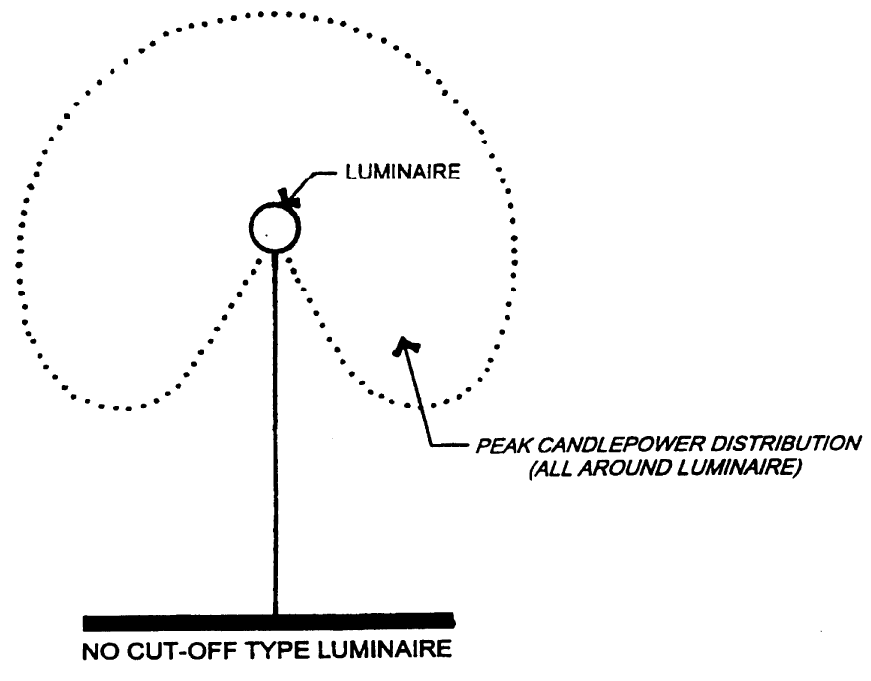
Requirements for the use of no cut-off type luminaires. When a light source or luminaire has no cut-off type luminaire (see Figure 21.06.0401(A)), the maximum permitted illumination and the maximum permitted luminaire height shall be as set forth in Table 21.06.0401(A).
Table 21.06.0401(A)
REQUIREMENTS FOR THE USE OF NO CUT-OFF TYPE LUMINAIRES (a)
(a)
These standards do not address illumination levels or fixture height that may be required by the City of Greenfield for the adequate lighting of public street rights-of-way. These represent maximum illumination levels on private property.
(b)
Any no cut-off luminaire which does not meet the requirements of this Table requires Plan Commission review and approval.
Figure 21.06.0401(A)
NO CUT-OFF TYPE LUMINAIRE
B.
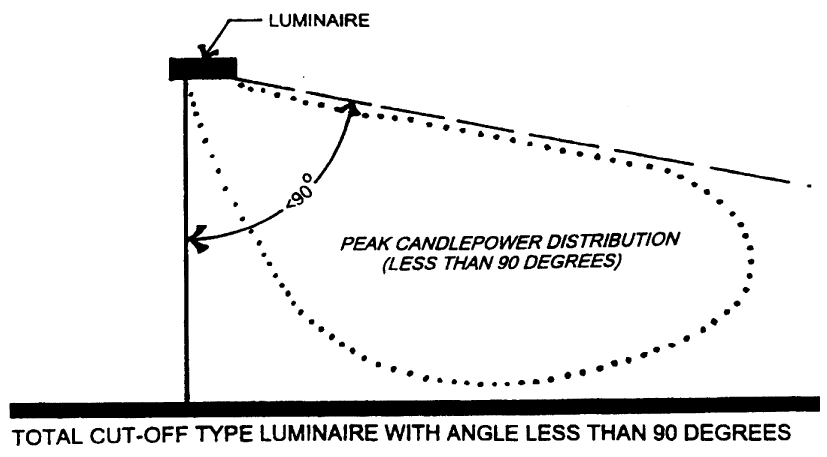
Requirements for total cut-off type luminaires (with angle less than 90 degrees). When a luminaire has total cut-off of light at an angle less than ninety (90) degrees and is located so that the bare light bulb, lamp, or light source is completely shielded from the direct view of an observer five (5) feet above the ground at the point where the cut-off angle intersects the ground (see Figure 21.06.0401(B)), then the maximum permitted illumination and the maximum permitted height of the luminaire shall be as set forth in Table 21.06.0401(B). Ground level building and sign lighting shall be reviewed and approved by the Plan Commission.
Table 21.06.0401(B)
REQUIREMENTS FOR THE USE OF CUT-OFF TYPE LUMINAIRES
WITH ANGLE LESS THAN 90 DEGREES (a,c,d,e)
(a)
These standards do not address illumination levels or fixture height that may be required by the City of Greenfield for the adequate lighting of public street rights-of-way. These represent maximum illumination levels on private property.
(b)
See Section 21.06.0403 for lighting standards for outdoor recreational facilities in the PR Park and Recreation District.
(c)
Not greater than the height of the building.
(d)
A commercial property abutting a residential district shall have lighting luminaire heights approved by the Plan Commission.
(e)
Light source within fifty (50) feet of a residential district shall not exceed twelve (12) feet in height.
Figure 21.06.0401(B)
CUT-OFF TYPE LUMINAIRES
WITH ANGLE LESS THAN 90 DEGREES
21.06.0402 - Exterior lighting plan required.
A.
General. At the time any exterior light is installed or substantially modified, whenever a Site Plan Review application is made, and whenever a Zoning Permit application is made, an exterior lighting plan shall be submitted to the City of Greenfield to determine whether the requirements of this section have been met and that adjoining property will not be adversely impacted by the proposed lighting.
B.
Lighting plan elements. A Lighting Plan submitted pursuant to this Code shall have, at a minimum, the following elements:
1.
A catalog page, cut sheet, or photograph of the luminaire including the mounting method.
2.
A photometric data test report of the proposed luminaire graphically showing the lighting distribution at all angles vertically and horizontally around the luminaire.
3.
A plot plan, drawn to a recognized engineering or architectural scale, indicating the location of the luminaire(s) proposed, mounting, and/or installation height in feet, the overall illumination levels (in footcandles) and uniformities on the site, and the illumination levels (in footcandles) at the property boundary lines. This may be accomplished by means of an isolux curve or computer printout projecting the illumination levels.
4.
A graphic depiction of the luminaire lamp (or bulb) concealment and light cut-off angles.
5.
In addition to the full-size drawings required above, one (1) copy of each such drawing submitted shall also be submitted in 11″ × 17″ black and white reduction.
21.06.0403 - Exterior lighting for specified outdoor recreational uses.
Ball diamonds, playing fields, golf driving ranges, tennis courts, and similar outdoor recreational facilities have unique requirements for nighttime visibility and generally have limited hours of operation. These uses may be exempted from the exterior lighting standards of the Division if the applicant can satisfy the Plan Commission, upon Site Plan Review, that the following requirements are met:
A.
Site plan. The Site Plan must meet all other requirements of this division and Code.
B.
Exterior light sources. Any exterior light sources shall not exceed the maximum permitted post height of fifty (50) feet.
C.
Shielded luminaires. If the luminaire is shielded in either its orientation or by a landscaped bufferyard to prevent light and glare spillover to adjacent residential property(s) or residential zoning districts, then the luminaire may exceed a total cut-off angle of ninety (90) degrees. The maximum permitted illumination at the interior bufferyard line of all required bufferyards shall not exceed two (2) footcandles.
D.
Lighting plan required. A "Lighting Plan" meeting the requirements of Section 21.06.0402 of this division shall be submitted to the Plan Commission for review and approval.
21.06.0404 - Street lighting.
Street lighting shall conform to the standards set forth by the State of Wisconsin for State Trunk Highways, Milwaukee County for County Trunk Highways, and the City of Greenfield for City streets and highways.
21.06.0405 - Searchlights.
The Zoning Administrator may permit the temporary use of a searchlight for advertising purposes in any nonresidential zoning district if the searchlight will not be located in any public right-of-way, will not be located closer than ten (10) feet to an adjacent property, and will not cause a hazard to traffic or adjoining properties. Searchlight permits shall not be granted for a period or more than five (5) days in any six-month period.
21.06.0406 - Additional regulations.
Despite any other provision of this section to the contrary, the following provisions shall also be applicable:
A.
Flickering and flashing lights. No flickering or flashing lights shall be permitted excluding seasonal lighting between November 1 and January 31.
B.
Light sources and/or luminaires not to be located within required bufferyards. Light sources or luminaires shall not be located within required bufferyard areas except on pedestrian walkways.
C.
Requirements of other applicable codes and ordinances to be met. The provisions of this division are designed to supplement other applicable ordinances and codes and not as a substitute. All outdoor electrically powered illuminating devices shall be installed in conformance with the provisions of this Code, applicable building codes and ordinances, electrical codes and ordinances, and all other codes and ordinances as applicable and under appropriate permit and inspection.
D.
[Exterior light pole base or pedestal.] Exterior light pole base or pedestal shall not exceed six (6) inches above the ground in handicapped areas or curbed protected areas. (Cr. #2430)
21.06.0407 - Light measurement.
A.
Metering equipment. Lighting levels shall be measured in footcandles with a direct-reading, portable light meter. The meter shall be read within an accuracy of plus or minus five (5) percent. It shall have been tested, calibrated, and certified by an independent commercial photometric laboratory or the manufacturer within thirty (30) days of its use.
B.
Method of measurement. The meter sensor shall be mounted not more than six (6) inches above ground level in a horizontal position at the interior line of the bufferyard or at the property line, as required herein. Readings shall be taken only after the cell has been exposed long enough to provide a constant reading. To eliminate the effects of moonlight and other ambient light, measurements shall be made after dark with the light source in question on, then with the same sources off. The average of the two (2) readings shall be compared with the maximum permitted illumination allowed under this division.