
Hall County Unincorporated
City Zoning Code
City Zoning Code
ARTICLE 6
- Special and Overlay Districts
Sec. 6.1. - Planned Development Districts (PD)
6.1.1. Intent
A.
To permit for the development of property which:
1.
Allows for greater flexibility in development standards and site planning considerations;
2.
Is in the best interest of Hall County in terms of its long range development plans; and
3.
Encourages a mixture of uses which without proper design and planning might not be compatible with surrounding uses or zoning districts.
B.
Planned development districts are to be utilized as a "floating zone" and will be individually evaluated for designation. These districts are separate zoning districts and follow the same amendment procedures as other districts. Unless otherwise stated in this section, the development standards and the land uses which are presented with the application for amendment will become the standards for the subject property.
6.1.2. Requirements for Rezoning
A.
An area may be considered for rezoning to a planned development district if any one of the following conditions exist:
1.
More than one land use is proposed for development on a single parcel;
2.
Separate land uses which would not otherwise be permitted to locate within the same zoning district are proposed for development on one or more adjacent parcels under single or separate ownership;
3.
Exception or variation from the size, setback, frontage, density, uses or other standards which are required in the other conventional zoning districts are being proposed as part of a comprehensive development plan.
B.
All proposed planned development district applications must adhere to the following specific requirements:
1.
The site proposed for a planned development must contain an area of at least five acres. In no case may the minimum tract size be less than the minimum lot area requirements for the comparable conventional district as specified for each planned development classification in this section. The comparable conventional zoning districts listed in the regulations are R-1 for a PRD, O-I for a POD, S-S for a PCD and I-1 for a PID.
2.
The site must have frontage along a public street for a distance of at least 100 feet.
3.
A suitable plan must be prepared for the development, and this plan must include the following elements where applicable:
a.
A plan drawn to scale by a registered engineer, architect, land surveyor or landscape architect showing the exact dimensions of the parcel or parcels of land under consideration and including the following information:
i.
A conceptual site plan drawn to scale and indicating all property dimensions, platting and street systems, proposed building sites, sizes, types of use proposed for buildings, plans for protection of abutting properties, means of ingress and egress, access and circulation arrangements, off-street parking and loading facilities, proposed reservations or dedications for streets and other public facilities and, if requested, a contour map of the site.
ii.
The name of the developers and of the development (if any).
iii.
A north arrow and scale.
iv.
If the proposal includes the subdivision of land for any purpose or for the provision of new public streets, a proposed lot and street layout must be submitted as part of the application. Any proposed variation from the standards set forth in the subdivision regulations must be listed and explained. If the plan is approved, a preliminary plat and final plat must be submitted as provided by the subdivision regulations of Article 9.
b.
A written report must also be submitted which explains the type, nature, size, intent and characteristics of the proposed development. This report must include, where applicable:
i.
A general description of the proposed development and its location.
ii.
The proposed standards for development, including restrictions on the use of the property, density standards, yard (setback) requirements and any proposed restrictive covenants.
iii.
An explanation of why the proposed development standards are necessary if the above proposed standards vary from existing standards in the zoning regulations.
iv.
Plans for the provision of utilities, including water, sewer and drainage facilities.
v.
Plans and methods for protection of adjacent properties.
vi.
Data stating the total number of square feet proposed for each type of land use, including public facilities, within the proposed development.
vii.
Additional relevant data as may be required by the County.
4.
A proposed development schedule and listing of all proposed uses must be submitted as a part of an application for a planned development district.
6.1.3. Administrative Procedures
A.
Any request pertaining to the establishment of a planned development district will be administered and processed in accordance with the regulations set forth in Sec. 11.2.
B.
All data, plans and specifications presented as part of the planned development district application will, if approved, be the standards of development for that particular planned development, but only to the extent that they do not conflict with the provisions of this UDC. To the extent that they conflict with this UDC all data, plans, and specifications become the standards of development for that particular planned development only if they are set forth as a specific condition of zoning or approved as a zoning variance.
C.
To the extent that the approved standards are consistent with this UDC, set forth as specific conditions, or approved as a zoning variance, all further development on the property must conform to the standards adopted for the district regardless of any change in ownership. Any proposed changes to those standards must be considered in accordance with the procedures set forth in Sec. 11.2. Appeals based upon hardship or an alleged misinterpretation of the ordinance or this UDC by the building official will be processed in accordance with procedures set forth in Sec. 11.2. In no case may the approved land uses be appealed.
D.
The violation of any provision of the planned development standards as submitted and approved under the provisions of this UDC will constitute a violation of these regulations.
6.1.4. Application Procedures
A.
Any application for a planned development district must be submitted to the Board of Commissioners through the Director of Planning and Zoning or other designated staff member.
B.
General Requirements
1.
All applications for zoning of property to a planned development district must conform to all requirements of Sec. 11.2 except as may otherwise be required by this section. All applications that do not comply with the requirements of Sec. 11.2 will be returned to the applicant unfiled with notice of the deficiency or deficiencies.
2.
No application to rezone property to a planned development district may be accepted until after a pre-application meeting is held between the applicant, appropriate staff of the Office of Planning and Development, appropriate staff of the Office of Public Works and Utilities, and any other applicable local or state agencies. Once a pre-application meeting is requested by the applicant, staff must schedule the meeting within ten business days. Failure to meet this timeline by staff would negate the pre-application meeting requirement.
6.1.5. District Classifications
A.
The following are classified as planned development districts subject to the provisions of this article and to the standards for each district:
1.
PRD: Planned Residential Development.
2.
POD: Planned Office Development.
3.
PCD: Planned Commercial Development.
4.
PID: Planned Industrial Development.
6.1.6. District Standards
A.
Planned Residential Development (PRD)
1.
Intent. A planned residential development is designed to allow for a more flexible placement, arrangement, and orientation of residential structures, the accompanying flexibility in the subdivision of land, and the grouping of open space and accessory facilities such as garages and parking. It may also provide for a mixture of housing types such as single-family, two-family, multi-family, townhomes, cottage court, and live-work according to a carefully designed plan. The proposed residential development should make maximum use of natural features and, through proper site planning measures, should conform to the existing character and development pattern of the surrounding area. Every effort should be made to preserve and protect any existing residential uses from adverse impacts which might result from a higher density development.
Table 6.1.1. PRD Dimensional Standards
2.
Application Requirements. All the general and special requirements in Secs. 6.1.2 and 6.1.3 for planned developments must be provided. The following special items must be addressed:
a.
The site plan must indicate the proposed size, location, number of units and number of bedrooms of all residential structures.
b.
All streets and common open spaces not proposed for dedication to the county must have the proposed maintenance and ownership agreements explained in detail.
c.
The architectural style and proposed siting of all multi-family structures or attached single-family structures must be indicated. Architectural standards for all planned residential developments are as indicated in Sec. 6.1.6.A.8.
d.
The development controls for the development must be detailed, including lot coverage, setbacks, building heights, and lot sizes.
e.
Planned developments of at least 5 acres in size may include commercial uses within the development, limited to neighborhood retail intended to serve the needs of the residents of the development unless otherwise specifically approved by the Board of Commissioners. Retail uses must be specified as part of the proposal and are limited to no more than 10,000 square feet of floor area for the entire development site.
3.
Dimensional Standards. See Table 6.1.1 for district standards and Sec. 2.1 (Measurements and Exceptions) for additional requirements.
4.
Buffers. A buffer at least 50 feet in width must be established along the perimeter of all property boundaries adjacent to residential and nonresidential districts to ensure that the planned residential development is appropriately screened. Buffers must meet the standards of Sec. 8.2.4.
5.
Landscaping. In addition to the tree protection requirements of Sec. 8.3, the following standards apply in planned residential developments:
a.
At least two trees per lot must be provided. Trees may be located in the front, side, or rear yard.
i.
These trees may not be counted towards the developments tree density unit requirement.
ii.
Trees located within any utility easement, drainage easement, or septic drain field may not count towards the per lot tree requirement.
b.
The developer is responsible for planting or preserving the individual lot trees prior to issuance of a certificate of occupancy.
6.
Access. In addition to the requirements of Article 9 (Subdivisions) the following standards apply in all planned residential developments:
a.
Any PRD with 150 or more lots must include at least two vehicular entrances with access to a city, state, or county maintained public right-of-way. The second entrance must be completed prior to the platting of 150 lots or more.
b.
Any PRD with 400 or more lots must include at least three vehicular entrances with access to a city, state, or county maintained public right-of-way.
i.
The county may waive the requirement for immediate construction of a third entrance based on the development schedule and phasing plan.
c.
In addition to the requirements of Sec. 8.4 and any applicable provisions of Article 9, sidewalks must be installed on both sides of any proposed street.
7.
Open Space. Open space is required in all PRD districts as follows:
a.
Open space must comprise at least 30% of the gross lot area.
b.
All other standards of Sec. 4.8.7 apply.
8.
Architectural Standards. The following architectural standards apply to all PRD districts:
a.
Building materials. All facades of residential structures and any permitted nonresidential structures must be finished with brick, stone, stucco, wood siding, wood shake, or cementitious siding. Vinyl siding is not permitted.
i.
The front facade must incorporate a variety in building material, texture or color.
b.
Garages. Garages for single-family detached and two-family structures on lots less than one acre in size must meet one of the following standards.
i.
Flush. Garage doors are oriented towards the street. Garage doors may be positioned flush with the front wall plane of the residence, extending no more than 55 percent of the width of the residence.
ii.
Semi-flush. Garage doors are oriented towards the street. Garage doors may be positioned within 10 feet of flush with the front wall plane of the residence in either direction, extending no more than 55 percent of the width of the residence.
iii.
Recessed. Garage doors are oriented towards the street. Garage doors must be positioned at least 10 feet behind the front wall plane of the residence, extending no more than 55 percent of the width of the residence.
iv.
Side-loaded. Garage doors are oriented perpendicular to the front wall plane of the residence. Any wall of the garage must be located at least 3 feet behind the front wall plane of the residence.
v.
Carriage court. Garage doors are oriented perpendicular to the front wall plane. All garage walls are located entirely in front of the front wall plane of the residence.
vi.
Detached. The garage is placed entirely to the rear of the residence.
c.
Townhouses. For townhouses garage placement must meet the following standards. Townhouses fronting an arterial or collector street must be rear loaded. Townhouses fronting a minor street may be rear-loaded or front-loaded.
i.
Rear-loaded. The garage must be placed entirely to the rear of the townhouse and may be attached or detached. Garage doors must face a rear right-of-way or easement. For detached garages, the garage must be either located 4 feet from the rear right-of-way or easement, or be a minimum of 20 feet from the rear right-of-way or easement.
ii.
Front-loaded. A minimum of 20 feet is required between the garage and the back of sidewalk.
9.
Footing Inspections. At the time of the footing inspection, the contractor must provide the county building official with a certificate from a licensed surveyor certifying building setbacks for all corners of the structure being inspected.
10.
Cluster Mailbox Unit (CBU). Pursuant to Unites States Postal Service Policy, all new subdivisions and new phases of existing subdivisions are required to provide CBU's for regular mail service delivery. A CBU is a structure or shelter housing multiple mailbox units to serve each residential dwelling of the development for the express purpose of regular mail delivery provided by the USPS. The following standards are for construction and maintenance of CBU's for all planned residential developments.
a.
The developer is responsible for confirming the logistics of regular mail delivery to CBU's with the USPS. As such, all CBU's are subject to final approval by the USPS.
b.
Maintenance. The county will not assume any responsibility for the maintenance and repairs of CBU's and associated parking areas. The CBU's and associated parking areas are to be maintained by the homeowners' association, managing entity, or collectively by the property owners.
c.
Location. CBU's must be located on their own lot or in an area dedicated for open space or on a public access easement obtained by the developer. The entrance to the proposed vehicular parking area must be located at least 200 feet from the main entrance and at least 60 feet from any street intersection.
d.
Parking. The minimum parking ratios established on Table 6.1.2. must be met for all CBU's:
Table 6.1.2. PRD Dimensional
Standards
e.
Property Management. A person owning or having possession or control of any property within a PRD must meet the following property management standards in addition to any conditions of approval placed upon the development as detailed in Sec. 6.1.3:
i.
Any damaged, dead, diseased or decaying plant materials must be removed and replaced if visible from the public right-of-way.
ii.
Premises occupied by a residential dwelling must be maintained free from grass, similar vegetation or uncultivated vegetation in excess of 12 inches in height.
iii.
Fences facing a street or adjacent public right-of-way must be regularly maintained, repaired, and replaced if considered necessary by the building official.
B.
Planned Office Development (POD)
1.
A Planned Office Development is designed to contain orderly, well-designed office and institutional uses upon a site that results in minimum impact upon the surrounding area. The site plans and building designs should produce a development that can be constructed to achieve maximum utilization of space while maintaining a low-intensity office character protected from more intensive commercial and industrial development and protecting any nearby residential uses.
2.
Planned Office Developments may also include a limited number of residential and commercial uses.
3.
All the general and special requirements in Secs. 6.1.2 and 6.1.3 for planned developments must be provided. The following special items should also be addressed:
a.
The site plan must indicate the proposed size, location, and number of stories in each office building.
b.
The development controls for the district must be detailed, including lot coverage, setbacks, building heights, and lot sizes. If standards are not specifically proposed, then the applicable standards in the Office Institutional (O-I) districts in Sec. 5.1, including screening and buffer requirements, apply.
c.
If residential uses are proposed in conjunction with the planned office development, then the applicable requirements of the planned residential development district or planned commercial development district must be provided.
C.
Planned Commercial Development (PCD)
1.
A Planned Commercial Development is designed to provide for the maximum attainable commercial usage of property while employing the best aspects of site planning and development controls to insure:
a.
Protection of surrounding residential uses;
b.
Safe access by motorists;
c.
Minimum traffic congestion; and
d.
A development which is consistent with long-range plans of the county.
2.
A limited number of carefully planned residential uses may also be included in a Planned Commercial Development.
3.
All the general and special requirements in Secs. 6.1.2 and 6.1.3 for planned developments must be provided. The following specific items must also be addressed:
a.
A site plan indicating the proposed site preparation and grading, streets and parking areas, loading zones, storm drainage, water, gas and sewage systems, and all buffer areas.
b.
The development controls for the district must be detailed, including lot coverage, setbacks, building heights, and lot sizes. If standards are not specifically proposed, then the applicable standards in the Suburban Shopping (S-S) district in Sec. 5.2, including screening and buffer requirements, apply.
D.
Planned Industrial Development (PID)
1.
A Planned Industrial Development is designed to consist of land which has been designated for a planned, organized and controlled industrial use or for multiple but compatible industrial uses in a planned industrial park. The standards must be designed to encourage the formation and continuance of a compatible environment for the planned industrial uses and the surrounding land uses.
2.
Carefully planned office and commercial uses may be incorporated as part of a Planned Industrial Development.
3.
All of the general and special requirements for planned developments in Secs. 6.1.2 and 6.1.3 must be provided. The following specific items must also be addressed:
a.
A site plan indicating the proposed site preparation and grading, streets and parking areas, loading zones, outdoor storage areas, rail facilities, storm drainage, water, gas and sewage systems and all buffer areas.
b.
The development controls for the district must be detailed, including lot coverage, setbacks, building heights, and lot sizes. If standards are not specifically proposed, then the applicable standards in the Light Industrial (I-1) district in Sec. 5.5, including screening and buffer requirements, apply.
c.
If office or commercial uses are proposed in conjunction with the Planned Industrial Development, then the applicable requirements in the POD or PCD district must be provided.
6.1.7. Other Standards
See Article 2 (Rules Common to All Districts) and Article 7 (Use Provisions) and Article 8 (Site Development) for additional standards which may be applicable.
Sec. 6.2. - Gateway Corridor Overlay District (GCOD)
6.2.1. intent
A.
The purpose of the Gateway Corridor Overlay District is:
1.
To promote the general health, safety and welfare of the community.
2.
To improve the efficient operation of traffic around the county.
3.
To promote safe and efficient movement within the Overlay District for persons using all modes of travel including motorized vehicles, bicycles and walking.
4.
To create a sense of place that is aesthetically appealing and environmentally responsible.
5.
To encourage innovative development projects that set standards for landscaping, community design and aesthetics.
6.
To establish consistent and harmonious design standards for public improvements and private property development within the Overlay District to unify the distinctive visual quality of the Gateway Corridors.
6.2.2. Boundaries
A.
The provisions of this section apply to all lots of record within the unincorporated portion of Hall County having frontage on the following road segments as of March 22, 2007. These road segments will be referred to as the "Gateway Corridors."
1.
S.R. 211 from S.R. 53 (Winder Highway), south to Thompson Mill Road.
2.
U.S. 129 (Athens Highway) from the Gainesville City limits, south to Gillsville Highway.
3.
S.R. 53 (Winder Highway) from S.R. 13 (Falcon Parkway), east to the Jackson County line.
4.
S.R. 13 (Atlanta Highway and Falcon Parkway) from the Flowery Branch City limits, north to S.R. 53 (Winder Highway).
5.
McEver Road from the Buford City limits, north to the northernmost intersection with Radford Road.
6.
Martin Road from S.R. 53 (Winder Highway) to S.R. 13, to continue along a proposed extension of Martin Road to Thurmond Tanner Pkwy pursuant to final alignment approved by GDOT.
7.
Spout Springs Road from the Flowery Branch City limits, south to Friendship Road.
8.
Friendship Road from Bogan Road, east to Thompson Mill Road.
9.
Realigned Thompson Mill Road from Spout Springs Road east to S.R. 211 (Old Winder Highway), pursuant to final alignment approved by GDOT.
10.
All state controlled rights-of-way within the jurisdiction of Hall County.
B.
This Sec. 6.2 may also apply to any lot of record within the unincorporated portion of Hall County when a portion of said parcel falls within 300 feet of the centerline of the Gateway Corridors as of March 22, 2007. Any parcel subject to the ordinance on the above date of adoption may continue to be subject to the provisions of this section, even if the parcel is subdivided in the future.
C.
Upon written application, the Director may grant exemptions from the requirements of this section for parcels or portions of a parcel that would otherwise be included in the GCOD, based on one or more of the following findings:
1.
Portions of the subject property to be exempted lie more than 300 feet from the centerline of a Gateway Corridor.
2.
The property to be exempted does not have access to a Gateway Corridor and will not require access to a Gateway Corridor when developed.
3.
Due to site topography development of the property to be exempted will not be visible from a Gateway Corridor.
4.
Due to the location, size and shape of the property, development of the parcel under its current zoning and in conformity with the requirements of the GCOD would present a severe and unique hardship.
If the Director does not issue a written decision regarding such exemption within 15 working days of receipt of the application required in this section, the exemption will be deemed to be approved.
6.2.3. Applicability of Overlay Provisions
A.
This Overlay District is supplemental to the underlying zoning district classifications established within this UDC. The provisions of this section are overlaid upon and imposed in addition to said underlying zoning regulations and other Hall County ordinances.
B.
In any case where the standards and requirements of the GCOD conflict with those of the underlying zoning district or subdivision regulations, the standards and requirements of the GCOD govern.
C.
The provisions of this Sec. 6.2 do not apply to the following:
1.
Completion of work subject to preliminary plats, site development plans, construction plans, building permits, or interior finish permits approved prior to March 22, 2007.
2.
Reconstruction, rehabilitation, restoration, repair or addition of an existing nonresidential structure, interior renovations or interior finishes within an existing structure, or addition to an existing nonresidential structure that was permitted prior to March 22, 2007, provided that such construction is on a lot of record and does not result in addition or change to more than 75 percent of the floor area of the existing permitted structure.
3.
Rezonings and planned developments that were approved by the Board of Commissioners prior to March 22, 2007, except for those approvals with specific reference to the GCOD.
D.
The following requirements apply to reconstruction, replacement or addition to a legally permitted and existing nonresidential structure when such change consists of more than 75 percent of the floor area of the existing structure:
1.
The portion of the project that is reconstructed, replaced or added must meet the Architectural Standards of 6.2.6.
2.
If the reconstruction, replacement or addition includes the addition of 50 parking spaces or more, the newly constructed parking spaces must meet the parking lot design requirements of Sec. 6.2.5.C.
3.
If the reconstruction, replacement or addition decreases the distance between the subject building and abutting property that is used for single-family residential purposes, the property line where the distance abutting residential property has been decreased must provide a transitional buffer as required in Sec. 6.2.5.A.
4.
If the reconstruction, replacement or addition includes the reconstruction or addition of loading and service areas adjacent to property that is used for single-family residential purposes, such loading and service areas must be screened as required in Sec. 8.1.5.
5.
Any new signs must meet the requirements of Sec. 8.6.
E.
Building plan application
1.
All building plans submitted pursuant to an application for a building permit should clearly indicate compliance with the proposed landscaping, architectural design, building materials, access management, and signage requirements of this Sec. 6.2.
2.
The plans must clearly show the location and calculate the amount or percentages of all building materials per building face as indicated in Sec. 6.2.6.B.
3.
Groups of buildings on the same parcel of land may be reviewed and permitted as a single project rather than individual buildings.
6.2.4. Uses
A.
Uses are permitted in accordance with the underlying zoning, except as set forth below. See Sec. 7.2 (Allowed Use Table).
B.
The following uses are not allowed in the GCOD:
1.
Adult entertainment establishments.
2.
Billboards.
3.
Junk or salvage yards.
4.
Mobile home.
5.
Manufactured home.
C.
The following uses are allowed only with approval of a Special Use by the Board of Commissioners:
1.
Car wash.
2.
Outdoor storage.
3.
Outdoor recreation.
4.
Self-storage warehouse.
5.
Truck stop.
6.
Truck terminal.
7.
Truck yard.
8.
Vehicle repair, minor or major.
9.
Vehicle sales, new or used.
6.2.5. Site Development Standards
The following site development standards apply to all newly constructed buildings used for office, commercial, industrial, institutional, and public purposes within the GCOD.
A.
Transitional Buffers.
1.
Applicability.
a.
Transitional buffers required in this section must provide an effective visual screen between dissimilar uses or activities unless permitted as a single project per Sec. 6.2.3.E.3.
b.
A transitional buffer is required along and inside the property line of a nonresidential property abutting a residential use or residentially zoned property.
c.
Transitional buffers are required along and inside the property line at the perimeter of a planned development district that abuts single-family residential zoning or uses, in accordance with the requirements of this subsection, but no transitional buffers are required between dissimilar uses within the planned development district.
2.
Width of transitional buffer.
a.
Where a commercial zoning district abuts property zoned for single-family residential, multi-family residential or agricultural use, the width must be at least 25 feet.
b.
Where an industrial zoning district abuts property zoned for residential or agricultural use, the width must be at least 50 feet.
c.
Public and institutional uses must comply with the standards in this section that apply to commercial zoning districts.
3.
Transitional buffers that are at least 25 feet in width or greater must meet at least two of the three following criteria:
a.
Be planted with a staggered double row of evergreen trees at least six feet in height, or
b.
A single row of deciduous shade trees at least two inches caliper DBH with a minimum height of 30 feet at maturity and two staggered rows of evergreen shrubs at least three feet in height, planted a maximum of four feet on center, or
c.
Other arrangements which provide a similar visual screen, as approved by the Director.
4.
Adjustments to buffer width.
a.
If a 6 foot high solid wood fence or masonry wall is incorporated into the design of a transitional buffer, the width of the buffer may be reduced by no more than 10 feet. The fence or wall must be located on the inside of the vegetation required in Sec. 6.2.5.A.3., with the finished side facing the adjacent property.
b.
Walls or fences required to screen loading and service areas, outdoor storage, and accessory equipment required in Sec. 6.2.5.B. may not be used to reduce the width of a transitional buffer required in Sec. 6.2.5.A.
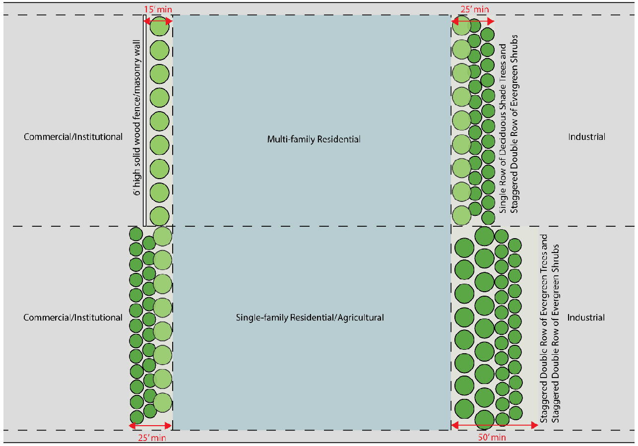
Figure 6-1. Transitional Buffer Design
B.
Additional Landscape and Screening Standards.
1.
Shrubs must be planted within ten feet of the foundation of the primary structure along each building facade at the rate of at least 20 shrubs per 100 lineal feet of building facade except for sides or rear of building used for loading or service areas. Foundation plantings may be clustered to provide visual interest.
2.
Along each street frontage there must be a landscape strip at least 10 feet in width except for perpendicular crossings for driveways and utilities.
a.
The landscape strip must be planted with shade trees at least six feet tall and two inches caliper, DBH at time of planting, with a height of at least 35 feet tall at maturity.
b.
Trees must be planted no less than 40 feet on center.
c.
Shrubbery forming an intermittent hedge at least three feet in height and designed to provide an adequate screen must also be provided within the landscape strip.
3.
The Director has authority to approve alternative methods for landscaping and screening parking lots that include at least the same amount of landscape material or screening effect when viewed from the street.
4.
In addition to general perimeter landscaping and required buffers, if a loading or service area is located within 50 feet of a side or rear lot line abutting a residential district or use or a public or institutional use, then the loading or service areas must be surrounded by either a masonry wall or opaque fence at least 6 feet in height and placed on the inside of the landscaped buffer required in Sec. 6.2.6.A.
5.
Screening of storage and accessory equipment.
a.
Waste receptacles, including dumpsters, garbage cans, or grease containers must be located in the rear or side yard and placed at least 20 feet from any street, public sidewalk, or property line that abuts a residential district or residential use. Such waste receptacles must be screened from view from all property lines and public areas of the site by a wall at least 6 feet in height constructed of masonry or solid wood with an opaque gate.
b.
Rooftop mechanical equipment, including HVAC and utility equipment, must be screened from adjacent streets, sidewalks, residential districts or uses, or public and institutional uses. Screening must consist of parapet walls or an opaque enclosure around the equipment. Enclosures must be constructed of a material compatible with those used on the primary facade of the principal structure.
c.
Ground-mounted or wall-mounted equipment such as HVAC equipment, transformers, and gangs of multiple utility meters must be screened from adjacent streets, sidewalks, residential districts or uses, or public and institutional uses. Screening may consist of a solid masonry wall or wooden fence or other opaque enclosure around the equipment that is constructed of a material compatible with those used on the primary facade of the building. The height of the fence or wall must be sufficient to effectively screen the equipment from view.
d.
Outdoor storage or sales displays are prohibited from front yards unless granted special use approval by the Board of Commissioners pursuant to the procedures of this UDC. Outdoor storage or sales displays must be screened from view from public streets and adjacent property by a solid fence or wall at least 8 feet in height, except as follows:
i.
Upon approval by the Director, the temporary sale of seasonal goods may be permitted on properties other than residentially zoned property for a period not to exceed 90 days, with up to a 30-day extension, to be approved no more than two times in a given calendar year. Such temporary sales are limited to sites that:
i.
Provide adequate off-street parking on approved surfaces;
ii.
Provide safe and adequate vehicular access; and
iii.
Are not adjacent to residentially zoned property.
ii.
Outdoor display and sale of goods may be permitted in designated parking areas provided that the parking is not reduced below the minimum required in Sec. 8.1.
6.
Cuts and fills of slopes must be terraced to blend into the natural terrain. Cut or fill slopes more than 10 feet in height must be landscaped with evergreen shrubbery planted at the rate of 10 shrubs per every 100 lineal feet.
C.
Parking Lot Design.
1.
Off-street parking is required as indicated in Sec. 8.1 of this UDC, except as provided in this subsection:
a.
The Director may approve a reduction in the number of parking spaces required for a specific use where inter-parcel access is provided and a shared parking analysis demonstrates that adequate parking will be provided with the approved reduction.
b.
The maximum number of parking spaces that may be constructed on impervious surfaces may be no more than 125 percent of the minimum number of parking spaces required in Sec. 8.1.
2.
In addition to the construction and design standards of Sec. 8.1.3, the following standards apply to all parking lots within the GCOD.
a.
Each parking area with at least 20 spaces must include landscaped islands within the parking area equivalent to not less than 10 percent of the total paved area of the parking lot, not including pervious paving surfaces.
b.
Landscaping in parking lots must contain at least one shade tree at least six feet in height and two inches caliper DBH at time of planting with a mature height of at least 35 feet for each 200 square feet of landscaping. Shade trees must be planted in a bed of ground cover, sod or low shrubbery.
c.
Parking areas must be designed to facilitate safe and convenient use by pedestrians. Commercial and multi-family developments must provide designated pedestrian pathways or sidewalks at least 5 feet in width connecting parking aisles to the front entrance of the principal building.
d.
All parking areas must be paved with asphalt, concrete or pervious materials as approved by the Director.
e.
Off-street parking must be located to the side or rear of the principal building and may not be located between the principal building and the street.
3.
Perimeter landscaping.
a.
Where parking lots abut adjacent residentially zoned property, a transitional buffer is required as provided in Sec. 6.2.5.A.
b.
Where parking lots abut public streets, a frontage landscape strip is required as provided in Sec. 8.1.3.
c.
The following are considered appropriate tree species for perimeter and parking lot landscaping:
i.
Nutall oak.
ii.
Shumard oak.
iii.
Willow oak.
iv.
Gingko (Variety: President, Autumn Gold, male gender).
v.
Princeton elm.
vi.
Chinese Elm (varieties Allee, Athena, Drake, Bosque).
vii.
Bald Cypress (variety: Shawnee Brave).
viii.
Zelkova (variety Green Vase or Village Green).
ix.
Northern red oak.
x.
Autumn maple.
xi.
Other native species as approved by the Director.
D.
Outdoor lighting.
1.
Streetlights.
a.
Streetlights must be provided on all public streets.
b.
The spacing of streetlights must be staggered, 300 feet on-center, along both sides of the roadway.
c.
All street lighting is subject to review and approval of the Hall County Public Works Department.
d.
All outdoor lighting must be the semi-cutoff type.
2.
Semi-cutoff luminaries must be used for all security lighting.
E.
Inter-parcel access.
1.
Inter-parcel access, joint driveways, cross access drives and access easements for nonresidential development that abuts other nonresidential development should be provided.
2.
When provided, inter-parcel access must incorporate the following:
a.
A continuous cross-access drive located in a cross-access easement to connect adjacent parcels along the thoroughfare.
b.
A design speed of 15 mph and a two-way travel aisle with a minimum paved width of 22 feet (back of curb to back of curb). Paving, base and curb specifications must meet Hall County's standards for public streets.
c.
Driveway aprons, stub-outs and other design features indicating that abutting properties may be connected to provide cross access via a service drive.
d.
A sidewalk at least 5 feet in width on one side of the cross-access drive.
e.
New commercial developments that abut residential property must provide a sidewalk at least five feet in width to connect the two uses.
6.2.6. Architectural Standards
The following design guidelines and standards apply to all newly constructed buildings used for multi-family residential, office, commercial, industrial, institutional, and public purposes.
A.
General Architectural Requirements.
1.
Principal building entrances must face public streets except for internal buildings not directly fronting a street.
2.
Any nonresidential building located within 150 feet of a residential or agricultural use is limited to no more than 40 feet in height as defined in Sec. 2.1.
3.
All buildings along U.S. 129 are limited to no more than 30 feet in height as defined in Sec. 2.1.
4.
All buildings along State Route 365 are limited to no more than 50 feet in height as defined in Sec. 2.1.
B.
Building Materials.
1.
The use of a common palette of building materials must be maintained for all four sides of principal buildings to create a consistent architectural identity. For nonresidential or multi-family building facades greater than 100 feet in length, variation in building materials, texture, and depth may be employed to provide design variation.
2.
Buildings that are located on outparcels and all accessory buildings must be constructed of materials compatible with the principal building with which they are associated.
3.
Building materials used for all four sides of new or reconstructed buildings are restricted to the following:
a.
Brick.
b.
Natural stone such as granite, limestone, marble or similar materials. Terra cotta or cast stone simulating natural stone is also acceptable. Painted stone is prohibited.
c.
Split-face block/concrete masonry unit (CMU) is restricted to no more than 50 percent of the surface area of each side of a principal nonresidential building.
d.
Split-face block/concrete masonry unit (CMU) is considered prohibited materials for any multi-family residential building.
e.
Stucco is restricted to no more than 50 percent of the surface area of each side of a building.
f.
Glass and glass block.
g.
Architectural metal panels are restricted to no more than 50 percent of the surface area of each side of a building.
h.
Precast or prestressed concrete may be used for industrial buildings.
i.
Exposed concrete block or painted concrete block are considered prohibited materials for any exterior wall.
4.
Restrictions on the use of metal building materials does not apply to entry doors or roll-up doors.
5.
The amount of permitted material must be calculated using the gross square footage of wall area for each elevation of the building, including windows, doors or other openings.
C.
Roof Materials.
1.
Materials for pitched roofs are limited to architectural grade composition shingles, natural slate, natural terra cotta, natural wood shake, or factory finished metal with standing seams. Alternative materials not listed may be used upon approval from the Director.
2.
Thermoplastic Polyolefin (TPO) may be used on flat roofs.
6.2.7. Signs
See Sec. 8.6.18 (Signs) for applicable sign standards within the Gateway Corridor Overlay.
6.2.8. Property Maintenance Standards
A.
Definitions
The following words have the meanings indicated below as used in this Sec. 6.2.8.
Boarding up. Erecting, installing, placing, or maintaining boards over the doors, windows, or other openings of any building or structure, or otherwise securing such openings by a means other than the conventional method used in the original construction and design of the building or structure.
Code Official. The Community Development and Infrastructure Director of Hall County or any other official charged with the administration and enforcement of this Sec. 6.2.8.
Condemn. To judge a structure as unfit for occupancy or use due to conditions which may pose a serious threat to the health and safety of the public or another structure or property.
Deterioration. To weaken, disintegrate, corrode, rust, or decay and lose effectiveness.
Exterior property. The open space on the premises and on adjoining property under the control of the owners or operators of such premises. Exterior property generally consists of the area outside a building or accessory structure and can include driveways, parking areas, portions of the public right-of-way, vacant lots, or adjoining property under the control of the same owner.
Garbage. Animal or vegetable waste resulting from the handling, preparation, cooking or consumption of food.
Imminent danger. A condition that could result in serious or life-threatening injury or death. As used in this section, imminent danger refers to conditions that pose a threat or danger to the building occupants or persons in the proximity of a building or premises.
Infestation. The presence, within or contiguous to, a structure or premises of insects, rodents, vermin or other pests.
Inoperable motor vehicle. A vehicle than cannot be driven upon a public street for reasons including, but not limited to, being unlicensed, wrecked, abandoned, in a state of disrepair, or incapable of being moved under its own power.
Litter. Any organic or inorganic waste material, rubbish, refuse, garbage, trash, hulls, peelings, debris, grass, weeds, ashes, sand, gravel, slag, brickbats, metal, plastic and glass containers, broken glass, dead animals or intentionally or unintentionally discarded materials of every kind and description.
Maintenance. The act of keeping property, premises, buildings, structures, equipment, or vegetation in a proper condition so as to prevent their decline, failure, or uncontrolled growth.
Marshal. Any officer of the Hall County Marshal's Office charged with the enforcement of County ordinances.
Neglect. The lack of proper maintenance for a building or structure.
Occupant. Any individual living or sleeping in a building, or having possession of a space within a building.
Operator. Any person who has charge, care or control of a structure or premises which is let or offered for occupancy. A real estate broker or salesperson licensed pursuant to Chapter 40 of Title 43 of the O.C.G.A. is not an operator for the purpose of this section unless such broker or salesperson is under contract to provide property management services to the owner of such structure or premises.
Owner. Any person, agent, operator, firm, or corporation having a legal or equitable interest in the property; or recorded in the official records of the state, county or municipality as holding title to the property; or otherwise having control of the property, including, but not limited to the guardian, executor, or administrator of the estate of any such person.
Person. An individual, corporation, partnership or any other legally recognized entity.
Premises. A lot, parcel of land, easement or public way, including any structures or other improvements.
Property. Any improved or unimproved residential or nonresidential real property, or portion thereof, situated in unincorporated Hall County and within the GCOD. Includes the buildings, structures, and improvements located on the real property regardless of condition.
Rubbish. Combustible and noncombustible waste materials, except garbage as defined in this Sec. 6.2.8. The term includes the residue from the burning of wood, coal and other combustible materials, paper, rags, cartons, boxes, wood, rubber, leather, tree branches, yard trimmings, tin cans, metals, mineral matter, glass, and dust and other similar materials.
Strict Liability of Offense. An offense in which the prosecution in a legal proceeding is not required to prove criminal intent as a part of its case.
Wooded areas. Portions of a lot consisting of dense tree growth in which the trees typically exceed 3 inches DBH.
B.
Applicability
The standards within this Sec. 6.2.8 apply to all property or portions of property within 50 feet of the right-of-way of the following corridors within the GCOD:
1.
Friendship Road from Lanier Islands Parkway to GA-211.
2.
S.R. 129/Athens Highway from the Gainesville city limits to Gillsville Highway.
3.
S.R. 53/Mundy Mill Road/Winder Highway from McEver Road to GA-211.
4.
S.R. 13 from the Flowery Branch city limits to Highway 53/Winder Highway.
5.
McEver Road from the Buford city limits to S.R. 53/Dawsonville Highway.
6.
Browns Bridge Road from the Gainesville city limits to McEver Road.
7.
Candler Road from Calvary Church Road to Poplar Springs Road.
8.
Cleveland Highway from the Gainesville city limits to Napone Road.
9.
Spout Springs Road from the Flowery Branch city limits to Friendship Road.
10.
Thompson Bridge Road from the Gainesville city limits to Price Road.
11.
S.R. 53/Dawsonville Highway from the Gainesville city limits to Marina Drive.
12.
S.R. 211/Old Winder Highway from Friendship Road to Winder Highway.
13.
985/365 from the county line to S.R. 52/Lula Road.
C.
Maintenance Standards
1.
It is the responsibility of the owner of any dwelling, building, structure, property, or premises within the GCOD property maintenance boundaries, as detailed in Sec. 6.2.8.B., to construct and maintain any such dwelling, building, structure, property, or premises with the standards of this section and all other applicable codes within Hall County.
2.
No property, building, or structure located within the GCOD property maintenance boundaries, as detailed in Sec. 6.2.8.B., may be expanded in any manner that does not meet the standards of this section.
3.
All premises must be free of litter, garbage, rubbish, inoperable vehicles, structural deterioration or neglect, and infestation.
4.
Yards and premises within the GCOD property maintenance boundaries must be maintained as follows:
a.
Required landscaping materials and any required landscape buffers must be maintained in a healthy, growing condition and must be removed and replaced when missing, dead or damaged.
b.
Grass, weeds, or undergrowth greater than 8 inches on any lot used for residential, institutional, commercial, or industrial purposes must be trimmed or removed.
c.
Grass, weeds, or undergrowth greater than 12 inches on any vacant of undeveloped lot must be trimmed or removed.
d.
Wooded areas, as defined in this Sec. 6.2.8, may be exempt from the requirements of this subsection.
5.
Outdoor storage must comply with the standards of Sec. 6.2.5.B.5.
6.
All buildings or structures located on a property must have:
a.
A roof impervious to the weather.
b.
Doors and windows which are functional and free of defects.
c.
Exterior walls which are impervious to the weather and free of defects.
d.
Facades which are not peeling, rusted, oxidized, or exposed and unprotected.
7.
When a building or structure within the GCOD property maintenance boundaries has been damaged by fire to such an extent that it cannot be repaired, the owner must remove the remaining portion of the building or structure and all refuse, debris, or damaged materials from the premises, so as to return the property to its vacant state, within 6 months of the completion of the scene investigation by the fire department or insurer of the property.
a.
When a building or structure has been damaged by fire but is determined capable of repair, the owner must obtain a permit for repair work, and repair work must commence, within 6 months of completion of the scene investigation by the fire department or insurer of the property.
8.
Vacant buildings or structures must be maintained in good repair and comply with all applicable laws, codes, and ordinances of Hall County. At a minimum, vacant structures must:
a.
Have all doors, windows, and other openings weather-tight and secured against entry by the public as well as any animals or pests. Such structures must be secured using the conventional methods used in the original construction.
b.
Have all roof and roof flashings maintained to an extent that no rain can penetrate the structure, ensuring appropriate drainage to prevent deterioration of interior walls or other interior portions of the structure.
c.
Be maintained in a structurally sound state, free from rubbish, garbage, and other debris.
d.
Be capable of bearing all loads making up the contents of the structure, including foundation walls.
e.
Keep the exterior of the structure free of loose or rotten materials, including any holes. Exposed metal, wood, or other surfaces must be protected from the elements by appropriate weather coating materials such as paint or similar treatments.
f.
Maintain all balconies, canopies, signs, awnings, stairways, fire escapes or other overhanging extensions in good condition and appropriately anchored. Exposed wood or metal elements of such extensions must be protected from the elements by appropriate weather coating materials such as paint or similar treatments.
g.
Ensure that all accessory structures or buildings such as garages, sheds or other storage facilities meet the standards of this section.
h.
Maintain all retaining walls, drainage systems, or other structures in good condition and ensure that such structures are structurally sound, as appropriate.
9.
Any structure ordered to be boarded up by the Code Official must be posted with the name, permit information, and 24-hour contact information of the property owner. The boarding of doors, windows, or other openings of any building or structure other than by the conventional method used in the original construction and design of the building or structure must be in accordance with the specifications or methods approved by the Building Official.
D.
Enforcement
1.
If a premises is found to be in violation of these standards, the Marshal must contact the owner or occupant and provide a written notice of items necessary to bring the premises into compliance. The notice must provide a reasonable time to begin remediation and for the property to be fully compliant. The time allowed for compliance prior to enforcement may depend on the condition of the premises when the violation is observed and documented.
2.
Any premises which is determined by the Marshal as not in compliance with the standards of this Sec. 6.2.8 will be ineligible for any of the following:
a.
A new business license or alcoholic beverage license.
b.
Renewal of a business license or alcoholic beverage license.
c.
A building permit unless such permit is necessary to bring the property into compliance.
6.2.9. Other Standards
See Article 2 (Rules Common to All Districts) and Article 7 (Use Provisions) and Article 8 (Site Development) for additional standards which may be applicable.
Sec. 6.3. - Black and Cooley Drive Overlay (BCOD)
6.3.1. Intent
It is in the public interest to maximize efficiency of the utilization of public services, infrastructure, and facilities to achieve balanced growth and to provide opportunities for development and redevelopment of existing residential areas.
Within the residential areas of Hall County, there exists an opportunity to achieve maximum utilization of land resources that have been by-passed or under-utilized in the development of the urban area. An increase in the density normally allowed by the underlying zoning district is deemed an appropriate incentive to promote infill development and redevelopment within this urban core for single-family residential detached districts.
The specific objectives of this section are related to infill development and redevelopment within the identified boundaries of Black Drive, Cooley Drive and Jordan Drive. This area has been previously designated an Urban Redevelopment Area. The intent of the proposed Overlay District is to:
1.
Accommodate growth by encouraging and facilitating new development on vacant and underutilized land in areas that already have infrastructure and utilities.
2.
Encourage efficient use of land and public services in the context of existing communities.
3.
Provide flexibility in development standards to facilitate infill development and redevelopment.
4.
Encourage construction of housing in proximity to employment and services.
5.
Promote neighborhood preservation and enhancement through redevelopment of blighted, distressed or underutilized properties.
6.3.2. Boundaries
This district implements the Black and Cooley Drive Overlay District also referred to as the "BCOD." The provisions of this district apply to all parcels designated within the BCOD on the Hall County Official Zoning Map.
The provisions of this Sec. 6.3 apply to all residential development and associated uses where:
1.
The primary structure is constructed after June 26, 2008; or
2.
At least 75 percent of the existing primary residential structure is redeveloped.
All land uses and development, including, but not limited to buildings, driveways, streets, buffers, or landscaping, must be located or provided for in accordance with the provisions of the zoning regulations and land development regulations, except as modified by this section.
6.3.3. Applicability of Overlay Provisions
The standards set forth in this Sec. 6.3 take precedence over those of the underlying zoning regulations and other sections pertaining to zoning regulations. In any case where the standards and requirements of the BCOD conflict with those of the underlying zoning district or subdivision regulations, the standards and requirements of the BCOD govern.
6.3.4. Uses
A.
Uses are permitted in accordance with the underlying zoning except as listed below. See Sec. 7.2 (Allowed Use Table).
B.
The following dwelling types are not permitted in the district:
1.
Class B manufactured homes. Existing mobile homes may be upgraded with a Class A manufactured home provided all standards of Secs. 6.3.5 and 6.3.6 are met.
2.
The conversion of existing residential structures to two-family dwellings as defined in Sec. 7.3.1.
6.3.5. Site Development Standards
A.
The following standards are required for all new residential construction or existing dwellings when at least 75 percent of the primary structure is redeveloped.
1.
All new dwellings must have outside lighting on the front facade.
2.
Minimal plantings are required along the front facade of the dwelling.
3.
Sodded front lawns are required.
4.
Any new attached carport or garage must be consistent with the architectural character of the principal dwelling.
6.3.6. Architectural Standards
A.
All new development created under the BCOD must include the following minor design elements to ensure quality, compatibility, and sustainability with the existing character of the area. The standards are as follows:
1.
Front porches are required.
2.
The following design features are recommended:
a.
Optimize privacy of residents and minimize infringement on the privacy of adjoining land uses through the strategic placement of windows, door entrances, porches, and similar structures, especially as it relates to accessory structures.
b.
Building orientation should maintain the integrity of the streetscape and provide direct, safe access to the street.
3.
Residential structures should incorporate the following design elements:
a.
Gable roofs with a pitch not less than 4:12 along facades facing public streets.
b.
Recessed entries along facades facing public streets.
c.
Window shutters along facades facing public streets.
d.
Bay or bow window with a minimum 12-inch projection along facades facing public streets.
e.
Eaves with a minimum six-inch projection along facades facing public streets.
6.3.7. Accessory Structures
A.
The following apply to all accessory structures within the BCOD:
1.
Accessory structures for properties within the BCOD are the same as those allowed under the R-1 zoning designation.
2.
In no case may the accessory structure be closer to any right-of-way than the principal building.
3.
No more than two accessory structures may be allowed on one lot.
4.
All accessory structures must be consistent with the architectural design and character of the primary structure.
5.
Exterior stairs, doors, porches, and similar elements on accessory buildings may not face an adjacent property.
6.3.8. Building Placement
A.
The following standards apply to all structures within the BCOD:
1.
The front setback must be at least 20 feet from the property line.
2.
Primary and accessory structures must be at least 5 feet from side property lines.
3.
Primary structures must be at least 10 feet from the rear property line.
4.
Accessory structures must be at least 5 feet from the rear property line.
6.3.9. Lot of Record Standards
A.
Any residentially zoned property within the BCOD that was recorded by subdivision plat or deed prior to August 28, 1978, using the proper county process at that time, as well as any lot recorded by plat subsequent to August 28, 1978, may be considered a lot of record, even though the lot may have less than the minimum required area for residential districts.
B.
Lots which have been combined as a result of development crossing a property line may be resubdivided to the original platted lots.
6.3.10. Other Standards
See Article 2 (Rules Common to All Districts) and Article 7 (Use Provisions) and Article 8 (Site Development) for additional standards which may be applicable.
Sec. 6.4. - Airport Overlay (AO)
6.4.1. Intent
Obstructions to air navigation have the potential for endangering the lives and property of users of Lee Gilmer Memorial Airport and the property or occupants of land in its vicinity. An obstruction to air navigation may affect existing and future instrument approach patterns of aircraft to Lee Gilmer Memorial Airport and may reduce the size of areas available for the landing, takeoff, and maneuvering of aircraft, thus tending to destroy or impair the utility of Lee Gilmer Memorial Airport and the public investment therein. The purpose of this zoning district is to impose height restrictions necessary to ensure that structures and natural objects will not impair flight safety or decrease the operational capability of Lee Gilmer Memorial Airport.
6.4.2. Definitions
The following words have the meanings indicated below as used in this Sec. 6.4.
Airport. As defined in Sec. 12.2. As used in this Sec. 6.4, the term applies specifically to the Lee Gilmer Memorial Airport or Gilmer Memorial Airport.
Airport elevation. 1,277 feet above mean sea level.
Airport reference point. A horizontal reference point calculated in accordance with Federal Aviation Administration Advisory Circular 150/5300-4B. (For the airport configuration on July 1, 1990, the position is 34°16′22″ N, 83°49′47″ E.)
Approach surface. A surface longitudinally centered on the extended runway center line, extending outward and upward from the end of the primary surface and at the same slope as the approach zone height limitation slope set forth in Sec. 6.4.4. In plan the perimeter of the approach surface coincides with the perimeter of the approach zone.
Approach, transitional, horizontal, conical and navigable airspace zones. Those zones as set forth in Sec. 6.4.3.
Conical space. A surface extending outward and upward from the periphery of the horizontal surface at a slope of 20 to 1 for a horizontal distance of 4,000 feet.
Hazard to air navigation. An obstruction determined to have substantial adverse effect on the safe and efficient utilization of the navigable airspace.
Height. For the purpose of determining the height limits in all zones set forth in this section, the datum shall be mean sea level elevation unless otherwise specified.
Horizontal surface. A horizontal plane 150 feet above the established airport elevation, the perimeter of which in plan coincides with the perimeter of the horizontal zone.
Larger than utility runway. A runway that is constructed for and intended to be used by propeller driven aircraft of greater than 12,500 pounds maximum gross weight and jet powered aircraft.
Navigable airspace. That area of airspace greater than 200 feet above ground level or above the established airport elevation (Lee Gilmer Memorial Airport elevation of 1,277 feet plus 200 feet equals 1,477 feet), whichever is higher, within three nautical miles of the established airport reference point, which height increases in the proportion of 100 feet for each additional nautical mile of distance from the airport to a maximum of 500 feet.
Nonconforming structure, object or use. Any structure, object of natural growth, or use of land which lawfully exists at the time of adoption of this section and which does not conform with the provisions of this section or an amendment thereto.
Nonprecision instrument runway. A runway having an existing instrument approach procedure utilizing air navigation facilities with only horizontal guidance, or area type navigation equipment, for which a straight-in nonprecision instrument approach procedure has been approved or planned.
Obstruction (or obstruction to air navigation). Any structure, growth, or other object, including a mobile object, which exceeds a limiting height set forth in Sec. 6.4.4.
Person. An individual, firm, partnership, corporation, company, association, joint stock association or government entity; includes a trustee, a receiver, an assignee, or a similar representative of any of them.
Precision [instrument runway]. A runway having an existing instrument approach procedure utilizing an instrument landing system (ILS) or a precision approach radar (PAR). It also means a runway for which a precision approach system is planned and is so indicated on an approved airport layout plan or any other planning document.
Primary surface. A surface longitudinally centered on a runway. When the runway has a specially prepared hard surface, the primary surface extends 200 feet beyond each end of that runway; for military runways or when the runway has no specially prepared hard surface, or planned hard surface, the primary surface ends at each end of that runway. The width of the primary surface is set forth in Sec. 6.4.3. The elevation of any point on the primary surface is the same as the elevation of the nearest point on the runway center line.
Runway. A defined area on an airport prepared for landing and take-off of aircraft along its length.
Structure. Anything constructed or erected, the use of which requires permanent or semipermanent location on the ground or which is attached to something having permanent location on the ground. As used in this Sec. 6.4, the term also applies to mobile objects constructed or installed by man, including, but not limited to buildings, towers, cranes, smokestacks, earth formations, and overhead transmission lines.
Transitional surfaces. These surfaces extend outward at 90-degree angles to the runway center line and the runway center line extended at a slope of seven feet horizontally for each foot vertically from the sides of the primary and approach surfaces to where they intersect the horizontal and conical surfaces. Transitional surfaces for those portions of the precision approach surfaces, which project through and beyond the limits of the conical surface, extend a distance of 5,000 feet measured horizontally from the edge of the approach surface and at 90-degree angles to the extended runway center line.
Tree. Any object of natural growth.
Utility runway. A runway that is constructed for and intended to be used by propeller driven aircraft of 12,500 pounds maximum gross weight and less.
Visual runway. A runway intended solely for the operation of aircraft using visual approach procedures.
6.4.3. Airport Zones
In order to carry out the provisions of this section, there are hereby created and established certain zones which include all of the land lying beneath the approach surfaces, transitional surfaces, horizontal surfaces, and conical surfaces as they apply to Lee Gilmer Memorial Airport. An area located in more than one of the following zones must adhere to the zone with the more restrictive height limitation. The various zones are hereby established and defined as follows:
A.
Utility runway visual approach zone.
The inner edge of this approach zone coincides with the width of the primary surface and is 250 feet wide. The approach zone expands outward uniformly to a width of 1,250 feet at a horizontal distance of 5,000 feet from the primary surface. Its center line is the continuation of the center line of the runway.
B.
Utility runway nonprecision instrument approach zone.
The inner edge of this approach zone coincides with the width of the primary surface and is 500 feet wide. The approach zone expands outward uniformly to a width of 2,000 feet at a horizontal distance 5,000 feet from the primary surface. Its center line is the continuation of the center line of the runway.
C.
Runway larger than utility visual approach zone.
The inner edge of this approach zone coincides with the width of the primary surface and is 500 feet wide. The approach zone expands outward uniformly to a width of 1,500 feet at a horizontal distance of 5,000 feet from the primary surface. Its center line is the continuation of the center line of the runway.
D.
Runway larger than utility with a visibility minimum greater than three-fourths mile nonprecision instrument approach zone.
The inner edge of this approach zone coincides with the width of the primary surface and is 500 feet wide. The approach zone expands outward uniformly to a width of 3,500 feet at a horizontal distance of 10,000 feet from the primary surface. Its center line is the continuation of the center line of the runway.
E.
Runway larger than utility with a visibility minimum as low as three-fourths mile nonprecision instrument approach zone.
The inner edge of this approach zone coincides with the width of the primary surface and is 1,000 feet wide. The approach zone expands outward uniformly to a width of 4,000 feet at a horizontal distance of 10,000 feet from the primary surface. Its center line is the continuation of the center line of the runway.
F.
Precision instrument runway approach zone.
The inner edge of this approach zone coincides with the width of the primary surface and is 1,000 feet wide. The approach zone expands outward uniformly to a width of 16,000 feet at a horizontal distance of 50,000 feet from the primary surface. Its center line is the continuation of the center line of the runway.
G.
Transitional zones.
The areas beneath the transitional surfaces.
H.
Horizontal zone.
The horizontal zone is established by swinging arcs of 5,000 feet radii for all runways designated utility or visual and 10,000 feet for all others from the center of each end of the primary surface of each runway and connecting the adjacent arcs by drawing lines tangent to those arcs. The horizontal zone does not include the approach and transitional zones.
I.
Conical zone.
The area that commences at the periphery of the horizontal zone and extends outward therefrom for a horizontal distance of 4,000 feet.
J.
Navigable airspace zones.
These four zones are at the ends of each runway beginning at their intersection with the conical zones 200 feet above the established airport elevation as defined in Sec. 6.4.2 and expanding outwardly as shown in Table 6.4.1 below.
Table 6.4.1. Navigable Airspace Zones
6.4.4. Height Limitations
Except as otherwise provided in this Sec. 6.4, no structure may be erected or altered, and no tree may be allowed to grow, in any zone created by this section to a height more than the applicable height established for such zone. Height limitations are established for each of the zones in question as follows:
A.
Utility runway visual approach zone.
Slopes 20 feet outward for each foot upward beginning at the end of and at the same elevation as the primary surface and extending to a horizontal distance of 5,000 feet along the extended runway center line.
B.
Utility runway nonprecision instrument approach zone.
Slopes 20 feet outward for each foot upward beginning at the end of and at the same elevation as the primary surface and extending to a horizontal distance of 5,000 feet along the extended runway center line.
C.
Runway larger than utility visual approach zone.
Slopes 20 feet outward for each foot upward beginning at the end of and at the same elevation as the primary surface and extending to a horizontal distance of 5,000 feet along the extended runway center line.
D.
Runway larger than utility with a visibility minimum greater than three-fourths mile nonprecision instrument approach zone.
Slopes 34 feet outward for each foot upward beginning at the end of and at the same elevation as the primary surface and extending to a horizontal distance of 10,000 feet along the extended runway center line.
E.
Runway larger than utility with a visibility minimum as low as three-fourths mile nonprecision instrument approach zone.
Slopes 34 feet outward for each foot upward beginning at the end of and at the same elevation as the primary surface and extending to a horizontal distance of 10,000 feet along the extended runway center line.
F.
Precision instrument runway approach zone.
Slopes 50 feet outward for each foot upward beginning at the end of and at the same elevation as the primary surface and extending to a horizontal distance of 10,000 feet along the extended runway center line; thence slopes upward 40 feet horizontally for each foot vertically to an additional horizontal distance of 40,000 feet along the extended runway center line.
G.
Transitional zones.
Slope seven feet outward for each foot upward beginning at the sides of and at the same elevation as the primary surface and the approach surface and extending to a height of 150 feet above the airport elevation. In addition, there are established height limits sloping seven feet outward for each foot upward beginning at the sides of and the same elevation as the approach surface and extending to where they intersect the conical surface. Where the precision instrument runway approach zone projects beyond the conical zone, there are established height limits sloping seven feet outward for each one foot upward beginning at the sides of and the same elevation as the approach surface and extending a horizontal distance of 5,000 feet measured at 90-degree angles to the extended runway center line.
H.
Horizontal zone.
Established at 150 feet above the airport elevation.
I.
Conical zone.
Slopes 20 feet outward for each foot upward beginning at the periphery of the horizontal zone and at 150 feet above the airport elevation and extending to a height of 350 feet above the airport elevation.
J.
Navigable airspace zone.
Established at 200 feet above the airport elevation as defined in Sec. 6.4.2 and extending outward at this elevation a distance of three nautical miles from the airport reference point. At three nautical miles this zone then slopes upward at a rate of 100 feet per nautical mile and ends at six nautical miles from the airport reference point at an elevation 500 feet above the established airport elevation.
K.
Excepted height limitations.
Nothing in this section may be construed as prohibiting the construction or maintenance of any structure or growth of any tree to a height up to 50 feet above the surface of the land.
6.4.5. Uses
A.
Uses are permitted in accordance with the underlying zoning except as listed below. See Sec. 7.2 (Allowed Use Table).
B.
Despite any other provisions of this section, no use may be made of land or water within any zone established by this section in such a manner as to create electrical interference with navigational signals or radio communication between the airport and aircraft, make it difficult for pilots to distinguish between airport lights and others, result in glare in the eyes of pilots using the airport, impair visibility in the vicinity of the airport, create bird strike hazards, or otherwise in any way endanger or interfere with the landing, takeoff, or maneuvering of aircraft intending to use the airport.
6.4.6. Nonconforming Structures, Objects or Uses
A.
The regulations prescribed in this section may not be construed to require the removal, lowering, or other change or alteration of any structure not conforming to the regulations as of January 14, 1991, or otherwise interfere with the continuance of a nonconforming use. Nothing contained herein will require any change in the construction, alteration, or intended use of any structure, the construction or alteration of which was begun prior to January 14, 1991, and is diligently prosecuted.
B.
Despite the preceding provision of this section, the owner of any existing nonconforming structure must permit the installation, operation, and maintenance of any markers and lights as deemed necessary by the county administrator or their designee to indicate to the operators of aircraft in the vicinity of the airport the presence of such airport construction. Such markers and lights must be installed, operated, and maintained at the expense of the City of Gainesville as the owner of the airport.
6.4.7. Permits
A.
No new structure may be erected or otherwise established unless a permit has been applied for and granted as provided in Sec. 11.2. Each application for a permit must indicate the purpose for which the permit is desired, with sufficient information to determine whether the resulting use, structure, or tree would conform to the regulations herein. No permit for a use inconsistent with the provisions of this section may be granted unless a variance has been approved in accordance with paragraph D below and any applicable provisions of Sec. 11.2.
B.
No permit may be granted that would allow the establishment or creation of an obstruction or permit a nonconforming structure to become a greater hazard to air navigation than it was on the effective date of this section or any amendments thereto or than it is when the application for a permit is made.
C.
Whenever the county administrator, or their designee, determines that a nonconforming structure has been abandoned or more than 50 percent removed, physically deteriorated, or decayed, no permit may be granted that would allow such structure to exceed the applicable height limit or otherwise deviate from the zoning regulations.
D.
Any person desiring to erect or increase the height of any structure not in accordance with the regulations prescribed in this Sec. 6.4 may apply to the Planning Commission for a variance from such regulations. The application for variance must be accompanied by a determination from the Federal Aviation Administration as to the effect of the proposal on the operation of air navigation facilities and the safe, efficient use of navigable airspace. No application for variance to the requirements of this section may be considered by the Planning Commission unless a copy of the application has been furnished to the airport manager for advice as to the aeronautical effects of the variance. If the airport manager does not respond to the application within 15 days after receipt, the Planning Commission may act without their review to grant or deny said application. In addition to the criteria established by Sec. 11.1.1.D. as grounds for granting a variance, the Planning Commission must also make a finding, before a variance may be granted, that the relief granted will not create a hazard to air navigation as defined by the Federal Aviation Administration.
E.
Any permit or variance granted may, if such action is deemed advisable to effectuate the purpose of this section and be reasonable in the circumstances, be so conditioned as to require the owner of the structure in question to install, operate, and maintain, at the owner's expense, such markings and lights as may be necessary. If deemed proper by the Planning Commission, this condition may be modified to require the owner to request the City of Gainesville, as the owner of the airport, to install, operate, and maintain the necessary markings and lights at its own expense.
6.4.8. Other Standards
See Article 2 (Rules Common to All Districts) and Article 7 (Use Provisions) and Article 8 (Site Development) for additional standards which may be applicable.
Sec. 6.5. - Protected Water Supply Watershed Overlay
6.5.1. Intent
The purpose and intent of these overlay zones is to conserve natural resources or realize development objectives without unduly disturbing the expectations created by the Unified Development Code. The existing zoning provisions may properly regulate the relevant district, in general, but more specific and targeted provisions contained in an overlay district are needed to accomplish pressing land use objectives related to the conservation of fragile natural resources. These resources include, but are not limited to, ground water recharge areas, water supply watershed and wetlands.
6.5.2. Definitions
The following words have the meanings indicated below as used in this Sec. 6.5.
Aquifer. Any stratum or zone of rock beneath the surface of the earth capable of containing or producing water from a well.
Buffer. A natural or landscaped open space or screen for buffering incompatible land uses or to visibly separate uses through distance to shield or block noise, light, glare, or visual or other nuisances; that portion of a given lot, not covered by buildings, pavement, parking, access and service areas, established for the purpose of screening and separating properties with incompatible land uses, width of which is measured from the common property line and extending the developed portion of the common property line. A buffer consists of trees, shrubs and other natural vegetation undisturbed by grading or site development and replanted where sparsely vegetated or where disturbed for approved access and utility crossings.
Buffer, undisturbed. An undisturbed buffer is one left in a natural state or augmented with plantings to achieve the goal of buffering.
Drastic. The standardized system for evaluating groundwater pollution potential using the hydrogeologic settings described in U.S. Environmental Protection Agency document EPA-600/2-87-035. The "drastic" methodology is the most widely used technique for evaluating pollution susceptibility.
Generalized wetlands maps. All wetlands within the jurisdiction of Hall County, Georgia, as indicated on the National Wetlands Inventory Maps. Disclaimer Language: The generalized wetlands map does not necessarily represent the boundaries of jurisdictional wetlands within Hall County and cannot serve as a substitute for a delineation of wetland boundaries by the U.S. Army Corps of Engineers, as required by Section 404 of the Clean Water Act, as amended.
Hazardous waste. Any solid waste which has been defined as a hazardous waste in regulations, promulgated by the administrator of the U.S. Environmental Protection Agency pursuant to the federal act, which are in force and effect on February 1, 1988, codified as 40 C.F.R. Section 261.3.
Impervious surface. Man-made structures or surfaces which prevent the infiltration of stormwater into the ground below the structure or surface. Examples include, but are not limited to, buildings, roads, driveways, parking lots, decks, swimming pools or patios.
Intake. The intake for the purpose of determining the watershed above the intake is the structure by which water will be removed from the North Oconee River and pumped to the reservoir, and will be located in the approximate area of the intersection of the Buffington Mill Creek and the North Oconee River.
Jurisdictional wetlands. An area that meets the definitional requirements for wetlands as determined by the U.S. Army Corps of Engineers.
Jurisdictional wetlands determination. A delineation of jurisdictional wetland boundaries by the U.S. Army Corps of Engineers, as required by Section 404 of the Clean Water Act, 33 U.S.C. § 1344, as amended.
Land-disturbing activity. Any grading, scraping, excavating, or filling of land; clearing of vegetation; and any construction, rebuilding, or alteration of a structure. Land-disturbing activity does not include ordinary maintenance and landscaping operations, individual home gardens, yard and grounds upkeep, repairs, additions or minor modifications to a single-family dwelling, or the cutting of firewood for personal use.
Overlay district. A zoning district that encompasses one or more underlying districts and imposes additional requirements above those required by the underlying district.
Perennial stream. A stream which flows throughout the entire year as indicated by a solid blue line on the most current USGS 7½ minute topographic series map.
Pollution susceptibility. The relative vulnerability of an aquifer to being polluted from spills, discharge, leaks, impoundments, application of chemicals, injections and other human activities in the recharge area.
Pollution susceptibility maps. Maps prepared by the Department of Natural Resources showing relative vulnerability of aquifers to pollution. Pollution susceptibility maps categorize the land areas of the state into areas having high, medium and low groundwater pollution potential.
Recharge areas. Any portion of the earth's surface where water infiltrates into the ground to replenish an aquifer.
Regulated activity. Any activity which will, or which may reasonably be expected to, result in the discharge of dredged or fill material into waters of the U.S., excepting those activities exempted in Section 404 of the Federal Clean Water Act.
Reservoir boundary. The edge of a water supply reservoir defined by its normal pool level.
Significant recharge areas. Those areas mapped by the Department of Natural Resources in Hydrologic Atlas 18 (1989 edition). Mapping of recharge areas is based on outcrop area, lithology, soil type and thickness, slope, density of lithologic contracts, geologic structure, the presence or karst, and potentiometric surfaces. Significant recharge areas for Hall County are typified by those in the Piedmont and Blue Ridge, where rocks have primary porosity, with most groundwater being stored in the overlying soils.
Utility. Public or private water or sewer piping systems, water or sewer pumping stations, electric power lines, fuel pipelines, telephone lines, roads, driveways, bridges, river/lake access facilities, stormwater systems, railroads or other utilities identified by a local government.
Water supply reservoir. A governmentally owned impoundment of water for the primary purpose of providing water to one or more governmentally owned public drinking water systems. This excludes multi-purpose reservoirs owned by the U.S. Army Corps of Engineers.
Water supply watershed. The area of land upstream of a governmentally owned public drinking water intake.
Water supply watershed protection plan. A land use plan prepared and adopted by a local government for the protection of the quality of drinking water obtained from the watershed.
Wetland protection district. All wetlands within Hall County which are indicated on the wetlands protection district overlay map as "wetlands providing significant wildlife habitat and/or which may be subject to extensive mitigation."
Wetlands. Those areas that are inundated or saturated by surface or groundwater at a frequency and duration to support, and that under normal circumstances do support, a prevalence of vegetation typically adapted for life in saturated soil conditions, and that meets the definition of natural conditions. Wetlands may include any area delineated as a wetland by the United States Army Corps of Engineers under their jurisdiction pursuant to Section 404 of the Federal Clean Water Act as amended; or any area shown on a 1:24,000 scale, United States Fish and Wildlife Service National Wetland Inventory Map as being a wetland; or any area shown on a 1:24,000 scale, Georgia Department of Natural Resources land cover database map as being a wetland.
Wetlands, freshwater. A wetland, as defined in this Sec. 6.5.2, that does not include any areas defined as "coastal marshlands" by the State Coastal Marshlands Protection Act.
6.5.3. District Classifications
A.
The following are classified as Protected Water Supply Overlay Districts for the purposes of this section:
1.
North Oconee Water Supply Watershed District
2.
Protected Groundwater Recharge Area District
3.
Wetland Protection District
6.5.4. North Oconee Water Supply Watershed District Standards
The North Oconee River Small Water Supply Watershed Overlay District is hereby designated and consist of the land areas that drain to the North Oconee River public water supply intake and water supply reservoir. The boundaries of this overlay are defined by the ridgelines of the respective watershed and the boundary of a radius of seven miles upstream of the respective water supply intake. This district may be further delineated and defined on the Water Supply Watershed Protection Overlay Map of the Hall County Official Zoning Map, which is hereby incorporated and made a part of this UDC by reference.
A.
Use Standards
1.
Permitted uses for perennial stream corridors within a seven mile radius upstream of the North Oconee River public drinking water supply intake include all uses allowed in the underlying zoning districts, except for those listed in Sec. 6.5.4.A.3., subject to the following standards:
a.
A buffer must be maintained for a distance of at least 100 feet on both sides of the stream as measured from the stream banks.
b.
No impervious surface may be constructed within a 150-foot setback area on both sides of the stream as measured from the stream banks. Septic tanks and septic tank drainfields are not permitted in this setback.
2.
Permitted uses for perennial stream corridors outside a seven mile radius upstream of the North Oconee public drinking water supply intake include all uses allowed in the underlying zoning districts, except for those listed in Sec. 6.5.4.A.3., subject to the following standards:
a.
A buffer must be maintained for a distance of at least 50 feet on both sides of the stream as measured from the stream banks.
b.
No impervious surface may be constructed within a 75-foot setback area on both sides of the stream as measured from the stream banks. Septic tanks and septic tank drainfields are not permitted in this setback.
3.
The following criteria apply to all locations in the North Oconee water supply watershed:
a.
The impervious surface area, including all public and private structures, utilities, or facilities, of the entire water supply watershed is limited to 25 percent of the lot area or existing use, whichever is greater.
b.
New hazardous waste treatment or disposal facilities are not permitted.
c.
New sanitary landfills are allowed only if they have synthetic liners and leachate collection systems.
d.
New facilities located within seven miles of a water supply intake or water supply reservoir which handle hazardous material of the types listed in Section 312 of the Resource Conservation and Recovery Act of 1976 (excluding underground storage tanks) and amounts of 10,000 pounds or more on any one day, must perform their operations on impervious surfaces and in conformance with any applicable federal spill prevention requirements or the requirements of the Standard Fire Prevention Code.
B.
Exemptions
The following uses are exempt from the stream corridor buffer and setback requirements:
1.
Land uses existing prior to March 22, 2001, are exempt from the provisions of water supply watershed protection plans. Any existing structure which is nonconforming with respect to the setback, buffer or impervious surface requirements of this section may be reestablished if damaged or destroyed, provided the degree of nonconformity is not increased with the construction of the replacement structure.
2.
Forestry and agricultural activities.
a.
Agricultural activities involving the planting and harvesting of crops or the raising of poultry and livestock are exempted if they conform to the best management practices established by the Georgia Department of Agriculture, and the activity does not impair the quality of the drinking water system.
b.
Silviculture activities must conform to the best management practices established by the Georgia Forestry Commission and not impair the quality of the drinking water system.
3.
Utilities.
a.
Utilities must be located as far as reasonably possible from the perennial stream bank and must not impair the quality of the drinking water stream.
b.
Utilities must be installed and maintained without changing the integrity of the buffer and setback areas as much as possible.
6.5.5. Protected Groundwater Recharge Area District Standards
The protected groundwater recharge area overlays are hereby designated and consist of all lands within the jurisdiction of Hall County, Georgia that are mapped as significant recharge areas by the Georgia Department of Natural Resources in Hydrologic Atlas 18, 1989 edition and any amendments to the Atlas after the listed date. These districts may be further delineated and defined on the Ground Water Recharge Area Protection Overlay Map of the Hall County Official Zoning Map, which is hereby incorporated and made a part of this UDC by reference.
A.
Use Standards.
All uses allowed in the underlying zoning districts, except for those listed as prohibited uses below, are permitted in a significant protected groundwater recharge area overlay, subject to the following conditions and standards:
1.
The Department of Natural Resources may not issue any permits for new sanitary landfills not having synthetic liners and leachate collection systems.
2.
The Department of Natural Resources may not issue any new permits for the land disposal of hazardous waste.
3.
The Department of Natural Resources may require all new facilities permitted or to be permitted to treat, store, or dispose of hazardous waste to perform such operations on an impermeable pad having a spill and leak collection system.
4.
New above-ground chemical or petroleum storage tanks, having a minimum volume of 660 gallons, must have secondary containment for 110 percent of the volume of such tanks or 110 percent of the volume of the largest tank in a cluster of tanks. (Note: These figures are consistent with US EPA rules for oil pollution prevention, 40 CFR 112.1.) Such tanks used for agricultural purposes are exempt, provided they comply with all federal requirements.
5.
New agricultural waste impoundment sites must be lined if they are within:
a.
A high pollution susceptibility area.
b.
A medium pollution susceptibility area and exceed 15 acre-feet.
c.
A low pollution susceptibility area and exceed 50 acre-feet.
As a minimum, the liner must be constructed of compacted clay having a thickness of one-foot and a vertical hydraulic conductivity of less than 5 × 10⁻⁷ cm/sec or other criteria established by the Natural Resources Conservation Service. (The average size of existing agricultural waste impoundments in Georgia is about 15 acre-feet; sheeps-foot rollers or pans with heavy rubber tires, which are normal equipment for most Georgia earth moving contractors, should be able to compact clay to the recommended vertical hydraulic conductivity.)
6.
New homes served by a septic tank or drain field system must be on lots having minimum size limitations as follows, based on application of Table MT-1 of the Department of Public Health Manual (DPH Table MT-1). The minimums set forth in DPH Table MT-1 may be increased further based on consideration of other factors (set forth in Sections A—F) of the DPH Manual.
a.
150 percent of the district minimum lot size calculated based on application of DPH Table MT-1 if they are within a high pollution susceptibility area.
b.
125 percent of the district minimum lot size calculated based on application of DPH Table MT-1 if they are within a medium pollution susceptibility area.
c.
110 percent of the district minimum lot size calculated based on application of DPH Table MT-1 if they are within a low pollution susceptibility area.
7.
New manufactured home parks served by septic tank or drain field systems must have lots or spaces having the following size limitations as follows, based on application of Table MT-2 of the Department of Public Health Manual (DPH Table MT-2). The minimums set forth in DPH Table MT-2 may be increased further based on consideration of other factors (set forth in sections A—F) of the DPH manual.
a.
150 percent of the subdivision minimum lot or space size calculated based on application of DPH Table MT-2 if they are within a high pollution susceptibility area.
b.
125 percent of the subdivision minimum lot or space size calculated based on application of DPH Table MT-2 if they are within a medium pollution susceptibility area.
c.
110 percent of the subdivision minimum lot or space size calculated based on application of DPH Table MT-2 if they are within a low pollution susceptibility area.
Each recharge area may be determined to have a pollution susceptibility of high, medium, or low based on the Georgia Pollution Susceptibility Map, Hydrologic Atlas 20, 1992 edition. Said map is hereby adopted and made a part of this section.
8.
If Hall County requires a larger lot size than required by this Sec. 6.5.5 for homes or manufactured homes, the larger lot size must be used.
9.
No construction may proceed on a building or manufactured home to be served by a septic tank unless the Hall County Health Department first approves the proposed septic tank installation as meeting the requirements of the DPH Manual and this Sec. 6.5.5.
10.
New facilities which handle hazardous material of the types listed in Section 312 of the Resource Conservation and Recovery Act of 1976 (excluding underground storage tanks) and amounts of ten thousand (10,000) pounds or more on any one day, must perform their operations on impervious surfaces in conformance with any applicable federal spill prevention requirements or the requirements of the Standard Fire Prevention Code.
11.
The Department of Natural Resources may require conservative design in any new permits for the spray irrigation of wastewater or the land spreading of wastewater sludge in areas having high pollution susceptibility. This may be accomplished by comparing the Department's Criteria for Slow Rate Land Treatment (February, 1986 or latest edition) with amendments and other technical publications to site specific information submitted by a registered professional engineer for each project.
12.
Permanent stormwater infiltration basins may not be constructed in areas having high pollution susceptibility.
13.
Exclusive of mining settling basins, new wastewater treatment basins must have an impermeable liner in areas having high pollution susceptibility.
B.
Any lot of record approved prior to the date of the adoption of this resolution may be exempt from the lot size standards in 6. and 7. above.
6.5.6. Wetland Protection District Standards
Wetland protection district overlays are hereby designated and consist of all wetlands as indicated on the generalized wetlands map, as defined herein and located within the jurisdiction of Hall County. These districts may be further delineated and defined on the Wetland Protection District Overlay Map of the Hall County Official Zoning Map, which is hereby incorporated and made a part of this UDC by reference.
The generalized wetland map is a general reference document and wetland boundaries indicated on the map are approximations. The purpose of the generalized wetland map is to alert developers or landowners if they are within proximity to a wetland, which means that there is a high likelihood of the presence of a jurisdictional wetland and a need for the developer or landowner to seek U.S. Army Corps of Engineers guidance as to whether a Section 404 Permit will be required prior to any activity. The generalized wetland map does not necessarily represent the exact boundaries of jurisdictional wetlands within Hall County and cannot serve as a substitute for a delineation of wetland boundaries by the U.S. Army Corps of Engineers, as required by Section 404 of the Clean Water Act, as amended. Any local government action under this section does not relieve the landowner from federal and state permitting requirements.
A.
Local development permits.
1.
No regulated activity may be permitted within the wetland protection district without prior approval by Hall County in the form of a local development permit. Issuance of a local development permit is contingent on full compliance with the terms of this Sec. 6.5 and all other applicable regulations. All activities which are not exempted below are prohibited without prior issuance of a local development permit.
2.
Prior to the issuance of a local development permit, the Director of Planning and Zoning must assess whether the proposed activity is of a type that could result in a disturbance of wetlands and, if so, must also assess whether the proposed activity is located with the wetland protection district or within 50 feet of the district.
3.
If the Director of Planning and Zoning determines that the proposed activity is of a type that could not result in a disturbance of wetlands, or if the proposed activity is not located within the wetland protection district or within 50 feet of the wetland protection district, the normal procedures for issuing a development permit must be followed.
4.
If the Director of Planning and Zoning determines that the proposed activity is of a type that could result in a disturbance of wetlands and that the proposed activity is located within the wetland protection district, or within 50 feet of the wetland protection district, a U.S. Army Corps of Engineers jurisdictional wetland determination must be required prior to issuance of a local development permit.
a.
If the U.S. Army Corps of Engineers determines that a Department of the Army permit is required, a local development permit may be issued only following issuance of the Department of Army permit.
b.
If the U.S. Army Corps of Engineers determines that the proposed activity would not require a Department of Army permit, the Department of Planning and Zoning may proceed with normal procedures for issuing a local development permit.
B.
Uses
1.
All uses allowed in the underlying zoning districts, except for those listed as prohibited uses in Sec. 6.5.6.C., are permitted in the wetland protection district overlay subject to the following standards:
a.
No development permit may be issued on a project that appears to contain wetlands until a determination has been made by the Army Corps of Engineers on whether jurisdictional wetlands exist on the site. If there are jurisdictional wetlands on the site that will be disturbed by the proposed development, the applicant must obtain a wetlands alteration Section 404 permit from the corps of engineers.
b.
If a project appears to contain wetlands, the following note must be printed in bold-face type on all development plans: "This site contains wetlands. The applicant will first obtain a wetland alteration Section 404 permit from the Corps of Engineers prior to disturbing any jurisdictional wetlands."
c.
Use of wetland areas without long term impairment is permitted. Acceptable uses may include:
i.
Timber production and harvesting.
ii.
Wildlife and fisheries management.
iii.
Wastewater treatment.
iv.
Recreational uses.
v.
Natural water quality treatment or purification.
vi.
Other uses permitted under Section 404 of the Clean Water Act.
C.
In the Wetland Protection District Overlay, the following are considered prohibited uses:
1.
Receiving areas for toxic or hazardous waste or other contaminants.
2.
Hazardous or sanitary waste landfills.
6.5.7. Other Standards
See Article 2 (Rules Common to All Districts) and Article 7 (Use Provisions) and Article 8 (Site Development) for additional standards which may be applicable.