
Hall County Unincorporated
City Zoning Code
City Zoning Code
ARTICLE 8
- Site Development
Sec. 8.1. - Parking and Loading
8.1.1. General
In order to facilitate the movement of emergency vehicles, to lessen congestion in the streets, and to prevent obstructing traffic and blocking streets, alleys and entrances to buildings, the following standards for off-street parking and loading are established.
8.1.2. Off-Street Parking Requirements
A.
Required Parking
1.
Off-street parking spaces must be provided on every lot on which any use is established.
2.
Off-street parking spaces must be provided with vehicular access to a street or alley and must be equal in number to the minimum requirements as specified in Table 8.1.1.
3.
Each fraction occurring in the total spaces required will be construed to mean one additional space.
4.
In the case of any use which is not specifically mentioned, the Director may make the determination on required off-street parking based on the most similar use.
5.
Spaces equipped with an electric vehicle (EV) charging station may be used to reduce the minimum requirements at a ratio of 1.5 standard parking spaces for every 1 EV charging station for a maximum of 10 EV equipped parking spaces.
Table 8.1.1. Required Parking
8.1.3. Parking Lot Construction and Design Standards
The following standards apply to all off-street parking facilities.
A.
Design Standards
1.
All off-street parking facilities must be constructed of materials which will have a surface resistant to erosion, adequately drained to prevent damage to abutting properties or public streets, and maintained by the property owner.
2.
Parking facilities must be arranged for convenient access and safety for pedestrians and vehicles.
3.
Each parking space for nonresidential uses must be clearly defined and must be provided with adequate access to a public right-of-way.
4.
Minimum dimensions for off-street parking spaces and drive aisles are provided in Table 8.1.2.
a.
Parking provided beyond the minimum required in Table 8.1.1 may include spaces designed for compact vehicles. Those spaces designed for compact vehicles must be clearly indicated on the site plan.
5.
Driveways and curb cuts are to be constructed consistent with the standards found in Title 12 of the Hall County Code of Ordinances.
B.
Parking Lot Landscaping
1.
Frontage landscape strips must be provided between any parking lot designed or intended to accommodate five cars or more and any street frontage of the property on which the parking lot is located. Landscaping must be provided as follows unless the parking area is otherwise screened from the street by a building or other means. The depth of such strips must be 10 feet for commercial and industrial zoned property and 20 feet for residentially zoned property.
2.
Such landscape strips may not contain any structures, parking areas, patios, stormwater detention facilities, or any other accessory uses except for:
a.
Retaining walls or earthen berms constructed as part of an overall landscape design.
b.
Pedestrian-oriented facilities such as sidewalks and bus stops.
c.
Underground utilities.
d.
Driveways required to access the property.
e.
Signs otherwise permitted by this UDC.
3.
One tree must be provided within the frontage landscape strip for every 40 feet of length of street frontage, or portion thereof.
a.
Such trees must be of a type that is suitable to local growing conditions and that will normally reach at least 12 inches diameter breast height upon maturity.
b.
New trees must have a caliper of no less than two inches DBH and may be clustered for decorative effect following professional landscaping standards for spacing, location, and design.
4.
All portions of a frontage landscape strip must be planted in trees, shrubs, or grass or ground cover, except for those areas that are mulched or covered by permitted structures.
5.
Plant materials in the landscape strip must not extend into the street right-of-way unless specifically allowed by the Department of Public Works.
6.
Where, for any reason, trees cannot be saved or planted within the required planting strips, the depth of the strip must be extended beyond the minimum indicated to such depth as necessary to accommodate the required landscaping.
7.
Deciduous shade trees must be provided within any parking lot designed or intended to accommodate five cars or more, in accordance with the requirements of this section.
a.
One deciduous shade tree must be provided within the parking lot for every ten parking spaces or portion thereof. Each tree must be located within the parking lot in reasonable proximity to the spaces for which the tree was required.
8.
A landscaping island must be located at the end of every parking bay between the parking space and an adjacent travel aisle or driveway. The island must be no less than 8 feet in width, equal to the depth of the parking bay, and planted with trees.
9.
Interior landscaped areas such as islands, peninsulas, and medians must be installed at the rate of one per every 12 parking spaces. Landscaped areas must be at least 8 feet in width and equal to the depth of the parking bay.
a.
Each interior landscaped area must include at least one tree subject to approval by the county.
10.
Tree planting areas within parking lots must provide at least 100 square feet of planting area per tree. No tree may be located less than two and one-half feet from the back of curb.
11.
Landscaping islands and tree planting areas must be well drained and contain suitable soil and natural irrigation characteristics for the planting materials they contain.
12.
To facilitate a more efficient and functional parking lot design, the Director may approve modifications to the above landscaping requirements, provided the total landscaping area is not reduced.
Table 8.1.2. Dimensions for Parking Spaces and Drive Aisles
8.1.4. Additional Vehicle Parking Provisions
A.
Off-site Shared Parking
If off-street parking cannot be reasonably provided on the same lot on which the principal use is conducted, the Planning Commission may permit such spaces to be provided on other off-street property upon approval of a variance in accordance with Sec. 11.2. Off-site parking spaces must be associated with the permitted use and may not thereafter be reduced or encroached upon in any manner.
B.
Shared Parking
1.
The required parking space for any number of separate uses may be combined in one lot, but the required space assigned to one use may not be assigned to another use at the same time, except that one-half of each parking space required for churches, theaters, or assembly halls may be assigned to a use with off-setting hours of operation.
2.
Up to 50 percent of the required off-street parking for places of public assembly may be met by utilizing parking facilities which normally serve businesses with off-setting hours of operation if the parking facilities are within 300 feet of the place of public assembly.
C.
Prohibitions
Notwithstanding any other provisions of this UDC, the following prohibitions apply to all off-street parking areas.
1.
Except for single-family residential uses, all off-street parking areas that make it necessary for vehicles to back out directly into a public road, street or highway are prohibited.
2.
No required off-street parking space may be used for the sale, repair, dismantling or servicing of any vehicles, equipment, materials or supplies.
8.1.5. Off-Street Loading Requirements
A.
Every building or structure used for business, trade or industry must provide space as indicated in Table 8.1.3 for the loading and unloading of vehicles. Off-street loading spaces must have access to a public alley or public street.
B.
The off-street loading spaces must be provided on the same lot as the structure they are intended to serve, and in no case may any off-street loading space be part of the area used to satisfy the off-street parking requirements of this section. Each space provided must have at least 14-feet of overhead clearance.
C.
All off-street loading areas visible from a public right-of-way must be screened with a landscape buffer at least 10 feet in width in accordance with Sec. 8.2.4.
Table 8.1.3. Required Loading Spaces
Sec. 8.2. - Fencing and Buffers
8.2.1. General
Buffers are required between incompatible land uses and zoning districts, around particular visually objectionable structures, and between certain land uses located along certain streets in order to provide separation and privacy and to reduce the impact of noise, debris, and undesirable lighting to adjacent properties.
8.2.2. Fences and Walls
Fences and walls are permitted in all districts. When erected in compliance with the standards of this section fences and walls do not require a building permit.
A.
Fence and Wall Standards
1.
Fences may be no more than 7 feet in height in side and rear yards for all uses, unless otherwise permitted by this UDC.
2.
Fences in yards adjacent to a street may be no more than 6 feet in height.
3.
Walls may be no more than 4 feet in height for all uses, unless otherwise permitted by this UDC.
4.
Design standards.
a.
Residential: Fences and walls in residential districts must be constructed of wood, brick, stone, decorative metal or aluminum, and split rail. Barbed wire may only be used for permitted agricultural purposes.
b.
Nonresidential: Fences and walls in nonresidential districts must be ornamental or decorative and must be constructed of wood, brick, stone, metal, or split rail. The use of chain link fencing, barbed wire, and metal mesh is not permitted.
c.
In all districts the use of discarded or scrap materials such as tires, scrap metal, scrap fabric, plastics, or fiberglass is prohibited.
5.
No fence or wall may be erected in the county right-of-way.
6.
See Sec. 8.2.4.F. for additional standards for fences and walls adjacent to street intersections.
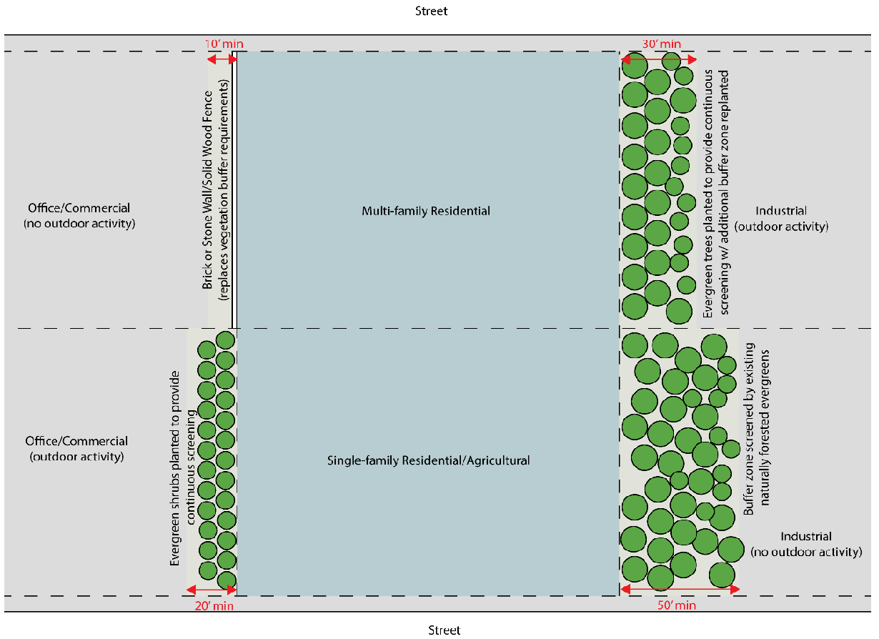
8.2.3. Required Buffer Areas
Except as noted in Sec. 8.2.4.B.4., a vegetated buffer area with a minimum width as specified in Table 8.2.1 must be planted parallel with the lot line when a nonresidential use or district abuts property zoned AR-1, V-C, R-1-L, R-1, R-TF, R-X, R-MF, or PRD.
Table 8.2.1. Buffer Requirements
Table notes:
*Outdoor activity does not include required parking or loading areas.
8.2.4. Buffer Types and Standards
A.
General
1.
Buffers must be undisturbed and may contain no structures except for walls, fences, or structures otherwise allowed in the buffer by this UDC.
2.
Buffers may be made up of existing vegetation or planted vegetation or a combination of the two.
3.
Buffers must be located wholly on the subject property.
4.
The owner of the property on which the buffer is located is responsible for the maintenance, repair, and replacement of the required buffer.
5.
The vegetation must be located or planted far enough from the property lines to prevent encroachment into adjacent properties.
6.
The required buffer must be installed prior to occupancy or commencement of use. Where compliance with the preceding is not possible because of the season of the year, the Building Official may grant a temporary occupancy permit until the season changes.
B.
Buffer Material
1.
The buffer strip must be planted as specified in Table 8.2.1 and must consist of evergreen trees or shrubs at least 5 feet in height at the time of planting, spaced to provide a continuous screen when mature.
a.
Where buffer widths greater than 10 feet are required, the remaining buffer adjacent to the residential district use may be left in a natural forested state, if such condition exists, or planted with a mix of deciduous and evergreen trees.
Buffer Design Standards, Figure 8-1
b.
Where existing vegetative material in good condition meeting the minimum height remains in the buffer area after clearing and construction, it may be utilized and credited toward meeting the screening requirement. The county must approve the materials and planting plan for the buffer prior to the buffer being established.
2.
Spacing of plants should be the minimum required for mature plants, and staggered rows of plantings may be used if necessary to attain the required initial screening. Screening plants must be nursery-grown and of such size, species, and condition as to ensure the maximum initial screening commensurate with a high rate of survival and a high growth rate. Other trees planted to re-establish a forested area must be a minimum caliper of at least three inches at the time of planting.
3.
Earthen berms may be incorporated in the buffer design upon approval by the Director after a determination that the berms will not cause drainage or erosion problems to the subject site or adjacent properties.
4.
A structural buffer such as a solid fence or wall may be substituted, upon approval from the Director, for part or all of the vegetated buffer as follows:
a.
A brick or stone wall at least 6 feet in height may be erected adjacent to the property line in lieu of the buffer requirements.
b.
A solid wooden fence at least 6 feet in height may be erected adjacent to the property line. The fence must have a natural finish and the finished side of the fence must face the adjacent property. If stained or varnished, the resulting finish must be natural in appearance.
5.
For nonresidential uses with outdoor storage, the construction of both a vegetative and structural buffer must be provided upon determination by the Director that the buffer requirement will otherwise be insufficient to achieve the desired level of screening.
C.
Buffer Height
The screening vegetation must attain a minimum height of 10 feet within five years of establishment of the buffer. Where the required interim growth has not been attained, the property owner is responsible for replacing the vegetation with new vegetation that will meet the buffer requirement within the remaining portion of the original five-year period.
D.
Buffer Width
The buffer width must be as indicated in Table 8.2.1 unless a structural buffer has been approved in accordance with Sec. 8.2.4.B.4.
E.
Maintenance of Buffer
All buffers required by this section must be maintained in a healthy condition and pruned to provide a solid screen with maximum opacity from the ground to a height of at least ten feet. Should vegetation die or be removed such that the buffer no longer functions as required, that vegetation must be replaced by the property owner. Fences or walls serving as a buffer must remain in a good state of repair to provide a solid screen.
F.
Vision Clearance at Intersections
In all districts no plantings, fences, walls, signs or other obstruction to vision between the heights of 3 feet and 15 feet may be permitted within 25 feet of the intersection of the right-of-way lines of two streets, railroads or driveways, and a public road.
G.
Modification of Buffer Requirements
1.
The Board of Commissioners may modify or waive the buffer requirements on rezonings and uses subject to their approval upon determination that the buffer is not necessary or creates a hardship.
2.
The Planning Commission may modify or waive the buffer requirements on uses subject to their approval upon determination that the buffer is not necessary or creates a hardship.
3.
The Director may modify or waive the buffer requirements on plan approvals not subject to Planning Commission or Board of Commissioners review, based on a specific finding that existing topography, vegetation, building orientation or other physical characteristics of the area will provide screening and buffering that meets the intent of this section.
Sec. 8.3. - Tree Protection
8.3.1. General
Growth and development in Hall County has resulted in the reduction of the overall tree canopy. The county recognizes the valuable benefits that trees hold to the community, including:
A.
Improved health of Hall County's citizens.
B.
Improved air quality.
C.
Improved water quality.
D.
Improved soil quality.
E.
Reduced noise and glare and better buffering or screening between uses.
F.
Increased shade to improve the quality of life and mitigate the urban heat island effects.
G.
Improved community aesthetics and increased property values.
The purpose of these regulations is to encourage the conservation of the existing tree canopy and to provide standards for the removal, protection, and replacement of trees within the county.
8.3.2. Definitions
The following words have the meanings indicated below as used in this Sec. 8.3.
Agricultural activities.
1.
Good-faith commercial production from the land or on the land of agricultural products, including horticultural, floricultural, dairy, livestock, poultry, and apiary products, but not including forestry products (See also tree farming);
2.
Clearing trees for the purpose of planting crops, providing pasture for livestock, or constructing buildings accessory to production of agricultural products.
Building tree line. The lines extending from the corners of a building nearest a street to the side lines of the lot (not including a street right-of-way), parallel to the right-of-way line or to the chord of that line.
Caliper. Tree trunk diameter measured at a point six inches above ground level.
Canopy tree. A species of tree that normally reaches a height at maturity in excess of 40 feet and in which the layers of leaves and branches of the tree are so arranged or formed to provide shade. Examples of canopy trees would include scarlet oak, northern red oak, shumard oak, water oak, white oak, yellow poplar, red maple, sugar maple, American elm, winged elm, Chinese elm, trident maple, pin oak, American beech, pecan, southern magnolia, sweetgum, and willow oak, or other species as approved by the Director.
Clear cut. The large-scale, indiscriminate removal of trees, shrubs, and undergrowth with the intention of preparing real property for nonagricultural development purposes.
Critical root zone. The land area circular in shape and centered on the trunk of a tree, the radius of which circle is determined by the farthest extent of the drip line from the trunk.
DBH (diameter-at-breast-height). Tree trunk diameter measured in inches at a height of four and one-half feet above the ground. If a tree splits into multiple trunks below four and one half feet, each trunk must be measured as a separate tree.
Development site. That portion of a tract of land that will be dedicated to a proposed development, including that land containing trees that will be counted toward satisfying the requirements of these provisions. Where a development site is smaller than the tract in its entirety, only those trees specified to be within the construction area may be counted toward meeting the 15 units per acre requirement.
Drip line. A perimeter formed by the points farthest away from the trunk of a tree where precipitation falling from the branches of that tree lands on the ground.
Significant tree. A tree in fair or better condition which has been determined to be of a high value by a trained arborist or other trained professional as approved by the Director because of its species, size, age, or other professional criteria. A tree is considered in fair or better condition if:
1.
Its life expectancy is greater than 15 years;
2.
It has a relatively sound and solid trunk with no extensive decay or hollow with less than 29 percent radial tip die-back; and
3.
It has no major insect or pathological problems.
Hardwood trees such as oaks and hickories and softwood trees such as pines and cedars whose diameters are 18 inches DBH or more and small hardwoods such as dogwoods, redbuds or sourwoods whose diameters are eight inches DBH or more are considered significant trees due to size. A tree of lesser size than the preceding may be significant if it is a rare or unusual species or is of historical significance or is specifically used by design as a landscape focal point of the project.
Tree farming. Planting, cultivating, and harvesting of trees in a continuous cycle as a regular practice on a tract of land, not including the removal of trees for purposes of development or the removal of trees without replanting.
8.3.3. Applicability
A.
The tree protection zone applies to the entirety of a tract of land for which no tree protection plan has been approved. After such approval, the tree protection zone must correspond to that part of a tract of land designated as a tree conservation area in the plan.
B.
The tree protection zone does not apply to the following (but see the soil erosion and sedimentation control ordinance for provisions regarding retention of undisturbed natural vegetative buffers adjacent to Lake Lanier and other state waters):
1.
Property already occupied by an owner-occupied single-family dwelling, unless nonresidential uses are proposed for such property. Any construction, paving, or other activity on the property that will damage trees on the public right-of-way is subject to the restrictions of Sec. 8.3.5.
2.
Public utility companies and government agencies conducting operations on public and utility rights-of-way and easements or on-sites for electric power substations and similar facilities, which operations are for the purpose of assuring uninterrupted utility and governmental services and unobstructed passage on public streets.
3.
Property in use for tree farming or other agricultural activities, provided the best management practices established by the Georgia Forestry Commission or the state Department of Agriculture are observed.
4.
Family held property the subdivision of which is affected for the sole purpose of transferring a portion of such property to one (1) or more family members for use as the family member's primary residence.
5.
Minor subdivisions as defined in Sec. 12.2.
8.3.4. Removal of Trees
A.
Permit. On properties which are not exempted under Sec. 8.3.3.B., a permit is required to remove or cause the death of existing significant trees and any other trees ten inches DBH or larger located within the tree protection zone, or for grading or other work adjacent to a tree which would affect it adversely. An approved tree protection plan is required for issuance of a permit. Permit requirements are waived where the county determines that trees to be removed are dead, diseased or are infested to the extent that removal is necessary, or have been damaged by lightning, wind, ice, or other disasters to the extent that public safety is endangered.
B.
Retention. The property owner must retain trees on the property equivalent to 15 units per acre of development site in accordance with these regulations and the approved plan, including, if necessary, replacing trees which die or are irreparably damaged.
8.3.5. Protection of Existing Trees
A.
When a choice is available as to which existing trees to save, emphasis must be given to the preservation of significant trees, even isolated individual trees, over retention of other trees. Nonsignificant trees, however, should be saved in stands rather than as individual trees scattered over a site. Removal of significant trees and other trees ten inches DBH or larger may be permitted only in conjunction with an approved preliminary tree protection plan, an approved grading plan, and actual grading of building pads. Removal of trees to clear a lot without a development plan is not permitted.
B.
On properties which are not exempted under Sec. 8.3.3.B. the following provisions apply, with the exception that encroachment on the critical root zone of a tree is permitted where necessary to the development, such as the construction of a driveway, provided that the tree may not be counted toward the required 15 units per acre of development site:
1.
No person may:
a.
Cut, carve, or otherwise damage or remove any tree except in accordance with the provisions of this section;
b.
Attach any wire, nails, advertising posters, or other contrivance harmful to any tree;
c.
Allow any gaseous, liquid, or solid substance which is harmful to trees such as concrete washout, fuel, lubricants, herbicides, or paint, to come in contact with any tree; or
d.
Set a fire or permit any fire to burn when such fire or the heat thereof will injure any portion of any tree.
2.
During excavation, filling, construction, or demolition operations, each tree or stand of trees to remain on the property must be protected against damage to bark, roots, and low-hanging branches with a fence enclosing the critical root zone. Fencing must be either plastic construction area fencing, silt fencing, 12-gauge two-inch by four-inch wire mesh, double one-inch by four-inch rails on two-inch by four-inch posts, or high-visibility surveyors' tape on one-inch by two-inch posts. The height of the latter three fence types must be at least four feet.
3.
All building materials, vehicles, construction equipment, dirt, debris, or other objects likely to cause soil compaction or above-ground damage must be kept outside the critical root zone. Where a limited amount of encroachment is unavoidable and is approved by the county, the critical root zone must first be mulched with a four-inch layer of processed pine bark or wood chips or a six-inch layer of pine straw.
4.
There may be no raising or lowering of the ground level within the critical root zone. Stripping of topsoil in the critical root zone is not permitted. Where necessary, the use of moderate fill is permitted only with prior installation of an aeration system approved by the county. Deposition of sediment in the critical root zone must be prevented by placement of sediment barriers backed by two-inch by four-inch wire mesh in areas of steep slope.
5.
No person may excavate any ditch or trench within the critical root zone. Where such encroachment is unavoidable and is approved by the county, ditches or trenches must be located in a manner to minimize root damage. If roots must be cut, root pruning procedures approved by the county must be employed.
6.
No person shall pave with concrete, asphalt, or other impervious material within the critical root zone unless authorized by the county.
8.3.6. Tree Replacement
The following standards apply to the replacement of trees:
A.
Spacing and the potential size of species chosen must be compatible with spatial limitations of the site.
B.
The species must be ecologically compatible with the specifically intended growing site.
C.
The trees must have the potential for size and quality comparable to those removed.
D.
The trees must be compatible in extent of crown and root systems at maturity with nearby utilities.
E.
Planting preference will be given to specimens of no more than three inches DBH.
F.
Where trees must be added to achieve the required 15 units per acre of development site, pines may not comprise more than 30 percent of the required units. Where existing pines already comprise 30 percent or more of the required units, no additional pines may be credited toward the required units. At least 25 percent of the replacement tree units must be canopy trees.
G.
Authority for questions of tree characteristics shall be publications of the USDA Forest Service, Georgia Forestry Commission, Cooperative Extension Service of the University of Georgia College of Agriculture, American Forest Foundation, The National Arbor Day Foundation or any other authority found acceptable by the county.
8.3.7. Tree Measurements
The diameter of a tree's trunk will be measured and a value assigned in units in accordance with Tables 8.3.1, 8.3.2, and 8.3.3. The values assigned to trees of the same size will be different for existing and new trees, as indicated. One unit is not the same as one tree.
Table 8.3.1. Unit Values for Existing Trees
Table 8.3.2. Unit Values for Replacement Trees
Table 8.3.3. Unit Values for Large Species Trees
8.3.8. Tree Protection Plan
A proposal for development or improvement of any tract of land must include a tree protection plan. The tree protection plan may be included on the soil erosion plan. Such plan must be submitted to the county prior to any grading, bulldozing, or other removal of existing vegetation. A preliminary plan may be submitted in certain circumstances as provided in Sec. 8.3.8.B.
A.
The full tree protection plan must show the following:
1.
The extent of the development site.
2.
All significant trees to be removed and all other trees ten inches DBH or larger to be removed.
3.
All significant trees and all other trees ten inches DBH or larger which will remain on the development site and be protected during construction, including trees less than ten inches DBH which are submitted for credit as part of the required 15 units per acre of development site.
4.
In heavily wooded areas that will not be disturbed, the plan may show only the boundaries of each stand of trees and a list of the number, size, and type (e.g., hardwood, softwood, deciduous, evergreen) of trees in each stand which are submitted for credit.
5.
Areas subject to provisions of the soil erosion and sedimentation control ordinance regarding retention of undisturbed natural vegetative buffers adjacent to Lake Lanier and other state waters must also be shown.
6.
Locations of proposed on-site underground utility lines.
7.
Locations of other on- and off-site utility lines. The plan must indicate areas where trees cannot be planted because of interference with existing or proposed utilities on public rights-of-way or on utility rights-of-way or easements and existing utilities on adjoining properties.
8.
Limits of land disturbance, clearing, grading, and trenching.
9.
Limits of tree conservation areas, showing trees to be maintained and planted, specifying type and size.
10.
Grade changes or other work adjacent to a significant tree or any other tree ten inches DBH or larger which would affect it adversely, with drawings or descriptions as to how the grade, drainage, and aeration will be maintained around the tree.
11.
Planting schedule, if applicable.
B.
A preliminary tree protection plan may be submitted for development of an industrial park where multiple sites will be cleared and graded for purposes of marketing vacant sites to industrial prospects. Planting of new trees will not be required on a lot until a use is developed on that lot, and locations of new trees need not be shown on the preliminary plan. The preliminary tree protection plan for industrial, office or commercial parks must show the following:
1.
The extent of the development site.
2.
Limits of land disturbance, clearing, grading, and trenching.
3.
All significant trees to be removed and all other trees ten inches DBH or larger to be removed.
4.
Grade changes or other work adjacent to a significant tree or any other tree ten inches DBH or larger which would affect it adversely, with drawings or descriptions as to how the grade, drainage, and aeration will be maintained around the tree.
5.
Units of trees that will be required on the lot when it is developed, calculated both without subtracting any building footprint area from the acreage and by subtracting one-third of the lot area as assumed building area.
C.
Where property has been clear-cut of trees in violation of the Best Management Practices as established by the Georgia Forestry Commission, or in violation of the provisions of this Article, no rezoning or permissive use application may be made for that property for a minimum of three years.
8.3.9. Requirements for Commercial, Industrial or Multi-family Residential Developments
The following standards apply to all commercial, industrial or multi-family residential uses.
A.
Upon completion of development, all properties must have a number of trees equivalent to 15 units per acre of development site.
B.
Existing significant trees or any other trees ten inches DBH or larger that are in excess of the required 15 units per acre of development site but outside the construction area may not be removed unless adjacent development would cause irreparable damage to the critical root zones.
C.
Flowering ornamental trees may not be used in density calculations.
D.
Trees located within the 25 foot nondisturb buffer of a creek or stream may not count toward the unit requirement.
E.
Where trees must be added to achieve the required 15 units per acre of development site, such additions may be made between the street right-of-way and the building tree line in locations approved by the Director.
F.
Trees required by this UDC in relation to parking lot landscaping may be included in calculating the required 15 units per acre. However, trees existing or planted in a buffer required under Sec. 8.2.4 are not to be counted as part of the minimum 15 units per acre requirement.
G.
On properties on which the requirements of this section would exceed the required 15 units per acre, the Department of Planning and Zoning must approve of the location and design of the landscape plan.
8.3.10. Requirements for Single-family Residential Developments
The following standards apply to all single-family residential developments which are subject to preliminary plat approval.
A.
A tree plan must accompany all preliminary plat submissions. The tree plan must indicate the location of all significant trees and existing tree stands, and the limits of clearing proposed to accommodate the construction of roads, utilities and other infrastructure necessary for the development of the subdivision.
B.
The removal or clearing of trees or other existing vegetation is prohibited outside the appropriate clearing boundaries as defined on the approved preliminary plan.
C.
Lots may not be cleared and prepared during the construction of the roads, infrastructure, utilities, etc. Where limited clearing is necessary, a note must be placed on the final plat indicating a tree plan for the lot in its entirety.
D.
In order to encourage the preservation of significant trees and the incorporation of these trees into the design of the development, additional density credit will be given for significant trees that are successfully saved. Credit for any significant tree saved will be two times the assigned unit value shown in Table 8.3.1.
E.
Any significant tree that is removed without the appropriate review and approval by the Department of Planning and Zoning must be replaced by trees with a total density equal to twice the unit value of the tree removed.
F.
Preference is given to existing trees that will be maintained on the property.
G.
Each residential subdivision development must, upon completion, achieve a tree count equivalent to 15 tree units per acre. It is anticipated that this requirement must be achieved through the preservation of existing trees on the site. However, where a site is primarily pastureland (90 percent open space or greater) prior to the initiation of the subdivision development, the tree units required may be calculated using the total acreage from disturbed areas only (i.e. acreage from road and utility construction).
H.
For subdivision developments in which trees must be planted to achieve the required tree units, the final plat must include a landscaping plan specifying the method in which the requirement is met. Any new trees required must be planted prior to the issuance of an occupancy permit for any dwelling located on a lot which would require a tree unit(s).
Sec. 8.4. - Sidewalks
8.4.1. General
The county finds that it is in the interests and safety of its citizens to provide safe, adequate space for pedestrians along rights-of-way.
8.4.2. Applicability
Sidewalks are to be installed along all new public rights-of-way or private streets as indicated in Sec. 8.4.3.
8.4.3. Standards for Design and Construction
A.
Where installed, sidewalks must conform to the following standards:
1.
Sidewalks must be at least five feet in width.
2.
Sidewalks are to be installed no less than one foot from the back of the required curb or edge of pavement, as applicable.
3.
All sidewalks must be constructed of a material as approved by Hall County as follows:
a.
At least four inches in thickness.
b.
Compacted subgrade (95 percent Standard Proctor).
c.
Class "A" concrete (3,000 psi).
d.
Sidewalks must have a ¾-inch grooved joint maximum ten-foot on center.
e.
Expansion joints must be installed at least every 40 feet and at catch basins, driveways, roads, and other similar locations as determined by the Hall County Engineer.
f.
All sidewalks must be broom finished.
g.
Sidewalks must have a ¼-inch per foot cross slope.
4.
Sidewalks must be compliant with the Americans with Disabilities Act (ADA).
8.4.4. Additional Requirements for Residential Subdivisions
See Secs. 9.4.8 and 9.4.9 for additional requirements for sidewalks in residential subdivisions.
8.4.5. Exemptions and Waivers
A.
The following exemptions apply to the installation of sidewalks:
1.
Along state owned rights-of-way, sidewalks are subject to the requirements of the Georgia Department of Transportation.
2.
New single-family residential construction in the AG-1 and AR-1 zoning districts are not required to install sidewalks.
3.
New single-family residential construction in the V-C, R-1-L, and R-1 zoning districts, when not a part of a residential subdivision, are not required to install sidewalks.
B.
The Director may waive or modify the requirements for sidewalks in Secs. 8.4.2 and 8.4.3 upon evidence that:
1.
There exist site conditions related to topography, wetlands, streams, or mature trees which would be negatively impacted by the installation of sidewalks; or
2.
There are existing sidewalks on the block face opposite of the subject property which meet the standards of this Sec. 8.4.
8.4.6. Sidewalk Repair and Maintenance
A.
Sidewalks on county right-of-way will be inspected by Hall County Engineering Division on a periodic basis, and as directed by citizen concern, to see that the sidewalks are in a safe and suitable condition for public use and travel. The County Engineer will determine repair requirements for any damage observed to bring the sidewalk back to a safe and suitable condition. The repair of sidewalks due to damage caused by activities of a resident, their guests, or their contractors will be the responsibility of the landowner, and a notification letter will be sent indicating such. The repair of sidewalks due to damage caused by activities of a subdivider's contractor or a subcontractor will be subdivider's responsibility, and a notification letter will be sent indicating such.
B.
Upon receiving the notification letter, the landowner or subdivider has three options in repairing the sidewalk:
1.
The landowner or subdivider may repair the sidewalk. The Hall County Engineering Division will inspect the sidewalk repair work, and any inconsistencies with the sidewalk specifications will need to be corrected. Sidewalks not repaired within 60 days of receiving the notification letter will be repaired by Hall County as provided in Sec. 8.4.6.B.3.
2.
A subcontractor hired by the landowner or subdivider may repair the sidewalk. The Hall County Engineering Division will inspect the sidewalk repair work, and any inconsistencies with the sidewalk specifications will need to be repaired. Sidewalks not repaired within 60 days of receiving the notification letter will be repaired by Hall County as provided in Sec. 8.4.6.B.3.
3.
The landowner or subdivider may choose to allow Hall County or its representatives to repair the sidewalk. Charges will be assessed to the landowner, and the cost of the repairs will be as per the most current Georgia Department of Transportation Item Mean Summary, or in accordance with actual Hall County contractual bid prices.
Sec. 8.5. - Open Space
8.5.1. General
A.
Purpose and Findings
The County finds that the preservation and conservation of undeveloped greenspace within its jurisdiction will have a significant impact on maintaining the character of the county as it continues to grow and develop. The intent of open space requirements is to conserve open land, preserve natural features and wildlife habitat, minimize land disturbing activities, create developments with direct access to open land and amenities, and provide active and passive recreational opportunities for residents in accordance with the Comprehensive Development Plan.
B.
Defined
Open space is an area of land essentially unimproved in its natural state and set aside, dedicated, designated, or reserved for permanent protection. Open space areas may be utilized for common use or enjoyment through means of active or passive recreation but may not be occupied by nonrecreational uses or structures.
8.5.2. Applicability
Open space is required as shown on Table 8.5.1. Open space must conform to the requirements of this Sec. 8.5 and any other applicable requirements of this UDC.
Table 8.5.1. Open Space Requirements
*Required open space is based on the gross area of the lot to be developed
_____
Table notes:
1. Additional open space standards for Conservation Subdivisions can be found in Sec. 4.8.7.
2. Includes development in the R-X district.
8.5.3. Open Space Standards
A.
The following areas or features of a site may be counted towards open space requirements:
1.
Areas set aside for conservation of natural, archaeological, or historic features.
2.
Meadows, woodlands, wetlands, wildlife corridors or similar conservation-oriented areas.
3.
Passive recreational areas.
4.
Outdoor amenities such as greens, commons, community gardens, nonpaved trails and similar areas.
5.
Active noncommercial recreation areas, such as playing fields, playgrounds, courts, and bikeways. These areas may be credited to no more than 25% of the required open space and may not be located within conservation areas.
6.
The area of any buffers required by Sec. 8.2.4.
B.
The following areas or features of a site may not be counted towards open space requirements:
1.
Driveways, alleys or similar paved areas.
2.
Parking lots, including those reserved for recreation areas.
3.
Streets, existing or proposed.
4.
Detention or retention ponds.
5.
Other impervious surfaces including, but not limited to buildings and accessory structures, unless otherwise permitted by this section.
Sec. 8.6. - Signs
8.6.1. General
A.
Purpose and Findings
The county finds that signs provide an important medium through which individuals may convey a variety of noncommercial and commercial messages. However, left completely unregulated, signs can become a threat to public safety as a traffic hazard and detriment to property values and to Hall County's overall public welfare as an aesthetic nuisance. By enacting this Sec. 8.6, the county commission intends to:
1.
Balance the rights of individuals to convey their messages through signs and the right of the public to be protected against the unrestricted proliferation of signs;
2.
Further the objectives of the Hall County Comprehensive Plan;
3.
Protect the public health, safety, and welfare;
4.
Reduce traffic and pedestrian hazards;
5.
Maintain and enhance the visual environment, and preserve the right of the citizens to enjoy Hall County's scenic beauty;
6.
Protect property values by minimizing possible adverse effects and visual blight caused by signs;
7.
Avoid the harmful aspects of the unrestricted proliferation of signs;
8.
Promote economic development; and
9.
Ensure the fair and consistent enforcement of sign regulations.
B.
Applicability
No sign may be erected, altered, refurbished or otherwise modified except in accordance with the requirements of this Sec. 8.6.
C.
Permit required
A permit shall be required for the erection, alteration or reconstruction of any sign unless otherwise noted and shall be issued by the building official in accordance with these regulations.
D.
Standards
1.
Materials and maintenance. Signs permitted by this UDC must be:
a.
Constructed of materials, either singly or in combination, such as wood, cut or formed metal, glass, stone, masonry, plastics, L.E.D., high-density urethane foam, acrylics, polycarbonates, or similar materials as approved by the Director; and
b.
Free from: rust or holes on or in the sign or sign structure; broken, missing, loose or bent parts; faded or flaking paint; nonoperative or partially nonoperative illuminating or mechanical devices; and/or missing letters/graphics in sign copy; and
c.
Maintained in good condition and not constitute a hazard to safety, health or public welfare by reason of inadequate maintenance, dilapidation or obsolescence.
2.
Freestanding signs
a.
All permanent freestanding signs over 6 square feet in area must be a monument sign.
b.
Maximum sign areas shall apply to each face separately, but no freestanding sign may have more than two faces.
c.
Where two sign faces are located in a "V" formation, the angle between the two sign faces may not exceed 60 degrees.
3.
Obsolete signs. A sign becomes obsolete if it conveys advertising or identification to services or uses without a valid business license, or a sign that is not maintained in accordance with this Sec. 8.6.1.D. Obsolete signs must be removed or repaired by property owner, developer or former lessee of property upon which sign is located within 30 days after receipt of written notice from the Director or Code Enforcement division.
4.
Illumination. No sign may be illuminated by lights that flash, move, change in intensity, or turn on intermittently; except that a digital display may change no more often than once each 20 seconds, and shall be subject to the applicable lighting standards within this Sec. 8.6.
a.
Internally illuminated signs, when permitted, may not exceed 20 foot-candles at a distance of 10 feet from such structure.
b.
To prevent glare visible from a public street or adjoining property, the beam of any external lighting shall be directed so as not to be visible beyond the sign at which it is directed, and the light source shall not be visible from any point on an adjacent property or the public right-of-way.
5.
Movement or animation. No sign or part of a sign may rotate, oscillate, or otherwise move or change in appearance, whether such motion is driven by wind, mechanical, electrical, or other means; except as provided under "Illumination" above.
8.6.2. Definitions
The following terms have the meanings indicated below as used in this Sec. 8.6.
Billboard. A freestanding sign larger than 200 square feet in area.
Billboard, digital. A freestanding sign larger than 200 square feet in area and programmable by a computer capable of displaying words, symbols, figures, or picture images that can be altered or rearranged on site or by remote means without altering the face or surface of the sign.
Freestanding sign. A sign that is not mounted on a principal building.
Nonconforming sign. A sign that does not conform to the provisions of this UDC and was legal when originally erected.
Portable sign. A sign which is not permanently affixed by rigid structures to a permanent, concrete foundation or a building; including any sign mounted on a vehicle, trailer, or other device designed to be moved periodically from place to place.
Roof sign. A sign projecting over the coping of a flat roof, or wholly or partially over the ridge of a gable, hip or gambrel roof, and supported by or attached to the roof.
Sign. Any structure, display, or device that is used to advertise, identify, direct, or attract attention to a business, institution, organization, person, idea, product, service, event, or location by any means, including words, letters, figures, design characteristics, symbols, logos, fixtures, movement, or illumination.
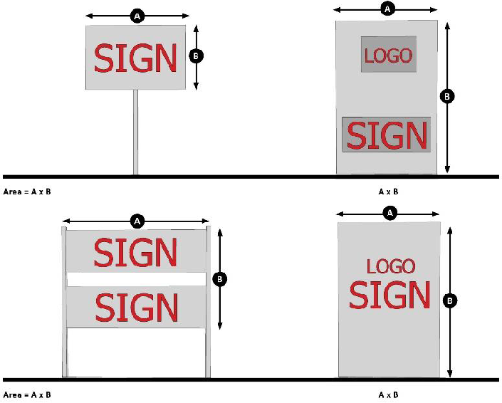
Sign area. The entire area within a continuous perimeter, enclosing the extreme limits of the sign structure, not to include the first 24 inches of the base height of a monument sign. Curved, spherical, or any other shaped sign face area will be computed based on the actual surface area. The copy of signs composed of individual letters, numerals, or other devices will be the sum of the area of the smallest rectangle or other geometric figure encompassing each of said letter or device as well as spaces between each letter or device.
1.
Supporting structures for signs are not counted in the sign area, provided such supporting structures consist of posts, hangers, or brackets of the minimum number and size necessary to support the sign.
2.
A wall or fence on which a sign is mounted not counted in the sign area, provided it serves primarily to enclose, divide, or protect an area.
Temporary sign. A display, sign, or banner with or without a structural frame, temporarily mounted, and intended to be displayed for a period not to exceed 30 days.
8.6.3. Prohibited Signs
Notwithstanding any other provision of this Sec. 8.6, the following signs are prohibited:
A.
Signs displaying intermittent lights resembling the flashing lights customarily used in traffic signals or in police, fire, ambulance or rescue vehicles, nor shall any sign use the words "stop," "danger," or any other word, phrase, symbol or character in a manner that might mislead or confuse a vehicular driver.
B.
Signs within any street or highway right-of-way, unless erected by a public agency.
C.
Signs painted on or attached to trees, fence posts and telephone or other utility poles or signs painted on or attached to rocks or other natural features or painted on the roofs or walls of buildings.
D.
Fluttering ribbons and banners and similar devices within the front yard setback. This restriction does not apply to flags.
E.
Billboard signs, except as otherwise required by Georgia or federal law.
F.
Roof signs and other signs mounted on or extending into the air above any roof surface of a building. A sign may be mounted against a parapet of uniform height around the perimeter of a building but may not extend above the parapet.
G.
Portable signs unless qualified as a temporary sign and complies with all applicable requirements for such signs under this Sec. 8.6.
H.
Wall murals.
I.
Signs within visibility clearance areas. No freestanding sign or flag between a height of two and one-half feet and ten feet, and no billboard support structure with a maximum dimension of 12 inches or more, shall be installed and/or maintained within the visibility clearance area defined by:
1.
Points 25 feet distant from the intersection of any two of the following:
a.
Any public street(s);
b.
Any driveway for other than single- or two-family use; or
c.
Any railroad right-of-way with an at-grade crossing; and
2.
A straight line connecting those two points.
8.6.4. Signs Not Requiring a Permit
The following sign types do not require a sign permit when they are erected and maintained in compliance with all applicable standards:
A.
Address Signs
An address sign is a sign displaying the street address of the property.
B.
Entrance Directory signs
An entrance directory sign is any sign located on a developed property, adjacent to exits, entrances, driveways or off-street parking facilities. Entrance directory signs must meet the following standards:
1.
The sign may not exceed 12 feet in area and 5 feet in height.
2.
The sign must be at least one foot from the edge of the pavement or curb.
3.
One entrance directory sign is allowed per exit, entrance, and off-street parking lot.
C.
Construction Signs
A construction sign is a temporary sign erected on-premises where construction for which a permit is required is taking place. Construction signs must meet the following standards:
1.
The sign may not exceed 50 square feet in area and 8 feet in height.
2.
The sign must be at least 10 feet from the edge of the adjacent pavement.
3.
Signs must be at least 15 feet from side and rear property lines.
D.
Home Occupation Signs
A home occupation sign is a sign associated with a permitted home occupation. Home occupation signs must meet the following standards:
1.
The sign may not exceed one foot in area.
2.
The sign may not be illuminated.
3.
The sign must be attached to the structure in which the home occupation is conducted.
E.
Internal Development Signs
Signs internal to a multi-building residential or nonresidential complex which may be part of a greater wayfinding system used to serve as directional signage to effectively navigate people through a space. Internal development signs must meet the following standards:
1.
One sign is allowed at each street or driveway intersection.
2.
The sign may not exceed 6 square feet in area and 4 feet in length.
3.
The sign may not be mounted more than 5 feet above grade.
F.
Residential temporary signs
Residential temporary signs are temporary signs on residentially zoned property. Residential temporary signs must meet the following standards:
1.
The sign may not exceed 6 square feet in area.
2.
Signs must be at least 15 feet from side and rear property lines.
G.
Flags
Flags are any fabric or other flexible material designed to be flown from a flagpole. Flags must meet the following standards:
1.
No more than two flagpoles are permitted per lot.
2.
No more than two flags are permitted per flagpole.
3.
The maximum dimension of the hoist side of each flag may not exceed 20 percent of the height of the flagpole.
4.
Flagpoles must be set back from each property boundary a distance equal to the height of the flagpole.
5.
Flagpoles must be maintained in good repair, so as not to constitute a hazard to health, welfare or public safety.
6.
On officially designated county, state, and federal holidays, there is no maximum flag size or number of flags which may be on display.
H.
Window signs
A window sign is a sign attached to the interior or exterior face of a window, door, or display case and intended to be viewed from the outside. Window signs must meet the following standards:
1.
Window signs may not exceed 25% of the area of the individual window they are located in; and
2.
Additional standards apply in the Gateway Corridor Overlay District. See Sec. 8.6.18.
I.
Other exempt signs
In addition to any other permitted signs, the following signs are also permitted without a sign permit:
1.
Agricultural and residential zoning districts. Individual signs not exceeding 6 square feet in area, with a combined area not exceeding 18 square feet.
2.
Other zoning districts. Individual signs not exceeding 10 square feet in area, with a combined area not exceeding 30 square feet. Such signs must not be more than 5 feet high and must be at least 5 feet from side and rear property lines.
3.
Public signs. Signs authorized by any public agency for official purposes. Official notices issued by any court, public agency, or officer.
8.6.5. Temporary Signs
A total of one additional sign per street frontage, which may be either of the following, is allowed for the duration of a temporary event:
A.
One nonilluminated temporary sign, flag or banner, not exceeding 6 square feet in area nor 4 feet in height in a single-family residential zoning district and not exceeding 32 square feet in area nor 12 feet in height in a multi-family or nonresidential zoning district; or
B.
One nonilluminated inflatable sign, which may be placed on a building roof, but regardless of location, must be installed in accordance with all requirements of the building code. Such inflatable sign may not contain an inflatable area in cubic feet that is greater than the square footage area of the sign structure for the principal freestanding sign on the property as determined by the Director.
C.
Signage is limited to a total of 60 days a calendar year for the same business or organization. The duration of the temporary event may not last longer than 15 consecutive days and must not take place more frequently than four times in any calendar year for the same business or organization. Any four such events must be separated by at least 30 consecutive days.
8.6.6. Sign Permits
A.
Purpose
The purpose of this Sec. 8.6.6 is to provide a review process for sign permit applications that ensures that signs comply with the standards of this Sec. 8.6.
B.
Authority
The Director is authorized to review and approve or disapprove an application for a sign permit pursuant to the procedures of this Sec. 8.6.6 and the standards of this Sec. 8.6.
C.
Applicability
No sign, except those listed in Sec. 8.6.4, may be erected, placed, reconstructed or structurally altered without the sign owner having first obtained a sign permit from the Director or building official, if applicable, per the procedures in this Sec. 8.6.5 and the standards of this Sec. 8.6.
D.
Procedure
1.
Initial submission and review of application. Application for a sign permit must be made on the form provided by the Department of Planning and Zoning and must be accompanied by the information and documents listed on the form. An application will only be deemed as sufficient when all required information and accompanying documents are received.
2.
Action by Planning and Zoning Director. Within 10 working days after the application is determined sufficient, the Director or their designee must review the application in accordance with this Sec. 8.6.5 and determine whether the application complies with the standards in this Sec. 8.6.
3.
Approval. If the Director finds that the application complies with the standards of this Sec. 8.6, they must approve a sign permit. Any sufficient sign application for which no action has been taken after ten working days will be deemed approved.
4.
Fails to comply. If the Director determines the application fails to comply with the standards of this Sec. 8.6, the applicant must be provided a notification with written comments, explaining why the application fails to comply with the standards. The applicant must be provided an opportunity to submit a revised application. If a revised application is not resubmitted within 30 days of the date of notification, the application will be considered withdrawn and subject to a new application and remittance of accompanying fees. The time for resubmission may be extended an additional 30 days, if requested prior to the original deadline for resubmittal.
5.
Re-submittal. A revised application must be re-submitted to the Director and reviewed by the Director within five working days after its re-submittal. The Director must approve or disapprove the application, based on the criteria in this Sec. 8.6.
6.
Fees. No permit may be issued until the appropriate application has been filed with the Department of Planning and Zoning and fees as established by the Board of Commissioners have been paid.
7.
Criteria. A sign permit must be approved upon a finding that the applicant has demonstrated the application complies with the standards of this Sec. 8.6.6.
E.
Expiration. If the work described in any sign permit has not been completed within six months of issuance, the sign permit will expire and be void, however, one six-month extension of the permit will be granted if an additional permit extension fee has been paid prior to the expiration date of the initial permit. The permit extension fee will be the amount of the initial permit fee.
F.
Amendments. A sign permit may be amended, extended, or modified only in with the procedures established for its original approval.
G.
Appeals. Any person aggrieved or affected or any officer, department, board or bureau of the county affected by the determination of the Director on an application for approval of a sign permit may appeal the determination to the Planning Commission in accordance with the procedures of Sec. 11.2. The appeal must be heard within 45 days of the filing of the written notice of appeal.
8.6.7. Signs Requiring a Sign Permit
Signs are allowed by district as shown below. Specific requirements for each sign are shown on the following pages. All of the following sign types require a sign permit.
Table Key:
■ = Allowed
□ = Allowed for nonresidential, residential businesses, and rural businesses uses
only
— = Not Allowed
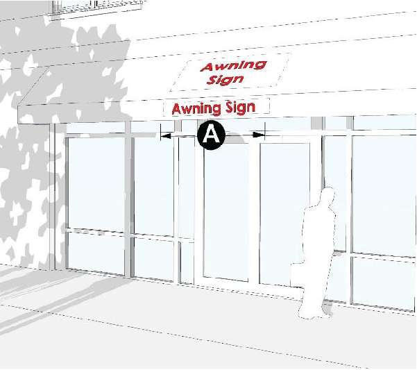
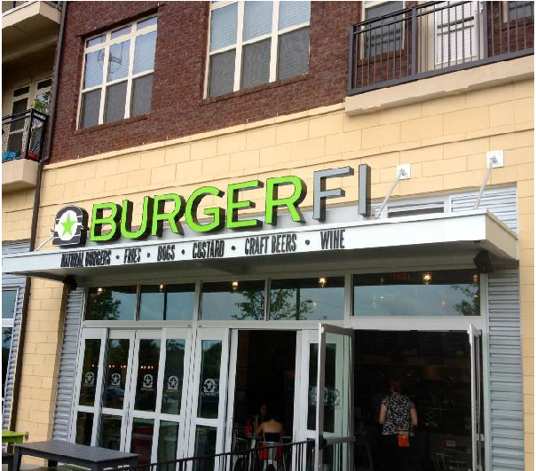
8.6.8. Awning Signs

A.
Definition
A sign where graphics or symbols are sewn on, printed on, or otherwise adhered to the awning material as an integrated part of the awning itself.
B.
General Provisions
1.
Signs may not extend outside the awning.
2.
Only awnings over ground story doors or windows may contain signs.
3.
The awning that the sign is attached to must be opaque.
4.
Signs may be on the front valance, the side valance, or on the sloping face of the awning.
5.
Signs may not be internally illuminated.
C.
Number of Signs
1.
One awning sign, or one canopy sign, or one wall sign, or one projecting sign is allowed per establishment along the side of the establishment that includes its public entrance, unless specified in Sec. 8.6.14 or Sec. 8.6.15.
2.
One additional awning sign, or one additional canopy, or one additional wall sign, or one addition projecting sign is allowed along each facade adjacent to a public right-of-way.
D.
Sign Area
1.
The maximum area is 64 square feet per building, or one square foot per linear foot of storefront, whichever is greater.
2.
A tenant with less than 16 linear feet of storefront is allowed one sign not exceeding 16 square feet in area.
E.
Dimensions
ⒶSign width: no max.
Ⓑ Sign height: no max.
8.6.9. Canopy Signs
A.
Definition
A sign affixed to, superimposed upon, or painted on any roof or roof-like structure which is extended over a sidewalk, walkway, or vehicle access area.
B.
General Provisions
1.
Signs cannot extend outside the overall length or width of the canopy. However, a canopy sign may extend above or below the canopy.
2.
Signs may not extend above the height of the building, including any parapet wall.
3.
Signs may not be located on a roof.
4.
Signs must be located at least 8 feet above any sidewalk or walkway and 13 feet 6 inches above any vehicular access area.
C.
Number of Signs
1.
One awning sign, or one canopy sign, or one wall sign, or one projecting sign is allowed per establishment along the side of the establishment that includes its public entrance, unless specified in Sec. 8.6.14 or Sec. 8.6.15.
2.
One additional awning sign, or one additional canopy, or one additional wall sign, or one addition projecting sign is allowed along each facade adjacent to a public right-of-way.
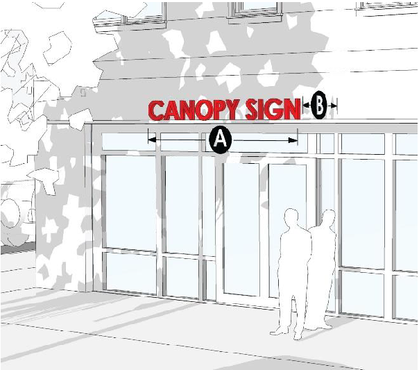
D.
Sign Area
1.
The maximum area is 64 square feet per building, or one square foot per linear foot of storefront, whichever is greater.
2.
A tenant with less than 16 linear feet of storefront is allowed one sign not exceeding 16 square feet in area.
E.
Sign Dimensions
Ⓐ Sign width: max. canopy width.
Ⓑ Sign height: max. 2 feet.
8.6.10. Wall Signs
A.
Definition
A sign which is mounted on the facade of the building, is in a plane parallel to the wall (i.e., does not project at an angle to the wall), and does not project more than 12 inches from the wall.
B.
General Provisions
Reserved
C.
Number of Signs
1.
One awning sign, or one canopy sign, or one wall sign, or one projecting sign is allowed per establishment along the side of the establishment that includes its public entrance, unless specified in Sec. 8.6.14 or Sec. 8.6.15.
2.
One additional awning sign, or one additional canopy, or one additional wall sign, or one addition projecting sign is allowed along each facade adjacent to a public right-of-way.
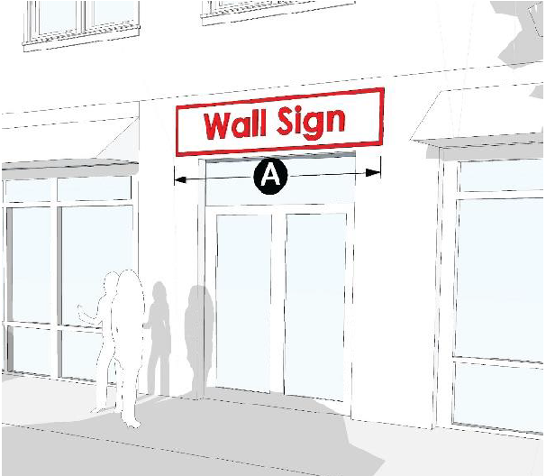
D.
Sign Area
1.
The maximum area is 64 square feet per building, or one square foot per linear foot of storefront, whichever is greater.
2.
A tenant with less than 16 linear feet of storefront is allowed one sign not exceeding 16 square feet in area.
E.
Sign Dimensions
Ⓐ Sign width: no max.
Ⓑ Sign height: no max.
8.6.11. Entrance Signs
A.
Definition
Any sign located in a residential or nonresidential subdivision or planned unit development.
B.
General Provisions
1.
Signs must be at least 15 feet from all property lines.
2.
Signs may not be internally illuminated, and any lighting must come from external sources screened from view with evergreen plantings.
C.
Number of Signs
One per street entrance.
D.
Sign Area
1.
Residential developments:
a.
Fewer than 100 residential units or lots: maximum 20 square feet.
b.
101—200 residential units or lots: maximum 32 square feet.
c.
Developments with more than 200 residential units or lots: maximum 48 square feet.
2.
Nonresidential or mixed-use developments: maximum 48 square feet.
E.
Sign Dimensions
Ⓐ Sign width: no maximum.
Ⓑ Sign height: maximum 6 feet.
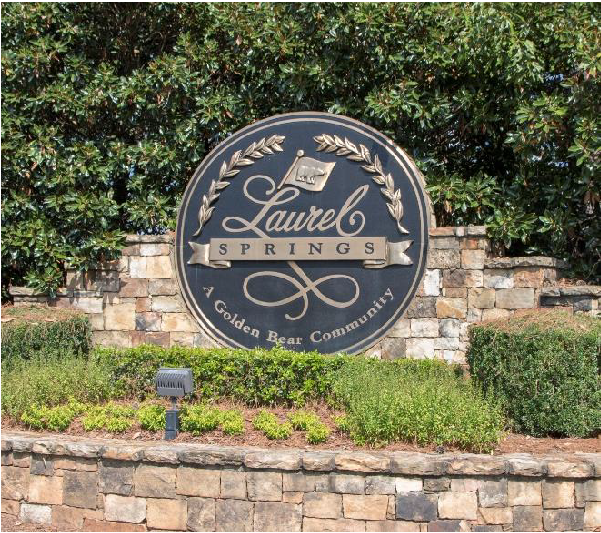
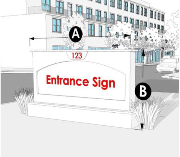
8.6.12. Monument Signs

A.
Definition
A permanently affixed sign which is wholly independent of a building for support and attached to the ground along its entire length.
B.
General Provisions
1.
The base of the monument sign must be at least two-thirds the width of the sign itself.
2.
The base of the monument sign must be faced in brick, masonry, stucco, or stone, unless otherwise specified in Sec. 8.6.18 for the Gateway Corridors Overlay District.
3.
On corner lots, monument signs must be at least 50 feet from lot corner (defined by the lot lines extended).
4.
Signs must be at least 15 feet from all property lines.
C.
Number of Signs
One monument sign is allowed along each street that the lot has frontage on, unless otherwise specified in Sec. 8.6.14 or Sec. 8.6.15.
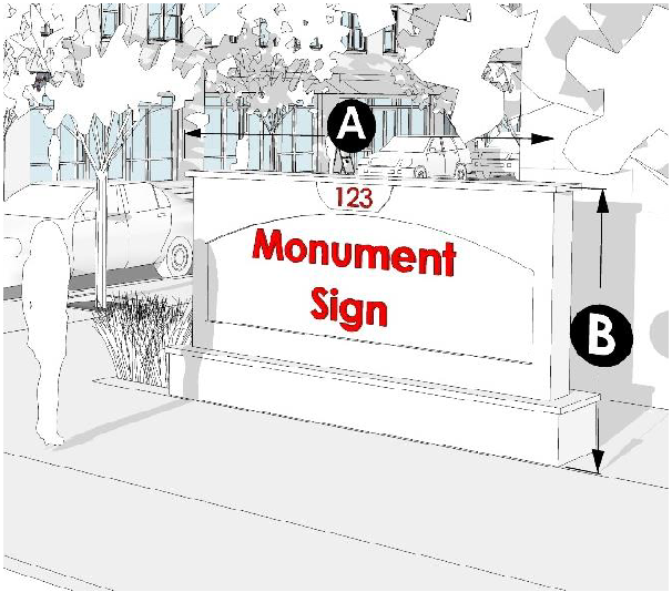
D.
Sign Area
1.
O-I, S-S, P-C, H-B, M-U, I-1, and I-2 zoning districts. Determined by building gross floor area:
a.
0—10,000 sf.: max. 32 sf. (each side)
b.
10,001—50,000 sf.: max. 48 sf. (per side)
c.
50,001—100,000 sf: max. 64 sf. (per side)
d.
Over 100,000 sf.: max. 96 sf. (per side)
2.
All other zoning districts. See Sec. 8.6.14 and Sec. 8.6.15.
E.
Sign Dimensions
Ⓐ Sign width: no max.
Ⓑ Sign height:
O-I, S-S, P-C, H-B, M-U, I-1, and I-2 zoning districts. Determined by building gross floor area:
a.
0—50,000 square feet: maximum 8 feet.
b.
50,001—100,000 square feet: maximum 10 feet.
c.
Over 100,000 square feet: maximum 12 feet.
All other zoning districts: maximum 6 feet.
8.6.13. Projecting Signs

A.
Definition
A sign which is attached perpendicular to a building or other structure and extends more than 12 inches horizontally from the plane of the building facade.
B.
General Provisions
1.
Must be at least 18 inches from a vertical plane at the street curb line.
2.
May not project beyond property lines.
C.
Number of Signs
1.
One awning sign, or one canopy sign, or one wall sign, or one projecting sign is allowed per establishment along the side of the establishment that includes its public entrance.
2.
One additional awning sign, or one additional canopy, or one additional wall sign, or one addition projecting sign is allowed along each facade adjacent to a public right-of-way.
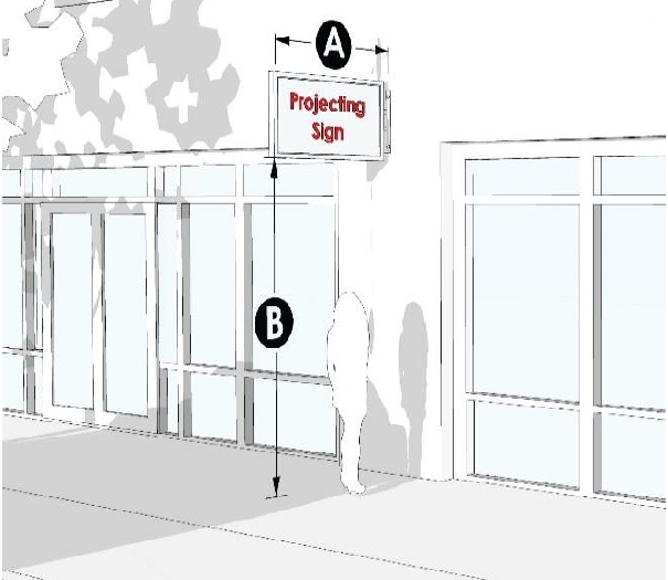
D.
Sign Area
1.
The maximum area is 64 square feet per building, or one square foot per linear foot of storefront, whichever is greater.
2.
A tenant with less than 16 linear feet of storefront is allowed one sign not exceeding 16 square feet in sign area.
E.
Sign Dimensions
Ⓐ Projection from facade: max. 5 feet.
Ⓑ Clear height above walkways or other nonvehicular areas: minimum 10 feet.
Ⓑ Clear height above parking, driveways, or other vehicle access: minimum 14 feet.
8.6.14. AG-1, AR-1, R-1-L, R-1, R-TF, R-X and PRD Zoning Districts
The following additional standards apply in AG-1, AR-1, R-1-L, R-1, R-TF, R-X and PRD zoning districts:
A.
Nonresidential Uses
Nonresidential uses are allowed one canopy sign, or one wall sign, or one projecting sign, or one freestanding sign, with a maximum area of 20 square feet and the maximum height of 6 feet.
B.
Residential Business Signs
1.
AG-1, AR-1, R-1-L, R-TF, R-X and PRD zoning districts. Residential businesses are allowed one nonilluminated freestanding sign with a maximum sign area of 16 square feet and a maximum height of 5 feet. The location must be approved by the planning commission.
2.
R-1 zoning district. No sign is allowed.
C.
Rural Business Signs
Rural businesses are allowed one nonilluminated freestanding sign not exceeding 16 square feet in area. The location must be approved by the planning commission. The sign must be at least 15 feet from all property lines.
8.6.15. R-MF and MHP Zoning Districts
The following additional standards apply in RMF and MHP zoning districts:
A.
Nonresidential Uses
Nonresidential uses are allowed one canopy sign, or one wall sign, or one projecting sign, or freestanding sign, with a maximum area of 30 square feet and the maximum height of 6 feet.
B.
Residential Business Signs
Residential businesses are allowed one nonilluminated freestanding sign, including a monument sign, with a maximum area of 16 square feet and a maximum height of 5 feet. The location must be approved by the Planning Commission.
C.
Rural Business Signs
Rural businesses are allowed one nonilluminated freestanding sign not exceeding 16 square feet in area. The location must be approved by the Planning Commission. The location must be at least 15 feet from all property lines.
8.6.16. O-I, S-S, H-B, M-U, I-1, and I-2 Zoning Districts
The following additional standards apply in O-I, S-S, H-B, M-U, I-1, and I-2 zoning districts:
A.
Master plan for signs in multi-tenant developments
For all multi-tenant buildings or developments, a coordinated program of wall signs must be developed and approved by the county at the time of site plan approval. The signage master plan must specify the sign type, design, height, colors, illumination, and other specifications to give a coordinated appearance to the building or development. The county's review and approval of the signage master plan must be based on the compatibility of the proposed signage with the siting and architecture of the subject building or development and the compatibility of the signage with surrounding land uses.
8.6.17. Standards for Fuel Sales
Fuel sales facilities are allowed additional signage as follows:
A.
One sign per canopy facade per public street frontage with a maximum of 16 square feet is allowed, provided that the area used to display this information is no larger than 8 square feet and does not extend above or below the edge of the canopy.
B.
Spreader bars (signs located under canopy over pump islands) are limited to no more than two signs per spreader bar, not exceeding 4 square feet per sign. However, the total area for all spreader bars may not exceed 24 square feet.
8.6.18. Gateway Corridors Overlay
The following additional standards and restrictions apply to civic, commercial, industrial, and other nonresidential uses in the Gateway Corridor Overlay district:
A.
Monument Signs
The monument sign structure must be constructed of the same materials that are used in the facade of the principal building.
B.
Sign Illumination
1.
Automatic changeable copy signs are prohibited, except for public buildings and uses, as these terms are defined in Sec. 7.4.
2.
Externally mounted neon signs are prohibited.
3.
Signs may be illuminated with external lighting fixtures provided that fixtures are directed downward and away from streets and adjacent property and public streets. All lighting shall have recessed luminaries or be semi-cutoff luminary fixtures.
4.
Internally illuminated signs are permitted subject to the standard of illumination in Sec. 8.6.1.D.4.
8.6.19. Standards for Billboards
A.
General Standards
Sec. 8.6.18 prohibits the erection of new billboards in Hall County and the reconstruction of existing billboards to the fullest extent to be consistent with state and federal law or with the provisions allowing for the reduction of the overall number of billboards within Hall County, per Sec. 8.6.19.C.
1.
Permit required. No billboard may be permitted to be erected or reconstructed without a permit from the county building official.
2.
No new billboards. After the effective date of this UDC, the county building official may not issue permits for new billboard structures except as required by Georgia or federal law and/or permitted by Sec. 8.6.19.C.
3.
Billboards are primary structures. After the effective date of this UDC all billboards are classified as primary structures, and no billboard may be located on any lot or parcel that contains another primary structure. Lots or parcels that contain both a billboard and another primary structure will be nonconforming and will be subject to the nonconforming use provisions of this UDC.
B.
Location, area and height
All billboard structures required to be permitted under state or federal law, and erected so as to be visible from any public, state or federal road must conform to the following standards:
1.
General. All billboard structures erected abutting or so as to be visible from the right-of-way of any state highway that is a limited or controlled access highway shall conform with O.C.G.A. § 32-6-75, and must meet all federal and state requirements necessary to obtain a permit under said code. In instances where the sign controls of this UDC are stricter, these regulations apply.
2.
Structure type. Only one sign may face the same direction per location. This allows back-to-back or V-formation signs, provided they are joined by a mutual or attached frame, but prohibits two signs stacked or side-by-side facing the same direction.
3.
Setback. All structures must be set back at least 15 feet from any property or right-of-way line.
4.
Spacing
a.
All roads except divided lane four-lane highways and limited or controlled access highways. No billboard structure may be within 500 feet of another billboard along the same side of the road or within 1,000 feet of any residential or agricultural district, public park, public building or religious building, regardless of whether the measurements extend outside of county limits.
b.
Divided four-lane highways and limited or controlled access highways. No billboard structure may be within 500 feet of another billboard, measuring from the two closest points, regardless of whether the measurements extend outside of county limits.
5.
Maximum sign area
a.
All roads except divided lane four-lane highways and limited or controlled access highways. The maximum sign area permitted for each face of the structure shall not exceed 64 square feet with or without trim.
b.
Divided four-lane highways and limited or controlled access highways. The maximum sign area permitted for each face of the structure may not exceed 100 square feet with or without trim.
6.
Sign height. Signs must be at least 10 feet above the adjacent road measuring from the lower portion of the sign face. No sign may exceed the height of 35 feet from either the level of the road or the ground surface, whichever is higher. Two signs in the same location back-to-back or in a V-formation must be the same height above the pavement surface.
7.
Extrusions prohibited. Extrusions beyond the face of the sign, excluding aprons, are prohibited.
8.
Lighting. No illumination of off-premises signs is allowed.
C.
Digital billboard conversion and location
Any legally erected billboard may be converted to a digital billboard so long as it meets the following limitations:
1.
Replacing a static billboard with a digital billboard
a.
Two square feet of existing static billboard display must be removed within the county limits for each one square foot of digital billboard display area, either newly constructed or installed as a modification and/or conversion of an existing static billboard. The two square feet removed must be from physically completed static billboards with complete sign faces. No partially erected or partially completed signs may be used to qualify for the requirement.
b.
The applicant must provide an inventory of their outdoor advertising sign locations within the county. A company that converts an existing static billboard to a digital billboard must provide, with each permit application, a complete current inventory of its billboards located within the corporate limits of Hall County. The inventory must include per structure: location (longitude/latitude), size, number of faces and type of illumination.
c.
No person may convert an existing static billboard structure to a digital billboard structure without first obtaining a sign permit as required by this Sec. 8.6.19.C. and all other applicable county permits required for improvements.
d.
Digital billboards shall be the same size or smaller than the static billboard being replaced.
e.
A digital billboard replacing a nonconforming static billboard may be permitted if approved by the county Board of Commissioners.
2.
Construction of digital billboards in new locations
a.
After removing two square feet of existing static billboard display per Sec. 8.6.19.C.1.a., a new structure may be erected containing a digital billboard if the location is approved by the county Board of Commissioners.
b.
The county Board of Commissioners has the right to permit the installation of a new digital billboard structure in any location within the county so long as the location complies with all applicable state and federal regulations pertaining to outdoor advertising, and these regulations.
3.
Digital billboard operational standards
a.
Digital billboards must display static images for a period of at least ten seconds before instantaneously transitioning to another static image.
b.
Animation, frame effects, flashing and the appearance of movement whatsoever are explicitly prohibited.
c.
All digital billboards must be equipped with automatic dimming technology which automatically adjusts the sign's brightness based on ambient light conditions.
d.
No digital billboard may exceed a brightness level of 0.3 foot-candles above ambient light as measured using a foot-candle meter at a preset distance depending on sign area. Measuring distance will be determined by the following equation: the square root of the product of the sign area and 100.
Example using a 200 square foot digital billboard:
(200×100) = 141.4 feet measuring distance.
e.
The county will from time to time check the brightness of each digital billboard to verify the levels specified in Sec. 8.6 are met. If the owner of a sign fails to control brightness within these limits, the sign permit will be revoked. If a permit is revoked, the sign must be turned off immediately and must remain off unless and until the sign is re-permitted. Re-permitting requires the owner to reapply in accordance with the procedures in place at the time of the new permit application, including paying fees required for a new permit.
f.
All digital billboards must have a switch or circuit breaker located on the property that allows electrical power to be turned off. The owner of each digital billboard must provide the county contact information for a 24-hour, seven-day/week contact person who has the authority and is able to turn off the sign promptly if a malfunction occurs. If at any time more than 30 percent of the digital display lights malfunction or are no longer working property, the owner of the digital billboard shall turn off the electronic display until repairs are made.
4.
Emergency compliance. The permit holder of a digital billboard must coordinate with governmental authorities to display, when appropriate, emergency information important to the traveling public, such as Amber Alerts or alerts concerning terrorist attacks, or natural disasters. Emergency information messages must remain in the advertising rotation according to the protocols of the agency that issues the information, or protocols established by the Georgia Department of Transportation.
D.
Nonconforming billboards
Any legally erected sign that would become nonconforming as a result of Sec. 8.6 is allowed to remain in accordance with this Code, or until purchased by the Georgia Department of Transportation or the county, provided that the sign owner meets the requirements of state laws and rules and regulations governing such signs. No nonconforming billboard may be increased in size or height or relocated on the property, but may be decreased in size or height and/or may be converted to a digital billboard subject to Sec. 8.6.19.C.
8.6.20. Nonconformities
A.
Signs related to nonconforming uses
Signs related to nonconforming uses, and located on the same lot or property as the nonconforming use, may continue to exist, but may not be increased in size or number, and may not be relocated on the same site unless the relocation of the existing sign brings it into greater conformity with the provisions of this Sec. 8.6 that would apply if the use were a permitted use in that zoning district.
B.
Nonconforming signs
1.
A building or freestanding sign that lawfully existed on the effective date of this UDC may continue to be used, except that the nonconforming sign:
a.
May not be repaired, rebuilt, replaced or altered after damage or removal exceeding 50% of the sign structure.
b.
May not be enlarged or altered in a way that increases its nonconformity.
c.
May not be altered for a change in use, change in ownership or change in business name. Individual sign panels not exceeding 50% of the total sign face area of a multi-tenant freestanding sign may be replaced for a change in use or change in business name.
2.
The owner of a nonconforming sign who wishes to apply for its continued use, and who makes an application for such within one year from the date such sign became nonconforming, will have their application fee waived. An owner who submits their application for the continued use of a nonconforming sign within two years of the date such sign became nonconforming will have one-half of the application fee waived. Any owner of a nonconforming sign must apply for its continued use after the expiration of two years from the date the sign became nonconforming must pay the full application fee as required by Sec. 11.2.
3.
Nonconforming signs associated with Legacy Uses, as defined in Sec. 7.1.6, may be re-used upon approval of a conditional use permit for such use.