
Hardeeville City Zoning Code
ARTICLE 2
- ZONING DISTRICTS
2.1. - General Provisions.
This Article establishes the zoning districts and contains basic information pertaining to zoning districts, primarily statements of purpose and district-specific regulations. The following Articles 3, Use Regulations, and 4, General Development Standards, set forth the uses allowed within the districts and the development standards that apply in the districts.
A.
Establishment of Districts and District Boundaries. For the purpose of this Ordinance, the City of Hardeeville and the Hardeeville-Jasper County Joint Planning Area are hereby divided into the following zoning districts:
B.
Official Zoning Map. The boundaries of the above zoning districts are indicated on a map or series of maps entitled "Official Zoning Map, Hardeeville, South Carolina," which, together with all explanatory matter thereon, are hereby adopted by references and declared to be a part of this Ordinance. Each map bearing the designation "Official Zoning Map, Hardeeville, South Carolina", shall be identified by the signature of the Mayor and attested by the Clerk, under the words: "Official Zoning Map, Hardeeville, South Carolina", together with the date of adoption of this Ordinance and the seal of the City. If, in accordance with the provisions of this Ordinance and the South Carolina Local Government Comprehensive Planning Enabling Act of 1994, as amended, changes are made in district boundaries or other matter portrayed on the Official Zoning Map, such changes shall be caused to be entered on the Official Zoning Map promptly by the Planning Director within seven (7) days after the amendment has been approved by the Mayor and Council. Such changes shall be made available by the City Clerk. No amendment to this Ordinance that involves matter portrayed on the Official Zoning Map shall become effective until after such changes have been made on said Map. No changes of any nature shall be made on the Official Zoning Map or matter shown thereon except in conformity with the procedures set forth in this Ordinance. Any unauthorized changes of whatever kind by any person or persons shall be considered a violation of this Ordinance and punishable as provided by law. Regardless of the existence of purported copies of the Official Zoning Map, which may from time to time be physically or electronically published, the Official Zoning Map will be maintained in paper form within the custody of the City Clerk pursuant to Section 1-6 (14) of the Hardeeville Code of Ordinances. This map information shall be the final authority as the current zoning status of land and water areas, buildings and other structures in the City. Copies of the Official Zoning Map as adopted and thereafter amended shall be updated regularly on the City of Hardeeville's Geographic Information System, which shall be located in the office of the Planning Director.
1.
Rules for Interpretation of District Boundaries. Where uncertainty exists as to the boundaries of districts as shown on the Official Zoning Map, or the FEMA Flood Hazard Boundary Maps, the following rules shall apply:
a.
Boundaries indicated as approximately following the center lines or right-of-way lines of streets, highways, alleys, railways, or public utility easements shall be construed to follow such lines.
b.
Boundaries indicated as approximately following platted lot or tract lines shall be construed as following such lines, whether public or private.
c.
Boundaries indicated as approximately following incorporated areas or County limit lines, or special district lines, as amended from time to time, shall be construed to follow such lines.
d.
Boundaries indicated as approximately following the center, mean high water mark, or shoreline of streams, rivers, canals, lakes or other bodies of water, flood plains or low lands, shall be construed to follow such boundaries.
e.
Boundaries indicated as parallel to or extensions of features indicated in subsections a through d above shall be so construed. When distances are not specifically indicated on the Official Zoning Map or in other circumstances not covered by subsections a through d above, the Board of Zoning Appeals shall interpret the district boundaries.
C.
Additions or Reductions in Total Land Area. Where the total land area within the jurisdiction of this Ordinance is increased or reduced by any means, the following conditions shall apply:
1.
When the changes result in an increase in land area within the jurisdiction of this Ordinance, said land area whether previously a part of a Municipality or not, shall be zoned accordingly and approved by the Mayor and Council through the normal amendment procedure. In the event any land shall inadvertently or otherwise fail to be zoned, such land shall have a default zoning designation of RA until such time as the landowner shall request a re-zoning.
2.
When reductions are made in the area under the jurisdiction of this Ordinance the provisions of this Ordinance shall no longer apply to that land area.
3.
In all cases, where additions or reductions in land area under the jurisdiction of this Ordinance require adjustments in the zoning, the requirements of State and local law shall be adhered to in all respects.
D.
Relationship to Overlay Districts. All lands within the jurisdiction of this Ordinance shall be designated as one (1) of the base zoning districts set forth in Sections 2.2 or 2.3. In addition, some lands may be designated as one (1) or more of the special purpose and overlay districts set forth in Section 2.4. Where the property is designated as an overlay district as well as a base zoning district, the regulations governing development in the overlay district shall apply in addition to the regulations governing development in the underlying base district. In the event of a conflict between the two sets of standards, the standards for the overlay district shall control.
2.2. - Residential Districts.
A.
General Purposes of Residential Districts. The residential zoning districts contained in this Section are intended to:
1.
Provide appropriately located areas for residential development that are consistent with the Comprehensive Plan and with standards for public health, safety, and general welfare;
2.
Allow for a variety of housing types that meet the diverse economic and social needs of residents;
3.
Protect the scale and character of existing residential neighborhoods and community character;
4.
Discourage any use that would generate traffic or create congestion on neighborhood streets other than the normal traffic that serves the residents of the district; and
5.
Discourage any use that, because of its character or size, would create additional requirements and costs for public services that are in excess of such requirements and costs if the district were developed solely for the intended type of residential uses.
B.
Specific Purposes of Residential Districts.
1.
Single-Family Residential District (SFR1). The SFR1 District is intended to be developed and reserved for low-density residential purposes. The regulations that apply within this District are designed to encourage the formation and continuance of a stable, healthy environment for single-family dwellings situated on individual lots in typical suburban-style developments. This District is intended to discourage any encroachment by intense commercial, industrial, or other uses capable of adversely affecting the residential character of the district while continuing to be in close proximity to neighborhood commercial-style services and conveniences. Residents of this District should expect a varied range of public services. In established residential subdivisions, lots that are in excess of the minimum lot size shall be allowed a one-time subdivision only if the minimum lot dimensions of the newly created lots are within fifteen (15%) percent of the surrounding established residential neighborhood.
2.
Single-Family Residential District (SFR2). The SFR2 District is intended to be developed and reserved for moderate-density residential purposes. The regulations that apply within this District are designed to encourage the formation and continuance of a stable, healthy environment for single-family dwellings situated on individual lots in typical suburban-style developments. This District is intended to discourage any encroachment by intense commercial, industrial, or other uses capable of adversely affecting the residential character of the district while continuing to be in close proximity to neighborhood commercial-style services and conveniences. Residents of this District should expect a varied range of public services. In established residential subdivision, lots that are in excess of the minimum lot size shall be allowed a one-time subdivision only if the minimum lot dimensions of the newly created lots are within fifteen (15%) percent of the surrounding established residential neighborhood.
3.
Multi-Family Residential District (MFR). The MFR District is intended to be developed and reserved for medium-to-high density residential purposes. The regulations that apply within this District are designed to encourage the formation and continuance of a stable, healthy environment for several different types of dwellings situated on lots of four thousand (4,000) square feet or more at a maximum density of sixteen (16) units per acre. This district should be located in areas near commercial centers and services. The District will be used to buffer single-family development from more intense commercial areas. Where adjacent lots are assimilated for development in a established single family residential neighborhood, for the purpose of constructing multi-family units, such a request will be submitted as a Special Exception pursuant to the standards of Section 7.7.
2.3. - Nonresidential Districts.
A.
General Purpose of Nonresidential Districts. The nonresidential zoning districts contained in this Section generally are intended to:
1.
Provide appropriately located areas consistent with the Comprehensive Plan for retail, service, office, and industrial uses;
2.
Strengthen the City's economic base and provide employment opportunities close to home for residents of the City and surrounding communities; and
3.
Minimize any negative impact of nonresidential development on adjacent residential districts.
B.
Specific Purposes of Nonresidential Districts.
1.
Rural Commercial (RC). The RC District is intended to be developed to provide conveniences and support for rural areas. Intensive commercial development will not be allowed. The uses allowed in this District will support farm uses and provide necessary services on a small scale. Development standards will ensure these uses are compatible with the rural communities that they serve.
2.
General Commercial District (GC). The GC District is intended to be developed and reserved for general business purposes. The regulations which apply within this District are designed to encourage the formation and continuance of a compatible and economical environment for businesses, financial, service and professional uses which benefit from being located in close proximity to each other; and discourage any encroachment by industrial, residential or other uses considered capable of adversely affecting the basic commercial character of the District. Manufactured housing units shall not be considered as acceptable structures for offices or places of business within this District.
3.
Highway Commercial District (HC). The HC District is intended to be developed with particular consideration for truck or automobile-oriented commercial development existing or proposed along principal highways passing through the city and in the vicinity of key interchanges or intersections. The regulations which apply within this District are designed to encourage the formation and continuance of a compatible and economically healthy environment for businesses, and services designed to serve the traveling public; and to discourage any encroachment by industrial, commercial, residential or other uses considered capable of adversely affecting the basic intent of the District. Manufactured Housing Units shall not be considered as acceptable structures for offices or places of business within this District.
4.
Limited Industrial District (LI). The LI District is intended to provide areas for limited industrial purposes which are not significantly objectionable in terms of noise, odor, fumes, etc., to surrounding properties. The regulations which apply within this District are designed to encourage the formation and continuance of a compatible environment for uses generally classified to be limited industrial in nature; protect and reserve undeveloped areas in Hardeeville which are suitable for such industries; and discourage encroachment by those residential, commercial or other uses capable of adversely affecting the basic industrial character of the District. Manufactured housing units shall not be considered as acceptable structures for offices or places of business within this District.
5.
Basic Industrial District (BI). The BI District is intended to promote the development and continued use of land for large-scale basic or primary industrial purposes which involve extensive manufacturing, processing or assembly operations; and preserve underdeveloped sizable tracts of land with industrial potential for industrial uses. Manufactured housing units shall not be considered as acceptable structures for offices or places of business within this District.
2.4. - Special Purpose and Overlay Districts.
A.
Conservation Preservation District (CP).
1.
Purpose. The CP District is intended to preserve and/or control development within certain land, marsh and/or water areas in Hardeeville which: 1) serve as wildlife refuges; 2) require protection from an environmental or ecological standpoint; 3) possess great natural beauty or are of historical significance; 4) are utilized for outdoor recreational purposes; 5) provided needed open space for the health and general welfare of the City's inhabitants; and/or 6) are subject to periodic flooding. The regulations which apply within this District are designed to reserve such areas for the purposes outlined herein and to discourage any encroachment by residential, commercial, industrial, or other uses capable of adversely affecting the relatively undeveloped character of the District.
2.
District Standards. No use or activity, including those listed as allowed in Article 3, shall be permitted in a CP District that would disturb, destroy, or impair the natural fauna, flora, water regimen or topography.
B.
Mixed Use District (MU).
1.
Purpose. The MU District is intended to be developed and reserved for village-style or neighborhood-oriented business purposes in conjunction with medium- to high-density residential development. This type of development will allow small nodes of neighborhood conveniences to be accessed by community-wide sidewalks or pedestrian ways. Development standards will allow minimal setbacks, narrow streets, and alleyways for services and rear access. Pocket parks and open space will provide amenities for these communities. The regulations that apply within the District are designed to encourage the formation and continuance of a stable, healthy, and compatible environment for uses that are located so as to provide nearby residential areas with convenient shopping and service facilities; reduce traffic and parking congestion; and discourage industrial and other encroachments capable of adversely affecting the localized commercial character of the District. Trailers and mobile homes shall not be considered as acceptable structures for offices or places of business within this District.
2.
District Standards.
a.
Applicability. These standards apply to traditional neighborhood developments (village-style or neighborhood-oriented), which are new developments within the MU District of fifteen (15) acres or more or redevelopment or infill development within the MU District.
b.
Neighborhood Uses. In order to achieve the proximity necessary to make neighborhoods walkable, it is important to mix land uses. A Mixed Use District should consist of a mix of residential uses, a mixed use area, and open space as provided below:
i.
Residential Uses. A mix of residential uses may occur anywhere in the Mixed Use District. For infill development, the mix of residential uses may be satisfied by existing residential uses adjacent to the Mixed Use District.
ii.
Mixed Use Area. A mixed use area of commercial, residential, civic or institutional, and open space uses as allowed in Section 3.1, Table of Allowed Uses. Individual businesses shall not exceed ten thousand (10,000) square feet in size. Exceptions to this maximum size requirement shall only be granted by special exception through the Board of Zoning Appeals subject to the criteria in Section 7.7.
iii.
Open Space. Open space uses should be incorporated in this District. Large outdoor recreation areas should be located at the periphery of neighborhoods rather than in central locations.
c.
Development Units. The number of residential dwelling units (excluding open spaces) shall be determined as follows:
i.
In areas devoted to mixed residential uses:
(A)
The number of single-family attached and detached units permitted shall be four (4) dwelling units per net acre.
(B)
The number of multi-family units shall be sixteen (16) dwelling units per net acre.
(C)
Secondary dwelling units shall be permissible in addition to the number of dwelling units authorized under this Section. However, the total square footage of the accessory dwelling unit is eight hundred (800) sq. ft. and must meet all other standards of this Ordinance.
d.
Open Space. Subject to the limitations of Section 4.3 Open Space.
e.
Block and Lot Size Diversity. Street layouts should provide for perimeter blocks that are generally in the range of two hundred (200) to four hundred (400) feet deep by four hundred (400) to eight hundred (800) feet long. A variety of lot sizes should be provided to facilitate housing diversity and choice and meet the projected requirements of people with different housing needs.
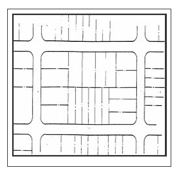
Plan-view diagram of a street grid showing a diversity of lot (parcel) sizes.
f.
Lot Widths. Lot widths should create a relatively symmetrical street cross section that reinforces the public space of the street as a simple, unified public space.
g.
Circulation Standards. The circulation system shall allow for different modes of transportation. The circulation system shall provide functional and visual links within the residential areas, mixed use area, and open space of the traditional neighborhood development and shall be connected to existing and proposed external development. The circulation system shall provide adequate traffic capacity, provide connected pedestrian and bicycle routes (especially off street bicycle or multi-use paths or bicycle lanes on the streets), control through traffic, limit lot access to streets of lower traffic volumes, and promote safe and efficient mobility through the traditional neighborhood development.
i.
Pedestrian Circulation. Convenient pedestrian circulation systems that minimize pedestrian-motor vehicle conflicts shall be provided continuously throughout the development. Where feasible, any existing pedestrian routes through the site shall be preserved and enhanced. All streets, except for alleys, shall be bordered by sidewalks on both sides. The following provisions also apply:
(A)
Sidewalks in Residential Areas. Clear and well-lighted sidewalks, four (4) feet in width, depending on projected pedestrian traffic, shall connect all dwelling entrances to the adjacent public sidewalk.
(B)
Sidewalks in Mixed Use Areas. Clear and well-lighted walkways shall connect building entrances to the adjacent public sidewalk and to associated parking areas. Such walkways shall be a minimum of seven (7) feet in width.
ii.
Bicycle Circulation. Bicycle circulation shall be accommodated on streets and/or on dedicated bicycle paths. Where feasible, any existing bicycle routes through the site shall be preserved and enhanced. Facilities for bicycle travel may include off-street bicycle paths (generally shared with pedestrians and other non motorized users) and separate, striped, four (4) foot bicycle lanes on streets. If a bicycle lane is combined with a lane for parking, the combined width should be fourteen (14) feet.
iii.
Public Transit Access. Where public transit service is available or planned, convenient access to transit stops shall be provided. Where transit shelters are provided, they shall be placed in highly visible locations that promote security through surveillance, and shall be well-lighted.
iv.
Motor Vehicle Circulation. Motor vehicle circulation shall be designed to minimize conflicts with pedestrians and bicycles. Traffic calming features such as "queuing streets," curb extensions, traffic circles, and medians may be used to encourage slow traffic speeds.
The orientation of streets should enhance the visual impact of common open spaces and prominent buildings create lots that facilitate passive solar design, and minimize street gradients. All streets shall terminate at other streets or at public land, except local streets may terminate in stub streets when such streets act as connections to future phases of the development. Local streets may terminate other than at other streets or public land when there is a connection to the pedestrian and bicycle path network at the terminus.
v.
Street Hierarchy. Subject to standards of Section 4.10B.
h.
Parking Requirements. The parking requirements below are in addition to any requirements established by Section 4.6, Parking and Loading.
i.
Parking areas for shared or community use are encouraged.
ii.
In the mixed use area, any parking lot shall be located at the rear or side of a building. If located at the side, screening shall be provided as specified in Section 4.5, Landscaping and Tree Conservation.
iii.
A parking lot or garage may not be adjacent to or opposite a street intersection.
iv.
In the mixed use area, a commercial use must provide one (1) parking space for every five hundred (500) square feet of gross building area.
v.
Parking lots or garages must provide not less than one (1) bicycle parking space for every ten (10) motor vehicle parking spaces.
vi.
Adjacent on-street parking may apply toward the minimum parking requirements.
i.
Service Access. Access for service vehicles should provide a direct route to service and loading dock areas, while avoiding movement through parking areas.
j.
Paving. Reduction of impervious surfaces through the use of interlocking pavers is strongly encouraged for areas such as remote parking lots and parking areas for periodic uses.
k.
Architectural Standards. A variety of architectural features and building materials should give each building or group of buildings a distinct character.
i.
Entries and Facades.
(A)
The architectural features, materials, and the articulation of a facade of a building shall be continued on all sides visible from a public street.
(B)
The front facade of the principal building on any lot in a Mixed Use District shall face onto a public street.
(C)
The front facade shall not be oriented to face directly toward a parking lot.
(D)
Porches, pent roofs, roof overhangs, hooded front doors or other similar architectural elements shall define the front entrance to all residences.
(E)
For commercial buildings, a minimum of fifty (50%) percent of the front facade on the ground floor shall be transparent, consisting of window or door openings allowing views into and out of the interior.
(F)
New structures on opposite sides of the same street should follow similar design guidelines. This provision shall not apply to buildings bordering civic uses.
l.
Guidelines for Lighting. Street lighting shall be provided along all streets. Generally more, smaller lights, as opposed to fewer, high-intensity lights, should be used. Street lights shall be installed on both sides of the street at intervals of no greater than seventy-five (75) feet.
C.
Downtown General Commercial (DGC).
1.
Purpose. Hardeeville seeks to preserve, promote and control infill development and revitalization in its traditional city core. History demonstrates that a few traditional urban design conventions will generate building types and neighborhood forms which allow profitable, positive infill and change, which strengthen property values and appearance, and which offer a high quality of life. This District establishes new standards for land development in order to:
a.
Preserve and extend the historic neighborhood character through the design and placement of building types and public spaces;
b.
Create high-quality street spaces by using buildings to form an interesting and safe environment that works for pedestrians, bicyclists and motorists;
c.
Enhance the viability of local businesses and reduce travel demand by focusing growth in appropriate locations;
d.
Provide a measure of predictability to property owners and occupants about what may be built on their land or that of their neighbors, yet allow for a market-driven mixture of land uses; and
e.
Encourage a wide range of building types and sizes that will offer a measure of self-sufficiency and sustainability, and which will adapt gracefully to change over time.
In the case of conflict between these standards and any other local land development regulation, these standards shall apply.
2.
Application Requirements. The following items are required for review, unless deemed not applicable by the Planning Director:
a.
A current Site Survey, no more than one (1) year old.
b.
A current Tree Survey, no more than one (1) year old.
c.
A Site Plan, drawn to scale, which shall indicate:
i.
Building locations;
ii.
Parking locations and number of spaces;
iii.
Paved surfaces, materials and location(s);
iv.
Site location diagram and legal description;
v.
Building elevations illustrating all sides of all structures; and
vi.
Other reasonable supporting documents to indicate intentions and/or any other items required by the Architectural/Overlay Review Board.
3.
General Provisions.
a.
Fences, Garden Walls, and Hedges. Fences, garden walls, or hedges are strongly encouraged and, if built, should be constructed along all unbuilt rights-of-way which abut streets and alleys. Maximum height shall be forty-eight (48) inches along front and side property lines adjacent to streets. Maximum height for rear and interior property lines shall be seventy-two (72) inches. Pillars and posts may extend up to six (6) inches above the height limitations provided such pillars and posts average no more than ten (10) feet apart. Fences and garden walls shall be a minimum of twenty-five (25%) percent opaque. Fences made of chain-link (wholly or in part) are prohibited along all right-of-way lines which abut streets.
b.
Size. Buildings shall not exceed ten thousand (10,000) square feet in size. Exceptions to this maximum size requirement shall only be granted by special exception through the Board of Zoning Appeals.
c.
Parking. Parking shall be placed along streets and in small, strategically located on-site lots.
i.
Off-Street Parking Lot Location and Design.
(A)
Wherever possible, parking lots shall be located behind buildings, such that buildings separate parking areas from the street. In cases where this is not possible, parking can be located to the side of building, but in no case shall the parking area be wider than fifty (50%) percent of the lot frontage and in no case shall parking be located in front of a building.
(B)
Buildings that have both rear and side access shall access parking through the rear.
(C)
Front driveways to rear parking areas are permitted only where rear or side street access is unavailable.
(D)
Access through parking lots across property lines should be encouraged, especially when there is no alley.
(E)
Circular drives must be approved on a case-by-case basis
(F)
Garage door(s) shall be positioned no closer than twenty (20) feet behind the principal plane of the building front. Where space permits, garage doors shall face the side or the rear, not the front.
ii.
Interior Parking Lot Landscaping Requirements.
(A)
Landscaped islands are required in parking areas at the following intervals for either head-in or diagonal parking stalls: No more than eight (8) consecutive parking stalls are permitted without a landscape break of at least six (6) feet in width and extending the entire length of the parking stall. Each landscape break shall have at least one (1) tree for every ninety (90) square feet of area, or portion thereof, and be covered with grass, shrubs, or living ground cover. To minimize water consumption, the use of low-water vegetative ground cover other than turf is encouraged.
(B)
In lieu of landscaped islands, landscape strips of at least six (6) feet in width can be provided between parking isles. Landscape strips shall have the same landscape requirements as landscape islands.
d.
Accessory Structures. Accessory structures are permitted and may contain parking, storage space, and/or accessory dwelling units.
Accessory dwelling units shall not be greater than six hundred twenty-five (625) square feet in area.
e.
Exceptions from Build-To Lines. Exceptions from build-to lines may be granted for avoiding trees with calipers greater than eight (8) inches DBH.
f.
Architectural Guidelines. The lists of permitted materials come from study of traditional buildings found in South Carolina and have been selected for their appropriateness to the visual environment and climate.
A primary goal of the architectural guidelines is authenticity. The guidelines encourage construction which is straightforward and functional, and which draws its ornament and variety from the traditional assembly of genuine materials. The Architectural/Overlay Review Board shall have authority to approve substitute materials for those listed as options under.
i.
General Requirements. The following shall be located in rear yards or side yards not facing side streets:
(A)
Air-conditioning compressors;
(B)
Irrigation and pool pumps;
(C)
Clotheslines;
(D)
Clothes-drying yards;
(E)
Electrical utility meters;
(F)
Antennas; and
(G)
Permanent barbecues.
The following are prohibited:
(A)
Undersized shutters (the shutter or shutters must be sized so as to equal the width that would be required to cover the window opening);
(B)
Plastic shutters within fifteen (15) feet of the right-of-way;
(C)
Reflective and/or bronze-tint glass;
(D)
Plastic or PVC roof tiles;
(E)
Backlit awnings;
(F)
Glossy-finish awnings;
(G)
Styrofoam cornices; and
(H)
Front-yard fences made of chain link, barbed wire, or plain wire mesh. Wire mesh fences may be permitted if installed in conjunction with landscaping which will provide minimum of twenty-five (25%) percent opacity.
ii.
Building Walls.
(A)
Permitted Finish Materials.
(1)
Wood siding, painted or natural (cypress and cedar preferred);
(2)
Cement-fiber siding (Hardi-Plank or equal);
(3)
Concrete masonry units with stucco (C.B.S.);
(4)
Reinforced concrete with stucco;
(5)
Brick; and
(6)
Tabby.
(B)
The following are prohibited:
(1)
Vinyl siding (shall only be approved on a case-by-case basis as a Special Exception);
(2)
Aluminum siding.
iii.
Garden Walls and Fences.
(A)
Permitted Finish Materials.
(1)
Wood: Painted white, left natural, or painted/stained
(2)
Concrete masonry units with stucco (C.B.S.);
(3)
Reinforced concrete with stucco;
(4)
Wrought iron;
(5)
Tabby; and
(6)
Brick;
(B)
Permitted Configurations.
(1)
Wood:
(2)
Picket fences: Minimum thirty (30%) percent opaque, with corner posts;
(3)
Other: To match building walls;
(4)
Concrete masonry units with stucco (C.B.S.);
(5)
Stucco: With smooth or light texture to match building walls;
(6)
Wrought iron: vertical, five-eighths (5/8) inch minimum dimension, four (4) to six (6) inch spacing;
(7)
Tabby: Vertical or battered;
(C)
General Requirements. Fences, garden walls and hedges shall be minimum twenty-five (25%) percent opaque.
Height along front and side property lines that abut the street: Up to forty-eight (48) inch maximum.
Height along rear property lines and side property lines not abutting the street: Up to seventy-two (72) inch maximum.
iv.
Columns, Arches, Piers, and Porches.
(A)
Permitted Finish Materials.
(1)
Columns:
(a)
Wood, painted or natural (cypress and cedar preferred);
(b)
Concrete with smooth finish;
(2)
Arches:
(a)
Concrete masonry units with stucco (C.B.S.);
(b)
Reinforced concrete with stucco;
(3)
Piers:
(a)
Concrete masonry units with stucco (C.B.S.);
(b)
Reinforced concrete with stucco;
(c)
Tabby;
(4)
Porches (railings, balustrades):
(a)
Wood, painted or natural (cypress and cedar preferred);
v.
Roofs.
(A)
Permitted Finish Materials.
(1)
Roofs:
(a)
Metal (strongly encouraged):
(I)
Galvanized;
(II)
Copper;
(III)
Aluminum;
(IV)
Zinc-Alum;
(V)
Terne;
(b)
Shingles:
(I)
Asphalt;
(II)
Metal, "dimensional" type;
(c)
Tile (other options preferred; permitted only if approved by the Architectural/Overlay Review Board).
D.
Downtown Mixed Use District (DMU).
1.
Purpose. The DMU District is intended to be developed and reserved for village-style or neighborhood-oriented business purposes in conjunction with medium- to high-density residential development. This type of development will allow small nodes of neighborhood conveniences to be accessed by community-wide sidewalks or pedestrian ways. Development standards will allow minimal setbacks, narrow streets, and alleyways for services and rear access. Pocket parks and open space will provide amenities for these communities. The regulations that apply within the District are designed to encourage the formation and continuance of a stable, healthy, and compatible environment for uses that are located so as to provide nearby residential areas with convenient shopping and service facilities; reduce traffic and parking congestion; and discourage industrial and other encroachments capable of adversely affecting the localized commercial character of the District. Trailers and mobile homes shall not be considered as acceptable structures for offices or places of business within this District.
This District establishes new standards for land development in order to:
a.
Preserve and extend the historic neighborhood character through the design and placement of building types and public spaces;
b.
Create high-quality street spaces by using buildings to form an interesting and safe environment that works for pedestrians, bicyclists and motorists;
c.
Enhance the viability of local businesses and reduce travel demand by focusing growth in appropriate locations; and
d.
Provide a measure of predictability to property owners and occupants about what may be built on their land or that of their neighbors, yet allow for a market-driven mixture of land uses.
In the case of conflict between these standards and any other local land development regulation, these standards shall apply.
2.
General Provisions.
a.
Fences, Garden Walls, and Hedges. Fences, garden walls, or hedges are strongly encouraged and, if built, should be constructed along all unbuilt rights-of-way which abut streets and alleys. Maximum height shall be forty-eight (48) inches along front and side property lines adjacent to streets. Maximum height for rear and interior property lines shall be seventy-two (72) inches. Pillars and posts may extend up to six (6) inches above the height limitations provided such pillars and posts average no more than ten (10) feet apart. Fences and garden walls shall be a minimum of twenty-five (25%) percent opaque. Fences made of chain-link (wholly or in part) are prohibited along all right-of-way lines which abut streets.
b.
Size. Buildings shall not exceed eight thousand (8,000) square feet in building footprint size. Exceptions to this maximum size requirement shall only be granted by special exception through the Board of Zoning Appeals.
c.
Accessory Structures. Accessory structures are permitted and may contain parking, storage space, and/or accessory dwelling units
Accessory dwelling units shall not be greater than six hundred twenty-five (625) square feet in area.
d.
Parking. Parking shall be placed along streets and in small, strategically located on-site lots.
i.
Off-Street Parking Lot Location and Design.
(A)
Wherever possible, parking lots shall be located behind buildings, such that buildings separate parking areas from the street. In cases where this is not possible, parking can be located to the side of building, but in no case shall the parking area be wider than fifty (50%) percent of the lot frontage and in no case shall parking be located in front of a building.
(B)
Buildings that have both rear and side access shall access parking through the rear.
(C)
Front driveways to rear parking areas are permitted only where rear or side street access is unavailable.
(D)
Access through parking lots across property lines should be encouraged, especially when there is no alley.
(E)
Garage door(s) shall be positioned no closer than twenty (20) feet behind the principal plane of the building front. Where space permits, garage doors shall face the side or the rear, not the front.
ii.
Interior Parking Lot Landscaping Requirements.
(A)
Landscaped islands are required in parking areas at the following intervals for either head-in or diagonal parking stalls: No more than eight (8) consecutive parking stalls are permitted without a landscape break of at least six (6) feet in width and extending the entire length of the parking stall. Each landscape break shall have at least one (1) tree for every ninety (90) square feet of area, or portion thereof, and be covered with grass, shrubs, or living ground cover. To minimize water consumption, the use of low-water vegetative ground cover other than turf is encouraged.
(B)
In lieu of landscaped islands, landscape strips of at least six (6) feet in width can be provided between parking isles. Landscape strips shall have the same landscape requirements as landscape islands.
e.
Accessory Structures. Accessory structures are permitted and may contain parking, storage space, and/or accessory dwelling units.
Accessory dwelling units shall not be greater than six hundred twenty-five (625) square feet in area.
f.
Exceptions from Build-To Lines. Exceptions from build-to lines may be granted for avoiding trees with calipers greater than eight (8) inches.
Note. An encroachment authorization letter must be obtained from the City (or State as applicable) when building elements shown below encroach into the right-of-way.
3.
Building Elements.
a.
Architectural Guidelines. The lists of permitted materials come from study of traditional buildings found in South Carolina and have been selected for their appropriateness to the visual environment and climate.
A primary goal of the architectural guidelines is authenticity. The guidelines encourage construction which is straightforward and functional, and which draws its ornament and variety from the traditional assembly of genuine materials. The Architectural/Overlay Review Board shall have authority to approve substitute materials for those listed as options under.
i.
General Requirements. The following shall be located in rear yards or side yards not facing side streets:
(A)
Air-conditioning compressors;
(B)
Irrigation and pool pumps;
(C)
Clotheslines;
(D)
Clothes-drying yards;
(E)
Electrical utility meters;
(F)
Antennas; and
(G)
Permanent barbecues.
The following are prohibited:
(A)
Undersized shutters (the shutter or shutters must be sized so as to equal the width that would be required to cover the window opening);
(B)
Plastic shutters within fifteen (15) feet of the right-of-way;
(C)
Reflective and/or bronze-tint glass;
(D)
Plastic or PVC roof tiles;
(E)
Backlit awnings;
(F)
Glossy-finish awnings;
(G)
Styrofoam cornices; and
(H)
Front-yard fences made of chain link, barbed wire, or plain wire mesh. Wire mesh fences may be permitted if installed in conjunction with landscaping which will provide minimum of twenty-five (25%) percent opacity.
ii.
Building Walls.
(A)
Permitted Finish Materials.
(1)
Wood siding, painted or natural (cypress and cedar preferred);
(2)
Cement-fiber siding (Hardi-Plank or equal);
(3)
Concrete masonry units with stucco (C.B.S.);
(4)
Reinforced concrete with stucco;
(5)
Brick; and
(6)
Tabby;
(B)
The following are prohibited:
(1)
Vinyl siding;
(2)
Aluminum siding;
iii.
Garden Walls and Fences.
(A)
Permitted Finish Materials.
(1)
Wood: Painted white, left natural, or painted/stained with colors approved by the Architectural/Overlay Review Board;
(2)
Concrete masonry units with stucco (C.B.S.);
(3)
Reinforced concrete with stucco;
(4)
Wrought iron;
(5)
Tabby; and
(6)
Brick;
(B)
General Requirements.
Fences, garden walls and hedges shall be minimum twenty-five (25%) percent opaque.
Height along front and side property lines that abut the street: Up to forty-eight (48) inch maximum.
Height along rear property lines and side property lines not abutting the street: Up to seventy-two (72) inch maximum.
iv.
Columns, Arches, Piers, and Porches.
(A)
Permitted Finish Materials.
(1)
Columns:
(a)
Wood, painted or natural (cypress and cedar preferred);
(b)
Concrete with smooth finish;
(2)
Arches:
(a)
Concrete masonry units with stucco (C.B.S.);
(b)
Reinforced concrete with stucco;
(3)
Piers:
(a)
Concrete masonry units with stucco (C.B.S.);
(b)
Reinforced concrete with stucco;
(c)
Tabby;
(4)
Porches (railings, balustrades):
(a)
Wood, painted or natural (cypress and cedar preferred);
v.
Roofs.
(A)
Permitted Finish Materials.
(1)
Roofs:
(a)
Metal (strongly encouraged):
(I)
Galvanized;
(II)
Copper;
(III)
Aluminum;
(IV)
Zinc-Alum;
(V)
Terne;
(b)
Shingles:
(I)
Asphalt;
(II)
Metal, "dimensional" type;
(c)
Tile.
E.
Rural Agriculture District (RA).
1.
Purpose. The RA District is intended to ensure that development occurs at a low density, in order to protect the open and rural character of the area. The rural and agricultural character of southern Jasper County is important to the historic, social, natural/environmental, and economic fabric of the region and should be maintained, protected, and enhanced. Any significant new development planned to occur in the RA District should be done via the Planned Development District. The RA Zoning District is intended to be utilized and reserved for general farming and tree growing purposes as well as certain specialized residential, recreational, or other public purposes. The regulations that apply within this District are designed: 1) to encourage the formation and continuance of a compatible environment for public and recreational areas, truck farms, orchards, livestock ranches, various timber lands, forest management areas, horticultural nurseries and other agricultural uses that involve the growing of crops, livestock and animals and/or trees; 2) to provide services and commercial land to residents of the RA Districts; and 3) to discourage any encroachment by premature housing developments, commercial and/or industrial operations, or other uses capable of adversely affecting the basic agricultural or open character of this District.
F.
Manufactured Home Community District (MHC).
1.
Purpose. The MHC District is intended to provide a sound and healthy environment sufficient to meet the meet the unique needs of the inhabitants living in mobile homes or manufactured homes, to protect mobile home parks or manufactured home parks from encroachment by incompatible uses, and to encourage the consolidation of mobile homes or manufactured homes into mobile home parks or manufactured home parks. Any manufactured home and/or manufactured home park in Hardeeville shall henceforth be located in conformance with the regulations set forth herein. The Manufactured Home District is a "floating" zoning classification authorized by the South Carolina Local Government Comprehensive Planning Enabling Act of 1994 which a land owner may petition the Planning Commission and City Council to apply to their land as a Special Exception Use, demonstrating to the Commission and the City Council that the minimum zoning district requirements for the Manufactured Home District have been met and that applying this zoning designation to the land is compatible with existing development and historic resources and substantially meets the objectives of the Comprehensive Plan.
2.
Definitions. As used in this Ordinance, the terms "Mobile Home" and Manufactured Home" are generally synonymous. For the definitions of the terms "Mobile Home" and "Manufactured Home," see Article 9.
3.
Scope and Jurisdiction:
a.
Codes enforcement personnel of the City shall enforce all applicable requirements of this Ordinance upon reasonable request and notification.
b.
Upon notice from the Code Enforcement Department, placement of a manufactured home contrary to the provisions of this Ordinance shall be immediately ceased. Such notice shall be in writing and transmitted to the owner of the manufactured home in violation. Notice shall state the violation and the conditions under which the violation may be corrected. Written notice shall be sufficient if mailed by registered mail, hand delivered, or accepted by an agent or relative of the owner of the manufactured home in violation.
c.
It shall be unlawful for any public utility to provide service to any manufactured home where a permit is required under this Ordinance prior to the issuance of the required permit(s) or to maintain such service upon notification by the Code Enforcement Department that such violation was made against the provisions of this Ordinance.
4.
Duty of Owner. Each owner of a manufactured home located within Hardeeville shall obtain and display a county registration decal as required by state law within fifteen (15) days of either purchase or change of ownership of a mobile home, or if the home is relocated. The decal must be displayed on the manufactured home in such a manner as to be visible from the street or driveway to which the mobile home is addressed or facing.
5.
Exceptions:
a.
A manufactured home held for display or exhibition purposes by a mobile home dealer licensed by the State of South Carolina as such; or
b.
A manufactured home passing through the City of Hardeeville on a public street, road, or highway for conveyance elsewhere.
6.
Registration and Adherence to Existing Regulations and Guidelines.
a.
All mobile homes or manufactured homes shall be registered with the Jasper County Assessor's Office in accordance to State and County law, and a copy of the application shall be made available to the City of Hardeeville and/or the City Treasurer upon request.
b.
All new or expanding mobile home parks or manufactured home parks must adhere to any applicable Federal, State, or County regulations or guidelines, including, but not limited to, DHEC Regulations, the Addressing and Road Naming Ordinances, and the Building Code.
7.
Moving Permit Requirements:
a.
Prior to the movement of any manufactured home being transported into, out of, or within the City of Hardeeville for any purpose, a "Moving Permit" endorsement to the Moving Permit required by Jasper County must be obtained from the City of Hardeeville and must be displayed at the rear of the manufactured home during the entire transportation period. Failure to acquire and display this permit will place the manufactured home hauler and the owner in violation of this Ordinance.
b.
This moving permit endorsement requirement shall not apply to manufactured home dealers moving a manufactured home from their lot to the customer's lot when delivery is required by the terms of the sale, or bringing a manufactured home into the state for resale purposes. However, a moving permit endorsement is required for any other reason including, but not limited to repossession of a manufactured home by or for a manufactured home dealer.
8.
Exceptions. The provisions of this Article shall not apply to transactions involving the sale and purchase of mobile homes between manufacturers and licensed dealers as such are defined by State law.
9.
Habitability:
a.
No manufactured home shall be permitted, used, or occupied, nor shall public utilities be extended to or activated in any such home unless and until the home has been inspected and found to be habitable by the Codes Enforcement Department. No manufactured home produced before June 15, 1976, shall be brought into and located in the City of Hardeeville. All manufactured housing brought into the City of Hardeeville for occupancy shall have at least seven hundred fifty (750) square feet of floor area; provided that units consisting of five hundred sixty (560) square feet of floor space are permitted when the only occupant is over sixty-five (65) years of age or physically handicapped.
b.
The term "habitable" as used herein means there is no defect, damage, or deterioration to the home which creates a dangerous or unsafe situation or condition; that the plumbing, heating, and electrical systems are in safe working order; that the walls, floor, and roof are free from any holes, breaks, loose or rotting boards and are structurally sound; and that all exterior doors and windows are in place and free from breaks. Further, the term "habitable" shall include the following facilities:
i.
Sanitary Facilities. Every manufactured home shall contain not less than a kitchen sink, lavatory, tub or shower, and a water closet all in good working condition and properly connected to an approved water and sewer system. Every plumbing fixture and water and waste pipe shall be properly installed and free from defects, leaks, and obstructions.
ii.
Hot and Cold Water Supply. Every manufactured home shall have cold and hot running water connected to the kitchen sink, lavatory, tub or shower. All water shall be supplied through an approved system connected to a publicly owned potable water supply.
iii.
Heating Facilities. Every manufactured home shall have heating facilities, which are properly installed and maintained in safe and good working condition, and are capable of safely and adequately heating all habitable rooms and bathrooms. Where a central heating system is not provided, each manufactured home shall be provided with an alternative system, approved by the Codes Enforcement Department.
iv.
Cooking and Heating Equipment. All cooking and heating equipment facilities shall be installed in accordance with the Federal Manufactured Home Construction and Safety Standards.
v.
Smoke Detector. Every manufactured home shall be provided with an approved UL listed smoke detector, installed in accordance with the manufacturer's recommendations. When activated, the detector shall provide an audible alarm.
vi.
Carbon Dioxide Detector. For mobile homes that use natural or propane gas for heating and/or cooking, an UL approved carbon dioxide detector shall be installed per manufacture's recommendations. When activated, the detector shall provide an audible alarm.
10.
Compliance Required:
a.
No manufactured home shall be used or occupied unless and until the home has been installed in accordance with these regulations and inspected for compliance by the Codes Enforcement Department.
b.
Where upon inspection by the Codes Enforcement Department, either as a new placement, relocation, or upon request for an inspection, a manufactured home is found not to meet the minimum requirements of habitability described herein, said official shall take appropriate action to require the owner to make necessary improvements to render the unit habitable; or block the placement and use of said unit by denying electricity or other utilities to the unit, and/or requiring the removal of said unit at the owner's expense.
c.
Failure to secure inspection and approval prior to occupying such unit shall be a violation of this Ordinance, and each day of violation shall constitute a separate offense.
d.
The Codes Enforcement Department may grant exceptions to this requirement upon consultation and agreement by the City Manager in hardship cases, such exception to not exceed thirty (30) days.
11.
Manufactured Housing Setup. Manufactured housing, being residentially designed single family dwelling built according to the Federal Manufactured Housing Construction and Safety Standards (24 CFR 3280) HUD Code where permitted to be located by this Ordinance, shall:
a.
Be installed in accordance with the Manufacturer's Installation Manual. In the absence of such a manual, the home must be installed in accordance with the requirements of Section 19-425.39 of the South Carolina Manufactured Housing Board Regulations, as they may hereafter be amended from time to time.
b.
Have skirting or a curtain wall around the entire home with brick, masonry, vinyl, or similar materials designed and manufactured for permanent outdoor installation.
c.
Have installed or constructed, and firmly attached to the home and anchored securely to the ground, permanent steps with landing and handrails at each exterior doorway, in accordance with applicable Building Codes.
d.
Have all moving or towing apparatus removed or concealed including hitch, wheels and axles.
e.
Be provided with a sanitary sewer system approved by DHEC (for septic tanks) and/or the BJWSA (for public sewer) Evidence of such approval shall accompany each and every permit request to install a manufactured home.
f.
Be served by a separate electric meter. It shall be unlawful for any manufactured home to receive electricity except by use of a separate meter. Any existing home not in compliance with this Section upon the effective date of this Ordinance shall obtain service from a separate electric meter within one hundred eighty (180) days of the effective date, or be declared by the Codes Enforcement Department to be in violation of this Ordinance.
It shall be unlawful for any public utility or electrical supplier to connect power to any manufactured home in the absence of an approved permit issued by the Codes Enforcement Department to establish said home.
12.
Mobile Homes Manufacture Prior to June 15, 1976. A mobile home, as defined by this Ordinance, being manufactured prior to June 15, 1976, shall not be established within the incorporated limits of Hardeeville on or after the effective date of this Ordinance. However, the use of an existing mobile home manufactured prior to June 15, 1976, may be continued in accordance with the requirements and conditions of sections 709.1 and 709.2 (Mobile Home Nonconformities and Nonconformity Compliance Schedule) of the prior City of Hardeeville Zoning Ordinance, the same as Manufactured Homes manufactured after June 15, 1976. If either type of mobile or manufactured home is relocated to another lot, parcel or site, it must meet all the requirements of this Ordinance regarding permitting, set-up and habitability.
13.
Fees. A fee schedule is hereby established to cover the cost of registration and inspections for compliance with this Ordinance, and is on file with the Planning and Permitting Departments.
14.
Manufactured Home Parks. The establishment and operation of a manufactured home park shall comply with the following design and development standards. A request for a Manufactured Home Park will require special exception approval from the Board of Zoning Appeals and re-zoning approval by Ordinance of the City Council after receiving a recommendation from the Planning Commission. The basis for approval is a demonstration by the Applicant that the owner/operator/developer can operate the manufactured home park in a manner that addresses the unique conditions that are created by both rental habitation and the intensity and density of the development and the infrastructure demands of such an operation. It is the responsibility of the Applicant to make evident to the Board and City Council that the following criteria can be met:
a.
As demonstration that the day-to-day operations of the manufactured home park addresses the unique conditions of a rental community, the Applicant must demonstrate the ability to effectively manage the park. The Applicant may submit a management plan to demonstrate such ability to manage the park, which plan could address such things as group gatherings, overflow parking, care and control of household animals, traffic controls, school bus stops, recreational opportunities for the residents on-site, standards for management of household and other waste, grounds keeping, and mobile home maintenance (for example, the presence of an on-site manager, repair staff or contracts, etc.).
b.
As demonstration that the manufactured home park community will be harmonious with the surrounding properties, the appropriate buffering restrictions, setbacks and other criteria as hereinafter set forth will be provided, as well as evidence that there is adequate water, sewer, and other infrastructure in place to service the park, or satisfactory arrangements made with the providers of such services prior to enactment of the Development Permit. A detailed surveyed site plan showing the appropriate buffering restrictions, parking, driveways, spacing, density and other requirements of the MZDO shall be required.
c.
The park site and all roads servicing the park must be named, with such names pre-approved by Jasper County E911 Addressing.
d.
The park site shall not be less than seven (7) acres, and have not less than two hundred (200) feet of frontage on a publicly maintained road; the park site shall not be larger than forty (40) acres, nor have more than one hundred fifty (150) spaces.
e.
The park shall be served by public water and sewer systems approved by DHEC and the BJWSA, a system of stormwater drainage in compliance with either the then-current Jasper County Drainage Standards and such standards as hereinafter are enacted by the City of Hardeeville under Section 4.9 of this Ordinance, as well as refuse disposal facilities, plans of which shall be approved by City officials.
f.
Turnarounds approved by the Hardeeville Fire Chief.
g.
All dwelling spaces shall abut upon an interior all weather roadway meeting the design requirements of Jasper County, shall have a right of way at least fifty (50) feet wide, and be paved at least twenty (20) feet in width, with unobstructed access to a public street.
h.
A copy of the proposed homeowner association, management plan (if rental), or other group maintenance agreement must be submitted to the Hardeeville Planning Commission and approved by City Council.
i.
All on-site roadway intersections shall be provided with a streetlight and proper signage.
j.
Lots in parks shall be sized and arranged so that there will be at least fifty (50) feet of spacing between the manufactured homes, and at least thirty-five (35) feet from the right of way of any street or drive providing common circulation. Minimum lot size for each space shall have an average minimum area of six thousand (6,000) square feet, with a minimum average lot width of fifty (50) feet. Mobile Homes may not be situated closer than twenty (20) feet from the interior edge of the buffer, which buffer requirements are set forth herein below. There shall otherwise be a fifteen (15) foot rear yard setback. Accessory structures as defined in Section 3.3, Accessory Uses and Structures, for individual mobile homes shall be located a minimum of six (6) feet from any adjoining manufactured home. The manufactured home space shall be exclusive of the prescribed buffer area, and all manufactured home spaces must be clearly delineated by fencing, vegetation, or other clearly visible means. The delineation of the spaces may be waived by the Board of Zoning Appeals if the park owner can demonstrate that maintenance and upkeep of the park will not suffer for lack of this measure. Even if the space delineation is waived, the prescribed buffer area must still be delineated to protect the required inactive character of that area.
k.
All homes shall be installed in accordance with the installation requirements of Section 19-425.39 of the South Carolina Manufactured Housing Board of Regulations, as may be amended or supplemented from time to time, and the requirements of Section 2.4.F.11, Manufactured Housing Setup, above.
l.
The open space percentage requirements for Manufactured Home Parks shall be the same as those found in Section 4.3, Open Space, of this Ordinance as are applicable to Single Family Residential developments of the same acreage; provided, however, that Manufactured Home Parks having more than sixty (60) dwelling units shall increase its open space percentage to thirty (30%) percent, of which at least one-third (1/3) must be set aside as active recreational area, such as basketball courts, playgrounds and open playing fields. Plans for such active recreational area must be submitted as part of the Park Management Plan as required hereinabove. Passive green area open space including trails, viewing areas, etc., must be completed prior to twenty-five (25%) percent development completion. Active green areas open space, including bike paths; park facilities, playgrounds, basketball courts, etc. must be completed prior to fifty (50%) percent development completion.
m.
Permanent space numbers shall be established for each manufactured home space and shall be located so as to be visible from the street or roadway, and shall be in accordance with the Jasper County standards for E911 Addressing standards. Signs identifying space locations shall be erected at each street or roadway intersection within the park.
n.
No manufactured home space in a park shall have direct access to any external public roadway, but shall instead access an internal street system.
o.
Manufactured home parks shall be limited to two (2) entrances off a public roadway, provided the entrances must meet South Carolina Department of Transportation or Jasper County specifications on spacing and sizing, whichever or more restrictive.
p.
The maximum number of manufactured home spaces per net acre shall not exceed six (6) units per acre, unless septic tank systems are used and for which a permit has been obtained from the Jasper County Health Department, in which case the maximum shall be two (2) units per acre.
q.
Notwithstanding the parking requirements set forth in Section 4.6, Off Street Parking, manufactured home parks shall have two (2) off-street parking spaces for each manufactured home. Parking may be provided at the manufactured home space or in community parking areas. The requirements of Section 4.6 for off-street loading and unloading may be satisfied by including such spaces as part of one (1) or more community parking areas. Parking spaces and driveways shall be paved, either of asphalt or concrete construction. Parking of recreational vehicles and watercraft must be exclusive of the two (2) parking spaces provided for the manufactured home and may not encroach upon the common driveway (if any) or street area for the manufactured home park.
r.
In the development of park areas, existing trees and other natural site features shall be preserved to the extent reasonably feasible. Clear-cutting, prior to development, is prohibited, except as part of a bona fide timbering operation undertaken in accordance with best management practices and/or South Carolina Department of Forestry standards for silviculture operations.
s.
Special buffering and screening requirements are appropriate for manufactured home parks. A buffer is an area in which no activity is permitted other than necessary utility functions, such as transmission lines, underground conduits, etc. This area is defined by a linear measurement from the property line inward and will vary, dependent upon the intensity of the development. Manufactured Home Parks consisting of more than sixty (60) units shall have a minimum buffer area of sixty (60) feet; Parks of less than sixty (60) units shall have a minimum buffer of thirty (30) feet. Such buffers shall be landscaped or natural vegetation providing at least fifty (50%) percent opacity for screening. Buffers may be reduced to thirty (30) and fifteen (15) feet, respectively, if privacy fencing in accordance with Section 4.5, Landscaping and Tree Conservation, (relation to fencing requirements for multi-family dwellings) is installed. In a Manufactured Home Park in excess of sixty (60) units, ten (10%) percent of the buffer area may be used as a credit against the open space requirement.
t.
Given the intent of this District and with consideration to the nature of this District being to promote a healthy and harmonious residential environment, it shall be prohibited to harbor or raise livestock, poultry or any animals customary to a barnyard, including but not limited to, cattle, horses, sheep, goats, swine, and/or chickens on any lot within this District.
15.
Sale of Manufactured Home Lots. If spaces for manufactured homes are to be offered for sale, lots proposed to be sold must be properly subdivided and recorded according to the requirements of the City and Jasper County. Application for subdivision/development approval may be processed in conjunction with the review procedure under this Ordinance to obtain authorization of its development within a MH Zoning District. Whether spaces are proposed for sale, rental or lease, the design of the park shall comply with the standards set forth in this Section.
16.
Revocation of Permit to operate a Manufactured Home Park. The City Council, in addition to other enforcement procedures available under the MZDO and the laws of the City and State, may revoke any permit to operate a manufactured home park when the operator or owner has been found to have violated the provisions of the MZDO by a court of competent jurisdiction. After any such finding, the license may be reissued only if the circumstances if the circumstances leading to the finding of a violation have been remedied and the park is being maintained and operated in full compliance with the law.
G.
Planned Development District (PDD).
1.
Purpose. The purpose of the PDD District is to encourage flexibility in land planning that will result in improved design, character, and quality of new housing of different types and densities and of compatible commercial uses, or shopping centers, office parks, and mixed use developments; to promote the most appropriate use of land; to facilitate the provision of streets and utilities; and to preserve the natural and scenic features and open space.
2.
Procedural Requirements. The procedure to establish a PDD District is set forth in Section 7.4 of this Ordinance.
3.
Permitted Uses:
a.
Any use permitted in any of the zoning districts adopted by the City of Hardeeville may be permitted, and any other uses as the Council may approve, including limited or special uses, provided the conditions for such uses are in compliance with the City of Hardeeville MZDO.
b.
There shall be no areas of a PDD that are unspecified as to the type of land uses that will occupy those particular areas.
c.
Sewer treatment plants, lift stations and utility pads may be permitted in a PDD.
4.
District Design and Development Standards:
a.
Any property in a PDD District shall be required to adhere to all provisions of this Ordinance, as well as any Overlay District as applicable, unless a waiver or deviation is secured as part of the approved Concept Plan. The regulations applicable to the uses in an approved PDD shall be those of the most restrictive zoning district where such uses are allowed, unless a waiver or deviation from such restrictions is secured as part of the approved Concept Plan.
b.
Perimeter setbacks around the boundary of the PDD shall be a minimum of ten (10) feet. The setback shall be measured from the property boundary unless a particular boundary of the PDD abuts a road or highway right-of-way, in which case it shall be measured from the abutting edge of the right-of-way.
c.
Buffer Requirements:
i.
Minimum buffers of (a) twenty (20) feet shall be maintained along all external dimensions of a PDD which abut a Conservation Preservation (CP) or Rural Agriculture (RA) District; (b) thirty (30) feet where the PDD is adjacent to a Single or Multi-Family Residential, and fifty (50) feet where adjacent to Commercial. Public or Institutional uses. Additional buffers, such as heavy plant screening, walls or fences to a height of seven (7) feet may be required for trash, all storage yards and/or outdoor display areas, as well as those areas identified in the MZDO specific use standards.
ii.
Buffers shall be in addition to the required perimeter setback.
iii.
No development, parking areas, structures or accessory buildings except the required fence and vegetation, a properly permitted sign, interconnecting pedestrian and/or bicycling trails, sidewalks and paths, or underground utilities shall be placed in the outer twenty (20) feet of the buffer area. Buffers shall include vegetative cover and be maintained regularly. Within the remaining buffer, the only allowable uses are pedestrian and/or bicycling trails, sidewalks and paths, or underground utilities.
iv.
The buffer shall include a vegetative screen of evergreen trees and/or shrubs that will reach seven (7) feet in height within twelve (12) months of installation and form a continuous screen of at least seventy-five (75%) percent opacity within two (2) years of installation.
d.
The City of Hardeeville reserves the right, if it finds substantial needs for screening of the proposed PDD activity, to include within the buffer a six (6) foot high fence made of either brick, finished concrete, mortar, wood, stone, masonry units, faux masonry materials, or a combination of the above. The public view side of the fence shall include vegetative plantings which complement and enhance the fence.
e.
The frontline of the required side yard buffer shall begin where the private property line and the public right-of-way intersect and extend to the rear lot line. The vegetative screen plantings and the fence, if required, shall begin where the private property line and the public right-of-way intersect and extend to the rear lot line. This requirement will be modified as necessary to accommodate safe view corridors for vehicular and pedestrian ingress and egress.
f.
Required rear yard buffers and the fence, if required, shall extend the entire length of the rear lot line.
H.
Highway 278 Corridor Overlay District (HCOD).
1.
Purpose. The intent of this section is to ensure that new construction within this district reflects the vision of the adopted Comprehensive Plan while creating quality development that is sensitive to the natural environment and its location along a gateway to major tourist destinations through design standards reflective of lowcountry vernacular architecture, signage, landscaping and buffering requirements.
2.
Applicability. The Highway Corridor District is an overlay district and the requirements of this Section are in addition to, and not replacing other requirements of the Hardeeville Municipal Zoning and Development Ordinance (MZDO). Whenever such requirements are in conflict, the stricter requirement as determined by the administrative official shall govern. The requirements of this Section shall be in effect whenever a use permit, subdivision/development approval, or Sign Permit is required by this Ordinance. Additionally, all lands within the designated boundary of the HCOD that are currently within a Planned Development District (PDD) shall be subject to the provisions of the HCOD to the greatest extent practical if amendments to an existing PDD are adopted.
3.
District Boundaries. The Highway Corridor District consists of all those lands lying within the Highway 278 Extension right-of-way and all those lands lying within one thousand (1,000) feet of the Highway 278 Extension right-of-way from U.S. Hwy 17 on the west to the City of Hardeeville corporate boundaries on the east.
4.
Design Standards. All sites shall be subject to the following standards:
a.
Highway Buffer. A minimum twenty five (25) foot wide continuous landscaped buffer shall be established and maintained parallel and adjacent to the entire Highway 278 Corridor. The highway buffer is separate and distinct from any buffer and/or open space requirements found elsewhere in the MZDO. Existing vegetated buffers shall be preserved to the greatest extent possible. Low-level clearing may be permitted to allow reasonable visibility to non-residential uses. The following activities and uses may be located in the buffer:
i.
Vehicular access drives.
ii.
Landscaped walls and fences not to exceed six (6) feet in height.
iii.
Lighting fixtures designed to illuminate entrance intersections and the subject property.
iv.
Certain landscaping features including but not limited to: planters, berms, fountains and other elements.
v.
Monument or other ground mounted signage subject to existing size requirements of the MZDO.
b.
Tree removal shall be subject to the provisions of Section 4.8.
c.
Landscaping shall be subject to the provisions of Section 4.5.
d.
Access Points - Every property within the Highway 278 Corridor District has access to a public roadway. No additional access points shall be allowed on the Highway 278 Extension, except as approved by the SC Department of Transportation (SCDOT) and the City of Hardeeville. Subdivision of interior lots shall be required to be served by interior roads and not be granted additional access to public roads.
e.
Lighting. Lighting shall be designed in such a manor that entrances and exits are illuminated for safe vehicular use. Interior lighting shall be erected at a pedestrian scale while still providing adequate lighting for the entire site.
f.
Signage shall be subject to the standards of Article 8 notwithstanding any requirements of this section.
g.
Architectural standards. It is the intent of this section to encourage building styles that are reflective of the lowcountry while still allowing creativity and flexibility for designers. Designers should consider the following guidelines when designing new structures:
i.
Building materials should include one (1) or more of the following: wood, brick, stucco, tabby, natural stone, faced concrete block, smooth structural steel siding and artificial siding which closely resembles painted wood clapboard. Wood siding may be painted, stained, weather or left natural. Exterior insulated finishing systems (EIFS) are generally not encouraged.
Metal and vertical sided buildings, which include but are not limited to buildings sided with vinyl and Masonite, and which are visible from the Highway 278 right-of-way, are prohibited unless architectural building plans and elevations are submitted to the Planning Commission for review and approval based on the following criteria:
(1)
A minimum of fifty (50) percent of each wall elevation mass shall be a non- metal/vertical siding material; and horizontal runs shall have a vertical break in building materials.
(2)
The color(s) of the metal/vertical siding shall be complementary with the color of non-metal/vertical siding materials used on the building.
(3)
Metal/vertical siding shall be used in a manner which maintains the architectural unity and integrity of the entire building.
(4)
In a multi-building development, metal/vertical sided buildings shall utilize a uniform architectural theme with other buildings on the site, and shall be designed to create a harmonious style through consideration of scale, proportion, detail, materials, color and site planning.
(5)
Corrugated and/or sheet metal are prohibited.
ii.
Pitched roofs should consist of wood, slate or multi-layered shingles, standing seam metal or tile
iii.
Features of new structures that should be incorporated into new design include pitched roofs, roof overhang, covered porches, canopies, awnings, trellises, gazebos and open wood fences
iv.
Colors earth tones shall be the pre-dominant theme of any development. Certain other colors may be permitted in lesser amounts to maintain a corporate identity.
h.
Uses any uses permitted in the underlying zoning district shall be allowed in the HCOD with the exception of:
i.
Animal Production.
ii.
Used Motor Vehicle Parts.
iii.
Recyclable Material.
iv.
Automotive Towing.
v.
Credit intermediation (including checking cashing, title loans, pawn shops etc.).
vi.
Waste Management Services.
vii.
Racetracks.
viii.
Bars and Nightclubs (Drinking Places).
ix.
Sexually Oriented Businesses.
x.
Tattoo/Piercing Parlors.
xi.
Correctional Institutions.
xii.
Manufactured Homes Park.
I.
Gateway Corridor Overlay (GCO).
A.
Purpose. The purpose and intent of the Gateway Corridor Overlay District (GCOD) is to promote an appropriate mix of commercial land uses that can coexist with residential land uses, while providing overall design standards that will enhance the entrance into the County and discourage incompatible land uses that may detract from the image of this important gateway. The GCOD adds an extra layer of land use regulation over the underlying commercial zoning, which allows increased flexibility in land use and identifies additional development standards needed to protect the overall character and appearance of this highly visible corridor.
B.
General Standards.
1.
The GCO district shall, at a minimum, address the following elements:
1.
The name and boundaries of the overlay district.
2.
The development along the corridor to which the overlay district applies (typically all new development and certain expansions and remodels).
3.
Any variations from the requirements of the underlying general zoning district(s).
4.
The uses allowed in the district, if appropriate.
5.
The development and form standards of the overlay district, including some or all of the following:
1.
Dimensions (height, setbacks, build-to-lines, etc.);
2.
Streetscape landscaping;
3.
Sidewalks and pedestrian circulation features;
4.
Off-street parking;
5.
Landscaping and tree preservation/reforestation;
6.
Open space;
7.
Signage;
8.
Exterior lighting;
9.
Building design and form; and
10.
Road access and traffic circulation.
2.
Outdoor advertising is prohibited in the GCO.
C.
Highway 17 South GCO District Standards. The Highway 17 South GCO district is hereby established, and shall be subject to the following standards:
1.
Boundaries of the District. The boundaries of the Highway 17 South GCO district are shown on the Official Zoning Map and are as follows:
- Highway 17 South (Speedway Blvd. from Strain Place to Alligator Alley)
2.
Applicability.
1.
Application. The GCOD shall apply to all land within five hundred feet (500') of the right-of-way of the designated highway. The regulations of this overlay shall apply to all new non-residential development and any existing development which meets the following criteria:
• Any change of use of a non-residential property, and/or
• Any building expansion that increases the floor area of a non-residential use by twenty (20) percent or more or any parking addition of ten (10) or more spaces.
[Commentary: The overlay applies if a vacant property converts to any non-residential use; a change in non-residential use such as a restaurant to a hardware store. However, changes of similar uses (e.g., retail to retail) would not apply unless parking or floor area is increased by the thresholds listed.]
Unless a deviation from such restrictions are provided elsewhere in this Section 8:8, property within the GCOD shall be required to adhere to all provisions of the Jasper County Zoning Ordinance and Land Development Regulations otherwise applicable within the underlying zoning district.
2.
Exemptions. The following development is exempt from the requirements of the Highway 17 South GCO district regulations:
1.
A single-family detached dwelling or a duplex dwelling on its own lot.
2.
Lots with an existing structure subject to a building permit application for improvement, repair, or renovation, provided the proposed changes do not result in a change in the type of occupancy under the International Building Code.
3.
Prohibited Uses. The following uses are strictly prohibited in the Gateway Corridor Overlay District:
•
Animal Production
•
Used Motor Vehicle Parts
•
Recyclable Material
•
Automotive Towing
•
Credit Intermediation (including check cashing, title loans, payday loans, pawn shops, etc.)
•
Waste Management Services
•
Racetracks
•
Bars and Nightclubs (Drinking Places)
•
Sexually Oriented Business
•
Tattoo/Piercing Parlors
•
Correctional Institutions
•
Manufactured Homes Parks
4.
Minimum Building Setbacks. Lots within the Highway 17 South GCO shall be subject to minimum building setbacks from Highway 17 South Minimum Building Setbacks. The minimum building setback may be reduced to the average lot width, in accordance with Highway 17 South GCO Landscaping Standards, when off-street parking areas are not located between the front building line and Highway 17 South and the building facades facing a public street include at least two (2) or more of the following features:
1.
Windows or fenestration;
2.
Changes in wall plane (such as projections or recesses) with an offset or depth of at least one (1) foot;
3.
Roofline changes, coupled with correspondingly aligned wall offset or facade material changes, changes in the roof planes, or changes in the height of a parapet wall;
4.
Use of columns, pilasters, piers, architectural boxing, or other technique to break the facade into different volumes;
5.
Inclusion of eaves or overhangs;
6.
Use of brick, stone, or glass as primary materials; or
7.
Inclusion of an entry way with a roof form that differs from the rest of the facade.
5.
Site Standards.
1.
Drive-Through.
1.
Outdoor speakers associated with the drive-through shall be at least fifty (50) feet from a residential district.
2.
Drive-through windows, menu boards, and speakers shall not be located between the principal building line and the front street right- of-way.
2.
Ground-based Mechanical Equipment. Screening Ground-based mechanical equipment should be located to the rear of the principal building(s), and shall be screened in accordance with this ordinance.
3.
Fencing. Shall be of durable construction using quality material (i.e., brick, stone, other masonry, wood, metal, decorative vinyl, or any combination thereof). The finished side of the fence shall face the corridor right-of-way or other adjacent property. Chain link, welded or woven wire, and other similar fencing are not permitted in the Highway Corridor Overlay District, unless their use is for sports field and recreational complexes. In such conditions, the fencing shall be color coated with a manufacturer applied finish. Such fencing may also be permitted for temporary use during construction and site development provided it is removed or replaced with a compliant material upon completion of construction. This requirement is for aesthetic purposes only and is not associated with building code requirements or standards.
4.
Outdoor Storage. All outdoor storage areas shall be located to the side or rear yard and shall be screened with a wooden fence or masonry wall at least eight feet (8') high. One (1) evergreen shrub shall be installed for every five (5) linear feet of fence or wall on the side of the fence or wall facing a neighboring property or public right-of-way. The minimum shrub shall be three (3) to five (5) gallons in size and shall be nursery stock with well-developed root systems. All planted areas shall be properly maintained and shall be provided with an irrigation system or a readily available water supply to ensure continuous healthy growth and development.
5.
Off-Street Loading. Off-street loading areas shall be located to the side or rear of the principal building and shall not face Highway 17 South.
6.
Landscaping Requirements. Landscaping in the Highway 17 South GCO shall be in accordance with the provisions of Landscaping Standards of the MZDO. Highway 17 South GCO Landscaping Standards, and the following requirements. In the case of conflict, the stricter standard shall apply.
1.
Stormwater detention ponds may on an individual basis be screened with landscaping so as to obscure, to the maximum extent practicable, the view from public right-of-way.
7.
Sidewalks and Pedestrian Amenities.
1.
Sidewalks and Connectivity:
a.
At a minimum, sidewalks shall comply with the construction requirements set forth in the Jasper County Land Development Regulations;
b.
Sidewalks shall be located to allow pedestrians to safely move from their vehicles to the building;
c.
Sidewalks shall connect to existing pedestrian circulation of adjacent parcels where not restricted by topography or other existing site features;
d.
When adjacent to a residential use district, sidewalks shall be provided to allow pedestrian access to and from a commercial retail development;
e.
Sidewalks shall be required on both sides of public or private streets within a commercial retail development;
2.
Other Pedestrian Amenities:
a.
All retail commercial development or use with a gross indoor floor area in excess of forty thousand (40,000) square feet shall provide improved common open space for use by patrons. Such common open space shall be a minimum of five hundred (500) square feet in area and may include squares, plazas, greens or other similar spaces.
8.
Signage. Signage shall be in accordance with Table 8.2.A, Highway 17 South GCO Signage Standards, Section 8.2, Permitted Signage, and the following requirements. In case of conflict, the stricter standard shall apply.
1.
Wall Signs and Freestanding Signs in accordance with Table 8.2.A are the only signs permitted within the GCO district with the following exceptions:
1.
Changeable copy signs (message boards) for fuel pricing shall meet the following requirements:
(i)
Be monument style only;
(ii)
Fuel pricing signs shall display only the name, trademark, registered logo, and the vehicular fuel product and prices.
2.
Animated signs, including electronic changeable copy signs, are prohibited except for time and temperature signs which do not exceed fifteen (15) square feet of copy area;
2.
Religious institution identification signs shall display only the institution name, service hours, and related events.
3.
In the business districts, illumination of all signage, except wall signage, shall be limited to cut-out letters and indirect lighting. Back lit wall signage shall be permitted however, the background of the sign face shall be opaque and light shall only come through the lettering of the sign.
4.
Freestanding signs shall meet the following requirements:
1.
Be monument style only;
2.
Display only the name, trademark, and a registered logo.
9.
Building Standards. The following standards are applied to all multifamily and nonresidential buildings:
1.
Roof Mounted Equipment.
1.
Flat roofs shall incorporate parapet walls with three-dimensional cornice treatments designed to screen the roof and roof- mounted equipment from view from the primary street fronting the building, to the maximum extent practicable. All parapet walls visible from a street shall be finished and be the same or similar in color and material to the building.
2.
For sloped roofs, roof-mounted equipment and other roof penetrations should be located and screened to have a minimal visual impact as seen from the street or existing residential uses.
3.
In cases where complete screening is not practicable, all roof- mounted equipment and other roof penetrations shall be camouflaged through the use of paint or architectural techniques to minimize its appearance.
4.
Green roofs, which use vegetation to improve stormwater quality and reduce runoff, are permitted as an alternative to the roof forms described in this subsection.
2.
Service or Vehicular Bays. Service or vehicular bays and their doors shall not face Highway 17 South, to the maximum extent practicable. Public safety facilities are exempt from this requirement.
3.
Building Siding. Metal and vertical sided buildings, which include but are not limited to buildings sided with vinyl and Masonite, and which are visible from the Highway 17 South right-of-way, are prohibited unless architectural building plans and elevations are submitted to the Planning Commission for review and approval based on the following criteria:
1.
A minimum of fifty (50) percent of each wall elevation mass shall be a non-metal/ vertical siding material; and horizontal runs shall have a vertical break in building materials.
2.
The color(s) of the metal/vertical siding shall be complementary with the color of non-metal/ vertical siding materials used on the building.
3.
Metal/vertical siding shall be used in a manner which maintains the architectural unity and integrity of the entire building.
4.
In a multi-building development, metal/vertical sided buildings shall utilize a uniform architectural theme with other buildings on the site, and shall be designed to create a harmonious style through consideration of scale, proportion, detail, materials, color and site planning.
5.
Corrugated and/or sheet metal are prohibited.
4.
Statement of Design Guidelines.
1.
General. Design guidelines for multi-tenant commercial developments and/or nonresidential group developments shall be required for the purpose of facilitating unified developments with compatible architecture, scale, proportion and building elements that provide visual unity and are harmonious with other buildings in the surrounding area. Prior to the development of any phase of a commercial multi-tenant and/or non-residential group development, design guidelines governing the appearance of all buildings within the property shall be submitted by the developer for the review and approval of the Planning and Development Director prior to the approval of any site plan, group development, or final subdivision plat. The guidelines shall address and include the following criteria:
(i)
Common signage plan requirements and criteria, including locations, area, copy, illumination proposed, height, material, proposed color schemes, and provisions for shared use of signage.
(ii)
Exterior building materials and colors, including examples of materials and colors to be consistent throughout the development.
(iii)
Roof shape and materials, including examples of materials and colors to be consistent throughout the development.
(iv)
Facade design, mass, and rhythm.
(v)
Common landscaping scheme, including street yard, and peripheral plantings, parking area plantings, and tree preservation.
2.
Amendment.
(i)
A statement of design guidelines may be amended by an applicant provided the proposed amendments are in keeping with the character, scale, materials, and configuration of the established development or approved statement.
(ii)
In no instance shall an amendment be requested after seventy-five (75) percent or more of the total development has been constructed.
10.
Character of Entrances to Existing Residential Subdivisions.
1.
Exterior modifications, alterations, additions, or construction of a new multi- family or nonresidential structure on land located at an entrance to a residential subdivision shall retain a residential character, nature and appearance, and be consistent with the following:
1.
A maximum of two (2) stories in height.
2.
A roof line compatible with adjacent residences.
3.
Building materials compatible with adjacent residences.
4.
Parking areas that are located in a manner which minimizes the impact on adjacent residential dwellings.
5.
Window treatments that are compatible with adjacent residences.
6.
Landscaping around the foundation of principal buildings.
7.
Style, size, and location of exterior lighting.
8.
Location, size, color, materials, height, and illumination of signage.
2.
Design guidelines which, at a minimum, address the above criteria, shall be submitted by the developer for the review and approval of the Planning and Development Director prior to the approval of any preliminary plat or the issuance of any permit.
11.
Processes and Procedures. All applications for development/zoning permits in the GCO within the City of Hardeeville will be processed through the Hardeeville Planning Commission for approval prior to Staff Review Committee per Section 7.5 of the Hardeeville MZDO.
(Ord. No. 2015-3-19A, § 1, 4-2-15; Ord. No. 2017-9-7A, § 1, 9-21-17; Ord. No. 2020-10-1D, 10-15-20)