
Hardeeville City Zoning Code
ARTICLE 4
- GENERAL DEVELOPMENT STANDARDS
4.1. - Applicability.
All subdivision/development of land and development within the jurisdiction of this Ordinance shall conform to the requirements of this Article 4, unless specific standards in accordance with the enactment of a Planned Unit Development in accordance with Section 512.2(D)(2) of Appendix A of the former Hardeeville Zoning Ordinance were adopted as part of that Planned Unit Development, or are specifically exempted from these standards by a provision of this Ordinance.
4.2. - Dimensional Standards.
A.
Table of Dimensional Standards. The table below lists the dimensional requirements for development in all zoning districts within the jurisdiction of this Ordinance. All primary and accessory structures are subject to the dimensional standards set forth in the following tables. These general standards may be further limited or modified by other applicable sections of this Ordinance.
1.
Dimensional Standards for Most Districts:
Notes:
[A] Where the District abuts any Residential Zoning District not separated by a street right-of-way, a suitable, well maintained masonry type wall not less than six feet in height above finish grade shall be constructed. Such a barrier shall be of the same design and nature on both sides. This barrier requirement may be amended to provide for other suitable barriers at the discretion of the Staff Review Committee in individual situations where a six-foot wall is determined to be an inappropriate barrier. Such wall is to be constructed by the developer or owner of the property.
[B] Except that stands or shelters for the selling and/or display of seasonal agricultural produce or other permitted commercial activities may be located within the minimum lot area, but not within 20 feet of the nearest street right-of-way.
[C] Minimum setback of 30 feet if abutting a residential district not separated by street right-of-way.
[D] Minimum setback of 30 feet if abutting another zoning district.
[E] Maximum setback required for any parcel located within one quarter-mile radius distance from intersection of Main Street and US 17.
B.
Measurements and Exceptions.
1.
Lots. All lots that shall hereafter be established within a subdivision/development shall comply with the following design standards:
a.
Measurement of Front, Side, Rear Yards; Determination of Building Area. The required front, side, and rear yards for individual lots, as set forth for the particular district within which a given lot is located, shall be measured inward toward the center of said lot from all points along the respective front, side, and rear property lines of the lot. Once the yard areas of a given lot have been established, the remaining area of the lot which is not included in any required front, side, or rear lot shall be known as the "Buildable Area."
b.
Special Front Yard Requirements for Dwellings in Developed Areas. The setback requirements of this Ordinance for dwellings shall not apply to any lot where the average setback on already built-upon lots located within one hundred (100) feet on each side of such lot and zoning district, and fronting on the same street as such lot, is less than the minimum required setback. In such cases, the setback on such lot may be less than the required setback but not less than the average of the existing setbacks on the developed lots. Also, in no case shall such setbacks be less than fifteen (15) feet.
c.
Location of Building on Lots and Residential Limitations. Every building or use hereafter erected or established shall be located on a lot; and every one-and two-family residential structure, except as herein provided, shall be located on an individual lot. In all cases, the principal buildings on a lot shall be located within the area formed by the building lines as outer boundaries and, in no case, shall such buildings infringe beyond the building lines into the respective front, side, rear yards or other setbacks required for the district in which the lot is located. The first floor elevation of all new or moved structures subsequent to the passage of this Ordinance shall be in compliance with the minimum height requirements of established Federal Flood Insurance Program flood boundaries.
d.
Double Frontage Lots. On lots having frontage on two (2) streets, but not located on a corner of two (2) or more streets, the minimum front yard shall be provided on each street in accordance with the provisions of this Ordinance on at least two (2) of the street frontages. The minimum front yard on the other frontage or frontages may be reduced along the other streets in accordance with the provisions of Corner Lots section.
e.
Corner Lots. On lots having frontage on more than one (1) street at an intersection, the minimum front yard requirement may be reduced to one half (1/2) the regulated distance on the portion of the lot fronting on the street or streets of less importance. If the streets are designated on the Zoning Map as being of equal importance, then the property owner can choose the street along which he wishes to reduce his front yard requirement. However, in no case, shall the setback be reduced to less than fifteen (15) feet.
f.
Street Access:
i.
All lots shall abut on a street which conforms to the design requirements of this Ordinance.
ii.
Flag lots are prohibited.
g.
Lot Shape. Insofar as practical, side lot lines shall be at right angles to straight street lines and radial to curved street lines. Excessive lot depth in relation to lot width shall be avoided. The depth of residential lots shall be not less than one (1) or more than five (5) times their width.
h.
Lot Drainage. Lots shall be provided with adequate drainage and shall be graded so as to drain water away from the building. The minimum elevation of the lot shall be a level that will prevent ponding or flooding as a result of heavy rains. The entire lot shall be properly drained at a minimum slope of one-eighth inch (1/8") per foot toward the roadside and/or lot swales. In no event should the lot be graded so as to throw the storm water onto the adjacent property or lot, except into a common ditch or swale established within an easement area on such property or lot for that purpose. Any remnants or lands not meeting all of the requirements of this Ordinance shall be incorporated into either existing or proposed lots, or shall be legally deeded to a Homeowners or Property Owners Association.
2.
Setbacks:
a.
Required Setbacks:
i.
A building, structure, or lot shall not be developed, used, or occupied unless it meets the minimum setback requirements set forth in the table above for the zoning district in which it is located, except as otherwise established in this Ordinance or unless a variance or administrative adjustment has been granted.
ii.
Setbacks shall be unoccupied and unobstructed by any structure or portion of a structure from thirty (30) inches above grade upward, unless otherwise allowed under subsection b. below.
b.
Projections into Required Setbacks. The following structures may project into required front, side or rear setbacks as specified in this subsection, and shall not be considered in determining lot coverage:
i.
Fences, Walls, and Other Yard Accessories. Fences, walls, trellises, poles, posts, ornaments, lawn furniture, and other customary yard accessories may be permitted in any setback subject to height limitations and requirements limiting obstruction of visibility.
ii.
Paved Terraces. Paved terraces may project into any required setback, provided that no structures placed there shall violate other requirements of this Ordinance and are at least five (5) feet from the lot line.
iii.
Unroofed Landings, Decks, Stairs and Balconies. Unroofed landing, decks, and stairs may project into required front and rear setbacks only, provided that no portion other than a handrail shall extend higher than thirty (30) inches above the finished grade level. Unroofed balconies may project into a required side or rear yard provided these projections are at least six (6) feet from the lot line.
iv.
Incidental Architectural Features. Cornices, eaves, canopies, sunshades, gutters, chimneys, flues, belt courses, headers, sills, pilasters, lintels, ornamental features, and other similar architectural features may project not more than two (2) feet into any required yard provided these projections are at least five (5) feet from the lot line.
v.
Roofs Over Porches and Other Exterior Approaches. Roofs over porches, stairways, landings, terraces, or other exterior approaches to pedestrian doorways may encroach up to five (5) feet into a front setback, provided that, where such roof projections encroach within the setback, the roof projections shall comprise no more than fifty (50%) percent of the total length of the building's facade. The covered porch or entrance area encroaching into the setback shall remain exterior to the building and enclosed by no more than a railing.
vi.
Projections Into Easements and Rights of Ways Prohibited. Projections shall not extend or encroach into any easement(s) or right(s)-of-way.
vii.
Handicap Ramps. The Planning Director may allow the installation of handicap access ramps in required front, side, and rear setbacks.
viii.
Bay Windows. Bay windows that are not more than eight (8) feet in width where the projection breaks the plane of the wall may project no more than two (2) feet into any required yard setback, so long as there is an eight (8) foot radius offset to any opposing bay window on the adjacent lot. Notwithstanding any other provisions of this Code, bay windows shall not be included in determining lot coverage.
ix.
Private Garages and Carports. A private garage or carport may project into a required setback abutting a public alley, in accordance with other requirements of this Ordinance.
c.
Visibility:
i.
Visibility at Street Intersection. In all districts, no fence, wall, terrace, sign, shrubbery, painting, or other structure or object capable of obstructing driver vision between the heights of three (3) and ten (10) feet above the finished street level shall be permitted on a corner lot within twenty-five (25) feet of the point formed by the intersection of the street right-of-way lines (or such lines extended in case of a rounded corner) that bound said lot.
ii.
Visibility at Private Drive and Entrance Intersecting with Public Streets. There shall be no impediment to visibility caused by any structure or vegetation at any intersection with a private drive and any public right-of-way which may create or cause to create a traffic hazard.
3.
Height:
a.
Height Measurement. Building height is determined by the vertical distance as measured from the lowest ground elevation on the building to the highest point on the building, excluding chimneys, cupolas and antennae.
b.
Exception to Height Limitations. The height limitations of this Ordinance shall not apply to church spires, belfries, cupolas and domes not intended for human occupancy; monuments; water towers; observation towers; transmission towers; silos; chimneys; smoke stacks; conveyors; flag poles; masts and aerials, provided evidence from appropriate authorities is submitted to the effect that such building or structure will not interfere with any airport approach zone or flight patterns.
c.
Buildings that Exceed Fifty (50) Feet in Height. Occupancies that exceed fifty (50) feet in height or exceed a total fire flow demand of three thousand five hundred (3,500) gallons per minute (GPM) as referenced in the Insurance Service Organization (ISO) requirements for specialized equipment must have plans approved by the Fire Chief and appropriate Staff at the City of Hardeeville and, as necessary, reach financial arrangements acceptable to the City Council which provide assistance in purchasing the appropriate fire-fighting apparatus or equipment.
(Ord. No. 2015-3-19B, § 1, 4-2-15; Ord. No. 2015-4-16B, § 1, 5-7-15)
4.3. - Open Space.
A.
Areas Qualifying as Open Space. Open space, as required in this Section 4.3, shall mean all areas not utilized for buildings, sidewalks, roads, and parking. Areas qualifying as open space are landscaped areas; dedicated wildlife preserves; buffer areas as required in the Highway Corridor Overlay District or other buffer requirements as may be found within this Ordinance; ancillary recreational amenities such as swimming pools, tennis courts, basketball courts, and golf courses; and up to fifty (50%) percent of lagoons, ponds, lakes, and natural freshwater wetlands.
B.
Required Open Space Percentages.
1.
Required open space, as shown in Table 4-3 below, shall be computed as the aggregate sum of the open space percentages computed for the various designated land uses and densities within the overall development, or if developed in phases, within each phase. The total open space required may be provided anywhere within the development, or if developed in phases, within each phase. In the event another provision of the MZDO requires a larger percentage of open space, or that a portion of the open space be set aside and developed as active open space, such provision(s) shall apply.
*Required open space percentage of total hotel/motel tracts is computed by dividing the hotel/motel units per acre by 2.5 and applying the resultant residential density requirement. Example: Hotel development at 30 units per acre. Take 30 DU divided by 2.5 which equals 12 DU/acre; residential multi-family 10—16 DU/acre equals 30 percent open space required.
** 1/3 of open space for active recreation.
2.
In the case of development fronting on saltwater tideland (i.e., the landowner owns to the mean high water mark, or under a King's Grant), the developer may utilize a portion of these wetlands, for which title is held, to meet up to twenty-five (25%) percent of the open space required in Table 4-3.
3.
The open space credit for lagoons, ponds, lakes, and natural freshwater wetlands may not exceed fifty (50%) percent of the total amount of the lagoons, ponds, lakes, and natural freshwater wetlands for which title is held, that is, the development shall be entitled to the lesser of the potential open space credit or fifty (50%) percent of the actual wetlands owned.
C.
Additional Open Space Requirement for Subdivisions and Developments with More than fifty (50) Dwelling Units. Subdivision/developments and PUDs with more than fifty (50) dwelling units shall increase their open space percentage to thirty (30%) percent, of which at least one-third (1/3) must be set aside as active recreational area, such as basketball courts, playgrounds and open playing fields. Plans for such active recreational area must be submitted as part of the park management plan as required hereinabove. Passive green area open space including trails, viewing areas, etc., must be completed prior to twenty-five (25%) percent development completion. Active green areas open space, including bike paths, park facilities, playgrounds, basketball courts, etc. must be completed prior to fifty (50%) percent development completion.
Examples: Development tract size (including fresh water wetlands) equals seven acres.
Example #1
High Ground = 6.00 acres
Wetlands = 3.00 acres
Proposed Density = 6.0 du/acre
Required Open Space from Table 4-4 (20% × 7 acres) = 1.4 acres
Potential Wetlands Credit
50% × 1.4 acre (required open space)] = 0.7 acre
50% of Wetlands Held = 1.5 acre
Open Space Required on High Ground = 0.7 acres
Wetlands Held were greater than Required Open Space, therefore Subtract Potential Wetlands Credit
Example #2
High Ground = 6.00 acres
Wetlands = 1 acres
Proposed Density = 6.0 Du/acre
Required Open Space from Table 4-4 (20% × 7 acres) = 1.4 acres
Potential Wetlands Credit
50% × 1.4 acre (required open space)] = 0.7 acre
50% of Wetlands Held = 0.5 acre
Open Space required on High Ground = 0.9 acres
Wetlands Held were less than 50% of the Required Open Space, therefore Subtract 50% of Wetlands Held
4.4. - Water and Air Pollution.
All uses must satisfactorily comply with the health and environmental requirements of all appropriate Federal, State, and local agencies regarding the protection of waterways from pollution by waste materials and the protection of the atmosphere from pollution by dust smoke, or other waste materials.
4.5. - Landscaping and Tree Conservation.
A.
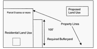
Bufferyards.
1.
Purpose. The bufferyard is a unit of yard together with the planting, fences, walls, and other screening devices required thereon. The purpose of a bufferyard is to avoid any potential adverse impact between adjacent land uses and streets, and promote land use compatibility.
2.
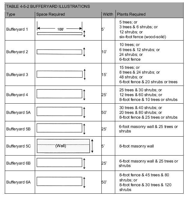
Where Required. Bufferyards shall be required for proposed new uses or substantially expanded uses (over fifty (50%) percent gross floor area) in accord with the following Table 4-5-1.
3.
Specifications and Options:
a.
From Table 4-5-1, match the abutting use with the proposed new or expanded use to determine the type of bufferyard required. Should a question arise as to the land use classification of a proposed or abutting use, the Planning Director shall determine the classification. Next, refer to the bufferyard illustrations following Table 4-5-1 to determine the amount of bufferyard required. Several options of landscaping are available under each bufferyard. The requirements are given in one hundred (100) foot units as measured along the property line. Whenever a wall or fence is required, the location of the structure may be on either side of the required bufferyard.
Note: Not to scale
b.
The length of a bufferyard shall extend along the length of the property line separating two uses, except for property lines in excess of two hundred (200) feet, where the bufferyard need only extend one hundred (100) feet beyond either end of the existing use to be buffered as long as the natural buffer is maintained and approved by SRC.
4.
Use of Existing Vegetation. Existing vegetation, including all trees of any dimension, shall be retained to the extent practical and feasible. In no event shall a developer clear-cut the site of a required bufferyard. Instead, the developer shall conduct an existing tree inventory, identifying the location, species, and diameter (breast high) of all trees in the bufferyard, and complement the presence of such trees with appropriate shrubs and other vegetation to meet all requirements of this section.
5.
Materials. To achieve the desired results, only coniferous (evergreen) plants, suitable for local conditions, shall be used. When structures are used, the materials shall be durable and suitable for screening.
6.
Plant Size and Caliper. The minimum tree at planting shall be six (6) to seven (7) feet in height and two and one half (2 1/2) inches DBH. The minimum shrub shall be two (2) to three (3) feet in height. Both trees and shrubs shall be nursery stock with well-developed root systems unless plants found in place can be used. If the existing vegetation provides a screen equal to or greater than that which would be planted, no other plant material shall be required. In case of open woods, an additional planting of eye shrubs such as hemlock or pines may be needed to improve screening. Fencing requirements are not changed by a wooded site.
7.
Substitutions. The following substitutions for opaque walls, fences, and plant materials may be made:
a.
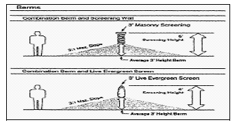
Berms may be used to compensate for fences. An eight (8) foot high opaque structure can be a combination of berm and fence to total eight (8) feet.
b.
Black, green, and brown color-coated chain-link fence, designed to blend into the landscape, along with evergreen hedge on the outbound side may be substituted for wooden or vinyl fences of the same height. All plants must be sized and spaced to obscure the chain link fence within five (5) years of planting.
c.
Any existing plant material that otherwise satisfies the requirements of this Section may be substituted and counted toward satisfying the requirements of this Section.
8.
Fence and Wall Specifications. All fences and walls used as part of the bufferyard requirement must have the finished side facing outward. Fences shall be wooden or other durable or opaque material approved by the Planning Director. Wooden fences shall be made of rot-resistant material such as pressure-treated pine, locust, cedar, or redwood. If made of pine, the post shall be rated for soil contact and the boards rated for outside use. Chain link fences with wood, plastic, or metal strips are expressly prohibited. However, a color-coated black, green, or brown chain link fence with evergreen hedge is acceptable. Metallic finish chain link fence is expressly prohibited. Walls must be made of masonry materials including poured concrete, concrete block covered with stucco, and brick.
9.
Responsibility. It shall be the responsibility of the proposed new use to provide the bufferyard where required by this Title, except that no new detached single-family dwelling or duplex shall be required to provide such bufferyard.
10.
Required Maintenance. The maintenance of required bufferyards shall be the responsibility of the property owner. All such areas shall be properly maintained so as to ensure continued buffering. All planted areas shall be provided with an irrigation system or a readily available water supply agreed upon with the Planning Director to ensure continuous healthy growth and development. Dead plant material shall be removed and replaced; debris and litter shall be cleaned; and berms, fences, and walls shall be maintained at all times. Failure to do so is a violation of this Title, and may be remedied in the manner prescribed for other violations.
11.
Use of Bufferyards. A bufferyard may be used for passive recreation and may be interrupted by access driveways not exceeding sixteen (16) feet in width (exceptions for uses requiring wide curb cuts may be approved by the Planning Director). All other uses are prohibited, including off-street parking.
12.
Sight Clearance. Bufferyards may not obscure a clear line of sight for vehicular traffic. Therefore, bufferyards should be placed no closer than twenty (20) feet from street/road right-of-way lines.
B.
Screening.
1.
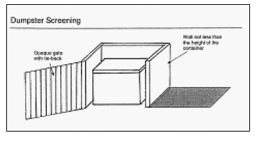
Purpose. Screening is a type of buffer that is designed to block or obscure a particular element or use from view. The purpose of screening is to minimize if not eliminate entirely the visual impact of potentially unsightly open storage areas and refuse disposal facilities.
2.
Where Required. Screening specified by this Section shall be required of all open storage areas not devoted to retail sales visible from any public street, including open storage areas for shipping containers, building materials, appliances, commercial trash containers, salvage materials, and similar unenclosed uses.
3.
Type of Screening Required. Screening shall be accomplished by an opaque divide not less than six (6) feet in height or the height of the object to be screened, whichever is greater. Screening may be accomplished by the use of sight obscuring plant materials (generally evergreens), earth berms, walls, fences, proper sitting of disruptive elements, building placement or other design techniques approved by the Planning Director.
4.
Fence and Wall Specifications. All fences and walls used as part of the screening requirement must have the finished side facing outward. Fences shall be wooden or other durable or opaque material approved by the Planning Director. Wooden fences shall be made of not resistant material such as pressure treated pine, locust, cedar, or redwood. If made of pine, the post shall be rated for soil contact and the boards rated for outside use. Chain link fences with wood, plastic, or metal strips are expressly prohibited. However, a color-coated black, green, or brown chain link fence with evergreen hedge is acceptable. Metallic finish chain link fence is expressly prohibited. Walls must be made of masonry materials including poured concrete, concrete block covered with stucco, and brick.
C.
Landscaping.
1.
Purpose. Landscaping is a type of open space permanently devoted and maintained for the growing of shrubbery, grass, other plants, and decorative features to the land. The purpose of landscaping is to improve the appearance of vehicular use areas and development abutting public rights-of-way; to enhance environmental and visual characteristics; to promote the greening of development and the reduction of noise pollution, storm water run off, air pollution, and artificial light glare, and to safeguard property values, protect public and private investments; and promote high-quality development.
2.
Where Required. No proposed commercial, institutional, industrial or other nonresidential use, or multi-family project or manufactured home park, shall hereafter be established or reestablished in an existing building or structure, and subsequently used unless landscaping is provided in accord with the provisions of this Section. No existing building, structure, or vehicular use area shall be enlarged by fifty (50%) percent or more unless the minimum landscaping required by the provisions of this Section is provided throughout the building site.
3.
Landscaping Plan Required. A Landscaping Plan shall be submitted as part of the application for Development Permit. The plan shall:
a.
Designate areas to be reserved for landscaping. The specific design of landscaping shall be sensitive to the physical and design characteristics of the site; and
b.
Indicate the location and dimensions of landscaped areas, plant materials, decorative features, irrigation etc. in accordance with the requirements of this Ordinance.
4.
Landscaping Requirements. Required landscaping shall be provided as follows:
a.
Along the outer perimeter of a lot or parcel, where required by the buffer area provisions of this Chapter, to buffer and separate incompatible land uses. The amount specified shall be as prescribed by Section 4.5.A, Bufferyards.
b.
Within the interior of a lot or parcel, peninsula, or island-type landscaped areas shall be provided for any open vehicular use area containing twenty (20) or more parking spaces. Landscaped areas shall be located in such a manner as to divide and break up the expanse of paving and at strategic points to guide travel flow and direction. Elsewhere, landscaped areas shall be designed to soften and complement the building site and separate the building from the vehicular surface area.
c.
At a minimum, interior lot landscaping shall be provided in the following amounts:
d.
Landscaping along exterior building walls and structures is suggested to separate with greenery the building from the vehicular surface area.
5.
Landscaped Areas:
a.
All landscaped areas in or adjacent to parking areas shall be protected from vehicular damage by a raised concrete curb or an equivalent barrier of four (4) inches in height. The barrier need not be continuous.
b.
Landscaped areas must be at least twenty-five (25) square feet in size.
6.
Required Maintenance. The maintenance of required landscaped areas shall be the responsibility of the property owner. All such areas shall be properly maintained so as to assure their survival and aesthetic value, and shall be provided with an irrigation system or other readily available water supply approved by the Planning Director. Failure to monitor such areas is a violation of this Section, and may be remedied in the manner prescribed for other violations.
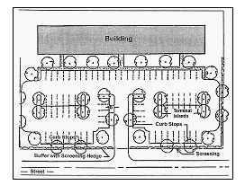
4.6. - Parking and Loading.
A.
Off-Street Parking and Loading Standards. Areas suitable for parking or storing automobiles in off-street locations shall hereafter be required in all districts at the time of the initial construction of any principal building producing an increase in dwelling units, guest rooms, floor area, seating or bed capacity, or when a conversion in use occurs. Off-street parking spaces shall have direct access to a street or alley, and shall be provided and maintained in accordance with the following requirements:
B.
Parking Requirements According to Use. Parking requirements for specific uses are listed in Table 3-1, Table of Allowed Uses.
C.
Location on Other Property. If the required automobile parking space cannot be reasonably provided on the same lot on which the principal use is conducted, such spaces may be provided on other off-street property provided such property lies within four hundred (400) feet of the main entrance to such principal use and shall not thereafter be reduced or encroached upon in any manner. A parking easement or other suitable legal encumbrance, to be filed of record, shall be required to be submitted to City Staff and the City Attorney for approval, which easement shall not be terminable without the City's permission to ensure the off-site parking is available for so long as the use requiring it is in existence.
D.
Common Off-Street Parking Areas. A single use encompassing more than one (1) of the activities specified in Table 3-1, or two (2) or more principal uses whether located on the same or separate lots, may utilize a common area in order to comply with off-street parking requirements, provided that the total number of individual spaces available in such common area is not less than the sum of the spaces required for the individual uses as separately computed in accordance with the provisions of Off-Street Parking, and provided that the owner of said lot relinquished the development rights over the property until such time as parking space is provided elsewhere. A parking easement or other suitable legal encumbrance, to be filed of record, shall be required to be submitted for approval by City Staff, including the City Attorney, which easement shall not be terminable without the City's permission to ensure the common parking is available for so long as the use requiring it is in existence.
E.
Use of Public Rights-of-Way for Maneuvering. When determining parking area requirements for individual uses, portions of the public right-of-way on minor streets may be considered as permissible for maneuvering incidental to parking. On major streets, parking facilities shall provide space outside of the public right-of-way for maneuvering incidental to parking.
F.
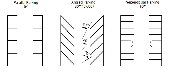
Parking Space Area Requirements. Each required off-street parking space as required by this Ordinance shall be a minimum of twenty (20) feet long by ten (10) feet wide in area. This requirement does not include any space necessary for the vehicular maneuvering within the lot or facility to access such parking spaces. Aisle widths must meet the approval of the Staff Review Committee to ensure public safety concerns are addressed. The Planning Director or other designated agent may require that the parking arrangements be prepared and certified by a licensed engineer. Handicap parking shall be provided, as specified by the "American with Disabilities Act (ADA)," latest edition as published in the Federal Register.
G.
Off-Street Loading and Unloading Spaces. Every lot on which a business, trade, industry, multifamily residential use or manufactured home park is hereafter established shall provide space as indicated herein for the loading and unloading of vehicles off the public right-of-way with direct access to an exterior doorway. Such space shall have access to an alley, or a street if there is no alley for the purpose of this Section, an off-street loading space shall have minimum dimensions of twelve (12) feet by forty (40) feet and be free of obstructions at all times. Required space shall be considered as follows:
1.
Retail Business. One (1) space for each five thousand (5,000) feet of gross floor space.
2.
Transportation, Wholesale, Industrial, Governmental and Institutional Uses, Including All Public Assembly Places, Hospitals and Educational Institutions, Public or Private Outdoor and Indoor Recreational Areas or Activities. One (1) space for the first twenty-five thousand (25,000) square feet, such uses shall provide loading spaces according to the following schedule:
For each additional one hundred thousand (100,000) square feet or fraction thereof one (1) additional loading/unloading space shall be required.
3.
Off-Street Loading. All uses, whether specified in this Ordinance or not, shall provide off-street loading areas sufficient for their requirements. Such space shall be adequate so that no vehicle being loaded or unloaded in connection with normal operations shall stand in or project into a public street, walk, alley or way.
4.
Location. Required off-street loading and unloading areas shall in all cases be located on the same lot or parcel of land as the structure they are intended to serve. In no case shall the required off-street loading space be considered as part of the area provided to satisfy off-street parking requirements as listed herein. In the case of residential areas or manufactured housing parks, such off-street parking may be located in consolidated areas so as to provide additional parking for visitors to the residents.
H.
Parking and Storage of Certain Vehicles. See Chapter 18 of the City of Hardeeville Municipal Code.
4.7. - Lighting.
All lighting fixtures designed or placed so as to illuminate any portion of a site shall meet the following requirements:
A.
Fixture (Luminaire). Except as provided herein, or unless otherwise explicitly approved by the SRC, the light source shall be a full cutoff fixture, completely concealed within an opaque housing and not be visible from any street. Where the design of an area may suggest the use of lighting fixtures of a particular "period" or architectural style, fixtures other than full cutoff fixtures may be used if the lumens generated by each fixture do not exceed five thousand five hundred (5,500) and if the mounting heights of such fixtures are less than or equal to fifteen (15) feet. Fixtures used under gasoline canopies and other structural canopies shall be flat lens, recessed lens, or drop lens with glare shields. Use of drop lens without glare shields is prohibited. Drop lenses without glare shields must be brought into compliance with this Section at the passage of this Ordinance.
B.
Light Source (Lamp). Only fluorescent, metal halide, LED, or color corrected height-pressure sodium may be used. The same type must be used for the same or similar types of lighting on any development. No colors other than white or off-white (light yellow tones) may be used for any light source for the lighting of signs, structures of the overall site unless the SRC deems such lighting to be appropriate to the design theme of the proposed development.
C.
Mounting. Fixtures must be mounted in such a manner that their cone of light does not cross ay property line of the site. Poles shall be black, dark gray, dark brown, or earth tone. The height of the light shall not exceed twenty-five (25) feet above grade; however, in parking areas greater than one (1) acre in size, lights located more than one hundred (100) feet from any property line may be up to thirty (30) feet above grade and MUST be approved for such height by the SRC. Any fixtures located within any required buffer should not exceed twelve (12) feet above grade. For purposes of this Ordinance, the mounting height of a lighting fixture shall be defined as the vertical distance from the grade elevation of the surface being illuminated to the bottom of the lighting fixture (luminaire).
D.
Submittal Requirements. A site Lighting Plan at a scale of one (1) inch to twenty (20) feet or other scale acceptable to the Planning Director shall be submitted. The site Lighting Plan shall include:
1.
Existing and proposed buildings, trees, landscaping, parking areas, and all proposed exterior lighting;
2.
Specifications for all proposed lighting fixtures including fixture design, type of lamp, wattage, designation as "cutoff" fixtures, and other descriptive information on the fixtures; and
3.
Proposed mounting height and placement of all exterior lighting fixtures.
E.
Timers and Dimmers. It is recommended that lighting installations include timers, dimmers, and/or sensors to reduce the overall energy consumption and eliminate unneeded lighting.
F.
Holiday Lighting. Holiday lighting shall be exempt from the provisions of this Section, provided that such lighting does not create dangerous glare on adjacent streets or properties and is limited to forty-five (45) days before the holiday and thirty (30) days after the holiday.
G.
Light Trespass. In addition to the general provisions in this Section, off-street lighting shall be shielded and/or directed in such a manner that it illuminates only the user's premises and does not spill over into the neighboring residential areas so as to interfere with the peaceful enjoyment of residential or public properties. Floodlighting of buildings is prohibited.
H.
Nonconforming Fixtures. Except where otherwise noted, all outdoor lighting fixtures existing and legally installed and operative before the effective date of this MZDO are exempt from the requirements of this Section. Whenever a nonconforming fixture is repaired/replaced, or moved, the replacement fixture shall meet the requirements of this Section if the damage is to more than thirty (30%) percent of the fixtures on site.
4.8. - Tree Protection.
A.
Purpose. The purpose of this Section is to protect and sustain the intrinsic value of trees and their ability to promote the public health, safety and general welfare, to lessen air pollution, to increase air filtration, to reduce noise, heat and glare, to prevent soil erosion, to aid in surface drainage and minimize flooding, to beautify and enhance the environment.
B.
Protected Trees. Any hardwood measuring twelve (12") DBH (Diameter at Breast Height) or greater with the exception of Sweet Gum trees and Water Oaks shall constitute a "protected tree" for purposes of this section and shall be protected to the extent practical and feasible. To this end, no person, firm, organization, society, association or corporation, or any agent or representative thereof shall directly or indirectly destroy or remove any tree in violation of the terms of this Section.
C.
Exceptions. Commercial timber, tree farms and nurseries, public utilities and agricultural operations of disturbing activity of less than two (2) acres on a single lot or parcel are exempt from the protective requirements of this Section. Property cleared under the exemptions of this Section shall not be redeveloped and the City shall withhold any development permit for a period of twenty-four (24) months.
D.
Tree Survey. Prior to grading or clearing a lot or parcel for development and the issuance of a grading or building permit, the developer/owner applicant shall have conducted a tree survey identifying the location of all protected trees. Said trees shall be shown on a survey plat and physically marked with brightly colored tape or other markings.
E.
Site Design. The design of any land development project or subdivision shall take into consideration the location of all protected trees identified on the tree survey. Lot and site design shall minimize the need to fell protected trees, of which no more than twenty-five (25%) percent may be removed to accommodate a proposed use or development. The minimum tree cover shall be fifteen (15) trees per acre.
The site design shall be presented on a Site Plan showing:
1.
Existing location and size of all protected trees;
2.
Trees to be removed;
3.
Trees to be preserved;
4.
Areas to be cleared; and
5.
Areas for proposed structures and improvements.
Site Plan approval by the Director of Planning shall be prerequisite to the issuance of a Grading and/or Building Permit.
F.
Tree Protection and Replacement.
1.
Clear Cutting Prohibited. The clear cutting of trees by any person for the sole purpose of clearing land or offering land for sale shall be prohibited. Bona fide silviculture operations are exempt from this provision to the extent harvesting operations in advance of land sales shall be authorized upon certification to the City that at least fifteen (15) trees per acre shall remain after clearing. Each tree removed is considered a separate offense.
2.
Prior to Development. Where a grading permit, building permit or subdivision approval has not been issued, the destruction of any protected tree, as defined by this Ordinance, without prior approval of the Planning Director, which approval shall not be unreasonable withheld, shall be prohibited. Each tree removed is considered a separate offense.
3.
During Development and Construction. During development, a minimum protective zone, marked by barriers, shall be established (erected) at the "drip line" and maintained around all trees to be retained as required by this Section. On any land it shall be unlawful, prior to or during construction of any structures, for any person to place solvents, building materials, construction machinery, construction vehicles, or soil deposits in any location other than a location specified on an approved Clearing Plan, or to engage in any other practices that have a potential for causing root or trunk injury, including, but not limited to excavating, building, trenching, grading, tree removal, grubbing, filling, stringing of overhead or underground utilities, land clearing or other land alteration, except in accordance with the terms and provisions of an approved Clearing Plan. During construction, no attachments or wires shall be attached to any trees designated for protection under such plans. Barriers must be inspected and approved by staff by to commencement of any construction activities. There shall be no construction, paving, grading, operation of equipment or vehicles, or storage materials within this protected zone.
4.
After Development. No person shall break, damage, remove, cut, kill or cause to be killed any protected tree, except for the following:
a.
In the event that any tree shall be determined to endanger the public health, safety or welfare, including airport operations, and require removal, written authorization may be given by the Planning Director and the tree or parts thereof (i.e. dead limbs) removed.
b.
During the period of an emergency, such as a hurricane, tornado, ice storm, flood or any other act of nature, the Planning Director may waive the requirements of this Section.
c.
Where due to unusual site conditions or circumstances, the requirements of this section pose a constrain to development and/or the use of a site or parcel, the Planning Director may adjust the requirements as necessary to moderate the constraint.
d.
Trees involved in wetland mitigation.
e.
Diseased (unhealthy) or nuisance trees, with approval of the Planning Director.
G.
Protected Trees Removed Without Permits. Where protected trees have been removed or where removal is necessitated at any time due to acts of negligence, or where sites were cleared of protected trees in violation of this Section, in addition to the per tree violation penalty and restitution provided under Section 1.9 of the Hardeeville Code of Ordinances, replacement trees shall be planted in accord with a replacement schedule approved by the Planning Director, or designee, who shall specify the number, species, DBH, and location of replacement trees, using the following criteria:
1.
Combined DBH of replacement trees is equal to or greater than three (3) times the DBH of the tree removed or;
2.
Individual replacement trees are of the largest transplantable DBH available.
4.9. - Erosion and Sediment Control and Stormwater Management.
A.
Purpose. In order to protect the general health, safety, and welfare, and to protect the natural assets and resources of the City and Joint Planning Area for posterity, this Section 4.9 is enacted to protect the lands and waters from the effects of excessive soil erosion and sedimentation, to prevent siltation of streams and waterways, to prevent clogging of drainage channels, and to prevent damages to the property of adjacent landowners. In addition, it is the purpose of this Section to provide proper drainage channels, clear of obstruction, for stormwater runoff; to control pollution of streams and drainage channels by urban stormwater runoff; and to prevent encroachment into natural drainage channels by buildings or other land improvements. Proper management of the quality and quantity of stormwater runoff will minimize damage to public and private property, insure a functional drainage system, promote the attainment and maintenance of water quality standards, enhance the local environment associated with the drainage system, maintain as nearly as possible the predevelopment runoff characteristics of the area, and facilitate economic development while mitigating drainage impacts.
B.
Exemptions. The provisions of this Section 4.9 shall not apply to:
1.
Agricultural and silvicultural land management and cultural practices, or construction of on-farm nonresidential buildings and structures used in a farming operation, provided that such structures do not require a building permit and adhere to the Flood Damage Prevention Ordinance, Chapter 9, Hardeeville Code of Ordinances.
2.
Single family residential lots of under two (2) acres or less or single family residential lots that have been approved as part of an overall subdivision/development stormwater management plan on record with the City and that meets the requirements of this Ordinance. However, the City Building Official and/or Engineer may, if valid reason exist, require submittal of all/or portions of this Section for any single family residential lots.
3.
Industrial operations conducted in accordance with valid NPDES individual storm water pollution prevention permit(s) issued by the Industrial, Agricultural and Storm Water Permitting Division of the South Carolina Department of Health and Environmental Control, provided that such operations are subject to review in accordance with this Ordinance and adhere to the Flood Damage Prevention Ordinance, Chapter 9, Hardeeville Code of Ordinances.
4.
Mining and mineral resource extraction operations conducted in accordance with a valid mining permit issued by the Mining and Reclamation Division of the South Carolina Department of Health and Environmental Control, provided that such operations are subject to review in accordance with Sec. 8-19(b) and adhere to the Flood Damage Prevention Ordinance, Chapter 9, Hardeeville Code of Ordinances.
5.
Any agency with power of eminent domain. Such agencies must apply to the Department of Health and Environmental Control for a Stormwater Management Permit.
6.
Construction and maintenance activities associated with provisions of gas, electrification or communication services and more particularly described in Section 72-302A(6) of the Standards for Stormwater Management and Sediment Reduction administered by the South Carolina Department of Health and Environmental Control pursuant to the South Carolina Stormwater Management and Sediment Reduction Act of 1991.
C.
Erosion and Sediment Control Requirements.
1.
Approved Plan and Permit Required for Land Disturbance. Unless otherwise provided in this Article, the surface of land in the City shall not be disturbed or changed for any purposes, whatsoever, but not including those exemptions outlined in Exemptions (below), except in accordance with a plan for control of erosion and sedimentation approved by the City of Hardeeville. Prior to any grading, construction, or land disturbances of any nature, a Land Disturbance Permit shall be obtained from the City of Hardeeville that shall state the period for which the permit is valid. The applicant must also comply with obtaining a Land Disturbance permit from OCRM as well.
2.
Land Disturbance Permits. The applicant shall apply in writing to the City of Hardeeville for a Land Disturbance Permit to disturb or change land in the city, pursuant to the procedure in Section 7.13, Land Disturbance Permits.
3.
Guidelines for Preparation of Erosion and Sediment Control Plans. Erosion and Sediment Control Plans shall be prepared according to the following guidelines, as applicable, prior to submission to the City of Hardeeville. Plans shall include appropriate measures and practices for erosion and sediment control, installed in a timely sequence during the development process, maintained to insure their proper functions, and removed when their function has been accomplished accordingly:
a.
Select land where the drainage pattern, topography, and soils are favorable for the intended use. Tracts of land vary in suitability for different uses. Consider the major characteristics of the land area and the kinds of soil in identifying and evaluating potential erosion and sediment problems, and in selecting appropriate control measures and practices to keep erosion/sedimentation to a minimum or from occurring altogether.
b.
Expose the smallest practical area of land for the least possible time during development and monitor this area constantly for erosion and sedimentation problems.
c.
When feasible, retain and protect natural vegetation. Save topsoil, where practical, for replacing on graded areas.
d.
Use temporary plant cover, silt fencing, mulching, and/or structures to control runoff and protect areas subject to erosion during construction.
e.
Provide for handling the increased runoff caused by changed soil and surface conditions. Emphasis should be placed on conservation of existing on-site soil. Effective means include the use of diversion ditches, grassed or surfaced waterways and outlets, enlarged and protected drainage channels, grade control structures, and effective use of street gutters and storm sewers.
f.
Use sediment basins or other forms of silt traps, where practical, to remove heavy sediment loads from runoff waters leaving the disturbed area. Install permanent vegetative cover and long-term erosion protection measures or structures as soon as practical in the development process. Insure all plans conform to applicable South Carolina Department of Health and Environmental Control requirements as well as those mandated by the Ocean and Coastal Resource Management Division. The City is not responsible for ensuring any development erosion control or drainage plan conforms with state and/or federal government regulations.
4.
Contents of Plan and Application. The Erosion and Sediment Control Plan and application for Land Disturbance Permit shall include, but not be limited to, the following data as applicable:
a.
A vicinity map sufficient to locate the site and to show the relationship of the site to its general surroundings at a scale of not less than one thousand (1,000) feet to one (1) inch.
b.
A Site Plan, drawn to a scale of not less than one hundred (100) feet to one (1) inch, and supporting specifications and schedules showing:
i.
The boundary lines of the site on which the work is to be performed, including the approximate acreage of the site.
ii.
Existing contours with intervals of not more than one (1) foot.
iii.
Existing drainage patterns, including off-site drainage through site, significant on-site depressional storage areas, and any existing drainage structures within the boundaries of the survey.
iv.
Proposed physical improvements on the site, including present development and future utilization, if known. Include pervious and impervious surfaces and note these accordingly.
v.
All drainage provisions, erosion and sediment control measures, vegetative practices, or other protective devices to be utilized in connection with, or as a part of, the proposed work. All drainage provisions must adhere to all applicable requirement of Chapter 9, Hardeeville Code of Ordinances, Flood Damage Prevention.
vi.
Provisions for erosion control during construction (temporary) and during the life of the facility (permanent). Such provisions shall include a schedule and sequence of operations indicating:
(A)
The anticipated starting and completion dates of each particular development sequence; and
(B)
the estimated time of exposure for each disturbed area prior to completion of effective erosion and sediment control measures. Specifications accompanying the plan shall include, as appropriate, seeding mixes and application rates, type of sod, seedbed preparation, lime and fertilizer application, mulching and other related data.
vii.
A complete and adequate Grading Plan for on-site borrow pits and material processing facilities, where applicable, including provisions for adequate drainage in such areas.
viii.
A general description of the predominant soil types on the site.
ix.
The name and address of the owner, developer, and petitioner, and the individual responsible for satisfactory completion of the work described in the plan, if different from the above as well as emergency contact information during construction.
x.
Title, scale, north arrow, date and name of the individual or organization preparing the plan, with seal when applicable.
xi.
The plan and application shall be supported by such supplemental reports, specifications, data, and additional information as the City may reasonably require, including but not limited to, finished contours, elevations, finished floor elevations, dimensions, locations, slopes, storm drainage computations, and field investigation reports on soils and drainage.
(A)
Evidence of compliance with all applicable regulations pertaining to the protection of wetlands as well as compliance with all State and Federal governmental regulations.
(B)
Copy of US Army Corps of Engineers and Ocean and Coastal Resource Management Division jurisdictional wetland determination documentation and proof of SCDOT drainage acceptance into their system (when applicable) along with a copy of the wetland boundary map for the entire property.
xii.
Applicant's certification statement:
I (We) hereby certify that all clearing, grading, construction and/or development will be done pursuant to this plan
Date Applicant
Seal of a South Carolina Registered Professional Civil Engineer, Registered Landscape Architect, or Tier B. Land Surveyor.
c.
Provide Ocean and Coastal Resource Management Division letter of approval.
5.
Inspection. The City Engineer or designee shall periodically review the work done under the approved Erosion and Sediment Control Plan and Land Disturbance Permit, as deemed advisable. Upon completion of such work, he/she shall make a final review. If the work has been completed in accordance with the plan and permit, the City Engineer or designee shall issue a letter of satisfactory completion.
D.
Stormwater Management Requirements.
1.
Approved Stormwater Management Plan Required:
a.
Unless otherwise provided in this Ordinance, any construction or other development affecting the quantity and/or quality of stormwater runoff shall be in accordance with a Stormwater Management Plan approved by the City. Approval of the Stormwater Management Plan shall be obtained prior to the issuance of a Building Permit.
b.
No Building Permit shall be issued until the required drainage improvements are installed. Drainage improvements shall in all cases be completed and in working condition prior to occupancy.
2.
Coverage Under Other Permit(s):
a.
The City may review industrial storm water pollution prevention plan(s), as required under a facility's National Pollutant Discharge Elimination System (NPDES) stormwater discharge permit, when outfall monitoring indicates a suspected violation.
b.
The City may review reclamation plan(s), as required under a mining and mineral resource extraction operation's operating permit, when outfall monitoring indicates a suspected violation.
c.
The City may review certificate(s) of environmental compatibility, as required by the Public Service Commission, when outfall monitoring indicates a suspected violation at a utility.
3.
Contents of Plan. The Stormwater Management Plan shall include, but not be limited to, the following data as applicable, and submitted in digital format specified by the City. The digital data may be deferred until the development permit is issued unless requested by the City Engineer as a part of the review. The City Engineer may require additional calculations be made, formulae used, or data supplied as he deems necessary:
a.
A Vicinity Map sufficient to locate the site and drainage area, showing the relationship of the site to its general surroundings at a scale of not less than one (1) inch = one thousand (1,000) feet.
b.
A Site Plan for the site(s) where drainage improvements are proposed, drawn to a scale of not less than one hundred (100) feet to one (1) inch utilizing the South Carolina State Plane Coordinates as specified in Title 27, Chapter 2, of the South Carolina Code of Laws, as amended. The Site Plan must include supporting specifications and computations showing:
i.
The boundary lines of the site(s) on which the work is to be performed, including the acreage of the site and drainage area, and boundary of any special flood hazard and/or regulatory floodway and base flood elevations. Adherence to the Flood Damage Prevention Ordinance, Chapter 9 of the Hardeeville Code of Ordinances, shall also be required.
ii.
Existing and proposed contours, at intervals of not more than one (1) foot based on mean sea level. Contours shall extend at least one hundred (100) feet outside the site boundary lines. Additional contours may be required to clarify drainage areas and/or flow patterns. Contours from credible sources (LIDAR, etc.) may be used in lieu of survey data provided that the contours show current data.
iii.
Existing drainage patterns map, drawn to a scale of not less than one (1) inch = one hundred (100) feet, including off-site drainage through site, on-site storage areas (stage - area/stage - volume relationships provided), and any existing drainage structures located within the boundaries of the survey.
iv.
Proposed physical improvements on the site, including present development and future utilization. Construction and design details shall be included for all structural controls. All landscaping relating to stormwater management shall also be shown on the grading plan or a supplemental grading plan included with engineered drawings.
v.
All drainage and flood protection provisions and improvements to be utilized in connection with, or as part of, the proposed work. Such provisions shall include a time schedule and sequence of operations indicating the anticipated starting and completion dates of each development sequence.
vi.
Show any existing drainage structures located within or immediately adjacent to the proposed drainage, whether it will or will not be considered as part of the proposed drainage plan.
vii.
Show all existing utility easements whether they be water, sewer, power, communications, etc ...
viii.
Designation of all easements needed for review and maintenance of the stormwater management facilities, including easements needed for the maintenance of the public drainage system. As a minimum, easements shall have the following characteristics:
(A)
Provide adequate access to all stormwater management facilities for review and maintenance. If the stormwater management facilities are submerged, a means of dewatering the structures for review and maintenance will be required;
(B)
Provide adequate access to all parts of the public drainage system and structures. Any steps shall be aligned immediately adjacent to the opening for safety of personnel accessing the structures;
(C)
Provide drainage easements of acceptable widths, in accordance with the City's Storm Drainage Standards;
(D)
Provide sufficient land area for maintenance equipment and personnel to adequately and efficiently maintain the system. A minimum of twenty (20) feet beyond the bank along one or both sides of all open drainage ways, ditches, channels, etc., is required. This distance shall be measured from the top of bank or toe of dam, whichever is applicable. Easements are also required for stormwater management facilities, in accordance with specifications provided in the Storm Drainage Standards.
(E)
Restriction on easements shall include:
(1)
Prohibiting all fences without gates of adequate size to allow maintenance equipment to pass; and
(2)
Prohibiting structures or landscaping that could interfere with access to the easement area(s) for inspections and maintenance.
ix.
A general description of the predominant on-site soil types, including, but not necessarily limited to the NRCS/SCS Soil Survey for Jasper County map, scale shown, and applicable soil and hydrologic soil group tables.
x.
The name and address of the applicant, the owner, and the individual responsible for satisfactory completion of the work described in the plan, if different from the above.
xi.
Title, scale north arrow, and date.
xii.
Name of the individual or organization preparing the plan, with seal when applicable.
xiii.
A geotechnical report, prepared by a State Registered Geotechnical Engineer, shall be submitted containing at a general soils characterization and at least one (1) current soil boring log and one (1) soil boring log per additional acre of stormwater management detention/retention ponds. The boring depth shall be to a depth of at least three (3) feet below the bottom of the proposed ponds, and shall indicate the groundwater depth observed at the time of the boring(s). The location of the boring(s) shall be indicated on the topographic map. In addition, the geotechnical engineer shall provide the estimated seasonal high ground water depth at each boring location. If dry retention is proposed, or if any stormwater discharge will be reduced through percolation, then the results of percolation tests, at least one (1/acre) per pond, shall be provided.
xiv.
The plan shall include such supplemental reports, specifications, data, and additional information as the City Engineer may require. Supplemental materials requested may include, but are not limited to, elevation; dimensions; locations; slopes; storm drainage computations; and field investigation reports on soils, drainage, and flooding.
xv.
Copy of US Army Corps of Engineers and Ocean and Coastal Resource Management Division jurisdictional wetland determination documentation along with a copy of the wetland boundary map for the entire property.
c.
A plan for maintenance of privately owned stormwater management facilities shall be included as part of the stormwater design plan. At a minimum, the maintenance plan shall specify the following:
i.
Maintenance activities that will be performed to ensure that the proposed drainage system and stormwater management facilities will operate as designed.
ii.
The frequency and amount of maintenance to be performed.
iii.
The equipment that will be required to perform the needed maintenance.
iv.
Name, address and phone number of the party responsible for maintenance.
v.
Annual certification of any stormwater detention facilities by a South Carolina registered engineer. This certification shall indicate that structures and embankments are in good condition. Every five years, an engineer shall provide certification of storage volume and depth. This certification shall indicate any change in depth due to siltation and shall verify the storage volume is equal to the designed volume. If changes have occurred, recommendations needed to restore the functionality of the detention facilities function shall be included. Certifications shall be sent to the City of Hardeeville.
d.
Applicant's certification statement:
I (We) hereby certify that all clearing, grading, construction and/or development will be done pursuant to this plan.
Date Applicant
e.
Seal of a qualified South Carolina Registered Professional Civil Engineer, Registered Landscape Architect, or Tier B. Land Surveyor.
4.
Application for Plan Approval. The applicant shall submit two (2) copies of the Stormwater Management Plan, prepared in accordance with the provisions of this Section 4.9, to the City Engineer. The Stormwater Management Plan shall include such stream flow and storm runoff calculations and other information as may be reasonably required by the City Engineer under the requirements of this Article. The Stormwater Management Plan shall be certified by the applicant and sealed by a South Carolina Registered Professional Civil Engineer in accordance with the requirements of sections this Ordinance. An Ocean and Coastal Resource Management Division letter of approval shall also be required when applicable.
5.
Approval or Disapproval of Stormwater Management Plan.
a.
If the Stormwater Management Plan conforms to the requirements of this Section, the City shall approve the plan and notify the applicant.
b.
If the Stormwater Management Plan does not conform to the requirements of this Section, the City shall disapprove the plan and forward a written notification, indicating the reason or reasons for plan disapproval, to the applicant.
c.
Review of the Stormwater Management Plan Review shall require twenty (20) working days or less from the date of submittal until the time a decision is rendered, either approving or disapproving the plan. However, if the City or its designee determines that the size and scope of the proposed plan requires additional time for adequate review, the review period shall be extended as determined appropriate by the City or its designee, but in no event shall the review period exceed forty-five (45) working days. If at the end of the forty-five (45) working day period a decision has not been reached, the plan shall be deemed approved; provided, however, that the applicant may waive this requirement and consent in writing to the extension of that period.
d.
If a Stormwater Management Plan is disapproved, the applicant may elect to correct the indicated deficiencies in conformity with the provisions of this Article and resubmit the plan.
6.
Responsibility of Applicant. Approval of plans by the City in no way relieves the applicant's technical representative from his responsibility for the correctness of the plans or the accuracy of his calculations, nor does it relieve the owner or the applicant from their obligation to comply with any applicable laws. In addition, the City's approval of such plans does not relieve the applicant in any way of its responsibility for conforming to all applicable State and Federal regulations and/or requirements.
7.
Methods of Calculating Stream Flow and Runoff:
a.
Formulas and values as prescribed in the Storm Drainage Design Standards shall be used for calculating all stream flow and runoff. Copies of the standards may be obtained through the City Building Official's office.
b.
The following rainfall frequencies shall be used in the calculations for stormwater runoff and stormwater management facility design, depending upon the size of the watershed:
The two (2) year, 24-hour rainfall shall also be used as prescribed in the Storm Drainage Design Standards.
c.
Calculations used in the design of proposed stormwater management facilities shall reflect the anticipated future development of the entire watershed.
d.
Appropriate inlet control and outlet control curves shall be used to determine headwater depths, where applicable.
8.
Primary Drainage Channel Requirements. All primary drainage channels located within or immediately adjacent to any improvement, development or subdivision/development shall be protected or improved by the applicant as follows:
a.
Responsibility of Applicant. The applicant shall be responsible for carrying out the proposed work in accordance with the approved Stormwater Management Plan (to include any special provisions or conditions), and in compliance with the requirements of this Section.
The applicant shall plan and carry out his developments in a manner that will not interfere with or restrict the flow of water. The applicant shall adhere to the requirements of the Flood Damage Prevention Ordinance, Chapter 9, Code of Ordinances, Hardeeville, SC. The developer shall be responsible for any improvements to such channels, as needed to handle increased runoff or other changes resulting from his development, in accordance with the provisions of this Article. This includes compliance with OCRM and SCDOT where applicable.
b.
Land Dedication Required. All land adjacent to a primary drainage channel and not protected by levees, dikes or fill shall be dedicated for the purpose of providing drainage right-of-way as follows:
In commercial or residential subdivision/developments of less than fifty (50) units, drainage easements of satisfactory width to provide working room for construction and maintenance equipment shall be deeded to the Property Owner's Association, and/or City and/or Jasper County for all drainage improvements, including stormwater management facilities, and shall be separate and apart from adjoining lots.
In group developments, residential developments in excess of fifty (50) units, or planned unit developments, the property owner(s) or Home Owners' Association shall be responsible for maintenance of drainage channels and easements. The final plat approved for recordation shall indicate the available public easements for drainage channels. The City and/or County shall have the right to encroach onto these public easements or permit others to encroach for any purpose deemed appropriate by the City. In no way does this right of encroachment lessen the obligation of the property owner(s) or the responsibility of the Home Owners' Association for maintenance of the drainage channels and easements.
c.
Existing Channels. The existing channel lying within or contiguous to a subdivision/development or parcel of land proposed for development or redevelopment may be:
i.
Cleaned to provide for free flow of water; and straightened, widened, and improved to prevent overflow resulting from the 50-year frequency rainfall beyond the limits of the dedicated drainage easement provided for in subsection (b) above; provided:
(A)
The Stormwater Management Plan contains details of the proposed channel modifications and includes either:
(1)
A Mitigation Plan for water quality impacts, including best management practices to be implemented as part of the channel modification and overall project; or
(2)
An engineering analysis demonstrating no water quality impacts resulting from the proposed modifications.
(B)
The Stormwater Management Plan must be approved in accordance with this Article prior to commencing any channel modifications.
d.
Final Grading. Final grading of all lots and building sites for new construction or substantial improvement shall adhere to the requirements of the Flood Damage Prevention Ordinance, Chapter 9, Code of Ordinances, Hardeeville, SC.
e.
Bank Protection. Whenever channel improvements are carried out in accordance with subsection (c) above, sodding, seeding, backsloping, cribbing, and other bank protection shall be designed and constructed to control erosion for the anticipated conditions and flow resulting from a 50-year rainfall.
f.
Channels within Street Easements. Primary drainage channels located within street easements shall be placed in enclosed storm sewers, except under the following conditions:
i.
Where a paved street surface at least two (2) lanes wide is provided on both sides of an improved channel so as to provide access to abutting properties.
ii.
For lots with a double-street frontage, an open drainage channel is permitted between the rear lot line and the paved street, provided that access from the street to the lot is prohibited both at the time of construction and in the future.
iii.
When a condition outlined in either (i) or (ii) above is present, adequate width shall be dedicated as right-of-way to provide for the maintenance of an improved drainage channel and its bank.
g.
Levees. All levees protecting residential structures or non-residential structures shall adhere to the requirements of the Flood Damage Prevention Ordinance, Chapter 9, Code of Ordinances, Hardeeville, SC. Any levee constructed or improved under this subsection shall also comply with the other provisions of this Section, including, but not limited to, subsection (h) below.
h.
Exceptions. Not withstanding any other provision of this Section, no levees, dikes, fill materials, structures or obstructions that will impede the free flow of water during times of flood shall deviate from the requirements of the Flood Damage Prevention Ordinance, Chapter 9, Code of Ordinances, Hardeeville, SC. except
i.
such proposed impediment is or would be a part of or used by any public or private school that was constructed and operated before January 1, 2001 on property subsequently classified as a regulatory floodway, or
ii.
such proposed impediment is or would be a part of or used by a publicly owned wastewater treatment facility that was constructed and operated before January 1, 2001 on property subsequently classified as a regulatory floodway; or
iii.
such proposed impediment is a minor recreational or playground facility or area, such as, but not limited to, a boat ramp, floating dock, picnic area, soccer goal, or swing set; or
iv.
such impediment was approved by the City under this subsection (8), or under any predecessor provision, before January 1, 2001; provided, however, that any specified activities permitted above must comply with all applicable Federal, State, and local requirements, including, but not limited to, 44 C.F.R. 60.3(d)(3), as amended. Nothing in this subsection (h) shall limit provisions in this Section or elsewhere authorizing or requiring the maintenance and repair of levees, dikes, dams, and similar structures; provided, however, that this sentence shall not be construed as authorizing or requiring the repair or maintenance of any such structure to the extent that such repair or maintenance would result in a structure that would be higher or wider than it was before the need arose for such repair or maintenance.
i.
Applicable Regulations. All applicable regulations of the National Flood Insurance Program, Ocean and Coastal Resource Management Division, the Flood Damage Prevention Ordinance, Chapter 9, Code of Ordinances, Hardeeville, SC and any State and Federal governmental agencies are incorporated by reference herein.
9.
Secondary Drainage Channel and Surface Requirements. All secondary drainage channels which are within or immediately adjacent to an improvement, development, or subdivision/development shall be protected and improved by the applicant as follows:
a.
Drainage easements of satisfactory width to provide working room for construction and maintenance equipment shall be dedicated to the City and/or Jasper County or to a private entity clearly identified in the recorded easement for all drainage improvements in subdivision/development developments, including stormwater management facilities. Drainage improvement maintenance for group developments, commercial buildings, or planned unit developments shall be the responsibility of the property owner(s) or Home Owners' Association.
b.
Secondary drainage channels having a primary function of: 1) collecting surface water from adjacent properties, or 2) intercepting and diverting side hill drainage, shall be improved open channels.
c.
Secondary drainage channels having a primary function of: 1) transporting surface water through a block or development; or 2) collecting surface water from cross channels, shall be improved as follows:
i.
Secondary drainage channels shall be improved with either a closed storm sewer or improved open channel designed to carry the runoff resulting from a 25-year frequency rainfall. A natural stream may be approved by the City for environmental or aesthetic purposes, provided that it has the required carrying capacity and it adheres to the requirements of the Flood Damage Prevention Ordinance, Chapter 9, Code of Ordinances, Hardeeville, SC.
ii.
All improvements to drainage channels shall be carried out such that waters of the State protected by the Federal Clean Water Act are not degraded. OCRM and/or Army Corps of Engineers approval for channel modifications shall be provided prior to approval by the City.
d.
In areas of special flood hazard, adherence to the requirements of the Flood Damage Prevention Ordinance, Chapter 9, Code of Ordinances, Hardeeville, SC shall be applicable.
e.
Secondary drainage channels located within street easements shall be placed in enclosed storm sewers, except under the following conditions:
i.
Where a paved street surface at least two (2) lanes wide is provided on both sides of an improved channel so as to provide access to abutting properties.
ii.
For lots with a double-street frontage, an open drainage channel is permitted between the rear lot line and the paved street, provided that access from the street to the lot is prohibited both at the time of construction and in the future.
iii.
When a condition outlined in either i. or ii. above is present, adequate width shall be dedicated as right-of-way to provide for the maintenance of an improved drainage channel and its bank.
f.
Off-site discharges from closed storm sewers or improved open channels and not routed through a stormwater facility will only be permitted at natural wetlands and/or streams or man-made drainage channels if the design is acceptable to the City, State, and Federal agencies, where applicable, no adverse impacts to the receiving water can be demonstrated via generally accepted engineering backwater analyses, and a drainage easement is obtained from the adjoining landowner. Adequate provisions shall be made to reduce discharge velocities such that the receiving channel is not degraded. When off-site drainage channels are not adequate to accept the additional runoff resulting from development, the developer shall install on-site facilities for controlled release of stormwater runoff. These on-site drainage facilities shall be designed to limit the runoff rate to predevelopment levels during storm events for the 2, 25, 50 and 100 year storm events.
10.
Developments:
a.
Single-family Residential, Duplex, or Manufactured Home Development. Site grading shall be carried out in such a manner that surface water from each dwelling lot will flow directly to a storm sewer, improved channel, sodded swale/ditch, or paved street without running more than two hundred (200) feet.
b.
Commercial, industrial, multi-family, and institutional development:
i.
Roofs, paved areas, yards, courts, courtyards, and other impervious surfaces shall be drained across pervious surfaces when possible and finally directed into a storm sewer system, with the exception that such drainage may flow directly into a street, curb and gutter system or improved channel when impractical, impractical and approved by the City.
ii.
Construction of buildings over storm drainage improvements is not permitted.
iii.
Surface water collected on streets shall be diverted to enclosed storm sewers or drainage channels at satisfactory intervals to prevent flooding of one half a lane in the case of a two lane road or one lane in the case of a four lane road. In no case shall water be allowed to overtop the curb during a 25-year frequency rainfall.
iv.
All such development shall conform to the Ocean and Coastal Resource Management Division regulations and requirements.
11.
Minimum Water Quality Requirements:
a.
The minimum quality control requirements are provided in the Storm Drainage Design Standards. These requirements may be waived by the City if:
i.
It can be shown, by engineering calculations acceptable to the City, that stormwater management facilities are not needed to control developed peak discharge rates and meet water quality requirements;
ii.
Installing such facilities would not be in the best interest of local citizens or the City;
iii.
Such facilities are in conformance with all State and Federal regulatory requirements; and
iv.
Will not degrade existing water quality.
b.
The City maintains the right to determine if additional stormwater management facilities, beyond those required under this Article, are necessary for on-site stormwater management. Additional facilities may be needed to enhance or provide for the general health, safety and welfare; to correct unacceptable or undesirable existing conditions; or to provide protection for future development in a more desirable fashion. If such a determination is made, the City may:
i.
Require that the owner/applicant grant any necessary easements to provide access to or drainage from the stormwater management facility; and
ii.
Develop an agreement with the owner/applicant for the over-design of the stormwater management facility to provide additional water quality benefits beyond that required by this Article; and
iii.
Require that the developer maintain the stormwater management facility for more time than the original proposed time by means of maintenance bonds or other means if necessary in feed; and
iv.
Participate financially in construction of the stormwater management facility, to the extent that such facility exceeds the on-site stormwater management requirements, as determined by the City. The City may pay the additional expenses incurred in providing the additional storage capacity or water quality benefits, including land costs and increased design and construction costs.
12.
Design Criteria for Improvements:
a.
Open Channels. Open channels shall be provided with an improved section that will carry runoff from the appropriate design storm and preclude the creation of backwater inundating any areas outside of dedicated drainage easements. The channel shall be designed to minimize negative water quality impacts and protect against erosion in accordance with standards adopted by the City. The channel shall have maximum side slopes of 3:1 (H:V).
b.
Closed Storm Sewers and Culverts. Closed storm sewers and culverts shall be constructed of precast or prefabricated pipe or box culvert or built in place, of closed box design, in conformity with South Carolina Department of Transportation specifications. They shall be sized to carry the runoff from the appropriate design storm and to preclude the creation of headwater inundating any areas outside of dedicated drainage easements. They shall be designed so that they can be dewatered for inspection as a part of the stormwater management plan.
c.
Bridges. Bridges shall be designed in accordance with standards established by the South Carolina Department of Transportation and/or Jasper County specifications, whichever is applicable.
d.
Levees. Levees shall be designed, constructed, and maintained as follows:
i.
Design and construction shall be in accordance with U.S. Army Corps of Engineers' Manual EM 1110-2-1913 (31 March 1978) Design and Construction of Levees. The design and construction of drainage systems within levees shall be in accordance with the U.S. Army Corps of Engineers' Manual EM 1110-2-1413 (15 Jan 1987) Hydrologic Analysis of Interior Areas. A South Carolina Registered Professional Engineer shall certify that he has been involved in the design, construction, and inspection phases and shall certify that the construction meets requirements of the Corps of Engineers. Where applicable, the levee shall be submitted for permitting in accordance with the South Carolina Safe Dams Act.
ii.
Owners of levees will perform the necessary and required maintenance and provide appropriate records to the City. These records will include:
(A)
Signed agreements of perpetual operation and maintenance between the constructor and/or owner and the City;
(B)
As-built construction plans sealed by a South Carolina Registered Professional Engineer. These as-built plans shall be approved by the City Engineer or designee; and
(C)
Annual maintenance reports and as required by the City.
13.
Stormwater Management Facilities:
a.
Stormwater management facilities may include both structural and non-structural elements incorporating quantity and/or quality control.
b.
A variety of different types of stormwater management facilities exist and can be used to satisfy the minimum quantity and/or quality control requirements. All proposed stormwater control measures shall be in accordance with the Storm Drainage Design Standards.
c.
Stormwater management facilities shall restrict the peak post-development runoff rate to the peak pre-development rate for the following storm events: the 2, 25, 50 and 100 year storm events shall have flow restrictions of the peak post-development runoff rate to the peak pre-development rate.
d.
On-site natural storage areas may not be filled unless provisions for the displaced storage are made in the post-development stormwater discharge calculations.
e.
Wet ponds (retention structures with a permanent pool) shall be utilized for drainage areas in accordance with the Storm Drainage Design Standards and approved by the Ocean and Coastal Resource Division.
f.
Where dry detention/retention is proposed to meet the water quality and design storm pre-post requirements, the stormwater calculations must demonstrate the capacity of the required treatment volume recovers in seventy-two (72) hours unless other Federal, State, or local regulations are more restrictive.
g.
Where stormwater management facilities are used, designs which consolidate them into a limited number of large structures are preferred over designs utilizing a large number of smaller structures. Additional State and/or Federal permits may be required for larger stormwater management facilities impacting waters of the State protected by the Federal Clean Water Act.
h.
The City may reject a Stormwater Management Plan if it incorporates structures and facilities that do not meet the requirements of this Article, through approved submittals in the case of structures, or utilize numerous small structures where other alternatives are physically possible.
i.
The drainage system and all stormwater management structures within the city (including public and private portions) will be designed to the same engineering and technical criteria and standards. Owners of stormwater management facilities will perform the required testing and maintenance and provide appropriate records to the City. These records will include:
i.
As-built construction plans certified by a South Carolina Registered Professional Civil Engineer, Registered Landscape Architect, or Tier B. Land Surveyor approved by the City Engineer;
ii.
Periodic maintenance reports as required by the City.
iii.
Annual inspection conducted by a South Carolina registered engineer detailing statements regarding the condition of the associated drainage structures as well as any recommendations needed to assure that the detention facilities function as designed. To adequately perform the inspections, submerged structures will require a means of dewatering these structures. Copies of inspection reports shall be submitted to the City of Hardeeville.
14.
Maintenance of Stormwater Management Facilities:
a.
All stormwater management facilities shall be maintained by the owner(s) in such a manner as to maintain and enhance the general health, safety and welfare; to reduce and minimize damage to public and private property; to reduce and minimize the impact of such facilities on land and stream channel erosion; to promote the attainment and maintenance of water quality standards; and to maintain, as nearly as possible, the pre-development runoff characteristics of the area. All maintenance of privately owned stormwater management facilities shall be at the sole cost and expense of the owner(s) of such facilities.
b.
It shall be unlawful for the owner or occupant of any property upon which a stormwater management facility is located, to fail to maintain the facility in such a manner that the facility creates a danger to the general health, safety and welfare. Should the owner fail to so maintain the stormwater management facility, this failure shall constitute a public nuisance and will be referred to the pertinent agencies.
c.
If the City assists private owners with the design of stormwater management facilities, this does not imply any maintenance responsibilities by the City. The maintenance of all such facilities shall be the sole responsibility of the property owner(s).
15.
Illicit Discharges and Improper Disposal:
a.
Illicit Connections. It shall be unlawful to use any stream or watercourse to carry off water from any kitchen sink, bathtub, septic tank, livestock facility, drainfield, or privy, or to carry off any fluid of an offensive or dangerous/toxic nature. No water or refuse from any industrial, commercial or institutional process, including water used for heating or cooling, shall be discharged in any stream or watercourse by any person until such person has obtained the appropriate local, State and Federal permits.
It shall be unlawful, either willfully or negligently, to injure, alter, deface, mutilate, tie-into, destroy, tamper or interfere with any publicly-owned property or any property used in the City's publicly owned storm water management system.
Building permits shall be required before the construction of any connection to the Jasper County, SCDOT, City or privately owned storm water management system.
b.
Improper Disposal. It shall be unlawful for any person to discharge non-storm water to any storm water conveyance with the exception of the following:
i.
Water line flushing;
ii.
Diverted stream flows;
iii.
Rising ground water;
iv.
Uncontaminated ground water infiltration (as defined at 40 CFR 35.2005 [20]) to separate storm sewers;
v.
Uncontaminated pumped ground water discharges from potable water sources;
vi.
Foundation drains;
vii.
Air conditioning condensation;
viii.
Irrigation water;
ix.
Springs;
x.
Water from crawl space pumps;
xi.
Footing drains;
xii.
Lawn watering;
xiii.
Car washing at one's residence, not for hire;
xiv.
Flows from riparian habitats and wetlands;
xv.
Dechlorinated swimming pool discharges;
xvi.
Street wash water;
xvii.
Discharges from fire fighting; and
xviii.
Fire flows from hydrants for cleaning or testing.
c.
Litter and Refuse Control. It shall be unlawful for any person to dump, throw, drop, leave, or in any way deposit any garbage, ashes, rubbish, white goods/appliances, paper, trash, carcasses, litter, refuse, building materials/debris, glass bottles, glass or cans: 1) on any property belonging to another; or 2) on or along any street, road, highway, curb, sidewalk or public right-of-way, except as required by the authorized and franchised waste management operator for that district. No person shall throw or deposit any refuse in any stream or other body of water within the boundaries of the City. Section 9-111 et seq. of the Hardeeville Code of Ordinances contains additional prohibitions.
d.
Organic Waste. It shall be the duty of the property owner to keep grass clippings, leaves, tree and shrub clippings, stumps, organic materials or any other yard trash out of gutters, inlets, catch basins, and side ditches.
It shall be unlawful to place grass clippings, leaves, tree and shrub clippings, stumps, organic materials or any other yard trash in any street, storm drain, stream, storm water conveyance, or any other location where concentrated flows could wash such wastes into the storm sewer system.
Privies, septic tanks, farming areas where pesticides are used and associated drain fields, pigpens, corrals and stables of all kinds shall be placed far enough away from any stream, ditch, drain, or other storm water conveyance that human or animal waste(s) and in a manner approved by the City so that run off from these facilities will not run into any stormwater system or receiving water.
16.
Spill Response:
a.
The Director of Emergency Services or designee, or an authorized Fire Official, shall have the authority to summarily abate, control and contain hazardous materials that are emitted into the environment and endanger the health or safety of the general public or the environment. The Director of Emergency Services or designee, or an authorized Fire Official, shall have the authority to enter public or private property with or without the owner's consent, to respond to such hazardous materials emergencies or reports. The Director of Emergency Services or designee, or authorized Fire Official, shall determine the type, amount and quantity of equipment and personnel required to adequately abate, control and contain all hazardous materials emitted into the environment.
b.
The property owner and/or person responsible for the hazardous materials spill or release shall be held financially liable for the response, control, containment, equipment and materials costs, including legal fees, incurred by the City and supporting agencies. The property owner and/or person responsible for the hazardous material spill may provide personnel to assist abatement, removal, and remedial measures needed to return area to original condition prior to contamination, provided such personnel have been adequately equipped and trained pursuant to the requirements of local, State and Federal laws. The City shall not be liable for the use of outside personnel. Assistance shall consist of any or all of the following:
i.
Informing Emergency Services Department personnel of all matters pertaining to the incident.
ii.
Supplying emergency response plan information for the site.
iii.
Supplying emergency response equipment, personnel, and materials. Charges for hazardous materials emergency response shall be based upon the actual costs of response, control, containment, equipment and materials, including legal fees. All fees collected shall be turned in to the City Treasurer and credited to the City's general fund.
iv.
Temporarily relocating any services or people from the affected area until the area is restored or declared safe by pertaining agencies.
c.
In fire incidents involving hazardous materials or exposure to hazardous materials, no fee will be assessed for resources normally associated with firefighting operations. Fees shall be assessed for those activities and resources associated with abatement, control and containment of the hazardous materials involvement or exposure.
17.
Supplemental Regulations:
a.
All applicable provisions of the standards for Stormwater Management and Sediment Reduction (Section 72-301, 302, 305, 307, 308, 312, 313, 314, 315 and 316) administered by the South Carolina Department of Health and Environmental Control pursuant to the South Carolina Stormwater Management and Sediment Reduction Act of 1991 are incorporated by reference herein.
b.
All applicable provisions of the NPDES and Land Application Permits Regulation (Section 61-9.122 Part A 122.2, 122.3, 122.4 and Part B 122.26) administered by the South Carolina Department of Health and Environmental Control pursuant to the South Carolina Pollution Control Act of 1976 are incorporated by reference herein.
18.
Review During Construction. The City Engineer or designee shall periodically review the work completed under the approved Stormwater Management Plan. Upon completion of such work, he/she shall make a final review and if the work has been carried out in accordance with the approved plan and all the pertaining close-out documentation submitted and accepted, he/she shall issue a letter of satisfactory completion upon receipt and approval of the as-built drawings.
19.
Right-of-entry:
a.
The City Engineer or designee shall have right-of-entry on or upon the property of any person subject to this Article and any permit/document issued hereunder. The City Engineer or designee shall be provided ready access to all parts of the premises for the purposes of inspection, monitoring, taking photographs, sampling, inventory, examination and copying of records, and the performance of any other duties necessary to determine compliance with this Article.
b.
Where a person has security measures in force requiring proper identification and clearance before entry onto the premises, the person shall make necessary arrangements with security guards so that, upon presentation of suitable identification, the City Engineer or designee will be permitted to enter without delay for the purposes of performing specific responsibilities.
c.
The City Engineer or designee shall have the right to set up on the person's property such devices as are necessary to conduct sampling and/or metering of the person's operations as they relate to stormwater management.
d.
Any temporary or permanent obstruction to safe and easy access to the areas to be inspected and/or monitored shall be removed promptly by the person at the written or verbal request of the City Engineer Official or designee. The costs of clearing such access shall be borne by the person. This includes all other liability therein.
e.
In cases where an imminent threat to the health or safety of the general public or the environment is suspected, the City Engineer or the Director of Emergency Services (or designee) shall review the existing stormwater management facilities to determine if immediate action is necessary. Such review shall be made with or without the consent of the owner, manager, or signatory official. If such consent is refused, the City may seek issuance of an administrative search warrant in order to gain access for review. Other law enforcement agencies may be called in if necessary.
20.
Enforcement:
a.
The City Engineer or designee shall be entitled to review all stormwater management facilities subject to this Section at all reasonable times in order to determine compliance or non-compliance with the terms and provisions hereof.
b.
When the City Engineer or designee finds that work done under any Grading Permit issued under the provisions of Article 7 fails to conform to the approved Erosion and Sediment Control Plan, or that the work has not been done, or finds that work done under any approved Stormwater Management Plan fails to conform to the approved plan, or that the work has not been done, the City Engineer may, as deemed necessary, by written order direct conformity to said Plan(s). Actions may include:
i.
Issuing a written order to comply, to suspend work, or to revoke the permit issued; or
ii.
Seeking redress through legal action; and/or
iii.
Withholding the release of permanent electric power to the site.
c.
When the City Engineer or designee determines that an owner has failed to maintain a stormwater management facility, he/she shall provide written notice to the owner or the person in possession, charge or control of such property stating that: 1) in the judgment of the City the conditions existing upon the property constitute a public nuisance; and 2) setting forth action to be taken to eliminate the objectionable conditions; and 3) requesting that such action be undertaken within the number of days specified in the notice. The notice shall further state that unless the objectionable conditions are voluntarily removed or remedied within the specified time, the City shall subject the offender to penalty in an amount deemed appropriate and in accordance with Section 7.12 of this Article.
d.
The City Manager is authorized to take all legal actions on behalf of the City necessary to correct any public nuisances, including actions that are necessary to remove from the property such objectionable conditions constituting the public nuisance.
e.
Nothing contained in this Section shall impair the right or ability of the City Attorney to exercise any and all other remedies available, at law or in equity, including without limitation, the pursuit of injunctive relief, under emergency circumstances where there exists the danger of bodily injury or death.
f.
The governing body of the City or its appointed agent may obtain injunctive relief to enjoin violations of the provisions of this Section, and any person damaged as a result of such violations may, upon a proper showing of such damages, obtain payment therefore by a civil action.
g.
This Section may be enforced by any other remedy of law or equity that the City is authorized to pursue, to include the authorities and powers conferred to local governments by the General Assembly of South Carolina. The penalties and other remedies provided in this Section are cumulative and not exclusive, and may be independently and separately pursued against the same person for the activity constituting a violation of this Section. The enforcement of any remedy provided herein shall not prevent the enforcement of any other remedy or remedies in other provisions of this Code or other laws and regulations.
4.10. - Streets.
A.
Street Access. Except as provided in this Section, no building shall hereafter be erected, constructed, moved, or relocated on a lot not located on a publicly or privately maintained street with a right-of-way of not less than twenty-four (24) feet.
B.
Classification of Streets. For the purpose of this Ordinance, all public streets within this Ordinance's jurisdiction are hereby classified as being freeway, arterial, collector or local.
C.
Standards:
1.
Street Layout Generally. The layout of proposed streets, whether public or private, as to the arrangement, width, grade, and location, should be coordinated with the street system in the adjoining areas, considering topography, natural features, and drainage systems existing and to be provided. Minor streets should be laid out so that their use by through traffic will be discouraged. Dead end streets, designed to be so permanently, shall be no longer than one thousand (1000) feet and shall be provided with a cul-de-sac. The cul-de-sac shall have a right of way radius of no less than fifty (50) feet and a solid paved circular area with a radius of forty (40) feet. Temporary dead end streets shall be provided with a temporary turnaround area which shall be designed considering traffic usage, maintenance, and removal. Landscaping may be utilized in the center of the cul-de-sac turnaround areas, if approved by City staff, including the Fire Chief and Chief of Police.
2.
Standards for Public Streets. Standards for public streets shall abide by the current standards enacted by the South Carolina Department of Transportation, except all public streets shall have pedestrian travel ways on both sides of the street, and must be accepted by either the State of South Carolina, Jasper County, City of Hardeeville or dedicated to a Property Owner's Association/Home Owner's Association that will assume the responsibility of maintenance. A letter of commitment is required along with appropriate deeds as legally recorded.
3.
Standards for Private Roads. Standard for private roads shall abide by the current standards enacted by the South Carolina Department of Transportation. Any deviation shall be approved by the City Engineer. Private roads when approved for a project and are not to become a public responsibility are to be so indicated on plats of the development and to be so noted in the covenants and agreements which control or follow the property.
4.
Standards for Inverted Crown Roads. The minimum requirements for inverted crown roads shall be:
a.
Transverse slopes shall be a two (2%) percent minimum.
b.
Longitudinal slopes shall be a one-half (0.5%) percent minimum.
c.
No utilities shall be placed under pavement, excluding stormwater drainage.
d.
A geotechnical report and analysis shall be performed by a qualified engineer, to determine if the soil is suitable for Inverted Crown Roads. The water table elevation shall also be determined.
e.
The road cross-section shall consist of the following:
i.
Twenty-four (24) inches compacted sub-base with satisfactory soils that conform to the requirements of SCDOT Specifications.
ii.
Six (6) inch stabilized aggregate base course that conforms to the SCDOT specifications for local roads.
iii.
Two (2) inch hot laid asphalt concrete surface course that conforms to SCDOT specifications.
iv.
The surface course shall be Type 1 according to SCDOT or AASHTO standards.
f.
Where the seasonal water table is less than three (3) feet below predevelopment grades, all designs shall contain a minimum of fifty (50) feet of six (6) inch perforated pipe subgrade drain encased with minimum of six (6) inches of #57 stone and wrapped completely with filter fabric on each side of drop inlets. Each section shall enter the drop inlet a minimum of one (1) foot above the storm drainage pipe invert elevation.
g.
Road shall consist of twenty-two (22) foot pavement, with two (2) foot shoulders unless otherwise approved by the City Engineer.
h.
Road shall have a minimum inlet spacing of five hundred (500) feet or less, depending on stormwater inlet spread calculations.
i.
All inlets shall be four (4) feet by four (4) feet minimum
j.
All intersections shall have sufficient inlets to keep stormwater out of the intersection.
k.
All discharges of stormwater in saltwater wetlands shall meet or exceed the Water Quality Control Standards DHEC OCRM.
l.
Transition areas for intersections and changes to a different road cross-section shall meet the standards of South Carolina Department of Transportation.
m.
Road shall be designed to South Carolina Department of Transportation standards so that potential for hydroplaning be reduced to a minimum (i.e., stormwater spread calculations).
n.
The Engineer designing the road will provide drainage calculations showing how these criteria are accomplished.
o.
Inverted crown roads are to be utilized for residential, low volume traffic usage only.
p.
The existing tree root systems within the right-of-way shall be trimmed and cut back to eliminate and reduce intrusion or presence within the road subgrade including the twenty-four (24) inch compact subgrade. No existing standing trees which are adversely impacted by root pruning shall be left standing such that they would present a dangerous or hazardous condition within the right-of-way. The developer or its contractor shall use the services of a Certified Arborist in determining the impact and survivability of individual trees.
D.
Access to Major Thoroughfares. Street, driveway, or other access separation along County, State, and Federal Highways shall be in accordance with the S.C.D.O.T. "Access and Roadside Management Standards." Relief requested from this provision, in the form of a stated exception or by request for a variance, must be accompanied by:
1.
Ownership and recording data associated with the lot of record; and
2.
Evidence that the applicant has explored all alternatives for access other than by variance or exception to the prescribed standards, including but not limited to, joint use with adjoining properties, access from adjacent minor street, establishment of a frontage road, etc.; and
3.
Application for a variance as set forth in this MDZO; and
4.
Map or plan showing surveyed distance to the nearest existing ingress/egress points from those proposed.
E.
Driveway Linkage Between Commercial Development. To the extent practical - as determined by the Staff Review Committee—driveways on adjacent commercial and office uses shall be linked to provide for movement from one such development to another without the necessity of returning to the public roadway. A driveway stub-out section shall be incorporated adjacent to a vacant lot or parcel, if that vacant lot or parcel is located in a district allowing for commercial development. This requirement shall not apply where a frontage road system is planned or in place. All driveways and driving areas (including those through parking lots) designated for such movement shall be paved. In addition, driveway connections to roadways shall be shared unless otherwise approved by the City Engineer.
F.
Traffic Impact. If trips per peak hour for any development exceed seventy-five (75), appropriate intersection geometry and traffic control devices will be required at any of the development's access points as approved by the City Engineer and the South Carolina Department of Transportation when required. Final approval will not be given for a development until suitable arrangements with the City of Hardeeville are made to ensure that there are no decreases in levels of service at adjacent roads and intersection.