
Hawkinsville City Zoning Code
ARTICLE IV
DEVELOPMENT DESIGN STANDARDS
Sec. 4.1.1. - Purpose.
The purpose of this article is to set out the minimum requirements and standards for construction of land development projects, including general principals of design and layout and requirements for such public facilities as streets and utilities.
(Ord. of 5-10-96)
Sec. 4.1.2. - Definitions.
For the purposes of these regulations, certain words, terms and phrases are to be used and interpreted as herein defined. Words used in the present tense shall include the future tense; words in the singular number include the plural and words in the plural number include the singular; the term "shall" is always mandatory and directory; and the word "may" is permissive.
The following words, terms and phrases are hereby defined and shall be interpreted as such throughout these regulations. Terms not herein defined shall have the meanings customarily assigned to them:
Center line: That line connecting the succession of mid-points between the identifiable limits of any improvements on the ground or of any easement.
Comprehensive Plan: The Comprehensive Plan for the City adopted by the Board of Commissioners, and as amended from time to time.
County health officer: The Pulaski County Health Department officer responsible for approval of on-site sewage disposal systems.
Cul-de-sac: A dead-end street that terminates in a permanent turnaround and not intended for future extension.
Dead-end street: A street connected to another street at only one end.
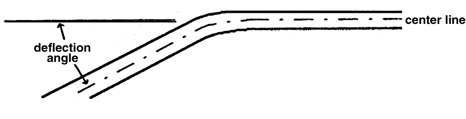
Deflection angle: The angle between a deviation in the direction of the center line of a street and
the extension of the center line along a straight course from the point from which
the center line changed direction. (See below)
Design variance: An alteration or relaxation of the terms of this article where such alteration will not be contrary to the public interest, convenience and welfare, and where, owing to conditions peculiar to the property over which the applicant for a variance has no control, a literal enforcement of these regulations would create unnecessary and undue hardship on the applicant in the use of the property.
Developer: The person, corporation or other legal entity that undertakes the subdivision of property or the construction of streets, utilities, buildings or other improvements required for the habitation or use of property.
Development: (1) A land development project involving the construction of streets, utilities, buildings, or other improvements required for the habitation or use of property, such as a residential neighborhood, an apartment complex, a store, or a shopping center; (2) any manmade change to improved or unimproved real estate, including, but not limited to, buildings or other structures, mining, dredging, filling, grading, paving, excavating, drilling operations, or permanent storage of materials; (3) the act of constructing or carrying out a land development project.
Easement: A strip of land on which the property owner has granted to the City the right to use such land for specific purposes.
Improvements: The physical addition and changes to land that may be necessary to produce usable, desirable and acceptable lots or building sites.
Intersection:
(1)
The place where two (2) streets cross;
(2)
The point at which the center line of a street intersects the center line of another street or railway.
Professional engineer: An engineer licensed and registered to perform the duties of a professional engineer (P.E.) by the State of Georgia.
Publicly dedicated: Land or improvements that has or have been transferred by plat or deeded to and accepted by the city for public use and maintenance.
Public Works Director: The Director of the Department of Public Works of the City of Hawkinsville, or his designee, whose duties include the review and approval of construction plans for public streets and utilities for the city.
Registered land surveyor: A land surveyor licensed and registered to perform the duties of a registered land surveyor (R.L.S.) by the State of Georgia.
Reserve strip: A strip or tract of land reserved for the purpose of controlling or limiting access from properties to abutting streets.
Sewerage, public: A sanitary sewerage system for the collection of water-borne wastes complete with a sewage treatment plant that is owned and operated by a public agency or authority.
Street: An improved way for the conveyance of motor driven, rubber-tired vehicles, such as automobiles and trucks.
a.
Arterial street: A state or U.S. numbered highway. Arterial streets are used for traffic of moderate to fast speeds and high volumes between major local centers of employment, recreation and shopping.
b.
Collector street: A major street used for traffic of moderate speeds and high peak volumes between local streets and arterial streets or serving as a principal entrance street or primary circulation route within a neighborhood or other limited area. Collector streets serve nonresidential or multi-family areas, or one hundred (100) dwelling units or more in residential subdivisions, but are not state or U.S. numbered highways.
c.
Local Street: A minor street used for traffic of relatively low speeds and volumes and for primary access to abutting properties. Local streets serve fewer than one hundred (100) dwelling units.
Street jog: The incidence where two (2) streets or two (2) portions of a single street are separated
by a relatively short distance, usually at their intersection with another street.
(See below)
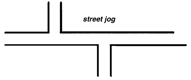
street jog
Subdivision:
(1)
The division of a property or tract of land into two (2) or more tracts or lots;
(2)
A land development project in which two (2) or more lots are created, along with the streets and utilities needed to support construction of buildings on the lots.
Tangent: The straight-line distance between the ending of one curve of a line (center line
of a street) and the beginning of another curve of the same line (center line). (See
below)
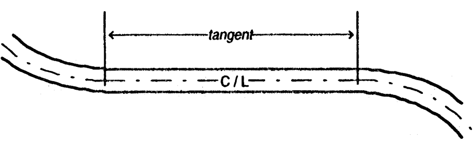
tangent
(Ord. of 5-10-96)
Sec. 4.2.1. - Suitability of the land.
Land physically unsuitable for subdivision or development because of flooding, poor drainage, steep slopes, rock formations or other such features that may endanger health, life or property, aggravate erosion, increase flood hazard, or necessitate excessive expenditures of public funds for supply and maintenance of services shall not be approved for subdivision or development unless adequate methods are formulated by the developer for solving the problems.
(Ord. of 5-10-96)
Sec. 4.2.2. - Conformance to the comprehensive plan.
a.
All proposed subdivisions shall conform to the Comprehensive Plan and development policies in effect at the time of submission to the Planning Commission.
b.
All highways, streets, and other features of the Comprehensive Plan shall be platted by the developer in the location and to the dimension indicated on the Comprehensive Plan.
c.
In subdivisions or developments related to or affecting any state or U.S. numbered highway, the approval of the Georgia Department of Transportation shall be required by the Planning Commission.
(Ord. of 5-10-96)
Sec. 4.2.3. - Name of subdivision.
The name of each subdivision must have the approval of the planning commission. The name shall not duplicate nor closely approximate the name of an existing subdivision.
(Ord. of 5-10-96)
Sec. 4.2.4. - Blocks.
a.
Length:
(1)
Blocks shall be at least four hundred (400) feet but not more than twelve hundred (1,200) feet in length, except as the planning commission considers necessary to secure efficient use of land or desired features of street pattern.
(2)
In blocks greater than eight hundred (800) feet in length, the planning commission may require one or more public crosswalks in pedestrian easements of not less than ten (10) feet in width to extend entirely across the block.
b.
Width: Blocks shall be wide enough to allow two (2) rows of lots, except where reverse frontage lots on arterial streets are provided, or when prevented by topographic conditions or size of the property, or for lots along the periphery of the subdivision, in which case the planning commission may approve a single row of lots.
(Ord. of 5-10-96)
Sec. 4.2.5. - Lots.
a.
Adequate building sites: Each lot shall contain a site large enough for a normal building that will meet all building setback requirements and not be subject to flood or periodic inundation.
b.
Street frontage: Each lot must abut a public street for a distance of no less than thirty-five (35) feet.
c.
Arrangement: Insofar as practical, side lot lines shall be at right angles to straight street lines or radial to curved street lines.
d.
Minimum lot dimensions and areas: All lots proposed in a subdivision shall meet or exceed the area and dimensional requirements of this Ordinance for the zoning district in which the lots are located.
e.
Double and reverse frontage lots: Double frontage and reverse frontage lots should be avoided except where specifically required to provide separation of residential development from an arterial street or to overcome specific disadvantages of topography and orientation of property. An easement of at least ten (10) feet across which there shall be no right of access, shall be provided where required by the planning commission along the line of lots abutting such arterial streets, or to overcome the disadvantageous orientation of property.
(Ord. of 5-10-96)
Sec. 4.3.1. - Minimum requirements.
The following improvements shall be provided by the developer or at the developer's expense in every subdivision or development in accordance with the standards contained in this article.
a.
Survey monumentation of the public streets and lot lines in a subdivision.
b.
Public streets providing access to a development and to all lots in a subdivision, including the extension of streets required to provide access to adjoining properties.
(1)
Public streets contained wholly within a subdivision shall be improved to the full standards contained in this article. Streets that adjoin a development shall be improved to one-half of the minimum standards from the center line of the street along the development's frontage.
(2)
Public streets in nonresidential areas or serving a multi-family development shall be improved to "collector" street standards. In residential subdivisions, streets that serve one hundred (100) dwelling units or more shall be improved to "collector" street standards, while those serving fewer than one hundred (100) dwelling units shall be improved to "local" street standards.
(3)
The city may participate in sharing the costs of construction and installation to the extent that improvements are needed to bring the street to a higher level of classification than required to exclusively serve the subdivision or development.
c.
Curb and gutter as follows:
(1)
Along streets within or adjacent to a subdivision in which the minimum lot size is less than one acre or the minimum lot width is less than two hundred (200) feet.
(2)
Along streets where sidewalks are required.
(3)
All other streets shall comply with the standards for a "swale ditch section" street or as otherwise required by the Georgia Department of Transportation.
d.
Stormwater drainage and detention facilities.
e.
Sidewalks along both sides of any street within the development within one mile of a public or private school, and along the development's frontage on any street adjacent to the development within one mile of a public school.
f.
Street name signs and traffic control signs shall be installed by the city at the developer's expense.
g.
Public water service shall be provided to every lot in a subdivision and to every development for both domestic use and fire protection. Water mains shall be connected to the existing city water system and extended to the meter box serving each lot or the master meter box serving a development. All elements of the water system, including mains, valves, hydrants, and meters, shall be installed at the developer's expense by the city directly or by the city's contractor. The city may participate in sharing the costs of construction and installation to the extent that pipe sizes are needed in excess of that size required to exclusively serve the subdivision or development.
h.
Fire hydrants shall be located along the streets in every subdivision and within every development project.
i.
Every lot in a subdivision and every development shall be connected to the city's public sanitary sewerage system. Sewer lines shall be connected to the existing sanitary sewerage system and extended to a stub-out serving each lot or serving the development as a whole, as appropriate. Every element of the sanitary sewer system, including mains, lift stations, outfalls, and laterals, shall be installed at the developer's expense by the city directly or by the city's contractor. The city may participate in sharing the costs of construction and installation to the extent that sewer mains or related improvements are needed in excess of the facilities required to exclusively serve the subdivision or development.
(Ord. of 5-10-96)
Sec. 4.3.2. - Design variances.
a.
The planning commission may authorize variances from the general requirements and minimum standards of design contained in this article provided the developer makes a specific request and shows to the satisfaction of the planning commission that topographical or other conditions peculiar and particular to the site are such that strict adherence to the requirements would cause unnecessary hardship and would not carry out the intent of these regulations.
b.
Any variance thus authorized is to be stated in writing in the minutes of the planning commission, along with the reasons for which the departure was justified and setting forth the conditions under which the variance was granted.
(Ord. of 5-10-96)
Sec. 4.3.3. - Guarantee in lieu of completed improvements.
No final subdivision plat shall be approved by the Board of Commissioners or accepted for record by the Clerk of Superior Court until one of the following conditions has been met:
a.
All required improvements have been constructed in a satisfactory manner and approved by the Board of Commissioners, or
b.
The Board of Commissioners has received in escrow full funding of the estimated cost of installation of the required improvements, and an executed contract for installation of the improvements by a qualified contractor. The executed contract shall call for completion of the improvements within one year of approval of the final subdivision plat.
(Ord. of 5-10-96)
Sec. 4.4.1. - Right-of-way monuments.
A reinforced concrete monument shall be set at the intersection of the centerline of street rights-of-way, and at the intersection of curves and tangents with straight lines along street centerlines. The survey monument shall be four (4) inches in diameter or square and at least three (3) feet long with a flat top, and shall be placed under the direction of a Registered Land Surveyor. The top of the monument shall have an indented cross to identify properly the location and shall be set flush with the surface of the street.
(Ord. of 5-10-96)
Sec. 4.4.2. - Property line monuments.
Every lot corner and each point at which a property line changes direction shall be marked with an iron pin placed by a Registered Land Surveyor. Each iron pin shall be at least three-fourths (¾) inch in diameter and twenty-four (24) inches long. The tops of such iron pins shall be approximately level with the finished grade.
(Ord. of 5-10-96)
Sec. 4.5.1. - Access.
a.
Every development and every lot within a subdivision shall be served by a publicly dedicated street meeting the requirements of this article.
b.
Every development and every subdivision shall have access to the public street system via a paved roadway.
c.
When land is subdivided into larger parcels than ordinary building lots, such parcels shall be arranged and designed so as to allow for the opening of future streets and to provide access to those areas not presently served by streets.
d.
No subdivision or development shall be designed so as to completely eliminate street access to adjoining parcels of land.
e.
Reserve strips shall be prohibited.
(Ord. of 5-10-96)
Sec. 4.5.2. - Street classifications.
Streets are hereby classified according to the function that they are to serve, the type, speed, and volume of traffic they will carry and the required standards of design. The classifications of streets and roads are as follows:
a.
Arterial streets—State and U.S. numbered highways.
b.
Collector streets—Major streets that carry traffic between neighborhoods and arterial streets, serve nonresidential or multi-family areas or developments, and streets within a residential subdivision that collect traffic from one hundred (100) dwelling units or more.
c.
Local streets—Streets in residential subdivisions that primarily provide access to individual lots, do not carry through traffic, and serve fewer than one hundred (100) dwelling units.
(Ord. of 5-10-96)
Sec. 4.5.3. - Relation to present and future street system.
a.
Existing streets that adjoin a subdivision boundary shall be deemed a part of the subdivision. The proposed street system within a subdivision shall have the right-of-way of existing streets extended no less than the required minimum width. Subdivisions that adjoin only one side of an existing street shall dedicate one-half (½) of the additional right-of-way needed to meet the minimum width requirement for the street. If any part of the subdivision includes both sides of an existing street, all of the required additional right-of-way shall be dedicated.
b.
Where, in the opinion of the Planning Commission, it is necessary to provide for street access to adjoining property, proposed streets shall be extended by dedication of right-of-way to the boundary of such property through the development.
c.
Where an arterial street adjoins or is included in a residential subdivision, lots that abut the arterial shall be provided with another means of access, such as (1) platting reverse frontage lots, (2) platting a separate street parallel to the arterial, or (3) platting a loop street or cul-de-sac.
d.
Subdivision streets that intersect an arterial street shall do so at intervals of not less than eight hundred (800) feet, or as required by the Georgia Department of Transportation, whichever is greater.
(Ord. of 5-10-96)
Sec. 4.5.4. - Design standards for streets.
a.
Arterial Streets. All State or U.S. numbered highways shall meet all design requirements of and be approved by the Georgia Department of Transportation.
b.
Local and Collector Streets. All local and collector streets shall comply with the design and construction requirements of this ordinance.
c.
Minimum width of right-of-way. Minimum width of right-of-way measured from lot line to lot line shall be as follows:
d.
Vertical alignment of streets.
(1)
Grades on collectors shall not exceed eight (8) percent; grades on local streets shall not exceed twelve (12) percent; all curbed and paved raised edge streets shall have a minimum grade of one percent.
(2)
All changes in grade shall be connected by a vertical curve so constructed as to afford a minimum sight distance, said sight distance being measured from the driver's eyes, which are assumed to be three and three-fourths (3¾) feet above the pavement surface, to an object six (6) inches high on the pavement.
(3)
The minimum sight distance shall be as follows:
e.
Horizontal alignment of streets.
(1)
Where a deflection angle of more than ten (10) degrees in the alignment of a street occurs, the radius of curvature of the center line of said street shall be not less than as follows:
(2)
A tangent of a least two hundred (200) feet in length shall be introduced between reverse curves on collector streets, and one hundred (100) feet on local streets.
(3)
Street jogs with center line offsets of less than one hundred twenty-five (125) feet shall not be allowed.
(4)
Intersections. All streets shall intersect within ten (10) degrees of a right angle. Such intersecting streets shall provide a uninterrupted line of sight from the center point of the intersection for not less than the minimum sight distance required in accordance with section 4.5.4.c(3).
(5)
Curb lines and edges of pavement at street intersections shall have a radius of curvature of not less than twenty (20) feet. The intersecting street right-of-way lines shall be rounded parallel to the curb or pavement radius.
f.
Dead-end Streets.
(1)
A cul-de-sac shall be no more than eight hundred (800) feet long unless necessitated by topographic or other conditions and approved by the Planning Commission. Such a street shall be provided at the closed end with a turnaround having the following right-of-way and pavement diameters:
(2)
A dead-end street other than a cul-de-sac shall not be allowed except as a temporary stage of construction of a street that is intended to be extended in a later stage of construction. Such a temporary dead-end street shall be provided with a temporary turn-around within the right-of-way if:
(a)
One or more lots front exclusively on the street; and,
(b)
Extension of the street is not under construction when the Final Plat is submitted for recording.
(3)
Temporary turnarounds shall consist of a tack coat and one inch of asphalt.
g.
Street names. Proposed streets that are obviously in alignment with others already existing and named shall bear the names of existing streets. In no case shall the name for a proposed street duplicate existing street names in the city, irrespective of the use of the suffix street, avenue, boulevard, road, pike, driveway, place, court or other derivatives.
(Ord. of 5-10-96)
Sec. 4.5.5. - Street improvements.
a.
Minimum width of pavement. The minimum width of pavement, measured from back of curb to back of curb or to pavement edge, required for collectors and local streets shall be as follows:
b.
Street base. Street base material shall conform to the following specifications:
(1)
Soil cement base shall contain a minimum 10% Portland Cement by volume.
(2)
Sand-Clay Base may be allowed only under the following conditions:
(a)
None of the streets exceed eight (8) percent grade.
(b)
Tests taken every one thousand (1,000) feet of roadway shall show that the soil meets Class "B" standards of the Georgia Department of Transportation. The tests shall be conducted by a qualified geotechnical laboratory and the results filed with the city in order to obtain authorization to proceed.
(3)
The street base shall extend fully under the curb and gutter, or six (6) inches beyond the edge of pavement where no curbing is provided.
c.
Pavement topping.
(1)
Streets shall be paved with a top course meeting the following standards:
(2)
If two-stage paving is approved by the Board of Commissioners, the developer shall place a temporary wearing surface on the street and delay final paving until the end of the 1-year maintenance period. In using this method, the base shall be primed with 0.25 gallons of R.C. 70 per square yard the same day it is compacted, and cured for seven (7) days prior to paving. The temporary wearing surface shall consist of Type I Surface Treatment using #6 and #89 stone. Prior to final paving with Type E or F hot plant mix, a tack coat acceptable to the city shall be applied at a rate of no less than 0.05 gallons per square yard.
d.
Curb and gutter.
(1)
Curb and gutter shall meet one of the following standards depending on type of street:
(a)
Collector street: 6" rolled by 24"
(b)
Local street: 4" rolled by 24"
(2)
Valley gutters may be allowed across local streets at street intersections only when no street cross drains are available. Valley gutters shall be poured-in-place Portland cement at least six (6) inches thick, and at least six (6) feet in width.
e.
Turning lanes. Turning lanes may be required at all entrances to subdivisions and industrial and commercial developments which front on arterial and collector streets. Turning lanes shall be twelve (12) feet in width plus curb and gutter for a minimum distance of two hundred (200) feet measured from the intersection of the right-of-way lines.
f.
Street name and traffic control signs. Street name signs of a type approved by the city shall appear at all intersections. Traffic control signs shall be placed as required by the city and conform to the U.S. Manual on Uniform Traffic Control Devices, latest edition.
g.
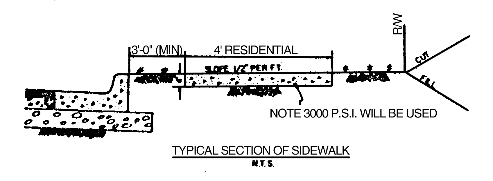
Sidewalks. Sidewalks shall be required within a one mile walking distance of existing or planned schools. Where provided, sidewalks shall be located not less than one foot from the property line to prevent interference of encroachment by fencing, walls, hedges or other planting or structures placed on the property line at a later date. Sidewalks shall be no less than four (4) feet in width, constructed of concrete no less than four (4) inches in depth, and located no less than three (3) feet from the back of curb.
(Ord. of 5-10-96)
Sec. 4.5.6. - Location of utilities.
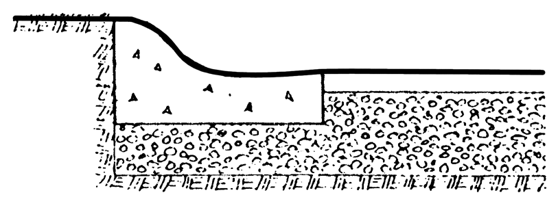
Utilities placed underground shall be placed within the right-of-way as follows (see Typical Street Section C at the end of this article):
a.
Sanitary sewer following generally the center line of the street, no less than six (6) feet below the street surface and providing a minimum slope of laterals to abutting properties of one percent.
b.
Other utilities, when placed underground along the roadway, shall be located in the shoulder of the road and shall be placed at the following distances measured from the back of curb or edge of pavement, and placed at or below the depths indicated as follows:
(Ord. of 5-10-96)
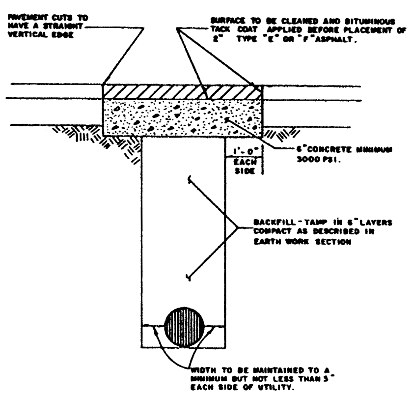
Sec. 4.5.7. - Pavement cuts.
a.
Pavement cuts for the installation of utilities shall be avoided whenever possible. Utility crossings shall be bored across any arterial, subject to the approval of the Georgia DOT, and across any collector unless a pavement cut is approved by the Board of Commissioners.
b.
Pavement cuts across local streets shall be permitted, provided the road is repaired with a least six (6) inches of 3000 psi Portland cement and topped with two (2) inches of E or F hot plant mix asphaltic cement. Pavement cuts across local streets shall conform to the following:
(Ord. of 5-10-96)
Sec. 4.5.8. - Sight triangle.
a.
A sight triangle easement shall be located at every street intersection, delineated by the two (2) intersecting street right-of-way lines and a line connecting the right-of-way lines at the points indicated in the Sight Triangle Table. The connecting points shall be measured from the right-of-way lines extended to their point of intersection.
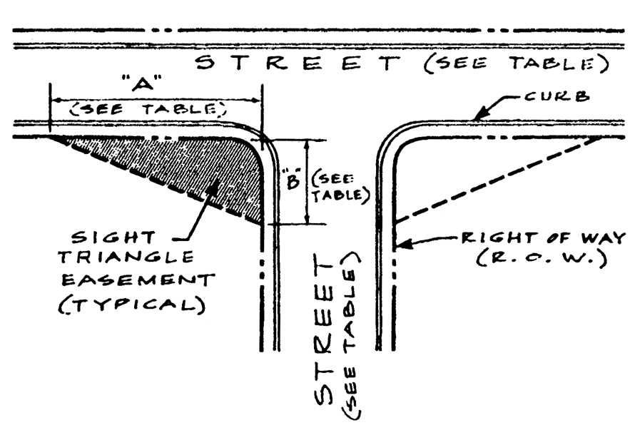
Sight Triangle Table
b.
Within the sight triangle easement, the planting of trees or other vegetation or the location of structures exceeding thirty (30) inches in height that would obstruct the clear sight across the area of the easement shall be prohibited.
c.
The easement shall provide right of entry to the city for the purpose of removing any object or vegetation that obstructs the clear sight.
(Ord. of 5-10-96)
[Sec. 4.6.0. - Required.]
An adequate drainage system, including necessary ditches, pipes, culverts, drains, inlets, bridges, etc., shall be provided for the proper drainage of all surface water.
(Ord. of 5-10-96)
Sec. 4.6.1. - System design.
a.
In order to obtain a Development Permit, a hydrology report shall be prepared that includes appropriate calculations for the two (2) year, ten (10) year, twenty-five (25) year, and one hundred (100) year design frequency storms. The report shall show detailed calculations indicating the formula used, along with the co-efficient of run-off, the time of concentration, the rainfall intensity, the discharged velocity, and the source of all data used.
b.
The hydrology report shall include a map outlining the areas and showing the acreage of all on-site and off-site drainage basins contributing flow through the project.
c.
The hydrology report shall include calculations for the runoff peak rate of discharge to determine the configurations and sizes of pipes, channels and other routing or flow control structures; and the runoff volume to determine the necessity for and sizing of stormwater detention facilities.
d.
Runoff peak rate of discharge for drainage areas up to three hundred (300) acres in size shall be calculated using the Rational Method, with a minimum time of concentration of ten (10) minutes. Flows from drainage areas larger than three hundred (300) acres in size shall be calculated using the SCS Method.
e.
Runoff coefficients used for pre- and post-development activity conditions for the Rational Method shall be consistent with local conditions. For the SCS Method, the runoff curve numbers found in the Manual for Erosion and Sediment Control in Georgia shall be used.
f.
Runoff volume for drainage areas up to five (5) acres in size shall be calculated using the Rational Method triangular hydrography approximation. Flows from drainage areas larger than five (5) acres in size shall be calculated using the SCS Method.
g.
Hydraulic capacity for open channel or closed conduit flow shall be determined using the Manning Equation.
h.
The stormwater flow velocity at the site's downstream property line shall not exceed the pre-development activity velocity.
(Ord. of 5-10-96)
Sec. 4.6.2. - Street cross drains.
a.
Pipe size for culverts under streets (street cross drains) shall be determined by design runoff and hydraulic capacity. The minimum allowable street cross drain diameter shall be eighteen (18) inches, with a minimum slope of one percent.
b.
Street cross drains shall be constructed of Class III reinforced concrete, corrugated aluminum, or bituminous coated corrugated steel. The least expensive materials shall be permitted unless site or other conditions identified by a Professional Engineer dictate otherwise.
c.
Street cross drains shall be sized to carry at least the 10-year frequency storm. Cross drains shall be designed to pass the peak rate of discharge associated with a 100-year storm with at least one foot of freeboard from the top of the roadway shoulder.
d.
Velocity at design flow shall be at least two (2) feet per second but not more than the velocity that would cause erosion damage to the conduit.
e.
Street cross drain design is to be in accordance with the methods contained in the Georgia Department of Transportation's Drainage Manual for Highways, latest edition.
f.
Street cross drains carrying live streams shall extend to where the crown of the pipe intersects the street slope.
(Ord. of 5-10-96)
Sec. 4.6.3. - Inlets and catch basins.
a.
Inlets and catch basins shall be designed in accordance with the Georgia Department of Transportation's Drainage Manual for Highways, latest edition.
b.
Frames and grates shall be Campbell Foundry Company Pattern No. 2617 Bicycle Grates with stream-flowing grating, or equivalent.
c.
Stormwater catch basins shall be spaced so that the spread in the street for a 10-year design peak rate of discharge shall not exceed eight (8) feet, as measured from the face of the curb.
d.
Catch basins shall be located at all low points of streets and shall be located so as to service no more than four (4) acres.
(Ord. of 5-10-96)
Sec. 4.6.4. - Piped systems.
a.
Pipe size shall be determined by design runoff and hydraulic capacity. The minimum allowable pipe diameter shall be eighteen (18) inches.
b.
Storm drain pipes shall be constructed of Class III reinforced concrete, corrugated aluminum, or bituminous coated corrugated steel. The least expensive materials shall be permitted unless site or other conditions identified by a Professional Engineer dictate otherwise.
c.
The design of piped stormwater collection systems shall be based upon conveyance of the peak rate of discharge associated with a 10-year storm.
d.
Stormwater pipes that do not carry live streams shall extend at least fifty (50) feet beyond the front building setback lines, and may be required to extend farther where necessary to provide an adequately protected building site on the property.
e.
Any storm drainage pipe that extends outside of the street right-of-way shall be located within a twenty (20) foot wide easement.
f.
All storm drainage pipes shall be at least eighteen (18) inches below the surface and shall have a slope of at least one percent.
g.
Pipe bedding shall be provided as specified in "Design and Construction of Sanitary and Storm Sewers," prepared by the American Society of Civil Engineers (Manuals and Reports on Engineering Practice No. 37), latest edition.
(Ord. of 5-10-96)
Sec. 4.6.5. - Headwalls.
a.
Headwalls are required at the inlet and outlet on all street cross drains and storm drain pipes.
b.
Headwalls are to be precast concrete, stone masonry with reinforced concrete footings, or poured-in-place, reinforced concrete with reinforced concrete footings.
c.
High water elevation contour is to be based on a twenty-five (25) year storm at the entrance of each head wall.
d.
Energy dissipation devices, such as splash pads, riprap, stilling basins, etc., shall be provided at the outlet of every street cross drain and storm drain pipe.
(Ord. of 5-10-96)
Sec. 4.6.6. - Open channels.
a.
All stormwater channels shall be designed to carry at least the 10-year frequency storm with one foot of freeboard.
b.
Velocity at design flow shall be not less than six (6) inches per second but not greater than four (4) feet per second. A higher velocity may be allowed if actions are taken that would avoid erosion or scouring of the channel.
c.
All stormwater channels must be designed to convey flows that prevent dwelling flooding, property damage, or public access and/or utility interruption.
d.
The Public Works Director may determine that the expected long-term maintenance of a surface drainage system could prove impractical, and a stormwater pipe collection system may be required.
e.
Any storm drainage channel that extends outside of the street right-of-way shall be located within a twenty (20) foot wide easement.
f.
In cases in which a subdivision or development is traversed by a stream, there shall be provided an easement extending ten (10) feet from each side of the stream bank.
g.
All drainage easements, natural ditches, and drainage areas shall be grassed and/or riprapped as necessary to control erosion.
h.
Cross drains under driveways shall meet the standards for street cross drains, except corrugated end sections may be used in lieu of headwalls.
(Ord. of 5-10-96)
Sec. 4.6.7. - Stormwater detention.
a.
Stormwater detention facilities providing for the storage and controlled release of runoff shall be required for any development activity that will increase the peak rate of discharge by one percent or more for the 10-year frequency storm.
b.
All stormwater detention facilities shall be designed to control the runoff volumes associated with storms having 2-year, 10-year, and 25-year return frequencies, considered individually. The design of the facility shall also consider the ponding limits of the 100-year storm.
c.
Detention shall be provided such that the peak rate of flow from the site after development will not exceed the corresponding flow that would have been created by the same return frequency storms prior to development.
d.
Reservoir routing methods shall be used for all detention facility design.
e.
Principal outlets such as weirs shall be constructed of concrete block or reinforced concrete with watertight joints. Outlet pipes shall be at least six (6) inches in diameter. Riser pipes, if used, shall be at least eight (8) inches in diameter.
f.
No portion of any detention facility shall be located in any required buffer or within a flood hazard area.
g.
The 100-year ponding limits of a detention facility shall not encroach upon a public street.
h.
An easement at least twenty-five (25) feet in width shall be required to provide access to the detention facility from a street.
i.
Every detention facility shall be completely enclosed within a drainage easement. The drainage easement shall extend at least ten (10) feet beyond the ponding limits of the 100-year storm.
(Ord. of 5-10-96)
[Sec. 4.7.1. - Generally.]
a.
Each developer shall be required to pay for the installation of a sanitary sewerage collection system connected to the city's system serving his subdivision or development. The layout and specifications of the system shall be in accordance with city specifications, as approved by the Public Works Director, and shall be installed by city forces or a contractor employed by the city.
b.
Where connection to the sanitary sewerage system is not feasible in the view of the Public Works Director, the lot shall contain adequate area for the installation and safe operation of a septic tank and disposal field, as approved by the county health officer.
(Ord. of 5-10-96)
[Sec. 4.8.1. - Generally.]
a.
Each subdivision or development shall connect to the city's public water system, and shall provide service to each lot or the development as a whole, as appropriate, at the expense of the developer.
b.
The layout and specifications of the system shall be in accordance with city specifications, as approved by the Public Works Director, and shall be installed by city forces or a contractor employed by the city.
c.
Fire hydrants in subdivisions shall be spaced no more than one thousand (1,000) feet apart, and meet the requirements of the Fire Department.
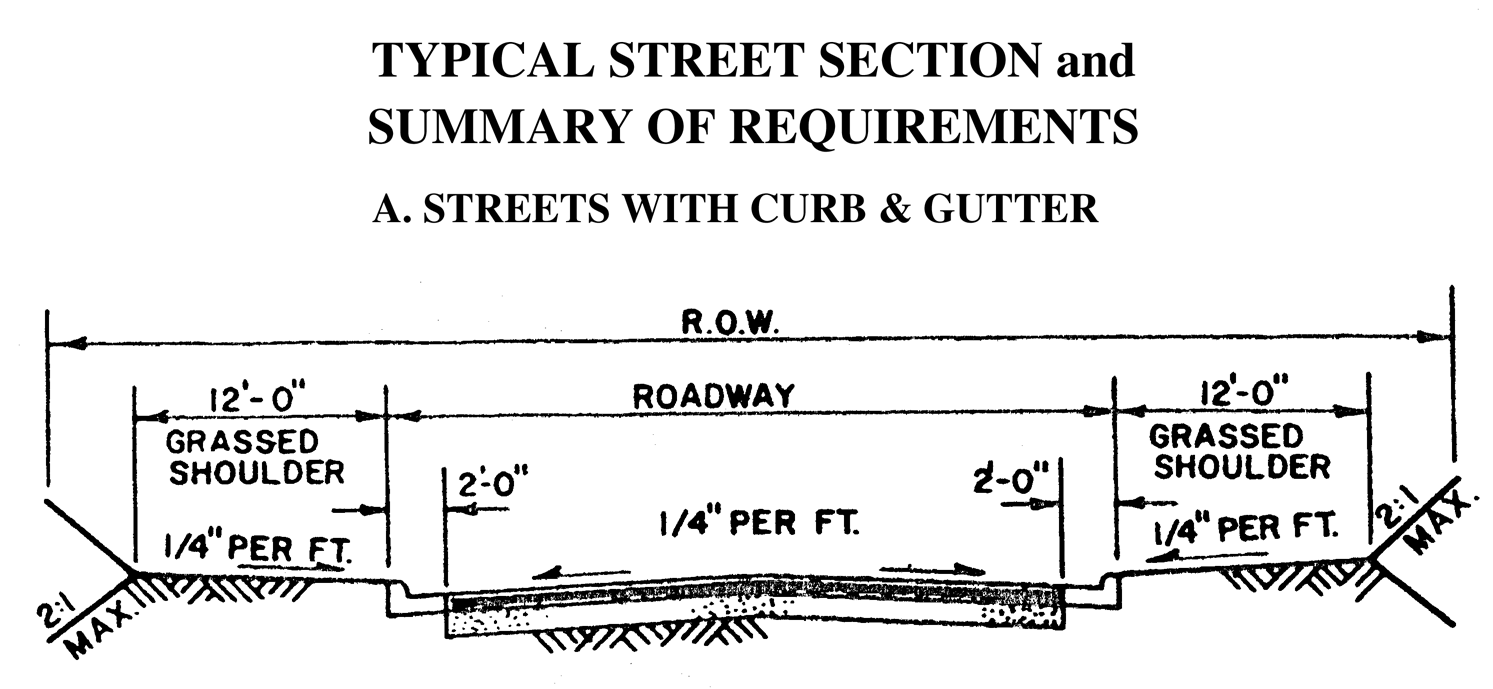
Streets with Curb & Gutter
Streets with Swale Ditch Drainage
(Ord. of 5-10-96)