
Hawkinsville City Zoning Code
ARTICLE VI
PLANS AND PROCEDURES
DIVISION 2. - ZONING CHANGES[5]
State Law reference— Zoning changes, O.C.G.A. § 36-66-1 et seq.
DIVISION 4. - CIVIL DESIGN AND CONSTRUCTION DRAWINGS
civil design
(Ord. of 5-10-96)
DIVISION 7. - FINAL SUBDIVISION PLAT
final subdivision plat
(Ord. of 5-10-96)
Sec. 6.1.1. - Purpose.
This article describes the process through which a zoning change may be approved on a property, the approval process for construction of subdivisions and other land development projects, the procedures for amendments to the text of this ordinance, and the process for appeals from an administrative decision or for hardships.
(Ord. of 5-10-96)
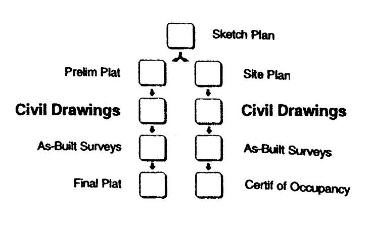
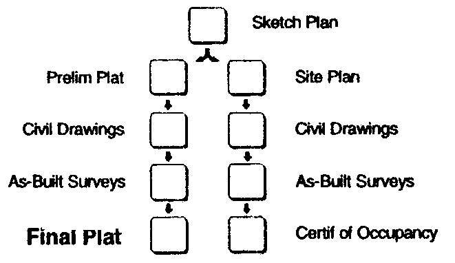
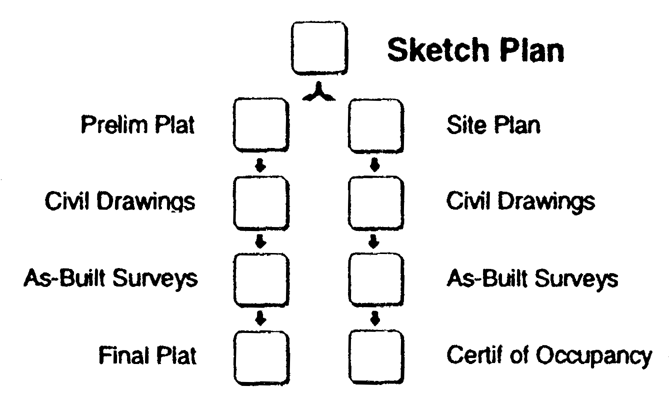
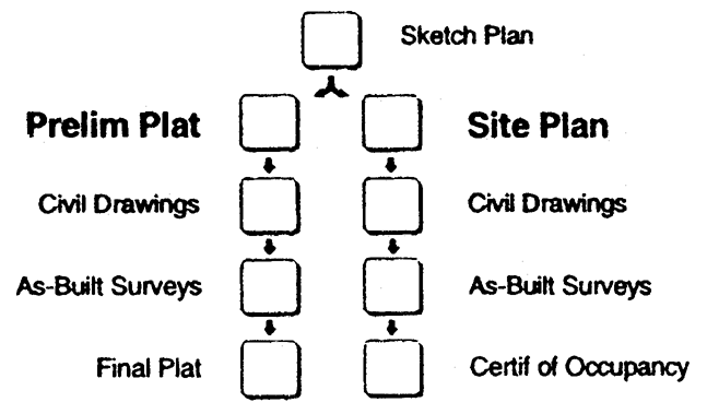
Sec. 6.1.2. - Overview—land development.
The following presents a graphic illustration of the plans and procedures involved
in the land development approval and construction process, described below.
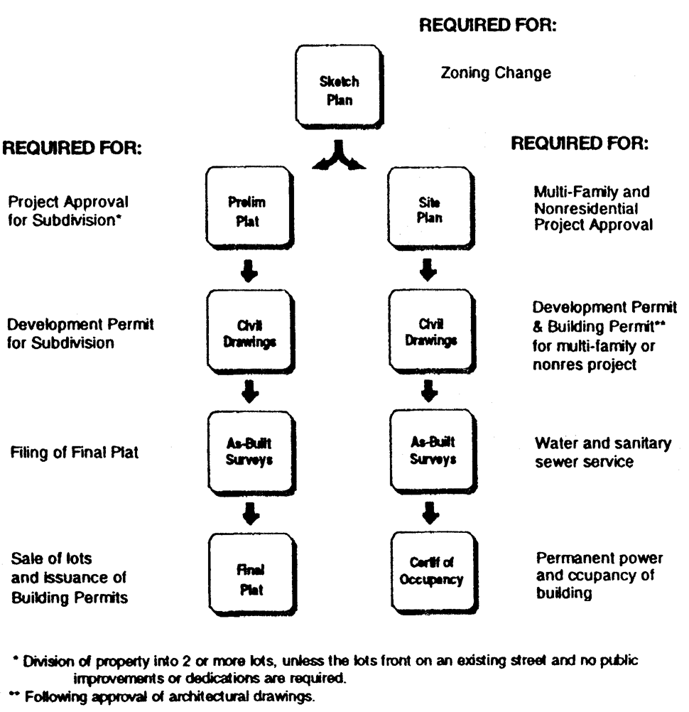
sketch plan
a.
Zoning Changes. An application for rezoning or approval of a conditional use must include a sketch plan of the proposed use of the property.
b.
Subdivisions with Public Improvements. The division of land into two (2) or more lots that will require the construction or extension of public streets, water or sanitary sewerage (other than the direct connection of buildings to existing facilities) shall be conducted as follows:
(1)
Project Approval is granted by the Planning Commission upon review and approval of a Preliminary Subdivision Plat.
(2)
A Development Permit is issued by the Building Inspector based on review and approval of civil drawings for construction of the subdivision.
(3)
Receipt by the Building Inspector of accurate surveys of the as-built condition of public improvements is required in order to allow filing of a Final Plat.
(4)
Approval of a Final Subdivision Plat and acceptance of public improvements by the Board of Commissioners will authorize recordation of the plat with the Clerk of the Superior Court.
(5)
After recordation of the Final Plat, the lots may be sold and building permits on the lots may be obtained.
c.
Minor Subdivisions. The division of land into two (2) or more lots, each of which will be adequately served by existing public streets, water and sanitary sewerage, shall be conducted as follows:
(1)
Approval of a Final Subdivision Plat by the Board of Commissioners will authorize recordation of the plat with the Clerk of the Superior Court.
(2)
After recordation of the Final Plat, the lots may be sold and building permits on the lots may be obtained.
d.
Multi-Family and Nonresidential Projects.
(1)
Project Approval is granted by the Planning Commission upon review and approval of a Site Plan for the project.
(2)
A Development Permit is issued by the Building Inspector based on review and approval of civil drawings for construction of the project.
(3)
A Building Permit is issued by the Building Inspector based on review and approval of architectural plans. Buildings falling under the authority of the State Fire Marshall shall be approved by the State prior to issuance of the building permit.
(4)
Receipt by the Building Inspector of accurate surveys of the as-built condition of all public improvements is required in order to authorize permanent water and sanitary sewer service.
(5)
Permanent electric power and occupancy of the building is authorized by the Building Inspector based on final inspection and issuance of a Certificate of Occupancy.
(Ord. of 5-10-96)
Sec. 6.1.3. - Definitions.
Applicant: A property owner or their authorized representative who has petitioned the City for approval of a zoning change, conditional use, development permit, building permit, variance, interpretation or appeal, or any other authorization for the use or development of their property under the requirements of this ordinance.
Application: A petition for approval of a zoning change, conditional use, development permit, building permit, variance, interpretation or appeal, or any other authorization for the use or development of a property under the requirements of this ordinance.
Building code: The technical codes adopted or adopted as amended by the City under Section 5-2 of its Code of Ordinances.
Condition of zoning approval: A requirement adopted by the Board of Commissioners at the time of approval of a zoning change, placing greater or additional requirements or restrictions on the property than provided in this ordinance in order to reduce an adverse impact of the zoning change and to further the protection of the public health, safety, or general welfare.
Presiding official: The person chairing a meeting of the Planning Commission or the Board of Commissioners in their official capacity.
Public improvement: The construction, enlargement, extension or other construction of a facility intended for dedication to the public, including but not limited to a street, curb and gutter, sidewalk, cross drain, catch basin, traffic control and street name sign, or other roadway appurtenance other than a driveway apron connection; domestic water supply system main, fire hydrant, valve or other appurtenance other than a supply line to a building; or sanitary sewerage main or outfall, lift station, force main, manhole or other appurtenance other than a drain line from a building.
Zoning change: An amendment to the Zoning Map (rezoning), approval of a conditional use, or approval of a change in the conditions of approval associated with a rezoning or conditional use.
(Ord. of 5-10-96)
[Sec. 6.2.0. - Generally.]
The Official Zoning Map may be amended from time to time and conditional uses may be approved for specific properties by the Board of Commissioners under the procedures in this Section. In addition, changes in the conditions of approval pertaining to a specific rezoning or conditional use approval may also be approved by the Board of Commissioners following the procedures in this Section. All of these types of actions shall be referred to as "zoning changes."
(Ord. of 5-10-96)
Sec. 6.2.1. - Initiation.
a.
An application for a zoning change for any property or properties in the city may be initiated by the Board of Commissioners, by the Planning Commission, or by the owner of the property. Unless initiated by the Board of Commissioners or the Planning Commission, all such applications shall be initiated by the owner of a majority interest in the property affected.
b.
All applications shall be submitted to the Building Inspector on application forms adopted from time to time by the Board of Commissioners. All applications shall be accompanied by a non-refundable fee as fixed from time to time by the Board of Commissioners. A fee shall not be charged if the Board of Commissioners or the Planning Commission has initiated the application.
c.
The Building Inspector shall review the application for completeness within five (5) days of submission. Incomplete applications will be returned to the applicant.
d.
An application for a zoning change affecting the same property shall not be considered by the Board of Commissioners more often than once every twelve (12) months; provided, however, that the Board of Commissioners may approve a reduction in the waiting period to no less than six (6) months.
(Ord. of 5-10-96)
Sec. 6.2.2. - Sketch plan.
sketch plan
a.
An application for a rezoning or conditional use approval shall be accompanied by a sketch plan if any new construction is proposed or alteration of the site is required under the site or development design standards of this ordinance (Articles 4 and 5).
b.
A sketch plan may be prepared by the applicant, a professional engineer, a registered land surveyor, a landscape architect, a land planner, or any other person familiar with land development activities.
c.
The sketch plan shall be drawn to scale on a boundary survey of the tract or on a property map showing the approximate location of the boundaries and dimensions of the tract.
d.
The sketch plan shall show the following, as appropriate to the zoning or conditional use requested:
(1)
Name and address of the property owner.
(2)
Name, address, and telephone number of the applicant.
(3)
Date of survey, north point and graphic scale, source of datum, date of plan drawing, and revision dates, as appropriate.
(4)
Proposed use of the property.
(5)
Location (Land District and Land Lot) and size of the property in acres (or in square feet if less than an acre).
(6)
Location sketch of the property in relation to the surrounding area with regard to well known landmarks such as arterial streets, railroads or others. Sketches may be drawn in freehand and at a scale sufficient to show clearly the information required, but not less than one inch equal to two thousand (2,000) feet. U.S. Geological Survey maps may be used as a reference guide for the location sketch.
(7)
Zoning district designation of the subject property and all adjacent properties, and zoning district boundaries as appropriate.
(8)
Man-made features within and adjacent to the property, including existing streets and names, city and county political boundary lines, and other significant information such as location of bridges, utility lines, existing buildings to remain, and other features as appropriate to the nature of the request.
(9)
The proposed project layout including:
(a)
For subdivisions, lot lines and street right-of-way lines, along with the front building setback line on each lot.
(b)
For multi-family and nonresidential development projects, the approximate outline and location of all buildings, and the location of all minimum building setback lines, outdoor storage areas, buffers, parking areas, and driveways.
(10)
A statement as to the source of domestic water supply.
(11)
A statement as to the provision for sanitary sewage disposal.
(12)
The approximate location of proposed stormwater detention facilities.
(13)
Such additional information as may be useful to permit an understanding of the proposed use and development of the property.
(Ord. of 5-10-96)
Sec. 6.2.3. - Process for zoning changes.
Before the Board of Commissioners may take final action on a proposed zoning change, the Planning Commission shall hold a public hearing on the proposal.
a.
Public Notice.
(1)
Notification to the General Public.
(a)
At least fifteen (15) days but not more than forty-five (45) days prior to the public hearing, notice shall be published in a newspaper of general circulation within the city. The City Manager shall prepare such notice, which shall state the time, place and purpose of the hearing.
(b)
A zoning change initiated by a party other than the Board of Commissioners or the Planning Commission shall be heard at a public hearing only upon:
1.
The published notice, in addition to the requirements above, shall include the location of the property, the present zoning classification of the property, and the proposed zoning classification of the property or the conditional use requested; and
2.
At least fifteen (15) days prior to the public hearing, the Applicant shall post, or have the City post at the Applicant's expense, a sign or signs of not less than twelve (12) square feet stating the date, time and place for the public hearing, the present zoning classification and the nature of the proposed zoning change. One such sign shall be placed in a conspicuous location along each street frontage of the property for which the zoning change has been requested. If the property has no street frontage, the sign shall be placed on each street from which access will be gained to the property.
(2)
Notice to Surrounding Property Owners. If the proposed zoning change was initiated by a party other than the Board of Commissioners or the Planning Commission, or if it affects only one property, notice shall also be given to surrounding property owners as follows:
(a)
At least ten (10) days prior to the public hearing at which a zoning change will be considered, the Applicant shall cause a notice to be mailed to all persons owning property located adjacent to or across the street from the property that is the subject matter of the zoning change.
(b)
The notice shall state the time, place and purpose of the hearing by the Planning Commission and the date of the meeting of the Board of Commissioners. The written notice shall be mailed to the property owners as such names and addresses appear on the Pulaski County ad valorem tax records.
b.
Planning Commission Public Hearing. The public hearing held by the Planning Commission for zoning changes shall be held within forty-five (45) days of receipt of a complete application. The public hearing shall be conducted in the following manner:
(1)
The public hearing shall be convened at the scheduled time and place by the chairman, the vice chairman, or the chairman's designee, who shall act as the Presiding Official.
(2)
The Presiding Official shall submit each proposed zoning change to the Planning Commission.
(3)
No person in attendance shall speak unless first formally recognized by the presiding official. Upon rising to speak each person recognized shall state their name and home address. The presiding official may place reasonable limits on the number of persons who may speak for or against a proposal, on the time allowed for each speaker, and on the total time allowed for presentation of the proposed zoning change. No less than ten (10) minutes shall be provided for all of those speaking in support of a zoning change and no less than ten (10) minutes shall be provided for all of those speaking against, unless such proponents or opponents take less time than the minimum allowed. If reasonable time limitations permit, any member of the general public may speak at a hearing. However, the applicant and nearby property owners shall be afforded the first opportunity to speak.
(4)
The applicant shall be allowed to speak first in order to present the application. Others may then speak, indicating first their support for or opposition to the application. The applicant will then be allowed time for rebuttal. Rebuttal must be limited to points or issues raised by opponents to the application at the hearing.
(5)
During the public hearing, the Planning Commission members may ask questions at any time. Time devoted to questions and answers will not be counted against any time limitations that have been imposed on presentations.
(6)
Following the public hearing on each zoning change, the Planning Commission shall make its recommendation or take such other action as may be appropriate within thirty (30) days.
(a)
A motion to recommend approval or denial of an application must be approved by an affirmative vote of at least three (3) members in order for the motion to be approved.
(b)
If a motion to recommend approval of an application fails, the application is recommended for denial. If a motion to recommend denial of an application fails, another motion would be in order.
(c)
A tie vote on a motion to recommend approval of an application shall be deemed a recommendation for denial of the application. A tie vote on any other motion shall be deemed to be no action, and another motion would be in order.
c.
Board of Commissioners Meeting.
(1)
The Board of Commissioners shall consider an application for a zoning change at their first scheduled meeting following receipt of the recommendation of the Planning Commission, or after thirty (30) days following the Planning Commission's public hearing on the application if no recommendation has been received.
(2)
At the Board Of Commissioners' meeting when the proposed zoning change is scheduled to be considered, the Chairman or the Vice-Chairman shall act as Presiding Official. As each application for a zoning change is called for consideration, the City Manager shall read the recommendation of the Planning Commission and shall present such other documentation as he may deem pertinent.
(3)
If the applicant or other interested parties are present at the meeting, any City Commissioner recognized by the Presiding Official may ask questions of such parties, whose answers shall be recorded in the minutes of the meeting.
(4)
At the meeting, following consideration of the application, action shall be taken by vote of the Board of Commissioners.
(a)
A motion to approve or deny an application must be approved by an affirmative vote of at least three (3) members in order for the motion to be approved.
(b)
If a motion to approve an application fails, the application is denied. If a motion to deny an application fails, another motion would be in order.
(c)
A tie vote on a motion for approval of an application shall be deemed a denial of the application. A tie vote on any other motion shall be deemed to be no action, and another motion would be in order.
(5)
In taking action on an application, the Board of Commissioners may:
(a)
Approve, approve with conditions, or reject the proposal; or,
(b)
Allow withdrawal if so requested by the applicant (with or without imposing a six month period during which another zoning change on the property may not be considered); or,
(c)
Table the proposal for consideration at its next scheduled meeting.
(d)
Rezoning of Areas to be Annexed into the City. An area proposed for annexation into the city shall first be considered for rezoning prior to its annexation. Consideration of the rezoning shall be subject to the same procedures, standards, and requirements for any zoning change as contained in this Section, except as modified below:
(1)
Upon or following the date of notice to the county of the proposed annexation as required under O.C.G.A. § 36-36-6, the board of commissioners shall initiate the rezoning of the property to be annexed or consider an application for a zoning change submitted by or on behalf of the owner of such property under the provisions of this section.
(2)
The planning commission shall conduct a public hearing on the zoning change under the provisions of subsection 6.2.3.b. prior to the annexation of the land into the city. Notice of such hearing shall be provided under the provisions of subsection 6.2.3.a., provided further that the notice shall be published in a newspaper of general circulation in the county.
(Ord. of 5-10-96; Ord. of 8-19-96, §§ 1, 2)
Sec. 6.2.4. - Standards for zoning changes.
a.
Zoning Map Amendments (Rezoning). The Planning Commission and the Board of Commissioners shall consider the following standards in considering any zoning proposal that would result in a change in the boundary of a zoning district, giving due weight or priority to those factors that are appropriate to the circumstances of each proposal:
(1)
Whether the proposal will permit a use that is suitable in view of the zoning and development of adjacent and nearby property.
(2)
Whether the proposal will adversely affect the existing use or usability of adjacent or nearby property.
(3)
Whether the proposal is compatible with the purpose and intent of the Comprehensive Plan.
(4)
Whether there are substantial reasons why the property cannot or should not be used as currently zoned.
(5)
Whether the proposal will result in a use that will or could cause an excessive or burdensome use of public facilities or services, including but not limited to streets, schools, water or sewer utilities, and police or fire protection.
(6)
Whether the proposal is supported by new or changing conditions not anticipated by the Comprehensive Plan or reflected in the existing zoning on the property or surrounding properties.
(7)
Whether the proposal reflects a reasonable balance between the promotion of the public health, safety, morality or general welfare against the right to unrestricted use of property.
b.
Conditional Uses. A conditional use otherwise permitted within a zoning district shall be considered to be compatible with other uses permitted in the district, provided that due consideration is given to the following objective criteria as applicable to the specific use proposed:
(1)
The type of street providing access to the use is or will be adequate to serve the proposed Conditional Use.
(2)
Access into and out of the property is or will be adequate to provide for traffic and pedestrian safety, the anticipated volume of traffic flow, and access by emergency vehicles.
(3)
Refuse, service, parking, and loading areas on the property are or will be located or screened to protect other properties in the area from such adverse effects as noise, light, glare, or odor.
(4)
The hours and manner of operation of the Condition Use has or will have no adverse effects on other properties in the area.
(5)
The height, size, or location of the buildings or other structures on the property are or will be compatible with the height, size, or location of buildings or other structures on neighboring properties.
c.
Change in Conditions of Approval. Any application that proposes a change in the conditions of approval previously established by the Board of Commissioners through action on a zoning change shall be reviewed in light of the standards set forth in this Section for a map amendment or conditional use, as appropriate.
(Ord. of 5-10-96)
Sec. 6.2.5. - Withdrawal.
Any applicant wishing to withdraw a proposed zoning change prior to final action by the Board of Commissioners shall file a written request for withdrawal with the City Manager.
a.
If the request for withdrawal is received prior to the publication of notice for the public hearing, the application shall be withdrawn administratively by the City Manager without restriction on the refiling of a proposed zoning change on the property in the future.
b.
If notice has been published (or is irretrievably set for publication) but the application has not been heard by the Board of Commissioners, the application shall be withdrawn administratively by the City Manager, and an application for a zoning change on the property may not be resubmitted for six (6) months from the date of withdrawal. In addition, the City Manager shall mail written notice of the withdrawal to the property owners previously notified. The cost of mailing shall be borne by the applicant.
c.
Should any request for withdrawal be made by the applicant at the Board Of Commissioners' meeting, the application shall remain on the public hearing agenda and the withdrawal request shall be considered for approval or denial, with or without prejudice, by the Board of Commissioners.
(Ord. of 5-10-96)
Sec. 6.2.6. - Developments of regional impact.
a.
Any application that would result in a zoning change that meets or exceeds any of the following thresholds shall be considered a Development of Regional Impact:
(1)
Office: greater than one hundred twenty-five thousand (125,000) gross square feet.
(2)
Commercial, Wholesale and Distribution: greater than one hundred seventy-five thousand (175,000) net square feet.
(3)
Hospitals: greater than two hundred (200) new beds.
(4)
Housing: greater than one hundred twenty-five (125) new lots or units.
(5)
Industrial: greater than one hundred seventy-five thousand (175,000) gross square feet, or employing more than five hundred (500) people.
(6)
Hotels: greater than one hundred twenty-five (125) rooms.
(7)
Mixed Land Use: greater than one hundred twenty-five thousand (125,000) gross square feet.
(8)
Airports: Any new airport, new runway, or runway extension.
(9)
Attractions and recreational facilities: greater than six hundred sixty (660) parking spaces or a seating capacity of more than two thousand five hundred (2,500).
(10)
Post-Secondary Schools: New school with capacity of more than seven hundred fifty (750) students, or expansion of this type school by at least twenty-five (25) percent of capacity.
(11)
Waste Disposal: New facility, or expansion of use of an existing facility by fifty (50) percent or more.
(12)
Quarry, Asphalt or Cement Plants: New facility or expansion of existing facility by more than fifty (50) percent and within one-half (½) mile of a jurisdictional boundary.
(13)
Wastewater Facilities: New facility or expansion of existing facility by more than fifty (50) percent and within one-half (½) mile of a jurisdictional boundary.
(14)
Petroleum storage greater than fifty thousand (50,000) barrels, if within one thousand (1,000) feet of any water supply; otherwise, storage greater than two hundred thousand (200,000) barrels.
(15)
Any use that would create the following demand on the following infrastructure:
(a)
Water: Any increase in average or peak demand of greater than fifty thousand (50,000) gallons per day, or will absorb the reserve capacity of another jurisdiction;
(b)
Wastewater Treatment: Any increase in average or peak demand greater than one hundred twenty-five thousand (125,000) gallons per day, or will absorb the reserve capacity of another jurisdiction; or,
(c)
Transportation: Any increase greater than three hundred seventy-five (375) peak hour vehicle trips per day.
b.
Any Development of Regional Impact shall be submitted by the applicant to the Heart of Georgia Regional Development Center (RDC) prior to submission of the application to the city.
c.
The Board of Commissioners shall not take final action to approve a Development of Regional Impact until either:
(1)
A report shall have been received from the Heart of Georgia RDC reflecting its findings and recommendations, if any; or,
(2)
Said report is not received within sixty (60) days of submittal of the application to the RDC.
(Ord. of 5-10-96)
Sec. 6.2.7. - Effect.
a.
Approval of a zoning change on a property located within the city shall be in full force and effect upon its approval by the board of commissioners.
b.
Approval of a zoning change on a property that is being annexed into the city shall become effective on the later of:
(1)
The date the rezoning is approved by the board of commissioners; or,
(2)
The date that the annexation becomes effective pursuant to state law under O.C.G.A § 36-36-2.
c.
For a property on which a use, building, structure, or other improvements existed in conformity with this ordinance prior to the effective date of a zoning change affecting the property, any such use, building, structure, or other improvements no longer in conformance shall be governed under the provisions for Nonconformities in this ordinance.
d.
Construction of any use, building, structure, or other improvements for which a building permit has been issued in conformity with this ordinance prior to the effective date of a zoning change affecting the property may continue to completion as though no change had occurred and, upon completion, shall be governed under the provisions for Nonconformities in this ordinance, as applicable.
(Ord. of 5-10-96; Ord. of 8-19-96, § 3)
[Sec. 6.3.0. - Required.]
The Planning Commission must first approve a preliminary plat for subdivision activity
or a site plan for development of a multi-family or nonresidential project prior to
the issuance of a development permit or initiation of any land disturbing or construction
activities.
project approval
(Ord. of 5-10-96)
Sec. 6.3.1. - Responsibility.
a.
The Building Inspector is responsible for administering the review and approval process for preliminary subdivision plats and site plans. The Building Inspector shall forward a copy of the project approval application to other City departments, the Georgia Department of Transportation, or others as appropriate, for their review and comment. The Building Inspector shall provide all comments to the applicant for resolution, and shall forward the application to the Planning Commission when ready for their action.
b.
A preliminary plat or site plan may be prepared by a professional engineer, a registered land surveyor, a landscape architect, a land planner, or any other person professionally familiar with land development and project construction activities.
(Ord. of 5-10-96)
Sec. 6.3.2. - Procedure for project approval.
a.
An application for project approval may be processed independently or in conjunction with an application for issuance of a development permit.
b.
An application for project approval shall be submitted to the Building Inspector. The application shall include:
(1)
A properly completed application form, as furnished by the Building Inspector, requesting review for project approval.
(2)
Ten (10) copies of the preliminary subdivision plat or site plan showing the entire ownership drawn to the specifications of this section.
(3)
Payment of all applicable application and review fees, as established by the Board of Commissioners from time to time.
c.
The Building Inspector shall review the application for completeness at the time of submission. Incomplete applications will be returned to the applicant.
d.
Within two (2) weeks following receipt of the application, the Building Inspector shall indicate on the drawing or in writing all comments related to compliance with this ordinance. The Building Inspector shall have sole authority to determine the applicability of any provisions of this ordinance to the project.
e.
The owner shall be responsible for compliance with all codes, regulations, and zoning requirements and for the satisfaction of all the noted and written comments of the Building Inspector. Resubmission of all revised drawings shall be made to the Building Inspector.
f.
When the project approval application is ready for consideration by the Planning Commission, or upon the request of the applicant, the Building Inspector shall forward the application form and the drawing to the Planning Commission for action at their next meeting.
g.
The Planning Commission may not approve any preliminary subdivision plat or site plan whereon is shown a lot or situation that would clearly require a variance to be reasonably usable, whether due to the presence of floodplain, unusual configuration, zoning compliance, lack of public utilities, or for any other reason.
h.
When the Planning Commission has determined that the preliminary subdivision plat or site plan is in compliance with the requirements, purpose and intent of this ordinance, it shall be approved. The Chairman or his designee shall sign and date the CERTIFICATE OF PROJECT APPROVAL stamped or printed on a reproducible copy of the preliminary subdivision plat or site plan. One copy of the approved drawing shall be transmitted to the applicant and one copy shall be retained by the Building Inspector.
i.
The Certificate of Project Approval shall remain in effect for a period of one consecutive year after which time it shall become null and void and a new Certificate may be required if no permit has been issued or no development activity has begun.
(Ord. of 5-10-96)
Sec. 6.3.3. - General standards.
a.
The proposed name of the development and proposed street names shall not duplicate or too closely approximate, phonetically, the name of any other development or street in the city. If shown to the contrary, the Planning Commission may refuse to accept such development or street names. The development may use letter designations in place of proposed street names at the option of the applicant.
b.
The preliminary plat or site plan shall be prepared on a boundary survey of the tract or on a property map showing the approximate location of the boundaries and dimensions of the tract to be developed.
c.
The preliminary subdivision plat or site plan shall be clearly and legibly drawn at a scale of one hundred (100) feet or less to one inch. The recommended maximum dimensions of the sheet size is thirty-six (36) inches by forty-eight (48) inches and the minimum dimensions of seventeen (17) inches by twenty-two (22) inches; however, the Building Inspector may approve other sheet sizes and scales as appropriate.
d.
For property of over one hundred (100) acres, a smaller scale may be used where, in the judgment of the Building Inspector, presentation of detailed data is not necessary to evaluate the entire project. It is the intent of this provision that in all cases sufficient information shall be provided for an adequate evaluation of the public and private improvements.
(Ord. of 5-10-96)
Sec. 6.3.4. - Project plan requirements.
a.
Proposed name of development.
b.
Name and address of the property owner.
c.
Name, address, and telephone number of the applicant.
d.
Date of survey, north point and graphic scale, source of datum, date of plan drawing, and revision dates, as appropriate.
e.
Proposed use of the property.
f.
Location (Land District and Land Lot) and size of the property in acres (or in square feet if less than an acre).
g.
Location sketch of the property in relation to the surrounding area with regard to well known landmarks such as arterial streets, railroads or others. Sketches may be drawn in freehand and at a scale sufficient to show clearly the information required, but not less than one inch equal to two thousand (2,000) feet. U.S. Geological Survey maps may be used as a reference guide for the location sketch.
h.
Name of former approved subdivision if any or all of the land in the preliminary subdivision plat or site plan has been previously subdivided, showing boundaries of same.
i.
Zoning district designation of the subject property and all adjacent properties, and zoning district boundaries as appropriate.
j.
Rezoning or conditional use application number, date of approval, and conditions of approval, as applicable. Variances obtained on the property by application number, date of approval, and conditions of approval, as applicable.
k.
Natural features within the property, including drainage channels, bodies of water, wooded areas and other significant natural features such as rock outcroppings. On all water courses entering or leaving the property, the direction of flow shall be indicated. The 100-year floodplain, if any, shall be outlined.
l.
Man-made features within and adjacent to the property, including street right-of-way and pavement widths, names of existing streets, all easements, city and county political boundary lines, and other significant information such as location and dimensions of bridges, utility lines, existing buildings to remain, and other features.
m.
The proposed project layout including:
(1)
For subdivisions, lot lines and street right-of-way lines, with proposed street names or letter designations and right-of-way widths, along with the front building setback line and the dimension of its length on each lot (i.e., the lot width).
(2)
For multi-family and nonresidential development site plans, the outline and location of all buildings, and the location of all minimum building setback lines, outdoor storage areas, buffers, parking areas, driveways, curb cuts, and designated fire lanes.
n.
The proposed phasing of the development if it is proposed to be built in sections.
o.
A statement as to the source of domestic water supply.
p.
A statement as to the provision for sanitary sewage disposal. For those properties that will not be served by a public sanitary sewerage system, location and results of percolation tests as required and approved by the County Health Department.
q.
The approximate location of proposed stormwater detention facilities.
r.
Such additional information as may be reasonably required to permit an adequate evaluation of the development activity proposed in the application.
(Ord. of 5-10-96)
Sec. 6.3.5. - Evidence of project approval.
Each preliminary subdivision plat or site plan shall carry the following certificates printed or stamped on the plat.
a.
Signed approval from the County Health Department (if septic tanks will be allowed by the Board of Commissioners).
b.
Certificate of Project Approval, to read as follows:
CERTIFICATE OF PROJECT APPROVAL
All applicable requirements of the Hawkinsville Unified Land Development Regulations relative to the project approval having been fulfilled, approval is hereby granted by the Hawkinsville Planning Commission, subject to further compliance with all provisions of said Ordinance.
_______
Chairman
(or designee)
Date_______
This Certificate of Project Approval shall expire twelve (12) months from the date of approval if a development permit has not been issued or a development permit has been issued but development activity has not been commenced.
(Ord. of 5-10-96)
Sec. 6.4.1. - General requirements.
a.
Persons seeking to perform development activity on land in the city shall not commence or proceed until civil design and construction drawings are approved and a development permit is issued by the Building Inspector. The process for approval of a development permit is presented in article 6, division 5, below.
b.
The civil design and construction drawings for a project shall conform in all respects with the requirements of this ordinance, and shall include each of the plans in this Section as appropriate to the project.
c.
All civil design and construction plans and supporting studies shall be prepared by or under the supervision of a professional engineer, or the City may forward the plans to the city's designated professional engineer for review and approval at the applicant's expense.
(Ord. of 5-10-96)
Sec. 6.4.2. - Erosion and sediment control plan.
a.
Plans must be prepared to meet the minimum requirements for erosion and sedimentation control using best management practices under Article 5 of this ordinance. Conformance with the minimum requirements may be attained through the use of design criteria in the current issue of the Manual for Erosion and Sediment Control in Georgia, published by the Georgia Soil and Water Conservation Commission as a guide; or through the use of alternate design criteria which conform to sound conservation and engineering practices. The erosion and sediment control plan shall consider the interrelationship of the soil types, geological and hydrological characteristics, topography, watershed, vegetation, proposed permanent structures including roadways, constructed waterways, sediment control and stormwater management facilities, local ordinances and State laws.
b.
Data Required for Erosion and Sediment Control Plan.
(1)
Narrative or notes, and other information: Notes or narrative to be located on the site plan in general notes or in erosion and sediment control notes.
(2)
Description of existing land use at project site and description of proposed project.
(3)
Name, address, and phone number of the property owner.
(4)
Name and phone number of 24-hour local contact who is responsible for erosion and sedimentation controls.
(5)
Size of project, or phase under construction, in acres.
(6)
Activity schedule showing anticipated starting and completion dates for the project. Include the statement in bold letters, that "the installation of erosion and sediment control measures and practices shall occur prior to or concurrent with land disturbing activities."
(7)
Stormwater and sedimentation management systems-storage capacity, hydrologic study, and calculations, including off-site drainage areas.
(8)
Vegetative plan for all temporary and permanent vegetative practices, including species, planting dates, and seeding, fertilizer, lime and mulching rates. The vegetative plan should show options for year-round seeding.
(9)
Detail drawings for all structural practices. Specifications may follow guidelines set forth in the Manual for Erosion and Sediment Control in Georgia.
(10)
Maintenance statement: "Erosion and sediment control measures will be maintained at all times. Additional erosion and sediment control measures and practices will be installed if deemed necessary by on-site inspection."
c.
Maps, drawings, and supportive computations shall bear the signature/seal of a registered or certified professional in engineering, architecture, landscape architecture, land surveying or erosion and sediment control. The certified plans shall contain:
(1)
Graphic scale and north point or arrow indicating magnetic north.
(2)
Vicinity map showing location of project and existing streets.
(3)
Boundary line survey.
(4)
Delineation of disturbed areas within project boundary.
(5)
Existing and planed contours, with contour lines drawn with an interval in accordance with the following:
(6)
Adjacent areas and features such as streams lakes, residential areas, etc. which might be affected should be indicated on the plan.
(7)
Proposed structures or additions to existing structures and paved areas.
(8)
Delineate the 25-foot horizontal greenway adjacent to state waters and the specified width in MRPA areas.
(9)
Delineate the specified horizontal greenway along designated trout streams, where applicable.
(10)
Location of erosion and sediment control measures and practices using coding symbols from the Manual for Erosion and Sediment Control in Georgia,Chapter 6.
(11)
Maintenance of all soil erosion and sediment control practices, whether temporary or permanent, shall be at all times the responsibility of the property owner.
(Ord. of 5-10-96)
Sec. 6.4.3. - Grading plan.
a.
Grading plans shall identify existing and proposed topographic contour lines at the interval required for erosion and sediment control plans, above.
b.
Grading plans shall outline any area that is required to remain undisturbed, such as a natural buffer (see "buffers" under Article 3) or greenway (see "greenways" under Article 5) and shall identify and describe the protective fencing or staking to be placed surrounding such area.
c.
If the property contains any area of special flood hazard, grading plans in and around the floodplain shall be designed in conformance to all requirements relating to Flood Damage Prevention under Article 5 of this ordinance.
(Ord. of 5-10-96)
Sec. 6.4.4. - Stormwater drainage management plan.
The location and size of all proposed drainage improvements shall be designed in accordance with and meet all standards of relating to Storm Drainage under Article 4 of this ordinance. The stormwater drainage management plan shall include:
a.
Location and profiles of all storm drainage pipes and slopes of receiving channels. Hydraulic grade lines to be shown on all pipes which cross streets and detention basin outfalls.
b.
Stormwater detention facility design and construction details.
c.
Location and typical construction details of all inlets and catch basins, headwalls, and other drainage structures.
d.
The 100-year ponding limits above each street cross drain.
e.
The hydrological report required for the system design under article 4, division 6 shall accompany the plan drawings.
(Ord. of 5-10-96)
Sec. 6.4.5. - Street improvement plan.
a.
Center line profiles and typical street sections of all proposed streets shall be required. Profiles shall be drawn on standard plan and profile sheet with plan section showing street layout, pavement and right-of-way width, curvature, and required drainage facilities. Typical street sections shall be provided for street widenings.
b.
Where sanitary sewer or stormwater sewers are to be installed within a street, the grade, size, location and bedding class of pip, and the location and invert elevation of manholes shall be indicated on the road profile.
c.
Center line profiles covering streets that are extensions of existing streets shall include elevations at fifty (50) foot intervals for such distance as may be adequate to provide continuity consistent with the standards required by this ordinance for street improvements, but no less than two hundred (200) feet.
d.
All plan elevations shall be coordinated and sited into U.S. Coast and Geodetic Survey or Georgia Department of Transportation bench marks where feasible or into reference monuments established by the Federal Emergency Management Agency.
e.
A street striping plan, showing striping in accordance with the Manual on Uniform Traffic Control Devices, latest edition as published by the Federal Highway Administration, shall be prepared for any street newly constructed or widened to four (4) or more lanes.
(Ord. of 5-10-96)
Sec. 6.4.6. - Buffer plan.
A buffer plan shall be prepared for any structural buffer required in accordance with the specifications and standards contained in Article 3 of this ordinance. Plans shall not be required for natural buffers, which are to be shown on the grading plan. The buffer plan shall show:
a.
All grading and construction details for earthen berms, walls and fences that are proposed as part of the visual screen.
b.
A planting plan showing the location and type of proposed plant materials.
c.
Typical cross-sections of the buffer illustrating the improvements proposed and typical location of vegetation. At least one cross-section shall be provided for each.
(Ord. of 5-10-96)
Sec. 6.4.7. - Sewage disposal plan.
Sewage disposal plans are to include:
a.
Sanitary sewerage plans, including profiles of all mains and outfalls, lift station and force main details, typical manhole construction details, and other information as may be required by the Director of Public Works.
b.
For projects approved by the Board of Commissioners to be served by on-site sewage disposal systems, location of septic tank, extent of drain field and attendant structures, location and results of percolation tests, and other information shall be shown as required by the County Health Department.
(Ord. of 5-10-96)
Sec. 6.4.8. - Domestic water supply plan.
The domestic water supply plan shall depict all water system improvements, water mains, fire hydrants, valves and other appurtenances, and other information as may be required by the Director of Public Works.
(Ord. of 5-10-96)
Sec. 6.5.1. - Responsibility.
a.
No person shall conduct any land disturbing activity within the city without first obtaining a development permit from the Building Inspector to perform such activity.
b.
Any person seeking development activity on land within the city shall first submit to the Building Inspector an application for a development permit, including all civil design and construction drawings required by this ordinance.
c.
The Building Inspector is responsible for administering the review and approval process for issuance of development permits. The Building Inspector shall forward a copy of the development permit application, including the civil design and constructions drawings for the project, to other City departments, the Georgia Department of Transportation, or others as appropriate, for their review and comment. The Building Inspector shall provide all comments to the applicant for resolution, and shall issue the development permit when all requirements of this ordinance are met.
d.
Approval of plans by the Building Inspector shall not imply or transfer acceptance of responsibility for the application of the principles of engineering, architecture, landscape architecture, or any other profession, from the professional, corporation, or individual under whose hand or supervision the plans were prepared.
e.
The completion of inspections by the City and authorization for work continuation shall not transfer responsibility for the quality of the work performed or materials used from the owner, nor imply or transfer acceptance of responsibility for project design or engineering from the professional, corporation, or individual under whose hand or supervision the plans were prepared.
f.
No development permit shall be interpreted to relieve any owner of the responsibility of maintaining full compliance with all codes, ordinances, and other regulations of the City. Any development permit issued in error or in contradiction to the provisions of this ordinance shall be considered to have been null and void upon its issuance.
g.
Liability.
(1)
The approval of an erosion and sediment control plan or other plans under the provisions of this Article, the issuance of a development permit, or the compliance with the provisions of this ordinance shall not relieve any person from the responsibility for damage to any person or property otherwise imposed by law nor impose any liability upon the City or the Soil and Water Conservation Commission District for damage to any person or property.
(2)
The fact that any activity for which a development permit has been issued results in injury to the property of another shall neither constitute proof of nor create a presumption of a violation of the standards provided for in this ordinance or the terms of the development permit.
(Ord. of 5-10-96)
Sec. 6.5.2. - Development activities authorized.
A development permit shall be issued to authorize all activities associated with development activity, including, but not limited to, clearing and grubbing, grading, and the construction of such improvements as streets, surface parking areas and drives, sewer systems, domestic water systems, stormwater drainage facilities, sidewalks, or other structures permanently placed on or in the property except for buildings, signs, or other structures requiring the issuance of a building permit.
(Ord. of 5-10-96)
Sec. 6.5.3. - Application requirements.
a.
The application for a development permit shall be submitted to the Building Inspector and must include the applicant's civil design and construction drawings, including an erosion and sediment control plan with supporting data, as appropriate to the proposed project. Said plans shall include, as a minimum, the data specified in this Section.
b.
Upon receipt of a development permit application, the Building Inspector shall refer the soil erosion and sediment control plan to the Ocmulgee Soil & Water Conservation District for its review and approval or disapproval concerning the adequacy of the erosion and sediment control plan. The results of the District review shall be forwarded to the City. No development permit will be issued unless the plan has been approved by the District, and any variances and bonding, if required, have been obtained.
c.
If the applicant has had two (2) or more violations in the city of previous permits, this ordinance, or the Georgia Erosion and Sedimentation Act, as amended, within three (3) years prior to the date of filing of the application under consideration, the Building Inspector shall refer the development permit application to the Board of Commissioners.
(1)
The Board of Commissioners may deny the development permit application; or,
(2)
The Board of Commissioners may require the applicant to post a bond in the form of government security, cash, irrevocable letter of credit, or any combination thereof up to, but not exceeding, three thousand dollars ($3,000.00) per acre or fraction thereof of the proposed land disturbing activity, prior to issuing the development permit. If the applicant does not comply with this ordinance or with the conditions of the development permit after issuance, the Board of Commissioners may call the bond or any part thereof to be forfeited and may use the proceeds to hire a contractor to stabilize the site of the land disturbing activity and bring it into compliance.
d.
No development permit shall be issued unless the applicant provides a statement by the City of Hawkinsville, Clerk's Office, certifying that all ad valorem taxes levied against the property and due and owing have been paid.
(Ord. of 5-10-96)
Sec. 6.5.4. - Process for approval.
An application for a development permit may proceed simultaneously with an application for a preliminary subdivision plat or site plan, but may not be issued prior to project approval of such plat or plan by the Planning Commission.
a.
An application for a development permit shall include:
(1)
Application on the form furnished by the Building Inspector, requesting review for issuance of a development permit.
(2)
Six (6) copies of the civil design and construction drawings prepared in conformance with the specifications and standards in this ordinance.
(3)
Payment of any development permit fee, as established from time to time by the Board of Commissioners.
b.
The application shall be checked for completeness at the time of submission. Incomplete applications will be returned to the applicant.
c.
The applicant may be required by the Building Inspector to secure development approval from other agencies if they are affected by the development. Development approval may be required from but not limited to:
(1)
The Ocmulgee Soil and Water Conservation District
(2)
Hawkinsville Public Works Department
(3)
Pulaski County Health Department
(4)
Georgia Department of Transportation
(5)
Georgia Department of Natural Resources
(6)
U.S. Army Corps of Engineers
(7)
U.S. Environmental Protection Agency
d.
If the civil design and construction drawings or supporting studies are not prepared by or under the direction of a professional engineer, the Building Inspector may forward the plans to the City's designated professional engineer for review and comment at the applicant's expense.
e.
Upon receipt of comments from other City departments, the Building Inspector shall indicate on a copy of the civil design and construction drawings or in writing all comments related to compliance with this ordinance, conditions of zoning approval, and other regulations under the purview of the City, as appropriate.
f.
The Building Inspector shall forward to the applicant the City's review comments.
g.
The applicant shall be responsible for compliance with all codes, regulations, and zoning requirements and for the satisfaction of all of the comments of the Building Inspector. The owner shall also be responsible for obtaining approval from all other agencies affected by the project.
(Ord. of 5-10-96)
Sec. 6.5.5. - Flood area permit.
a.
If development or construction is proposed within or affecting an area of special flood hazard, a flood area permit application shall be included with and reviewed along with a development permit application.
b.
Application for a flood area permit shall be made to the Building Inspector on forms furnished by him prior to any development activities, and may include, but are not limited to, the following: plans in duplicate drawn to scale showing the nature, location, dimensions, and elevations of the area in question; existing or proposed structures, fill, storage of materials, drainage facilities, and the location of the foregoing. Specifically, the following information is required:
(1)
Elevation in relation to mean sea level of the proposed lowest floor, including basement, of all buildings;
(2)
Elevation in relation to mean sea level to which any nonresidential building will be floodproofed;
(3)
Certificate from a registered professional engineer or architect that the nonresidential floodproofed building will meet the floodproofing criteria in Section 5.3.7.b;
(4)
Description of the extent to which any watercourse will be altered or relocated as a result of proposed development.
(Ord. of 5-10-96)
Sec. 6.5.6. - Issuance of development permit.
a.
Following satisfaction of all comments from the City and receipt of approvals from all affected agencies, the Building Inspector shall issue a development permit authorizing development activities to begin based on the approved civil design and construction drawings.
b.
No development permit shall be issued unless the erosion and sediment control plan has been approved by the Soil and Water Conservation District and the Building Inspector has affirmatively determined that the plan is in compliance with all requirements of this ordinance. If the development permit is denied, the reason for denial shall be furnished to the applicant.
c.
If the tract is to be developed in phases, then a separate development permit shall be required for each phase.
d.
The development permit may be suspended, revoked, or modified by the City, as to all or any portion of the land affected by the plan, upon finding that the holder or his successor in title is not in compliance with the approved erosion and sediment control plan or that the holder or his successor in title is in violation of this ordinance. A holder of a development permit shall notify any successor in title to him as to all or any portion of the land affected by the approved plan of the conditions contained in the development permit.
(Ord. of 5-10-96)
Sec. 6.5.7. - Expiration of development permit.
a.
If the development activity described in a development permit is not begun within six (6) months from the date of issuance thereof, said permit shall expire and be null and void.
b.
Any development permit that has expired may be renewed by the Building Inspector within six (6) months of expiration. If a development permit has expired for more than six (6) months, the applicant shall be required to apply for a new development permit under the development permit approval process of this ordinance.
(Ord. of 5-10-96)
Sec. 6.6.1. - Development activity.
a.
Preconstruction activity. Following the issuance of any permit authorizing clearing and grading of a site:
(1)
Required erosion and sedimentation control measures must be installed where practical by the owner and inspected and approved by the Building Inspector prior to any major development activity.
(2)
Areas required to be undisturbed, such as natural buffers or stream greenways, shall be designated by survey stakes, flags, ribbon, or other appropriate markings and shall be inspected and approved by the Building Inspector prior to the commencement of any clearing or grading activities.
b.
Grading.
(1)
Grading shall be done in accordance with the lines and grades drawn on the approved grading plan.
(2)
Earthen embankments shall be placed in uniform layers not to exceed a compacted thickness of six (6) inches per layer and shall be compacted to a density of ninety-five (95) percent of the maximum laboratory dry weight per cubic foot as determined by AASHTO Method T-99 in all areas where structures, parking lots and drives, streets, and utilities are to be placed. All other embankments are to be compacted to at least ninety (90) percent.
(Ord. of 5-10-96)
Sec. 6.6.2. - Development phase inspections.
Requests for inspections shall be made by the owner or contractor to the Building Inspector at least twenty-four (24) hours prior to when the inspection is needed. Inspections shall be made and passed prior to continuation of further activity or proceeding into new phases. Inspections are required of each of the following phases, as applicable to the actual work to be performed under the development permit:
a.
Prior to clearing or clearing and grubbing of the property or any portion included under the development permit, inspection of erosion and sedimentation control measures and protective devices for undisturbed areas.
b.
Upon completion of street grading, inspection and approval shall be required prior to trenching or continuation with subgrade preparation.
c.
Upon installation of storm drainage pipe, detention, or other stormwater facilities.
d.
Street curbing and gutter. Inspection shall be requested after the forms or string line have been set. Street width and vertical and horizontal alignment may be spot checked.
e.
Sub-grade of streets. After compaction and receipt of test reports by the Building Inspector the sub-grade may be roll tested with an 18-ton tandem dump truck and shall pass to the satisfaction of the Public Works Director.
f.
Street base. After receipt of test reports by the Building Inspector, the base may be string-lined for depth and crown. The street base may be roll-tested with an 18-ton tandem dump truck and shall pass to the satisfaction of the Public Works Director.
g.
Paving. The Public Works Director shall be on site during the paving process to check consistency, depth, and workmanship, as applicable. For asphalt paving, the temperature of the material will be monitored and the street will be cored after completion to check thickness and density. Satisfactory test results of the cores shall be delivered to the Building Inspector prior approval of a final subdivision plat or certificate of occupancy.
(Ord. of 5-10-96)
Sec. 6.6.3. - As-built surveys.
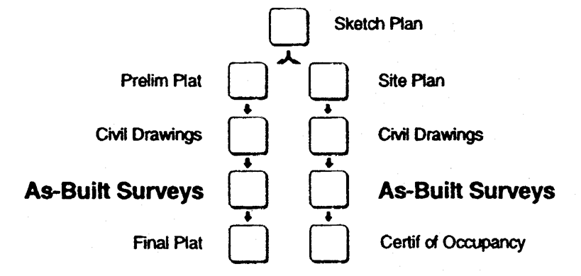
as built surveys
a.
Upon completion of the development activity as authorized by the development permit and prior to final development inspection of public and private improvements, the owner shall submit to the Building Inspector for review and approval a complete set of record drawings showing "as-built" conditions prepared by a registered land surveyor. These drawings shall show the location, vertical and horizontal alignment, and finished elevations of:
(1)
Drainage system pipes and channels;
(2)
Stormwater detention facilities;
(3)
Sanitary sewer system;
(4)
Public water system; and
(5)
Public streets, including street centerlines showing angles of deflection and standard curve data of intersection, radii, length of tangents and arcs, and degree of curvature with basis of curve data.
b.
The As-Built Surveys shall be certified and sealed by the registered land surveyor, subject to the tolerances of accuracy indicated in the survey certification.
(Ord. of 5-10-96)
Sec. 6.6.4. - Final development inspection.
a.
Following submission and review of the as-built surveys, the Building Inspector shall conduct a final development Inspection of the project, and may be assisted by the Public Works Director or others.
b.
The owner shall be responsible for correcting any deficiencies identified in the final development inspection prior to approval of a final subdivision plat.
(Ord. of 5-10-96)
Sec. 6.6.5. - Maintenance bond.
a.
Prior to approval of a final subdivision plat or issuance of a certificate of occupancy, a maintenance bond in a form acceptable to the Building Inspector is required for all public improvements shown on the as-built surveys. The owner shall be responsible for maintenance of all such public improvements for one year from the date of issuance of the certificate of occupancy or final subdivision plat approval by the Board of Commissioners, as applicable.
b.
The value of the Maintenance Bond shall be equal to ten (10) percent of the actual cost of construction of the public improvements shown on the as-built surveys. The cost of construction shall be evidenced by copies of contractor agreements or actual invoices paid, or as otherwise determined by the Public Works Director.
(Ord. of 5-10-96)
Sec. 6.7.1. - Responsibility.
a.
The Building Inspector shall be responsible for coordination of the approval process for all final subdivision plats.
b.
The final subdivision plat shall be certified and sealed by a registered land surveyor.
c.
The owner is responsible for compliance with all requirements of this ordinance. Approval of a final subdivision plat and acceptance of the public improvements and dedications therein shall not relieve the owner of this responsibility.
(Ord. of 5-10-96)
Sec. 6.7.2. - Procedures for final plat approval.
a.
Prior to submission of an application for final subdivision plat approval, either:
(1)
All public improvements shall have been properly installed and completed in accordance with all requirements and standards of this ordinance (other than traffic signs, street name signs, street striping, and signalization); or,
(2)
A guarantee in lieu of completed improvements shall have been received by the Building Inspector as provided under Article 4 of this ordinance.
b.
Application for a final subdivision plat approval shall be made to the Building Inspector. The application shall include:
(1)
A properly completed application form, as furnished by the Building Inspector, requesting final subdivision plat review.
(2)
Ten (10) copies of the final subdivision plat drawing prepared in conformance with the specifications in this Section.
(3)
Payment of all applicable final subdivision plat application and review fees, as established by the Board of Commissioners from time to time.
(4)
Payment to the City for materials and installation of traffic signs and street name signs. Payment of the cost of street striping or signalization, if required and not completed by the owner, shall also be included in the application.
(5)
A maintenance bond providing for the maintenance of all public improvements required by this ordinance in the subdivision for a period of twelve (12) months following the date of approval of the final plat.
c.
The Building Inspector shall review the application for completeness at the time of submission. Incomplete applications will be returned to the applicant.
d.
Within two (2) weeks following receipt of the application, the Building Inspector shall indicate on the drawing or in writing all comments related to compliance with this ordinance. The Building Inspector shall have sole authority to determine the applicability of any provisions of this ordinance to the project.
e.
The owner shall be responsible for compliance with all codes, regulations, and zoning requirements, and for the satisfaction of all the noted and written comments of the Building Inspector. Resubmission of all revised drawings shall be made to the Building Inspector.
f.
When all of the requirements of this ordinance, and any conditions of zoning approval, have been met, or upon the request of the applicant, the Building Inspector shall forward the final subdivision plat to the Board of Commissioners for action at their next meeting.
g.
When the Board of Commissions has determined that the final subdivision plat is in compliance with this ordinance, it shall be approved. The Chairman or Vice-Chairman shall sign and date the CERTIFICATE OF FINAL PLAT APPROVAL stamped or printed on a reproducible copy of the final subdivision plat. The executed original of the approved drawing shall be transmitted to the applicant and one copy shall be retained by the Building Inspector.
h.
Once the final subdivision plat has been so certified, it shall be recorded by the owner with the Clerk of the Superior Court. The owner shall provide the Building Inspector with two (2) copies of the plat as recorded.
(Ord. of 5-10-96)
Sec. 6.7.3. - General standards.
a.
The final subdivision plat shall be drawn on an appropriate material and sheet size, and using minimum line weights and letter heights as required by Georgia law for the recordation of maps and plats (O.C.G.A. § 15-6-67, as amended) and as acceptable to the Clerk of the Superior Court.
b.
The final subdivision plat shall substantially conform to the preliminary subdivision plat and may constitute only that portion of the approved preliminary subdivision plat that the owner proposes to record at any one time, provided that such portion conforms to the requirements of this ordinance.
(Ord. of 5-10-96)
Sec. 6.7.4. - Final plat requirements.
The final subdivision plat shall contain the following information:
a.
All data required by Georgia law pertaining to the recordation of maps and plats (O.C.G.A. § 15-6-67, as amended).
b.
Name of the subdivision and street names.
c.
Name of the former subdivision if any or all of the property has been previously subdivided.
d.
Location sketch.
e.
Lot lines with dimensions to the nearest one-tenth ( 1/10 ) foot, necessary internal angles, arcs, and chords and tangent or radii of rounded corner.
f.
Building front setback lines with dimensions as to length across each lot and distance from the street right-of-way.
g.
Lots or sites numbered in numerical order and blocks lettered alphabetically.
h.
Location, dimensions and purpose of all easements, including slope easements, if required, and any areas to be reserved, donated, or dedicated to public use.
i.
A listing of the private covenants recorded with each lot or a statement of the location of such covenants, if applicable.
j.
The extent of any area of special flood hazard, as defined in this ordinance.
k.
The street address number of each lot, as approved by the U.S. Postal Service.
(Ord. of 5-10-96)
Sec. 6.7.5. - Surveyor and owner certificates.
Each Final Subdivision Plat shall carry the following certificates printed or stamped on the plat and signed and dated in black ink.
a.
Surveyor's Certificate, to read and be completed as follows:
SURVEYOR'S CERTIFICATE
It is hereby certified that this plat is true and correct and was prepared from an actual survey of the property by me or under my supervision; that all monuments shown thereon actually exist.
The field data upon which this plat is based has a closure precision of one foot in _______ feet, and an angular error of _______ per angle point, and was adjusted using _______ rule.
This plat has been calculated for closure and is found to be accurate within one foot in _______ feet.
By (name):_______
Registered Georgia Land Surveyor No._______
Address:_______
Telephone Number:_______
Date:_______
b.
Surveyor's Seal. The original final subdivision plat drawing shall bear the original signature, in black ink, of the registered land surveyor placed across the surveyor's seal in order to be valid and recordable.
c.
Owner's Certificate, to read and be completed as follows, and signed in black ink on the original drawing:
OWNER'S CERTIFICATE
State of Georgia
County of Pulaski
The undersigned certifies that he or she is the owner of the land shown on this plat and that the plat and the public improvements contained therein or associated therewith meet all applicable requirements and standards of the Hawkinsville Unified Land Development Regulations. The owner further acknowledges this plat and allotment to be his free act and deed, and dedicates to the public use forever all areas shown or indicated on this plat as streets, easements or other public use areas, and all associated public improvements as depicted on the as-built surveys for this subdivision, approved on (date).
Owner's name:_______
Owner's address: _______
Date _______
(Owner's signature)
(Ord. of 5-10-96)
Sec. 6.7.6. - Certificate of final subdivision plat approval.
The following shall be stamped or printed on the final subdivision plat for execution upon its approval by the Board of Commissioners.
CERTIFICATE OF FINAL PLAT APPROVAL
All requirements of the Hawkinsville Unified Land Development Regulations having been represented as being fulfilled by this plat and the related as-built surveys approved on (date), the Board of Commissioners hereby approves this plat for recordation by the Clerk of the Superior Court and accept dedication of all areas and public improvements shown thereon and on said as-built surveys, subject to maintenance and guarantee by the owner for one year from the date of this approval.
_______Date___
(Signature of Chairman or Vice-Chairman)
(Ord. of 5-10-96)
Sec. 6.7.7. - Acceptance of public improvements.
a.
If construction of any required public improvements was deferred at the time of final plat approval, said work shall have been completed during the one-year maintenance period for the subdivision.
b.
Prior to expiration of the maintenance bond, a final acceptance inspection of the public improvements shall be conducted by the Public Works Director.
c.
The owner shall correct all defects or deficiencies in materials or workmanship and make such repairs as necessary to approximate the as-built condition of the improvements.
d.
Upon certification by the Public Works Director that the public improvements depicted on the as-built surveys are in conformance with the specifications of this ordinance and are in good repair, the Board of Commissioners shall release the maintenance bond and accept the public improvements into perpetual maintenance by the City.
(Ord. of 5-10-96)
Sec. 6.8.1. - Building permit.
A building permit issued by the Building Inspector is required in advance of the initiation of construction, erection, moving or alteration of any building or structure where the estimated cost of such construction, erection, moving, or alteration will be in excess of three hundred dollars ($300.00). All structures shall comply with the requirements of this ordinance, whether or not a building permit is required.
a.
Procedure for approval. The Building Inspector shall be responsible for administering and enforcing the City's building code. The applicant shall be responsible for obtaining approval of the State Fire Marshall, as applicable.
(1)
Prior to issuance of a building permit the owner shall have received a development permit if required by this ordinance.
(2)
Application for a building permit shall be made to the Building Inspector. The application shall include:
(a)
Application on the form furnished by the Building Inspector, requesting issuance of a building permit.
(b)
Three (3) sets of the building plans for principal multi-family or non-residential buildings prepared in conformance with this ordinance and the applicable building codes. Plans shall be prepared by or under the supervision of, or reviewed and approved by, an architect registered in Georgia, who shall sign and seal each sheet in the original set of drawings.
(c)
County Health Department Approval if an on-site sewage disposal system has been allowed by the Board of Commissioners.
(d)
Payment of the building permit application and review fee.
(e)
Payment of the water and sewer tap fees.
(3)
The application will be checked by the Building Inspector for completeness at the time of submission. Incomplete applications will be returned to the applicant.
(4)
Within two (2) weeks following receipt of a complete application, the Building Inspector shall indicate on one copy of the building plans or in writing all comments related to compliance of the building plans with this ordinance, applicable building codes, and any conditions of zoning approval.
(5)
The owner shall be responsible for compliance with this ordinance and all building code requirements, regulations, and for the satisfaction of all of the comments of the Building Inspector.
(6)
A street address number shall be assigned prior to issuance of a building permit.
(7)
At such time as the owner has addressed the comments to the satisfaction of the Building Inspector and the State Fire Marshall, a building permit shall be issued for the structure.
(8)
Plumbing, electrical and mechanical permits shall be issued separately by the Building Inspector or separately identified on the building permit. Such permits must be issued prior to commencement of work by each affected trade.
b.
Standards for approval.
(1)
Building permits shall only be issued on buildable lots of record, as defined in this ordinance.
(2)
Building permits shall be issued in conformance with the technical codes adopted and amended by the City under Section 5-2 of its Code of Ordinances.
(Ord. of 5-10-96)
Sec. 6.8.2. - Building inspection.
a.
Inspections shall be scheduled with the Building Inspector at least twenty-four (24) hours before the inspection is needed. Requests for inspection should include the street address, lot number, building permit number, and type of inspection.
b.
Required Inspections:
(1)
Foundation. Verify minimum required building setbacks, footing, trenches dug and reinforcing steel in place.
(2)
Plumbing Connections. Water supply line connected to meter and sewer lateral connected to clean-out. Pressure test lines.
(3)
Slab Preparation. After gravel, vapor barrier, and reinforcing wire is in place.
(4)
Framing. Completion of all rough-ins and after insulation is installed.
(5)
Interior walls may not be covered until the following inspections are completed:
(a)
Mechanical. Rough-ins complete with pressure test on gas line.
(b)
Electrical. Rough-ins with neutral ground, and service cable wired.
(c)
Plumbing. Rough-ins complete and all fixtures installed.
(6)
Meter Approval (Gas and Electric). When building is safe. No loose wires, furnace vents installed, thermostats installed, and gas piping connected.
(7)
Final Inspection. Building is complete and ready to occupy except for carpet and those fixtures omitted for home purchaser selection (see Designer Houses, below).
(Ord. of 5-10-96)
Sec. 6.8.3. - Construction in flood area.
Construction of a building for which a flood area permit was issued as part of a development permit shall be governed by the following:
a.
Upon placement of the lowest floor, or floodproofing by whatever construction means, or upon placement of the horizontal structural members of the lowest floor, whichever is applicable, it shall be the duty of the development permit holder to submit to the Building Inspector a certification of the elevation of the lowest floor, floodproofed elevation, or the elevation of the lowest portion of the horizontal structural members of the lowest floor, whichever is applicable, as built, in relation to mean sea level.
b.
Certification shall be prepared by or under the direct supervision of a registered land surveyor or professional engineer and certified by such registered land surveyor or professional engineer. When floodproofing is utilized for a particular building, the certification shall be prepared by or under the direct supervision of a professional engineer or architect and certified by the professional engineer or architect.
c.
Any work undertaken prior to submission of the certification shall be at the development permit holder's risk.
d.
The Building Inspector shall review the floor elevation survey data submitted. Deficiencies detected by such review shall be corrected by the development permit holder immediately and prior to further progressive work being permitted to proceed. Failure to submit the survey or failure to make the corrections shall be cause to issue a stop-work order for the project.
(Ord. of 5-10-96)
Sec. 6.8.4. - Certificate of occupancy.
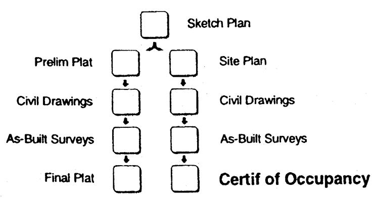
certificate of occupancy
a.
It shall be unlawful to use or occupy or permit the use or occupancy of any building or premises or parts thereof hereafter created, erected, changed, converted, or wholly or partly altered or enlarged in its use or structure, until a certificate of occupancy shall have been issued therefor by the Building Inspector stating that the proposed use of the building or land conforms to the requirements of this ordinance and other applicable codes and ordinances adopted by the City.
b.
Permanent electric power may not be supplied to any structure until a certificate of occupancy shall have been issued and the power company contacted by the Building Inspector.
c.
Designer houses.
(1)
A Certificate of Occupancy may be issued for a home in which certain fixtures have been omitted, pending selection by the home purchaser, provided that an escrow account has been established under joint custody of the builder and the City with sufficient funds to cover installation of the omitted fixtures.
(2)
The Building Inspector shall approve the amount of funds to be escrowed prior to issuance of the certificate of occupancy.
(3)
At the request of the builder for a final inspection, the Building Inspector shall confirm installation of the required fixtures and release the escrow funds to the builder.
(Ord. of 5-10-96)
[Sec. 6.9.0. - Amendments.]
This ordinance may be amended from time to time in whole or in part by the Board of Commissioners under the provisions of this Section.
(Ord. of 5-10-96)
Sec. 6.9.1. - Initiation.
A proposed change to the text of this ordinance may be initiated by the Board of Commissioners or the Planning Commission by a majority vote of those voting.
(Ord. of 5-10-96)
Sec. 6.9.2. - Text amendment process.
Before the Board of Commissioners may take final action on a proposed text amendment, the Planning Commission shall hold a public hearing on the proposal.
a.
Public Notice. At least fifteen (15) days but not more than forty-five (45) days prior to the public hearing, notice shall be published in a newspaper of general circulation within the city. The City Manager shall prepare such notice, which shall state the time, place and purpose of the hearing.
b.
Planning Commission Public Hearing. The public hearing held by the Planning Commission for a text amendment shall be conducted in the following manner:
(1)
The public hearing shall be convened at the scheduled time and place by the chairman, the vice chairman, or the chairman's designee, who shall act as the Presiding Official.
(2)
The Presiding Official shall submit each proposed text amendment to the Planning Commission.
(3)
No person in attendance shall speak unless first formally recognized by the presiding official. Upon rising to speak each person recognized shall state their name and home address. The presiding official may place reasonable limits on the number of persons who may speak for or against a proposal, on the time allowed for each speaker, and on the total time allowed for presentation of the proposed text amendment. No less than ten (10) minutes shall be provided for all of those speaking in support of a text amendment and no less than ten (10) minutes shall be provided for all of those speaking against, unless such proponents or opponents take less time than the minimum allowed. If reasonable time limitations permit, any member of the general public may speak at a hearing. However, the petitioner and nearby property owners shall be afforded the first opportunity to speak.
(4)
Following the public hearing on each text amendment, the Planning Commission shall make its recommendation or take such other action as may be appropriate within thirty (30) days.
(a)
A motion to recommend approval or denial of an amendment must be approved by an affirmative vote of at least three (3) members in order for the motion to be approved.
(b)
If a motion to recommend approval of an amendment fails, the amendment is recommended for denial. If a motion to recommend denial of an amendment fails, another motion would be in order.
(c)
A tie vote on a motion to recommend approval of an amendment shall be deemed a recommendation for denial of the amendment. A tie vote on any other motion shall be deemed to be no action, and another motion would be in order.
c.
Board of Commissioners Meeting.
(1)
At the Board Of Commissioners' meeting when the proposed amendment is scheduled to be considered, the City Manager shall read the recommendation of the Planning Commission.
(2)
If interested parties are present at the meeting, any City Commissioner recognized by the Presiding Official may ask questions of such parties, whose answers shall be recorded in the minutes of the meeting.
(3)
At the meeting, following presentation of the amendment, action shall be taken by vote of the Board of Commissioners.
(a)
A motion to approve or deny any amendment must be approved by an affirmative vote of at least three (3) members in order for the motion to be approved.
(b)
If a motion to approve an amendment fails, the amendment is denied. If a motion to deny an amendment fails another motion would be in order.
(c)
A tie vote on a motion for approval of an amendment shall be deemed a denial of the amendment. A tie vote on any other motion shall be deemed to be no action and another motion would be in order.
(4)
In taking action on an amendment, the Board of Commissioners may:
(a)
Approve, approve with changes, or reject the proposal; or,
(b)
Table the proposal for consideration at the next scheduled meeting.
(Ord. of 5-10-96; Ord. of 8-19-96, § 4)
Sec. 6.9.3. - Standards for text amendments.
The Planning Commission and the Board Commissioners shall consider the following standards considering any proposal that would result in a change the text of this ordinance, giving due weight or priority those factors that are appropriate to the circumstances each proposal:
a.
Whether the proposed amendment is consistent with the purpose and intent of this ordinance as stated under Article 1.
b.
Whether the proposed amendment furthers or is compatible with the purpose and intent of the Comprehensive Plan.
c.
Whether the proposed amendment is required to adequately address new or changing conditions in the city or to properly implement the Comprehensive Plan.
d.
Whether the proposed amendment reasonably promotes the public health, safety, morality or general welfare.
(Ord. of 5-10-96)
Sec. 6.9.4. - Effect.
a.
Approval of a text amendment shall be in full force and effect upon its approval or upon the stated effective date thereof, and shall thereupon apply to every property for which a use has not been established or for which a building permit or development permit may subsequently be requested.
b.
For a property on which a use, building, structure, or other improvements existed in conformity with this ordinance prior to the effective date of a text amendment affecting the property, any such use, building, structure, or other improvements no longer in conformance shall be governed under the provisions for Nonconformities in this ordinance.
c.
Construction of any use, building, structure, or other improvements for which a building permit has been issued in conformity with this ordinance prior to the effective date of a text amendment may continue to completion as though no change had occurred and, upon completion, shall be governed under the provisions for Nonconformities in this ordinance, as applicable.
(Ord. of 5-10-96)
Sec. 6.10.1. - Types of appeals.
Persons may appeal to the Board of Commissioners for relief under the following circumstances:
a.
When aggrieved by an action of an administrative official of the City.
b.
When compliance with the requirements of the ordinance would create a particular and unique hardship.
c.
When an exception is desired for a particular property from certain requirements of the ordinance, as specified in this Section.
d.
When the requirements for flood protection affect an historic structure.
e.
When an interpretation is needed as to the meaning of words used in this ordinance, the application of standards or requirements of this ordinance to a specific property or development plan, or the location of zoning district boundaries.
(Ord. of 5-10-96)
Sec. 6.10.2. - Initiation.
a.
All requests for relief shall be taken as an appeal to the Board of Commissioners, as provided in the Section.
b.
Appeals to the Board of Commissioners may be initiated by any person aggrieved or by an office or department head of the City. Such appeal shall be initiated within fifteen (15) days of the action on decision appealed from by filing with the City Manager a notice of said appeal specifying the grounds thereof.
c.
An appeal stays all legal proceedings in furtherance of the action appealed from, unless the officer or department head from whom the appeal is made certifies to the Board of Commissioners, after the notice of appeal shall have been filed, that by reason of facts stated in the certificate a stay would cause imminent peril to life or property. In such case, proceedings shall not be stayed otherwise than by a restraining order which may be granted by a court of competent jurisdiction.
d.
If denied, an application for a hardship variance or exception affecting the same property shall not be reconsidered for a period of twelve (12) months from the date of denial; provided, however, that the Board of Commissioners may reduce the waiting period under extenuating circumstances or on its own motion.
(Ord. of 5-10-96)
Sec. 6.10.3. - Appeals from administrative action.
The holder of a development permit or a building permit may appeal any of the following actions taken by a City official:
a.
The suspension, revocation, modification or grant with condition of a development permit by the Building Inspector upon finding that the holder is not in compliance with the approved erosion and sediment control plan or other approved plans.
b.
The determination by the Building Inspector that the holder is in violation of development permit or building permit conditions.
c.
The determination by the Building Inspector that the holder is in violation of any other provision of this ordinance.
(Ord. of 5-10-96)
Sec. 6.10.4. - Hardship variances.
a.
General.
(1)
Relief from the application of the provisions of this ordinance may be granted by the Board of Commissioners upon a finding that compliance with such provision will result in a hardship to the property or owner that is substantially unwarranted by the protection of the public health, safety or general welfare, and the need for consistency among all properties similarly zoned.
(2)
Such relief may be granted only to the extent necessary to alleviate such unnecessary hardship and not as a convenience to the applicant nor to gain any advantage or interest over similarly zoned properties.
b.
Standards for approval. A hardship variance may be granted in whole or in part, or with conditions, in such individual case of unnecessary hardship upon a finding by the Board of Commissioners that:
(1)
There are extraordinary and exceptional conditions pertaining to the particular piece of property in question because of its size, shape, or topography; or,
(2)
The application of the ordinance to this particular piece of property would create an unnecessary hardship; or,
(3)
There are conditions that are peculiar to the property which adversely affect its reasonable use or usability as currently zoned.
c.
If denied, an appeal for a hardship variance affecting the same property shall not be reconsidered for a period of twelve (12) months from the date of denial; provided, however, that the Board of Commissioners may reduce the waiting period under extenuating circumstances or on its own motion.
d.
In no case shall a hardship variance be granted for any of the following:
(1)
A condition created by the applicant, including the result of an unwise investment decision or real estate transaction.
(2)
A change in the conditions of approval imposed through a zoning change granted by the Board of Commissioners.
(3)
Reduction of a minimum lot size required by a zoning district.
(4)
A use of land or buildings or structures that is not permitted by the zoning district that is applicable to the property.
(5)
Any increase in the number of dwelling units or nonresidential building floor area otherwise permitted by the zoning district that is applicable to the property.
(Ord. of 5-10-96)
Sec. 6.10.5. - Special exceptions.
a.
Special Exceptions shall be limited to relief from the following requirements of this ordinance:
(1)
Minimum building setbacks.
(2)
Maximum building height.
(3)
Minimum lot width.
(4)
Public street frontage.
(5)
Buffers and screening.
(6)
Signage height, number and copy area in accordance with a coordinated signage plan.
(7)
Parking requirements.
b.
A special exception may be granted upon a finding that the relief, if granted, would not cause substantial detriment to the public good or impair the purpose and intent of the ordinance.
c.
If denied, an application for a special exception affecting the same property shall not be reconsidered for a period of twelve (12) months from the date of denial; provided, however, that the Board of Commissioners may reduce the waiting period under extenuating circumstances or on its own motion.
d.
In no case shall a special exception be granted from the conditions of approval imposed on a property through a zoning change granted by the Board of Commissioners.
(Ord. of 5-10-96)
Sec. 6.10.6. - Flood protection variances.
a.
Flood protection variances may be approved for the reconstruction, rehabilitation, or restoration of buildings listed on the National Register of Historic Places or the State Inventory of Historic Places provided that the proposed reconstruction, rehabilitation, or restoration will not result in the building losing its historical designation.
b.
In passing upon a flood protection variance, the Board of Commissioners shall consider all technical evaluations, all relevant factors, all standards specified in other sections of this ordinance relating to flood damage prevention, and the:
(1)
Danger that materials may be swept onto other lands to the injury of others;
(2)
Danger to life and property due to flooding or erosion damage;
(3)
Susceptibility of the proposed facility and its contents to flood damage and the effect of such damage on the individual owner;
(4)
Importance of the services provided by the proposed facility to the community;
(5)
Necessity of the facility to a waterfront location, in the case of a functionally dependent facility;
(6)
Availability of alternative locations, not subject to flooding or erosion damage, for the proposed use;
(7)
Compatibility of the proposed use with existing and anticipated development;
(8)
Relationship of the proposed use to the comprehensive plan and floodplain management program for that area;
(9)
Safety of access to the property in times of flood for ordinary and emergency vehicles;
(10)
Expected heights, velocity, duration, rate of rise and sediment transport of the floodwaters and the effects of wave action, if applicable, expected at the site; and
(11)
Costs of providing governmental services during and after flood conditions, including maintenance and repair of public utilities and facilities such as sewer, gas, electrical and water systems, and streets and bridges.
c.
Upon consideration of the factors listed above, and the purposes of this ordinance, the Board of Commissioners may attach such conditions to the granting of the variance as it deems necessary to further the purposes of flood damage prevention.
d.
Variances shall not be issued within any designated floodway if any increase in flood levels during the base flood discharge would result.
e.
Conditions for variances are as follows:
(1)
Variances shall only be issued upon a determination that the variance is the minimum necessary, considering the flood hazard, to afford relief; and in the instance of an historical building, a determination that the variance is the minimum necessary so as not to destroy the historical character and design of the building.
(2)
Variances shall only be approved upon:
(a)
Showing of good and sufficient cause;
(b)
Determination that failure to grant the variance would result in exceptional hardship; and
(c)
Determination that the granting of a variance will not result in increased flood heights, additional threats to public safety, extraordinary public expenses, create nuisances, cause fraud on or victimization of the public, or conflict with existing local laws or ordinances.
(3)
Any applicant to whom a variance is granted shall be given written notice specifying the difference between the base flood elevation and the elevation to which the building is to be built and stating that the cost of flood insurance will be commensurate with the increased risk resulting from the reduced lowest floor elevation.
(4)
The city manager shall maintain the records of all appeal actions and report any variances to the Federal Emergency Management Agency upon request.
(Ord. of 5-10-96)
Sec. 6.10.7. - Interpretations.
a.
The Board of Commissioners, upon appeal of an aggrieved party or at the request of the City Manager, shall:
(1)
Interpret the use of words or phrases within the context of the intent of this ordinance.
(2)
Determine the boundaries of the various zoning districts where uncertainty exists.
(3)
Decide appeals from any order, determination, decision or other interpretation by the City Manager, Building Inspector or other person acting under authority of this ordinance, where a misinterpretation or misapplication of the requirements or other provisions of this ordinance is alleged.
(4)
Interpret such other provisions of this ordinance as may require clarification or extension in specific or general cases.
b.
An interpretation by the Board of Commissioners shall be final.
(Ord. of 5-10-96)
Sec. 6.10.8. - Process for granting appeals.
a.
Upon receiving a notice of an appeal, the City Manager shall assemble such memos, papers, plans, or other documents as may constitute the record for the appeal or as may provide an understanding of the issues involved.
b.
Once the record has been assembled, the City Manager shall schedule the appeal for consideration at the next scheduled meeting of the Board of Commissioners.
c.
Any appellant wishing to withdraw an appeal prior to the meeting of the Board of Commissioners shall file a written request for such withdrawal with the City Manager. The appeal shall thereupon be removed from the Board's agenda and the request shall have no further effect.
d.
Board of Commissioners Meeting.
(1)
The City Manager shall submit the assembled record of the appeal to the Board of Commissioners.
(2)
At the meeting, any party may appear in person or by agent or by attorney. The appellant shall be given time to present the appeal and the basis for the request.
(3)
The City Manager, or other appropriate party if the appeal was taken from an administrative action or interpretation, shall provide such information or explanation as appropriate to the circumstances of the appeal.
(4)
If other interested parties are present at the meeting, any City Commissioner recognized by the Presiding Official may ask questions of such parties, whose answers shall be recorded in the minutes of the meeting.
(5)
At the meeting, following presentation of the appeal, action shall be taken by vote of the Board of Commissioners.
(a)
A motion to approve or deny an appeal must be approved by an affirmative vote of at least three (3) members in order for the motion to be approved.
(b)
If a motion to approve an appeal fails, the appeal is denied. If a motion to deny an appeal fails, another motion would be in order.
(c)
A tie vote on a motion for approval of an appeal shall be deemed a denial of the appeal. A tie vote on any other motion shall be deemed to be no action, and another motion would be in order.
(6)
In taking action on an appeal, the Board of Commissioners may:
(a)
Approve, approve with changes, or reject the request; or,
(b)
Table the appeal for consideration at its next scheduled meeting; or,
(c)
Allow withdrawal of the appeal at the request of the appellant.
(Ord. of 5-10-96)
[Sec. 6.11.1. - Temporary suspension.]
a.
Upon submission of a valid application for a zoning change or for the granting of relief on a property, no permits shall be issued nor shall any actions be undertaken on the property that may be affected by the outcome of such application.
b.
Upon the initiation of a zoning change or text amendment by the Planning Commission or Board of Commissioners, no permits shall be issued nor shall any actions be undertaken on any property that may be affected by the outcome of such zoning change or text amendment.
(Ord. of 5-10-96)