
Henrico County Unincorporated
City Zoning Code
City Zoning Code
ARTICLE 5
- DEVELOPMENT STANDARDS
Sec. 24-5101. - Purpose and Intent.
A.
The purpose of this division is to ensure that new developments are served by a coordinated multimodal transportation system that facilitates the safe and efficient movement of motor vehicles, emergency vehicles, transit, bicyclists, and pedestrians within the development and between the development and external transportation systems, neighboring development, and local destination points, such as places of employment, schools, parks, and shopping areas.
B.
The multimodal transportation system required by this division is intended to:
1.
Provide transportation options;
2.
Increase the effectiveness of local service delivery;
3.
Reduce emergency response times;
4.
Promote walking and bicycling;
5.
Facilitate use of public transportation;
6.
Contribute to the attractiveness of the development and community;
7.
Connect neighborhoods and increase opportunities for interaction between neighbors;
8.
Reduce vehicle miles of travel and travel times;
9.
Reduce greenhouse gas emissions;
10.
Improve air quality;
11.
Minimize congestion and traffic conflicts; and
12.
Preserve the safety and capacity of the County's transportation systems. The purpose of this division is to.
C.
The parking and loading standards in this division are intended to ensure provision of off-street parking and loading facilities in proportion to the parking and loading demand of different uses allowed by this Ordinance by accomplishing the following:
1.
Provide for adequate but not excessive off-street parking and loading while accommodating alternative parking solutions for permanent, temporary, and seasonal demands;
2.
Minimize the environmental impact of vehicular parking by avoiding excessive paved surface areas, applying appropriate minimum parking requirements, and encouraging the use of permeable parking surfacing;
3.
Support walking and bicycling in appropriate locations through context-driven parking standards and the provision of bicycle parking; and
4.
Achieve County policies of supporting redevelopment of commercial corridors and new mixed-use development and accommodating appropriate infill development.
Sec. 24-5102. - Applicability.
A.
New Development. All new development must provide access, circulation, off-street parking, and loading areas in accordance with the standards of this division.
B.
Existing Development.
1.
Change in Use. Any change in use of existing development must be accompanied by the provision of any additional off-street vehicular parking, loading areas, and bicycle parking spaces required for the proposed use by this division.
2.
Expansion. If an existing structure or use is expanded or enlarged (in terms of the number of dwelling units, floor area, number of employees, or seating capacity as applicable in accordance with Sec. 24-5110, Minimum Number of Off-Street Parking Spaces), any additional off-street vehicular parking, loading areas, and bicycle parking that may be required must be provided in accordance with the requirements of this division as applied only to the expanded or enlarged part of the structure or use.
3.
Nonconforming Parking. Nonconforming parking facilities on the site of an enlarged or expanded building or use must comply with the requirements of this division in accordance with Article 6: Nonconformities.
C.
Timing of Review. Review for compliance with the standards of this division will occur during review of an application for a provisional use permit, conditional use permit, building permit, certificate of occupancy, plan of development, site plan, or subdivision (see Chapter 19 of the County Code), as appropriate.
D.
Developer Responsible for Access and Circulation Improvements. If the development substantially generates a need for road, street, sidewalk, and other access and circulation improvements, the developer must provide such improvements at the developer's cost in accordance with the applicable requirements in this division and Chapter 19 of the County Code, and the developer must dedicate such improvements that are to become public facilities to the County.
E.
Parking Plan Required.
1.
All development applications subject to review for compliance with the standards of this division must include a parking plan.
2.
The parking plan must accurately designate the number and location of required vehicular and bicycle parking spaces, access aisles, and driveways, demonstrate compliance with ADA standards, and identify the relation of the off-street parking facilities to the development they are designed to serve, including how the parking facilities coordinate with the vehicular, pedestrian, bicycle, and transit circulation systems for the development. The parking plan must also include the information required in accordance with Sec. 24-5115, Off-Street Parking Alternative Parking Plans, if applicable.
Sec. 24-5103. - Access and Circulation System.
A.
Integrated Access and Circulation System. All new development must be served by a system of sidewalks, paths, roadways, accessways, and other facilities designed to provide for multiple travel modes (vehicular, transit, and pedestrian), as appropriate to the development's size, character, relationship to surrounding development and development patterns, and existing and planned community transportation systems. Vehicular, transit, and pedestrian access and circulation systems must be coordinated and integrated to provide transportation choices within and to and from the proposed development, as deemed necessary by the agency responsible for review.
B.
Internal Streets. All streets internal to every development must comply with the standards in Division 4, Street Standards, of Chapter 19 of the County Code.
C.
Vehicular Cross-Access between Adjoining Development.
1.
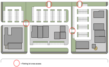
An internal vehicular circulation system in a nonresidential or mixed-use development that is subject to the requirements of this division must be designed and constructed to provide vehicular cross-access between any public parking lots within the development and any public parking lots on adjoining parcels containing nonresidential or mixed-use development, and to the boundary of adjoining vacant land if it is in a Nonresidential or Mixed-Use District, and to a Planned Development district that includes nonresidential development. Each required cross-access must consist of a two-way driveway or drive aisle that is at least 22 feet wide or two one-way driveways or drive aisles that are each at least 14 feet wide. See Figure 5103: Example of Parking Lot Cross-Access.
2.
Easements allowing cross-access to and from lands served by a vehicular cross-access in accordance with subsection C.1. above, along with agreements defining maintenance responsibilities of landowners pertaining to the vehicular cross-access, must be recorded in the land records before issuance of a certificate of occupancy.
3.
The Planning Director may modify the requirement for vehicular cross-access established in this subsection on determining that such cross-access is impractical or undesirable due to the presence of topographic conditions, natural features, vehicular safety factors, land use conflicts, site-specific security concerns, or existing development on adjacent lands that precludes the cross-access. If the Planning Director does not require cross-access because of land use conflicts or existing development that precludes cross-access but determines that cross-access may be provided in the future, the applicant must record easements to allow for future cross-access having a minimum width required by subsection C.1 above between the development and adjacent lands.
4.
The Planning Director may modify the requirement for vehicular cross-access established in this subsection on determining that such cross-access is impractical or undesirable due to the presence of topographic conditions, natural features, vehicular safety factors, land use conflicts, site-specific security concerns, or existing development on adjacent lands that precludes the cross-access. If the Planning Director does not require cross-access because of land use conflicts or existing development that precludes cross access but determines that cross access may be provided in the future, the applicant must record easements to allow for future cross-access having a minimum width required by subsection C.1. above between the development and adjacent lands.
Figure 5103: Example of Parking Lot Cross-Access
D.
Pedestrian Cross-Access Between Adjoining Development.
1.
Multifamily, nonresidential, or mixed-use development subject to the requirements of this division must establish an internal pedestrian circulation system that is designed to allow for pedestrian walkway cross-access between the development's buildings and parking areas and those on adjoining lots containing multifamily, nonresidential, or mixed-use development, and to lands zoned for such uses or designated for such uses on the comprehensive plan future land use map. Each required cross-access must consist of sidewalk at least 5 feet wide that is ADA accessible and lighted in accordance with Sec. 24-5504.C, Pedestrian Areas.
2.
Easements allowing cross-access to and from properties served by a pedestrian cross-access in accordance with subsection 1 above, along with agreements defining maintenance responsibilities of landowners, must be recorded in the land records before issuance of a certificate of occupancy.
3.
The Planning Director may modify the requirement for pedestrian cross-access established in subsection 1 above on determining that such cross-access is impractical or undesirable due to the presence of topographic conditions, natural features vehicular safety factors, land use conflicts, site-specific security concerns, or existing development on adjacent lands that precludes the cross-access.
E.
Access to Private Cemetery or Graveyard. When development is proposed adjacent to or encompassing a private cemetery or graveyard, access must be provided by either a public right-of-way or a private accessway at least 20 feet in width extending from the cemetery or graveyard to a public street. The access must be improved with an all-weather surface at least 5 feet in width and compatible with the proposed development. The proposed development must be separated from the cemetery or graveyard by a fence between 36 and 42 inches in height meeting the requirements of Article 5, Division 4, Fences and Walls. In the R-5A and R-5B Districts, the nearest residential lot must be at least 20 feet from the cemetery or graveyard.
F.
Access to Nonresidential Development. All nonresidential development must provide its primary access to a public street without crossing private property in a Residential District. The Planning Director may approve secondary or emergency access across private property in a Residential District where such access will not have a detrimental impact on the residential property.
G.
Access to Shared Facilities. The following requirements apply to all new development that includes shared facilities for common use such as a consolidated mail delivery point or a recycling and refuse collection area (for additional requirements for refuse and recycling collection areas, see Sec. 24-4428).
1.
An accessible pedestrian path must be provided from each facility to every dwelling or unit to be served, or an accessible sidewalk provided from each facility to an adjacent dedicated parking lot.
2.
The shared facilities must be illuminated to the standards of Section 24-5503, General Standards. For site features or facilities not listed in Section 24-5503, the average illumination must be at least 0.5 foot candles.
3.
Where consolidated mail delivery facilities are required by the United States Postal Service, they must be identified and approved on a plan of development, site plan, or subdivision construction plan prior to construction. Shared mail delivery facilities must be located such that every dwelling or unit to be served by each facility is within 1,400 linear feet, as measured along the most direct pedestrian or vehicular way. Construction of the facilities must be completed prior to issuance of a final certificate of occupancy for a dwelling or unit to be served by them.
(Ord. No. 1335, § 48, 11-12-2024; Ord. No. 1338, § 15, 2-11-2025)
Sec. 24-5104. - Off-Street Parking Location, Entrances, and Exits.
A.
Location.
1.
In Conservation, Agricultural, and Residential Districts, for any use other than a single-family, duplex, or townhouse dwelling, parking must not be located in a required front yard or a required street side yard.
2.
For townhouse developments, parking lots must be set back at least 15 feet from any existing or proposed public right-of-way (see also Sec. 24-5312.B, Perimeter Landscaping). Individual townhouse dwelling lots fronting on public streets must not have front-loaded garages, individual driveways, or parking spaces facing the public street. For individual townhouse dwelling lots fronting on a private access, parking must not be located in a front yard except as a driveway serving a permitted front-loaded garage (one driveway space for each garage space). Such parking must be at least 18 feet deep by 9 feet wide exclusive of sidewalks and easements.
3.
In all Office, Business, and Industrial Districts, parking lots must be set back at least 15 feet from any existing or proposed public right-of-way (see also Sec. 24-5312.B, Perimeter Landscaping).
4.
Vehicles must only be parked in approved and constructed parking spaces.
5.
Except where permitted in the CMU, Community Mixed Use District and Planned Development districts, for residential uses, space in a private garage does not count toward the off-street parking requirement.
6.
For single-family detached dwellings, the width of the driveway must not exceed 50 percent of the lot width or 30 feet, whichever is less.
B.
Entrances and Exits.
1.
Entrances and exits to off-street vehicular parking and loading areas must comply with the following standards, unless the County Engineer, Planning Director, and, for state-maintained roads, VDOT jointly authorize modifications of the standards on determining strict compliance is impractical or undesirable due to site-specific traffic safety concerns such as slopes, curves, or sight distance obstructions:
(a)
They must be located a minimum of 12.5 feet from abutting properties;
(b)
They must be located a minimum of 200 feet (measured along the same side of street and in the same block) from the premises of elementary or secondary schools, public parks, religious institutions, hospitals, cultural facilities, and childcare centers, except for a parking or loading area that is serving that use;
(c)
On corner lots, they must be located a minimum of 25 feet from the intersection of property lines and reference lines as defined in Sec. 24-8307.A, Front Yard or Street Side Yard;
(d)
They must have a maximum width of 50 feet if no on-street parking is provided along the intersecting road, or 40 feet if parking is provided along the intersecting road; and
(e)
They must be separated by a minimum of 25 feet from any other entrance or exit, unless the entrances or exits are less than five feet apart.
2.
Distances in subsection 1 above will be measured from the nearest edge of pavement of the entrance or exit.
(Ord. No. 1335, § 49, 11-12-2024)
Sec. 24-5105. - Off-Street Parking Surfacing and Marking.
A.
Surfacing. Except as provided in subsection B below, all off-street vehicular parking and loading areas must be surfaced in accordance with one of the following methods:
1.
A hard, durable, and bonded surface material such as asphalt, concrete, brick, cobblestone, pavers, or recycled glass, rubber, asphalt, or other materials, maintained in a smooth, well-graded, clean, and orderly condition that meets County specifications.
2.
A pervious parking lot surfacing material such as pervious asphalt and concrete, open joint pavers, and reinforced grids made of grass, gravel, or shell may be used for all or part of a parking and loading area subject to the following:
(a)
The applicant must provide a maintenance plan and commit to an ongoing maintenance program in accordance with industry standards; and
(b)
Any pervious or semi-pervious surfacing used for aisles within or driveways to vehicular parking and loading areas must be certified by an engineer licensed within the state as capable of accommodating anticipated traffic loading stresses and maintenance impacts.
B.
Surfacing Alternatives. Alternative surfacing may be used for off-street vehicular parking areas as follows:
1.
Natural unpaved surfaces such as grass, crushed stone, gravel, and mulch may be used, provided the surface is maintained in a neat, orderly, and passable condition, for the following uses and situations:
(a)
Uses in the A-1 district;
(b)
Bed and breakfast inns; and
(c)
Areas designated or used for temporary overflow parking, provided that the area is used for parking not more than 24 days in a calendar year.
2.
Off-street parking spaces and driveways for single-family detached, manufactured, or duplex dwellings may be surfaced with pervious materials such as crushed stone or gravel. Such material must be confined to the parking space or driveway with bricks, railroad ties, landscaping borders, or similar means, and must be replaced as necessary to maintain a neat and orderly appearance.
C.
Required Markings and Separation Stripe.
1.
Except for parking areas serving single-family detached, manufactured home, duplex, or townhouse dwellings, each required off-street vehicular parking area and space, and each off-street loading area and berth, must be identified by surface markings that provide for orderly and safe loading, unloading, parking, and storage of vehicles, in accordance with Sec. 24-5109, Dimensional Standards for Parking Spaces and Aisles. Parking spaces must be marked on the pavement surface with painted lines four inches wide. All markings must be white in color except for markings dividing traffic, which must be yellow. All surface markings, including striping, directional arrows, and lettering on signs and in accessible-designated areas, must be maintained to be readily visible at all times.
2.
One-way and two-way accesses into off-street vehicular parking facilities must be identified by directional arrows painted on the surface and by associated signs. Any two-way access intersecting a street at any angle other than 90 degrees must be marked with a traffic separation stripe running along the length of the access; this requirement does not apply to interior intersections between drive aisles.
3.
Required fire lanes must be marked and maintained in accordance with the Virginia Statewide Fire Prevention Code.
4.
Traffic control signs must be provided.
D.
Dwellings on Private Roads in R-5A, R-5B, R-5, R-6, and RTH Districts.
1.
Private roads, drives, and parking areas for multifamily, townhouse, and R-5A and R-5B developments must be designed and constructed in accordance with the pavement design standards and specifications of the department of public works.
2.
A professional engineer, licensed in the State of Virginia, must inspect all private road, drive, and parking area construction activities. Prior to issuance of the last certificate of occupancy, the engineer must provide the county with certification that the private roads, drives, and parking areas have been constructed in accordance with the approved plans and specifications.
3.
For owner-occupied developments, the developer must post a defect bond for the construction of private roads, drives, and parking areas. The defect bond must remain in effect for a period of three years from the date of the issuance of the final certificate of occupancy.
(Ord. No. 1338, § 16, 2-11-2025)
Sec. 24-5106. - Off-Street Parking Lighting, Landscaping, Screening.
A.
Exterior Lighting. All off-street vehicular parking, loading, and bicycle parking areas must be lighted in accordance with Article 5, Division 5, Exterior Lighting and Crime Prevention.
B.
Landscaping. All off-street vehicular parking and loading areas must comply with Article 5, Division 3, Landscaping and Tree Protection.
C.
Protected Walkway. Adequate and safe pedestrian access by a walkway protected by a curb separation and elevation from the street grade must be provided to connect parking areas and the primary pedestrian entrances to the uses served by the parking, and to the public sidewalk if one abuts the property. Walkways must not conflict with parking space area, depth, or width, including private driveways.
D.
Pick-Up and Drop-Off Areas. If provided, designated areas for pick-up and drop-off by taxis, ridesharing, or other mobility service providers must not interfere with the movement of vehicles or pedestrians within the parking lot.
C.
Protected Walkway. Adequate and safe pedestrian access by a walkway protected by a curb separation and elevation from the street grade must be provided to connect parking areas and the primary pedestrian entrances to the uses served by the parking, and to the public sidewalk if one abuts the property. Walkways must not conflict with parking space area, depth, or width, including private driveways.
(Ord. No. 1335, § 50, 11-12-2024)
Sec. 24-5107. - Design Requirements for Large Parking Lots.
Public parking lots that contain 300 or more parking spaces must be organized into a series of parking bays separated by buildings, landscaping, or primary drive aisles in accordance with the following standards. The Planning Director may approve an alternative configuration on determining that the site's topography, current configuration, or other unique circumstances make full compliance with the standards in this section impractical and the proposed configuration provides similar pedestrian access and visual partitioning of the parking lot to the maximum extent practicable.
A.
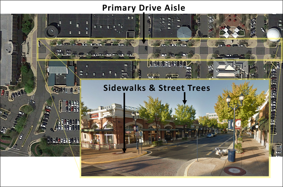
Primary Drive Aisle. The primary drive aisles must be designed to appear as an extension of the public street network extending from the external public or private right-of-way along the full length of the primary façades of structures being served by the drive aisle (see Figure 5107A: Primary Drive Aisle). The primary drive aisle must:
1.
Have a minimum cross section width between curbs sufficient to serve two travel lanes;
2.
Include a sidewalk or curb-delineated pedestrian passageway at least five feet wide along the front façade of each building façade parallel to the drive aisle; and
3.
Include street trees along both sides with an average spacing of 40 feet on-center with at least five trees every 200 feet.
Figure 5107A: Primary Drive Aisle
B.
Pedestrian Pathways. Improved pedestrian pathways must be provided to the entrance to each use served by the parking. Pedestrian pathways must meet the following standards (see Figure 5107B: Pathways through Vehicular Parking Area):
1.
The pathways must be at least five feet wide;
2.
The pathways must comply with ADA requirements for accessible routes;
3.
One pathway must be provided every 200 feet of parking lot width;
4.
A landscaping strip must be provided along one or both sides of each pathway. The strips must be planted with shade trees with a maximum spacing of 40 feet on-center, measured linearly along the pathway.
5.
Any pathway serving retail uses must be at the same grade as the abutting parking service or must provide access points for persons pushing shopping carts spaced no more than every 75 feet along each side of the pathway.
6.
Pathways must be aligned with and perpendicular to the primary entrance into the building served by the parking lot, to the maximum extent practicable.
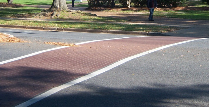
7.
Pathways must be paved with asphalt, cement, brick, or other comparable material, and must be distinguished by contrasting color or materials when crossing drive aisles. See Figure 5107C: Contrasting Drive-Aisle Crossing. White painted crosswalks do not comply with this standard.
Figure 5107B: Pathways through Vehicular Parking Area
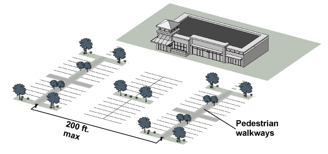
Figure 5107C: Contrasting Drive Aisle Crossing
Sec. 24-5108. - Off-Street Parking Lot Completion, Maintenance, and Use.
A.
Completion. All off-street vehicular parking, loading, and bicycle parking areas must be completed, or a financial guarantee must be posted to ensure their timely completion, prior to the issuance of a final certificate of occupancy for the development they serve. In the case of phased development, parking and loading facilities are only required to be provided for the phase being developed.
B.
Maintained in Good Repair at All Times. All off-street vehicular parking and loading areas must be maintained in a safe condition and good repair at all times so as not to constitute a hazard to public safety or a visual or aesthetic nuisance to surrounding land.
C.
Use of Parking Area. Except as part of a temporary use approved in accordance with the requirements of Sec. 24-2312, Temporary Use Permit, required parking spaces must be used solely for the parking of licensed motor vehicles in operating condition. Other use of required parking areas, such as the display of goods for sale (including building or landscaping materials or supplies), or the sale, lease, storage, dismantling, or service of vehicles, boats, motor homes, campers, mobile homes, building materials equipment or supplies, is prohibited.
D.
Required Parking May Not Be Reserved. Required parking spaces must not be designated or reserved for use by specific persons (e.g., employees, executives, or patrons of a particular use) unless such spaces are in addition to the minimum required.
E.
Trucks and Commercial Vehicles. In Conservation, Agricultural, and Residential Districts, the parking of any truck or commercial vehicle in excess of 10,000 pounds gross weight, or any commercial trailer or wrecker, is prohibited on private land or public roads except while loading, unloading, or working at or near the location where it is parked.
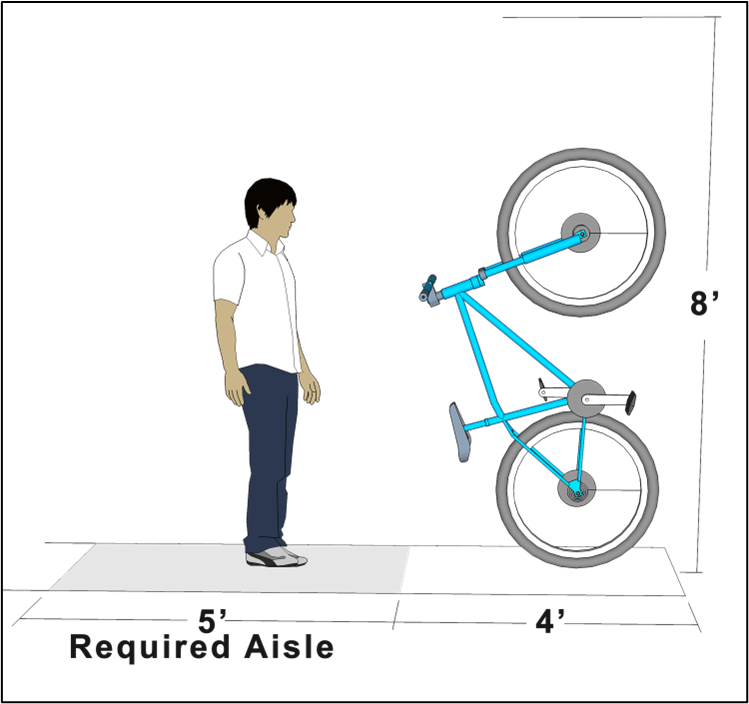
Sec. 24-5109. - Dimensional Standards for Parking Spaces and Aisles.
A.
General Requirements. Except as otherwise provided in subsections C or D below, standard vehicle parking spaces and aisles must comply with the minimum dimensional standards established in Table 5109: Dimensional Standards for Parking Spaces and Aisles. See Figure 5109A: Measurement of Parking Space and Aisle Dimensions and Figure 5109B: Measurement of Parallel Parking Space and Aisle Dimensions. Parking lots must include raised curb and gutter separating vehicular travel lanes from adjacent parking areas and walkways unless the County Engineer approves a stormwater management design for the parking lot that promotes the absence of raised curb and gutter. On-street parking bays that terminate at intersections must be protected by raised curb and gutter defining the full width and depth of the parking bay outside of adjacent travel lanes.
Figure 5109A: Measurement of Parking Space and Aisle Dimensions
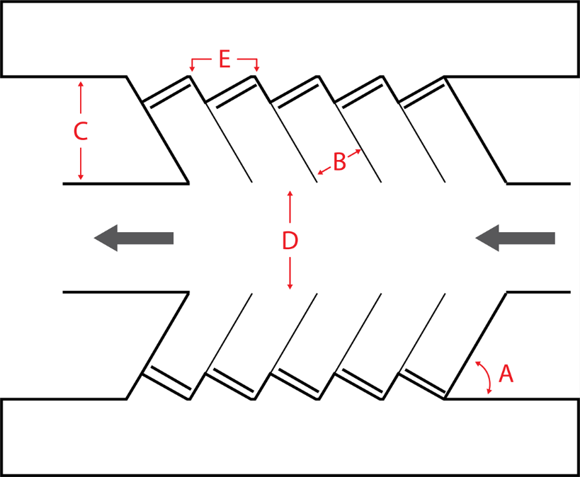
Figure 5109B: Measurement of Parallel Parking Space and Aisle Dimensions
B.
Vertical Clearance. All off-street parking spaces must have a minimum overhead vertical clearance of 8.2 feet for van-accessible parking and 7.0 feet for all other vehicles.
C.
Accessible Parking. A percentage of the required off-street vehicular parking spaces must be specifically designated, located, and reserved for use by persons with physical disabilities, in accordance with the standards in the Federal Americans with Disabilities Act Accessibility Guidelines and State law, including the Uniform Statewide Building Code and related regulations. Compliance with these standards will be reviewed by the Building Official.
D.
Compact Parking. Up to 20 percent of required off-street parking spaces may be designated for use by compact cars. The dimensions of such designated off-street parking spaces may be reduced to a width of eight feet and a depth of 16 feet. If angled parking is reduced to compact size, aisle width must be no less than 24 feet. Parallel parking spaces may not be reduced to compact parking spaces.
E.
Motorcycle Parking. Motorcycle, scooter, and moped parking spaces must have a minimum depth of five feet and a minimum width of four and one-half feet.
(Ord. No. 1335, § 51, 11-12-2024)
Sec. 24-5110. - Minimum Number of Off-Street Parking Spaces.
Except as provided in Sec. 24-5111, Alternative Minimum Requirements, all new development and any change in use or expansion must provide the minimum number of off-street parking spaces set forth in Table 5110: Minimum Number of Off-Street Parking Spaces, based on the principal use(s) involved and the extent of development. Off-street parking standards for principal uses with variable parking demands or unlisted principal uses will be interpreted in accordance with Sec. 24-5112, Required Number of Parking Spaces for Unlisted Uses.
(Ord. No. 1324, § 3, 6-25-2024; Ord. No. 1325, § 3, 7-9-2024; Ord. No. 1335, § 52, 11-12-2024; Ord. No. 1342, § 7, 6-10-2025)
Sec. 24-5111. - Alternative Minimum Requirements.
The minimum number of off-street parking spaces required by Table 5110: Minimum Number of Off-Street Parking Spaces may be adjusted as follows:
A.
Rideshare and Delivery. Vehicular parking spaces that are reserved for rideshare or taxi pick-up and drop-off in accordance with subsection Sec. 24-5106.D above, or for small-scale delivery service such as food delivery, will reduce the amount of minimum parking required in accordance with Table 5110: Minimum Number of Off-Street Parking Spaces, by a 1:1 ratio.
B.
Motorcycle Parking. Parking spaces that are reserved for motorcycle users in accordance with the standards in subsection Sec. 24-5109.E above will reduce the amount of minimum vehicular parking by a 1:1 ratio up to a maximum of five percent of the spaces required by Table 5110: Minimum Number of Off-Street Parking Spaces.
C.
Multiple Use Commercial Centers.
1.
Except as otherwise provided by subsection 2 below, a development that includes at least 8,000 square feet of retail or commercial space and at least four different storefronts, and that includes a recorded agreement providing for shared parking and vehicular and pedestrian circulation systems, must provide 3.5 parking spaces per 1,000 square feet of gross floor area in the development.
2.
Any theater, hotel, or any use that is not a Commercial use in a development subject to subsection 1 above must provide the amount of parking required by Table 5110: Minimum Number of Off-Street Parking Spaces, and the remaining development must provide 3.5 parking spaces per 1,000 square feet of the remaining gross floor area.
Sec. 24-5112. - Required Number of Parking Spaces for Unlisted Uses.
An applicant proposing to develop a principal use that is unlisted in Table 5110: Minimum Number of Off-Street Parking Spaces, must propose the amount of required parking by one of the three methods in subsections A through C below. On receiving the application, the Planning Director will determine the amount of required parking using the method selected by the applicant or using any of the following methods:
A.
Apply the minimum off-street parking space requirement for the listed use that the Planning Director deems most similar to the proposed use;
B.
Establish the minimum off-street parking space requirement by reference to standard parking resources published by the Institute for Transportation Engineers (ITE), Urban Land Institute (ULI), National Parking Association, or the American Planning Association (APA); or
C.
Require the applicant to conduct a parking demand study to demonstrate the appropriate minimum off-street parking space requirement. The study must estimate parking demand based on the recommendations of the ITE, ULI, or another comparable source of parking demand data. This demand study must include relevant data collected from uses or combinations of uses that are the same or comparable to the proposed use in terms of density, scale, bulk, area, type of activity, and location.
Sec. 24-5113. - Required Number of Parking Spaces for Mixed-Use Development.
A.
Applicability.
1.
An applicant for a development containing more than one principal use may calculate minimum parking requirements based on the potential to share parking between uses, thus reducing the overall parking supply that would result from each individual use meeting minimum standards, for a maximum potential reduction of 30 percent.
2.
These provisions do not limit the opportunity for an applicant to reduce the minimum number of required off-street parking spaces through approval of an alternative parking plan in accordance with Sec. 24-5115, Off-Street Parking Alternative Parking Plans, or other provisions of this Ordinance.
B.
Methodology. The following methodology will be used to calculate the required parking:
1.
The applicant must determine the minimum parking required for each principal use in the development in accordance with Table 5110: Minimum Number of Off-Street Parking Spaces.
2.
The applicant must apply the time-of-day demand factors for each principal use in accordance with Table 5113: Shared Parking Time-of-Day Parking Ratios.
3.
The applicant must calculate the sum of each column in the resulting table (rounding up all fractions). These sums represent the total estimated shared demand for each time period throughout a typical day.
4.
The highest of the sums of the columns may be used as the minimum amount of parking required for the development.
Sec. 24-5114. - Electric Vehicle Charging Stations.
Up to ten percent of the required number of off-street parking spaces may be used and designated as electric vehicle (EV) charging stations, subject to the standards in Sec. 24-4416, Accessory Electric Vehicle (EV) Level 1, 2, or 3 Charging Station. The Planning Director may approve the use and designation of additional required parking spaces as EV charging stations, provided that such additional spaces will count as only one-half of a parking space when computing the minimum number of parking spaces required. EV charging stations must be contiguous to spaces clearly marked for electric vehicles.
Sec. 24-5115. - Off-Street Parking Alternative Parking Plans.
In reviewing a parking plan (see Sec. 24-5102.E, Parking Plan Required), the Planning Director may approve alternatives to providing the off-street parking spaces required by Sec. 24-5110, Minimum Number of Off-Street Parking Spaces, using one or more of the alternatives in Sections 24-5116 through 24-5119 below.
Sec. 24-5116. - Off-Site Parking.
An applicant may propose an alternative parking plan to meet a portion of the minimum number of off-street parking spaces required for that use through off-site parking located on a different lot from the use it serves. Such use of off-site parking will be subject to the following standards:
A.
Maximum Off-Site Spaces. Up to 50 percent of the number of parking spaces required for the use may be provided off-site provided that parking demands do not overlap.
B.
Location.
1.
The off-site parking spaces must be located within a maximum walking distance of the primary pedestrian entrances to the uses served by the parking of 660 feet for residential uses (including mixed-use dwellings), and 800 feet for all other uses, measured by the actual walking distance using adequate and safe pedestrian facilities.
2.
The off-site parking spaces must not be separated from the use they serve by an arterial road unless pedestrian access across that street is provided by appropriate traffic controls (such as a signalized crosswalk), or a pedestrian walkway (such as a bridge or tunnel).
3.
The location of the off-site parking must not result in the routing of traffic through a single-family residential area or lead to a change in character of a single-family residential area.
C.
Pedestrian Access. Adequate and safe pedestrian access by a walkway protected by landscape buffer, or a curb separation and elevation from the street grade, must be provided to connect the off-site parking areas and the primary pedestrian entrances to the uses served by the parking.
D.
Signage Required. Signage complying with the standards in Article 5, Division 7, Signs, must be provided to direct the public to the off-site parking spaces.
E.
Off-Site Parking Agreement.
1.
An approved off-site parking arrangement will be enforced through written agreement among all the owners or long-term lessees of lands containing the parking spaces.
2.
The agreement must state that no party can cancel the agreement without first sending written notice to the Planning Director at least 120 days prior to the termination of the agreement.
3.
The agreement must be submitted to the Planning Director for review and approval before execution.
4.
An attested copy of an approved and executed agreement must be recorded in the land records before issuance of a final certificate of occupancy for any use to be served by the off-site parking area.
5.
The agreement will run with the land and will bind the heirs, successors, and assigns of the landowner. A violation of the agreement will constitute a violation of this Ordinance.
6.
If the off-site parking becomes permanently unavailable to the use it serves, the use must not continue operating unless the full number of off-street parking spaces required by this section are provided.
(Ord. No. 1335, § 53, 11-12-2024)
Sec. 24-5117. - On-Street Parking.
In the CMU and Planned Development zoning districts, an alternative parking plan may propose to provide up to 50 percent of the minimum number of required off-street parking spaces through on-street parking along streets that are within the development, subject to Sec. 24-5116.C, Pedestrian Access.
Sec. 24-5118. - Deferred Parking.
An alternative parking plan may propose to defer construction of up to 25 percent of the number of off-street parking spaces required by Table 5110: Minimum Number of Off-Street Parking Spaces, in accordance with the following standards:
A.
Justification. The alternative parking plan must include a study demonstrating that because of the location, nature, or mix of uses, the number of parking spaces actually needed to serve the development is less than the minimum required by Table 5110: Minimum Number of Off-Street Parking Spaces.
B.
Reserve Parking Plan. The alternative parking plan must include a reserve parking plan identifying the amount of off-street parking being deferred and the location of the area to be reserved for future parking if needed.
C.
Parking Demand Study. The alternative parking plan must provide assurance that within 24 months after the initial certificate of occupancy is issued for the proposed development, an off-street parking demand study evaluating the adequacy of the existing parking spaces in meeting the off-street parking demand generated by the development will be submitted to the Planning Director. However, if the Planning Director determines that additional time beyond 24 months is needed to determine whether the supply of parking is adequate to meet demand, the Planning Director may delay the preparation of the parking study for up to 24 additional months.
If the Planning Director determines that the study demonstrates the existing parking is adequate, then construction of the remaining number of parking spaces will not be required at that time. If the Planning Director determines the study indicates additional parking is needed, such parking must be provided consistent with the reserve parking plan and the standards of this section.
D.
Limitations on Reserve Areas. Areas reserved for future parking must be brought to the finished grade at the time the site is developed and must not be used for buildings, storage, loading, or other purposes, even if the reserved parking is not needed. Such areas may be used for temporary overflow parking, provided such use is sufficiently infrequent to ensure maintenance of its ground cover in a healthy condition.
E.
Landscaping of Reserve Areas Required. Areas reserved for future off-street parking must be landscaped with an appropriate ground cover such as grass or mulch, and if ultimately developed for off-street parking, must be landscaped in accordance with Article 5, Division 3, Landscaping and Tree Protection.
Sec. 24-5119. - Valet and Tandem Parking.
An alternative parking plan may propose to use valet and tandem parking to meet a portion of the minimum number of off-street parking spaces required in accordance with the following standards:
A.
Number of Valet or Tandem Spaces. The percentage of the total number of required parking spaces that may be designated for valet or tandem spaces must not exceed 50% for restaurants, or 80% for hotels, or 35% for all other uses.
B.
Drop-Off and Pick-Up Areas. The development must provide a designated drop-off and pick-up area. The drop-off and pick-up area may be located adjacent to the building served but may not be located in a fire lane or where its use would impede vehicular or pedestrian circulation, cause queuing in a public street, or impede an internal drive aisle serving the development. Drop-off and pick-up areas must not use impede sidewalks.
C.
Valet or Tandem Parking Agreement. Valet or tandem parking may be established and managed only in accordance with a valet or tandem parking agreement that complies with the following requirements
1.
The agreement must be for a minimum of 10 years, and include provisions ensuring that a valet parking attendant will be on duty during hours of operation of the uses served by the valet parking.
2.
The agreement must be submitted to the Planning Director for review and approval before execution.
3.
An attested copy of an approved and executed agreement must be recorded in the land records before issuance of a certificate of occupancy for any use to be served by the valet or tandem parking.
4.
The agreement will run with the land and will bind the heirs, successors, and assigns of the landowner.
5.
A violation of the agreement will constitute a violation of this Ordinance.
6.
If the valet or tandem parking services becomes unavailable for more than 30 days, the use must cease until the standards of this section are met.
Sec. 24-5120. - Reduced Parking Standards for Parking Demand Reduction Strategies.
Use of transportation demand reduction strategies in this section allows for a reduction of off-street parking provided by Sec. 24-5110, Minimum Number of Off-Street Parking Spaces. Parking reductions are not exclusive and may be applied cumulatively.
A.
Transit Accessibility. A five percent reduction in the minimum number of off-street parking spaces required by Table 5110: Minimum Number of Off-Street Parking Spaces, may be approved for uses located within one-eighth mile of any station, stop, or other transit facility served by scheduled transit with weekday peak-level frequencies of 15 minutes or less and weekday off-peak frequencies of 20 minutes or less at the time of approval.
B.
Transportation Demand Management. The Planning Director may, through approval of a Transportation Demand Management (TDM) plan, authorize up to a 30 percent reduction in the minimum number of off-street parking spaces required by Sec. 24-5110, Minimum Number of Off-Street Parking Spaces, for nonresidential uses having a floor area of at least 25,000 square feet, including nonresidential components of mixed-use developments, in accordance with the following standards.
1.
TDM Plan Requirements. The required TDM plan must include facts, projections, an analysis (e.g., type of development, proximity to transit or other multi-modal systems, anticipated number of employees and patrons, minimum parking requirements) and indicate the types of transportation demand management activities that will be instituted to reduce single-occupant vehicle use and reduce traffic congestion. The plan must identify the amount by which parking requirements have been reduced from the amounts otherwise required by Sec. 24-5110.
2.
Transportation Demand Management Activities. The TDM Plan must provide the following TDM activities:
(a)
A Guaranteed Ride Home program that offers emergency ride services to each employee with an allowance of no fewer than four rides per year, which an applicant may establish to serve the development or in partnership with other developments or uses.
(b)
Written notice to all employees of available transportation and ride-sharing options.
(c)
Formation of transportation demand reduction programs such as carpooling, vanpooling, ridesharing, subsidy of employee bus passes, teleworking, and shuttle service programs.
3.
Two Transportation Demand Management Options Required. The TDM plan must implement at least two of the following transportation demand management strategies:
(a)
Establishment of a development-specific website that provides multi-modal transportation information such as real-time travel and traffic information, bus schedules and maps, and logging of alternative commutes (e.g., bicycle, pedestrian, carpool, and vanpool). Specific information will vary depending on the specific services and transportation infrastructure available in the vicinity of the development, but in general will allow tenants or customers to compare travel modes available.
(b)
In lieu of the website described in subsection (a) above, installation of a real-time visual display screen or other display device of this type that provides multi-modal transportation information.
(c)
A parking cash-out or transportation stipend, or provision of a cash incentive to employees not to use parking spaces otherwise available to tenants of a development.
(d)
Unbundling of parking from leases, or issuing tenant leases that do not include parking as an integral part of a floor-area space lease and require parking to be leased, purchased, or otherwise accessed through separate payment.
(e)
Creation of a Preferential Parking Management Plan that specifically marks spaces for registered carpool and vanpool vehicles that are located near building entrances or in other preferential locations.
(f)
Institution of off-peak work schedules that allow employees to arrive and depart at times other than the peak morning commute period (defined as 7:00 a.m. to 9:00 a.m.) and peak evening commute period (defined as 5:00 p.m. to 7:00 p.m.).
(g)
Any other transportation demand management activity may be approved by the Planning Director as a means of complying with the parking reduction provisions of this section.
4.
Recording of TDM Plan. A copy of the approved TDM plan must be recorded in the land records before issuance of a building permit for the development to be served by the plan. The TDM plan will run with the land, and the applicant and successors in interest in the land will be responsible for implementing the plan.
5.
TDM Program Coordinator. The applicant must appoint a TDM program coordinator to oversee transportation demand management activities. The TDM program coordinator must be a licensed engineer, certified planner, or a traffic consultant who is also a qualified or trained TDM professional. The TDM program coordinator must be appointed prior to issuance of a building permit for the buildings to be served by the TDM program.
6.
TDM Report. The TDM program coordinator must submit to the Planning Director a report on a biennial basis that details implementation of the approved TDM plan and the extent to which it has achieved the target reduction in drive-alone trips that justified the original reduction in parking. The report must include, but is not limited to, the following:
(a)
A description of transportation demand management activities undertaken;
(b)
An analysis of parking demand reductions based on employee and resident use of ridership programs or alternative transportation options;
(c)
Changes to the TDM plan to increase bus ridership, bicycle ridership, and other commuting alternatives, as defined in subsection 7 below; and
(d)
The results of an employee transportation survey.
7.
Amendments. The Planning Director may approve amendments to an approved TDM plan in accordance with the procedures and standards for its original approval. Changes in transportation options subsequent to the approval of the original plan that allow a development to meet the reduction targets identified in the original plan, such as introduction of new transit service to a development area, will not require amendments to the plan so long as the development continues to comply with the approved plan and annual reports demonstrate that these services contribute to the plan's intent.
8.
Parking Required if TDM Terminated. If the applicant or successor in interest in the development subject to a TDM plan stops implementing the plan or fails to submit a TDM report within one year of the regularly scheduled date the biennial report is due, the TDM plan will be terminated and become null and void. Any such termination of the TDM plan does not negate the parties' obligations to comply with parking requirements in this Ordinance, and will constitute a violation of this Ordinance. No use served by the TDM plan may be continued unless another TDM plan is approved or all required off-street parking spaces are provided in accordance with this section and this Ordinance, within 120 days of termination of the TDM plan.
Sec. 24-5121. - Dedicated Facilities for Bicycle Commuters.
A five percent reduction in the minimum number of off-street parking spaces required by Table 5110: Minimum Number of Off-Street Parking Spaces, is allowed for developments that comply with the bicycle parking standards in Sec. 24-5122, Bicycle Parking Standards, and provide both of the following: additional bicycle parking spaces that are secure and either enclosed or covered (indoor or locker) equal to at least five percent of the number of vehicle parking spaces provided; and shower and dressing areas for employees.
Sec. 24-5122. - Bicycle Parking Standards.
A.
Minimum Bicycle Parking Required. The following types of development must include bicycle parking spaces in accordance with Table 5122: Minimum Bicycle Parking Standards:
1.
All new development; and
2.
Any individual expansion or alteration of a building existing prior to September 1, 2021, if the expansion increases the building's gross floor area by 50 percent or more, or if the alteration involves 50 percent or more of the building's gross floor area (including interior alterations), provided no long-term bicycle parking is required if the building has a gross floor area of less than 2,500 square feet after the expansion or alteration.
B.
Bicycle Parking Space Design Standards.
1.
A bicycle parking space must be located on a paved or similar hard, all-weather surface, having a slope not greater than three percent.
2.
Lighting must be provided for bicycle parking spaces that are accessible after dark.
3.
Bicycle parking must be visible from the main entrance of the building it serves unless the Planning Director determines that another location provides better security for users.
4.
The minimum dimensional requirements for a bicycle parking space are:
(a)
For horizontal storage, six feet long by two feet wide (See Figure 5122A: Bicycle Parking Space and Rack Dimensional Standards Context View, and Figure 5122B: Bicycle Parking Space and Rack Dimensional Standards Overhead View); or
(b)
For vertical storage, four feet long by two feet wide by eight feet high (see Figure 5122C: Vertical Bicycle Parking Dimensional Standards Context View).
Figure 5122A: Bicycle Parking Space and Rack Dimensional Standards Context View
Figure 5122B: Bicycle Parking Space and Rack Dimensional Standards Overhead View
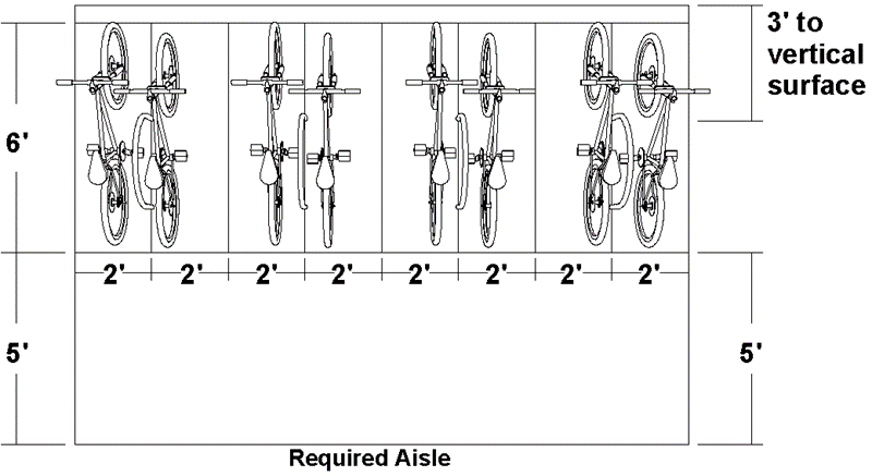
Figure 5122C: Example of Vertical Bicycle Parking Dimensional Standards
(c)
Each bicycle parking space must be accessible without moving another parked bicycle.
(d)
Not more than 35 percent of required bicycle parking spaces may be vertical or wall-mounted parking unless bicycle parking and retrieval services are provided.
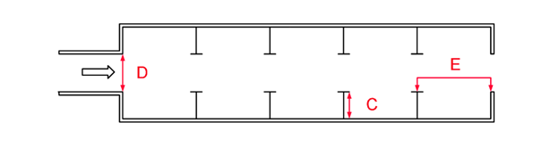
5.
A bicycle parking rack must:
(a)
Allow for the securing of the frame and at least one wheel of a bicycle in a bicycle parking space to the rack with an industry-standard U-shaped bike lock;
(b)
Provide each bicycle parking space with support for a bicycle in a stable position with direct support to the bicycle frame;
(c)
Be securely anchored to the ground or to a structural element of a building or structure;
(d)
Be designed and located so it does not block pedestrian circulation systems and pedestrian movements;
(e)
Be constructed of materials designed to withstand cutting, severe weather, and permanent exposure to the elements, such as powder-coated steel or stainless steel;
(f)
If bicycles must be moved onto or off of the rack parallel to their direction of travel, provide an aisle having a minimum width of five feet between all bicycle parking spaces served by the rack and any bicycle spaces served by another bicycle parking rack, parking lot, or obstructions, including fences, walls, doors, posts, columns, or landscaping areas (see Figures 5122A and 5122B);
(g)
Be located at least three feet from any vertical surface, such as another bicycle parking rack, the side of a building, a tree, or a fence or wall (see Figures 5122A and 5122B); and
(h)
Be separated from any abutting parking lot by at least three feet and a physical barrier, such as bollards, curbing, wheel stops, reflective wands, or a fence or wall.
6.
Bicycle parking areas must be maintained free of inoperable bicycles (such as bicycles with flat tires or missing parts) and debris. Bicycle parking racks must be maintained in good repair, securely anchored, and free of rust.
7.
Location.
(a)
A bicycle parking space serving a development with a single use must be located within 75 feet of a public entrance to the building for which the space is required, measured along the most direct pedestrian access route.
(b)
A bicycle parking space that is located in a bicycle parking area serving more than one use must be located within 150 feet of a public entrance to the building for which the space is required, measured along the most direct pedestrian access route.
(c)
Long-term bicycle parking that provides enhanced protection from weather, theft, and vandalism, such as bicycle lockers or designated and secured indoor storage areas, must be located within 500 feet of a public entrance to the building for which the space is required, measured along the most direct pedestrian access route.
Sec. 24-5123. - Vehicle Stacking Standards.
Uses with drive-through facilities and other auto-oriented uses where vehicles queue up to access a service facility must provide stacking spaces.
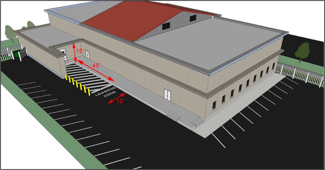
Sec. 24-5124. - Loading Standards.
A.
Minimum Number. Any new development listed below involving the routine vehicular delivery or shipping of goods, supplies, or equipment to or from the development must provide a sufficient number of off-street loading berths to accommodate the delivery and shipping operations of the development's uses in a safe and convenient manner. Table 5124: Minimum Number of Off-Street Loading Berths, sets forth the minimum number of loading berths for the different principal uses for which loading berths are required. For proposed uses not listed in Table 5124, the requirement for a use most similar to the proposed use will apply. Loading berths may be shared among multiple uses in a single development. The addition of loading berths will not be required solely because of a change of use of an existing structure
B.
Car Carrier Trailers. In addition to the requirements of Table 5124: Minimum Number of Off-Street Loading Berths, Vehicle Sales and Service Uses that receive vehicles shipped on car carrier trailers that accommodate multiple vehicles (e.g., Automobile Sales uses) must ensure there is sufficient loading area to accommodate the loading and unloading of all such vehicles without impeding a public right-of-way.
C.
Dimensional Standards. Each loading berth must be at least 10 feet wide and must have at least 15 feet overhead clearance. For general industrial, distribution, or warehousing uses, each loading berth must be at least 45 feet long. For all other uses, each loading berth must be at least 25 feet long.
D.
Location.
1.
To the maximum extent practicable, loading berths must be located to the rear of the use they serve (see Figure 5124: Loading Area Configuration). In the M-1, M-2, and M-3 district, a loading berth may occupy any part of a front or street side yard if:
(a)
All loading doors, docks, and berths are set back a minimum of 50 feet from the property line;
(b)
Loading berths are delineated by a curb or bumper parallel to the property line to prevent encroachment on the right-of-way; and
(c)
Curb and gutter and storm sewer are provided.
2.
Loading berths must be located adjacent to the building's loading doors in an area that promotes their practical use.
3.
Loading berths must not be located within 50 feet of a lot in a Residential zoning district.
4.
Loading berths must be located and designed so vehicles using them can maneuver safely and conveniently to them from a public street and complete loading without obstructing or interfering with any public right-of-way or any parking space or parking lot aisle.
Figure 5124: Loading Area Configuration
Sec. 24-5201. - Purpose and Intent.
Required open space is intended to promote the public health, safety, and welfare. The standards in this division are intended to ensure that a minimum amount of required open space is provided in new development for the use and enjoyment of the development's residents, employees, and users in a manner that:
A.
Preserves the County's natural resources;
B.
Provides open areas for use as active and passive recreation;
C.
Reduces the heat island effect of developed areas;
D.
Provides civic and meeting spaces for use by the public;
E.
Preserves specimen trees and strands of older growth trees;
F.
Enhances stormwater management; and
G.
Provides other public health benefits.
Sec. 24-5202. - Applicability.
A.
General. Unless exempted in accordance with subsection B below, all new development in the County must comply with the standards in this division.
B.
Exemptions. The following development is exempted from the standards in this division:
1.
Development of single-family or duplex dwellings that is not part of a subdivision of land into more than 50 lots (including all phases or sections), a plan of development, a site plan, a mixed-use development, or a Planned Development;
2.
Utility uses;
3.
Agricultural uses; and
4.
Development where the total minimum open space otherwise required by this division, including all phases of development, would be 100 square feet or less.
C.
Timing of Review. Review for compliance with the standards of this division will occur during review of an application for a planned development, provisional use permit, conditional use permit, building permit, certificate of occupancy, plan of development, site plan, or subdivision, as appropriate.
D.
Open Space Plan Required. All development applications subject to review for compliance with the standards of this division must include an open space plan. The plan must designate all open space areas, including the amount of each type of open space provided and the relation of each open space area to the constructed areas of the site, including all buildings and pedestrian circulation systems and their links to the open spaces.
Sec. 24-5203. - Amount of Open Space Required.
Development subject to these standards must provide required open space in an amount that meets or exceeds the minimum in Table 5203: Required Open Space, based on the use and zoning district where the development is proposed. The open space within a large, unified development (such as a shopping center or office park) may be allocated to the open space requirement for individual projects within that development (such as outparcels or individual buildings), provided no area of open space may be allocated to more than one project.
Sec. 24-5204. - Areas Counted Towards Required Open Space.
A.
Qualifying Types of Open Space. The features and areas identified as counting towards required open space in Table 5204: Required Open Space Features, will be credited towards compliance with the amount of open space required by Sec. 24-5203 above if designed and maintained in accordance with Table 5204.
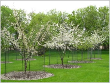
| Table 5204: Required Open Space Features | |
| Area Counted as Common Required Open Space, and Design and Maintenance Requirements | |
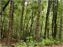 | Natural Features Description: Native mixed forests, monoculture pine forests, wildlife habitat areas, areas with groupings of grand trees, natural vegetation, streams, rivers, ponds, lakes, wetlands, steep slopes, drainageways, riparian buffers, other riparian areas, and flood hazard areas with natural service trails. Design and Maintenance Requirements: Maintenance is limited to the minimum removal and avoidance of hazards, nuisances, and unhealthy conditions, and the clearing of trails. |
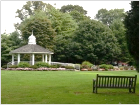 | Passive Recreation Areas Description: Formally planned and regularly maintained open areas that provide passive recreation opportunities, including arranged plantings, gardens, community gardens, green roofs, gazebos, and similar structures. Design and Maintenance Requirements: Passive recreation areas must have at least one direct access to a building or to a street or walkway accessible to the development's occupants and users. |
 | Required Landscape Areas, Tree Protection Areas, Screening, and Buffers Description: All areas occupied by required landscape areas, tree protection areas, vegetative screening, and water quality buffers, except for landscape areas within parking lots. Design and Maintenance Requirements: See, Article 5, Division 3, Landscaping and Tree Protection |
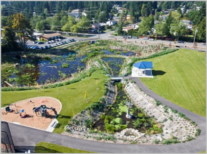 | Stormwater Management Areas Treated as Site Amenities Description: Up to 75 percent of the land area occupied by stormwater management facilities (including retention and detention ponds and other bioretention devices) may be included, but only when such features are incorporated into a site amenity (e.g., with low fencing, vegetative landscaping, gentle slopes, fountain or other visible water circulation device, and pedestrian access or seating). Design and Maintenance Requirements: To qualify, stormwater management facilities must support passive recreation uses by providing access, pedestrian elements such as paths and benches, gentle slopes (less than 3:1), and vegetative landscaping. |
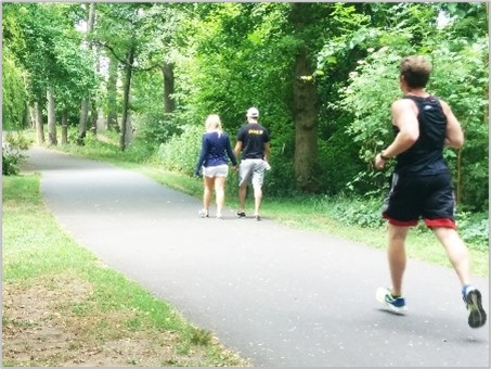 | Public Access Easements with Paths or Trails Description: Public access easements that include paths or trails that are available for passive recreational activities such as walking, running, and biking. Design and Maintenance Requirements: Such access easements must include at least one improved access from a public street, sidewalk, or trail that includes signage designating the access point. |
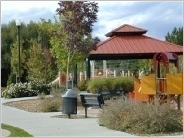 | Active Recreational Areas Description: Land occupied by areas and facilities used for active recreational purposes, such as ballfields, playgrounds, tennis courts, pools, jogging trails, community buildings and clubhouses, and land dedicated for parks. Design and Maintenance Requirements: Land must be compact and contiguous unless used to link or continue an existing or planned open space resource. Areas must have at least one direct access to a building or to a street or walkway accessible to the public or the development's occupants and users. |
 | Squares, Forecourts, and Plazas Description: Flat, open areas immediately in front of a building or framed by buildings or streets, or rooftops that provide gathering places, opportunities for outdoor dining, and other similar activities. Design: A square, forecourt, or plaza must be at least 200 square feet, but no more than one acre, in area. It must have at least one direct access to a principal building, or to a street or walkway accessible to the public or the development's occupants and users. Surrounding principal buildings must be oriented toward the square, forecourt, or plaza where possible. |
| NOTES: [1] Images are for illustrative purposes only. | |
B.
Areas Not Counted as Required Open Space. The following features and areas will not be counted as required open space for purposes of this section:
1.
Yards on lots containing a single-family detached or attached, manufactured home, duplex, or townhouse dwelling, that are not subject to an open space or conservation easement;
2.
Street rights-of-way or private access easements, including sidewalks located within those rights-of-way or easements, other than a sidewalk located in a landscape strip that exceeds the minimum requirements in Article 5, Division 3, Landscaping and Tree Protection;
3.
Parking areas and driveways, including parking lot interior landscaping and walkways;
4.
Land covered by structures, unless designed for active recreational uses;
5.
Designated outdoor storage areas and mechanical yards; and
6.
Stormwater ponds not located and designed as a site amenity (see design and maintenance requirements in Table 5204: Required Open Space Features).
(Ord. No. 1335, § 54, 11-12-2024)
Sec. 24-5205. - Prioritization of Required Open Space.
A.
Except as otherwise provided in subsection B below, and to the maximum extent practicable, required open space must be located and organized to include, protect, and enhance as many of the following open areas and features as possible, in the following order of priority:
1.
Preserved historic resources.
2.
Natural features such as riparian areas and buffers, shorelines, flood hazard areas, floodplains, steep slopes, wildlife habitation, and woodland areas.
3.
Water features such as rivers, bays, lakes, creeks, canals, natural ponds, and retention and detention ponds.
4.
Protected trees, including heritage, memorial, or specimen trees, and other mature trees.
5.
Parks and trails (regardless of public or private ownership).
6.
Lands with active agricultural uses and activities.
7.
Perimeter buffers or visual transitions between different types or intensities of uses.
8.
Areas that accommodate multiple compatible open space set-aside uses rather than a single use.
9.
Squares, forecourts, plazas, rooftop plazas, and similar open space amenities.
B.
In the CMU District, the highest priority for open space will be the establishment of squares, forecourts, plazas, and similar urban open space amenities, followed by parks and trails, all of which must be ADA accessible where practical. The priority of the remaining types of open space will be the same as listed in subsection A above.
Sec. 24-5206. - Design and Development Standards.
A.
Location. Required open space must be readily accessible by occupants and users of the development to the maximum extent practicable. In residential subdivisions, each residential lot must be located within one-half mile of a required open space. To the extent practicable, a portion of the open space area should provide focal points for the development through prominent placement or direct visibility from streets.
B.
Configuration.
1.
Required open space must be compact and contiguous unless a linear configuration is needed to continue an existing trail or accommodate preservation of natural features. A minimum of 40 percent of the required open space must be contiguous unless a different configuration provides better access to usable open space for intended users of the open space.
2.
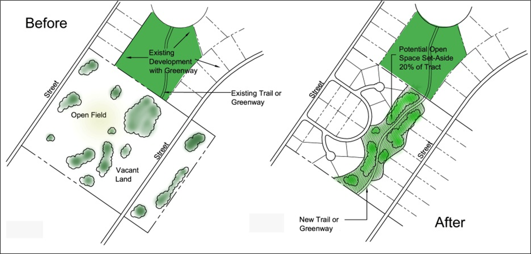
If the development site is adjacent to existing or planned public trails, parks, or other public open space area, the required open space must, to the maximum extent practicable, be located to adjoin, extend, and enlarge the trail, park, or other public open space area (see Figure 5206: Example Open Space Set-Aside Configuration).
3.
Pedestrian access to required open space must be provided from sidewalks or other pedestrian ways within or adjacent to the development.
4.
If a passive recreation open space with a minimum width of 20 feet or more abuts an existing or planned open space area, a buffer is not required between the two open space areas, even if otherwise required by Sec. 24-5310, Transitional Buffers.
Figure 5206: Example Open Space Configuration
C.
Orientation of Adjacent Buildings. To the extent practicable, buildings adjacent to required open space must have at least one entrance facing the open space.
D.
Limited Development Allowed. Development within required open space must be appropriate to the purposes of the type of required open space. Where appropriate, such development may include walking, jogging, and biking paths and trails; benches and other seating areas; meeting areas; tables, shelters, grills, and other picnicking facilities; docks and other facilities for fishing; educational guides and exhibits; gazebos and other decorative structures; fountains and other water features; play structures for children; gardens and seasonal planting areas; pools; athletic fields and courts; consolidated mail facilities; and clubhouses. All structures within required open space must comply with setback and other dimensional requirements of the zoning district.
E.
Protection During Construction.
1.
Required open space must be protected and maintained during the development process in accordance with the requirements of this Ordinance and Chapter 10 of the County Code.
2.
During the development process, required open space must not be used for storing, filling, or dumping of any materials and must not be denuded, defaced, or otherwise disturbed without the prior approval of the appropriate County department and the Planning Director.
3.
Any required open space consisting of natural features that are damaged or destroyed must be restored by the developer or owner to the condition existing prior to the disturbance, including the removal of dead or damaged trees, stumps, and remnants in accordance with an appropriate plan and performance guarantees approved by the Planning Director.
Sec. 24-5207. - Ownership, Management, and Maintenance.
A.
All required open space must include deed restrictions, covenants, or other legal instruments that ensure continued use of the land for its intended open space purposes and provide for the continued and effective management, operation, and maintenance of the land and facilities.
B.
Stormwater features treated as site amenities must be maintained in accordance with Chapter 10, Article 2 of the County Code.
C.
Other than stormwater features treated as site amenities, required open space must be maintained by the developer or owner of the project or by a property owners' association comprising owners of the property in the project. If property is conveyed to the property owners' association, deed restrictions and covenants, in form satisfactory to the County Attorney, must provide that any assessments, charges, or costs of maintenance of required open space constitute a pro rata lien upon the individual properties inferior in lien and dignity only to taxes and bona fide duly recorded first deeds of trust on each property or lot.
D.
Required open space may be dedicated to the County for public use only in a manner and form approved by the County Attorney.
Sec. 24-5301. - Purpose and Intent.
The purpose of this division is to establish standards for landscaping that facilitate the creation of a convenient, attractive, and harmonious community; conserve and protect natural resources, including air and water quality; preserve the unique character of the area; and encourage the appropriate use of land. In particular, this division is intended to:
A.
Provide screening between potentially incompatible uses of land;
B.
Improve the quality of the streetscape;
C.
Require landscaping around and within parking lots and around multifamily and nonresidential buildings;
D.
Provide shade to reduce heat and glare reflected by paving and reduce the heat island effect;
E.
Reduce stormwater runoff;
F.
Reduce the glare of headlights and noise on adjacent properties;
G.
Ensure that development enhances tree canopy and preserves existing trees to the maximum extent possible;
H.
Enhance parking lot appearance; and
I.
Protect trees that have particular significance in the County, enhance the appeal and economic value of properties in the County, encourage site design techniques that preserve the existing natural environment.
Sec. 24-5302. - Applicability.
A.
General. Except as provided in subsection B below, the standards in this division apply to the following:
1.
All new development;
2.
Expansions and alterations of existing development that increase building area or parking lot area, but only regarding the site of the expansion, enlargement, or reconstruction; and
3.
Removal or maintenance of vegetative material.
B.
Exemptions.
1.
The following are exempt from all standards in this division:
(a)
Development of a single-family detached or duplex dwelling on an individual lot; however, the standards do apply to a single-family detached or duplex subdivision, as well as a residential project developed as a part of a plan of development (see Sec. 24-2314, Plan of Development) or site plan (see Sec. 24-2315, Site Plan); and
(b)
Uses in the Agriculture use classification.
2.
In addition to the exemptions in subsection 1 above, the following are exempt from the standards of Sec. 24-5313, Tree Protection:
(a)
Routine or seasonal pruning in accordance with Sec. 24-5306. Maintenance;
(b)
The removal or pruning, after providing documentation to the Planning Director of the condition of the tree(s), of dead or naturally fallen trees; trees damaged during a hurricane, tornado, ice or wind storm, or flood; or trees that are found by the Planning Director to be a threat to the public health, safety, or welfare;
(c)
The selective and limited removal or pruning of trees or vegetation necessary to obtain clear visibility at driveways or intersections;
(d)
The removal or pruning of trees within a public right-of-way, private access drive, or utility easement by a utility company or as part of an approved road or utility project;
(e)
The removal or pruning of trees when required by the Federal Aviation Administration; and
(f)
The removal or pruning of trees or vegetation on land zoned or lawfully used for commercial cultivation of trees, outside of any right-of-way, transitional buffer, front or street side yard, or interior planting area in a parking lot.
C.
Timing of Review. Review for compliance with the standards of this division will occur during review of an application for a planned development, provisional use permit, conditional use permit, building permit, certificate of occupancy, tree removal permit, plan of development, or site plan, as appropriate.
Sec. 24-5303. - Landscaping Plan Required.
A.
Landscaping Plan Submission.
1.
A landscaping plan must be submitted with an application for any development subject to the requirements of this division that proposes land-disturbing activity.
2.
The landscaping plan must include all information necessary to demonstrate how the proposed development complies with the requirements of this division, and must include the following:
(a)
All property and right-of-way lines, easements, existing and proposed buildings, vehicular storage areas, parking lots, recycling and refuse containers, and similar features;
(b)
The location, size, and description of all existing and proposed landscaping materials and tree cover;
(c)
All information required in Sec. 24-5313, Tree Protection; and
(d)
Any information determined necessary by the Planning Director to ensure compliance with the standards in this division.
B.
Alternative Landscaping Plan.
1.
At the request of the applicant, a plan with alternative landscaping may be approved if the plan demonstrates all of the following:
(a)
The site size, configuration, topography, existence of utility or other easements, location of existing buildings on the site, or other site conditions make strict compliance with the standards of this division impractical;
(b)
The alternative landscaping is of a similar quality, effectiveness, durability, and performance as is required by the standards in this division; and
(c)
The alternative landscaping is consistent with the purposes of this division, taking into account the number of plantings, the species, arrangement, and coverage proposed, the location of plantings on the development site, the level of screening achieved, and the height, spread, and canopy of the proposed plantings at maturity.
2.
The Planning Director or, at the request of the Planning Director, the Planning Commission may approve the alternative landscaping plan upon determining that the plan meets the standards of subsection 1 above.
(Ord. No. 1335, § 55, 11-12-2024)
Sec. 24-5304. - General Planting Requirements.
A.
Required Plant Materials.
1.
Any healthy existing tree or shrub that is not identified in the Landscape Manual as a member of a nuisance or invasive species, and that meets the standards for new plantings in Table 5304: Minimum Size at Time of Planting, may be included for credit towards the requirements of this division.
2.
Species planted to comply with standards in this division must be selected from the Tree Selection and Cover Guide included within the Landscape Manual. A minimum of 35 percent of all plantings on a site must be native species.
3.
Species listed in the Landscape Manual as undesirable in an urban environment must be avoided in urban or developed areas, such as near buildings, parking structures, roads, and pedestrian walkways.
4.
Species that are identified in the Landscape Manual as invasive or nuisance species are prohibited.
5.
Each species should be selected with consideration of the site conditions where it will be planted, in accordance with the guidelines in the Landscape Manual, to further the purposes of this division and to maximize the likelihood that the tree or shrub will survive and be healthy.
6.
Trees and shrubs planted to comply with the standards in this division must have the minimum size in Table 5304: Minimum Size at Time of Planting, at the time they are planted.
B.
Plant Diversity. To minimize the spread of disease and insect infestation in a plant species, the following genus diversity requirements apply to trees required to be planted on a site:
1.
If fewer than 20 trees are required to be planted on a site, no more than 70 percent of the required trees must be of a single genus.
2.
If 20 or more trees are required to be planted on a site, no more than 35 percent of the required trees must be of a single genus.
Sec. 24-5305. - Installation.
A.
Except as otherwise provided in subsection B below, all landscaping and tree cover required by this division must be completed, installed, or planted according to the approved landscaping plan and certified by the Planning Director before use of the property, issuance of a final certificate of occupancy, or other final approval.
B.
The Planning Director may, for good cause shown, allow installation of required landscaping to be deferred until after issuance of a certificate of occupancy. Circumstances that may warrant an extension include the following:
1.
Unusual environmental conditions, such as drought, cold weather, or over-saturated soil;
2.
Proposed construction on an adjacent site that would have a negative impact on the viability of installed material;
3.
The inappropriateness of the current season for planting the approved plant species; or
4.
Utility work, road work, or site development activities occurring in a proposed landscaped area that is incomplete or delayed.
C.
Any allowance of deferred installation in accordance with subsection B above will be conditioned on the required landscaping being installed as soon as practicable after the circumstances warranting deferral cease to exist, but no later than nine months after such time, and the provision of a performance guarantee if required by the Planning Director that ensures compliance with this division.
D.
All support stakes and wires must be removed within six months after installation of required landscaping has been completed.
Sec. 24-5306. - Maintenance.
A.
The owner or lessee of the property where landscaping is required will be responsible for the maintenance and protection of all plant and screening material and fencing, must maintain all landscaped areas in good condition, and must replace any removed vegetative material with replacement landscaping that meets the standards of this section.
B.
All diseased and dead plant materials, except leaves and other normal forest litter, must be promptly removed and replaced during the next normal planting season and in all cases within a year.
C.
Required landscaped areas must not be used for accessory structures, recycling or refuse collection, parking, or other functional use unless otherwise allowed by this Ordinance.
D.
All required trees must be allowed to reach their mature size and must be maintained at their mature size. Except for trimming and pruning within a utility easement in accordance with applicable policies of the affected utility, required plants must not be cut or severely pruned or otherwise damaged so that their natural form is impaired.
Sec. 24-5307. - Location.
Plantings must not be placed where they would obstruct vision at any height between 30 inches and eight feet above grade in the following locations:
A.
At any street intersection with another street or a driveway serving any property other than a single-family or duplex dwelling, within a triangular area that is included between the lines of the street and driveway, extended to the point where the lines intersect, and, at points on each line 20 feet distant from that point, a straight line connecting them.
B.
At any street intersection with a driveway serving a single-family or duplex dwelling, within a triangular area that is included between the lines of the street and driveway, extended to the point where the lines intersect, and, at points on each line ten feet distant from that point, a straight line connecting them.
Sec. 24-5308. - Minimum Tree Cover.
A.
Minimum Tree Cover Required. Except as otherwise provided by subsection 1 or 2 below, all developments requiring approval of a site plan or construction plan must provide the minimum tree cover in Table 5308A: Tree Cover Requirements. The minimum percentage tree cover will be calculated based on the area within the tree's drip line projected at ten years' maturity for all trees on the site as a percentage of the gross site area.
1.
The following are exempt from the requirements in this section:
(a)
Single-family detached dwellings other than developments in the R-5A and R-5B Districts requiring a plan of development or site plan; and
(b)
In Conservation and Agricultural districts, uses in the Agricultural use category and uses in the Public, Civic, and Institutional use category.
(c)
In all zoning districts, cemeteries must provide 10% tree cover.
2.
The Planning Director may allow an applicant to provide less than the minimum required tree cover in Table 5308A: Tree Cover Requirements, and impose alternate conditions to accomplish the intent of this section, if necessary:
(a)
To allow for the reasonable development of farmland or other areas devoid of woody materials;
(b)
To allow for clearing and grading required to achieve drainage away from residential structures;
(c)
To allow for the reasonable development of dedicated school sites, playing fields, and other non-wooded recreation areas;
(d)
To allow for the preservation of wetlands; or
(e)
To avoid unreasonable hardship to the owner.
3.
The methodologies for calculating the required tree cover and for applying tree preservation credit are included in the Landscape Manual and are incorporated herein by reference.
B.
Planting Requirements.
1.
The landscaping plan (see Sec. 24-5303) must provide for a reasonable distribution of trees throughout the site. It must reflect the topography and configuration of the site and the location of existing and proposed improvements and must conform with good horticultural practices.
2.
Trees planted to meet the tree cover requirements of this section must be provided a minimum planting area in accordance with Table 5308B: Planting Area Requirements, except that trees used to meet the requirements of Sec. 24-5310, Transitional Buffers, will be subject to the minimum planting area requirements in the Landscape Manual instead.
C.
Credit for Preserved Trees.
1.
Existing trees identified on the tree protection plan (see Sec. 24-5313.C) may be counted towards the tree cover requirements. Freestanding trees will be credited by 1.25 multiplied by the area defined by the boundaries of the existing dripline of a freestanding tree or group of trees as surveyed in the field and delineated on the tree protection plan. A credit up to 2.0 may be granted by the Planning Director for trees of outstanding size and quality.
2.
If any preserved tree that has received credit in accordance with this subsection C dies within three years of issuance of a certificate of occupancy, replacement trees must be planted to meet the required minimum tree cover canopy density.
(Ord. No. 1338, § 17, 2-11-2025)
Sec. 24-5309. - Foundation Landscaping.
A.
Applicability.
1.
Unless exempted by subsection 2 below, all development must comply with the standards in this section.
2.
The following are exempt from the standards in this section:
(a)
Development that consists solely of a change in land use;
(b)
Single-family detached, manufactured home, duplex, and townhouse dwellings;
(c)
Heavy manufacturing; and
(d)
Agricultural, Transportation, Utilities, and Waste-Related Services uses.
B.
Plantings Required.
1.
Landscaping must be provided along the building perimeter facing public rights-of-way in the amount listed in Table 5309: Required Foundation Plantings, based on the proposed use:
2.
Required shrubs must be placed a maximum of five feet from the building if there is no sidewalk located between the planting area and the building wall, or up to 15 feet from the building if there is a sidewalk located between the planting area and building wall, as measured from the center of the shrub. See Figure 5309A: Foundation Planting Requirements and Figure 5309B: Foundation Planting Requirements with Sidewalk.
Figure 5309A: Foundation Planting Requirements
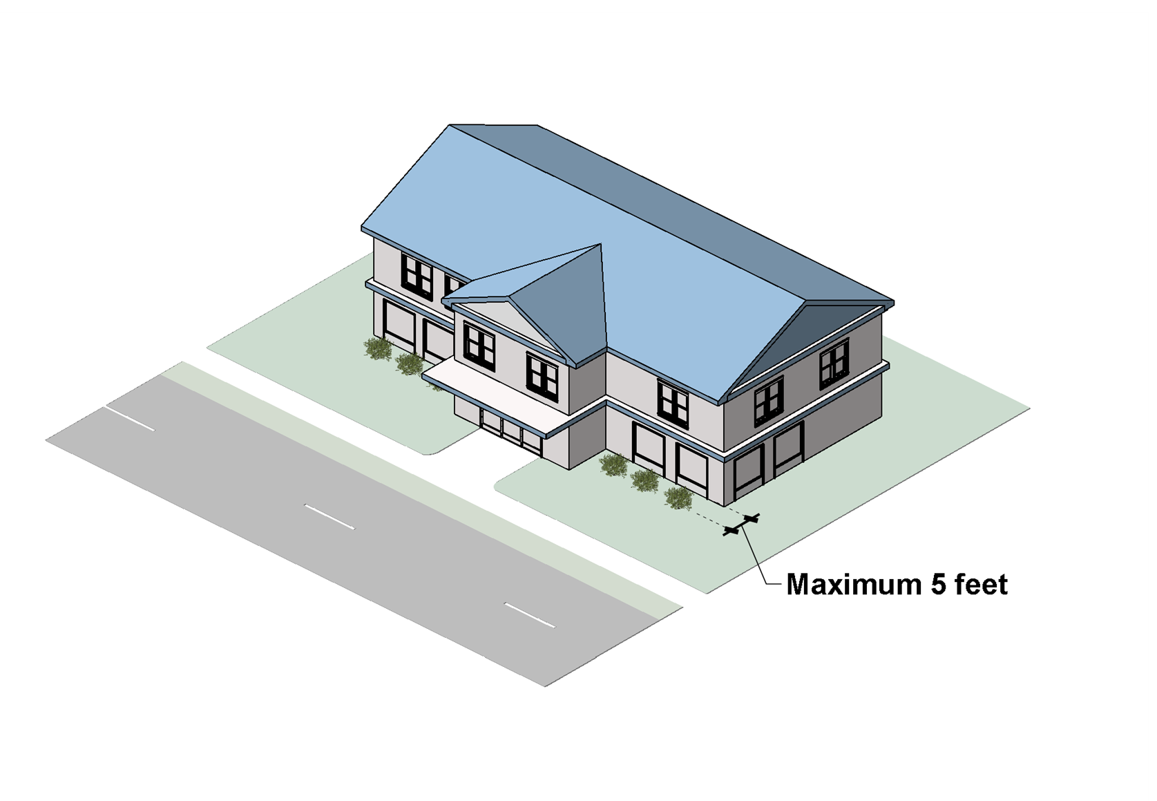
Figure 5309B: Foundation Planting Requirements with Sidewalk
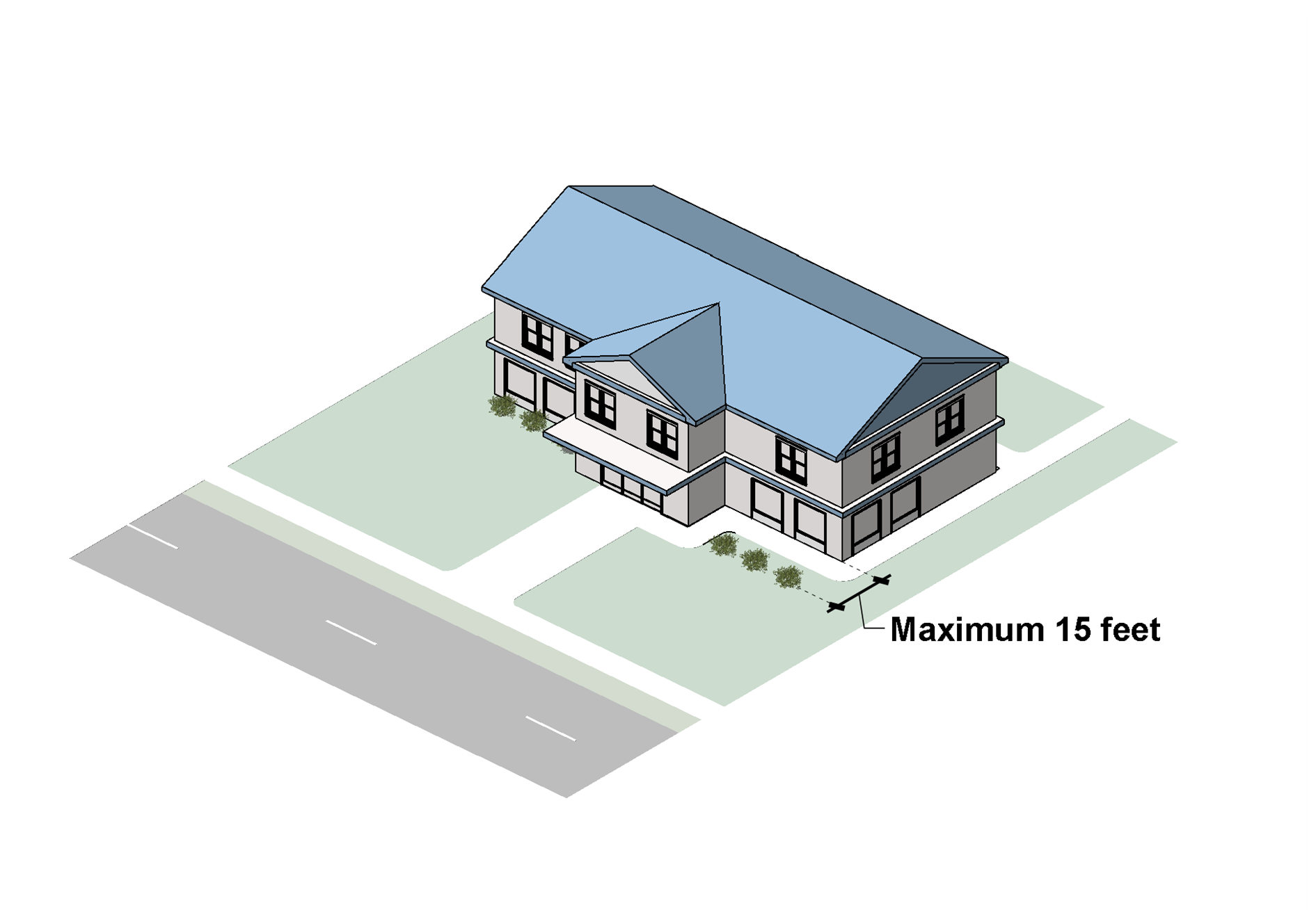
Sec. 24-5310. - Transitional Buffers.
A.
Applicability.
1.
Except as otherwise provided in subsections 2 through 7 below, all new development must comply with the standards in this section.
2.
Where a change of use of an existing structure is proposed that requires a zoning map amendment, the site must be brought into compliance with the standards in this section to the extent practicable.
3.
Where a proposed use abuts the adjacent zoning district or is separated from the adjacent zoning district by a public right-of-way 80 feet or less in width, the transitional buffer indicated by Table 5310A is required. However, if a proposed use and the adjacent zoning district are separated by a public right-of-way greater than 80 feet in width (other than a controlled-access road), a transitional buffer is not required.
4.
A transitional buffer is not required between uses, buildings, or lots developed under a common plan or operated under common management.
5.
Development in accordance with an approved plan of development or site plan will be considered in compliance with the requirements of this section regardless of subsequent changes outside of the property boundaries.
6.
The Planning Director or Planning Commission may approve modifications to these requirements, proposed in accordance with Sec. 24-5303.B, Alternative Landscaping, upon determining that the modified transitional buffer plan, including any additional conditions or requirements imposed on the development project, meets the intent of this section.
7.
The applicant may propose, and the Planning Director may approve, a screening alternative where a building or screening has been specifically designed to minimize adverse effects through a combination of architectural and landscaping techniques, and the Planning Director determines the building or screening is consistent with the purposes of this section.
B.
Transitional Buffer Standards.
1.
Buffer Type Required. Table 5310A: Buffer Type Assignment, identifies the type of transitional buffer, if any, required between a proposed use identified from the column on the left, and an existing adjacent zoning district identified in the table heading rows. "Adjacent" includes land closer to the proposed use than the required buffer width even if they are separated by a narrow strip of land with different zoning. Transitional buffers for planned developments will be determined as part of the PD Master Plan.
2.
Width and Planting Standards.
(a)
Subject to subsection (b) below, each transitional buffer type identified in Table 5310A: Buffer Type Assignment, must have the minimum width and planting requirements identified for the buffer type in Table 5310B: Minimum Width and Planting Requirements.
(b)
The minimum width of a transitional buffer and the minimum plantings required by subsection (a) above may be adjusted along portions of the buffer where a screening wall is installed in accordance with Table 5310C: Transitional Buffer Width and Planting Reduction. Screening alternatives must be situated where they will best perform their intended function as determined by the Planning Director.
3.
Location and Design.
(a)
Transitional buffers must extend along the outer boundaries of a lot and must be provided except where driveways or other openings are permitted.
(b)
Transitional buffers may be located in required minimum front, side, or rear yards.
(c)
Development within a transitional buffer must be limited to the following:
(1)
Fences and walls, including retaining walls;
(2)
Sidewalks, trails, paths, and drainage and utility easements that intersect the transitional buffer at or near a 90-degree angle;
(3)
Driveways and parking lot aisles in accordance with Sec. 24-5103.C, Vehicular Cross-Access between Adjoining Development; and
(4)
Areas that incorporate Low Impact Development (LID) practices to manage stormwater.
(d)
Development within a transitional buffer must not reduce the separation of land uses or interfere with the required plantings.
(Ord. No. 1335, § 56, 11-12-2024; Ord. No. 1338, § 18, 2-11-2025)
Sec. 24-5311. - Screening.
This section will not apply to Agricultural uses or to dwellings in a One-Family Residence District. For other districts and uses, the following objects and areas must be screened from public view at ground level, both on and off the premises, in accordance with this section. "Public view" means plainly visible to a person on any public right-of-way, any property adjacent to the subject property, or anywhere on the subject property open to the general public (e.g., customers). For Multifamily and Townhouse dwellings, see Sec. 24-4306, Residential Uses: Household Living. For Recycling and Refuse Collection Areas, see Sec. 24-4428, Accessory Recycling and Refuse Collection Area, Outdoor.
A.
Areas to be Screened by Buildings, Walls, or Fences: The following areas must be screened by the principal buildings on the site, or architecturally integrated building elements, or opaque walls or fences of approved height, design, and materials compatible with the principal buildings:
1.
Outdoor storage areas, including storage tanks;
2.
Towing or wrecker service storage lots;
3.
Inoperable or nonrepairable vehicle storage;
4.
Unless they are located in a service area screened in accordance with subsection B. below, ground-mounted and rooftop utility and mechanical equipment, including HVAC units, electric, water, and gas meters, junction and accessory boxes, transformers, generators, and accessory solar energy equipment, but not including wall-mounted equipment.
B.
Areas to be Screened by Walls, Fences, or Landscaping: The following areas must be screened by opaque walls or fences of approved height, materials, and design, or as approved on an Alternative Landscaping Plan (see Sec. 24-5303.B, Alternative Landscaping):
1.
Wall-mounted utility and mechanical equipment;
2.
Loading docks and service areas;
3.
Automobile storage lots or nonpublic parking areas, including surplus inventory for automobile sales, fleet vehicles, or contractor service vehicles, if the lot does not meet the landscaping requirements for parking lots (see also Sec. 24-5312, Parking Lot Landscaping); and
4.
Stormwater retention or detention ponds when not developed as a site amenity in accordance with Article 5, Division 2, Required Open Space.
(Ord. No. 1335, § 57, 11-12-2024)
Sec. 24-5312. - Parking Lot Landscaping.
A.
Applicability. The standards in this section apply to parking lots containing six or more parking spaces. Any parking lot that does not meet the standards of this section, such as automobile storage lots, nonpublic parking areas, or surplus storage lots for automobile sales, must meet the setbacks for principal uses for the zoning district in which it is located, and must be screened in accordance with Sec. 24-5311, Screening.
B.
Perimeter Landscaping Abutting Public Right-of-Way. Along the perimeter of a parking lot that abuts a public right-of-way, except along driveway openings or other openings where impractical or where a transitional buffer is required by Sec. 24-5310, Transitional Buffers, one of the following must be provided:
1.
A continuous landscape strip no less than ten feet in width between the parking lot and the property line. If easements preclude placing the landscape strip adjacent to the right-of-way, it must be situated adjacent to the easement if practicable, or an equivalent area must be provided as close as practicable to the right-of-way or easement. Within the landscape strip, evergreen shrubs at least 24 inches in height when planted and with a mature height of at least 36 inches must be planted three and one-half feet on center, except where a greater distance is necessary to accommodate trees. Along every 100 feet, there must be three trees planted, with a minimum of one tree in each landscape strip. The landscape strip may include a sidewalk or trail. The remainder of the landscape strip must contain groundcover, turf, trees, or shrubs, or be mulched; or
2.
A continuous landscape strip no less than six feet in width along the perimeter. Within the landscape strip along the edge nearest the parking lot, an opaque wall must be provided that is no less than three feet tall that meets the standards of Article 5, Division 4, Fences and Walls. An average of three shrubs must be planted every ten linear feet within the landscape strip. The shrubs must be at least 24 inches in height when planted and must have a mature height of at least 36 inches. One tree must be planted along every 100 feet. The landscape strip may include a sidewalk or trail. The remainder of the landscape strip must contain groundcover, turf, trees, or shrubs, or be mulched.
C.
Perimeter Landscaping Not Abutting Public Right-of-Way. Along the perimeter of a parking lot that does not abut a public right-of-way, except along driveway openings or other openings where impractical or where a transitional buffer is required by Sec. 24-5310, Transitional Buffers, one of the following must be provided:
1.
A continuous landscape strip no less than six feet in width; if the strip would adversely separate functional parking areas and reduce efficiency and vehicular circulation, an equivalent area may be provided in landscape islands within the parking lot. Within the landscape strip, evergreen shrubs at least 24 inches in height when planted and with a mature height of at least 36 inches must be planted three and one-half feet on center, except where a greater distance is necessary to accommodate trees. Along every 100 feet, there must be two trees planted, with a minimum of one tree in each landscape strip. The remainder of the landscape strip must contain groundcover, turf, trees, or shrubs, or be mulched; or
2.
A continuous landscape strip no less than four feet in width along the perimeter. Within the landscape strip along the edge nearest the parking lot, an opaque wall must be provided that is no less than four feet tall that meets the standards of Article 5, Division 4, Fences and Walls. An average of three shrubs must be planted every ten feet within the landscape strip. The shrubs must be at least 24 inches in height when planted with a mature height of at least 36 inches. The remainder of the landscape strip must contain groundcover, turf, trees, or shrubs, or be mulched.
D.
Interior Landscaping. Except for vehicle storage or nonpublic parking areas, such as automotive sales surplus storage lots, parking lots must comply with the following standards:
1.
A parking lot must include interior landscaping area that is equal to at least five percent of the total area of the parking spaces.
2.
A parking lot must not include a line of more than 19 spaces uninterrupted by a landscape area at least nine feet in width, at least 162 square feet in area, and containing at least one large tree and at least two shrubs.
3.
Every parking space must be within 100 feet of a canopy tree (see Figure 5312: Parking Lot Interior Tree Coverage).
4.
Vegetation at the intersection of two drive aisles must be maintained at a maximum height of 30 inches to maintain visibility.
Figure 5312: Parking Lot Interior Tree Coverage
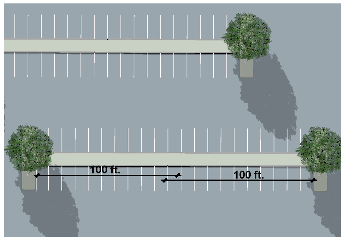
Sec. 24-5313. - Tree Protection.
A.
Protected Tree Defined. For purposes of this section, the following are protected trees:
1.
Any healthy tree with a diameter at breast height (DBH) of six inches or greater located within any minimum required yard abutting an existing public street, a transitional buffer, a proffered natural buffer, a wetland, a Chesapeake Bay Resource Protection Area, or similar area protected by this Ordinance;
2.
Any healthy tree planted or preserved for the purpose of meeting a requirement for street tree planting, parking lot perimeter landscaping, parking lot interior landscaping, transitional buffer planting, required screening, a proffered condition, or otherwise required to be planted or preserved by this Ordinance; and
3.
Any healthy tree of a DBH of 22 inches or greater designated by the Board of Supervisors as a memorial, heritage, or specimen tree.
B.
Tree Protection Zone. The tree protection zone of a protected tree consists of the area within the drip line of the tree extended one foot outward.
C.
Tree Protection Plan Required. A tree protection plan must be submitted before any land disturbance takes place, with a clearing and grubbing plan (see Sec. 24-2314, Plan of Development), or with an erosion and sediment control plan in accordance with the requirements in the Landscape Manual, and must include the following:
1.
Identification of all protected trees on the site;
2.
Identification of tree protection zone boundaries, including the limits of land disturbance, clearing, grading, and trenching;
3.
Detailed drawings of tree protection measures, including protective tree fencing, tree wells and aeration systems, staking specifications, transplanting specifications, and other applicable drawings;
4.
Procedures and schedules for the implementation, installation, and maintenance of tree protection measures, all of which must be installed prior to any land disturbing activity;
5.
Limits of wetlands, tributary streams, 100-year floodplains (base flood hazard area), limits of Chesapeake Bay resource protection areas, all buffers required by the County Code (including resource protection area buffers), and other natural features; and
6.
Identification of all zoning proffers and other applicable conditions of approval relating to buffers, landscaping, screening, berms, mounds, erosion and sediment control, and water quality maintenance or protection.
D.
Tree Protection During Construction.
1.
During construction, the landowner or developer will be responsible for the erection and maintenance of all barriers necessary to protect trees within a tree protection zone, and any other existing vegetation to be retained, from damage both during and after construction. Protective barriers must be installed prior to, and maintained throughout, the land disturbance and construction process. Such barriers must be installed along the outer edge of and completely surrounding all tree protection zones.
2.
Protective barriers must consist of one of the following:
(a)
A minimum four-foot-high wooden post and rail fence with two-inch by four-inch posts and a double one-inch by four-inch rail;
(b)
A minimum four-foot-high orange safety fencing made of polyethylene laminar or similar durable plastic and mounted on wooden posts; or
(c)
A fencing method offering similar protection approved by the Planning Director.
3.
Protective barriers must be posted with warning signs at least one square foot in area, not more than 150 feet apart, that are clearly visible from all sides of the tree protection zone, identifying the fenced area as a tree protection zone and directing construction workers not to encroach into the area (e.g., "Tree Protection Zone: Do Not Enter").
4.
Construction site activities, including cutting, filling, grading, parking, equipment or material storage, bury pits, concrete washout, or burning of debris, are prohibited within tree protection zones.
5.
Trees located within a tree protection zone must be protected from contamination from liquids or other materials, including paint, chemical solvents, gasoline, oil, diesel fuel, hydraulic fluid, concrete spoils, or rinse water from cleaning of concrete trucks or other vehicles.
6.
Prior to machinery passing over any area within a tree protection zone during construction activities, the area must be cushioned using plywood sheeting covered by a minimum four-inch-thick layer of wood mulch, or materials providing an equivalent degree of protection, as shown on an approved landscaping plan.
7.
Any violation of the tree protection standards in this section is a violation of this Ordinance and may result in remedies and penalties set forth in Article 7: Enforcement, and require replacement in accordance with subsection F below. Any violation of this section that results in damage to a protected tree that jeopardizes its survival will be deemed removal of a protected tree.
E.
Removal of Protected Trees. Protected trees must not be removed unless a tree protection plan has been approved or a tree removal permit has been issued (Sec. 24-2313, Tree Removal Permit). Removal of protected trees from a development site may be approved if the landowner demonstrates development on the site cannot otherwise be located and designed to allow for a reasonable use, after exploration of applicable alternatives for relief including submission and approval of an alternative landscaping plan (see Sec. 24-5303.B, Alternative Landscaping). Mitigation must be provided in accordance with subsection F below. Protected trees removed without an approved tree protection plan or a tree removal permit will require additional mitigation as set forth in subsection F below.
F.
Replacement and Mitigation of Protected Trees. The removal of protected trees must be mitigated as follows:
1.
Each replacement tree must meet the requirements of Sec. 24-5304.A, Required Plant Materials, or as specified below.
2.
For protected trees removed in accordance with an approved tree protection plan or an approved tree removal permit (see Sec. 24-2313, Tree Removal Permit), the number of replacement trees must be determined by one of the following methods:
(a)
One replacement tree for each protected tree removed, or
(b)
One large deciduous or evergreen replacement tree, 4 caliper inches, for every 1,000 square feet of woodland cleared, or
(c)
Approval of an alternative landscaping plan (see Sec. 24-5303.B, Alternative Landscaping).
3.
For protected trees removed without an approved tree protection plan or tree removal permit where one is required (see Sec. 24-2313, Tree Removal Permit), a minimum of 15 caliper inches of replacement trees must be planted for every ten inches DBH or fraction thereof of protected trees removed. Where the number and size of protected trees cannot be determined, two large deciduous or evergreen replacement trees, 4 caliper inches, must be planted for every 1,000 square feet of woodland cleared.
4.
To the extent practical, replacement trees must be planted within or adjacent to the area that constituted the tree protection zone where the removed tree was located.
5.
Replacement trees must be of the same species as the removed tree, unless the Planning Director approves a similar species because the species of the removed tree is invasive, a nuisance, or is unlikely to thrive.
6.
Required replacement trees must be maintained for one year from the time of their planting. Financial guarantee for the duration of the one-year period must be provided at the time of planting. The financial guarantee will be canceled and returned at the end of the one-year period if the required replacement trees have been planted and maintained and are healthy and growing; otherwise, the County may draw on the financial guarantor to ensure replacement trees are provided as required by this section.
Sec. 24-5401. - Purpose and Intent.
The purpose and intent of this division is to regulate the location, height, and appearance of fences and walls to:
A.
Ensure the safety, security, and privacy of people and land;
B.
Ensure that fences and walls are subject to timely maintenance, as needed; and
C.
Protect adjacent lands from the indiscriminate placement, excessive height, and unsightliness of fences and walls.
Sec. 24-5402. - Applicability.
Unless exempted in accordance with subsection A below, the standards of this division apply to any construction, reconstruction, or replacement of fences or walls, except that only the standards of Sec. 24-5407, Retaining Walls, apply to retaining walls.
A.
Exemptions. The following are exempt from the standards of this division:
1.
Fences and walls required for the physical support of a principal or accessory structure;
2.
Fences erected temporarily for construction sites or a similar purpose, provided that they comply with all relevant requirements of the Uniform Statewide Building Code and do not block sight distance as determined by the County Engineer.
3.
Landscaping berms without fences;
4.
Noise attenuation walls installed by a public entity along a public roadway;
5.
Fences and walls necessary for soil erosion control;
6.
Fences at government facilities;
7.
Fences for protecting livestock or for other similar agricultural functions if part of a use in the Agricultural use classification; and
8.
Fences for tree protection (temporary and permanent).
B.
Timing of Review. Review for compliance with the standards of this division will occur during review of an application for a provisional use permit, conditional use permit, building permit, certificate of occupancy, plan of development, site plan, or subdivision, as appropriate, and in conjunction with a landscaping plan required by Sec. 24-5303, Landscaping Plan Required. Fences and walls constructed in accordance with an approved plan will be considered in compliance with the requirements of this division regardless of subsequent changes outside of the property boundaries.
Sec. 24-5403. - Location.
A.
Fences and walls are permitted on the property line between two or more parcels of land held in private ownership.
B.
Fences and walls may be located within any required yard; however, uses within a fenced area may be subject to limitations on their location within a given yard.
C.
Fences and walls may be installed within required landscaping areas, subject to an approved landscaping plan.
D.
Fences must not be located within utility easements without written authorization from the easement holder or the County, as appropriate. The County will not be responsible for damage to, or the repair or replacement of, fences that must be removed to access utility easements or facilities.
E.
A fence or wall must not block or divert natural drainage flow onto or off of any land.
F.
Fences and walls must not prevent immediate view of, or access to, fire hydrants or other fire-fighting water supply devices, in accordance with the Fire Code.
G.
Fences and walls must not obstruct vision at any height between 30 inches and eight feet above grade in the sight distance triangles as described below:
1.
At any street intersection with another street or a driveway serving any property other than a single-family or duplex dwelling, within a triangular area that is included between the lines of the street and driveway, extended to the point where the lines intersect, and, at points on each line 20 feet distant from that point, a straight line connecting them.
2.
At any street intersection with a driveway serving a single-family or duplex dwelling, within a triangular area that is included between the lines of the street and driveway, extended to the point where the lines intersect, and, at points on each line ten feet distant from that point, a straight line connecting them. See Figure 5403: Visibility at Single-Family or Duplex Dwelling Driveway Intersection.
Figure 5403: Visibility at Single-Family or Duplex Dwelling Driveway Intersection
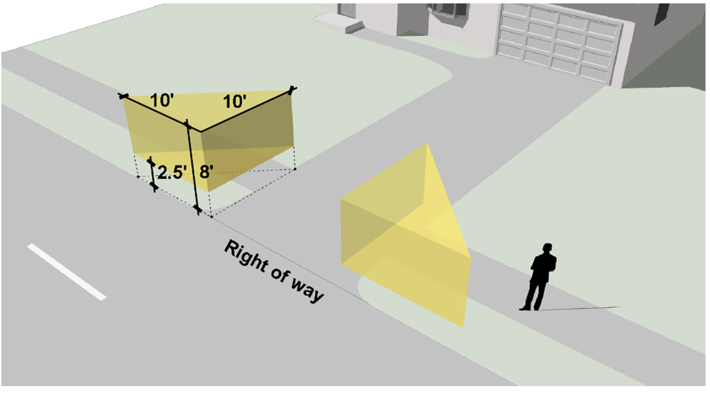
3.
Fences and walls must not obstruct vision within sight lines and easements identified on an approved plan of development, site plan, or subdivision plan.
H.
Fences and walls, and any associated landscaping, must not obstruct vision within sight lines and sight easements identified on an approved plan of development, site plan, or subdivision plan.
(Ord. No. 1335, § 58, 11-12-2024)
Sec. 24-5404. - Height Standards.
A.
General. Except as otherwise provided in subsection B below, or unless additional height for a wall or fence is permitted as part of a transitional buffer in accordance with Sec. 24-5310, Transitional Buffers, or required screening in accordance with Sec. 24-5311, Screening, fences and walls must not exceed the maximum height listed in Table 5404, below.
B.
Exceptions.
1.
Customary fencing provided as part of a permitted tennis court, athletic field, and similar recreational facility will be exempt from the height standards.
2.
Where the side lot line of a residential lot adjoins a business, office, or industrial use, a fence or wall along the side lot line up to seven feet tall may be extended into the front yard within 15 feet of the front lot line, subject to the sight distance requirements in Sec. 24-5403, Location.
3.
Where the side lot line of a residential lot adjoins the rear lot line of the adjoining lot, or when the side lot line and rear lot line are separated by an alley, a seven-foot-high fence or wall may be permitted along either of the abutting or adjacent side and rear lot lines to within 10' of the front lot line.
4.
Where the side lot line of a residential lot adjoins the side lot line of an adjacent residential lot, a fence up to 7' in height may be permitted along the common side lot line on either lot to the actual front yard of either lot.
5.
Alternative Fence Height: The Planning Director or at the request of the Planning Director, the Planning Commission will permit fences or walls up to the maximum height listed in Table 5404 upon finding that the fence or wall:
(a)
Would be compatible with the size, configuration, and topography of the site;
(b)
Would be compatible with the height, location, and materials of any existing buildings and structures;
(c)
Would comply with the sight distance requirements in Sec. 24-5403 and the landscaping requirements of Sec. 24-5406.B; and
(d)
Would not adversely affect the health, safety, or welfare of persons residing on or working on the premises; the visibility of or access to abutting and adjacent properties from the street; the adequate supply of light and air to adjoining property; traffic or pedestrian safety; or the character of the surrounding area.
C.
Measurement of Height.
1.
Fence or wall height will be measured from the highest point above grade, not including supporting columns or posts, to grade on the side of the fence or wall where the grade is lowest, but excluding the height of any retaining wall directly beneath the fence or wall (see Figure 5404: Measurement of Fence Height).
2.
Supporting columns or posts may extend up to 18 inches above the maximum allowed height for the fence or wall.
Figure 5404: Measurement of Fence Height
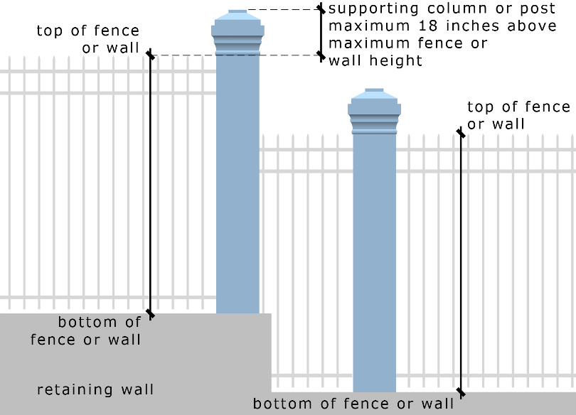
(Ord. No. 1335, § 59, 11-12-2024)
Sec. 24-5405. - Materials.
A.
Permitted Fence and Wall Materials.
1.
Fences and walls must be constructed of durable all-weather materials such as masonry, stone, wrought iron, welded steel, electroplated aluminum, pressure-treated or rot-resistant lumber, composite materials designed to appear as wood or masonry, vinyl, or similar customary fencing materials.
2.
Except in the C-1, A-1, and M-3 districts, or in conjunction with a single-family or two-family dwelling or a school playground or athletic field, chain-link fences must be vinyl-clad and must be supplemented with landscaped screening consisting of the types and spacing of plantings required by Sec. 24-5406.B, Fence and Wall Landscaping, along the side of the fence facing the exterior of the lot.
B.
Prohibited Fence and Wall Materials. The following materials are specifically prohibited for use in walls or fences:
1.
Barbed or razor wire, unless
(a)
Approved as part of a security exemption plan in accordance with Sec. 24-5409, Security Exemptions;
(b)
As part of an Agricultural use; or
(c)
On land used for installation and operation of high-voltage equipment for electrical generation, transmission, and distribution by a regulated public utility;
2.
Chicken wire, corrugated metal, fabric materials (except windscreen or sunscreen for athletic facilities), slats inserted into chain-link fences, fiberboard, garage door panels, plywood, rolled plastic, sheet metal, debris, junk, or waste materials; and
3.
Above-ground fences that carry electrical current, except as used for the purposes of enclosing livestock in the C-1 or A-1 districts (this does not prohibit below-ground electrical fences intended for the keeping of pets).
(Ord. No. 1335, § 60, 11-12-2024)
Sec. 24-5406. - Finished Side and Landscaping
A.
Support Framing and Textured Surfaces. Wherever a fence or wall is visible from off-site locations, if one side of the fence or wall has visible support framing and the other does not, or one side of a wall has a textured surface and the other does not, then the side of the fence without support framing or with a textured surface must face the exterior of the lot (see Figure 5406A: Fence with Finished Side Facing Out).
Figure 5406A: Fence with Finished Side Facing Out
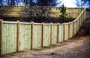
B.
Fence and Wall Landscaping.
1.
Except as provided in subsection 3 below, portions of fences or walls taller than 3 feet 6 inches in height located within 20 feet of a street right-of-way must be supplemented with landscaped screening in accordance with the following standards (see Figure 5406B: Fence and Wall Landscaping):
(a)
At least one evergreen shrub must be installed for every five linear feet of fence or wall, on the side of the fence or wall facing the public street right of way. Shrubs may be installed in a staggered, clustered, grouped, or linear fashion.
(b)
One small tree may be substituted for every three shrubs, provided the trees meet the requirements in Sec. 24-5304, General Planting Requirements.
Figure 5406B: Fence and Wall Landscaping
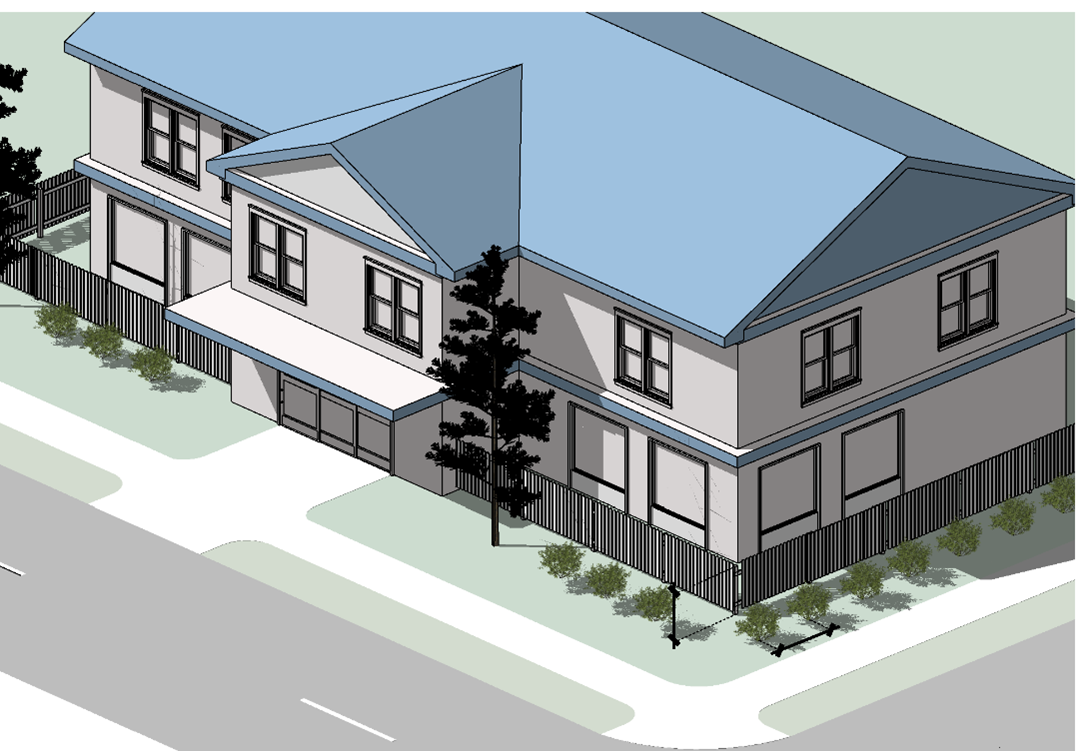
2.
Trees and shrubs required by subsection 1 above must comply with the standards in Sec. 24-5304, General Planting Requirements, and may also be counted toward requirements in Article 5, Division 3, Landscaping and Tree Protection, if they comply with those requirements.
3.
The Planning Director may modify the landscaping requirements of this subsection B on determining that:
(a)
The proposed fence or wall provides a similar degree of screening through the use of alternative landscape materials, horizontal offsets, variation of height, opacity, variation of materials, decorative features, or other design features; or
(b)
The approval of an alternative fence height warrants additional or alternative landscaping materials to ensure compatibility of the fence or wall in accordance with Sec. 24-5404.B.5.
(Ord. No. 1335, § 61, 11-12-2024)
Sec. 24-5407. - Retaining Walls.
Retaining walls must comply with the following standards. The Planning Director may reduce or waive these requirements subject to the standards for review of alternative fence height (see Section 24-5404.B.5).
A.
Any retaining wall located within the front or street side yard setbacks for the principal use in the zoning district in which it is located must not be taller than six feet. A change in elevation greater than six feet may be terraced in six-foot sections as provided in subsection D below.
B.
If the elevation at the top of a retaining wall, including a terraced retaining wall, is more than six feet higher than a property line within 20 feet, or more than ten feet higher than a property line within 50 feet, the base of the retaining wall must be supplemented with landscaping in accordance with Sec. 24-5406.B, Fence and Wall Landscaping.
C.
Any retaining wall having a height of at least four feet must have a minimum four-foot-high fence, measured from the top of the wall, installed on the upper side of the wall. See Figure 5407: Retaining Wall with Adjacent Parking Area. Any parking areas on the upper level and adjacent to the wall must be separated from the top of the wall by one of the following, unless there is an existing physical impediment to a vehicle reaching the edge of the wall:
1.
Guardrails;
2.
Earthen berms having a minimum height of three feet; or
3.
Concrete filled steel bollards spaced a maximum of four feet on center.
Figure 5407: Retaining Wall with Adjacent Parking Area
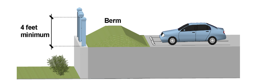
D.
Terraces created between retaining walls must be permanently landscaped with native vegetation in accordance with Sec. 24-5406.B, Fence and Wall Landscaping. Two vertical retaining walls that are each less than six feet in height must be separated by a terrace with a minimum width of three feet. Two vertical retaining walls, one or both of which is greater than six feet in height, must be separated by a terrace with a minimum width of five feet.
E.
A retaining wall facing a street or adjacent parcel, where not subject to the provisions of subsection B of this section, must be screened in accordance with Sec. 24-5406.B, Fence and Wall Landscaping, unless the wall is finished or faced with stone, brick, or earth-colored materials similar to the surrounding natural landscape.
F.
Utilities or storm sewers crossing under retaining walls greater than three feet in height must be installed in sleeves unless an exception is approved by the Director of Public Utilities or the County Engineer, as applicable.
G.
Retaining walls located within five feet of drive aisles or parking spaces must be designed to accommodate dynamic loading of parked vehicles and emergency vehicles as determined by the County Engineer.
H.
Except for shared retaining walls along the property lines of two parcels, a retaining wall must be set back at least five feet. Where common retaining walls or their tiebacks or other components abut or encroach on adjacent property, a maintenance easement must be recorded and any necessary declaration of covenants or agreements associated with the easement must provide for notice of the easement to be provided to prospective property owners. Tieback distances must be shown on the plan of development construction and landscaping plans.
(Ord. No. 1335, § 62, 11-12-2024)
Sec. 24-5408. - Maintenance Requirements.
Fences and walls and associated landscaping must be maintained in good repair and in a safe condition. Maintenance of fences and walls must include the timely replacement of missing, decayed, or broken elements and the repair of deteriorated or damaged fence materials, including weathered surfaces visible from the public right-of-way, sagging sections, and posts that lean more than ten degrees from vertical. Trash must not be allowed to accumulate along a fence or wall and must be promptly removed.
Sec. 24-5409. - Security Exemptions.
A.
A landowner or tenant in need of heightened security may submit to the Planning Director and Chief of Police a security plan proposing a fence or wall taller than what is permitted by this division or proposing the use of barbed, razor, or electric wire atop a fence or wall for security reasons. The security plan is distinct from the landscaping plan and lighting plan but may incorporate elements of each.
B.
The Planning Director may approve the security plan on finding that a taller wall or fence, or the addition of barbed, razor, or electrical wire, will alleviate an unusual danger of theft or damage or a significant hazard to public safety without adversely affecting the security, function, appearance, or value of nearby property.
Sec. 24-5501. - Purpose and Intent.
The purpose and intent of this division is to regulate exterior lighting to:
A.
Provide security for persons and land;
B.
Ensure all exterior lighting is designed and installed to maintain adequate light levels on site;
C.
Ensure that adjacent lands, neighboring areas, and motorists are protected from excessive light spillage and glare;
D.
Curtail light pollution, reduce skyglow, and preserve the nighttime environment for the enjoyment of residents and visitors; and
E.
Conserve energy and resources.
Sec. 24-5502. - Applicability.
A.
General. Unless exempted in accordance with subsection B below, the standards in this division apply to:
1.
All new development;
2.
Any extension, enlargement, or reconstruction of a building, structure, or parking lot, but only regarding the extended, enlarged, or reconstructed portions of the building, structure, or parking lot;
3.
Replacement of outdoor lighting fixtures that were approved before September 1, 2021, but only regarding the new fixtures, which may be replaced at the same location and height; and
4.
Any change of use where the new use requires lighting or a CPTED plan under this division.
B.
Exemptions.
1.
Lighting exempt under State or federal law;
2.
Lighting relating to signs (see Article 5, Division 7, Signs);
3.
Government facilities;
4.
Lighting on single-family and individual townhouse lots where light is contained on the property;
5.
Lighting required by applicable building codes such as lighting for exit signs, stairs, and ramps, to the extent that such lighting is unable to comply with these standards;
6.
Temporary lighting for circuses, fairs, carnivals, and theatrical and other performance areas, provided such lighting is discontinued upon completion of the activity;
7.
Temporary lighting of construction sites, provided such lighting is discontinued upon completion of the construction activity; and
8.
Temporary lighting for emergency situations, provided such lighting is discontinued upon abatement of the emergency situation.
C.
Timing of Review. Review for compliance with the standards of this division will occur during review of an application for a provisional use permit, conditional use permit, building permit, certificate of occupancy, plan of development, site plan, or subdivision, as appropriate. Exterior lighting installed in accordance with an approved lighting plan will be considered in compliance with the requirements of this division regardless of subsequent changes outside of the property boundaries.
D.
Lighting Plan Required. All development that requires approval of a plan of development or site plan must include a lighting plan which must identify the location and specifications of all lighting being installed with sufficient detail to demonstrate compliance with the standards of this division. The lighting plan must be submitted concurrent with the initial plan of development or site plan, and lighting must not be installed before the electrical permit is approved.
(Ord. No. 1335, § 63, 11-12-2024)
Sec. 24-5503. - General Standards.
A.
Lighting to be Provided. For each of the specific site features listed in Table 5503A: Average Illuminance (Minimum and Maximum), lighting must be provided to create the average horizontal illuminance values between the minimum and maximum levels listed when the area is in use. The ratio of minimum to maximum illuminance must not exceed 1:10 except where necessary to comply with other requirements, including the maximum illumination levels of subsection B. below.
B.
Maximum Illumination Levels. All lighting visible from outside, except for street lighting and pedestrian area lighting (see Sec. 24-5504.C below), must be designed and located so that the maximum illumination measured in footcandles at ground level at any lot line does not exceed the standards in Table 5503B: Maximum Illumination Levels.
C.
Hours of Illumination.
1.
Public, Civic, and Institutional uses, Commercial uses, Industrial uses, and mixed-use developments that are adjacent to existing residential development must extinguish all exterior lighting by within one hour of closing, except the minimum amount of exterior lighting necessary for security or emergency purposes.
2.
Athletic events that are adjacent to existing residential development must be scheduled to end by 11 PM but may maintain exterior lighting until the end of the event.
D.
Shielding. All exterior luminaries, including security lighting, must be full cut-off fixtures that are directed downward, consistent with Figure 5503: Full Cut-off Fixtures. Lighting must not be directed above a horizontal plane through the lighting fixtures.
Figure 5503: Full Cut-off Fixtures
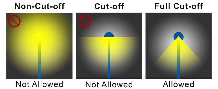
E.
Maximum Height.
1.
Except as provided in subsection 2 below, the maximum height of exterior lighting must not exceed the following, measured from the ground to the light source (see Sec. 24-8309.C, Measurement of the Height of Exterior Lighting):
(a)
In Residential Districts and within 100 feet of any Residential District, 15 feet;
(b)
In the A-1, M-1, M-2, and M-3 Districts more than 100 feet from all Residential Districts, 35 feet; and
(c)
In all other districts more than 100 feet from any Residential District, 25 feet.
2.
The maximum height of exterior lighting may be exceeded by athletic field or outdoor venue lighting fixtures, streetlights, and other fixtures where the Planning Director determines that taller lights will better achieve the purpose and intent of this division.
(Ord. No. 1335, § 64, 11-12-2024; Ord. No. 1338, § 19, 2-11-2025)
Sec. 24-5504. - Lighting Standards for Specific Uses and Site Features.
A.
Streets and Parking Areas.
1.
Required lighting for off-street parking areas must be provided during hours of operation.
2.
Lights for streets and parking areas must be provided by full cut-off fixtures mounted on non-corrosive poles served by underground wiring.
3.
In a parking lot or within 8 feet of the vehicular travel lane of a street or alley, any light pole over 15 feet in height must have a concrete base or equivalent structural support; direct-embedded construction without structural support is prohibited.
4.
The poles, fixtures, and light color of streetlights in an individual subdivision or development must be consistent throughout the subdivision or development.
5.
Streetlight poles must be designed and placed in accordance with VDOT or County standards.
B.
Athletic Fields and Outdoor Venues. Lighting fixtures for outdoor sports areas, athletic fields, and performance areas must not exceed 95 feet in height and must be equipped with a glare control package (e.g., louvers, shields, or similar devices) and aimed so that their beams are directed and fall within the primary playing or performance area.
C.
Pedestrian Areas.
1.
All fixtures for sidewalks, walkways, and trails outside of off-street parking lots must have a maximum height of 15 feet.
2.
Any pedestrian bollard lamps must be mounted no higher than four feet above grade (See Figure 5504: Examples of Pedestrian Bollard Lamps).
Figure 5504: Examples of Pedestrian Bollard Lamps
(Ord. No. 1335, § 65, 11-12-2024)
Sec. 24-5505. - Prohibited Lighting.
Light fixtures that imitate an official highway or traffic control light or sign or emergency vehicle lighting, or that have a flashing or intermittent pattern of illumination, are prohibited.
Sec. 24-5506. - Alternative Lighting Plan.
A landowner or tenant may submit an alternative lighting plan to the Planning Director and Chief of Police proposing exterior lighting that deviates from the standards in this division. The Planning Director will approve or approve with conditions the alternative lighting plan and its proposed deviation from the standards, only on finding that:
A.
The proposed lighting is appropriate for the protection of the subject land, development, and the public;
B.
If the requested lighting is greater than the maximum allowed by this division, the condition, location, or use of the land, or the history of activity in the area, indicates the land or any materials stored or used on it are in significantly greater danger of theft or damage, or members of the public are at greater risk for harm than on surrounding land without the additional lighting;
C.
If the requested lighting is less than the minimum required by this division, the condition, location, or use of the land, or the character of surrounding development, indicates the purpose and intent of these regulations would be better served by reduced lighting; and
D.
The proposed deviation from the standards, with any imposed conditions, will not have a significant adverse effect on neighboring lands.
Sec. 24-5507. - Illumination Measurement.
Illumination will be measured at the lot line of the land upon which light to be measured is being generated. If measurement on private property is not practical, light level measurements may be made at the boundary of the public right-of-way that adjoins the land. Measurements will be made at finished grade (ground level), with the light-registering portion of the meter held parallel to the ground.
Sec. 24-5508. - Crime Prevention Through Environmental Design.
A.
Purpose and Intent. The purpose and intent of Crime Prevention Through Environmental Design (CPTED) is to design and use the built environment to contribute to a reduction in the incidence and fear of crime and an improvement in the quality of life. CPTED principles include the following design elements:
1.
Natural Surveillance: Provide natural surveillance throughout the site, especially to parking areas, buildings, building entrances, walkways, etc. Natural surveillance is the placement of physical features, activities, and people in such a way as to maximize visibility.
2.
Natural Access Control: Provide natural access control throughout the site. Natural access control is the physical guidance of people coming and going from a space by the judicial placement of entrances, exits, fencing, landscaping and lighting. The goal is to guide people where you want them to go and how you want them to get there.
3.
Territorial reinforcement: Territorial reinforcement is the use of physical attributes that express ownership, such as fences, pavement treatments, art, signage, lighting and landscaping.
4.
Maintenance: Allows for the continued use of space for its intended purpose. It also serves as an additional expression of ownership
B.
Specific Uses Requiring a CPTED Plan. A CPTED Plan must be reviewed and approved by the Planning Director, in accordance with subsection C, for the following uses:
1.
Any business open to the public between 12:00 midnight and 6:00 am;
2.
Automatic teller machines (ATMs);
3.
Billiard parlors;
4.
Gambling-related uses, including charitable gaming, historical horse racing, off-track betting, and skill games;
5.
Gun shops;
6.
Pawn shops;
7.
Vaping shops;
8.
Video game rooms; and
9.
Visitor Accommodations uses.
C.
CPTED Plan Submission. A CPTED Plan must be submitted with an application for any plan of development or site plan where one of the uses listed in subsection B above is proposed. The CPTED Plan must include all information necessary to demonstrate that the proposed development complies with the CPTED principles listed in subsection A above. The CPTED Plan will be reviewed by the Chief of Police, who will make a recommendation to the Planning Director whether the CPTED Plan meets the requirements of this section. The Planning Director will review the CPTED Plan and recommendation and approve the Plan if it meets the requirements of this section.
(Ord. No. 1324, § 4, 6-25-2024; Ord. No. 1325, § 4, 7-9-2024; Ord. No. 1335, § 66, 11-12-2024)
Sec. 24-5601. - Purpose and Intent.
The purpose of these neighborhood compatibility standards is to provide a proper transition from and ensure compatibility between single-family detached dwellings and zoning districts and more intense forms of development. More specifically, it is the intent of these standards to:
A.
Protect the character of existing neighborhoods consisting primarily of single-family detached dwellings from adverse impacts resulting from more intense and incompatible adjacent forms of development;
B.
Use development form and design treatments as alternatives to large, vegetated buffers; and
C.
Establish and maintain vibrant pedestrian-oriented areas where multiple uses can operate near one another.
(Ord. No. 1335, § 67, 11-12-2024)
Sec. 24-5602. - Applicability.
A.
General.
1.
Unless exempted by subsection B below, the standards in this division apply to:
(a)
New multifamily, nonresidential, and mixed-use development when located on land adjacent to, or across a street or alley from, a single-family residential lot (see subsection 2 below); and
(b)
Any expansion or alteration of an existing multifamily, nonresidential, or mixed-use development when located on land adjacent to, or across a street or alley from, a single-family residential lot, if the expansion increases the building's floor area by 50 percent or more, or the alteration involves 50 percent or more of the building's floor area.
2.
For the purposes of this division, single-family residential lots include all residential subdivision lots developed or intended to be developed for single-family attached, single-family detached, or duplex dwellings.
3.
For the purpose of this division, multifamily, nonresidential, or mixed-use development includes the following:
(a)
Live-work dwellings;
(b)
Multifamily dwellings;
(c)
Townhouse dwellings;
(d)
Uses in the Group Living uses category;
(e)
Uses in the Public, Civic, and Institutional use classification (except for public schools and uses in the Community Service, Government Facilities, and Utilities use categories);
(f)
Uses in the Commercial use classification;
(g)
Uses in the Industrial use classification; and
(h)
Buildings containing both dwellings and nonresidential uses as principal uses.
B.
Exemptions. The following are exempt from these standards:
1.
Multifamily, nonresidential, or mixed-use development when the adjacent single-family detached or duplex dwelling is located on a lot that is not within a Residential district.
2.
Multifamily, nonresidential, or mixed-use development when separated from the single-family residential lot by a street with four or more lanes of travel or a right-of-way greater than 80 feet; and
3.
Public schools and uses in the Community Service, Government Facilities, and Utilities use categories.
C.
Timing of Review. Review for compliance with the standards of this division will occur during review of an application for a provisional use permit, conditional use permit, building permit, certificate of occupancy, plan of development, or site plan, as appropriate. Development in accordance with an approved application will be considered in compliance with the requirements of this division regardless of subsequent changes outside of the property boundaries.
D.
Conflict. If these neighborhood compatibility standards conflict with other standards in this ordinance, these neighborhood compatibility standards will govern.
(Ord. No. 1335, § 68, 11-12-2024)
Sec. 24-5603. - Site Design.
A.
Building Orientation and Placement.
1.
For a multi-building development that includes varying uses and development intensities in different buildings, the buildings with the lowest intensity must be located nearest to adjacent single-family residential lots, and those with the highest intensity must be located furthest from the single-family residential lots.
2.
To the maximum extent practicable, multifamily, nonresidential, and mixed-use development must be oriented to face similar forms of development on adjacent or opposing lots rather than single-family residential lots.
B.
Parking and Driveway Areas.
1.
The total amount of off-street parking must not exceed 1.2 times the required minimum specified in Sec. 24-5110, Minimum Number of Off-Street Parking Spaces, unless approved by the Planning Director based on a parking study demonstrating the need for additional off-street parking spaces.
2.
When required, off-street parking must be established in one or more of the following locations, listed in priority order:
(a)
Adjacent to off-street parking lots serving nonresidential uses on abutting lots;
(b)
Adjacent to lot lines abutting nonresidential development;
(c)
Adjacent to lot lines abutting mixed-use development; or
(d)
Adjacent to lot lines abutting single-family residential lots.
3.
Off-street parking areas must be screened from adjacent single-family residential lots by an opaque fence or a fully opaque vegetative buffer at least ten feet wide in accordance with Sec. 24-5311, Screening.
4.
Parking structure façades adjacent to single-family residential lots must be designed to appear as articulated building walls or must be landscaped to decrease their visual impact.
C.
Loading and Refuse Collection Areas. Loading, service, fuel storage, mechanical, and refuse and recycling collection areas must be:
1.
Located away from adjacent single-family residential lots to the maximum extent practicable;
2.
Screened from view in accordance with Sec. 24-5311, Screening; and
3.
Provided with access that is integrated with parking areas and the vehicular circulation network.
D.
Drive-Throughs and Outdoor Dining.
1.
Drive-through and pick-up windows must not be located on a building façade that faces a single-family residential lot.
2.
Order boxes associated with a drive-through or pick-up window must not be located within 200 feet of any single-family residential lot.
3.
Outdoor dining areas must not be located between the principal building and any adjoining single-family residential lot.
E.
Required Open Space and Recreation Features.
1.
Required open space must be located between the proposed development and the single-family residential lot to the maximum extent practicable.
2.
Any outdoor recreation features such as swimming pools, tennis courts, playgrounds, and similar features must be located at least 100 feet from any single-family residential lot.
Sec. 24-5604. - Building Height.
Building height must not exceed the height established in Table 5604: Maximum Building Height (see Figure 5604: Neighborhood Compatibility Building Height Standards); see also the Building Height limitations in Sec. 24-3707.E, IR-O Innsbrook Redevelopment Overlay District).
Figure 5604: Neighborhood Compatibility Building Height Standards
Sec. 24-5605. - Building Form and Façades.
A.
All buildings subject to these standards must:
1.
Orient porches and balconies away from the rear yards of single-family residential lots within 75 feet;
2.
Use similarly sized and patterned wall offsets and other building articulations found on adjacent single-family or duplex dwellings; and
3.
Configure all roof-mounted equipment to be screened from view at ground level by a parapet wall or similar architectural feature.
B.
Front building façades facing single-family residential lots across a public right-of-way must:
1.
Use building articulations that are similar to those used on adjacent single-family residential development, through features such as windows, doors, awnings, arcades, pilasters, cornices, and wall offsets;
2.
If the building houses a use in the Retail Sales and Services category, be designed to appear as a series of discrete storefronts, with no single storefront occupying more than 50 feet or 50 percent of the total façade width of the building, whichever is less; and
3.
Comply with the transparency standards in Table 5605: Façade Transparency Standards (see the definition and illustration in Sec. 24-3840).
(Ord. No. 1335, § 69, 11-12-2024)
Sec. 24-5606. - Signs.
In addition to the standards of Article 5, Division 7, Signs, development subject to these standards must comply with the following:
A.
To the maximum extent practicable, signs must be located a minimum of 100 feet from all single-family residential lots.
B.
Signs within 100 feet of a single-family residential lot must not exceed 32 square feet in area or eight feet in height.
Sec. 24-5607. - Operational Standards.
The following operational standards apply to development subject to these standards:
A.
Otherwise permitted outdoor dining or other outdoor activities within 150 feet of single-family residential lots must not operate earlier than 7:00 a.m., or later than 9:00 p.m. Sunday through Thursday and 11:00 p.m. Friday and Saturday;
B.
Service functions such as deliveries or recycling and refuse collection must not be conducted before 7:00 a.m. or after 11:00 p.m.; and
C.
Amplified music or other forms of noise clearly audible at lot lines shared with a single-family residential lot must be extinguished after 9:00 p.m. Sunday through Thursday and after 11:00 p.m. Friday and Saturday nights, and may not resume until 7:00 a.m.
Sec. 24-5701. - Purpose and Intent.
A.
Purpose and Intent. Signs have the potential to obstruct views, distract motorists, displace alternative uses for land, and pose other problems that call for regulation. The purpose of this division is to regulate the size, color, illumination, movement, materials, location, height, and condition of signs, in order to:
1.
Reduce the problems caused by signs;
2.
Facilitate the creation of a convenient, attractive, and harmonious community;
3.
Protect property values and the character of neighborhoods and historic areas within the County;
4.
Promote the safety of pedestrians and traffic; and
5.
Encourage economic development.
Sec. 24-5702. - Applicability.
A.
All signs are subject to the standards of this division. Except as provided in Sec. 24-5703 below, a sign permit in accordance with Sec. 24-2311, Sign Permit, is required prior to the installation or display of any sign within the County.
B.
If any provision of this division is found by a court of competent jurisdiction to be invalid, the remaining provisions should be given effect to the fullest extent possible, consistent with the First Amendment guarantee of free speech.
C.
Unless otherwise provided, wherever this chapter allows a sign with commercial content, noncommercial content is also permitted, subject to the same regulations.
Sec. 24-5703. - Signs Not Requiring Permits.
A sign permit is not required for:
A.
Any sign placed by a government body, required by law, or permitted by the Virginia Department of Transportation.
B.
Up to three noncommercial flags on any lot. Any commercial flag must comply with the regulations for detached signs.
C.
The refacing or repair of an existing permitted sign.
D.
On any lot, not more than two non-illuminated signs not exceeding two square feet in aggregate area or four feet in height.
E.
Non-illuminated signs posted along the property line of any lot, except that (i) such signs must not exceed one square foot in area and (ii) such signs must not be posted within 250 feet of each other on the same property line. Notwithstanding the general prohibition in Sec. 24-5704.A.1 below, such signs may be attached to trees.
F.
Window signs that do not exceed 50 percent of the total area of the window or door.
G.
Temporary signs, as follows:
1.
On property where a building permit is active, one sign no more than three square feet in area;
2.
On property actively marketed for sale or rent, one sign no more than 32 square feet in area and eight feet in height when the sign abuts a street classified as a controlled access, major arterial, minor arterial, major collector, or major access road; and no more than three square feet in area and four feet in height when the sign abuts any other street;
3.
In any Conservation and Agricultural District or Residential District, or Planned Development District that includes only residential development, temporary noncommercial signs not exceeding 16 square feet in aggregate area for each lot may be displayed no more than 90 consecutive days and no more than 120 days in any calendar year;
4.
In any Nonresidential or Mixed-Use District, or Planned Development District that includes nonresidential development, temporary noncommercial signs may be displayed no more than 90 consecutive days and no more than 120 days in any calendar year. Each sign must not exceed 32 square feet in area, and the total aggregate area of signs along any 300-foot segment of street frontage must not exceed 32 square feet; and
5.
Detached temporary signs must not be illuminated and must not exceed eight feet in height.
H.
In any Nonresidential or Mixed-Use District, or Planned Development District that includes nonresidential development, one display of attention-getting devices for a period not exceeding ten days in each three-month period: January 1 through March 31, April 1 through June 30, July 1 through September 30, or October 1 through December 31, provided that:
1.
The display must not obstruct any public right-of-way, required parking space, or ingress or egress to any building;
2.
The display must not damage required landscaping;
3.
The display must not exceed 20 feet in any dimension, and the top of the display must not exceed a height of 30 feet above the ground; and
4.
If an otherwise permissible attention-getting device is displayed more than ten days in any three-month period, in addition to any other remedy, the number of days in excess of ten will be counted against the number of days permitted in future three-month periods.
Sec. 24-5704. - Prohibited Signs.
In addition to signs prohibited in certain parts of the County in accordance with Sec. 24-5606, Signs, the following signs are prohibited:
A.
General Prohibitions.
1.
Any sign attached to trees, bushes, shrubberies, or other plants or vegetation except those allowed in accordance with Sec. 24-5703.E above;
2.
Any sign simulating, or which is likely to be confused with, a traffic control sign, any other sign displayed by a public authority, or the lights or markings on an emergency vehicle; and
3.
Any sign displayed on a stationary vehicle or trailer that is used for the purpose of a mobile or portable sign, including the parking of a vehicle for a period of more than 24 hours within 100 feet of and plainly visible from the public right-of-way.
B.
Distraction-Based Prohibitions.
1.
Any sign with parts that rotate or move, or appear to rotate or move;
2.
Any sign displaying flashing, scrolling, or intermittent lights or lights of changing degrees of intensity;
3.
Searchlights;
4.
Any sign consisting primarily of exposed illuminated tubing or strings of lights, except in windows or when used for temporary decorations not to exceed 90 days in any calendar year;
5.
Any sign that emits smoke, flame, scent, mist, aerosol, liquid, or gas;
6.
Any sign that emits sound; and
7.
Strings of pennants or flags except temporary attention-getting devices as provided in Sec. 24-5703.H above.
C.
Location-Based Prohibitions.
1.
Off-premises commercial signs, except outdoor advertising signs allowed by Sec. 24-5707.D.7;
2.
Any sign placed on public land, including street right-of-way, other than those approved in writing by the County Engineer or the Virginia Department of Transportation, required by law without such approval, or permitted under Code of Virginia § 24.2-310 E. Any unauthorized sign is subject to immediate removal and disposal by any authorized official. Removal of the sign by an authorized official does not preclude prosecution of the person responsible for the sign;
3.
Any sign attached to the roof of a building (other than the lower plane of a mansard roof), extending above the ridge of a sloped roof, or attached to a parapet wall and extending above the top of such wall; and
4.
Any sign that prevents a driver from having an unobstructed view of an intersection or seeing conflicting vehicles or pedestrians in the roadway.
Sec. 24-5705. - General Requirements.
The following requirements apply to all signs subject to this division:
A.
Detached signs must be set back from any street right-of-way at least five feet.
B.
Any attached sign in a business or industrial district located within 150 feet of a Residential District on the same side of the same street must be attached flat against a building wall that does not face the adjacent Residential District.
C.
External lighting of signs must consist of full cut-off or directionally shielded lighting fixtures that are aimed and controlled so that the directed light is substantially confined to the sign. The beam width must not be wider than that needed to illuminate the sign.
D.
Illumination from any sign must not exceed 0.5 footcandles above ambient lighting conditions at any property line and must not shine directly into oncoming traffic or directly into a dwelling.
E.
For any sign in the B-1, B-2, B-3, M-1, M-2, or M-3 districts, except for outdoor advertising signs subject to Sec. 24-5707.D.7, the image or message must not change more often than once every ten seconds. For any sign in any other zoning district, the image or message must not change more often than once every five minutes. The images, messages, and transitions between them must not include or simulate motion, video, or animation.
Sec. 24-5706. - Maintenance and Removal.
A.
All signs must be constructed and maintained in compliance with the Uniform Statewide Building Code and in a neat and clean condition.
B.
The Building Official may order the immediate removal or repair of any sign the Building Official determines presents an immediate threat to the safety of the public because it has become insecure, in danger of falling, or otherwise unsafe. If such action is necessary to render a sign safe, the cost of such action will be at the expense of the owner or lessee of the premises.
C.
Any sign that becomes a safety hazard or is not kept in a reasonably good state of repair must be repaired or removed after written notice by the Building Official to the property owner or permit holder.
D.
When the business advertised on a sign has ceased operating, the owner of the property must remove the sign or replace the sign face with a blank face within 60 days of the cessation of business operations until such time as a new use has begun operating on the property.
E.
Any sign that constitutes a nuisance may be abated by the County under the provisions of Code of Virginia §§ 15.2-900, 15.2-906, or 15.2-1115.
Sec. 24-5707. - Signs Requiring Permits.
A.
Agricultural and Conservation Districts, and Single-Family Residential Districts. A sign permit may be issued for the following signs in the R-0, R-0A, R-1, R-1A, R-2, R- 2A, R-3, R-3A, R-4, R-4A, R-5A, R-5B, A-1, and C-1 districts:
1.
At each entrance to a section of an approved and recorded subdivision: One detached sign not exceeding 25 square feet in area or six feet in height, or two signs attached to a wall or fence on opposite sides of the entrance and not exceeding 30 square feet in aggregate area. Such signs may be located in the right-of-way if approved by the County Engineer.
2.
Accessory to any principal use other than a single-family dwelling:
(a)
No more than three attached or detached signs, not exceeding 50 square feet each or 82 square feet in aggregate area. Detached signs must not exceed eight feet in height.
(b)
For each parking lot serving two or more buildings: One detached sign per building, not exceeding three square feet in area or five feet in height.
B.
Other Residential Districts. A sign permit may be issued for the following signs in the R-5, R-6, and RTH districts:
1.
Accessory to a residential use for which a plan of development or site plan is required, including a townhouse project or multifamily development:
(a)
At each entrance to a phase or section as shown on the approved plan of development or recorded subdivision plat: One sign not exceeding 32 square feet in area or eight feet in height, or two signs attached to a wall or fence on opposite sides of the entrance and not exceeding 36 square feet in aggregate area. Such signs may be located in the right-of-way if approved by the County Engineer.
(b)
For each parking lot serving two or more buildings: one detached sign per building, not exceeding three square feet in area or five feet in height.
2.
Accessory to any principal use other than a residential use:
(a)
No more than three attached or detached signs, not exceeding 50 square feet each or 82 square feet in aggregate area. Detached signs must not exceed eight feet in height.
(b)
For each parking lot serving two or more buildings: one detached sign per building, not exceeding three square feet in area or five feet in height.
C.
Office and Office/Service Districts. A sign permit may be issued for the following signs in the O-1, O-2, O-3, and O/S districts:
1.
For each lot: One detached sign if the lot has an entrance on one public street, or two detached signs if the lot has entrances on two or more public streets. Each sign must not exceed 32 square feet in area or 15 feet in height.
2.
For each building: Attached signs not exceeding 32 square feet in aggregate area for each 25,000 square feet of finished floor area or part thereof. One detached sign not exceeding 12 square feet in area or five feet in height may be substituted for 12 square feet of attached sign area.
3.
For each parking lot serving two or more buildings: One detached sign per building, not exceeding three square feet in area or five feet in height.
4.
For each phase or section in the approved plan of development: One attached or detached sign not exceeding 20 square feet in area. Detached signs must not exceed ten feet in height. Such signs may be located in the right-of-way if approved by the County Engineer.
5.
For a coordinated development of 20 acres or more:
(a)
For each entrance from a major arterial, minor arterial, or major collector road: one detached sign not exceeding 75 square feet in area, or two signs not exceeding 75 square feet in aggregate area when attached to a wall or fence on opposite sides of an entrance. Each sign must not exceed 15 feet in height and must not be located within 75 feet of any other detached sign. Such signs may be located in the right-of-way if approved by the County Engineer.
(b)
For each 20 acres or part thereof: one detached sign not exceeding 36 square feet in area or six feet in height, provided such signs must not be located within 75 feet of any other detached sign. Such signs may be located in the right-of-way if approved by the County Engineer.
D.
Business Districts. A sign permit may be issued for the following signs in the B-1, B-2 and B-3 districts, provided that in the B-1 district, signs must not be illuminated between 12:00 am (midnight) and 6:00 am:
1.
Attached signs not exceeding the following aggregate allowance of sign area for each linear foot of building length: In the B-1 district, one and one-half square feet; in the B-2 district, three square feet; in the B-3 district, four square feet.
2.
Detached signs: One of the following may be allowed on a parcel as applicable, but not both:
(a)
Accessory to one business with independent street access and parking: One detached sign may be located along each public street frontage. Such signs must not exceed 32 square feet in area each or eight feet in height and must be located at least 75 feet from any other detached sign.
(b)
Accessory to a group of two or more businesses with coordinated street access and parking: One detached sign for each point of access to a public street, provided that any two signs on the same public street must be located at least 500 feet apart, and any such sign must be located at least 75 feet from any other detached sign. Such signs must not exceed 150 square feet in area each or 25 feet in height, except that for a coordinated development of 40 acres or more, one detached sign may be up to 250 square feet in area and 30 feet in height.
3.
For each parking lot serving two or more buildings: One detached sign per building, not exceeding three square feet in area or five feet in height.
4.
For a coordinated development of 20 acres or more: One detached sign not exceeding 36 square feet in area or six feet in height for each 20 acres or part thereof. Such signs must not be located within 75 feet of any other detached sign. Such signs may be located in the right-of-way if approved by the County Engineer.
5.
For a coordinated development of 40 acres or more: for each parcel improved with a building of 60,000 square feet or more of finished floor area, one monument sign not exceeding 35 square feet in area or five feet in height.
6.
As a part of a drive-through facility: No more than two detached signs for each position where orders are placed or customers are served, not exceeding 48 square feet in area or eight feet in height.
7.
In the B-3 district, outdoor advertising signs as provided below.
(a)
No permit will be issued for a new outdoor advertising sign in addition to those lawfully in existence on May 27, 1998, except as follows:
(1)
Replacement. A lawful outdoor advertising sign for which a permit has been issued may be replaced with a new outdoor advertising sign at the same location provided the new sign must not:
A.
Exceed 500 square feet in area;
B.
Exceed 40 feet in height if abutting an interstate highway or 25 feet in height if not abutting an interstate highway; and
C.
Project over any property line or any right-of-way line (public or private).
(2)
Relocation. A lawful outdoor advertising sign for which a permit has been issued may be relocated to, or replaced with a new outdoor advertising sign at, a new site on the same side of the same street provided that the following requirements are met. For purposes of this provision, "original sign" will mean the sign as it existed on May 27, 1998:
A.
The new location must be on the same lot as the original sign or on a different lot and within 500 feet of the original sign, measured parallel to the front property line;
B.
The new location must be at least 1,000 feet from any other outdoor advertising sign on the same side of the same street;
C.
The new location must be at least 500 feet from any Residential district fronting on the same side of the same street, or from any school, County park, or religious institution;
D.
The relocated or replacement sign must not exceed 500 square feet in area;
E.
The relocated or replacement sign must not exceed 40 feet in height if abutting an interstate highway, or 25 feet in height if not abutting an interstate highway; and
F.
The relocated or replacement sign must not project over any property line or any right-of-way line (public or private).
(b)
A lawful outdoor advertising sign for which a permit has been issued may be continued, maintained, refaced, or repaired at its existing location, size, and height.
(c)
Artistic embellishments may be added to a lawful outdoor advertising sign structure for which a permit has been issued if such embellishments do not exceed ten percent of the area of the sign face and such embellishments do not extend more than five feet from such sign structure.
E.
Industrial Districts. For any use in the M-1, M-2, or M-3 district that is also allowed in the B-3 district, a sign permit may be issued for any sign that would be allowed in the B-3 district pursuant to subsection D above subject to the standards for the B-3 district in subsection D.7 above. For any use in the M-1, M-2, or M-3 district that is not allowed in the B-3 district, a sign permit may be issued for the following signs:
1.
Attached signs not exceeding four and one-half square feet of sign area for each linear foot of building length.
2.
Detached signs: One for each point of access to a public street, provided that any two signs on the same public street must be located at least 500 feet apart. Each sign must not exceed 150 square feet in area or 25 feet in height and must be located at least 75 feet from any other detached sign.
3.
For each parking lot serving two or more buildings: One detached sign per building, not exceeding three square feet in area or five feet in height.
4.
For a coordinated development of 20 acres or more: One detached sign not exceeding 50 square feet in area or six feet in height for each 20 acres or part thereof. Such signs must not be located within 75 feet of any other detached sign. Such signs may be located in the right-of-way if approved by the County Engineer.
5.
Outdoor advertising signs will be allowed subject to subsection D.7 above.
F.
Planned Development Districts. Signs requiring a permit may be allowed in Planned Development Districts in accordance with the approved PD Master Plan (see Sec. 24-3503.A, PD Master Plan) and PD Terms and Conditions Document (see Sec. 24-3503.D, PD Terms and Conditions Document).
(Ord. No. 1338, § 20, 2-11-2025)
Sec. 24-5801. - Chesapeake Bay Preservation: Purpose.
The purpose of this division is to:
A.
Protect Chesapeake Bay Preservation Areas which if improperly developed may result in a substantial adverse impact to the waters of the Chesapeake Bay and its tributaries;
B.
Reduce nonpoint source pollution to state waters;
C.
Promote and restore the high quality of state waters in order to provide for the health, safety and welfare of the present and future residents of the County and the Commonwealth of Virginia; and
D.
Establish standards and criteria to prevent a net increase in nonpoint source pollution from new development and development on previously developed land where the runoff was treated by a water quality protection best management practice (BMP), achieve a ten percent reduction in nonpoint source pollution from development on previously developed land where the runoff was not treated by one or more BMPs, and achieve a 40 percent reduction in nonpoint source pollution from agricultural and silvicultural uses. Statutory authority for this section is provided by the Code of Virginia, §§ 15.2-2283 and 62.1-44.15:67 et seq.
Sec. 24-5802. - Chesapeake Bay Preservation: Applicability.
A.
General Applicability.
1.
Except as permitted and regulated by this division and as further regulated by Article II of Chapter 10 of the County Code, within Chesapeake Bay Preservation Areas and the associated buffer, all land disturbing activities; use, development, and redevelopment of land; and clearing of live vegetation are prohibited.
2.
Where the provisions of this division are more restrictive or in conflict with any other provisions of this chapter, or other chapters of the County Code, or where the provisions of this division impose a greater requirement or higher standard than state or federal law, the provisions of this division will govern.
B.
Areas of Applicability. This subsection governs the identification of Chesapeake Bay Preservation Areas in the County and applies to all land identified under its provisions as resource protection areas (RPAs) and resource management areas (RMAs). These areas, which are collectively referred to as "Chesapeake Bay Preservation Areas," will be as defined in this chapter. The planning office will maintain maps of all Chesapeake Bay Preservation Areas, the extent of which are identified from available mapping resources, but such maps are for illustrative purposes only and do not definitively identify all Chesapeake Bay Preservation Areas. In the event of a conflict between the terms of this division and the maps, the provisions of this division will govern.
1.
Resource Protection Areas (RPAs). In their natural condition, RPAs provide for the removal, reduction or assimilation of sediments, nutrients and potentially harmful or toxic substances in runoff entering the bay and its tributaries, and minimize the adverse effects of human activities on state waters and aquatic resources. The RPA will consist of:
(a)
Tidal wetlands;
(b)
Nontidal wetlands connected by surface flow and contiguous to tidal wetlands or water bodies with perennial flow;
(c)
Tidal shores;
(d)
Such other lands which the Board of Supervisors may designate by ordinance to provide the benefits of RPAs set forth herein and which are necessary to protect the quality of state waters; and
(e)
A vegetated buffer area no less than 100 feet in width located adjacent to and landward of the components listed in subsections (a) through (d) above and along both sides of any water body with perennial flow. The full buffer area will be designated as the landward component of the RPA notwithstanding the presence of permitted uses, encroachments, and permitted vegetation clearing in compliance with Sec. 24-5803, Chesapeake Bay Preservation Standards.
2.
Resource Management Areas (RMAs). A RMA must be provided contiguous to the entire inland boundary of the RPA. Where mapping indicates the presence of the following land types contiguous to RPAs, the following will be classified as an RMA:
(a)
All areas specifically designated as RMAs by ordinance by the Board of Supervisors because of their potential effect on water quality.
(b)
Base flood hazard areas (100-year floodplains)
(c)
Highly erodible soils, including steep slopes.
(d)
Highly permeable soils.
(e)
Nontidal wetlands not included in RPAs; and
(f)
Where the land contiguous to RPAs is not an RMA as defined above, the 100-foot area contiguous to the RPA.
C.
Identification of Chesapeake Bay Preservation Areas.
1.
The Planning Director will develop maps delineating Chesapeake Bay Preservation Areas. These maps are only intended as general guides to the location of Chesapeake Bay Preservation Areas in the County and are not conclusive evidence of inclusion or exclusion. Owners may demonstrate that their property is not within a Chesapeake Bay Preservation Area, even if mapped, by submission of an environmental site assessment containing the elements listed in section 10-33 of the County Code.
2.
Questions concerning boundaries of Chesapeake Bay Preservation Areas will be resolved by the County Engineer based upon submission of an environmental site assessment.
3.
As part of the plan of development review process pursuant to Sec. 24-2314, Plan of Development, or during the review of a water quality impact assessment pursuant to section 10-39(b) of the County Code, the County Engineer will ensure or confirm that (1) a reliable, site-specific evaluation is conducted to determine whether water bodies on or adjacent to the development site have perennial flow and (2) RPA boundaries on the site are adjusted, as necessary, based on this evaluation of the site. The County Engineer may conduct the site evaluation or require the applicant to conduct the evaluation and submit the required information for review. In determining whether water bodies have a perennial flow, the County Engineer will use field indicator protocols that have been found as acceptable site-specific determinations by the Division of Chesapeake Bay Local Assistance, or other appropriate agency. Designation of the components listed in Sec. 24-5802.B.1(a) through Sec. 24-5802.B.1(d) above will not be subject to modification unless based on reliable, site-specific information as provided for in this subsection.
4.
After approval of land development in Chesapeake Bay Preservation Areas is granted, prior to any land disturbing activity, all wetlands must be conspicuously flagged or otherwise identified and not disturbed unless authorized by law.
D.
Exempted Uses and Development. The following uses and development as regulated by this subsection will be exempt from the provisions of this division but will be subject to the other provisions of this Ordinance:
1.
Construction, installation, operation and maintenance of electric, fiber optic, natural gas and telephone transmission lines, railroads and public roads and their appurtenant structures in accordance with regulations promulgated pursuant to the Erosion and Sediment Control Law (Code of Virginia, § 62.1-44.15:51 et seq., as amended) and the Stormwater Management Act (Code of Virginia, § 62.1-44.15:24 et seq., as amended) and an erosion and sediment control plan and a stormwater management plan approved by the Virginia Department of Environmental Quality. Public roads must be designed, approved and constructed to prevent or otherwise minimize encroachment in the RPA and adverse effects on water quality. For purposes of this subsection, "public road" means a publicly owned road designed and constructed in accordance with water quality protection criteria at least as stringent as requirements applicable to the Virginia Department of Transportation (VDOT), including regulations promulgated pursuant to Code of Virginia, §§ 62.1-44.15:51 and 62.1-44.15:2 et seq., as amended. This definition includes those roads where VDOT exercises direct supervision over the design or construction activities, or both, and cases where secondary roads are constructed or maintained, or both, by the County in accordance with County standards. Appurtenant structures include bridges, culverts, guardrails, drainage facilities, lighting, traffic control devices, fences, and berms.
2.
Construction, installation and maintenance of water, sewer, natural gas, and underground telecommunications and cable television lines owned or permitted, or both, by the County provided:
(a)
To the degree possible, the location of such utilities should be outside RPAs.
(b)
No more land will be disturbed than is necessary to provide for the proposed utility installation.
(c)
All such construction, installation and maintenance of the utilities and facilities will be in compliance with all applicable state and federal permits and designed and conducted in a manner that protects water quality.
(d)
Any land disturbance of 2,500 square feet or more must comply with the applicable erosion and sediment control requirements of Chapter 10 of the County Code.
3.
Water wells, passive recreation facilities, such as boardwalks, trails and pathways, and historic preservation activities and archaeological activities, provided any such activity disturbing 2,500 square feet or more of land must comply with the applicable erosion and sediment control requirements of Chapter 10 of the County Code and approval is obtained from the County Engineer.
4.
Silvicultural activities, provided such activities adhere to water quality protection procedures prescribed by the Virginia Department of Forestry in the Fifth edition (March 2011) of "Forestry Best Management Practices for Water Quality Technical Manual."
Sec. 24-5803. - Chesapeake Bay Preservation Standards.
A.
Permitted Development in RPAs.
1.
There must be no development in RPAs unless permitted by the zoning district(s) of the lot and unless development is limited to:
(a)
New or expanded water-dependent facilities which satisfy the following conditions:
(1)
The use does not conflict with the comprehensive plan;
(2)
The facility complies with the performance criteria set forth in Sec. 24-5803.D through Sec. 24-5803.I below;
(3)
Any non-water-dependent components are located outside of RPAs; and
(4)
Access will be provided with the minimum disturbance necessary. Where possible, a single point of access will be provided.
(b)
Redevelopment on isolated redevelopment sites, but only if there is (i) no increase in the amount of impervious cover within the RPA, (ii) no further encroachment within the RPA, and (iii) compliance with the applicable erosion and sediment control criteria set forth in the Erosion and Sediment Control Law and the Virginia Stormwater Management Act and their attendant regulations, the erosion and sediment control requirements in Chapter 10 of the County Code and Sec. 24-5803.F, Erosion and Sediment Control, and all applicable stormwater management requirements of state and federal agencies.
(c)
Roads and driveways not exempted by Sec. 24-5802.D, Exempted Uses and Development, may be constructed within or across RPAs provided the following conditions are met:
(1)
The County Engineer makes a finding that there are no reasonable alternatives for the proposed alignment within or across the RPA;
(2)
The proposed alignment, design, and construction is optimized consistent with other applicable requirements to minimize (i) encroachment in the RPA and (ii) adverse effects on water quality;
(3)
The design and construction is in accordance with the applicable criteria of this section, including submission of a water quality impact assessment; and
(4)
The plan for the road or driveway is reviewed and approved during the site plan, subdivision, or plan of development approval process.
(d)
Flood control and stormwater management facilities that drain or treat water from multiple development projects or from a significant portion of a watershed, if:
(1)
The facility is allowed and constructed in accordance with the Virginia Stormwater Management Act and its attendant regulations;
(2)
The County Engineer has conclusively established that location of the facility within the RPA is the optimum location and has given approval before construction;
(3)
The size of the facility is the minimum necessary to provide necessary flood control, stormwater treatment, or both;
(4)
The facility is consistent with a comprehensive stormwater management plan that has been developed and approved in accordance with 9VAC25-870-92 of the Virginia Stormwater Management Program regulations;
(5)
All applicable permits for construction in state or federal water have been obtained from the appropriate state and federal agencies; and
(6)
Maintenance agreements have been executed to allow the County to perform routine maintenance on such facilities to ensure that they continue to function as they were designed. It is not the intent of this subdivision to allow a best management practice that collects and treats runoff from only an individual lot or some portion of the lot to be located within an RPA.
(e)
New uses established pursuant to Sec. 24-5803.C.2(b).
2.
For any proposed land disturbance in RPAs, a water quality impact assessment in accordance with section 10-39(b) of the County Code must be submitted for approval by the County Engineer.
B.
Permitted Development in RMAs. Any development permitted and regulated by the zoning district(s) of the lot will be allowed in RMAs subject to the performance criteria set forth in Sec. 24-5803.D through Sec. 24-5803.I below.
C.
Buffer Requirements in RPAs.
1.
The 100-foot-wide buffer area will be the landward component of the RPA. Notwithstanding permitted uses, encroachments, and vegetation clearing as set forth in this section and in accordance with the provisions of Article II of Chapter 10 of the County Code, the 100-foot-wide buffer area will not be reduced in width. To minimize the adverse effects of human activities on the other components of the RPA, state waters, and aquatic life, a 100-foot-wide buffer area of vegetation that is effective in retarding runoff, preventing erosion, and filtering nonpoint source pollution from runoff must be retained if present or established where it does not exist.
(a)
The 100-foot-wide buffer area will be deemed to achieve a 75 percent reduction of sediments and a 40 percent reduction of nutrients.
(b)
Where land uses such as agriculture or silviculture within the area of the buffer cease and the lands are proposed to be converted to other uses, the full 100-foot-wide buffer must be reestablished. In reestablishing the buffer, management measures must be undertaken to provide woody vegetation that accomplishes the buffer functions set forth in this section.
2.
The buffer must be maintained as follows:
(a)
In order to maintain the functional value of the buffer, indigenous vegetation may be removed with the approval of the County Engineer only to provide for reasonable sight lines, access paths, general woodlot management and BMPs, including those that prevent upland erosion and concentrated flows of stormwater, as follows:
(1)
Trees may be pruned or removed as necessary to provide for sight lines and vistas; provided, that where removed, they must be replaced with other vegetation that is equally effective in retarding runoff, preventing erosion and filtering nonpoint source pollution from runoff.
(2)
Any path must be constructed and surfaced so as to effectively control erosion.
(3)
Dead, diseased or dying trees or shrubbery and noxious weeds (such as Johnson grass, kudzu, and multiflora rose) may be removed and thinning of trees may be allowed pursuant to sound horticultural practices adopted by the County.
(4)
For shoreline erosion control projects, trees and woody vegetation may be removed, necessary control techniques employed, and appropriate vegetation established to protect or stabilize the shoreline in accordance with the best available technical advice and applicable permit conditions or requirements.
(b)
When the requirements of this section for a buffer would result in the loss of a buildable area on a lot recorded prior to October 1, 1989, encroachments into the buffer area may be allowed by the County Engineer in accordance with the following criteria:
(1)
Encroachments into the buffer area must be the minimum necessary to achieve a reasonable buildable area for a principal structure and necessary utilities.
(2)
Where practicable, a vegetated area that will maximize water quality protection, mitigate the effects of the buffer encroachment, and is equal to the area of encroachment into the buffer area must be established elsewhere on the lot.
(3)
The encroachment may not extend into the seaward 50 feet of the buffer area.
(c)
When the requirements of this section for a buffer would result in the loss of a buildable area on a lot recorded between October 1, 1989, and March 1, 2002, encroachments into the buffer area may be allowed by the County Engineer in accordance with the following criteria:
(1)
The lot or parcel was created as a result of a legal process conducted in conformity with Chapter 19 of the County Code;
(2)
Conditions or mitigation measures imposed through a previously approved exception are met;
(3)
If the use of a BMP was previously required, the BMP has been evaluated to determine if it continues to function effectively and, if necessary, the BMP must be reestablished or repaired and maintained as required;
(4)
Encroachments into the buffer area must be the minimum necessary to achieve a reasonable buildable area for a principal structure and necessary utilities;
(5)
Where practicable, a vegetated area that will maximize water quality protection, mitigate the effects of the buffer encroachment, and is equal to the area of encroachment into the buffer area must be established elsewhere on the lot; and
(6)
The encroachment may not extend into the seaward 50 feet of the buffer area.
(d)
On agricultural lands the agricultural buffer must be managed to prevent concentrated flows of surface water from breaching the buffer and noxious weeds from invading the buffer area. Agricultural activities may encroach into the buffer as follows:
(1)
Agricultural activities may encroach into the landward 50 feet of the 100-foot wide buffer area when at least one agricultural BMP which, in the opinion of the Henricopolis Soil and Water Conservation District Board, addresses the more predominant water quality issues on the adjacent land (erosion control or nutrient management) is being implemented on the adjacent land, provided that the combination of the undisturbed buffer area and the BMP achieves water quality protection, pollutant removal, and water resource conservation at least the equivalent of the 100-foot wide buffer area. If nutrient management is identified as the predominant water quality issue, a nutrient management plan, including soil tests, must be developed consistent with the "Virginia Nutrient Management Training and Certification Regulations" (4 VAC 5-15 et seq.) administered by the Virginia Department of Conservation and Recreation.
(2)
Agricultural activities may encroach into the landward 75 feet of the 100-foot wide buffer area when agricultural BMPs which address erosion control, nutrient management, and pest chemical control, are being implemented on the adjacent land. The erosion control practices must prevent erosion from exceeding the soil loss tolerance level, referred to as "T," as defined in the "National Soil Survey Handbook" of November 1996 in the "Field Office Technical Guide" of the U.S. Department of Agriculture Natural Resource Conservation Service. A nutrient management plan, including soil tests, must be developed consistent with the "Virginia Nutrient Management Training and Certification Regulations" (4 VAC 5-15 et seq.) administered by the Virginia Department of Conservation and Recreation. In conjunction with the remaining buffer area, this collection of BMPs will be presumed to achieve water quality protection at least the equivalent of that provided by the 100-foot wide buffer area.
(3)
The buffer need not be designated adjacent to agricultural drainage ditches if the adjacent agricultural land has in place at least one BMP considered by the Henricopolis Soil and Water Conservation District Board to address the more predominant water quality issue on the adjacent land (erosion control or nutrient management).
(4)
If the County Engineer identifies specific problems with agricultural activities which are causing pollution of a nearby water body with perennial flow or which violate performance standards for the vegetated buffer area, the County Engineer, in conjunction with the Henricopolis Soil and Water Conservation District, will recommend a compliance schedule and require the landowner to correct the problems. This schedule will expedite environmental protection while taking into account seasonal and other temporal considerations to maximize the probability of successful implementation of the corrective measures.
(5)
When the owner has refused assistance from the Henricopolis Soil and Water Conservation District in complying with or documenting compliance with the agricultural requirements of this section, the district will report the noncompliance to the County Engineer. The County Engineer will recommend a compliance schedule and require the owner to correct the problems within 18 months of the initial notification of the deficiencies to the owner. This schedule will expedite environmental protection while taking into account seasonal and other temporal considerations to maximize the probability of successful implementation of the corrective measures.
(6)
A water quality impact assessment will be required for any proposed development within the RPA consistent with this section and for any other development in Chesapeake Bay Preservation Areas that may warrant such assessment because of the unique characteristics of the site or intensity of the proposed use or development.
A.
The purpose of the water quality impact assessment is to identify the impacts of proposed development on water quality and lands in the RPAs consistent with the goals and objectives of the Chesapeake Bay Preservation Act, this chapter and Secs. 24-5901 through 24-5906 for mitigation of those impacts. The specific content and procedures for the water quality impact assessment have been established in section 10-39(b).
B.
The water quality impact assessment must be of sufficient specificity to demonstrate compliance with the criteria of Secs. 24-5901 through 24-5906.
D.
Minimization of Land Disturbance.
1.
No more land must be disturbed than is necessary to provide for the proposed use or development.
2.
Ingress and egress during construction must be limited to one access point unless otherwise approved by the County Engineer.
3.
The limits of clearing and grading must be marked on all site plans submitted for approval. These limits should be the smallest necessary for development, and the construction footprint may not violate the setbacks established in the zoning ordinance for the zoning district.
E.
Vegetation. Indigenous vegetation must be preserved to the maximum extent practicable consistent with the proposed use and development. Such vegetation and new or replacement vegetation will be reviewed and approved in accordance with Article 5, Division 3, Landscaping and Tree Protection.
F.
Erosion and Sediment Control.
1.
Land development must minimize impervious cover consistent with the proposed use or development.
2.
All development of 2,500 square feet or more of land disturbance must obtain approval in accordance with Sec. 24-2314, Plan of Development or Sec. 24-2315, Site Plan, and section 10-29 of the County Code.
3.
Any land disturbing activity of 2,500 square feet or more (including construction of all single-family dwellings, septic tanks, and drainfields) must comply with article II of Chapter 10 of the County Code. Enforcement for noncompliance with the erosion and sediment control requirements will be conducted under the provisions of the Erosion and Sediment Control Law and attendant regulations.
G.
Wetlands Permits. The County Engineer will require evidence that all wetlands permits required by law are obtained prior to authorizing grading and other on-site activities to begin.
H.
On-Site Sewage Treatment. For new construction, any individual onsite sewage disposal system not requiring a VPDES permit must have a reserve sewage disposal site with a capacity at least equal to the primary sewage disposal site on the same lot in accordance with the requirements of section 23-60 of the County Code. Owners of all individual onsite sewage disposal systems that do not require a VPDES permit must, at least once every five years, either pump out their septic tanks and submit documentation thereof, or submit documentation, certified by an operator or on-site soil evaluator licensed or certified under Code of Virginia, Chapter 23 of title 54.1, as being qualified to operate, maintain, or design onsite sewage disposal systems, that the onsite sewage disposal system has been inspected within the last five years, is functioning properly, and the tank does not need to have the effluent pumped out of it. All documentation must be submitted to the County Engineer. Building is prohibited on the area of all sewage disposal sites.
I.
Soil and Water Quality Conservation Assessment. Land upon which agricultural activities are being conducted, including crop production, pasture and dairy and feed lot operations, and land otherwise defined as agricultural land by the County must have a soil and water quality conservation assessment that evaluates the effectiveness of existing practices pertaining to soil erosion and sediment control, nutrient management, and management of pesticides. Where necessary, there must be a plan that outlines additional practices needed to ensure that water quality protection is being accomplished consistent with Secs. 24-5901 through 24-5906 and the provisions of subsection 8 of 9VAC25-830-130:
1.
Recommendations for additional conservation practices need address only those conservation issues applicable to the tract or field being assessed. Any soil and water quality conservation practices that are recommended as a result of such an assessment and are subsequently implemented with financial assistance from federal or state cost-share programs must be designed consistent with cost-share practice standards effective in January 1999 in the "Field Office Technical Guide" of the U.S. Department of Agriculture Natural Resource Conservation Service or the June 2000 edition of the "Virginia Agricultural BMP Manual" of the Virginia Department of Conservation and Recreation, respectively. Unless otherwise specified in this section, general standards pertaining to the various agricultural conservation practices being assessed will be as follows:
(a)
For erosion and sediment control recommendations, the goal will be, where feasible, to prevent erosion from exceeding the soil loss tolerance level, referred to as "T," as defined in the "National Soil Survey Handbook" of November 1996 in the "Field Office Technical Guide" of the U.S. Department of Agriculture Natural Resource Conservation Service. However, in no case may erosion exceed the soil loss consistent with an Alternative Conservation System, referred to as an "ACS", as defined in the "Field Office Technical Guide" of the U.S. Department of Agriculture Natural Resource Conservation Service.
(b)
For nutrient management, whenever nutrient management plans are developed, the operator or landowner must provide soil test information, consistent with the Virginia Nutrient Management Training and Certification Regulations (4VAC50-85).
(c)
For pest chemical control, referrals must be made to the local cooperative extension agent or an Integrated Pest Management Specialist of the Virginia Cooperative Extension Service. Recommendations must include copies of applicable information from the "Virginia Pest Management Guide" or other Extension materials related to pest control.
2.
A higher priority will be placed on conducting assessments of agricultural fields and tracts adjacent to Resource Protection Areas. However, if the landowner or operator of such a tract also has Resource Management Area fields or tracts in his operation, the assessment for that landowner or operator may be conducted for all fields or tracts in the operation. When such an expanded assessment is completed, priority must return to Resource Protection Area fields and tracts.
3.
The findings and recommendations of such assessments and any resulting soil and water quality conservation plans will be submitted to the Henricopolis Soil and Water Conservation District Board, which will be the plan-approving authority.
J.
Changes in Land Surface Impacting Runoff Characteristics. Any man-made change to the land surface that potentially changes its runoff characteristics, including clearing, grading, or excavation, must comply with the requirements of 9VAC25-870-51 and 9VAC25-870-103 unless the activity is exempted by Va. Code § 62.1-44.15:34(C).
Sec. 24-5804. - Chesapeake Bay Preservation: Administration and Enforcement.
A.
Except as herein provided, the review and approval procedures for uses and development impacting on Chesapeake Bay Preservation Areas will be as provided in this chapter and Article II of Chapter 10 (Stormwater Management), Chapter 19 (Subdivisions), and Chapter 23 (Water and Sewer) of the County Code.
B.
The County Engineer will be responsible for the administration and enforcement of the water quality provisions of this division and for the initial review, approval or disapproval of exemptions and waivers. Decisions of the County Engineer may be appealed by the applicant to the County Manager within 15 working days of the decision being appealed. The County Manager's decision will be the final decision of the County.
Sec. 24-5805. - Chesapeake Bay Preservation: Exceptions.
A.
Request to Planning Commission.
1.
A request for an exception to the requirements of Sec. 24-5803.A, Permitted Development in RPAs, and Sec. 24-5803.C, Buffer Requirements in RPAs, must be made in writing to the Planning Commission. The request must include a sketch or site plan providing the name of the applicant, a legal description of the property, a sketch location of all proposed improvements, the boundary of RPAs and RMAs, and the location of existing private water supply and existing and proposed on-site sewage systems and primary and reserve sewage drainfields. The request must also identify the impacts of the proposed exception on water quality on lands within the RPA through a water quality impact assessment which complies with the provisions defined in Article II of Chapter 10 of the County Code. An environmental site assessment as described in Sec. 10-33 and a water quality impact assessment as described in Sec. 10-39 of the County Code must be submitted.
2.
The Planning Commission will notify the affected public of such exception requests and will consider these requests in a public hearing in accordance with Code of Virginia, § 15.2-2204.
3.
The Planning Commission will review the request for an exception and the water quality impact assessment and may grant the exception with such conditions and safeguards as it deems necessary only if the Planning Commission finds:
(a)
Granting the exception will not confer upon the applicant any special privilege denied to similarly situated property owners;
(b)
The exception request is not based on conditions or circumstances that are self-created or self-imposed, and the request does not arise from conditions or circumstances either permitted or nonconforming that are related to adjacent parcels;
(c)
The exception request is the minimum necessary to afford relief;
(d)
The exception request is in harmony with the purpose and intent of the zoning ordinance and is not of substantial detriment to water quality; and
(e)
Reasonable and appropriate conditions which will prevent the exception request from causing a degradation of water quality are imposed.
4.
If the Planning Commission cannot make the required findings or refuses to grant the exception, the Planning Commission will return the request for an exception and the water quality impact assessment to the applicant.
B.
Request to County Engineer.
1.
A request for an exception to provisions of this division other than Sec. 24-5803.A, Permitted Development in RPAs, and Sec. 24-5803.C, Buffer Requirements in RPAs, must be made in writing to the County Engineer with a sketch or site plan containing the name of the applicant, the legal description of the property, a sketch of the proposed improvement, the boundaries of the RPAs and RMAs, and the location of any existing private water supply and existing and proposed on-site sewage systems and primary and reserve sewage drainfields. An environmental site assessment as defined in section 10-33 and a water quality impact assessment as defined in section 10-39 of the County Code must be submitted. The County Engineer will forward a copy of all exception requests submitted to him to the Planning Director.
2.
The County Engineer will evaluate requests for exceptions on a case-by-case basis. Except for exceptions to the provisions in Sec. 24-5803.D through Sec. 24-5803.I, the County Engineer may grant the exception request provided that exceptions to the requirements are the minimum necessary to afford relief and reasonable and appropriate conditions are imposed upon the exception to achieve the purpose and intent of this division.
3.
For requests for an exception to the provisions in Sec. 24-5803.D through Sec. 24-5803.I, the County Engineer will review the request for an exception and the water quality impact assessment and may grant the exception with necessary conditions and safeguards if the County Engineer finds:
(a)
Granting the exception will not confer upon the applicant any special privilege denied to similarly situated property owners;
(b)
The exception request is not based on conditions or circumstances that are self-created or self-imposed, and the request does not arise from conditions or circumstances either permitted or nonconforming that are related to adjacent parcels;
(c)
The exception request is the minimum necessary to afford relief;
(d)
The exception request is in harmony with the purpose and intent of this Ordinance and is not of substantial detriment to water quality; and
(e)
Reasonable and appropriate conditions which will prevent the exception request from causing a degradation of water quality are imposed.
4.
Exceptions to the requirements of this division will be granted in the following transitional cases, if the requirements of this subsection are satisfied and the County Engineer determines there is compliance with the requirements of this division to the maximum extent practicable:
(a)
Conditional subdivision approval granted to the owner or developer by the planning commission before November 15, 1991, provided application for final subdivision approval is made by November 15, 1992, and such application is complete and satisfies all requirements of the County Code in effect at the time of the application.
(b)
Final subdivision approval granted to the owner or developer by the Planning Director or planning commission before November 15, 1991.
(c)
Approval of subdivision construction plans, utility plans, road construction plans or capital improvement construction plans of the owner or developer by the director of public utilities or the County Engineer before November 15, 1991.
(d)
Approval of site plans, including grading and erosion and sediment control plans, of the owner or developer by the director of public utilities, the County Engineer or the Planning Director before November 15, 1991.
(e)
Approval of a plan of development by the Board of Supervisors or the planning commission before November 15, 1991.
(f)
Granting of a conditional use permit to the owner or developer by the planning commission or the Board of Zoning Appeals before November 15, 1991.
(g)
Granting of a provisional use permit to the owner or developer by the Board of Supervisors before November 15, 1991.
(h)
Approval of proffered rezoning by the Board of Supervisors before November 15, 1991, where full compliance with this division would conflict with the proffered conditions accepted by the Board of Supervisors.
(i)
Granting of a variance by the Board of Zoning Appeals before November 15, 1991, provided application for all necessary permits is made by November 15, 1992.
(j)
Approval of an individual onsite sewage disposal system permit by the County Department of Health before November 15, 1991.
(k)
Filing on or before September 12, 1991, for any of the approvals listed in (a) through (j) above, provided that the application was complete and satisfied all requirements of the County Code in effect at the time of filing, subsequent approval is based upon the application filed and approval is obtained by March 12, 1992.
(l)
Filing for a building permit prior to November 15, 1991, provided that the application contains all the information required by the County Code in effect at the time of filing and construction is commenced within 12 months of approval and is diligently pursued to completion.
5.
Existing uses rendered nonconforming on November 15, 1991, and uses vested by law as of November 15, 1991, will not be subject to the requirements of Secs. 24-5801 through 24-5806 in accordance with state law. In addition, this division will not be applied so as to constitute an unconstitutional taking of property.
(Ord. No. 1335, § 70, 11-12-2024)
Sec. 24-5806. - Chesapeake Bay Preservation: Nonconforming Uses and Noncomplying Structures in RPAs.
A.
The County Engineer may waive or modify the requirements of this division for remodeling, additions or alterations to principal structures on legal nonconforming lots that were legally in existence in RPAs on November 15, 1991, provided that:
1.
There will be no net increase in nonpoint source pollutant loads;
2.
Any development or land disturbance of 2,500 square feet or more complies with the erosion and sediment control requirements of Chapter 10 of the County Code; and
3.
Additions must be built outside RPAs where possible.
B.
This section will not apply to accessory structures.
C.
Waiver requests must include a sketch or site plan with the name of the applicant, the legal description of the property, a sketch of the proposed improvement, the boundaries of the RPAs and RMAs, and the location of any existing private water supply and existing or proposed on-site sewage facilities and primary and reserve sewage drainfields. An environmental site assessment as defined in Sec. 10-33 and a water quality impact assessment as defined in Sec. 10-39 of the County Code must be submitted.
D.
An application for the expansion of a nonconforming structure may be approved by the County Engineer provided that the following findings are made:
1.
The request for the waiver is the minimum necessary to afford relief;
2.
Granting the waiver will not confer upon the applicant any privilege that is denied to property owners in similar situations;
3.
The waiver is in harmony with the purpose and intent of this division and does not result in water quality degradation;
4.
The waiver is not based on conditions or circumstances that are self-created or self-imposed; and
5.
Reasonable and appropriate conditions are imposed, as warranted, that will prevent the waiver from causing a degradation of water quality.
E.
A nonconforming use development waiver will become null and void 12 months from the date it is issued if substantial work has not commenced.
F.
This section will not prohibit the reconstruction of preexisting structures within Chesapeake Bay Preservation Areas because of casualty loss.
Sec. 24-5901. - Purpose and Intent.
The purpose and intent of this division is to encourage new development to incorporate environmentally friendly features into projects. Specifically, this division is intended to provide incentives for developments that incorporate green building features that support:
A.
Energy conservation;
B.
Alternative energy generation and use;
C.
Water conservation;
D.
Water quality;
E.
Urban agriculture;
F.
Recycled building materials;
G.
Multimodal transportation; and
H.
Increased resiliency.
Sec. 24-5902. - Applicability.
A.
General. The incentives in this division are available in all base zoning districts except the A-1 and C-1 districts for the following:
1.
All new development; and
2.
Any expansion of an existing development that increases its gross floor area by 50 percent or more.
B.
Timing of Review. Review for determining whether proposed development qualifies for incentives provided by this division will take place during review of an application for a planned development, provisional use permit, conditional use permit, building permit, certificate of occupancy, plan of development, or site plan, as appropriate, in accordance with subsection Sec. 24-5905 below.
Sec. 24-5903. - Environmentally Friendly Development Incentives.
A.
Development integrating environmentally-friendly features in accordance with this division will be eligible for the following incentives:
1.
A density bonus of up to one additional dwelling unit per acre beyond the maximum allowed in the base zoning district.
2.
An increase in the maximum allowable height by up to 14 feet beyond the maximum allowed in the base zoning district;
3.
In the CMU, O-1, O-2, O-3, and O/S districts, a decrease in minimum required lot area by ten percent; and
4.
A modification to the off-street parking requirements resulting in a reduction from the minimum requirements by 15 percent without an alternative parking plan.
B.
Development that includes a sufficient number of environmentally friendly building features may take advantage of more than one type of incentive.
Sec. 24-5904. - Conflicts with Neighborhood Compatibility.
If the incentives in this division conflict with the neighborhood compatibility standards in Division 6, Neighborhood Compatibility, the neighborhood compatibility standards will govern.
Sec. 24-5905. - Procedure.
A.
Development seeking to use environmentally friendly development incentives in this division must include a written request with the development application that demonstrates how compliance with the standards of this division will be achieved.
B.
The decision-making body or person responsible for review of the development application will also be responsible for the review of the environmentally friendly development incentive request.
C.
The incentives will be based on the number of environmentally friendly development features provided, in accordance with Table 5905: Environmentally Friendly Development Incentives, and Sec. 5906: Environmentally Friendly Development Features. To obtain the right to a particular incentive identified in the left column of Table 5905: Environmentally Friendly Development Incentives, the development proposed is required to provide the minimum number of environmentally friendly building features associated with the incentive from both schedule A and schedule B in Table 5905: Environmentally Friendly Development Incentives. For example, for a density bonus of up to one additional dwelling unit per acre beyond the maximum allowed in the base zoning district, the proposed development is required to include two green building features from Schedule A and four green building features from Schedule B.
D.
Each environmentally friendly design feature may only count for one incentive. If an applicant wants to achieve a second type of incentive (for example, both the density bonus incentive and the lot coverage incentive), the proposed development must include the minimum number of green building features in Schedule A and Schedule B required for both incentives (e.g., two from Schedule A and four from Schedule B for the density bonus incentive, and two from Schedule A and three from Schedule B for the lot coverage incentive).
Sec. 24-5906. - Determination of Nonconformity Status.
In all cases, the burden of establishing that a nonconformity lawfully exists and was lawful at the time it was established will be on the owner of the land on which the purported nonconformity is located.
Sec. 24-5907. - Menu of Environmentally Friendly Features.
The environmentally friendly development features listed in Table 5906: Environmentally-Friendly Development Features, may be offered by an applicant for proposed development in accordance with Table 5905: Environmentally-Friendly Development Incentives.
Sec. 24-5908. - Failure to Install or Maintain Features.
Failure to install or maintain the environmentally friendly development features for which development incentives are provided is a violation of this Ordinance and may result in revocation of a development approval or permit.