
Hilton Head Island City Zoning Code
CHAPTER 16
3: - Zoning Districts
Sec.16-3-101.- General Provisions
A. Compliance with District Standards
No land within the Town shall be developed except in accordance with the zoning district regulations of this chapter and all other regulations of this Ordinance.
Land within the Town is classified by this Ordinance to be within one of several base zoning districts. Land within any base zoning district may also be classified into one or more overlay zoning districts, in which case regulations governing development in the overlay district shall apply in addition to the regulations governing development in the underlying base zoning district.
Sec.16-3-102. - Base Zoning Districts Established
A. General
Table 16-3-102.A, Base Zoning Districts Established, sets out the base zoning districts established by this Ordinance. Base zoning districts are grouped into Conservation and Recreation Districts, Residential Districts, and Mixed-Use and Business Districts.
B. Classification of Base Zoning Districts
Land shall be classified or reclassified into a base zoning district only in accordance with the procedures and requirements set forth in Sec. 16-2-103.C, Zoning Map Amendment (Rezoning), or Sec. 16-2-103.D, PD-1, Planned Unit Development (PUD) District, as appropriate.
C. Relationship Between Base and Overlay Zoning Districts
Regulations governing development in an overlay zoning district shall apply in addition to the regulations governing development in the underlying base zoning district. The standards governing the overlay zoning district shall control, whether they are more restrictive or less restrictive than a base zoning district. If land is classified into multiple overlay zoning districts and the standards governing one overlay district are not consistent with the standards in another overlay district, the more restrictive standard shall apply unless the standards applicable in either of the overlay districts expressly provide that the district's standards shall prevail over those in other overlay districts.
Sec.16-3-103. - Conservation and Recreation Districts
A. General Purposes
The conservation and recreation districts established in this section are intended to accommodate lands where typical growth and development does not occur, either because the lands contain or are nearby important natural resources (Conservation District) or the lands are used as publicly held park and recreation resources (Parks and Recreation District).
Sec.16-3-104. - Residential Base Zoning Districts
A. General Purposes
The residential districts established in this section are intended to provide lands to accommodate a comfortable, healthy, safe, and pleasant environment in which to live and recreate. More specifically, they are intended to:
1.
Provide appropriately located lands for residential development that are consistent with the goals and policies of the Comprehensive Plan;
2.
Ensure adequate light, air, privacy, and recreational and open space lands for each dwelling, and protect residents from the negative effects of noise, excessive population density, traffic congestion, flooding, and other significant adverse environmental impacts;
3.
Protect residential lands from fires, explosions, toxic fumes and substances, and other public safety hazards;
4.
Provide for residential housing choice, and diversity with varying housing densities, types, and designs;
5.
Provide for safe and efficient vehicular access and circulation and promote pedestrian-friendly neighborhoods;
6.
Provide for public services and facilities needed to serve residential development;
7.
Accommodate public, civic, institutional, and educational land uses that complement residential development; and
8.
Protect residential development from incompatible nonresidential development.
B. Residential Single-Family-3 (RSF-3) District
(Revised 3-7-2023 - Ordinance 2023-04; revised 8-19-2025 - Ordinance 2025-16)
C. Residential Single-Family-5 (RSF-5) District
(Revised 3-7-2023 - Ordinance 2023-04; revised 8-19-2025 - Ordinance 2025-16)
D. Residential Single-Family-6 (RSF-6) District
(Revised 3-7-2023 - Ordinance 2023-04; revised 8-19-2025 - Ordinance 2025-16)
E. Low to Moderate Density Residential (RM-4) District
(Revised 4-18-2017 - Ordinance 2017-05; revised 9-17-2019 - Ordinance 2019-20; revised 11-18-2020 - Ordinance 2020-27; revised 2-16-2021 - Ordinance 2021-02; revised 7-20-2021 - Ordinance 2021-15; revised 3-7-2023 - Ordinance 2023-04; revised 8-19-2025 - Ordinance 2025-16)
F. Moderate Density Residential District (RM-8) District
(Revised 9-17-2019 - Ordinance 2019-20; revised 11-18-2020 - Ordinance 2020-27; revised 7-20-2021 - Ordinance 2021-15; revised 3-7-2023 - Ordinance 2023-04; revised 8-19-2025 - Ordinance 2025-16)
G. Moderate to High Density Residential District (RM-12) District
(Revised 9-17-2019 - Ordinance 2019-20; revised 11-18-2020 - Ordinance 2020-27; revised 7-20-2021 - Ordinance 2021-15; revised 3-7-2023 - Ordinance 2023-04; revised 6-3-2025 - Ordinance 2025-10; revised 8-19-2025 - Ordinance 2025-16)
Sec.16-3-105. - Mixed-Use and Business Districts
A. General Purposes
The mixed-use and business base zoning districts established in this section are intended to provide a range of business and mixed-use development opportunities in appropriate locations. More specifically, they are intended to:
1.
Provide appropriately located lands for the full range of business uses needed by the Town's residents, businesses, and workers, consistent with the goals, objectives, and policies of the Comprehensive Plan;
2.
Strengthen the Town's economic base, and provide employment opportunities close to home for residents of the Town and surrounding communities;
3.
Create suitable environments for various types of business uses, and protect them from the adverse effects of incompatible uses;
4.
Create suitable environments for various types of mixed-use development, where business, office, retail, and residential uses are designed and integrated in compatible ways; and
5.
Minimize the impact of business development on residential districts and uses, and sensitive natural environments.
B. Coligny Resort (CR) District
(Revised 4-18-2017 - Ordinance 2017-05; revised 12-5-2017 - Ordinance 2017-19; revised 11-4-2020 - Ordinance 2020-26; revised 8-19-2025 - Ordinance 2025-16)
C. Community Commercial (CC) District
(Revised 4-18-2017 - Ordinance 2017-05; revised 8-18-2020 - Ordinance 2020-19; revised 11-4-2020 - Ordinance 2020-26; revised 3-7-2023 - Ordinance 2023-04)
D. Light Commercial (LC) District
(Revised 5-17-2016 - Ordinance 2016-07; revised 9-17-2019 - Ordinance 2019-20; revised 11-4-2020 - Ordinance 2020-26; revised 7-20-2021 - Ordinance 2021-15; revised 3-7-2023 - Ordinance 2023-04; revised 8-19-2025 - Ordinance 2025-16)
E. Light Industrial (IL) District
(Revised 5-17-2016 - Ordinance 2016-07; revised 6-6-2017 - Ordinance 2017-08; revised 8-18-2020 - Ordinance 2020-19; revised 3-7-2023 - Ordinance 2023-04)
(Revised 4-18-2017 - Ordinance 2017-05; revised 7-20-2021 - Ordinance 2021-15; revised 3-7-2023 - Ordinance 2023-04; revised 8-19-2025 - Ordinance 2025-16)
(Revised 4-18-2017 - Ordinance 2017-05; revised 9-17-2019 - Ordinance 2019-20; revised 11-4-2020 - Ordinance 2020-26; revised 11-18-2020 - Ordinance 2020-27; revised 7-20-2021 - Ordinance 2021-15; revised 3-7-2023 - Ordinance 2023-04; revised 8-19-2025 - Ordinance 2025-16)
(Revised 4-18-2017 - Ordinance 2017-05; revised 11-4-2020 - Ordinance 2020-26; revised 3-7-2023 - Ordinance 2023-04)
(Revised 4-18-2017 - Ordinance 2017-05; revised 12-5-2017 - Ordinance 2017-19; revised 9-17-2019 - Ordinance 2019-20; revised 8-18-2020 - Ordinance 2020-19; revised 11-4-2020 - Ordinance 2020-26; revised 11-18-2020 - Ordinance 2020-27; revised 7-20-2021 - Ordinance 2021-15; revised 8-19-2025 - Ordinance 2025-16)
J. Neighborhood Commercial (NC)
(Revised 9-17-2019 - Ordinance 2019-20; revised 11-4-2020 - Ordinance 2020-26; revised 11-18-2020 - Ordinance 2020-27; revised 7-20-2021 - Ordinance 2021-15; revised 3-7-2023 - Ordinance 2023-04; revised 8-19-2025 - Ordinance 2025-16)
K. Planned Development Mixed-Use (PD-1) District
(Revised 8-18-2020 - Ordinance 2020-19; revised 11-4-2020 - Ordinance 2020-26)
L. Resort Development (RD) District
(Revised 5-17-2016 - Ordinance 2016-07; revised 4-18-2017 - Ordinance 2017-05; revised 4-18-2017 - Ordinance 2017-06; revised 11-4-2020 - Ordinance 2020-26; revised 7-20-2021 - Ordinance 2021-15; revised 8-19-2025 - Ordinance 2025-16)
M. Sea Pines Circle (SPC) District
(Revised 4-18-2017 - Ordinance 2017-05; revised 3-7-2023 - Ordinance 2023-04; revised 10-3-2023 - Ordinance 2023-12; revised 8-19-2025 - Ordinance 2025-16)
(Revised 4-18-2017 - Ordinance 2017-05; revised 9-17-2019 - Ordinance 2019-20; revised 11-4-2020 - Ordinance 2020-26; revised 11-18-2020 - Ordinance 2020-27; revised 7-20-2021 - Ordinance 2021-15; revised 3-7-2023 - Ordinance 2023-04; revised 8-19-2025 - Ordinance 2025-16)
O. Waterfront Mixed-Use (WMU) District
(Revised 11-3-2015 - Ordinance 2015-23; revised 4-18-2017 - Ordinance 2017-05; revised 9-17-2019 - Ordinance 2019-20; revised 11-4-2020 - Ordinance 2020-26; revised 11-18-2020 - Ordinance 2020-27; revised 7-20-2021 - Ordinance 2021-15; revised 8-19-2025 - Ordinance 2025-16)
Sec.16-3-106. - Overlay Zoning Districts
A. Purpose
Overlay zoning districts are superimposed over portions of one or more underlying base zoning districts or planned development districts with the intent of supplementing generally applicable development regulations with additional development regulations that address special area-specific conditions, features, or plans while maintaining the character and purposes of the underlying zoning district.
B. Establishment of Overlay Zoning Districts
Table 16-3-106.B, Overlay Zoning Districts Established, sets out the overlay zoning districts established by this Ordinance. Except where specifically provided in this Ordinance, variances from the overlay zoning district standards shall not be granted.
C. Classification of Overlay Zoning Districts
Land shall be classified or reclassified into an overlay zoning district only in accordance with the procedures and requirements set forth in Sec. 16-2-103.C, Zoning Map Amendment (Rezoning).
D. Relationship Between Overlay and Base Zoning Districts
Regulations governing development in an overlay zoning district shall apply in addition to the regulations governing development in the underlying base zoning district. The standards governing the overlay zoning district shall control, whether they are more restrictive or less restrictive than a base zoning district. If land is classified into multiple overlay zoning districts and the standards governing one overlay district are not consistent with the standards in another overlay district, the more restrictive standard shall apply unless the standards applicable in either of the overlay districts expressly provide that the district's standards shall prevail over those in other overlay districts.
E. Airport Overlay (A-O) District
The Airport Overlay (A-O) District is hereby established to ensure against safety hazards, noise, and obstruction problems associated with aircraft utilizing the Hilton Head Island Airport. All development proposed within the A-O District shall be subject to the standards specified in this section in addition to the standards and regulations contained in the particular base district in which the development occurs.
Development in the A-O District is subject to regulation primarily to mitigate safety and noise problems. However, uses within the district also shall be regulated to ensure they are compatible with airport operations. The regulations governing use and height within the A-O District shall conform to the standards recommended by the Federal Aviation Administration's (FAA) Advisory Circular, 150/5190-4A, "Model Zoning Ordinance to Limit Height of Objects Around Airports" (12-14-87).
3. Delineation of the District
The A-O District boundaries correspond with the Ldn 60 noise curve in accordance with planning standards of the FAA. The following five subdistricts of regulation are delineated within the A-O District. The A-O District and subdistricts are mapped as part of the Official Zoning Map.
i.
Discretionary Noise Level
This level of regulation corresponds to the Ldn 60 noise curve. It is considered discretionary because it is the transitional impact level between significant and insignificant noise levels in the vicinity of the airport. The areas to be regulated are subsections of the Discretionary Noise Level.
ii.
Significant Noise Level
The Ldn 65 noise curve is concentrically placed inside the Ldn 60 noise curve. Due to its proximity to the airport's primary surface, greater noise and safety concerns exist and more restrictive regulation is required.
iii.
Approach Path Subdistrict
This Approach Path subdistrict is established to ensure that development near the airstrip will not pose safety problems due to vertical protrusions. It is the area that extends 525 feet on both sides of the airport's primary surface, and extends to the Ldn 60 noise curve at each end of the airport's primary surface. The airport runway primary surface area consists of a rectangle that is 5,000 feet long and 500 feet wide. The area encompassed by these special height limitations at the ends of the runway is in the shape of a trapezoid, in which the smaller and larger bases are established by the FAA. The height of the trapezoid would be the linear distance from the end of the runway.
iv.
Inner Hazard Zone
This Inner Hazard Zone is defined to include the runway protection zone, object free area, and obstacle free zone as determined by the FAA. All of the land within the Inner Hazard Zone lies on the Hilton Head Island Airport property.
v.
Outer Hazard Zone
Land within the Outer Hazard Zone is identified as the area that demonstrates a higher statistical probability of aircraft accidents occurring as determined by methods developed by the Institute of Transportation Studies at the University of California at Berkeley.
i.
A notice shall be placed on all plats for properties located within the A-O District that states as follows: "This property lies either partially or wholly within the Hilton Head Island Airport Overlay District and is subject to noise that may be objectionable."
ii.
A notice shall be placed on all plats for properties located within the Outer Hazard Zone of the A-O District that states as follows: "This property lies either partially or wholly within the Outer Hazard Zone of the Hilton Head Island Airport Overlay District."
4. Airport Overlay District Regulations
Geographically, the subdistricts of the A-O District overlap; however, development shall comply with all applicable regulations. Occupant loads referenced shall be based upon Table 1003.2.2.2, Maximum Floor Area Allowances Per Occupant, of the latest adopted edition of the IBC. For uses with fixed seating, minimum occupant load shall be calculated by dividing the net square footage by the number of seats.
a. Discretionary Noise Level District—Ldn 60
Notwithstanding any other provisions of this Ordinance, no use may be made of land or water within the Ldn 60 noise level district in such a manner as to create electrical interference with navigational signals or radio communication between the airport and aircraft, make it difficult for pilots to distinguish between airport lights and other lights (i.e., colors and patterns), result in glare in the eyes of pilots using the airport, impair visibility in the vicinity of the airport, create bird strike hazards or otherwise in any way endanger or interfere with the landing, takeoff, or maneuvering of aircraft intending to use the airport. Noise mitigation measures are encouraged for all proposed residential development.
b. Significant Noise Level—Ldn 65
Residential development is prohibited inside the Ldn 65 noise curve due to the severe nature of public health, safety, and welfare concerns.
Within the Approach Path subdistrict, no building, structure, utility pole or protrusion of any kind shall be permitted to extend to a height measured from the mean elevation of the airport runway that exceeds the limits established by the methodology described in this section.
i.
The maximum height limits permitted under this Ordinance of 75 feet shall be lowered as necessary to correspond with the limits established as follows:
01.
Along both sides and ends of the airport primary surface area, at the extremity of the primary surface, the height restriction shall be zero feet. Moving outward from both sides of the runway, 250 feet from the runway center line, the height limit shall increase at the rate of 1 foot upward per 7 linear feet, or a ratio of 1:7.
02.
Moving outward from both ends of the runway primary surface area, the height limit shall increase at the rate of one foot upward per 34 linear feet, or a ratio of 1:34. From both ends of the primary surface area, the area subject to these special height limitations shall fan outward beyond the area that would be covered if the height limitation from the sides of the primary surface area extended beyond the ends of the runway.
ii.
The following process has been established for tree pruning, topping, and removal on and off airport property to address the height limits in provision i above. For purposes of this section, "on airport property" shall be defined as any property in the approach path owned by Beaufort County and used for the operations of the Hilton Head Island Airport; "off airport property" shall be defined as that property affected by the height limits in the approach path. The requirements listed below are the only requirements in this Ordinance that the Hilton Head Island Airport must follow for tree pruning, topping and removal in the approach path.
01.
On Airport Property
(A)
Applicants for a Natural Resources Permit (see Sec. 16-2-103.K, Natural Resources Permit) need only submit an application form, a brief narrative of proposed plans for tree protection and replacement, a site plan, and copies of all required permits from other agencies. The applicant may phase the tree pruning, topping, and removal by parcel. The site plan shall identify the parcels where trees will be pruned or removed and delineate any wetlands and wetland buffers within the subject parcels. Additionally, the Town and Beaufort County will jointly fund and employ an arborist to document the size and species of each removed tree by parcel. This data will be used to prepare a mitigation plan and to calculate any required fee for the tree replacement fund.
(B)
Prior to any tree pruning or removal, the applicant shall flag all buffers and wetlands.
(C)
In meeting the height requirements of provision i above, all adjacent use buffers and adjacent street buffers shall be a minimum of 75 feet in width. Additional buffers will also be required in the following areas:
(1)
Between the 75-foot buffer and the wetland buffer related to the wetland on airport property in closest proximity to St. James Baptist Church and between this wetland buffer and the 75-foot buffer near Beach City Road; and
(2)
Between the wetland buffer related to the wetland on airport property in closest proximity to St. James Baptist Church and the 1:34 approach slope line.
(D)
All trees within the 1:34 slope, unless located within wetlands, wetland buffers or any buffers listed in provision (C) above may be removed.
(E)
The Arborist will determine which trees within the 1:7 slope, wetlands or any buffers have exceeded or have the potential to exceed the height requirements in provision i above within five years [hardwoods] of the approval date or ten years [conifers] of the approval date based on the species and maturity of each tree; the Arborist will then identify which of these trees can be pruned to be out of the approach path and to the five or ten year growth potential, respectively. For the purposes of this section, conifers are defined as cone-bearing trees with needle-like leaves, to include the cypresses as well as cone-bearing evergreens. Those trees that the Arborist determines require such severe pruning that they can no longer support themselves may be removed. Those specimen trees and trees in any wetland buffer that cannot be pruned may be removed without a Variance. Those trees in any wetland that cannot be pruned may be removed without a Wetland Alteration Permit. Reasonable care shall be taken to protect the understory vegetation. Mechanized vehicles shall not be used in wetlands or any buffers.
02.
Off Airport Property
(A)
Applicants for a Natural Resources Permit (see Sec. 16-2-103.K, Natural Resources Permit) need only submit an application form, a brief narrative of proposed plans for tree protection and replacement, a site plan, copies of all signed avigation easements or a copy of paperwork indicating that condemnation notices have been filed, and copies of all required permits from other agencies. The applicant may phase the tree pruning and removal by parcel. The site plan must identify the parcels where trees will be pruned or removed and delineate any wetlands and wetland buffers within the subject parcels. Additionally, the Town and Beaufort County will jointly fund and employ an Arborist to document the size and species of each removed tree by parcel. This data will be used to prepare a mitigation plan for each parcel.
(B)
Prior to any tree pruning or removal the applicant shall flag all wetlands and wetland buffers.
(C)
The Arborist shall determine which trees have exceeded or have the potential to exceed the height requirements in provision i above within five years [hardwoods] of the approval date or within ten years [conifers] of the approval date based on the species and maturity of each tree; the Arborist will then identify which of these trees can be pruned to be out of the approach path and to the five or ten year growth potential, respectively. Those trees that the arborist determines require such severe pruning that they can no longer support themselves may be removed. Reasonable care shall be taken to protect understory vegetation.
(D)
Specimen trees and trees within wetland buffers, if required to be removed based on the above subparagraph, may be removed without a Variance. Trees within wetlands, if required to be removed based on the above subparagraph, may be removed without a Wetland Alteration Permit. Mechanized vehicles shall not be used in wetlands or any buffers.
03.
Other Requirements
(A)
Due to its significance to the Town, the 64-inch DBH Live Oak tree located adjacent to St. James Baptist Church in the Beach City Road right-of-way shall not be pruned or removed; instead, a light will be installed in the canopy of the tree to indicate the presence of this tree to the operators of aircraft in the vicinity of the airport. Should the FAA reject lighting this tree, the provisions of Sec. 16-3-106.E.4.c.ii shall apply.
(B)
Due to their significance to the Town, the specimen Live Oak trees in the 1:34 and 1:7 slopes for the Hilton Head Island Airport shall only be pruned one foot out of the slope.
(C)
The County and Town shall work together to jointly develop a plan to protect water quality consistent with storm water utility objectives. This plan shall include the planting of low growing native plants on the non-wetland, non-buffer portions of on airport property in the 1:34 slope. These plants help to maintain this area's ability to filter stormwater and biodegrade pollutants by maintaining the forest soils and their beneficial decomposers, keeping pore space in the soil to allow oxygen flow and providing suitable root systems as additional habitat for decomposers and to uptake pollutants. Examples of plants that can be used for these purposes are seaside juniper, native grasses, dwarf wax myrtle, saw palms, needle palms and some species of native blueberries. This plan shall be implemented by the County.
(D)
All previous Hilton Head Island Airport projects related to non-developmenttree removal and mitigation on and off airport property must be completed prior to a permit being issued for additional tree removal.
(E)
For both on airport and off airport property, the County and Town will work together to develop a landscape plan to meet mitigation requirements based on tree removal documented by the Arborist. The mitigation plan shall indicate dense plantings in all buffer areas; however, mitigation will be required throughout the affected parcels off airport property. The County shall present this landscape plan to the Town's Design Review Board for approval. Once the landscape plan is approved, the County shall implement the plan and pay into the tree replacement fund for tree mitigation not accomplished by replanting.
All uses other than those that are airport runway related are prohibited from this area.
i.
Special Construction Standards
01.
For uses with minimum occupant loads of 100 square feet or more per occupant or structures designated as historical by the Town Council, no special construction standards shall apply.
02.
For uses with minimum occupant loads of more than 20 square feet but less than 100 square feet per occupant, the following special construction standards shall apply:
(A)
Noncombustible construction (IBC Type I, II, III or IV) is required.
(B)
Fire protection sprinkler system is required.
(C)
Minimum of two exits are required for each occupancy.
(D)
Emergency lighting system is required.
ii.
Prohibited Uses
01.
Uses with a minimum occupant load of 20 square feet per occupant or less.
02.
Uses designed to serve children or those with low effective mobility. Examples include, but are not limited to, day care centers, hospitals, assisted living facilities, and nursing homes.
03.
Uses categorized as hazardous under the IBC.
5. Nonconforming Uses or Structures
a. Regulations Not Retroactive
The regulations prescribed in this section shall not be construed to require the removal, lowering, or other change or alteration of any existing structure not conforming to the regulations as of July 21, 1998, or otherwise interfere with the continuance of a nonconforming use. Nothing contained herein shall require any change in the construction, alteration, or intended use of any structure, the lawful construction or alteration of which was begun prior to July 21, 1998, and is diligently pursued.
The owner of any existing nonconforming structure is required to permit the installation, operation, and maintenance thereon of such markers and lights as shall be deemed necessary by the Airport Manager to indicate to the operators of aircraft in the vicinity of the Airport the presence of such airport obstruction. Such markers and lights shall be installed, operated, and maintained at the expense of Beaufort County.
F. Corridor Overlay (COR) District
a.
The purpose of establishing this overlay district is to protect the aesthetic and visual character of lands on Hilton Head Island adjacent to the major streets, the waterfront, and the marshfront, as defined in this section. All development proposed within this Corridor Overlay (COR) District shall be subject to the procedures, standards and guidelines specified in the following paragraphs, in addition to those standards pertaining to the particular base district in which the development occurs. In particular, the purpose of the COR District is to:
i.
Encourage and better articulate positive visual experiences along the Island's major streets, the beachfront, and the marshfront;
ii.
Provide for the continued safe and efficient utilization of these streets; and
iii.
Provide for the continued preservation and conservation of the beachfront and marshfront.
b.
This is accomplished through evaluation of development within the COR District by the Design Review Board (DRB), which is authorized to review the location, character, and appearance of new development and redevelopment. It is the purpose of such review to determine whether the proposed plan for development complies with the guidelines and other standards of this district.
a.
The COR District shall include:
i.
The rights-of-way and all parcels lying in whole or in part within 450 feet of each side of the rights-of-way of any street designated as a major or minor arterial in Sec. 16-5-105.B, Street Hierarchy;
ii.
All parcels lying in whole or in part within 500 feet landward of the OCRM Base Line within the Town;
iii.
All parcels lying in whole or in part within 500 feet of the OCRM Critical Line; and
iv.
All parcels in the RD District, SPC District, and CR District.
b.
The approximate boundary of this COR District shall be shown on the Official Zoning Map.
c.
There shall be no alteration of the existing condition of land, uses, structures, landscaping, or lighting within the COR District, except in accordance with the requirements of this section and all other relevant provisions of this Ordinance.
d.
All proposed new development and changes to existing development located in the COR District shall be reviewed by the DRB in accordance with Sec. 16-2-103.I, Corridor Review (Minor and Major), and receive DRB approval before proceeding with development, unless exempted in accordance with subparagraph e below.
e.
All public projects, with the exception of pathways, streets, and underground utilities, are subject to review by the Design Review Board.
f.
If a proposed development will not be visible from the right-of-way of the associated arterial, the OCRM Base Line within the Town or the OCRM Critical Line once the project is completed, the Official will review it through the Minor Corridor Review Procedure (Sec. 16-2-103.I.3).
(Revised 8-18-2020 - Ordinance 2020-19)
The intent of the design review is not to stifle innovative architecture but to assure respect for and reduce incompatible and adverse impacts on the visual experience. To accomplish this, the DRB shall utilize the Design Guide, in reviewing and making decisions on development.
4. Streetscape Improvement Guidelines
Streetscape improvements include those architectural or functional facilities or structures that occur on site but are not part of the building, and that encourage and facilitate human interaction with the environment. Examples include, but are not limited to, decorative light fixtures, fountains, sculpture, benches and tables, planters, retaining walls, pedestrian and bicycle paths, bicycle parking structures, trash receptacles and enclosures, vendor areas, bollards and fences. These improvements shall be designed to be consistent with all guidelines of this section, and shall be reviewed for aesthetic functionality and compatibility with the Island character, as defined in the Hilton Head Island Design Guide.
i.
Decorative, low-level intensity, non-concealed source lighting that defines vehicular or pedestrian ways may be acceptable if not used as general lighting for a development.
ii.
All interior lighting shall be designed to prevent the light source or high levels of light from being visible from the corridor.
iii.
Exterior architectural, display and decorative lighting visible from the corridor shall be generated from a concealed light source or low level light fixtures. With the exception of LED lighting, color lamps shall not be used.
iv.
Site lighting shall conform to the provisions of Sec. 16-5-108, Site Lighting Standards.
Landscape plans for the proposed development shall provide visually harmonious and compatible settings for structures on the same lot and on adjoining or nearby lots and shall blend with the surrounding natural landscape. Natural appearing landscape forms are strongly encouraged; formal plans and the appearance of uninterrupted lines are discouraged. Landscaping may be required between buildings and sidewalks, parking lots and driveways. The scale of the proposed landscaping shall be in proportion to the building.
i.
New signs, replacement signs, or alterations to existing signs shall receive approval from the DRB (major signs) or the Official (minor signs), as provided in Sec. 16-5-114, Sign Standards, prior to installation.
ii.
Signs will be reviewed for compliance with the guidelines of this section and for compatibility with the Island character.
iii.
All signs shall meet all requirements of Sec. 16-5-114, Sign Standards.
5. Requirements Following Project Completion
a.
All appearance features, lighting, and landscaping shown on the application approved by the DRB shall be maintained by the landowner and all subsequent landowners.
b.
Changes or damage to any appearance features, lighting, and landscaping shown on the application approved by the DRB that occur as a result of events or occurrences beyond the landowner's control shall be restored by the landowner to the condition that existed prior to the changes or damage.
c.
Any changes to any appearance features, lighting, and landscaping shown on the application approved by the DRB that are proposed by the landowner shall require review and approval by the DRB in accordance with Sec. 16-2-103.I, Corridor Review (Minor and Major).
G. Planned Development Overlay (PD-2) District
This Planned Development Overlay (PD-2) District is intended to encourage creativity in design and planning in the development of parcels between five and 249 acres by allowing greater design flexibility than the underlying base zoning district so that natural features may be protected and development concentrated in more suitable or less environmentally sensitive areas.
A PD-2 Overlay District may be established in any base district other than the CON District using the provisions set forth in Sec. 16-2-103.D, Planned Unit Development (PUD) District.
Any use permitted by right, subject to use-specific conditions, or as a Special Exception in the underlying base district is permitted. Where multiple base zoning districts are incorporated in the PD-2, the uses shall remain proportional to the area of the underlying base zoning district(s).
4. Density and Development Standards
a.
A section or phase of the planned development may be built at a density which is greater than the site-specific density allowed by the underlying base zoning district, provided that any such concentration of density is offset by an area of lower density in another section or phase of the planned development or by an appropriate reservation of common open space elsewhere in the planned development. The average density for the PD-2 Overlay District shall not exceed the maximum density permitted in the base zoning district.
b.
The standards for impervious cover and open space within a PD-2 Overlay District shall be fully satisfied for the district as a whole, but do not have to be satisfied on a site-specific basis within individual phases of the planned development.
c.
When a PD-2 Overlay District overlays more than one base zoning district, the area standards shall be pro-rated based on the district acreage and the average resulting standard shall rule.
d.
Where a specific site in a PD-2 Overlay District has been developed for a use that can reasonably be considered to be long-term in nature (e.g., residential structures) and the resulting density of the use is less than the maximum density allowed for the specific site by the approved Master Plan, the Master Plan shall be deemed to be automatically amended for both the site and, when applicable, the Master Plan cap, to reflect the lesser density actually developed on the specific site. This provision shall not apply if a plan, survey, or other similar relevant document approved by the Town indicates that additional development is still contemplated for the specific site after completion of development of the long-term use. This provision shall not necessarily preclude the transfer of specified density from one undeveloped site to another undeveloped site through the approval of minor deviations from the approved Master Plan in accordance with Sec. 16-2-103.D.8, Minor Deviations from Approved Master Plan.
The following PUDs are included in PD-2 Overlay Districts and their Town-approved Master Plans including associated text and any subsequent amendments are hereby incorporated by reference as a part of the Official Zoning Map and LMO text.
(Revised 12-5-2017 - Ordinance 2017-19; revised 8-18-2020 - Ordinance 2020-19)
6. Planned Development Master Plan Design
Planned development Master Plans shall include the following elements:
a.
An arrangement of developed uses on the site that properly considers significant natural features and natural drainage patterns, views, roadway access, and surrounding land uses.
b.
Clustering of development sites, especially buildings, so as to preserve natural or historic features and provide usable common open space.
c.
An integrated, coordinated circulation system with complete interconnection.
d.
Maximum integration of other infrastructure—such as sewer, water, and drainage systems—in consideration of environmental factors.
e.
Design and sizing of street, drainage, and utility systems to accommodate the overall service demand of the planned development.
f.
Provision for the ownership and maintenance of common open space through a property owners' association or other mechanisms permitted under Section Sec. 16-5-104.E, Ownership, Management and Maintenance of Common Open Space.
g.
Architectural guidelines and standards throughout the planned development.
h.
Acreage sufficient to accomplish the basic purposes and features as outlined above.
7. Noncontiguous Planned Developments
As a means of enabling greater flexibility in the use of planned developments and promoting the Comprehensive Plan'sland management goals, planned developments may be allowed on noncontiguous lands in several areas, as identified by the Comprehensive Plan. A noncontiguous planned development consists of two or more separate tracts of land that are not contiguous but are or upon approval, will be owned by the same legal entity. For purposes of this paragraph, tracts are not deemed noncontiguous solely because they are separated by a street, street right-of-way, or utility easement.
b. Additional Criteria for Noncontiguous Planned Development Master Plans
In addition to meeting the requirements of paragraph 6 above, the Master Plan for a noncontiguous planned development shall be designed expressly to provide creative utilization of separate lands to accomplish one or more of the following purposes:
i.
To make better use of existing infrastructure;
ii.
To establish and link amenities—including, but not limited to, open space, pedestrian and bike paths, and parking;
iii.
To provide solutions to drainage, parking, redevelopment, or shoreline erosion problems;
iv.
To allow protection in the Airport Overlay (A-O) District; and
v.
To enable protection of significant historic, cultural, or natural resources.
c. Calculation and Transfer of Density and Area Requirements
i.
The overall density permitted within a noncontiguous PD-2 Overlay District shall be calculated by adding the densities allowed by right for the total acreage of all sites in the district and then averaging.
ii.
Densities on the tract where development will occur cannot exceed 125 percent of the density allowed by the underlyingbase zoning district.
iii.
Any tracts from which density is transferred to another tract within the PD-2 Overlay District shall not contain less than ½ acre of contiguous area, and the base zoning district containing land from which density is transferred shall be rezoned simultaneously to the Conservation District and subject to the Conservation District's development limitations.
iv.
Applications for a noncontiguous PD-2 Overlay District shall include documents in a form suitable for recording that identify tracts proposed to be rezoned to the Conservation District and the tracts to which density is proposed to be transferred. The documents shall also summarize the restrictions of future development under Town regulations. The document shall be recorded as a condition of development plan approval and be in effect until the property is subsequently rezoned.
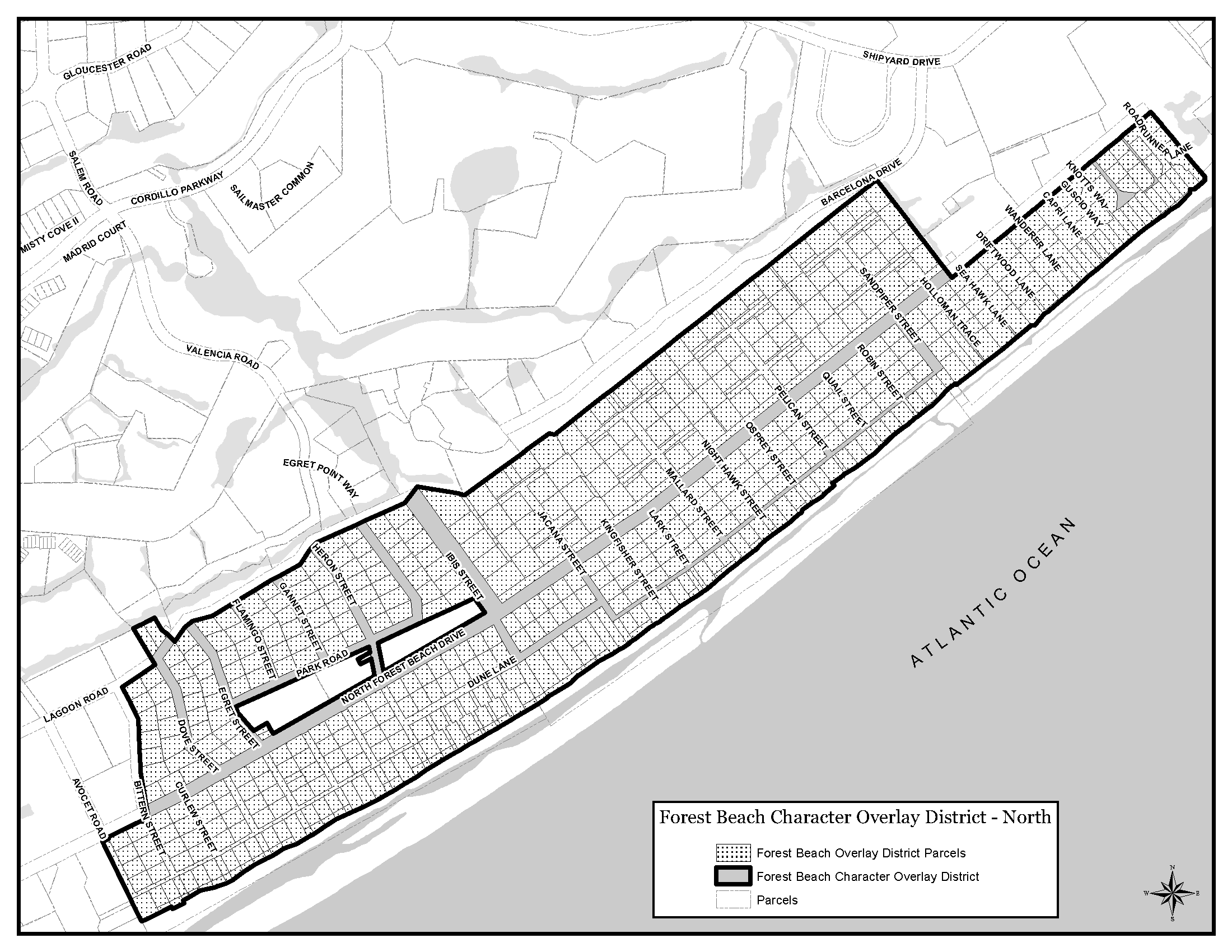
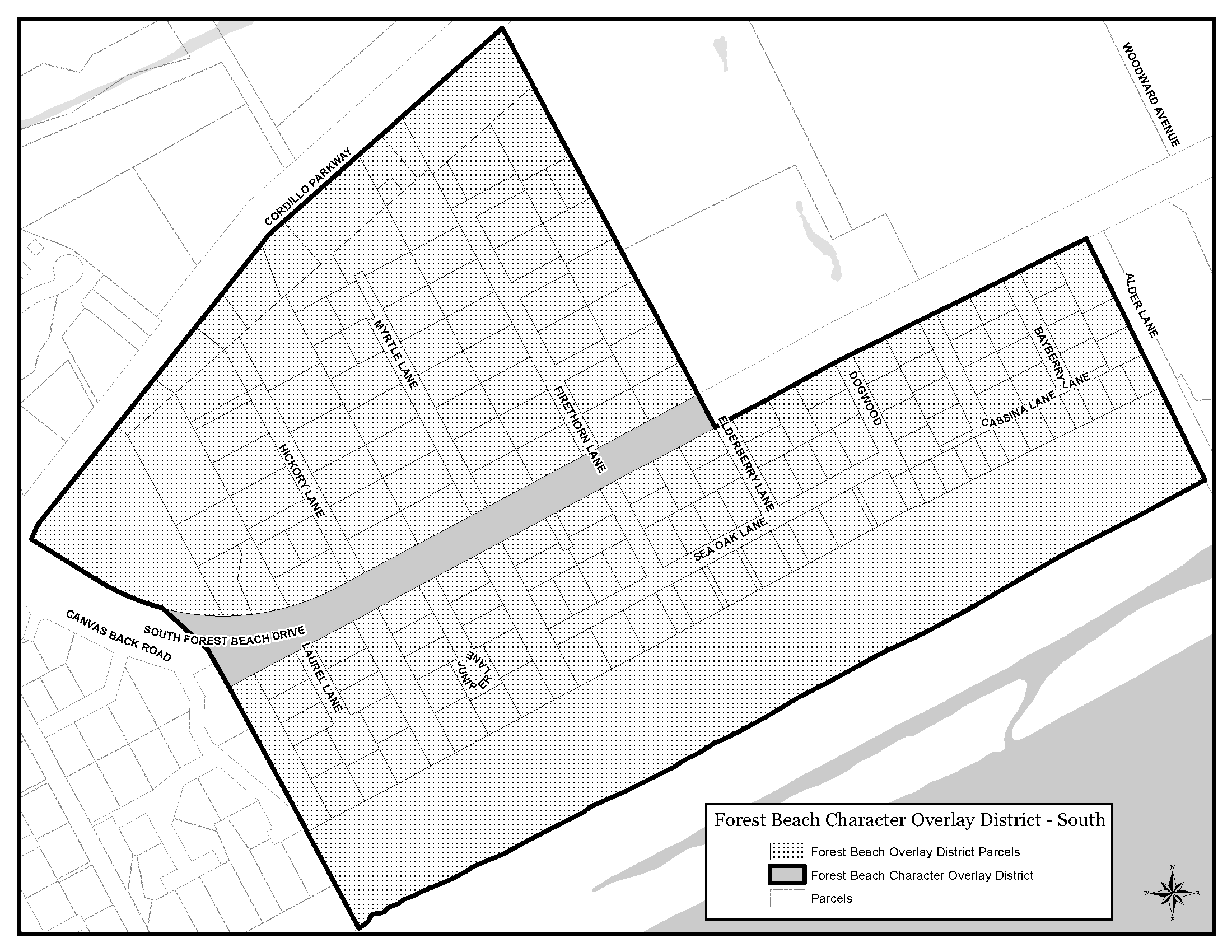
H. Forest Beach Neighborhood Character Overlay (FB-NC-O) District
The purpose of the Forest Beach Neighborhood Character Overlay (FB-NC-O) District is to protect the single-family residential character of the district and in particular the development and redevelopment of lots within the district. All new development and changes to existing development in the district are subject to the overlay district regulations in addition to those listed in Sec. 16-3-104.C, Residential Single-Family-5 (RSF-5) District.
Compliance with the requirements of this section shall be determined by the Official at the time the building permit is reviewed and shall be based upon the standards of Sec. 16-3-104.C, Residential Single-Family-5 (RSF-5) District.
The Forest Beach Neighborhood Character Overlay (FB-NC-O) District includes all parcels shown as hatched in Figure 16-3-106.H.3 below.
(Revised 5-17-2016 - Ordinance 2016-07)
(Revised 5-17-2016 - Ordinance 2016-07)
i.
In addition to the single-family setback requirements of Sec. 16-5-102, Setback Standards, a side, and rear adjacent use setback shall be required.
ii.
Setbacks shall comply with the standards of Sec. 16-5-102, Setback Standards, except that the 65 degree setback angle shall be measured from 20 feet above thirteen feet (13') above mean sea level using the NAVD 88 vertical datum or pre-development grade, whichever is higher.
iii.
Side adjacent use setbacks shall be 10 feet for lots with a width of 70 feet and above. For lot widths less than 70 feet, the side adjacent use setback shall be equal to 12 percent of the lot width rounded to the closest whole number. However, to preserve significant trees or stands of trees any one side setback may be reduced to five feet, provided the sum of the required side setbacks is not reduced.
iv.
Rear adjacent use setbacks shall equal 10 percent of the lot depth or 10 feet, whichever is greater. However, to preserve significant trees or stands of trees, the rear setback may be reduced to five feet provided the sum of the required street and rear setbacks is not reduced.
v.
To preserve significant trees or stands of trees in the rear of the lot, the street setback may be reduced to 15 feet provided the sum of the required street and rear setback is not reduced.
(Revised 3-7-2023 - Ordinance 2023-04)
i.
A 20-foot street buffer and side and rear buffers equal to the setbacks above shall be required.
ii.
Buffers shall comply with the standards of Sec. 16-5-103, Buffer Standards,except that driveways for street access as permitted in Sec. 16-5-103.J, Development Within Required Buffers, shall be limited to a total of 24 feet wide within the buffer.
(Revised 12-5-2017 - Ordinance 2017-19)
iii.
If the cumulative size of existing trees in a buffer is less than two inches DBH per 100 square feet, supplemental tree planting shall be required. Supplemental trees shall be sized to achieve the two inches DBH per 100 square foot minimum in each buffer. 50 percent of the caliper inches of any supplemental trees shall be broad-leaved evergreen overstory hardwoods and endangered species as identified in Sec. 16-6-104.H.
iv.
In the case of a corner lot, the required 20-foot adjacent street buffer may be reduced to 10 feet for the street with the lower ADT unless the street with the higher ADT is approved for the reduction in order to preserve significant trees or stands of trees. In the case where both streets have the same ADT, the 20-foot buffer shall apply to the street that will better preserve significant trees or stands of trees.
v.
In order to preserve significant trees or stands of trees in the rear of the lot, the street buffer may be reduced to 15 feet, provided the sum of the required street and rear buffer is not reduced.
All site paving shall be pervious with the exception of a swimming pool and deck not to exceed 500 square feet unless the site complies with the maximum impervious cover requirements for the RSF-5 District. Spaced wood decking over a pervious surface is considered pervious.
The maximum gross floor area is limited to 0.45 times the area of the lot containing the single-family residence up to a maximum of 5,000 square feet. The gross floor area shall include covered porches and all enclosed space with a ceiling height of seven feet or greater except as follows:
i.
Areas beneath the structure utilized solely for parking and storage. All such areas must be hydrostatically vented if required by the Building Official.
ii.
The first 600 square feet of covered porches.
iii.
Attic space as defined by the latest adopted edition of the IBC.
(Revised 5-7-2024 - Ordinance 2024-04)
The subdivision or recombination of lots platted and recorded on or after April 3, 2001, shall not result in any lot less than 7,000 square feet in size or 70 feet in width.
I. Folly Field Neighborhood Character Overlay (FF-NC-O) District
The purpose of the Folly Field Neighborhood Character Overlay (FF-NC-O) District is to protect the single-family residential character of the district and in particular the development and redevelopment of lots within the district. All new development and changes to existing development in the district are subject to the overlay district regulations in addition to those listed in Sec. 16-3-104.C, Residential Single-Family-5 (RSF-5) District.
Compliance with these regulations shall be determined by the Official at the time the Building Permit is reviewed and shall be based upon the standards of Sec. 16-3-104.C, Residential Single-Family-5 (RSF-5) District.
The Folly Field Neighborhood Character Overlay (FF-NC-O) District includes all parcels depicted as the Strand or as part of Sections A, B, C, or D in Figure 16-3-106.I.3 below.
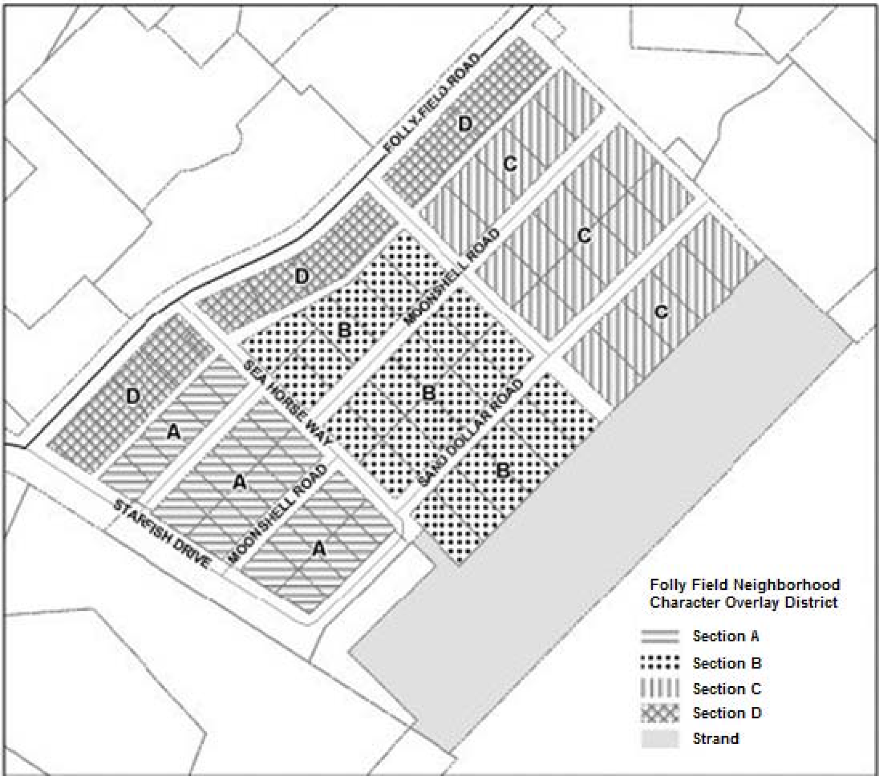
Figure 16-3-106.I.3: Folly Field Neighborhood Character Overlay (FF-NC-O) District
and Sections.
In addition to the single-family setback requirements of Sec. 16-5-102, Setback Standards, with the exception that structures greater than 24 inches in height along minor arterials are required to have a minimum adjacent street setback of 20 feet, the following setbacks shall be required.
i.
Rear yard setbacks shall be a minimum of ten percent of lot depth or ten feet, whichever is greater.
ii.
Side yard setbacks shall each contain a minimum of ten percent of the total lot width.
iii.
Maximum setback angle of 65 degrees shall be measured from 20 feet above thirteen feet (13') above mean sea level using the NAVD 88 vertical datum or pre-development grade, whichever is higher.
(Revised 3-7-2023 - Ordinance 2023-04)
In addition to the buffer requirements of Sec. 16-5-103, Buffer Standards, the following buffers shall be required.
i.
A 20-foot adjacent street buffer shall be required.
ii.
Driveways for street access as permitted in Sec. 16-5-103.J, Development Within Required Buffers, shall be limited to a total width of 24 feet within the buffer.
iii.
In the case of a corner lot, the required 20-foot adjacent street buffer may be reduced to ten feet for the street with the lower ADT unless the street with the higher ADT is approved for the reduction in order to preserve significant trees. In the case where both streets have the same ADT, the 20-foot buffer shall apply to the street that will better preserve significant trees.
The open space or strand area that lies between the existing most current seaward lots and the beach shall not be counted towards the density calculation for any development activities for any lot or other land. In addition, vertical construction in this area is prohibited.
The maximum gross floor area is limited to 0.45 times the area of the lot containing a single-family dwelling up to a maximum of 4,500 square feet. The gross floor area shall include covered porches and all enclosed space with a ceiling height of seven feet or greater, with the following exclusions:
i.
Areas beneath the structure utilized solely for parking or storage.
ii.
The first 600 square feet of covered porches.
iii.
Attic space as defined by the latest adopted edition of the IBC.
f. Minimum Lot Frontage and Depth
The subdivision or recombination of any lot shown on a plat recorded prior to November 5, 2003, shall not result in any lot with frontage and depth less than that shown on the following table for the applicable Section of the district (see Figure 16-3-106.I.3 above).
J. Holiday Homes Neighborhood Character Overlay (HH-NC-O) District
The purpose of the Holiday Homes Neighborhood Character Overlay (HH-NC-O) District is to protect the single-family residential character of the district and in particular the development and redevelopment of lots within the district. All new development and changes to existing development are subject to the overlay district regulations, in addition to those listed in Sec. 16-3-104.D, Residential Single-Family-6 (RSF-6) District. Existing nonconforming structures and site features may be expanded as long as the site complies with the required floor area ratio (FAR) and maximum impervious cover listed in paragraph 3 below.
Compliance with these regulations shall be determined by the Official at the time the Building Permit is reviewed and shall be based upon the standards of Sec. 16-3-104.D, Residential Single-Family-6 (RSF-6) District.
The Holiday Homes Neighborhood Character Overlay (HH-NC-O) District includes all parcels shown as hatched in Figure 16-3-106.J.3 below.
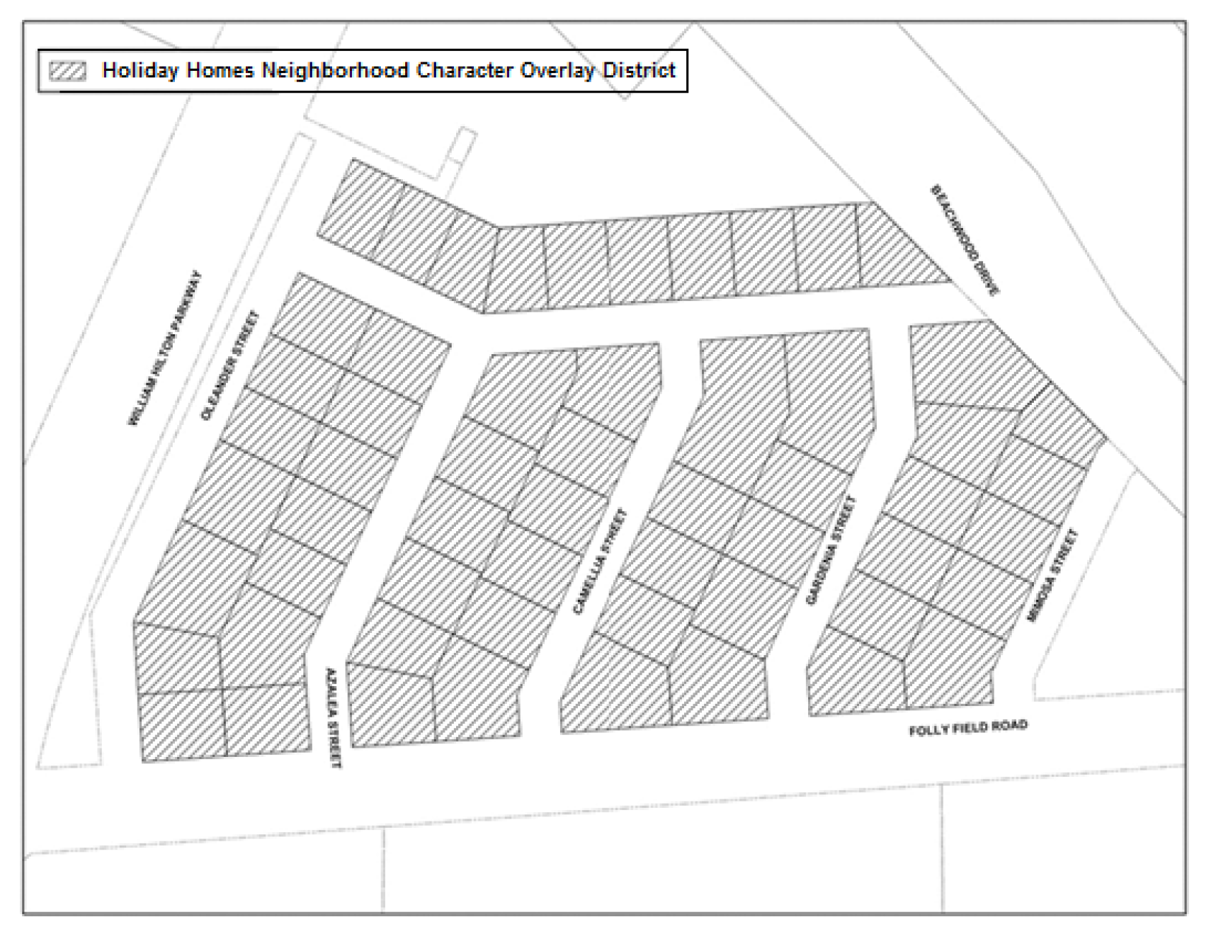
Figure 16-3-106.J.3: Holiday Homes Neighborhood Character Overlay (HH-NC-O) District.
In addition to the single-family setback requirements of Sec. 16-5-102, Setback Standards, the following setbacks shall be required:
i.
Rear yard setbacks shall be a minimum of ten feet.
ii.
Side yard setbacks shall be a minimum of ten feet; however, to preserve existing trees, any one side yard setback may be reduced to five feet provided the sum of the required side yard setbacks equals at least 20 feet.
01.
A lot with less than 50 feet of street frontage or less than 0.15 acres in area shall be permitted to reduce side yard setbacks to a minimum of five feet.
02.
Dwelling units that are nonconforming as to the side yard setbacks identified above are permitted to be expanded along the subject boundary line; however, expansions shall be constructed no closer than five feet from the side property line.
03.
Side yard setback angles shall be a minimum of 65 degrees measured from 20 feet above thirteen feet (13') above mean sea level using the NAVD 88 vertical datum or pre-development grade, whichever is higher, at the setback line. The illustration in Sec. 16-5-102.D, Adjacent Use Setback Requirements, can be referenced for an example of a setback angle.
iii.
In the case of a corner lot, the required 20-foot adjacent street setback may be reduced to ten feet for the street with the lower average daily trips (ADT).
iv.
Lots directly adjacent to Folly Field Road shall have a minimum adjacent street setback of 20 feet.
(Revised 3-7-2023 - Ordinance 2023-04)
In addition to the buffer requirements of Sec. 16-5-103, Buffer Standards,the following buffers shall be required:
i.
A 20-foot street buffer and side and rear buffers equal to the setbacks above.
ii.
Driveways for street access, as permitted in Sec. 16-5-103.J, Development Within Required Buffers,shall be limited to a total width of 24 feet per lot.
iii.
In the case of a corner lot, the required 20-foot adjacent street buffer may be reduced to ten feet for the street with the lower average daily trips (ADT).
iv.
Lots directly adjacent to Folly Field Road shall have a minimum adjacent street buffer of 20 feet.
The maximum gross floor area is limited to 0.45 times the area of the lot containing the single-family dwelling, up to a maximum of 4,000 square feet. The gross floor area shall be calculated as all enclosed space with a ceiling height of seven feet or greater with the following exclusions:
i.
Enclosed areas, where the floor level is located below the required base flood elevation (BFE), which are used solely for parking or storage.
ii.
Attic space as defined by the latest adopted edition of the IBC.
Two parking spaces are required for up to 2,000 square feet of gross floor area. Thereafter, one additional space shall be required for each 1,000 square feet or less of gross floor area.
K. Redevelopment Overlay (R-O) District
The purpose of the Redevelopment Overlay (R-O) District is to create and establish a zoning overlay district to provide flexibility in the design standards of Chapter 16-5: Development and Design Standards, and to utilize zoning and planning techniques specifically designed to promote and encourage the redevelopment of existing nonconforming structures and existing nonconforming site features.
The Redevelopment Overlay (R-O) District is a hybrid floating zone and overlay zone that is unmapped on the Official Zoning Map and that can be applied to discrete, noncontiguous parcels for the purpose of promoting the redevelopment of existing nonconforming structures and existing nonconforming site features.
3. Specific Techniques Authorized
On parcels approved for the Redevelopment Overlay (R-O) District, the following techniques are authorized to accomplish the purpose of the R-O District:
a.
A relaxation of specific design standards set out in Chapter 16-5: Development and Design Standards; or
b.
Authorization of the Official to make minor amendments to any R-O District.
a.
A landowner of a parcel of land who proposes to redevelop may apply to have the parcel of land rezoned R-O District in accordance with Sec. 16-2-103.C, Zoning Map Amendment (Rezoning), and this section. For the purposes of this section, redevelopment is defined as the renovation of a previously developed site to the density allowed under this Ordinance, or the existing density, whichever is greater. Cosmetic changes to the exterior of the structure and interior renovations do not qualify as redevelopment.
b.
The following parcels of land may apply to have the land rezoned R-O District:
i.
A parcel of land that contains a nonconforming structure or site feature; or
ii.
A conforming parcel that redevelops in conjunction with a parcel that contains a nonconforming structure or site feature.
c.
A parcel of land that is located in a RSF district does not qualify and is not eligible to have the land rezoned R-O District.
An R-O District classification shall only be approved in accordance with the procedures in Sec. 16-2-103.C.2, Zoning Map Amendment (Rezoning) Procedure, and the standards in Sec. 16-2-103.C.3, Zoning Map Amendment (Rezoning) Review Standards, and the requirements of this section.
6. Additional R-O District Review Standards
In addition to the review standards in Sec. 16-2-103.C.3, Zoning Map Amendment (Rezoning) Review Standards, redevelopment proposed to be classified to a R-O District may modify the dimensional, development and design, and natural resources protection standards of this Ordinance in accordance with Table 16-3-106.K.4, Additional R-O District Review Standards.
Because unanticipated circumstances may arise in the redevelopment of existing nonconforming structures and existing nonconforming site features that make it impractical or impossible to execute an approved redevelopment plan set out in an approved R-O District, the Official is authorized to approve minor amendments to an approved R-O District as follows:
a.
A minor amendment shall be an amendment that does not make the site nonconforming to the adopted development and design standards approved as part of the R-O District. A minor amendment shall not further relax a development or design standard or other design criteria that has been modified by the approved R-O District.
b.
Disapproval or denial of a request for a proposed minor amendment to an R-O District by the Official may be appealed within 14 calendar days of the decision to the Board of Zoning Appeals.
L. Coastal Protection Area (CPA-O) District
a.
The purpose of the Coastal Protection Area Overlay (CPA-O) District, in conjunction with the Transition Area Overlay (TA-O) District, is to eliminate the potential for seaward migration of the built environment along the Island's beachfront to the greatest extent possible. This environmentally sensitive area:
i.
Protects life and property by serving as a storm barrier;
ii.
Provides an important basis for a tourism industry that generates annual tourism industry revenue;
iii.
Provides habitat for numerous species of plants and animals that are important to the natural functioning of the beach and dune system, or that are threatened or endangered; and
iv.
Provides beach and dune system vegetation that is unique and extremely important to the vitality and preservation of the barrier island environment.
b.
All new development and changes to existing development in the district are subject to the regulations of this section.
c.
The Town's standards and regulations pertaining to development activity within the CPA-O district are intended to complement those of the State of South Carolina.
d.
Where State law and Town provisions regulate development under this subsection, the more restrictive standard shall govern, to the extent allowed by State law. In the event of a conflict between the provisions of this section and applicable State law, State law governs.
2. Delineation of the CPA-O District
Except as otherwise provided in subparagraph b below, the Coastal Protection Area Overlay (CPA-O) District includes the following areas within and adjacent to parcels fronting the Hilton Head Island beach, as defined in Section 8-1-112 of the Municipal Code:
i.
Parcels Containing Single-Family, Golf Course, and Open Space Uses
For parcels containing single-family residential and golf course uses, and open space uses without structures, the CPA-O District includes the area between:
01.
The Beachfront Line or the seaward property line of the parcel, whichever is further landward, and
02.
The mean high water line, the Beachfront Line, or the seaward property line of the parcel, whichever is further seaward.
ii.
Parcels Containing Other Uses
For parcels containing any land use other than single-family residential and golf course uses, and open space uses without structures, the CPA-O District includes the area between:
01.
The seaward boundary of the Transition Area Overlay (TA-O) District (see Sec. 16-3-106.M.2, Delineation of the TA-O District) and
02.
The mean high water line, the Beachfront Line, or the seaward property line of the parcel, whichever is further seaward.
iii.
Basis for Parcel Lines
The single-family parcels (with the exception of North Forest Beach Subdivisions 1, 2, and 3) and non-single-family parcel lines used to establish the CPA-O District boundaries in accordance with this subparagraph are as platted and recorded in the Beaufort County Register of Deeds Office as of the date of Ordinance 2009-22.
b. Hilton Head Beach Subdivisions 1, 2, and 3 subdistricts
i.
The three single-family subdivisions identified as Hilton Head Beach Subdivisions 1, 2, and 3, are subdistricts within the CPA-O District. The Hilton Head Beach Subdivisions 1, 2, and 3 subdistricts are contiguous with parcels of property described as "Beach Lot," "Strand Parcel" lots on recorded plats as follows:
01.
For Hilton Head Beach Subdivision 1, the plat is recorded in the Beaufort County Register of Deeds Office, in Plat Book 81 at Page 153, and the property in question is described thereon as the "Beach Lot";
02.
For Hilton Head Beach Subdivision 2, the plat is recorded in the Beaufort County Register of Deeds Office, in Plat Book 84 at Page 112, and the property in question is described thereon as the "Strand Parcel"; and
03.
For Hilton Head Beach Subdivision 3, the plat is recorded in the Beaufort County Register of Deeds Office, in Plat Book 81 at Page 154, and the property in question is described thereon as the "Beach Lot."
ii.
The uses allowed in the CPA-O District in Hilton Head Beach Subdivision 2 are those uses allowed on the "Strand Parcel" property in the declarations of covenants and restrictions that are recorded in the Beaufort County Register of Deeds Office in Official Record Book 1532 at Page 1312.
iii.
For all other property in the CPA-O District, this Ordinance applies.
iv.
With respect to the CPA-O District in Hilton Head Beach Subdivision 2, where the text of this Ordinance conflicts with the declarations of covenants described above, the text of the declarations of covenants and restrictions shall control.
3. Activities and Uses Permitted and Prohibited in the CPA-O District
a.
All development is prohibited in the CPA-O District except the following permitted uses and activities:
i.
Boarded pathways as perpendicular to the beach as practical and not larger than six feet in width and their associated wooden deck not larger than 144 square feet (must comply with Sec. 16-6-103, Beach and Dune Protection);
ii.
Beach renourishment;
iii.
Emergency vehicular beach access; and
iv.
Permitted beach maintenance activities such as sand fencing, re-vegetation with native plant material and erosion control.
b.
All activities and uses in the CPA-O District must also comply with all current local, State and federal laws.
4. Nonconforming Structures within the CPA-O District
a.
Any structure or site feature that is nonconforming to the activities and uses permitted within the CPA-O District may be rebuilt to its current size (or smaller) and location provided that:
i.
The structure conforms to current local, State, and federal laws;
ii.
The same use that previously existed is reestablished within the structure; and
iii.
Neither the structure nor the use has been discontinued for a period of 12 consecutive months or greater.
b.
Normal maintenance activities of nonconforming structures are allowed.
M. Transition Area Overlay (TA-O) District
a.
The purpose of the Transition Area Overlay (TA-O) District, in conjunction with the Coastal Protection Area Overlay (CPA-O) District, is to eliminate the potential for seaward migration of the built environment along the Island's beachfront as well as protect the area between existing construction and the mean high water mark, to the greatest extent possible. This environmentally sensitive area:
i.
Protects life and property by serving as a storm barrier;
ii.
Provides an important basis for a tourism industry that generates annual tourism industry revenue;
iii.
Provides habitat for numerous species of plants and animals that are important to the natural functioning of the beach and dune system, or that are threatened or endangered; and
iv.
Provides beach and dune system vegetation that is unique and extremely important to the vitality and preservation of the barrier island environment.
b.
All new development and changes to existing development in the district are subject to the regulations of this section.
c.
The Town's standards and regulations pertaining to development activity within the TA-O district are intended to complement those of the State of South Carolina.
d.
Where State law and Town provisions regulate development under this subsection, the more restrictive standard shall govern, to the extent allowed by State law. In the event of a conflict between the provisions of this section and applicable State law, State law governs.
2. Delineation of the TA-O District
Except as otherwise provided in subparagraph b below, the Transition Area Overlay (TA-O) District applies only to non-single-family areas, where it includes the area between:
i.
The existing line of construction (as bound by the South Carolina State Plane Coordinate System), and
ii.
The most immediate seaward property line of parcels fronting the beach (as defined in Section 8-1-112 of the Municipal Code) or the Beachfront Line, whichever is further landward.
b. Hilton Head Beach Subdivisions 1, 2, and 3 subdistricts
i.
The three single-family subdivisions identified as Hilton Head Beach Subdivisions 1, 2, and 3, are subdistricts within the TA-O District. The Hilton Head Beach Subdivisions 1, 2 and 3 subdistricts are contiguous with parcels of property described as 'A' lots, 'E' and 'S' lots and 'X' lots on recorded plats as follows:
01.
For Hilton Head Beach Subdivision 1, the plat is recorded in the Beaufort County Register of Deeds Office, in Plat Book 81 at Page 153, and the lots in question are described thereon as the "A" lots;
02.
For Hilton Head Beach Subdivision 2, the plat is recorded in the Beaufort County Register of Deeds Office, in Plat Book 84 at Page 112, and the lots in question are described thereon as the "E" and "S" lots; and
03.
For Hilton Head Beach Subdivision 3, the plat is recorded in the Beaufort County Register of Deeds Office, in Plat Book 81 at Page 154, and the lots in question are described thereon as the "X" lots.
ii.
The uses allowed in the TA-O District in Hilton Head Beach Subdivisions 1, 2, and 3 are those uses allowed on the "A," "E," "S," and "X" lots in the declarations of covenants and restrictions that are recorded in the Beaufort County Register of Deeds Office as follows:
01.
For Hilton Head Beach Subdivision Number 1, in Official Record Book 1450 at Page 835;
02.
For Hilton Head Beach Subdivision Number 2, in Official Record Book 1532 at Page 1317; and
03.
For Hilton Head Beach Subdivision Number 3, in Official Record Book 1450 at Page 828
iii.
Where the text of this Ordinance conflicts with the declarations of covenants described above, the text of the declarations of covenants and restrictions shall control.
3. Activities and Uses Permitted in the TA-O District
a.
In addition to the activities and uses permitted in the CPA-O District (see Sec. 16-3-106.L.3), the TA-O District may include any uses that do not require enclosed space to operate. These activities and uses include, but are not limited to, swimming pools, boardwalks, fire pits, decks, required drainage improvements, and necessary utilities.
b.
The activities and uses in the TA-O District shall be located as far landward as possible. Activities or uses in the TA-O District shall be accessory activities or uses to the development to which they are directly seaward.
c.
Development in the TA-O District shall conform to the standards for impervious cover and open space for the underlying base zoning district.
d.
Activities or uses in the TA-O District shall not be on or in any part of a dune or dune system.
4. Nonconforming Structures within the TA-O District
a.
Any structure or site feature that is nonconforming as to the activities and uses permitted within the TA-O District may be rebuilt to its current size (or smaller) and location provided that:
i.
The structure conforms to current local, State, and federal laws;
ii.
The same use that previously existed is reestablished within the structure; and
iii.
Use of the structure has not ceased for a period of 12 consecutive months or greater.
b.
Normal maintenance activities of nonconforming structures are allowed.