
Hilton Head Island City Zoning Code
CHAPTER 16
5: - Development and Design Standards
Sec.16-5-101.- General
A. Purpose and Intent
The purpose of this chapter is to establish development and design standards for development in the Town. The standards promote good site design and planning to produce development that is functional, serves as an asset to the community, is in keeping with the general aesthetics, philosophy, and character of the Island, and protects and enhances the unique barrier island environment. The standards allow for and promote design that integrates man-made improvements to the land with the natural elements of the land.
Sec.16-5-102. - Setback Standards
A. Purpose and Intent
The purpose of the adjacent street and use setback standards in this section is to provide separation between structures and adjacent streetrights-of-way and property lines. Such separation is intended to maintain and protect the Town's Island character, ensure protection from street traffic, and facilitate adequate air circulation and light between structures and the street, and between structures in adjacent developments.
Except as provided in subsection 2 below, the requirements of this section shall apply to all development in the Town.
a.
For development within the CR District, see Sec 16-3-105.B.3.
b.
For development within a PD-1 District, adjacent street and use setback standards shall apply only along those lot lines and street rights-of-way located outside any gates restricting access by the general public to areas within the PUD, or constituting the boundaries of the district.
(Revised 5-17-2016 - Ordinance 2016-07)
c.
For development within a PD-2 District, adjacent street and use setback standards shall apply only along those lot lines and street rights-of-way located within a Corridor Overlay District or constituting the boundaries of the district.
(Revised 7-21-2020 - Ordinance 2020-16)
C. Adjacent Street Setback Requirements
Unless expressly exempted or modified in this subsection or for the CR, S, and IL Districts in Chapter 16-3: Zoning Districts, all portions of a structure shall be located to the interior of the vertical and angled planes established by the applicable minimum setback distance from an adjacent street and maximum setback angle shown in Table 16-5-102.C, Adjacent Street Setback Requirements, based on the proposed use and the classification of the adjacent street. (See Figure 16-5-102.C, Street Setback Angle.)
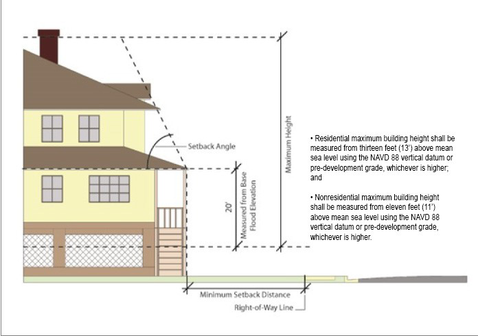 |
| Figure 16-5-102.C, Street Setback Angle |
(Revised 12-5-2017 - Ordinance 2017-19; revised 8-18-2020 - Ordinance 2020-19; revised 11-18-2020 - Ordinance 2020-27; revised 7-20-2021 - Ordinance 2021-15; revised 3-7-2023 - Ordinance 2023-04)
D. Adjacent Use Setback Requirements
1.
Unless expressly exempted or modified in this subsection or for the CR and S Districts in Chapter 16-3: Zoning Districts, all portions of a structure shall be located to the interior of the vertical and angled planes established by the applicable minimum setback distance from adjacent properties and maximum setback angle shown in Table 16-5-102.D, Adjacent Use Setback Requirements, based on the proposed use and the existing use of the adjacent property (or zoning of a vacant adjacent property). (See Figure 16-5-102.D, Use Setback Angle.)
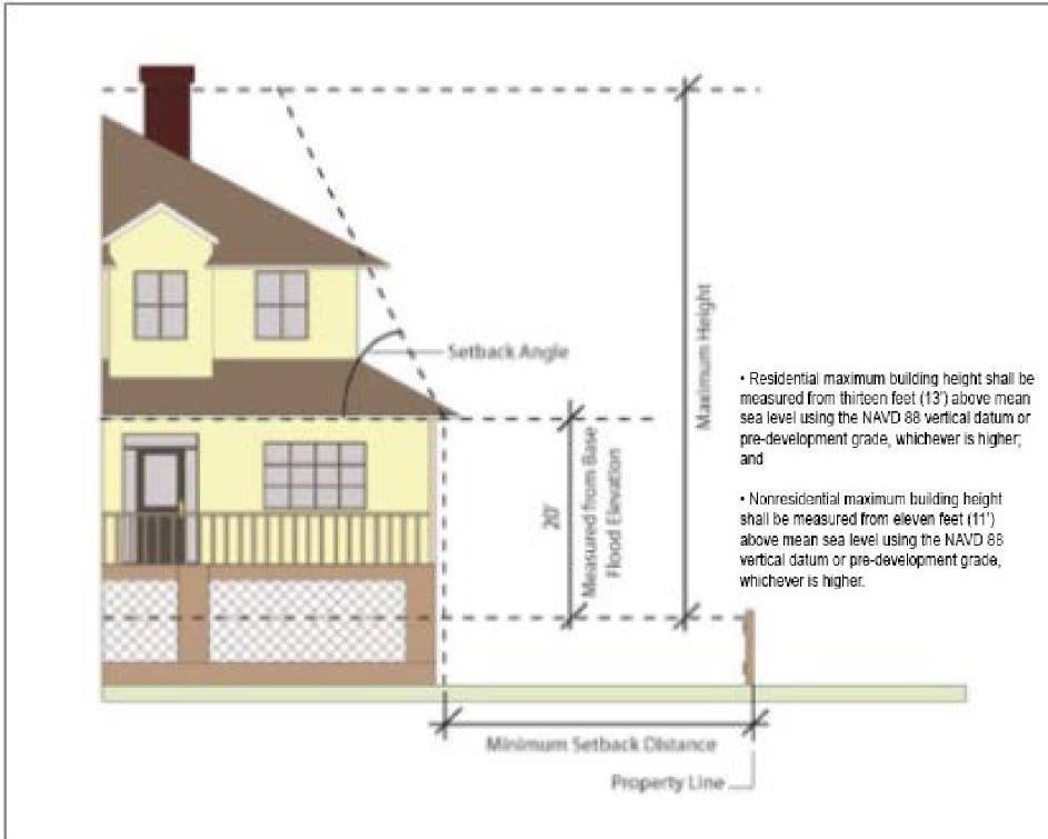 |
| Figure 16-5-102.D, Use Setback Angle |
2.
Where the adjacent property includes uses from more than one listed use classification/use type (including mixed-use developments), the adjacent use setback required shall be that for the use classification/use type to which the greatest percentage of the development'sgross floor area is devoted.
3.
The adjacent use setback distance applicable to lots along the perimeter of development subject to Small Residential Development Review may be reduced by up to 50 percent, down to no less than five feet. The Official may allow further reduction as necessary to ensure that the total area within such perimeter setbacks does not exceed 20 percent of the total area of the site of the Small Residential Development.
4.
There is no adjacent use setback requirement for non-single-family properties when the proposed development and the adjacent development function as a single development due to having either shared parking, connecting vehicular access or shared stormwater facilities. The recording of a cross access easement agreement between the two properties is required.
(Revised 12-5-2017 - Ordinance 2017-19; revised 7-20-2021 - Ordinance 2021-15; revised 3-7-2023 - Ordinance 2023-04)
E. Allowable Setback Encroachments
Table 16-5-102.E, Allowable Setback Encroachments, identifies features that are allowed to encroach beyond the vertical and angled planes defined by minimum adjacent street and use setback requirements.
(Ord. No. 2015-23, 11-3-2015; revised 5-17-2016 - Ordinance 2016-07; revised 12-5-2017 - Ordinance 2017-19)
Sec.16-5-103. - Buffer Standards
A. Purpose and Intent
The purpose of the adjacent street and use buffer standards in this section is to spatially separate development from adjacent streets and adjacent development with aesthetically pleasing natural or landscaped buffers. Such buffers are intended to help mitigate potential adverse impacts (e.g., noise, odor, fumes) from adjacent street traffic, create an attractive streetscape for motorists, allow the location of certain dissimilar land uses adjacent to one another by mitigating potential negative effects between the uses, and provide space for landscaping that can help improve air and water quality and be used to reduce stormwater runoff.
Except as provided in subsection 2 below, the requirements of this section shall apply to all development in the Town.
a.
For development within a PD-1 District, adjacent street and use buffer standards shall apply only along those lot lines and street rights-of-way located outside any gates restricting access by the general public to areas within the PUD, or constituting the boundaries of the district.
(Revised 5-17-2016 - Ordinance 2016-07)
b.
For development within a PD-2 District, adjacent street and use buffer standards shall apply only along those lot lines and street rights-of-way located within a Corridor Overlay District or constituting the boundaries of the district.
c.
Adjacent street buffers shall not apply to development within the CR District.
(Revised 7-21-2020 - Ordinance 2020-16)
Applications for development where a buffer is required shall include a landscape plan in accordance with the submittal requirements in Appendix D: Application Submittal Requirements.
D. Adjacent Street Buffer Requirements
Unless expressly exempted or modified in this subsection, development shall provide a buffer along adjacent streets that is of the type designated in Table 16-5-103.D, Adjacent Street Buffer Requirements, for the proposed use and the classification of the adjacent street. Descriptions and width and screening requirements for the various buffer types are set out in Sec. 16-5-103.F, Buffer Types.
(Revised 11-18-2020 - Ordinance 2020-27; revised 7-20-2021 - Ordinance 2021-15)
E. Adjacent Use Buffer Requirements
1.
Unless expressly exempted or modified in this subsection, development shall provide a buffer along common property lines with adjoining properties that is of the type designated in Table 16-5-103.E, Adjacent Use Buffer Requirements, for the proposed use and the classification of the use of the adjacent property (or zoning of a vacant adjacent property). Descriptions and width and screening requirements for the various buffer types are set out in Sec. 16-5-103.F, Buffer Types.
(Revised 6-6-2017 - Ordinance 2017-08; revised 12-5-2017 - Ordinance 2017-19; revised 7-20-2021 - Ordinance 2021-15)
2.
There is no adjacent use buffer requirement for non-single-family properties when the proposed development and the adjacent development function as a single development due to having either shared parking, connecting vehicular access or shared stormwater facilities. The recording of a cross access easement agreement between the two properties is required.
(Revised 12-5-2017 - Ordinance 2017-19; revised 3-7-2023 - Ordinance 2023-04)
Table 16-5-103.F, Buffer Types, describes the five different buffer types in terms of their function, opacity, width, and planting requirements. The planting requirements should be used as a guide to achieve an aesthetically pleasing landscaped buffer and only apply if the existing buffer does not meet the intent of the prescribed buffer. Either of the options under a specific buffer type may be used at the option of the developer/applicant. If the square footage of an existing building on a site is being increased by more than 50% then the buffers must be brought into compliance with the standards in this table.
| TABLE 16-5-103.F: BUFFER TYPES | ||
|---|---|---|
| MINIMUM BUFFER WIDTH AND SCREENING REQUIREMENTS1,2,3,4,5 | ||
| TYPE A BUFFER | ||
| This buffer includes low-density screening designed to partially block visual contact and create spatial separation between adjacent uses or between development and adjacent streets with low traffic volumes. | ||
| Option 1 | 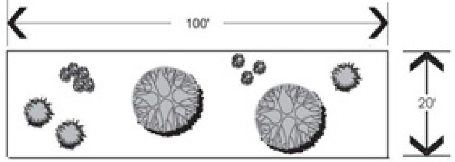 |
• Width: 20 feet
• Overstory trees: 2 every 100 linear feet • Understory trees: 3 every 100 linear feet • Evergreen shrubs: 8 every 100 linear feet |
| Option 2 |
• Width: 10 feet
• Overstory trees: 2 every 100 linear feet • Understory trees: 4 every 100 linear feet • Evergreen shrubs: 10 every 100 linear feet | |
| TYPE B BUFFER | ||
| This buffer includes low- to medium-density screening designed to create the impression of spatial separation without significantly interfering with visual contact between adjacent uses or between development and adjacent minor arterials. | ||
| Option 1 | 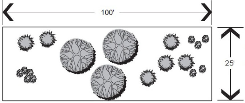 |
• Width: 25 feet
• Overstory trees: 3 every 100 linear feet • Understory trees: 6 every 100 linear feet • Evergreen shrubs: 10 every 100 linear feet |
| Option 2 |  |
• Width: 15 feet
• Overstory trees: 4 every 100 linear feet • Understory trees: 8 every 100 linear feet • Evergreen shrubs: 12 every 100 linear feet |
| TYPE C BUFFER | ||
| This buffer includes medium-density screening designed to eliminate visual contact at lower levels and create spatial separation between adjacent uses. | ||
| Option 1 |  |
• Width: 25 feet
• Overstory trees: 3 every 100 linear feet • Understory trees: 5 every 100 linear feet • A solid wall or fence at least 3 feet high or a solid evergreen hedge at least 3 feet high and 3 feet wide |
| Option 2 |  |
• Width: 15 feet
• Overstory trees: 4 every 100 linear feet • Understory trees: 6 every 100 linear feet • A solid wall or fence at least 3 feet high or a solid evergreen hedge at least 3 feet high and 3 feet wide • At least 50% of all trees must be evergreen |
| TYPE D BUFFER | ||
| The buffer includes high-density screening designed to eliminate visual contact up to a height of six feet and create a strong spatial separation between adjacent uses. A Type D buffer is required adjacent to all loading areas per Section 16-5-107.H.8.d, Buffering of Loading Areas. | ||
| Option 1 |  |
• Width: 30 feet
• Overstory trees: 5 every 100 linear feet • Understory trees: 6 every 100 linear feet • Evergreen shrubs: 25 every 100 linear feet and at least 6 feet high at maturity • At least 50% of all trees must be evergreen |
| Option 2 | 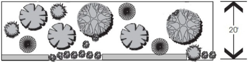 |
• Width 20 feet
• Overstory trees: 6 every 100 linear feet • Understory trees: 8 every 100 linear ft • A solid wall or fence at least 6 feet high or a solid evergreen hedge at least 6 feet high and 3 feet wide • At least 50% of all trees must be evergreen |
| TYPE E BUFFER | ||
| This buffer provides greater spacing and medium-density screening designed to define "green" corridors along major arterials. | ||
| Option 1 | 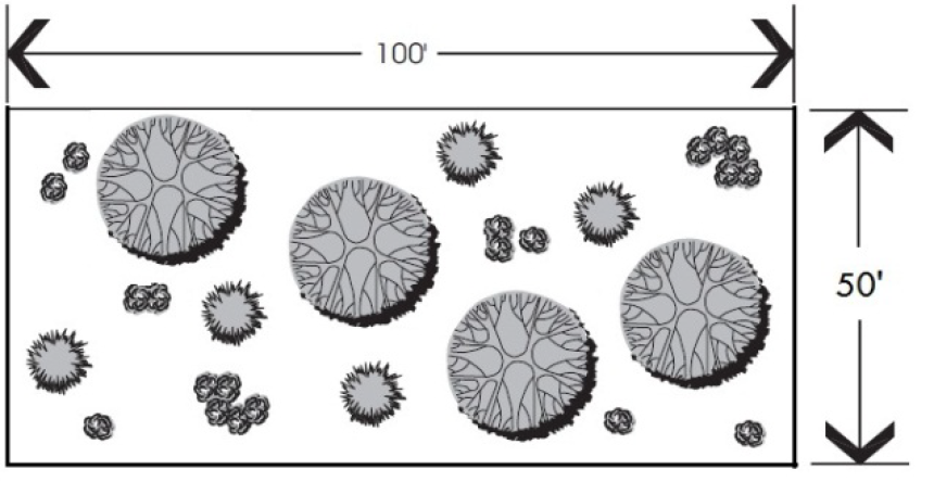 |
• Width: 50 feet
• Overstory trees: 4 every 100 linear feet • Understory trees: 5 every 100 linear feet • Evergreen shrubs: 20 every 100 linear feet and at least 3 feet high at maturity |
| Option 2 | 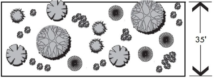 |
• Width: 35 feet
• Overstory trees: 5 every 100 linear feet • Understory trees: 7 every 100 linear feet • Evergreen shrubs: 25 every 100 linear feet and at least 3 feet high at maturity • At least 50% of all trees must be evergreen |
|
NOTES:
1. Required overstory trees shall be distributed and spaced to maximize their future health and effectiveness as buffers. Other required vegetation shall be distributed within the buffer as appropriate to the function of the buffer. 2. Where an adjacent use is designed for solar access, understory trees may be substituted for overstory trees. 3. Fences or walls within an adjacent street or use buffer shall comply with the standards of Sec. 16-5-113, Fence and Wall Standards. 4. A berm may be provided in conjunction with the provision of a hedge, fence, or wall to achieve height requirements, provided its side slopes do not exceed a ratio of three horizontal feet to one vertical foot and the width of its top is at least one-half its height. 5. If a buffer length is greater or less than 100 linear feet, the planting requirements shall be applied on a proportional basis, rounding up for a requirement that is 0.5 or greater, and down for a requirement that is less than 0.5. (For example, if the buffer length is 150 linear feet, and there is a requirement that 5 overstory trees be planted every 100 linear feet, 8 overstory trees are required to be planted in the buffer (1.5 x 5 = 7.5, rounded up to 8)). | ||
(Revised 12-5-2017 - Ordinance 2017-19; revised 1-7-2020 - Ordinance 2020-02; revised 3-7-2023 - Ordinance 2023-04)
Buffer areas shall be located between the property boundary and all development on the site, but not necessarily within the minimum setback.
1.
If a buffer area has existing trees, they shall be preserved and be used as part of the buffer to comply with the buffer standards of this Ordinance. Where groupings of native shrubs are present, their preservation with minimum disturbance is required. Any clearing or other work in buffers must have the prior approval of the Official.
(Revised 5-17-2016 - Ordinance 2016-07; revised 1-7-2020 - Ordinance 2020-02)
2.
In order to preserve existing vegetation and to restrict activities within a buffer, protective fencing shall be installed in accordance with Sec. 16-6-104.J, Tree and Buffer Protection During Development Activity.
(Revised 1-7-2020 - Ordinance 2020-02)
3.
Existing vegetation that is preserved shall not be limbed up from the ground more than five feet to the lowest branches, except:
a.
Vegetation at intersections may be limbed up to a greater height to ensure compliance with Sec. 16-5-105.H.4, Sight Triangles; and
b.
If understory planting is proposed, the Official may allow existing vegetation to be limbed up to a height that will provide adequate sunlight to plants.
(Revised 1-7-2020 - Ordinance 2020-02)
4.
The removal of invasive species shall be allowed with an approved replanting plan, if needed.
(Revised 5-17-2016 - Ordinance 2016-07; revised 1-7-2020 - Ordinance 2020-02))
At the time of planting, overstory and understory trees included as part of required buffers shall comply with the size standards for supplemental and replacement trees in Sec. 16-6-104.I, Standards for Supplemental and Replacement Trees; evergreen shrubs shall be at least three feet in height above ground level. All buffer plantings must be native species of plants, see Appendix C, except where ornamental plantings or plants that have historically been prevalent on Hilton Head Island are approved as part of a Corridor Review approval.
J. Development Within Required Buffers
Development is prohibited within required buffers except in accordance with this subsection.
1.
The following activities may occur in required buffers, unless expressly prohibited elsewhere in this Ordinance.
a.
Street or driveway access, provided it runs approximately perpendicular to/from the adjacent street right-of-way or common property line.
b.
Walkways, pathways, trails, benches, bike racks, and other elements associated with passive recreation or the provision of continuous pedestrian and bicycle connections between adjoining properties, provided all landscaping required by Sec. 16-5-103.F, Buffer Types, is provided and the Official determines that installation or maintenance of such elements will minimize impacts on to required vegetation to the maximum extent practicable.
c.
Lighting fixtures.
d.
Service and utility lines and minor facilities (e.g. water, sanitary sewer, electrical, telephone, natural gas, cable, storm drainage lines, utility boxes and pedestals), subject to the following standards:
i.
Such lines generally shall run approximately perpendicular to/from the adjacent street right-of-way or common property line. If they must be installed approximately parallel to the street right-of-way or property line, the easement for the lines may be included as part of a required buffer if the 16-5-104 easement allows the vegetation or structures necessary to meet buffer screening requirements and provides the requisite visual separation in a manner that is aesthetically acceptable; otherwise, additional buffer width shall be required to provide the space needed for the required buffer screening.
ii.
Permission for easement and right-of-way disturbance and clearings for such utility and service lines and facilities shall be more favorably considered when such activity is consolidated with vehicular access routes.
2.
The following features and activities are allowed within adjacent street buffers only:
a.
Signage, to the extent permitted by Sec. 16-5-114, Sign Standards.
b.
Clearing for sight distances at permitted entrances and exits to any development as required to provide for reasonable traffic safety.
c.
Fountains, plazas, sculptures, and similar features that are part of publicly owned facilities, where approved by the Official.
(Ord. No. 2015-23, 11-3-2015; revised 8-19-2025 - Ordinance 2025-16)
Sec.16-5-104. - Common Open Space Standards
A. Purpose and Intent
The purpose and intent of this section is to ensure a portion of residential development sites is set aside as common open space for the use and enjoyment of the development's occupants and users. Common open space serves numerous purposes, including preservation and protection of natural areas and features, providing opportunities for passive and active recreation, providing areas for people to meet and congregate, and limiting impervious surfaces that adversely impact water quality and the environment.
1.
The provisions of this section apply to any Major Subdivisions (six or more lots) creating lots for residential development, unless expressly exempted in this section.
2.
The provisions of this section also shall apply to any Minor Subdivision (five or fewer lots) creating lots for residential development that is expanded onto adjacent parcels so the total number of lots in the subdivision is greater than five.
3.
The provisions of this section do not apply to Family Subdivisions.
(Revised 8-19-2025 - Ordinance 2025-16)
C. Common Open Space Requirement
1.
At least 16 percent of the land within the subdivision shall consist of common open space meeting the requirements of this section.
2.
Common open space shall be depicted on any plat of the development submitted for approval and labeled "common open space."
3.
Common open space must be visually identifiable, distinguished by elements including but not limited to signs, fencing, landscape buffers, trail systems, pools, sport facilities, or grass lawns.
(Revised 8-19-2025 - Ordinance 2025-16)
D. Common Open Space Location and Configuration
1.
Common open space shall be connected to all lots within the subdivision by pathways in accordance with Sec. 16-5-115.D.5.
2.
The common open space shall be accessible to all residents of the subdivision development, subject to reasonable rules and regulations. Common open space may be dedicated for general public use; however, such dedication is not mandatory.
3.
The design and establishment of common open space shall meet the following standards:
a.
An area or multiple areas of common open space shall be planned for active or passive recreational use.
b.
At least 75 percent of the common open space area shall be arranged in dimensions no less than 15 feet across in any direction.
c.
At least 50 percent of the common open space shall be arranged in one contiguous area. For the purpose of this requirement, common open space areas divided by pathways, sidewalks, or streets that would otherwise be contiguous without the existence of the pathways, sidewalks, or streets shall be considered contiguous.
d.
The arrangement and design of common open space shall prioritize the preservation of existing tracts of specimen and significant trees. The applicant shall demonstrate how these priority areas have been considered during the application process.
(Revised 8-19-2025 - Ordinance 2025-16)
E. Ownership, Management and Maintenance of Common Open Space
Common open space shall be maintained so that its use and enjoyment as common open space is not diminished or destroyed. Ownership of common open space shall be subject to deed restrictions or recorded covenants and restrictions that prevent development or subsequent subdivision of the common open space and provide responsibility for maintenance of the common open space.
(Revised 8-19-2025 - Ordinance 2025-16)
Sec.16-5-105. - Mobility, Street, and Pathway Standards
A. Mobility
The purpose of this section is to ensure that development accommodates the safe and efficient movement of motor vehicles, emergency vehicles, bicyclists, and pedestrians within the development and between the development and external transportation systems, neighboring development, and local destination points such as places of employment, schools, parks, and shopping areas. Such multimodal access and circulation is intended to provide transportation options, increase the effectiveness of local service delivery, reduce emergency response times, promote healthy walking and bicycling, contribute to the attractiveness of the development and community, increase opportunities for interaction between neighbors, reduce vehicle miles of travel and travel times, improve air quality, minimize congestion and traffic conflicts, and preserve the safety and capacity of community transportation systems.
Except as otherwise provided in this section, the standards in this section shall apply to all development.
3. Complete Street Design Principles Encouraged
While not required, the use of complete street design principles are encouraged in all development.
4. Required Level of Vehicular Access and Circulation
To the maximum extent practicable, a development shall be served by an internal vehicular access and circulation system (including driveways, alleys, fire lanes, and parking lot drive aisles) that permits safe, convenient, efficient, and orderly movement of vehicles between and among trip origin and destination points within the development, as well as between the internal vehicular circulation system and adjoining parts of an existing or planned external street system.
5. Accessway Layout and Design
a. Adaptation to Site Conditions
The layout of the access and circulation system shall adapt to the site, taking into consideration physical factors such as natural elements, grade, and drainage, as well as aesthetic factors such as the visual impact of the street pattern and the highlighting of special site features.
b. Coordination of Vehicular, Bicycle, and Pedestrian Access and Circulation
The vehicular, bicycle, and pedestrian access and circulation systems in a development shall be coordinated with each other within the development and with such systems adjacent to the development to minimize conflicts.
c. Incentives for Vehicular Cross Access Between Adjoining Developments
For each adjoining property to which a development provides vehicular cross access, the number of parking spaces required in accordance with Sec. 16-5-107.D, Parking Space Requirements, may be reduced by five spaces. If the cross access is adjacent to a landscape median at the end of a parking bay, the minimum width of the median as required by Sec. 16-5-107.G.3, Configuration and Landscaping, may be reduced to 12 feet.
d. Traffic Control and Calming Measures
Traffic-calming measures—including, but not limited to, diverters, street gardens, landscaped medians, and curvilinear alignments—shall be integrated into a development's vehicular circulation system where necessary to mitigate the impact of traffic. Installation of new speed bumps/humps or changes to existing speed bumps/humps shall be prohibited unless approved by the Fire Marshal.
i.
Driveway Entrances
Driveway entrances from streets shall comply with standards in the current edition of SCDOT's Access and Roadside Management Standards manual—including, but not limited to, standards for driveway spacing, angle of intersection, entry width, radius, offset, approach grade and side slope, throat length, and islands and medians. In instances where the Town's access spacing standard as outlined in [Sec.] 16-5-105.I is greater than the SCDOT standard, the Town's standard shall be applicable.
(Revised 5-17-2016 - Ordinance 2016-07)
ii.
Driveway Width
01.
All driveways shall comply with the following minimum and maximum width requirements:
(A)
One-way one-lane driveways shall be at least 14 feet wide and no more than 20 feet wide, as measured between the edges of paving.
(B)
Two-way, two-lane driveways shall be at least 20 feet wide and no more than 30 feet wide, as measured between the edges of paving.
(C)
Service driveways shall be a minimum of 10 feet wide and no more than 14 feet wide, as measured between the edges of paving.
(Revised 12-5-2017 - Ordinance 2017-19)
02.
The Official may require a wider driveway on determining that it is needed to facilitate special vehicle or traffic demand requirements.
iii.
Driveway Surfacing
Driveways shall be surfaced with asphalt, concrete, porous paving blocks, compacted shell, gravel, or other material that the Official determines is unlikely to cause substantial maintenance problems. Driveway aprons within a public street right-of-way connecting to a paved street shall be paved with asphalt or concrete in accordance with SCDOT specifications.
iv.
Turnaround and Surfacing for Long Driveways
Driveways more than 150 feet long shall have a turnaround and all-weather surfacing adequate for emergency vehicles approved by the Fire Chief for the Town of Hilton Head Island.
i.
If the location of a proposed development in relation to other potential areas or its location with respect to an overall pathway plan adopted by the Planning Commission reveals that the probable volume of bicycle use warrants the installation of bike paths or bike lanes, the Official is authorized to require them.
ii.
Bike paths and bike lanes shall be designed and provided in accordance with the latest edition of the AASHTO Guide for the Development of Bicycle Facilities and S.C. Code Ann. § 56-5-3425.
Pedestrian walkways (including sidewalks) shall:
i.
Be at least five feet wide;
ii.
Be distinguishable from vehicular traffic lanes they cross by painted markings, a change in pavement material or color, raised paving height, decorative bollards, or flashing caution signals; and
iii.
Meet the accessibility guidelines promulgated under the Americans with Disabilities Act (ADA).
1.
Streets shall be classified in a street hierarchy system, with through traffic separated from residential access streets, and with design tailored to function.
2.
The street hierarchy shall be defined by street function and average daily traffic (ADT). Each street shall be classified and designed to meet or exceed the minimum standards for one of the street types defined above.
3.
The streets as identified in Table 16-5-105.B: Designated Arterials, are designated as major and minor arterial streets, respectively:
C. General Street Design Standards
All streets shall comply with the following standards, as applicable:
1.
The arrangement of streets shall conform to that indicated by the Comprehensive Plan or Official Map, as appropriate.
2.
For streets not shown on the Comprehensive Plan or Official Map, the arrangement of streets shall provide for the extension of existing streets where appropriate.
3.
The street system shall be designed to permit the safe, efficient, and orderly movement of traffic, and should generally follow the guidelines of the latest edition of SCDOT's Highway Design Manual and AASHTO's A Policy on Geometric Design of Highways and Streets.
4.
The street system for residential subdivisions shall be designed to serve the needs of the residential subdivision and to discourage use by through traffic.
5.
Bicycle-safe drainage grates shall be used and perpendicular to the direction of travel in the construction of all streets.
6.
The Official may require marginal access, frontage streets, or other such treatment as may be necessary for adequate protection of residential properties where a subdivision abuts or contains an existing or proposed arterial, collector, or other major street. This requirement shall not apply in a development (such as a PUD) where a central access street is provided.
7.
The standards set forth above shall be met by all streets, whether publicly owned or maintained or privately owned or maintained.
D. Exceptions for Streets in the Town's Dirt Road Paving Program
The Town has a program to accept donations of public road rights-of-way on qualifying private unpaved roads with a goal to provide publicly maintained infrastructure within these rights-of-way. The Town may approve different right-of-way design standards on these particular roads, including streets, pathways, and storm drainage, to achieve this goal. If the donations of public road rights-of-way meet the Town's acceptance criterion, a public Town right-of-way will be recorded and the Town will maintain that right-of-way in perpetuity. The criterion are as follows:
• The road must serve more than five dwelling units, each with an individual address point; and
• Property owners must express interest in public road right-of-way assemblage (100% willing participation); and
• Land for the public road right-of-way must be donated to the Town; and
• Condemn land only as necessary due to unclear title issues; and
• Community volunteers may assist staff with facilitating right-of-way donations.
In an effort to encourage the right-of-way donations, the Town will provide relief to certain standards as described below:
1.
Right-of-way width standards per Sec 16-5-105.D.1. shall apply, except the Town Engineer may accept a minimum right-of-way width of 30' for two-way traffic and a minimum right-of-way width of 24' for one-way traffic where physical and property constraints preclude the standard widths from reasonably being met.
2.
End Treatments shall be constructed in accordance with Sec 16-5-105.H, except where the Town Engineer and Fire Marshal have deemed physical and property constraints preclude this from reasonably being met.
3.
Adjacent street setbacks shall be five feet along properties abutting the new Town right-of-way.
4.
Adjacent street buffers shall not apply to properties abutting the new Town right-of-way.
5.
Each adjacent parcel abutting the Town right-of-way acquired under this program shall be permitted to develop to its full density potential based on the size of the parcel prior to the establishment of the Town right-of-way.
(Revised 11-18-2020 - Ordinance 2020-27)
E. Design Standards by Street Type
All streets in the Town shall comply with the street standards established in Table 16-5-105.E.1: Street Standards.
No dead-end streets shall be permitted except those classified as a lane or cul-de-sac above. All dead end streets classified as cul-de-sacs require the geometric end treatment required in Sec. 16-5-105.G, Cul-de-Sac, or Sec. 16-5-105.H, Hammerheads.
3. Estimate of Annual Average Daily Trips (AADT)
If it is not possible to determine the maximum ADTs to be served by a street at the time of street design due to uncertainty about the type or intensity of use to be served, then the applicant shall estimate the probable uses and intensities and probable ADTs. If the Official determines that such estimates are unrealistic, the Official shall state why and require more realistic estimates.
(Revised 11-18-2020 - Ordinance 2020-27)
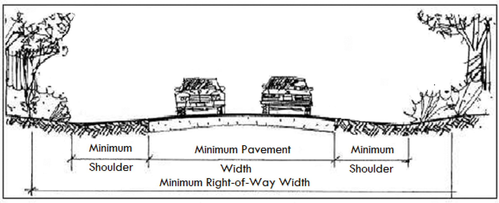
Right-of-way shall be measured from property line to property line and shall be sufficiently wide to contain the encompassing street elements of street pavement, shoulders, curbing, sidewalks and median (if provided). In addition to a street, It may contain, but is not limited to, utilities (including drainage), signs as allowed by Sec. 16-5-114, Sign Standards, landscaping, and where applicable, pathways. The street elements required vary depending on intensity of development and street order. Minimum rights-of-way shall be provided in Sec. 16-5-105.E.1, Street Standards.
(Revised 11-18-2020 - Ordinance 2020-27)
To be classified as a cul-de-sac, a street must terminate at one end with the hammerhead or cul-de-sac geometric end treatment described in 16-5-105.G and 16-5-105.H, respectively.
1.
A residential cul-de-sac shall have a minimum right-of-way radius of 65 feet and a minimum outside edge-of-pavement radius of 55 feet.
2.
A nonresidential cul-de-sac shall have a minimum right-of-way radius of 75 feet and a minimum outside edge-of-pavement radius of 65 feet.
3.
A cul-de-sac shall have a minimum width of 20 feet of unobstructed pavement.
4.
A residential cul-de-sac shall have a maximum length of 1,000 feet.
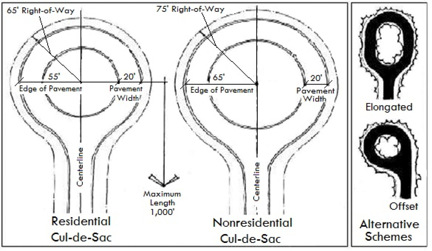
Figure 16-5-105.G: Cul-de-Sac Design
(Revised 11-18-2020 - Ordinance 2020-27)
1.
Hammerheads shall have a minimum length of 60 feet and a maximum length of 120 feet.
2.
A hammerhead shall have a minimum width of 20 feet of unobstructed pavement.
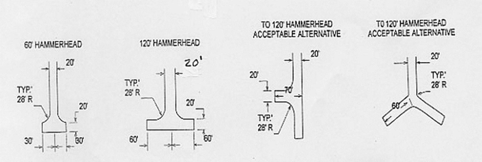
Figure 16-5-105.H: Hammerhead Design
(Revised 11-18-2020 - Ordinance 2020-27)
Street intersections shall be as nearly at right angles as practical and in no case shall be less than 75 degrees, with the angle measured at a distance of 100 feet from the centerline of the existing roadway (measured from a point of tangency if in a curve) to the centerline of the new roadway.
2. Minimum Centerline Offset of Adjacent Intersections
New intersections along one side of an existing street shall coincide with and, if practical, be directly opposite any existing intersections on the opposite side of the street. For all streets, the use of "T" intersections in subdivisions is encouraged. To avoid corner-cutting when inadequate offsets exist between adjacent intersections, offsets shall be at least 125 feet between centerlines of intersecting streets.
Intersections shall be designed with a relatively flat grade wherever practical. Maximum grade within intersections shall be five percent except within collectors and lower order streets, where the maximum grade shall be three percent.
a.
Sight triangles shall be required and shall include the area on each street corner that is bounded by the line that connects the "connecting" points located on each of the right-of-way lines of the intersecting street (see Figure 16-5-105.H.1: Sight Triangle Visual Clearance).
b.
No structure or plantings (at mature growth) exceeding 30 inches in height above the street grade shall be permitted within the sight triangle. Exceptions are permitted for trees if the lower canopy of the trees allows a clear line of sight between three feet and seven feet above the street grade and the trunks of such trees are sufficiently spaced or are so located as to be unlikely to substantially interrupt the line of sight.
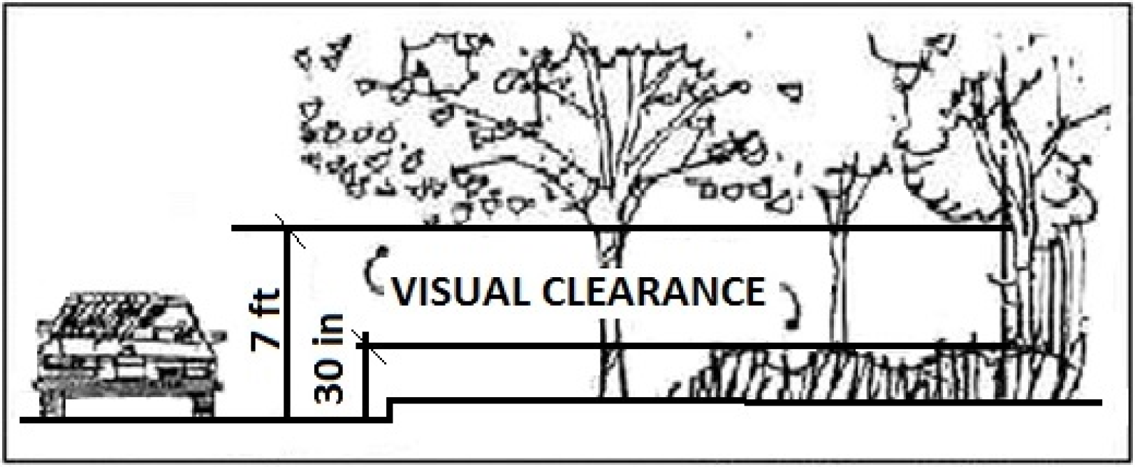
Figure 16-5-105.I.1: Sight Triangle Visual Clearance
c.
Obstruction of a sight triangle is considered a violation of this Ordinance. Clearance of an obstruction shall be enforced in accordance with Chapter 16-8: Enforcement.
d.
Sight triangles shall have the dimensions shown in Table 16-5-105.I.4, Sight Triangle Dimensions.
| TABLE 16-5-105.I.4: SIGHT TRIANGLE DIMENSIONS (FEET)1 | |||||
|---|---|---|---|---|---|
| CLASSIFICATION OF STREET "A" | CLASSIFICATION OF STREET "B" | ||||
| LANE, CUL-DE-SAC, LOCAL ACCESS | SUBCOLLECTOR | COLLECTOR | MINOR ARTERIAL | MAJOR ARTERIAL | |
| Lane, Cul-de-Sac, Local Access | 25/25 | 25/35 | 30/40 | 30/45 | 35/50 |
| Subcollector | 35/25 | 35/35 | 40/40 | 40/45 | 45/50 |
| Collector | 40/30 | 40/40 | 40/40 | 45/45 | 50/50 |
| Minor Arterial | 45/30 | 45/40 | 45/45 | 45/45 | 50/50 |
| Major Arterial | 50/35 | 50/45 | 50/50 | 50/50 | 50/50 |
| 1. The first number in each pair is the length of the sight triangle's leg along the right-of-way of street "A"; the second is the length of the leg along the right-of-way of street "B" (see Figure 16-5-105.I.2: Sight Triangle Dimensions). | |||||
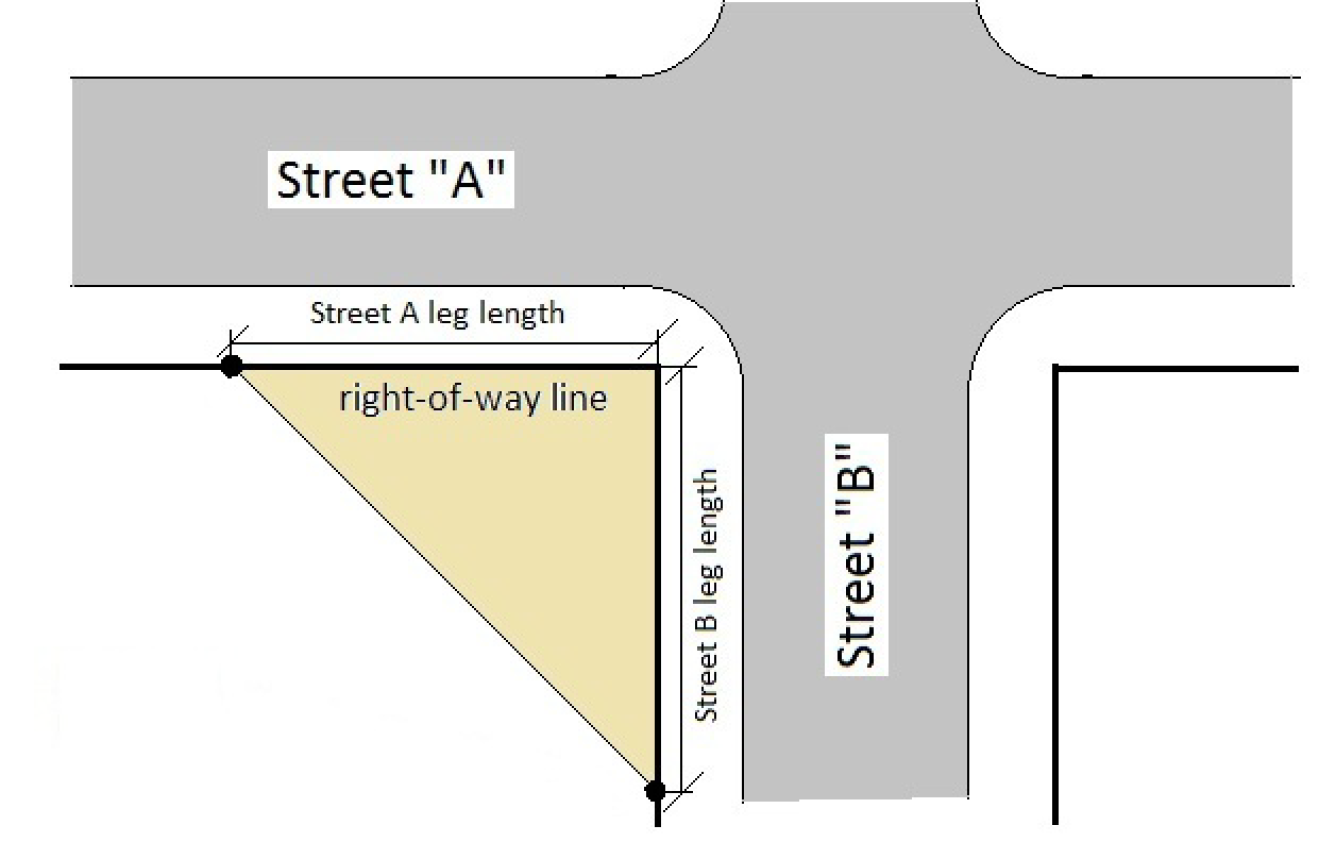 | |||||
| Figure 16-5-105.I.2: Sight Triangle Dimensions. | |||||
Curbing shall be required at the radials of intersections involving two streets of subcollector or higher order.
6. Deceleration Lane and Right Turn Lane
Whenever an arterial or collector street intersects an arterial, the street having the right-of-way shall have a full-width deceleration lane at least 150 feet long, and the yielding street shall have a full-width right-turn lane designed to allow stacking distance at least 100 feet in length. In addition, any driveway access on the street without the deceleration lane shall be a minimum of 150 feet from the intersection. In any case, where neither street is obviously dominant (due to equal order hierarchy, signalization or other similar factor), then both streets shall provide full-width deceleration or right-turn lanes, as appropriate, at least 150 feet long.
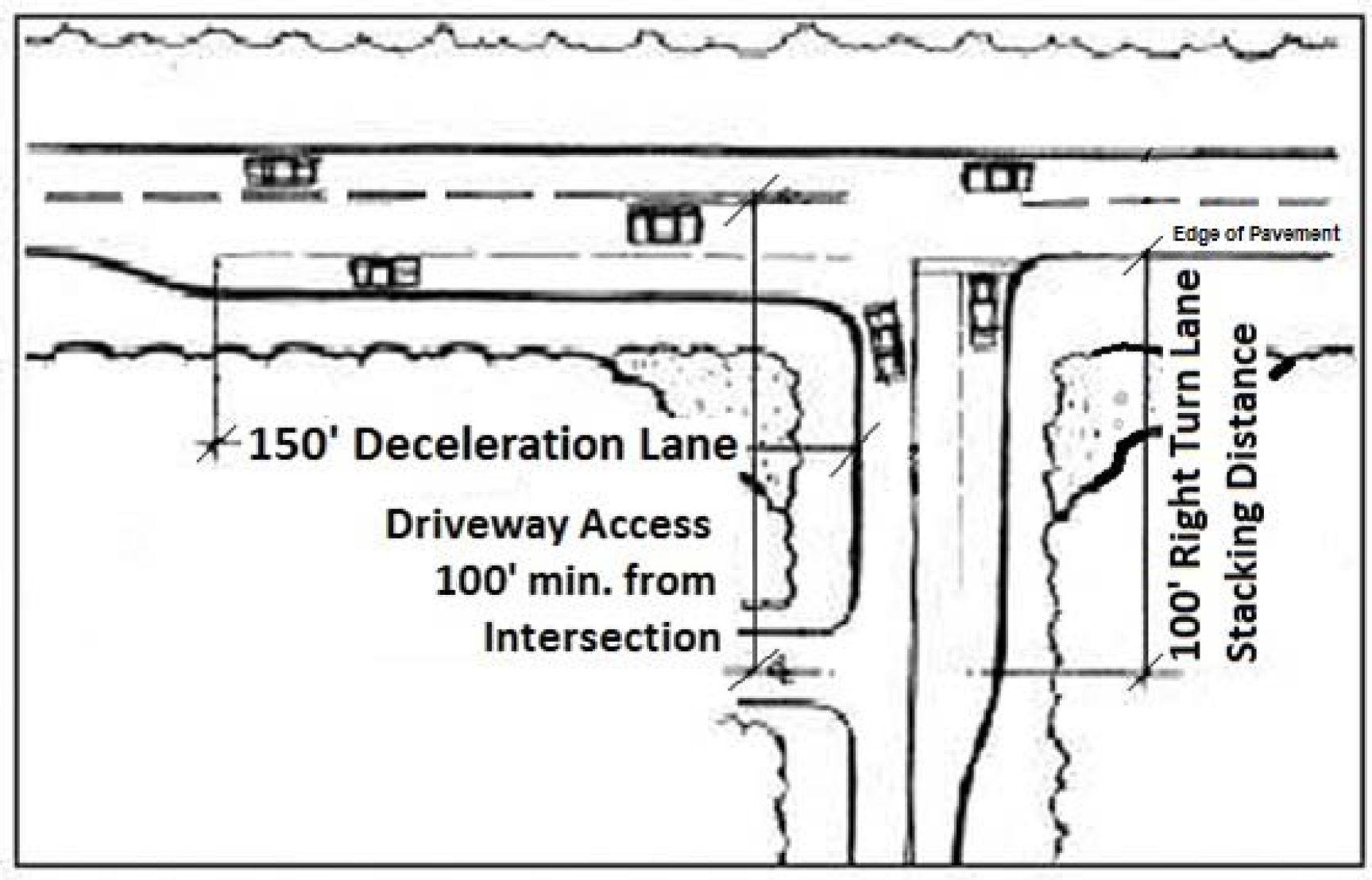
Figure 16-5-105.I.6: Deceleration Lanes
Development on major arterials shall provide a drive aisle not less than 100 feet long from the arterial, measured from edge-of-pavement to edge-of-pavement (including deceleration lanes), so as to provide adequate stacking room for vehicles entering the development. Such drive aisles shall be free of any elements that may impede vehicle travel.
(Revised 11-18-2020 - Ordinance 2020-27)
Along the same side of major arterials, no street, driveway, or other vehicular access point shall enter at a point nearer than 500 feet from the centerline of an existing or final approved street, driveway, or other vehicular access point to the centerline of the proposed vehicular access unless the lot would be rendered unusable by the strict application of this standard, in which case the access point should be optimally located.
(Revised 3-7-2023 - Ordinance 2023-04)
Along the same side of minor arterials no street, driveway, or other vehicular access point shall enter at a point nearer than 200 feet from the centerline of an existing or final approved street, driveway, or other vehicular access point to the centerline of the proposed vehicular access unless the lot would be rendered unusable by the strict application of this standard, in which case the access point should be optimally located.
(Revised 3-7-2023 - Ordinance 2023-04)
Along the same side of all other streets, no street, driveway, or other vehicular access point shall enter at a point nearer than 100 feet from the centerline of an existing or final approved street, driveway, or other vehicular access point to the centerline of the proposed vehicular access unless the lot would be rendered unusable by the strict application of this standard, in which case the access point should be optimally located—provided, however, that this minimum separation standards shall not apply to vehicular access points serving single-family dwellings in subdivisions.
(Revised 3-7-2023 - Ordinance 2023-04)
When evaluating the required minimum distance separation between vehicular access points along the same side of a street, a pair of one-way vehicular access points may be considered a single vehicular access point centered midway between the pair. The centerline-to-centerline spacing between any ingress/egress pair must be a minimum of 100 feet, unless the one-way pair is divided by a median that is 20 feet wide or less. A one-way vehicular access point shall have a width of not less than 14 feet or more than 20 feet. These vehicular access points shall attain at least one-half of the minimum distance separation from adjacent vehicular access points that would otherwise be required.
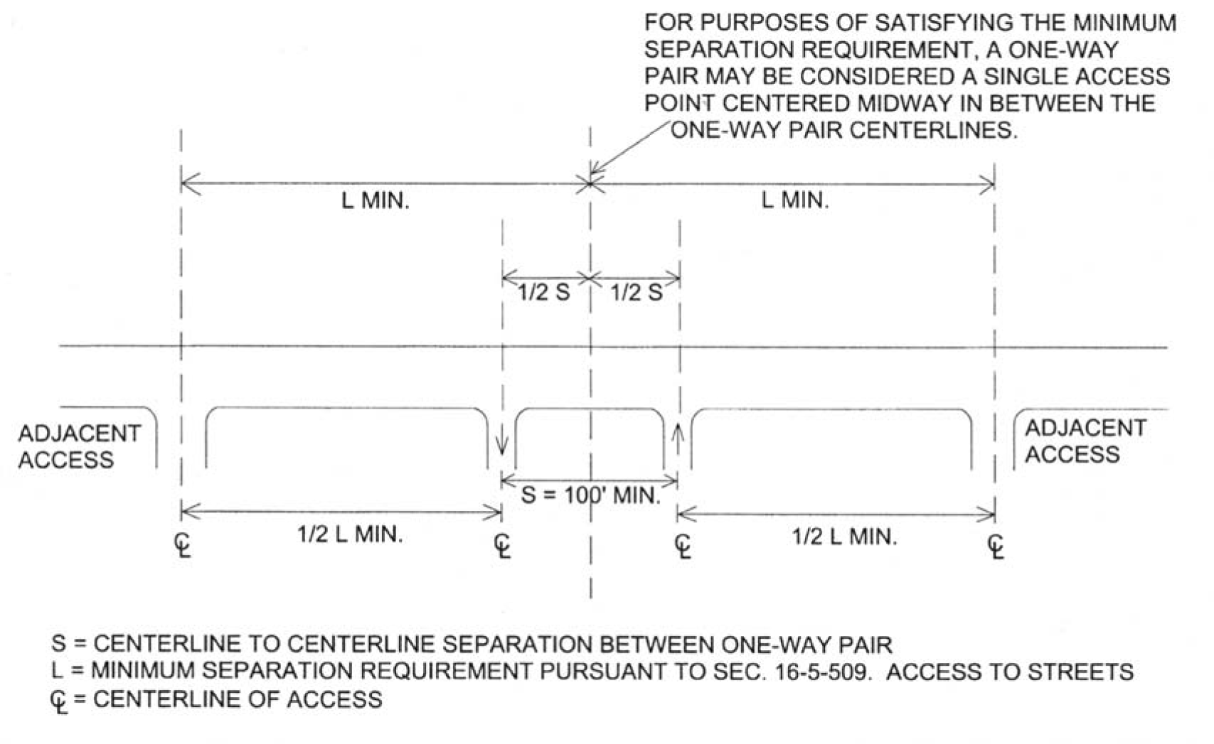 |
| Figure 16-5-105.J.4: Separation Requirements for One-Way Access Points |
New median cuts on major arterials shall be at least 1,000 feet from existing or approved median cuts and shall have left-turn deceleration lanes in each direction at the median cut.
All new multifamily and nonresidential development shall have frontage on, and direct vehicular access onto, a street meeting the standards in Section Sec. 16-5-105.E.1, Street Standards. This vehicular access requirement shall not apply to the redevelopment of an existing development site with vehicular access only on a street not meeting the standards in Sec. 16-5-105.E.1, Street Standards.
a.
The installation of gates across fire apparatus access streets shall ensure adequate emergency vehicle access. Gates shall have an approved means of emergency operation and the emergency operation shall be maintained as operational at all times.
b.
Gates shall have an unobstructed opening of not less than 14 feet in width for one-way traffic and 20 feet in width for two-way traffic.
c.
Gates shall be located at least 100 feet from any arterial or collector street, and shall comply with the stacking distance standards in Table 16-5-107.I.1, Vehicle Stacking Distance for Drive-Through and Related Uses.
(Revised 8-18-2020 - Ordinance 2020-19)
(Revised 11-18-2020 - Ordinance 2020-27; revised 3-7-2023 - Ordinance 2023-04)
The developer shall record restrictive covenants defining operation and maintenance responsibilities for private streets with the Beaufort County Register of Deeds.
(Revised 11-18-2020 - Ordinance 2020-27)
Street lighting, if provided, shall comply with the standards recommended in the latest edition of the IES Lighting Handbook published by the Illuminating Society of North America, or other comparable standards approved by the Official. All such lighting shall be hooded or directed, to the extent practical, to shield the light source from direct view from adjacent properties and streets.
(Revised 11-18-2020 - Ordinance 2020-27)
M. Traffic Signs and Street Name Signs
Traffic signs shall be provided at the developer's expense, and their design and placement shall be in accordance with the latest edition of the Manual on Uniform Traffic Control Devices.
a.
Street name signs (on private internal streets) shall be provided at the developer's expense.
b.
Two street name signs shall be provided in instances where there are differently named streets on either side of the intersection.
c.
Signs shall be reflective or installed under light standards and should be consistent, of a style appropriate to the Town, of a uniform size and color, and erected on street posts of the same height set in concrete as established by the Town Engineer.
d.
The Official may allow deviations from these standards in consideration of neighborhood character or special signage.
(Revised 11-18-2020 - Ordinance 2020-27)
Street furniture, which consists of the man-made elements of a streetscape generally associated with amenities for pedestrians, shall be placed where needed and not interfere with safe use of the pathway or roadway.
(Revised 11-18-2020 - Ordinance 2020-27)
O. Street Design and Construction Standards
Subject to the Town Engineer's approval, the following standards shall apply:
1. Shoulders, Side Slopes and Ditches
a.
All streets offered for public dedication shall have shoulders or curbs, side slopes and ditches, or alternative storm drainage systems prepared in accordance with the latest editions of the SCDOT's Standard Specifications for Highway Construction and Access and Roadside Management Standards.
b.
Shoulders shall be properly compacted and stabilized to a safe edge. Stabilized turf shoulders are not required but are recommended. If curbs are used, shoulders may not be required.
2. Paving Streets for Public Dedication
All streets offered for public dedication shall be constructed and surfaced with finished paving in accordance with the latest editions of the SCDOT's Standard Specifications for Highway Construction and Access and Roadside Management Standards.
Private streets may be constructed without finished paving, provided that the finished surface and drainage system are approved by the Town Engineer.
Bike lanes shall be designed and provided in accordance with the latest edition of the AASHTO Guide for the Development of Bicycle Facilities and S.C. Code Ann. § 56-5-3425.
(Revised 11-18-2020 - Ordinance 2020-27)
Multi-purpose pathways to accommodate both pedestrian and bicycle traffic may be provided independent of the street system. The pathway standards in this section apply only to pathways constructed generally parallel to streets within a private or public right-of-way. The following standards shall apply to multi-purpose pathways:
(Revised 5-17-2016 - Ordinance 2016-07)
1.
Pathways shall be designed and provided in accordance with the latest edition of AASHTO's Guide for the Development or Bicycle Facilities. Dimensions and construction specifications of multi-purpose paths shall be determined by the number and type of users and the location and purpose of the path.
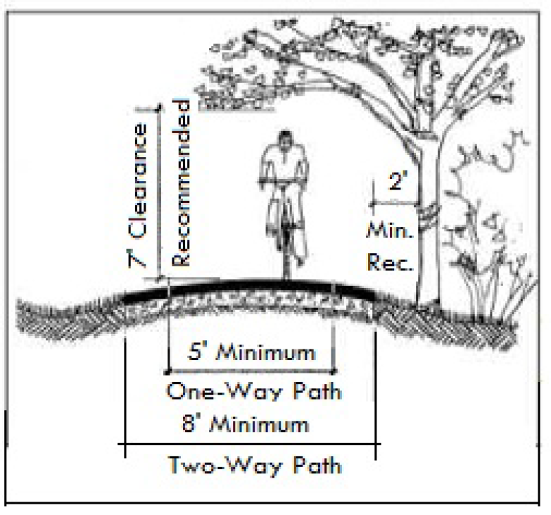
Figure 16-5-105.P.1: Pathway Dimensions
2.
A minimum eight-foot paved width shall be provided for two-way traffic and a five-foot width for one-way traffic. A five-foot sidewalk on each side of the roadway is an acceptable alternative to providing a single separated two-way pathway facility.
(Revised 5-17-2016 - Ordinance 2016-07)
3.
Choice of surface materials, including bituminous mixes, concrete, gravel, soil cement, stabilized earth, and wood planking, shall depend on use and users of the path, as approved by the Town Engineer.
4.
Gradients of bike paths should generally not exceed a grade of five percent, except for short distances. In no case, shall the gradient exceed a grade of eight percent.
5.
Any multi-purpose pathway shall be restricted as part of the site's common open space when within a major subdivision. A permanent easement for the pathway shall be dedicated or reserved and shall provide for access to the pathway to allow for its maintenance.
6.
Bicycle-safe drainage grates shall be used and properly oriented with their openings aligned perpendicular to the pathway in the construction of all multi-purpose pathways.
(Revised 11-3-2015 - Ordinance 2015-23; revised 11-18-2020 - Ordinance 2020-27))
Sec.16-5-106. - Transportation Analysis Standards
A. Purpose
The purpose of this section is to guide development in accordance with the existing and future needs of the Town in order to protect, promote and improve the public health, safety, convenience, order, prosperity and general welfare of the citizens of the Town, by ensuring new development does not overburden and overly congest streets, pathways, sidewalks, and other transportation systems in the Town.
The regulations of this section are designed and intended:
1.
To ensure that the Town'sadopted transportation service level standards are met within the Town and to provide safety from fire, panic and other dangers, to promote the public health and general welfare, to prevent the overcrowding of land, to avoid undue concentration of population, and to facilitate safe and adequate street and non-motorized facilities.
2.
To enable the Town Engineer or their designee to conduct an appropriate review and evaluation of the multimodal transportation impacts of proposed development, to provide for the imposition of conditions in order to assure that new development does not impair the safety and adequacy of impacted street and transportation facilities used by the Town's citizens, and to prescribe necessary project-specific mitigation measures or changes to the site design or operations, and establish the implementation timing and funding, as part of the plan approval.
3.
To ensure that no transportation impact analysis plan approvals are granted that would cause a reduction in the service level of any street facility that is currently operating in a manner that fails to satisfy the Town's adopted traffic service level standards.
4.
To ensure that no transportation impact analysis plan approvals are granted unless street facilities with adequate capacity to accommodate the traffic generated by the proposed development are available concurrently with the scheduled opening of the development.
5.
To establish uniform procedures for the review of applications for transportation impact analysis plan approval subject to the transportation impact analysis plan requirements set forth herein.
6.
To better coordinate the short-term growth potential of the Town with the immediately available street system capacity, taking into account exempt development and approved development that has not been built, to the extent to which these may be eligible for development plan approval without being subject to the transportation impact analysis plan requirements of this section.
7.
To better coordinate the long-term growth potential of the Town with an assessment of street capacity which is currently and which may in the future become available, recognizing the limitations on the Town's financial resources, the constraints presented by the geography of the Island, and the need to preserve the Island's sensitive natural, historic, and environmental resources.
8.
To require that Transportation Impact Analysis Plans are prepared by a licensed professional transportation engineer, and that the plan contents and modeling are consistent with national guidelines and practices published by the Institute of Transportation Engineers (ITE), the Transportation Research Board (TB), the Federal Highway Association (FHWA), the American Association of State Highway and Transportation Officials (ASHTO), the National Association of City Transportation Officials.
9.
To ensure that, in addition to measuring the impact on the roadway system, the transportation impact analysis plan measures the multimodal impacts, and mitigation measures, for non-motorized travel and transit.
10.
To establish and maintain a traffic monitoring system to regularly determine the volume of traffic of the Town's street system and the degree to which capacity limits ("thresholds") are being approached or exceeded.
All required transportation impact analysis plans shall, at a minimum, indicate compliance or non-compliance with the standards of this section.
1.
The average total delay in seconds per vehicle for each signalized intersection does not exceed 55.0 seconds during the peak hour for an average July weekday; and
2.
The volume-to-capacity (V/C) ratio for each signalized intersection does not exceed 0.90 during the peak hour for an average July weekday; and
3.
The average total day on any approach to the Sea Pines Circle does not exceed 150 seconds per vehicle during the peak hour for an average July weekday, and the average total delay on any approach to any other traffic circle or roundabout does not exceed 55.0 seconds per vehicle during the peak hour for an average July weekday; and
4.
The Level of Service (LOS) for any vehicular traffic movement does not decline by more than one level per the requirements of the Highway Capacity Manual (HCM), nor to a Level of Service of "F"; and
5.
The development causes safety issues or delays that require mitigation as determined by the Town Engineer.
(Revised 3-7-2023 - Ordinance 2023-04; revised 10-7-2025 - Ordinance 2025-18)
Sec.16-5-107. - Parking and Loading Standards
A. Purpose and Intent
The purpose of this section is to ensure provision of parking and loading facilities in proportion to the generalized parking and loading demand of the different uses allowed by this Ordinance. The standards in this section are intended to provide for adequate off-street parking and loading while allowing the flexibility needed to accommodate alternative solutions. The standards are also intended to achieve Town policies of supporting development and redevelopment and avoiding excessive paved surface areas.
1.
All development shall provide off-street parking and loading areas in accordance with the standards of this section.
2.
Any change in use of an existing development that does not involve expansion or remodeling subject to paragraph 3 below, shall comply with the standards this section as applied to the new use, to the maximum extent practicable.
3.
Except as otherwise provided in Sec. 16-7-105, Nonconforming Site Features, any expansion or remodeling of an existing use or structure that results in an increase in the number of dwelling units, square feet, rooms, seats, or other unit on which calculation of the minimum number of required parking or loading spaces is based shall provide additional off-street parking and loading spaces as required by application of the standards of this section to such increase, to the maximum extent practicable.
C. Use of Parking and Loading Areas
Off-street parking areas required by this section shall be used solely for the parking of licensed motorized vehicles in operating condition. Required parking spaces and loading berths may not be used for the display of goods for sale, or the sale, lease, storage, dismantling, or service of any vehicles, boats, motor homes, campers, mobile homes, building materials, equipment, or supplies.
1. Minimum Number of Parking Spaces
Except as otherwise expressly provided elsewhere in this Ordinance, development shall provide the minimum number of off-street parking spaces in accordance with Table 16-5-107.D.1, Minimum Number of Parking Spaces, based on the principal use(s) involved and the extent of development. Required off-street loading spaces, spaces in buildings used for auto repairs or car washes, and stacking spaces in driveways serving drive-through and related uses shall not be counted as meeting parking space requirements.
(Revised 12-5-2017 - Ordinance 2017-19; revised 8-18-2020 - Ordinance 2020-19; revised 11-4-2020 - Ordinance 2020-26; revised 7-20-2021 - Ordinance 2021-15; revised 3-7-2023 - Ordinance 2023-04)
2. Uses with Variable Parking Demand Characteristics and Unlisted Uses
For some listed uses, Table 16-5-107.D.1, Minimum Number of Parking Spaces, refers to this subparagraph because the use has widely varying parking and loading demand characteristics, making it difficult to establish a single appropriate off-street parking or loading standard. On receiving an application proposing such a use, or proposing a use not expressly listed in Table 16-5-107.D.1, Minimum Number of Parking Spaces, the Official is authorized to:
a.
Apply the minimum off-street parking space requirement specified in Table 16-5-107.D.1, Minimum Number of Parking Spaces, for the listed use that is deemed most similar to the proposed use; or
b.
Establish the minimum off-street parking space requirement by reference to standard parking resources published by the National Parking Association or the American Planning Association; or
c.
Establish the minimum off-street parking space requirement based on a parking demand study prepared by the applicant that estimates parking demand based on the recommendations of the latest edition of the Institute of Traffic Engineers (ITE) Trip Generation Manual, and that includes relevant data collected from uses or combinations of uses that are the same or comparable to the proposed use in terms of density, scale, bulk, area, type of activity, and location.
Development containing more than one principal use shall provide parking spaces in an amount equal to the total of the requirements applied to all individual principal uses. This provision shall not limit the opportunity to reduce the minimum number of required off-street parking spaces through approval of an alternative parking plan that justifies the feasibility of shared parking (see Sec. 16-5-107.H.3, Shared Parking.)
a.
If the Official determines that normal operation of a development requires that a number of vehicles be stored on site at any one time—including, but not limited to, taxicab service, auto rental, auto sales, towing service, and tractor or truck rental—a sufficient number of spaces or a sufficient area for vehicle storage shall be provided.
b.
No area allocated to fleet vehicle storage may be used to satisfy the area requirements for off-street parking, nor shall any portion of any off-street parking area be used to satisfy the area requirements for fleet vehicle storage.
5. Maximum Number of Off-Street Parking Spaces
The number of off-street parking spaces shall not exceed 120 percent of the minimum number required for any eating establishment use, or 105 percent of the minimum number required for any other use, except as may be allowed through approval of an alternative parking plan in accordance with Sec. 16-5-107.H.2, Provision over Maximum Allowed. Any parking spaces allowed above the maximum in accordance with this section shall be pervious.
6. Accessible Parking Spaces for Physically Disabled Persons
In each off-street parking area, a portion of the total number of off-street parking spaces shall be spaces specifically designated, located, and reserved for use by persons with physical disabilities ("accessible parking spaces"), in accordance with the standards of the latest adopted edition of the IBC and the Americans with Disabilities Act (ADA), as amended.
Up to 20 percent of the required number of off-street parking spaces may be designed as parallel parking spaces.
Up to 20 percent of the required number of off-street parking spaces may be designed and designated as compact parking spaces. Compact parking spaces shall be grouped where possible and located where they can be readily identified by compact vehicle drivers, and designated by signage or pavement marking incorporating the word "COMPACT" with letters at least 12 inches high.
9. Temporary Parking for Passenger Drop-Off and Pick-Up
Uses that involve the frequent stopping of vehicles (including taxis, limousines, vans, and passenger vehicles) to drop-off or pick-up passengers (e.g., schools, recreation/entertainment facilities, hotels)—and especially nightclubs, bars, or eating establishments that serve alcohol—are encouraged to supplement required parking with a designated area for temporary parking and the dropping off or picking up of passengers. Such spaces shall comply with parking space dimension standards.
(Revised 3-7-2023 - Ordinance 2023-04)
10. Use of Parking Spaces as Electric Vehicle (EV) Charging Station
All multifamily and nonresidential development shall provide one electric vehicle (EV) charging station per site. If the development requires over 100 parking spaces, the electric vehicle (EV) charging station shall have a sign that states that only electric vehicles being charged can park in that particular parking space. If the square footage of an existing building on a site is being increased by more than 50% then the applicant will be required to provide an EV charging station on site.
(Revised 5-17-2016 - Ordinance 2016-07; revised 12-5-2017 - Ordinance 2017-19)
E. Parking Space and Aisle Dimensions
The size of a parking space for one vehicle shall encompass a rectangular area having dimensions of not less than those shown in Table 16-5-107.E.1, Minimum Parking Space Dimensions, for the type and location of parking space.
2. Parking Bay Drive Aisle Width
a.
All parking bay drive aisles shall be at least 18 feet wide and no more than 22 feet wide where serving parking spaces at a 60 degree angle, and shall be at least 24 feet wide and no more than 30 feet wide if serving parking spaces at a 90 degree angle.
b.
The Official may require a wider drive aisle on determining that it is needed to facilitate the types of vehicles expected to use the drive aisles, or similar traffic demand requirements of the specific development.
c.
Parking bay drive aisles serving parking spaces placed at an angle of less than 90 degrees to the aisle shall be one-way unless the angle is placed so as to accommodate the direction of travel for each side of a two-way aisle.
d.
Width requirements for drive aisles that do not service parking are the same as outlined for driveways in Sec. 16-5-105.A.5.e.ii, Driveway Width.
e.
Parking spaces under buildings, where it is not feasible to provide a landscaped median on the end of a parking bay, shall be separated from adjoining parallel drive aisles by a painted area that is a minimum of four feet in width.
a.
Off-street parking areas shall be arranged for convenient vehicular access between an adjacent street and all parking spaces to facilitate ease of mobility, ample clearance, and safety of vehicles and pedestrians. Each off-street parking space shall have adequate and unobstructed means for the ingress and egress of vehicles.
b.
Except for parking areas serving single-family dwellings, off-street parking areas shall be arranged so a vehicle may be parked or unparked (including backing out of parking spaces) without having to encroach onto a public street, multi-purpose pathway, or sidewalk.
a.
Each required off-street parking area and space shall be identified by surface markings arranged to provide for orderly and safe parking of vehicles. Such markings shall be maintained so as to be readily visible at all times.
b.
Spaces in parking areas with concrete and asphalt surfacing shall be marked by durable painted white lines except where accessibility requirements require that spaces be delineated in blue.
c.
Spaces in gravel parking lots shall be delineated at the end of the space by an individual block, railroad tie, or timber.
d.
Parking spaces on lock pavers may be marked by contrasting color of pavers or by durable painted white lines. (Painted yellow lines are reserved for marking no parking areas.)
a.
Permanently anchored wheel stops shall be provided at the end of all parking spaces that abut a sidewalk or walkway or are not bounded by curbing.
b.
The vehicle side of the wheel stop shall be no less than 18 inches from the end of the parking space.
(Revised 12-5-2017 - Ordinance 2017-19)
G. Landscaping of Parking Lots
The standards in this subsection are intended to mitigate the environmental and any visual impacts associated with a parking lot (including heat island effects, pollution, noise, and glare), and help manage stormwater runoff.
Except for parking areas located within or under structures, development shall provide and maintain landscaped medians within the interior of parking lots in accordance with the standards in this subsection. Interior planting medians may be used for stormwater management purposes as long as they are designed as site amenities and comply with these parking lot landscaping standards.
3. Configuration and Landscaping
a.
Landscaped medians shall be provided:
i.
To separate parking bays from each other;
ii.
At the ends of each parking bay;
iii.
Between a parking bay and an adjacent property line; and
iv.
To separate parking spaces along a row of parking containing more than 15 parking spaces into groups of no more than ten spaces.
b.
Landscaped medians shall be at least 12 feet wide except those at the ends of a parking bay, which shall be at least 15 feet wide, and those between a parking bay and adjacent property line, which shall be at least six feet wide.
c.
Each landscaped median shall contain at least one overstory tree per 50 linear feet of median length, with the remainder of the median not used for pedestrian walkways or bicycle parking landscaped with trees, shrubs, or groundcover, and material such as mulch. Understory trees may be substituted for overstory trees in areas underneath overhead utilities or exterior lighting fixtures.
d.
Landscaped medians and required overstory trees shall be distributed and sited so as to maximize shading of pavement and pedestrian routes through the parking area.
e.
Existing trees and native understory vegetation shall be retained where possible. The Official may allow modification of the above standards as necessary to do so.
H. Off-Street Parking Alternatives
1. General; Alternative Parking Plan
The Official is authorized to approve an alternative parking plan that proposes alternatives to providing the minimum or maximum number of off-street parking spaces required by this section, in accordance with the standards listed below. The alternative parking plan shall be submitted with an application for Development Plan Review (Sec. 16-2-103.G), Small Residential Development Review (Sec. 16-2-103.H), or Corridor Review (Sec. 16-2-103.I), as appropriate.
2. Provision over Maximum Allowed
An alternative parking plan may propose to exceed the maximum number of off-street parking spaces allowed by Sec. 16-5-107.D.5, Maximum Number of Off-Street Parking Spaces, in accordance with the following standards:
The alternative parking plan shall include a parking demand study demonstrating how the maximum number of parking spaces allowed by Sec. 16-5-107.D.5, Maximum Number of Off-Street Parking Spaces, is insufficient for the proposed development.
An alternative parking plan may propose to meet a portion of the required minimum number of off-street parking spaces with shared parking in accordance with the following standards:
Up to 50 percent of the number of parking spaces required for a use may be used to satisfy the number of parking spaces required for other uses, provided the uses generate parking demands during different times of the day or different days of the week.
b. Location and Pedestrian Access
i.
Shared parking spaces other than those serving development in the CR District shall be located no more than 500 feet walking distance from the primary pedestrian entrance(s) to the uses served by the parking, as measured along sidewalks or other pedestrian accessways connecting the shared spaces and such entrance(s).
ii.
Adequate and safe pedestrian access shall be provided between the shared parking spaces and the primary pedestrian entrances to the uses served by the parking.
iii.
Shared parking spaces shall not be separated from the use they serve by an arterial street unless pedestrian access across the arterial street is provided by a grade-separated pedestrian walkway or appropriate traffic controls (e.g., signalized crosswalk).
The alternative parking plan shall include justification of the feasibility of shared parking among the proposed uses. Such justification shall address, at a minimum, the size and type of the uses proposed to share off-street parking spaces, the composition of their tenants, the types and hours of their operations, the anticipated peak parking and traffic demands they generate, and the anticipated rate of turnover in parking space use.
i.
An approved shared parking arrangement shall be enforced through written agreement among all the owners of lands containing the uses proposed to share off-street parking spaces.
ii.
The agreement shall provide all parties the right to joint use of the shared parking area for as long the shared parking spaces are needed to comply with this Ordinance, and shall be binding on subsequent owners.
iii.
The agreement shall be submitted to the Official for review and approval before execution.
iv.
A Certified True Copy of an approved agreement that has been recorded in the Beaufort County Register of Deeds shall be delivered to the Official before issuance of a Building Permit or Certificate of Occupancy for any use to be served by the shared parking area.
v.
Any termination of the shared parking agreement does not negate the parties' obligations to comply with parking requirements and thus shall constitute a violation of this Ordinance. No use served by the shared parking may be continued if the shared parking becomes unavailable to the use unless substitute off-street parking spaces are provided in accordance with this section.
An alternative parking plan may propose to meet a portion of the required minimum number of off-street parking spaces with off-site parking in accordance with the following standards.
Off-site parking may be used to satisfy up to 100 percent of the number of parking spaces required for a use in the CR District. Off-site parking may be used to satisfy up to 50 percent of the number of parking spaces required for a use in any other district.
The zoning district classification of the off-site parking area shall be one that allows the use served by off-site parking (and thus off-street parking accessory to such use).
c. Location and Pedestrian Access
i.
Off-site parking spaces other than those serving development in the CR District shall be located no more than 500 feet walking distance from the pedestrian entrance(s) to the uses served by the parking, as measured along sidewalks or other pedestrian accessways connecting the shared spaces and such entrance(s).
ii.
Adequate and safe pedestrian access shall be provided between the off-site parking spaces and the primary pedestrian entrances to the uses served by the parking.
iii.
Off-site parking spaces shall not be separated from the use they serve by an arterial street unless pedestrian access across the arterial street is provided by a grade-separated pedestrian walkway or appropriate traffic controls (e.g., signalized crosswalk).
i.
If land containing the off-site parking area is not under the same ownership as land containing the principal use served, the off-site parking arrangement shall be established in a written agreement between the owners or long-term lessees of land containing the off-site parking area and land containing the served use.
ii.
The agreement shall provide the owner of the served use the right to use the off-site parking area for as long the shared parking spaces are needed to comply with this Ordinance, and shall be binding on subsequent owners or long-term lessees.
iii.
The agreement shall be submitted to the Official for review and approval before execution.
iv.
An attested copy of an approved and executed agreement shall be recorded with the Beaufort County Register of Deeds before issuance of a Building Permit or Certificate of Occupancy for any use to be served by the off-site parking area.
v.
Any termination of an off-site parking agreement or transfer of land containing the off-site parking area does not negate the developer's obligation to comply with parking requirements and thus shall constitute a violation of this Ordinance. No use served by the off-site parking may be continued if the off-site parking becomes unavailable unless substitute off-street parking spaces are provided in accordance with this section and this Ordinance.
An alternative parking plan may propose to defer construction of up to 20 percent of the required minimum number of off-street parking spaces, in accordance with the following standards:
The alternative parking plan shall include an assessment demonstrating that because of the location, nature, or mix of uses, there is a reasonable probability the number of parking spaces actually needed to serve the development is less than the minimum required by the Minimum Number of Parking Spaces table in Sec. 16-5-107.D.1.
The alternative parking plan shall include a reserve parking plan identifying the amount of off-street parking being deferred and the location of the area to be reserved for future parking, if future parking is needed.
i.
The alternative parking plan shall provide assurance that within 18 months after the initial Certificate of Occupancy is issued for the proposed development, an off-street parking demand study evaluating the adequacy of the existing parking spaces in meeting the off-street parking demand generated by the development will be submitted to the Official.
ii.
If the Official determines that the study indicates the existing parking is adequate, then construction of the remaining number of parking spaces shall not be required and the areas reserved for future parking shall no longer be so reserved. If the Official determines that the study indicates additional parking is needed, such parking shall be provided consistent with the reserve parking plan and the standards of this section.
d. Maintenance of Reserve Areas as Common Open Space
As long as areas are reserved for future parking, they shall be maintained as common open space, without any clearing of trees. During such time, the reserve areas shall not count as common open space for purposes of complying with Sec. 16-5-104, Common Open Space Standards, and shall count as impervious surface for purposes of complying with Sec. 16-5-109, Stormwater Management and Erosion and Sedimentation Control Standards.
i.
A deferred parking agreement shall be included as part of any development approval which includes deferred parking. The agreement shall incorporate by reference the deferred parking plan and agreement by the owner to reserve a future parking area as common open space consistent with the deferred parking plan, and assurances that a parking demand study will be completed in accordance with the terms of the development approval and this section, and additional parking provided, if determined necessary.
ii.
An attested copy of an approved and executed agreement shall be recorded with the Beaufort County Register of Deeds before issuance of a Building Permit or Certificate of Occupancy for any use subject to deferred parking.
iii.
Any termination of a deferred parking agreement does not negate the developer's and owner's obligation to comply with parking requirements of this Ordinance. Failure to comply shall constitute a violation.
(Revised 8-19-2025 - Ordinance 2025-16)
An alternative parking plan may propose to meet a portion of the required minimum number of off-street parking spaces with on-street parking spaces, in accordance with the following standards:
a.
On-street parking may be used to satisfy up to 100 percent of the number of parking spaces required for a use in the CR District.
b.
The on-street parking spaces shall be located along the development site's street frontage or no more than 150 feet walking distance from the primary entrance(s) of the proposed use, as measured along sidewalks or other pedestrian accessways connecting the on-street spaces and such entrance(s).
c.
The on-street parking spaces are not counted towards meeting the off-street parking requirement for any other development; and
d.
There is no negative impact to existing or planned traffic circulation patterns.
a.
Allmultifamily and nonresidential development shall provide bike racks sufficient to accommodate the parking of at least four bicycles for every ten vehicle parking spaces required, or major fraction thereof except that once twenty bicycle parking spaces are provided, any required bicycle parking after that shall be required at a ratio of two bicycle parking spaces for every ten vehicle parking spaces, or major fraction, thereof. An applicant may use developer submitted data to demonstrate fewer bicycle parking spaces should be required. If a lower number of bicycle parking spaces is accepted, the applicant shall submit a site plan that includes a reserve parking plan identifying the amount of bicycle parking spaces being deferred and the location of the area to be reserved for future bicycle parking, if future bicycle parking is needed. If the proposed project does not reasonably connect to a Town multi-purpose pathway, then the required bicycle parking spaces can be reduced.
(Revised 5-17-2016 - Ordinance 2016-07)
b.
The bike racks shall be located in visible, well-lit areas and shall be in an area maintained with an all weather surface. They shall be located where they do not interfere with pedestrian traffic and are protected from conflicts with vehicular traffic.
(Revised 5-17-2016 - Ordinance 2016-07)
c.
The required minimum number of vehicular parking spaces shall be reduced by one space for every ten bicycle parking spaces provided.
d.
If the square footage of an existing building on a site is being increased by more than 50% then the applicant will be required to meet the bicycle parking standards.
(Revised 12-5-2017 - Ordinance 2017-19)
a. Minimum Number of Off-Street Loading Spaces
i.
Any development involving the routine vehicular delivery or shipping of goods, supplies, or equipment to or from the development shall provide a sufficient number of off-street loading spaces to accommodate the delivery and shipping operations of the development's uses in a safe and convenient manner.
ii.
Table 16-5-107.H.8, Minimum Number of Off-Street Loading Spaces, sets forth the minimum number of loading spaces that presumptively satisfies the loading area requirement in provision i above for the listed principal uses. For proposed uses not listed in Table 16-5-107.H.8, the requirement for a use most similar to the proposed use shall apply.
iii.
The Official may require more loading spaces or fewer loading spaces than indicated by Table 16-5-107.H.8 on determining that the characteristics of the particular development warrant such addition or reduction and the general standard is met. Such a determination may be based on information submitted by an applicant for development approval or by documented analyses or case studies.
iv.
Where a change of use not involving the enlargement of a structure is proposed on a lot with insufficient area to practically accommodate an off-street loading area, the developer need only comply with these loading area standards to the maximum extent practicable.
v.
No area used to comply with loading area standards may be used to comply with the parking standards, nor shall any area used to comply with parking standards be used to comply with loading area standards.
b. Dimensional Standards for Loading Areas
i.
Each loading space shall be of sufficient size to accommodate the types of delivery/shipping vehicles likely to use the loading area.
ii.
A loading space that presumptively satisfies the needs of delivery/shipping vehicles shall be at least 12 feet wide and 40 feet long, and shall have at least 14 feet of vertical clearance. The Official may require larger or smaller loading spaces or lesser or greater vertical clearance on determining that the characteristics of the particular development warrant such a variation and the general standard in subparagraph a above is met.
c. Location and Design of Loading Areas
i.
Where possible, loading areas shall be located to the rear of the building(s) they serve.
ii.
The loading area shall be located adjacent to the building's loading doors, in an area that promotes its practical use.
iii.
The loading area shall be located and designed so vehicles using them can maneuver safely and conveniently to it from a public street and complete loading without obstructing or interfering with any public right-of-way or any parking space or parking lot drive aisle—provided, however, that a loading area may overlie a drive aisle if it is included as a condition of approval and the applicant provides a recorded memorandum of agreement that loading will not occur during normal business hours.
I. Vehicle Stacking Distance for Drive-Through and Related Uses
Driveways on which vehicles queue up to access a drive-through facility or similar service facility, or a drop-off or pick-up zone, shall provide at least the minimum stacking distance behind the facility or zone in accordance with Table 16-5-107.I.1, Minimum Stacking Distance for Drive-Through and Related Uses.
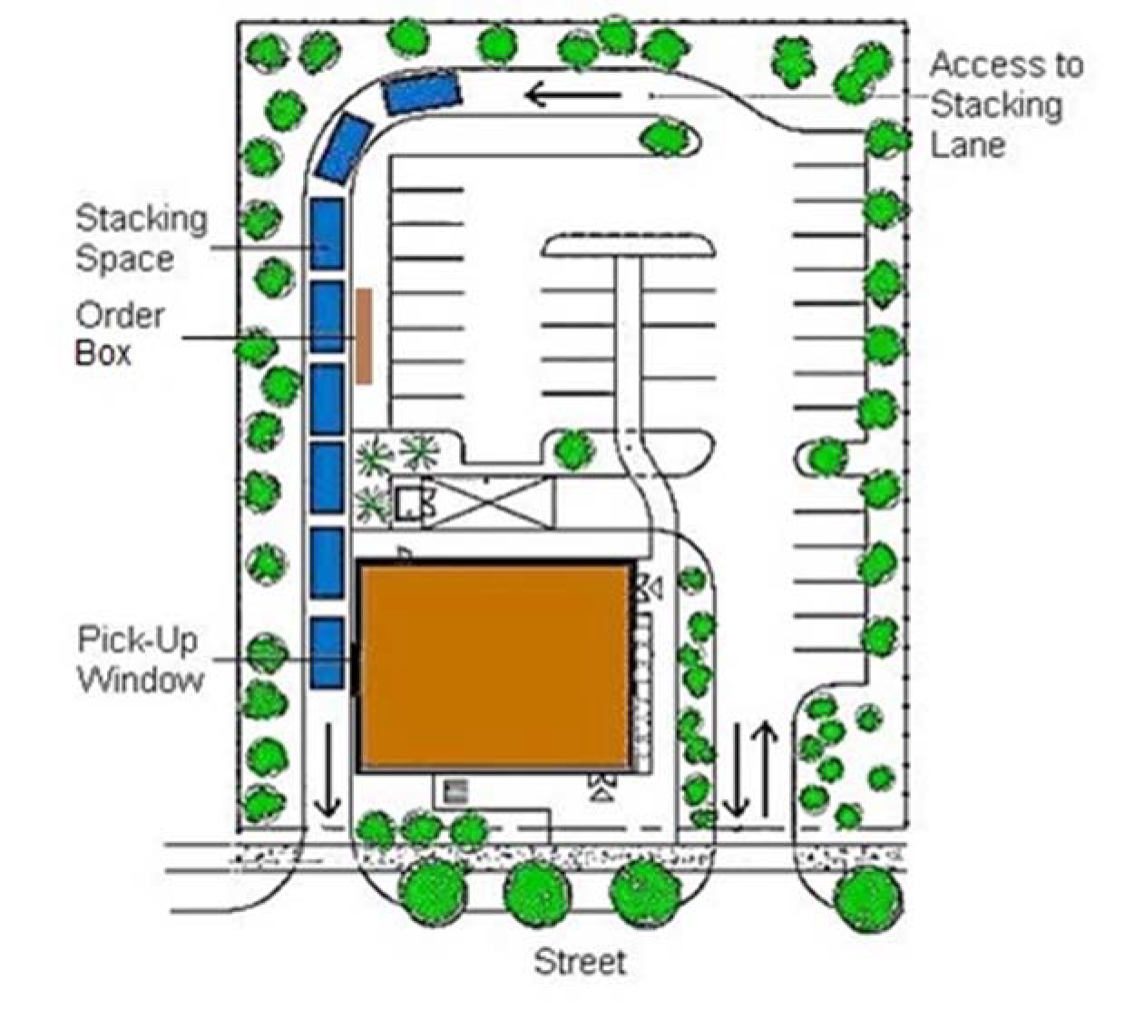 |
| Figure 16-5-107.I.1.: Stacking Distance for a Drive-Through Restaurant |
(Revised 4-18-2017 - Ordinance 2017-05)
a. The minimum clear width for any drive-through aisle shall be ten feet.
b. Driveways providing required stacking distance shall be designed so as not to impede onsite or offsite vehicular traffic movements into or out of off-street parking spaces, or onsite or offsite bicycle or pedestrian traffic movements.
c. Driveways providing required stacking distance may be required to be separated from other internal driveways if deemed necessary for traffic movement and safety by the Official.
Sec.16-5-108. - Site Lighting Standards
A. Purpose and Intent
The purpose of this section is to regulate exterior site lighting to ensure the safety of motorists, bicyclists, and pedestrians, and minimize adverse impacts on adjacent lands. The regulations in this section are intended to ensure that all exterior site lighting is designed and installed to maintain adequate lighting levels on a site while limiting excessive lighting impacts on adjacent lands, streets, and paths.
The standards in this section shall apply to all development in the Town unless expressly exempted elsewhere in this Ordinance.
C. General Exterior Lighting Standards
The light source shall be completely concealed within an opaque housing and shall not be visible from any street right-of-way.
Only LED, incandescent, florescent, metal halide, or color corrected high-pressure sodium may be used. The same type must be used for the same or similar types of lighting on any one development site or Planned Unit Development district.
D. Exterior Lighting Illumination Levels
1.
All exterior site lighting facilities shall be designed and located so that the level of illumination measured in foot-candles (fc) at ground level at any one point complies with the standards set forth in Table 16-5-108.D, Exterior Lighting Illumination Levels.
2.
Exterior site lighting facilities not identified in Table 16-5-108.D, Exterior Lighting Illumination Levels, are not required to comply with these illumination standards.
(Ord. No. 2015-23, 11-3-2015)
Sec.16-5-109. - Stormwater Management and Erosion and Sedimentation Control Standards
A. Purpose
The purpose of the standards in this section is to ensure that developments incorporate best management practices to minimize and manage stormwater runoff so as to control flooding, protect the quality of the ground and surface waters within and surrounding the Town, and minimize erosion and sedimentation. Specifically, this section is intended to supplement the State's stormwater management program and standards with additional standards that ensure control of the volume and flow of stormwater runoff, limit pollutants in stormwater runoff, provide opportunities for the filtering and settling of pollutants from runoff before it enters the ground water and surface waters, and minimize erosion and sedimentation from stormwater runoff.
This section applies to all land disturbing activity that disturbs ½ acre or greater of land and all development that is within ½ mile of coastal receiving waters, regardless of disturbed area. Additionally, this section applies to any project or activity that is part of a Larger Common Plan, regardless of size. Exceptions to these requirements are listed in subsection 2. below.
The following activities are exempt from the standards in this section:
a.
Development exempt from Development Plan Review in accordance with Sec. 16-2-103.G.3, Exemptions, with the exception of public street or minor utility construction;
b.
The establishment of, or additions or modifications to, a single-family dwelling or its accessory structure, provided that such development shall be subject to all standards in Sec. 16-5-109.I, Erosion and Sedimentation Control, except the requirement to submit an erosion control plan (Such development is also subject to the flood damage control standards in Chapter 9 of Title 15 of the Municipal Code, and must conform to the grading scheme and finished floor elevation established by the approved Development Plan.);
c.
Maintenance and repair of public streets, pathways, storm drainage, or similar public infrastructure subject to government maintenance;
d.
New or existing agricultural activity (as defined in Sec. 16-10-105, General Definitions) not involving the filling or drainage of land; and
e.
Emergency work by agencies or property owners required to address flooding conditions, provided:
i.
Such work is verbally approved by the Official or other duly appointed official in charge of emergency preparedness or emergency relief if practicable (property owners performing emergency work will be responsible for any damage or injury to persons or property caused by their unauthorized actions);
ii.
The Official or other duly appointed official who verbally approved the action delivers written notice of the action to the landowner and any affected agency at the earliest possible time; and
iii.
Property owners performing emergency work restore the site of the emergency work within 60 days following the end of the emergency period.
(Revised 6-6-2017 - Ordinance 2017-08)
C. General Standards for Stormwater Management
1. Compliance with State and Federal Stormwater Management Standards
All development shall comply with the stormwater management standards of the South Carolina Department of Health and Environment Control (DHEC) and any applicable federal stormwater standards and permits (e.g., NPDES permits), unless such standards are waived by the appropriate State or federal agency.
2. Compliance with Maximum Impervious Cover Standards
All development shall comply with the maximum impervious cover standards applicable to the zoning district in which the development is located (see Chapter 16-3: Zoning Districts). (See definition of impervious surface in Sec. 16-10-105, General Definitions.)
3. Compliance with OCRM Critical Area Permitting Requirements
For development adjacent to the OCRM Critical Line, all stormwater management facilities located in the critical areas shall obtain a permit from the South Carolina Office of Ocean and Coastal Resource Management (OCRM) prior to installation.
4. No Increased Flood Potential
Development shall not appreciably increase the flood potential within the development, on adjacent or surrounding lands, or on tidal or freshwater wetlands, as determined by the Town Engineer.
5. No High-Maintenance Facilities
Development shall not incorporate structures and facilities that the Town Engineer determines will demand considerable maintenance.
6. Discharges onto Beaches and into Wetlands and Water Bodies
a.
No stormwater discharge shall be permitted onto beaches.
b.
No direct stormwater discharge shall be permitted into tidal or freshwater wetlands unless approved by the Town Engineer.
c.
Discharging stormwater runoff directly into water bodies from impervious areas shall not be allowed unless methods are provided to filter the runoff to the maximum extent practicable. Such methods include filtering runoff through sheet flow, grass swales, drywells, infiltration ditches, gravel, sand, or other filter mediums before the runoff leaves the site or enters any natural or shared-in-common manmade water body.
Dredging, clearing, deepening, widening, straightening, stabilizing, or otherwise altering water bodies may be permitted by the Town Engineer only when a positive benefit can be demonstrated. Such approval does not obviate the need for other applicable Town, State, or federal agency approvals.
8. Water Surface Elevation Alteration and Adjustment
a.
No development shall construct, establish, maintain, or permanently alter the surface water elevation of any water body or wetland so as to adversely affect the natural drainage from any upstream areas, or to any downstream areas, of the drainage basin.
b.
The water surface elevations proposed for lagoons or water bodies are subject to approval by the Town Engineer as part of the development review process. The applicant shall submit sufficient ground water, topographic elevation data, and hydrologic data on or around the proposed water body site to assist in establishing the water surface elevation.
The standards and design guidelines as set forth in the latest editions of the Beaufort County Manual for Storm Water Best Management and Design Practices, the South Carolina DHEC's Stormwater Management BMP Handbook, and the Georgia Coastal Stormwater Supplement shall serve as guides to technical specifications for the design and construction of various types of stormwater management facilities (including, but not limited to, structural and nonstructural stormwater best management practices (BMPs) and maintenance standards).
A pre-design conference with the Town Engineer or his or her designee is suggested for small projects not affecting major drainage ways or environmentally sensitive areas, and is required for all Subdivision Review and Development Plan Review applications.
11. Professional Engineer or Surveyor
All surveys, plans, specifications, and reports shall be prepared and certified by the appropriate professional engineer or professional surveyor registered in South Carolina, in accordance with the current South Carolina Code of Laws, Title 40-Professions and Occupations, Chapter 22, Engineers and Surveyors.
i.
The two accepted hydrological methodologies for computing surface runoff are the rational method and the USDA NRCS TR-55 method. Other methods approved by the Town Engineer are allowable.
ii.
The rational method may be used only for sizing individual culverts or storm drains that are not part of a pipe network or system and have a contributing drainage area of 20 acres or less.
iii.
The USDA NRCS TR-55 method or other approved methodology may be used for sites of any size.
iv.
Proposed development design shall consider the hydrological features within the total watershed, including the development site, upstream and downstream areas.
The site area incorporated in stormwater management design shall be the total area of proposed development, including any noncontiguous lands that are part of a Planned Development, which is owned in fee simple by the landowner/developer of the Planned Development, or is included in perpetual cross easements for drainage purposes.
The design storm, to be used in the design of all drainage systems and permanent stormwater management facilities, is the 25-year frequency/24-hour/8.4-Inch rainfall and Antecedent Moisture Condition II (AMC II).
2. Pre-Development Peak Discharge Rates
a.
All development shall incorporate stormwater management facilities sufficient to ensure that for the design storm and Type III rainfall distribution, the post-development peak discharge rate across adjacent property lines will not exceed the pre-development peak discharge rate. In the case of redevelopment, the pre-development condition shall be defined as the existing state at the time of development application.
b.
Stormwater best management practices (BMPs) shall be used to retain and detain the increased and accelerated runoff that the development generates.
c.
The peak discharge requirement is not required upon the Town Engineer determining that the applicant has demonstrated that:
i.
A suitable means of flow into a downstream tidal discharge point is accessible by means of recorded permanent storm drainage easements, through drainage infrastructure that will adequately convey the peak discharge from the 100-year storm without any adverse impacts on downstream properties; or
ii.
The development includes a drainage system with adequate capacity to carry site flows to an ultimate downstream tidal discharge point.
(Revised 3-7-2023 - Ordinance 2023-04)
3. On-Site Retention of First Inch of Runoff
a.
All development shall provide for on-site retention (dry or wet) or percolation of a minimum of one inch of runoff from on-site impervious surfaces. Major drainage canals may not be used for retention where doing so may adversely impact the storm hydrology upstream or downstream.
b.
The one inch of runoff from all such impervious surfaces shall be dissipated by percolation into the soil, evaporation, or other methods of treatment or handling acceptable to the Town Engineer.
c.
Where on-site retention of runoff is also required by OCRM standards, evidence of OCRM approval of the on-site retention shall be submitted to the Town Engineer.
4. On-Site Detention or Percolation of Runoff
a.
All development shall provide for on-site detention (dry or wet) or percolation of stormwater runoff that is sufficient to maintain the same peak discharge rate as occurred pre-development. Major drainage canals may not be used for detention where doing so may adversely impact the storm hydrology upstream or downstream.
b.
Off-site detention (dry or wet) or percolation areas may be used, provided:
i.
The Town Engineer determines that such improvements are in the common good and are of satisfactory design to cause no hardship to others utilizing the same drainageway, whether on-site or upstream or downstream;
ii.
A recorded, permanent drainage easement is provided that complies with this section and Sec. 16-5-109.G, Drainage Easements, and benefits the land described in the application for development permit;
iii.
Adequate maintenance of the areas is provided for in accordance with Sec. 16-5-109.H.1, Ownership and Maintenance Responsibility; and
iv.
The developer bears the total cost of the areas and their detention or percolation facilities.
5. Design of Detention and Retention Facilities
a.
Detention and retention facilities shall be designed to provide at least one-half foot of freeboard or vertical detention storage volume for runoff above the design storm peak elevation.
b.
Detention and retention facilities shall be designed for ten-year sediment loads before the one-half foot storage volume required in subparagraph a above is included. Sediment storage may be accommodated below the dry weather water level design, as long as an adequate permanent pool depth is maintained.
c.
Detention and retention facilities shall be designed with relatively flat side slopes (maximum horizontal to vertical ratio of 3:1) along the shoreline.
d.
Where possible, detention and retention facilities shall be designed with meandering shorelines to increase the length of shoreline, thus offering more space for the growth of littoral vegetation for pollution control purposes.
e.
Where cleared site conditions exist around detention or retention areas, the banks shall be sloped to the proposed dry weather water surface elevation and planted for stabilization purposes. Where slopes are not practical or desired, other methods of bank stabilization will be used and noted on plans submitted for approval.
A developer shall provide adequate outfall ditches, pipes, and easements downstream from a proposed discharge if public or private facilities adequate to carry the proposed discharge do not exist or are not available for use by the developer.
a.
The use of wetlands for stormwater retention is allowable with approval by the Town Engineer. Adjacent BMPs that benefit from retention of normal wetland water table elevations are acceptable.
b.
Regulated wetlands shall not be disturbed by the construction of BMPs in them or sufficiently near to deprive them of required runoff or to lower their normal water table elevations.
c.
If a BMP is proposed to be located near a regulated wetland or in a required wetland buffer (see Sec. 16-6-102, Wetland Protection), the applicant will provide data showing that impacts will not be detrimental to the wetland or wetland buffer, and the BMPs shall include flow dissipation devices ensuring that discharge to wetlands occurs at non-erosive velocities.
8. Incorporation of Stormwater Management into Landscape Design
Final landscape designs and plantings shall not adversely affect stormwater conveyance or maintenance of stormwater management facilities, but rather should further opportunities for percolation, retention, detention, filtration, and plant absorption of site-generated stormwater runoff (e.g., using low impact development (LID) measures—see guides in Sec. 16-5-109.C.9, Reference Guides).
E. Inspection and Certification of Construction
The application for a Certificate of Compliance for a development, or approved phase thereof, shall include certification by a professional engineer registered in South Carolina that the development site work was constructed in accordance with approved plans and the requirements of this Ordinance. Prior to approval of such application, the Town Engineer or his or her designee shall conduct an inspection of constructed stormwater management facilities. Any deficiencies identified by the inspection shall be corrected before a Certificate of Compliance is issued.
1.
Before issuance of a Certificate of Compliance, the applicant shall submit to the Town Engineer an as-built survey prepared and certified by a South Carolina professional land surveyor that accurately identifies and depicts the horizontal location of all property corners, easements, and the horizontal and vertical locations of all on-site improvements. The as-built survey shall show:
a.
Closed polygons of all impervious areas (buildings, sidewalks, parking facilities, paved areas), utilities, storm drainage structures, pipes, channels, and detention/retention areas;
b.
The diameter and type of material for all new storm drainage pipes;
c.
All storm drainage structures, grate/rim, and invert elevations, along with finish grades on pavements and curbing as per the design plans (with design elevations to be struck through and the actual as-built elevations to be underlined and shown directly above or below the design elevation).
2.
The as-built survey shall be clearly labeled and based on NAD 83, NAD 83 State Plane South Carolina Feet Intl, and NAVD 88 datums.
3.
The as-built survey shall be submitted in the form of two sets of hard copy, sealed prints at a legible scale, and the digital file in AutoCAD 2007 format or newer.
Developments shall provide adequate access for maintenance and improvement of the drainage easement and required stormwater management facilities.
Generally, the minimum width of a drainage easement with underground storm drain pipes shall be at least 15 feet. The Town Engineer may require additional width as necessary to allow for access by service equipment and storage of removed fill to one side of the pipes, or to accommodate larger or more deeply buried pipes.
Drainage easements for open drainage channels shall have a minimum width equal to the maximum top width of the channel plus an additional 15 feet. The Town Engineer may require additional width as necessary to allow for access by service equipment to one side of the channel.
Drainage easements may be shared with other easements with the written approval of the Town Engineer and with consent of the easement holders. Nothing herein shall be construed as prohibiting the use of drainage easements for access to various properties or other compatible uses with the consent of the landowners and easement holders.
H. Maintenance of Stormwater Management Facilities and Easements
All required drainage easements and stormwater management facilities shall be maintained in accordance with the provisions in this subsection.
1. Ownership and Maintenance Responsibility
a.
The applicant shall designate what specific entity or entities will own and be responsible for operation and maintenance of drainage easements and required stormwater management facilities. Specific entities may include, but are not limited to, the Town, the developer or a homeowners' or property owners' association or regime.
b.
For systems conveying runoff from a public street right-of-way, the applicant shall dedicate permanent drainage easements to the Town.
c.
Any stormwater management facility serving a single-lot commercial or single-lot industrial development shall be privately owned and maintained.
d.
Private maintenance of drainage easements and stormwater management systems shall be provided for in restrictive covenants (e.g., through reference to the operation and maintenance agreement required in paragraph 2 below).
e.
Prior to the issuance of a Certificate of Compliance, all required drainage easements and restrictive covenants ensuring maintenance of drainage easements and stormwater management facilities shall be recorded with the Beaufort County Register of Deeds.
2. Operation and Maintenance Agreement
Where drainage easements and stormwater management facilities are to be privately operated and maintained, the applicant shall obtain Town approval of a DHEC Operation and Maintenance Agreement ensuring adequate and perpetual operation and maintenance of the easements and facilities by the developer or a homeowners' or property owners' association. In addition to meeting DHEC requirements, the operation and maintenance agreement shall:
a.
Require the parties responsible for operation and maintenance of stormwater management facilities to inspect the facilities on an annual basis and submit an annual facilities inspection report to the Town Engineer each December; and
b.
Authorize the Town, State, or other legal entity having authority to enforce stormwater management requirements to perform, or require the homeowners' or property owners' association or landowner to perform, actions necessary to:
i.
Correct any lack of maintenance resulting in an adverse effect on drainage flow, or
ii.
Alleviate flooding or other emergency drainage problems upstream or downstream of the development site.
I. Erosion and Sedimentation Control
Erosion, sedimentation, and pollution controls shall be required for all land disturbing activities subject to this section. The Town Engineer shall have the authority to require an erosion and sediment control plan for any other land disturbance activity that may impact adjacent drainageways.
a.
The applicant for a development shall identify potential sources of erosion, sedimentation, and other forms of pollution that could be transported by stormwater runoff on the construction site, and shall prepare plans to prevent and minimize adverse effects.
b.
Erosion, sedimentation, and pollution control plans shall be submitted with development applications according to the provisions set forth by DHEC for land disturbing activities.
c.
All erosion, sedimentation, and pollution control plans shall conform to the standards of the most recent South Carolina NPDES General Permit for Stormwater Discharges from Construction Activities (SCR100000) and South Carolina Regulation 72-300, when applicable.
d.
All erosion, sedimentation, and pollution control BMPs shall be designed, installed, and maintained in accordance with the South Carolina DHEC's Stormwater BMP Handbook. All symbols and standard details on plans shall conform to those found within the BMP Handbook.
3. Stabilization of Disturbed Areas
a.
Temporary stabilization measures shall be established on the site of any land disturbing activity that is inactive for more than 14 days, until activity recommences.
b.
Permanent stabilization measures shall be established on the development site prior to the issuance of final approval or a Certificate of Compliance for the development.
Land disturbing activities adjacent to regulated wetlands and waters of the State shall be subject to the applicable wetland buffer standards in Sec. 16-6-102, Wetland Protection, or NPDES buffer requirements.
(Ord. No. 2015-23, 11-3-2015)
Sec.16-5-110. - Utility Standards
A. Required Utility Services and Standards
All development shall be provided with minimum services in accordance with the provisions of this section. The property owner or developer, agents or assignees shall assume responsibility for the provision of basic services within the proposed development. The requirement of services as a prerequisite for development does not in any way obligate the Town Council or its departments or agents to furnish such services.
B. Minimum Service Requirements
No development shall be undertaken unless appropriate documentation is provided for the following basic services, as applicable:
1.
Water supply of acceptable quality and quantity to satisfy demand for potable water and firefighting service.
2.
Means for treatment and disposal of domestic sewage and other liquid wastes, or the approval of the use of septic tanks, together with appropriate soil tests.
3.
Electric power supply.
4.
Telephone service.
C. Conformance to Standards and Regulations
No development shall be undertaken except in conformance with all applicable standards, regulations, specifications and permitting procedures established by any duly authorized governing body or its authorized agents for the purpose of regulating utilities and services. It shall be the responsibility of the developer to show that the development is in conformance with all such standards.
No development shall be undertaken unless adequate easements are provided for the installation and maintenance of all required or planned utilities. The developer shall also demonstrate that adequate provisions have been made for access to and maintenance of all easements.
Sec.16-5-111. - Fire Protection Water Supply
A.
All development shall be served by a water supply—including water lines—capable of supplying the fire flow required by the latest edition of the International Fire Code as adopted by Town Council to provide fire protection for the development or in the case of a subdivision, for the anticipated development of subdivisionlots.
B.
The location, spacing, and type of fire hydrants shall be in accordance with the latest edition of the International Fire Code as adopted by Town Council.
C.
Fire hydrant systems shall be maintained in an operative condition at all times and shall be repaired where defective. The Fire Chief shall provide for the annual inspection of all fire hydrants. The owner of the land shall provide for fire hydrants to be flow-tested annually by a company licensed by the State to conduct such tests.
Sec.16-5-112. - Flood Zone Standards
A. Applicability
1.
All development activity on Hilton Head Island shall conform to the standards governing flood zones that are referenced to the floodplain protection zones identified by the Federal Emergency Management Agency (FEMA), unless a variance from such standards is granted by the Town in accordance with Title 15 (Building and Building Codes) of the Municipal Code.
2.
The location of the flood zones on Hilton Head Island are identified by the Town-adopted Flood Insurance Rate Maps (FIRMs).
3.
The Island is covered by the following flood zones that range from most vulnerable to flooding and flood damage to least vulnerable:
a.
VE Zone, or coastal high hazard area, subject to 100-year coastal flooding and storm surge;
b.
Coastal A Zone, or the area landward of a V-zone and seaward of the Limit of Moderate Wave Action as shown on the FIRMs.
c.
AE Zone, or 100-year flood plain area;
d.
AO Zone, or areas of shallow flooding;
e.
X(shaded) Zone, or 100 to 500-year flood plain area; and
f.
X Zone, or areas of minimal flooding.
(Revised 3-16-2021 - Ordinance 2021-05)
On all plats within "VE" or "AE" zones for which lots, sites, or structures are to be sold, the following statement shall be clearly affixed to the plat and shall be recorded:
Some or all areas on this plat are flood hazard areas and have been identified as having at least a one percent chance of being flooded in any given year by rising tidal waters associated with possible hurricanes. Local regulations require that certain flood hazard protective measures be incorporated in the design and construction of structures in these designated areas. Reference shall be made to the development covenants and restrictions of this development and requirements of the Town Building Official. In addition, federal law requires mandatory purchase of flood insurance as a prerequisite to federally insured mortgage financing in these designated flood hazard areas.
(Revised 3-16-2021 - Ordinance 2021-05)
Sites shall not be elevated with fill material to an average height greater than three feet above existing grade with the exception of critical facilities. The fill material shall be retained under the footprint of the structure. Other methods of elevation may be used solely or in conjunction with three feet of fill to meet base flood elevation requirements. Single-family residential development is exempt from this provision.
(Ord. No. 2015-23, 11-3-2015)
Sec.16-5-113. - Fence and Wall Standards
A. Purpose and Intent
The purpose and intent of this section is to establish minimum standards to regulate the location, height, and appearance of fences and walls to maintain visual harmony within neighborhoods and zoning districts throughout the Town, protect adjacent properties from the indiscriminate placement and unsightliness of fences and walls, and ensure the safety, security, and privacy of properties.
1.
This section applies to the construction, substantial reconstruction, or replacement of fences or walls not required for support of a principal or accessory structure, and to any other linear barrier intended to delineate different portions of a lot, within the Town.
2.
Temporary fences for construction sites, sand fencing in beachfront areas, and tree protection fencing are exempt from the standards and requirements of this section.
Except as otherwise required or allowed in Sec. 16-5-102, Setback Standards, fences and walls shall be subject to the following height limits:
1.
Fences up to seven feet in height are allowed on or along common property lines.
2.
Fences up to four feet in height are allowed within required setbacks along streets, beaches, and regulated wetland areas, if they comply with the requirements of this section and are approved by the Official in accordance with this Ordinance.
3.
The gates, posts, columns, and associated details of entry gates are allowed within the required setbacks along streets if they do not exceed six feet in height and are approved by the Official in accordance with the requirements of this Ordinance.
Sec.16-5-114. - Sign Standards
A. Purpose
It is the purpose of this section to promote the public health, safety, and general welfare through a comprehensive system of reasonable, consistent, and nondiscriminatory sign standards and requirements. These sign regulations are intended to:
1.
Maximize the value of commercial signage as a means of locating and identifying commercial establishments providing goods and services while, at the same time, discouraging the use of commercial signage to sell goods and services;
2.
Encourage the construction of commercial signs of high-quality materials that are aesthetically pleasing and are compatible with their natural surroundings and with the buildings they identify;
3.
Avoid the creation of a distracting atmosphere that can result when businesses compete for attention through the use of commercial advertising signs;
4.
Protect, preserve, and enhance the unique aesthetic character, beauty, and charm of the Town, and thereby encourage the continued economic development within the Town; and
5.
Improve pedestrian and traffic safety and eliminate physical and visual clutter caused by signs that compete for the attention of pedestrian and vehicular traffic.
B. Applicability and Provisions
a.
A sign may be erected, placed, established, painted, created, or maintained in the Town only in conformance with the standards, procedures, exemptions, and other requirements of this section and this Ordinance. Signs exempt from regulations under Sec. 16-5-114.E.1.b.ii, Signs Allowed Without a Sign Permit, shall not otherwise be subject to this Ordinance.
b.
With the exception of Sec. 16-5-114.H.5, Residential Real Estate Sales Signs, and Sec. 16-5-114.H.6, Residential Short-Term Rental Signs, the provisions of this Ordinance shall not apply to single-family uses.
c.
Signs located on property within those portions of a PD-1 district where vehicular access by the general public is restricted by a security gate staffed 8 hours each day by a security guard and within the Spanish Wells PD-1 District, and where such signs are not visible from any beach, navigable waterway, or public street are not subject to the provisions of this Ordinance.
d.
Notwithstanding any other provision of this section, no sign shall be subject to any limitation based on the content of the message contained on such sign.
e.
Any legal sign that does not comply with the provisions of this section due solely to the enactment of an amendment shall, upon the effective date of such amendment, become a legal nonconforming sign and shall be subject to the provisions of Title 16, Chapter 16-7: Nonconformities.
f.
All signs shall comply with applicable building and electrical code requirements.
g.
In accordance with IBC Section 1609.1, applications for new freestanding signs larger than 40 square feet shall include wind load calculations stamped and signed by a certified engineer and stating that the sign can withstand winds of up to 130 miles per hour.
2. Substitution of Noncommercial Message
Noncommercial signs shall be allowed in all zoning districts and may be substituted for any sign expressly allowed under this Ordinance. Noncommercial signs shall be subject to the same permit requirements, restrictions on size and type, and other conditions and specifications as apply to the sign for which they are being substituted.
C. Sign Design, Construction, and Maintenance Guidelines
The Hilton Head Island Design Guide defines Island Character and describes how development should be directed to preserve Island Character. Goals of the Design Guide that pertain to sign design include:
a.
Demonstrate the fundamental principles of good architectural design.
b.
Design structures with subtle visual impact and utilize natural materials, textures, and colors.
c.
Coordinate and harmonize the design of structures, parking, and site amenities.
d.
Conceal visually undesirable utilities and equipment.
2. Sign Design, Construction, and Maintenance Standards
To meet these goals, sign design, construction, and maintenance shall comply with the following standards:
a.
Materials, colors, and shapes of proposed signs shall be complementary to the related buildings and to nearby structures and signs. Sign colors shall be non-reflective and shall not contain fluorescent colors. (See Figure 16-5-114.C.2: Examples of Signs that are Complementary to Nearby Structures.)
b.
Signs shall be constructed of high-quality materials. (See Design Guide.)
c.
The amount of information on signs shall be no more than is necessary to provide reasonable identification of the business or of any message to be conveyed. Objective factors to consider in determining reasonableness shall include, but not be limited to, physical location, size of the sign and typeface, colors of the sign and typeface, and sign height.
d.
The visual impact of freestanding signs shall be softened with landscaping appropriate to the site.
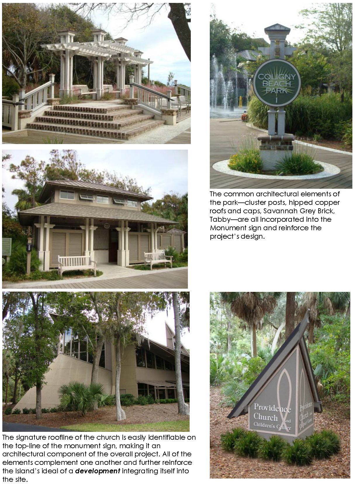 |
| Figure 16-5-114.C.2: Examples of Signs that are Complementary to Nearby Structures |
e.
Sign illumination shall comply with the standards in Sec. 16-5-114.D, Sign Illumination.
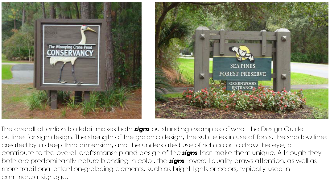 |
| Figure 16-5-114.C.3: Examples of Freestanding Signs that Meet the Intent of The Hilton Head Island Design Guide |
f.
Signs shall be maintained in good condition at all times and shall be kept free of cracked or peeling paint, missing or damaged sign panels or supports, and weeds, grass or vegetation that obscures the view of the sign message.
Electrical requirements pertaining to sign illumination shall be as prescribed under the latest adopted edition of the IBC. Illuminated signs shall conform to the following standards:
1.
External illumination shall be by a steady stationary light source, shielded and directed solely at the sign. Light fixtures shall be restricted to not more than one shielded light fixture per side for signs up to 40 square feet and not more than two shielded light fixtures per side for signs over 40 square feet.
2.
Light sources to illuminate signs shall neither be visible from any street right-of-way, nor cause glare hazardous to pedestrians or vehicle drivers or so as to create a nuisance to adjacent properties. All ground-mounted lighting must be obscured by landscaping approved by the Official.
3.
The intensity of the light shall not exceed 20 foot-candles at any point on the sign.
4.
Signs shall not have light-reflecting backgrounds but may use light-reflecting lettering or halo lighting.
5.
The Official may permit internal illumination for menu board signs for eating establishments with a drive-through. Such signs shall not cause glare hazardous to pedestrians or vehicle drivers or so as to create a nuisance to adjacent properties. Such signs shall be placed and angled so that, to the greatest extent possible, they are not visible from public or private streets.
6.
Lamps shall only produce a white light.
Unless exempted in accordance with subparagraph b below, a Sign Permit is required for each of the following types of signs prior to the sign being erected, placed, or displayed:
i.
Freestanding Signs (Sec. 16-5-114.F).
ii.
Tenant Panels on Freestanding Signs (Sec. 16-5-114.F.10.a).
iii.
Facade and Hanging Signs (Sec. 16-5-114.G).
iv.
Temporary Signs for Permitted Signs (Sec. 16-5-114.H.1).
v.
Construction Signs (Sec. 16-5-114.H.2).
vi.
Nonresidential Real Estate Sales Signs (Sec. 16-5-114.H.3).
vii.
Nonresidential Real Estate Lease or Rent Signs (Sec. 16-5-114.H.4).
viii.
Residential Real Estate Sales Signs (Sec. 16-5-114.H.5).
ix.
Residential Short-Term Rental Signs (Sec. 16-5-114.H.6).
x.
Sign Systems (Sec. 16-5-114.H.7).
xi.
Temporary Special Event Signs (Sec. 16-5-114.H.9).
xii.
Signs with Changeable Copy (Sec. 16-5-114.H.10).
xiii.
Price Displays at Gas Sales Establishments (Sec. 16-5-114.H.11).
xiv.
Planned Unit Development Off-Premises Signs (Sec. 16-5-114.H.12).
i.
Sign Alterations Exempt from Sign Permit
A Sign Permit is not required prior to engaging in the following alterations to a sign:
01.
The changing of copy on a sign permitted for changeable copy.
02.
The painting or refinishing of the surface of a sign face or sign structure of a permitted sign so as to keep the appearance of such sign as permitted.
ii.
Signs Allowed Without a Sign Permit
The following signs shall be allowed subject to compliance with the standards of this section, but no Sign Permit shall be required. The property owner's consent shall be obtained before erecting such signage.
01.
Flags
Non-governmental flags are deemed to be signs and shall be subject to the provisions of this section. The official flags of the federal, State, county, or municipal governments are not deemed to be signs provided no such flag shall exceed 40 square feet per face. The Official may waive this size provision for the United States flag when:
(A)
The Design Review Board approves a larger flag for use on a telecommunications tower designed as a flagpole; or
(B)
The Town Council approves a larger flag for display on public property or other appropriate noncommercial sites as determined by Town Council.
02.
Holiday decorations
Decorations that are not internally illuminated shall not require a Sign Permit, provided they are displayed for no more than a total of 60 days per calendar year, excluding the time period between November 1 and January 15. Such decorations shall be maintained in a good condition at all times and shall be removed or replaced when they are overly weathered, torn, broken, or otherwise present a potential safety hazard.
(A)
Strings of lights used as holiday decorations shall be subject to the provisions of Sec. 16-5-114.E.1.b.ii.12, String Lights for Decoration.
(B)
Inflated holiday decorations are allowed from November 1 through January 15 of each year.
(C)
Windblown decorations are prohibited at all times.

Figure 16-5-114.E.1.b.ii.02(A): Example of Conforming Holiday Decorations with String
Lights

Figure 16-5-114.E.1.b.ii.02(B): Example of Conforming Holiday Decorations Without
String Lights
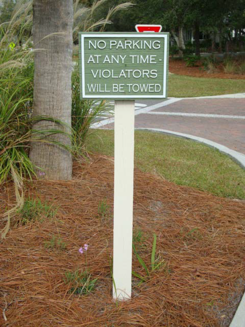
Figure 16-5-114.E.1.b.ii.03: Example of a Conforming Incidental Sign
03.
Incidental Signs
Addresses, building numbers, entrance and exit signs, and traffic directional signs shall not require Sign Permits if they do not exceed four square feet in area per sign. If such sign contains commercial copy, the sign counts toward the allowable square footage for freestanding signs.
04.
Interior Signs
Any sign that, in the Official's reasonable opinion, is to be viewed from the inside of a building only.
05.
Nonresidential Real Estate for Lease or Rent Signs
Such signs shall meet the requirements in Sec. 16-5-114.H.4, Nonresidential Real Estate Lease or Rent Signs.
06.
Menus
Menus attached to the facade of a building with no more than four square feet of sign face area located at the entrance or service window of a business.
07.
Parking Signs
Signs that reserve parking spaces for specific uses or businesses, except that such signs are not allowed in shopping centers per Sec. 16-5-114.I, Prohibited Signs. Parking signs shall not exceed 1.5 square feet in area per sign. No more than three parking signs shall be displayed at any given time on each parcel.
08.
Public Signs
Signs erected by the federal, State, or local government, or governmental entity, including interpretive signs located on Town-owned property. Signs that are required by a public entity are considered public signs.
09.
Sandwich Boards and Chalkboards

Figure 16-5-114.E.1.b.ii.09: Example of a Conforming Sandwich Board Sign
Freestanding, framed chalkboard signs that comply with each of the following standards:
(A)
One sign per business may be displayed during hours of operation.
(B)
Signs shall be placed within ten feet of the building entrance of the business displaying the sign.
(C)
Signs shall be placed to allow at least 36 inches of unobstructed pedestrian clearance adjacent to the sign.
(D)
Signs shall be limited to a maximum of six square feet in total area.
(E)
Sign frame colors are limited to earth tones. Sign face colors are limited to black (Pantone® Black or equivalent) or dark green (Pantone® 574 U or equivalent) with a matte finish.
(F)
Plastic or dry erase boards shall not be allowed.
10.
Shopping Cart Return
Signs identifying shopping cart return areas, provided that such signs are no larger than ten square feet.
11.
Stadium Signs
Signs or banners that are located within a stadium and are not intended to be visible from outside of a stadium.
12.
String Lights for Decoration
(A)
Strings of lights may be used for outside lighting or tree decoration from November 1 through January 15 of each year.
(B)
Because many colors are used to celebrate various holidays during this time, multi-color lights are allowed.
(C)
Flashing, blinking and chasing lights are prohibited.
13.
String Lights for Ambient Illumination
(A)
Strings of white lights may be used to provide ambient lighting for outdoor seating areas of an eating establishment. Such string lights shall be limited to the dining area.
(B)
Colored bulbs, colored lanterns, or other housing and rope lights are prohibited. Flashing and chasing lights are prohibited.
(C)
Strings of white lights may be hung from or displayed on trees, but may not be attached to trees with nails, hooks, fasteners, or other materials that penetrate the tree's bark.

Figure 16-5-114.E.1.b.ii.13: Example of Conforming Strings of Lights Used for Ambient
Illumination
14.
Towing Signs
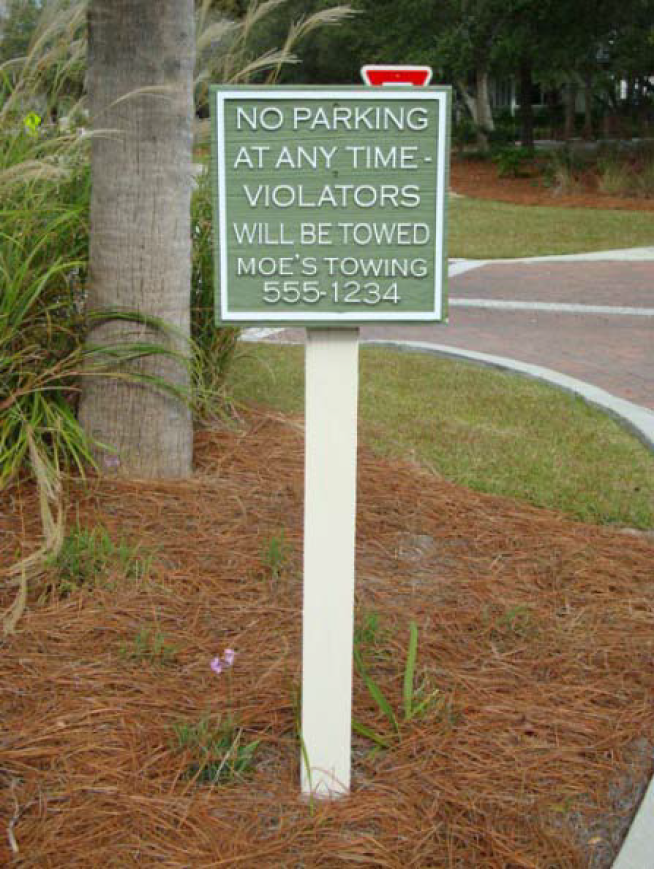
Figure 16-5-114.E.1.b.ii.14: Example of a Conforming Towing Sign
(A)
Public notice required by applicable law to be displayed on a property where vehicles may be towed.
(B)
Such signs shall not exceed four square feet in size and shall be limited to one sign per vehicular entrance to the property.
15.
Traffic Control Signs
Any public notice or warning required by applicable federal, State, or local law, regulation, or ordinance—including, but not limited to, warning flashers and variable message signs (VMSs) deployed temporarily by a government agency to guide traffic. When such signs are located on private property, they are subject to each of the following:
(A)
Sign faces shall not exceed four square feet per sign face.
(B)
The Official shall have authority to limit the number, location, and color of such signs.
(C)
Sign faces shall meet South Carolina Department of Transportation standards.
16.
Window Signs
Signs on the inside, or attached to the outside, of window glass shall comply with each of the following:
(A)
Window signs shall cover no more than 25 percent of the gross area of glass on any one side of a building.
(B)
Window signs shall not be illuminated.
(C)
No single window sign shall exceed four square feet in totality.
i.
Signs Subject to Administrative Sign Review
Unless review by the Design Review Board is required in accordance with Sec. 16-5-114.E.2.a.ii below, the following signs are subject to review and approval of a Sign Permit applicationby the Official:
01.
Real estate signs;
02.
Project signs;
03.
Temporary signs;
04.
Sign systems not subject to DRB Sign Review; and
05.
Permanent signs, including the sign face and structure, that are 40 square feet or less.
ii.
Signs Subject to DRB Sign Review
Any permanent sign, including the sign face and structure, that is greater than 40 square feet, or any sign system that includes such a sign, is subject to review and approval of a Sign Permit application by the Design Review Board in accordance with the following procedures, which relate to the standard review steps and specific procedures in Sec. 16-2-102, Standard Review Procedures.
i.
Application Submittal
An applicationfor a Sign Permit may be submitted by persons identified in Sec. 16-2-102.C.1, and shall be submitted in accordance with Sec. 16-2-102.C.
ii.
Staff Review and Action
01.
On receiving a Sign Permit applicationsubject to administrative sign review (see Sec. 16-5-114.E.2.a.i), the Official shall review and make a final decision on the application in accordance with Sec. 16-2-102.D. The Official's decision shall be based on the standards in Sec. 16-5-114.E.3, Sign Review Standards, and shall be one of the following:
(A)
Approve the application;
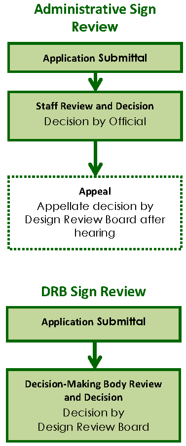
(B)
Approve the application, subject to conditions of approval; or
(C)
Deny the application.
02.
On receiving a Sign Permit application subject to DRB sign review (see Sec. 16-5-114.E.2.a.ii), the Official shall transmit the application to the DRB.
iii.
Decision-Making Body Review and Decision
On receiving a Sign Permit application subject to DRB sign review (see Sec. 16-5-114.E.2.a.ii), the Design Review Board shall review the application, hold a public meeting and make a final decision on the application in accordance with Sec. 16-2-102.G. The Board's decision shall be based on the standards in Sec. 16-5-114.E.3, Sign Review Standards, and shall be one of the following:
01.
Approve the application;
02.
Approve the application, subject to conditions of approval; or
03.
Deny the application.
iv.
Post-Decision Actions and Limitations
01.
Notice of Decision
The Official shall provide notice of the final decision on the application in accordance with Sec. 16-2-102.H.1.
02.
Appeal
(A)
Appeals from the final decision of the Official on an application for a Sign Permit are governed by Sec. 16-2-103.V, Appeal of Official's Decision to Design Review Board, and S.C. Code Ann. § 6-29-890.
(B)
Appeals from the final decision of the Design Review Board on an application for a Sign Permit are governed by S.C. Code Ann. § 6-29-890.
A Sign Permit application shall be approved on a finding the applicant demonstrates the sign complies with the standards in this section, including the standards in:
a.
Sec. 16-5-114.I, Prohibited Signs;
b.
Sec. 16-5-114.C, Sign Design, Construction, and Maintenance Guidelines;
c.
Sec. 16-5-114.D, Sign Illumination;
d.
Sec. 16-5-114.F, Freestanding Signs;
e.
Sec. 16-5-114.G, Facade and Hanging Signs; and
f.
Sec. 16-5-114.H, Standards for Specific Types of Signs.
If a Sign Permit application is approved, the Official shall issue a Sign Permit. A Sign Permit authorizes only the approved sign, and not any other sign.
A Sign Permit is valid for a period of six months, unless the Official approves an extension for good cause in accordance with Sec. 16-2-102.J.2.b, Extension of Expiration Time Period.
1.
The total area and quantity of any freestanding signs for which a Sign Permit is required shall conform to the standards in Table 16-5-114.F, Freestanding Sign Standards. For planned unit developments that contain more than one category of use, theOfficial shall apply the appropriate use category to each building or development to calculate the total area and quantity of freestanding signs allowed. The number of freestanding signs for any development may not exceed the total number allowed in Table 16-5-114.F: Freestanding Sign Standards.
(Revised 6-6-2017 - Ordinance 2017-08)
2.
The maximum height of any freestanding sign above the average grade elevation surrounding the sign shall not exceed the following:
a.
Eight feet where the sign face does not exceed 40 square feet;
b.
Ten feet where the sign face does not exceed 60 square feet; or
c.
Twelve feet where the sign face exceeds 60 square feet.
3.
The bottom edge of the sign shall not exceed four feet in height from the lowest grade elevation at the base of the sign.
4.
The maximum width of any freestanding sign shall not exceed the following:
a.
Fifteen feet where the sign face does not exceed 40 square feet;
b.
Twenty feet where the sign face does not exceed 60 square feet; or
c.
Twenty-five feet where the sign face exceeds 60 square feet.
5.
All freestanding signs fronting on a street right-of-way shall be required to be set back at least 20 feet from the edge of the adjacent street right-of-way. However, if conditions exist so as to make this impractical, this setback may be reduced by the Official provided such reduction does not create a hazard to motorists or pedestrians and that no portion of the sign is located in the right-of-way.
6.
Freestanding signs shall be separated by a distance of not less than 200-foot intervals along each street frontage of the premises.
7.
Freestanding menu boards—including, but not limited to, those used for drive-through eating establishments—shall meet the standards of this section, but shall not count toward the total number of signs allowed for a business.
8.
In lieu of a freestanding sign, a development may use signs on entrance structures such as fences or walls. The number of sign faces is limited to two per entrance, on either side of the entrance, and are confined to the entrance area. The distance between sign faces shall not exceed 100 feet. Such signs are subject to the size limitations of this section. Entrance structures are subject to the provisions of Sec. 16-5-102, Setback Standards.
9.
Signs may be permitted in access easements, subject to the approval of the Official, if the applicant can demonstrate that the access easement provides a necessary means of vehicular access to the property for which the sign is proposed. In the event where a property is served by more than one necessary access easement, the sign shall be located within the easement that serves the street with the highest number of average daily vehicle traffic (ADT) as determined by the Official.
10.
Directory signs are subject to the following standards:
a.
Changing the tenant panels of a directory sign does not require a Sign Permit where the new panel matches the approved tenant panel design, including materials, dimensions, and colors.
b.
The sign should not be, to the greatest extent practicable, visible from a street or right-of-way.
1.
The total size of facade and hanging signs shall not occupy more than ten percent of the area of the facade on which they are placed, with the maximum size of any one sign limited to 40 square feet. Developments with less than 2,500 square feet of gross floor area that waive the right to have a freestanding sign shall be permitted to exceed these size limitations by 50 percent.
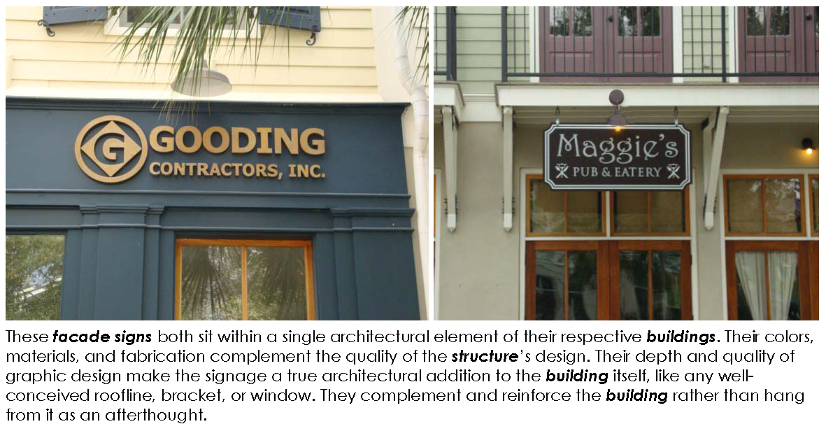 |
| Figure 16-5-114.G.1: Examples of Facade and Hanging Signs that Meet the Intent of The Hilton Head Island Design Guide |

Figure 16-5-114.G.2: Example of a Tenant Space in a Shopping Center with Two Conforming
Signs—One Facade Sign and One Hanging Sign Perpendicular to the Storefront
2.
No more than two signs may be placed on or displayed from any one facade of any one building. Shopping centers shall be permitted two signs per tenant facade, provided that only one such tenant sign is visible from any public way. Such tenant signs shall only be permitted in lieu of facade signs identifying the name of the shopping center or building.
3.
Facade signs shall be contained within any single wall panel, window, door, or other architectural component upon which they are placed.
4.
Hanging signs shall be located in consideration of their respective architectural element.
5.
Tenant facade and hanging signs shall be located on the tenant space being identified. If this requirement cannot be reasonably achieved, the Official shall approve an alternate location.
H. Standards for Specific Types of Signs
1. Temporary Signs for Permitted Signs
a.
When a Sign Permit has been issued for a permanent commercial sign, a separate Sign Permit may be issued for a temporary sign to identify the business while the permanent sign is being constructed. The temporary sign shall comply with the following standards:
i.
Only one sign with no more than two sign faces shall be displayed per proposed permanent sign.
ii.
Any temporary sign face shall not exceed 16 square feet.
iii.
The copy, logo, and colors on a temporary sign shall be identical to the copy, logo, and colors on the related permanent sign.
iv.
A temporary sign shall be constructed of ½-inch MDO or a material of equal durability. Banners shall not be a permitted material.
v.
A temporary sign shall be removed upon installation of the permanent identification sign or within 45 days from the date of its permit, unless an extension is approved by the Official.
b.
Temporary signs advertising a sales event, such as a grand opening or a seasonal sale, shall not be permitted.
c.
Temporary special event signs are permitted as specified in Sec. 16-5-114.H.9, Temporary Special Event Signs.
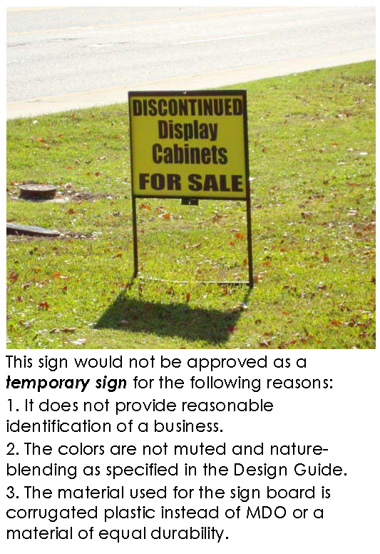 | 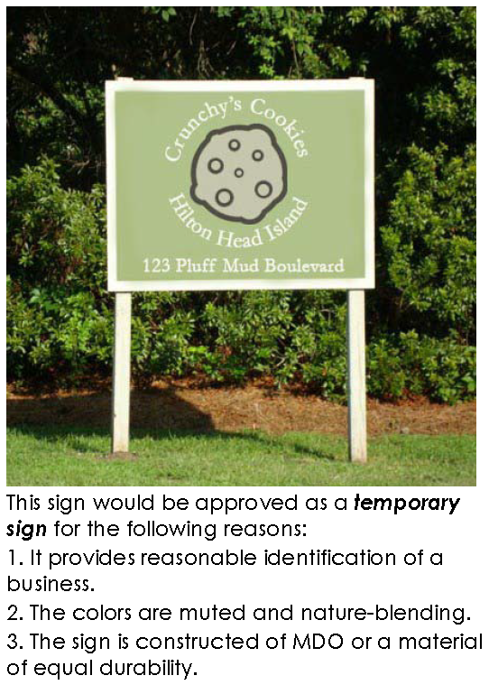 |
| Figure 16-5-114.H.1.a: Example of A Prohibited Temporary Sign | Figure 16-5-114.H.1.b: Example of a Conforming Temporary Sign |
Figure 16-5-114.H.2: Example of a Conforming Construction Sign
Any sign identifying a project under construction and located on the construction site shall comply with the following standards:
a.
Quantity is limited to one per street front of the property on which the construction is occurring.
b.
The total area of a freestanding construction sign shall not exceed 40 square feet. The total area of a facade construction sign shall not exceed 20 square feet. Each sign face shall not exceed 20 square feet.
c.
A freestanding sign shall be mounted so that its top edge is no higher than eight feet above grade. A facade-mounted sign shall be mounted so that its top edge is no higher than eight feet above grade.
d.
Such signs shall not be illuminated by artificial light.
e.
Such signs shall be square or rectangular in shape.
f.
Such signs may not be erected prior to issuance of a Building Permit and shall be removed prior to the issuance of a Certificate of Occupancy.
3. Nonresidential Real Estate Sales Signs
a.
A Sign Permit is required for the design of signs that advertise the sale of nonresidential property and are four square feet or smaller in size. Such signs shall comply with the following standards:
i.
The number of such signs placed on any one premises shall be limited to one sign per street frontage of the property being sold.
ii.
The sign shall be square or rectangular in shape.
iii.
The sign shall not exceed four square feet in area.
iv.
The amount of information on the sign shall be no more than is necessary to provide reasonable identification of the offering.
v.
The sign shall not be illuminated by artificial light.
vi.
The sign shall be removed within two days of completion of the sale of the property.
b.
A Sign Permit is required for each sign that advertises the sale of nonresidential property and is larger than four square feet. Such signs shall comply with the following standards:
i.
The number of signs placed on any one premises shall be limited to one sign per street frontage of the property being sold.
ii.
The sign shall be rectangular or square in shape.
iii.
The area of each sign shall not exceed 40 square feet total and 20 square feet per sign face.
iv.
The maximum height of each sign shall not exceed eight feet above the average grade within a 20-foot radius of the sign. The lower edge of each sign shall not exceed four feet in height from the lowest grade at the base of the sign.
v.
The amount of information on the sign shall be no more than is necessary to provide reasonable identification of the offering.
vi.
The sign shall not be illuminated by artificial light.
vii.
The sign shall be removed within two days of completion of the sale of the property.
c.
Where a freestanding sign is not feasible, the Official may approve a real estate sales facade sign. The sign shall comply with the following standards:
i.
The number of signs placed on any one premises shall be limited to one sign per street frontage of the property being sold.
ii.
The sign shall be square or rectangular in shape.
iii.
The area of each sign shall not exceed 20 square feet.
iv.
The maximum height of each sign shall not exceed ten feet above the average grade within a 20-foot radius of the sign.
v.
The sign shall be contained within any single wall panel, window, door, or other architectural component upon which it is placed.
vi.
The amount of information on the sign shall be no more than is necessary to provide reasonable identification of the offering.
vii.
The sign shall not be illuminated by artificial light.
viii.
The sign shall be removed within two days of completion of the sale of the property.
4. Nonresidential Real Estate Lease or Rent Signs
a. Buildings for Lease or Rent
On premises where a whole building or whole buildings are offered for lease or rent and where there are no other tenant spaces on the premises, a nonresidential real estate sign offering the building or buildings for lease or rent may be displayed. Such signs shall comply with the following standards:
i.
A Sign Permit is required.
ii.
The number of signs placed on any one premises shall be limited to one sign per street frontage of the property to be let.
iii.
The sign shall be square or rectangular in shape.
iv.
The area of each sign shall not exceed 40 square feet total and 20 square feet per sign face.
v.
The maximum height of each sign shall not exceed eight feet above the average grade within a 20-foot radius of the sign. The lower edge of each sign shall not exceed four feet in height from the lowest grade at the base of the sign.
vi.
The amount of information on the sign shall be no more than is necessary to provide reasonable identification of the offering.
vii.
The sign shall not be illuminated by artificial light.
viii.
The sign shall be removed within two days of execution of a lease for the property.
b. Tenant Spaces for Lease or Rent
i.
A nonresidential real estate sign offering tenant space for lease or rent shall be placed as a tenant panel on a permitted sign or as a panel on a permitted freestanding sign if there are such signs on site. Such signs shall comply with the following standards:
01.
A Sign Permit is required.
02.
If placed on a sign with other panels, such panels shall match the dimensions, materials, and colors of the other panels. The amount of information on the panel shall be no more than is necessary to provide reasonable identification of the offering.

Figure 16-5-114.H.4.b: Example of a Directory Sign with a Conforming Space for Lease
Tenant Panel
03.
If placed on a freestanding sign without other panels, a Sign Permit is required to ensure the panel complements the design of the freestanding sign. The amount of information on the panel shall be no more than is necessary to provide reasonable identification of the offering.
ii.
If there are no permitted signs on which a tenant panel or other panel may be placed to advertise a tenant space for lease or rent, a sign not exceeding four square feet in area may be used. The sign shall comply with the following standards:
01.
A Sign Permit is required for an individual sign, regardless of whether the sign design has been approved for other uses.
02.
The number of signs placed on any one premises shall be limited to one sign per street frontage of the building that includes the space to be let.
03.
The sign shall be square or rectangular in shape.
04.
The sign shall not exceed four square feet in area.
05.
The amount of information on the sign shall be no more than is necessary to provide reasonable identification of the offering.
06.
The sign shall not be illuminated by artificial light.
07.
The sign shall be removed within two days of the execution of a lease for the property.
5. Residential Real Estate Sales Signs
a.
A Sign Permit is required for each sign advertising the sale of residential real estate. The design of the sign shall comply with the following:
i.
The sign shall be square or rectangular in shape.
ii.
The sign shall not exceed four square feet in area.
iii.
The amount of information on the sign shall be no more than is necessary to provide reasonable identification of the offering and identification of the agent.
b.
Once a Sign Permit is issued for a sign design, individual signs are not required to be permitted.
c.
Such signs shall meet the following standards:
i.
The number of signs placed on any one premises shall be limited to one sign per street frontage of the property being sold.
ii.
Signs shall be placed on the parcel for sale. In multifamily or condominium development, signs shall be placed near the front door of the unit for sale.
iii.
Signs shall not be illuminated by artificial light.
iv.
Signs shall be removed within two days of the completion of the sale of the property.
v.
Each sign may have one information box or tube attached to the sign structure. Information boxes or tubes shall not be independently freestanding.
d.
A residential development (such as a named subdivision) with multiple properties for sale may use one real estate sign in lieu of individual real estate signs on each lot. A Sign Permit is required for each sign. Such signs shall comply with the following standards:
i.
The number of signs shall be limited to one per entrance of the development, not including paired one-way entrance lanes.
ii.
Signs shall be square or rectangular in shape.
iii.
The area of each sign shall not exceed 40 square feet total and 20 square feet per sign face.
iv.
The maximum height of each sign shall not exceed eight feet above the average grade within a 20-foot radius of the sign. The lower edge of each sign shall not exceed four feet in height from the lowest grade at the base of the sign.
v.
The amount of information on the sign shall be no more than is necessary to provide reasonable identification of the offering.
vi.
Signs shall not be illuminated by artificial light.
vii.
Signs shall be removed within two days of the completion of the sale of the property.
viii.
Each sign may have one information box or tube attached to the sign structure. Information boxes or tubes shall not be independently freestanding.
6. Residential Short-Term Rental Signs
A Sign Permit is required for each sign advertising the short-term rental of a residence. Such signs shall meet the following standards:
a.
Signs are limited to one per residence. The sign shall be placed near the entrance of the residence, visible from the street and wall mounted no more than six feet above FEMA base flood elevation. The sign shall not be visible from the beach.
b.
The sign shall be 12 inches in height by 18 inches in length.
c.
The sign shall be made of ½-inch PVC sign board or another material approved by the Official.
d.
The amount of information on the sign shall be no more than is necessary to provide reasonable identification of the offering.
e.
The sign shall not be illuminated by artificial light.
An integrated sign system design shall be required for all planned unit developments, commercial developments, office complexes, and shopping centers.
a.
These systems shall be reviewed for materials, colors, shapes, sizes, compatibility and architecture, and establishment of unity of design for the development. (See the Hilton Head Island Design Guide for guidance.)
b.
New individual signs and changes to existing individual signs shall conform to such sign systems.
c.
In the case of changes to any integrated sign system design, all existing signs in the sign system shall be brought into compliance with the changed design within three months of approval of any changes to the integrated sign system.
8. Permanent Special Event Signs
Figure 16-5-114.H.8: Example of a Conforming Permanent Special Event Sign
Permanent signs identifying special events may be erected only by the Town of Hilton Head Island. They shall comply with the following standards:
a.
Permanent special event signs may only announce events that are sponsored by a nonprofit or public entity, or public service announcements. Requests to display announcements shall be made to the Town Manager.
b.
Guidelines for determining the events or functions to be announced, copy, space, location, and display time limit shall be as proposed by the Official and approved by the Town Council.
c.
Public service announcements may obtain a higher priority for display than special event announcements, at the discretion of the Town Manager.
9. Temporary Special Event Signs
The organizer of a special event (see definition in Sec. 16-10-105, General Definitions), shall obtain a Temporary Special Event Sign Permit prior to displaying temporary signs at a special event. The application shall state the location and dates of the event, the expected number of attendees, and the types and number of proposed temporary signs. The application shall be submitted no fewer than five business days prior to the event. The following temporary special event signs may be used as specified:
a. Off-Premises Signs Directing Traffic
i.
Signs directing traffic to the site of an event may be used for events at which more than 5,000 attendees are expected.
ii.
Signs shall meet South Carolina DOT standards.
b. Off-Premises Signs Identifying Race Routes
Signs intended to direct pedestrians, runners, and bicyclists on race routes are subject to the following standards:
i.
Such signs shall be no larger than two square feet each.
ii.
Such signs may be displayed one day prior to the event, during the duration of the event, and one day after the event.
c. Off-Premises Post Mounted Banners
i.
Post mounted banners may only be used for events which are multi-day and at which more than 18,000 attendees are expected during the course of the event.
ii.
The banners shall be no larger than 16" in width and 45" in height.
iii.
The banners must be approved and installed as part of the Town permitting process.
(Revised 12-5-2017 - Ordinance 2017-19)
d. On-Premises Signs Identifying an Event
Signs located at the entrances of special events that are meant to identify a special event are subject to the following standards:
i.
No more than two signs shall be displayed per event, with no more than four sign faces. Any single sign face shall not exceed 16 square feet.
ii.
Signs shall be constructed of ½-inch MDO, or a material of equal durability, mounted on four-by-four wood posts.
iii.
The amount of information on signs shall be no more than is necessary to provide reasonable identification of the event or other information to be conveyed.
iv.
Signs shall be displayed no sooner than one day prior to the event, during the duration of the event, and one day after the event.
v.
Signs shall not be illuminated by artificial light.
(Revised 12-5-2017 - Ordinance 2017-19)
Signs displayed within a special event are subject to the following standards:
i.
Signs shall be displayed no sooner than one day prior to the event, during the duration of the event, and one day after the event.
ii.
Banners and pennants are permitted within the area where the special event takes place.
(Revised 12-5-2017 - Ordinance 2017-19)
10. Signs with Changeable Copy
a.
Description of Changeable Copy Types.
i.
Manually activated changeable copy shall mean a sign or portion of a sign that can be changed or re-arranged manually or mechanically, and has a readerboard for the display of text information in which each alphanumeric character, graphic, or symbol is defined by objects, not consisting of an illumination device.
ii.
Electronically activated changeable copy shall mean a sign or portion of a sign that can be changed by means of remote electrically energized on-off switching combinations of alphanumeric character, graphic, or symbol.
b.
Signs with changeable copy are limited to one sign per street frontage per parcel.
c.
The total size of changeable copy shall not exceed 20 square feet per sign face, with no more than three lines of copy.
d.
Copy height shall be eight inches maximum and four inches minimum.
e.
Copy shall be securely fastened to the sign face and neatly maintained.
f.
Changeable copy shall be limited to announcing:
i.
On-premises special events.
ii.
Motion pictures or entertainment at a theater whose primary function is to provide musical or dramatic events; or
iii.
Gasoline prices as described in Sec. 16-5-114.H.11, Price Displays at Gas Establishments.
g.
Permanent Special Event Signs as described in Sec. 16-5-114.H.8, Permanent Special Event Signs, are exempt from the requirements of this section.
h.
Minimum Fixed Period. Electronic changeable copy shall remain fixed and should be changed no more than twice per day.
i.
Transition Between Copy. The duration of change between electronic changeable copy shall be accomplished within two seconds or less.
(Revised 3-7-2023 - Ordinance 2023-04)
11. Price Displays at Gas Sales Establishments
a.
Petroleum product pumps and dispensers that are within view of a public way shall be allowed to display only the information needed to reasonably identify the products dispensed.
b.
Premises from which retail petroleum products are dispensed by pump shall be allowed one additional sign with a maximum size of ten square feet announcing the price per gallon of the products. The additional sign shall require a Sign Permit.
c.
In lieu of the one additional sign allowed above, the price per gallon may be displayed by increasing by ten square feet the area allowed within this section for a single freestanding sign.
12. Planned Unit Development Off-Premises Signs
a. Planned Unit Development Off-Premises Directional Signs
i.
Planned unit developments (PUDs) may erect freestanding off-premises directional signs for the purpose of directing vehicle traffic to destinations within the development. Such signs must be located within the boundary of the PUD or on a parcel within 500 feet of the boundary that fronts on the major arterial serving the PUD.
ii.
Off-premises directional signs that are viewed from any public way shall comply with the following requirements:
01.
The amount of information on signs shall be no more than is necessary to provide reasonable identification of the destination(s) and direction thereto.
02.
Such signs shall be located within one mile of the intersection where vehicles must turn to reach the PUD. No more than two signs shall be placed in any one direction from such intersection with no more than three signs for any one development.
03.
The total area of all signs for any one development shall not exceed 200 square feet of sign face with no single sign face greater than 80 square feet. Sign height, width, and structure shall meet the requirements of Sec. 16-5-114.F, Freestanding Signs.
iii.
Off-premises directional signs that are viewed from private streets internal to the development shall comply with the following requirements:
01.
The amount of information on signs shall be no more than is necessary to provide reasonable identification of the destination(s) and direction thereto.
02.
Such signs must be located within 200 feet of an intersection with no more than one sign viewed from any one direction.
03.
Such signs shall be limited to 20 square feet of sign face.
b. Planned Unit Development Off-Premises Identification Signs
i.
A planned unit development (PUD) whose primary entrance (right-of-way or easement) is located on a public street but is not within the boundary of the PUD shall be allowed one off-premises identification sign, which shall be located within the right-of-way or easement for the entrance street.
ii.
This sign shall comply with the following requirements:
01.
The amount of information on such sign shall be no more than is necessary to provide reasonable identification of the PUD.
02.
Such sign shall be subject to the standards of Sec. 16-5-114.F, Freestanding Signs.
The following types of signs are prohibited:
1.
Abandoned signs and sign structures.
2.
Signs with animated or moving effects (including but not limited to sign faces that periodically change to show different images or messages), and signs carried, waved, or otherwise displayed by persons either on public ways or in a manner visible from public ways, are prohibited. This provision is directed toward such displays intended to draw attention for a commercial purpose, and is not intended to limit the display of placards, banners, flags, or other signage by persons participating in demonstrations, political rallies, and similar events.
3.
Balloons.
4.
Banners, except within the boundaries of a special event. (See Sec. 16-5-114.H.9, Temporary Special Event Signs.)
5.
Bench signs.
6.
Dilapidated or damaged signs.
7.
Signs attached to or painted upon piers, docks, or seawalls, other than official regulatory or warning signs.
8.
Signs that emit sound, vapor, smoke, odor, particles, or gaseous matter.
9.
Inflated signs and windblown signs other than holiday decorations.
10.
Information boxes not attached to a real estate sign.
11.
Internally illuminated signs that contain a visible light source, except for those signs complying with the provisions of Sec. 16-5-114.D, Sign Illumination.
12.
Signs that are displayed or erected for which a Sign Permit has been denied or has not been issued.
13.
Signs that exhibit statements, words, or pictures of an obscene or pornographic nature.
14.
Signs that are not located on the parcel of the business or development it identifies, except that special event signs, directional signs, public park signs, and other signs that are specifically allowed under this section are exempt.
15.
Parking signs that limit parking spaces to certain uses or businesses within a shopping center.
16.
Pennants except within the boundaries of a special event. (See Sec. 16-5-114.H.9, Temporary Special Event Signs.)
Figure 16-5-114.I.17: Examples of Prohibited Portable and Off-Premises Signs
17.
Portable signs, or any sign not permanently attached to the ground or other permanent structure, including but not limited to signs attached to or painted on vehicles or trailers other than those advertising the business which the vehicle is used to conduct, either parked or being driven, and visible from the right-of-way, unless said vehicle is used as a vehicle in the normal day-to-day operations of the business, except that sandwich boards, chalkboards, and other signs that are specifically allowed under this section are exempt.
18.
Signs located in the public rights-of-way, except signs in landscaped medians of private streets where the sign meets the minimum sight triangle distances of Sec. 16-5-105.H.4, Sight Triangles.
19.
Signs where the sign or any portion of the sign is located on or extends above the roof of the building where the sign is located.
20.
Signs attached to, placed on, painted on, or otherwise displayed on or from any tree or other vegetation.
21.
Signs in or upon any body of water, other than official regulatory or warning signs, including any sign located on any land subject to periodic inundation by tidal saltwater. The Design Review Board may approve a permanent monument sign in or upon a body of water within a parcel if the Official determines that there is no other reasonable location for that sign on that parcel.
22.
Signs towed behind a vehicle, watercraft, or aircraft.
23.
All other signs that are not expressly exempt from regulation or expressly allowed under this Ordinance.
(Revised 4-18-2017 - Ordinance 2017-05)
Sec.16-5-115. - Subdivision Standards
A. Purpose and Intent
The purpose of subdivision layout is to create a functional and attractive development with infrastructure and lots appropriately sized and located to minimize adverse impacts. The intent of this section is to provide clear requirements and guidelines for subdivision design for both Major and Minor Subdivisions. Subdivisions should promote the health, safety, convenience, order, prosperity and welfare of the present and future residents of the Town by:
a.
Providing for the orderly growth and development of the Town;
b.
Coordinating with the existing street system, transportation plans, and public facilities;
c.
Providing right-of-way for street and vehicular easements;
d.
Avoiding congestion and overcrowding and encouraging proper arrangement of streets in relation to existing planned streets;
e.
Preservation of the natural tree canopy and preservation of protected tree species;
f.
Ensuring there is adequate common open space and recreation facilities; and
g.
Ensuring there is proper recordation of land ownership.
(Ordinance 2025-13, § 1(Exh. A), 8-19-2025; revised 8-19-2025 - Ordinance 2025-16)
Subdivisions shall comply with all applicable design and performance standards of this section and this Ordinance, including the adjacent setback and buffer standards in Sec. 16-5-102 and 16-5-103.
1.
Layout of the subdivision shall be based on complete site analysis. Streets and lots shall be designed to preserve significant trees, stands of trees and understory vegetation and situated to minimize alteration of natural and historic site features to be preserved.
2.
The subdivision layout shall consider the practicality and economic feasibility of development of individual lots including the environmental characteristics, size of the site, and the requirements of this Ordinance.
3.
The applicant is required to demonstrate that they have made all reasonable efforts to preserve unique and fragile elements on site, including but not limited to wetlands, significant stands of trees and individual trees of significant size, with development reserved for environmentally stable areas.
(Revised 1-7-2020 - Ordinance 2020-02; revised 3-7-2023 - Ordinance 2023-04)
4.
Common open space and recreational areas shall be planned in accordance with Sec. 16-5-104, Common Open Space Standards.
(Revised 8-19-2025 - Ordinance 2025-16)
5.
Lots shall be situated so that stormwater may be easily directed away from buildings in subsequent site-specific development. Lots shall be configured so that buildings and general flood sensitive site facilities can be located out of drainageways. Subdivisions shall be designed so as to comply with Sec. 16-5-109, Stormwater Management and Erosion and Sedimentation Control Standards.
6.
All lots shall have the access required by Sec. 16-5-105.I, Access to Streets.
(Revised 8-19-2025 - Ordinance 2025-16)
1.
Subdivisions may be laid out in conventional, cluster, zero lot line, or a combination of block/ lot designs.
(Revised 7-21-2020 - Ordinance 2020-16)
2.
The lot configuration and shape shall provide appropriate sites for buildings, and be properly related to topography, natural elements, existing significant trees and stands of trees, access, drainage and utilities, and conform to all requirements of this Ordinance.
(Revised 1-7-2020 - Ordinance 2020-02)
3.
The dimensions of corner lots shall permit the required minimum setbacks from streets (see Sec. 16-5-102, Setback Standards) and required site triangles (see Sec. 16-5-105.H.4, Sight Triangles).
4.
The number of lots within a block shall be as appropriate for the location and the type of development contemplated, as practical. Visual monotony created by excessive blocks of lots which are not interrupted by intersections, common open space, buffers, trees or features shall be avoided.
(Revised 1-7-2020 - Ordinance 2020-02; revised 8-19-2025 - Ordinance 2025-16)
5.
Pathway Connectivity.
a.
Pathways are required throughout subdivisions. The provisions of this subsection shall not apply to Minor Subdivisions and Family Subdivisions.
b.
Pathways shall provide direct connectivity between all lots and the subdivision's community amenities, including usable common open space, mailbox facilities, community buildings, and recreational areas. For the purpose of this requirement, a residential lot located across a street from a pathway within the same subdivision or adjacent to a common open space having a pathway is considered to be served by and connected to that pathway.
c.
Pathways shall be designed to provide connectivity from within the subdivision to:
i.
An existing pathway system located along an abutting right-of-way or easement, an existing pathway within an easement on the property, or a pathway on abutting Town-owned property; and
ii.
Any pathway system planned within an adopted Town pathway plan or the Capital Improvement Program (CIP) located along an abutting right-of-way or easement, an existing pathway easement on the property, or an abutting Town-owned property.
d.
If the land proposed for a subdivision serves as a priority connection between existing pathways and is included in an adopted Town pathway plan, the pathway system shall be designed to connect the existing pathways through the subdivision or along abutting street right-of-way. This requirement shall not be construed as requiring off-site improvements other than within an abutting street right-of-way.
e.
As an alternative to pathway construction, a sidewalk may be approved by the Official if the proposed subdivision abuts a street with an existing sidewalk network or if the character or design of the proposed subdivision would clearly benefit from incorporating sidewalks instead of pathways. The incorporation of sidewalks shall meet all other requirements of this section. The Official may determine that a sidewalk is preferable over a pathway if:
i.
Spacing is not sufficient for a pathway based on existing natural features, infrastructure, utilities, easements, or built features;
ii.
It would connect seamlessly to existing infrastructure;
iii.
It would be more consistent with the design characteristics of the proposed subdivision and abutting development;
iv.
The travel distance of the proposed route is significantly shorter than areas typically suitable for pathways; or
v.
It would encourage slower travel speeds in areas of higher congestion.
f.
Pathways or sidewalks shall be designed and constructed in accordance with the fifth edition of the AASHTO Guide for the Development of Bicycle Facilities and meet the accessibility guidelines promulgated under the Americans with Disabilities Act (ADA).
(Revised 8-19-2025 - Ordinance 2025-16)
E. Zero Lot Line Residential Subdivisions
1.
Zero lot line residential subdivisions are permitted in the following zoning districts: RM-4, RM-8, RM-12, SPC, MS, WMU, S, MF, MV, NC, LC and RD.
2.
All lots created in a zero lot line residential subdivision shall be buildable lots (the appropriate size to construct a home) and shall be a minimum of .05 acres in size with a minimum lot width of 20 feet.
3.
All lots in a zero lot line residential subdivision shall have a 50% maximum impervious coverage.
4.
All zero lot line residential subdivisions shall provide 16% minimum common open space.
(Revised 8-19-2025 - Ordinance 2025-16)
5.
No structure shall be located closer than ten feet from adjacent property lines, with the exception of structures that have a wall that rests on a common property line.
6.
Where a proposed zero lot line residential subdivision is adjacent to an existing single family detached residential neighborhood or use, a setback of 20 feet is required along the perimeter of the proposed subdivision.
7.
Where a proposed zero lot line residential subdivision is adjacent to an existing single family detached residential neighborhood or use, a Type A buffer, Option 1, is required along the perimeter of the proposed subdivision.
8.
A zero lot line residential subdivision is not permitted on existing lots of record that were not previously platted as a zero lot line residential subdivision, unless the entire previously platted subdivision is combined and re-platted to be a zero lot line residential subdivision.
(Revised 7-21-2020 - Ordinance 2020-16)
1.
All Major Subdivisions shall have direct vehicular access to a public street that meets the standards of Sec. 16-5-105.C, General Street Design Standards.
2.
Minor Subdivisions shall be permitted to provide vehicular access to lots via a minimum 20-foot wide unobstructed access easement, provided the access easement complies with the following standards:
a.
Access easements shall contain an all-weather driving surface approved by the Fire Chief for the Town of Hilton Head Island.
b.
Dead-end easements shall have a turn-around as required by the latest edition of the International Fire Code as adopted by Town Council.
c.
No access easement shall be permitted to exceed a maximum traffic volume of 50 ADT due to the further subdivision of lots without upgrading the accessway to meet the design standards of Sec. 16-5-105.C, General Street Design Standards.
d.
Access easements are not allowed in any wetland buffer required by Sec. 16-6-102.D, Wetland Buffer Standards, except for approximately perpendicular crossings as approved by the Official.
e.
A bridge may be permitted within an access easement as long as the driving surface is at least 20 feet wide and is approved by the Fire Chief of the Town of Hilton Head Island.
(Revised 7-21-2020 - Ordinance 2020-16)
a.
Horizontal control monuments shall be placed in the pavement of subdivision streets so that no lot is more than 2,000 feet from a control monument. Alternatively, control monuments may be placed in common open space areas, park areas, and the like. The control monument shall be placed in a manner satisfactory to the Town Engineer.
(Revised 8-19-2025 - Ordinance 2025-16)
b.
Corner monuments or markers shall be installed at all lot corners.
c.
All corner monuments or markers shall consist of a concrete marker with metal cap marking the exact corner and bearing the name of the surveying company or the land surveyor in responsible charge of the survey. If the corner location falls on pavement, concrete, or other material where it cannot be marked with a cap, a shaft of ferrous metal (iron pipe or bar), spikes, or scribes may be installed in or on the surface. These methods shall be used unless exceptional circumstances warrant the use of other materials.
d.
If a corner cannot be monumented or marked, one or more witness monuments shall be placed on the boundary line and described by bearings or distances so that the inaccessible point may be located accurately on the ground. A witness monument shall adhere to the same standards applicable to a corner monument.
2. Addressing and Lot Numbering
The Official shall determine a method of street addressing/lot numbering. Applicants should consult with the Town for site-specific review.
Subdivisions creating lots to which public sanitary sewer is unavailable shall demonstrate that all such lots are sized to accommodate septic systems. Such systems shall be set back from property lines, approved by SCDHEC, and located within septic easements recorded with the subdivision plat.
(Revised 7-20-2020 - Ordinance 2020-16)
Sec.16-5-116. - Impact Fees
A. Purpose
This section is intended to ensure timely construction of off-site public capital improvements that are necessary to serve new development by ensuring that necessary financing is available for such improvements. The impact fees to be paid by each new development in accordance with this section is to be proportional to the impact that the new development will have on the types of facilities for which the fees are charged.
The collection of impact fees shall apply to all development, unless otherwise provided herein.
1.
The movement of a structure onto a lot shall be considered development and shall be subject to these impact fee provisions, unless otherwise provided in paragraphs 2 and 3 below.
2.
The impact fee provisions shall not apply to the following actions:
a.
The movement of a manufactured home onto a lot or parcel for use as a residence that does not result in a net increase in the number of manufactured home sites on the Island;
b.
Placing on a lot in the Town a temporary construction trailer or office, but only for the life of the Building Permit issued for the construction served by the trailer or office;
c.
Converting an existing structure from one use to another; and
d.
Any development, including but not limited to the mere subdivision of land, installation of utilities, or the use of land for limited recreational, agricultural, filling or dredging purposes, which, in the opinion of the Official, will not result in a net increase of more than one one-way ADT.
3.
The impact fee provisions shall not apply to public projects.
C. Impact Fee Benefit District
1.
There shall be one impact fee benefit district that encompasses the entire Town.
2.
The appropriateness of the designation and boundaries of the benefit district shall be reviewed by the Town as part of the impact fee revision process set forth below. Following such review and a public hearing, the benefit district may be amended.
3.
Impact fees collected within the benefit district shall be spent within the benefit district.
D. Payment of Impact Fee as Condition of Approval
Until any impact fee required by this section has been paid in full, no Building Permit, Electrical Permit, Certificate of Compliance, Certificate of Occupancy, or other permit subsequent to Development Plan Review for any development that is not exempted by Sec. 16-5-116.B, Applicability, shall be issued. A stop work order shall be issued on any development for which the applicable impact fee has not been paid in full.
E. Calculation of Fees Using Fee Schedule
Impact fees shall be calculated as follows:
1.
Unless an applicant requests an administrative determination or individual assessment as set forth in the following subsections, the impact fees shall be calculated for the proposed development based on the Development Plan Approval or permit allowing the use, according to the applicable fee schedule.
2.
The following impact fee schedules are hereby adopted and incorporated herein by reference:
a.
Transportation Impact Fee Schedule
3.
The units of development specified in the fee schedule shall be interpreted as follows:
a.
A hotel "room" shall include any space that is part of the same rental unit and that does not have a separate entrance.
b.
Building square footage shall be measured in terms of gross floor area.
4.
For categories of uses not specified in the applicable impact fee schedule, the Official shall apply the category of use set forth in the applicable fee schedule that is deemed to be most similar to the proposed use.
5.
If the Development Plan Approval or permit for the proposed development indicates a mix of uses in the development, the impact fees shall be calculated separately for each use according to the fee schedule, and the results aggregated.
6.
For an addition to or replacement of existing structures, the impact fee to be paid shall be the difference, if any, between:
a.
The fee, if any, that would be payable for existing development on the site or, in the case of demolition or removal of a structure, the previous development on the site, provided that the demolition or removal occurred after October 23, 1989, or within ten years of the date of submittal of the application for which impact fees are assessed, whichever is less; and
b.
The fee, if any, that would be payable for the total development on the site after the new development.
7.
Upon written request of an applicant, the Official shall provide an estimate of the current fee based on the data provided by the applicant. However, the Official shall not be responsible for determining at such preliminary date the accuracy of the information provided.
F. Individual Assessment of Impact Fees
1.
If any person submitting an application for which payment of an impact fee is a prerequisite to approval believes that the impacts of the proposed development will be substantially less than would be indicated by using a strict interpretation of the fee schedule or an administrative determination of the fee, such person may request that the Town perform an individual assessment of the impact of the proposed development, consistent with the methodology set forth in paragraph 2 below. A request for an individual assessment must be made prior to submittal of an application for a Building Permit.
2.
The individual assessment shall be subject to the Transportation Impact Fees as set forth in Sec. 16-5-116.R, Individual Transportation Fee Assessments.
3.
The Town shall accept the calculations of the individual assessment if the Planning Commission finds at a public meeting that:
a.
The proposed development is in fact so unique in the impacts it will generate that the strict application of the fee schedule or administrative determination would result in inaccurate impact projections; and
b.
The individual assessment results in a fee which differs by at least five percent from the fees calculated under the fee schedule or administrative determination.
4.
If the Town accepts the computations of the individual assessment under this section, the applicable fee shall be determined from the individual assessment, regardless of whether it is higher or lower than the fee calculated under the fee schedule or administrative determination.
The collection of impact fees shall be as follows:
1.
Except as set forth in the following paragraph, the impact fees for all new development shall be calculated and collected in conjunction with the application for the first Building Permit, Electrical Permit, Certificate of Compliance, Certificate of Occupancy, or other permit subsequent to approval of a Development Plan for such development, whichever occurs first in time.
2.
For other uses not ultimately requiring a Building Permit, Electrical Permit, Certificate of Compliance, Certificate of Occupancy, or other permit subsequent to approval of a Development Plan, the fee shall be calculated and collected at the time of approval of the Development Plan.
H. Fund Accounting for Impact Fees
1.
The Town shall establish a separate accounting fund in which the impact fees collected for a particular type of facility within the benefit district shall be credited. Such fees shall be invested by the Town and the yield on such fees, at the actual rate of return to the Town, shall be credited to such accounting fund periodically in accordance with the accounting policies of the Town. Such funds need not be segregated from other Town monies for banking purposes.
2.
Any yield on such accounting fund into which the fees are deposited shall accrue to that fund and shall be used for the purposes specified for such fund.
3.
The Town shall maintain and keep financial records for such accounting fund showing the revenues to such fund and the disbursements from such fund, in accordance with normal Town accounting practices. The records of such fund shall be open to public inspection in the same manner as other financial records of the Town.
Transportation Impact Fees shall only be spent on qualifying public street and pathway improvements, as set forth in Sec. 16-5-116.S, Use of Transportation Impact Fees.
1.
Any impact fee or portion thereof collected in accordance with this section that has not been committed for a use permitted by Sec. 16-5-116.S, Use of Transportation Impact Fees, within six years from the last day of the fiscal year in which it was received by the Town, shall be refunded to the current record owner of the property upon written application. Impact fees shall be deemed to be "committed" when they have been spent or encumbered by contract. Impact fees shall be deemed to be "committed" in the order in which they are received and committed by the Town. The refund shall include accrued interest at the rate of return on investments earned by the Town on such amount. In disbursing such funds the Town may rely on the written certification of the current record owner of the property as to his or her entitlement to the refund, in the absence of a written assertion by another party that such proposed payee is not the proper payee. If in doubt, the Town may deposit such funds in an appropriate court for disposition as the court may determine. In such event, the Town may deduct from the funds deposited an amount equal to the reasonable cost of causing the funds to be deposited with the court, including reasonable attorney's fees.
2.
If development for which an impact fee has been paid has not begun, the impact fee and any accrued interest thereon shall be returned to the applicant provided that the applicant applies for the refund in writing within 60 days after the expiration of the Building Permit or other approval (or any extension thereof) on which it was assessed.
3.
The Town shall charge an administrative fee for verifying and computing the refund of three percent of the amount of the refund.
Offsets, which are reductions from the impact fee that would otherwise be due from a development, shall be subject to the following provisions.
1.
The Planning Commission shall grant an offset only for qualifying improvements that are required to be made by a developer as a condition of development approval after the effective date of the impact fee ordinance against which such offset is claimed.
2.
Offsets shall be allowable and payable only to offset impact fees otherwise due for the same category of improvements and shall not result in reimbursement from, nor constitute a liability of, the Town.
3.
Offsets shall be given only for the value of any construction of improvements or contribution or dedication of land or money by a developer or the developer's predecessor in title or interest for qualifying improvements of the same category for which an impact fee was imposed.
4.
The person applying for an offset shall be responsible for providing appraisals of land and improvements, construction cost figures, and documentation of all contributions and dedications necessary to the computation of the offset claimed. The Planning Commission shall have no obligation to grant offsets to any person who cannot provide such documentation in such form as the Planning Commission may reasonably require.
5.
The value of land dedicated or donated shall be based on the appraised land value of the parent parcel (which land value is based on the date of transfer of ownership to the Town) as determined by a certified appraiser who was selected and paid for by the applicant, and who used generally accepted appraisal techniques. If the Town disagrees with the appraised value, the Town may engage another appraiser at the Town's expense, and the value shall be an amount equal to the average of the two appraisals. If either party rejects the average of the two appraisals, a third appraisal shall be obtained, with the cost of such third appraisal being shared equally by the property owner and the Town. The third appraiser shall be selected by the first two appraisers, and the third appraisal shall be binding on both parties.
6.
Offsets provided for qualifying improvements meeting the requirements of this section shall be valid from the date of approval until ten years after the date of approval or until the last date of construction within the project, whichever occurs first. The right to claim offsets shall run with the land and may be claimed only by owners of property within the development for which the qualifying improvement was required.
7.
Any claim for offsets must be made no later than the time of submittal of a Building Permit application or application for another permit subsequent to Development Plan Approval that is subject to impact fees. Any claim not so made shall be deemed waived.
L. Developer Agreements for Impact Fees
1.
Where a development includes or requires a qualifying improvement, the Town and the developer may agree in writing to have the developer participate in the financing or construction of part or all of the qualifying improvement(s). Such agreement may provide for cash reimbursements, offsets, or other appropriate compensation to the developer for the developer's participation in the financing and/or construction of the improvement(s).
2.
The agreement shall include:
a.
The estimated cost of the qualifying improvement(s), using the lowest responsive bid by a qualified bidder, which bid is approved by the Official; or, if no bid is available, the estimated cost certified by a licensed South Carolina engineer and approved by the Official;
b.
A schedule for initiation and completion of the improvement(s);
c.
A requirement that the improvement(s) be designed and completed in compliance with any applicable Town ordinances; and,
d.
Such other terms and conditions as deemed necessary by the Town.
M. Relief Procedures and Hearings
The developer who owes or has paid an impact fee may appeal the assessment or payment of the fee to the Board of Zoning Appeals in accordance with Sec. 16-2-103.T, Appeal of Administrative Decisions and Written Interpretations to Board of Zoning Appeals.
N. Fee Supplemental to Other Financing Methods
1.
Except as otherwise provided in this section, impact fees are in addition to any other requirements, taxes, fees, or assessments imposed by the Town on development or the issuance of Building Permits or Certificates of Occupancy which are imposed on and due against property within the jurisdiction of the Town. Such fees are intended to be consistent with the Town's Comprehensive Plan, Capital Improvements Program, LMO, and other Town policies, ordinances, and resolutions by which the Town seeks to ensure the provision of capital facilities in conjunction with development.
2.
In addition to the use of impact fees, the Town may finance qualifying capital improvements through the issuance of bonds, the formation of assessment districts, or any other authorized mechanism, in such manner and subject to such limitations as may be provided by law.
O. Updates and Revisions of the Impact Fees
Not less often than every five years and to be tied to the Comprehensive Plan update, the Planning Commission, following a public hearing, shall review and, if warranted, recommend changes in the schedules of impact fees. Factors to be considered may include, without limitation, past and projected growth in residential and nonresidential development, qualifying improvements actually constructed, changing levels of service, revised cost estimates for qualifying improvements, changes in the availability of other funding sources, changes in demand generation characteristics, sources of non-Town funds, and such other factors as may be relevant.
Q. Transportation Impact Fee Calculation
1.
At the option of the Official, the transportation impact fee may be calculated based on the formula in paragraph 4 below.
2.
The Official shall determine the land use category that best represents the proposed use in terms of trip generation characteristics. Trip generation rates or equations and/or primary trip data contained in the most current edition of the Institute of Transportation Engineers Trip Generation Manual (ITE Manual) shall be utilized.
3.
The Official shall make the determination of the appropriate land use category, trip generation rate or equation and primary trip factor based on the appropriateness and quality of the data, the guidelines for determining whether to use trip generation rates or equations set forth in the ITE Manual, and other relevant considerations.
4.
Calculation
a.
FEE = One-Way ADT x Primary Trip Factor x Average Trip Length x Average Cost per Daily Travel Mile
b.
WHERE:
i.
"One-Way ADT" means one-half the average daily trip ends on a weekday.
ii.
"Primary Trip Factor" means the percentage of average daily trips to or from the development that are primary trips, as opposed to pass-by or diverted-link trips.
iii.
"Average Trip Length" means the average distance per trip traveled on public streets in the Town. The average trip length is 2.78 miles based on analysis of 1990 trip and travel data. This distance shall be used until updated using the Town's transportation model, and this Ordinance is updated to reflect such re-calculation.
iv.
"Average Cost per Daily Travel Mile" means the total cost of required future public street improvements at Town build-out divided by the projected number of new vehicle travel miles to be generated by new development. This cost shall be $61.38 per daily mile until this Ordinance is updated to reflect recalculation by the Town.
R. Individual Transportation Fee Assessments
Individual assessments of transportation impact fees shall be allowed as follows:
1.
The traffic engineer or engineering firm to perform each individual assessment shall be selected by the applicant from a list of qualified traffic engineers or engineering firms maintained by the Town. The list of engineers shall be created through the solicitation by the Town of professional traffic engineers qualified to perform this service. The list shall contain the names of at least three traffic engineers or traffic engineering firms, along with statements of qualifications on each. The list shall be updated periodically by a committee appointed by the Planning Commission.
2.
The traffic study shall be signed by the traffic engineer submitting the assessment and shall include, without limitation, the following elements:
a.
A projection of the number of vehicular trips entering and departing from the project during an average weekday.
b.
If the site is already developed, and some or all of the existing development will be replaced by the completed project, a calculation of the number of vehicular trips for that portion of the existing development that will be replaced by the completed project.
c.
The percentage of those trips identified in paragraphs a and b above that are "primary trips" (as opposed to "pass-by trips" or "diverted-link trips" for which the project is not the primary destination).
d.
The assumptions and conclusions from which any projections are made. If the assumptions or conclusions are derived from the current edition of the ITE Manual or other standard reference materials, the materials shall be identified and appropriate excerpts or specific references provided. Otherwise, the reasoning underlying the assumptions and conclusions shall be clearly stated in writing.
e.
Such other information as the Official shall reasonably request.
3.
Following action by the Planning Commission, the Official shall determine the fee based on the review of the independent assessment and the guidelines and formula described above.
S. Use of Transportation Impact Fees
1.
The revenues from transportation impact fees collected within the benefit district and accrued interest on such revenues shall be used to finance project costs of qualifying transportation improvements, as determined by the Town Council, provided that the improvements are shown on the Capital Improvements Program and are located within the same benefit district.
2.
Qualifying transportation improvements include:
a.
Project engineering costs;
b.
The acquisition cost of rights-of-way and easements, including legal costs;
c.
The construction cost of improvements—including, but not limited to, public street travel lanes, public pedestrian and bicycle pathways, turning lanes or the portion thereof located within the right-of-way of a public street, lighting, signalization, signage, and landscaping improvements—that are required for the transportation improvement to function effectively; and
d.
The principal, interest, and other financing costs of bonds, notes or other obligations issued by or on behalf of the Town to finance qualified improvements.
3.
Such revenues may also fund the cost of consultants used in updating the transportation portion of the Capital Improvements Program and in updating the fee computations.
4.
Monies collected as transportation impact fees shall not be used to pay for any of the following:
a.
Construction, acquisition, or expansion of public facilities other than qualifying transportation improvements;
b.
Repair, operation, or maintenance of existing or new public street or pathway improvements;
c.
Town personnel and consultants hired for purposes other than those expressly permitted under paragraphs a and b above; and
d.
Streets, pathways, and related transportation improvements that are within and intended to serve only a specific development such as a new residential subdivision.
Sec.16-5-117. - Construction Management Standards
A. Noise and Hours of Operation
All construction site activities must comply with the sound level limits and hours of operation established in the Town's Municipal Code Sec. 17-4-114 unless specifically exempt under Sec. 17-4-115.
All construction site activities must adhere to the South Carolina Department of Health and Environmental Control (SCDHEC) NPDES General Permit SCR10000 for Stormwater Discharges from Construction Activities.
C. Refuse and Site Cleanliness
1.
A Refuse Disposal Plan providing for the proper disposal of all trash, site clearing and/or construction and/or demolition refuse and/or debris and/or waste material and/or refuse in accordance with all applicable local, state, and federal statutes, regulations and ordinances, including those related to hazardous materials, is required. The Refuse Disposal Plan shall contain a site cleaning schedule, designated disposal area labeled on the Erosion and Sediment Control Plan, and the final disposal site (i.e. landfill). Manifests and any other documentation showing the amounts of trash, site clearing and/or construction and/or demolition refuse and/or debris and/or waste material disposed of, and the location where such were disposed are required to be kept onsite with the Refuse Disposal Plan and Stormwater Pollution Prevention Plan or readily available within twenty-four (24) hours of the request. For materials that are state or federally regulated, manifests and all other documentation are required to be kept for at least three (3) years.
2.
Trash, site clearing and/or construction and/or demolition refuse and/or debris and/or waste material and/or refuse shall be contained in such a manner as to prevent contamination of any adjacent properties, storm-sewer conveyances, wetlands, and/or waters of the state.
3.
Trash, site clearing and/or construction and/or demolition refuse and/or debris and/or waste material and/or refuse shall be stored, maintained, and secured to prevent safety risks or danger.
4.
No loading, unloading, or storage of trash, site clearing and/or construction and/or demolition refuse and/or debris and/or waste material and/or refuse shall be permitted within any right-of-way, on any public property, or within ten feet of any right-of-way adjacent to public or private property unless specifically approved by the Town and shown on an approved development plan, if applicable.
5.
Trash, site clearing and/or construction and/or demolition refuse and/or debris and/or waste material and/or refuse shall be hauled away and disposed of in accordance with all applicable laws, on a regular basis, but no less than one time per week. In addition to any applicable dumpster requirements set forth in this Ordinance, dumpsters shall be emptied or removed when full. Debris from construction sites shall not be disposed of in dumpsters located at any other construction site within the Town without the prior approval of the Official.
6.
All mud, dirt, or debris deposited on any street, alley, lane, crosswalk, sidewalk, or other public property as a result of demolition, excavation, or construction shall be removed and cleaned on a regular basis and at all times when a nuisance has been created by said debris. In addition, such areas shall be broom cleaned to the extent possible at the end of each day that construction work has occurred. All mud, dirt, or debris shall be disposed of in accordance with all applicable laws.
7.
It shall be the responsibility of the development permit holder to clean and remove all trash, site clearing and/or construction and/or demolition refuse and/or debris and/or waste material and/or refuse and other related organic and inorganic materials from the site prior to receiving the final Certificate of Compliance approval.
8.
All permit holders are required to secure trash, site clearing and/or construction and/or demolition refuse and/or debris and/or waste material and/or refuse at a site within 24 hours after the National Hurricane Center issues a Tropical Cyclone Watch or Warning. This requirement shall remain in effect until the storm event's Watch or Warning has been lifted. Materials shall be removed from the site or secured in such a manner as to minimize the danger of such materials causing damage to person(s), properties, and the environment.
1.
A Construction Plan Parking Plan showing that parking for all vehicles of any persons involved in the work on the construction site is contained within the construction site is required. No parking of any vehicles of any persons involved in the work on the construction is permitted on or in any right-of-way or access easement, or the Town's multi-user pathway system.
2.
A Traffic Control Plan is required for any project that involves any activity, in or on, any right-of-way or the Town's multi-use pathway. Routes of access for ingress and egress to the construction site, which will provide protection to pedestrians and minimize disruption of traffic and damage to the public rights-of-way, shall be followed. The Town reserves the right to designate certain prescribed routes of access for construction traffic.
3.
Oversized construction vehicles will be allowed only on those streets or rights-of-way as designated by the Official.
1.
Portable Toilets. A portable toilet shall be provided at every construction site of a new principal structure, or addition thereto, prior to the commencement of construction unless an existing facility is available on the site. Portable toilets shall be located to have the least possible impact on adjacent properties and should be located, to the extent possible, at the rear of the construction site and out of plain view of any public right-of-way. Portable toilets shall be serviced no less than once a week.
2.
Tree Protection. Trees shall be protected in accordance with Sec. 16-6-104Tree Protection, as applicable.
3.
Utilities and On-Site Equipment. On-site electricity is required for construction-related work as soon as is practicable. The proposed locations of any generator and/or compressor shall be depicted on the plans submitted at the time of application for the review and approval of the Town and shall be located so as to have the least possible impact on adjacent properties, preferably at the rear of the property.
Failure to comply with this section may result in the permit holder being issued a Notice of Violation(s), Stop Work Order, and/or fines in accordance with Chapter 16-8 of this Ordinance.
(Revised 8-19-2025 - 2025-14)