
Hilton Head Island City Zoning Code
CHAPTER 16
6: - Natural Resource Protection
Sec.16-6-101.- General
A. Purpose and Intent
The intent of this chapter is to establish standards to conserve or restore the natural resources that help define the character of Hilton Head Island and enhance the well-being of Island residents and visitors. Wetlands, dunes, beaches, and trees contribute substantially to the functioning of the Island's natural systems and processes, protection of wildlife habitat, water quality, control of flooding, community resiliency to natural hazards and disasters, and economic viability.
Sec.16-6-102. - Wetland Protection
A. Purpose and Intent
The purpose and intent of the standards in this section are to protect and conserve natural wetlands that control flooding by absorbing and retaining flood waters, minimize erosion and sedimentation, maintain and enhance the chemical, physical, and biological integrity of open bodies of water, provide important wildlife habitat and native vegetation, and otherwise enhance the sustainability of the coastal island environment so important to the livability and economy of Hilton Head Island. The standards are intended to regulate development and activities in and around wetlands so as to:
1.
Avoid the disturbance or alteration of wetlands wherever practicable;
2.
Minimize any unavoidable alteration of wetlands;
3.
Mitigate any loss of wetlands or wetland integrity by the revegetation or restoration of altered wetlands, creation of new wetlands, and conservation of existing wetlands;
4.
Minimize erosion, sedimentation, and pollution of wetlands;
5.
Limit the placement of fill in and excavation of wetlands; and
6.
Provide buffers along the perimeter of wetlands that will protect the wetlands from impacts of adjacent development and allow for filtration of stormwater runoff before it enters wetlands, and allow for wetland views.
1.
Except as expressly provided otherwise, the standards in this section shall apply to all development in the territorial limits of the Town.
2.
Development within or adjacent to wetlands is also subject to State and federal regulations.
3.
No person shall undertake any work in a wetland buffer without first receiving approval of a Natural Resources Permit in accordance with the procedures and standards of Sec. 16-2-103.K, Natural Resources Permit, and the standards in this section.
C. General Performance Standards
1.
Fertilizers, pesticides, and other potential pollutants shall be prevented from directly entering into wetlands, whether by surface flow, ground water flow, or outfall structures.
2.
During development, every precaution shall be taken to prevent the disruption of adjacent wetlands and open bodies of water. Siltation fences and other best-management practices shall be used at all times to minimize siltation, sedimentation, erosion, and disturbance of vegetation.
3.
To ensure that sediment is not transported into adjacent wetlands or open bodies of water, erosion and sediment controls shall be left in place until filled areas are stabilized with permanent vegetation that will prevent the transport of sediment off the site of land-disturbing activities
4.
When the use of fill is permitted, fill material shall be clean and shall not consist of garbage, refuse, toxic or contaminated material, or any material that through the actions of soil leaching may cause the degradation of surface or ground water quality.
5.
Filling shall be limited to the minimum amount to achieve the purpose for which the fill is permitted.
6.
Slopes resulting from the placement of fill shall be no steeper than a 3 to 1 (horizontal to vertical) ratio and shall be stabilized with vegetation to prevent erosion and sedimentation. The stabilization shall be completed at least 30 days before issuance of a Certificate of Compliance. The vegetation used for fill stabilization shall be maintained in a living condition.
7.
Where wetlands are filled for street construction and culverts are deemed appropriate, a sufficient number of culverts shall be used to allow for the passage of water and maintain the natural hydrologic regime.
a.
Wetland buffers shall comply with the average and minimum width standards in Table 16-6-102.D.2, Wetland Buffer Width, for the type of development and the type of wetland.>
(Revised 3-7-2023 - Ordinance 2023-04)
3. Development Within Wetland Buffers
a. Prohibited Development Activities
The following activities are specifically prohibited in a wetland buffer unless expressly authorized in subparagraph b below or elsewhere in this Ordinance:
i.
Removal, excavation, or disturbance of the soil, except for minimal disturbance associated with the installation of trees and plants as approved by the Official, where a wetland buffer is re-established;
ii.
Dumping or filling with any materials;
iii.
Placement of any sod or garden of any type;
iv.
Placement of structures or other pervious or impervious surfaces; and
v.
Removal or destruction of trees, plants, grasses, or vines.
b. Allowed Development Activities
i.
The following activities may occur in a required wetland buffer, subject to specified limitations and the requirements in subparagraphs ii and iii below.
01.
Maintenance of existing buffer landscaping in a manicured fashion, as approved by the Official;
02.
Construction and maintenance of public multi-purpose pathways, including minor associated structures such as footbridges, benches, and signage—provided the pathway is not more than ten feet wide;
03.
Construction and maintenance of pedestrian walkways, including minor associated structures such as benches and signage, that provide public access to adjacent wetlands for wildlife management and viewing, fishing, and recreational purposes, or that provide access to approved water-dependent development activities—provided the walkway is not more than four feet wide and is pervious;
(Revised 5-17-2016 - Ordinance 2016-07)
04.
Construction and maintenance of pervious bulkheads or revetments, including associated backfill in tidal wetland buffers—provided:
(Revised 5-17-2016 - Ordinance 2016-07)
(A)
A wetland buffer in accordance with the standards in this section is re-established; and
(B)
The Official approves the replanting plan and any tree removal;
05.
Construction and maintenance of impervious bulkheads or revetments
(Revised 5-17-2016 - Ordinance 2016-07)
06.
Clearing needed to establish or improve view corridors in accordance with paragraph 4 below;
(Revised 5-17-2016 - Ordinance 2016-07)
07.
Essential development activities such as stormwater management facilities and water, sanitary sewer, telephone, natural gas, cable TV, or other utility lines—provided:
(Revised 5-17-2016 - Ordinance 2016-07)
(A)
Stormwater management facilities and utility lines that must cross the buffer shall do so at approximately a right angle to minimize the area of buffer width disturbed; and
(B)
Stormwater management facilities and utility lines may run approximately parallel to the edge of the wetland if the utility or drainage easement allows the vegetation necessary to provide for significant filtration of stormwater runoff before it reaches the wetland; otherwise additional buffer width shall be required to provide the space for such filtration.
08.
Water-dependent development activities such as docks, boat ramps, shoreline stabilization, and stream and wetland restoration;
(Revised 5-17-2016 - Ordinance 2016-07)
09.
Limited removal of:
(Revised 5-17-2016 - Ordinance 2016-07)
(A)
Trees or other vegetation determined by the Official to be dead, dying, or diseased, provided the root system is retained intact;
(B)
Non-native trees or other vegetation determined by the Official to constitute a threat to the growth or reintroduction of native species of vegetation;
(C)
Fallen trees, tree limbs, brush, and similar debris that have accumulated in or along stream beds and are determined by the Official to substantially impede stream flow
(D)
Fallen trees, tree limbs, and brush that are determined by the Official to impede pedestrian or bicycle traffic along approved multi-purpose pathways and pedestrian walkways.
ii.
Any impervious surfaces shall either be sloped away from the wetland and stormwater runoff from them shall be routed over a greater distance for filtration purposes, or constructed or installed In accordance with an alternative filtration design approved by the Official as ensuring that the impervious surfaces do not adversely impact the natural functionally of the wetland buffer.
iii.
The allowed development activity incorporates any additional measures the Official deems necessary to adequately protect the wetland's water quality and mitigate any loss of or damage to wildlife habitat or native plant communities.
Vegetation within wetland buffers may be removed or selectively pruned to establish view corridors to the wetlands, subject to the Official's determination of compliance with the following standards:
a.
To the maximum extent practicable, view corridors shall be located where the least amount of native vegetation is required to be removed or pruned (i.e., where little vegetation exists or where existing vegetation is non-native), and the pruning of trees and vegetation adjacent to the corridor can be done in a manner that maintains the health of such trees and other vegetation.
b.
No healthy specimen tree may be removed to create a view corridor. Selective pruning of trees (including specimen trees) is allowed, in accordance with accepted International Society of Arboriculture practices.
c.
Any trees removed shall be cut flush with existing grade and their root systems left intact. All removed vegetation shall be replaced with shrubs or other low-growing vegetation (not turf or sod) that will maximize the buffer's function in slowing runoff and removing pollutants before they reach the wetland system.
E. Wetland Alteration and Mitigation Requirements
1. Wetland Alteration Allowed Only Where Unavoidable
a.
Alteration to a wetland shall be allowed only when the applicant clearly demonstrates that wetland alteration cannot be avoided. Wetland alteration shall be considered unavoidable only if there no feasible alternative layout or design that would avoid disturbance of wetland and still practically accomplish the overall basic purpose of the proposed development or activity, or if an overriding public interest in the alteration can be demonstrated. Examples of alternative layouts and design that might allow wetland alteration to be avoided include, but are not limited to: locating buildings, parking, and other disturbed areas in non-wetland areas; using existing wetland crossings for needed street or utility access to upland areas; renovating, remodeling, or expanding existing buildings rather than constructing new buildings; using already disturbed areas as sites for new development; and minimizing the footprint of buildings and parking areas (building "up" rather than "out").
(Revised 8-19-2025 - Ordinance 2025-16)
b.
Where alteration to a wetland is allowed, any impact of the alteration on the wetland shall be minimized through the use of best management practices, re-design, innovative technology (e.g., pervious parking areas), preservation, and legal protection (e.g., deed restrictions, conservation easements).
c.
Any mitigation proposal to alter a wetland shall ensure that, upon completion, there will be no net loss to the wetland's values, functions, and area.
2. Mitigation Required for Altered Wetlands
a.
Where alteration of a wetland cannot be avoided, mitigation to compensate for the loss of wetland shall be required through any approved combination of wetland revegetation, wetland restoration, wetland creation, wetland preservation, wetland mitigation banking, or the payment of fees in lieu of mitigation, in accordance with the following standards.
b.
The applicant shall demonstrate every effort to avoid and minimize the impact prior to pursuing mitigation through wetland revegetation, wetland restoration, wetland creation, wetland preservation, wetland mitigation banking, or the payment of fees in lieu of mitigation.
a.
Mitigation completed prior to grading or during construction of an approved development shall compensate for the altered wetland at a ratio of at least 1:1 (e.g., an acre of restored or created wetland for each acre of altered wetland). A higher mitigation ratio may be required based on the value of the altered wetland, or as required by OCRM. Although OCRM will accept upland buffers for wetland mitigation, this provision does not allow replacement of altered wetlands by upland buffers, since the goal is no net loss of wetland value, function, and area.
b.
Mitigation completed post-construction for an approved development shall compensate for the altered wetland at a ratio of at least 3:1 (e.g., three acres of restored or created wetland for each acre of altered wetland).
Wetland revegetation, restoration, creation, or preservation shall be provided on the site of the altered wetland wherever practical and beneficial to the wetland resources. If such mitigation cannot be provided on-site, it may be provided off-site, but only within a watershed on Hilton Head Island as identified on the Official Watershed Map.
Wetland revegetation involves the replanting of native vegetation in wetland areas where man-made changes have altered vegetation, but where wetland hydrologic and soil conditions have been retained. Wetland revegetation shall comply with the following standards:
a.
All plants used for revegetation shall be native plants. Refer to U.S. Fish and Wildlife Service, 1988, National List of Plant Species that Occur in Wetlands: 1988 National Summary, Biological Reports 88(24).
b.
Revegetated areas shall be protected from vehicular encroachment.
c.
Trees and plants required herein shall be inspected over a three year period after installation to determine whether they are surviving in a healthy condition. If the trees or plants appear unable to promote healthy future growth, they shall be replaced by other native plants.
d.
The size and species of vegetation shall be appropriate to the location being revegetated and the type of habitat being created, and shall be of the same species and diversity as that being removed.
e.
All revegetation shall be done in accordance with best management practices.
f.
Wetland restoration, enhancement, or creation may be permitted only where the proposed project exhibits that the hydrologic, soil, side slope, and other basic characteristics of the wetland are adequate to achieve the proposed project goals.
g.
Wetland restoration or creation may be permitted to compensate for new wetland losses only where the restored or created wetland will be at least as persistent as the existing wetland system it is intended to replace.
Wetland restoration involves the restoration of wetland conditions on lands altered by man-made changes in vegetation, hydrology, or soils. Areas suitable for wetland resto-ration include agricultural lands, mining sites, silvicultural lands, industrial sites, and other degraded wetland systems. Wetland restoration projects shall comply with the following standards.
a.
The degraded nature of the system shall be documented by the applicant before a restoration plan can be considered.
b.
A wetland restoration plan shall be submitted to demonstrate achievement of a long-term wetland hydrologic regime through the re-establishment of natural hydrophytic vegetation or the planting of hydrophytic vegetation species, as appropriate to the site.
c.
The wetland restoration plan shall include a planting plan that identifies the species composition, sizes, plant spacing, and planting schedule for any new plants.
d.
The wetland restoration plan shall include a monitoring program to ensure the success of the project. Success criteria include a predominance of hydrophytic plant species from natural regeneration or the reasonable growth of planted hydrophytic vegetation with a survival rate of at least 75 percent over a three-year establishment period.
e.
Any problems detected during monitoring shall immediately be evaluated as to the cause and measures shall be taken to alleviate the problem or readjust the mitigation plan. A contingency plan shall be developed on how detected problems will be corrected to meet the success criteria.
Wetland creation involves the conversion of uplands into wetland systems. Sites suitable for wetland creation are prior converted wetlands, cut-overs, agricultural lands, or very young forest stands. Creation adjacent to existing wetlands may be beneficial to obtain hydrology. Wetland creation projects shall comply with the following standards.
a.
A wetland creation plan designed by a qualified wetland consultant shall be submitted to demonstrate achievement of a long-term wetland hydrological regime through the creation of new wetlands.
b.
The wetland creation plan shall include a planting plan that identifies the species composition, sizes, plant spacing, and planting schedule for any new plants.
c.
If at all possible, hydric soils from a wetland area to be filled or excavated shall be used for the base soils of the created wetland. To provide a stock of seed and rhizomes to assist in vegetating the creation site, the creation site shall be excavated below grade and backfilled with the hydric topsoil to a depth of six to 16 inches. Usable hydric soils shall be moved and spread quickly. If hydric soils are not available, nonhydric topsoils shall be used. Under no circumstances shall bare sub-soil be used as a planting medium.
d.
Vegetation shall match that being altered as to species, density, and diversity.
e.
The wetland creation plan shall include a monitoring program to ensure the success of the project in terms of both vegetation and hydrology. The monitoring program shall be spelled out in a recorded memorandum of agreement and included as part of the conditions of approval. Unless otherwise established in the mitigation plan, success criteria include a predominance of hydrophytic plant species from natural regeneration or the reasonable growth of planted hydrophytic vegetation with a survival rate of at least 75 percent over a three-year establishment period.
f.
Any problems detected during monitoring shall immediately be evaluated as to the cause and measures shall be taken to alleviate the problem or readjust the mitigation plan. A contingency plan shall also be developed on how detected problems will be corrected to meet the success criteria. The contingency plan shall be spelled out in the recorded memorandum of agreement and included as part of the conditions of approval.
Wetland preservation involves the conservation of a wetland area in perpetuity through legal limitations on the use and disturbance of the area. Wetland preservation projects are allowed under the following conditions:
a.
No more than 50 percent of required mitigation shall be in wetland preservation.
b.
Total wetland area preserved shall be multiplied by a factor of 0.2 to obtain the amount eligible to be applied toward required mitigation.
c.
Upland buffers shall be included in all preservation mitigation, but only wetland area shall be applied toward the mitigation requirement.
Wetland mitigation banking involves the purchase of credits from an established mitigation bank for wetland area that has previously been restored, created, enhanced, or preserved on another site to compensate for wetland lost to development. Wetland mitigation banking is allowed under the following conditions:
a.
The bank to be debited is within any watershed on Hilton Head Island as shown on the Official Watershed Map.
b.
The mitigation bank to be debited has received federal and State approval prior to allowance of debits for wetlands impacts.
10. Payment of Fees in Lieu of Mitigation
If the applicant has made all reasonable efforts to mitigate altered wetland through wetland revegetation, restoration, creation, and preservation, and no mitigation bank credits are available, then the applicant may pay a fee to the Town in lieu of mitigation, subject to the following standards:
a.
The fee shall be calculated by the Official based on the area of wetland altered but not mitigated in accordance with this subsection, the current cost of land in the watershed, and the cost of wetland mitigation design, construction, plant installation, and maintenance.
b.
The fee shall be submitted to the Town prior to approval of a Development Plan for the development proposing the wetland alteration.
c.
The Town shall establish a separate accounting fund in which the fees in lieu of wetland mitigation shall be deposited, subject to the following requirements:
i.
Such funds need not be segregated from other Town monies for banking purposes.
ii.
Any yield on the accounting fund shall accrue to that fund and be used for the purposes specified for the fund.
iii.
The Town shall maintain and keep financial records for the accounting fund showing the revenues to, and disbursements from, the fund, in accordance with normal Town accounting practices. The records of the fund shall be open to public inspection in the same manner as other financial records of the Town.
iv.
Fees in lieu of mitigation shall only be spent on qualifying wetland creation projects. Qualifying debits include land acquisition, design, construction, plant installation, and maintenance of wetland mitigation areas.
11. Maintenance and Monitoring
a.
For all mitigation projects, the Official shall require, at a minimum:
i.
Maintenance of all plantings at a survival rate of at least 75 percent over a three-year establishment period;
ii.
Replantings as necessary to maintain the required survival rate; and
iii.
Removal of exotic species.
b.
The applicant shall submit monitoring reports every six months for a three-year establishment period (unless otherwise established at the time of project approval).
c.
These requirements shall be spelled out in a recorded memorandum of agreement and included as part of the conditions of approval.
Sec.16-6-103. - Beach and Dune Protection
A. Purpose and Intent
The purpose of this section is to protect, preserve, restore, and enhance the beach and dune systems that are so important to protecting life and property from storms, providing significant economic benefits through tourism, providing habitat for important plants and animals, providing a healthy environment for recreation, and improving the quality of life for citizens of and visitors to Hilton Head Island.
1.
The standards in this section shall apply to all development.
2.
If these standards conflict with standards in any Town-adopted shoreline management program, the standards in that program govern.
3.
Development on beaches and dunes is also subject to State regulations administered by OCRM.
4.
No person shall undertake any work in a dune or dune system without first receiving approval of a Natural Resources Permit in accordance with the procedures and standards of Sec. 16-2-103.K, Natural Resources Permit, and the standards in this section.
Development Plan approval shall be granted for development adjacent to the beach only if the applicant can demonstrate that the proposed development:
1.
Will not result in the removal or diminution of the amount of sand, silt, shell, sediment, or other geologic components of any beach, or interfere with natural patterns of wind and water movement of sand, silt, shell, sediment or other beach components, except for maintenance of any structures causing these effects that existed before July 21, 1998;
2.
Will not result in the direct discharge of stormwater onto any beach;
3.
Will not result in the discharge of treated or untreated sewage or other human waste from land or waterborne sources, with the exception of advanced treated effluent irrigation systems approved by the South Carolina Department of Health and Environmental Control;
4.
Will not result in the direct or indirect removal, destruction, depletion, or digging out of vegetation that contributes to beach stability;
5.
Will minimize any interference with the natural use of the beach for feeding, foraging, resting, nesting, and breeding by indigenous and migratory birds, shellfish, marine fishes, sea turtles, and other wildlife (Such interference shall include the destruction or diminution of organisms or material upon which wildlife feed.);
6.
Will not interfere with the customary rights of the public for access to and use of the active beach; and
7.
Will not remove, alter or destroy any beach protection structure, such as seawalls or revetments, unless specifically authorized by an appropriate Development Plan approval or Building Permit.
D. Beach Nourishment and Erosion Control
Private or public projects for beach nourishment or control of beach erosion shall adhere to the following standards:
1.
Fill materials shall come from approved areas and use approved methods as regulated by the appropriate State and federal agencies. Fill materials shall be of similar sediment size and material as the existing material.
2.
Use of natural features of the beach and dune system shall be favored over artificial structures. (Examples: trapping sand by use of sand fencing; planting dune vegetation on small dunes to encourage growth.)
3.
Erosion control structures shall not interfere with existing or planned public access to the beach unless equivalent, alternate access can be provided.
4.
Beach nourishment or construction of erosion control structures shall be done at times of the year when impact on wildlife, particularly endangered species, is minimized. Appropriate State and federal permits shall be secured before Town approval.
1.
Pedestrian or bicycle access to beach areas shall be provided by elevated walkways with a two foot minimum clearance where dunes of any size or age exist or are to be restored. In no case shall direct vehicular access to beach areas be permitted unless specifically authorized by the Town.
2.
In reviewing all development applications involving property adjacent to the beach, the Official shall consider the need for beach access to meet the general public interest.
3.
The Official shall not approve any development on property adjacent to the beach that would cause the net loss of any existing officially designated beach access.
No dune in an active beach system shall be leveled, breached, altered, or undermined in any way by development or other human-caused activity, and no dune vegetation may be disturbed or destroyed, except for:
a.
The construction and maintenance of very limited elevated boardwalks with a two foot minimum clearance or similar beach access for handicap accessibility necessary for pedestrian and bicycle access to the beach, in accordance with the standards in paragraph 2 below and their associated wooden deck not larger than 144 square feet;
b.
The establishment and maintenance of a view corridor in accordance with paragraph 3 below;
c.
The planting of native, salt-tolerant vegetation or the placement and maintenance of wood-and-wire sand fences, where used to speed accumulation of sand for dune stabilization, restoration, or reconstruction;
d.
The removal of non-native invasive vegetation, provided any trees removed shall be cut flush with existing grade and their root systems left intact;
e.
The placement of informational signs, trash receptacles, and other similar minor structures serving persons accessing the beach;
f.
Tie-downs or anchors to existing minor structures or trees;
g.
Limited shore stabilization measures approved under the S.C. Beachfront Management Act; and
h.
Temporary measures (e.g., sandbags, sand scraping) approved by the Town or OCRM to address an emergency situation.
All boardwalks constructed on dunes for pedestrian and bicycle access to the beach shall comply with the following standards:
a.
Dune boardwalks shall be designed and sited to protect dune features, minimize disturbance of native dune vegetation, avoid lateral beach access, and minimize the amount of construction material that may become debris during a storm event. If removal or disturbance of native dune vegetation cannot be avoided, replacement vegetation in an equivalent amount shall be planted.
b.
Dune boardwalks shall generally be constructed perpendicular to the shoreline and extend at least to the seaward toe of the primary dune.
c.
Dune boardwalks constructed across existing or proposed native beach and dune vegetation shall be post-supported and elevated a minimum of two feet above the grade to allow for sand build-up and clearance above the vegetation.
(Revised 5-17-2016 - Ordinance 2016-07)
d.
Where possible, stairways and ramps leading from the dune crest down to the beach shall be designed to minimize the quantity of material used in construction.
e.
Dune boardwalks shall not exceed an overall width of six feet unless otherwise permitted by SCDHEC-OCRM. Support posts shall not be encased in concrete or installed in dune slopes greater than 30 degrees.
f.
Windblown sand may be removed from dune boardwalks.
Dune vegetation may be removed or selectively pruned to 4 feet to establish view corridors to the beach, in accordance with the following standards:
a.
To the maximum extent practicable, view corridors shall be located where the least amount of native dune vegetation is required to be removed or pruned (i.e., where little dune vegetation exists or where existing vegetation is non-native), and the pruning of trees and vegetation adjacent to the corridor can be done in a manner that maintains the health of such trees and other vegetation.
b.
No healthy specimen tree may be removed to create a view corridor. Selective pruning of trees (including specimen trees) is allowed, in accordance with accepted International Society of Arboriculture practices.
c.
Any trees removed shall be cut flush with existing grade and their root systems left intact. All removed vegetation shall be replaced with shrubs or other low-growing vegetation (not turf) that will enhance the stabilization of the dune system.
(Revised 11-3-2015 - Ordinance 2015-23; revised 4-18-2017, Ordinance 2017-05)
Sec.16-6-104. - Tree Protection
A. Purpose and Intent
The purpose and intent of this section is to provide standards for the management of trees and forest areas, including the tree canopy and specimen trees, that contribute to the ambience, economy, and quality of life on Hilton Head Island by adhering to principles of sustainable management and use of forests, forest lands, and trees in a way that protects the ecosystems supporting the forests and trees, maintains their biodiversity, productivity, and ability to regenerate, and maintains their overall health and potential to fulfill, now and into the future, relevant ecological, economic, and social functions. Specifically, the standards in this section are intended to:
1.
Lessen air pollution and promote clean air quality by increasing dust filtration;
2.
Prevent soil erosion;
3.
Improve surface drainage and minimize flooding, and minimize the cost of constructing and maintaining drainage systems necessitated by the increased flow and diversion of surface waters;
4.
Conserve energy by reducing heating and cooling costs;
5.
Ensure that noise, glare, and other distractions originating in one area do not adversely affect adjacent areas;
6.
Reduce noise, heat, dust, and glare;
7.
Provide a visual buffer between adjacent developments and ensure that distractions of movement and other aspects of any development do not adversely impact activity in adjacent development;
8.
Beautify and enhance improved and undeveloped land and views from the Town's entryways, public lands and streets; and,
9.
Maintain the ambiance of the Town and enhance property values.
a.
Except as exempted in subsection 2 below, no person shall cut, destroy, cause to be destroyed, move or remove, transplant, prune, or limb any protected tree in the Town without first receiving approval of a Natural Resources Permit in accordance with the procedures and standards of Sec. 16-2-103.K, Natural Resources Permit, and the standards in this section.
b.
Consistent with the purposes of this section, all persons are required to make all reasonable efforts to preserve and retain any existing stands of trees, individual trees, and other self-supporting plants, whether or not such plants are protected under this section, as well as such other flora that make up part of the understory, shrub layer, or herb layer.
(Revised 1-7-2020 - Ordinance 2020-02)
c.
Failure to comply with the standards of this section shall be a violation of this Ordinance and subject to the remedies and penalties specified in Chapter 16-8: Enforcement.
a.
The following activities are exempt from the standards in this section and the requirement for a Natural Resources Permit:
i.
Removal of damaged protected trees during an emergency such as a hurricane, tornado, ice or wind storm, flood, wildfire or any other such act of nature;
ii.
The removal of invasive species;
iii.
Removal of a hazardous tree, provided such removal is reported to the Official within five days after removal. Removal of a hazardous tree may require mitigation at the discretion of the Official;
(Revised 1-7-2020 - Ordinance 2020-02; revised 8-19-2025 - Ordinance 2025-13)
iv.
The selective and limited pruning and removal of trees or vegetation within sight triangles (see Sec. 16-5-105.H.4, Sight Triangles) as necessary to obtain clear visibility at street and driveway intersections;
v.
Necessary tree removal by a utility company consistent with plans submitted periodically to the Official for approval in accordance with Sec. 16-5-110, Utility Standards, provided such plans include appropriate provision for removal of any felled trees;
vi.
Topping of healthy trees is only permitted on land of the Hilton Head Island Airport, and only for the maintenance of the slope approaches to the airport as referenced in Sec. 16-3-106.E, Airport Overlay (A-O) District;
vii.
Tree removal associated with forestry activities shielded from local development regulation in accordance with S.C. Code Ann. § 48-23-205, subject to the limitations on subsequent development in Sec. 16-6-104.E, Limitations on Development Applications Subsequent to Exempt Forestry Activity; and
viii.
Routine or seasonal pruning (see Sec. 16-5-103.H, Existing Vegetation, for restrictions on limbing trees in adjacent street and use buffers), subject to the following requirements and conditions:
01.
Pruning shall be done according to the guidelines of the International Society of Arboriculture, as published in the Arborist Certification Guide.
02.
No more than ten percent of the tree's leaf surface shall be removed.
03.
Climbing spikes shall not be used on trees that are not being removed.
04.
Property owners bear the burden of proving that they have met the above requirements.
ix.
Removal or pruning of trees in the PD-1 zoning district under the following conditions:
01.
On the Common Property owned by a Property Owners Association, to which all landowners of property located behind the security gate must belong, that is behind any security gate or access point that is manned a minimum of eight (8) hours per day, or at any point within the Spanish Wells PD-1, where the tree or trees to be removed or pruned are:
a)
Damaged, dead or dying or a fall hazard; or,
b)
Causing an actual, imminent hazard to pedestrian, bicycle or vehicular travel because roots of any tree or trees have uplifted pavement, or because branches and foliage are impeding travel sight lines, or because branches and foliage impede travel areas for pedestrians, bicycles and vehicles, and no feasible alternative to removing or pruning the tree or trees exists.
b.
No Natural Resources Permit is required where the proposed tree removal or alteration is reviewed and authorized in accordance with an approved Subdivision Plan (see Sec. 16-2-103.F), Development Plan (Minor or Major) (see Sec. 16-2-103.G), Small Residential Development (see Sec. 16-2-103.H) or Public Project (see Sec. 16-2-103.Q)—though compliance with the standards in this section is required.
C. Tree Protection Information in Applications
a.
Except as otherwise provided in subparagraph b below, all applications for a Natural Resources Permit or for new development shall include at least the following information:
i.
A complete tree survey, as described in paragraph 2 below;
ii.
A brief written narrative of proposed plans for tree protection and replacement;
iii.
A complete tree tally sheet listing trees by category (See Sec. 16-6-104.H, Tree Equivalency Table);
iv.
A complete site development plan showing utility lines, grading activities, and building elevations in relation to existing trees and denoting trees to be removed with an "X"; and
v.
A replacement tree planting schedule, if required by Sec. 16-6-104.I.5, Timing.
b.
Applications for redevelopment or alteration of existing development may include a sketch plan showing the trees on the site and the proposed buildings in lieu of the information in provisions i, iii, iv, and v above.
a.
The tree survey shall be in the form of a map or a site plan prepared and sealed by a registered land surveyor within two years of the date of application. The tree survey shall be at the same scale as the required site development plan and shall include the following information:
i.
The location of all Category I, II and IV trees with a DBH of 6 inches or greater, Category III trees (other than cedar and palmetto trees) with a DBH of 12 inches or greater and cedar and palmetto trees with a DBH of 8 inches or greater within the areas to be developed and within areas 25 feet beyond such area in each direction, or extending to the property line, whichever is less;
(Revised 5-17-2016 - Ordinance 2016-07)
ii.
The location of any trees with a DBH less than 6 inches (Category I, II and IV) less than 8 inches (cedar and palmetto trees) and less than 12 inches (Category III other than cedar and palmetto trees) that the applicant wishes to count toward the minimum standard of tree coverage on the site; and
(Revised 5-17-2016 - Ordinance 2016-07)
iii.
The species and DBH of all trees.
b.
In conjunction with the tree survey, trees shall be marked with color ribbons, using blue ribbons to mark trees to be preserved, red ribbons for trees to be removed, and orange ribbons for hazardous trees that are proposed to be removed (hazardous trees will not count towards the overall required tree replacement). In heavily wooded areas, the Official may allow a significant stand of trees to be preserved or removed to be marked with the appropriately colored ribbon extending around the perimeter of the group of trees.
(Revised 8-19-2025 - Ordinance 2025-13)
D. Pre-Construction Underbrushing
No underbrushing of property other than public utility easements shall occur before a building permit is issued unless approved by the Official as in compliance with this section.
1.
Applicants for final development approval shall schedule an on-site inspection with the Official to explain the extent and purpose of the underbrushing activity. Purposes that will be considered justification for pre-development underbrushing activity include showing property for sale and facilitating surveying work in very densely vegetated areas.
2.
In all cases, applicants shall be required to maintain all vegetation in required buffers except for a six-foot-wide path providing access to the interior of the property. Such buffer areas shall be clearly marked and protected prior to the commencement of the underbrushing activity.
3.
The intent of this provision is to retain suitable species of native understory that can be incorporated into landscape plans and development plan approvals so as to conserve water, preserve indigenous plant species and dependent wildlife species, protect wildlife habitat, and save the applicant landscaping and irrigation costs.
4.
Following the receipt of final development approval, the applicant shall work with the Official to preserve all existing understory vegetation throughout a site to the greatest extent practicable.
(Revised 1-7-2020 - Ordinance 2020-02)
5.
Any property owner who fails to abide by this restriction shall be required to restore the affected property to a condition as close to its original condition as practicable.
6.
Exemption
a.
Underbrushing on land by a property owner in zoning districts RM4, RM8, RM12, RS3, RS5, RS6, MF, MV, S, and WMU is exempt from the requirements of Section 16-6-104.D; however, all significant trees and stands of trees shall be maintained on site and vegetation in required buffers shall be maintained except for a six-foot-wide path providing access to the interior of the property. Such buffer areas shall be clearly marked and protected prior to the commencement of the underbrushing activity. A Natural Resources Permit shall be required for such underbrushing.
(Revised 1-7-2020 - Ordinance 2020-02)
b.
In the event that a property owner applies for a permit for non-single-family development or commences any construction on land within twelve (12) months of underbrushing, the property owner shall be presumed to have undertaken the underbrushing in anticipation of non-single-family development or construction and the permit for the non-single-family development or construction shall not be issued for a period of one year after completion of the underbrushing. The presumption that the underbrushing activity was completed in anticipation of non-single-family development may be rebutted by the production by the property owner of evidence establishing that the underbrushing was not in anticipation of non-single-family development.
(Revised 4-18-2017 - Ordinance 2017-05)
E. Limitations on Development Applications Subsequent to Exempt Forestry Activity
Clearing of a site to circumvent the requirements of this section is prohibited. If the forestry exemption in Sec. 16-6-104.B.2.a.vii above is used to remove all or substantially all of the trees that would have been protected by this section pursuant to a development application, no such application shall be accepted for a period of one year after completion of the timber harvest, or for a period of five years after completion of the timber harvest if the tree removal constituted a willful violation of this section.
F. Specimen and Significant Tree Preservation
1. Specimen and Significant Tree Defined
For purposes of this section, a specimen tree is any tree of a species designated by the State or federal government as an endangered, threatened, or rare species, or any tree of a type and with a DBH equal or greater than that indicated in Table 16-6-104.F.1, Specimen Trees, for the tree type. A tree that is within 20% of the size classified as a specimen, is considered a significant tree.
(Revised 5-17-2016 - Ordinance 2016-07; revised 1-7-2020 - Ordinance 2020-02)
(Revised 1-7-2020 - Ordinance 2020-02; revised 8-19-2025 - Ordinance 2025-13)
a.
No specimen tree may be removed except in accordance with paragraph b below. In addition, all specimen trees shall have the following protections, whether located on public or private land.
(Revised 5-17-2016 - Ordinance 2016-07; revised 8-19-2025 - Ordinance 2025-13)
i.
Any activities performed within the drip line of a specimen tree shall have the prior approval of the Official.
ii.
Specimen trees shall not be cut, removed, pushed over, killed, or otherwise harmed.
iii.
No more than 20 percent of the total area within the drip line of any specimen tree shall be subject to paving or soil compaction, and no paving or soil compaction is allowed within 15 feet of the tree trunk. (See Figure 16-6-104.F.2: Limits of Paving or Compaction near Specimen Trees.) The Official may allow paving or soil compaction beyond the 20 percent limit if low impact development techniques (e.g., pervious pavers, materials placed at or above grade, no use of mechanical machinery) are used as an alternative means of protecting the specimen tree.
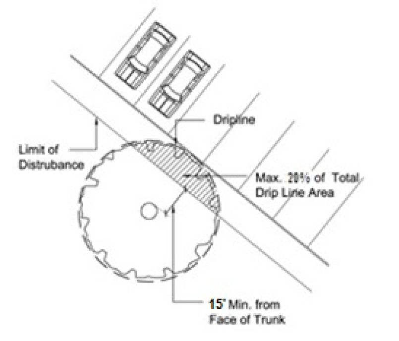
Figure 16-6-104.F.2: Limits of Paving or Compaction near Specimen Trees
b.
If preservation of a specimen tree causes unnecessary hardship, the applicant may apply for a variance from this subsection (see Sec. 16-2-103.S, Variance) once any required State or federal government agency approval, if applicable, to remove the tree is received in writing.
(Revised 4-18-2017 - Ordinance 2017-05)
G. Minimum Tree Coverage Standard
a.
All new development except for the construction of any public street, pathway, drainage project, single family subdivision, athletic field, airport runway, golf course or minor utility and the redevelopment or alteration of existing development (see subparagraph b below) shall include at least 900 adjusted caliper inches (ACI) of trees per acre of pervious surface area. Pervious surface area equals the gross acreage less the maximum impervious cover required for the proposed development. In the case of development in the CR zoning district, the maximum impervious coverage solely for the purposes of this section shall be 80%.
b.
Redevelopment or alteration of existing development shall have the option of meeting the standard in subparagraph a above or meeting replacement requirements in Sec. 16-6-104.I, Standards for Supplemental and Replacement Trees, based on trees removed by tree category.
c.
For the construction of any public street, pathway, drainage project, single family subdivision, athletic field, airport runway, golf course or minor utility the applicant is required to demonstrate that they have made all reasonable efforts to save significant trees and stands of trees. Reasonable tree replanting shall be required by the Official for these uses.
(Revised 4-18-2017 - Ordinance 2017-05; revised 1-7-2020 - Ordinance 2020-02; revised 3-7-2023 - Ordinance 2023-04)
To measure the ACI of trees on the development site, the following Tree Value Factors in Table 16-6-104.G.2, Tree Value Factors, shall be multiplied by the respective DBH in inches of trees in each category as listed in the Tree Equivalency Table in Sec. 16-6-104.H and then totaled.
Supplemental planting shall be at 15 percent of the difference between the minimum standard ACI less the pre-development ACI on the site.
Replacement planting shall be at 30 percent of the difference between minimum standard ACI and the ACI of trees remaining after construction. At the discretion of the Official, no more than 60% of the required tree planting on golf courses may be substituted for other environmental improvements, such as establishing native plants in lagoons to improve water quality and wildlife habitat or reestablishing understory vegetation in forested areas of the course.
The purpose of Table 16-6-104.H Tree Equivalency Table, is to illustrate the relative value of broad groups of trees, as well as individual trees, provide guidance in choosing trees, and provide guidance in selecting trees to supplement inadequate buffers.
I. Standards for Supplemental and Replacement Trees
Supplement and replacement trees provided in accordance with Sec. 16-6-104.G, Minimum Tree Coverage Standard, or Sec. 16-6-104.K, Tree Damage During Development, shall comply with the following standards.
Supplemental and replacement trees shall be planted within any part of the development site. If the site is within a PUD, the Official may allow supplemental and replacement trees to be planted on adjoining open space or other open space within the same PUD.
Supplemental and replacement trees shall be species native to Hilton Head Island (see the list of acceptable native plant species in Appendix C: Recommended Native Plants).
3. Replacement Rate, Tree Category, Planting Size
a.
Trees that are removed shall be replaced at the rate of one tree for every ten tree inches removed per tree category.
b.
Supplemental and replacement trees shall be within the same or lower-numbered tree category (see Sec. 16-6-104.H, Tree Equivalency Table) as the trees being replaced.
c.
At the time of planting, supplemental and replacement trees shall have the minimum height and trunk diameter shown in Table 16-6-104.I.3 for the category of the tree.
(Revised 4-18-2017 - Ordinance 2017-05; revised 8-19-2025 - Ordinance 2025-13)
Planting, staking, mulching, and care of all supplemental and replacement trees shall be in accordance with the guidelines of the International Society of Arboriculture, as published in the latest edition of the Arborist Certification Study Guide.
Replacement trees shall be planted within 180 days after removal of the tree being replaced, or a final Certificate of Compliance shall not be issued. The Official may extend this time period to accommodate the planting season (October 1 through June 1).
6. Post-Development Inspections
a.
After development is complete, the Official shall continue to make random inspections to insure that all existing trees of protected size as well as supplemental and replacement trees are maintained.
b.
Tree planting shall be required should any of these trees die, be removed, or be destroyed at any time after completion of development.
c.
This regulation applies to all projects regardless of the date the development permit or development approval was issued.
J. Tree and Buffer Protection During Development Activity
1. Tree and Buffer Protection Zones
a.
Tree and buffer protection zones shall include the areas of a development site that are within the drip lines of the individual trees and stands of trees proposed to be retained and protected in accordance with Sec. 16-6-104.F, Specimen and Significant Tree Preservation, Sec. 16-6-104.G, Minimum Tree Coverage Standard, areas for any supplemental or replacement trees proposed to be provided in accordance with Sec. 16-6-104.G, Minimum Tree Coverage Standard, or Sec. 16-6-104.K, Tree Damage During Development, as well as buffer areas proposed to be protected in accordance with Sec. 16-5-103.D, Adjacent Street Buffer Requirements and Sec. 16-5-103.E, Adjacent Use Buffer Requirements.
b.
Tree and buffer protection zones shall be depicted on all development plans.
During any development activity (including demolition activity), the property owner or developer shall be responsible for protecting existing, supplemental, or replacement trees within tree and buffer protection zones.
3. Protective Fencing, Marking, and Signage
i.
Continuous tree protective fencing shall be provided along the boundaries of tree and buffer protection zones. The Official shall consider existing site conditions and the species and size of the trees to be protected in determining the exact location of tree protective fencing, and may require the fencing to be extended to include the critical root zones of trees. For buffer protection, the fencing shall be installed along the edge of the buffer on the interior of the site.
ii.
Protective fencing shall consist of a bright orange plastic mesh or more durable material that is at least four feet high.
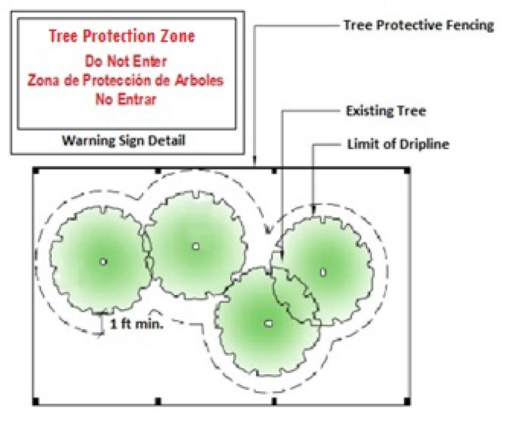
Figure 16-6-104.J.2: Tree Protective Fencing and Signage.
Warning signs shall be installed along any required tree and buffer protective fencing at points no more than 150 feet apart. The signs shall be clearly visible from all sides of the outside of the fenced-in area. The size of each sign must be a minimum of two feet by two feet. The sign message shall identify the fenced or marked area as a tree or buffer protection zone and direct construction workers not to encroach into the area (e.g., "Tree or Buffer Protection Zone: Do Not Enter"). (See Figure 16-6-104.J.2: Tree Protective Fencing and Signage.)
c. Duration of Protective Fencing or Signage
Required protective fencing and signage shall be erected before any grading or other development activity begins and shall be maintained until issuance of a Certificate of Compliance following completion of all development in the immediate area of the fencing or signage.
4. Tree and Buffer Protection Zone Encroachments and Protective Measures
Encroachments into tree and buffer protection zones may occur only when no other alternative exists, and shall comply with landscaping best management practices and the following limitations and requirements:
a. Construction Activity, Equipment, or Materials Storage
No development or demolition activity—including grading, the operation or parking of heavy equipment or the storage of material—shall be allowed within the tree and buffer protection zone.
Where compaction might occur due to construction traffic or materials delivery through a tree and buffer protection zone, the area must first be mulched with a minimum four-inch layer of wood chips. Equipment or materials storage shall not be allowed within a tree and buffer protection zone.
c. Fill, Retaining Walls, and Drywells
No fill shall be placed within a tree and buffer protection zone unless retaining walls and drywells are used to protect trees to be preserved from severe grade changes and venting adequate to allow air and water to reach tree roots is provided through any fill.
Trees located within a tree and buffer protection zone shall be protected from chemical contamination from liquids or other materials, including but not limited to paint, chemical solvents, gasoline, oil, diesel fuel, hydraulic fluid, concrete spoils, or rinse water from vehicle cleaning, including rinsing of concrete truck tanks and chutes.
f. Trenching Prior to Clearing
The removal of trees adjacent to tree and buffer protection zones can cause inadvertent damage to the protected trees. Prior to clearing activities, trenches with a minimum width of one-and-one-half inches and a minimum depth of 12 inches shall be cut along the limits of land disturbance, so as to cut, rather than tear tree roots.
a. All tree and buffer protection measures shall be inspected by the Official before start of any land disturbing activities and during the development process. The Official may continue to conduct random inspections to ensure that retained trees, supplemental trees, and replacement trees are maintained in a healthy state.
b. If any tree protected by this section is removed, dies, or is destroyed at any time during development activities or after completion of the development, it shall be replaced in accordance with Sec. 16-6-104.I, Standards for Supplemental and Replacement Trees.
(Revised 1-7-2020 - Ordinance 2020-02)
K. Tree Damage During Development
1.
If a specimen tree or other existing tree to be preserved under the tree protection plan is damaged during development of the development site, an arborist or other qualified professional shall, at the expense of the applicant, assess the damage and provide a written report to the Official that documents the following:
a.
Severity of the tree damage;
b.
Determination on whether corrective measures can be taken to save the tree or whether the tree has been damaged beyond repair; and
c.
Any corrective measures recommended to ensure the tree's survival (e.g., pruning damage to tree canopy, root pruning, fertilization, soil enhancements for damage to tree roots, and application of irrigation to compensate for root loss).
2.
If the assessment concludes that the tree can survive with corrective measures, the applicant shall promptly have recommended corrective actions undertaken by an arborist or other qualified professional. Such corrective measures shall be completed before issuance of a Certificate of Compliance for the development.
3.
If the assessment concludes that a tree has been damaged beyond repair, the tree shall be replaced with one or more trees that shall comply with the standards in Sec. 16-6-104.I, Standards for Supplemental and Replacement Trees.
The tree mitigation fee is established to allow the future planting of replacement trees removed for development in limited cases where this section's requirements for preservation of specimen trees (see Sec. 16-6-104.F) or for retention of existing tree coverage (see Sec. 16-6-104.G) cannot be reasonably achieved, and to allow the future planting of trees following a disaster.
On Hilton Head Island Airport property, the Official may allow a tree mitigation fee payment to be paid in lieu of the replacement of trees removed from beneath the side and approach slopes to the airport runway on determining that adequate buffers are being established in addition to those required in Sec. 16-5-103, Buffer Standards, and Sec. 16-6-102.D, Wetland Buffer Standards.
(Revised 4-18-2017 - Ordinance 2017-05)
The tree mitigation fee shall be calculated by the Official based on the cost of the required replacement trees and the cost of planting. Such costs shall be determined based on a cost estimate received from a local landscaping firm or through pricing information available through a project completed no more than one year earlier.
All required tree mitigation fees shall be paid prior to Development Plan approval.
a.
The Town shall establish and maintain a separate accounting fund for the deposit of tree mitigation fees paid in lieu of providing required replacement trees. Such funds need not be segregated from other Town monies for banking purposes. Any yield on such accounting fund shall accrue to that fund and shall be used for the purposes specified for the fund.
b.
The Town shall maintain and keep financial records for such accounting fund showing the revenues to such fund and the disbursements from such fund, in accordance with normal Town accounting practices. The records of such fund shall be open to public inspection in the same manner as other financial records of the Town.
c.
Monies from the tree replacement fund shall only be spent on planting of trees on publicly owned and maintained property. Qualifying debits include the cost of the trees, cost of installation of the trees, and cost of one year of maintenance for the trees.
(Revised 11-3-2015 - Ord. No. 2015-23)