Hopkinton City Zoning Code
SECTION 2
- Definitions.
The following words or terms used in this ordinance shall have the following meanings:
Abutter. One whose property adjoins the property of another at a border, boundary, or point with no intervening land.
Accessory dwelling unit (ADU). A residential living unit on the same parcel where the primary use is a legally established single-unit or multi-unit dwelling. An ADU provides complete independent living facilities for one (1) or more persons. It may take various forms including, but not limited to: A detached unit; a unit that is part of an accessory structure, such as a detached garage; or a unit that is part of an expanded or remodeled primary dwelling.
Accessory solar energy system. A solar energy system that is either 1) entirely roof-mounted or 2) ground mounted and generates no more energy than one hundred twenty-five percent (125%) of the energy (regardless of whether the current energy usage is from electric, oil, propane, etc.) that is necessary to support the residence or business on the parcel.
Accessory use. A use of land or a building or a portion of a building customarily incidental and subordinate to the principal use of the land or building. The incidental sale of products raised on a farm shall be considered accessory to the farm use.
Accessory structure. A structure that is incidental and subordinate to the principal structure on the same lot or parcel.
Affordable housing. Year-round housing built with a federal, state, or municipal subsidy that has a deed-restricted sales price or rental amount that is within means of a household that is moderate income or less, as defined by R.I.G.L.§ 42-128-8.1(d), and that will remain affordable through a deed or land lease for at least thirty (30) years. Synonymous with "low or moderate income housing."
Affordable housing plan. A component of the housing element in the comprehensive community plan that addresses housing needs and is prepared according to the guidelines adopted by the state planning council. An approved affordable housing plan is a plan approved by the director of administration.
Aggrieved party. A person or entity who can demonstrate that his or its property will be injured by a decision of any town official or board responsible for administering the zoning ordinance, or anyone entitled to notice pursuant to R.I.G.L. title 45, chapter 24.
Agricultural land. Land suitable for agriculture by reason of suitability of soil or other natural characteristics or past use for agricultural purposes, including land designated as prime farm land or additional farm land of statewide importance by the soil conservation service of the U.S. Department of Agriculture.
Applicant. An owner or authorized agent of the owner submitting an application or appealing an action of any official or board.
Application. The completed form or forms and all accompanying documents, exhibits, and fees an applicant is required to submit for approval or permitting.
Aquifer. A saturated, permeable geologic formation that can yield significant quantities of water to wells, springs or surface water bodies.
Aquifer protection permit. A permit allowing a use designated by the letter "A" in the primary or in the secondary groundwater and wellhead protection overlay district in the use table of this ordinance.
Best management practices. A schedule of activities, prohibition of practices, maintenance procedures and other management practices designed to prevent or reduce the degradation of the town's groundwater quality.
Buffer. Land maintained in either a natural or landscaped state that is used to screen or mitigate the impacts of development on surrounding areas, properties or rights-of-way.
Building. Any structure used or intended for supporting or sheltering any use or occupancy.
Building height. On all structures, building height is measured to the top of the highest point of the existing or proposed structure, excluding spires, chimneys, flag poles, and similar projections. On an undeveloped lot, building height is measured from the average existing-grade elevation at the proposed midpoint of the structure's foundation. On an existing structure, building height is measured from the average grade of the outermost corners of the foundation. On a structure in a special flood hazard area, as shown on the official Federal Emergency Management Agency (FEMA) flood insurance rate maps, the base flood elevation on the FEMA map, plus up to five (5) feet of any existing or proposed freeboard, less the average existing grade elevation, is excluded from the building height calculation. Freeboard is the number of feet the lowest floor of a structure must be elevated above the base flood elevation to provide safety.
Cannabis cultivator. An entity licensed to cultivate, process and package cannabis, to deliver cannabis to cannabis establishments and to transfer cannabis to other cannabis establishments, but not to consumers. See R.I.G.L. § 21-28.6-3(11).
Cannabis product manufacturer. An entity licensed to obtain, manufacture, process and package cannabis and cannabis products, to deliver cannabis and cannabis products to cannabis establishments and to transfer cannabis and cannabis products to other cannabis establishments, but not to consumers. See R.I.G.L § 21-28.11-3(14).
Cannabis retailer. An entity licensed pursuant to R.I.G.L. § 21-28.11-10.2 to purchase and deliver cannabis and cannabis products from cannabis establishments and to deliver, sell or otherwise transfer cannabis and cannabis products to cannabis establishments and to consumers. See R.I.G.L. § 21-28.11-3(16).
Cannabis testing laboratory. A third-party analytical testing laboratory that is licensed annually by the R.I. cannabis control commission, in consultation with the department of health, to collect and test samples of cannabis and cannabis products pursuant to regulations issued by the commission and is:
(1)
Independent financially from any medical cannabis treatment center or any licensee or cannabis establishment for which it conducts a test; and
(2)
Qualified to test cannabis in compliance with regulations promulgated by the commission pursuant to this chapter. The term includes, but is not limited to, a cannabis testing laboratory as provided in R.I.G.L. § 21-28.11-11. See R.I.G.L. § 21-28.11-3(17).
Residential cluster development. A site planning technique that concentrates buildings in specific areas on the site to allow the remaining land to be used for recreation, common open space, or preservation of environmentally, historically, culturally, or other sensitive features and/or structures. Under cluster development there is no increase in the number of lots over that which would be permitted under conventional development except for provisions which include incentive bonuses for certain types or conditions of development.
Common ownership. Ownership of two (2) or more contiguous lots by the same individual, individuals, entity, or entities; or ownership by an association of property owners such as a homeowners' association.
Community residence. A home or residential facility where children and/or adults reside in a family setting and may or may not receive supervised care. This shall not include halfway houses or substance abuse treatment facilities. See R.I.G.L. § 45-24-31(16).
Compassion center. A not-for-profit corporation licensed under R.I.G.L. § 21-28.6-12 that acquires, possesses, cultivates, manufactures, delivers, transfers, transports, supplies, or dispenses medical marijuana, and/or related supplies and educational materials, to patient cardholders and/or their registered caregiver cardholder or authorized purchaser. See R.I.G.L. 21-28.6-3(6).
Comprehensive plan. The document adopted and approved pursuant to R.I.G.L. title 45, chapter 22.2 to which any zoning ordinance adopted pursuant to R.I.G.L. title 45, chapter 24 shall be in compliance.
Contaminated site solar energy system. A solar energy system located on a contaminated site pending remediation as of February 16, 2021 or a remediated and restricted contamination site as of February 16, 2021. A contaminated site solar energy system shall be reviewed as a major land development project.
Contaminated site pending remediation. A property that has been identified and confirmed by the R.I. department of environmental management as of February 16, 2021, as being contaminated through issuance of a "Letter of Responsibility," but has not yet been remediated to the satisfaction of the R.I. department of environmental management.
Day care—Day care center. A facility other than a family day care home that provides daytime care and supervision.
Day care—Family day care home. A home where daytime care and supervision is provided for no more than eight (8) individuals, including up to six (6) individuals who are not related to the caregiver.
Development. The construction, reconstruction, conversion, structural alteration, relocation, or enlargement of any structure; any mining, excavation, landfill or land disturbance; any change in use, or alteration or extension of the use, of land.
Development plan review. Design or site plan review of a development of a permitted use. A municipality may utilize development plan review under limited circumstances to encourage development to comply with design and/or performance standards of the community under specific and objective guidelines, for developments including, but not limited to:
(1)
A change in use at the property where no extensive construction of improvements is sought;
(2)
An adaptive reuse project located in a commercial zone where no extensive exterior construction of improvements is sought;
(3)
An adaptive reuse project located in a residential zone which results in less than nine (9) residential units;
(4)
Development in a designated urban or growth center;
(5)
Institutional development design review for educational or hospital facilities; or
(6)
Development in a historic district.
Dwelling unit. A structure or portion thereof providing complete, independent living facilities for one (1) or more persons, including permanent provisions for living, sleeping, eating, cooking, and sanitation, and containing a separate means of ingress and egress.
Extractive industry. The extraction of minerals, including solids such as coal and ores and sand and gravel; liquids such as crude petroleum; and gases such as natural gases. The term also includes quarrying; well operation; milling such as crushing, screening, washing, and flotation; and other preparation customarily done at the extraction site or as a part of the extractive activity.
Family member. A person related by blood, marriage, or other legal means, including but not limited to a child, parent, spouse, mother-in-law, father-in-law, grandparent, grandchild, domestic partner, sibling, care recipient, or member of the household.
Floodplain or flood hazard area. An area that has a one (1) percent or greater chance of inundation in any given year, as delineated by the Federal Emergency Management Agency pursuant to the National Flood Insurance Act of 1968, as amended (P.L. 90-448) (42 U.S.C. 4011 et seq.). See R.I.G.L. § 45-22.2-4.
Ground-mounted solar energy system. A solar energy system that is structurally appended to the ground and is not attached to a structure or building.
Groundwater. Underground water that completely fills the spaces between particles of sediment and within rock formations.
Halfway house. A residential facility for adults or children who have been institutionalized for criminal conduct and who require a group setting to facilitate the transition to a functional member of society.
Hazardous material. Any material defined as a "hazardous substance" by section 101(14) of the Comprehensive Environmental Response, Compensation and Liability Act (CERCLA) of 1980 (42 USC 9605) as amended. Hazardous material shall include, but shall not be limited to, any hazardous waste as well as any of the following materials: acetone, ethanol, ethylene oxide, methanol, methylene chloride, perchloroethylene and petroleum products.
Historic district commission. The body established by chapter 7 of the code of ordinances that is authorized to approve construction, alteration, repair, removal, or demolition affecting the exterior appearance of a structure or its appurtenances in the historic district or in a historic cemetery. See R.I.G.L. title 45, chapter 24.1.
Customary home occupation. Any activity customarily carried out for gain by a resident that is conducted as an accessory use in the resident's dwelling unit. A customary home occupation shall employ no more than one (1) person other than the resident. The term includes the office of a contractor and the daily storage of no more than three (3) commercially registered vehicles with a gross vehicle weight rating of no more than tenty thousand (20,000) pounds, but does not include outdoor equipment or material storage.
Household. One (1) or more persons living together in one (1) dwelling unit who have common access to, and use of, all living areas and all areas for eating and food preparation and storage. A household may consist of a family and its servants or employees, if any; or no more than four(4) unrelated persons.
Hybrid cannabis retailer or hybrid compassion center. A compassion center licensed pursuant to R.I.G. L. title 21, chapter 28.6 that is authorized to sell nonmedical or adult-use cannabis to consumers. See R.I.G.L. § 21-28.11-3(28).
Impervious surface. A surface that inhibits the absorption of water into the underlying soil including but not limited to concrete or pavement.
Infrastructure. Facilities and services needed to sustain residential, commercial, industrial, institutional, and other activities.
Land development project. A project in which one (1) or more lots, tracts, or parcels of land or a portion thereof are developed or redeveloped as a coordinated site for one (1) or more uses, units, or structures, including but not limited to planned development or cluster development for residential, commercial, institutional, recreational, open space, or mixed uses.
Large scale solar energy system. Any solar energy system that is not either an accessory solar energy system or a contaminated site solar energy system.
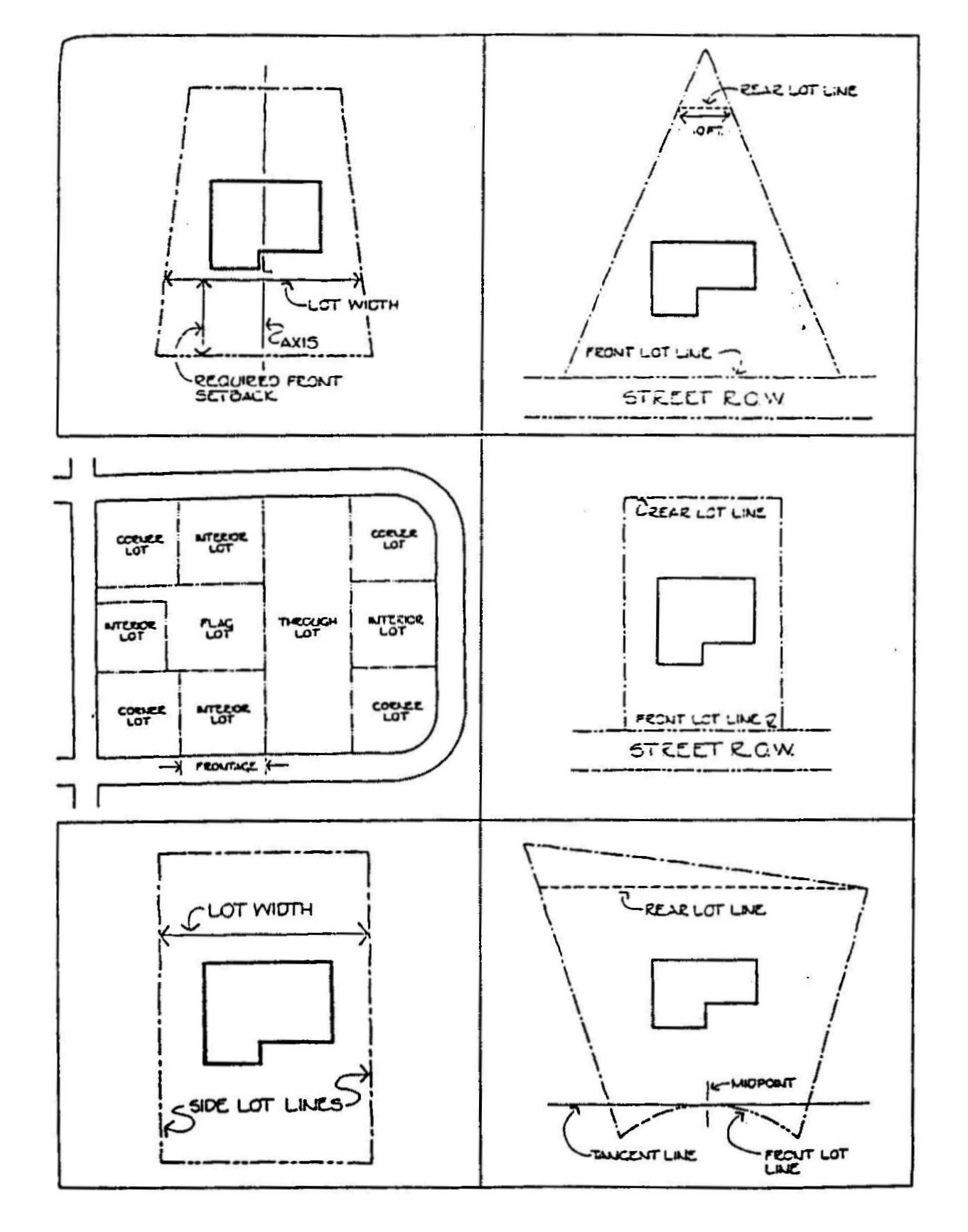
Lot. Either (a) The basic development unit for determination of lot area, depth, and other dimensional regulations; or (b) A parcel of land whose boundaries have been established by some legal instrument such as a recorded deed or recorded map and is recognized as a separate legal entity for purposes of transfer of title.
Lot area. The total area within the boundaries of a lot, excluding any street right-of-way, usually reported in acres or square feet.
Lot depth. The distance measured from the front lot line to the rear lot line. For lots where the front and rear lot lines are not parallel, the lot depth is an average of the depth.
Lot frontage. That portion of a lot abutting a street. Lot frontage must be contiguous to meet minimum frontage requirements.
Lot line. A line of record, bounding a lot that divides one (1) lot from another lot or from a public or private street or any other public or private space and shall include:
(1)
Front lot line. The lot line separating a lot from a street or right-of-way. On an interior lot, the lot line abutting a street; on a corner lot, the shorter lot line abutting a street; and on a through lot, the lot line abutting the street providing the primary access to the lot.
(2)
Rear lot line. The lot line opposite and most distant from the front lot line, or in the case of a triangular or otherwise irregularly shaped lot, an assumed line at least ten (10) feet in length entirely within the lot, parallel to and at a maximum distance from the front lot line. In the event that the front property line is a curved line, the rear property line is an assumed line not less than ten (10) feet long, lying within the lot and parallel to a line tangent to the front property line at its midpoint.
(3)
Side lot line. Any lot line other than a front or rear lot line. On a corner lot, a side lot line is along the street lot line other than the front lot line.
Lot, through. A lot that fronts on two (2) substantially parallel streets, or fronts on two (2) streets that do not intersect at the boundaries of the lot.
Lot width. The horizontal distance between the side lines of a lot measured at right angles to its depth along a straight line parallel to the front lot line at the minimum front setback line.
Low- and moderate-income housing. Synonymous with "affordable housing."
Mixed use. A mixture of land uses within a single development, building, tract or parcel.
Maximum lot coverage. The maximum percentage of a lot that is permitted to be covered by buildings and impervious surfaces.
Modification. A dimensional variance granted by the zoning enforcement officer pursuant to section 13 of this ordinance.
Nonconformance. A building, structure, or parcel of land, or use thereof, lawfully existing at the time of the adoption or amendment of the zoning ordinance and not in conformity with the provisions of the ordinance or amendment.
(1)
Nonconforming by use. A lawfully established use of land, building, or structure that is not a permitted use in that zoning district. A building or structure containing more dwelling units than are permitted by the use regulations of the zoning ordinance shall be nonconforming by use;
(2)
Nonconforming by dimension. A building, structure, or parcel of land not in compliance with the dimensional regulations of the zoning ordinance. Dimensional regulations include all regulations of the zoning ordinance other than those pertaining to the permitted uses. A building or structure containing more dwelling units than are permitted by the use regulations of the zoning ordinance shall be nonconforming by use; a building or structure containing a permitted number of dwelling units by the use regulations of the zoning ordinance, but not meeting the lot area per dwelling unit regulations, shall be nonconforming by dimension.
Overlay district. A zoning district that is superimposed on one (1) or more other zoning districts or parts of districts and that imposes requirements in addition to those otherwise applicable to the underlying district.
Performance standards. A set of criteria or limits relating to elements that a particular use or process must meet or may not exceed.
Permitted use. A use allowed by right that is specifically authorized in a particular zoning district.
Preapplication conference. A review meeting held between applicants and reviewing agencies before formal submission of an application for a permit or for development approval.
Primary groundwater and wellhead protection zone overlay district. Those areas depicted on that certain map entitled "Groundwater and Wellhead Protection Areas Map, Hopkinton, RI," dated September 28, 2009, or the most recent revision adopted by the town council, which map is on file in the records of the town clerk. The groundwater and wellhead protection areas map, Hopkinton, RI shall be amended, at a minimum, on a bi-annual basis and the town planner shall be responsible for presenting an amended map to the town planning board for its review and referral to the town council with a recommendation that it be adopted.
Roof-mounted solar energy system. A solar energy system that is structurally attached to the roof of a building or structure.
Setback line. A line parallel to a lot line at the minimum distance of the required setback for the zoning district in which the lot is located that establishes the area within which a structure must be erected or placed.
Site plan. The development plan for one (1) or more lots that shows the existing or the existing and the proposed conditions of the lot.
Solar energy system. The equipment and requisite hardware and structures that provide and are used for collecting, transferring, converting, storing, or using incident solar energy for water heating, space heating, cooling, generating electricity, and off-loading said electricity to the grid, or other applications that would otherwise require the use of a conventional source of energy such as petroleum products, natural gas, manufactured gas, or electricity produced from a nonrenewable resource. This shall include photovoltaic arrays and installations that utilize ground-mounted systems. A solar energy system, when the principal use of a parcel, shall be deemed to be a manufacturing use.
Solar energy system operator. The agent or entity that conducts the daily operation and maintenance of the solar energy system under contractual agreement with the solar energy system owner.
Solar energy system owner. The owner of equipment and appurtenances comprising the solar energy system; said entity may also be the solar energy system operator.
Solar glare. The effect produced by light reflecting from a solar panel with intensity sufficient to cause annoyance, discomfort, or loss in visual performance and visibility.
Solid waste. Any solid waste as defined in the R.I. Department of Environmental Management Rules and Regulations for solid waste management facilities, February 1991, and amendments thereto; and which shall include garbage, refuse and other discarded solid materials generated by residential, institutional, commercial, industrial and agricultural sources but does not include solids or dissolved materials in domestic sewage or sewage sludge, nor does it include hazardous waste. Solid waste shall also include non-hazardous liquid, semi-solid and containerized gaseous waste.
Street right-of-way. The entire area dedicated for street use, including the pavement or travel surface, and the areas on both sides of the pavement or travel surface that may be reserved for installation of sidewalks, utilities, drainage improvements or other purposes.
Structure. A combination of materials to form a construction for use, occupancy, or ornamentation, whether installed on, above, or below, the surface of land or water.
Substandard lot of record. Any lot lawfully existing at the time of adoption or amendment of the zoning ordinance and not in conformance with the dimensional provisions of that ordinance.
Use. The purpose or activity for which land or buildings are designed, arranged, or intended, or for which land or buildings are occupied or maintained.
Variance. Permission to depart from the literal requirements of the zoning ordinance.
Waters. As defined in R.I.G.L. § 46-12-1(23).
Wellhead protection area. The critical area surrounding a community water system well or non-transient non-community water system well through which water will move toward and reach such wells, as depicted on that certain map titled "The Groundwater and Wellhead Protection Map, Hopkinton, RI," dated March 22, 2004 or the most recent revision adopted by the town council, which map is on file in the records of the town clerk.
Wetland, freshwater. As defined in R.I. Department of Environmental Management Regulations.
Zoning certificate. A document signed by the zoning enforcement officer that acknowledges that a use, structure, building or lot either complies with or is legally nonconforming to the provisions of the town zoning ordinance or is an authorized variance or modification.
(Ch. 134, § 2, 12-19-94; Ch. 131, 3-22-04; Ch. 211, 11-16-09; Ch. 214, 9-20-10; Ch. 246, 7-18-16, Revised: 1-22-19; Ch. 279, 4-19-21; Ch. 285, 8-1-22; Ch. 286, 10-3-22; Ch. 292, §(Exh. A), 12-18-23)
FIGURES FOR LOT DEFINITIONS #'S: 39-46