
Irmo City Zoning Code
ARTICLE IV
- COMMUNITY APPEARANCE, BUFFERING, SCREENING, LANDSCAPING, COMMON OPEN SPACE, AND TREE PROTECTION2
The regulations contained in this article are intended generally to ensure land use compatibility, improve aesthetics, ensure adequate provision of open space, and protect trees within the town.
Editor's note— Ord. No. 23-22, adopted October 17, 2023, repealed art. IV, §§ 4-1—4-6, and enacted a new art. IV as set out herein and later amended. Former art. IV pertained to similar subject matter and derived from Ord. No. 20-01, adopted February 4, 2020; Ord. No. 22-08, adopted May 17, 2022; and Ord. No. 23-16, adopted July 18, 2023.
Sec. 4-1. - Descriptions.
There are five separate types of landscaping outlined in this Code, as described below:
A.
Buffer areas. Landscaping placed around the exterior boundary of a parcel separating the subject property from adjacent properties and roads.
B.
Screening. A specific type of buffer designed to block or obscure a particular element or use, such as a dumpster or exterior storage, from view.
C.
Interior landscaping. Open space within a lot devoted to growing trees, shrubs, grass, and other vegetation, as well as decorative hardscape elements.
D.
Parking area landscaping. Trees and associated vegetation designed to break up the expanse of a parking area.
E.
Common open space. Open space particular to residential developments for the use and enjoyment of residents and property owners.
(Ord. No. 23-22, 10-17-2023)
Sec. 4-2. - Buffer areas.
4-2.1. Definition and purpose of buffer areas.
a.
Buffer areas shall be required to separate incompatible land uses from each other in order to reduce potential nuisances such as views, noise, and light by providing spatial separation and landscaping to soften or mitigate those impacts.
b.
The term "buffer area" refers to both the area of land where buffer vegetation is planted as well as the planting required thereon.
i.
Both the amount of land and the type and amount of planting specified for each buffer area required by this section are designed to ameliorate conditions between incompatible adjacent land uses, or between a land use and a street.
ii.
The planting requirements of buffer areas are intended to ensure that they reduce the impacts of adjacent incompatible land uses while also being horticulturally appropriate, as stated in article XIV, planting materials list.
4-2.2. Location of buffer areas.
a.
Buffer areas shall be located on the outer perimeter of a lot or parcel, extending to the lot or parcel boundary line, except for smaller parcels (outparcels) within a larger development where internal buffer area requirements shall be determined through the design review process of the overall development.
b.
Buffer areas shall not be located on any portion of an existing public or private street or right-of-way.
c.
Buffer areas shall not impede sight triangles at drives or intersections.
4-2.3. Determination of buffer area requirements.
To determine the buffer area required between two adjacent parcels or between a parcel and a street, the following procedure shall be followed:
a.
Identify the proposed land use.
b.
Identify the adjacent land use along each property line or segment of property line. If the adjacent parcel is undeveloped (vacant), determine the zoning from the zoning map. The adjacent future land use as designated by the comprehensive plan may be used with zoning administrator's approval. Adjacent properties outside of town limits will be treated the same as those within town limits for buffering requirements.
c.
Buffer areas shall not be required adjacent to existing buffer areas which meet the intent of this ordinance. Specifically, double buffer areas are not required. However, buffer areas may be required to bring combined buffer areas up to these standards.
d.
Where no buffers are required between lots, the equivalent of a type A buffer shall be calculated for the length of the dividing property line. The calculated number of plants shall then be required somewhere on the property. The plants may be placed along the calculated property line, the interior of the property, or amongst other buffers. However, effort should be made to spread the vegetation out and not cluster all required additional plantings. These plantings will count towards the ten percent required interior landscaping requirement.
e.
Use of table.
a.
Determine the buffer area required on each boundary (or segment thereof) of the subject parcel by referring to the table of buffer area requirements in section 4-2.7.
b.
The letter designations contained in the table refer to the table of buffer area types shown in section 4-2.6.
f.
Required buffers shall be planted whenever a vacant parcel is developed or when permitted work equal or greater than 50 percent of the value of the property is performed on developed property. Property valuation is determined by the county assessor's office, while project valuation is determined through business licensing and associated contracts. Similarly, changes to a more intense land use shall necessitate an increase in buffer area requirements as required by the buffer table. In all cases of redevelopment or changes in the intensity of land use, additional plantings shall be determined by the zoning administrator, who may grant an administrative variance at his or her professional discretion. Such findings may be appealed to the zoning board of appeals.
4-2.4. Buffer area specifications.
1.
Generally.
a.
The requirements are stated in terms of the minimum width of the buffer area and the number of plants required per 100 linear feet of buffer area.
b.
Multiply the length of the buffer area segment by the plant requirements to determine the quantity of plants required. Fractions are rounded up to the nearest whole number.
c.
The "plant multiplier" is a factor by which the number of plants required for a given buffer area segment may be modified, given a change in the width of that buffer.
d.
Arrangement of plants, as well as plant type and plant species, shall be determined through the design approval process, based upon the proposed use of the subject property and the uses of adjoining properties.
e.
Massing and grouping of plants should be intentional and part of the overall site design. Arrangement may be either formal and regimented or naturalistic. Examples of buffer area design approaches are shown in section 4-2.6 for illustrative purposes only.
f.
Where fences or walls are used, the design shall be appropriate to the project.
g.
The ground plane of the buffer area shall be required shrubs, lawn, groundcover, and/or mulch. Bare ground shall not be allowed.
h.
Any existing plant material, which otherwise satisfies the requirements of this section, may be counted toward satisfying all such requirements.
i.
Irrigation is required except in certain circumstances as determined by the zoning administrator. Where irrigation is not in place a nearby water source shall be provided to facilitate watering of plants. See section 4-2.5, below.
j.
Plants shall meet the requirements of the American Standard for Nursery Stock.
k.
Plants listed by Clemson University or the South Carolina Forestry Commission as invasive shall not be allowed.
2.
Change in land use. When a land use of a previously developed parcel is changed to a more intense land use (according to table 7.7), the buffer area shall be increased as necessary to meet the requirements for buffer areas between the new land use and existing adjacent uses.
3.
Use of buffer areas. A buffer area may be used for passive recreation, such as paths or trails, providing all spatial and planting requirements are met. All other uses, including off-street parking, is prohibited.
4.
Buffer area part of required yards. Where front, side, and rear yard setbacks or build-to lines are required the buffer areas may be established inclusive of such required setbacks.
5.
Interruption. Buffer areas may be interrupted to provide vehicular and/or pedestrian ingress and egress to serve the property. In this case, the widths of ingress and egress areas are subtracted from the length of the buffer area segment.
4-2.5. Maintenance.
1.
Requirements for maintaining buffers and interior landscaping.
a.
Responsibility. The responsibility for maintenance of a required buffer, to include fences, shall remain with the owner of the property. Maintenance is required in order to ensure the proper functioning of a buffer as a landscaped area which reduces or eliminates nuisance and/or conflict. The owner shall be responsible for installing live, healthy plants. Replacement plants shall be provided by the owner for any required plants that die or are removed.
b.
Maintenance. Maintenance shall consist of mowing, mulching, edging, removal of litter, removal of dead plant materials, and necessary pruning. The removal of limbs higher than eight feet is prohibited unless the individual limb has died due to damage. The removal of all limbs above eight feet, i.e. "topping," is prohibited, as is preventing a tree from reaching said height by pruning. Topped trees will be required to be removed and replaced with new, healthy trees of a similar category (canopy or understory).
c.
All planted areas shall be provided with an irrigation system. In the case of redevelopment landscaping or remote vegetation, a readily available water supply to ensure continuous healthy growth and development may be permitted by the zoning administrator. Failure to do so is a violation of this ordinance and may be remedied in the manner prescribed for other violations.
d.
Where replacement planting is required the total caliper inches of replacement trees shall equal at least one-third of the total diameter at breast height (DBH) of the trees to be removed. However, where replacement planting is required as a result of a violation of this ordinance, the total caliper inches of replacement trees shall equal at least 100 percent of the total DBH of the trees that were removed. In the event trees are removed and cannot be measured, stumps may be measured or recent photographs may be studied to approximate diameter. Instead of replacement planting, parties are permitted to pay into the town tree fund an amount set by council per caliper inch. These funds will be used to plant trees on public property throughout the town.
e.
Where pedestrian or bicycle trails are allowed within a buffer, these trails shall be maintained to provide for their safe use. Such maintenance shall include pruning of plants to remove obstructions, removal of dead plant materials, litter, or other hazards.
f.
Natural watercourses within a buffer shall be maintained as free-flowing and free of debris. Stream channels shall be maintained so as not to alter floodplain areas.
g.
Failure to maintain. Failure to maintain a buffer shall be considered violation of the zoning ordinance.
4-2.6. Buffer area types.
1.
Opaque screens may be wood or masonry (block, brick, or stucco) and must be a minimum of six feet zero inches tall and placed at the property line. If screening is used the buffer area requirement defaults to the next less intensive buffer area planting and width requirements. Along streets, opaque screens shall be placed at the interior edge of the buffer, not at the property line. Opaque screens may not be used along streets for type A, B, or C buffers, except for residential uses, in which case no reduction of buffer type shall apply.
2.
Berms must be two feet in height and have a minimum crown width of two feet. Buffer width may be reduced by 25 percent with the inclusion of a landscaped earth berm in addition to the required number of plantings. Reduction requires zoning administrator approval.
3.
Canopy trees, understory trees, and upright evergreen trees must be selected from the list of approved species. Canopy trees must be a minimum of two and one-half inch caliper at planting. Upright evergreens and understory trees must be a minimum of six feet zero inches tall at planting and should generally be specified as six feet eight inches tall. Over the total length of all buffer areas for a project, tree species and type may vary, as appropriate to the project. However, at least one-third of the total number of required trees shall be canopy trees. Likewise, no more than one-third of the total number of required trees shall be understory trees. Buffer area designs are subject to approval by the town community development director. Palmetto (Sabal palmetto) shall not count toward required tree requirements except by special exception. When allowed, palmettos may be substituted at a ratio of three palmettos for each required tree.
4.
Evergreen and deciduous shrubs must be a minimum size of three gallons at installation but shall be species that reach a mature height of at least six feet zero inches. Other smaller shrubs and groundcover may be included as part of the overall buffer design but shall not count towards this requirement. For type A, B, and C buffer areas fronting streets, the six-feet-zero-inch requirement does not apply.
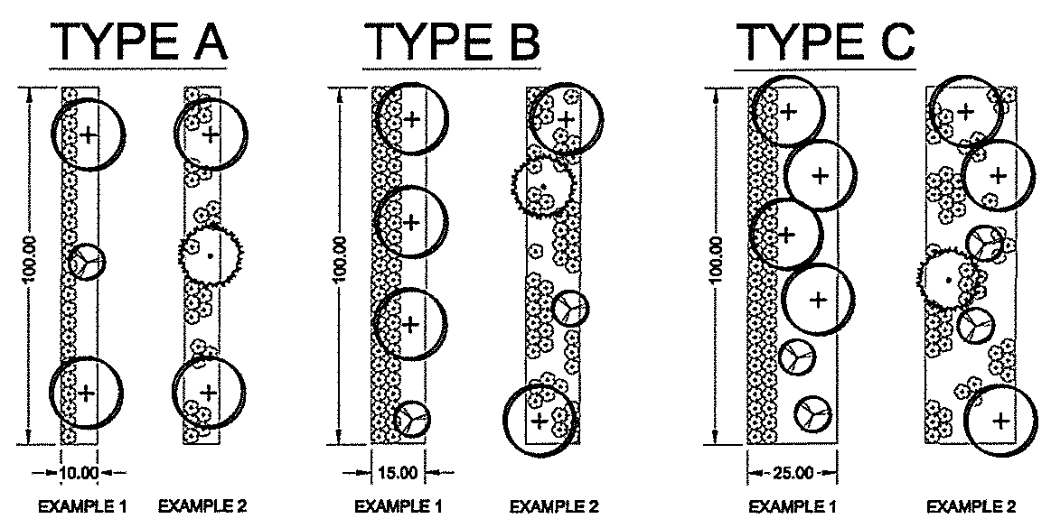
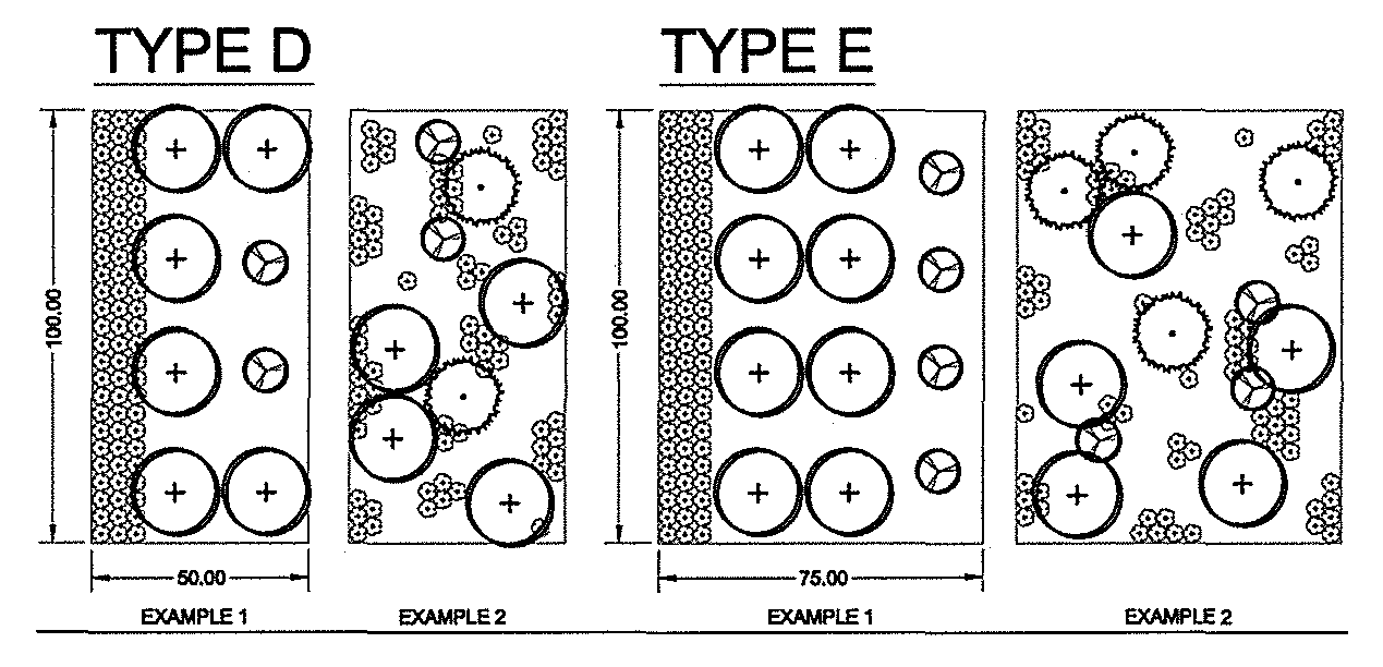
4-2.7. Table of buffer area requirements.
4-2.8. Existing plant material.
1.
Where practicable, the natural vegetation on a site shall be preserved according to the provisions of this chapter and the town tree protection ordinance.
2.
Wherever healthy plant material exists on a site, the above-mentioned standards may be adjusted to allow credit for such plant material, if, in the opinion of the zoning administrator, such adjustment is in the best interests of the town and preserves all intents of this chapter and the tree protection ordinance.
(Ord. No. 23-22, 10-17-2023)
Sec. 4-3. - Screening.
4-3.1. Definition.
Screening is a type of buffer that is designed to block or obscure a particular element or use from view.
4-3.2. Purpose.
The purpose of screening is to minimize, if not eliminate entirely, the visual impact of potentially unsightly open storage areas, mechanical equipment, and refuse disposal facilities.
4-3.3. Where required.
Screening specified by this section shall be required of all open storage areas not devoted to retail sales visible from any public street which includes:
A.
Open storage areas for building materials, salvage materials, and similar unenclosed uses.
B.
Appliances.
C.
Mechanical systems, including roof-mounted heating ventilation and air conditioning (HVAC).
D.
Trash containers of four or more cubic yards.
E.
Shipping containers, where permitted.
Screening shall be required for A-E above on all proposed new multi-family and non-residential uses, as well as whenever such uses as above are newly utilized on existing non-residential and multi-family uses.
4-3.4. Type screening required.
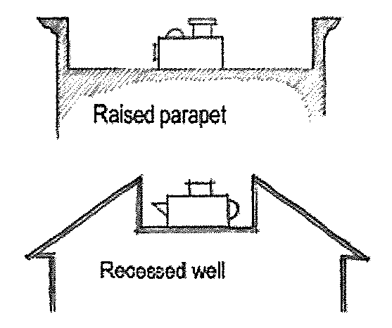
Screening shall be accomplished by an opaque divide not less than six feet high or the height of the object to be screened, whichever is greater. Screening may be accomplished by the use of sight-obscuring plant materials (generally evergreens), earth berms, walls, fences, proper siting of disruptive elements, building placement or other design techniques approved by the planning commission. Roof-mounted mechanical systems shall be screened by architectural features such as parapet walls.
4-3.5. Retention pond screening.
Where a retention or detention pond is included in the site design, said pond shall be landscaped by the use of sight-obscuring plant materials (generally evergreens), and be in compliance with all applicable county, state and federal regulations.
(Ord. No. 23-22, 10-17-2023)
Sec. 4-4. - Landscaping.
4-4.1. Definition.
Landscaping is a type of open space permanently devoted and maintained for the growing of trees, shrubbery, and ground covers with complementary grass and mulch, as well as the addition of decorative features to the land such as plazas, courtyards, and other hardscape elements.
4-4.2. Purpose.
The purpose of landscaping is to improve the appearance of vehicular use areas and development abutting public rights-of-way; to protect, preserve, and promote the aesthetic appeal, scenic beauty, character and value of land; and to promote public health and safety through the reduction of noise pollution, storm water runoff, air pollution, visual pollution, and artificial light glare.
4-4.3. Where required.
No proposed commercial, institutional, industrial, or other non-residential use, or multi-family development, shall hereafter be established and subsequently used unless landscaping is provided in accordance with the provisions of this section. No existing building, structure, or vehicular use area shall be expanded or enlarged by 50 percent or more or renovated at 50 percent or more of value unless the minimum landscaping required by the provisions of this section is provided throughout the building site. In all cases of redevelopment or changes in the intensity of land use, additional plantings shall be determined by the zoning administrator, who may grant an administrative variance at his or her professional discretion.
4-4.4. Interior landscaping.
a.
The area to be landscaped shall be ten percent of the total gross lot area.
b.
This amount of land shall be devoted to landscaping, which includes hardscape elements (plazas and courtyards), trees, shrubs, and ground covers, with complementary grass, mulch, and other landscape treatment.
c.
Any required landscaping, including parking lot islands or screening may be included in the required landscaped area. However, the required minimum buffer yards are excluded except as outlined in section 4-2.3.
4-4.5. Parking area landscaping.
a.
All open vehicular use areas containing ten more parking spaces require one medium- or large-maturing tree per ten parking spaces.
b.
Parking lots shall contain planter islands and peripheral landscaping to provide breaks in the expanse of paving.
1.
Landscaped islands shall be required. A maximum of ten parking spaces in a row will be allowed without a landscaped island. However, this requirement may be adjusted by the zoning administrator, when strict application will significantly limit the efficiency of the parking area.
2.
Planter islands shall have a minimum of 150 square feet in area (approximately 9'-0" x 18'-0" with appropriate radii).
3.
Planter islands shall contain at least one two-and-one-half-inch caliper canopy tree.
4.
Light poles, transformers, junction boxes, water meters, and/or fire hydrants shall not be placed where they conflict with required trees.
5.
The island shall be landscaped with shrubs, ornamental grasses, groundcover, and/or mulch. The use of lawn within an island should be avoided or minimized.
4-4.6. Parking curbs.
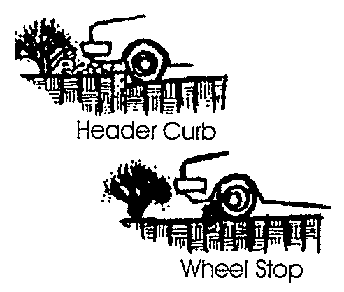
All landscaped areas in or adjacent to parking areas shall be protected from vehicular damage by a raised concrete curb or an equivalent barrier. The barrier need not be continuous.
4-4.7. Parking and interior landscaping widths.
Trees shall have a minimum of 16 square feet of open soil surface area when planted in tree wells or concrete cutouts. Otherwise, trees shall have the minimum open soil surface areas listed below.
A.
Small-maturing trees—16 square feet (four feet by four feet).
B.
Medium-maturing trees—64 square feet (eight feet by eight feet).
C.
Large-maturing trees—144 square feet (12 feet by 12 feet).
D.
Landscaped areas must be at least 25 square feet in size and a minimum of three feet wide to qualify.
4-4.8. Landscaping plan.
A landscaping plan shall be submitted as part of the application for a zoning permit.
Applicants shall submit two copies and one digital landscaping plan either separately or with site plans. The plan shall contain:
A.
Name of the proposed development; the name, address, telephone number, and email address of the developer and the project designer; and a location map showing the proposed project; and,
B.
Scaled plan no smaller than one inch equals 30 feet and no larger than 24 by 36 inches, showing the actual size, shape, and location of all existing and proposed features and landscaping as follows:
1.
Proposed and existing buildings, pavements, rights-of-way/utility easements, watercourses, floodways/wetland, detention/retention pond, and final grades after grading;
2.
Proposed landscaping, hardscaping, decorative features, and irrigation/watering system;
3.
A table of planting materials stating species (botanical and common names), quantity, height, spread, and installation size (section 4-1.6(a)) for all plants, using per article XIV, planting materials list); and
4.
Tree survey, where applicable, per section 4-5.4 and:
a.
Significant trees identification per sections 4-5.2 and 4-5.5.
b.
Distinguish trees and vegetation to be removed and/or preserved.
(Ord. No. 23-22, 10-17-2023)
Sec. 4-5. - Common open space.
4-5.1. Definition.
Common open space consists of land and/or water bodies used for recreation, amenity, or buffer in residential developments; it shall be freely accessible to all residents and property owners of a development, where required by this ordinance. Open space shall not be occupied by buildings or structures other than those in conjunction with the use of the open space, including associated roads or parking, nor shall it include the yards or lots of residential dwelling units required to meet minimum lot area or parking area requirements.
4-5.2. Purpose.
The purpose of this section is to ensure adequate open space for residential development; to integrate recreation, landscaping, greenery and/or natural areas into such projects; to promote the health and safety of residents of such projects; and to compensate for the loss of open space inherent in single-family residential projects.
4-5.3. Where required.
The following uses/projects consisting of nine or more units shall provide common open space in the amounts prescribed:
A.
New sites. No proposed development, building, or structure in connection with the above shall hereafter be erected or used unless common open space is provided in accordance with the provisions of this section.
B.
Existing sites. Expansion or enlargement of an existing development of 50 percent or more shall meet in full the minimum common open space requirements of this section for the entire site. Expansion or enlargement involving less than 50 percent shall meet the minimum requirements for the enlargement only.
4-5.4. Common open space plan.
Proposed uses/projects set forth in section 4-5.3 shall submit an open space or landscaping plan as part of the application for a building permit. The plan shall:
A.
Designate areas to be reserved as open space. The specific design of open space shall be sensitive to the physical and design characteristics of the site.
B.
Designate the type of open space which will be provided and indicate the location of plant materials, decorative features, recreational facilities, etc.
C.
Specify the manner in which common open space shall be perpetuated, maintained, and administered.
4-5.5. Types of common open space and required maintenance.
The types of common open space which may be provided to satisfy the requirements of this ordinance together with the maintenance required for each are as follows:
A.
Natural areas are areas of undisturbed vegetation or areas replanted with vegetation after construction. Woodlands and wetlands are specific types of natural areas. Maintenance is limited to removal of litter, dead trees, plant materials, and brush. Natural water courses are to be maintained as free-flowing and devoid of debris. Stream channels shall be maintained so as not to alter flood plain levels.
B.
Recreational areas are designed for specific active recreational uses, such as tot lots, tennis courts, swimming pools, ballfields, and similar uses. Recreational areas shall be accessible to all residents of the development. Maintenance is limited to ensuring that there exists no hazards, nuisances, or unhealthy conditions.
C.
Greenways are linear green belts linking residential areas with other open space areas. These greenways may contain bicycle paths, footpaths, and bridle paths. Connecting greenways between residences and recreational areas is encouraged. Maintenance is limited to a minimum of removal and avoidance of hazards, nuisances, or unhealthy conditions.
D.
Landscaped areas, lawns and required buffer areas, including creative hardscaped areas with gravel and pavers (tile, stone, brick, etc.), so long as the paver area does not occupy more than ten percent of the required open space or unless the pavers are made of pervious material. Lawns, with or without trees and shrubs, shall be watered regularly to ensure survival and mowed regularly to ensure neatness. Landscaped areas shall be trimmed, cleaned, and weeded regularly.
E.
Retention ponds and the adjacent landscaped area may be considered as common open space by the zoning administrator if the area is accessible, landscaped, and incorporates amenities such as benches, fishing piers, fountains or a trail system.
4-5.6. Preservation of open space.
Land designated as common open space may not be separately sold, subdivided, or developed. Open space areas shall be maintained so that their use and enjoyment as open spaces are not diminished or destroyed. Open space areas may be owned, preserved, and maintained as required by this section by any of the following mechanisms or combinations thereof:
A.
Dedication of and acceptance by the town.
B.
Common ownership of the open space by a home-owner's association which assumes full responsibility for its maintenance.
C.
Deed restricted, private ownership which shall prevent development and/or subsequent subdivision of the open space land and provide the maintenance.
D.
In the event that any private owner of open space fails to maintain same, the town may, in accordance with the open space plan and following reasonable notice, demand that deficiency of maintenance be corrected and may enter the open space to maintain same. The cost of such maintenance shall be charged to those persons having the primary responsibility for maintenance of the open space.
(Ord. No. 23-22, 10-17-2023)
Sec. 4-6. - Private tree protection.
4-6.1. Purpose.
The purpose of this section is to protect and sustain the intrinsic value of trees and their ability to promote the public health, safety, and general welfare; to lessen air pollution; to increase air filtration; to reduce noise, heat and glare; to prevent soil erosion; to aid in surface drainage and minimize flooding; and to beautify and enhance the environment.
4-6.2. Protection of significant trees.
Any pine tree measuring 20 inches DBH (diameter breast high) or greater and all other tree species measuring 12 inches DBH or greater shall constitute a "significant tree" for purposes of this ordinance and shall be protected to the extent practical and feasible. To this end, no person, firm, organization, society, association, or corporation, or any agent or representative thereof, shall directly or indirectly destroy or remove any tree in violation of the terms of this section.
4-6.3. Exceptions.
Commercial timber, tree farms, nurseries, and agricultural operations are exempt from the protective requirements of this section. Property cleared under the exceptions of this section shall not be redeveloped and the town shall withhold any development permit for a period of 24 months, unless a tree replacement schedule, approved by the planning commission, has been implemented.
4-6.4. Tree survey.
Prior to grading or clearing a lot or parcel for development and the issuance of a grading or building permit, the developer/owner applicant shall have conducted a tree survey identifying the location of all significant trees. Said trees shall be shown on a survey plat and physically marked with brightly colored tape or other markings.
4-6.5. Site design (significant trees).
The design of any land development project or subdivision shall take into considerations the location of all significant trees identified on the tree survey. Lot and site design shall minimize the need to fell significant trees. Within any required buffer, common open space, screening, or landscaped area, all significant trees shall be utilized to the extent practicable to meet the tree planting requirements of this article. Site plans shall clearly demonstrate the incorporation of significant trees into buffer, open space, screening, and landscape design. Outside of the buildable area, within the required setback areas, no more than 25 percent of significant trees shall be removed without replacement.
The site design shall be presented on a site plan showing:
A.
Existing location and size of all significant trees.
B.
Trees to be removed.
C.
Trees to be preserved.
D.
Percent of significant trees to be removed from the buildable area.
Site plan approval by the zoning administrator shall be prerequisite to the issuance of a grading and/or building permit.
4-6.6. Tree protection.
A.
Prior to development. Where a grading permit, building permit, or subdivision approval has not been issued, the destruction of any significant tree, as defined by this section, without prior approval of the zoning administrator, shall be prohibited.
B.
During development. During development, a minimum protective zone, marked by barriers, shall be established (erected) at the dripline and maintained around all trees to be retained as required by this section. There shall be no construction, paving, grading, operation of equipment or vehicles, or storage materials within this protected zone.
C.
After development. No person shall break, damage, remove, cut, kill, or cause to be killed any significant tree, except for the following:
1.
In the event that any tree shall be determined to endanger the public health, safety or welfare, and require removal, written authorization may be given by the zoning administrator and the tree or parts thereof (i.e. dead limbs) removed.
2.
During the period of an emergency, such as a hurricane, tornado, ice storm, flood, or any other act of nature, the zoning administrator may waive the requirements of this section.
3.
Where due to unusual site conditions or circumstances, the requirements of this section pose a constraint to development and/or the use of a site or parcel, the zoning administrator or zoning board of appeals may adjust the requirements as necessary to moderate the constraint.
4.
Trees involved in wetland mitigation.
5.
Diseased (unhealthy) or invasive trees, with approval of the zoning administrator.
6.
Trees located on lots occupied by single-family housing are not included in this ordinance.
4-6.7. Tree replacement.
Where significant trees have been removed, due to site design; where removal is necessitated at any time due to acts of negligence; or where sites were cleared of significant trees in violation of this section, replacement trees shall be planted in accordance with a replacement schedule approved by the zoning administrator or zoning board of appeals, who shall specify the number, species, DBH, and location of replacement trees, using the following criteria:
A.
Combined DBH of replacement trees is equal to or greater than the DBH of the trees removed; and
B.
Individual replacement trees are of the largest transplantable DBH available.
In the event trees are removed and cannot be measured, stumps may be measured or recent photographs may be studied to approximate diameter.
Where replacement of trees is not feasible and/or desirable, the property owner may pay into the town tree fund an amount set by council per diameter inch removed with approval of the zoning administrator. These funds will be used by the town to plant trees on public property.
Where, due to clear cutting in violation of this section, the number of significant trees removed is unknown, a replacement plan specifying the numbers, species, DBH, and location of replacement trees shall be submitted to and approved by the zoning administrator prior to the issuance of a building permit. The zoning administrator may also require the inclusion of berms, walls, and/or more intensive buffer plantings prescribed by ordinance to help mitigate the effects of illegal clear cutting on the adjacent property.
Where replacement of trees is not feasible and/or desirable following a clear-cutting violation, the property owner may pay into the town tree fund an amount set per council per acre of property cleared, with the approval of the zoning administrator. These funds will be used by the town to plant trees on public property.
As per the town's code concerning forestry activity, the town may deny a grading, land development, or building permit for one year after completion of a legal timbering operation or five years for a timbering operation in violation of town regulations. See the town's land development design standards for more information.
(Ord. No. 23-22, 10-17-2023)