
Irvine City Zoning Code
Division 5
OVERLAY DISTRICTS
Sec. 5-1-1. - General.
A.
This division contains the regulations for the overlay districts established by the City. An overlay district states additional development requirements for areas having special circumstances or sensitivity. Examples of such situations include:
1.
Floodplain protection.
2.
Hillside development.
3.
Protection of wildlife habitat or natural vegetation.
4.
Open space preservation.
5.
Areas impacted by noise.
6.
Civic center area.
B.
Overlay districts can be established as a result of special studies or in an effort to implement General Plan policies on a particular issue through adoption of a zone change.
C.
The regulations for these districts shall take precedence over all other regulations established by this zoning ordinance.
(Code 1976, § V.E-500; Ord. No. 92-3, 4-14-92)
Sec. 5-2-1. - Statutory authorization.
Article 11, Section 7 of the California Constitution confers upon local government units authority to adopt regulations designed to promote the public health, safety, and general welfare of its citizenry. Therefore, the City Council of the City of Irvine does hereby adopt the following floodplain management regulations.
(Code 1976, § V.E-501.1; Ord. No. 92-3, 4-14-92; Ord. No. 94-7, § 3, 6-14-94; Ord. No. 95-18, § 4, 10-10-95)
Sec. 5-2-2. - Findings of fact.
A.
The flood hazard areas of the City of Irvine are subject to periodic inundation which results in loss of life and property, health and safety hazards, disruption of commerce and governmental services, extraordinary public expenditures for flood protection and relief, and impairment of the tax base, all of which adversely affect the public health, safety, and general welfare.
B.
These flood losses are caused by uses that are inadequately elevated, floodproofed, or protected from flood damage. The cumulative effect of obstructions in areas of special flood hazards which increase flood heights and velocities also contributes to the flood loss.
(Code 1976, § V.E-501.2; Ord. No. 92-3, 4-14-92; Ord. No. 94-7, § 3, 6-14-94; Ord. No. 95-18, § 4, 10-10-95)
Sec. 5-2-3. - Statement of purpose.
A.
The floodplain district (FP-1 or FP-2) is part of the City's overall floodplain management program and is intended to be applied to those areas of the City which, under present conditions, are subject to special flood hazards.
B.
It is the purpose of this ordinance to promote the public health, safety, and general welfare, and to minimize public and private losses due to flood conditions in specific areas, by provisions designed to:
1.
Protect human life and health;
2.
Minimize expenditure of public money for costly flood control projects;
3.
Minimize the need for rescue and relief efforts associated with flooding and generally undertaken at the expense of the general public;
4.
Minimize prolonged business interruptions;
5.
Minimize damage to public facilities and utilities such as water and gas mains; electric, telephone and sewer lines; and streets and bridges located in areas of special flood hazard;
6.
Help maintain a stable tax base by providing for the sound use and development of areas of special flood hazard so as to minimize future blighted areas caused by flood damage;
7.
Ensure that potential buyers are notified that property is in an area of special flood hazard;
8.
Ensure that those who occupy the areas of special flood hazard assume responsibility for their actions; and
9.
Provide flood insurance eligibility for property owners.
(Code 1976, § V.E-501.3; Ord. No. 92-3, 4-14-92; Ord. No. 94-7, § 3, 6-14-94; Ord. No. 95-18, § 4, 10-10-95)
Sec. 5-2-4. - Methods of reducing flood losses.
In order to accomplish its purposes, this ordinance includes methods and provisions to:
A.
Restrict or prohibit uses which are dangerous to health, safety, and property due to water or erosion hazards, or which result in damaging increases in erosion or flood heights or velocities;
B.
Require that uses vulnerable to floods, including facilities which serve such uses, be protected against flood damage at the time of initial construction;
C.
Control the alteration of natural floodplains, stream channels, and natural protective barriers, which help accommodate or channel floodwaters;
D.
Control filling, grading, dredging, and other development which may increase flood damage;
E.
Prevent or regulate the construction of flood barriers which will unnaturally divert floodwaters or which may increase flood hazards in other areas; and
F.
Construct a system of flood control facilities to accommodate the theoretical 100-year storm flow.
(Code 1976, § V.E-501.4; Ord. No. 92-3, 4-14-92; Ord. No. 94-7, § 3, 6-14-94; Ord. No. 95-18, § 4, 10-10-95)
Sec. 5-2-5. - Lands to which this ordinance applies.
This ordinance shall apply to all areas of special flood hazards within the jurisdiction of the City of Irvine.
(Code 1976, § V.E-501.5; Ord. No. 92-3, 4-14-92; Ord. No. 94-7, § 3, 6-14-94; Ord. No. 95-18, § 4, 10-10-95)
Sec. 5-2-7. - Basis for establishing areas of special flood hazard.
The areas of special flood hazard identified by the Federal Insurance Administration (FIA) of the Federal Emergency Management Agency (FEMA) in the flood insurance study (FIS) dated November 3, 1993, and accompanying flood insurance rate maps (FIRMs) and flood boundary and floodway maps (FBFMs), dated September 15, 1989, November 3, 1993, and all subsequent amendments and/or revisions, are hereby adopted by reference and declared to be a part of this ordinance. This FIS and attendant mapping is the minimum area of applicability of this ordinance and may be supplemented by studies for other areas which allow implementation of this ordinance and which are recommended to the City Council by the Floodplain Administrator. Copies of the latest study, FIRMs and FBFMs are on file at the City of Irvine Public Works Department, One Civic Center Plaza, Irvine, California, 92714-5208.
A.
The various federal hazard areas and the equivalent City floodplain district designations shall be as follows:
B.
Where a flood protection system is planned which will eliminate an area of special flood hazard from property, the City will submit the appropriate plans and justification to the Administrator of the Federal Insurance Administration for review and approval, including the necessity of Letter of Map Change (LOMC) at the earliest possible opportunity.
(Code 1976, § V.E-501.6; Ord. No. 92-3, 4-14-92; Ord. No. 94-7, § 3, 6-14-94; Ord. No. 95-18, § 4, 10-10-95; Ord. No. 10-04, § 3, 4-13-10)
Sec. 5-2-8. - Compliance.
No structure or land shall hereafter be constructed, located, extended, converted, or altered without full compliance with the terms of this ordinance and other applicable regulations. Violation of the requirements (including violations of conditions and safeguards established in connection with conditions) shall constitute a misdemeanor. Nothing herein shall prevent the City of Irvine from taking such lawful action as is necessary to prevent or remedy any violation.
(Code 1976, § V.E-501.7; Ord. No. 92-3, 4-14-92; Ord. No. 94-7, § 3, 6-14-94; Ord. No. 95-18, § 4, 10-10-95)
Sec. 5-2-9. - Abrogation and greater restrictions.
This ordinance is not intended to repeal, abrogate, or impair any existing easements, covenants, or deed restrictions. However, where this ordinance and another ordinance, easement, covenant, or deed restriction conflict or overlap, whichever imposes the more stringent restrictions shall prevail.
(Code 1976, § V.E-501.8; Ord. No. 92-3, 4-14-92; Ord. No. 94-7, § 3, 6-14-94; Ord. No. 95-18, § 4, 10-10-95)
Sec. 5-2-10. - Interpretation.
In the interpretation and application of this ordinance, all provisions shall be:
A.
Considered as minimum requirements;
B.
Liberally construed in favor of the City of Irvine; and
C.
Deemed neither to limit nor repeal any other powers granted under State statutes.
(Code 1976, § V.E-501.9; Ord. No. 92-3, 4-14-92; Ord. No. 94-7, § 3, 6-14-94; Ord. No. 95-18, § 4, 10-10-95)
Sec. 5-2-11. - Warning and disclaimer of liability.
The degree of flood protection required by this ordinance is considered reasonable for regulatory purposes and is based on scientific and engineering considerations. Larger floods can and will occur on rare occasions. Flood heights may be increased by manmade or natural causes. This ordinance does not imply that land outside the areas of special flood hazards or uses permitted within such areas will be free from flooding or flood damages. This ordinance shall not create liability on the part of the City of Irvine, any officer or employee thereof, the State of California, or the Federal Insurance Administration, Federal Emergency Management Agency, for any flood damages that result from reliance on this ordinance or any administrative decision lawfully made hereunder.
(Code 1976, § V.E-501.10; Ord. No. 92-3, 4-14-92; Ord. No. 94-7, § 3, 6-14-94; Ord. No. 95-18, § 4, 10-10-95)
Sec. 5-2-13. - Establishment of development permit.
A development permit shall be obtained before any construction or other development begins within any area of special flood hazard established in Section 5-2-7. Application for a development permit shall be made on forms furnished by the Floodplain Administrator and may include, but not be limited to: plans in duplicate drawn to scale showing the nature, location, dimensions, and elevation of the area in question; existing or proposed structures, fill, storage of materials, drainage facilities; and the location of the foregoing. Specifically, the following information is required:
A.
Proposed elevation, in relation to mean sea level, of the lowest floor (including basement) of all structures including Zone AO, also the elevation of the highest adjacent grade; and
B.
Proposed elevation in relation to mean sea level to which any nonresidential structure will be floodproofed, if required in Section 5-2-24.C; and
C.
All appropriate certifications listed in Section 5-2-15.4 of this ordinance; and
D.
Description of the extent to which any watercourse will be altered or relocated as a result of proposed development.
(Code 1976, § V.E-501.13; Ord. No. 92-3, 4-14-92; Ord. No. 94-7, § 3, 6-14-94; Ord. No. 95-18, § 4, 10-10-95; Ord. No. 10-04, § 3, 4-13-10)
Sec. 5-2-14. - Designation of Floodplain Administrator.
The Director of Public Works is hereby appointed to administer, implement, and enforce this ordinance by granting or denying development permits in accord with its provisions.
(Code 1976, § V.E-501.13; Ord. No. 92-3, 4-14-92; Ord. No. 94-7, § 3, 6-14-94; Ord. No. 95-18, § 4, 10-10-95)
Sec. 5-2-15. - Duties and responsibilities of Floodplain Administrator.
A.
The duties and responsibilities of the Floodplain Administrator shall include, but not be limited to, the following:
1.
Permit review. Review all development permits to determine that:
a.
Permit requirements of this ordinance have been satisfied;
b.
All other required State and federal permits have been obtained;
c.
The site is reasonably safe from flooding; and
d.
The proposed development does not adversely affect the carrying capacity of areas where base flood elevations have been determined but a floodway has not been designated. For purposes of this ordinance, "adversely affects" means that the cumulative effect of the proposed development when combined with all other existing and anticipated development will increase the water surface elevation of the base flood more than one foot at any point.
2.
Review and use of any other base flood data. When base flood elevation data has not been provided in accordance with Section 5-2-7, the Floodplain Administrator shall obtain, review, and reasonably utilize any base flood elevation and floodway data available from a federal or State agency, or other source, in order to administer Section 5-2-17 to Section 5-2-22. Any such information shall be submitted to the City Council for adoption.
3.
Notification of other agencies. In alteration or relocation of a watercourse:
a.
Notify adjacent communities and the California Department of Water Resources prior to alteration or relocation;
b.
Submit evidence of such notification to the Federal Insurance Administration, Federal Emergency Management Agency; and
c.
Assure that the flood-carrying capacity within the altered or relocated portion of said watercourse is maintained.
4.
Documentation of floodplain development. Obtain and maintain for public inspection and make available as needed the following:
a.
Certification required by Section 5-2-24.C.1 (lowest floor elevations);
b.
Certification required by Section 5-2-24.C.2.c (elevation or floodproofing of nonresidential structures);
c.
Certification required by Section 5-2-24.C.3.a (wet floodproofing standard);
d.
Certification of elevation required by Section 5-2-19.B (subdivision standards); and
e.
Certification required by Section 5-2-22.A (floodway encroachments).
5.
Map determinations. Make interpretations, where needed, as to the exact location of the boundaries of the areas of special flood hazard, for example, where there appears to be a conflict between a mapped boundary and actual field conditions. The person contesting the location of the boundary shall be given a reasonable opportunity to appeal the interpretation as provided in Section 5-2-25.
6.
Remedial action. Take action to remedy violations of this ordinance as specified in Section 5-2-8.
B.
The Planning Commission of the City of Irvine shall hear and decide appeals when it is alleged there is an error in any requirement, decision, or determination made by the Floodplain Administrator in the enforcement or administration of this ordinance.
(Code 1976, § V.E-501.14; Ord. No. 92-3, 4-14-92; Ord. No. 94-7, § 3, 6-14-94; Ord. No. 95-18, § 4, 10-10-95; Ord. No. 10-04, § 3, 4-13-10)
Sec. 5-2-16. - Reserved.
Editor's note— Ord. No. 10-04, § 3, adopted April 13, 2010, amended the Code by repealing former § 5-2-16 in its entirety. Former § 5-2-16 pertained to standards of construction, and derived from the Code of 1976, § V.E-501.15; Ord. No. 92-3, adopted April 14, 1992; Ord. No. 94-7, adopted June 14, 1994; and Ord. No. 95-18, adopted October 10, 1995.
Sec. 5-2-17. - Standards for utilities and distributing systems.
A.
All new and replacement water supply and sanitary sewage systems shall be designed to minimize or eliminate:
1.
Infiltration of floodwaters into the systems; and
2.
Discharge from the systems into floodwaters.
B.
On-site waste disposal systems shall be located to avoid impairment to them, or contamination from them, during flooding.
(Code 1976, § V.E-501.16; Ord. No. 92-3, 4-14-92; Ord. No. 94-7, § 3, 6-14-94; Ord. No. 95-18, § 4, 10-10-95)
Sec. 5-2-19. - Standards for subdivisions.
A.
All preliminary subdivision proposals (tentative maps) shall identify the flood hazard area and the elevation of the base flood.
B.
All subdivision plans will provide the elevation of proposed structure(s) and pad(s). If the site is filled above the base flood elevation, the lowest floor shall be certified by a registered professional engineer or surveyor as being at least one foot above the base flood elevation and such certification shall be provided to the Floodplain Administrator.
C.
All subdivision proposals shall be consistent with the need to minimize flood damage.
D.
All subdivision proposals shall have public utilities and facilities such as sewer, gas, electrical and water systems located and constructed to minimize flood damage.
E.
All subdivisions shall provide adequate drainage to reduce exposure to flood hazards.
F.
All proposals for subdivisions wholly or partially located within the special flood hazard area inundated by the 100-year flood (SFHA) on the FIRM shall include the appropriate means to remove the subdivision from the SFHA and/or contain the 100-year flood flows within facilities as designated in the currently approved flood control Master Plan.
1.
The subdivision proposal shall include Letter of Map Revision (LOMR) required by FEMA for revision to the FIRM and FIS, including additional data as required by FEMA, and shall pay all preliminary and subsequent fees, as required by FEMA.
2.
The documentation required by this Section 5-2-19 shall be submitted to the Federal Insurance Administration per Section 5-2-7.B.
(Code 1976, § V.E-501.17; Ord. No. 92-3, 4-14-92; Ord. No. 94-7, § 3, 6-14-94; Ord. No. 95-18, § 4, 10-10-95; Ord. No. 10-04, § 3, 4-13-10)
Sec. 5-2-20. - Standards for manufactured structures.
A.
All manufactured structures that are placed or substantially improved, within Zones A1-30, AH, and AE on the FIRM, on sites located:
1.
Outside of a manufactured home park or subdivision;
2.
In a new manufactured home park or subdivision;
3.
In an expansion to an existing manufactured home park or subdivision; or
4.
In an existing manufactured home park or subdivision on a site upon which a manufactured home has incurred "substantial damage" as the result of a flood;
shall be elevated on a permanent foundation such that the lowest floor of the manufactured structure is elevated to at least one foot above the base flood elevation, and be securely fastened to an adequately anchored foundation system to resist flotation, collapse and lateral movement.
B.
All manufactured structures to be placed or substantially improved on sites in an existing manufactured home park or subdivision within Zones A1-30, AH and AE on the FIRM that are not subject to the provisions of Section 5-2-20.A will be securely fastened to an adequately anchored foundation system to resist flotation, collapse, and lateral movement, and be elevated so that either the:
1.
Lowest floor of the manufactured structure is at least one foot above the base flood elevation; or
2.
The manufactured structure chassis is supported by reinforced piers or other foundation elements of at least equivalent strength that are no less than 36 inches in height above grade.
(Code 1976, § V.E-501.18; Ord. No. 92-3, 4-14-92; Ord. No. 94-7, § 3, 6-14-94; Ord. No. 95-18, § 4, 10-10-95)
Sec. 5-2-21. - Standards for recreational vehicles.
All recreational vehicles placed on sites within Zones A1-30, AH, and AE on the FIRM will either:
A.
Be on the site for fewer than 180 consecutive days, and be fully licensed and ready for highway use. A recreational vehicle is ready for highway use if it is on its wheels or jacking system, is attached to the site only by quick disconnect type utilities and security devices, and has no permanently attached additions; or
B.
Meet the permit requirements of Section 5-2-13 to Section 5-2-15 of this ordinance and the elevation and anchoring requirements for manufactured structures in Section 5-2-20.A.
(Code 1976, § V.E-501.19; Ord. No. 92-3, 4-14-92; Ord. No. 94-7, § 3, 6-14-94; Ord. No. 95-18, § 4, 10-10-95)
Sec. 5-2-22. - Floodways.
Located within special flood hazard areas established in Section 5-2-7 are areas designated as floodways. No new structures, buildings, or substantial improvements are permitted in the floodways prior to FEMA approval of Letter of Map Revision (LOMR). Building permits must not be issued based on Conditional Letter of Map Revision (CLOMR). Approved CLOMR allows construction of proposed flood control projects and land preparation as specified in the "start of construction" definition.
Since the floodway is an extremely hazardous area due to the velocity of floodwaters which carry debris, potential projectiles, and erosion potential, the following provisions apply:
A.
Prohibit encroachments, including fill, new construction, substantial improvement, and other new development unless certification by a registered professional engineer or architect is provided, demonstrating that encroachments shall not result in any increase in the base flood elevation during the occurrence of the base flood discharge.
B.
If Section 5-2-22.A is satisfied, all new construction, substantial improvement, and other proposed new development shall comply with all other applicable flood hazard reduction provisions of Section 5-2-17 to Section 5-2-22.
C.
The following uses are permitted within the Regulatory Floodway District (FP-1), provided all necessary local, State and federal permits and Section 5-2-22.A are satisfied:
1.
Spreading grounds and basins, roads, bridges and ultimate flood protective systems, constructed in accordance with plans approved by the Orange County Flood Control District.
2.
Farming, including all types of agriculture and horticulture (except orchards, tree crops, nurseries for producing trees, vines and other horticultural stock which could obstruct the natural flow of floodwater), grazing, gardening, wildlife preserves, forest preserves and similar open space or agricultural uses.
D.
The following uses shall be permitted in the Regulatory Floodway District (FP-1) provided all required, local, State and federal permits have been issued, and subject to the approval of a conditional use permit by the Planning Commission. The application for a conditional use permit shall be forwarded to the Orange County Flood Control District for review and comment prior to final Planning Commission action.
1.
Interim flood protective systems.
2.
Temporary (not to exceed six months) and readily removable structures accessory to agricultural uses.
3.
Public utility facilities and distributing systems as provided for in Section 5-2-17.
4.
Recreation areas, parks, campgrounds, playgrounds, fishing lakes, hunting clubs, riding and hiking trails, golf courses, golf driving ranges, polo fields, athletic fields, and parking lots, all of which involve only the open use of land without permanent structures or improvements.
5.
Excavation and removal of rock, sand, gravel and other material.
E.
The following uses are specifically prohibited in the Regulatory Floodway District (FP-1):
1.
Landfills, except as required in the construction of an approved flood protective system.
2.
Excavations that will tend to broaden the floodplain or direct flood flows out of the natural floodplain.
3.
Residential and nonresidential buildings.
4.
Storage of floatable substances or materials which will add to the debris load of a stream or watercourse, except where said materials are temporarily stored for use in the planting or harvesting of agricultural commodities.
5.
Notwithstanding Sections 5-2-22.C and 5-2-22.D above, any new construction, substantial improvements, development or encroachment which will endanger life and property or that would obstruct the natural flow of floodwaters so as to result in an increase in flood levels during the occurrence of the base flood discharge.
6.
Any alteration or relocation of a watercourse, except:
a.
That which is in accordance with an approved Master Plan of drainage, or has otherwise been specifically approved by the City Council, and then only provided the overall flood-carrying capacity within the watercourse is maintained;
b.
When the City has notified and requested comments of the Orange County Flood Control District, State coordinating office and adjacent communities prior to City approval, with copies of the notification forwarded to the Federal Insurance Administration; and
c.
When all necessary permits required by federal or State law, including Section 404 of the Federal Water Pollution Control Act Amendments of 1972, have been approved.
7.
All uses not expressly permitted by Sections 5-2-22.C and 5-2-22.D above.
(Code 1976, § V.E-501.20; Ord. No. 92-3, 4-14-92; Ord. No. 94-7, § 3, 6-14-94; Ord. No. 95-18, § 4, 10-10-95; Ord. No. 10-04, § 3, 4-13-10)
Sec. 5-2-23. - Flood hazard zones.
Located within areas of special flood hazard zones (A, AE, AH and AO) established in Section 5-2-7 are areas designated as FP-2.
A.
The following uses are permitted in the FP-2 district, provided all required local, State or federal permits have been issued:
1.
All uses expressly permitted in the FP-1 district;
2.
Orchards, tree crops, nurseries for producing trees, vines, and other horticultural stock and similar open space or agricultural uses; and
3.
Temporary (not to exceed six months) and readily removable structures accessory to agricultural uses.
B.
If Section 5-2-22.A is satisfied, all new construction, substantial improvement, and other proposed new development shall comply with all other applicable flood hazard reduction provisions of Section 5-2-17 to Section 5-2-20.
C.
The following uses and structures shall be permitted in the FP-2 district provided all necessary local, State and federal permits have been issued, and subject to the approval of a conditional use permit by the Planning Commission. The application for a conditional use permit shall be forwarded to the Orange County Flood Control District for review and comment prior to final Planning Commission action.
1.
Interim flood protective services.
2.
Public utility facilities and distributing systems provided:
a.
New and replacement water supply systems are designed to eliminate infiltration of floodwater into the systems;
b.
New and replacement sanitary sewage systems are designed to eliminate infiltration of floodwater into the systems and discharge from the systems into floodwater; and
c.
On-site waste disposal systems are located to avoid impairment to them or contamination from them during flooding.
3.
Recreation areas, parks, campgrounds, playgrounds, fishing lakes, hunting clubs, riding and hiking trails, golf courses, golf driving ranges, polo fields, athletic fields, and parking lots, all of which involve only the open use of land without permanent structures or improvements.
4.
Excavation and removal of rock, sand, gravel and other material.
5.
New residential (excluding manufactured homes), commercial, industrial, institutional and agricultural structures, including substantial improvement thereto, permitted by the village zoning, when these uses comply with building, health and subdivision code requirements applicable to flood hazard areas and with the following conditions:
a.
Adequate drainage measures are provided to reduce exposure to flood hazards;
b.
Residential structures shall have the lowest floor (including basement) or bottom elevation of the structure (whichever is lower) elevated above the highest adjacent grade at least as high as the depth number specified in feet on the FIRM, or at least two feet above the highest adjacent grade if no depth number is specified;
c.
Nonresidential structures shall (a) have the lowest floor (including basement) elevated to one foot above the base flood level (in the case of AO or AH Zones to one foot above the depth number indicated on the FIRM) or (b) together with attendant utility and sanitary facilities, be designed so that below the base flood level (or depth number) the structure is watertight with walls substantially impermeable to the passage of water and with structural components having the capability of resisting hydrostatic and hydrodynamic loads and effects of buoyancy. Where floodproofing is utilized for a particular structure, a registered professional engineer or architect shall certify in the FEMA floodproofing certificate that the floodproofing methods are adequate to withstand the flood depths, pressures, velocities, impact and uplift forces and other factors associated with the base flood. A copy of such certificate indicating the specific elevation (in relation to mean sea level) to which such structures are floodproofed shall be maintained with the building permit for the structure; and
d.
All landfills, substantial improvements, new construction or other encroachments with an effect on the base flood level such that the water surface elevations of the base flood would be increased by one foot or more shall be fully offset by requirements for stream or channel improvements.
D.
The following uses are specifically prohibited in the FP-2 district:
1.
Manufactured structures;
2.
Landfills, improvements, development or other encroachments that would increase water surface elevations of the base flood more than one foot and that cannot be fully offset by stream or channel improvements as provided in Section 5-2-23.C;
3.
Excavations that will tend to broaden the floodplain or direct flood flows out of the natural floodplain;
4.
Storage of floatable substances or materials which will add to the debris load of a stream or watercourse, except where said materials are temporarily stored for use in the planting or harvesting of agricultural commodities; and
5.
All uses not expressly permitted by Sections 5-2-22 and 5-2-23.
(Code 1976, § V.E-501.21; Ord. No. 92-3, 4-14-92; Ord. No. 94-7, § 3, 6-14-94; Ord. No. 95-18, § 4, 10-10-95; Ord. No. 10-04, § 3, 4-13-10)
Sec. 5-2-24. - Standards of construction for flood hazard zones.
In all areas of special flood hazards the following standards are required:
A.
Anchoring.
1.
All new construction and substantial improvements, including manufactured structures, shall be adequately anchored to prevent flotation, collapse or lateral movement of the structure resulting from hydrodynamic and hydrostatic loads, including the effects of buoyancy.
2.
All manufactured homes shall meet the anchoring standards of Section 5-2-20.
B.
Construction materials and methods. All new construction and substantial improvements, including manufactured structures, shall be constructed:
1.
With materials and utility equipment resistant to flood damage below BFE;
2.
Using methods and practices that minimize flood damage;
3.
With electrical, heating, ventilation, plumbing and air conditioning equipment and other service facilities that are designed and/or located so as to prevent water from entering or accumulating within the components during conditions of flooding; and
4.
Within Zone AH or AO, so that there are adequate drainage paths around structures on slopes to guide floodwaters around and away from proposed structures.
C.
Elevation and floodproofing. (Refer to Section 1-2-1 definitions for "basement," "lowest floor," "new construction," "substantial damage" and "substantial improvement.")
1.
Residential construction, new or substantial improvement, shall have the lowest floor, including basement:
a.
In an AO Zone, elevated above the highest adjacent grade to a height equal to or exceeding one foot above the depth number specified in feet on the FIRM, or elevated at least two feet above the highest adjacent grade if no depth number is specified.
b.
In an A Zone, elevated at least one foot above the base flood elevation, as determined by the Floodplain Administrator.
c.
In all other zones, elevated at least one foot above the base flood elevation.
Upon the completion of the structure, the elevation of the lowest floor, including basement, shall be certified by a registered professional engineer or surveyor, and verified by the City of Irvine Chief Building Official, to be properly elevated. Such certification or verification shall be provided to the Floodplain Administrator.
2.
Nonresidential construction, new or substantial improvement, shall either be elevated to conform with Section 5-2-24.C.1 or, together with attendant utility and sanitary facilities:
a.
Be floodproofed below the elevation recommended under this Section 5-2-24 so that the structure is watertight with walls substantially impermeable to the passage of water;
b.
Have structural components capable of resisting hydrostatic and hydrodynamic loads and effects of buoyancy; and
c.
Be certified by a registered professional engineer or architect that the standards of this Section (5-2-24.C.2) are satisfied. Such certification shall be provided to the Floodplain Administrator.
3.
All new construction and substantial improvement with fully enclosed areas below the lowest floor (excluding basements) that are usable solely for parking of vehicles, building access or storage, and which are subject to flooding, shall be designed to automatically equalize hydrostatic flood forces on exterior walls by allowing for the entry and exit of floodwater. Designs for meeting this requirement must exceed the following minimum criteria:
a.
Be certified by a registered professional engineer or architect; or
b.
Have a minimum of two openings having a total net area of not less than one square inch for every square foot of enclosed area subject to flooding. The bottom of all openings shall be no higher than one foot above grade. Openings may be equipped with screens, louvers, valves or other coverings or devices provided that they permit the automatic entry and exit of floodwater.
4.
Manufactured homes shall also meet the standards in Section 5-2-20.
(Code 1976, § V.E-501.15; Ord. No. 92-3, 4-14-92; Ord. No. 94-7, § 3, 6-14-94; Ord. No. 95-18, § 4, 10-10-95; Ord. No. 10-04, § 3, 4-13-10)
Sec. 5-2-25. - Nature of variances.
A.
The variance criteria set forth in this section of the ordinance are based on the general principle of zoning law that variances pertain to a piece of property and are not personal in nature. A variance may be granted for a parcel of property with physical characteristics so unusual that complying with the requirements of this ordinance would create an exceptional hardship to the applicant or the surrounding property owners. The characteristics must be unique to the property and not be shared by adjacent parcels. The unique characteristic must pertain to the land itself, not to the structure, its inhabitants, or the property owners.
B.
It is the duty of the City to help protect its citizens from flooding. This need is so compelling and the implications of the cost of insuring a structure built below flood level are so serious that variances from the flood elevation or from other requirements in the floodplain district ordinance are quite rare. (The long-term goal of preventing and reducing flood loss and damage can only be met if variances are strictly limited. Therefore, the variance guidelines provided in this ordinance are more detailed and contain multiple provisions that must be met before a variance can be properly granted. The criteria are designed to screen out those situations in which alternatives other than a variance are more appropriate.)
(Code 1976, § V.E-501.22; Ord. No. 92-3, 4-14-92; Ord. No. 94-7, § 3, 6-14-94; Ord. No. 95-18, § 4, 10-10-95)
Sec. 5-2-26. - Appeal board.
A.
In passing upon requests for variances, the Planning Commission shall consider all technical evaluations, all relevant factors, standards specified in other sections of this ordinance, and:
1.
Danger that materials may be swept onto other lands to the injury of others;
2.
Danger of life and property due to flooding or erosion damage;
3.
Susceptibility of the proposed facility and its contents to flood damage and the effect of such damage on the existing individual owner and future owners of the property;
4.
Importance of the services provided by the proposed facility to the community;
5.
Necessity to the facility of a waterfront location, where applicable;
6.
Availability of alternative locations for the proposed use which are not subject to flooding or erosion damage;
7.
Compatibility of the proposed use with existing and anticipated development;
8.
Relationship of the proposed use to the comprehensive plan and floodplain management program for that area;
9.
Safety of access to the property in time of flood for ordinary and emergency vehicles;
10.
Expected heights, velocity, duration, rate of rise, and sediment transport of the floodwaters expected at the site; and
11.
Costs of providing governmental services during and after flood conditions, including maintenance and repair of public utilities and facilities such as sewer, gas, electrical, and water systems, and streets and bridges.
B.
Any applicant to whom a variance is granted shall be given written notice over the signature of the Director of Public Works that:
1.
The issuance of a variance to construct a structure below the base flood level will result in increased premium rates for flood insurance up to amounts as high as $25 for $100 of insurance coverage; and
2.
Such construction below the base flood level increases risks to life and property. A copy of the notice shall be recorded by the Floodplain Administrator in the Office of the Orange County Recorder and shall be recorded in a manner so that it appears in the chain of title of the affected parcel of land.
C.
The Floodplain Administrator will maintain a record of all variance actions, including justification for their issuance, and report such variances issued in its biennial report submitted to the Federal Insurance Administration, Federal Emergency Management Agency.
(Code 1976, § V.E-501.23; Ord. No. 92-3, 4-14-92; Ord. No. 94-7, § 3, 6-14-94; Ord. No. 95-18, § 4, 10-10-95)
Sec. 5-2-27. - Conditions for variances.
A.
Generally, variances may be issued for new construction, substantial improvement, and other proposed new development to be erected on a lot of one-half acre or less in size contiguous to and surrounded by lots with existing structures constructed below the base flood level, providing that the procedures of Section 5-2-13 to Section 5-2-15 and Section 5-2-17 to Section 5-2-24 of this ordinance have been fully considered. As the lot size increases beyond one-half acre, the technical justification required for issuing the variance increases.
B.
Variances may be issued for the repair or rehabilitation of "historic structures" (as defined in Section 1-2-1) upon a determination that the proposed repair or rehabilitation will not preclude the structure's continued designation as a historic structure and the variance is the minimum necessary to preserve the historic character and design of the structure.
C.
Variances shall not be issued within any mapped regulatory floodway if any increase in flood levels during the base flood discharge would result.
D.
Variances shall only be issued upon a determination that the variance is the "minimum necessary," considering the flood hazard, to afford relief. "Minimum necessary" means to afford relief with a minimum of deviation from the requirements of this ordinance. For example, in the case of variances to an elevation requirement, this means the Planning Commission need not grant permission for the applicant to build at grade, or even to whatever elevation the applicant proposes, but only to that elevation which the Planning Commission believes will both provide relief and preserve the integrity of this ordinance.
E.
Variances shall only be issued upon a:
1.
Showing of good and sufficient cause;
2.
Determination that failure to grant the variance would result in exceptional "hardship" (as defined in Section 1-2-1) to the applicant; and
3.
Determination that the granting of a variance will not result in increased flood heights, additional threats to public safety, or extraordinary public expense, create a nuisance (as defined in Section 1-2-1, see "public safety and nuisance"), cause fraud or victimization (as defined in Section 1-2-1) of the public, or conflict with existing local laws or ordinances.
F.
Variances may be issued for new construction, substantial improvement, and other proposed new development necessary for the conduct of a functionally dependent use provided that the provisions of Section 5-2-27.A through Section 5-2-27.E are satisfied and that the structure or other development is protected by methods that minimize flood damages during the base flood and does not result in additional threats to public safety and does not create a public nuisance. New construction and substantial improvements in a floodprone area shall:
1.
Be designed (or modified) and adequately anchored to prevent flotation, collapse or lateral movement of the structure resulting from hydrodynamic and hydrostatic loads, including the effects of buoyancy; and
2.
Be constructed with electrical, heating, ventilation, plumbing and air conditioning equipment and other service facilities that are designed and/or located so as to prevent water from entering or accumulating within the components during conditions of flooding.
G.
Upon consideration of the factors of Section 5-2-26.A and the purposes of this ordinance, the Planning Commission may attach such conditions to the granting of variances as it deems necessary to further the purposes of this ordinance.
(Code 1976, § V.E-501.24; Ord. No. 92-3, 4-14-92; Ord. No. 94-7, § 3, 6-14-94; Ord. No. 95-18, § 4, 10-10-95; Ord. No. 10-04, § 3, 4-13-10)
Sec. 5-3-1. - Golf course district.
Within the Golf Course Overlay District golf courses are permitted within any area of the underlying residential land use categories.
(Code 1976, § V.E-502.1; Ord. No. 94-7, § 3, 6-14-94)
Sec. 5-4-1. - Purpose.
The purpose of this district is to provide regulations for the development of those areas in the City of Irvine and the sphere of influence which, due to their topography, require special consideration to assure that they are developed in a way that will substantially maintain their natural character and environmental and aesthetic values in accordance with the policies set forth in Section 5-4-2 below.
(Code 1976, § V.E-503.1; Ord. No. 92-3, 4-14-92; Ord. No. 94-7, § 3, 6-14-94)
Sec. 5-4-2. - Policies.
The policies of the City of Irvine with regard to development in hillside areas are as follows:
A.
To preserve the most visually significant slope banks and ridgelines in their natural state.
B.
To minimize the effects of grading and ensure that the natural character of the hillside is retained.
C.
To preserve visually significant rock outcroppings, native plant materials, natural hydrology, and areas of historical or visual significance.
D.
To preserve views of significant visual features as viewed both from within the hillside community and outside the hillside community.
E.
To encourage a variety of housing types, padding techniques, grading techniques, lot sizes, site design, density, arrangement, and spacing of homes and developments.
F.
To encourage innovative architectural, landscaping, circulation and site design.
G.
To discourage grading of large pads and excessive terracing.
H.
To provide for safe circulation of vehicular and pedestrian traffic to and within the hillside areas and to provide access for emergency vehicles necessary to serve the hillside areas.
I.
To provide safety against unstable slopes or slopes subject to erosion and deterioration in order to protect human lives and property.
J.
To permit only those developments which are not detrimental to the public health, safety and welfare.
(Code 1976, § V.E-503.3; Ord. No. 92-3, 4-14-92; Ord. No. 94-7, § 3, 6-14-94)
Sec. 5-4-3. - Review procedure for hillside development.
The Planning Commission shall approve, conditionally approve or disapprove plans in accordance with the provisions of Section 5-4-2 of this chapter. In order to implement the policies of the City of Irvine for the development of hillside areas within the City and the sphere of influence (San Joaquin Hills and Lomas de Santiago Hills area), project plans for the development of property in this district shall be subject to review as follows:
A.
Change of underlying land use category.
1.
Submittal requirements. At the time that an application is filed for a zone change to change the underlying land use category, the applicant shall submit the following information and maps at a scale where one inch equals 200 feet or other appropriate scale.
a.
A conceptual grading plan depicting the following:
(1)
Planning area boundaries;
(2)
Areas to be left undisturbed area (not graded);
(3)
Areas which will not be developed;
(4)
Areas of proposed cut and fill (in contrasting colors) clearly showing where cut and fill exceed depths established in the hillside development guidelines;
(5)
Contour intervals of 10 feet for existing and ultimate grades.
b.
A slope map depicting existing slope zones in percentage categories and contrasting colors as follows:
c.
A conceptual drainage and flood control plan describing planned drainage improvements.
d.
A conceptual landscape plan which addresses entryway treatment, streetscapes and other overall planning area landscape elements.
e.
A preliminary geological and soils report prepared by a registered engineering geologist.
f.
A natural features map identifying all slope banks, ridgelines, natural drainage courses, rock outcroppings, existing vegetation and other natural features determined to be worthy of consideration for preservation. Also depicted shall be landslides and other existing geologic hazards. Each feature depicted shall be noted for its visual (V) significance, environmental function (E), or both.
g.
Photographic renderings, view analysis, three-dimensional models and other information if required by the Director of Community Development.
2.
Findings.
a.
Prior to making a recommendation for approval of change in land use category, conceptual grading plan, drainage plan, landscape plan or natural features map, the Planning Commission shall first find that:
(1)
The proposed development concepts and plans are compatible with the natural topography of the site; and
(2)
They are in conformance with the spirit and intent of the hillside development policies and guidelines.
b.
Prior to final approval of the zone change by the City Council, the following shall be conceptually identified on maps at an appropriate scale for incorporation into the planning area zoning:
(1)
All natural features determined to be significant for their visual or environmental function and which are to be preserved or further considered for preservation.
(2)
All open space areas to be offered for dedication.
(3)
All community collector roads and arterials and their proposed alignments.
(4)
Development from which views to significant features are to be preserved.
(5)
Conceptual grading plan.
(6)
Conceptual landscape plan.
(7)
Conceptual drainage and flood control plan.
B.
Master Plan.
1.
Submittal requirements. A Master Plan shall be submitted for approval in accordance with Chapter 2-17. The applicant shall submit the following additional information and maps at a scale where one inch equals 200 feet or other appropriate scale.
a.
A conceptual grading plan, including information necessary to determine the proposed grading concepts, elevation of pads, and natural features to be preserved. The following specific information shall be depicted:
(1)
Areas to be left natural.
(2)
Areas of proposed cut and fill (in contrasting colors) clearly showing where cut and fill exceed depths established in the hillside development guidelines.
(3)
Contour intervals of 10 feet for existing and ultimate grades.
b.
A slope zone map for the area under consideration which depicts existing slope zones, in contrasting colors, in accordance with the adopted planning area slope zone map.
c.
An updated conceptual drainage and flood control plan for the area under consideration.
d.
A conceptual landscape plan which addresses the landscape treatment for the area under consideration.
e.
Photographic renderings, view analysis, three-dimensional models and other information if required by the Director of Community Development.
2.
Findings. Prior to final approval, the Planning Commission shall find that the proposed development plans are in conformance with the spirit and intent of the hillside development policies in Section 5-4-2 and the proposed concepts and plans are compatible with the natural topography of the site.
C.
Tentative subdivision maps.
1.
Prior to, or concurrent with, the submission of a tentative tract or parcel map within the Hillside District, the following shall be submitted for review and approval by the Planning Commission, in the number and at the scale specified by the Director of Community Development:
a.
Any required conditional use permits for residential development.
b.
Erosion control plans.
c.
Landscape plans.
d.
Grading plans.
e.
Precise drainage and flood control plans.
f.
Photographic renderings, view analysis, three-dimensional models, and other information if required by the Director of Community Development.
Note: Subject to approval of the Planning Commission, Items b through e may be submitted at a later time for approval by the Director of Community Development.
2.
Findings. Prior to final approval, the Planning Commission shall find that the proposed development plans are in conformance with the spirit and intent of the hillside development guidelines and the proposed development concepts and plans are compatible with the natural topography of the site.
D.
Grading and building permits. Prior to the issuance of grading or building permits, prints of the final grading plans, in the number and at the scale specified by the Director of Community Development, shall be submitted to and approved by the Director of Community Development. The Director of Community Development shall approve the final grading plans only if they are in substantial conformance with conceptual grading plans previously approved by the Planning Commission and City Council. In the absence of previous conceptual grading plan approval by the Planning Commission or City Council, the approval of the final grading plan shall be granted by the Planning Commission.
(Code 1976, § V.E-503.4; Ord. No. 92-3, 4-14-92; Ord. No. 94-7, § 3, 6-14-94)
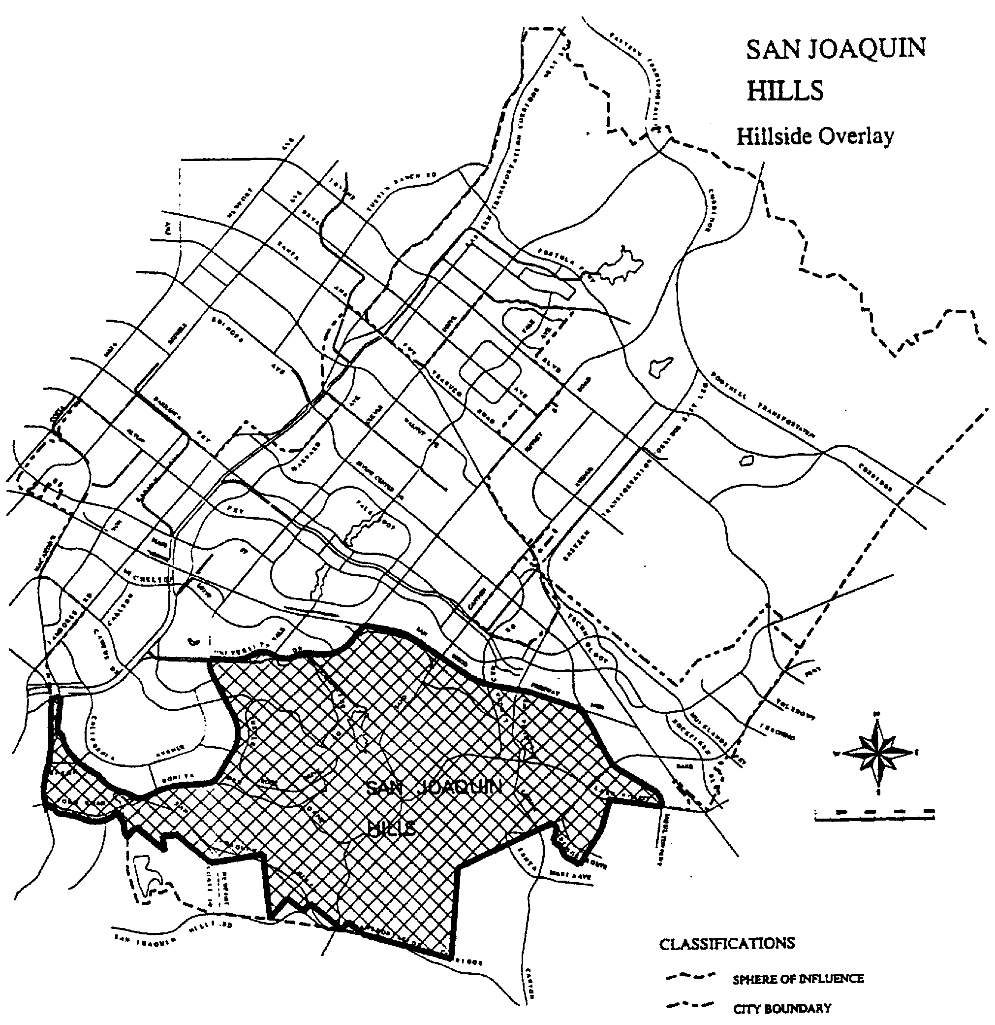
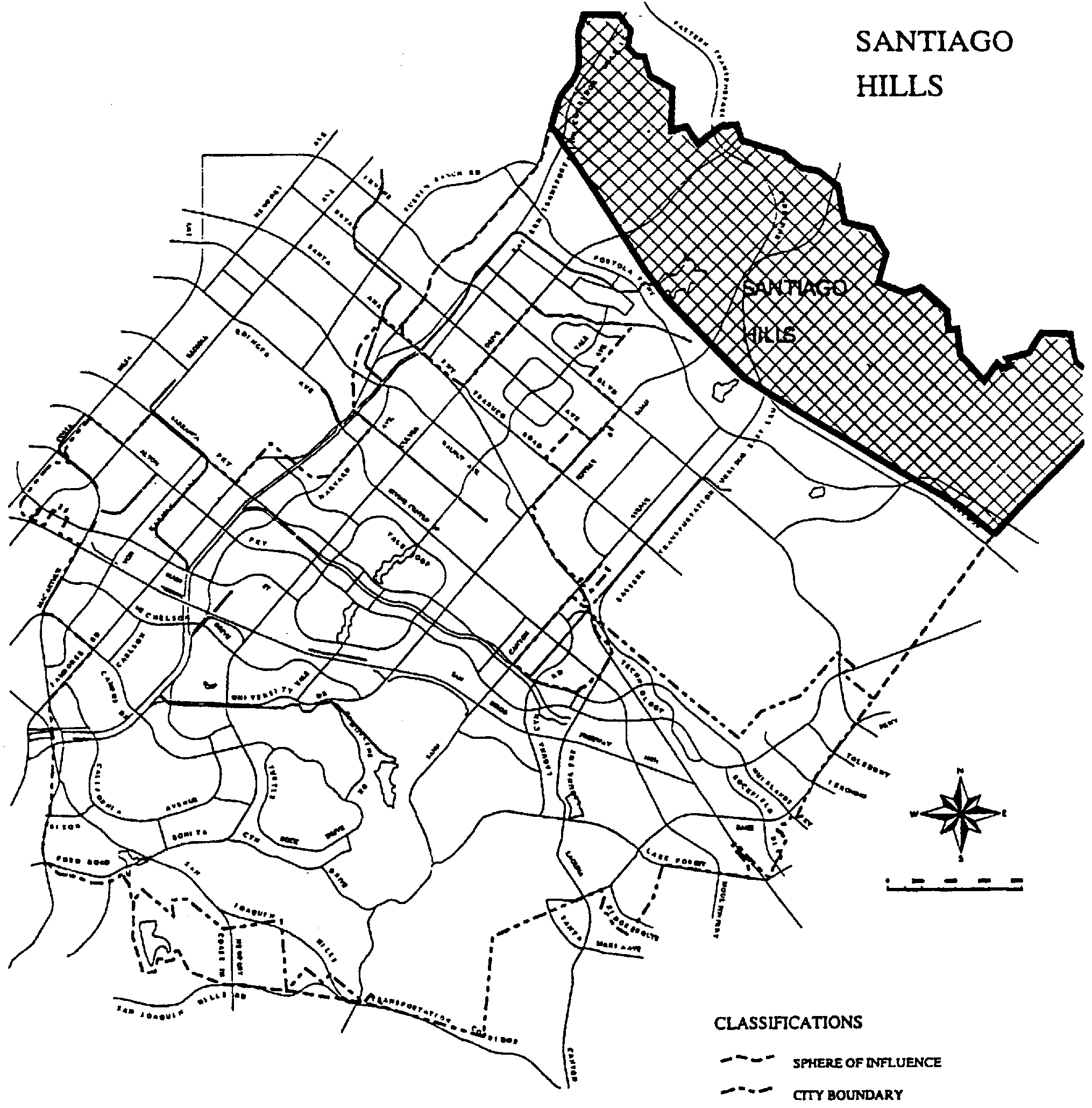
Sec. 5-4-4. - Review procedures for San Joaquin Hills and Lomas de Santiago Hills.
These apply to all areas shown on Figure 5-4B and 5-4C. In order to implement the policies of the City of Irvine for the development of hillside areas in the San Joaquin Hills and Lomas de Santiago Hills, project plans for the development of property in these districts shall be subject to review as indicated in Section 5-4-3 and as follows:
A.
Slope analysis procedures.
1.
Submit, along with a concept plan, zone change or master tentative map, a contour map of the project area with the following information:
a.
Delineate on the contour map:
(1)
All project areas.
(2)
All drainage courses, rock outcroppings and permanent open spaces.
b.
Calculate the average existing slope for each project area.
Average Existing Slope: S = 100 × l × L/A
S = Average existing slope (%).
l = Contour intervals (feet).
L = Sum of length of contours feet excluding drainage courses, rock outcroppings and all permanent open space within the project area (feet).
A = Total square feet in a project area excluding drainage courses, rock outcroppings and all permanent open space within the project area (square feet).
c.
Assign one of four slope zones to each project based on the average existing slope. (Show the corresponding slope zone for each project area based on table A below.)
B.
Location and character of development. Table A shall serve as general guidelines for establishing slope zones to ensure that development will complement the overall character of the landform. In order to permit the extension of a logical design concept, the guidelines for one zone may be applied to limited portions of an adjacent zone.
1.
Development is permitted in all slope zones, exclusive of preservation areas.
2.
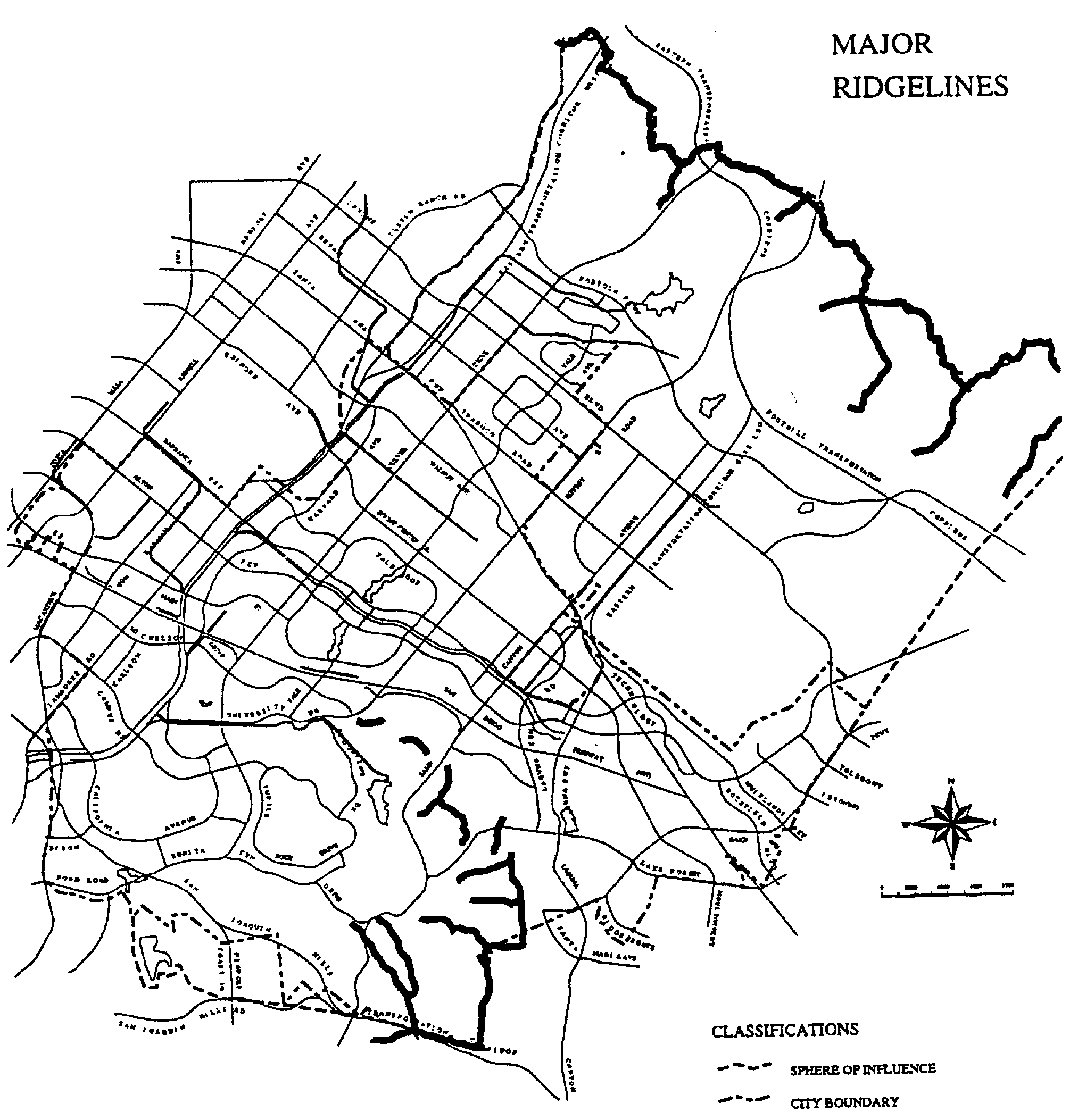
Major ridgelines are identified on Figure 5-4A and will be preserved as open space. The top of structures will be positioned below the top elevation of any adjoining major ridgeline. Ridgelines not identified as "major" may be developed as consistent with other applicable hillside development guidelines contained herein.
3.
Development shall be permitted in identified seismic or geologic hazard areas (General Plan seismic element, Seismic Response Areas 4 and 5), natural springs, perched water tables, faults, fracture zones and where bedding planes project out of the slope subject to the City's review and acceptance of a detailed geologic or soils engineer's report which identifies mitigation measures required for safe development of the site.
4.
Development shall be located to preserve and protect significant historical, archaeological and paleontological sites in accordance with the policies of the General Plan cultural resources element. The significance of historical, archaeological, and paleontological sites shall be determined through the environmental assessment process.
5.
Upon annexation of the southern sphere of influence, the Hillside Overlay District zoning shall apply to those areas with slopes in excess of 10 percent.
C.
Grading.
1.
Revegetation of cut and fill slopes shall be required according to the guidelines in the landscaping section herein (Landscaping).
2.
Within "transition zones," buffer areas separating preservation areas from areas of development, the following shall apply:
a.
The overall slope, height and grade of any cut and fill slope shall be in character and scale with the natural terrain in the adjacent preservation area.
b.
Where feasible, the toes and tops of all slopes in excess of 10 feet in vertical height and visible from public areas shall be rounded with curves in proportion to the total height of the slope.
c.
Any dwelling unit shall be located a minimum of 10 feet from the toes and tops of all slopes which are over 10 feet in vertical height.
3.
Manufactured slopes shall be contour graded or screened by landscaping in accordance with the following techniques:
a.
The angle of graded slopes which are visible shall be gradually adjusted to the angle of adjoining natural terrain.
b.
Graded slopes shall be vegetated and shall reflect the form of existing contours.
c.
The toes and tops of visible graded slopes in excess of 10 feet in vertical height shall be screened by landscaping or rounded in proportion to the height of the slope where drainage and geotechnical stability permit such rounding.
d.
The horizontal contours of graded slopes shall be screened by landscaping or curved in a continuous, undulating fashion.
4.
Except for road and utility construction in accordance with approved plans and agricultural uses, grading will be prohibited until a tentative tract or parcel map has been approved for the area. Grading for borrow or disposal of earth outside of the tract boundary may be approved by the Planning Commission provided plans conform to an approved planning area level conceptual grading plan and residents in the area have been advised in advance.
5.
Grading plans will include mitigation measures that reduce to acceptable safety levels underground water seepage which may occur because of increased irrigation or landform alteration.
6.
Conceptual grading plans shall be submitted in accordance with the provisions of Section 5-4-3 of the existing Hillside Development Overlay District.
D.
Landscaping.
1.
Where feasible, all landscaped common areas shall use recycled water when permanent irrigation is required and the supply of recycled water supply is adequate.
2.
All cut and fill slopes shall be vegetated. Landscape and irrigation plans shall be submitted for approval.
3.
New landscape materials introduced as transition planting shall be used to integrate the manmade and natural environments, to screen and soften the visual impact of development and to provide privacy within existing adjacent development. Refer to the City's landscape manual and standard plans.
E.
Drainage.
1.
Interceptor ditches shall be established only where necessary above cut/fill slopes and the intercepted water conveyed to a stable channel or natural drainage with adequate capacity.
2.
Road designs shall be such that water on roadways is prevented from flowing off the roadway in an uncontrolled fashion.
3.
Natural drainageways shall be riprapped or otherwise stabilized below drainage and culvert discharge points for a distance sufficient to minimize channel erosion.
4.
Runoff from areas of concentrated impervious cover (e.g., roofs, driveways, roads) shall be conveyed to a natural drainage or drainage structure with sufficient capacity to accept the discharge without undue erosion. The effects of new drainage patterns on existing systems shall be accounted for in the design of the project drainage plan.
5.
Sediment catchment basins and other erosion/siltation control devices shall be constructed and maintained in accordance with an overall erosion control plan approved by the City.
6.
The overall drainage system shall be completed and made operational at the earliest practical time during construction.
F.
Views.
1.
Homes will be oriented to allow view opportunities, although such views may be limited. Residential privacy should not be unreasonably sacrificed.
2.
Any significant public vista areas and view corridors to preservation areas from arterial highways to be protected will be identified at the time of zone change in accordance with the provisions of Section 5-4-3 of the existing Hillside Development Overlay District. Public vista areas and view corridors within project areas are not required to be protected.
G.
Roadways.
1.
Variations in the City's established roadway standards shall be carefully considered for reduction in Slope Zones 2, 3, and 4 where safety and circulation considerations justify.
2.
Sidewalks should only be required in Slope Zones 2, 3, and 4 only when other means of safe and convenient pedestrian circulation are not available, and then only in accordance with a carefully conceived total pedestrian circulation plan.
3.
Grading for local and collector roadways shall comply with Subsection 3 of "Grading" herein.
4.
Those portions of Bake Parkway and Sand Canyon Avenue which are located within or abut preservation areas shall be contour graded and vegetated in accordance with the following techniques where feasible:
a.
The angle of graded slopes shall be gradually adjusted to the angle of adjoining natural terrain.
b.
Graded slopes shall be vegetated with drought-resistant plant species.
c.
Graded slopes shall reflect the form of existing contours. Horizontal contours shall be curved in a continuous, undulating fashion.
d.
The toes and tops of graded slopes in excess of 10 feet in vertical height shall be rounded in proportion to the height of the slope where permitted by drainage and geotechnical stability.
H.
Fire protection.
1.
Hillside development within "high" or "extreme" fire hazard zones, as determined through the environmental review process, shall be designed to reduce fire hazards in accordance with the requirements of the Orange County Fire Marshal.
I.
Open space/development boundary.
1.
Access to special, endangered, rare or fragile plant and animal habitats shall be limited, with public access carefully managed to prevent disruption of the area's natural values.
2.
Public access to public resources shall be provided, where appropriate, in accordance with the requirements of the subdivision ordinance (Title 5, Division 5 of the Irvine Municipal Code). Conflicts between public access to public resources and the need for security and privacy of residents will be minimized.
3.
At the boundary between development and preservation areas ("transition zones") provisions will be made for fuel modification zones in accordance with the fire protection guidelines. Maintenance of these fuel modification zones shall be the responsibility of the respective maintenance district, community association or other appropriate agency. Areas in fuel modification zones subject to public access or use should be the responsibility of an appropriate public agency.
(Code 1976, § V.E-503.5; Ord. No. 92-3, 4-14-92; Ord. No. 94-7, § 3, 6-14-94; Ord. No. 01-01, § 5, 1-23-01)
Sec. 5-4-5. - Reserved.
Editor's note— Ord. No. 01-01, § 5, adopted January 23, 2001, amended the Code by repealing former § 5-4-5 in its entirety. Former § 5-4-5 pertained to review procedures for Lomas de Santiago Hills, and derived from the Code of 1976, § V.E-503.6; Ord. No. 92-3, adopted April 14, 1992; and Ord. No. 94-7, adopted June 14, 1994.
Sec. 5-5-1. - Intent.
The Historic District is an overlay zone which implements the City's General Plan cultural resources element by promoting the conservation, preservation, protection and enhancement of historic resources identified as significant in the General Plan.
(Code 1976, § V.E-504.1; Ord. No. 92-3, 4-14-92; Ord. No. 94-7, § 3, 6-14-94; Ord. No. 95-4, 5-9-95)
Sec. 5-5-2. - Policies and guidelines.
A.
Encourage the nomination of significant protected sites to the National Register of Historic Places.
B.
Include sites which are appropriate for educational or recreational purposes as an integral part of either public or community facilities or as part of the City-wide bikeway, pedestrian, and equestrian trail system.
C.
Encourage agencies, organizations and individuals to develop interpretive and educational programs in order to properly utilize the site for the benefit of the entire community.
D.
Determine the methods and means of preservation on a case-by-case basis according to a site's importance and disposition methods available. These methods may include public or private acquisition or one of the following provided extreme care is exercised not to adversely affect the site.
1.
Inclusion with greenbelts, parks, open space spines, preservation areas or other open space.
2.
Coverage by adequate fill, pavement, or building of surface of subsurface sites.
3.
Use of the site for nondestructive public interest or educational purposes such as museums, interpretative centers, or outdoor classrooms.
4.
Movement of buildings for preservation as part of a consolidated historic site.
5.
Utilization of buildings in a preserved state as part of their functional capacity (e.g., a building preserved and used as an office, restaurant, or home).
6.
Use of historically correct planting verified by project landscape architect.
7.
The rescue of historic signs.
E.
Encourage site preservation through economic incentives such as reduced taxes or reduction of other amenity requirements as required through the dedications/exactions process established by the City.
F.
Every person in possession or control of a structure and appurtenant premises in the district shall maintain and keep in good repair such structure and premises. Good repair includes, and is defined as, that level of maintenance and repair which clearly ensures the continued availability of such structure and premises for lawful reasonable uses; prevents deterioration, dilapidation, and decay of any exterior portion of such structure and premises; and avoids impairment to surrounding structures of the benefits of the zone.
G.
Encourage the dedication of conservation easements for the public purpose of preserving buildings, structures or sites of historical, architectural, or cultural significance.
H.
Ensure that adverse impacts of a proposed project on cultural resources are mitigated in accordance with the California Environmental Quality Act (CEQA), as well as other appropriate City policies and procedures, where preservation of a significant site is not practicable.
(Code 1976, § V.E-504.2; Ord. No. 92-3, 4-14-92; Ord. No. 94-7, § 3, 6-14-94; Ord. No. 95-4, 5-9-95)
Sec. 5-5-3. - Application of district.
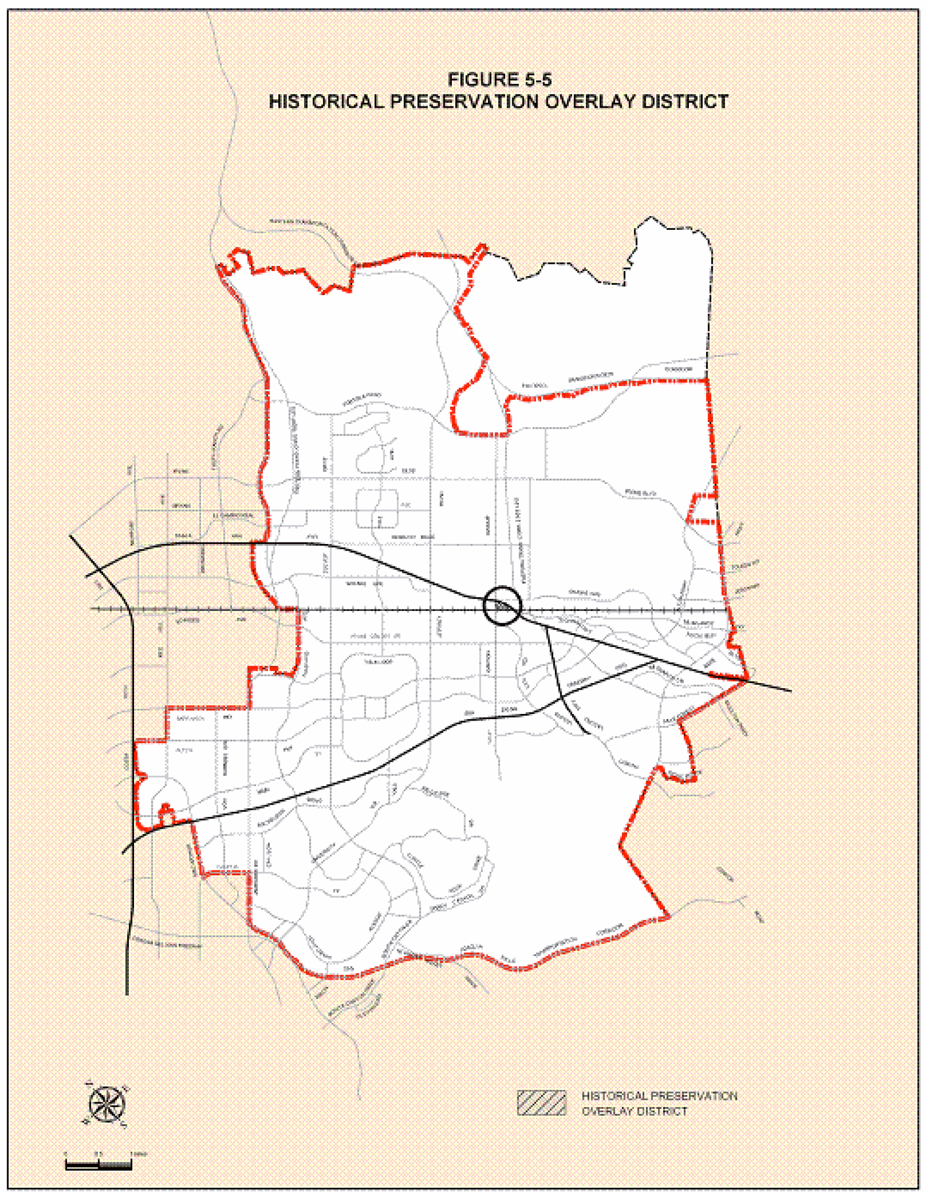
A.
The Historic Overlay District applies to all areas shown on Figure 5-5.
B.
Properties eligible to be considered for this district must be designated historically significant by the General Plan and the property owner must submit a formal request for the property to be included in the district.
(Code 1976, § V.E-504.3; Ord. No. 92-3, 4-14-92; Ord. No. 94-7, § 3, 6-14-94; Ord. No. 95-4, 5-9-95)
Sec. 5-7-1. - Purpose.
The purpose of this district is to provide regulations for the operation and post-closure development of adequate Class III solid waste sites within specific areas underlying the Development Reserve—Landfill Overlay District (1.7).
(Code 1976, § V.E-505.1; Ord. No. 92-3, 4-14-92; Ord. No. 94-7, § 3, 6-14-94; Ord. No. 95-4, 5-9-95)
Sec. 5-7-2. - Requirements.
A.
General conditions. The operation and post-closure development of Class III solid waste landfills shall meet the objectives identified in the waste management element of the General Plan for the City of Irvine.
B.
Landfill operation.
1.
Compliance with State standards. Landfills shall be operated in conformity with California State requirements for a Class III landfill site. Strict adherence to all applicable State standards is the legal responsibility of the landfill operating agency.
2.
Bee Canyon Landfill—Compliance with settlement agreement. Bee Canyon Landfill shall operate in compliance with the existing settlement agreement between the City of Irvine and the County of Orange regarding the Bee Canyon Landfill dated August 1, 1984.
C.
Permitted land uses.
1.
Accessory uses. Permitted accessory uses shall be as specified in Section 1-2-1 (Definitions).
2.
Conditionally permitted uses. Conditionally permitted uses shall be as specified in appropriate zoning districts for Planning Areas 3, 26, and 27 of Chapter 3-37.
a.
Approval process. Conditionally permitted uses shall be reviewed in accordance with the requirements specified in Chapter 2-9 (Conditional Use Permit).
D.
Closure plan.
1.
Compliance with State standards. The closure of landfills shall be in compliance with State standards in effect at the time of closure.
E.
Post-closure development.
1.
Coyote Canyon Landfill. The post-closure development of Coyote Canyon Landfill shall be in compliance with the conditions and mitigation measures adopted in Conditional Use Permit 86-CP-0729 and City Council Resolution No. 86-138.
2.
Bee Canyon Landfill—Compliance with settlement agreement. Bee Canyon Landfill shall be closed in compliance with the existing settlement agreement between the City of Irvine and the County of Orange regarding the Bee Canyon Landfill dated August 1, 1984.
F.
Development plan.
1.
General. A post-closure development plan for Class III landfills shall be in compliance with the General Plan and the waste management element.
2.
Compliance with State standards. A post-closure development plan for Class III landfills shall be in compliance with State standards.
3.
Local enforcement agency notification. The Orange County Health Care Agency, which is the County's local solid waste enforcement agency (LEA), shall be notified of proposed development within 2,000 feet of operating and closed solid waste facilities. The intent of this requirement is to ensure that an assessment of the stability and health risks existing at the landfill is conducted prior to approval of development.
4.
Planning Areas 26 and 27 Coyote Canyon Landfill—Compliance with Conditional Use Permit 86-CP-0729 and the mitigation measures specified in Environmental Impact Report 507.
a.
Upon initiation of a concept plan or zoning for post-closure development, the Director of Community Development shall contact the Director of the Orange County Integrated Waste Management Agency (OCIWMA). The Director of OCIWMA, within 120 days of notification, shall submit a plan for removing the aboveground leachate storage tank and replacing the tank with either an underground storage tank or other alternative which results in an effective removal of leachate from public visibility.
(Code 1976, § V.E-505.2; Ord. No. 92-3, 4-14-92; Ord. No. 94-7, § 3, 6-14-94; Ord. No. 95-4, 5-9-95)
Sec. 5-8-1. - Purpose.
The Irvine Business Complex Residential and Mixed-Use (IBCRMU) Overlay District establishes districts that are intended to provide for the orderly transition of certain portions of the IBC from exclusively industrial and/or office areas into pedestrian-oriented districts that accommodate a mixture of retail, office, and residential uses, while protecting existing businesses.
This overlay district implements the following goals and objectives as defined in the Land Use Element of the General Plan and corresponding IBC Design Criteria:
IBC Vision Plan goals:
A.
Protect the existing job base;
B.
Develop mixed-use cores;
C.
Provide transportation, pedestrian, and visual connectivity;
D.
Create usable outdoor areas; and
E.
Develop, safe well-designed neighborhoods.
These goals are further implemented through the following objectives:
A.
Create a walkable urban environment that encourages on-street pedestrian activity and reduces dependence on the automobile for everyday needs.
B.
Develop an urban framework to ensure the appearance, location, and scale of buildings compliment the character of the area in which they are located.
C.
Ensure compatibility between existing and proposed businesses within the IBC.
D.
Provide a mix of building types allowing variety and choice in urban living.
E.
Provide a variety of outdoor areas for both passive and active recreation as an amenity for residents and employees.
F.
Establish sustainable new urban development within the IBCRMU Overlay District.
(Ord. No. 10-07, § 9 (Exh. A), 7-27-10; Ord. No. 24-13, § 2(Exh. A), 9-10-24)
Sec. 5-8-2. - Applicability.
All proposed residential or residential mixed-use development/redevelopment, subdivisions, and new residential land uses within the IBCRMU Overlay shall comply with all applicable requirements of this chapter, including the provisions outlined below:
A.
Regulating plan. The regulating plan (Section 5-8-3) defines and identifies the three IBCRMU Overlay Districts as follows: Urban Neighborhood (UN), Multiple Use (MU), and Business Complex (BC).
B.
Additional applicable requirements. All development pursuant to this overlay zone is subject to the development intensity maximums established in Chapter 9-36 of the Zoning Code.
C.
Administrative relief. Requests for administrative relief shall be considered by the Planning Commission in conjunction with the associated discretionary review application and shall be subject to the requirements of Chapter 2-22 of the Zoning Code. In order for the Planning Commission to approve administrative relief from the overlay zone requirements, except where noted in this section, the approval body shall find that:
1.
The proposed project meets the intent of the IBCRMU Overlay Zone and Vision Plan.
2.
The request will not negatively impact the appearance of the project site or the surrounding properties.
3.
The proposed project will not adversely impact operations of adjacent nonresidential uses.
(Ord. No. 10-07, § 9 (Exh. A), 7-27-10)
Sec. 5-8-3. - Regulating plan and districts.
A.
Purpose. This section establishes the districts applied to property within the IBCRMU Overlay by the regulating plan. The regulating plan divides the area within the IBCRMU Overlay into separate districts. The districts allocate land uses and suggest architectural types as well as provide guidelines for building placement and height.
B.
Zones established. The following districts are established for the purposes of the IBCRMU Overlay District, and are applied to property within the overlay zone boundary as shown on the regulating plan, as provided in Sections 5-8-5 and 5-8-6. Existing current underlying zoning designations in Chapter 9-36 remain unchanged except as noted on the zoning map in Section 9-36-2.
(Ord. No. 10-07, § 9 (Exh. A), 7-27-10)
Sec. 5-8-4. - Special development requirements.
A.
Compatibility standards. The following standards are intended to ensure the compatibility of uses within a residential or mixed-use project:
1.
Development adjacent to San Diego Creek or San Joaquin Marsh.
a.
For buildings four or more stories in height located within 100 feet of the San Joaquin Marsh or San Diego Creek, the project applicant shall demonstrate that architectural plans do not specify the use of highly reflective glass windows, and utilize angles that are not highly reflective in order to reduce light and glare impacts on the marsh and creek environment, and to reduce the incidence of bird collisions, to the satisfaction of the Community Development Director.
b.
Landscape plans for areas located within 100 feet of the San Joaquin Marsh or San Diego Creek shall not include exotic plant species that may be invasive to native habitats. Exotic plant species not to be used include those species listed on Lists A and B of the California Invasive Plant Council's (Cal-IPC) list of "Exotic Pest Plants of Greatest Ecological Concern in California as of October 1999 or subsequent documentation.
2.
Compatibility with surrounding uses. The IBC mixed use environment is an urbanized area, therefore land use compatibility issues are expected to occur. Therefore, applicants for new residential and/or residential mixed use development shall submit data as determined by the Director of Community Development for the City to evaluate compatibility with surrounding uses with respect to issues including, but limited to the following:
a.
Noise.
b.
Odors.
c.
Truck traffic and deliveries.
d.
Hazardous materials handling/storage.
e.
Air emissions.
f.
Soil/groundwater contamination.
g.
John Wayne Airport compatibility.
3.
Residential disclosures: All discretionary applications for residential or residential mixed use shall include a condition of approval for disclosure to residents clearly outlining the issues associated with living in a mixed-use environment. The language for this disclosure shall be as specified by the Community Development Director. Copies of each signed disclosure shall be made available for review upon written request by the City. Such disclosure shall also include additional wording regarding proximity to John Wayne Airport, pursuant to Section 11010 of the Business and Professions Code, as follows:
Notice of Airport in Vicinity
This property is presently located in the vicinity of an airport, within what is known as an airport influence area. For that reason, the property may be subject to some of the annoyances or inconveniences associated with proximity to airport operations (for example: noise, vibration, or odors). Individual sensitivities to those annoyances can vary from person to person. You may wish to consider what airport annoyances, if any, are associated with the property before you complete your purchase and determine whether they are acceptable to you.
4.
Air quality standards. For residential and residential mixed use projects, the following air quality standards are required, or as otherwise mandated by state regulations:
a.
Applicants for new residential/mixed-use developments in the Irvine Business Complex shall require that the construction contractor to utilize off-road construction equipment that conforms to Tier 3 of the United States Environmental Protection Agency, or higher emissions standards. The construction contractor shall be made aware of this requirement prior to the start of construction activities. Use of Tier 3 or higher off-road construction equipment shall be stated on all grading plans. The construction contractor shall maintain a list of all operating equipment in use on the project site. The construction equipment list shall state the makes, models, and numbers of construction equipment on-site.
b.
Applicants for new residential/mixed-use developments in the Irvine Business Complex shall require that the construction contractor to properly service and maintain construction equipment in accordance with the manufacturer's recommendations. Non-essential idling of construction equipment shall be restricted to five minutes or less in compliance with California Air Resources Board's Rule 2449.
c.
Applicants for new developments in the Irvine Business Complex shall require that the construction contractor prepare a dust control plan and implement the following measures during ground-disturbing activities in addition to the existing requirements for fugitive dust control under South Coast Air Quality Management District Rule 403 to further reduce PM10 and PM2.5 emissions. To assure compliance, the City shall verify compliance that these measures have been implemented during normal construction site inspections:
• During all grading activities, the construction contractor shall reestablish ground cover on the construction site through seeding and watering.
• During all construction activities, the construction contractor shall sweep streets with Rule 1186 compliant PM 10 -efficient vacuum units on a daily basis if silt is carried over to adjacent public thoroughfares or occurs as a result of hauling.
• During all construction activities, the construction contractor shall maintain a minimum 24-inch freeboard on trucks hauling dirt, sand, soil, or other loose materials and tarp materials with a fabric cover or other suitable means.
• During all construction activities, the construction contractor shall water exposed ground surfaces and disturbed areas a minimum of every three hours on the construction site and a minimum of three times per day.
• During all construction activities, the construction contractor shall limit on-site vehicle speeds on unpaved roads to no more than 15 miles per hour.
• The construction contractor shall apply chemical soil stabilizers to reduce wind erosion.
d.
Prior to the issuance of building permits, plans shall indicate that coatings and solvents with a volatile organic compound (VOC) content lower than required under Rule 1113 (i.e., Super Compliant Paints) shall be used. All architectural coatings shall be applied either by (1) using a high-volume, low-pressure (HVLP) spray method operated at an air pressure between 0.1 and 10 pounds per square inch gauge (psig) to achieve a 65 percent application efficiency; or (2) manual application using a paintbrush, hand-roller, trowel, spatula, dauber, rag, or sponge, to achieve a 100 percent applicant efficiency. The construction contractor shall also use precoated/natural colored building materials, where feasible.
e.
Applicants for new residential developments in the Irvine Business Complex within 500 feet of Interstate 405 shall be required to install high efficiency Minimum Efficiency Reporting Value (MERV) filters of MERV 14 or better in the intake of residential ventilation systems. Heating, air conditioning and ventilation (HVAC) systems shall be installed with a fan unit power designed to force air through the MERV 14 filter. To ensure long-term maintenance and replacement of the MERV 14 filters in the individual units, the following shall occur:
i)
The developer, sale, and/or rental representative shall provide notification to all affected tenants/residents of the potential health risk from I-405 for all affected units, per Item 3 of this section.
ii)
For rental units within 500 feet of the I-405, the owner/property manager shall maintain and replace MERV 14 filters in accordance with the manufacturer's recommendations. The property owner shall inform renters of increased risk of exposure to diesel particulates from I-405 or SR-55 when windows are open.
iii)
For residential owned units within 500 feet of I-405, the homeowners' association (HOA) shall incorporate requirements for long-term maintenance in the covenant conditions and restrictions and inform homeowners of their responsibility to maintain the MERV 14 filter in accordance with the manufacturer's recommendations. The HOA shall inform homeowners' of increased risk of exposure to diesel particulates from I-405 when windows are open.
f.
For all residential or residential mixed-use projects located within the distances to industrial uses as outlined below the project applicant shall submit a health risk assessment (HRA) prepared in accordance with policies and procedures of the State Office of Environmental Health Hazard Assessment (OEHHA) and the South Coast Air Quality Management District (SCAQMD) to the Community Development Director prior to approval of any future discretionary residential or residential mixed use project. If the HRA shows that the incremental cancer risk exceeds one in 100,000 (1.0E-05), or the appropriate noncancer hazard index exceeds 1.0, the applicant will be required to identify and demonstrate that Best Available Control Technologies for Toxics (T-BACTs) are capable of reducing potential cancer and noncancer risks to an acceptable level, including appropriate enforcement mechanisms. T-BACTs may include, but are not limited to, scrubbers at the industrial facility, or installation of Minimum Efficiency Reporting Value (MERV) filters rated at 14 or better at all residential units.
• 1,000 feet from the truck bays of an existing distribution center that accommodates more than 100 trucks per day, more than 40 trucks with operating transport refrigeration units, or where transport refrigeration unit operations exceed 300 hours per week.
• 1,000 feet from an existing chrome plating facility, or existing facility using Hexavalent Chromium.
• 300 feet from a dry cleaning facility using perchloroethylene using one machine and 500 feet from a dry cleaning facility using perchloroethylene using two machines.
• 50 feet from gas pumps within a gas-dispensing facility and 300 feet from gas pumps within a gasoline dispensing facility with a throughput of 3.6 million gallons per year or greater.
g.
For all discretionary residential or residential mixed-use projects located within 1,000 feet of an industrial facility which emits toxic air contaminants (TACs), the project applicant shall submit a health risk assessment (HRA) prepared in accordance with policies and procedures of the State Office of Environmental Health Hazard Assessment (OEHHA) and the South Coast Air Quality Management District (SCAQMD) to the Community Development Director prior to approval of any discretionary residential or residential mixed-use projects. If the HRA shows that the incremental cancer risk exceeds one in 100,000 (1.0E-05), or the appropriate noncancer hazard index exceeds 1.0, the applicant will be required to identify and demonstrate that Best Available Control Technologies for Toxics (T-BACTs) are capable of reducing potential cancer and noncancer risks to an acceptable level, including appropriate enforcement mechanisms. T-BACTs may include, but are not limited to, scrubbers at the industrial facility, or installation of Minimum Efficiency Reporting Value (MERV) filters rated at 14 or better at all residential units.
h.
For all residential projects located within 1,000 feet of an industrial facility that emits substantial odors, which includes, but is not limited to:
•
Wastewater treatment plants.
•
Composting, greenwaste, or recycling facilities.
•
Fiberglass manufacturing facilities.
•
Painting/coating operations.
•
Coffee roasters.
•
Food processing facilities.
The project applicant shall submit an odor assessment to the Community Development Director prior to approval of any future discretionary action that verifies that the South Coast Air Quality Management District (SCAQMD) has not received three or more verified odor complaints. If the odor assessment identifies that the facility has received three such complaints, the applicant will be required to identify and demonstrate that Best Available Control Technologies for Toxics (T-BACTs) are capable of reducing potential odors to an acceptable level, including appropriate enforcement mechanisms. T-BACTs may include, but are not limited to, scrubbers at the industrial facility, or installation of Minimum Efficiency Reporting Value (MERV) filters rated at 14 or better at all residential units.
5.
Noise standards.
a.
Prior to issuance of grading permits, the project applicant shall incorporate the following measures as a note on the grading plan cover sheet to ensure that the greatest distance between noise sources and sensitive receptors during construction activities has been achieved.
•
Construction equipment, fixed or mobile, shall be equipped with properly operating and maintained noise mufflers consistent with manufacturer's standards.
•
Construction staging areas shall be located away from off-site sensitive uses during the later phases of project development.
•
The project contractor shall place all stationary construction equipment so that emitted noise is directed away from sensitive receptors nearest the project site, whenever feasible.
•
For construction of sound walls that have been incorporated into the project design, prior to construction of the building foundation, installation of temporary sound blankets (fences typically composed of poly-vinyl-chloride-coated outer shells with adsorbent inner insulation) shall be placed along the boundary of the project site during construction activities.
b.
Individual projects that involve vibration-intensive construction activities, such as pile drivers, jack hammers, and vibratory rollers, occurring near sensitive-receptors shall be evaluated for potential vibration impacts. If construction-related vibration is determined to exceed the Federal Transit Administration vibration-annoyance criteria of 78 VdB during the daytime, mitigation measures, such as use of less vibration intensive equipment or construction techniques, shall be implemented.
c.
The project applicant shall submit evidence to the satisfaction of the Director of Community Development that occupancy disclosure notices for units with patios and/or balconies that do not meet the 65 dBA CNEL are provided to all future tenants pursuant to the City's noise ordinance.
6.
Hazardous materials standards. Individual development sites may have existing facilities, such as transformers or clarifiers, to be demolished as part of a proposed development. To mitigate hazardous materials-related impacts during the removal of such facilities, the Director of Community Development, in conjunction with the Orange County Fire Authority, shall include specific project conditions of approval as part of the discretionary review process for the proposed development.
7.
GreenPoint Rated Development. Applicants for new residential developments in the Irvine Business Complex shall submit evidence to the satisfaction of the Director of Community Development that proposed buildings are designed and constructed to be GreenPoint Rated. GreenPoint Rated developments must achieve a minimum of 50 total points and meet the category-specific point thresholds as specified in the current GreenPoint Rated Builder Handbook. Developments that exceed this minimum are rewarded by a higher grade on their projects. The GreenPoint Rated program is updated every three years to coincide with changes to the California Building Energy Efficiency Standards.
B.
Public safety standards.
1.
Plans submitted for discretionary review of residential development shall include the following safety features:
a.
Recreation areas shall be located adjacent to residential uses whenever possible. These areas shall be visible to residents from within their dwellings to allow for "eyes on the street" proper visual surveillance. Placement of windows, landscaping, lighting, and recreation uses shall be coordinated to enhance resident surveillance opportunity, but not to detract from the recreational use.
b.
General utilization of the concepts of Crime Prevention Through Environmental Design (CPTED) in the planning and development stages.
2.
The inclusion of the following items shall be verified by the public safety department prior to issuance of the first building permit for a residential unit.
a.
Development of a security plan for residential and/or mixed-used projects that includes:
(1)
Management contact for public safety issues available 24-hours a day;
(2)
Cameras for monitoring and recording vehicles and persons entering the site;
(3)
Comprehensive tenant screening process for apartments tenants;
(4)
Quick removal of graffiti; and
(5)
Enforcement of restricted parking spaces.
b.
Preparation of a standardized, high density, "wayfinding" sign program to aid emergency responders in finding individual residential units quickly and easily.
c.
A Click2Enter radio frequency access system shall be installed at any vehicle and pedestrian access point controlled by privacy gates.
d.
Security. Residential units shall be designed to ensure the security of residents through the provision of secured entrances and exits that are separate from the nonresidential uses. Nonresidential and residential uses shall not have common entrance hallways or common balconies. These separations shall be shown on the development plan and the separations shall be permanently maintained.
e.
Lighting. Outdoor lighting associated with commercial uses shall be shaded and directed to minimize impact to surrounding residential uses, but shall provide sufficient illumination for access and meet the Uniform Security Code requirements for lighting. Such lighting shall not blink, flash or oscillate.
f.
Windows. Residential windows of buildings directly adjacent to industrial uses shall generally be directed away from loading areas and docks, unless view-restricting architectural elements are utilized.
C.
Airport restrictions. Development within the Airport Land Use Commission ("ALUC") jurisdiction shall meet the following requirements in order to support John Wayne Airport operations:
1.
Building height limitations, recordation of avigation easements, obstruction lighting and marking, and airport proximity disclosures and signage shall be provided as required by the per Orange County Airport Environs Land Use Plan standards for John Wayne Airport.
2.
Building heights shall not penetrate Federal Aviation Regulation (FAR) Part 77 Imaginary Surfaces for John Wayne Airport.
3.
Residential land uses shall be prohibited in John Wayne Airport Safety Zone 3.
4.
Sound attenuation. For all residential dwelling units within the 60 CNEL contour of John Wayne Airport, the maximum interior noise levels shall not exceed 45 dBA CNEL with windows closed, and shall not exceed the single event noise criteria outlined in the noise element of the General Plan of the loudest 10 percent of single noise events (Lmax 10) shall not exceed 65 dBA daytime (7 a.m. to 7 p.m.) and 55 dBA nighttime (7 p.m. to 7 a.m.).
5.
Parks located within the John Wayne Airport 60 dBA CNEL shall include signage indicating proximity to John Wayne Airport and related overflight and noise.
6.
Residential uses are prohibited within the 1985 John Wayne Airport Master Plan 65 dBA CNEL contour.
7.
Applicants for a conditional use permit for a heliport or helistop shall provide evidence that the proposed heliport or helistop complies fully with State of California permit procedures and with any and all conditions of approval imposed by the Federal Aviation Administration (FAA), the Airport Land Use Commission for Orange County (ALUC), and by the Caltrans Division of Aeronautics.
D.
Additional requirements.
1.
Libraries. In the event that a City-wide library impact fee is adopted and in force at the time of discretionary project approval, the project applicant shall pay this fee prior to issuance of building permits.
2.
San Diego Creekwalk.
a.
Prior to approval of the design for the San Diego Creek Trail improvements/extension, the City shall examine alternative locations of the proposed trail and methods that could be used to minimize potential impacts (e.g., fencing and buffers). The design shall consider an alternative that excludes a trail segment along the most sensitive part of San Diego Creek (the northwestern side of the creek between Campus Drive and MacArthur Boulevard).
b.
Prior to issuance of grading permits for the San Diego Creek Trail, a note shall be placed on all grading plans that construction activities involving the use of heavy equipment are prohibited during the bird nesting season (March 15 to September 15). If minor construction activities are carried out during the bird nesting season, a qualified biologist shall conduct a preconstruction survey in the off-site habitat to determine the location of any active bird nests in the area, including, but not limited to, raptors and least Bell's vireo. The survey should begin not more than three days prior to the beginning of construction activities. The wildlife agencies shall be notified if any nesting least Bell's vireo are found. During construction, active nesting sites shall be monitored to ensure that construction levels do not exceed 60 dBA Leq. Should these noise levels be exceeded, the City shall implement noise attenuation measures, potentially including the erection of temporary noise curtains sufficient to reduce noise levels at occupied nesting sites to acceptable levels. Nest monitoring should continue until fledglings have dispersed or the nest has been determined to be a failure, as approved by the wildlife agencies.
3.
Accessory retail. For project sites located more than one-fourth mile from existing neighborhood-oriented retail services, applicants for residential development of 500 units or more, or nonresidential developments of 250,000 square feet or more are strongly encouraged to provide accessory retail uses as defined in the City of Irvine Zoning Code. Should accessory retail uses not be provided, applicants shall provide written rationale for not doing so, as part of the conditional use permit application.
(Ord. No. 10-07, § 9 (Exh. A), 7-27-10; Res. No. 15-86, § 3(Exh. A), 8-11-15)
Sec. 5-8-5. - Urban Neighborhood (UN) standards.
The UN District incorporates portions of the IBC appropriate for sustainable residential neighborhoods, employment, and mixed-use blocks. This district is intended for residential projects to cluster in nodes around local services. Small scattered residential projects are discouraged within the UN District. Mixed-use is encouraged with ground floor uses including residential, retail, offices, and restaurants, and upper floors accommodating offices or residential. New, smaller, non-arterial streets within this district are proposed to be pedestrian-oriented with highly articulated residential frontages. Roadways will be defined by both residential and nonresidential building facades and characterized by a lush, dominant landscape.
A.
Maximum building height: As specified in Figure 1 in Section 5-8-3.
B.
Creekwalk. All properties abutting the San Diego Creek channel shall consider the San Diego Creek edge as a street frontage. Where feasible, private ways, public and private streets shall be located adjacent to the Creek edge.
(Ord. No. 10-07, § 9 (Exh. A), 7-27-10)
Sec. 5-8-6. - Business Complex (BC).
The intent of the Business Complex District is to maintain the existing industrial character of the northwesterly portion of the IBC, consistent with the Council-adopted goal of protecting existing businesses in the IBC. Due to a number of constraints, including the proximity of John Wayne Airport and the extent of existing industrial uses, residential uses are not appropriate for this area and are therefore prohibited. Properties in the BC District are subject to the requirements of the underlying IBC base zoning and as specified in Section 5-8-4.C (Airport Restrictions).
(Ord. No. 10-07, § 9 (Exh. A), 7-27-10)
Sec. 5-9-1. - Purpose.
The Residential and Residential Mixed-Use (RRMU) Overlay establishes three focused districts (the Greater Irvine Business Complex, the Greater Spectrum Area, and the Great Park Neighborhoods Transit Village District) that are intended to allow selected Planning Areas of the City identified in the City of Irvine 2021-2029 Housing Elements Site Inventory as potential areas to accommodate a portion of the City's unmet Regional Housing Needs Allocation (RHNA). Traditionally, the districts within the RRMU Overlay are zoned for non-residential uses but are areas that are optimized for the integration of residential, mixed-use, and residential serving uses due to their proximity to employment centers and transit. The RRMU Overlay would protect existing uses allowed in the Planning Areas, while also allowing residential and residential mixed-use within the Overlay, providing the greatest level of flexibility for developers and landowners.
The RRMU Overlay implements the goals and objectives as defined in the Land Use and Housing Elements of the General Plan.
(Ord. No. 24-13, § 2(Exh. A), 9-10-24; Ord. No. 24-17, Exh. A, 10-22-24)
Sec. 5-9-2. - Applicability.
All proposed residential and residential mixed-use development/redevelopment, subdivisions, and new residential land uses within the RRMU Overlay that expressly elect to use the additional rights provided by the RRMU Overlay shall comply with all applicable requirements of this chapter. The rights and requirements (including development standards and procedures) of the RRMU Overlay do not apply to, nor otherwise limit or restrict in any manner, any other proposed development/redevelopment, subdivision, existing buildings or structures, permitted and conditionally permitted uses, and/or other existing or proposed land uses and structures located within the RRMU Overlay.
(Ord. No. 24-13, § 2(Exh. A), 9-10-24; Ord. No. 24-17, Exh. A, 10-22-24)
Sec. 5-9-3. - Regulating plan and districts.
A.
Purpose. This section establishes the districts applied to property within the RRMU Overlay. The Planning Areas within the RRMU Overlay are consistent with the Land Use Element of the General Plan. The districts provide guidelines for new residential and residential mixed-use development/redevelopment within the RRMU Overlay.
B.
Districts established. The following districts are established for the purposes of the RRMU Overlay District and are applied to property within the Overlay boundaries. Existing current underlying zoning designations for these districts, as included in Chapters 9-12, 9-13, 9-19, 9-31, 9-32, 9-33, 9-36, and 9-51, remain unchanged.
1.
Greater Irvine Business Complex Area RRMU Overlay District: Planning Area 36 (Irvine Business Complex)* and Planning Area 19 (Rancho San Joaquin).**
2.
Greater Spectrum Area RRMU Overlay District: Spectrum 7 portion of Planning Area 12 (Oakcreek), Planning Area 13 (Irvine Spectrum 4), Planning Area 31 (Irvine Spectrum 6), Planning Area 32 (Irvine Spectrum 3), and Planning Area 33 (Irvine Spectrum Center).
3.
Great Park Neighborhoods Transit Village RRMU Overlay District: Planning Area 51 (Great Park Neighborhoods).
* The RRMU Overlay shall not apply to the portion of Planning Area 36 that is within the California Coastal Zone until a Local Coastal Plan Amendment has been approved by the California Coastal Commission.
**Does not include the Rancho San Joaquin Golf Course or Racquet Club of Irvine.
Figure 1: Greater IBC Area RRMU Overlay District
Figure 2: Greater Spectrum Area RRMU Overlay District
Figure 3: Great Park Neighborhoods Transit Village RRMU Overlay District
(Ord. No. 24-13, § 2(Exh. A), 9-10-24; Ord. No. 24-17, Exh. A, 10-22-24)
Sec. 5-9-4. - Review procedure for Residential and Residential Mixed-Use Overlay.
The Planning Commission shall approve, conditionally approve, or disapprove development projects for up to a total of 23,610 residential units in accordance with the provisions of this chapter. Following the approval of the 23,610th residential unit, the City Council shall be the final approval authority, following receipt of a Planning Commission recommendation, for the approval, conditional approval, or disapproval of development projects containing residential units. The Planning Commission shall not recommend, and the City Council shall not approve any Project that exceeds a total of 23,610 residential units unless it receives an affirmative demonstration that establishes clearly and convincingly that such approval is essential to the satisfaction of State law housing mandates, and that the proposed Project is the least intrusive means of meeting such State law housing mandates.
In order to implement the policies of the City of Irvine for the development of projects in the RRMU Overlay District, an applicant shall submit an application for a master plan per Section 2-17. Additionally, for any Project that exceeds a total of 23,610 residential units, an applicant shall submit such additional studies and analyses as are deemed necessary in the discretion of City staff, the Planning Commission, or the City Council to make the demonstration required in the preceding paragraph.
Where applicable law related to the review and approval of residential and mixed-use development projects precludes the application of certain standards or requirements of this Chapter, those standards or requirements shall not apply. Where Planning Commission review is prohibited by applicable law, the Director of Community Development or designee shall serve as the review and approval authority.
(Ord. No. 24-13, § 2(Exh. A), 9-10-24; Ord. No. 24-17, Exh. A, 10-22-24)
Sec. 5-9-5. - Special development requirements.
A.
Proximity Village, General Plan. The RRMU Overlay is intended for residential and residential mixed-use projects to cluster in nodes around local services and should be consistent with the proximity village City vision outlined in the General Plan. Small scattered residential projects are discouraged within the RRMU Overlay. Mixed-use is encouraged and can be vertical or horizontal in design. Residential supporting uses such as, but not limited to, retail, office, restaurants, and community facilities are encouraged. Where appropriate to the development, new, smaller, non-arterial streets within the RRMU Overlay shall encourage mobility.
B.
Density. Minimum average density of 50 dwelling units per acre. A deviation from the minimum density shall be granted upon a demonstration that ownership or rental housing (whichever is proposed) at the applicable location is not feasible at a density of 50 dwelling units per acre. Separately and additionally, to the extent permitted by applicable law, a deviation may be granted in the discretion of the approval body for projects that are able to provide a significant and specific public benefit in addition to the provision of housing and affordability as otherwise required by this Zoning Ordinance, provided that the deviation shall not result in a specific and adverse effect to health or safety. Requests for minimum density deviations shall be included with the master plan required by Section 5-9-4 of this Chapter and shall be reviewed concurrently therewith.
C.
Accessory retail. For all project sites located more than one-fourth mile from existing resident serving non-residential uses, applicants for residential and residential mixed-use developments of 250 units or more shall provide accessory retail and/or resident-serving non-residential square footage that occupies ten percent or less than the total area of the principal use. Should accessory retail and/or resident-serving non-residential uses not be provided, applicants shall provide documentation which demonstrates the omission of is necessary to physically accommodate the minimum density required by this Chapter, or that the inclusion of accessory retail would result in a specific and adverse effect to health or safety.
D.
Compatibility standards. Uses in the RRMU Overlay shall be compatible to the fullest extent permitted by applicable law. The RRMU Overlay mixed-use environment is an urbanized area, therefore land use compatibility issues are expected to occur. Therefore, applicants for new residential and/or residential mixed-use development entitled pursuant to the RRMU Overlay shall submit data and information requested by the Director of Community Development or designee, for the City to evaluate compatibility with surrounding uses with respect to issues, including, but not limited to the following:
1.
Noise.
2.
Odors.
3.
Truck traffic and deliveries.
4.
Hazardous materials handling/storage.
5.
Air emissions.
6.
Soil/groundwater contamination.
E.
Irvine Business Complex - Residential Incentive Program.
1.
In the Irvine Business Complex (Planning Area 36), the IBC land use and development intensity value (DIV) database specifies the quantity, in gross square footage, dwelling units and hotel rooms as defined by the Zoning Ordinance, for all existing, approved, and zoned development in the planning area by legal parcel and according to the following general land use categories:
a.
Office.
b.
Industrial.
c.
Retail.
d.
Hotel.
e.
Residential.
f.
Zoning Potential.
g.
Miniwarehouse.
h.
Hotel, extended stay.
2.
The land use and DIV database shall specify the corresponding a.m., p.m., and average daily DIVs allocated for both existing and build-out conditions for each legal parcel in the planning area. Information specific to the development intensity value database can be found in Section 9-36-8.
3.
Pursuant to 2021-2029 Housing Element program PP-H.2: "Monitor and Adjust Fees, Incentives, and Processes", the City will establish a "Residential Incentive Program" specific to the Irvine Business Complex. The City will issue DIVs from a City controlled distribution system, at no cost, for residential and/or residential mixed-use projects that provide a minimum 17% affordability for the base number of units proposed. The "Residential Incentive Program" DIVs shall only be utilized for the residential component of a mixed-use program. Residential serving non-residential uses, including but not limited to retail, restaurants, and qualifying community facilities, 50,000 square feet or less and proposed on site and as part of a residential mixed-use project shall be exempt from the DIV requirements. Pursuant to the "Residential Incentive Program", projects shall:
a.
Provision of onsite affordable units at a minimum 17% affordability at the following income levels:
i.
7% very low income (Health and Safety Code § 50105).
ii.
6% low income (Health and Safety Code § 50079.5, 25 Cal. Code Regs. § 6928).
iii.
4% moderate (Health and Safety Code § 50093) - specific workforce units (81 to 100% moderate).
iv.
These affordability levels are alternative and enhanced to the affordability levels otherwise required by Section 2-3-4.
b.
Utilize on-site DIV budget prior to requesting additional DIVs under the Residential Incentive Program.
c.
The Planning Commission would authorize approval of the Residential Incentive Program DIVs at the time of project review (master plan) and based on the recommendation from Community Development staff.
d.
Residential Incentive Program DIVs are non-transferable and would expire with a master plan and would return to the Residential Incentive Program DIV City controlled distribution system.
e.
Any change to the project's affordability would require additional review and may require the forfeiture of the Residential Incentive Program DIVs.
f.
Projects that do not provide a minimum 17 percent affordability combined for very low, low, and workforce moderate income levels at the identified category breakdown would be required to acquire DIVs directly from a private owner/developer.
g.
Projects that are not requesting Residential Incentive Program DIVs are required to adhere to the minimum levels of affordability generally applicable to projects in the City set forth in Section 2-3-4.
F.
All other requirements related to the provision of affordable housing set forth in Chapter 2-3 shall apply to all projects in the RMMU Overlay.
G.
Building heights shall not penetrate Federal Aviation Regulation (FAA) Part 77 Imaginary Surfaces for John Wayne Airport (14 Code of Federal Regulations Part 77).
(Ord. No. 24-13, § 2(Exh. A), 9-10-24; Ord. No. 24-17, Exh. A, 10-22-24; Ord. No. 25-22, 9-9-25)
Sec. 5-9-6. - Other standards.
This Chapter applies concurrently with all other applicable zoning standards (including those specific to underlying districts in the Overlay as they apply to those districts). This Chapter does not modify or supersede such underlying zoning except to permit the development of residential and mixed-use projects at the densities and intensities as provided herein. Without limiting the generality of the foregoing provisions, residential and/or residential mixed-use development entitled pursuant to the RRMU Overlay shall be allowed to exceed (and shall not be counted toward) development intensity and square footage maximums, maximum number of dwelling units, maximum vehicle trips, and other traffic limitations established by the General Plan, the Zoning Ordinance, Municipal Code, any statutory development agreement, and/or other agreement with or in favor of the City.
(Ord. No. 24-13, § 2(Exh. A), 9-10-24; Ord. No. 24-17, Exh. A, 10-22-24; Ord. No. 25-22, 9-9-25)