
James City County Unincorporated
City Zoning Code
City Zoning Code
ARTICLE I
- IN GENERAL
Sec. 24-1.- Short title.
This chapter shall be known and may be cited as the "James City County, Virginia, Zoning Ordinance" or simply as the "Zoning Ordinance."
(Ord. No. 31A-88, § 20-1, 4-8-85)
Sec. 24-2. - Definitions.
For the purposes of this chapter, the following words and phrases shall have the meaning respectively ascribed to them by this section:
A
Accessory apartment, attached. A separate, complete housekeeping unit that is substantially contained within the structure of, and clearly secondary to, a single-family dwelling. The accessory apartment may not occupy more than 35 percent of the floor area of the dwelling.
Accessory apartment, detached. A separate, complete housekeeping unit that is incidental to and located on the same lot occupied by a single-family dwelling. The detached accessory apartment may not occupy more than 50 percent of the floor area of the accessory structure.
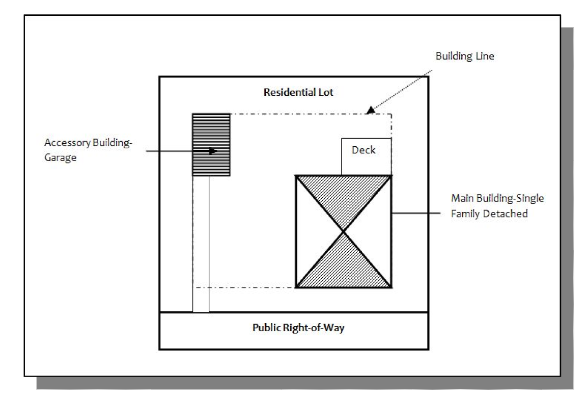
Accessory building or structure. A subordinate building or structure customarily incidental to and located upon the same lot occupied by the main use or building. With the exception of detached accessory apartments, as may be approved by a special use permit, no such accessory building or structure shall be used for housekeeping purposes. Garages or other accessory structures such as carports, porches, decks and stoops attached to the main building shall be considered part of the main building. Accessory buildings and structures located ten feet or less from a main structure shall be considered part of the main structure for the purpose of determining side and rear yards. (Refer to the definition of "structure.") Solely for the purposes of article VI, division 3 [of this chapter], an accessory building or structure shall be considered non-residential.
Accessory use. A subordinate use customarily incidental to and located upon the same lot occupied by the main use or building.
Acreage parcel. A parcel of land, regardless of area, described by metes and bounds which is not a numbered lot on any recorded subdivision plat.
Administrative review-eligible project (AREP). Solely for the purposes of article II, special regulations, division 6, communications facilities, antennas, towers and support structures only, either:
(1) The installation or construction of a new structure that is not more than 50 feet above ground level, provided that the structure with attached communications facilities is (i) not more than ten feet above the tallest existing utility pole located within 500 feet of the new structure within the same public right-of-way or within the existing line of utility poles; (ii) not located within the boundaries of a local, state, or federal historic district; and (iii) designed to support small cell facilities (referred to as "AREP-1"); or
(2) The co-location on any existing structure of a communications facility that is not a small cell facility (referred to as "AREP-2").
Administrator; zoning administrator. The official charged with the administration, interpretation and enforcement of this chapter.
Adult day care center. Any facility that is either operated for profit or that desires licensure from the Virginia Department of Social Services (VDSS) and that provides supplementary care and protection during only a part of the day to four or more aged, infirmed or disabled adults who reside elsewhere.
Affordable housing. Housing available at a sales price or rental amount that does not exceed 30 percent of the total monthly income of households earning between 30 percent and 80 percent of the area median income as determined by the U.S. Department of Housing and Urban Development (HUD).
Agricultural operation. Any operation devoted to the bona fide production of crops, or animals, or fowl including the production of fruits or vegetables of all kinds; meat, dairy, and poultry products; nuts, tobacco, nursery, and floral products; and the production and harvest of products from silviculture activity.
Agriculture, general. The tilling of the soil, the raising of crops, orchards, horticulture, forestry and gardening, including the keeping of animals and fowl but not intensive agriculture as herein defined or the commercial slaughtering or processing of animals or poultry.
Agriculture, intensive. Those intensive agricultural operations commonly known as confinement operations where large numbers of animals or poultry are confined to a relatively small space such as hog, veal and poultry pens or houses, feedlots for livestock and dairy farming operations. Any enclosure, pen or building for the concentrated confinement of livestock or poultry wherein more than 300 veal animals, slaughter or feeder cattle, 200 dairy cattle, 750 swine, 150 horses, 500 sheep, lambs, goats or similar animals, 5,500 turkeys, or 10,000 laying hens or broilers are confined or housed shall constitute intensive agriculture. Enclosed pasture or range where grass is maintained for at least ten months of the year or where animals are confined at no more than 15 adult animals per acre for no longer than 120 continuous days shall not constitute intensive agriculture.
Agritourism activity. Any activity carried out on a farm or ranch that allows members of the general public, for recreational, entertainment, or educational purposes, to view or enjoy rural activities, including farming, wineries, ranching, historical, cultural, harvest-your-own activities, or natural activities and attractions. An activity is an agritourism activity whether or not the participant paid to participate in the activity.
Alteration. Any change or rearrangement in the supporting members of an existing building, such as bearing walls, columns, beams, girders or interior partitions, as well as any change in doors or windows or any enlargement to or diminution of a building or structure, whether horizontally or vertically, or the moving of a building or structure from one location to another.
Antenna. A device of which the surface is used to capture an incoming and/or to transmit an outgoing radio-frequency signal. Antennas shall include the following types:
(1)
Omni directional (or "whip") antenna. An antenna that receives and transmits signals in a 360-degree pattern.
(2)
Directional (or "panel") antenna. An antenna that receives and transmits signals in a directional pattern typically encompassing an arc of 120 degrees.
(3)
Dish (or parabolic) antenna. A bowl shaped device, less than two meters in diameter, that receives and transmits signals in a specific directional pattern.
Aquaculture. The growing, farming and husbandry of freshwater and marine organisms under controlled conditions, including, but not limited to, hatcheries, fish farms, the propagation of ornamental fish and plants and pearl culture.
Assisted living facility. Any congregate residential setting that provides or coordinates personal and health care services, 24-hour supervision, and assistance (scheduled and unscheduled) for the maintenance or care of four or more adults who are aged, infirmed or disabled in a primarily residential setting. For the purpose of this definition, an assisted living facility is an institutional use and therefore it does not count toward residential density calculation.
Attic. That part of a building which is immediately below and wholly or partly within the roof framing.
B
Base flood. The flood having a one percent chance of being equaled or exceeded in any given year (formerly 100-year flood).
Base flood elevation. The Federal Emergency Management Agency (FEMA) designated one percent annual chance (100-year) water surface elevation.
Base station. For the purposes of article II, special regulations, division 6, communications facilities, antennas, towers and support structures only, base station shall be defined as a structure or equipment at a fixed location that enables Federal Communications Commission (FCC)-licensed or authorized wireless communications between user equipment and a communications network. The term does not encompass a tower as defined herein or any equipment associated with a tower. Base stations include, without limitation:
(1)
Equipment associated with wireless communications services such as private, broadcast, and public safety services, as well as unlicensed wireless service and fixed wireless services such as microwave backhaul.
(2)
Radio transceivers, antennas, coaxial or fiber-optic cable, regular and backup power supplies, and comparable equipment, regardless of technological configuration, including distributed antenna systems and small-cell networks.
(3)
Any structure other than a tower that, at the time the relevant application is filed with the county, supports or houses equipment described in paragraphs (1) and (2) of this definition that has been reviewed and approved under the applicable zoning or siting process, or under another state or local regulatory review process, even if the structure was not built for the sole or primary purpose of providing that support. The term does not include any structure that, at the time the relevant application is filed with the county, does not support or house equipment described in paragraphs (1) and (2) of this definition.
Basement. A story having part but not more than one-half of its height below grade. A basement shall be counted as a story for the purpose of height regulations if it is used for business purposes or for dwelling purposes by other than a janitor employed on the premises. Solely for the purposes of Article VI, Overlay District, Division 3, Floodplain Area Regulations, this term shall mean any area of the building having its floor subgrade (below ground level) on all sides.
Building. Any structure having a roof supported by columns or walls and intended for the shelter, housing or enclosure of any individual, animal, process, equipment, goods or materials of any kind or nature.
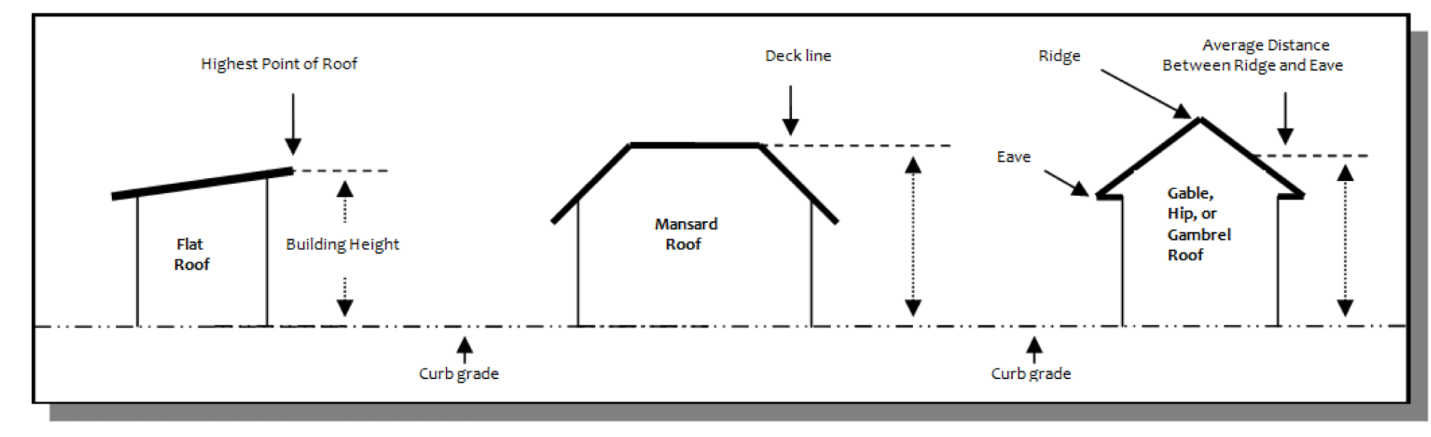
Building, height of. The vertical distance measured from the level of the curb or the established curb grade opposite the middle of the front of the structure to the highest point of the roof if a flat roof, to the deck line of a mansard roof, or to the mean height level between the eaves and ridge of a gable, hip or gambrel roof. For buildings set back from the street line, the height shall be measured from the average elevation of the ground surface along the front of the building.
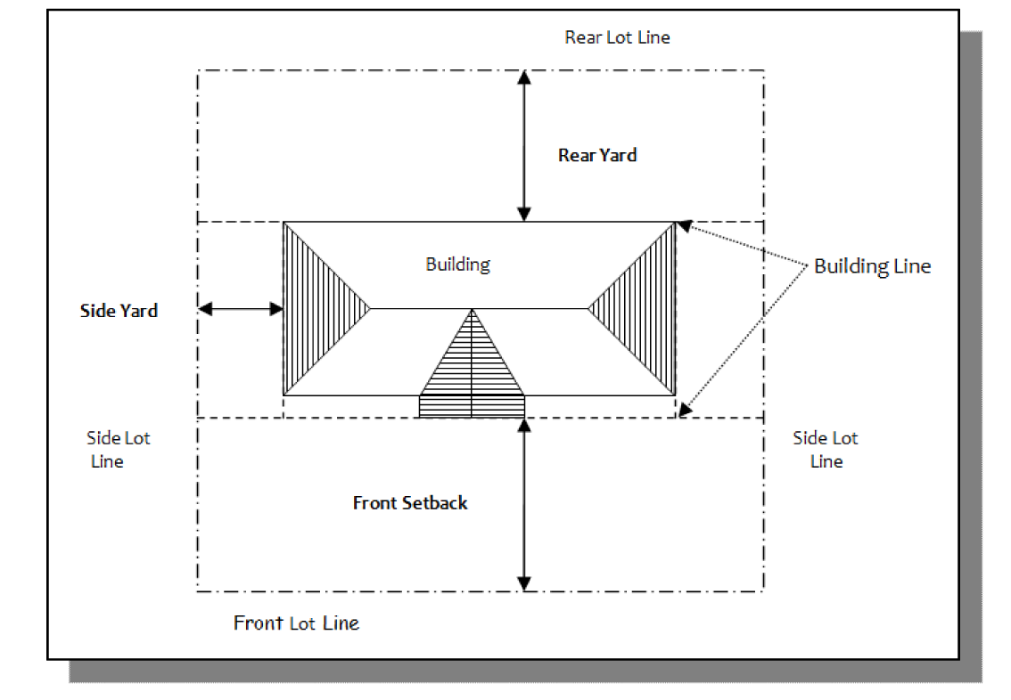
Building line. The line marking the intersection of the vertical building face and the ground plane. For the purpose of this definition, the building face shall be deemed to exclude exterior steps, chimneys and architectural features such as canopies, cornices, belt courses, pilasters, sills and eaves which project no more than three feet into the yard.
Building, main. The principal structure or one of the principal buildings on a lot, or the building or one of the principal buildings housing the principal use on the lot.
C
Caliper. The diameter of a tree trunk measured at breast height for trees.
Campgrounds. Any area, place, parcel or tract of land of four acres or more on which three or more campsites are occupied or intended for occupancy or facilities are established or maintained, wholly or in part, for the accommodation of camping units for periods of overnight or longer, whether the use of the campsites and facilities is granted gratuitously, or by rental fee, lease or conditional sale, or by covenants, restrictions and easements. "Campground" includes, but is not limited to, a travel trailer camp, recreation camp, family campground, camping resort, recreational vehicle park and camping community. "Campground" does not include a summer camp, migrant labor camp or park for mobile homes as defined in section 32.1-203 of the Code of Virginia, or a construction camp, storage area for unoccupied camping units, or property upon which the individual owner may choose to camp and not be prohibited or encumbered by covenants, restrictions, and conditions for providing his sanitary facilities within his property lines.
Camping unit. A tent, tent trailer, travel trailer, camping trailer, pickup camper, motor home, recreational vehicle or any other commonly used temporary shelter device used as temporary living quarters or shelter during periods of recreation, vacation, leisure time or travel. To qualify as a camping unit, vehicular and mobile units shall be eligible to be currently licensed and registered by a governmental body and shall be legal to travel on Virginia highways without special permits for size, weight or other reasons. For purposes of this definition, "temporary shelter device" shall mean a unit not occupied by the same persons in the campground for more than 90 days in any 120-day period. A mobile home or manufactured home shall not be considered a camping unit.
Campsite. Any plot of ground within a campground used or intended for occupation by the camping unit.
CATS. Acronym for Communications facilities, Antennas, Towers and/or Support structures, each of which is separately defined in this section.
Cellar. A story having more than one-half of its height below grade and which may not be occupied for dwelling purposes.
Certificate of occupancy (C.O.). A document issued by the James City County building official after completion of the final inspection and when the building or structure is in compliance with the Virginia Uniform Statewide Building Code (USBC) and any pertinent laws and ordinances. A certificate of occupancy indicates completion of the work for which a permit was issued and allows the occupancy or use of a building or structure.
Child day care center. An establishment offering group care to six or more children away from their own home for any part of a day.
Co-location. The mounting, installation, maintenance, modification, operation, or replacement of communications facilities on, under, within, or adjacent to a base station, building, existing structure, utility pole, or support structure for the purpose of transmitting and/or receiving radio frequency signals or other wireless data for communications purposes. "Co-locate" has a corresponding meaning.
Combat tactical training facility. A commercial use designed to train in mission simulations or any combination of anti-terrorism, counter-terrorism, or force protection operations. Such use generally includes one or more of the following items:
(1)
Use of military or paramilitary weapons, including outdoor firearms ranges utilizing automatic and/or semiautomatic weapons.
(2)
Combat training with real or simulated use of firearms or other military weapons systems.
(3)
Military tactical training area.
(4)
Use of real or simulated explosive devices.
(5)
Use of mock high impact firearms blast or simulated rocket-propelled grenades.
(6)
Unenclosed shoot house.
(7)
Evasive driving courses with or without the use of real or simulated firearms.
This definition shall not apply to hunting preserves or clubs, indoor or outdoor firing and shooting ranges, racetracks for animals or vehicles, indoor or outdoor sports facilities, schools, and facilities operated by local regional, state, or federal government agencies.
Commission, the. The planning commission of James City County, Virginia.
Communications facility. Equipment at a fixed location that enables wireless communications between user equipment and a communications network, including (i) equipment associated with wireless services, such as private, broadcast, and public safety services, as well as unlicensed wireless services and fixed wireless services, such as microwave backhaul, and (ii) radio transceivers, antennas, coaxial, or fiber-optic cable, regular and backup power supplies, and comparable equipment, regardless of technological configuration. Communications facilities shall not include facilities used for transmitting or receiving signals by governmental agencies or amateur radio or citizens band radio.
Community character corridor. A road shown and identified on the Land Use Plan Map in the Comprehensive Plan as a community character corridor.
Concealment element. Any condition of approval, including any applicable requirements of article II, special regulations, division 6, communications facilities, antennas, towers and support structures, in effect at the time of approval, established and imposed on a communications facility as a concealment technique designed to render the facility minimally visible to the casual observer or otherwise not having the appearance of an antenna or a tower, including conditions or regulations pertaining to antenna size, color of the structure and all equipment, antenna mounting techniques, maximum tower diameters, limitations on tower height relative to a reference tree, screening by trees, including the restrictions on removing trees that are screening the tower, and the size, location, design and screening for ground based equipment.
Continuing care retirement community (CCRC). An age-restricted development that is planned, designed and operated to provide a full range of accommodations for senior citizens, including independent living, assisted living and a skilled nursing component.
Convenience store. A single store, the ground floor area which consists of 4,000 square feet or less of retail floor area and which offers for sale, primarily, most of the following articles: bread, milk, cheese, canned and bottled foods and drinks, tobacco products, candy, papers and magazines, and general hardware articles. Gasoline may also be offered for sale but only as a secondary activity of a convenience store.
D
Dairy. A commercial establishment for the manufacture, processing, distribution and sale of dairy products.
Data center. An establishment or facility used for the storage, management, processing, and transmission of digital data, which may include the housing of computer and/or network equipment systems, servers, appliances, and other associated equipment or components related to digital data operation. Supporting equipment may include, but not limited to, back-up batteries and power generators, air handlers, water cooling and storage facilities, utility substation, and other associated utility infrastructure to support operation. This definition does not include server rooms or information technology infrastructure that is accessory to the principal use of the site. Further, this definition does not include an establishment or facility used to mine cryptocurrency.
Density, net. Net density shall be calculated as the number of dwelling units divided by the developable area.
Detectable warnings. A standardized surface feature built in or applied to walking surfaces or other elements to warn visually impaired people of hazards on a circulation path.
Developable area. The total land area of the site minus resource protection area as defined in the Chesapeake Bay Preservation Ordinance, areas subject to flooding under the one percent annual chance (100-year) storm event (FEMA zones A , AE, AO, V, and VE), and areas of 1,000 square feet or greater containing steep slopes. (Refer to definition of "non-developable area" and "steep slopes.")
Development. Solely for the purposes of Article VI, Overlay District, Division 3, Floodplain Area Regulations, this term shall mean any man-made change to improved or unimproved real estate, including, but not limited to, buildings or other structures, the placement of manufactured homes, streets and other paving, utilities, filling, grading, excavation, mining, dredging, drilling operations, storage of equipment or materials.
Development plans. Any site plan, subdivision plat, or subdivision construction plan.
Diameter breast height. The diameter of a tree trunk measured four and five-tenths feet from the ground.
Discontinuance. "Discontinuance" is defined as:
(1)
Vacancy of a building originally designed or arranged for the nonconforming use for a continuous period of two years;
(2)
Vacancy of land for a period of 90 days;
(3)
Vacancy of any building other than in subparagraph (1) above for a period of six months; or
(4)
Clear intent on the part of the owner to abandon the nonconforming use.
District. Districts as referred to in the Code of Virginia, section 15.2-2280.
Dry floodproofing. Solely for the purposes of Article VI, Overlay District, Division 3, Floodplain Area Regulations, dry floodproofing is a combination of measures that results in a structure, including the attendant utilities and equipment, being watertight with all elements substantially impermeable and with structural components having the capacity to resist flood loads.
Dwelling. Any structure, or portion of thereof, which is designed for use for residential purposes, except hotels, motels, boardinghouses, lodging houses, tourist cabins, time-share units, motor lodges, tents, travel trailers, recreational vehicles and similar accommodations. Dwellings may include the following types:
(1)
Single-family detached. A detached structure arranged or designed to be occupied by one family, the structure having only one dwelling unit.
(2)
Multi-family. A building or structure including, but not limited to, townhouses, duplexes, and triplexes that are arranged or designed to be occupied by more than one family living in separate dwelling units with separate cooking, toilet facilities, and entrances.
(3)
Apartments. A building or structure arranged or designed to be occupied by three or more families living in separate dwelling units but sharing the entrance to the building.
Dwelling unit. One or more rooms in a dwelling designed for living or sleeping purposes, and having at least one kitchen. For purposes of this chapter, attached and detached accessory apartments shall not be considered dwelling units.
E
Electric vehicle charging station. An Electric Vehicle Charging Station (EVCS) is an appliance that supplies energy to recharge electric vehicle batteries. There are three types of EVCS equipment available for residential and/or commercial use.
(1)
Level 1. Level 1 charging systems can be plugged into most grounded electrical outlets and is rated for 15 amperes at 120 volts.
(2)
Level 2. Level 2 charging systems require a dedicated circuit between 30 and 60 amperes.
(3)
Level 3. Level 3 charging systems are for commercial use and the only level permitted for commercial use. This system requires a dedicated circuit and with amperes ratings and voltage requirement determined by the manufacturer's specifications.
Elevated building. A non-basement building built to have the lowest floor elevated above the ground level by means of solid foundation, perimeter walls, pilings, or columns (post and piers).
Elevation. A vertical distance above or below a fixed reference point.
Eligible facilities request. Any request for modification of an existing tower or existing base station that does not substantially change the physical dimensions of such tower or base station, involving:
(1)
Co-location of new communications facilities.
(2)
Removal of communications facilities.
(3)
Replacement of communications facilities.
Eligible support structure. Any tower or base station, provided that it is existing at the time the relevant application is filed with the county.
Encroachment. Solely for the purposes of Article VI, Overlay District, Division 3, Floodplain Area Regulations, this term shall mean the advance or infringement of uses, plant growth, fill, excavation, buildings, permanent structures or development into a floodplain, which may impede or alter the flow of capacity of a floodplain.
Equipment enclosure. A small building, cabinet, or vault used to house and protect the electronic equipment necessary to process wireless communications signals. Associated equipment may include air conditioners and emergency generators.
Existing. Having been reviewed and approved under the applicable zoning process. A tower or base station that has not been reviewed and approved because it was not required to be reviewed when it was built, but was lawfully constructed, shall also be deemed "existing."
Existing structure.
(1)
Solely for the purposes of article VI, division 3 [of this chapter], this term shall mean structures for which the start of construction commenced before the effective date of the FIRM on or before February 6, 1991.
(2)
Solely for the purposes of article II, division 6 [of this chapter], antennas, towers and support structures only, this term shall mean any structure that is installed or approved for installation at the time a wireless services provider or wireless infrastructure provider provides notice to the locality of an agreement with the owner of the structure to co-locate equipment on that structure. "Existing structure" includes any structure that is currently supporting, designed to support, or capable of supporting the attachment of communications facilities, including towers, buildings, utility poles, light poles, flag poles, signs, and water towers.
Exterior lot. Pertaining to lots for three- or four-family dwellings whose units are laid out side-by-side in a row, an exterior lot is a lot intended to contain a dwelling unit sharing only one wall in common with another dwelling unit.
F
Fair market value. The price that a good or service would bring between a willing seller and a willing buyer in the open market after negotiation.
Family. One or more persons related by blood, adoption or marriage living and cooking together as a single housekeeping unit, exclusive of household servants. A number of persons, not exceeding three, living and cooking together as a single housekeeping unit though not related by blood, adoption or marriage shall be deemed to constitute a family.
A family is, exclusive of household servants:
(1)
An individual;
(2)
Two or more persons related by blood, marriage, adoption or guardianship;
(3)
A number of persons, not exceeding three, living and cooking together as a single housekeeping unit though not related by blood, marriage, adoption or guardianship; or
(4)
Not, more than two unrelated persons living and cooking together along with two or more persons related by blood, marriage, adoption or guardianship, as a single housekeeping unit.
Farmer's market. An occasional or periodic market held in a structure or open area where farmers sell their produce or farm products.
Fast food restaurant. Any building in which, for compensation, food or beverages are dispensed for consumption on or off the premises. Customer orders and/or services may be by means of a walk-up counter or a window designated to accommodate traffic of vehicles. (Refer to the definition of "restaurant.")
Fish farm. See "Aquaculture."
Flag lot. A lot where a majority of the parcel does not abut a public right-of-way, but that achieves access to the public road by a narrow section of land not less than 25 feet in width.
Flea market. An occasional or periodic market held in a structure or open area where one or more individuals offer goods for sale to the public. "Flea market" does not include sales held by charitable or nonprofit organizations not more than four times a year, farmer's market or garage sales.
Flood or flooding. The terms include:
(1)
A general or temporary condition of partial or complete inundation of normally dry land areas from:
(a)
the overflow of inland or tidal waters; or
(b)
the unusual and rapid accumulation or runoff of surface waters from any source; or
(c)
mudflows which are proximately caused by flooding as defined in paragraph (1) (b) of this definition and are akin to a river of liquid and flowing mud on the surfaces of normal dry land areas, as when earth is carried by a current of water and deposited along the path of the current.
(2)
The collapse or subsidence of land along the shore of a lake or other body of water as a result of erosion or undermining caused by waves or currents of water exceeding anticipated cyclical levels or suddenly caused by an unusually high water level in a natural body of water, accompanied by a severe storm, or by an unanticipated force of nature such as a flash flood or an abnormal tidal surge, or by some similarly unusual and unforeseeable event which results in flooding as defined in paragraph 1(a) of this definition.
Flood Insurance Rate Map (FIRM). An official map of a community, on which the Federal Emergency Management Agency has delineated both the special hazard areas and the risk premium zones applicable to the community. A FIRM that has been made available digitally is called a Digital Flood Insurance Rate Map (DFIRM).
Flood Insurance Study (FIS). A report by the Federal Emergency Management Agency that examines, evaluates and determines flood hazards and, if appropriate, corresponding water surface elevations, or an examination, evaluation, and determination of mudflow and/or flood-related erosion hazards.
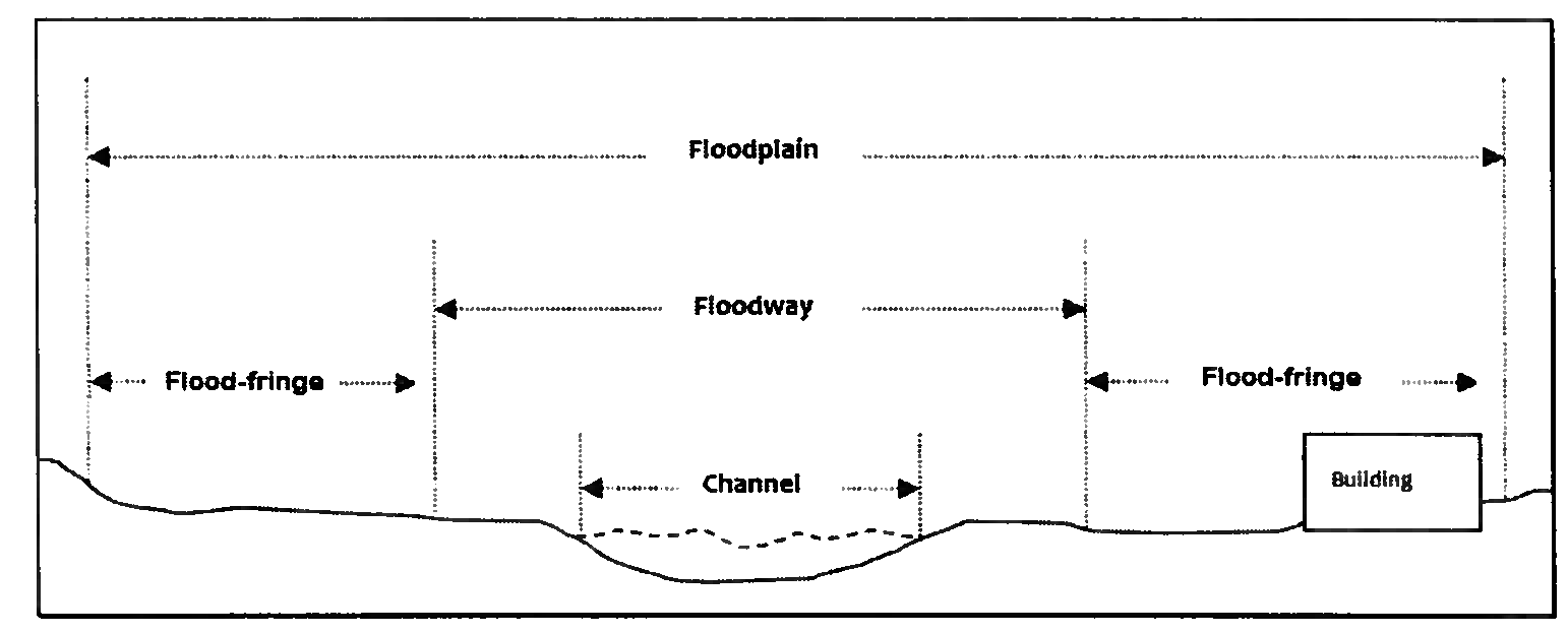
Floodplain or flood-prone area. Any land area susceptible to being inundated by water from any source.
Flood proofing. Any combination of structural and non-structural additions, changes or adjustments to structures which reduce or eliminate flood damage to real estate or improved real property, water and sanitary facilities, structures and their contents.
Floodway. The channel of a river or other watercourse and the adjacent land areas that must be reserved in order to discharge the base flood without cumulatively increasing the water surface elevation more than one foot.
Floor area. The total number of square feet of floor space within the exterior walls of a building, not including space in cellars, basements or attics.
Floor area ratio. A mathematical expression determined by dividing the total floor area of a building by the area of the lot on which it is located, as:

Floor area, retail. The total floor area of a commercial building or the commercial portion of a mixed use building, excluding stairwells, elevator shafts, equipment rooms (HVAC, plumbing, electrical, mechanical), storage areas, restrooms, hallways, and interior vehicle parking or loading. For the purposes of commercial parking calculations, the applicant shall be responsible for providing the zoning administrator with information detailing the allocation of retail and non-retail space.
Foot-candle. A measure of light falling on a surface. One foot-candle is equal to the amount of light generated by one candle shining on one square foot surface located one foot away. Foot-candle measurements shall be made with a photometric light meter and with a specified horizontal orientation.
Freeboard. A factor of safety usually expressed in feet above a flood level for purposes of floodplain management also known as the design base flood elevation for building code purposes.
Frontage. The minimum width of a lot measured along the street from one side lot line to the other.
G
Garage. A deck, building or structure, or part thereof, used or intended to be used for the parking or storage of vehicles.
Garage, private. An accessory building which is designed or used for the storage of automobiles owned and used by the occupants of the building to which it is accessory and which is not operated as a separate commercial enterprise available to the public.
Garage, repair. A building or portion thereof, other than a private garage, designed or used for servicing, repairing, equipping, renting, selling or storing motor-driven vehicles.
Garage sale. The sale of goods by a property owner and his neighbors at the property owner's residence occurring not more than twice a year.
Glare. The effect of a light source that shines in a conspicuous and obtrusive manner.
Golf course. Any area of land, publicly or privately owned, on which the game of golf is played, including accessory uses and buildings customary thereto, but excluding golf driving ranges as defined herein.
Golf driving range. A limited area on which golf players do not walk, but onto which they drive golf balls from a common driving tee.
Governing body. The board of supervisors of James City County, Virginia.
Green building. Structures constructed in a manner that addresses elements such as efficient management of energy and water resources, management of material resources and waste, protection of environmental quality, protection of health and indoor environmental quality, reinforcement of natural systems, and integration of the design approach. Accreditation programs include, but are not limited to, Earthcraft and LEED (Leadership in Energy and Environmental Design).
Group home. A residential facility in which individuals with mental illness, mental retardation or developmental disabilities reside with one or more resident counselors or other staff persons, and which is licensed by the Department of Behavioral Health and Development Services. Mental illness and developmental disability shall not include current illegal use of or addiction to a controlled substance as provided for in the Code of Virginia.
Guest room. A room which is intended, arranged or designed to be occupied, or which is occupied, by one or more guests paying direct or indirect compensation therefor, but in which no provision is made for cooking. Dormitories are excluded.
H
Highest adjacent grade. Solely for the purposes of Article VI, Overlay District, Division 3, Floodplain Area Regulations, this term shall mean the highest natural elevation of the ground surface prior to construction next to the proposed walls of a structure.
Historic and scenic resource area. Land managed by Colonial Williamsburg, the Jamestown-Yorktown Foundation, the National Park Service, York River State Park, the Virginia Association for Preservation of Antiquities, the Williamsburg Land Conservancy, or properties listed in the National Register, Virginia Historic Landmarks Register, or locally designated historic structures or districts, or Community Character Areas as defined in the Comprehensive Plan.
Historic structure. Solely for the purposes of article VI, division 3 [of this chapter], this term shall also mean any structure that is:
(1)
Listed individually in the National Register of Historic Places (a listing maintained by the Department of Interior) or preliminarily determined by the Secretary of the Interior as meeting the requirements for individual listing on the National Register;
(2)
Certified or preliminarily determined by the Secretary of the Interior as contributing to the historical significance of a registered historic district or a district preliminary determined by the secretary to qualify as a registered historic district;
(3)
Individually listed on a state inventory of historic places in states with historic preservation program which have been approved by the Secretary of the Interior; or
(4)
Individually listed on a local inventory of historic places in communities with historic preservation programs that have been certified by an approved state program as determined by the Secretary of the Interior or directly by the Secretary of the Interior in states with approved programs.
Home garden. An accessory use in a residential district for the production of vegetables, fruits and flowers generally for use or consumption, or both, by the occupants of the premises.
Home occupation. Any occupation or activity which is clearly incidental and secondary to the use of the premises for dwelling purposes and conducted solely by residents of the dwelling; provided, that:
(1)
The occupation or activity is conducted entirely within the dwelling; and
(2)
Not more than 25 percent of the first floor area is used throughout the structure for such occupation or activity; and
(3)
The occupation or activity requires no external alterations or the use or outdoor storage of machinery or equipment that creates noise, odor, smoke, dust or glare or is dangerous or otherwise detrimental to persons residing in the home or on adjacent property; and
(4)
No exterior evidence of the secondary use exists, with the exception of one sign, not to exceed four square feet. Such a sign must be attached to the dwelling and shall not be illuminated; and
(5)
No articles are displayed or otherwise offered for sale upon the premises; and
(6)
No equipment or process is used that may disrupt neighboring dwellings; and
(7)
Traffic is not generated in greater volumes than would normally be expected in a residential neighborhood and any need for parking generated by the conduct of such home occupation shall be met off the street.
Horizontal light bars/strips. An illumination device erected in a way so there is no visible bulb, lens, globe, diode or other light source as desired and designed such that there is no light spillage beyond the intended object to be illuminated.
Hospitals and mental health facilities. Any facility in which the primary function is the provision of diagnosis, of treatment and of medical and nursing services, surgical or nonsurgical, for two or more nonrelated individuals, including hospitals known by varying nomenclature or designation such as sanatoriums, sanitariums, and general, acute, short-term, long-term, outpatient and maternity hospitals.
Hotel. A building designed or occupied as the more or less temporary abiding place for more than ten individuals who are, for compensation, lodged, with or without meals, and in which provision is not generally made for cooking in individual rooms or suites.
Hydrologic and hydraulic analysis. Analyses performed by a licensed professional engineer in accordance with standard engineering practices that are accepted by the Virginia Department of Conservation and Recreation and FEMA, used to determine the base flood, other frequency floods, flood elevations, floodway information and boundaries, and flood profiles.
I
Independent living facility. A facility containing independent dwelling units providing housing and supportive services such as meals, housekeeping, social activities and transportation to residents.
Institutional use. A nonprofit, religious, private or public use, such as a church, library, school, hospital, or government-owned or operated building, structure, or land used for a public purpose.
Iso-footcandle diagram. A diagram consisting of lines showing the relative illumination in foot candles from a light source or group of light sources.
J
Junk yard. The use of any area of land lying within 100 feet of a state highway or the use of more than 200 square feet of land area in any location for the storage, keeping or abandonment of junk, including scrap metals or other scrap materials.
K
Kennel. A place prepared to house, board, breed, handle or otherwise keep or care for either dogs or cats or both for sale or in return for compensation.
L
Landscaped open space, area or strip. An area containing living plant materials, including trees, flowers, shrubs or grass. Landscaped areas may include pedestrian walks, ornamental objects, decorative planting, lawns and wooded areas, but at least 50 percent of the area must be vegetated. Landscaped open space, areas or strips shall not include any building, parking surface or structure except as stated above, or any wet detention pond or infiltration trench.
Lighting fixture. A complete lighting unit consisting of the lamp, lens, optical reflector, housing and any electrical components necessary for ignition and control of the lamp, which may include a ballast, starter and/or photo control.
Lighting fixture, directionally shielded. A lighting fixture which emits a light distribution where some light is emitted at or above a horizontal plane located at the bottom of a fixture. Such fixtures may contain visors, louvers or other types of shields, baffles or lenses which are designed to direct light onto a targeted area and to minimize light spillage.
Lighting fixture, full cut-off. A lighting fixture from which no light output is emitted at or above a horizontal plane drawn through the bottom of the lighting fixture.
Limited farm brewery. Breweries that manufacture no more than 15,000 barrels of beer per calendar year, provided the brewery is located on a farm where agricultural products, including barley, other grains, hops, or fruit, used by such brewery in the manufacture of its beer are grown on the farm. Limited farm brewery does not include a restaurant or tap room operations, but may include the sale or tasting of beer during regular business hours within the normal course of business. The sale of beer-related items that are incidental to the sale of beer is also permitted.
Limited farm distillery. Distilleries that manufacture no more than 36,000 gallons of alcohol per calendar year, provided the distillery is located on a farm where agricultural products used by such distillery in the manufacture of its alcohol are grown on the farm. Limited farm distillery does not include a restaurant or tap room operations, but may include the sale or tasting of alcohol during regular business hours within the normal course of business. The sale of distillery-related items that are incidental to the sale of alcohol is also permitted.
Livestock. Domestic animals normally raised on a farm such as horses, cows, swine, goats, sheep, etc.
Livestock market. A commercial establishment wherein livestock is collected for sale and auctioned off.
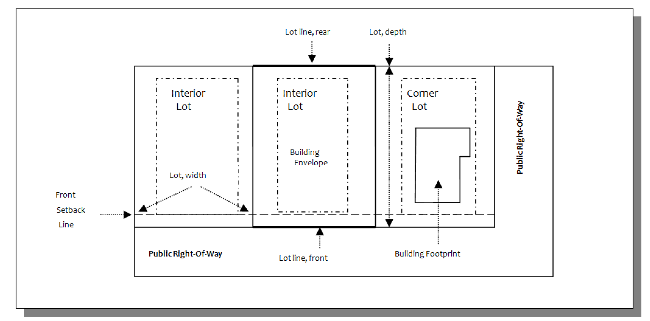
Lot. A unit, division or piece of land occupied or to be occupied by a main structure or group of main structures and accessory structures, together with such yards, open spaces, lot width and lot areas as are required by this chapter, and having frontage upon a street, either shown on a plat of record or considered as a unit of property and described by metes and bounds.
Lot, area of. The total area of land contained by lot lines and inclusive of any easements that may exist upon the lot. For the purpose of computing coverage of floor area ratio, the area of the lot shall not be considered to include any area of land designated for a future public road right-of-way.
Lot, corner. A lot abutting on two or more streets at their intersection. Of the two sides of a corner lot the front shall be deemed to be the shortest of the two sides fronting on streets.
Lot, depth of. The shortest horizontal distance between the front and rear lot lines.
Lot, double frontage. An interior lot having frontage on two streets.
Lot, interior. Any lot other than a corner lot.
Lot, interior unit. Pertaining to lots for multi-family dwellings, an "interior unit lot" is a lot intended to contain a dwelling unit sharing two walls wholly or in part with another dwelling unit.
Lot line, front. The lot line separating a lot from a street right-of-way except in the case of a flag lot, which the front lot line shall be the lot line nearest and parallel or approximately parallel to the street to which the lot has access except as otherwise provided for in the subdivision ordinance.
Lot line, rear. The lot line opposite and most distant from the front lot line; or in the case of a triangular or otherwise irregularly shaped lot, a line ten feet in length entirely within the lot, parallel to and at a maximum distance from the front lot line.
Lot, width of. The horizontal distance between side lot lines measured at the setback line.
Lot of record. A lot which has been recorded in the clerk's office of the circuit court.
Lowest floor. The lowest floor of the lowest enclosed area including the basement. An unfinished or flood-resistant enclosure, usable solely for parking of vehicles, building access or storage in an area other than a basement area is not considered a building's lowest floor; provided that such enclosure is not built to render the structure in violation of the applicable non-elevation design requirement of Federal Code 44CFR Section 60.3.
Luminary. A lighting fixture assembly or source of artificial illumination including, but not limited to, bulbs, lamps, reflectors, refractors and housings associated with them.
M
Manufacture; manufacturing. The assembly of components, pieces or subassemblies, or the processing or converting of raw, unfinished materials or products into articles or substances of different character or for use for a different purpose.
Manufactured home. A manufactured home is a structure subject to federal regulation which is transportable in one or more sections; is eight body feet or more in width and 40 body feet or more in length in the traveling mode, or is 320 or more square feet when erected on site; is built on a permanent chassis; is designed to be used as a single-family dwelling, with or without a permanent foundation, when connected to the required utilities; and includes the plumbing, heating, air conditioning and electrical systems contained in the structure.
Manufactured home park. A lot or parcel, not part of a manufactured home subdivision, on which are located or which are arranged or equipped for the accommodation of three or more manufactured homes occupied as single-family dwellings.
Medical clinic. An establishment where patients are admitted for examination and treatment by one or more physicians, dentists or psychologists and where patients are not usually lodged overnight. "Medical clinic" includes a facility known as surgical outpatient clinic.
Micro-brewery. A brewery that produces less than 15,000 barrels per year.
Micro-wireless facility. A small cell facility that is not larger in dimension than 24 inches in length, 15 inches in width, and 12 inches in height and that has an exterior antenna, if any, not longer than 11 inches.
Mixed use structure. A building or other structure containing a combination of two or more different principle uses.
Mobile food vending vehicle (food truck). A self-propelled or towed vehicle licensed by the Department of Motor Vehicles containing a mobile kitchen in which food and beverages are stored and/or prepared and from which menu items are served in individual portions to walk-up customers.
Mobile home. A mobile home is a structure not meeting the specifications or requirements of a manufactured home, designed for transportation, after fabrication, on streets and highways on its own wheels or on flat bed or other trailer, and arriving at the site where it is to be occupied as a dwelling complete and ready for occupancy except for minor and incidental unpacking and assembly operation, location on jacks or permanent foundations, connection to utilities and the like. (See "trailer" and "travel trailer" following in this section.)
Monopole. A communications facility tower used to deploy antennas defined as self-supporting with a single shaft of wood, steel or concrete.
Motel. One or more buildings containing individual sleeping rooms, designed for or used temporarily by automobile tourists or transients, with garage or parking space conveniently located to each unit. Cooking facilities may be provided for each unit.
Multi-antenna system. Communications facilities networked together and connected to a wireless service source so that one or more multiple provisioning (high-powered) antennae which would normally be mounted on a tower to serve a given area are replaced or prevented by a group of lower-power antennas to serve the same geographic area.
Multiple provisioning antenna. Antennas used as part of an overall network such as distributive antenna systems that transmit and/or receive radio signals from multiple points and multiple users in a prescribed geographic area.
N
Neighborhood resource center. A facility used primarily by residents of adjacent neighborhoods for the sharing of information and services of a public, nonprofit, or charitable nature. Primary uses may include resource libraries, meeting rooms, offices for neighborhood organizations or related staff, and education rooms. Accessory uses may include food preparation areas, health areas, community gardens, and parking. "Neighborhood resource center" does not include any facility with sales or residential units, nor does it include facilities for private lodges or clubs.
New construction. For the purposes of determining insurance rates, structures for which the "start of construction" commenced on or after July 18, 1975, the effective date of an initial Flood Insurance Rate Map, and includes any subsequent improvements to such structures. For floodplain management purposes, new construction means structures for which start of construction commenced on or after August 8, 1977, the effective date of these floodplain management regulations, and includes any subsequent improvements to such structures.
Nonconforming lot. An otherwise legally platted lot that does not conform to the minimum area or width requirements of this chapter for the district in which it is located either at the effective date of this chapter or as a result of subsequent amendments to the chapter.
Nonconforming use. Any activity using land, building, sign, lot, and/or structure for purposes which were legally established prior to the effective date of this chapter, or subsequent amendment to it, and which would not be permitted to be established in the zoning district in which it is located by the currently adopted regulations.
Nonconforming building. An otherwise legal building that does not conform with the lot area, yard, height, lot coverage or other area regulations of this chapter, or is designed or intended for a use that does not conform to the use regulations of this chapter for the district in which it is located, either at the effective date of this chapter or as a result of subsequent amendments to the chapter.
Nonconforming structure. Any structure not in conformance with current ordinance regulations.
Non-developable area. Non-developable areas consist of all resource protection area as defined in the Chesapeake Bay Preservation Ordinance, areas subject to flooding under the one percent annual chance (100-year) storm event (FEMA zones A, AE, AO, V, VE, and Coastal A), and areas of 1,000 square feet or greater containing steep slopes. (Refer to definition of "steep slopes.")
Noninterference/intermodulation study. A study prepared by a licensed engineer indicating potential interference of communications facilities with public safety communication equipment.
O
Office park. A development on a tract of land that contains two or more separate office buildings that are designed, planned, constructed, and managed on an integrated and coordinated basis.
Off-street parking area. Space provided for vehicular parking outside the dedicated street right-of-way.
Open space. Space suitable for recreation, gardens or landscaping which may include areas left in their natural state, trails, ponds, stream banks, recreation areas, areas of excessive slopes, low-lying areas and marshes and landscaped areas required by this chapter. Such space must be free of automobile traffic and parking and be readily accessible to all those for whom it is required.
P
Parcel. A contiguous area of land described in a single description as one of a number of lots on a plat, separately owned, either publicly or privately, and capable of being separately conveyed.
Parks and playgrounds. Land set aside for nonprofit activities of a recreational nature such as fishing, boating, swimming, camping, hiking, picnicking, outdoor games and sports incidental to the foregoing.
Parking area. Any public or private land area or structure designed and used for parking motor vehicles including parking lots, garages, private driveways and legally designated areas of public streets.
Parking lot. An off-street, outdoor area, usually surfaced and improved, for the parking of motor vehicles.
Pawnshop. A retail establishment where any person who lends or advances money or other things for profit on the pledge and possession of tangible personal property, or other valuable things, other than securities or written or printed evidences of indebtedness or title, or who deals in the purchasing of personal property or other valuable things on condition of selling the same back to the seller at a stipulated price.
Payday/title loan establishment. Any establishment which advances or lends a small, short-maturity loan on the security of (i) a check, (ii) any form of assignment of an interest in the account of an individual at a depository institution, (iii) any form of assignment of income payable to an individual, other than loans based on income tax refunds or (iv) title of a motor vehicle.
Pedestrian accommodations. A paved right-of-way for pedestrians and/or bicyclists that is separate from the traveled portion of the roadway and is free of vehicular traffic. Pedestrian accommodations may include but are not limited to sidewalks and multi-use paths.
Pen. A small enclosure used for the concentrated confinement and housing of animals or poultry; a place for feeding and fattening animals; a coop. Enclosed pasture or range with an area in excess of 100 square feet for each hog or small animal or 200 square feet for each larger animal shall not be regarded as a pen.
Places of public assembly. Places of public assembly include public or private meeting halls, fraternal organizations, houses of worship, civic clubs, and lodges.
Planned road. Any road or similar transportation facility as designated on the Comprehensive Plan, Six-Year Primary or Secondary Road Plan, Long Range Transportation Plan or any road plan adopted by the board of supervisors.
Plant and garden supply sales. Stores which shall sell a combination of materials used in the process of creating, cultivating, decorating, and maintaining gardens and landscaped areas. The primary items sold may include plants, shrubs, and trees grown on- or off-site; seeds; produce; hand tools; fertilizer; plant containers and hangers; natural materials such as sand, soil, rock, wood chips, and mulch; and decorative features including sculptures, fountains, ponds, ornaments, and cast or formed cement and cement pavers. Patio and outdoor furniture, including grills, gazebos, trellises, and outdoor fireplaces may also be included as secondary and incidental items sold at a plant and garden supply store. Excluded from this definition are mechanical lawn and garden equipment, pools and pool equipment, lumber and building supplies.
Portable cellular transmission facility (PCTF). A portable, self contained transmission tower that can be moved to a location and set up to provide wireless service on a temporary or emergency basis. A PCTF is normally vehicle-mounted and may contain a telescoping boom as the antenna support structure. PCTFs include, but are not limited to, Cells-on-Wheels (COW), Site-on-Wheels (SOW), Cell in a Box (CIAB) and Cell on Light Trucks (COLT) or other portable devices as determined by the zoning administrator.
Poultry. Domestic fowl normally raised on a farm such as chickens, ducks, geese and turkeys.
Primary service area. The primary service area (PSA) is the area(s) identified on the zoning map where urban development is encouraged to locate in accordance with the Comprehensive Plan. These areas presently are provided with public water and sewer systems and other public services such as police and fire protection, transportation and emergency medical services, and areas slated to receive such services in the next 20 years.
Principal residential use. A single-family dwelling, including a mobile home, manufactured home, modular home, or multi-family dwelling. The occupancy of a building by a caretaker or watchman for sleeping quarters shall not constitute a principal residential use.
Production agriculture or silviculture activity. The bona fide production or harvesting of agricultural products as defined in section 3.2-6400 of the Code of Virginia, including silvicutural products, but shall not include the processing of agricultural or silviculture products, the above ground application or storage of sewage sludge, or the storage or disposal of non-agricultural excavation material, waste and debris if the excavation material, waste and debris are not generated on the farm, subject to the provisions of the Virginia Waste Management Act.
Public water and sewer systems. A water or sewer system owned and operated by a municipality, county, service authority or sanitary district, or owned and operated by a private individual or a corporation approved by the governing body and properly licensed by the State Corporation Commission and approved by the Virginia Department of Health.
Publicly owned solid waste container site. A county-owned facility providing containers for citizens to dispose of residential solid waste and recyclable materials to include, but not limited to, aluminum cans, container glass and newspaper.
R
Radio frequency (RF) report. A statement from a registered engineer demonstrating that electromagnetic radiation emitted from communications facilities, including all facilities that may already be attached, does or does not result in "public" exposure level outside the communications facilities that exceeds relevant FCC standards.
Recreation facility, commercial. A place designed and equipped for the conduct of leisure-time activities, sports or other customary and usual recreation activities and which is operated as a business.
Recreation facility, community. A place designed and equipped for recreational activities by the inhabitants of a residential or mixed use project and which is operated for noncommercial purposes by a developer, homeowner association, nonprofit organization or a governmental agency.
Recreational vehicle. A vehicle which is:
(1)
Built on a single chassis;
(2)
400 square feet or less when measured at the largest horizontal projection;
(3)
Designed to be self-propelled or permanently towable by a light-duty truck; and
(4)
Designed primarily not for use as a permanent dwelling but as temporary living quarters for recreational camping, travel or seasonal use.
Residential club house. A facility used by residents of the community for recreational purposes.
Resort Hotel. A building or group of buildings designed or occupied as the more or less temporary abiding place for more than ten individuals who are, for compensation, lodged, with or without meals, and in which provision is not generally made for cooking in individual rooms but may be accommodated for in suites or detached units. Resort hotel units, regardless of the structural arrangement, must meet the performance standards listed in section 24-45, Performance standards for resort hotels.
Restaurant. Any building in which, for compensation, food or beverages are dispensed for consumption on the premises including, among other establishments, cafes, tea rooms, confectionery shops or refreshment stands.
Retail stores and shops. Buildings for display and sale of merchandise at retail or for the rendering of personal services such as the following which will serve as illustration: Drug store, newsstand, food store, candy shop, milk dispensary, dry goods and notions store, antique shop and gift shop, hardware store, household appliance store, furniture store, florist, optician, music and radio store, tailor shop, barber shop and beauty shop. For purposes of this definition, the following uses are excluded: coal, wood and lumber yards, sexually oriented businesses, vape/smoke shop, and vape/smoke lounge.
Retreat. A private or secure place of refuge and education. A retreat can include temporary, short-term residential facilities, recreational amenities, and educational activities (e.g. for job training and life skills). Retreat facilities must be voluntary in nature, and are different from group homes, which must be licensed by the Department of Behavioral Health and Development Services. A caretaker must be present when guests/lodgers are on-site.
S
Sanitary landfill. A facility where solid waste is spread in thin layers on the ground, compacted to the smallest practical volume and covered with soil at the end of each working day.
Scenic resource corridor. Community Character Corridors as defined in the Comprehensive Plan; Virginia Byways.
Setback. The distance by which any building or structure must be separated from the front lot line. For buildings, the setback is measured from the building line. For other structures, the setback is measured from the point on the ground vertically below the point of the structure nearest the front lot line.
Setback for timbering. The distance which any timbering activity must be set back from a public road right-of-way. It is an area in which no timbering shall occur except in accordance with section 24-43.
Setback line. That line that is the required distance from the street line or any other lot line. The setback line establishes the area within which the principal structure shall be erected or placed.
Sexually oriented business. Any premises which the public patronizes or to which members are invited or admitted, and which are so physically arranged as to provide booths, cubicles, rooms, compartments or stalls separate from the common areas of the premises for the purpose of viewing adult-oriented motion pictures or wherein an entertainer provides adult entertainment to a member of the public, a patron or a member, when such adult entertainment is held, conducted, operated or maintained for a profit, directly or indirectly. A sexually oriented business further includes, without being limited to, any adult store, adult entertainment studio, or any premises that are used as such, whether advertised or represented as an adult entertainment studio, adult-oriented motion picture theatre, exotic dance studio, or any other term of like or similar import; and other activities and land uses which the zoning administrator determines to be materially similar to the activities listed above. The following additional definitions are to be included when determining a sextually oriented business:
Adult store. A commercial establishment which regularly excludes all persons under the age of eighteen (18) from the premises, or a section thereof, because of the sexually explicit nature of the items sold, rented or displayed therein, or which, as one of its principal purposes, offers for sale or rental for any form of consideration adult media or adult novelty items as defined below. For these purposes, to constitute a principal business purpose, an adult store must have at least twenty-five percent (25%) or more of its floor space dedicated to or have twenty-five percent (25%) or more of its stock-in-trade consist of, the sale or rental of any adult media or adult novelty items. A commercial establishment may have other principal business purposes that do not involve the offering for sale or rental adult media or adult novelty items and still be categorized as an adult store.
Adult media. Adult media includes, but is not limited to, books, magazines, periodicals, or other printed matter; photographs, films, motion pictures, videos in any format including digital format; computer programs; or other visual representations which are distinguished or characterized by the exhibition or display of specified sexual activities or specified anatomical areas as defined below.
Adult novelty items. Instruments, devices, or paraphernalia which are designed or marketed for use in connection with specified sexual activities. Adult novelty items do not include instruments, devices, or paraphernalia that also constitute contraception.
Adult entertainment. Live performance, display, dancing, or other live entertainment of any type where the entertainment is characterized by an emphasis on specified sexual activities or specified anatomical areas or is intended for the sexual stimulation or titillation of patrons; or the showing of films, motion pictures, videotapes, slides, photographs, VHS, CD-ROMs, DVD-ROMs, streaming video, or other media that are characterized by their emphasis on matter depicting, describing or relating to specified sexual activities or specified anatomical areas.
Specified anatomical areas. Less than completely and opaquely covered human genitals, pubic region, buttock, or female breast below a point immediately above the top of the areola; or human male genitals in a discernibly erect state, even if completely and opaquely covered.
Specified sexual activities. Human genitals in a state of sexual stimulation or arousal; sexual intercourse or sodomy; or fondling or other erotic touching of human genitals, pubic region, buttock or breast, including masturbation.
Shallow flooding area. A special flood hazard area with base flood depths from one to three feet where a clearly defined channel does not exist, where a path of flooding is unpredictable and indeterminate and where velocity flows may be evident. Such flooding is characterized by ponding or sheet flow.
Shrubs. For the landscaping requirements of this chapter, a shrub shall be defined as a low-growing woody plant having several permanent stems which is, at planting, 18 inches if evergreen or 22 inches if deciduous.
Silvicultural activities. Forest management activities, including but not limited to the harvesting of timber, the construction of roads and trails for forest management purposes, and the preparation of property for reforestation.
Skilled nursing/Nursing home facilities. Any facility or any identifiable component of any facility in which the primary function is the provision, on a continuing basis, of nursing services and health-related services for the treatment and inpatient care of two or more nonrelated individuals, including facilities known by varying nomenclature or designation such as convalescent homes, skilled care facilities, intermediate care facilities, extended care facilities and infirmaries.
Slick stick. A monopole where all antenna arrays are concealed within the tower.
Small cell facility. A communications facility installed on an existing structure that meets both of the following qualifications: (i) each antenna is located inside an enclosure of no more than six cubic feet in volume, or, in the case of an antenna that has exposed elements, the antenna and all of its exposed elements could fit within an imaginary enclosure of no more than six cubic feet and (ii) all other transmission equipment associated with the facility has a cumulative volume of no more than 28 cubic feet, or such higher limit as is established by the Federal Communications Commission. The following types of associated equipment are not included in the calculation of equipment volume: electric meter, concealment, telecommunications demarcation boxes, back-up power systems, grounding equipment, power transfer switches, cut-off switches, and vertical cable runs for the connection of power and other services.
Small-scale alcohol production. Includes operations such as micro-breweries, micro-distilleries, and micro-wineries. Micro-breweries produce no more than 15,000 barrels a year. Micro-distilleries produce no more than 36,000 gallons of alcohol per year. Micro-wineries produce no more than 15,000 barrels a year. These uses are often accompanied by tap rooms, brew pubs, and retail sales.
Solid waste transfer station. A facility for the collection of solid waste and shipment to a final point of disposal. The facility may serve one or more localities and may include accessory facilities for the collection of recyclable materials such as glass, aluminum, paper and plastic products, waste motor oil, tires and appliances.
Special flood hazard area. The land in the floodplain subject to one percent or greater chance (100-year) of being flood in any given year. The area may be designated as Zone A, AE, AO, Coastal A, V, or VE on the official Flood Insurance Rate Map (FIRM) for James City County and defined as follows:
"A" zones are areas subject to inundation by the one percent annual chance (100-year) flood event generally determined using approximate methodologies. Because detailed hydraulic analyses have not been performed, no base flood elevations or flood depths are shown.
"AE" zones are areas subject to inundation by the one percent annual chance (100-year) flood event determined by detailed methods. Base flood elevations are shown.
"AO" zones are areas subject to inundation by one percent annual chance (100-year) shallow flooding (usually sheet flow on sloping terrain) where average depths are between one and three feet.
"Coastal A" zones are areas that have been delineated as subject to wave heights between 1.5 feet and 3 feet and identified on the FIRM as AE areas that are seaward of the Limit of Moderate Wave Action (LiMWA) line.
"V" zones are areas along coasts subject to inundation by the one percent annual chance flood (100-year) event with additional hazards associated with storm-induced waves. Because detailed hydraulic analyses have not been performed, no base flood elevations or flood depths are shown.
"VE" zones are areas subject to inundation by the one percent annual chance flood (100-year) event with additional hazards due to storm-induced velocity wave action three feet or greater. Base flood elevations derived from detailed hydraulic analyses are shown.
Spillage (light). Light which falls or is transmitted from a luminary in one area or site into an adjoining area or site.
Start of construction. The date the building permit was issued, provided the actual start of construction, repair, reconstruction, rehabilitation, addition, placement or other improvement is within 180 days of the permit date. The actual start means either the first placement of permanent construction of a structure on a site (such as the pouring of slab or footings, the installation of piles, the construction of columns or any work beyond the stage of excavation) or the placement of a manufactured home on a foundation. Permanent construction does not include land preparation, such as clearing, grading, or filling; nor does it include excavation for a basement, footings, piers, or foundations or the erection of temporary forms; nor does it include the installation on the property of accessory buildings, such as garages or sheds not occupied as dwelling units or not part of the main structure. For a substantial improvement, the actual start of construction means the first alteration on any wall, ceiling, floor, or other structural part of a building, whether or not the alteration affects the external dimensions of the building.
Steep slopes. Areas containing changes in elevation meeting or exceeding 25 percent gradient.
Store. See "Retail stores and shops" preceding in this section.
Story. That portion of a building, other than the basement, included between the surface of any floor and the surface of the floor next above it. If there is no floor above it, the space between the floor and the ceiling next above it.
Story, half. A space under a sloping roof which has the line of intersection of roof decking and wall face not more than three feet above the top floor level and in which space not more than two-thirds of the floor area is finished off for use.
Street functional classification. Streets shall be functionally classified as follows:
(1)
Interstate: A highway that is part of the nationwide U.S. Interstate Highway System connecting or involving different states.
(2)
Expressway or Freeway: A roadway designated exclusively for unrestrictive movement of traffic. Access is only with selected arterial streets by means of interchanges.
(3)
Arterial streets (principal, minor). Streets and roads which function within a regional network conveying traffic between major activity centers. The purpose of such streets is to carry relatively large volumes of traffic at higher speeds, and not to serve abutting lots except indirectly through intersection streets. The arterial classification is further subdivided into "principal arterial" and "minor arterial" based on traffic volumes.
(4)
Collector streets (major, minor): Streets designed to conduct and distribute traffic between streets of lower order and streets of higher order linking major activity centers. The collector classification is further divided into "major collector" and "minor collector."
(5)
Local or access streets. Streets designed to carry low to moderate volumes of traffic, at low operating speeds. The primary function of these streets is to provide access to individual lots, typically within a residential subdivision.
The functional classification status of a specific road shall be determined by the agent after consulting with the transportation department.
Street; road. A public or private thoroughfare which affords principal means of access to abutting property.
Street line. The line that forms the boundary between a street or road right-of-way and the contiguous property.
Structure. Anything constructed or erected, the use of which required permanent location on the ground or attachment to something having a permanent location on the ground. The term structure shall not refer to fences, walls used as fences, mailboxes, retention walls, street signs, utility pedestals, docks or other features which are constructed or erected as determined by the zoning administrator. Solely for the purposes of article VI, division 3 [of this chapter], this term shall also mean a walled and roofed building, including a gas or liquid storage tank that is principally above ground as well as a manufactured home.
Substantial change. For the purposes of article II, division 6 [of this chapter], antennas, towers and support structures, substantial change shall be defined as modification to an eligible support structure which meets any of the following criteria:
(1)
Increase in height. For towers other than towers in the public rights-of-way, the modification increases the height of the tower by more than ten percent or by the height of one additional antenna array with separation from the nearest existing antenna not to exceed 20 feet, whichever is greater; for other eligible support structures, the modification increase the height of the structure by more than ten percent or more than ten feet, whichever is greater. Changes in height shall be measured from the original support structure in cases where deployments are or will be separated horizontally, such as on building rooftops; in other circumstances, changes in height should be measured from the dimensions of the tower or base station, inclusive of originally approved appurtenances and any modifications that were approved prior to February 22, 2012.
(2)
Increase in width. For towers other than towers in the public rights-of-way, the modification involves adding an appurtenance to the body of the tower that would protrude from the edge of the tower more than 20 feet, or more than the width of the tower structure at the level of the appurtenance, whichever is greater; for other eligible support structures, the modification involves adding an appurtenance to the body of the structure that would protrude from the edge of the structure by more than six feet.
(3)
Excessive equipment cabinets. For any eligible support structure, the modification involves installation of more than the standard number of new equipment cabinets for the technology involved, but not to exceed four cabinets; or, for towers in the public-rights-of-way and base stations, the modification involves installation of any new equipment cabinets on the ground if there are no pre-existing ground cabinets associated with the structure, or else involves installation of ground cabinets that are more than ten percent larger in height or overall volume than any other ground cabinets associated with the structure.
(4)
Expands tower site. The modification entails any excavation or deployment outside the current site.
(5)
Defeats concealment elements. The modification would defeat the concealment elements of the eligible support structure.
(6)
Does not comply with conditions of approval. The modification does not comply with conditions associated with the siting approval of the construction or modification of the eligible support structure or base station equipment; provided that this limitation does not apply to any modification that is noncompliant only in a manner that would not exceed the thresholds identified in paragraphs (1) through (4) of this section.
Substantial damage. Damage of any origin sustained by a structure whereby the cost of restoring the structure to its before damaged condition would equal or exceed 50 percent of the market value of the structure before the damage occurred.
Substantial improvement. Any reconstruction, rehabilitation, addition, or other improvement of a structure, the cost of which equals or exceeds 50 percent of the market value of the structure before the start of construction of the improvement. This term includes structures which have incurred substantial damage regardless of the actual repair work performed. The term does not, however, include either:
(1)
Any project for improvement of a structure to correct existing violations of state or local health, sanitary, or safety code specifications which have been identified by the local code enforcement official and which are the minimum necessary to assure safe living conditions, or
(2)
Any alteration of a historic structure, provided that the alteration will not preclude the structure's continued designation as a historic structure.
(3)
Historic structures undergoing repair or rehabilitation that would constitute a substantial improvement as defined above, must comply with all ordinance requirements that do not preclude the structure's continued designation as a historic structure. Documentation that a specific ordinance requirement will cause removal of the structure from the National Register of Historic Places or the State Inventory of Historic places must be obtained from the Secretary of Interior or the State Historic Preservation Officer. Any exemption from ordinance requirements will be the minimum necessary to preserve the historic character and design of the structure.
Support structure. The structure to which antenna and other necessary hardware is mounted. Support structures shall include the following:
(1)
Tower. A pole or latticed structure designed for the attachment of one or more FFC-licensed or -authorized antenna as the primary use of the structure. This term does not include a base station.
(2)
Alternative mounting structure. Light poles, utility transmission structures, water towers, buildings, and other structures other than towers or camouflaged communications facilities which are not primarily designed to support antenna nor are designed taller in order to accommodate antenna.
(3)
Camouflaged structure. Any communications facility disguised or hidden by utilizing concealment elements so that all of its components are unnoticeable to the casual observer, or otherwise not having the appearance of an antenna or a tower.
(4)
Antenna support structures for multi-antenna systems. Structures whose primary function is to deploy an antenna as part of a multi-antenna system arrangement.
T
Theme park. A park or garden facility that is based on a common theme and may include, but is not limited to, the following: exhibits, animal acts and displays, rides, shops and eating facilities encompassing a minimum of ten acres.
Timbering. Tree harvesting, cutting, or removal where the total amount of land on which tree cutting occurs exceeds 10,000 square feet, which is performed in accordance with accepted Virginia Department of Forestry best management practices for timber harvesting as determined by the state and which includes reforestation either by natural or artificial reforestation, or both. However, timbering shall not include:
(1)
Harvesting, cutting, removal or other clearing of trees in accordance with a site plan, subdivision plan, or building permit that is currently under review by the county or has received final approval; or
(2)
Removal of tree stumps or conduct of other land disturbing activities; or
(3)
Removal of dead, diseased, dying, or insect damaged trees.
Tourist home. A dwelling where lodging or lodging and meals are provided for compensation for up to five rooms which are open to transients.
Trailer. A structure standing on wheels towed or hauled by another vehicle and used for short-term human occupancy, carrying materials, goods or objects, or as a temporary office.
Travel trailer. A mobile unit less than 29 feet in length and less than 4,500 pounds in weight which is designed for human habitation.
Tree. For the landscaping requirements of this chapter, a tree shall be defined as a deciduous shade tree having a minimum caliper of 1-1/2 inches at planting or an evergreen tree at least eight feet in height and a minimum caliper of 1-1/4 inches if single stemmed at planting or eight feet in height if multi-stemmed at planting. The term "tree" shall not include ornamental trees as defined below.
Tree, mature. Any deciduous or evergreen tree with a minimum diameter breast height of 12 inches which is free of disease and significant damage.
Tree, ornamental. For the landscaping requirements of this chapter, an ornamental tree shall be defined as a deciduous or evergreen tree which if single stemmed is eight feet in height and has a minimum caliper of 1-1/4 inches at planting or if multi-stemmed has a height of eight feet at planting.
Tree, specimen. Any tree with a minimum diameter breast height of 24 inches which is free of disease and significant damage or which is notable by virtue of its outstanding size and quality for its particular species.
Truck. A motor vehicle designed to transport property on its own structure or to transport property on a trailer drawn by it. "Truck" is inclusive of "tractor trailer vehicle," " tractor truck," and "road tractor" and has a registered gross weight in excess of 10,000 pounds.
Truck stop. Any facility offering for sale fuel for commercial vehicles, trucks and automobiles and constructed and designed to enhance maneuverability and fueling of tractor trailer vehicles by the contouring of curbs and aprons, the placement and design of fuel pump islands or other such design criteria. In addition, a truck stop shall have the capability to fuel three or more tractor trailer vehicles at the same time and/or parking facilities for three or more such vehicles. The facility may include provisions for one or more of the following: repairs or maintenance of commercial vehicles and trucks; sleeping accommodations for commercial vehicles or truck crews; sale of parts and/or accessories for commercial vehicles or trucks; or a restaurant.
Truck terminal. A storage facility for the unloading, transferring and storing of goods and materials being transported by truck. A truck terminal may include facilities for the repair and servicing of trucks.
U
Unit. See "Dwelling unit."
Usable satellite signal. A satellite signal which, when viewed on a conventional television set, is at least equal in picture quality to that received from local commercial television stations by use of an outdoor antenna.
V
Variance. In the application of the zoning ordinance, a reasonable deviation from those provisions regulating the shape, size, or area of a lot or parcel of land, or the size, height, area, bulk, or location of a building or structure when the strict application of the ordinance would unreasonably restrict the utilization of the property, and such need for a variance would not be shared generally by other properties, and provided such variance is not contrary to the purpose of the ordinance. It shall not include a change in use, which change shall be accomplished by a rezoning or by a conditional zoning.
Vape/smoke shop. A retail establishment that sells cigars, tobacco, and/or tobacco products, such as, but not limited to cigars, pipe tobacco, roll-your-own supplies, herbal and wax vaporizers, and glassware; hookah and water pipes; cannabis and/or hemp products, such as, but not limited to Cannabidiol (CBD); and/or e-cigarettes and associated equipment, such as, but not limited to vape batteries, coils, and e-liquids. Drug stores, retail food stores, grocery stores and convenience stores, the primary purpose of which is to sell goods and services other than those listed above, shall not be considered vape or smoke shops even if the above referenced goods are offered for sale.
Vape/smoke lounge. Any public or private establishment that allows persons to gather for the purpose of using cigars, tobacco, and/or tobacco products, such as, but not limited to cigars, pipe tobacco, roll-your-own supplies, herbal and wax vaporizers, and glassware; hookah and water pipes; cannabis and/or hemp products such as, but not limited to Cannabidiol (CBD); and/or e-cigarettes and associated equipment, such as, but not limited to vape batteries, coils, and e-liquids.
Vehicle. A motor vehicle designed to transport property and/or passengers on its own structure and having a gross registered weight of 10,000 pounds or less. Vehicle is inclusive of, but not limited to, "passenger car," "pickup truck," "panel truck" and "van."
Vehicle and gasoline service station. A facility for fueling, minor repairs and maintenance of vehicles. A vehicle or gasoline service station may include no more than four enclosed service bays for maintenance and minor repair of vehicles and may also include retail sale of lubricants, tires, batteries and similar accessories.
Vehicle graveyard. Any lot or place which is exposed to the weather upon which more than five motor vehicles of any kind, incapable of being operated and which it would not be economically practical to make operative, are placed, located or found.
Violation. Solely for the purposes of Article VI, Overlay District, Division 3, Floodplain Area Regulations, this term shall mean the failure of a structure or other development to be fully compliant with the community's floodplain area regulations. A structure or other development without the elevation certificate, other certification, or other evidence of compliance required is presumed to be in violation until such time as the document is provided.
Virginia Erosion and Sediment Control Program (VESCP). A program approved by the State Water Control Board that has been established by a VESCP authority for the effective control of soil erosion, sediment deposition, and nonagricultural runoff associated with a land-disturbing activity to prevent the unreasonable degradation of properties, stream channels, waters, and other natural resources and shall include such items where applicable such as local ordinances, rules, permit requirements, annual standards and specifications, policies and guidelines, technical materials, and requirements for plan of development review, inspection, enforcement where authorized in the Virginia Erosion and Sediment Control Law and its attendant regulations and chapter 8 of the County Code, and evaluation consistent with the requirements of the Virginia Erosion and Sediment Control Law and its attendant regulations and chapter 8 of the County Code.
Virginia Stormwater Management Program (VSMP). A program approved by the State Water Control Board after September 13, 2011 that has been established by a VSMP authority to manage the quality and quantity of runoff resulting from land-disturbing activities and shall include such items as local ordinances, rules, permit requirements, annual standards and specifications, policies and guidelines, technical materials, and requirements for plan of development review, inspection, enforcement, where authorized in the Virginia Stormwater Management Act or associated regulations or chapter 8 of the County Code, and evaluation consistent with the requirements of the Virginia Stormwater Management Act and associated regulations and chapter 8 of the County Code.
W
Watercourse. A lake, river, creek, stream, wash, channel or other topographic feature on or over which waters flow at least periodically. Watercourse includes specifically designated areas in which substantial flood damage may occur.
Wayside stand; roadside stand; wayside market. Any structure or land use for the sale of agricultural or horticultural produce, livestock or merchandise produced by the owner or his family on their farm.
Wet floodproofing. Solely for the purposes of Article VI, Overlay District, Division 3, Floodplain Area Regulations, wet floodproofing is a floodproofing method that relies on the use of flood damage-resistant materials and construction techniques in the areas of a structure that are below the elevation required by this standard by intentionally allowing those areas to flood.
Winery. An establishment located on a farm with a producing vineyard, orchard or similar growing areas and with facilities for fermenting, bottling, storage and sale of wine on the premises.
Wireless infrastructure provider. Any person that builds or installs transmission equipment, communications facilities, or support structures, but that is not a wireless services provider.
Wireless service. Any service that is (i) "personal wireless services" as defined in 47 U.S.C. § 332(c)(7)(C)(i); (ii) provided over "personal wireless service facilities" as defined in 47 U.S.C. § 332(c)(7)(C)(ii), including commercial mobile services as defined in 47 U.S.C. § 332(d), to personal mobile communication devices through communications facilities; and (iii) any other fixed or mobile wireless service, using licensed or unlicensed spectrum, provided using communications facilities.
Wireless services provider. Any person that provides wireless services.
Workforce housing. Housing available at a sales price or rental amount that does not exceed 30 percent of the total monthly income of households earning between greater than 80 percent and 120 percent of the area median income as determined by the U.S. Department of Housing and Urban Development (HUD).
Y
Yard. An open space on a lot, other than a court, unoccupied and unobstructed from the ground upward except as otherwise provided herein:
(1)
Front. An open space on the same lot as a building and located between the front building line and the front lot or street line and extending across the full width of the lot.
(2)
Rear. An open, unoccupied space on the same lot as a building between the rear building line and rear line of the lot and extending the full width of the lot.
(3)
Side. An open, unoccupied space on the same lot as a building between the side building line and the side line of the lot and extending from the front yard line to the rear yard line.
Z
Zoning district, overlay. Any section of James City County, Virginia, for which regulations governing the use of buildings and land, the height of buildings, the size of yards and the intensity of use are uniform and which district overlays one or more principal zoning districts so as to impose special requirements in addition to the requirements of the principal zoning district.
Zoning district, principal. Any section of James City County, Virginia, for which regulations governing the use of buildings and land, the height of buildings, the size of yards and the intensity of use are uniform. Wherever used in this chapter, the term "district" or "zoning district" shall mean the same as the term "principal zoning district" as if the latter term were fully set out.
(Ord. No. 31A-88, § 20-2, 4-8-85; Ord. No. 31A-94, 2-3-86; Ord. No. 31A-109, 8-22-88; Ord. No. 31A-110, 9-12-88; Ord. No. 31A-113, 4-3-89; Ord. No. 31A-114, 5-1-89; Ord. No. 31A-119, 3-5-90; Ord. No. 31A-123, 7-2-90; Ord. No. 31A-126, 10-1-90; Ord. No. 31A-131, 6-3-91; Ord. No. 31A-145, 7-6-92; Ord. No. 31A-149, 2-1-93; Ord. No. 31A-151, 5-3-93; Ord. No. 31A-163, 7-3-95; Ord. No. 31A-165, 9-18-95; Ord. No. 31A-167, 5-26-96; Ord. No. 31A-169, 5-28-96; Ord. No. 31A-174, 1-28-97; Ord. No. 31A-176, 5-26-98; Ord. No. 31A-177, 8-18-98; Ord. No. 31A-179, 9-8-98; Ord. No. 31A-198, 5-25-99; Ord. No. 31A-204, 5-8-01; Ord. No. 31A-222, 2-14-06; Ord. No. 31A-228, 9-25-07; Ord. No. 31A-231, 12-11-07; Ord. No. 31A-238, 5-12-09; Ord. No. 31A-242, 7-14-09; Ord. No. 31A-265, 4-10-12; Ord. No. 31A-277, 9-11-12; Ord. No. 31A-278, 11-27-12; Ord. No. 31A-280, 12-11-12; Ord. No. 31A-287, 4-9-13; Ord. No. 31A-291, 8-13-13; Ord. No. 31A-293, 8-12-14; Ord. No. 31A-296, 6-9-15; Ord. No. 31A-299, 10-13-15; Ord. No. 31A-300, 10-13-15; Ord. No. 31A-305, 10-11-16; Ord. No. 31A-307, 11-8-16; Ord. No. 31A-308, 11-8-16; Ord. No. 31A-338, 1-9-18; Ord. No. 31A-347, 7-14-20; 31A-348, 7-14-20; Ord. No. 31A-357, 5-9-23; Ord. No. 31A-359, 5-9-23; Ord. No. 31A-363, 7-8-25; Ord. No. 31A-364, 9-9-25)
Sec. 24-3. - Purpose of chapter; zoning map.
(a)
The board of supervisors hereby enacts this chapter, together with the zoning map and all accompanying data thereon or affixed thereto which is and shall remain on file in the office of the county administrator, and which is hereby incorporated in and made a part of this chapter for the purpose of promoting the health, safety and general welfare of the public, and for the further purpose of accomplishing the objectives of sections 15.2-2200, 15.2-2280 and 15.2-2283 of the Code of Virginia.
(b)
This chapter is designed to give reasonable consideration to each of the following purposes, where applicable:
(1)
To provide for adequate light, air, convenience of access and safety from fire, flood, impounding structure failure and other dangers;
(2)
To reduce or prevent congestion in the public streets;
(3)
To facilitate the creation of a convenient, attractive and harmonious community;
(4)
To facilitate the provision of adequate police and fire protection, disaster evacuation, civil defense, transportation, water, sewage, flood protection, schools, parks, forests, playgrounds, recreational facilities, airports and other public requirements;
(5)
To protect against destruction of or encroachment upon historic areas;
(6)
To protect against one or more of the following: overcrowding of land; undue density of population in relation to the community facilities existing or available; obstruction of light and air; danger and congestion in travel and transportation; or loss of life, health or property from fire, flood, impounding structure failure, panic or other dangers;
(7)
To encourage economic development activities that provide desirable employment and enlarge the tax base;
(8)
To provide for the preservation of agricultural and forestal lands and other lands of significance for the protection of the natural environment.
(Ord. No. 31A-88, § 20-3, 4-8-85; Ord. No. 31A-266, 6-12-12; Ord. No. 31A-291, 8-13-13)
Sec. 24-4. - Exclusive nature of the chapter.
This chapter shall be deemed exclusive in nature and only those uses specified shall be permitted in the various zoning districts. If a use is not specified in a zoning district, it shall be prohibited in that district. In the event that a use is not permitted in any zoning district, it may only be permitted after appropriate amendment to the text of this chapter.
(Ord. No. 31A-100, 4-6-87)
Sec. 24-5. - Zoning administrator; administration and enforcement of chapter.
This chapter shall be administered and enforced by the zoning administrator who shall be appointed by the governing body. The zoning administrator shall serve at the pleasure of that body. Compensation for such shall be fixed by resolution of the governing body.
(Ord. No. 31A-88, § 20-5, 4-8-85)
Sec. 24-6. - Duty of those authorized to issue licenses and permits to conform to chapter.
All departments, officials and public employees of this jurisdiction who or which are vested with the duty of authority to issue permits or licenses shall conform to the provisions of this chapter. They shall issue permits for uses, buildings or purposes only when they are in harmony with the provisions of this chapter. Any such permit, if issued in conflict with the provisions of this chapter, shall be null and void.
(Ord. No. 31A-88, § 20-6, 4-8-85)
Sec. 24-7. - Administrative fees.
(a)
Fees as set forth in County Code Appendix A—Fee Schedule for Development Related Permits shall be charged at the time of application to offset the cost of making inspections, issuing permits, advertising notices and other expenses incident to the administration of this chapter or to the filing or processing of any appeal or amendment thereto.
(b)
Payment of any permit fees set forth in County Code Appendix A—Fee Schedule for Development Related Permits shall be waived for the county, any entity created solely by the county and those regional entities to which the county is a party provided that: (1) The other parties to the regional entity similarly waive fees; and (2) The regional entity has locations in more than one locality.
(Ord. No. 31A-88, § 20-8, 4-8-85; Ord. No. 31A-130, 5-6-91; Ord. No. 31A-145, 7-6-92; Ord. No. 31A-166, 1-23-96; Ord. No. 31A-170, 6-25-96; Ord. No. 31A-176, 5-26-98; Ord. No. 31A-178, 8-18-98; Ord. No. 31A-190, 4-13-99; Ord. No. 31A-212; 4-22-03; Ord. No. 31A-225, 4-24-07; Ord. No. 31A-235, 5-27-08; Ord. No. 31A-250, 8-9-11; Ord. No. 31A-297, 6-9-15; Ord. No. 31A-339, 6-12-18)
Sec. 24-8. - Certificate of occupancy.
(a)
Land may be used or occupied and buildings structurally altered or erected may be used or changed in use only after a certificate of occupancy has been issued by the building official. Such a certificate shall state that the building or the proposed use, or the use of the land, complies with the provisions of this chapter. A similar certificate shall be issued for the purpose of maintaining, renewing, changing or extending a nonconforming use. The certificate shall be issued within ten days after the erection or structural alteration of such building or part has conformed with the provisions of this chapter and all applicable codes and ordinances. Upon the request of the holder of a permit, the building official may issue a temporary certificate of occupancy for a building or structure, or part thereof, before the entire work covered by the permit shall have been completed, provided such portion or portions may be occupied safely prior to full completion of the building or structure without endangering life or public welfare.
(b)
The building official shall not issue a temporary certificate of occupancy until the applicant has guaranteed the completion of public improvements, including, but not limited to, public roads, public water and public sewer facilities, or the completion of required landscape areas and plantings shown on the approved site plan or other approved plan by providing either a letter of credit, certified check, cash escrow or cash payment approved by the county attorney.
(Ord. No. 31A-88, § 20-9, 4-8-85; Ord. No. 31A-100, 4-6-87; Ord. No. 31A-123, 7-2-90; Ord. No. 31A-266, 6-12-12)
Sec. 24-9. - Special use permits.
In order to provide for good zoning practices and the purpose the zoning district seeks to accomplish, to provide for adjustments in the relative location of uses and buildings of the same or different classification, and to promote the usefulness of these regulations, special use permits, limited as to location by the district regulations, are permitted as set forth under the terms of this chapter. In considering an application for a special use permit in those districts allowing them, the planning commission and the board of supervisors shall give due regard to the James City County Comprehensive Plan, the nature and condition of adjacent uses and structures, and the probable effect upon them of the proposed special use permit. They shall also take into account the special characteristics, design, location, construction, methods and hours of operation, effect on traffic conditions, or any other aspects of the particular use or structure that may be proposed by the applicant.
The planning commission and the board of supervisors should consider whether the proposed establishment or use will adversely affect the health, safety or welfare of persons residing or working on the premises or in the neighborhood, will unreasonably restrict an adequate supply of light and air to adjacent property, will increase congestion in the streets, will increase public danger from fire, will impair the character of the district or adjacent districts, will be incompatible with the Comprehensive Plan of James City County, will likely reduce or impair the value of buildings or property in surrounding areas, and whether such establishment or use will be in substantial accordance with the general purpose and objectives of this chapter. After a public hearing, if the planning commission determines the above considerations have been protected, the planning commission shall recommend to the board of supervisors that the special use permit be granted. The board of supervisors shall consider the recommendation of the planning commission and after a public hearing and a determination that the above considerations have been protected shall grant the special use permit. In those instances where the planning commission or the board of supervisors find that the proposed use may be likely to have an adverse effect, they shall determine whether such effect may be avoided by the imposition of special requirements or conditions, including, but not limited to, location, design, construction, equipment, maintenance and/or hours of operation, in addition to those expressly stipulated in this chapter and the commission may make their recommendation or the board of supervisors may grant the special use permit contingent upon the imposition of such special requirements or conditions. An application for a special use permit substantially the same as one previously denied shall not be reconsidered within a one-year period from the date the similar application was denied by the board of supervisors.
(Ord. No. 31A-88, § 20-10, 4-8-85; Ord. No. 31A-110, 9-12-88; Ord. No. 31A-116, 11-6-89; Ord. No. 31A-266, 6-12-12)
Sec. 24-10. - Public hearing required.
Prior to issuance of a special use permit a public hearing shall be held by the planning commission and by the board of supervisors; provided, however, that a special use permit for a manufactured home, temporary classroom trailer, or a family subdivision may be issued after a public hearing is held by the board of supervisors only. Whenever the planning commission is not required to hold a public hearing, it need not consider the permit nor make a recommendation to the board of supervisors for such permit.
(Ord. No. 31A-88, § 20-10.1, 4-8-85; Ord. No. 31A-108, 4-18-88; Ord. No. 31A-110, 9-12-88; Ord. No. 31A-114, 5-1-89; Ord. No. 31A-201, 12-1-99; Ord. No. 31A-266, 6-12-12)
Sec. 24-11. - Special use permit requirements for certain commercial uses; exemptions.
(a)
General requirements. A special use permit issued by the board of supervisors shall be required for:
(1)
Any convenience store;
(2)
Any commercial building or group of buildings which exceeds 10,000 square feet of floor area; or
(3)
Any commercial building or group of buildings, not including office uses, which generates, or would be expected to generate, a total of 100 or more additional trips to and from the site during the peak hour of the operation, based on the application of the Institute of Transportation Engineers (ITE) traffic generation rates contained in the latest edition of its book entitled Trip Generation. The applicable trip generation rate shall be determined by the planning director. The planning director may permit other traffic generation rates to be used if an individual or firm qualified to conduct traffic engineering studies documents that the use would not reasonably be expected to generate the amount of peak hour traffic projected by application of ITE traffic generation rates, provided the documentation is acceptable to the planning director; or
(4)
Automobile and gasoline service stations.
(b)
New buildings, additions or expansions. A special use permit shall be required for a new building, addition or expansion when:
(1)
In combination with the existing structure, it exceeds the thresholds set forth in paragraph (a);
(2)
It adds 5,000 square feet or more of commercial floor area or, in combination with other new buildings, additions or expansions, generates 75 or more peak-hour trips than generated by the existing or approved use on May 21, 1990, or than approved in a special use permit, whichever is greater; and
(3)
It is located on the same property as the existing structure or other parcel which is a logical component of such property. Factors to determine whether a parcel is a logical component include:
a.
Common ownership or control of the parcels under consideration by the same person(s) or entity(ies), or similar or related entities;
b.
Regardless of factor a. above, shared access to public roads, shared parking arrangements, shared traffic circulation or shared service areas; and
c.
Proximity. For the purpose of this paragraph, "proximity" means adjacent parcels, parcels separated by property under common ownership or control by the same person(s) or entity(ies) or similar or related entities, or parcels separated by a public or private right-of-way.
(c)
Design and submittal requirements. Any building or use and addition or expansion thereto requiring a special use permit under this section shall comply with the requirements of section 24-23.
(d)
Exemptions. The following shall be exempt from the requirements of this section:
(1)
Any use or building and expansion or addition thereto with preliminary site plan approval prior to May 21, 1990;
(2)
Any use or building and expansion or addition thereto for which the start of construction began prior to May 21, 1990, in accordance with a site plan approved prior to that date;
(3)
Any use or building and expansion or addition thereto shown on a proffered binding master plan that binds the general location of all of the features on the plan as required under this section;
(4)
Any building located in a mixed use district, residential planned community district or planned unit development district; or
(5)
Any building predominantly used as a warehouse, distribution center, office, or for other industrial or manufacturing purposes. For purposes of this exemption only, the term "predominantly" shall mean 85 percent of the total square feet of the building or more.
(Ord. No. 31A-121, 5-21-90; Ord. No. 31A-145, 7-6-92; Ord. No. 31A-155, 1-3-94; Ord. No. 31A-201, 12-1-99)
Sec. 24-12. - Revocation of special use permits.
(a)
The governing body may, by resolution, initiate a revocation of a special use permit. When initiated, the revocation process shall be handled as would a new application for a special use permit, following the procedures set forth in section 24-9 of this chapter.
(b)
After review by the planning director and consideration and recommendation by the planning commission, the governing body shall act on the proposal to revoke the special use permit. Grounds for revocation shall include, but not be limited to, the following:
(1)
A change in conditions affecting the public health, safety and welfare since adoption of the special use permit; or
(2)
Repeated violations of this chapter, including any conditions attached to the special use permit, by the owner/operator of the use; or
(3)
Fraudulent, false or misleading information supplied by the applicant (or his agent) for the special use permit; or
(4)
Improper public notice of the special use permit public hearing(s) when the permit was considered by the planning commission or the governing body; or
(5)
An error or mistake in fact that led to an arbitrary and unreasonable decision made by the governing body when approving the special use permit.
(Ord. No. 31A-102, 6-1-87; Ord. No. 31A-266, 6-12-12)
Sec. 24-13. - Amendment of chapter.
As provided for by section 15.2-2286(7) of the Code of Virginia, the board of supervisors may from time to time amend, supplement or change by ordinance the boundaries of the districts or the regulations herein established; any such amendment may be initiated by resolution of the board of supervisors or by motion of the planning commission or by petition of any property owner, contract purchaser with the owner's written consent, or the owner's agent therefor of the property which is the subject of the proposed zoning map amendment, addressed to the board of supervisors. Petitions for change or amendment shall comply with the requirements of section 24-23. These changes may be made, provided:
(1)
The planning commission and the board of supervisors shall each hold at least one public hearing in relation thereto at which parties in interest and citizens shall have an opportunity to be heard.
(2)
That notice shall be given of the time and place of such hearing by publication as a box advertisement in at least two issues of some newspaper having a general circulation in the jurisdiction. Such notice shall specify the time and place of the hearing at which persons affected may appear and present their views, not less than five days nor more than 21 days after final publication. After enactment of any such plan, ordinance or amendment, further publication thereof shall not be required.
(3)
When a proposed amendment of the zoning ordinance involves a change in the zoning classification of 25 or less parcels of land, then, in addition to the advertising as required above, written notice shall be given by the planning commission at least five days before the hearing to the owner or owners, their agent or the occupant of each parcel involved and to the owners, their agent or the occupant of all abutting property and property immediately across the street from the property affected. When a proposed amendment of the zoning ordinance involves a change in the zoning map classification of more than 25 parcels of land, then, in addition to the advertising as above required, written notice shall be given at least five days before the hearing to the owner, owners or their agent of each parcel of land involved. One notice sent by first class mail to the last known address of such owner as shown on the current real estate assessment books shall be deemed adequate compliance with this requirement; provided, that a representative of the local commission shall make affidavit that such mailings have been made and file such affidavit with the papers in the case. Nothing in this paragraph shall be construed as to invalidate any subsequently adopted amendment or ordinance because of the inadvertent failure by the representative of the planning commission to give written notice to the owner, owners or their agent of any parcel involved. Such notice shall be sent in accordance with section 15.2-2204 of the Code of Virginia.
(4)
No plan, ordinance or amendment shall be enacted, amended or re-enacted unless the board of supervisors has referred the proposal to the planning commission for its recommendation or has received the planning commission recommendation. Failure of the planning commission to report 100 days after the first meeting of the commission after the proposed plan, amendment or reenactment has been referred to the commission for action shall be deemed approval. After the public hearing required in subsection (1) above, the board may make appropriate changes or corrections in the ordinance or proposed amendment.
(5)
A petition for a plan or amendment substantially the same as one previously considered shall not be reconsidered within a one-year period from the date the similar petition was decided by the board of supervisors.
(Ord. No. 31A-88, § 20-14, 4-8-85; Ord. No. 31A-201, 12-1-99; Ord. No. 31A-210, 12-10-02; Ord. No. 31A-266, 6-12-12)
Sec. 24-14. - Construction and severability of provisions.
This chapter shall be liberally construed so as to effectuate the purposes hereof. If any clause, sentence, paragraph, section or subsection of this chapter shall be adjudged by any court of competent jurisdiction to be invalid for any reason, including a declaration that is contrary to the constitution of the commonwealth or of the United States, or if the application thereof to any government, agency, person or circumstance is held invalid, such judgment or holding shall be confined in its operation to the clause, sentence, paragraph, section or subsection hereof, or the specific application hereof, directly involved in the controversy in which the judgment or holding shall have been rendered or made, and shall not in any way affect the validity of any other clause, sentence, paragraph, section or subsection hereof, or affect the validity of the application thereof to any other government agency, person or circumstance.
(Ord. No. 31A-88, § 20-14.1, 4-8-85)
Sec. 24-15. - Purpose of this article.
It is the general policy of the county, in accordance with the laws of the Commonwealth of Virginia, to provide for the orderly development of land, for all purposes, through zoning and other land development legislation. Frequently where competing and incompatible uses conflict, traditional zoning methods and procedures are inadequate. In these cases, more flexible and adaptable zoning methods are needed to permit land uses and at the same time to recognize effects of change. It is the purpose of this article to provide a more flexible and adaptable zoning method to cope with situations found in such zoning through conditional zoning, whereby a zoning reclassification may be allowed subject to certain conditions proffered by the zoning applicant for the protection of the community that is not applicable to land similarly zoned. The provisions of this article shall not be used for the purpose of discrimination in housing.
(Ord. No. 31A-88, § 20-14.2, 4-8-85)
Sec. 24-16. - Proffer of conditions.
The owner or owners of property making application for a change in zoning or amendment to a zoning map, as part of their application, may voluntarily proffer in writing reasonable conditions, prior to a public hearing before the board of supervisors, which shall be in addition to the regulations provided for in the zoning district or zone sought in the rezoning petition. The conditions shall be proffered as a part of the requested rezoning or amendment to the county's zoning map. No proffers shall be submitted or accepted for any new residential rezoning or zoning map amendment, or any new residential component of a multi-use district rezoning or zoning map amendment field after July 1, 2016 unless such proffers are submitted pursuant to Section 15.2-2303.4(D) of the Code of Virginia, 1950, as amended.
(Ord. No. 31A-88, § 20-14.3, 4-8-85; Ord. No. 31A-100, 4-6-87; Ord. No. 31A-110, 9-12-88; Ord. No. 31A-115, 6-5-89; Ord. No. 31A-304, 9-13-16; Ord. No. 31A-346, 10-8-19)
State Law reference— Code of Va., § 15.2-2303
Sec. 24-17. - Enforcement and guarantees as to conditions.
The zoning administrator shall be vested with all necessary authority on behalf of the county to administer and enforce conditions attached to a rezoning or amendment to a zoning map, including:
(1)
The ordering in writing of the remedy of any noncompliance with such conditions;
(2)
The bringing of legal action to ensure compliance with such conditions, including injunction, abatement or other appropriate action or proceeding; and
(3)
Requiring a guarantee, in an amount sufficient for or conditioned upon the construction of any physical improvements required by the conditions, or a contract for the construction of such improvements and the contractor's guarantee, in like amount and so conditioned, which guarantee may be reduced or released by the zoning administrator upon the submission of satisfactory evidence that construction of such improvements has been completed in whole or in part. Failure to meet all conditions shall constitute cause to deny the issuance of any required use, occupancy or building permits as may be appropriate.
(Ord. No. 31A-88, § 20-14.4, 4-8-85)
Sec. 24-18. - Records.
The zoning map of the county shall show by an appropriate symbol on the map the existence of conditions attached to the zoning on the map. The zoning administrator shall keep in his office and make available for public inspection a conditional zoning index. The index shall provide ready access to the ordinance creating conditions in addition to the regulations provided for in a particular zone.
(Ord. No. 31A-88, § 20-14.5, 4-8-85)
Sec. 24-19. - Petition for review of decision.
(a)
Any zoning applicant who is aggrieved by a decision of the zoning administrator, pursuant to the provisions of section 24-17, may petition the board of supervisors for the review of such decision. Such appeal shall be taken within 30 days from the date of the action complained of and shall be instituted by filing with the zoning administrator and with the county administrator a notice of appeal, specifying the grounds thereof.
(b)
The zoning administrator shall forthwith transmit to the board of supervisors all of the papers constituting the record upon which the action appealed from was taken. The board of supervisors shall hear the appeal within 45 days from the date of the filing and give public notice in accordance with section 15.2-2204 of the Code of Virginia of the date fixed for the hearing, and shall give written notice at least five days before the hearing to the owner or owners, their agent or the occupant of each parcel involved and to the owners, their agent or occupant of all abutting property and property immediately across the street from the property affected.
(c)
An appeal shall stay all proceedings in furtherance of the action appealed from, unless the zoning administrator certifies to the board of supervisors, after notice of appeal has been filed with him, that, by reason of the facts stated in the certificate, a stay would, in his opinion, cause imminent peril to life or property. In such case, the proceedings shall not be stayed otherwise than by a restraining order which may be granted by the board of supervisors or by a court of record on application or notice to the zoning administrator and on due cause shown.
(Ord. No. 31A-88, § 20-14.6, 4-8-85; Ord. No. 31A-217, 4-26-05)
Sec. 24-20. - Amendments and variations of conditions.
(a)
Conditions proffered and accepted as part of an amendment of the zoning ordinance shall continue in full force and effect until a subsequent amendment changes the zoning on the property covered by such conditions; provided, however, that such conditions shall continue if the subsequent amendment is part of a comprehensive implementation of a new or substantially revised zoning ordinance.
(b)
Except as provided in subsection (c), there shall be no amendment or variation of proffered conditions created pursuant to the provisions of this article until after a public hearing before the board of supervisors which shall be advertised pursuant to section 24-13 of this chapter.
(c)
Where an amendment or variation of proffered conditions is requested pursuant to Virginia Code § 15.2-2302(A), and where such amendment does not affect conditions of use or density, the board of supervisors may waive the requirement for a public hearing under any statute, ordinance, or proffer requiring a public hearing prior to amendment of such proffered conditions. Written notice of such application shall be provided by the applicant to any landowner subject to such existing proffered conditions in the manner prescribed by Virginia Code § 15.2-2302(H).
(Ord. No. 31A-88, § 20-14.7, 4-8-85; Ord. No. 31A-297, 6-9-15)
Sec. 24-21. - Relation of section to other laws.
The provisions contained in this section shall be considered separate from, supplemental to and additional to the provisions contained elsewhere in this Code or other county ordinances. Nothing contained in this section shall be construed as excusing compliance with all other applicable provisions of this Code or other county ordinances.
(Ord. No. 31A-88, § 20-14.8, 4-8-85)
Sec. 24-22. - Penalties; sanctions, injunctive relief, fines.
(a)
Violating, causing or permitting the violation of, or otherwise disregarding any of the provisions of this chapter by any person, firm or corporation, whether as principal, agent, owner lessee, employee or other similar position, shall be unlawful and is subject to the following:
(1)
Criminal sanctions. Upon conviction, shall be guilty of a misdemeanor and shall be fined not less than $10.00, nor more than $1,000.00. Failure to remove or abate a zoning violation within the specified time period shall constitute a separate misdemeanor offense punishable by a fine of not less than $10.00 nor more than $1,000.00, and any such failure during any succeeding thirty day period shall constitute a separate misdemeanor offense for each thirty day period punishable by a fine of not less than $10.00 nor more than $1,000.00.
(2)
Injunctive relief. Any violation or attempted violation of this chapter may be restrained, corrected or abated as the case may be by injunction or other appropriate relief.
(3)
Civil fines:
a.
A civil penalty in the amount listed on the schedule below shall be assessed for a violation of the respective offense:
1.
Keeping an inoperative vehicle in residential or commercial zoning districts in violation of section 24-37, per vehicle .....$100.00
2.
Constructing, placing, erecting or displaying a sign on private property without a sign permit issued by the county in violation of section 24-67, per sign .....100.00
3.
Occupying, or permitting to be occupied, a single-family dwelling (SFD) by more than three unrelated individuals in violation of the definition of "family" in section 24-2, per offense .....100.00
4.
Installing, placing or maintaining a dish antennae in violation of section 24-34, per offense .....50.00
5.
Failure to meet the tree replacement requirements for any buffer or setback for timbering in accordance with section 24-43, per offense .....100.00
b.
Each day during which a violation is found to exist shall be a separate offense. However, in no event shall specified violations arising from the same set of operative facts be charged more frequently than once in a ten-day period and in no event shall a series of such violations result in civil penalties of more than $3,000.00.
c.
Any person summoned for a scheduled violation may make an appearance in person or in writing by mail to the county treasurer prior to the date fixed for trial in court. Any person so appearing may enter a waiver of trial, admit liability and pay the civil penalty established for the offense charged. Such persons shall be informed of their right to stand trial and that a signature to an admission of liability will have the same force and effect as a judgment of court.
d.
No provisions herein shall be construed to allow the imposition of civil penalties for:
1.
Enforcement of the Uniform Statewide Building Code;
2.
Activities related to land development or activities related to the construction or repair of buildings and other structures;
3.
Violations of the erosion and sedimentation control ordinance;
4.
Violations of any provisions of a local zoning ordinance relating to the posting of signs on public property or public right-of-ways; or
5.
Violations resulting in injury to any person or persons.
(b)
Civil or criminal action may be brought in conjunction with an action for injunctive relief. However, the offense designated for civil penalties above shall be in lieu of criminal enforcement.
(Ord. No. 31A-88, § 20-15, 4-8-85; Ord. No. 31A-100, 4-6-87; Ord. No. 31A-129, 3-4-91; Ord. No. 31A-182, 10-13-98; Ord. No. 31A-204, 5-8-01)
Sec. 24-23. - Submittal requirements.
(a)
The following information shall be submitted with any request for an amendment of this chapter, as provided for in section 24-13, or for any building or use and addition or expansion thereto which requires a special use permit (SUP) under this chapter, provided however, applications for family subdivisions, manufactured homes and temporary classroom trailers shall be exempt from the requirements of this section.
(1)
The community impact statement shall describe the probable effects of the proposed development upon the community and at a minimum shall address the following topics regarding infrastructure and quality of life:
a.
A traffic impact analysis for all projects that expect to generate 100 or more weekday peak hour trips to and from the site during the hours of operation and/or those projects with an entrance or exit onto a roadway with a level of service "D" or lower shall be required pursuant to the traffic impact analysis submittal requirement policy. Vehicular access points and drives shall be designed to encourage smooth traffic flow, with controlled turning movements and minimum hazards to vehicular and pedestrian traffic. Buildings, parking areas and drives shall be arranged in a manner that encourages pedestrian access and minimizes traffic movement. No more than one access point on each abutting public street shall be permitted unless specifically approved by the board of supervisors after reviewing the applicant's traffic impact analysis; and
b.
A water and sewer impact study for all projects with an anticipated average daily flow greater than 15,500 gallons, and/or for proposed residential projects containing 50 lots or more. Water conservation information shall be submitted in accordance with water conservation guidelines policy; and
c.
Environmental information shall be submitted in accordance with the environmental constraints analysis policy for legislative cases; and
d.
An adequate public facilities report in accordance with board of supervisors policy to include sewer, water, schools, fire stations, libraries and other major locally-financed facilities. School information shall be prepared according to the adequate public school facilities test policy; and
e.
Additional on-site and off-site public facilities or services which would be required as a result of the development; and
f.
A phase IA archaeological study if the property is identified as being an ultra- or highly-sensitive area on the James City County archaeological assessment; and
g.
A preliminary natural resource inventory if the property is identified as being in any B1, B2, or B3 areas, as defined by the Virginia Department of Conservation and Recreation's Natural Heritage Resources Program; and
h.
A fiscal impact analysis, using the worksheet and assumptions provided by the planning division, when the proposal includes residential dwelling units. The analysis must estimate revenues to be generated versus the cost of public improvements to be financed by the county or the state using the fiscal impact model prepared by the county. If desired by the applicant supplemental studies may be prepared by an individual or firm qualified to conduct a fiscal impact study in a manner and form acceptable to the planning director; and
i.
Parks and recreation information based on parks and recreation master plan proffer guidelines.
(2)
The master plan shall depict and bind the approximate boundaries and general location of all principal land uses and their building square footage and height, roads, rights-of-way (with an indication of whether public or private), accesses, open spaces, public uses and other features to be located on the site for which approval is sought. The planning director may require other features, including general location and approximate boundaries of buildings, structures or parking areas, to be incorporated into the master plan where deemed necessary due to the size of the development, access to or location of public roads, distance from residential areas, presence of environmentally sensitive areas or availability of public utilities. The master plan shall be prepared by a licensed surveyor, engineer, architect, landscape architect or planner. A scale may be used so that the entire parcel can be shown on one piece of paper no larger than 30 inches by 48 inches. The master plan shall also include:
a.
An inset map at a scale of not less than one inch to one mile showing the property in relation to surrounding roads, subdivision or major landmarks;
b.
A north arrow, scale, the proposed use, approximate development phasing (if applicable);
c.
The location of existing property lines, watercourse or lakes, wooded areas and existing roads which are within or adjoining the property;
d.
If applicable, a table which shows for each section or area of different uses: the use; approximate development phasing, maximum number of dwelling units and density for residential areas, maximum square feet of floor space for commercial or industrial areas; and maximum acreage of each use;
e.
If applicable, schematic plans which shall indicate the phasing of development and master water, sewer and drainage plans; and
f.
If more than one type of land uses is proposed, each use shall be designated on the master plan as follows:
*Areas of a master plan designated M (structures containing a mixture of uses) shall indicate in parentheses, following the M designation, the appropriate letter designations of the types of uses contained within the structure (e.g. M (CG)) in the order of their proportion in the mixed use structure.
A total of 12 copies of the master plan should be submitted along with an application for rezoning or a SUP; if necessary, additional copies of the master plan may be required for submittal. The master plan shall be reviewed and approved and thereafter become binding upon approval of a rezoning or a SUP by the board of supervisors. Thereafter, all amendments to the master plan shall be in accordance with section 24-13 of this chapter. Final development plans may be approved after approval of a master plan by the board of supervisors. All final development plans shall be consistent with the master plan, but may deviate from the master plan if the planning director concludes that the development plan does not:
1.
Significantly affect the general location or classification of housing units or buildings as shown on the master plan;
2.
Significantly alter the distribution of recreation or open space areas on the master plan;
3.
Significantly affect the road layout as shown on the master plan;
4.
Significantly alter the character of land uses or other features or conflict with any building conditions placed on the corresponding legislatively-approved case associated with the master plan.
If the planning director determines that a proposed change would deviate from the approved master plan, the amendment shall be submitted and approved in accordance with section 24-13. In the event the planning director disapproves the amendment, the applicant may appeal the decision of the planning director to the development review committee which shall forward a recommendation to the planning commission. For additional information regarding master plan submittal requirements refer to the submittal sections for the following zoning districts: R-4, residential planned community; RT, research and technology; PUD, planned unit development; MU, mixed use; EO, economic opportunity; and residential cluster development overlay district.
(2)
Any other submittal requirement which may be required by this chapter.
(3)
An application and fee in accordance with section 24-7 of this chapter.
(b)
Supplemental information should be submitted in accordance with the "Supplemental Submittal Requirements for Special Use Permits and Rezonings" policy as adopted by the board of supervisors and any additional policies as deemed necessary by the planning director.
(c)
In addition to the paper copies of all documents required by this chapter, all information and plans required under (a)(1), (a)(2) or (a)(3) shall be submitted in an electronic format in accordance with the "Electronic Submittal Requirements for Legislative Applications" policy, as approved by the planning commission.
(d)
Unless otherwise required by this chapter, upon written request by the applicant, the planning director may waive any requirement under (a)(1) or (a)(2) above after finding that such information would not be germane to the application.
(Ord. No. 31A-201, 12-1-99; Ord. No. 31A-266, 6-12-12; Ord. No. 31A-281, 12-11-12; Ord. No. 31A-297, 6-9-15; Ord. No. 31A-341, 8-14-18)
Sec. 24-24. - Additional requirements for submittal.
An application by the owner of the subject property, the owner's agent, or any entity in which the owner holds an ownership interest greater than 50 percent, for a special exception, special use permit, variance, rezoning or other land disturbing permit, including building permits and erosion and sediment control permits shall provide evidence to the Director of Planning that any delinquent real estate taxes, nuisance charges, stormwater management utility fees, and any other charges that constitute a lien on the subject property, that are owed to the locality and have been properly assessed against the subject property, have been paid, unless otherwise authorized by the treasurer.
(Ord. No. 31A-247, 8-10-10; Ord. No. 31A-362, 1-14-25)
State Law reference— Permitted provisions in zoning ordinances; amendments; applicant to pay delinquent taxes; penalties, Code of VA., § 15.2-2286.