
James City County Unincorporated
City Zoning Code
City Zoning Code
ARTICLE II
SPECIAL REGULATIONS
DIVISION 3. - EXTERIOR SIGNS[2]
Editor's note— Ord. No. 31A-333, adopted January 10, 2017, repealed art. II., div. 3, §§ 24-65—24-79 and enacted a new art. II., div. 3, §§ 24-65—24-79. Former art. II pertained to similar subject matter and derived from Ord. No. 31A-185, adopted December 22, 1998; Ord. No. 31A-207, adopted December 11, 2001; Ord. No. 31A-213, adopted March 9, 2004; Ord. No. 31A-224, adopted June 27, 2006; Ord. No. 31A-239, adopted May 12, 2009; Ord. No. 31A-245, adopted June 22, 2010; Ord. No. 31A-269, adopted September 11, 2012; Ord. No. 31A-291, adopted August 13, 2013.
Sec. 24-32. - Special requirements for accessory apartments.
(a)
Attached accessory apartments shall comply with the following requirements:
(1)
Only one accessory apartment shall be created within a single-family dwelling.
(2)
The accessory apartment shall be designed so that the appearance of the building remains that of a single-family residence. New entrances shall be located on the side or rear of the building and the apartment may not occupy more than 35 percent of the floor area of the dwelling.
(3)
For purposes of location and design, the accessory apartment is part of the main structure and shall meet all setback, yard and height regulations applicable to main structures in the zoning district in which it is located.
(4)
Off-street parking shall be required in accordance with section 24-54 of this chapter.
(b)
Detached, accessory apartments, where approved, shall comply with the following requirements:
(1)
Only one accessory apartment shall be created per lot.
(2)
The accessory apartment may not occupy more than 50 percent of the floor area of the accessory structure and shall meet all setback, yard, and height regulations applicable to accessory structures in the zoning district in which it is located.
(3)
The accessory apartment shall not exceed 400 square feet in size and shall meet all setback, yard, and height regulations applicable to accessory structures in the zoning district in which it is located.
(4)
The property owner or an immediate family member as defined in section 19-17 of the subdivision ordinance shall reside in either the single-family dwelling or the accessory apartment.
(5)
Approval from the health department shall be required where the property is served by an individual well and/or sewer disposal system.
(6)
The accessory structure shall be so designed such that the size and scale of the structure is compatible with surrounding structures.
(7)
Off-street parking shall be required in accordance with section 24-54 of this chapter.
(Ord. No. 31A-88, § 20-27.4, 4-8-85; Ord. No. 31A-293, 8-12-14)
Sec. 24-33. - Special provision for condominiums.
A building or group of buildings permitted under the terms of this chapter may be sold as condominiums unless otherwise prohibited by law.
(Ord. No. 31A-102, 6-1-87)
Sec. 24-34. - Special requirements for antennas.
In order to protect the health, safety and welfare of the citizens of James City County and to ensure that the unique aesthetic characteristics of the area are maintained, the following shall apply to the installation, maintenance and location of satellite earth station antennas and other types of incidental antennas located in the county, provided however the following shall be exempt from the requirements of this section:
• Those antennas and facilities covered by article II, special regulations, division 6, communications facilities, antennas, towers and support structures, except satellite earth station antennas and other types of incidental antennas.
• A "dish" antenna that is one meter (39.37 inches) or less in diameter and is designed to receive direct broadcast satellite service, including direct-to-home satellite service, or to receive or transmit fixed wireless signals via satellite, including satellite internet service, provided such antenna is not located more than 12 feet above the roofline of the structure to which it is affixed.
• An antenna that is one meter or less in diameter or diagonal measurement and is designed to receive video programming services via broadband radio service (wireless cable) or to receive or transmit fixed wireless signals other than via satellite, provided such antenna is not located more than 12 feet above the roofline of the structure to which it is affixed.
• An antenna that is designed to receive local television broadcast signals, provided such antenna is not located more than 12 feet above the roofline of the structure to which it is affixed.
• An antenna that is designed to receive internet service signals, provided such antenna is not located more than 12 feet above the roofline of the structure to which it is affixed.
• Exempt antenna as defined in § 15.2-2293.1 of the Code of Virginia.
Any satellite dish antenna more than one meter in diameter or any other antenna in a residential district with more than ten square feet of surface area on any one side shall be permitted only after the issuance of a special use permit by the board of supervisors. In all other districts, antennae shall be permitted as accessory uses upon the issuance of a building permit. Provided that transmission and reception signals are not materially limited for satellite dish antennas one meter or less in diameter, or two meters in diameter in commercial or industrial zoned property, all antennas shall be subject to the following requirements:
(1)
Height limitations. The antenna shall not exceed the height limitations for accessory structures of each district.
(2)
Yard limitations. All antennas shall meet all yard requirements for accessory structures of each district. Additionally, they shall be further restricted as follows:
a.
A-1 and R-8 districts. For lots in the A-1 and R-8 districts, antennas shall be permitted in side and rear yards only and on roofs as provided in subsection (3).
b.
R-1, R-2, and R-6 districts. For all lots in the R-1, R-2, and R-6 districts, antennas shall be permitted in rear yards only and on roofs as provided in subsection (3).
c.
R-4, R-5, MU, PUD-R, LB, B-1, M-1, M-3, and PUD-C districts. For all lots in the R-4, R-5, MU, PUD-R, LB, B-1, M-1, M-3, and PUD-C districts, antennas shall be permitted in rear yards and on roofs as provided in subsection (3).
d.
M-2 District. In the M-2 District, antennas shall be permitted in all yards and on roofs as provided in subsection (3).
(3)
Roof location. An antenna larger than ten square feet in surface area on any one side and located on a roof shall be set back from all edges of the roof at least two times the height of the antenna.
(4)
Standards. All antennas and the construction and installation thereof shall conform with applicable Uniform Statewide Building Code requirements. No antenna larger than ten square feet in surface area on any one side may be installed on a portable or moveable device. Further, all antennas shall be of noncombustible and corrosive-resistant materials and be erected in a secure, wind-resistant manner located and designed to reduce visual impact from surrounding properties at street level and from public streets, antennas visible from public streets shall be black in color unless otherwise approved by the planning director.
(5)
Exceptions. Satellite dish antennas one meter or less in diameter or two meters or less if located in commercial or industrial zoned districts are not required to be black in color. Additionally, if transmission or reception of a satellite antenna one meter or less in diameter, or two meters or less in diameter if located on commercial or industrial zoned property, is shown to be materially limited by one or more of the above requirements, the minimum number of requirement(s) necessary to provide a usable signal shall be waived. For all other antenna, upon a finding by the director of planning that a usable signal cannot be obtained by locating an antenna in the rear yard or upon a roof as provided in subsection (3) in the R-1, R-2, R-4, R-5, R-6, MU, PUD-R, PUD-C, LB, B-1, M-3, and M-1 districts or in the rear or side yard or upon a roof as provided in subsection (3) in the A-1 and R-8 districts, the planning commission may grant an exception to the provisions of this section to allow placement of an antenna in a side or front yard in the R-1, R-2, R-4, R-5, R-6, MU, PUD-R, PUD-C, LB, B-1, M-3, and M-1 districts or the front yard in the A-1 and R-8 districts, if the placement will provide for the reception of a usable signal. No exception shall be granted unless it is determined that the granting of such exception will not be of substantial detriment to adjacent property and will not change the character of the districts. In granting an exception, the planning commission may impose conditions including, but not limited to, the following:
a.
Screening by architectural or landscape methods to reduce visual impact from surrounding properties and public streets.
b.
Placement and installation methods to limit detrimental impact upon surrounding properties and to enhance the public health, safety, and general welfare,
c.
Other reasonable requirements deemed necessary to make the use consistent with the character of surrounding properties.
(Ord. No. 31A-94, 2-3-85; Ord. No. 31A-122, 6-18-90; Ord. No. 31A-145, 7-6-92; Ord. No. 31A-159, 3-6-95; Ord. No. 31A-171, 7-9-96; Ord. No. 31A-176, 5-26-98; Ord. No. 31A-309, 11-8-16)
Sec. 24-35. - Pedestrian and bicycle accommodations.
(a)
Pedestrian and bicycle accommodations shall be required for all projects requiring site plan or major subdivision review in accordance with the following:
(1)
Pedestrian and bicycle accommodations shall be required for the subject property(ies) along all public roads as shown on the pedestrian accommodation master plan and the regional bikeways plan. In addition to corridors identified on the pedestrian accommodation master plan, sidewalks shall be required along at least one side of all roads built within a community character area sidewalk inclusion zone as specified on the pedestrian accommodation master plan.
(2)
Internal public streets. Pedestrian accommodation internal to a residential, commercial, office or industrial development with public streets shall be required pursuant to the Secondary Street Acceptance Requirements found in 24VAC30-92, as amended.
(3)
Internal private streets.
a.
Pedestrian accommodation internal to a residential, commercial, or office development with private streets shall be required on at least one side of all internal streets.
b.
For development designated by the Comprehensive Plan as mixed use; moderate density residential; or the residential, commercial, and office sections of an economic opportunity area, pedestrian accommodations shall be required on both sides of the private streets.
c.
Sidewalks on private streets shall not be required internal to industrial parks or industrial sections of areas designated economic opportunity on the Comprehensive Plan.
d.
The planning director or his designee may approve alternative locations for pedestrian accommodations that are found to have equivalent connectivity as providing sidewalks along the roads internal to the development, such as paved connections between or from cul-de-sacs to other pedestrian accommodations.
(4)
Interconnectivity internal to a parcel. Pedestrian accommodations shall be required between parking areas, buildings, and public areas for residential, commercial, and office development sites. Pedestrian accommodation internal to a development shall link with any existing or master planned pedestrian accommodation along an abutting road external to the development and any existing public transit stops. Development within industrial parks and industrial sections of the economic opportunity zone shall be required to meet applicable Americans with Disabilities Act (ADA) connectivity standards.
(5)
Interconnectivity between parcels. Pedestrian and bicycle accommodations shall be required between residential developments and adjoining schools, park, or recreational facilities as determined by the planning director or designee. The property owner shall provide a connection internal to the development to the property line with the adjoining facility. This criterion may be waived by the planning director or designee if the owner of the contiguous parcel objects to a connection or if a significant obstruction exists (such as wetlands, slopes exceeding 25 percent gradient and guardrails) that would make a connection impracticable.
(b)
Construction standards. Pedestrian and bicycle accommodations required by section 24-35(a) shall be built in accordance with the following construction standards:
(1)
If accommodations are to be publicly maintained, the accommodations shall be built to VDOT standards and located within VDOT right-of-way. If sufficient VDOT right-of-way does not exist, such needed right-of-way shall be dedicated prior to final plan or plat approval.
(2)
The accommodations shall be shown on the final plat and/or site plan.
(3)
If accommodations are to be privately maintained, they shall meet the following requirements:
a.
Sidewalks shall be paved and a minimum of five feet in width and be built to VDOT construction standards;
b.
Multi-use paths shall be paved and a minimum of eight feet in width and shall be built to paved trail standards in the Parks and Recreation Greenways Master Plan;
c.
All pedestrian accommodations shall meet the requirements of the ADA's Accessibility Guidelines;
d.
Width criteria for private accommodations may be reduced with approval by the planning director or designee if a significant obstruction exists (such as wetlands, slopes exceeding 25 percent gradient and guardrails) that would make a connection impracticable.
(c)
Exemptions. Exemptions to this section may be granted by the planning director or his designee if:
(1)
A proposed temporary structure(s) will not be erected for more than six months; or
(2)
A proposed addition to an existing structure is less than 1,000 square feet or no changes to the building footprint are proposed; or
(3)
The development is located within an office park with private streets in existence prior to November 22, 2011 and providing pedestrian accommodations along the frontage of the development site would not result in a safe and continuous connection to an existing or planned pedestrian accommodation or public transit stop; or
(4)
Land disturbance on the project area is less than 2,500 square feet; or
(5)
The site plan submittal is for a project associated with an existing individual multi-family dwelling unit; or
(6)
The development is for outdoor operations and/or outdoor storage. This exemption shall not apply to outdoor venues for sports, entertainment, or retail; or
(7)
There is not an existing sidewalk within one mile of the development along the road the bicycle and pedestrian facility is proposed; or
(8)
The development is more than 500 feet from the road.
(d)
Exceptions. Exceptions to this section may be granted by the planning director or his designee if:
(1)
A pedestrian or bicycle accommodation is otherwise required by this section and would be substantially damaged or need to be replaced as a result of a fully engineered roadway construction project implemented by the county or VDOT. The planning director or his designee may request dedication of sufficient right-of-way for pedestrian or bicycle accommodations related to the road project in lieu of construction of the pedestrian or bicycle requirement. The requirement to dedicate right-of-way shall be based on existing right-of-way, the design of the engineered project, and additional right-of-way that is needed; or
(2)
In circumstances where topographical conditions make construction of pedestrian or bicycle accommodations impractical, the planning director or his designee may approve an alternative alignment that is accessible by the public that differs from the pedestrian accommodation master plan. The alternative alignment shall link with adjacent pedestrian accommodations; or
(3)
Pedestrian or bicycle accommodations are shown on a master plan or corridor plan approved by the board of supervisors that differs from the pedestrian accommodation master plan or the regional bikeways plan.
If an exception is granted for (d)(1) or (d)(2) above, the applicant shall be required to pay into the pedestrian or bicycle accommodation construction and maintenance fund in an amount determined by the county engineer or designee. The amount shall be based on:
a.
Projected engineering costs;
b.
Projected material costs;
c.
Projected labor and mobilization costs;
d.
Current topographical conditions of the site; and
e.
Linear feet of road frontage.
(e)
Appeals. In the event the planning director disapproves plans of this section or recommends conditions or modifications which are unacceptable to the applicant, the applicant may appeal the decision to the development review committee who shall forward a recommendation to the planning commission.
(Ord. No. 31A-118, 2-5-90; Ord. No. 31A-203, 1-26-00; Ord. No. 31A-256, 11-22-11; Ord. No. 31A-342, 8-14-18; Ord. No. 31A-365, 9-9-25)
Sec. 24-36. - Special provisions for garage sales.
Garage sales shall be permitted in all districts.
(Ord. No. 31A-89, 9-9-85)
Sec. 24-37. - Keeping of inoperative vehicles and certain oversized vehicles in agricultural, residential, or commercial districts.
(a)
Keeping of inoperative vehicles in certain zoning areas.
(1)
On any property zoned for residential or commercial purposes, it shall be unlawful for any person, firm or corporation to keep, except within a fully enclosed building or structure or otherwise shielded or screened from view, any motor vehicle, trailer or semitrailer, as such is defined in Code of Va. § 46.2-100, which is inoperative. No such inoperative vehicle may be shielded or screened from view by covers when kept outside of a fully enclosed building or structure.
For the purposes of subsection (a)(1), an "inoperative motor vehicle" shall mean any motor vehicle: which is not in operating condition; or which for a period of 60 days or longer has been partially or totally disassembled by the removal of tires and wheels, the engine or other essential parts required for the operation of the vehicle; or on which there are displayed neither valid license plates nor a valid inspection decal. The provisions of this act shall not apply to a licensed business which on June 26, 1970, is regularly engaged in business as an automobile dealer, salvage dealer or scrap processor.
Any person who fails to comply with this subsection shall be subject to penalties set forth in section 24-22 of this chapter.
(2)
On any property two acres in area or smaller and zoned for agricultural, residential or commercial purposes, it shall be unlawful for any person, firm or corporation to keep, except within a fully enclosed building or structure or otherwise shielded or screened from view, any motor vehicle, trailer or semitrailer, as such is defined in Code of Va. § 46.2-100, which is inoperative. No such inoperative vehicle may be shielded or screened from view by covers when kept outside of a fully enclosed building or structure.
For the purposes of subsection (a)(2), an "inoperative motor vehicle" shall mean any motor vehicle: which is not in operating condition; or does not display valid license plates; or does not display any inspection decal that is valid; or does display an inspection decal that has been expired for more than 60 days. This provision of this act shall not apply to a licensed business that is regularly engaged in business as automobile dealer, salvage dealer or scrap processor.
(3)
As used in this section, notwithstanding any other provision of law, general or special, "shielded or screened from view" means not visible by someone standing at ground level from outside of the property on which the subject vehicle is located.
(4)
The owners of property zoned for agricultural, residential or commercial purposes shall, at such time as the county or its agent may prescribe, remove therefrom any such inoperative motor vehicles, trailers, or semitrailers that are not kept within a fully enclosed building or structure. If, after reasonable notice, the owner of the premises has failed to remove such vehicles, the county, through its own agent or employees, may remove them. The county, through its own agent or employees, may dispose of such motor vehicles, trailers, or semitrailers after giving additional notice to the owner of the vehicle.
The cost of any such removal and disposal shall be chargeable to the owner of the vehicle or premises and may be collected by the county as taxes and levies are collected. Every cost authorized by this section with which the owner of the premises shall have been assessed shall constitute a lien against the property from which the vehicle was removed, the lien to continue until actual payment of such costs have been made to the county.
(b)
Keeping certain oversized vehicles in residential areas.
(1)
On any property zoned for residential purposes, except on a farm, it shall be unlawful for any person, firm or corporation to keep any solid waste collection vehicle, tractor truck or tractor truck/semitrailer or tractor truck/trailer combination, dump truck, concrete mixer truck, or any heavy construction equipment.
(2)
Exceptions. The provisions of this subsection shall not apply to any vehicle when it is associated with any approved permitted or specially permitted use in that particular zoning district or when taking on or discharging passengers or when temporarily parked pursuant to the performance of work or service at a particular location.
(3)
These provisions shall not supersede or nullify any other restrictive covenants or other ordinance or article of the Code of the County of James City when dealing with the keeping of certain oversized vehicles.
(Ord. No. 31A-129, 3-4-91; Ord. No. 31A-350, 9-8-20)
State Law reference— Authority of board of supervisors to enact this section, Code of Va. § 15.2-904.
Editor's note— Ord. No. 31A-350, adopted Sept. 8, 2020, amended § 24-37 and in doing same changed the title of said section from "keeping of inoperative vehicles in residential or commercial districts" to "keeping of inoperative vehicles and certain oversized vehicles in agricultural, residential, or commercial districts," as set out herein.
Sec. 24-38. - Special requirements for establishments selling or dispensing vehicular fuels.
The following special requirements shall apply to automobile service stations, truck stops, truck terminals and other establishments selling or dispensing motor vehicle fuels in any district in which they are located:
(1)
Minimum lot area shall be 20,000 square feet.
(2)
Minimum lot width at the setback line shall be 200 feet or 150 feet where self-service gasoline pumps are subordinate to general retail uses and no repair is conducted.
(3)
No fuel service island or pump canopy shall be located within 15 feet of any adjoining road right-of-way or property line.
(4)
The width of curb openings shall not exceed 35 feet. Where two or more curb openings are proposed, they shall be no closer than 25 feet apart; except that where required for the safe maneuvering of trucks, the curb openings may be increased to a width of 60 feet, and curb openings shall be no closer than 75 feet apart.
(5)
Curb openings shall be no closer than ten feet from an adjoining property line and no closer than 25 feet from a street intersection. Curb openings for truck terminals and truck stops shall be no closer than 25 feet from an adjoining property line.
(6)
Two off-street parking spaces shall be provided for each service bay plus a total of three spaces for employee parking.
(7)
If dumpsters are provided, they shall be screened from adjacent properties by vegetation, landscaping or fences. Dumpsters shall be placed on concrete pads with a drainage system as required by the health department.
(Ord. No. 31A-88, § 20-27.1, 4-8-85; Ord. No. 31A-123, 7-2-90)
Sec. 24-39. - Special provisions for lots for public utilities.
Lots intended for public water and public sewage facilities and other public utilities and structures erected for these purposes shall be waived from the lot area, lot width and lot frontage, and setback requirements of the district in which they are located, provided that such facilities are landscaped and fenced to screen them from nearby roads, residences and other development and provided that such facilities are not located within 15 feet of any property line.
(Ord. No. 31A-88, § 20-27.2, 4-8-85; Ord. No. 31A-186, 12-22-98)
Sec. 24-40. - Special requirements for sanitary landfills.
Sanitary landfills shall comply with the following requirements:
(1)
Refuse shall be placed in an excavation or in an area which can readily receive cover material and each lift shall be thoroughly compacted to a depth not greater than two feet.
(2)
An adequate amount of the proper type equipment shall be provided to move, compact and cover the refuse at the end of each operating day, regardless of machinery breakdown.
(3)
All solid waste received shall be buried each day with the exception of bulky materials (e.g., tree stumps).
(4)
A daily cover of not less than six inches shall be applied. At completion of a cell or section of the landfill at least two feet of earth shall cover the cell or section at a grade no less than five percent.
(5)
No burning of garbage or refuse containing garbage shall be allowed. Any other burning shall be as prescribed by the air pollution control board.
(6)
Adequate provisions shall also be made for adequate supervision of the landfill operation to prevent blowing paper, plastic bags and other debris, to control dust, and to provide insect and rodent control measures.
(Ord. No. 31A-88, § 20-27.9, 4-8-85; Ord. No. 31A-146, 8-3-92)
Sec. 24-42. - Special provisions for townhouse and condominium development.
Pavement for roadways shall meet the design and construction requirements of the Virginia Department of Transportation's standards or section 24-62 if streets are to be private. Parking areas to serve townhouse and condominium development shall be constructed and certified in accordance with the Administrative Guidelines for Certification of Private Street Construction. Criteria to be considered under this requirement shall be strength of foundation soils and type and depth of pavement components. Until such time as the director of community development or his designee has accepted and approved such certification, surety required to assure proper pavement construction shall not be released. Production and installation of base aggregate and wearing surface, or equivalent pavement design approved by the director of community development or his designee, shall be certified as complying with ordinance requirements and approved plans.
(Ord. No. 31A-154, 1-3-94; Ord. No. 31A-255, 11-22-11; Ord. No. 31A-306, 10-11-16)
Sec. 24-43. - Buffer and setback requirements for timbering activities.
The requirements in this section shall apply to timbering activities located in all districts. This section shall not apply to tree removal activities conducted as part of a site plan, subdivision plan, or building permit that is currently under review by the county or has received final approval. Approval of site plans, subdivision plans, or building permits shall be in accordance with other provisions of the zoning ordinance and shall not be governed or guided by the provisions of this section. This section shall also not apply to timbering activities where all timbering is conducted outside of the buffers or setback for timbering listed in paragraph (1), (2) or (3) or for timbering within such buffers or setback for timbering to construct access drives having a maximum width of 30 feet. The following provisions shall apply to all timbering activities subject to this section except as otherwise noted:
(1)
Buffer along public roads. This paragraph shall not apply to the General Agricultural District, A-1. An undisturbed buffer at least 75 feet wide shall be maintained along all public roads. No trees or other vegetation shall be removed from this buffer except as permitted under this section.
(2)
Buffer along community character corridor. This paragraph shall not apply to the General Agricultural District, A-1. On all other property fronting on roads that are identified as community character corridors on the comprehensive plan, an undisturbed buffer at least 150 feet wide shall be maintained along the community character corridor on properties that are zoned residential. No trees or other vegetation shall be removed from this buffer except as permitted under this section.
(3)
Setback for timbering. In the General Agricultural District, A-1, for properties that are in the primary service area, all timbering activities shall be located a minimum of 50 feet from any public road right-of-way unless done in accordance with other provisions in section 24-43. This distance shall be known as the setback for timbering. In the general agricultural district, A-1, for properties outside the primary service area, there shall be no setback for timbering except that those parcels adjacent to Wooded Community Character Corridors shall have a 50-foot-wide setback for timbering.
(4)
Buffer and setback for timbering measurement and determinations. The width of required buffers and setbacks for timbering shall exclude any planned future right-of-way as designated on the Six-Year Primary or Secondary Road Plan.
(5)
Tree protection. Required buffer areas and setbacks for timbering shall be marked by painting trees along the interior edge of the buffer. Equipment, timber, or other materials shall not be placed within the buffer or setback for timbering area.
(6)
Processing requirements. Prior to commencing any timbering activities within a buffer or setback for timbering except for a 30-foot access drive, the property owner or agent shall complete a timber buffer modification application and submit it along with a James City County Tax Map (with topography) to the planning director that shows the site's property lines, any existing and proposed driveway entrances, required buffer areas, and setbacks for timbering, and tree protection measures. The planning director shall determine whether to permit timbering activities within a buffer or setback for timbering in accordance with paragraphs (7) and (8) below. Upon approval of the application by the planning director, timbering activities within a buffer or setback for timbering may proceed. All timbering activities within a buffer or setback for timbering including location of driveways or any other land disturbing activities, shall take place only in those areas indicated on the approved map and in accordance with the methods approved by the planning director. The planning director shall have no more than ten working days from the filing of such application to approve or disapprove the application. If disapproved, the planning director shall write a letter to the applicant identifying the revisions to be made to gain approval.
(7)
Modifications. The planning director may grant modifications to the buffer, setback for timbering, and tree protection requirements when, in the opinion of the planning director, an alternative design provides equivalent measures, or retains the rural character of the property, or when buffers, setbacks for timbering, or tree protection are unnecessary due to a site's physical conditions such as topography or presence of streambeds, wetlands or other natural features. The planning director may also permit tree removal within the buffer or setback for timbering when trees are weakened, dying, diseased, or insect damaged, or, in the opinion of the state forester or a certified horticulturalist, unlikely to survive or such removal will enhance the long-term effectiveness of the buffer or setback for timbering as a visual barrier.
(8)
Partial timbering within a buffer or setback for timbering. The planning director may approve partial timbering of buffer areas and setback for timbering and the use and type of equipment for partial timbering, after considering the following:
a.
The effect of the timbering on the long-term effectiveness of the buffer area, or setback for timbering and on adjacent roads and properties;
b.
The anticipated development of the property and the surrounding area;
c.
The condition of any adjacent dwelling or subdivision including whether the structures are abandoned or dilapidated;
d.
Any recommendations of the state forester or a certified horticulturalist, including recommendations on the use and type of equipment for partial timbering;
e.
The health and diversity of trees with emphasis on protection of mixed hardwood trees, and the reforestation of the buffer or setback for timbering; and
f.
The market value of the timber in the buffer or setback for timbering and the timber to be removed, and the market value of the timber on the balance of the property.
(9)
Development review committee review. The development review committee shall consider the timber buffer modification application if there are unresolved problems between the applicant and the planning director.
(10)
Tree Replacement. If timbering occurs within the buffers or setbacks for timbering described above in paragraphs (1), (2) and (3) and such timbering is not approved in accordance with paragraphs (7) and (8) above, trees shall be replaced at a ratio of one tree for each 800 square feet of area timbered. All replacement trees shall be of a species native to eastern Virginia. Such trees shall meet the standards for trees stated in section 24-2. The number and type of trees and their placement shall be approved by the planning director.
All trees shall be planted within 30 days from the date the trees were removed from the buffer or setback unless such period does not fall within the planting season. In such cases, their replacement in the next planting season (October 1 through March 31) shall be guaranteed by entering into a written agreement with the county and furnishing to the county a certified check, bond with surety satisfactory to the county, or a letter of credit in an amount to cover all costs of the plantings and their installation as estimated by the planning director. Such written agreement shall be entered into and such financial guarantee shall be provided to the county within 30 days from the date the trees were removed. The form of the agreement, financial guarantee, or type of surety shall be to the satisfaction of and approved by the county attorney. If the improvements are not completed in a timely manner, the planning director shall proceed to complete the improvements by calling on the surety or financial guarantee. After the first full growing season (February 1 to November 30) after planting, any trees not in a healthy growing condition or determined to be dead, diseased, or dying, shall be replaced as determined by the planning director. Thereafter, all trees shall be maintained in a healthy growing environment and in a healthy growing condition.
The planning director may allow some or all of the trees required by this paragraph to be planted outside the buffer or off-site when, if in the opinion of the planning director, such an alternative mitigates the environmental, buffering, or wildlife habitat impacts of the tree removal.
(11)
Violations and penalties. Prior to any criminal or civil enforcement under this section, the administrator or designee shall give five days written notice of the violation to the owner of the property prior to commencing enforcement. The violation of any provision of this section concerning tree replacement in paragraph 10 above is subject to a civil fine pursuant to section 24-22. The violation of any other provisions in this section is subject to a criminal sanction under section 24-22.
(Ord. No. 31A-167, 3-26-96; Ord. No. 31A-169, 5-28-96; Ord. No. 31A-204, 5-8-01; Ord. No. 31A-257, 11-22-11; Ord. No. 31A-360, 10-8-24)
Sec. 24-44. - Special requirements for street names.
(a)
Proposed streets which align with existing streets shall bear the names of the existing streets. Names of proposed streets shall not duplicate, irrespective of suffixes, or be similar in sound or spelling to existing street names in James City County, the City of Williamsburg, or the northern portions of York County served by the Williamsburg Post Office, by common zip code or by inter-jurisdictional emergency services.
(b)
Street names shall be indicated on the preliminary and final site plans. Names of existing streets that provide access to two or more property owners or lessees shall not be changed except by approval of the governing body.
(Ord. No. 31A-183, 11-24-98)
Sec. 24-45. - Performance standards for resort hotels.
Resort hotel units, regardless of the structural arrangement, must meet the following requirements:
(a)
Individual units cannot serve as permanent residences and shall not be addressed other than with the unit or building number.
(b)
Access shall be controlled by a central check-in/check-out desk with daily maid service that may include the changing of sheets and towels, etc.
(c)
No room shall be used by the same person or persons for more than 60 consecutive days.
(Ord. No. 31A-265, 4-10-12)
Sec. 24-46. - Soil stockpiling.
(a)
Applicability. When soil is placed on a parcel of land for the purpose of storage, whether temporary or long-term, and the deposits of soil cover a total cumulative land area exceeding 2,500 square feet, or the deposit exceeds eight feet from the natural grade at its maximum height, then the activity shall be considered a "soil stockpile" and shall be subject to the permitting and performance standards set forth in this section. However, the following specific activities shall not be considered "soil stockpiling."
(1)
Placement of soil on a site for the purpose of changing the natural grade, such as filling low spots, improving drainage, or improving the suitability of the site for building;
(2)
Placement of soil for temporary storage purposes at depths greater than one foot, covering a cumulative area of less than 2,500 square feet, and when all of the following conditions are met:
a.
the soil deposit is not mounded higher than eight feet above the natural existing grade;
b.
the soil deposit is no closer to any property line than the minimum principal building setback for the district in which the parcel is located;
c.
the soil deposit does not block, encroach on or otherwise adversely affect stormwater drainage;
d.
the soil deposit is not within the drip-line of any tree on or abutting the site; and
e.
the soil deposit is removed from the site, or distributed and graded across the site to depths of less than one foot, within one year.
(3)
Placement of soil associated with agricultural or mining activities on the site.
Any and all of the activities listed above shall be required to comply with all federal, state and local permit requirements including county and state erosion and sediment control, Chesapeake Bay preservation area, floodplain and Virginia stormwater management permit regulations.
(b)
Prohibited materials. Nothing herein shall be construed to allow the creation of stockpiles containing anything other than clean soil, including, but not limited to, the following specifically prohibited materials:
(1)
stockpiles of any waste material, including: commercial/business waste; construction, clearing and/or demolition waste; garbage or trash; hazardous waste; household waste; industrial waste; institutional/governmental waste; solid waste; or, unacceptable waste as defined in chapter 24 of the county code;
(2)
stockpiles of sand, gravel, stone, felled forestal debris, wood chips/mulch or similar materials.
(c)
Effects of other zoning districts. The standards established in section (e) below shall be required unless a more restrictive requirement is specifically stated in an individual zoning district, in which case the more restrictive standards shall apply.
(d)
Development plans. The location, size and dimensions of all stockpiles shall be shown on any associated development plan and approved as part of a site plan, site erosion and sediment control plan or construction plan for a subdivision prior to development. At a minimum the plan shall include:
(1)
A stockpile plan prepared in sufficient detail to demonstrate compliance with all applicable performance standards; and
(2)
An operations plan shall be included in the site plan submittal documents and shall contain the following information:
a.
The date on which the operation will commence, the date on which the operation will be completed, the date that all required stabilization measures are to be completed, a statement as to the ultimate disposition of the stockpile and the length of time that the stockpile will remain on the site;
b.
A statement listing the public streets and highways to be used to access the site and as haul routes;
c.
The hours of operation each day and the days of operation during the week;
d.
A general description of the type and quantity of equipment to be used in connection with the use;
e.
Operating practices to be used to minimize noise, dust, air contaminants, and vibration including information on the treatment of access roads to eliminate dust and deposit of mud on public roads;
f.
Methods for ensuring that oil, grease, or other contaminating materials from equipment maintenance are not deposited on the ground or within the confines of any drainageways.
(e)
Performance standards. All soil stockpiling shall be subject to the following conditions:
(1)
Location. All soil stockpiles shall be located on the same parcel within the proposed development in the area under construction.
(2)
Setbacks.
a.
Setback areas for soil stockpiles shall be:
i.
Not less than 50 feet from any property line in any zoning district; and
ii.
Not less than 100 feet from any existing off-site structure;
b.
All existing trees, bushes, shrubs and other vegetation within such setback areas shall be protected and preserved during and after the stockpiling operation. The planning director may require the installation of trees or shrubs to help buffer the view of any stockpiles authorized on sites without sufficient screening.
(3)
Access. Operation plan, as referenced in section 24-46 (d) (2), shall include access information required below at site plan submittal:
a.
Local residential streets (i.e., those platted/created as a component of a recorded subdivision) shall not be used for access to the stockpile site. The developer shall be limited to using those routes specified in the application and approved by the county.
b.
All on-site access roads and driveways shall be maintained to prevent the creation of dust and shall have an appropriate surface treatment to prevent the deposit of mud, debris or dust onto any public street.
c.
Any access road shall be a minimum of 20 feet from any property line except at the point of access to any public right-of-way.
d.
If determined necessary by the Virginia Department of Transportation (VDOT), the operator shall be required to post a letter of credit to VDOT in an amount sufficient to cover any potential damages to the public road system attributable to the operation.
(4)
Hours of operation. The construction activity shall be conducted between local sunrise and sunset and shall have no Sunday operations, unless for necessary maintenance of equipment essential for public health and safety.
(5)
The height of the soil stockpile shall be limited by the following design parameters:
a.
One foot of stockpile height for every two feet of setback from any perimeter property line;
b.
Side slopes shall not exceed three feet in width to one foot in height (3H:1V; horizontal: vertical);
c.
The maximum height of any stockpile shall be 25 feet in a residential district and 40 feet in a commercial or industrial district. In a mixed-use area, the maximum height shall be determined based on the predominant land use designation on the master plan; and
d.
No stockpile shall exceed the height of the treeline on or abutting the stockpile site. If no treeline is located on-site or adjacent to the site, or if vegetation consists of under-story growth or shrubs, the height of the stockpile shall not exceed 25 feet in height.
(6)
Stockpiles shall be limited to a maximum term of two years. In the event the operator wishes to maintain the temporary soil stockpile beyond that term, he or she may apply to the development review committee (DRC) for a time extension.
(7)
No stockpile shall be located within 150 feet of a community character corridor. If the parcel is less than 300 feet in depth, the location of the stockpile may be reduced to 75 feet from a front property line along a community character corridor.
(8)
Elimination of noise, dust, and vibration.
a.
All equipment used for the transportation or movement/grading of soil shall be constructed, maintained and operated in such a manner as to minimize any noise, dust or vibration which would be harmful or a nuisance to persons living in the vicinity of the stockpile.
b.
All service roads or other non-vegetated open areas within the boundaries of the site shall be maintained to prevent dust or other windblown air pollutants. Proposed methods of dust control and equipment proposed for such control shall be included in the operations plan and shall be located at the site during operation.
c.
Trucks shall not be loaded beyond design capacity, as defined in the department of motor vehicles size, weight and equipment requirements manual DMV-109, and loads shall be covered as required by state law to prevent hauled materials from being deposited or spilled during transport across any public or private land or property.
(9)
The approved exterior limits of all areas where soil will be stockpiled shall be delineated with construction fencing and adequate tree protection measures shall be used, as determined by the engineering and resource protection director, prior to beginning operation.
(10)
The following drainage requirements shall be met during the operation of the stockpile:
a.
The site shall be graded to prevent standing water which would or could reasonably be expected to constitute a safety or health hazard; and
b.
Existing drainage channels shall not be altered in such a way that water backs up onto adjoining properties or that the peak flow of water leaving the site exceeds the capacity of the downstream drainage channel.
(11)
The operation shall at all times comply with the applicable provisions of the Virginia erosion and sediment control handbook promulgated by the Virginia soil and water conservation board.
(12)
Maintenance of equipment shall be conducted in such a fashion as to not allow the depositing of oil, grease, or other contaminating materials on the ground or into drainageways.
(f)
Waivers.
(1)
An applicant may request a waiver from the planning director from any of the provisions of section 24-46 (e) (1) through (7) above. The planning director shall only consider waivers that meet the following requirements:
a.
Stockpiles shall not be visible from a community character corridor;
b.
Stockpiles shall be screened from adjacent properties;
c.
Stockpiles shall be located on a parcel that will have minimal impact on surrounding residential parcels, as determined by the planning director;
d.
Stockpiles shall be located on a parcel that can be accessed without disruption to local residential streets, as determined by the planning director.
e.
Stockpiles shall have no impacts to environmental inventory features as listed in section 23-10 (2) of the county Chesapeake Bay preservation ordinance.
(2)
Appeals. In the event the planning director disapproves the items specified in (f) above or recommends conditions or modifications that are unacceptable to the applicant, the applicant may appeal the decision of the planning director to the DRC which shall forward a recommendation to the planning commission.
(Ord. No. 31A-282, 12-11-12; Ord. No. 31A-291, 8-13-13)
Sec. 24-47. - Keeping of chickens in residentially zoned areas.
Keeping and housing domestic chickens on residentially-zoned and occupied property shall be solely for purposes of household consumption and shall comply with the following requirements:
(a)
Chickens allowed pursuant to this section shall be kept and raised only for domestic purposes and no commercial activity such as selling eggs or selling chickens for meat shall be allowed. Harvesting of chickens is not permitted.
(b)
The maximum number of chickens permitted on a residential lot shall be two (2) hens per the first 5,000 square feet of lot area, and one additional bird for each additional 5,000 square feet of total lot area thereof. The total number of birds is not to exceed a maximum of twelve (12) hens.
(c)
Chickens shall only be allowed on properties consisting of single family homes and which are on lots of at least 15,000 square feet in size.
(d)
No roosters shall be allowed.
(e)
Coops or cages and runs shall only be located in the rear yard area. The zoning administrator may grant an exception to this requirement in cases where due to unusual lot configuration, topography, or proximity of neighbors, another area of the yard is more suitable for such an activity.
(f)
Coops or cages and runs shall be situated at least five (5) feet from adjoining property lines and twenty-five (25) feet from any dwelling located on a property not owned by the applicant. On corner lots, all pens coops or cages shall be situated no closer than 35 feet from the side street.
(g)
Coops or cages and runs shall be located outside of resource protection areas and any conservation easements dedicated to the county.
(h)
Coops or cages and runs shall be required, a portion of which shall be covered. Such coops, cages, and runs shall be enclosed with a minimum four (4) feet high chicken wire fence. All coops, cages, or runs shall provide at least three (3) square feet of area per bird.
(i)
Each property owner seeking to keep chickens shall file an application with the James City County zoning office. Such application shall be accompanied by a processing fee as set forth in County Code Appendix A—Fee Schedule for Development Related Permits. The application shall include a sketch showing the area where the chickens will be housed and the types and size of enclosures in which the chickens shall be housed. The sketch must show all dimensions and setbacks. Upon review and determination that the proposed chicken-keeping complies with the standards set forth in this section, the zoning office shall issue a permit. Any permit that is found in violation or not in compliance with this section may be revoked.
(j)
Any more restrictive covenants dealing with the keeping of chickens shall supersede and control over the provisions of this section.
(Ord. No. 31A-292, 6-10-14; Ord. No. 31A-294, 9-9-14; Ord. No. 31A-339, 6-12-18)
Sec. 24-47.1. - Standards for beekeeping.
(a)
Beekeeping on residentially zoned property shall comply with the following requirements:
(l)
Hives shall be at least ten feet away from public rights-of-way and the boundary lines of properties not owned or controlled by the person maintaining the hive.
(2)
Hives shall be at least 50 feet away from any dwelling or structure located on property not under the same ownership or control as that of the person maintaining the hive.
(3)
A barrier shall be required if a hive is located between ten and 30 feet from a public right-of-way or boundary line of a property not owned or controlled by the person maintaining the hive. The barrier shall consist of fencing, vegetation, or both, and must (i) be no less than six feet in height as measured from finished grade; (ii) be of sufficient density to establish bee flyways six feet or higher; (iii) be located between the hive and public right-of-way or property boundary line; and (iv) extend no less than ten feet in length on either side of the hive.
(4)
Hives shall be located within the rear yard of the lot and shall be orientated with the entrance facing internal to the property.
(5)
There shall be an on-site water source located within 50 feet of the hive, or less than half the distance to the nearest unnatural source of water, whichever is closest.
(6)
If the property on which the hive is located is less than one acre, the person maintaining the hive shall have no more than six colonies. If the property is one acre or more, the number of colonies shall not be limited.
(b)
Beekeeping on non-residentially zoned property shall comply with the requirements of subsection (a) and the following:
(1)
There shall be a permanent sign, not to exceed four square feet in size, on the property stating that bees are on the premises. The sign shall be attached to the building and shall not be illuminated.
(2)
Hives located on rooftops shall:
a.
Be located only on flat roofs.
b.
Be at least six feet from the edge of the roof.
c.
Include a strapping system to ensure hives are secure.
(Ord. No. 31A-351, 9-8-20; Ord. No. 31A-354, 12-14-21)
Sec. 24-48. - Place of public assembly used primarily as an event facility.
(a)
Applicability. A place of public assembly used primarily as an event facility (referred to as an "event facility") is a place for hosting functions including, but not limited to, weddings, receptions, banquets, anniversaries, meetings or conferences. The event facility may be a building, tent, uncovered outdoor gathering space or a combination thereof. For the purposes of this section, an event facility is one that charges a fee or requires compensation to use the space or charges an entry or other fee for the uses related to the facility. Facilities exclusively used by membership groups such as civic or service clubs, or fraternal organizations are not included in this definition.
(b)
Performance standards. All event facilities, and the parcel(s) upon which they are located, must meet the following standards:
(1)
Parcel size. The property must be ten or more acres. This may consist of a single parcel or two adjacent parcels under the same ownership, which, when aggregated, total ten or more acres. If adjacent, the parcels must share at least 25 percent of the smaller parcel's property line. If the total acreage becomes less than ten acres through subsequent subdivision, sale or other means, this standard would no longer be met and approval under this section would no longer be valid.
(2)
Maximum number of attendees. The maximum number of attendees for any given event is limited to 300 people, including but not limited to, any event staff, caterers, photographers and vendors.
(3)
Setbacks.
a.
Setback areas shall be:
1.
Not less than 75 feet from any property line for all development and activity areas related to the event facility, including but not limited to, parking, permanent facilities, temporary tents, fire pits and outdoor gathering spaces;
2.
Not less than 150 feet from the edge of the right-of-way for roads that are designated by the comprehensive plan as community character corridors for all development and activity areas related to the event facility;
3.
Not less than 100 feet from any property line for any activity area that will include the use of outdoor amplified sound or music.
b.
Existing trees, bushes, shrubs and other vegetation within such setback areas shall be protected and preserved. For those areas where the event facility would be visible from a property line or right-of-way, the setbacks specified in 3.a.1. and 3.a.2. shall contain landscaping in accordance with section 24-96, General landscape area standards, and setbacks along community character corridors shall also adhere to the community character corridor buffer treatment guidelines and map. The planning director may modify, permit substitutions or permit transfer of required landscaping in accordance with the provisions set forth in article II, division 4 of this chapter.
(4)
Access. The property shall be located on a road that is classified by the Virginia Department of Transportation as an arterial road. Access to and from the event facility may not occur via a shared or common driveway.
(5)
Limitations on noise. No activity shall cause or permit to be caused any noise which is plainly audible across a property line between the hours of 11:00 p.m. to 7:00 a.m. For the purposes of this standard, all definitions shall be those found in section 15.20 of the county code. In addition, all sources of amplified music shall be oriented toward the interior of the property.
(6)
Temporary tents. Where proposed, temporary tents are allowed for a period not to exceed 30 days. The 30-day time period may be extended by written request to the zoning administrator or their designee showing reasonable cause.
(7)
Consideration of future production capacity. To the greatest degree possible, the permanent component(s) of a proposed event facility should be placed on a parcel so as to avoid areas defined by the United States Department of Agriculture (USDA) as prime farmland or farmland of statewide importance. A map shall be submitted showing the location of any prime farmland or farmland of statewide importance on the parcel and the location of the permanent component(s) of the event facility. The planning director may allow the permanent component(s) of the event facility to be located in whole or in part on these areas of farmland, should the applicant demonstrate, in writing, that their placement is due to the unique aspects of the property such as, but not limited to, topography, previous disturbance or unusual shape of the parcel.
(c)
Development plans.
(1)
The applicant must demonstrate that all performance standards would be met by their proposal through submission of a site plan.
(2)
Upon written request, the planning director may waive or modify provisions of the following sections of the zoning ordinance:
a.
Chapter 24, Article II. Special Regulations, Division 2. Highways, Streets, Parking and Loading.
b.
Chapter 24, Article II. Special Regulations, Division 4. Landscaping.
c.
Chapter 24, Article III. Site Plan.
d.
The planning director will consider a waiver or modification of a provision of the above sections of the zoning ordinance only if the specific circumstances of the proposal and the site indicate that a waiver or modification of the provision(s) will:
1.
Not negatively impact adjacent property owners;
2.
Assist in keeping the proposal consistent with the comprehensive plan's rural lands designation description and development standards; and
3.
Not be contrary to public health, safety and welfare.
In the event the planning director disapproves the waiver or modification or recommends conditions or modifications which are unacceptable to the applicant, the applicant may appeal the decision of the planning director to the development review committee, which shall forward a recommendation to the planning commission.
(Ord. No. 31A-334, 8-8-17)
Sec. 24-49. - Mobile food vending vehicles (food trucks).
In order to protect the health, safety and welfare of the citizens of the county and to ensure that the unique aesthetic characteristics of the area are maintained, the following regulations shall apply to the permitting and operation of mobile food vending vehicles ("food trucks") on public and private property within certain zoning districts of the county. These regulations shall not apply to the operation of food trucks operating in conjunction with a special event, for which a special event permit would be required per chapter 14 of the county code, or to food trucks operating in conjunction with a privately catered event not serving the general public.
(a)
Administration. The operation of food trucks on appropriately zoned properties shall be permitted by administrative permit. Written application for a mobile food vendor permit shall be made to the zoning administrator or his designee. Such application shall be on forms provided by the county and shall be accompanied by the following:
(1)
A copy of a valid health permit from the Virginia Department of Health stating that food truck operation meets all applicable standards. A valid health permit must be maintained for the duration of the permit.
(2)
Verification of fire department inspection and approval.
(3)
Written documentation of the consent of the owner(s) of the property or properties on which the food truck will be operated.
Upon review and determination that the proposed food truck operation complies with the standards set forth in this section, the zoning office shall issue a permit. Any permit that is found in violation or not in compliance with this section may be revoked. The administrative permit shall be issued for a period not to exceed one year, at which time the operator may apply to renew their permit. At any time during the one-year permit period, the operator may amend an approved permit application to include additional vending locations by submitting written documentation to the zoning administrator of the consent of the owner(s) of the newly proposed property or properties.
(b)
General operational requirements. The following standards and conditions shall apply to all food truck operations:
(1)
Parking. Food trucks shall not park, with the intent of vending, along public rights-of-way, or in designated handicapped parking spaces. Food trucks shall not obstruct pedestrian or bicycle access or passage, impede traffic or parking lot circulation or create safety or visibility problems for vehicles and pedestrians.
(2)
Hours of operation. Food trucks shall operate only during the operational hours of the establishment on the premises.
(3)
Permitting. The operator shall display, in a prominent location visible to potential customers, a copy of a valid business license and a copy of a valid health permit.
(4)
Setbacks. Food trucks shall be parked at least 100 feet from any off-site residential dwelling or the main entrance of any existing off-site restaurant establishment.
(5)
Signage. Not more than one (a) A-frame signs may be used in conjunction with the food truck operation. Such signs shall not exceed six square feet in area (e.g., each face of the A-frame) and four feet in height, shall be positioned within 30 feet of the food truck and shall not be placed within a public road right-of-way. Signage that is permanently affixed to the food truck shall be permitted; however, flags, banners, flashing signs or other decorative appurtenances, whether attached or detached, shall not be allowed.
(6)
Lighting. No lighting shall be displayed on the exterior of the food truck. If a food truck is operating after dark, appropriate lighting may be used to illuminate the menu board and the customer waiting area adjacent to the vehicle. Such lighting shall be provided in accordance with section 24-132 of James City County Code and shall not produce light trespass onto adjacent roadways or properties or into the night sky.
(7)
Noise. The volume of any background music played from the food truck shall be limited so as not to be plainly audible beyond the property boundaries of the site where the food truck is located, or at a distance of 100 feet from the vehicle, whichever is less.
(8)
Trash. Operators must provide at least one trash receptacle within ten feet of their food truck.
(9)
Liquid waste. No liquid wastes used in the operation of the food truck or food vending shall be allowed to be discharged from the food truck except into an approved sewerage system as permitted by law.
(10)
One station for items such as condiments and paper products and the like, may be set up next to the food truck. Such station may be covered by a roll-out awning extending from the food truck or by a temporary canopy not exceeding ten feet by ten feet in size.
(Ord. No. 31A-310, 11-8-16)
Sec. 24-50. - Standards for archaeological studies.
(a)
All archaeological studies shall meet the Virginia Department of Historic Resources' Guidelines for Conducting Historic Resources Survey in Virginia for preparing archaeological resource management reports and the secretary of the interior's standards and guidelines for archaeological documentation, as applicable, and shall be conducted under the supervision of a qualified archaeologist who meets the qualifications set forth in the secretary of the interior's professional qualification standards.
(1)
When a phase I archaeological study is required, it shall identify, in accordance with accepted practices, all sites recommended for a phase II evaluation, and/or identified as being eligible for inclusion on the national register of historic places. If the phase I study concludes that there are no sites meeting these criteria, then no further work is required and development may occur within the subject area. If the phase I study concludes that there are sites that meet these criteria, then the requirements of subsection (a)(2) will apply.
(2)
All sites in a phase I archaeological study that are recommended for a phase II evaluation, and/or identified as being eligible for inclusion on the national register of historic places, shall be treated by:
a.
The preparation of a phase II study to identify, in accordance with accepted practices, all sites recommended for a phase III evaluation, and/or identified as being eligible for inclusion on the national register of historic places; or
b.
Preservation of the site in situ in accordance with an approved treatment plan, meaning leaving the site completely undisturbed or preserving the site in a manner acceptable to the director of planning.
If the phase II study concludes that there are no sites that meet these criteria, then no further work is required and development may occur within the subject area.
(3)
All sites in a phase II archaeological study that are recommended for a phase III evaluation, and/or identified as being eligible for inclusion on the national register of historic places, shall be treated by:
a.
The preparation of a phase III study in accordance with the plan for data recovery outlined in the approved treatment plan. The phase III study shall identify in accordance with accepted practices, all sites identified as being eligible for inclusion on the national register of historic places; or
b.
Preservation of the site in situ in accordance with an approved treatment plan, meaning leaving the site completely undisturbed or preserving the site in a manner acceptable to the director of planning.
(4)
All studies and treatment plans shall be submitted to the director of planning for review and approval prior to land disturbance. If in the phase II or III study a site is determined eligible for nomination to the national register of historic places and the site is to be preserved in situ, the treatment plan shall include nomination of the site to the national register of historic places. The director of planning shall determine whether the studies and plans have been prepared in accordance with the applicable guidelines through consultation with the Virginia Department of Historic Resources. All approved treatment plans shall be incorporated into the plan of development for the site, and the clearing, grading or construction activities thereon.
(Ord. No. 31A-341, 8-14-18)
Sec. 24-51. - Standards for natural resource inventories.
(a)
When a natural resource inventory is required, it shall identify habitats suitable for S1, S2, S3, G1, G2 and G3 resources, as defined by the Virginia Department of Conservation and Recreation's Division of Natural Heritage (DCR/DNH), in the project area. If the inventory concludes that there is no suitable habitat, then no further work is required and development may occur within the subject area. If the inventory concludes that there is suitable habitat, then the requirements of item (b) will apply.
(b)
If the natural resource inventory confirms that a S1, S2, S3, G1, G2 or G3 natural heritage resource either exists on, or could be supported by a portion of the site, a conservation management plan for the affected area shall be submitted to and approved by the director of planning. The conservation management plan shall consist of a plan that indicates preservation boundaries, and with language that fully explains the safeguards intended to minimize impacts to the natural heritage resource. All approved conservation management plans shall be incorporated into the plan of development for the site, and the clearing, grading or construction activities thereon.
(c)
All inventories and conservation management plans shall meet the DCR/DNH standards for preparing such plans, and shall be conducted under the supervision of a qualified biologist as determined by DCR/DNH, the United States Fish and Wildlife Service and/or the Virginia Department of Game and Inland Fisheries.
(d)
All inventories and conservation management plans shall be submitted to the director of planning for review and approval prior to land disturbance. The director of planning shall determine whether the inventories and conservation management plans have been prepared in accordance with the standards through consultation with DCR/DNH.
(e)
Upon written request by the applicant demonstrating that the conservation management plan would severely impact the plan of development, the director of planning may waive the requirement to incorporate the conservation management plan into the plan of development, and may instead permit the substitution of a mitigation plan. Such mitigation plan shall provide for the permanent conservation of an equally or more rare resource off-site where such resource would otherwise not be protected.
(Ord. No. 31A-341, 8-14-18)
Sec. 24-52. - Statement of intent.
This division seeks to effectively manage traffic flow and to provide for an adequate number of parking spaces for vehicles while creating and maintaining vehicle areas which are safe, attractive, and functional for pedestrians and motorists. The ordinance establishes minimum standards for parking and is intended to be flexible in order to reduce impervious surfaces, monetary costs, and improve the function and appearance of parking areas.
(Ord. No. 31A-199, 7-13-99)
Sec. 24-53. - Widening of highways and streets.
Whenever there shall be plans in existence, approved by either the State Department of Transportation or by the governing body, for the widening, extension or construction of any street or highway, the commission may require additional setbacks and yards for any new construction or for any structures altered or remodeled adjacent to planned roads or planned roads shown on county approved development plans, or the dedication or reservation of additional right-of-way in order to preserve and protect the planned road for such proposed street or highway as part of its review of subdivision plats, site plans or master plans.
(Ord. No. 31A-88, § 20-11, 4-8-85; Ord. No. 31A-199, 7-13-99)
Sec. 24-54. - Minimum off-street parking.
There shall be provided at the time of erection of any main building or at the time any main building is enlarged, except detached single-family residential units, minimum off-street parking with adequate landscaping as required in article II, division 4 of the zoning ordinance and provision for entrance and exit by standard-sized automobiles, as provided herein.
(Ord. No. 31A-88, § 20-12, 4-8-85; Ord. No. 31A-89, 9-9-85; Ord. No. 31A-105, 2-22-88; Ord. No. 31A-110, 9-12-88; Ord. No. 31A-112, 2-6-89; Ord. No. 31A-123, 7-2-90; Ord. No. 31A-132, 10-14-91; Ord. No. 31A-151, 5-3-93; Ord. No. 31A-157, 11-21-94; Ord. No. 31A-163, 7-3-95; Ord. No. 31A-199, 7-13-99)
Sec. 24-55. - General provisions.
(a)
Certificate of occupancy required and exemptions. No certificate of occupancy shall be issued for any structure which does not comply with these requirements; however, structures already in use are exempted; provided that:
(1)
Such structure at the time of its erection complied with the provisions of all applicable ordinances of James City County;
(2)
Exempted buildings remain in continuous use and at no time remain vacant or unused for a continuous period of one year; and
(3)
No parking lot for any exempted property is enlarged or materially altered. If such a parking lot is to be enlarged or materially altered, the existing parking area as well as the new parking area shall be brought into conformance with this chapter; provided, however, the planning director may waive the setbacks and geometric design requirements found in sections 24-57 as they apply to existing parking areas, upon finding that the costs of complying with these standards would impose a severe hardship or that insufficient area exists to allow such revision.
For purposes of this section, "enlarged or materially altered" shall mean expansion or change in the parking lot which either increases the number of parking spaces by more than 15 percent or reduces the landscaped areas of the parking lot by more than 15 percent. Nothing in this section is intended to prohibit paving or surfacing of parking lots, the installation of curbs or bumpers, or other improvements which do not affect the number of spaces or the areas of the site dedicated to landscaped open space.
(b)
Location of off-street parking.
(1)
Required off-street parking spaces shall be located on the same lot as the structure or use to which they are accessory or on a lot adjacent thereto which has the same zoning classification or a zoning classification that would allow the use that the parking will serve. The rights of use of any such adjacent property shall be secured by ownership, easement or similar recorded covenant or agreement approved as to form and content by the county attorney, in order to assure the permanent availability of such parking.
(2)
Off-site parking spaces shall be permitted by the planning director which are not located on the same property or use they serve, provided they meet the criteria specified in this section. All such parking shall be easily and safely accessible to pedestrians. The rights of use of any such property and pedestrian walkways shall be provided for by ownership, easement or similar recorded covenant or agreement, approved as to form and content by the county attorney, in order to assure the permanent availability of such parking.
(3)
Incentive to reduce visibility of off-street parking. Applicants of a development proposal that:
a.
provides off-street parking to the side or rear of the site only;
b.
provides parking that is screened by landscaping or a building;
c.
is located along an urban/suburban community character corridor as designated on the James City County Community Character Corridors Type Designation and Buffer Treatment Map; and
d.
complements the design standards of the corridor or area to the satisfaction of the planning director;
may request the planning director to grant one of the following incentives:
a.
front building setback reduction;
b.
front landscape area width reduction; or
c.
minimum parking lot landscaping requirement reduction.
In no case shall a reduction be greater than 20 percent of the ordinance requirement.
(c)
Types of vehicles permitted in parking spaces. Off-street parking spaces shall be used solely for the parking of vehicles in operating condition by patrons, occupants or employees of the use to which such parking is accessory. Permanent storage of vehicles shall not be allowed. Storage of vehicles for sale shall not be allowed.
(d)
Parking of vehicles for sale/rent permitted and prohibited.
(1)
The following provisions shall apply to the parking or placement of automobiles, trucks, trailers, recreational vehicles, motorcycles, boats (a boat displayed for sale with a trailer shall be construed as a single vehicle), tractors, heavy construction equipment or other types of motorized vehicles or equipment with the intent to offer such vehicles or equipment for sale or rent. For the purposes of this section, the presence of signs, lettering, papers, flyers or other visible advertisement or information on or within the vehicle or the use of internet or print media indicating it to be for sale or rent shall be deemed evidence of such intent.
(2)
The owner or occupant of a parcel on which an occupied residential, commercial or industrial structure is located may park a legally inspected and tagged automobile, light-duty truck, recreational vehicle or trailer, boat or cargo trailer on the property for the purpose of selling or offering the vehicle for rent, provided that:
a.
The vehicle is owned by the owner or occupant of the property, or a member of the owner/occupant's immediate family living on the property. For the purposes of this section, the term "immediate family" shall be deemed to include spouse, natural or legally defined offspring or parents or grandparents of the owner or occupant of the premises. The owner must produce proof of ownership in the form of title or current registration if requested by inspection staff.
b.
The vehicle is parked on a cleared area on the property, and shall not be parked on forested or landscaped portions of the property.
c.
Any signs or lettering advertising the vehicle to be for sale or rent shall be attached to or applied to the vehicle and shall not exceed six square feet in area.
d.
Not more than two vehicles shall be parked or displayed for sale or rent at any time and not more than five vehicles may be parked or displayed for sale or rent on any property within the same calendar year.
e.
In the event the commercial or industrial use occupying the property is authorized to include the on-premises parking or storage of heavy construction equipment, large trucks, and similar vehicles/equipment, the above-noted limitation to "light-duty trucks" shall be waived.
f.
Parking of vehicles or equipment for sale or rent on undeveloped or vacant property, or on property on which the principal structure(s) are unoccupied, shall be prohibited.
(3)
Violations of the terms of this section shall be enforceable against the owner of the property and/or the owner of the vehicle.
(4)
The provisions of this section shall not be deemed to prohibit the sale or rental of vehicles or equipment when conducted from a site which has been authorized, pursuant to the terms of this chapter, for the conduct of vehicle or equipment sales/rental as a principal use of the property.
(5)
Violation of any of these terms may result in court action in accordance with section 24-22 in addition to having the vehicle towed from the property at the owner's expense.
(6)
The provisions of this section are not intended to prevent temporary parking related to day-to-day use and operation of the vehicle (i.e. shopping, normal road use) and should not be construed as such.
(e)
Appeals. In the event the planning director disapproves plans of this section or recommends conditions or modifications which are unacceptable to the applicant, the applicant may appeal the decision to the development review committee who shall forward a recommendation to the planning commission.
(Ord. No. 31A-88, § 20-12, 4-8-85; Ord. No. 31A-89, 9-9-85; Ord. No. 31A-105, 2-22-88; Ord. No. 31A-110, 9-12-88; Ord. No. 31A-112, 2-6-89; Ord. No. 31A-123, 7-2-90; Ord. No. 31A-132, 10-14-91; Ord. No. 31A-151, 5-3-93; Ord. No. 31A-157, 11-21-94; Ord. No. 31A-163, 7-3-95; Ord. No. 31A-199, 7-13-99; Ord. No. 31A-240, 5-12-09; Ord. No. 31A-254, 11-22-11)
Sec. 24-56. - Handicap parking.
Parking spaces for the handicapped and any necessary curb cuts, ramps and accessible routes to the proposed use shall be provided in and from parking areas in conformance with the regulations issued by the U.S. Department of Justice pursuant to the Americans with Disabilities Act (ADA) (See 28 CFR Part 36, Nondiscrimination on the Basis of Disability by Public Accommodations and in Commercial Facilities).
(a)
Dimensions. The required dimensions for parking spaces and aisles shall be in conformance with those provided in the following table.
No more than two spaces may share an aisle. Each aisle shall be headed by a curb cut or ramp, with a detectable warning, to allow unimpeded access to the use.
(b)
Signage.
(1)
Each space shall be headed with a sign clearly marking the space as handicapped (with the international symbol of accessibility). Such signs shall not exceed 1.5 square feet in area and shall be positioned so that the bottom edge of the sign is no less than four feet above grade and no more than seven feet above grade.
(2)
All signs shall include the following language: "Penalty, $100-$500 Fine, TOW-AWAY ZONE." Such language may be placed on a separate sign and attached below existing above grade disabled parking signs, provided that the bottom edge of the attached sign is no lower than four feet above the parking surface.
(c)
Location. Location of handicapped spots shall be determined as follows. Such spaces shall generally be closest to the entrance to the building or use for which they are provided. The spaces shall be connected to the use by a paved walk with a grade not to exceed 1:20, no less than five feet wide, with curb cuts, ramps and detectable warnings where necessary, which shall allow unimpeded access to the use. When a ramp is required to provide an accessible route, it shall be constructed in conformance with ADA regulations.
(d)
Number of handicap spaces required. The number of handicapped parking spaces shall be determined by the following chart:
(Ord. No. 31A-88, § 20-12, 4-8-85; Ord. No. 31A-89, 9-9-85; Ord. No. 31A-105, 2-22-88; Ord. No. 31A-110, 9-12-88; Ord. No. 31A-112, 2-6-89; Ord. No. 31A-123, 7-2-90; Ord. No. 31A-132, 10-14-91; Ord. No. 31A-151, 5-3-93; Ord. No. 31A-157, 11-21-94; Ord. No. 31A-163, 7-3-95; Ord. No. 31A-199, 7-13-99)
Sec. 24-57. - Parking lot design.
Parking areas shall be arranged for functional efficiency and safety for both vehicles and pedestrians and shall be designed to be amenable to surrounding property. Parking areas, accessory or otherwise, shall comply with the following:
(a)
Dimensions of parking bays and required islands. The parking lot shall be constructed so that spaces are grouped into bays. At the end of each bay, a landscape island of at least nine feet in width and 15 feet in length shall be built to separate the bays from each other or from traffic lanes. When the parking bays contain double rows of parking spaces, the landscape island shall be increased to nine feet in width and 30 feet in length. A parking bay may not be constructed to a length of more than 90 feet without constructing a landscape island. The planning director may approve islands which vary from nine-foot by 15-foot or nine-foot by 30-foot rectangles in order to provide desirable geometric design features such as rounded corners and angles to facilitate maneuvering of automobile traffic. However, in no case shall the total area of an island be decreased as a result of such design change.
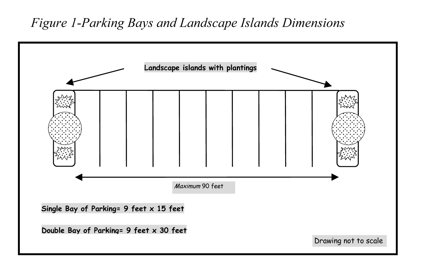
(b)
Protection of landscape areas and location of parking areas and drive aisles. All landscape areas contiguous to parking bays shall be protected from intrusion by vehicles through installation of curbs or bumpers. Parking areas shall not be located within five feet of any building. Driveways shall not be located within five feet of any building except where vehicular access is necessary. The above-mentioned five-foot setback for parking areas and drives shall not be required for vehicle parking areas and drives (including those serving the parking area) located underneath a building or within a parking garage.
(c)
Connections to adjacent parcels. Commercial development designated as community commercial or neighborhood commercial on the Comprehensive Plan shall connect to similarly designated adjoining parcel(s) via a stub-out to the property line(s) with the objective of providing internal vehicular and pedestrian access between neighboring commercial parcels. The planning director may waive the connection requirement upon finding that such connection is found to be impractical or is opposed in writing by the adjacent property owner.
(d)
Geometric standards.
(1)
The design of the parking lot shall meet the minimum geometric standards presented in the following table:
(2)
Other parking angle and aisle dimensions other than those listed in the chart contained in (d) (1) above may be permitted by the planning director or his designee upon finding that they conform to commonly accepted engineer design standards and do not compromise the safety, appearance, or function of the parking area. In no case shall the stall dimensions for angle parking be less than nine feet by 18 feet.
(3)
The minimum aisle dimension of any parking lot designed to accommodate at least 500 vehicles and intended for long-term parking may be reduced by four feet, provided the lot is designed and marked for one-way traffic, the parking spaces form an angle of 80 degrees to 90 degrees with the aisle, each vehicle is individually guided to a parking space by an attendant, and the safety and effective operation of the lot has been clearly demonstrated.
For the purpose of this section, the phrase "long-term parking" shall mean parking the duration of which is on the average six hours or more.
(e)
Surface and drainage of parking areas. Parking areas, driveways and entrances shall be surfaced with gravel, stone, asphalt or concrete and shall be maintained in good repair. Adequate drainage shall be provided in all parking areas for the removal of stormwater and a drainage plan shall be submitted with the site plan and approved by the environmental director.
The use of grass pavers may be permitted in low-traffic areas (i.e. overflow parking for churches, special events, etc.) upon approval from the planning director, where it can be demonstrated that the vegetation will survive the amount of expected traffic.
(f)
Entrances to parking areas from public or private roads. The location, size, and number of entrances from parking areas onto public or private roads shall be shown on the site plan. Upon finding that on-site traffic circulation, offsite traffic flow or public safety would be impaired or improved, the planning commission may require the location, number, and/or size of proposed entrances to be modified, limited, or increased.
(Ord. No. 31A-88, § 20-12, 4-8-85; Ord. No. 31A-89, 9-9-85; Ord. No. 31A-105, 2-22-88; Ord. No. 31A-110, 9-12-88; Ord. No. 31A-112, 2-6-89; Ord. No. 31A-123, 7-2-90; Ord. No. 31A-132, 10-14-91; Ord. No. 31A-151, 5-3-93; Ord. No. 31A-157, 11-21-94; Ord. No. 31A-163, 7-3-95; Ord. No. 31A-199, 7-13-99; Ord. No. 31A-254, 11-22-11)
Sec. 24-58. - Special provisions for bus parking.
If provided, bus parking areas shall be arranged for functional efficiency and convenience and shall be designed to be amenable to surrounding property. Bus parking areas, accessory or otherwise, are exempted from the requirements of section 24-57, but shall comply with the requirements of section 24-55 (a) and with the following:
(a)
Site plan required. Site plans, in accordance with article III of this chapter, shall be submitted for all new off-street parking areas for buses or for any additions to existing off-street parking areas for buses.
(b)
Signs for bus parking only. Parking areas to be used for bus parking shall be used for bus parking only. Signs shall be erected within the parking lot indicating those areas designated for bus parking only.
(c)
Location. No parking area for buses shall be located closer than 30 feet to adjacent residential uses, hotels, motels, hospitals or institutes of human care and occupancy. Upon finding that due to enhanced landscaping, the use of berms, or other site characteristics and/or improvements the bus parking area is sufficiently screened from the uses listed above, the planning director may reduce this buffer/setback requirement to a minimum of 20 feet.
(d)
Dimensions. The design of the bus parking lot shall meet the minimum geometric standards presented in the following table.
The width of aisles within bus parking lots shall be determined by the turning radii necessary to safely maneuver into and out of the parking spaces, however, shall in no case be less than 24 feet wide.
(e)
Entrances to parking areas. The location, size and number of entrances from parking areas onto public or private roads shall be shown on the site plan. Upon finding that on-site traffic circulation, offsite traffic flow or public safety would be impaired or improved, the planning commission may require the location, number, and/or size of proposed entrances to be modified, limited, or increased.
(f)
Surface and drainage of parking areas. Bus parking areas shall be surfaced with gravel, stone, asphalt or concrete and shall be maintained in good repair. Adequate drainage shall be provided for the removal of stormwater and a drainage plan shall be submitted with the site plan and approved by the director of engineering and resource protection.
(g)
Adequate lighting shall be provided in accordance with section 24-57 (c).
(Ord. No. 31A-88, § 20-12, 4-8-85; Ord. No. 31A-89, 9-9-85; Ord. No. 31A-105, 2-22-88; Ord. No. 31A-110, 9-12-88; Ord. No. 31A-112, 2-6-89; Ord. No. 31A-123, 7-2-90; Ord. No. 31A-132, 10-14-91; Ord. No. 31A-151, 5-3-93; Ord. No. 31A-157, 11-21-94; Ord. No. 31A-163, 7-3-95; Ord. No. 31A-199, 7-13-99; Ord. No. 31A-291, 8-13-13)
Sec. 24-59. - Minimum off-street parking requirements.
(a)
Residential uses.
(1)
Minimum number of resident parking spaces. The minimum number of off-street parking spaces required for residential uses is provided in the following table.
Spaces in garages shall be counted towards the required minimum number of parking spaces for each dwelling. The parking space within the garage shall be large enough to provide an adequate parking space for a full size automobile and necessary space for ingress and egress out of the vehicle as determined by the zoning administrator. Building plans shall be submitted that demonstrate the adequacy of the garage(s) for accommodating parking, adequate ingress and egress out of the vehicle, and interior access to the residential unit.
(b)
Commercial uses. Commercial and institutional uses shall be divided into various categories according to the parking demand which they generate, as follows:
Category A—High demand. High parking demand generators shall provide a minimum of one parking space per 200 square feet of retail and/or office floor area but not more than 120 percent of the minimum requirement, to include:
• Convenience stores.
• Dance Halls/Clubs.
• Drug stores.
• Libraries.
• Liquor stores.
• Lodges, civic clubs, fraternal organizations, service clubs, and private clubs.
• Post offices.
• Retail food stores, bakeries and fish markets.
• Truck stops.
Category B—Moderate demand. Moderate parking demand generators shall provide a minimum of one parking space per 250 square feet of retail and/or office floor area but not more than 120 percent of the minimum requirement, to include:
• Arcades.
• All other commercial uses not specified in Category A or C.
• Automobile and trailer sales and service.
• Banks and other financial institutions.
• Billiard parlors and pool rooms.
• Business, governmental and professional offices.
• Laundries and dry cleaners.
• Lumber and building supply.
• Machinery sales and service.
• Photography, artist and sculptor stores and studios.
• Plumbing and electrical supply.
• Retail and service stores, including the following stores: appliances, books, cabinets, cameras, candy, carpet, coin, department, dressmaking, electronics, florist, furniture, furrier, garden supply, gift, greeting cards, handicrafts, hardware, home appliance, health and beauty aids, ice cream, jewelry, locksmith, music, office supply, optical goods, paint, pet, photography, picture framing, plant supply, secretarial services, shoes, sporting goods, stamps, tailor, tobacco and pipes, toys, travel agencies, upholstery, variety, wearing apparel, and yard goods.
• Retail stores, general.
• Tire, transmission, glass, body and fender, and other automotive product sales and service.
Category C—Uses with unique requirements. Category C uses shall provide minimum parking as stated below but not more than 120 percent of the minimum requirement:
(1)
Bowling alleys. Three spaces per alley plus one space for every 200 square feet of accessory business use.
(2)
Barber shops and beauty parlors. At least three spaces plus two spaces for every barber or beautician chair.
(3)
Furniture and carpet stores and/or show rooms. One space for every 400 square feet of retail floor area.
(4)
Hospitals. Two parking spaces for every bed.
(5)
Indoor vehicular sales show rooms. One space for every 400 square feet of retail floor area.
(6)
Medical office/clinic (reference (18) below for Veterinary Hospitals). Seven spaces per practitioner, or one space per 250 square feet, whichever is greater.
(7)
Mini-storage warehouses. One space per 100 units, plus two spaces per on-site caretaker residence.
(8)
Mortuaries and funeral homes. The applicant shall provide a rationale justifying the number of parking spaces provided. The rationale should cite commonly accepted industry standards, provide information on peak parking demands, shared parking opportunities, hours of operation, and other variables which would influence the number of parking spaces provided on-site. The planning director shall review and approve the number of parking spaces provided prior to final site plan approval.
(9)
Motels, hotels, and tourist homes. One space per rental unit plus four parking spaces for every 50 rental units plus one space per five persons to the maximum capacity of each public meeting and/or banquet room. Accessory uses (restaurants, bars, etc.) shall provide the number of parking spaces required for those uses individually.
(10)
Nursing homes. One space for every four residents, plus one parking space for each employee on the largest shift.
(11)
Outdoor retail sales/display areas. At least one space per 500 square feet of area.
(12)
Outlet malls. Five spaces per 1,000 square feet of retail floor area. For the purposes of this provision, an "outlet mall" shall be defined as four or more stores which (1) are physically connected or are otherwise arranged in an integrated manner, (2) share a common parking area, and (3) the majority of the individual stores primarily sell the goods of a single manufacturer or sell returned, discontinued, overstock, and/or similar goods..
(13)
Planned shopping centers, excluding outlet malls, with four or more stores using a common parking lot, shall provide parking spaces according to the following schedule:
Where a theater or other place of public assembly is proposed in conjunction with any shopping center which contains at least 60,000-square feet of retail floor area, the number of parking spaces required for the theater may be reduced by 25 percent of what would have been required under subsection (17) below.
(14)
Recreation facilities. For recreation facilities not listed herein, the applicant shall provide a rationale justifying the number of parking spaces provided. The rationale should cite commonly accepted national park and recreation standards, provide information on peak parking demands, shared parking opportunities, hours of operation, and other variables which would influence the number of parking spaces provided on-site. The planning director shall review and approve the number of parking spaces provided prior to final site plan approval.
(15)
Rental of rooms. Rental of rooms to a maximum of three rooms shall provide off-street parking totaling one more parking space than the total number of rooms to be rented.
(16)
Restaurants. One space for every four seats based upon the maximum seating capacity allowed.
(17)
Places of public assembly including houses of worship and public meeting halls. One parking space per five seats based upon the planned seating capacity. For uses with bench seating, each 24 inches of bench shall be counted as one seat. In calculating the number of seats, all resulting fractions shall be rounded up to the nearest whole number.
(18)
Veterinary hospitals. Three spaces per examination or treatment room, plus one space per employee on the largest shift.
(c)
Industrial uses. Industries, warehouses and wholesale establishments not selling directly to the public shall provide a minimum of one parking space per two employees on the largest shift.
(d)
All other uses—planning director determination. Where the required number of parking spaces is not set forth for a particular use in the preceding subsections, where the applicant is uncertain as to final use or size of the structure or where there is no similar general type of use listed, the planning director shall determine the number of spaces to be provided.
(e)
Shared parking. Shared use of required parking spaces may be permitted where two or more uses on the same or separate sites are able to share the same parking spaces because their parking demands occur at different times. The location of such shared parking area(s) shall also be in compliance with section 24-55 (b). Shared use of required nonresidential parking spaces is allowed if the following documentation is submitted in writing to the planning director as part of the site plan review:
(1)
The names and addresses of the uses and of the owners or tenants that are sharing the parking;
(2)
The location and number of parking spaces that are being shared;
(3)
An analysis showing that the peak parking times of the uses occur at different times and that the parking area will be large enough for the anticipated demands of both uses; and
(4)
A legal instrument such as an easement or deed restriction that guarantees access to the parking for both uses and perpetual maintenance of the shared parking facilities. The rights of use of any such lots and pedestrian walkways shall be provided for by ownership, easement or similar recorded covenant or agreement, approved as to form and content by the county attorney, in order to assure the permanent availability of such parking.
(f)
Mass or alternate transportation plans.
(1)
The minimum number of required parking spaces may be reduced upon the approval of a mass transportation or alternate transportation plan, which details arrangements for the mass or alternate transit of potential visitors to the site, including residents, employees, and customers. The plan shall also demonstrate that facilities exist or will be provided to accommodate the safe loading and unloading of mass transit passengers. A facility which provides a safe and comfortable waiting area for passengers shall also be provided.
Such plans shall be subject to the review and approval of the planning director and transit manager prior to the reduction of the number of required parking spaces.
(2)
Each lot for which the minimum number of parking spaces has been reduced shall show a reserve area sufficient in size to accommodate the number of parking spaces which were not required to be constructed.
(3)
Every approved mass transportation or alternate transportation plan shall be reviewed by the planning director and transit manager every two years. The purpose of the review is to ascertain whether the plan has the effect of significantly reducing the automobile traffic to and from the site, and whether the reduced number of parking spaces is sufficient to accommodate the automobile traffic to the site. The planning director and the transit manager shall make a determination to this effect.
(4)
In the event that the planning director and transit manager determine that an approved mass transportation plan or alternate transportation plan has not had the effect of significantly reducing automobile traffic to a site, and that the reduced number of parking spaces is not sufficient to accommodate the automobile traffic to a site, the owner shall construct the number of parking spaces necessary to meet the minimum required under this ordinance.
(g)
Parking Garages. The maximum parking requirement shall not be applicable for establishments utilizing parking garages.
(h)
Appeals and waivers:
(1)
Appeals. A property owner may appeal for a change of a commercial use from Category A to Category B or a less restrictive requirement; however, the burden of proof shall be upon the applicant to show that the particular activity will not reasonably generate parking demand sufficient to justify the parking requirement of its present classification. Appeals for changes to parking classifications shall be made to the planning director.
(2)
Waivers. A property owner may be granted a waiver by the planning director from the 120 percent maximum parking cap if it can be shown that due to unique circumstances a particular activity would be expected to generate more parking demand than that allowed by the maximum parking cap. The planning director shall make a determination if the requested additional parking is necessary. The applicant shall demonstrate efforts toward utilizing a shared parking agreement or implementing a parking management plan to meet demand. The planning director may place conditions upon the granting of a waiver and may require that the parking area be landscaped in addition to the minimum landscaping requirements. In the event the planning director disapproves plans applicable to this section or recommends conditions or modifications which are unacceptable to the applicant, the applicant may appeal the decision to the development review committee who shall forward a recommendation to the planning commission.
(Ord. No. 31A-88, § 20-12, 4-8-85; Ord. No. 31A-89, 9-9-85; Ord. No. 31A-105, 2-22-88; Ord. No. 31A-110, 9-12-88; Ord. No. 31A-112, 2-6-89; Ord. No. 31A-123, 7-2-90; Ord. No. 31A-132, 10-14-91; Ord. No. 31A-151, 5-3-93; Ord. No. 31A-157, 11-21-94; Ord. No. 31A-163, 7-3-95; Ord. No. 31A-199, 7-13-99; Ord. No. 31A-238, 5-12-09; Ord. No. 31A-254, 11-22-11)
Sec. 24-60. - Bicycle parking facilities.
Bicycle parking facilities shall be provided for all retail and office development 20,000 square feet in floor area and above. The facilities shall be permanently affixed to the ground and shall be provided in accordance with the following schedule:
(Ord. No. 31A-199, 7-13-99)
Sec. 24-61. - Off-street loading requirements.
On the same premises with every building, structure or part thereof erected and occupied for manufacturing, storage, warehouse, goods display, department store, wholesale store, market, hotel, hospital, mortuary, laundry, dry cleaning or other uses similarly involving the receipt or distribution of vehicles, materials or merchandise, there shall be provided and maintained on the lot adequate space for standing, turning, loading and unloading services. In no case shall the required off-street loading space be part of the area used to satisfy the off-street parking requirement, nor shall the space for loading and unloading of vehicles be so located that a vehicle using such loading space projects into any public or private street or alley or driving aisle required for circulation within a parking lot.
Such loading and unloading space shall:
(1)
Be an area ten feet by 50 feet, with 15-foot height clearance; and
(2)
Be provided according to the following schedule:
For the above uses, with gross floor areas of 2,000 to 5,000 square feet, one loading and unloading space measuring ten feet by 30 feet, with 15-foot height clearance, shall be provided.
(Ord. No. 31A-88, § 20-12.1, 4-8-85; Ord. No. 31A-199, 7-13-99)
Sec. 24-62. - Special provisions for private streets.
(a)
Approval process.
(1)
Generally. Private streets may be permitted for the uses listed in Table 1 below upon approval of the board of supervisors unless otherwise specified and shall be coordinated with existing or planned streets of approved master plans and the Comprehensive Plan. Such approval shall be requested in writing.
Table 1: Zoning districts and uses where private streets may be permitted
✓ : permitted with board approval X: not permitted B: By-right
(2)
Qualifying Industrial Parks
a.
A "qualifying industrial park" shall be defined as an industrial and/or business park that has an actual or planned size of at least 1,000,000 square feet. The "Qualifying Industrial Park Square Footage Adjustments" shall be applied, to determine the qualifying industrial park square footage in order to determine whether the qualifying threshold can or would be reached. Qualifying square footage is computed by multiplying the existing or planned total square footage by the square footage credit listed in the following chart.
The planned development adjustments listed above shall be applied to undeveloped property zoned Mixed-Use, MU; Limited Business/Industrial District, M-1; General Industrial District, M-2; Research and Technology District, RT; and Planned Unit Development, PUD and allows nonindustrial/office and/or nonwarehouse activity to occur based on master plan projections which have been approved by the board of supervisors. For undeveloped property not subject to a binding master plan the square footage shall be determined by multiplying 0.75 by 25 percent of the net-developable area of the project.
If an industrial/office/warehouse development is proffered exclusively, the existing development adjustments listed above may be applied upon examination of the proffers.
b.
Requests for board approval of private streets in qualifying industrial parks shall include a traffic impact analysis and square footage estimates for the proposed industrial park. The traffic impact analysis shall be in conformance with the submittal requirements of section 24-23. Additionally, the traffic impact analysis shall address internal circulation and capacity.
(3)
Guarantees. The construction of streets whether public or private shall be guaranteed by surety, in an amount and in a form approved by the county attorney.
(4)
To the extent streets are private rather than public, the applicant shall also submit assurances satisfactory to the county attorney that a property owner's community association or similar organization has been legally established under which the lots within the area of the final development plan will be assessed for the cost of maintaining private streets and that such assessments shall constitute a pro rata lien upon the individual lots shown on the development plan.
(b)
Minimum Standards:
(1)
Private streets shown on the development plan shall meet the construction and geometric requirements of the Virginia Department of Transportation and the Administrative Guidelines for Certifications of Private Street Construction, except as specified in paragraph (2) below.
(2)
If the uniqueness of a proposal requires that the specifications for the width, surfacing, construction and geometric design of streets, alleys, ways for public utilities, with associated drainage and specifications for curbs and gutters be subject to modification from the specifications established in chapter 19, the director of community development or his designee, within the limits hereinafter specified, may waive or modify the specifications otherwise applicable for a particular private road (or road network) if the specifications are not required in the interests of the residents, occupants, workers, customers of businesses and property owners of the development and that the modifications of such specifications are not inconsistent with the interests of the entire county.
It shall be the responsibility of the applicant to demonstrate to the satisfaction of the director of community development or his designee with respect to any requested waiver or modification that:
a.
The waiver or modification shall result in design and construction that is in accordance with accepted engineering standards;
b.
The waiver or modification is reasonable because of the uniqueness of the development or because of the development within which the nature and excellence of design and construction will be coordinated, preplanned and controlled;
c.
Any waiver or modification pertaining to streets is reasonable with respect to the generation of vehicular traffic that is estimated to occur within the area of the development;
d.
Traffic lanes of streets are sufficiently wide enough to carry the anticipated volume and speed of traffic and in no case be less than ten feet wide; and
e.
Waivers or modifications as to base and surface construction of streets and as to the condition of ditches or drainage ways be based upon the soil tests for California Bearing Ratio value and erosion characteristics of the particular subgrade support soils in the area.
The applicant may appeal the decision of the director of community development or his designee to the development review committee (DRC).
(Ord. No. 31A-150, 4-5-93; Ord. No. 31A-199, 7-13-99; Ord. No. 31A-255, 11-22-11; Ord. No. 31A-283, 12-11-12; Ord. No. 31A-306, 10-11-16)
Sec. 24-63. - Special provisions for electric vehicle charging stations.
Electric vehicle charging stations of any level shall be permitted as an accessory use to off-street parking in all zoning districts. The stations shall comply with the following:
(1)
Parking spaces designated for electric vehicle charging stations may be used in the calculation for meeting minimum parking requirements.
(2)
At least one space designated for an electric vehicle charging station per parking lot shall be ADA-accessible, but it shall not be designated as exclusively for use by persons with disabilities.
(3)
All electric vehicle charging stations shall be screened from outside of the parking lot with landscaping, fencing or berms. The screening requirements may be achieved through the landscape regulations in section 24-99 for parking lot landscaping. Electric vehicle charging stations that are proposed to be retrofitted to existing parking lots may require additional landscaping to achieve the screening required as determined by the director of planning.
(4)
All electric vehicle charging stations shall have adequate lighting in accordance with division 7 if they are to operate at night. Required lighting for parking lots that operate at night may be used to achieve this purpose: however, when electric vehicle charging stations are retrofitted into existing parking lots additional lighting may be required as determined by the planning director.
(Ord. No. 31A-305, 10-11-16)
Sec. 24-65. - Statement of intent.
These regulations attempt to achieve the proper balance among the commercial needs of businesses, the needs of customers, and the needs of motorists, visitors, residents and other persons moving through the public spaces of the county to be able to identify destinations and locations. These regulations also attempt to achieve the proper balance of the rights of persons to exercise their first amendment rights and the need to protect the appearance of the county as an important factor in its economic well-being, as aesthetic and other quality of life considerations influence economic value.
Therefore, the intent of this article is to:
• Promote and protect the public health, safety, and welfare of the community;
• Establish limitations on signs to ensure that they are appropriate to the neighborhood, building, or use to which they are appurtenant and are adequate, but not excessive, for their intended purpose as a means of communication without adverse impact on the visual character of the area;
• Reduce the distractions, obstructions, and hazards to pedestrian and automobile traffic caused by the excessive number, excessive size or height, inappropriate means of illumination or movement, indiscriminate placement, overconcentration, or unsafe construction of signs;
• Avoid visual clutter that is harmful to traffic and pedestrian safety, property values, and community appearance;
• Protect the historic and natural character of the community and enhance the physical appearance of all areas of the county;
• Improve pedestrian and traffic safety; and
• Enable the fair and consistent enforcement of these sign regulations.
(Ord. No. 31A-333, 1-10-17)
Sec. 24-66. - Applicability.
The regulations of this division shall govern and control the location, erection, enlargement, expansion, alteration, operation, maintenance, relocation, and removal of any sign within the county. These regulations shall also govern the removal of signs determined to be physically unsafe or which create a safety hazard to the public. These regulations dictate the display, location, and physical characteristics of signs subject to the procedures of this division. The regulations of this division shall be in addition to any applicable provisions of the Outdoor Advertising in Sight of Public Highways Act, Title 33.2, Chapter 12 of the Code of Virginia, 1950, as amended (§§33.2-1200 et. seq), and the Uniform Statewide Building Code applicable to the construction and maintenance of signs. The regulations of this division do not apply to property owned by the Commonwealth of Virginia or any governmental body created by the Commonwealth, or by the United States.
(Ord. No. 31A-333, 1-10-17)
Sec. 24-67. - Definitions.
For the purpose of this article, the following words and phrases shall have the meanings respectively ascribed to them by this section:
A-Frame sign. A sign consisting of two sign faces placed together at an angle of 90 degrees or less to form an "A" shape structure which tapers from a wide base to a narrow top. This sign design is also known as a sandwich board sign.
Back-lit or channeled lettered sign. Any sign in which only the letters, characters, or figures are internally lighted. The background of the sign shall be opaque and shall not be internally illuminated.
Blade sign. A two-sided flat sign that projects more than 18 inches from, and that is mounted perpendicularly to, a vertical building wall. Such sign may be suspended from an arm or bracket, or may be directly mounted to a building wall or the underside of a canopy or awning.
Building face sign. Any sign attached to and erected parallel to, or painted on, the face of the outside wall of a building and supported throughout its length by such wall or building and not extending more than 18 inches from the building wall.
Community character areas or corridors (signage within). Any sign which is visible from and located within 150 feet of the existing or proposed rights-of-way of primary and secondary roads within a community character area or corridor, respectively, as identified on the James City County Comprehensive Plan Land Use Map.
Double-faced sign. A sign with two parallel or nearly parallel faces, back-to-back, and located not more than 24 inches from each other.
Electronic display sign. A sign containing light emitting diodes (LEDs), fiber optics, light bulbs, plasma display screens or other illumination devices, or a series of vertical or horizontal slats or cylinders that are capable of being rotated at intervals, that are used to change the messages, intensity of light or colors displayed by such sign.
Flashing sign. An illuminated sign on which the artificial or reflected light is not maintained stationary or constant in intensity and/or color at all times when in use, and whose intermittent or sequential lights are used primarily to attract attention. Also included is any sign with either flashing, running, or laser-generated lights or with lights that flash, blink, pulse, strobe, scroll, or create an illusion of movement or that have a conspicuous and intermittent variation in illumination, appearance, color, or pattern. Any sign which revolves or moves, whether illuminated or not, shall be considered a flashing sign.
Freestanding sign. A sign not attached to or painted on a building, but which is affixed to the ground. A sign attached to a flat surface such as a fence or wall, not a part of a building, shall be considered a freestanding sign.
Good repair, in. In good condition and not damaged.
Gross sign area. That area within a line including the outer extremities of all letters, figures, characters and delineations, or within a line including the outer extremities of the framework or background of the sign, whichever line includes the larger area. The support for the sign background, whether it be columns, a pylon, or a building or part thereof, shall not be included in a sign area. Only one side of a double-faced sign shall be included in a computation of sign area. The area of signs with more than two faces shall be computed by multiplying one-half the circumference of the footprint of the sign by the height of the sign. The area of a cylindrical sign shall be computed by multiplying one-half of the circumference by the height of the sign.
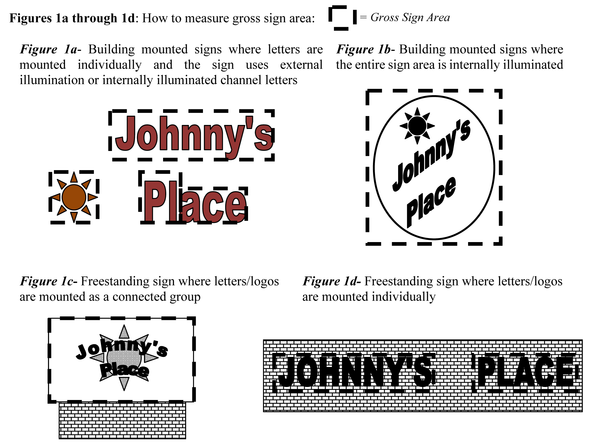
Ground sign. A freestanding sign, other than a monument or pole sign, placed upon or supported by the ground independently of any other structure.
Illuminated sign. Any sign designed to give forth artificial light or designed to reflect light from one or more sources of artificial light erected for the purpose of providing light for the sign.
Indirectly illuminated sign. A sign which does not produce artificial light from within itself, but which is opaque and backlighted or illuminated by spotlights or floodlights not a part of or attached to the sign itself.
Internally illuminated sign. A sign of translucent or transparent material with the source of illumination, exposed or shielded, enclosed within the face or supporting structure of the sign. This term shall not apply to a sign in which only the letters, characters, or figures are internally lighted and the background of the sign is opaque.
Marquee sign. Any sign attached to or hung from a marquee. For the purpose of this article, a "marquee" is a covered structure projecting from and supported by a building with independent roof and drainage provisions and which is erected over a doorway or doorways as protection against the weather.
Off-premises sign. A sign that directs attention to a business, product, service, entertainment, or attraction sold, offered, created, furnished, or conducted at a location other than the premises on which the sign is erected.
Projecting sign. A sign that is attached to and projects more than 18 inches from the face of a wall of a building. The term "projecting sign" includes a marquee sign.
Shopping center. A group of four or more commercial establishments having a minimum combined total square footage of 25,000 square feet, planned, constructed, and/or managed as a single entity, with customer and employee parking provided onsite, provision for goods delivery separated from customer access, aesthetic considerations and protection from the elements, and landscaping and signage in accordance with an approved plan.
Sign. Any structure, display, device, or other object or thing, or part thereof, visible from any public street or right-of-way, any area open to use by the general public, or any navigable body of water, including, but not limited to, any word, letter, series of words or letters, designs, symbols, fixtures, colors, illumination, painting, mural, logo, insignia, emblem, service mark, or other graphic or pictorial representation, that: (i) identifies or advertises, or directs or attracts attention to, any institution, organization, business, product, merchandise, service, event, business, or establishment; or (ii) suggests the identity or nature of any business or establishment; or (iii) invites or proposes a commercial transaction; or (iv) communicates a message of a noncommercial nature. For clarification, examples of items which typically do not satisfy the necessary elements of this definition and would not be considered signs include, but are not limited to, architectural elements incorporated into the style or function of a building, numerals signifying a property address, notifications of a "private residence," nonilluminated postings less than four square feet in size on private property in areas zoned agricultural, corner stones (or foundation stones) and flags of any nation, state, or municipality.
Store-within-a-store. Within retail structures which have an individual footprint in excess of 40,000 square feet in size, an area where the retailer rents a part of the retail space to be used by a different company to run another, independent store or where the retailer uses a part of the retail space to operate distinct departments.
Symbol. A thing that represents or stands for something else, especially a material object representing something abstract.
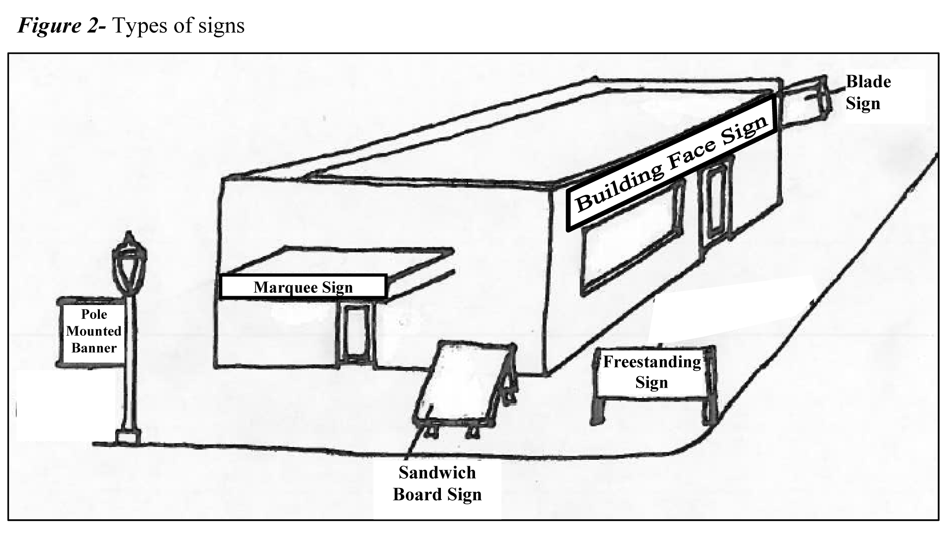
(Ord. No. 31A-333, 1-10-17)
Sec. 24-68. - Permits.
The following regulations apply generally to all signs and are in addition to the regulations contained elsewhere in this chapter:
(1)
Required application; inspection of signs. No sign, unless herein exempted, shall be erected, constructed, structurally altered, or relocated, except as provided in this article and in these regulations, until a permit has been issued by the administrator or the administrator's designee. Before any permit is issued, an application provided by the administrator or the administrator's designee shall be filed together with two sets of drawings and specifications, one to be returned to the applicant, as such may be necessary to advise and acquaint the administrator or the administrator's designee fully with the location in relation to adjacent buildings, construction, materials, manner of illuminating or securing or fastening, and number of signs applied for.
(2)
Electrical permit. All signs which require electricity or are electrically illuminated shall require a separate electrical permit and an inspection.
(3)
Permit time limit. All signs shall be erected on or before the expiration of six months from the date of issuance of the permit, otherwise the permit shall become null and void and a new permit shall be required.
(4)
Permit number. Each sign requiring a permit shall be clearly marked with the permit number and the name of the person or firm placing the sign on the premises.
(5)
Fees required. For all sign permits, fees shall be required in accordance with section 24-7 of this chapter.
(Ord. No. 31A-333, 1-10-17)
Sec. 24-69. - Freestanding signs on residentially zoned property.
On property that is zoned R1, R2, R3, R4, R5, R6, R8, A-1, MU, or PUD-R, no sign intended to be read from any public right-of-way adjoining the district shall be permitted except for:
(a)
One sign for each principal entrance shall be permitted if in compliance with the following regulations:
(1)
Such sign shall not exceed 32 square feet in area.
(2)
If freestanding, such sign shall not exceed a height of 15 feet above natural grade.
(3)
If illuminated and ground-mounted, the sign shall be illuminated by ground-mounted horizontal light bars/strips or ground-mounted spotlights. The ground-mounted lights shall be concealed by landscaping. In no case shall the lamps or bulbs from any type of lighting be visible nor shall glare be cast upon any adjacent property, or public or private right-of-way.
(4)
If the sign is located at the corner of two rights-of-way, the sign may be placed no closer than ten feet to the corner property lines.
(5)
Such sign shall be bound by all other provisions of this section.
(6)
For properties zoned A-1 or MU, signs shall be permitted under section 24-69 or 24-70, but not both.
(b)
Two signs for each principal entrance shall be permitted if in compliance with the following regulations:
(1)
The signs shall be placed on each side of the principal entrance.
(2)
The cumulative size of the signs at each principal entrance may not exceed 32 square feet in area.
(3)
Each sign shall not exceed a height of eight feet above natural grade.
(4)
If illuminated and ground-mounted, the sign shall be illuminated by ground-mounted horizontal light bars/strips or ground-mounted spotlights. The ground-mounted lights shall be concealed by landscaping. In no case shall the lamps or bulbs from any type of lighting be visible nor shall glare be cast upon any adjacent property, or public or private right-of-way.
(5)
If the signs are located at the corner of two rights-of-way, the signs may be placed no closer than ten feet to the corner property lines.
(6)
Such sign shall be bound by all other provisions of this section.
(7)
For properties zoned A-1 or MU, signs shall be permitted under section 24-69 or 24-70, but not both.
(c)
Special requirements for signs located within community character areas or along community character corridors.
The planning director shall review and approve signs, supporting structures, and entrance features to be placed within a community character area or along roads designated as community character corridors as identified by the James City County Comprehensive Plan. An applicant may appeal the decision of the planning director to the development review committee (DRC). The appeal shall be in writing and shall document the reasons and justifications for such request. The DRC shall approve, deny, or conditionally approve the applicant's request based on the review criteria outlined in this section.
Plans indicating the location of the sign(s), supporting structure(s), location and type of landscaping, and entrance features relative to surrounding streets, lots, and other features of the residentially zoned property shall be provided to the administrator or the administrator's designee along with the application and drawings as specified in section 24-68.
In reviewing the plans for signs, supporting structures, and entrance features, the following criteria shall be considered in deciding whether to approve the sign application:
(1)
Scale. The scale of the sign(s), supporting structure(s), and entrance features shall be consistent with, and complement, the adjacent properties and the road(s) on which the residentially zoned property is located.
(2)
Materials, colors, and construction. The materials, colors, and construction of the sign(s), supporting structure(s), and entrance features shall complement the character of the road on which the residentially zoned property is located and shall not detract from the aesthetics of adjacent properties.
(3)
Landscaping. An appropriate mix of deciduous and evergreen trees and/or shrubs shall be provided that enhance the appearance of the sign(s), supporting structure(s), and associated entrance features.
(4)
Safety. The sign(s) and entrance features shall be located in such a manner that they do not impair the safety of motorists, pedestrians, or bicyclists.
(Ord. No. 31A-333, 1-10-17)
Sec. 24-70. - Freestanding signs on non-residentially zoned properties.
On property that is zoned A-1, LB, B1, RT, MU, EO, PUD-C, M1, or M2, freestanding signs shall only be permitted on properties having street frontage and shall be in compliance with the following regulations:
(a)
One freestanding sign on each street frontage shall be permitted if in compliance with the following regulations:
(1)
Such sign shall only be permitted on properties having street frontage.
(2)
Sign location and setbacks. Such signs may only be placed on the property within the required sign setbacks. Sign setbacks shall be located at least five feet from any property line.
(3)
Sign area. Such signs shall not exceed:
a.
Thirty two square feet per face if located less than 75 feet from the road right-of-way;
b.
Fifty square feet per face if located 75 to 150 feet from the road right-of-way; or
c.
Sixty square feet per face if located more than 150 feet from the road right-of-way.
(4)
Sign height. Such signs shall not exceed an overall height of 15 feet above natural grade.
(5)
For properties zoned A-1 or MU, signs shall be permitted under section 24-69 or 24-70, but not both.
(b)
Two freestanding monument-style identification signs on each street frontage shall be permitted if in compliance with the following regulations:
(1)
Such sign shall only be permitted on properties having street frontage.
(2)
Sign location and setbacks. Such signs shall be placed on each side of the principal entrance. Such signs may only be placed on the property within the required sign setbacks. Sign setbacks shall be located at least five feet from any property line. If the signs are located at the corner of two rights-of-way, the signs may be placed no closer than ten feet to the corner property lines.
(3)
Sign area. The cumulative size of the signs at each entrance shall not exceed 32 square feet in area.
(4)
Sign height. Each sign shall not exceed an overall height of eight feet above natural grade.
(5)
For properties zoned A-1 or MU, signs shall be permitted under section 24-69 or 24-70, but not both.
Figure 3—Two freestanding signs placed at a principal entrance
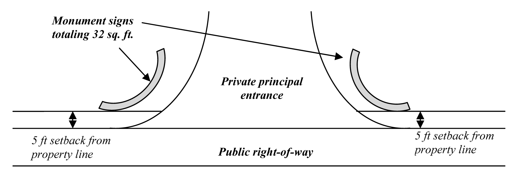
(c)
Sign lighting.
(1)
Internally illuminated signs shall be prohibited when such signs are visible from and located within 150 feet of the existing or proposed corridor or area as identified on the James City County Comprehensive Plan Land Use Map.
(2)
Illuminated signs within community character areas and along community character corridors, as defined, are permitted as long as they comply with the following:
a.
A back-lit or channeled lettered sign as approved by the planning director in accordance with the criteria outlined in section 24-72. An applicant may appeal the decision of the planning director to the DRC. The appeal shall be in writing and shall document the reasons and justifications for such request. The DRC shall approve, deny, or conditionally approve the applicant's exception request based on the review criteria outlined in section 24-72; or
b.
Externally illuminated by either sign-mounted lighting or ground-mounted horizontal light bars, light strips, or spotlights, which shall be concealed by landscaping. With either ground-mounted or sign-mounted lighting, the bulbs, lenses, and globes shall not be visible from the right-of-way, and light shall not be directed in such a way as to cause glare for passing motorists or pedestrians.
c.
Sign lighting shall cast no glare upon any adjacent property or public or private right-of-way.
(3)
In either case of (a) or (b), above, signs shall cast no glare upon any adjacent property or public or private right-of-way.
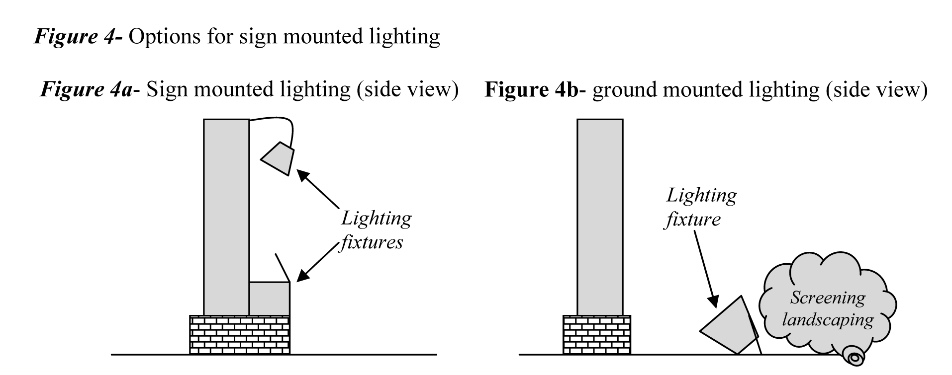
(d)
Signs for individual stores, businesses or professions on the same property. Individual stores, businesses or professions on the same property, exclusive of shopping centers, shall combine signs on a single standard and the square footage of the combined signs shall not exceed 32 square feet per face.
(e)
Shopping center signs. Shopping centers shall be permitted up to two freestanding signs per major street frontage as permitted above in (a) and (b). Individual shops and businesses in shopping centers may have building face signs as provided for in section 24-71 or specially designed signs consistent with the overall development plan for the shopping center and approved as a part thereof by the planning commission.
(f)
Alternative shopping center sign. In lieu of (e) above, shopping centers may be permitted one maximum 42 square foot freestanding sign per primary entrance if in compliance with the following regulations:
(1)
The shopping center is located in a mixed-use zoning district and on property designated as mixed use on the James City County Comprehensive Plan;
(2)
The property is regulated by a design review board with approved architectural and design standards;
(3)
The property is subject to a master plan of development approved by the board of supervisors; and
(4)
The signs are consistent with the overall development plan and approved by the planning director or the director's designee as part of a comprehensive signage plan for the entire shopping center.
(5)
Sign location and setbacks. Such signs may only be placed on the property within required sign setbacks. Sign setbacks shall be located at least five feet from any property line.
(6)
Sign height. Such signs shall not exceed an overall height of 15 feet above natural grade.
(Ord. No. 31A-333, 1-10-17)
Sec. 24-71. - Building face signs.
In zones where business or manufacturing is permitted, a building face sign shall also be permitted. The signs shall be in compliance with the following regulations:
(a)
Sign location and area. The building face sign(s) shall be placed on the front façade of the building, except in cases outlined below in subsections (d) and (g). The area devoted to such signs shall not exceed one square foot of sign area for each linear foot of the building's or unit's front façade or 60 square feet, whichever is smaller. The front façade of the building shall be considered the side that has the main public entrance.
If the footprint of a building for an individual use exceeds 40,000 square feet on property zoned M-1, M-2, PUD-C, or RT, the applicant may request an exception from the planning director to allow the building face sign(s) to exceed 60 square feet. An applicant may appeal the decision of the planning director to the DRC. The appeal shall be in writing and shall document the reasons and justifications for such request. The DRC shall approve, deny, or conditionally approve the applicant's exception request based on the review criteria outlined in this section. In addition to the submittal requirements outlined in section 24- 68, the applicant shall provide scale drawings of the building elevation(s) and proposed sign(s). A conceptual plan shall also be submitted which shows the location of the sign relative to the existing and proposed landscaping, sight lines, distances from rights-of-way, and other pertinent site features.
In reviewing an exception request, the following criteria shall be considered in deciding whether to approve the request.
(1)
Scale and proportion. The size and scale of the sign and proportion of lettering, characters, and figures shall complement the design, scale, size, and materials of the building as well as the distance of the building from adjacent public rights-of-way. The scale of the sign in proportion to the building should be balanced so that the sign is not the dominant visual feature of the structure, with additional size aimed primarily at making the use identifiable from an adjoining public road. In no case shall the size of the sign exceed ten percent of the building's wall surface upon which the sign is placed.
(2)
Materials, lighting, colors, and construction. The materials, lighting, and colors of the sign shall not negatively impact adjacent properties or adjacent public roads.
(3)
No exceptions will be granted for signs located within 150 feet of the road right-of-way of roads designated as community character corridors.
(b)
Sign mounting. Such signs shall be mounted flat against the building on the side measured above.
(c)
Sign lighting.
(1)
Internally illuminated signs shall be prohibited when such signs are visible from and located within 150 feet of the existing or proposed rights-of-way of primary and secondary roads within a community character corridor or area as identified on the James City County Comprehensive Plan Land Use Map.
(2)
Illuminated signs within community character areas and along community character corridors, as defined, shall be composed of:
a.
Back-lit or channeled lettered sign as approved by the planning director in accordance with the criteria outlined in section 24-72. An applicant may appeal the decision of the planning director to the DRC. The appeal shall be in writing and shall document the reasons and justifications for such request. The DRC shall approve, deny, or conditionally approve the applicant's exception request based on the review criteria outlined in section 24-72; or
b.
Externally illuminated in such a way that bulbs, lenses, or globes shall not be visible from the right-of-way.
(3)
Signs shall cast no glare upon any adjacent property or public or private right-of-way.
(d)
Additional signs for buildings facing onto public rights-of-way or parking lots. When the same building faces onto a public right-of-way or parking lot on the rear or side of the building, an additional sign may be erected at the public entrance on that side. The area devoted to such sign(s) shall not exceed one square foot of sign area for each linear foot of the building's side upon which the sign is placed or 60 square feet, whichever is smaller. Such sign must be mounted flat against the building.
(e)
Additional signs for buildings in excess of 40,000 square feet. If the footprint of an individual store exceeds 40,000 square feet in size and contains a store within a store (e.g., bakery, restaurant, pharmacy, etc.), up to four additional building face signs , in addition to the main sign, may be permitted. The size of these individual sign(s) shall not exceed one square foot of sign area for each linear foot of the retail department's interior façade or 75 percent of the size of the main building face sign, whichever is smaller.
(f)
Exterior signs for stores within an enclosed shopping mall. If there are individual stores located within an enclosed shopping mall and the stores are not directly accessible from the outside, each of the interior stores shall be allowed to display one exterior wall sign in accordance with the following regulations:
(1)
The area devoted to such signs shall not exceed one square foot of sign area for each linear foot of the unit's front façade or 60 square feet, whichever is smaller.
(2)
The sign shall be mounted flat against the building at one of the mall's public entrances.
(g)
A building face sign, which is typically placed above the building's main public entrance, may be located on the side of the building that faces the public road right-of-way or parking lot. This provision applies only if the side of the building facing the public road right-of-way or parking lot has no public entrance. No additional building face signs beyond the maximum number permitted by section 24-71 is permitted. The area devoted to such sign(s) shall not exceed one square foot of sign area for each linear foot of the building's side upon which the sign is placed or 60 square feet, whichever is smaller. Such sign must be mounted flat against the building.
(Ord. No. 31A-333, 1-10-17)
Sec. 24-72. - Review criteria for back-lit or channeled lettered signs within community character areas and along community character corridors.
In reviewing applications for signs containing back-lit or channeled lettered signs within community character areas and along community character corridors, the following criteria shall be used by the director of planning in deciding whether to approve the application.
(a)
Scale and proportion. As determined by the director of planning, the scale of the sign and proportion of lettering, characters, and figures shall be of a scale, size, and character in keeping with the historic and/or rural ambience of the county and Williamsburg.
(b)
Materials, colors, and construction. As determined by the director of planning, the materials, colors, and construction shall complement the character of surrounding development and shall be in keeping with the historic and/or rural ambience of the county and Williamsburg.
(c)
Intensity and quantity of lighting. As determined by the director of planning, the area of the sign that is lit shall be less than the overall size of the sign. The lighting used shall be of a subdued nature and shall not dominate the streetscape.
(Ord. No. 31A-333, 1-10-17)
Sec. 24-73. - Special regulations for certain signs.
(a)
Logos, trademarks, murals, etc. Any symbol painted on any face of the building shall be treated as a building face sign.
(b)
Flags as signs. Flags used as signs shall be allowed by permit, provided that the same are installed in a permanent fashion, are maintained in good repair, and will not constitute a hazard to vehicular or pedestrian traffic.
(c)
Signs on entrance marquees or canopies. Signs on entrance marquees or canopies shall be allowed, provided that the total area of such signs if constructed alone or in combination with other building signs does not exceed the maximum allowable dimensions and square footage as set forth in section 24-71 (a) above.
(d)
Signs on corner lots. Except for those provided for under section 24-69 and 24-70, signs on corner lots shall not be closer than 50 feet to the corner of the lot. In cases where the applicant can demonstrate that the location of a sign does not obstruct adequate sight distance and good visibility is maintained for all motorists and pedestrians traveling the intersection, the administrator or the administrator's designee may permit setbacks of less than 50 feet.
(e)
Freestanding signs on properties adjacent to and visible from residential districts. On properties adjacent to residential districts, any freestanding sign, visible from an adjacent residential district, shall be limited to 32 square feet in area. The top of the freestanding sign shall not exceed 15 feet above grade. If illuminated, freestanding signs within these areas shall be signs composed of:
(1)
Back-lit or lighted channeled letters; or
(2)
Shall be externally illuminated by ground-mounted horizontal light bars/strips or ground-mounted spotlights in such a way that bulbs, lenses, or globes shall not be visible from the right-of-way. The ground-mounted lights shall be concealed by landscaping.
(f)
Additional signs during construction. Temporary nonilluminated signs may be erected and displayed on the premises during such time as the actual construction work is in progress. The signs shall conform with the following criteria:
(1)
The maximum number and size of signs shall be:
a.
A maximum of three signs with a cumulative sign area not to exceed 24 square feet; or,
b.
A maximum of one sign with a sign area not to exceed 32 square feet.
(2)
The sign(s) shall only be placed along one of the property's street frontages.
(g)
Setback reductions in mixed-use districts. In cases where the applicant can demonstrate that the location of a sign does not obstruct adequate sight distance, and good visibility is maintained for all motorists and pedestrians traveling the intersection, the administrator or the administrator's designee may permit setbacks of less than five feet on any lot in a mixed-use district.
(h)
Blade signs in mixed-use districts. Blade signs are permitted in mixed-use districts, as long as the project is regulated by a design review board, governed by specific architectural and design standards, and subject to an approved master plan of development, all of which shall be approved by the board of supervisors. Blade signs must adhere to the following limitations and requirements:
(1)
There shall be no more than one sign per public entrance to any given building;
(2)
The sign(s) shall be positioned at the public entrance(s) of the building;
(3)
An individual blade sign shall be no more than 12 square feet in area;
(4)
The sign shall be mounted such that the bottom edge of the sign is not less than eight feet from the finished grade directly underneath it;
(5)
Blade signs shall be unlit, or externally illuminated in such a way that bulbs, lenses, and globes shall not be visible from the right-of-way, and light shall not be directed in such a way as to cause glare for passing motorists or pedestrians;
(6)
Blade signs that extend over a public right-of-way are subject to the prior approval of the controlling public entity;
(7)
All blade signs shall obtain the prior approval of the design review board for the mixed-use project before they are installed.
(i)
Pedestrian-scale signs in mixed-use districts. Small, free-standing signs internal to the development may be placed in mixed-use districts, as long as the project is regulated by a design review board, governed by specific architectural and design standards, and subject to an approved master plan of development, all of which shall be approved by the board of supervisors. Pedestrian-scale signs must adhere to the following limitations and requirements:
(1)
Such individual signs shall be no more than 24 square feet in total area, and may not have more than two faces. Only one side of a double-faced sign shall be included in a computation of sign area;
(2)
The top edge of a pedestrian-scale directional sign shall be no more than seven feet above finished grade;
(3)
Any lighting that is used shall be externally mounted and either supported solely from the sign structure, or ground-mounted. The ground-mounted lights shall be concealed by landscaping. Lighting shall be directed only onto the sign's face. Bulbs, lenses, and globes shall not be visible from the right-of-way, and light shall not be directed in such a way as to cause glare for passing motorists or pedestrians;
(4)
The number, relative positioning, and placement of each sign in a given mixed-use development shall be subject to the prior approval of the design review board and the planning director, or the director's designee.
(j)
Pole-mounted banners. Banners that are affixed to light poles and that do not exceed 24 square feet each, are permitted. Banners shall be mounted such that the bottom edge of any given banner is not less than eight feet from the finished grade directly beneath it. Banners are permitted only in shopping centers (as defined in section 24-67) or in mixed-use districts.
(k)
A-Frame signs. A-Frame signs may be permitted in areas designated for commercial use located in mixed-use districts, as long as the project is regulated by a design review board, governed by specific architectural and design standards, and subject to an approved master plan of development, all of which shall have been approved by the board of supervisors. Alternatively, such signs may be located in other areas where there exists approved design guidelines adopted by the board of supervisors when such signs comply with said guidelines.
A-Frame signs must adhere to the following requirements:
(1)
One A-Frame sign on the premises shall be permitted at each public entrance of a business location.
(2)
Such sign(s) shall not exceed 12 square feet in area and five feet in height.
(3)
Sign(s) shall be located on premises or no more than ten feet from the seating area or access door and shall not block the flow of pedestrian traffic.
(4)
Any such sign shall be removed at close of business each day.
A-Frame signs may also be permitted pursuant to section 24-49.
(Ord. No. 31A-333, 1-10-17)
Sec. 24-74. - Exemptions.
The following signs are exempted from the provisions of these regulations and may be erected or constructed without a permit but shall be erected or constructed in accordance with the structural and safety requirements of the building code:
(1)
Signs located on public rights-of-way that are erected and maintained by a governmental entity.
(2)
Signs posted by or required to be posted by a governmental entity in compliance with a provision of federal, state, or local law located on a premises where an activity that necessitates the posting of such signage is or may be occurring.
(3)
Changing of the copy on a bulletin board, poster board, display encasement, reader board or billboard.
(4)
Temporary residential signs. On real property where a dwelling unit is being offered for sale or lease, one temporary on-premises nonilluminated sign for each street frontage is permitted, not more than six square feet in area.
(5)
Temporary non-residential signs. On real property where a non-residential structure or unit is being offered for sale or lease, one temporary on-premises nonilluminated sign is permitted, not more than six square feet, and provided such sign conforms to the following regulations:
a.
One sign is permitted for each street frontage per parcel.
b.
The maximum height of the sign shall not exceed eight feet.
c.
The sign shall be erected in such a manner that it does not obstruct views of existing signs and/or create a safety hazard.
(6)
Temporary nonilluminated signs, not more than ten square feet in area, on parcels for which a building permit has been issued for a new single-family residential dwelling unit and for such time as the building permit is valid, one such sign for each parcel.
(7)
Sign on a truck, bus, or other vehicle, while in use in a normal course of business. This section should not be interpreted to permit parking for display purposes of a vehicle (to which signs are attached) in designated customer or employee parking at the place of business.
(8)
On real property where a dwelling unit exists and for which there is an approved and valid home occupation permit, one on-premises nonilluminated sign is permitted, provided the sign is attached to the dwelling and does not exceed four square feet.
(9)
Signs within a business or manufacturing district or within a nonresidential development in any zoning district which are not visible from a public road or abutting property line.
(10)
Ground-mounted signs within a business or manufacturing district or within a nonresidential development in any zoning district that have a maximum area of six square feet in area per sign face, are not internally illuminated, are not taller than two and one-half feet in height, and do not exceed four feet in height from grade. Such signs are allowed generally internal to the site with no limitation on the maximum number of signs. No such signs shall be located within required perimeter landscape buffers; however, one such sign shall be allocated at each vehicular entrance.
(11)
Temporary signs on property zoned general agricultural not to exceed 12 square feet per face erected for a period of up to 60 days.
(12)
Temporary signs of a non-commercial nature may be displayed on private property, provided such signs shall not exceed 32 square feet in size; and provided that, such signs may be erected no more than 90 days in a calendar year.
(13)
When a dwelling unit for sale or lease is having an open house, an off-premises temporary sign may be erected in any zoning district in accordance with the following regulations:
a.
No such sign shall exceed three square feet in area and three feet in height.
b.
Such signs shall be located only at intersections where a turning movement is indicated, and only at intersections where at least one of the streets is within the residential area in which the subject property for sale, lease, or rent is located.
c.
No more than two such signs shall be located at any one intersection.
d.
Such signs shall be temporarily displayed only when the residential unit is open for public viewing under the direction of an on-site representative of the owner.
e.
Such signs shall be placed only on private property and only with the express consent of the owner of said property.
f.
Each sign shall contain an identification tag either attached or permanently affixed to the signs which contains the name, address, and phone number of the sign's owner. The identification tag shall not exceed four square inches in area.
(Ord. No. 31A-333, 1-10-17)
Sec. 24-75. - Prohibited signs.
The following signs are specifically prohibited:
(1)
Off-premise signs or off-premise billboards, unless specifically exempted by section 24-74.
(2)
Electronic display signs; flashing signs; flashing, animated and rotating signs or appurtenances to signs which are nonstationary. Any sign that contains or consists of strings of light bulbs.
(3)
Displays of intermittent lights resembling or seeming to resemble the flashing lights customarily associated with danger, such as are customarily used by police, fire, or ambulance vehicles or for navigation or traffic-control purposes.
(4)
Signs so located and so illuminated as to provide a background of colored lights blending with traffic signal lights that might reasonably confuse a motorist when viewed from a normal approach position of a vehicle at a distance of up to 300 feet.
(5)
Internally illuminated signs which are visible from and located within 150 feet of the existing or proposed rights-of-way of primary and secondary roads within a community character area or community character corridor as identified on the James City County Comprehensive Plan Land Use Map.
(6)
Signs that are not an integral part of the building design but fastened to and supported by or on the roof of a building or projecting over or above the roof line or parapet wall of a building, except as otherwise provided herein.
(7)
Signs placed or located to conflict with the vision clearance or other requirements of applicable traffic ordinances.
(8)
Signs attached to trees, utility poles, or other unapproved supporting structures.
(9)
Signs that are portable or otherwise designed to be relocated or are constructed on a chassis or carriage with permanent or removable wheels, except for those permitted by section 24-74 (7).
(10)
Any permanent or temporary sign affixed to, painted on, or placed in or upon any parked vehicle, parked trailer or other parked device capable of being towed, which is not properly parked in a designated legal parking space. Said vehicles/equipment shall be in operating condition, currently registered and licensed to operate on public streets with a valid inspection sticker, and actively used in the daily function of the business; or shall be engaged in active construction projects; or shall be offered for rent to the general public and stored on-premises, except for those permitted by section 24-74 (13).
(11)
Any sign that consists of pennants, ribbons, spinners, blades, inflatables, or other similar moving devices. Pennants, banners, flags, and other displays are prohibited except as provided in sections 24-73 (b) and 24-73 (j). Such devices, when not part of any sign, are also prohibited when intended to attract attention to the establishment on which they are located.
(Ord. No. 31A-333, 1-10-17)
Sec. 24-76. - Temporary signs.
Upon application, the administrator or the administrator's designee shall issue permits for a period not to exceed 30 days for the following signs and displays:
(1)
Signs or banners of not more than 32 square feet at the site of a special civic or cultural event such as a fair or exposition, play, concert or meeting sponsored by a governmental, charitable or nonprofit organization.
(2)
Signs or banners of not more than 32 square feet at the site of public demonstrations.
(3)
Banners not to exceed 32 square feet in size used at the site of a property where a new store, business or profession is opening.
(Ord. No. 31A-333, 1-10-17)
Sec. 24-77. - Exceptions.
(a)
Upon application, the administrator or the administrator's designee may grant an on-premises sign limitation waiver which may allow:
(1)
One freestanding sign not to exceed 60 square feet per face;
(2)
One building face sign not to exceed an area equal to one square foot multiplied by the length or width of the building in industrial zones, provided that the face on which the sign shall be mounted is at least 500 feet from any road or street right-of-way;
(3)
One freestanding sign not to exceed 32 square feet per face and not to exceed 30 feet in height;
(4)
One sign to be placed on the roof of the building not to exceed one square foot of sign area for each linear foot of the building's or unit's front façade or 60 square feet, whichever is smaller;
(5)
A second freestanding sign not to exceed 32 square feet on parcels that contain more than 400 feet of road frontage and more than one main entrance, provided that such lot is not a corner lot; or
(6)
One additional building face sign not to exceed the building unit's front façade or 60 square feet, whichever is smaller, when the unit is located in a mixed-use district and an area designated for commercial uses on the binding master plan as long as the project is regulated by a design review board, governed by specific architectural and design standards, and guided by an approved binding master plan of development, all of which shall be approved by the board of supervisors. The size and scale of the sign and proportion of lettering, characters, and figures shall complement the design, scale, size, and materials of the building as well as the distance of the building from adjacent public rights-of-way. The scale of the sign in proportion to the building should be balanced so that the sign is not the dominant visual feature of the structure.
(b)
Such on-premises sign limitation waivers shall only be granted in unusual circumstances where it can be demonstrated to the administrator or the administrator's designee that:
(1)
Unusual topography, vegetation, distance of the business or parcel from the road right-of-way, distance between driveways, separation of grade or the location of the driveway in relation to the location of the business and traffic patterns would impose a substantial hardship upon the business by making the sign(s) unreadable from vehicles on the adjoining roadway; or
(2)
The waiver would allow the business to post signs that are consistent with the majority of other businesses located on the same parcel; or
(3)
In addition to the provisions for granting sign limitation waivers under (b)(1) and (2) of this subsection, if the façade of the building is so designed that a building face sign cannot be placed upon it, and a roof sign would be the only reasonable and practical solution consistent with good design, a sign consistent with subsection (a)(4) above shall be permitted, provided that the sign is not within 200 feet of residentially zoned property; and
(4)
That in subsections (b)(1), (2), and (3) above such waiver is consistent with traffic safety and all other provisions of this article.
(Ord. No. 31A-333, 1-10-17)
Sec. 24-78. - Reserved.
Editor's note— Ord. No. 31A-333, adopted January 10, 2017, repealed § 24-78. Former § 24-78 pertained to abandoned signs and derived from Ord. No. 31A-185, adopted December 22, 1998.
Sec. 24-79. - Violations.
Prior to any criminal or civil enforcement under this section, the administrator or the administrator's designee shall give five days' written notice of the violation to the owner of the property. If the violation involves a portable sign or any sign affixed to any object, such sign shall be removed immediately, and if not, the administrator or the administrator's designee may remove or cause to be removed at the owner's or tenant's expense such sign or advertisement and/or institute such other action as may be appropriate. Removal of a sign shall not affect any proceedings instituted prior to removal of such sign. Removal of signs in VDOT right-of-way or signs affixed to any objects within VDOT right-of-way and prosecution of violations for signs located in VDOT right-of-way shall be in accordance with the procedures set forth by agreement between the county and VDOT.
(Ord. No. 31A-333, 1-10-17)
Sec. 24-86. - Statement of intent.
The purpose of this division is to promote the public health, safety and welfare by providing for the preservation and planting of trees in order to safeguard and enhance residential and commercial real estate values; reduce noise, glare, and heat; conserve energy; buffer noise and wind; mitigate storm water runoff; protect properties from erosion; and provide habitats for wildlife.
These objectives will be realized through regulatory measures which seek to encourage planting of trees, discourage tree removal and promote preserving specimen trees. The preservation, installation, and maintenance of trees and plant materials will:
(1)
Ensure development which is consistent with the goals of the Comprehensive Plan related to natural resources, environmental and land use standards, Community Character Corridors, and aesthetics;
(2)
Retain the historic and natural character of James City County by reducing the visual impact of signs, parking lots, buildings and structures and protecting, preserving and enhancing its natural physical wooded character with emphasis on preserving the existing tree canopy and other indigenous vegetation and providing such canopy and vegetation where it does not exist;
(3)
Minimize the environmental and land use impacts of developments associated with noise, glare, dust and movement; changes in appearance, character and value of neighboring properties; and effects on air and water quality, stormwater runoff, groundwater recharge and soil erosion by preserving existing tree canopies and indigenous vegetation and restoring such canopies and vegetation and providing other landscape features;
(4)
Promote traffic safety by controlling views and visually defining circulation patterns;
(5)
Provide more comfortable exterior spaces and conserve energy by preserving and providing tree canopies and other landscape features which provide shade and windbreaks; and
(6)
Ensure the location, type, and maintenance of plant materials create and maintain a safe environment for users of the site.
(Ord. No. 31A-88, § 20-12.2, 4-8-85; Ord. No. 31A-123, 7-2-90; Ord. No. 31A-125, 8-20-90; Ord. No. 31A-145, 7-6-92; Ord. No. 31A-168, 5-14-96; Ord. No. 31A-200, 7-13-99; Ord. No. 31A-253, 11-22-11)
Sec. 24-87. - Administration.
(a)
Landscape plan and tree clearing and protection plan; when required. A landscape plan and tree clearing and protection plan is required for any site plan or residential subdivision plan for development subject to sections 24-100 (f) and (g) and shall be submitted at the time of application for plan approval. The landscape plan shall be prepared and approved in accordance with article III, Site Plan. The landscape plans shall also indicate the location of all existing and planned utilities and any proposed outstanding specimen tree. The tree clearing and protection plan shall be prepared and approved in accordance with section 23-10 (3) of the County's Chesapeake Bay Preservation Ordinance. The landscape plans shall also indicate the location of all existing and planned utilities, and any proposed designated outstanding specimen tree as defined in section 24-93 of the zoning ordinance; and
(b)
A narrative shall accompany the plan explaining how only trees necessary for the development of the site are proposed to be removed and that no adverse impacts are created on adjacent properties that result in damaged trees.
(c)
Landscape plan; who prepares. A Virginia registered landscape architect, a member of the Virginia Society of Landscape Designers, or a Certified Virginia Nurseryman with experience preparing planting plans and landscape construction drawings, shall prepare landscape plans for projects that propose a new building or group of new buildings whose building footprint(s) exceeds 2,500 square feet; or propose site improvements which result in the disturbance of 5,000 or more square feet of land area.
(d)
Plan requirements and determinations. Where requirements of this section are based on zoning or planning designations, such designations shall be determined by the county zoning district map, Comprehensive Plan and Six-Year Secondary Road Plan and the official planning and zoning documents of the adjoining jurisdiction if applicable. Required landscape areas shall exclude any planned future right-of-way as designated on the Comprehensive Plan, Six-Year Primary or Secondary Road Plan, Long Range Transportation Plan, approved master plan, or any road plan adopted by the board of supervisors.
(e)
Installation of required landscaping, performance guarantee. Where a landscape plan is required, landscaping shall be installed and existing trees shall be preserved in conformance with the approved landscape plan. A certificate of occupancy shall not be issued until all landscaping has been installed in accordance with the approved landscape plan unless the installation of any incompleted landscaping is guaranteed as provided in section 24-8.
(f)
Maintenance of landscaping. The owner, or his agent, shall be responsible for the maintenance, repair and replacement of all landscaping materials, fences and barriers as may be required by the provisions of this section. All plant materials, including existing trees preserved to meet the requirements of this section, shall be tended and maintained in a healthy growing condition, replaced when necessary, and kept free of refuse and debris. Fences and walls shall be maintained in good repair. Replacement material shall conform to the original intent of the approved landscape plan and any replacement planting shall meet the minimum requirements of this section.
(Ord. No. 31A-88, § 20-12.2, 4-8-85; Ord. No. 31A-123, 7-2-90; Ord. No. 31A-125, 8-20-90; Ord. No. 31A-145, 7-6-92; Ord. No. 31A-168, 5-14-96; Ord. No. 31A-200, 7-13-99; Ord. No. 31A-253, 11-22-11)
Sec. 24-88. - Tree protection and criteria for tree removal for all uses requiring a landscape plan.
(a)
Standards for tree protection and impervious cover. Existing mature trees shall be preserved except in impervious areas and impervious cover shall be limited to the extent permitted in the county's Chesapeake Bay Preservation Ordinance. Existing mature and specimen trees shall be integrated into the overall plan of development and shall be preserved so as to promote the intent of this section. The commission or planning director, depending upon the applicable review process, may require that certain mature trees or specimen trees be preserved upon determination that they contribute significantly to the character of the county and that preservation is necessary to satisfy the intent of this section. The purpose of this paragraph is to protect such trees and other amenities which could otherwise be lost due to careless site design or construction. All trees to be preserved shall be protected in accordance with the standards of this section.
(b)
Tree protection.
(1)
All trees to be preserved shall be protected before, during and after the development process in accordance with specifications contained in the Virginia Erosion and Sediment Control Handbook. The applicant shall include a conservation checklist for review and approval by the engineering and resource protection director which shall ensure that the specified trees will be protected in accordance with these specifications.
(2)
Groups of trees shall be preserved rather than single trees. Trees or groups of trees to be preserved shall be clearly marked in the field.
(3)
Trees and groups of trees to be preserved shall be enclosed by a substantial, temporary fence or barrier as specified by the engineering and resource protection director. The location, type, and installation standards for protective tree fencing shall be clearly shown on the site plan. The fence or barrier shall be located and maintained outside the dripline before commencement of clearing or grading. The fencing or barrier shall remain throughout construction and any subsequent grading or excavation unless otherwise approved on a clearing and grading plan. In no case shall materials, debris, fill, vehicles or equipment be stored within this enclosure, nor shall the topsoil layer be disturbed except in accordance with tree protection standards approved as part of the conservation checklist.
(4)
The developer shall be responsible for ensuring these areas are protected in accordance with this section. Where changes from the existing natural grade level are necessary, permanent protective structures, such as tree walls or wells, shall be properly installed in accordance with the Virginia Erosion and Sediment Control Handbook, as required by the engineering and resource protection director.
(c)
Tree removal:
Outside impervious areas, trees may be removed in accordance with sections 24-98 (f) (2) and (3).
(Ord. No. 31A-88, § 20-12.2, 4-8-85; Ord. No. 31A-123, 7-2-90; Ord. No. 31A-125, 8-20-90; Ord. No. 31A-145, 7-6-92; Ord. No. 31A-168, 5-14-96; Ord. No. 31A-200, 7-13-99; Ord. No. 31A-253, 11-22-11)
Sec. 24-89. - Phased clearing plan; submittal requirements.
(a)
"Phased clearing" means the clearing or grading of a parcel of land in distinct portions with the stabilization of each disturbed section before the cutting and removal of trees or grading of the next section. A phased clearing plan shall be required to be submitted with the tree clearing and protection plan on all sites upon which more than 25 acres are disturbed. The size of each phase will be established at site plan review and as approved by the planning director or Development Review Committee (DRC) and the planning commission for plans meeting the criteria of section 24-147. Phased clearing plans and grading plans shall be coordinated to provide a balancing of cut and fill operations to minimize the need to transport fill materials on- or off-site. Exemptions to these phased clearing plan submittal requirements may be granted by the planning director for parcels that have an insignificant amount of existing trees or when it can be shown that clearing the site in portions would be impractical and that phasing would not provide any economical, environmental, or public benefit.
(Ord. No. 31A-253, 11-22-11)
Sec. 24-90. - General standards.
(a)
All tree removal shall be limited to the area required for the practical development of the site. No clear cutting shall be permitted except when it is shown that the complete removal of vegetation is necessary for the development of the site. Clear cutting is defined as removal of large areas of existing vegetation in areas not necessary for the construction of buildings and/or the infrastructure associated with the development.
(b)
This ordinance strongly encourages the planting of trees native to eastern Virginia and/or adaptable to the coastal conditions and climate of James City County. As a resource for developing tree plans, the planning director or his designee shall maintain and make available to the public a list of desirable trees based on their adaptability to the climate of eastern Virginia.
(Ord. No. 31A-253, 11-22-11)
Sec. 24-91. - Modification, substitution, transfer.
Generally the need for any modification, substitution or transfer shall be demonstrated by the applicant. Nothing in this section shall act to circumvent the landscape standards and purposes set forth in this division. Modifications, substitutions and transfers are intended to provide more flexibility in specific limited instances as more particularly described below.
(a)
Cases for modifications. Modifications may be requested when an adjustment to planting mixtures or densities are needed. Planting density may be modified by proposing plants that are larger than minimum ordinance standards for plant size in exchange for a reduction in quantity when it can be demonstrated that due to site constraints planting to ordinance requirements will result in overplanting and where a transfer of plant materials cannot accomplish the same intent as described in the modification request. Applicants may propose a minimum 25 percent increase in plant size for a maximum 25 percent reduction in required plant quantity. Planting mixtures may be adjusted to provide more screening, complement surrounding areas, or to implement a planting theme.
(b)
Cases for substitution. Substitutions of plant materials may be considered if it can be demonstrated that the substitution is warranted and is equal to or greater than the standard requirement.
(c)
Cases for transfer. Transfers may be requested when it can be demonstrated that the transferred plant materials serve to provide a greater public benefit than the standard requirements would provide.
(d)
All modifications, substitutions, or transfer requests shall be designed to mitigate existing site constraints or meet the conditions listed below:
(1)
The proposed landscape plan, by substitution of technique, design or materials of comparable quality, but differing from those required by this section, will achieve results which clearly satisfy the overall purposes of this division in a manner clearly equal to or exceeding the desired effects of the requirements of this division;
(2)
The proposed landscape plan substantially preserves, enhances, integrates and complements existing trees and topography;
(3)
Where, because of unusual size, topography, shape or location of the property or other unusual conditions, strict application of the requirements of this division would result in significant degradation of the site or adjacent properties;
(4)
Where existing easements present site constraints in which this division would result in overcrowding of landscape plant materials;
(5)
Where, because of narrow parcels, unusually shaped lots, or sloping topography, strict application of the landscape standards of this division would result in overcrowding of landscape plant materials;
(6)
The proposed landscape design or materials involve a readily discernible theme, historic or otherwise, or complements an architectural style or design;
(7)
Where it is necessary to allow the subdivision of property on which commercial or industrial units will be for sale, for sale in condominium or for lease, and such units are constructed as part of a multiunit structure in which the units share common walls or are part of a multiple-structure development, and the entire development has been planned and designed as a cohesive, coordinated unit under a single master plan; or
(8)
Where transfers of required landscape areas to other areas on a site are necessary to satisfy other purposes of this division, including transfers to increase screening or preserve existing trees, provided such transfers do not reduce overall landscape requirements for a development.
(e)
Process for requesting modifications, substitutions, or transfers. Requests for modifications, substitutions or transfers shall be filed in writing with the planning director at the time of plan submittal and shall identify the specific requirement of this section and the reasons and justifications for such request together with the proposed alternative. Depending upon whether the landscape plan is subject to commission or administrative review, the commission or planning director shall approve, deny, conditionally approve or defer action on such request and shall include a written statement certifying the above findings. The commission or planning director may require the applicant to provide plans, documentation or other materials to substantiate these findings.
In the case of approvals or conditional approvals, this statement shall include a finding as to the public purpose served by such recommendations, particularly in regard to the purposes of this division. The planning director shall notify the applicant in writing as to the reasons for such action within 30 days of submittal of administrative plans meeting all applicable submittal criteria or within five working days of such decision by the commission.
(f)
Findings for acceptance of modifications, substitutions, or transfers. The commission or planning director may modify, permit substitutions for any requirement of this division, or permit transfer of required landscaping on a site upon finding that:
(1)
Such requirement would not promote the intent of this division;
(2)
The proposed site and landscape plan shall satisfy the intent of this division and its landscape area requirements to at least an equivalent degree as compared to a plan that strictly complies with the minimum requirements of this division;
(3)
The proposed site and landscape plan shall not reduce the total amount of landscape area or will not reduce the overall landscape effects of the requirements of this division as compared to a plan that strictly complies with the minimum requirements of this division;
(4)
Such modification, substitution or transfer shall have no additional adverse impact on adjacent properties or public areas; and
(5)
The proposed site and landscape plan, as compared to a plan that strictly complies with the minimum requirements of this division, shall have no additional detrimental impacts on the orderly development or character of the area, adjacent properties, the environment, sound engineering or planning practice, Comprehensive Plan, or on achievement of the purposes of this division.
(Ord. No. 31A-88, § 20-12.2, 4-8-85; Ord. No. 31A-123, 7-2-90; Ord. No. 31A-125, 8-20-90; Ord. No. 31A-145, 7-6-92; Ord. No. 31A-168, 5-14-96; Ord. No. 31A-200, 7-13-99; Ord. No. 31A-253, 11-22-11; Ord. No. 31A-288, 4-9-13)
Sec. 24-92. - Size requirements for new plantings.
Planted trees and shrubs shall conform to the minimum size requirements outlined in the following table.
(Ord. No. 31A-200, 7-13-99; Ord. No. 31A-253, 11-22-11)
Sec. 24-93. - Summary of definitions for trees and shrubs.
Outlined below is a quick reference of the definitions for trees and shrubs. Please refer to section 24-2 for complete definitions of these terms.
(Ord. No. 31A-200, 7-13-99; Ord. No. 31A-253, 11-22-11)
Sec. 24-94. - Plant material standards.
(a)
All required plantings shall conform with the most recent edition of American Standard for Nursery Stock, published by the American Association of Nurserymen, and shall be planted in accordance with the most recent edition of Guidelines for Planting Landscape Trees and Planting and Care of Trees and Shrubs, published by the Virginia Cooperative Extension Service.
(b)
Required planting materials shall be of a species that promotes the intent of this division and that is compatible with the proposed planting environment.
(c)
Transplanting for the purpose of achieving a larger size tree may be approved, provided it is done in accordance with accepted horticultural and silvicultural practices.
(Ord. No. 31A-200, 7-13-99; Ord. No. 31A-253, 11-22-11)
Sec. 24-95. - Tree credits.
(a)
Existing viable trees, preserved on the site in accordance with the tree protection standards outlined in section 24-88 (b), may provide tree credits which shall reduce the number of new trees required to be installed.
(b)
The trees to be saved shall be clearly identified on the landscaping plan and tree clearing and protection plan. The plan shall identify the specific location, number, size, and type of trees proposed to be saved and the requested tree credits.
(c)
The amount of tree credit is outlined in the following chart.
(Ord. No. 31A-200, 7-13-99; Ord. No. 31A-253, 11-22-11)
Sec. 24-96. - General landscape area standards.
(a)
Tree preservation and the minimum number required. Existing trees shall be retained to the maximum extent possible in all landscape areas. All required landscape areas, other than landscape areas adjacent to buildings and within parking lots as required in sections 24-97 and 24-99, shall contain at least a minimum number of trees and shrubs as specified in the following chart:
(b)
Size and mixture requirements.
(c)
Distribution, mixture and placement. Planted trees and shrubs shall be reasonably distributed throughout the site singly or in groups, with an appropriate mix of planting types and species which achieves the purposes of this section. Required landscape areas shall be designed so as to not create vehicular and pedestrian hazards.
(Ord. No. 31A-88, § 20-12.2, 4-8-85; Ord. No. 31A-123, 7-2-90; Ord. No. 31A-125, 8-20-90; Ord. No. 31A-145, 7-6-92; Ord. No. 31A-168, 5-14-96; Ord. No. 31A-200, 7-13-99; Ord. No. 31A-253, 11-22-11)
Sec. 24-97. - Landscape areas adjacent to buildings.
A landscape area which is a minimum of ten feet wide shall be provided adjacent to buildings. Up to one-half of this area may be transferred elsewhere on the site. This area shall contain a number of trees and shrubs equal to at least the minimums specified in the following chart.
(Ord. No. 31A-88, § 20-12.2, 4-8-85; Ord. No. 31A-123, 7-2-90; Ord. No. 31A-125, 8-20-90; Ord. No. 31A-145, 7-6-92; Ord. No. 31A-168, 5-14-96; Ord. No. 31A-200, 7-13-99; Ord. No. 31A-253, 11-22-11)
Sec. 24-98. - Landscape area(s) along right(s)-of-way.
(a)
Width requirements. A landscape area having an average width as specified in the following chart shall be provided adjacent to any existing or planned road right-of-way.
(b)
Square footage calculation for landscape areas. All landscape areas along a right-of-way shall contain a minimum amount of square footage which shall be equal to:
In no case shall any portion of any landscape area located more than 125 feet from the right-of-way of a Wooded Community Character Corridor outside the Primary Service Area, 65 feet from the right-of-way of all other Community Character Corridors or 45 feet from the right-of-way along all other roads be counted toward meeting the requirements of this paragraph. All required square footage shall be contiguous and located in an area that is directly adjacent to the right-of-way except as provided for in section 24-98 (f)(1).
(c)
Outdoor operations and storage.
Any commercial or industrial operation or storage conducted in whole or in part out-of-doors shall:
(1)
Be screened from the right of way and conform to the landscape requirements in section 24-98 and 24-100 (a) of the zoning ordinance. Evergreen tree and shrub mixture requirements of section 24-94 (b) shall be used to screen the outdoor operations from the public right-of-way; and
(2)
Be well drained with adequate provisions to control storm drainage and erosion; and
(3)
Where the ground cover would be routinely disturbed because of the nature of the activity to be conducted or because of vehicular traffic, the area shall be maintained in an all-weather surface; and
(4)
Be screened from adjacent property by landscaping and fencing, except that outdoor displays for sale of vehicles, equipment, machinery and/or plant materials shall be exempt from the screening requirements where such screening would materially interfere with the visibility of the items for sale from a public road; and
(5)
Be limited to uses and items to be stored which do not create noise, odor, dust or other objectionable effects. The effects of an activity shall be assessed at the nearest property line.
(d)
"Construction zone" setback for structures.
(1)
All structures shall be setback a minimum of 15-feet from the perimeter of the landscape area buffer required in section 24-98 (a). For example, if the required landscape area buffer measures 50-feet in width from the right-of-way, then the structure(s) shall be no closer than 65-feet from the right-of-way.
(2)
The "construction zone" setback shall be clearly delineated on the site plan.
(3)
This "construction zone" setback shall not apply to parking lots. Parking lots may be constructed up to the edge of the required landscape buffer provided no grading, tree removal, or land disturbance occurs within the required landscape buffer.
(e)
Waiver criteria for landscape areas along Community Character Corridors. The average width requirement of the required landscape areas along Community Character Corridors may be reduced by the planning director if subsection(s) (1) and/or (2) provided below is satisfied. In no case shall the total reduction exceed 20 feet. In deciding whether a reduction in the standard landscape area width is warranted, the planning director shall consider the impact of proposed road and/or utility improvements on existing trees and vegetation. Planned road and/or utility improvements that will remove existing trees and vegetation will reduce the likelihood of a reduction in landscape area required. In approving a reduction request, the planning director may require additional plantings beyond the minimum ordinance requirements, alter the mixture of plantings provided, and/or specify the types of plantings to be used.
(1)
The applicant may achieve a maximum reduction of 10 feet by providing superior site design with a combination of elements such as:
a.
Parking located away from public view behind buildings or screened by other architectural features (i.e. decorative brick walls);
b.
Innovative use of grading and topography to minimize visual impacts of parking and other unsightly features (i.e. dumpsters, HVAC equipment, loading areas, etc.);
c.
Provision of pedestrian amenities beyond what the ordinance requires. Examples may include brick pavers to connect existing and planned pedestrian walkways, lighting, and benches; or
d.
The use of monument style signs that are of a scale and type that complement the positive features of the surrounding architecture and streetscape. The use of wood, brick, or other natural features is recommended.
(2)
The applicant may achieve a maximum reduction of 15 feet by providing superior architecture and building materials that meet the following standards.
a.
The building architecture and materials complement the positive features of nearby existing or planned development and/or the character of Colonial Williamsburg and James City County;
b.
Architecture and materials should be unique and not replicate standard and/or conventional prototypes; and
c.
The proposed location of the building and parking areas shall not require the removal of specimen trees or large stands of viable mature trees.
(f)
Right-of-way landscape area performance standards.
(1)
Permitted breaks in landscape areas.
a.
All landscape areas along rights-of-way shall be continuous along the road right-of-way frontage, except where driveway, utility or other breaks running perpendicular to the right-of-way are necessary, and shall be designed in a manner that achieves the intent of this division.
b.
No new utilities, outside of those running parallel to permitted breaks in the required landscape areas, shall be located within the required landscape area(s) unless a waiver is granted by the planning director. The planning director shall grant a waiver only if the applicant can sufficiently demonstrate that there are unavoidable physical or regulatory constraints that warrant an intrusion into the landscape area.
(2)
Tree preservation and criteria for tree removal.
a.
All existing viable mature trees (eight inches or greater diameter at breast height (DBH)) and specimen trees (24 inches or greater DBH) shall be preserved within the required right-of-way landscape area. All understory trees of two inches or greater DBH shall be preserved.
b.
The planning director or his designee may permit the removal of understory and overstory trees exceeding these size thresholds after an on-site inspection. The trees must be tagged to allow for easy identification. The planning director or his designee shall authorize removal of the tagged trees only if they are of poor quality, diseased, not consistent with the existing or planned plant species and design, poorly situated so as to interfere with the growth of other viable trees and/or shrubs, compromise safety, or interfere with other planned site improvements such as sidewalks and/or signs.
(3)
Buffer grooming and enhancement.
a.
Trees below the size thresholds stated above in paragraph (2) and underbrush may be hand-removed from the landscape area. No grading shall be permitted; however, hand grooming is permitted.
b.
Overstory tree limbs may be removed/"limbed-up" to a maximum height of ten feet above the base of the tree. Understory tree limbs may be removed/"limbed-up" to a maximum height of six feet. These height limitations shall not restrict the removal of dead, diseased, or injured tree limbs above the height limits mentioned above.
(4)
Tree protection required. The required landscape area shall be fully protected by a substantial, temporary fence or barrier with a minimum height of 40-inches. The location, type, and installation standards for this fence shall be clearly shown on the site plan. This fence shall be installed prior to the issuance of a land disturbance permit and shall remain standing until all construction activities on site have been completed.
(5)
Landscaping required. Required landscape areas shall be supplemented where necessary with planted trees and shrubs to achieve the minimum number of trees and shrubs specified in section 24-96.
(6)
Landscaping treatments of community character corridor buffers. Right-of-way landscape areas along community character corridors as designated on the Community Character Corridor Buffer Designation and Treatment Map shall be designed to meet the design standards found in the Community Character Corridor Buffer Treatment Guidelines as determined by the planning director.
(Ord. No. 31A-88, § 20-12.2, 4-8-85; Ord. No. 31A-123, 7-2-90; Ord. No. 31A-125, 8-20-90; Ord. No. 31A-145, 7-6-92; Ord. No. 31A-168, 5-14-96; Ord. No. 31A-200, 7-13-99; Ord. No. 31A-253, 11-22-11; Ord. No. 31A-360, 10-8-24)
Sec. 24-99. - Off-street parking lot landscaping.
Parking areas, accessory or otherwise, containing ten or more parking spaces shall contain landscaping and landscape areas in accordance with all of the following:
(a)
Preservation of trees. Parking lots shall be designed and constructed so that existing viable trees are preserved in a manner which will meet the intent and satisfy the requirements in this section to the maximum extent possible. Where such existing trees do not fully satisfy these requirements, additional trees shall be planted in an amount which meets or exceeds the stated minimum requirements. The requirements in this paragraph shall be in addition to other requirements stated in this section.
(b)
Landscape area and planting requirements. Total landscape area within the parking lot shall at least meet the minimum standards specified in the following chart.
(c)
Parking lot screening. In addition to the above tree and shrub requirements, all parking lots shall be visually screened from public road rights-of-way by evergreen plantings or berms that create a screen a minimum of three feet in height. Such berms shall have a maximum side slope ratio of three horizontal feet to one vertical foot and a level crown with a minimum width of three feet for maintenance and planting purposes. Any berm shall be designed and constructed to ensure that proper erosion prevention and control practices have been utilized.
(d)
Special requirements for bus parking lots. Bus parking areas shall contain landscape areas in accordance with the above requirements except that plantings shall be provided as follows:
(e)
Excavation of parking lot islands.
(1)
All parking lot islands, peninsulas, and planting areas shall be excavated to remove all crusher run or parking lot base material and back filled with quality topsoil, except those areas where existing vegetation is to be preserved. The topsoil shall be high in organic matter and shall allow water to percolate readily. The excavation of these planting areas shall be to a minimum of 24" and will freely allow penetration of a hand-held probe to a minimum of 24".
(2)
Inspection of these planting areas shall be conducted by engineering and resource protection inspectors during the construction process.
(Ord. No. 31A-200, 7-13-99; Ord. No. 31A-253, 11-22-11)
Sec. 24-100. - Screening.
(a)
Transitional screening. Transitional screening between conflicting land uses and districts shall be provided as required in this paragraph and in section 24-101. Such screening areas shall be left in their undisturbed natural state and supplemented where necessary in accordance with section 24-96 and with additional plantings to provide an effective visual screen. Such areas shall be continuous except where driveways, utilities and other breaks are necessary. All breaks shall cross transitional screening areas at right angles. Where such breaks are necessary, different design requirements may be imposed to achieve an equivalent screening effect. Transitional screening areas shall not contain accessory structures, storage, parking or loading.
(b)
Additional transitional screening requirements. If the commission determines that noise, dust and debris, glare or other objectionable impacts created by a proposed development will have a detrimental effect on adjoining properties which will not be adequately addressed by transitional screening required by this, section, the commission may increase minimum transitional screening requirements or setbacks and may require landscaping or architectural barriers which provide a visual screen between a proposed development and adjoining properties.
(c)
Objectionable features. Objectionable features shall be visually screened by landscaping or architectural barriers from or by adjacent residential districts, agricultural districts which are designated for residential use on the Comprehensive Plan and public streets. Objectionable features may include, but are not limited to, the following: refuse areas, storage yards, and loading areas.
(d)
Stormwater management facilities, detention ponds, and best management practices (BMPs). Stormwater management facilities, detention ponds, and BMPs that are visible from roads, adjoining properties, or open to public view shall be designed such that:
(1)
These facilities shall not be allowed within required landscape buffers along Community Character Corridors (CCCs) unless a waiver is granted by the planning director. In order for the planning director to consider a waiver request, the applicant shall request a waiver in writing and shall present plans and documentation supporting the waiver request. The planning director shall consult with the engineering and resource protection director and shall make a determination to approve or deny the waiver request within 30 days of its receipt. The waiver request will not be approved unless the applicant can document topographical or unusual physical constraints on the property that require placement of the BMP within the right-of-way landscape area;
(2)
The structural aspects (i.e. riser pipes, inlets, etc.) are hidden from public view and/or adjoining property owner's view, or adequately screened from these views by innovative structural design, berms, and/or landscaping;
(3)
The facility shall be well landscaped with an emphasis on making the facility appear more natural than man-made, as determined by the planning director; and
(4)
The facilities shall be designed and landscaped in such a manner that they are sensitive to the character of the site and surrounding properties. Unless it can be demonstrated by the applicant that an alternative design better meets the intent of this section, the facilities shall be designed with a curvilinear shape, shall be designed to complement the existing topography of the site, and/or shall be designed and landscaped in a manner that visually reduces their size, and supports growth of wetlands vegetation.
(e)
Historic landmarks and buildings. The commission may require screening of any use, or portion thereof, upon a determination that the use would otherwise have a negative visual impact on property listed on the Virginia Historical Landmarks Register.
(f)
Multiple frontage lots. Lots with multiple frontages shall have screening provided between the rear of the principal use or building and the public right-of-way.
(g)
Residential developments not subject to article III, Site Plan. Major subdivisions of residential developments, as defined in Chapter 19, shall conform with screening requirements for multiple frontage lots. Such developments shall also provide transitional screening along any property line which is adjacent to or across a peripheral public street from any multifamily, commercial or industrial zoning district. The amount of transitional screening shall be based on the zoning district adjacent to or across a peripheral public street from the proposed residential development. Such residential developments shall provide transitional screening in accordance with the requirements for the multifamily, commercial or industrial district contained in section 24-101.
(Ord. No. 31A-88, § 20-12.2, 4-8-85; Ord. No. 31A-123, 7-2-90; Ord. No. 31A-125, 8-20-90; Ord. No. 31A-145, 7-6-92; Ord. No. 31A-168, 5-14-96; Ord. No. 31A-200, 7-13-99; Ord. No. 31A-253, 11-22-11)
Sec. 24-101. - Landscape requirements by zoning district.
All uses and developments requiring a site plan and landscape plan in accordance with article III, Site Plan, and this section shall comply with the above requirements and those which follow. Where no landscape requirements are provided for a specific zoning district, the landscape plan shall be prepared in accordance with the requirements for the district which is deemed by the planning director to be the most similar to the character of the proposed use, situation and surrounding conditions. In making this determination, the following shall be considered: the characteristics of the proposed use and surrounding area, existing zoning and Comprehensive Plan designations and use regulations of this chapter. At a minimum, required setbacks and yards shall be provided as landscape areas which meet the requirements of this section.
(a)
R-5, Multifamily residential district:
(1)
Setbacks: Setbacks from existing or planned peripheral roads, including peripheral roads shown on county approved development plans, shall contain a landscape area having an average width of 50 feet and meet requirements outlined in section 24-98 (b), (d), and (f). The balance of the setback and setbacks from internal streets shall contain existing trees and plantings in conformance with section 24-96. This requirement shall not apply to single-family dwellings.
(2)
Yards: All required yards shall contain existing trees and plantings in conformance with section 24-96. This requirement shall not apply to single family dwellings.
(3)
Transitional screening: For developments with 200 or fewer units, a transitional screening area in accordance with section 24-100, with a minimum width of 35 feet, shall be provided within the first 35 feet of yard area or setback from any property line when adjacent to or across a peripheral public street from any residential district other than R-5 or any agricultural district designated for low-density residential or rural lands on the Comprehensive Plan. For larger developments, such transitional screening area shall be a minimum of 40 feet in width.
(b)
Manufactured home subdivision and manufactured home park:
Perimeter Landscape Area: If the park fronts on a public right-of-way, then a landscape area shall be provided that meets the minimum requirements of section 24-174. In all other areas a perimeter landscape area shall be provided in accordance with section 24-174 around the entire site in addition to all other yard requirements in manufactured home subdivisions and parks.
(c)
LB, Limited Business District; B-1, General Business District; M-1, Limited Business/Industrial District; M-2, General Industrial District; RT, Research and Technology District; PL, Public Lands District:
(1)
Side and rear landscape area: A landscape area adjoining all side and rear property lines shall be provided which is at least 15 feet in width. Along the rear property lines, such landscape area may be reduced to a minimum of ten feet in width or five percent of the average lot depth, whichever is greater, on lots less than 65,000 square feet which were recorded or legally in existence prior to July 3, 1990. Such landscape area shall be landscaped in accordance section 24-98. Such area may be broken by necessary driveways or utilities perpendicular to the property line.
(2)
Special requirements for industrial uses: Landscape standards in section 24-96 and section 24-97 for certain landscape areas shall be reduced for all uses in M-2 or RT districts, or for industrial uses in M-1 districts, when the following requirements of this paragraph are met. For purposes of this section, industrial uses shall include any permitted use or use permitted by special use permit in an M-2 or RT district except automobile service stations, offices, employment agencies, or schools.
a.
Landscape areas along rights-of-way and side and rear property lines: Where such a landscape area is not adjacent to a public street, and the landscape area is adjacent to one of the industrial districts listed above, then the requirements provided in the following chart shall apply:
For such landscape areas, none of the deciduous trees shall be required to be of a 2.5 inch minimum caliper. All required trees shall meet the other minimum standards of this section; or
b.
Landscape areas adjacent to buildings: A landscape area which is a minimum of ten feet wide shall be provided adjacent to one-half of the perimeter of the building. Up to one-half of this landscape area may be eliminated where such landscape area would be along a portion of a building's perimeter that is not visible from a public street, and that same side of the building is not visible from any district other than one of the industrial districts listed above. Such landscape area shall be landscaped in accordance with section 24-97 unless a modification is granted under section 24-91.
(3)
Transitional screening: Landscape areas along property lines of properties zoned LB, B-1, M-1, M-2, and RT shall be increased to the following widths when adjacent to or across a public street from a residential district or agricultural district if designated residential on the Comprehensive Plan:
Such landscape areas shall be exclusive of any planned future right-of-way and shall be left in an undisturbed natural state and supplemented with additional plantings to create a visual screen in accordance with section 24-100.
(4)
Landscape open space and impervious cover: As required in Chapter 23, Chesapeake Bay Preservation Ordinance, impervious cover shall not exceed 60 percent of the lot area except where an exception is approved in accordance with Chapter 23. Provided, however, in no case shall minimum landscape open space be less than that required below for the respective district:
(d)
PUD, planned unit development district, MU, mixed use district:
(1)
Landscape setbacks:
a.
Landscape setbacks in PUD, planned unit development district. Setbacks from existing or planned peripheral public roads shall contain a landscape area having an average width in accordance with section 24-498, except for industrial and commercial uses which shall have an average width of 30 feet in accordance with section 24-98 (b), (d), and (f). The balance of that setback and setbacks from internal streets shall contain existing trees and plantings in conformance with section 24-96. Landscape requirements along internal streets shall not apply to single-family dwellings. Requirements of this paragraph shall not apply to active recreation playing areas designated on the master plan and approved in accordance with article V, division 14.
b.
Landscape setbacks in mixed use, mixed use district. Setbacks from existing or planned peripheral roads, including peripheral roads shown on county approved development plans, shall contain a landscape area having a minimum width in accordance with section 24-98. The balance of that setback and setbacks from internal streets shall contain existing trees and plantings in conformance with section 24-96. Landscape requirements along internal streets shall not apply to single-family dwellings. Requirements of this paragraph shall not apply to active recreation playing areas designated on the master plan and approved in accordance with article V, division 14.
(2)
Yards: All yards shall contain existing trees and plantings in conformance with section 24-96. This requirement shall not apply to single-family dwellings or active recreation playing areas designated on the master plan and approved in accordance with article V, division 14 of this chapter.
(3)
Special requirements for industrial uses: Landscape standards in section 24-96 and section 24-97 for certain landscape areas shall be reduced for industrial uses in PUD and MU districts, when the following requirements of this paragraph are met. For purposes of this section, industrial uses shall include any permitted use or use permitted by special use permit in an M-2 or RT district except automobile service stations, offices, employment agencies, or schools.
a.
Landscape areas in setbacks and yards. Where such a landscape area is not adjacent to a public street, and the landscape area is adjacent to one of the districts or land bays listed above, no shrubs shall be required within such landscape area, and the required trees may be provided at a ratio of one tree per 600 square feet of landscape area. For such landscape areas, none of the deciduous trees shall be required to be of a 2.5 inch minimum caliper. All required trees shall meet the other minimum standards of this section; or
b.
Landscape areas adjacent to buildings. A landscape area which is a minimum of ten feet wide shall be provided adjacent to one-half of the perimeter of the building. Up to one-half of this landscape area may be eliminated where such landscape areas would be along a portion of a building's perimeter that is not visible from a public street, and that same side of building is not visible from any district other than one of the districts listed above. Such area shall be landscaped in accordance with section 24-97 unless a modification is granted under section 24-91.
(4)
Transitional screening:
a.
Residential. Where a multifamily or townhouse structure in a PUD district is located adjacent to or across a peripheral public street from an R-1, R-2, or R-6 residential district or agricultural district if designated low-density residential or rural lands on the Comprehensive Plan, a 35-foot wide transitional screening area in accordance with section 24-100 shall be provided within the first 35 feet of yard area or setback from any property line adjoining such district.
b.
Commercial, industrial, public or institutional uses. Where a commercial, industrial, public or institutional use in a PUD district is located adjacent to or across a peripheral public street from any residential district or agricultural district if designated for residential use on the Comprehensive Plan, transitional screening shall be provided in accordance with requirements for LB, B-1, M-1, M-2, or RT districts as required in section 24-101(c)(3). The applicable transitional screening requirements shall be determined by the planning director in accordance with section 24-101.
(Ord. No. 31A-88, § 20-12.2, 4-8-85; Ord. No. 31A-123, 7-2-90; Ord. No. 31A-125, 8-20-90; Ord. No. 31A-145, 7-6-92; Ord. No. 31A-168, 5-14-96; Ord. No. 31A-200, 7-13-99; Ord. No. 31A-253, 11-22-11; Ord. No. 31A-288, 4-9-13)
Cross reference— Chesapeake Bay Preservation regulations, Ch. 23.
Sec. 24-102. - Street trees.
In multi-family and independent living facilities and apartment developments, or areas of multi-family or apartment units containing two or more dwelling units, deciduous shade trees shall be planted as street trees along all rights-of-way. In instances where all or portions these developments are designed as parking lots rather than rights-of-way, then landscaping shall instead be provided in accordance with section 24-99. Street trees shall meet the following requirements:
(1)
Deciduous shade trees shall be planted as street trees along all right-of-ways within the development. Such trees shall be located either within the right-of-way or within a five-foot landscape preservation easement contiguous to such right-of-way. Where located within an easement, the easement shall be dedicated, together with a maintenance easement, to the property owners' association or other entity approved by the county attorney.
(2)
The easement or right-of-way shall contain at a minimum, one tree planted approximately every 40 feet.
(3)
All trees planted to meet this requirement shall have a minimum caliper of one and one half inch (1½") and conform to the provisions of section 24-94 of the zoning ordinance. Existing trees within the landscape preservation easement that are protected and preserved in accordance with the standards contained in the zoning ordinance may be used to satisfy the planting requirement.
(4)
All street trees shall be deciduous shade trees that are native species or street trees commonly planted in James City County and adaptive to the soils and climate of James City County. If an applicant wishes to substitute the required shade trees with an evergreen or ornamental tree, a landscape modification request form referenced in section 24-91 of the zoning ordinance may be submitted for consideration by the planning director.
(5)
Installation. Unless otherwise approved by the planning director or his designee, plantings shall occur between September and February while the plant materials are dormant; however, temporary certificates of occupancy may be issued pursuant to section 24-8 (b).
(Ord. No. 31A-340, 6-12-18)
Sec. 24-107. - Regulations for manufactured homes requiring special use permits.
Manufactured homes requiring special use permits shall comply with the following regulations:
(1)
An application and a vegetative screening plan shall be submitted to the administrator.
(2)
No manufactured home shall be placed within 300 feet of any of the following interstate highways, principal or minor arterial streets, or major collector streets:
Interstate 64
Route 60 West (Richmond Road)
Route 5 (John Tyler Highway)
Route 30 (Old Stage Road, Barhamsville Road and Rochambeau Drive)
Route 607 (Croaker Road) from Richmond Road to Riverview Road
Route 614 (Centerville Road and Greensprings Road) from Brick Bat Road to Jamestown Road
(Ord. No. 31A-88, § 20-10.2, 4-8-85; Ord. No. 31A-110, 9-12-88)
Sec. 24-108. - Special requirements for manufactured homes or mobile homes.
All manufactured homes located or relocated after April 8, 1985, shall comply with the following requirements:
(1)
Manufactured homes shall be certified as meeting the Mobile Home Construction and Safety Standards promulgated by the Department of Housing and Urban Development. It shall be the responsibility of the manufactured home owner to provide proof that the manufactured home complies with these standards.
(2)
Manufactured homes shall have a visible foundation of skirting. The skirting shall be in place within 30 days of placement of the manufactured home on the parcel or lot. The tongue and axle of the manufactured homes shall be removed if not covered by the skirting.
Mobile homes shall not be located or relocated.
(Ord. No. 31A-88, § 20-27.10, 4-8-85; Ord. No. 31A-89, 9-9-85; Ord. No. 31A-110, 9-12-88)
Sec. 24-109. - Temporary classroom trailers.
Temporary classroom trailers accessory to an existing school may be permitted upon issuance of a special use permit by the board of supervisors.
(Ord. No. 31A-108, 4-18-88)
Sec. 24-110. - Temporary manufactured homes.
Certificates of occupancy for temporary manufactured homes may be issued by the zoning administrator, subject to section 24-8 of this chapter and the following conditions:
(1)
The location of a temporary manufactured home shall be necessary for the housing of a property owner on the same lot during the reconstruction of a dwelling destroyed by fire or other causes beyond the control of the owner.
(2)
A minimum area of 5,000 square feet shall be provided for the manufactured home.
(3)
Sanitary facilities shall conform to county and state health regulations.
(4)
Electrical connections shall meet the requirements of the county electrical code.
(5)
The period for the use of any such temporary manufactured home shall not exceed the completion date of construction as submitted by the applicant or one year from the date of issue, whichever is the shortest period, except that a certificate of occupancy may be renewed one time for an additional period not to exceed six months. Any such application for renewal shall be submitted to the zoning administrator at least 30 days prior to the expiration of the initial certificate of occupancy.
(6)
The temporary manufactured home shall be removed from the site within 60 days after the completion date of construction.
(Ord. No. 31A-88, § 20-27.7, 4-8-85; Ord. No. 31A-110, 9-12-88)
Sec. 24-111. - Temporary offices.
Trailers and portable buildings may be used as temporary offices in any zoning district by issuance of a certificate of occupancy by the zoning administrator, subject to the following conditions:
(1)
The location of a temporary building or structure shall be necessary for use as a business office during the construction of any commercial structure or structures or for the sale or rental of on-site property by a developer.
(2)
The location of a temporary building or structure shall be necessary for use in conjunction with a temporary special event such as a golf tournament or music festival.
(3)
The temporary building or structure shall not be used for residential purposes.
(4)
A minimum area of 5,000 square feet shall be provided for each structure.
(5)
The structure shall not be placed closer than 15 feet to any lot line.
(6)
The sanitary facilities shall conform to county and state health regulations.
(7)
The electrical connections shall meet the requirements of the Uniform Statewide Building Code.
(8)
If the director of planning finds that it is not practical for the application to meet the undergrounding requirements of section 24-200(c), then such requirements shall not apply to the temporary office provided that all other provisions of this section are met. If the director of planning finds that it is practicable to place new utilities underground, an applicant may request waiver from the planning commission in accordance with section 24-200(c).
(9)
The temporary office shall be used for a period not to exceed one year; provided, that:
a.
The one-year time period may be extended by written request to the zoning administrator showing reasonable cause; and
b.
The temporary office and any aboveground utilities and associated equipment shall be removed from the site within 60 days after the completion of construction.
(Ord. No. 31A-88, § 20-27.5, 4-8-85; 31A-345, 8-13-19)
Sec. 24-121. - Statement of intent.
The purpose of this article is to provide guidance for the deployment and usage of communications facilities, antennas, towers and/or support structures (CATS).
(a)
The goals for the placement of CATS are to:
1.
Protect viewsheds and the scenic beauty of James City County.
2.
Deploy CATS in a manner that will not adversely impact property values.
(b)
The objectives for the CATS are to:
1.
Ensure that the deployment of CATS will accommodate existing and future technologies by providing sufficient height and facility expansion capabilities to accommodate the needs of the current and future residential, commercial, and industrial marketplace.
2.
Ensure all antenna deployments provide substantial coverage area.
3.
Promote the use of camouflaged, alternatively mounted and low-rise CATS.
(Ord. No. 31A-176, 5-26-98; Ord. No. 31A-259, 1-10-12; Ord. No. 31A-311, 11-8-16)
Sec. 24-122. - Antenna mounting.
(a)
CATS application types.
(1)
Standard Process Projects:
a.
Tower (see "Support Structure" definition). Requirements for this mounting category are found in section 24-122(b)(1).
b.
Alternative Mounting CATS (see "support structure" definition). Requirements for this mounting category are found in subsection 24-122(b)(2).
c.
Camouflaged CATS (see "support structure" definition). Requirements for this mounting category are found in subsection 24-122(b)(3).
d.
Multi-Antenna Systems (see "support structure" definition). Requirements for this mounting category are found in subsection 24-122(b)(4).
(2)
Portable Transmission Facility (PTF) (see "support structure" definition). Requirements for this application type are found in subsection 24-122(b)(5).
(3)
Small Cell Facilities, as defined. Requirements for this application type are found in subsection 24-122(b)(6).
(4)
Administrative Review-Eligible Projects, as defined. Requirements for this application type are found in subsection 24-122(b)(7).
(5)
Eligible Facilities Requests, as defined. Modifications to CATS determined by the planning director to be an eligible facilities request shall be processed in accordance with subsection 24-128.
(b)
Communications facilities, antennas, towers and/or support structures.
(1)
Tower-mounted communications facility. Tower-mounted communications facilities shall be allowed as shown on Table 1.
Table 1: Tower mounted communications facilities
a.
Tower-mounted communications facilities shall meet the requirements in Table 1 above and the requirements in sections 24-123 through 24-128.1.
(2)
Alternative mounting structure—CATS. CATS determined by the planning director to be utilizing alternative mounting structures as a concealment element as defined by this chapter shall be permitted in all zoning districts and shall conform to the following criteria:
a.
The principal use of the structure to be used for the placement of the antenna shall be for a use not associated with the communications facility as determined by the planning director.
b.
The principal structure shall be permitted in accordance with the height limitations of the underlying zoning district. Height limitation waivers for CATS may be issued by the board of supervisors upon finding that the proposal is in accordance with the criteria identified in the height limitation section of the underlying zoning district. CATS utilizing alternative mounting structures shall conform to the following height requirements:
1.
On alternative mounting structures without a height limitation waiver. CATS utilizing alternative mounting structures may be erected to a total height of 60 feet from grade. CATS utilizing alternative mounting structures in excess of 60 feet, but not to exceed 100 feet, from grade may be permitted by issuance of a height limitation waiver from the board of supervisors.
2.
On alternative mounting structures with height limitation waiver. CATS utilizing alternative mounting structures may be erected to a total height of 60 feet from grade. Antennas may be erected in excess of 60 feet from grade on structures that have received a height limitation waiver from the board of supervisors. Such antennas shall be permitted by-right provided that the antenna does not exceed the maximum approved height of the structure to which it is mounted. An antenna may be permitted to exceed the maximum approved height of the structure upon issuance of a separate height limitation waiver from the board of supervisors, but shall not exceed a total height of 100 feet from grade.
c.
The antennas mounted on alternative mounting structures shall also conform to the following requirements:
1.
All panel antenna shall be no more than five feet measured to the outermost point of the panel antenna from any surface of the existing structure at the point of attachment.
2.
All whip antenna shall be no more than ten feet measured to the tip of the whip antenna above the mounting surface of the existing structure at the point of attachment.
3.
All parabolic or dish antenna shall be no more than five feet measured to the outermost point of the dish from any surface of the existing structure at the point of attachment.
4.
Building-mounted antennas shall be mounted in a manner that is architecturally compatible with the structure on which they are located as determined by the planning director. Building-mounted antennas (excluding whip antennas under five feet in height) shall be completely screened or camouflaged from view from residentially zoned areas or adjacent roadways.
5.
Equipment enclosures shall be camouflaged or screened from view by landscaping or a wall or fence.
6.
CATS shall meet the requirements in sections 24-123 through 24-128.1.
(3)
Camouflaged communications facility. Camouflaged CATS as defined by this chapter shall be permitted pursuant to Table 1.1 below.
Table 1.1 Camouflaged CATS Determinations
Upon application for a special use permit for a camouflaged CATS in a residential district, the board of supervisors shall make a determination pursuant to subsection 24-122(b)(3) whether a proposed tower is camouflaged. Upon application for a by-right camouflaged CATS, the planning director shall make a determination pursuant to subsection 24-122(b)(3) whether a proposed tower is camouflaged. An appeal of a planning director determination shall be made to the development review committee which shall forward a recommendation to the planning commission. Written notice of the appeal must be received by the planning division within 30 days of the date of the planning director's determination.
Applicants may apply for any of the three categories of camouflaged CATS as defined below:
a.
Architecturally compatible. The CATS has the appearance, scale and height of other structures that are generally permitted in the district in which it is to be located. When an architecturally compatible CATS is proposed the following requirements shall be met:
1.
The CATS shall use materials best suited to camouflage as determined by the planning director to create the appearance, scale and height of other structures that are generally permitted in the district in which it is to be located;
2.
The architecturally compatible CATS shall be placed in the vicinity of another structure that the proposed CATS intends to replicate and be unnoticeable to the casual observer that the primary use of the structure is for a CATS;
3.
The architecturally compatible CATS should be no taller than twice the permitted height of the replicated structure up to 70 feet;
4.
Professional design requirements:
i.
All CATS shall include a detailed landscaping plan with plan and profile views encompassing native tree buffer, native vegetation, correct ratio to proportion of existing tree buffers or structures, and view of the proposed CATS in profile;
ii.
The landscape architect providing the landscape plan shall be professionally licensed in the Commonwealth of Virginia;
5.
Meet the requirements in sections 24-123 through 24-128.1;
6.
Reserved.
b.
Native vegetation. The structure has the appearance of vegetation native to eastern Virginia. Where a native vegetation CATS is proposed the following requirements shall be met:
1.
Should the CATS be taller than nearby trees, it shall be buffered with existing mature trees in a manner such that it will not appear out of scale with existing natural vegetation from an off-site view.
2.
The CATS shall include a detailed landscaping plan with plan and profile views encompassing native tree buffer, native vegetation, correct ratio in proportion to existing tree buffers or structures, and artistic view of the proposed facility in profile.
3.
The landscape architect providing the landscape plan shall be professionally licensed in the Commonwealth of Virginia.
4.
The CATS shall use materials best suited to camouflage as determined by the planning director to appear as native vegetation and be unnoticeable to the casual observer that the function of structure is for a CATS.
5.
Access drives shall be designed and located in a manner that obscures views of the CATS base or related facilities from the road point of ingress.
6.
Meet the requirements in sections 24-123 through 24-128.1.
7.
Shall not exceed 120 feet in height.
c.
Buffered. The structure is well buffered by tall vegetation and/or other structures. Where a buffered CATS is proposed, the following requirements shall be met:
1.
A minimum of a 100-foot, undisturbed buffer of mature trees, or a buffer consisting of other elements such as evergreen trees, buildings, or topography that provide at least the equivalent visual effect of a 100-foot undisturbed buffer of mature deciduous trees, that in combination with the design and color of the structure renders the CATS generally unnoticeable to the off-site casual observer as determined by the planning director.
2.
Shall be set back from any off-site existing residential structure no less than 400 feet.
3.
The buffer shall remain undisturbed except for any access drives and utilities necessary for the CATS and other improvements or timbering activities that do not alter the visual effect of the buffer as determined by the planning director. The buffer shall be located in an on-site or off-site area that:
i.
The planning director determines is not likely to be altered such that the visual effect of the buffer would be diminished while the CATS would be in existence, such as lands protected by the Chesapeake Bay Ordinance or other environmental regulations or conservation areas or community character corridors or property depicted as conservation area on the Comprehensive Plan; or
ii.
Such areas where the CATS owner has guaranteed the buffer will remain undisturbed while the CATS is in existence by way of lease agreement, recorded easement or other means acceptable to the planning director. Such leases and easements shall be in effect until such time as the CATS is removed.
4.
Professional design requirements:
i.
CATS shall include a detailed landscaping plan with plan and profile views encompassing native tree buffer, native vegetation, correct ratio in proportion of existing tree buffers or structures, and artistic view of the proposed facility in profile.
ii.
The landscape architect preparing the landscape plan shall be professionally licensed in the Commonwealth of Virginia.
iii.
Access drives shall be designed and located in a manner that obscures view of the CATS base or related facilities from the point of ingress.
5.
Meet the requirements in sections 24-123 through 24-128.1.
6.
Shall not exceed 120 feet in height.
(4)
Multi-antenna system. A multi-antenna system such as Distributed Antenna System (DAS) or others as determined by the zoning administrator shall utilize concealment elements and be permitted as shown on Table 2.
Table 2: Multi-antenna system. Antennas shall be mounted no higher than stated below unless approved by the board of supervisors. Multi-antenna systems are permitted in the following zoning districts:
Concealment requirements for antenna mounting of multi-antenna systems:
a.
To the greatest extent possible, antennas should be mounted on structures not originally associated with the communications facility as determined by the zoning administrator.
b.
Antennas shall be generally unnoticeable to the casual observer and/or screened from view as determined by the planning director.
c.
Equipment enclosures shall be camouflaged or screened from view by landscaping, walls or fencing.
d.
Antenna support structures for multi-antenna systems shall be designed to appear as native vegetation or other typical features of the zoning district (such as a light/telephone pole).
e.
Meet the requirements in sections 24-123 through 24-128.1.
(5)
Portable Transmission Facility (PTF).
a.
A PTF shall be permitted for a maximum of 90 days in any 365-day period or longer during an emergency as determined by the county administrator or his designee.
1.
Any applicant who is aggrieved by the time limitations for a PTF may petition the board of supervisors for an extension. If additional time is determined to be in the interest of the public, the board of supervisors may grant an extension.
b.
The PTF shall be set back at least two times the height of the PTF from any residential or public structure.
c.
The maximum height of the PTF shall be 120 feet.
d.
The applicant shall submit a conceptual plan of the structure pursuant to section 24-144, an RF report and a noninterference/intermodulation study no fewer than seven business days prior to deployment stating how long the PTF will be in use and demonstrate a public health or safety need. Upon review of the application, the zoning administrator may request additional information, deny the application because of an ordinance violation, or approve the use of the PTF at the location and time duration indicated on the conceptual plan.
(6)
Small Cell Facilities. CATS determined by the planning director to be small cell facilities shall be permitted in all zoning districts and shall conform to the following criteria:
a.
Applications for small cell facilities as permitted under this subsection shall be processed in accordance with section 24-128.
b.
Any application for a small cell facility that also meets the criteria for an eligible facility request shall be processed as an eligible facility request.
c.
The installation, placement, maintenance, or replacement of micro-wireless facilities that are suspended on cables or lines that are strung between existing utility poles in compliance with national safety codes shall be exempt from permitting requirements and fees. Evidence of qualification for this exemption shall be provided through a conceptual plan, site plan, building permit plans, or otherwise.
(7)
Administrative Review-Eligible Projects (AREPs). CATS determined by the planning director to be AREPs shall be permitted in all zoning districts and shall be processed in accordance with section 24-128.1. Any application for an AREP-2 that qualifies as an eligible facilities request shall be processed as an eligible facilities request under section 24-128.
(Ord. No. 31A-176, 5-26-98; Ord. No. 31A-219, 8-9-05; Ord. No. 31A-259, 1-10-12; Ord. No. 31A-291, 8-13-13; Ord. No. 31A-311, 11-8-16; Ord. No. 34A-348, 7-14-20)
Sec. 24-123. - General requirements.
The following requirements shall apply to all CATS, except for eligible facilities requests and small cell facility applications, to the extent noted in section 24-128.1:
(a)
Appearance. Towers, all CATS equipment enclosures, and security fences shall conform to the following requirements:
(1)
Lighting installed at all CATS, other than low-intensity lighting installed for the purpose of site security, shall be only that required to meet the minimum requirements set forth in the Federal Aviation Administration Advisory Circular AC 70/7460-1J, or its successors. If lighting is required, the planning director shall review the available lighting alternatives and approve the lighting design. Such lighting shall minimize impacts on adjacent property and be located and designed to minimize visibility of the light source from the ground.
(2)
Towers shall be gray in color unless otherwise approved by the planning director and in compliance with the Federal Aviation Administration Advisory Circular AC 70/7460-1J, or its successors.
(3)
No signage of any kind shall be displayed at or on a tower that advertises a product, service or business activity or institution.
(4)
All equipment enclosures shall be screened from public view with fencing and landscaping unless the enclosure is of a similar design and material to that used for a single-family residence and approved by the planning director.
(b)
Security. Except where otherwise noted, the following security requirements shall apply to all CATS:
(1)
All CATS using alternative mounting structures, and camouflaged CATS shall be equipped with an anti-climbing device, or be designed in a manner that precludes climbing without the use of additional equipment.
(2)
Security fencing, if used, shall conform to the following:
a.
Security fencing shall be screened from view with landscaping.
b.
Chain-link fences shall be of a black or green color.
c.
No fence shall exceed six feet in height and it shall contain no barb wire or similar barrier.
(c)
Satellite earth station antenna. In addition to the requirements of this section, satellite earth station antennas and other types of incidental antenna shall be provided in accordance with section 23-34.
(d)
Special requirements for certain antenna. Installation or replacement of any antenna on a tower shall require a special use permit if all of the following conditions apply:
(1)
The tower on which it is to be placed was constructed after the effective date of this ordinance, May 26, 1998;
(2)
The tower on which it is to be placed is higher than the thresholds for towers requiring a special use permit identified on Table 1; and
(3)
A special use permit does not already exist which would permit the construction of that tower or the installation of additional antenna on that tower.
(Ord. No. 31A-176, 5-26-98; Ord. No. 31A-259, 1-10-12; Ord. No. 31A-311, 11-8-16; Ord. No. 31A-348, 7-14-20)
Sec. 24-124. - Performance standards.
In considering an application for a special use permit for a CATS, the planning director shall prepare a composite report identifying the extent to which the application is in compliance with the "Performance Standards for Communications Facilities, Antennas, Towers and Support Structures (CATS) That Require a Special Use Permit," revised as of July 14, 2020, and endorsed by the board of supervisors. Such report shall be submitted to the planning commission and board of supervisors prior to the date of the public hearing on the special use permit application. In general, it is expected that all facilities shall substantially meet the provisions of the above performance standards.
(Ord. No. 31A-176, 5-26-98; Ord. No. 31A-259, 1-10-12; Ord. No. 31A-311, 11-8-16; Ord. No. 31A-348, 7-14-20)
Sec. 24-125. - Radio frequency standards.
(a)
Federal communications commission emissions standards. The CATS shall comply with Federal Communications Commission (FCC) standards for all electromagnetic emissions.
(b)
Noninterference/intermodulation with local broadcasts. The applicant shall ensure that the CATS will not cause localized interference/intermodulation with the transmittance or reception of area television or radio authorized FCC broadcasts. Prior to preliminary site plan approval of the CATS, a noninterference/intermodulation study shall be submitted to and approved by the planning director indicating that no interference with any communications equipment will take place. If such interference/intermodulation is detected at any time, and is not corrected within 60 days, the special use permit or any other permits may be modified or revoked.
(Ord. No. 31A-176, 5-26-98; Ord. No. 31A-259, 1-10-12; Ord. No. 31A-311, 11-8-16)
Sec. 24-126. - Public safety considerations.
(a)
Noninterference with public safety communications. The applicant shall ensure that the CATS will not interfere with public safety communications. If such interference is detected, and not corrected or ceased within 24 hours, operation of the CATS shall be terminated and the special use permit or any other permits may be modified or revoked.
(b)
All CATS providing voice service shall be reported to the county dispatch center to ensure that all wireless E-911 calls placed within the boundaries of the county are routed to the county dispatch center.
(Ord. No. 31A-176, 5-26-98; Ord. No. 31A-259, 1-10-12; Ord. No. 31A-311, 11-8-16; Ord. No. 31A-348, 7-14-20)
Sec. 24-127. - Permit limitations.
(a)
Abandonment and removal. A CATS shall be considered abandoned or unused if it is not being utilized for the purpose of providing communications services for a period of six months. At such time the CATS shall be removed, except where the CATS is used by the county or deemed necessary by the county for placement of its communications equipment.
(b)
Right of access. The county shall be granted access to the CATS for the life of the facility for the purposes of inspection and, in the event a CATS is abandoned or unused, removal.
(c)
Site restoration. The site of a removed CATS shall be restored to its original state, except that any installed landscaping shall remain in place.
(Ord. No. 31A-176, 5-26-98; Ord. No. 31A-259, 1-10-12; Ord. No. 31A-311, 11-8-16; Ord. No. 31A-348, 7-14-20)
Sec. 24-128. - Processing and submittal requirements for eligible facilities requests and small cell facility applications.
(a)
The following shall apply to eligible facilities requests, as that term is defined in section 24-2:
(1)
Conceptual plan. A site plan, drawn to scale, shall be submitted that depicts the location of support structure(s), equipment enclosures, landscaped/vegetative buffer areas, the potential location of additional or replacement communications facilities or support structures on the site, and fences. This plan should also include elevation or profile views.
a.
Any eligible facilities request that consists solely of the replacement of communications facilities or support structures within a six-foot perimeter with communications facilities or support structures that are substantially similar or the same size or smaller shall only be required to submit a conceptual plan as required by this subsection to demonstrate that zoning approval is not required, and a noninterference/intermodulation study indicating no potential interference with public safety communications for review by the fire department. The further requirements of this section shall not apply to such eligible facilities requests.
(2)
Evidence of eligible support structure. The applicant shall provide evidence of prior approval letters or actions from the county authorizing the initial construction of the support structure. If no approvals were granted by the county for the structure, the applicant shall provide copies of site plan and building permit approvals as evidence that the structure was constructed lawfully.
(3)
Evidence of eligible request. The applicant shall provide certification by a Virginia-registered professional engineer specifying the following information in order to verify that the proposal will not result in a substantial change to the existing eligible support structure:
a.
Location and dimensions of all existing and proposed improvements to the structure, including appurtenances, ground equipment and enclosures, landscaped/vegetative buffer areas, fences and access ways. This plan should include elevation or profile views.
b.
Identification of the color of the existing structure and any new appurtenances or fencing.
c.
Depiction of the facility illustrating the maximum height above ground and maximum width of the structure permitted without triggering a substantial change to the facility.
(b)
The following shall apply to small cell facility applications:
(1)
The applicant shall submit a site plan, drawn to scale, that depicts the location of the existing structure(s) serving as support structure(s), equipment enclosures, landscaped/vegetative buffer areas, the location of communications facilities on the existing structures, and fences. This plan should also include elevation or profile views.
(2)
The applicant shall provide certification by a Virginia-registered professional engineer specifying the location and dimensions of all existing and proposed communications facilities and support structures, including appurtenances, ground equipment and enclosures, in order to verify that the proposed communications facilities are small cell facilities.
(3)
The applicant shall provide evidence of permission from the owner of the existing structure to locate the small cell facilities on that existing structure.
(4)
An applicant may voluntarily submit any conditions that address potential visual or aesthetic effects resulting from the placement of small cell facilities.
(5)
Each application may include up to 35 small cell facilities.
(c)
The following shall apply to eligible facilities requests and small cell facility applications:
(1)
Public safety. The applicant shall provide certification by a Virginia-registered professional engineer specifying the following information in order to verify that the proposal will not adversely impact public safety:
a.
Compliance with all structural and safety requirements of the Virginia Uniform Statewide Building Code, including the BOCA Basic Building Code and section 222(F) of the standards adopted by the Electronics Industry Association, and all amendments thereto, and the National Electrical Code.
b.
A radio frequency (RF) report indicating compliance with FCC standards for electromagnetic emissions.
c.
A noninterference/intermodulation study indicating no potential interference with public safety communications shall be provided in a manner acceptable to the planning director.
(2)
Timing. The county will act on eligible facilities requests and small cell facility applications within 60 days, adjusted for any tolling or extensions of time.
a.
The timeframe for review shall begin to run when the application is submitted, but shall be tolled if the county finds the application is incomplete and requests that the applicant submit additional information to complete the application. Such requests shall be made by electronic mail to a valid address provided in the application within ten days of submission of the application and specify any missing information. After submission of additional information by the applicant, the county will notify the applicant within ten days of this submission if the additional information failed to complete the application.
b.
For review of a small cell facility application that is not a colocation, the 60-day period may be extended by the county in writing for a period not to exceed an additional 30 days. For review of a small cell facility application that is a co-location, the 60-day period may be extended by the written mutual agreement of the county and the applicant for a period not to exceed an additional 30 days.
c.
If the county determines that an application does not qualify as an eligible facilities request or a small cell facility, the county will notify the applicant of that determination in writing and will process the application in accordance with section 24-128.1.
d.
To the extent federal law and regulations provide a "deemed granted" remedy for eligible facilities requests not acted on within 60 days, or state law provides a "deemed approved" remedy for small cell facilities not acted upon within the appropriate timeframe, no such application shall be deemed granted or deemed approved until the applicant provides notice to the county, in writing.
e.
Any request that is deemed granted or deemed approved by operation of law shall be subject to the applicant's compliance with the applicable requirements of sections 24-122, 24-125, and 24-127.
(d)
The county may disapprove of the proposed location or installation of a small cell facility for:
(1)
Material potential interference with other pre-existing communications facilities or with future communications facilities that have already been designed and planned for a specific location or that have been reserved for future public safety communications facilities;
(2)
Public safety or other critical public service needs;
(3)
In the case of an installation on or in publicly owned or publicly controlled property, an aesthetic impact or lack of any required approvals from all departments, authorities, and agencies with jurisdiction over such property;
(4)
Conflict with an applicable local ordinance adopted pursuant to Code of Va. § 15.2-2306, or pursuant to local charter on a historic property that is not eligible for the review process established under 54 U.S.C. § 306.108.
(Ord. No. 31A-311, 11-8-16)
Editor's note— Ord. No. 31A-311, adopted November 8, 2016, renumbered § 24-128 as 24-128.1.
Editor's note— Ord. No. 31A-348, adopted July 14, 2020, amended § 24-128 and in doing so changed the title of said section from "processing and submittal requirements for eligible facilities requests" to "processing and submittal requirements for eligible facilities requests and small cell facility applications," as set out herein.
Sec. 24-128.1. - Processing and submittal requirements for all other new CATS and modifications.
(a)
The following shall apply to applications for new CATS and/or for modifications to eligible support structures that are not eligible facilities requests or small cell facility applications:
(1)
Conceptual plan. A site plan, drawn to scale, shall be submitted that depicts the location of support structure(s), equipment enclosures, landscaped/vegetative buffer areas, the potential location of additional towers on the site, fences, access, and ownership and use of adjacent properties. This plan should also include elevation or profile views.
(2)
Preapplication meeting. Prior to formal application for a camouflaged CATS, multi-antenna system, or a tower submittal, the prospective permittee or its representative shall attend a pre-application meeting with he planning director or his representative. The purpose of this meeting will be to discuss future service plans of the provider, the proposed CATS location, the configuration of the proposed CATS, the feasibility of co-location, the feasibility of alternative tower locations, and the feasibility of a building-mounted CATS, utilizing an alternative mounting structure or a camouflaged CATS. The planning director may request a tower simulation (balloon test) for a camouflaged determination.
(3)
Professional certification. The applicant shall provide certification by a Virginia-registered engineer specifying the following information prior to preliminary site plan approval:
a.
Antenna height, design, structure and capacity, including the number, type, and mounting elevations of antenna that could be accommodated. Applications for new CATS shall include a scaled depiction of the maximum permitted increase in the physical dimensions of the proposed project that would be permitted according to Section 6409(a) of the Middle Class Tax Relief and Job Creation Act of 2012 and FCC implementing regulations, using the proposed project as a baseline.
b.
Compliance with all structural and safety requirements of the Virginia Uniform Statewide Building Code, including the BOCA Basic Building Code and section 222(F) of the standards adopted by the Electronics Industry Association, and all amendments thereto and the National Electrical Code.
c.
A RF report indicating compliance with FCC standards for electromagnetic emissions.
d.
A noninterference/intermodulation study indicating no potential interference with public safety communications shall be provided in a manner acceptable to the planning director.
(4)
Aesthetics. The applicant may voluntarily submit any conditions that address potential visual or aesthetic effects resulting from the placement of new CATS.
(5)
Disapproval. The county may disapprove any application that proposes to locate a new structure, or to co-locate a communications facility, in an area where all cable and public utility facilities are required to be placed underground by a date certain or encouraged to be undergrounded as part of a transportation improvement project or rezoning proceeding as set forth in objectives contained in a comprehensive plan. The county may disapprove any application, other than an AREP, on the basis of the availability of existing support structures within a reasonable distance that could be used for co-location at reasonable terms and conditions without imposing technical limitations on the applicant. The county may disapprove any new structure AREP-1 or a standard process project if the applicant has not given written notice to adjacent landowners at least 15 days before applying to locate a new structure in the area.
(b)
In addition to meeting all other processing and submittal requirements for site plans, any application for a special use permit for the installation of CATS shall comply with the following, and the application shall not be deemed complete until accompanied by these materials, which shall be submitted six weeks prior to the planning commission meeting:
(1)
Federal approval. The applicant shall provide a copy of any approval granted by a federal agency, including conditions imposed by that agency.
(2)
Evidence of attempts at co-location and using alternative locations, designs, and operating procedures. The applicant shall provide a copy of its co-location policy and the following evidence of attempts to co-locate and attempts to utilize alternative locations, designs, and operating procedures in a manner acceptable to the planning director:
a.
The applicant shall indicate on a map provided by the planning department all existing tower and building mounted CATS, and alternative mounting structures and buildings more than 60 feet tall within a three-mile radius of the proposed new location. The planning director may reduce the radius of this study area where the intended coverage of the proposed CATS is less than three miles.
b.
Applicants shall provide evidence acceptable to the planning director that all existing towers, and alternative mounting structures and buildings more than 60 feet tall within a three-mile radius of the site of a proposed CATS have been evaluated with respect to their ability to provide adequate service coverage and antenna-mounting opportunity, and evidence acceptable to the planning director that adequate service coverage cannot be provided through an increase in transmission power, or through the use of camouflaged CATS, alternative mounting structures, building-mounted CATS, or a system that uses lower antenna heights than proposed. The planning director may waive these requirements where documented evidence, satisfactory to the planning director is available that indicates alternative locations and designs are not feasible, and where the intended coverage of the proposed CATS is less than three miles.
c.
The applicant shall provide evidence deemed suitable by the planning director that good faith negotiations have taken place to use existing CATS, and existing alternative mounting structures and buildings, including copies of letters sent to other service providers and their response, if any, on a request to co-locate on their facility.
(3)
Balloon test. At least three weeks prior to the planning commission meeting, the applicant shall conduct a balloon test that simulates both the height of the proposed CATS, and the maximum increase in the physical dimensions of the proposed project permitted according to Section 6409(a) of the Middle Class Tax Relief and Job Creation Act of 2012 and FCC implementing regulations. The balloon test shall be scheduled within the first week following application submittal. The planning director may also require the balloon to be flown at other altitudes to determine impacts. The planning director shall give notice of the balloon test at least seven days prior to the day of the test in a newspaper having a general circulation in the county. The results of the balloon test providing representative photographic evidence of the views of a proposed CATS from residential areas, public rights-of-way, and other sensitive areas identified by the planning director or his representative shall be provided to the planning director at least two weeks prior to the planning commission meeting. Other scaled graphical simulations of potential views encompassing a proposed CATS may be substituted for the balloon test results or required in addition to the balloon test results at the discretion of the planning director.
(c)
Timing. The county will act on applications for an AREP-2 and proposed modifications to CATS that are not eligible facilities requests within 90 days, adjusted for any tolling due to requests for additional information or mutually agreed upon extensions of time. The county will act on any applications for an AREP-1 or new CATS within 150 days, adjusted for any tolling due to requests for additional information or mutually agreed upon extensions of time. Any period specified in this subsection for the county to approve or disapprove an application may be extended by mutual agreement between the applicant and the county.
(1)
The timeframe for review shall begin to run when the application is submitted, but shall be tolled if the county finds the application is incomplete and requests that the applicant submit additional information to complete the application. The county shall make such requests by electronic mail to a valid address provided in the application within ten days of submission of the application and specify any missing information. After submission of additional information, the county will notify the applicant within ten days of this submission if the additional information failed to complete the application.
(2)
If the county denies an application submitted pursuant to this section, the county will notify the applicant of the denial in writing of the reasons for the denial. If the county is aware of any modifications to the project as described in the application that if made would permit the locality to approve the proposed project, the county shall identify them in the written statement of denial. The county's action on disapproval shall be supported by substantial record evidence contained in a written record publicly released within thirty days of the disapproval.
(3)
To the extent federal law and regulations provide a "deemed granted" remedy, or state law provides a "deemed approved" remedy for applications not acted upon within the appropriate timeframe, no such application shall be deemed granted or deemed approved until the applicant provides notice to the county, in writing.
(Ord. No. 31A-176, 5-26-98; Ord. No. 31A-259, 1-10-12; Ord. No. 31A-311, 11-8-16; Ord. No. 31A-348, 7-14-20)
Editor's note— Former § 24-128. See editor's note § 24-128.
Sec. 24-129. - Statement of intent.
The intent of this ordinance is to require and set minimum standards for outdoor lighting to provide and control lighting in outdoor public places to promote public health, safety and welfare. These standards are intended to protect drivers and pedestrians from the glare of non-vehicular light sources; protect citizens and the night sky from nuisance glare and light trespass from improperly selected, placed, aimed, applied, maintained or shielded light sources; promote energy efficient lighting design and operation; and protect and retain the intended visual character of the county.
(Ord. No. 31A-252, 11-22-11)
Sec. 24-130. - Lighting plan submission.
Where site lighting is required by this section, or is proposed by an applicant, lighting plans shall be submitted for county review and approval for site and subdivision plans. The lighting plan shall include the following:
(a)
The layout of the site, complete with all structures, parking spaces, building entrances, traffic areas (both vehicular and pedestrian), existing and proposed landscaping as shown on the landscape plan, and adjacent uses.
(b)
The location of all proposed and existing light fixtures, including but not limited to, area, architectural, building entrance, canopy, soffit, landscape, flag, and sign.
(c)
For all lighting of predominantly horizontal surfaces specified in section 24-132(a), an isofootcandle diagram that includes all light fixtures. The diagram shall depict the aiming angle of all fixtures and the projected foot-candle pattern to at least the 0.1 foot-candle level.
(d)
Details for each light fixture, or category of light fixture, showing the type, pole design, mounting height, and wattage.
(e)
Required plan notations:
(1)
Post-approval alterations to lighting plans or intended substitutions for specified lighting equipment on the approved plan shall be submitted to the county for review and approval prior to installation. Requests for substitutions shall be accompanied by a lighting plan that meets all requirements of this section and which demonstrates that proposed substitutions will result in a lighting design that equals or exceeds the quality of the approved plan.
(2)
The county may conduct a post-installation inspection to verify compliance with the requirements of this section and the approved lighting plan.
(3)
Upon written request by the applicant, the planning director may waive any requirement listed above after finding that such information would not be germane to the use and type of lighting proposed.
(Ord. No. 31A-252, 11-22-11)
Sec. 24-131. - Required lighting.
Adequate lighting shall be provided for the building entrances and parking lots of uses which will be in operation at night. All other lighting proposed by an applicant (such as landscape lighting and sign illumination) is optional, but where proposed, must meet the requirements of this division.
(Ord. No. 31A-252, 11-22-11)
Sec. 24-132. - Standards.
All lighting shall be aimed, located, designed, fitted and maintained in a way that will not present a hazard to drivers by impairing their ability to safely traverse the roadway and in a way that will not create a nuisance by projecting or reflecting objectionable light skyward or onto a neighboring use or property.
(a)
Lighting of predominantly horizontal surfaces. For the lighting of predominantly horizontal surfaces, light fixtures shall be full-cutoff fixtures that meet Illuminating Engineering Society of North America (IESNA) criteria, and shall be aimed straight down (see figure 1). Examples of predominantly horizontal surfaces include, but are not limited to, parking areas, roadways, vehicular and pedestrian passage areas, merchandising and storage areas, under-canopy lighting (automotive-fuel dispensing facilities, drive-thrus, etc.), automotive sales areas, loading docks, active and passive recreational areas, building entrances, sidewalks, bicycle and pedestrian paths, and site entrances.
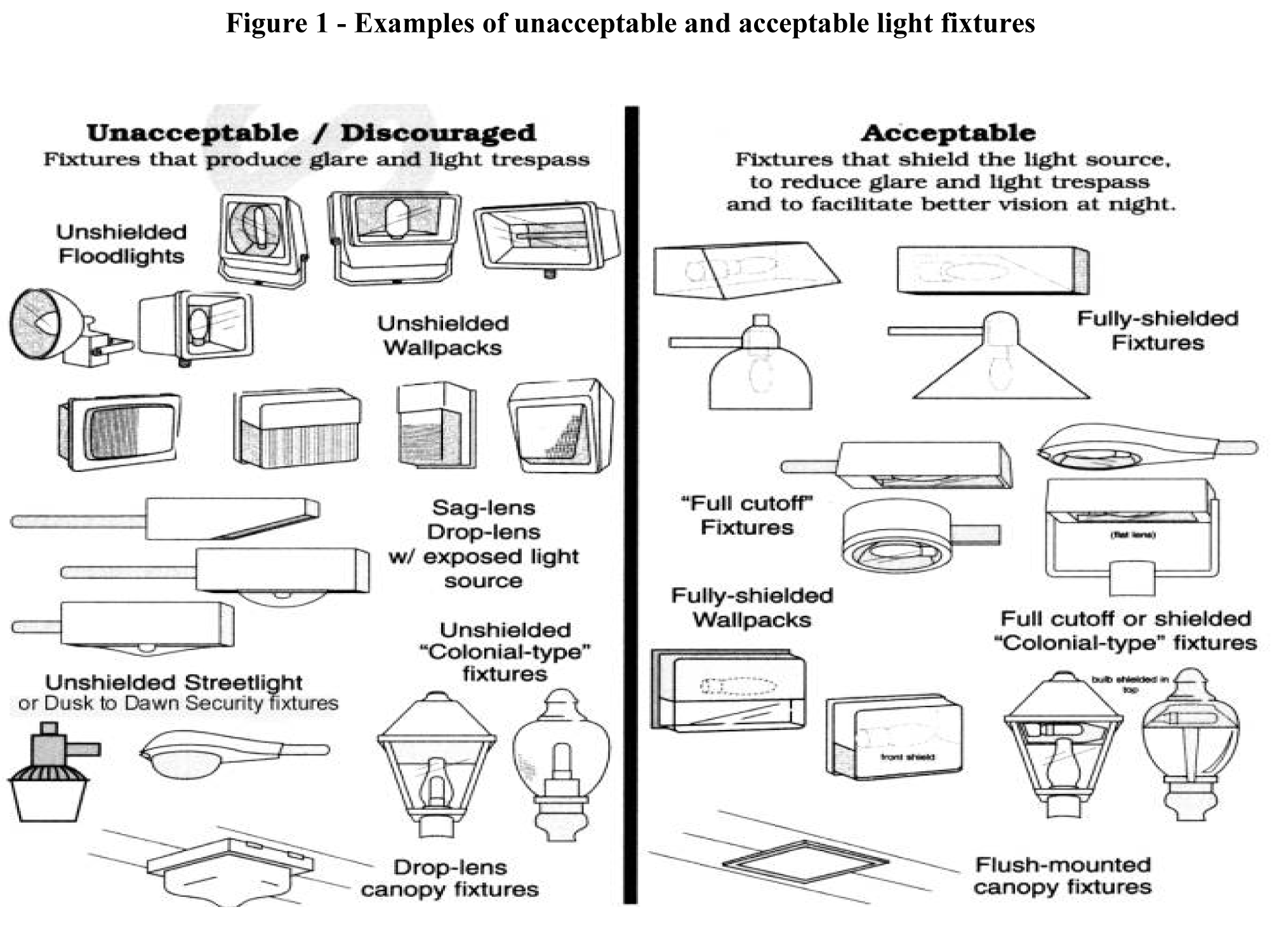
(b)
Lighting of predominantly non-horizontal surfaces. For the lighting of predominantly non-horizontal surfaces, light fixtures shall be full-cutoff or directionally shielded and shall be aimed and controlled so that light is confined, as much as possible, to the objects that are intended to be lit and does not project into the windows of neighboring residences, adjacent uses, past the object being illuminated, skyward, or onto a public roadway (see figure 2). Examples of predominantly non-horizontal surfaces include, but are not limited to, buildings, facades, landscaping, signs, displays, flags, and statuary, when their uses are specifically permitted by the county. All outdoor lighting associated with illuminating signage shall be required to follow specifications for sign lighting found in article 2, division 3.
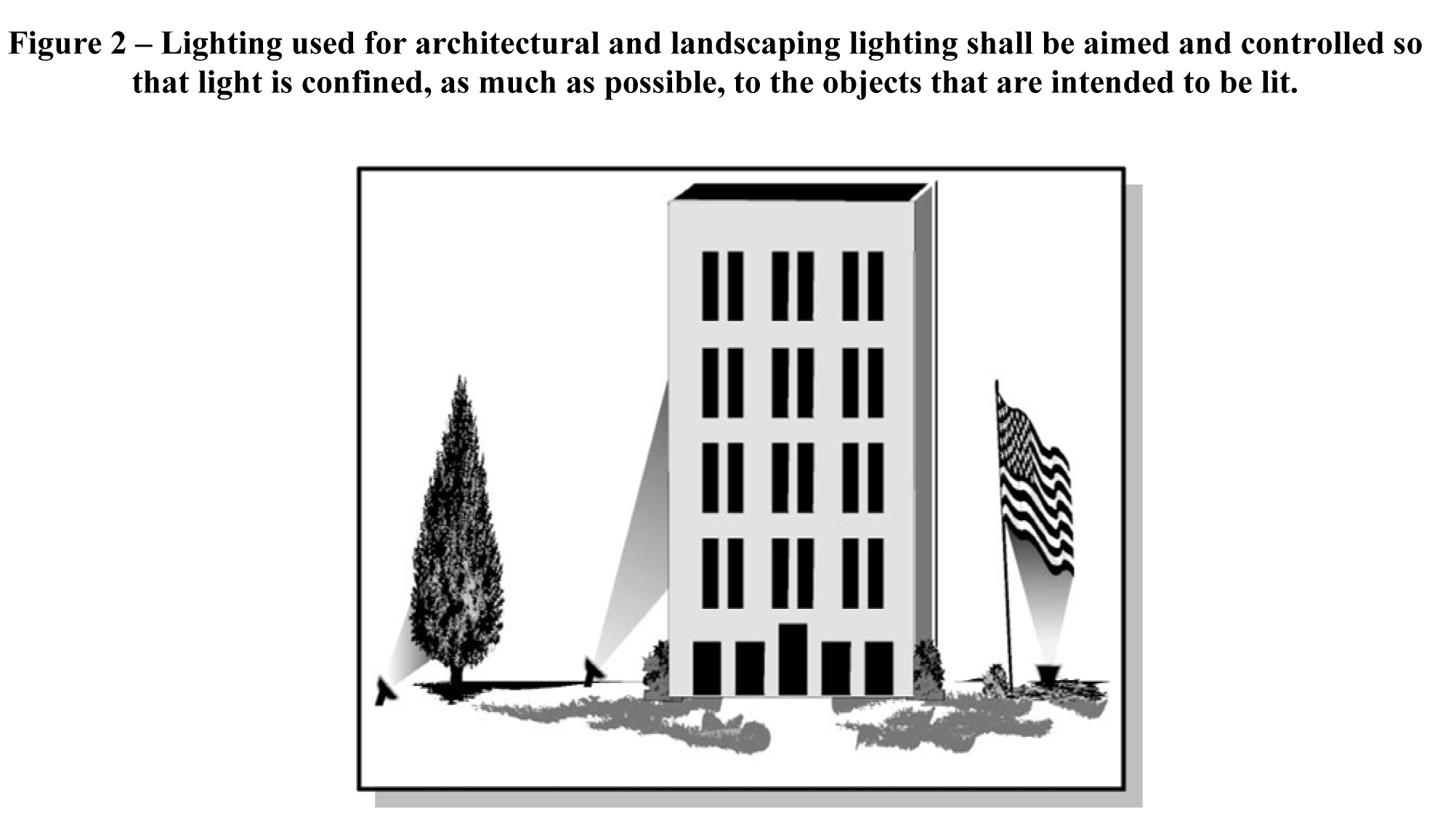
(c)
Light trespass. Light trespass, defined as light intensity measured at 0.1 footcandle or higher extending beyond any property line or into the public right-of-way, shall be prohibited. In cases where there is a public pedestrian accommodation located within an adjacent public right-of-way, light intensity greater than 0.1 footcandle may cross into the right-of-way in order to light the pedestrian accommodation. In all other instances, the applicant may request a waiver to allow for a light intensity higher than 0.1 footcandle to extend beyond a property line upon written application to the planning director. In evaluating such a waiver, the planning director shall consider the type of lighting, impact on adjacent properties and roadways, and any circumstances that are unique to the property.
(d)
Fixture height. Pole mounted light fixtures shall not exceed 30 feet in height. Height of the light fixture shall be the distance from ground or finished grade level to the highest point. Upon application to the planning director, the applicant may request a waiver to allow for the height to be raised to a height in excess of 30 feet up to the height of the main structure on the property or a maximum of 60 feet above grade, whichever is less. Light fixtures mounted on poles which are intended for the illumination of athletic fields shall only be subject to the height limitations of the zoning district.
(e)
Coordination with landscape plan. The applicant shall demonstrate that the site lighting and landscaping have been coordinated to minimize conflict between vegetation and intended light distribution, both initially and at vegetation maturity.
(f)
Temporary lighting. Upon written request of the applicant, temporary use of spotlights, floodlights and other specialized lights which do not meet the standards specified above may be approved by the planning director. In this context, temporary lighting shall mean lighting used at events of a special or seasonal nature. Conditions may be attached to such approval at the discretion of the planning director.
(Ord. No. 31A-252, 11-22-11)
Sec. 24-133. - Installation of lighting fixtures.
(a)
Poles and brackets for supporting light fixtures shall be those specifically manufactured for that purpose and shall be designed and rated for the light fixture and mounting accessory weights and wind loads involved.
(b)
Pole foundations shall be designed to be consistent with manufacturer's wind load requirements and local soil conditions involved.
(Ord. No. 31A-252, 11-22-11)
Sec. 24-134. - Maintenance.
Light fixtures and ancillary equipment shall be maintained to meet the requirements of this ordinance.
(Ord. No. 31A-252, 11-22-11)
Sec. 24-135. - Signs.
All outdoor lighting used to illuminate signage shall be required to follow specifications for sign lighting found in article 2, division 3.
(Ord. No. 31A-252, 11-22-11)
Sec. 24-136. - Streetlights in residential subdivisions.
All outdoor lighting associated with streetlights in residential subdivisions shall only be required to follow the specifications found in Chapter 19, Subdivisions.
(Ord. No. 31A-252, 11-22-11)