
James City County Unincorporated
City Zoning Code
City Zoning Code
ARTICLE VI
OVERLAY DISTRICTS
Sec. 24-538. - Statement of intent.
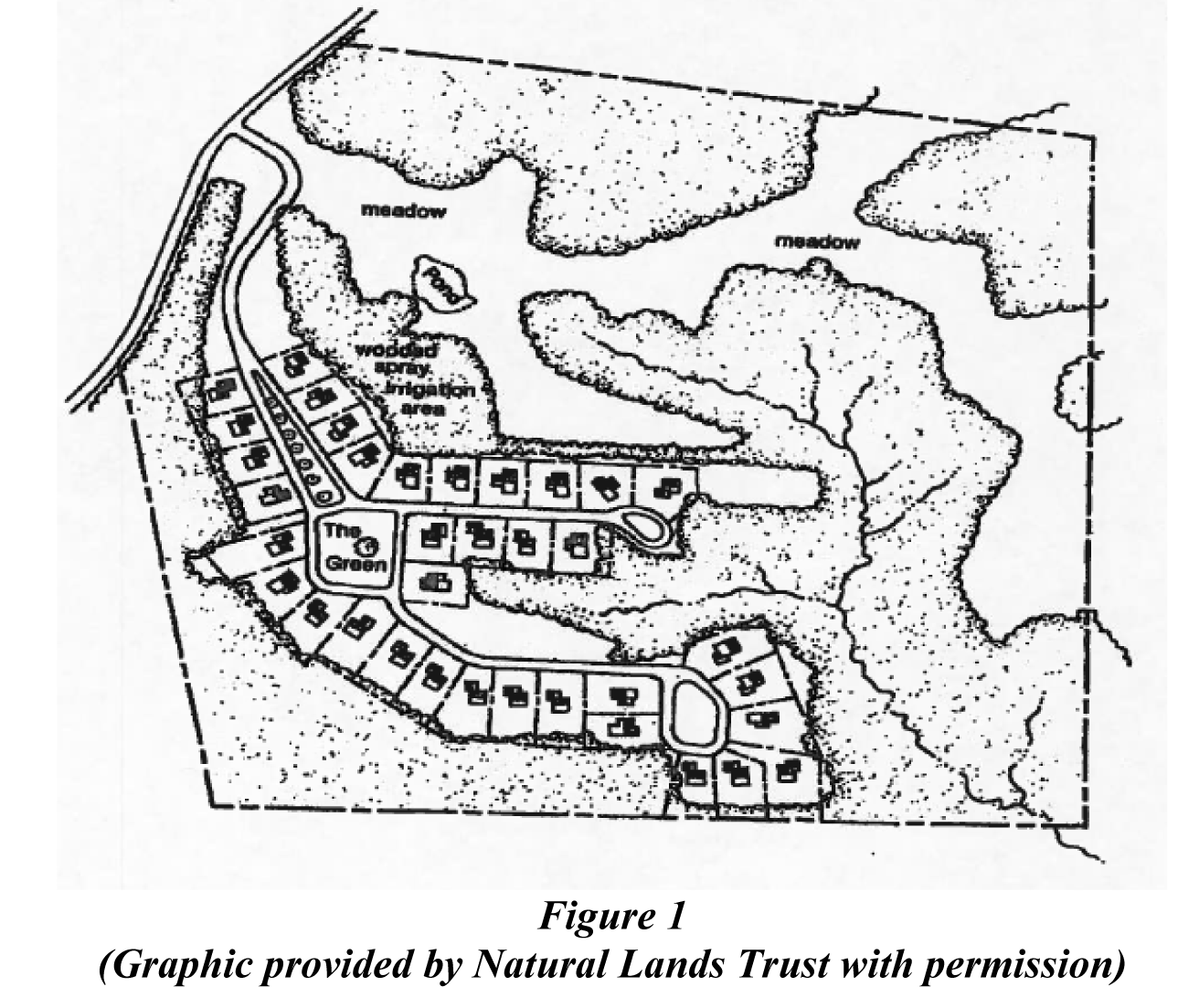
The purpose and intent of this article is to achieve innovative and quality designs of residential developments above one dwelling unit per acre that provide avenues for affordable and workforce housing, minimize environmental impacts, provide for usable and meaningful open space, and provide recreation amenities within a more practical and efficient development. Recognizing that greater variety and affordability are more obtainable with higher densities, developers have the flexibility to provide this product and still provide reasonable amenities within variously priced residential cluster communities. Hand in hand with the opportunities offered in higher density development is the expectation that the development will provide certain benefits to the community. As stated in the comprehensive plan, examples of these benefits include mixed-cost housing, affordable and workforce housing, unusual environmental protection or development that adheres to the principles of open space development design. Such design may include maintaining open fields; preserving scenic vistas; protecting wildlife habitats and corridors; retaining natural vegetative buffers around water bodies, wetlands, and along roads; preserving historic sites; creating adequate recreational areas; designing efficient pedestrian circulation to include trail systems; and ensuring that common land adjoins protected open space on adjacent parcels.
(Ord. No. 31A-88, § 20-153.1, 4-8-85; Ord. No. 31A-137, 2-18-92; Ord. No. 31A-197, 5-25-99; Ord. No. 31A-279, 11-27-12)
Sec. 24-539. - Residential cluster development defined.
A "residential cluster development," for purposes of this article, shall be a planned development of land consisting of predominantly residential uses together with its recreational facilities, supporting roads, utilities and other public facilities.
(Ord. No. 31A-88, § 20-153.2, 4-8-85; Ord. No. 31A-137, 2-18-92; Ord. No. 31A-197, 5-25-99)
Sec. 24-540. - Where permitted.
A residential cluster development is permitted in the R-1 and R-2 zoning districts inside the primary service area. The requirements of this article shall govern where there is a conflict with the requirements of the underlying district.
(Ord. No. 31A-88, § 20-153.3, 4-8-85; Ord. No. 31A-137, 2-18-92; Ord. No. 31A-197, 5-25-99; Ord. No. 31A-279, 11-27-12)
Sec. 24-541. - Minimum site size.
The minimum site size for a residential cluster development is five acres, except that extensions to an existing cluster development may be less than five acres. The planning director may waive the minimum site size requirements for residential cluster developments which provide affordable and workforce housing set forth in section 24-549 below. However, in no case shall such development be less than two acres. Such a waiver may be considered upon the applicant providing a written request to the planning director to waive the minimum acreage requirement demonstrating to the satisfaction of the planning director that:
(1)
The proposed development is consistent with the comprehensive plan;
(2)
Verification of affordable and workforce housing is provided; and
(3)
Evidence that the property can be subdivided as proposed.
Upon receipt of the request, the planning director shall, within thirty days of the request, either grant or deny the waiver with reasons to that effect.
(Ord. No. 31A-88, § 20-153.4, 4-8-85; Ord. No. 31A-197, 5-25-99; Ord. No. 31A-279, 11-27-12)
Sec. 24-542. - Permitted uses.
Uses permitted in a residential cluster development shall be the same as those permitted in the zoning district in which the residential cluster development is located. In the event that the individual units within attached dwellings are proposed to be sold as separate living units, the attached dwelling may be divided to permit separate deed descriptions for conveyance purposes. A limited amount of commercial development may be allowed within residential clusters as permitted in the zoning district in which the development is located. Commercial uses shall be shown on the master plan and be consistent with the Comprehensive Plan land use description and development standards.
(Ord. No. 31A-88, § 20-153.5, 4-8-85; Ord. No. 31A-137, 2-18-92; Ord. No. 31A-197, 5-25-99; Ord. No. 31A-279, 11-27-12)
Sec. 24-543. - Utilities.
Lots in a residential cluster development shall be served by a public sewage disposal system and a public water system.
(Ord. No. 31A-88, § 20-153.6, 4-8-85)
Sec. 24-544. - Buffer requirements.
(a)
Right-of-way buffer. Within any residential cluster approved under this division, there shall be planned and maintained buffers along all external existing and planned arterial road rights-of-way, as follows:
(1)
The minimum right-of-way buffer on Community Character Corridor roads as defined in the Comprehensive Plan shall be 150 feet, except when the average lot depth of the parent parcel is less than 600 feet. In those cases, the required buffer shall be at a depth of 25 percent of the average lot depth.
(2)
The minimum right-of-way buffer on all non-Community Character Corridor roads shall be 75 feet, except when the average lot depth of the parent parcel is less than 300 feet. In those cases, the required buffer shall be at a depth of 25 percent of the average lot depth.
(3)
The right-of-way buffer shall be planted in accordance with section 24-96, General landscape area standards. Buffers along community character corridor roads shall also adhere to the community character corridor buffer treatment guidelines and map.
(b)
Perimeter buffers. Within any residential cluster approved under this division, there shall be planned and maintained a perimeter buffer along the perimeter property lines of the development, except for areas adjacent to road rights-of-way. The minimum perimeter buffer shall be 35 feet. Landscaping guidelines for perimeter buffers shall follow the requirements in section 24-96 of this chapter.
(c)
Waiver provisions. In instances where properties have more than a 300-foot average depth and are located along a Community Character Corridor, or in all instances of perimeter buffers, the planning director may reduce the buffer depth requirements specified in (a) and (b) of this section for residential developments when:
(1)
The development is less than five acres and a majority of the development=s units are dedicated to affordable and workforce housing; or
(2)
The developer demonstrates that due to natural or protected features, or due to adjoining physical features, a reduced buffer will screen the development as effectively as a full buffer; or
(3)
The developer demonstrates that the development will be adequately screened and buffered from the road using berms and landscaping. Such a request shall be supplemented with a landscaping plan and/or planting plan with photos of the existing site.
In no case shall the right-of-way buffer be reduced by a waiver provision to less than 75 feet. The perimeter buffer shall not be reduced by a waiver provision to less than 20 feet. The planning director may also, in the event of granting a waiver, require additional landscaping as determined on a case by case basis.
(d)
Modifications to the landscape requirements. The planning director may modify, permit substitutions, or permit transfer of required landscaping in accordance with the provisions set forth in article II, division 4 of this chapter.
(e)
Requirements for buffers. All required buffers shall be exclusive of lots, remain free of structures and parking, and remain undisturbed, except for additional plantings and selective clearing approved by the planning director or his designee. Soil stockpiles and staging areas shall not be permitted within any buffer, except that temporary soil stockpiles may be allowed upon approval by the planning director under the following circumstances:
(1)
The buffer in which the temporary stockpile is to occur is non-wooded, defined as having no mature trees.
(2)
The stockpile shall not be visible from a Community Character Corridor or Community Character Area, unless the soil stockpiling is needed for approved berming in that buffer.
(3)
Stockpiles shall not exceed 35 feet in height.
(4)
Stockpiles shall be temporary, with a time limit of six months.
(5)
Once the use of the temporary soil stockpiles is completed, the ground must be adequately prepared for planting and revegetated in a manner that meets or exceeds the amount and quality of vegetation on the site previously.
(6)
Stockpiling shall conform with any applicable requirements of the Virginia erosion and sediment control regulations, the Virginia Erosion and Sediment Control Handbook and county erosion and sediment control program policies.
(f)
Limitations on buffers. Structural BMPs such as wet and dry ponds shall not generally be permitted in the buffers, except that the planning director may approve them under the following circumstances:
(1)
The need is necessitated by site conditions rather than economic factors; and
(2)
The screening/buffering effect of the buffer has been retained by the design of the BMP and any degradation has been mitigated with additional plantings or berms as necessary.
(g)
Improvements allowable within buffers. An entrance road, community and directional signage, bicycle and/or pedestrian paths, and utility connections and drainage improvements shall be permitted within the buffer with approval of the planning director. Permitted utilities and constructed drainage conveyance systems shall cross the buffer at or near a perpendicular angle to the property line, with clearing kept to a minimum necessary to accommodate the utilities, except that minor improvements to natural drainage channels may be permitted at a different angle to the property line upon approval of the planning director.
(h)
Roads within buffers. Entrance roads through these buffers shall be built to the narrowest cross-section possible. Roads and open space shall be located and designed in a manner that minimizes views of structures within the development from the adjoining primary or secondary road as determined by the planning director.
(i)
Appeals. In the event the planning director disapproves the items specified in (c), (d), (e), (f), (g), and (h) in this section or recommends conditions or modifications that are unacceptable to the applicant, the applicant may appeal the decision of the planning director to the development review committee which shall forward a recommendation to the planning commission. Any appeal shall be in writing and may be subject to fees as specified in article I of this chapter.
(Ord. No. 31A-197, 5-25-99; Ord. No. 31A-279, 11-27-12)
Sec. 24-545. - Setback requirements.
The minimum setback from the right-of-way shall be shown on the plan of development and on the recorded subdivision plat. The minimum setback from external streets shall be the same as that required by the zoning district in which the lot is located, except as superseded by section 24-544. The minimum setback from internal streets may be reduced to zero, provided that no building in a residential cluster shall be closer than 25 feet to the internal edge of perimeter buffers. Off-street parking shall not be permitted within the required setbacks, except that parking spaces for single-family and two-family dwellings may be located within the required setback.
(Ord. No. 31A-88, § 20-153.8, 4-8-85; Ord. No. 31A-197, 5-25-99; Ord. No. 31A-279, 11-27-12)
Sec. 24-546. - Minimum lot width and area requirements.
There are no lot width or area requirements.
(Ord. No. 31A-88, § 20-153.9, 4-8-85; Ord. No. 31A-137, 2-18-92; Ord. No. 31A-197, 5-25-99)
Sec. 24-547. - Yard requirements.
The rear and side yards may be reduced to zero feet subject to the following conditions:
(a)
The minimum distance between any two buildings within the residential cluster development shall be governed by the Virginia Uniform Statewide Building Code.
(b)
No building in a residential cluster development shall be closer than 25 feet to the internal edge of perimeter buffers.
(c)
Easements or covenants establish the rights of two abutting properties where main buildings are to be constructed on or within five feet of a property line. Such easements or covenants shall establish the rights of each affected owner to gain access to each owner's building for purposes of essential maintenance and service. Documents establishing such easements or covenants shall be satisfactory to the county attorney and submitted prior to approval of the development plan.
(Ord. No. 31A-88, § 20-153.10, 4-8-85; Ord. No. 31A-89, 9-9-85; Ord. No. 31A-137, 2-18-92; Ord. No. 31A-145, 7-6-92; Ord. No. 31A-197, 5-25-99; Ord. No. 31A-279, 11-27-12)
Sec. 24-548. - Density.
Editor's note— Ord. No. 31A-357, adopted May 9, 2023, repealed § 24-548, which pertained to Density and derived from Ord. No. 31A-88, § 20-153.11, adopted April 8, 1985; Ord. No. 31A-137, adopted Feb. 18, 1992; Ord. No. 31A-145, adopted July 6, 1992; Ord. No. 31A-175, adopted March 25, 1997; Ord. No. 31A-197, adopted May 25, 1999; Ord. No. 31A-279, adopted Nov. 27, 2012.
Sec. 24-549. - Density standards.
No project shall have a net density (including bonuses) of more than four units per acre. In order to achieve the net densities listed below, the developer shall provide at least the minimum amount of open space, and shall make assurances in a master plan, proffers, or other document approved by the county attorney, for the density bonus items. The approval process for cluster development shall be as stated in section 24-556.
(Ord. No. 31A-197, 5-25-99; Ord. No. 31A-279, 11-27-12; Ord. No. 31A-357, 5-9-23)
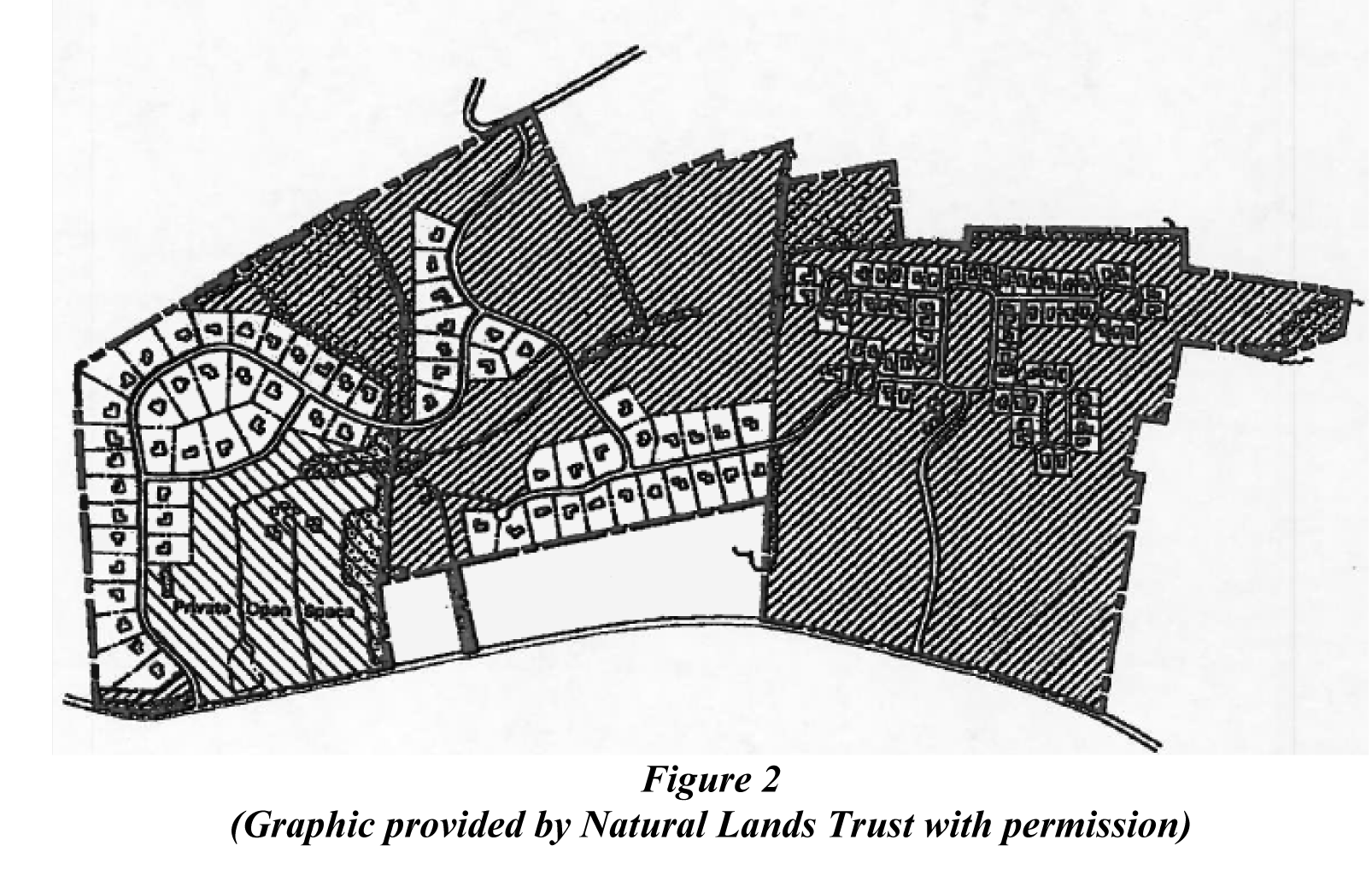
Sec. 24-550. - Open space.
Within every residential cluster development approved under this division, there shall be planned and set aside permanently an amount of open space to be maintained exclusively for conservation and recreation purposes.
(a)
Non-developable areas shall be maintained as open space and shall not be included on any private lot, and should be protected through a conservation easement dedicated to the county or other legal entity approved by the county attorney.
(b)
In addition, a percentage of the developable area shall also be set aside as open space, as specified in section 24-549. The developable area open space may include, but is not limited to:
(1)
Areas on site necessary to meet county policies pertaining to natural resources, archaeology, and parks and recreation;
(2)
Areas on site used to achieve density bonus points in accordance with section 24-549;
(3)
The following areas, up to the percent specified:
a.
Golf courses cannot exceed 30 percent of the developable open space required
b.
Required right-of-way and perimeter buffers cannot exceed 50 percent of the developable open space required, and
c.
Stormwater management facilities cannot exceed 20 percent of the developable open space required (this limitation applies to structural best management practices such as wet and dry ponds, but does not apply to bioretention or other low impact design measures).
(c)
For the purpose of meeting the developable open space requirements specified in (b), open space area may not include:
(1)
Area on any individual private lots, or in the case of condominiums, within 15 feet of the units, or
(2)
Land within public road rights-of-way and utility or drainage easements.
(d)
Conceptual and/or master plans shall include a table with the open space information as follows:
(e)
Open space shall be arranged on the site in a manner that coordinates with section 24-551, Open space development design elements. While every site is different, the applicant, as part of the conceptual and/or master plan review process, shall demonstrate through a narrative document or exhibits that the following were considered in designing the open space:
(1)
Conservation/general open space:
a.
Located to preserve existing significant natural and historic features and scenic viewsheds such as ponds and views to open water, particularly those that can be seen from public roads;
b.
Located to adjoin any neighboring areas of open space, other protected areas, and non-protected natural areas that would be candidates for inclusion as part of a future protected open space;
c.
Located to be interconnected and contiguous to the extent possible, and located to benefit and be accessible to the maximum number of units; and
d.
Prominently located within the development (for example, at the terminus of key views along roads, at the intersection of arterial or collector streets, at topographic high points or centrally located within the residential area).
(2)
Recreation
a.
Cluster developments shall adhere to the parks and recreation master plan proffer guidelines. Any additional land intended for recreation shall be useable for the purpose intended, and also follow the design specifications in the parks and recreation master plan proffer guidelines.
(Ord. No. 31A-88, § 20-153.14, 4-8-85; Ord. No. 31A-112, 2-6-89; Ord. No. 31A-137, 2-18-92; Ord. No. 31A-197, 5-25-99; Ord. No. 31A-279, 11-27-12)
Sec. 24-551. - Open space development design elements.
While every site is different, the applicant, as part of the conceptual and/or master plan review process, shall demonstrate through a narrative document or exhibits that the following were considered in designing the development. These considerations shall be coordinated with the open space design.
(a)
The design should take advantage of the compact design by clustering development into a walkable scale neighborhood and preserving significant open space and natural features;
(b)
The development should be designed to complement existing topography and minimize the need for alteration of the landscape;
(c)
The development should use a mixture of diverse unit types, lot sizes, and/or unit prices; and
(d)
The design should use a creative layout. Examples include:
(1)
Fronting on open space;
(2)
Constructed with one side exterior wall along the side property line to allow side or rear yard garages;
(3)
Detached or attached homes on loop lanes;
(4)
Use of better site design techniques such as group or shared parking, and shared driveways; and
(5)
Clear access from the units to the open space by abutting it, or via sidewalks or trails.
(Ord. No. 31A-279, 11-27-12)
Sec. 24-552. - Establishment of homeowners association.
A homeowners association shall be established in accordance with chapter 19 of the county code. The homeowners association documents shall set forth the nature (recreation or conservation) and location of the open space(s) either through illustration or through incorporation by reference of the development's master plan. The documents shall generally describe the use and maintenance standards necessary to adhere to the nature of the open space(s) as shown on the development's master plan.
(Ord. No. 31A-88, § 20-153.15, 4-8-85; Ord. No. 31A-137, 2-18-92; Ord. No. 31A-197, 5-25-99; Ord. No. 31A-279, 11-27-12)
Sec. 24-553. - BMP requirements.
To assure an appearance and condition which is consistent with the purpose of the residential cluster development overlay district, structural BMPs serving the properties within the district shall comply with the landscaping regulations in article II, division 4 of this chapter.
(Ord. No. 31A-197, 5-25-99; Ord. No. 31A-279, 11-27-12)
Sec. 24-554. - Performance assurance.
For all improvements proposed by the applicant pursuant to section 24-549, assurances shall be provided, satisfactory to the county attorney, that such improvements will be constructed and completed for use by project residents within a specific, reasonable period of time.
(Ord. No. 31A-88, § 20-153.13, 4-8-85; Ord. No. 31A-137, 2-18-92; Ord. No. 31A-197, 5-25-99; Ord. No. 31A-279, 11-27-12)
Sec. 24-555. - Pedestrian accommodations.
Pedestrian accommodations shall be provided in accordance with section 24-35.
(Ord. No. 31A-279, 11-27-12)
Sec. 24-556. - Review and approval process.
(a)
Conceptual plan and master plan. Any conceptual plan or master plan for a residential cluster development proposed under this division shall include the elements listed below. For master plans, these elements shall be in addition to meeting the requirements of section 24-23.
(1)
Depiction and/or documentation of the items that the applicant plans to pursue when a bonus density above the base density is sought;
(2)
Conceptual development design, including required setbacks and buffers, and illustration of the features listed above in the open space and open space development design sections;
(3)
Marginal data and depiction which shows the gross acreage of the site, the nondevelopable area, the total number of dwelling units and/or lots, and, in the table format specified in section 24-550, the amount of open space required and the amount of open space provided; and
(4)
Conceptual stormwater design, illustrating use of better site design and low impact development techniques, where possible.
(b)
Approval process.
(1)
In instances where a special use permit is not required by the residential district, a master plan shall be filed with the planning director who shall recommend action on the plan to the development review committee, which shall forward a recommendation to the planning commission. The planning commission shall approve the master plan upon finding that the proposed cluster development meets the requirements of this ordinance and is in accordance with the applicable residential designation description of the Comprehensive Plan.
(2)
In instances where a special use permit is required by the residential district:
a.
Prior to submission of a master plan for legislative action, the applicant is strongly encouraged to file a conceptual plan for review by the development review committee. The development review committee shall provide a recommendation on the conceptual plan based upon its findings regarding the extent that the proposed cluster development meets the requirements of this ordinance and is in accordance with the applicable residential designation description of the comprehensive plan.
b.
A master plan in accordance with section 24-23 shall be submitted and shall follow the process established in that section. The recommendations and findings of the development review committee on any conceptual plan shall be presented to the planning commission.
(Ord. No. 31A-88, § 20-153.16, 4-8-85; Ord. No. 31A-97, 6-2-86; Ord. No. 31A-112, 2-6-89; Ord. No. 31A-137, 2-18-92; Ord. No. 31A-197, 5-25-99; Ord. No. 31A-233, 12-11-07; Ord. No. 31A-279, 11-27-12)
Sec. 24-564. - Statement of intent.
The Scenic Roadway Overlay District is intended to protect and preserve the viewshed of scenic roadways. The district establishes an increased dwelling setback to maintain the existing rural character along the roadways. The district is intended to impose special requirements in addition to the regulations of the principal zoning district where it applies.
(Ord. No. 31A-361, 10-8-24)
Sec. 24-565. - Applicability.
The governing body of James City County, Virginia, hereby establishes and delineates on the zoning district map the Scenic Roadway Overlay District, to be referred to on the zoning district map by the symbol SR. Unless otherwise stated herein, the permitted uses and other regulations of the underlying zoning districts and all other sections of this Zoning Ordinance shall continue to apply.
(Ord. No. 31A-361, 10-8-24)
Sec. 24-566. - Scenic roadways defined.
A "scenic roadway," for the purposes of this district, shall include State Route 610 (Forge Road), State Route 603 (Diascund Road), and State Route 715 (North Riverside Drive).
(Ord. No. 31A-361, 10-8-24)
Sec. 24-567. - Setback requirements.
(a)
Any unimproved parcel or lot in existence as of October 8, 2024, shall adhere to the following setback requirements:
1.
For those parcels or lots containing a lot depth of greater than 500 feet, dwellings shall be located a minimum of 400 feet from the street right-of-way of a scenic roadway.
2.
For those parcels or lots containing a lot depth of greater than 300 feet but less than or equal to 500 feet, dwellings shall be located a minimum of 200 feet from the street right-of-way of a scenic roadway.
3.
For those parcels or lots containing a lot depth of 300 feet or less or those parcels approved as a flag lot, the applicable setback shall be determined by the underlying zoning district regulations.
An unimproved parcel or lot shall mean any parcel or lot which does not have a building placed upon or affixed to land. Any change in a recorded subdivision plat as defined in section 19-11 of the subdivision ordinance to circumvent the above requirements shall not be permitted.
(b)
For any parcel or lot created after October 8, 2024, dwellings shall be located a minimum of 400 feet from the street right-of-way of a scenic roadway. For the purposes of a flag lot, the required minimum 400 feet from a scenic roadway may include the distance of the flag stem, however, no dwelling shall be located less than 75 feet from the front lot line nearest and parallel or approximately parallel to the street to which the lot has access as shown in section 19-41 of the subdivision ordinance.
(Ord. No. 31A-361, 10-8-24)
Sec. 24-586. - Statement of intent.
(a)
This section is adopted pursuant to the authority granted to localities by Virginia Code § 15.2-2280. These regulations are intended to prevent the loss of life and property, the creation of health and safety hazards, the disruption of commerce and governmental services, the extraordinary and unnecessary expenditure of public funds for flood protection and relief, and the impairment of the tax base by:
(1)
Regulating uses, activities and development which, alone or in combination with other existing or future uses, activities and development, may cause unacceptable increases in flood heights, velocities and frequencies;
(2)
Restricting or prohibiting certain uses, activities and development within districts subject to flooding;
(3)
Requiring uses, activities and developments that do occur in flood-prone districts to be protected and/or flood-proofed against flooding and flood damage; and
(4)
Protecting individuals from buying land and structures which are unsuited for intended purposes because of flood hazards.
(b)
These regulations comply with the requirements of the National Flood Insurance Program (42 USC 4001-4128) of the Federal Insurance Administration. These regulations are necessary in order for all property owners within the county to be eligible for the National Flood Insurance Program and thereby purchase such insurance at nominal rates.
(Ord. No. 31A-127, 10-29-90; Ord. No. 31A-228, 9-25-07; Ord. No. 31A-301, 10-13-15; Ord. No. 31A-338, 1-9-18)
Sec. 24-587. - Applicability.
These regulations shall apply to all property located within an area designated as a floodplain area, and as such shall supplement the regulations of the zoning district within which such property is located. Where these regulations are at variance with other provisions of this chapter, it is intended that these regulations shall apply. These regulations shall only apply to property which is designated as being within a floodplain area.
(Ord. No. 31A-127, 10-29-90; Ord. No. 31A-338, 1-9-18)
Sec. 24-588. - Compliance, liability, abrogation and severability.
(a)
No land shall hereafter be developed and no structure shall be located, relocated, constructed, reconstructed, enlarged or structurally altered except in full compliance with the terms and provisions of these regulations and any other applicable ordinances and regulations; including, but not limited to: the Virginia Uniform Statewide Building Code (USBC), the Virginia Industrialized Building Safety Regulations (IBSR), and the Manufactured Home Safety Regulations (MHSR).
(b)
The degree of flood protection sought by the provisions of these regulations is for reasonable regulatory purposes and is based on acceptable engineering methods of study. Larger floods may occur on rare occasions. Flood heights may be increased by man-made or natural causes, such as ice jams and bridge openings restricted by debris. These regulations do not imply that districts outside the floodplain district or that land uses permitted within such district will be free from flooding or flood damage.
(c)
Records of actions associated with administering these regulations shall be kept on file and maintained by the director of community development or his designee in perpetuity.
(d)
These regulations shall not create liability on the part of the county or any officer or employee thereof for any flood damages that result from reliance on these regulations or any administrative decision lawfully made thereunder.
(e)
Any person who fails to comply with any requirement or provision of this article shall be guilty of the appropriate violation and subject to penalties set forth in section 24-22 of this chapter.
(f)
To the extent that the provisions are more restrictive than previous requirements, this ordinance supersedes any ordinance currently in effect in flood-prone districts. To the extent that any other existing law or regulation is more restrictive or does not conflict, it shall remain in full force and effect. These regulations are not intended to repeal or abrogate any existing ordinances including subdivision regulations, zoning ordinances, or building codes. In the event of a conflict between these regulations and any other ordinances, the more restrictive shall govern.
(g)
If any section, subsection, paragraph, sentence, clause, or phrase of this division shall be declared invalid for any reason whatever, such decision shall not affect the remaining portions of this division. The remaining portions shall remain in full force and effect; and for this purpose, the provisions of this division are hereby declared to be severable.
(Ord. No. 31A-127, 10-29-90; Ord. No. 31A-228, 9-25-07; Ord. No. 31A-258, 11-22-11; Ord. No. 31A-291, 8-13-13; Ord. No. 31A-301, 10-13-15; Ord. No. 31A-306, 10-11-16; Ord. No. 31A-338, 1-9-18)
Sec. 24-589. - Definitions and administrator.
The terms used in these regulations are defined in section 24-2 of this chapter except for the board of zoning appeals, which is defined in section 24-645. The administrator of these regulations is set forth in section 24-5 of this chapter.
(Ord. No. 31A-228, 9-25-07; Ord. No. 31A-301, 10-13-15; Ord. No. 31A-338, 1-9-18)
Sec. 24-590. - Designation of floodplain districts.
(a)
The various floodplain districts shall include areas subject to inundation by waters of the one percent annual chance (100-year) flood. The minimum basis for the delineation of these districts shall be, but not be limited to, the December 16, 2015 Flood Insurance Study (FIS) and Flood Insurance Rate Maps (FIRMs) prepared by the Federal Emergency Management Agency (FEMA), and subsequent revisions or amendments thereto. In areas with no base flood elevation provided by the FIRM/FIS, the best available data for the one percent annual chance (100-year) flood elevations and floodways from federal, state and local sources shall be used when available. Where the specific one percent annual chance (100-year) flood elevation cannot be determined for an area by using available sources of data, then the applicant for the proposed use, development and/or activity shall determine this elevation to the satisfaction of the director of community development or his designee in accordance with hydrologic and hydraulic engineering techniques. Hydrologic and hydraulic analyses shall be undertaken only by professional engineers or others of demonstrated qualifications, who shall certify that the technical methods used correctly reflect currently accepted technical concepts. Studies, analyses, computations, etc. shall consider full development of the watershed and shall be submitted in sufficient detail to allow a thorough review by the director of community development or his designee.
Where flood elevations are provided by the FEMA, these elevations shall not be changed except with FEMA approval. Local sources of flood-prone area data include, but are not limited to, the Mill Creek-Lake Powell Watershed Study, GKY and Associates, 1988 report, locally approved watershed management plans and comprehensive drainage studies.
When base flood elevations have increased or decreased resulting from physical changes affecting flooding conditions, technical or scientific data shall be submitted to FEMA no later than six months after the date such information becomes available. Such submission is necessary so that, upon confirmation of those physical changes affecting flooding conditions, risk premium rates and floodplain management requirement will be based upon current data.
(b)
The floodway district, minimally shown on the maps accompanying the flood insurance study, is established for purposes of these regulations using the criterion that certain areas within the floodplain must be kept free of encroachment in order that the one percent annual chance (100-year) flood be conveyed without increasing the water surface areas included in this district.
(c)
The flood-fringe district shall be that area of the one percent annual chance (100-year) flood not included in the floodway district. The basis for the outmost boundary of the district shall be the one percent annual chance (100-year) elevations minimally shown as Zones AE and AO on the maps accompanying the flood insurance study.
(d)
The approximated floodplain district shall be that floodplain area for which no detailed flood profiles or elevations are provided but where a one percent annual chance (100-year) flood boundary has been approximated. Such areas are minimally shown as Zone A on the maps accompanying the flood insurance study. Consider other available data such as presented in subsection (a) of this section as the basis for elevating residential structures to or above base flood level, and for floodproofing or elevating nonresidential structures to or above base flood level.
(e)
Coastal A zones shall be those areas as defined by the Virginia Uniform Statewide Building Code that are subject to wave heights between one and one half feet and three feet and identified on the FIRM as AE areas that are seaward of the Limit of Moderate Wave Action (LiMWA) line.
(f)
Coastal high-hazard area districts shall be those portions of land within the coastal floodplain subject to inundations by high velocity waters and wave action greater than three feet. Such areas are minimally shown as Zones V and VE.
(Ord. No. 31A-127, 10-29-90; Ord. No. 31A-179, 9-8-98; Ord. No. 31A-228, 9-25-07; Ord. No. 31-258, 11-22-11; Ord. No. 31A-286, 12-11-12; Ord. No. 31A-301, 10-13-15; Ord. No. 31A-306, 10-11-16; Ord. No. 31A-338, 1-9-18)
Sec. 24-591. - Official map.
The boundaries of floodway, flood-fringe and approximated floodplain districts in section 24-590(b), (c) and (d) above are established as minimum areas, as shown on the flood insurance rate map dated December 16, 2015, which is declared to be a part of these regulations and which shall be kept on file at the office of the director of community development.
(Ord. No. 31A-127, 10-29-90; Ord. No. 31A-179, 9-8-98; Ord. No. 31A-228, 9-25-07; Ord. No. 31A-301, 10-13-15; Ord. No. 31A-306, 10-11-16; Ord. No. 31A-338, 1-9-18)
Sec. 24-592. - Permits.
A permit is required for all proposed construction and other developments, including the placement of manufactured homes, within the floodway or any floodplain district. An application for subdivision, site plan, rezoning, building permit, special use permit, Virginia Erosion and Sediment Control Program/Virginia Stormwater Management Program permit, wetlands permit or other local development permit shall be considered an application for development under these regulations. The applicant shall be informed of the provisions of this article as they may apply to the property and no permit shall be issued until the applicant has complied with such provisions. Applications will be reviewed to ensure the proposed construction or other developments will be reasonably safe from flooding.
(Ord. No. 31A-127, 10-29-90; Ord. No. 31A-301, 10-13-15; Ord. No. 31A-338, 1-9-18)
Sec. 24-593. - Permitted uses.
Permitted uses, special permit uses, accessory uses, dimensional standards and special requirements shall be as established by the underlying zoning district except as specifically modified herein.
(Ord. No. 31A-127, 10-29-90; Ord. No. 31A-338, 1-9-18)
Sec. 24-594. - Prohibited uses.
(a)
The following uses shall be specifically prohibited within all floodplain districts:
(1)
Sanitary landfills, junkyards, outdoor storage of inoperative vehicles.
(2)
Manufactured homes.
(3)
Surface mines and borrow pits.
(4)
Manufacture, bulk storage, transformation or distribution of petroleum, chemical or asphalt products or any hazardous materials as defined in either or both of the following:
a.
Superfund Amendment and Reauthorization Act of 1986.
b.
Identification and Listing of Hazardous Wastes, 40 CFR section 261 (1987).
The following products shall be specifically included:
i.
Oil and oil products including petrochemicals.
ii.
Radioactive materials.
iii.
Any material transported or stored in large commercial quantities (such as 55-gallon drums) which is a very soluble acid or base, causes abnormal growth of an organ or organism, or is highly biodegradable, exerting a strong oxygen demand.
iv.
Biologically accumulative poisons.
v.
Substances containing the active ingredients of poisons that are or were ever registered in accordance with the provisions of the Federal Insecticide, Fungicide, and Rodenticide Act, as amended (7 USC 135 et seq.).
vi.
Substances highly lethal to mammalian or aquatic life.
(5)
Storage or land application of industrial wastes.
(6)
Outdoor storage of equipment, materials or supplies which are buoyant, flammable or explosive.
(b)
Nonconforming uses of this chapter notwithstanding, no expansion of any of the above uses located within the floodplain district shall be permitted.
(Ord. No. 31A-127, 10-29-90; Ord. No. 31A-338, 1-9-18)
Sec. 24-595. - Regulations for construction.
(a)
The construction or placement of any structure or obstruction, filling or changing the cross-section or flow characteristics within the one percent annual chance (100-year) flood shall not be permitted unless the project is in conformance with the following requirements:
(1)
All construction shall use methods that minimize flood damage and which are in accordance with the Virginia Uniform Statewide Building Code. Structures shall be constructed with materials and equipment resistant to flood damage and shall be anchored to prevent floatation, collapse, or lateral movement.
(2)
The finished elevation of the lowest floor, including the basement or cellar of any building, shall have at least two feet freeboard above the one percent annual chance (100-year) flood elevation. For nonresidential structures, excluding accessory structures which conform to 24-595(a)(9), dry floodproofing up to the level of two feet freeboard in accordance with the Virginia Uniform Statewide Building Code may be provided in lieu of the finished grade requirement described herein.
(3)
Utility and sanitary facilities, including but not limited to mechanical, plumbing and electrical systems and gas lines, shall be floodproofed up to the level of two feet freeboard above the one percent annual chance (100-year) base flood elevation.
(4)
Encroachments, including fill, new construction, substantial improvements and other development are prohibited within the floodway or any floodplain district unless it has been demonstrated through hydrologic and hydraulic analyses that the proposed encroachment would not result in any increase in flood levels during the occurrence of the base flood discharge. Hydrologic and hydraulic analyses shall be undertaken by a professional engineer and shall be submitted in sufficient detail to allow a thorough review by the director of community development or his designee. Hydrologic and hydraulic analyses shall not be required for properties affected only by coastal (tidal) flooding.
(5)
All new construction and substantial improved structures in Zone AO shall meet the following requirements:
a.
The lowest floor, including basements, shall be at or above the highest adjacent grade and two feet above the FIRM's depth number.
b.
Nonresidential structures may use dry floodproofing in accordance with the Virginia Uniform Statewide Building Code in lieu of the finished grade requirement described herein.
c.
Adequate drainage paths around structures on slopes shall be provided to guide floodwaters around and away from proposed structures.
(6)
All new construction and substantial improvements in Zones V, VE, and Coastal A shall meet the following requirements:
a.
The structure shall be elevated on pilings or columns so that the bottom of the lowest horizontal structural member of the lowest floor (excluding the pilings or columns) is elevated at least two feet above the base flood level. The pile of column foundation and structure attached thereto is anchored to resist flotation, collapse and lateral movement due to effects of wind and water loads acting simultaneously on all building components. A registered design professional engineer or architect shall develop and seal the structural design, specifications and plans for the construction, and shall certify the design and methods of construction.
b.
The space below the lowest floor shall be either free of obstruction or constructed with nonsupporting breakaway walls, open wood-lattice work, or insect screening intended to collapse under wind and water loads without causing collapse, displacement, or other structural damage to the elevated portion of the building or supporting foundation system. Breakaway walls shall collapse from water loads that are less than that which would occur during the base flood.
c.
New construction shall be landward of reach of mean high tide.
d.
Fill for structural support and alterations of sand dunes are prohibited.
(7)
The enclosed space below the lowest floor shall be used solely for parking of vehicles, building access or storage, have permanent openings designed to allow the exit of floodwaters in accordance with the Virginia Statewide Building Code and Federal Code 44CRF Section 60.3 approved by the director of building safety and permits. This requirement applies to all floodplain districts, including Zones V, VE, and Coastal A.
(8)
Prior to issuance of a certificate of occupancy, the owner of any structure located in a floodplain district shall submit a completed elevation certificate or floodproofing certificate from a registered professional engineer or architect, as appropriate, to the director of building safety and permits.
(9)
Accessory structures shall comply with elevation or dry floodproofing requirements in section 24-595 (a)(2) or shall conform to the following standards:
a.
Not located in a floodway;
b.
Not be used for human habitation;
c.
Be limited to no more than 600 square feet in total floor area;
d.
Be usable only for parking of vehicles or limited storage;
e.
Be constructed with flood damage-resistant material to the level of two feet freeboard above the one percent annual chance (100-year) base flood elevation;
f.
Be constructed and placed to offer the minimum resistance to the flow of floodwaters;
g.
Be anchored to prevent flotation;
h.
All utilities, including but not limited to mechanical, plumbing and electrical systems and gas lines, shall be elevated or floodproofed up to the level of two feet freeboard above the one percent annual chance (100-year) base flood elevation;
i.
Shall be provided with flood openings which shall meet the following criteria:
1.
There shall be a minimum of two flood openings on different sides of each enclosed area; if a building has more than one enclosure below the lowest floor, each such enclosure shall have flood openings on exterior walls;
2.
The total net area of all flood openings shall be at least one square inch for each square foot of enclosed area (non-engineered flood opening), or the flood openings shall be engineered flood openings that are designed and certified by a licensed professional engineer to automatically allow entry and exit of floodwaters; the certification requirement may be satisfied by an individual certification or an evaluation report issued by ICC Evaluation Service, Inc.;
3.
The bottom of each flood opening shall be one foot or less above the higher of the interior floor or grade, or the exterior grade, immediately below the opening;
4.
Any louvers, screens or other covers for the flood opening shall allow the automatic flow of floodwaters into and out of the enclosed area.
j.
Such accessory structure shall not be used to store any hazardous material as listed in section 24-593 (a)(4).
(10)
All other federal and state permits shall be obtained by the applicant before the development will be permitted under this chapter.
(b)
It shall be the responsibility of the applicant to provide this data, certified by a licensed surveyor or engineer or other source acceptable to the director of building safety and permits.
(Ord. No. 31A-127, 10-29-90; Ord. No. 31A-249, 7-26-11; Ord. No. 31A-258, 11-22-11; Ord. No. 31A-286, 12-11-12; Ord. No. 31A-301, 10-13-15; Ord. No. 31A-306, 10-11-16; Ord. No. 31A-338, 1-9-18)
Sec. 24-596. - Regulations for subdivisions and site plans.
The applicant of any subdivision of land or site plan within the county shall submit with his application a statement by a licensed surveyor or engineer as to whether or not any property shown on the plat or plan is at an elevation lower than the one percent annual chance (100-year) flood level. Where a one percent annual chance (100-year) flood level exists, the extent of this area shall be shown on the plat or plan. Further, the elevation of the finished surface of the ground at each building location shall be shown. Lots created after February 6, 1991, which are within a non-coastal (non-tidal) floodplain district, shall contain a natural, unfilled building site at least one foot above the one percent annual chance (100-year) flood elevation adequate to accommodate all proposed buildings. All buildings shall be constructed solely within such building site and outside of the one percent annual chance (100-year) flood plain. All proposals shall be consistent with the need to minimize flood damage.
(Ord. No. 31A-127, 10-29-90; Ord. No. 31A-228, 9-25-07; Ord. No. 31A-258, 11-22-11; Ord. No. 31A-301, 10-13-15; Ord. No. 31A-338, 1-9-18)
Sec. 24-597. - Regulations for replacement manufactured homes.
(a)
Replacement manufactured homes shall be elevated on a permanent foundation in accordance with the construction standards identified in section 24-595.
(b)
In floodplain areas, replacement manufactured homes shall be anchored to resist flotation, collapse or lateral movement by providing over-the-top and frame ties to ground anchors in either of the following arrangements:
(1)
Over-the-top ties at each corner plus one frame tie at the middle of each side; or
(2)
Frame ties at each corner plus no less than five evenly spaced additional frame ties per side.
(c)
All ties to the ground shall be able to carry a force of 4,800 pounds.
(Ord. No. 31A-127, 10-29-90; Ord. No. 31A-258, 11-22-11; Ord. No. 31A-301, 10-13-15; Ord. No. 31A-338, 1-9-18)
Sec. 24-598. - Recreational vehicles.
Recreational vehicles placed on sites must either be on the site for fewer than 180 consecutive days and be fully licensed and ready for highway use or meet requirements for placement, elevation and anchoring requirements for manufactured homes for the floodplain district in which the recreational vehicle is located.
(Ord. No. 31A-127, 10-29-90; Ord. No. 31A-338, 1-9-18)
Sec. 24-599. - Design criteria for utilities and facilities.
(a)
Sanitary sewer facilities. All new or replacement sanitary sewer facilities shall be designed to eliminate infiltration of floodwaters into the systems up to the one percent annual chance (100-year) flood level and discharges from the systems into the floodwaters in accordance with the Commonwealth of Virginia, Department of Health, Sewage Collection and Treatment Regulations. In addition, they should be located and constructed to eliminate flood damage and impairment.
(b)
Water facilities. All new or replacement water facilities shall be designed to eliminate infiltration of floodwaters into the systems and shall be located and constructed to minimize or eliminate flood damages.
(c)
Drainage facilities. All storm drainage facilities shall be designed to convey the flow of surface waters without damage to persons or property. The systems shall ensure drainage away from buildings and on site waste disposal sites.
(d)
Septic tanks. New or replacement septic tank drain fields shall be placed where they shall not be impaired or contaminated by a base flood. The Virginia Department of Health shall be consulted to verify compliance with this requirement.
(e)
Utilities. All utilities, such as gas lines, electrical and telephone systems, being placed in flood prone areas should be located and constructed to eliminate the chance of impairment during a 100-year flooding occurrence.
(f)
Streets and sidewalks. Streets and sidewalks should be designed to minimize their potential for increasing and aggravating the levels of flood flow. Drainage openings shall be required to sufficiently discharge flood flows without unduly increasing flood heights.
(Ord. No. 31A-127, 10-29-90; Ord. No. 31A-301, 10-13-15; Ord. No. 31A-338, 1-9-18)
Sec. 24-600. - Regulations for filling in flood fringe and approximated floodplain districts.
No permit shall be issued or approved until the site development plan for such fill meets the following requirements:
(1)
The filling of land shall be designed and constructed to minimize obstruction to and effect upon the flow of water and more particularly that:
a.
Such fill will not result in any increase in flood levels during the occurrence of a one percent annual chance (100-year) flood discharge.
b.
The flood-carrying capacity of the watercourse shall be maintained.
(2)
Fill shall be effectively protected against erosion by vegetative cover, riprap, gabions, bulkhead or other acceptable method. Any structure, equipment or material permitted shall be firmly anchored to prevent dislocation due to flooding;
(3)
Fill shall be of a material that will not pollute surface water or groundwater;
(4)
Where, in the opinion of the director of community development or his designee additional topographic, engineering and other data or studies are necessary to determine the effects of flooding on a proposed structure or fill and/or the effect of such structure or fill on the flow of water in flood stage, the applicant shall submit such data or studies.
(Ord. No. 31A-127, 10-29-90; Ord. No. 31A-228, 9-25-07; Ord. No. 31A-301, 10-13-15; Ord. No. 31A-306, 10-11-16; Ord. No. 31A-338, 1-9-18)
Sec. 24-601. - Watercourse modification.
The Federal Insurance Administrator, adjacent jurisdictions and the Department of Conservation and Recreation, Division of Dam Safety and Floodplain Management shall be notified and all federal and state permits shall be obtained prior to the alteration or relocation of any watercourse. The flood-carrying capacity to such watercourse shall be maintained.
(Ord. No. 31A-127, 10-29-90; Ord. No. 31A-258, 11-22-11; Ord. No. 31A-301, 10-13-15; Ord. No. 31A-338, 1-9-18)
Sec. 24-602. - Existing structures in floodplain districts.
A structure or use of a structure or premises which lawfully existed before the enactment of these regulations, but which is not in conformity with these regulations, may be continued subject to the following conditions:
(1)
Existing structures in the floodway district shall not be expanded or enlarged unless it has been demonstrated through hydrologic and hydraulic analyses performed in accordance with standard engineering practice that the proposed expansion would not result in any increase in the one percent annual chance (100-year) flood elevation flood elevation;
(2)
Any modification, alteration, repair, reconstruction or improvement of any kind to an existing structure and/or use located in any floodplain area to an extent or amount of less than 50 percent of its market value shall be elevated to conform to the Virginia Uniform Statewide Building Code; and,
(3)
The substantial improvement of any kind to a structure and/or use, regardless of its locations in a floodplain area, to an extent or amount of 50 percent or more of its market value shall be undertaken only in full compliance with the provisions of these regulations and the Virginia Uniform Statewide Building Code and shall require that the entire structure be brought into full compliance with these provisions.
(Ord. No. 31A-127, 10-29-90; Ord. No. 31A-228, 9-25-07; Ord. No. 31A-301, 10-13-15; Ord. No. 31A-338, 1-9-18)
Sec. 24-603. - Variances; factors to be considered.
(a)
Factors in passing upon applications for variance. In passing upon applications for variances, the board of zoning appeals shall satisfy all relevant factors and procedures specified in other sections of the zoning ordinance and consider the following additional factors:
(1)
The danger to life and property due to increased flood heights or velocities caused by encroachments. No variance shall be granted for any proposed use, development or activity within any floodway district that will cause any increase in the one percent annual chance (100-year) flood elevation.
(2)
The danger that materials may be swept onto other lands or downstream to the injury of others.
(3)
The proposed water supply and sanitation systems and the ability of these systems to prevent disease, contamination and unsanitary conditions.
(4)
The susceptibility of the proposed facility and its contents to flood damage and the effect of such damage on the individual owners.
(5)
The importance of the services provided by the proposed facility to the community.
(6)
The requirements of the facility for a waterfront location.
(7)
The availability of alternative locations not subject to flooding for the proposed use.
(8)
The compatibility of the proposed use with existing development and development anticipated in the foreseeable future.
(9)
The relationship of the proposed use to the comprehensive plan and floodplain management program for the area.
(10)
The safety of access by ordinary and emergency vehicles to the property in time of flood.
(11)
The expected heights, velocity, duration, rate of rise and sediment transport of the floodwaters expected at the site.
(12)
The repair or rehabilitation of historic structures upon a determination that the proposed repair or rehabilitation will not preclude the structure's continued designation as a historic structure and the variance is the minimum necessary to preserve the historic character and design of the structure.
(13)
No variance shall be granted for any accessory structure to be wet floodproofed if that structure exceeds 600 square feet.
(14)
Such other factors which are relevant to the purposes of this section.
(b)
Referral to qualified persons or agencies for technical assistance. The board of zoning appeals may refer any application and accompanying documentation pertaining to any request for a variance to any engineer or other qualified person or agency for technical assistance in evaluating the proposed project in relation to flood heights and velocities and the adequacy of the plans for flood protection and other related matters.
(c)
Factors considered in variance application review. In reviewing all variance applications, the board of zoning appeals shall consider the following factors:
(1)
Increases in flood heights;
(2)
Additional threats to public safety;
(3)
Extraordinary public expense;
(4)
Creation of nuisances;
(5)
Fraud or victimization of the public; and
(6)
Conflicts with local laws or ordinances.
(d)
Issuance. Variances shall be issued only after the board of zoning appeals has determined that variance will be the minimum required to provide relief from any hardship to the applicant.
(e)
Notification of increased risk. The board of zoning appeals shall notify the applicant for a variance, in writing, that the issuance of a variance to construct a structure below the one percent annual chance (100-year) flood elevation increases the risks to life and property and will result in increased premium rates for flood insurance.
(f)
Records of variance actions. A record shall be maintained of the above notification as well as all variance actions, including justification for the issuance of the variances. Any variances which are issued shall be noted in the annual or biennial report submitted to the Federal Insurance Administrator.
(Ord. No. 31A-127, 10-29-90; Ord. No. 31A-301, 10-13-15; Ord. No. 31A-338, 1-9-18)
Sec. 24-614. - Statement of intent.
The Airport Approach Overlay District is established for the purpose of protecting the public health, safety and general welfare by preventing obstructions that constitute a hazard to air navigation. This is accomplished by restricting the height of structures and objects of natural growth in the vicinity of any public or private airport in James City County. The Airport Approach Overlay District is intended to impose special requirements in addition to the regulations of the principal zoning district where it applies.
(Ord. No. 31A-88, § 20-195, 4-8-85)
Sec. 24-615. - Designation of the airport approach overlay district.
The governing body of James City County, Virginia, hereby establishes and delineates on the zoning district map the Airport Approach Overlay District, to be referred to on the zoning district map by the symbol AA.
(Ord. No. 31A-88, § 20-196, 4-8-85)
Sec. 24-616. - Approach surface.
A surface to be known as the approach surface is hereby established and longitudinally centered along an extension of each runway. The approach surface begins at a point 200 feet from the end of the runway and at that point is 500 feet wide. The approach surface then runs along the extended centerline of the runway for a distance of 5,000 feet and at that point is 2,000 feet wide. The approach surface elevation at its beginning point is the same as the centerline elevation (extended) of the runway. It then increases in elevation at a slope of one foot vertical to 20 feet horizontal throughout its entire length.
(Ord. No. 31A-88, § 20-197, 4-8-85)
Sec. 24-617. - Height limits.
No structure shall be erected to a height greater than that established by the dimensions set forth in section 24-616.
(Ord. No. 31A-88, § 20-198, 4-8-85)