
Jasper County Unincorporated
City Zoning Code
City Zoning Code
ARTICLE 4
- DEFINITIONS
All definitions as provided in this article and throughout the zoning ordinance shall also apply to the land development regulations.
Words not defined herein shall have the meanings stated in the Standard Building Code, Standard Plumbing Code, Standard Gas Code, or Standard Fire Prevention Code. Words not defined in the Standard Codes shall have the meanings in Webster's Tenth Edition Collegiate Dictionary, as revised.
Words in the present tense include the future tense. Words used in the singular include the plural, and words used in the plural include the singular.
The word "shall" is always mandatory.
The word "may" is permissive.
The word "lot" includes the word "plot" or "parcel."
The word "person" includes a firm, association, organization, partnership, trust company, or corporation, as well as an individual.
The word "used" or "occupied" as applied to any land or building shall be construed to imply that said land or building is in actual use or occupancy and shall be construed to include the words "intended," "arranged," or "designed to be used or occupied."
The word "building" or "structure" includes any part thereof.
The word "map" or "zoning map" shall mean the official zoning map of Jasper County, South Carolina.
The term "planning commission" refers to the Jasper County Planning Commission established by County Ordinance Number 98-0-09. The term "council" refers to the Jasper County Council.
The term "board of zoning appeals" refers to the Jasper County Board of Zoning Appeals (BZA).
Unless the context clearly indicates the contrary, conjunctions shall be interpreted as follows:
1.
"And" indicates that all connected items, conditions, provisions or events shall apply.
2.
"Or" indicates that the connected items, conditions, provisions or events shall apply.
3.
"Either...or" indicates that the connected items, conditions, provisions or events shall apply singly but not in combination.
Other words and terms defined herein are as follows:
Abandonment: The relinquishment of maintenance responsibilities on a road by the county council (See "Road").
Abutting: Sharing a common border; physically touching.
Accessory: An activity or structure that is customarily associated with and appropriately incidental and subordinate to a principal activity and/or structure, and is located on the same zone lot except as provided under the provisions for accessory off-street parking (See "Structure").
Activity: The performance of a function or operation which constitutes the use of the land.
Activity principal: An activity which fulfills a primary function of an establishment, institution, household, or other entity.
Affordable housing: In the case of dwelling units for sale or to be occupied by the landowner, stick built or modular housing in which mortgage, amortization, taxes, insurance, and condominium or association fees, if any, constitute no more than 28 percent of the annual household income for a household earning no more than 80 percent of the area median income, by family size, as published from time to time by the Lowcountry Council of Governments and, in the case of dwelling units for rent, housing for which the rent and utilities constitute no more than 30 percent of the annual household income for a household earning no more than 80 percent of the area median income, by family size as published from time to time by Lowcountry Council of Governments.
Alley: (See "Road Classifications — Alley").
Area of shallow flooding: A designated AO or VO Zone shown on flood insurance rate maps (FIRM) with base flood depths of one to three feet, where a clearly defined channel does not exist, where the path of flooding is unpredictable and indeterminate, and where velocity flow may be evident (See "Base flood," "Flood," and "Flood insurance rule maps" (FIRM)).
Area of special flood hazard: The land in the flood plain subject to a one percent or greater chance of flooding in any given year.
As-built/record drawings: A set of drawings prepared by and certified by a South Carolina registered professional engineer and surveyor or register landscape architect (if plans were prepared and accepted by an RLA), that accurately represents the actual final configuration of the stormwater and other related infrastructure constructed in a development.
Attached: Buildings which share one or more common walls with other buildings. As pertains to residential use, dwelling units may also be considered attached when sharing structures in a manner other than just common walls (See "Building," "Dwelling Unit," "Residential Use," and "Structure").
Base flood: The flood having a one percent chance of being equaled or exceeded in any given year (See "Flood").
Bed and breakfast inn: Any owner-occupied dwelling or portion thereof offering rooms and meals at breakfast to transient lodgers in return for compensation (See "Dwelling").
Best management practices or BMP: Stormwater management practices, either structural, non-structural or natural that has been demonstrated to effectively control movement of pollutants, prevent degradation of soil and water resources, and that are compatible with the planned land use.
Block: A piece or parcel of land entirely surrounded by public roads (See "Road").
Buildable area: That portion of any lot which may be used or built upon in accordance with the regulations governing the zoning district within which the lot is located when the front, side and rear yard, open space, and applicable buffer area requirements have been met (See "Yard," "Yard, Front," "Yard, Rear," "Yard, Side," and "Zoning District").
Building: A structure having a roof supported by columns or walls and intended for use on a permanent basis (See "Structure").
Building, accessory: A subordinate structure on the same lot as the principal or main building or use occupied or devoted to a use incidental to the principal use. Included in this definition are private garages, storage sheds, workshops, animal shelters, pool houses, etc., when detached from the principal buildings, and carports attached to the principal building when at least 75 percent open or unenclosed (See "Building, Principal," "Structure," "Use," and "Use, Principal").
Building, alteration: Any act or process that changes one or more of the exterior architectural features of a structure, including, but not limited to, the erection, construction, reconstruction, or removal of any structure (See "Building" and "Structure").
Building, principal: A building in which is conducted, or in which is intended to be conducted, the main or principal use of the lot on which it is located (See "building" and "lot").
Building setback line: A line establishing the minimum allowable distance between the nearest portion of any building excluding steps, gutters, and similar fixtures, and the property line when measured perpendicular thereto (See "Building").
Canopy tree: A deciduous tree that forms the top layer of vegetation in a forest. Examples of such trees include oaks, hickories, maples, poplars, and others.
Certificate of occupancy: A document allowing the occupancy or use of a building or certifying that the structure or use has been constructed or will be used in compliance with all applicable provisions of this ordinance and the building code (See "Building," "Structure," and "Use").
Certificate of zoning compliance: A document certifying that a proposed use meets all requirements of this ordinance (See "Use").
Chicanes: Curb extensions that alternate from one side (or both sides) of the road to the other, forming S-shaped curves (See "Road").
Clean Water Act: The Federal Water Pollution Control Act, as amended, codified at 33 U.S.C. § 1251 et seq.
Cluster home development: A development design technique that concentrates buildings in specific areas on the site to allow the remaining land to be used for recreation, common open space, and preservation of environmentally sensitive features (See "Building," "Common open space," and "Development").
Commission or planning commission: The Jasper County Planning Commission.
Common area: The areas not owned by an individual owner of a condominium or cooperative residence or PUD parcel, but shared by all owners, either by percentage interest or owned by the management organization. Common areas may include recreation facilities, outdoor space, parking, landscaping, fences, laundry rooms and all other jointly used space (See "Condominium").
Comprehensive land use plan: A plan for the physical development of the area of jurisdiction, or any amendment or extension of the plan or any addition to the plan adopted by county council pursuant to the authority vested in it by law.
Conditional use: A use of land or structure, which is permitted in a zoning district under conditions, specified in the zoning ordinance ("See Structure", "Use", "Zoning district").
Condominium: A unit in a multi-unit structure owned by an individual who has use of all common areas associated with that structure (See "Structure").
Contiguous: Describes two more objects that are adjacent to each other.
County: Jasper County, South Carolina.
County council: The publicly elected officials of Jasper County, South Carolina.
Critical area: Defined by OCRM as tidelands, coastal waters and the beach/sand dune system. OCRM determines the jurisdictional boundary, which is referred to as the "critical line". A permit is required from OCRM prior to any alteration to the critical areas of South Carolina.
Cul-de-sac: A road having one end open to traffic and being permanently terminated by a vehicular turnaround of circular design (See "Road").
Day care services: Day care services shall mean and include any home, center, agency, or place, however styled, where children, elderly, and other persons not related to the operator are received for custodial care, apart from their parents, whether for compensation, reward, or otherwise during part or all of the day or any number of successive days.
Dedication: A deeded, prescriptive, or acknowledged proof by maintenance activity right-of-way, unless otherwise stated, grants an easement to the traveling public.
Density: The number of dwelling units per acre of land developed or used for residential purposes. Density requirements in this Ordinance are expressed in dwelling units per gross acre; that is, per acre of land devoted to residential use is based on the total land area within a development tract or subdivision devoted to residential use, excluding nothing (See "Dwelling unit," "Gross acreage," and "Residential use").
Detached: A building which is surrounded by yards or other open areas (See "Building, accessory").
Developer: An individual, partnership, corporation, or other entity (or agent therefore) that undertakes the activities covered by these regulations.
Development: Any manmade change to improved or unimproved real estate, including, but not limited to, buildings or other structures, mining, dredging, filling, grading, paving, excavation, or drilling operations (See "Building" and "Structure").
Development, land development, land development, major: The physical improvement of land by land disturbing activities or construction of infrastructure, buildings and structures allowed through site plan, development plan or major subdivision approval.
Development services representative (DSR): The person or persons as designated by the Jasper County Deputy Administrator of Development Services.
DHEC: South Carolina Department of Health and Environmental Control.
Discharge rate: The rate at which stormwater leaves a development.
Domestic animal shelter: A pen, shelter, or structure where no more than three dogs or small domestic animals, not to include horses, cows, goats, swine including pot bellied pigs, sheep, ponies, grazing animals, and fowl of any kind, are boarded and kept (See "Structure").
Drainage: The removal of surface water or groundwater from land by drains, grading, or other means.
Driveway: A paved or unpaved area used for ingress and egress of vehicles, and allowing access from a road to a building or other structure or facility (See "Building," "Road," and "Structure").
DSR: The county's designated development services representative.
Dwelling: A building or portion of a building arranged or designed exclusively for human habitation (See "Building").
Dwelling, detached: A single dwelling unit, surrounded by open space or yards and which is not attached to any other dwelling by any means (See "Dwelling unit").
Dwelling, duplex: A building containing two dwelling units (See "Dwelling unit").
Dwelling, group occupied: A dwelling unit occupied by five or more individuals unrelated by blood, marriage, adoption, or guardianship living together as a single housekeeping unit (See "Dwelling unit").
Dwelling, multi-family: A building containing three or more dwelling units (See "Dwelling unit" and "Family").
Dwelling, patio home: A single-family detached or semi-detached dwelling unit. It is built on a small lot sometimes enclosed by walls, which provide privacy. Instead of being centered on a lot, the dwelling is placed against one of the side lot lines.
Dwelling, residential designed manufactured home: A single-family dwelling unit built according to the Federal Manufactured Housing Construction and Safety Standards (245 CFR 3280) HUD Code, 6-15-76, and which:
a.
Has a minimum width over 20 feet (multiple-section);
b.
Has a minimum of 900 square feet of enclosed living area;
c.
Has a minimum 3:12 roof pitch; and has a type of shingle commonly used in standard residential construction;
d.
Is covered with an exterior material customarily used on site built homes, including vinyl or aluminum lap siding, wood, masonite, or other materials similar to the exterior siding commonly used in standard residential construction; and
e.
Has a roof overhang of not less than eight inches.
Dwelling, single-family: A building containing one dwelling unit (See "Dwelling unit").
Dwelling, standard designed manufactured home: A single-family dwelling unit built according to the Federal Manufactured Housing Construction and Safety Standards (24 CFR 3280) HUD Code, 6-15-76, and which does not meet the definition of a Residential Designed Manufactured Home (See "Dwelling, Single-Family").
Dwelling, townhouse: A series of attached single-family dwelling units on separate lots, which may or may not have a common roof and are separated from each other by common vertical walls (See "Dwelling, single-family").
Dwelling unit: A single unit providing complete, independent living facilities for one or more persons in the same family including permanent provisions for living, sleeping, eating, cooking, and sanitation (See "Family").
Easement: A grant, by the property owner of a portion of land, for use by the public, a utility, a corporation, or person for specified purposes.
Elevated building: A non-basement building constructed to have the lowest floor elevated above the ground level by means of fill, solid foundation perimeter walls, pilings, columns, (post and piers), shear walls, or breakaway walls (See "Building").
Environment: The complex of physical, chemical, and biotic factors that act upon an ecological community and ultimately determine its form and survival.
Evergreen tree: A coniferous or deciduous tree that remains green throughout the year.
Excavation: The mechanical removal of any subsurface minerals, natural resource material or other substance including but not limited to sand, clay, gravel, limestone or rock:
a.
Where the gross acreage of the excavation(s) within the site exceeds one acre and the average final depth of the excavation is proposed to be greater than ten feet from the final grade to the top of the bank of the excavation; or
b.
Where the gross acreage of the excavation(s) within the site exceeds 25 percent of the gross acreage of the parcel or lot on which the excavation(s) take place;
c.
Where the excavated mineral, material, or substance is sold and the gross acreage of the excavation(s) within the site exceeds two acres. Any activity involving the sales of excavated minerals, materials or substances will require the appropriate DHEC permit.
Excavation plan: The written engineering drawings, specification and documents as may be required to review and document conformance to this ordinance of an excavation, excavation activity or excavation operation.
Eyebrow: The arch of a cul-de-sac covering the outer ridge of a tangent road section.
Family day care home: Where permitted as an accessory use and allowed by law shall mean a home in which care and developmental activities is provided for other people's children. Care is primarily aimed at children up to five years old but may include primary school children and may assist older children in special or emergency situations.
Family: One or more persons related by blood, marriage, adoption, or guardianship, and not more than four persons not so related, except that mentally and physically handicapped persons living together for whom care is provided on a 24-hour basis shall be construed to be a family, in accord with the provisions of S.C. Code § 6-7-830.
Fast food restaurants: Eating establishments which typically offer drive-thru service as well as table seating for indoor ordering and pick-up by patrons.
Federal Manufactured Home Construction and Safety Standards: Regulations promulgated by the Department of Housing and Urban Development (HUD) governing the design and construction, strength and durability, transportability, fire resistance, energy efficiency, and quality of manufactured housing. These standards also set performance requirements for heating, plumbing, air conditions, thermal, and electrical systems.
Flag: Usually a rectangular piece of fabric of distinctive design that is used as a symbol for a state, nation, government, or community; or as a signaling device, or as a decoration, or as an advertisement.
Floating zone: A zone which is described in the text of a zoning ordinance but is unmapped. A property owner may petition for the zone to be applied to a particular parcel meeting the minimum zoning district area requirements of the zoning ordinance through legislative action.
Flood: A general and temporary condition of partial or complete inundation of normally dry land areas.
Flood hazard boundary map (FHBM): An official map issued by the Federal Emergency Management Agency, where the boundaries of the areas of special flood hazard are defined.
Flood insurance rate map (FIRM): An official map on which the Federal Emergency Management Agency has delineated both the areas of special flood hazard and the risk premium zones.
Flood plain: Area of land typically located adjacent to rivers, streams, wetlands and coastal areas which are subject to recurring flood waters due to low and/or flat topography.
Flood-resistant material: Any building material capable of withstanding direct and prolonged contact (minimum 72 hours) with floodwaters without sustaining damage which requires more than low-cost cosmetic repair.
Floodway: The channel of a river or other watercourse and the adjacent land area that must be reserved in order to discharge the base flood without cumulatively increasing the water surface elevation more than one foot (See "Base flood").
Floor: The top surface of an enclosed area in a building (including basement), i.e. top of slab in concrete slab construction or top of wood flooring in wood frame construction. The term does not include floor of a garage used solely for parking vehicles (See "Building").
Floor area ratio: An intensity measure of land use derived at by dividing the total floor area of a building by the total site area (See "Floor").
Gross acreage: Is to be measured as the total area of land confined within the property boundaries, including those which are permanently under water or subject to inundation, or which are contained in an easement or grant of use other than existing publicly dedicated road rights-of-way (See "Road").
Gross floor area (GFA): The sum of the floor area for each of a building's stories measured from the exterior limits of the faces of the structure, including basement floor area. It does not include unenclosed porches or any floor space in an accessory building or in the principal building, which is designed for parking of motor vehicles (See "Building," "Floor," and "Structure").
Group non-residential development: A building or group of buildings which consists of more than one office, commercial, retail or industrial structure erected on one or more parcels of ground developed with a common plan for the protection, maintenance and improvement of the parcels with reciprocal easements and rights in one or more of the parcels and governed by an owner's association or developed as a horizontal property regime (See "Easement" and "Parcel").
Group residential development: A building or group of buildings containing three or more dwelling units located on one or more parcels of ground developed with a common plan for the protection, maintenance and improvement of the parcels with reciprocal easements and rights in one or more of the parcels and governed by an owner's association or developed as a horizontal property regime (See "Easement" and "Parcel").
Habitable dwelling: A dwelling meeting the minimum habitability requirements of this ordinance, and other applicable regulations (See "Dwelling").
Hazard to air navigation: An obstruction determined to have a substantial adverse effect on the safe and efficient utilization of the navigable airspace.
Height: The vertical distance of a structure or vegetation (See "Structure" and "Vegetation").
Highway: A road, street, or traffic way serving as and designated as a State or United States route (See "Road" and "Street").
Historic structure: Above-ground architectural features (e.g., house, temple, market place, church) that have reached a designated age or have other characteristics, such as association with an important even or person, that make them 'historic' and therefore worthy of consideration as a heritage resource (See "Substantial improvement").
Home occupation: Any occupation within a dwelling, including a hobby and clearly incidental thereto, carried on by a member or members of the family residing on the premises (See "Dwelling," "Family," and "Premises").
Illicit connection: A connection to a stormwater system or receiving water which results in a discharge that is not composed entirely of stormwater runoff except allowable non-storm water discharges or those granted coverage by an active NPDES permit.
Illicit discharge: Any activity, which results in a discharge to a stormwater system or receiving waters that is not composed entirely of stormwater except (a) discharge pursuant to an active NPDES permit, and (b) other allowable discharges as defined and exempted in the LDR.
Impervious surface: A surface, which has been compacted or covered with a layer of material so that it is highly resistant to infiltration by water. It includes, but is not limited to, surfaces such as compacted clay, as well as most conventionally surfaced streets, roofs, sidewalks, parking lots, patios, swimming pool decks, and other similar structures.
Improvement: Any manmade immovable item that becomes part of, placed upon, or is affixed to real estate.
Instrument runway: A runway equipped or to be equipped with a precision electronic navigation aid or landing aid or other air navigation facilities suitable to permit the landing of aircraft by an instrument approach under restricted visibility conditions (See "Runway").
Integrated basis: Means development of a parcel or parcels of land as part of a common plan based upon a development concept having common characteristics among district segments or subdivisions. A subdivision of property solely for the purpose of conveyance at less than fair market value to children or grandchildren of the property owner shall not for that reason be developed on an integrated basis.
Land development, major: The changing of land characteristics through development, redevelopment, and/or construction of condominium complexes, commercial parks, shopping centers, industrial parks, manufactured home parks, and similar developments for sale, lease, or any combination of owner and rental characteristics.
Land development: The changing of land characteristics through redevelopment, construction, subdivision into parcels, condominium complexes, apartment complexes, commercial parks, shopping centers, industrial parks, mobile home parks, and similar developments for sale, lease, or any combination of owner and rental characteristics.
Land disturbance or land disturbing activities: Any activity that changes stormwater runoff rates, volumes and pollutant loads on a site. These activities include, but are not limited to, the grading, digging, cutting, scraping, or excavating of soil, the placement of fill materials, paving, construction, substantial removal of vegetation and any activity that bares soil or rock or involves the diversion or piping of any natural or man-made watercourse. The definition excludes those activities that are identified as vegetation clearance activities, such as silviculture or agriculture.
Larger common plan: A contiguous area where multiple separate and distinct construction or development activities may be taking place at different times on different schedules under one plan. For example, if a developer buys a 20-acre lot and builds roads, installs pipes, and runs electricity with the intention of constructing homes or other structures sometime in the future, this would be considered a larger common plan of development or sale. If the land is parceled off or sold, and construction or development occurs on smaller plots by separate, independent builders, this activity would be considered part of the larger common plan.
Larger than utility runway: A runway that is constructed for and intended to be used by propeller driven aircraft of greater than 12,500 pounds maximum gross weight and jet powered aircraft.
Line of sight: The linear distance along the line of vision offered by a window, door, or other opening in a principal or accessory building to the property line (See "Building, accessory" and "Building, principal").
Lot: A parcel of land considered as a unit. The terms "lot", "lot of record", "parcel," "plot," "property", or "tract", whenever used in this Ordinance are interchangeable (See "Parcel").
Lot area: The area contained within the boundary line of a lot (See "Lot").
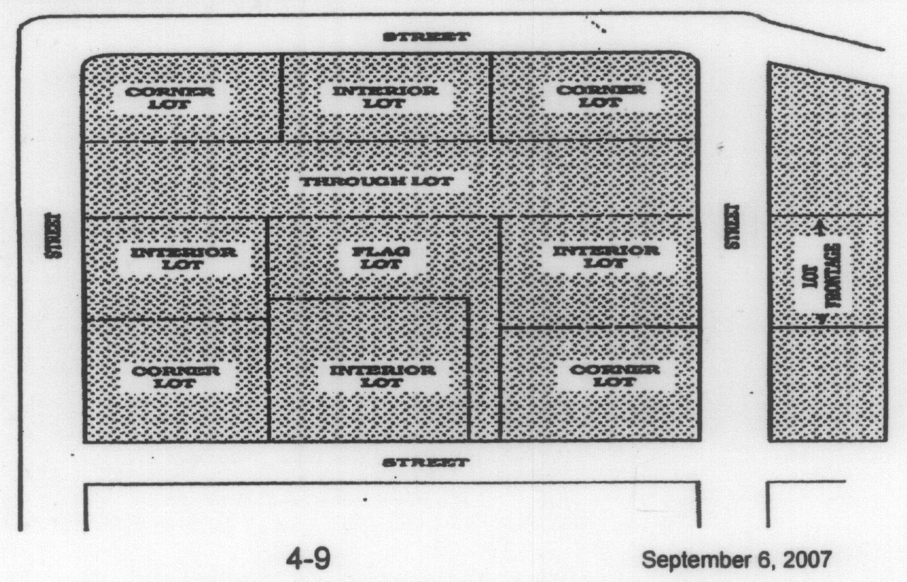
Lot, corner: A lot located at the intersection of two or more roads (See "Lot" and "Road").
Lot, depth: The horizontal distance between front and rear lot lines (See "Lot Line").
Lot, double frontage: A lot, other than a corner lot, abutting upon two or more streets. A corner lot shall be considered having double frontage if it has access on three or more sides or shows access to two streets parallel to one another (See "Lot" and "Road").
Lot, flag: An interior lot, located behind another lot, which has a narrow strip of land, as a portion of that lot, that runs along one side of the front lot to provide access to the road. A panhandle or pipe stem lot is considered a flag lot (See "Lot, flag" and "Road").
Lot, flag pole: The narrow portion of a flag lot that serves as access to a public road. The minimum width of the flagpole portion of the lot is 20 feet (See "Lot" and "Road").
Lot, interior: A lot, other than a corner lot, which has frontage on only one road other than an alley (See "Alley," "Lot," and "Road").
Lot line: A line bounding a lot which divides one lot from another or from a road or any other public or private space (See "Lot" and "Road").
Lot of record: A lot, the boundaries of which are filed as legal record (See "Lot").
Lot, through: A lot which has access to an internal subdivision road and an external collector or arterial road (See "Lot," "Road," and "Subdivision").
Lot, through or double frontage: A lot which has frontage on more than one road (See "Lot" and "Road").
Lot, width: The distance between the side lot lines, at the minimum required building setback line of a lot, as measured along a straight line parallel to the front lot line or parallel to the chord thereof (See "Lot").
Maintenance: Any action necessary to preserve stormwater management facilities in proper working condition, in order to serve the intended purposes set forth in the LDR and to prevent structural failure of such facilities.
Manufactured home: A home that is built in a factory according to the Federal Manufactured Home Construction and Safety Standards, known as the HUD Code, and is then transported and installed at its final destination.
Manufactured home park: A parcel with space, improvements and utilities for the long-term parking of three or more manufactured homes, which shall include services, utilities and facilities for the residents (See "Lot").
Manufactured home park space: A plot or ground within a manufactured home park designed for the accommodation of one unit (See "Manufactured home park" and "Unit").
Maximum extent practicable: A measure of an action or effort that is consistent with the current definition of the U.S. Environmental Protection Agency and the S.C. Department of Health and Environmental Control. An action or effort is defined as accomplishing its goal to the maximum extent practical if that action or effort is available and capable of being done after taking into consideration cost, existing technology and logistics in light of overall purpose and incremental effect of the action or effort.
Maximum flood of record: The elevation of the maximum flood of record determined by using the 100-year frequency flood elevation where such has been previously determined by published governmental data.
Mini-warehouse: A building or group of buildings in a controlled-access and fenced compound that contains individual, compartmentalized and controlled-access stalls or lockers for the dead storage of customer's goods or wares (See "Building").
Mining and mine operation: Comprises establishments that extract naturally occurring mineral solids, including but not limited to sand, fill dirt, coal and ores; liquid minerals, such as crude petroleum and gases, such as natural gas. The term mining is used in the broad sense to include quarrying, beneficiating (e.g. crushing, screening, washing, and flotation), and other preparation customarily performed at the mine site, or as a part of mining activity. Mine operation includes establishing operating mines, quarries, or other facilities on their own account or for others on a contract or fee basis.
Mixed occupancy: Any building that is used for two or more occupancies classified by different occupancy use groups (See "Building" and "Occupancy use group").
Mobile home: See Manufactured home.
Modular building unit or modular structure: Any building of closed construction, regardless of type of construction or occupancy use group, other than a mobile or manufactured home, constructed off-site in accordance with the applicable codes (International Building Code, International Residential Code, etc.) and transported to the point of use for installation or erection (See "Building," "Manufactured home," "Mobile home," and "Occupancy use group").
NPDES: National Pollutant Discharge Elimination System (See "Clean Water Act").
Nonconformity: A nonconformity is any lot of record, use, building, structure or vegetation in existence prior to the effective date of this ordinance or an amendment or revision of this ordinance, but which fails, by reason of such adoption, revision or amendment, to conform to the present requirements of the ordinance, revision, or amendment.
Non-residential use: A principal use of land for other than residential purposes, i.e. commercial, industrial, institutional (See "Use").
Nudity or a state of nudity: A state of dress which fails to opaquely and fully cover a human buttocks, anus, male or female genitals, pubic region or areola or nipple of the female breast.
Open space: A portion of a subdivision that has been set aside for permanent protection. Activities within the Open Space are restricted in perpetuity through the use of an approved legal instrument (See "Open space ratio").
Open space ratio: The open space ratio is a measure of the intensity of land use. It is arrived at by dividing the total amount of open space within the site by the total site area (See "Common open space ratio" and "Park").
Overlay district: An additional zoning requirement that is placed on a geographic area that does not change the underlying zoning.
Owners association: A private non-profit association which is organized by the developer and/or owners of a development in which individual owners share common interests in open space and/or facilities and are in charge of preserving, protecting, managing, and maintaining the common property and enforcement of the protective covenants, easements and/or restrictions (See "Developer," "Development," and "Easement").
Parcel: A land area bounded by property lines that is recognized as such by the county assessor's office. A lot or contiguous lots under the same ownership (See "Lot").
Park: A public facility open for recreation, with commercial activities for recreational uses only, open space and public gardens (See "Open space").
Performance standards: Limits imposed upon land uses with respect to their noise, vibration, toxic matter and hazardous waste, fire and explosive hazards, radioactive materials, odor, light and glare, electromagnetic interference, and smoke and particulate matter.
Person: Any and all persons, natural or artificial and includes any individual, association, firm, corporation, business trust, estate, trust, partnership, two or more persons having a joint or common interest, or an agent or employee thereof, or any other legal entity.
Plat: A map or drawing, the accuracy of which is certified by an engineer or land surveyor, upon which the developer's plan of a subdivision or land development is presented for approval (See "Subdivision").
Pollutant: Those man-made or naturally occurring constituents that when introduced to a specific environment creates a deleterious effects. Typical pollutants found in stormwater include but are not limited to sediment (suspended and dissolved), nutrients (nitrogen and phosphorus), oxygen demanding organic matter, heavy metals (iron, lead, manganese, etc.), bacteria and other pathogens, oil and grease, household hazardous waste (insecticide, pesticide, solvents, paints, etc.) and Polycyclic Aromatic Hydrocarbons (PAHs).
Precision instrument runway: A runway with an instrument approach procedure utilizing an instrument landing system (ILS) or precision approach radar (PAR).
Pre-development: The conditions that exist immediately prior to the initiation of development or construction in terms of topography, vegetation, land use and rate, volume and direction of stormwater runoff. For the purposes of the LDR, pre-development refers to the condition of a an area immediately prior to application for a development permit.
Premises: A lot, plot, or parcel of land including the buildings or structures thereon, under control by the same owner or operator (See "Building," "Lot," "Parcel," and "Structure").
Principal building: A building which contains the principal activity or use located on a zone lot on which the building is situated (See "Activity, principal," "Building," and "Use, principal").
Property owner or owner: The legal or equitable owner of land, including but not limited to a mortgagee or vendee in possession, receiver, executor, trustee, or long-term or commercial lessee, or any other person or entity holding proprietary rights in the property or having legal power of management and control of the property.
Protected property: Property which is protected from the impacts of land uses upon surrounding properties by means of specified buffering restrictions and performance standards (See "Performance standards" and "Use").
Protected property line: A property boundary or portion thereof from which, across which, or at which buffering restrictions or performance standards are measured (See "Performance standards").
Private road or private street: Any right-of-way, road, street, drive, or means of vehicular access to private properties that is not dedicated to public use (See "Road," "Street," and "Use").
Public right-of-way: Roadway surface being used by the traveling public and/or proposed to be used by the traveling public (See "Roadway").
Raised crosswalk: Speed humps outfitted with crosswalk markings and signage to be used by pedestrians.
Receiving waters: All natural water bodies, including oceans, salt and freshwater marsh areas, lakes, rivers, streams, ponds, wetlands, and groundwater. stormwater management ponds, man-made wetlands, ditches, and swales constructed for the sole purpose of controlling and treating stormwater are not considered receiving waters.
Record drawing: Drawings submitted for record purposes and which have been annotated to show significant changes in the work made during construction based upon marked up prints, drawings, and other data furnished by the Contractor to the developer, or to the developer's engineer.
Recreational vehicle: A vehicular-type portable structure without permanent foundation that can be towed, hauled, or driven and is primarily designed as a temporary living accommodation for recreational and camping purposes.
Redevelopment: A change to previously existing, improved property, including but not limited to the demolition or building of structures, filling, grading, paving, or excavating, but excluding ordinary maintenance activities, remodeling or reconstruction of buildings on the existing footprint, resurfacing of paved areas and exterior changes or improvements that do not materially increase or concentrate stormwater runoff or cause additional nonpoint source pollutions.
Reserve strip: A strip of land adjacent to a public street or similar right-of-way which has been reserved for the purpose of controlling access to the public way (See "Road").
Residence: A building or part of a building containing one or more dwelling units, including mobile homes and manufactured housing, mobile home parks and group residential activities. Residence does not include transient habitation, detention centers, nursing homes, and hospitals (See "Building," "Dwelling unit," "Manufactured housing," and "Mobile home").
Residential use: Pertaining to a residence. An attached garage is a residential use, whereas a detached garage is an accessory use. In a mixed building, that part of the structure used for non-residential purposes is not a residential use (See "Residence").
Residential use, grandfathered: Residential use in existence or permitted for construction prior to the date of the original adoption of this ordinance or the date of any applicable amendment hereto.
Responsible party: Any individual, partnership, copartnership, firm, company, corporation, association, joint stock company, trust, estate, governmental entity, or any other legal entity; or their legal representatives, agents, or assigns that is named on a stormwater inspection and maintenance agreement and plan as responsible for the long-term operation and maintenance of one or more stormwater management practices.
Restriction: Any limitation on activity, by statute, regulation or contract provision (See "Easement" and "Owner's association").
Re-subdivision: A combination or recombination of previously recorded lots or tracts of contiguous land for the purpose of creating additional lots or enlarging existing lots (See "Lot" and "Tract").
Retention: All stormwater that is collected within a development and is not directly discharged into receiving waters.
Right-of-way plan: The plan within the adopted comprehensive plan prepared by the county planning commission which defines and designates the various categories of roads within the county according to potential right-of-way needs.
Riparian buffer: A vegetated buffer strip along tidelands, streams and rivers that serves the purpose of: filtering stormwater; providing wildlife habitat; protecting water quality; and mitigation of shoreline erosion, flooding and storm surge.
Road: The terms road, highway, street, avenue and like shall be interchangeable as designators of vehicular by-ways providing access to two or more individual parcels of property. Pedestrian facilities, bridges, tunnels, viaducts, drainage structures and other appurtenances commonly considered as a component part of a road shall also be included in the definition of the term. A "road" is a vehicular by-way irrespective of prior platting or planning.
a.
Road, county: Any road currently maintained under the county road maintenance system, and any new road to be constructed within the jurisdiction of the county which accesses, or presupposes to access, two or more parcels of land under different ownership.
b.
Road, private: No road shall be designated as a private road, unless:
1.
In a new development, such proposed road is defined as such by action of the county planning commission upon its satisfaction as to the maintenance of such road; or
2.
All the owners of property accessed by such road agreed to sign an instrument and plat to be recorded in the office of the register of mesne conveyance for the county which waives county responsibility for the maintenance of such road; or
3.
The road exists prior to July 1, 1998, and accesses two or more parcels of land under different ownership, but is not in the county, state, or federal road maintenance system. This type of private road shall not suffice as approved access for further development of land.
c.
Road, nonresidential. Roads used for access to commercial, service, and industrial properties as designated by the zoning classification or to those areas exhibiting this character or intent.
d.
Road, residential. Roads used primarily to provide access from major or minor collector roads to residential units. By nature of their design, these roads serve vehicles passing through the area with either origin or destination within the area (See "Collector, major," and "Collector, minor,"). The two classes of residential roads are listed below:
1.
Road, residential sub-collector: A road which provides access to residential dwelling units and carries 400—1,250 vehicles per day. A road may not be classified a sub-collector road if it is designed in such a way that it may carry at any future date more than 1,250 vehicles per day (See "Dwelling unit"); and
2.
Road, residential local. A road providing access and/or road frontage to residential dwelling units and carries less than 400 vehicles per day. A road may not be classified as a local road if it is designed in such a way that it may carry at any time in the more than 400 vehicles per day (See "Dwelling unit" and "Street").
e.
Road classifications:
1.
Arterial. A freeway, expressway, road or highway which is intended or used for moving either heavy vehicular traffic volumes or high-speed traffic or both, or which has been designated as an arterial in the adopted county zoning ordinance.
a.
Minor arterial. Principal traffic arteries within residential or commercial areas that carry traffic from arterials to lower-order residential streets (See "Street").
2.
Collector. A road which is used or intended to be used for moving traffic from local roads to arterials and which may included the principal entrance and circulation roads of a land development, or which has been designated as a collector in the adopted county zoning ordinance.
a.
Collectors, major. Street that provides access to arterials from residential streets and carry more than 4,000 vehicles per day (See "Street").
b.
Collectors, minor. Streets that provide access to arterials from residential streets and carry 1,250 to 4,000 vehicles per day (See "Street").
3.
Local. A road which is used or intended to be used for access to abutting properties, or which has been designated as a local road in the adopted county zoning ordinance.
4.
Cul-de-sac. A local road being terminated by a vehicular turnaround.
5.
Alley (or half street). A minor, permanent private service-way which is used for secondary vehicular access to the back or the side of properties which otherwise have primary vehicular access to a public road. All alleys are to be privately maintained with measures to ensure that the travel way is not obstructed in any manner, including parking.
Roadway: That portion of a road intended for the use by vehicular traffic.
Road width: The shortest distance between the lines delineating the traveling surface of a road. For roads with curbs, the width is measured from the edge of pavement.
Roof: That part of a building or open structure which covers the interior area delineated by the walls or support structure.
Roof height (mean): The elevation located at a point two-thirds of the distance between the bottom of the roof to the roof peak as measured from the eave elevation.
Runway: A defined area on an airport prepared for landing and takeoff of aircraft along its length.
SCDOT: South Carolina Department of Transportation.
Semi-nudity or state of semi-nudity: A state of dress in which in which clothing covers no more than the genitals, pubic regions, and areola of the female breast, as well as portions of the body covered by supporting straps or devices.
Setback/setback line: The minimum horizontal distance between the street right-of-way line or front line and/or corner side lot line of a lot and the nearest wall of a building or structure adjoining such right-of-way.
Sexually oriented business: For purposes of this ordinance, sexually oriented business operations shall mean and include the following:
Adult arcade means any place to which the public is permitted or invited wherein coin-operated or slug-operated or electronically, electrically, or mechanically controlled still or motion picture machines, projectors, or other image-producing devices are maintained to show images to five or fewer persons per machine at any one time, and where the images so displayed are distinguished or characterized by the depicting or describing of "specified sexual activities" or "specified anatomical areas".
Adult bookstore or adult video store means a commercial establishment, which, as one of its principal business purposes, offers for sale or rental for any form of consideration any one or more of the following:
1.
Books, magazines, periodicals or other printed matter, or photographs, films, motion pictures, video cassettes or video reproductions, slides or other visual representations which depict or describe "specified sexual activities" or "specified anatomical areas"; or
2.
Instruments, devices, or paraphernalia, which are designed for use in connection with "specified sexual activities". A commercial establishment may have other principal business purposes that do not involve the offering for sale or rental of material depicting or describing "specified sexual activities" or "specified anatomical areas" and still be categorized as an adult bookstore or adult video store. Such other business purposes will not serve to exempt such commercial establishment from being categorized as an adult bookstore or adult video store so long as: one of its principal business purposes is the offering for sale or rental for consideration the specified materials which depict or describe "specified sexual activities" or "specified anatomical areas".
Adult cabaret means a nightclub, bar; restaurant or similar commercial establishment, which regularly features:
1.
Persons who appear in a state of nudity; or
2.
Live performances which are characterized by the exposure of "specified anatomical areas" or by "specified sexual activities"; or
3.
Films, motion pictures, videocassettes, slides, or other photographic reproductions, which are characterized by the description of "specified sexual activities" or "specified anatomical areas".
Adult motel means a hotel, motel or similar commercial establishment which:
1.
Offers accommodations to the public for any form of consideration; provides patrons with closed-circuit television transmissions, films, motion pictures, video cassettes, slides, or other photographic reproductions which are characterized by the depiction or description of "specified sexual activities" or "specified anatomical areas"; and has a sign visible from the public right-of-way which advertises the availability of this adult-type of photographic reproductions; or
2.
Offers a sleeping room for rent for a period of time that is less than ten hours; or
3.
Allows a tenant or occupant of a sleeping room to sublet the room for a period of time that is less than ten hours.
Adult motion picture theater means a commercial establishment where, for any form of consideration, films, motion pictures, video cassettes, slides or similar photographic reproductions are regularly shown which are characterized by the depiction or description of "specified sexual activities" or "specified anatomical areas".
Adult theater means a theater, concert hall, auditorium or similar commercial establishment which regularly features persons who appear in a state of nudity or live performances which are characterized by the exposure of "specified anatomical areas" or by "specified sexual activities".
Sexual encounter center means a business or commercial enterprise that, as one of its primary business purposes, offers for any form of consideration:
1.
Physical contact in the form of wrestling or tumbling between persons of the opposite sex; or
2.
Activities between male and female persons and/or persons of the same sex when one or more of the persons is in a state of nudity or seminude.
Sign: Any object, device, display or structure, or part thereof, situated outdoors or indoors, which is used to advertise, identify, display, promote direct or attract attention to an object, person, institution, organization, business, product, service, event or location by any means, including words, letters, figures, design, symbols, fixtures, colors, insignias, illumination or projected images when the same is placed in view of the general public, or viewed when traveling along a public street right-of-way, privately maintained street and access or service drives.
Sign, abandoned: A sign structure not containing a sign for 180 continuous days or a sign not in use for 180 continuous days, or a sign advertising a business no longer occupying the site on which the sign exists or to which it refers (See "Sign" and "Structure").
Sign, animated: Any sign or part of a sign that uses movement or change of lighting to depict action, gives the visual impression of movement or creates a special effect or sign. Means a sign or display that uses movement or the appearance of movement through the use of patterns of lights, changes in color or light intensity, computerized special effects, video displays, or through any other method.
Sign, audible: Any sign or part of a sign which emits any sound capable of being detected on a public road or adjoining property.
Sign, awning: A sign that is mounted, painted, or attached to an awning or other window or door canopy that is otherwise permitted by county ordinances.
Sign, banner: A temporary sign of cloth or similar material that celebrates an event, season, community, neighborhood, or district and is sponsored by a recognized community agency or organization.
Sign, bench: A sign painted on, located on, or attached to any part of the surface of a bench, seat, or chair placed on or adjacent to a public place or roadway.
Sign, billboard: A commercial sign that directs attention to a business, commodity, service, or entertainment conducted, sold, or offered at a location other than the premises on which the sign is located. Also known as "Off-premise sign" or "Off-site sign."
Sign, building: Any sign attached to any part of a building (See "Sign").
Sign, canopy: A sign attached to the underside of a canopy.
Sign, changeable copy: A sign or portion thereof with characters, letters or illustrations that is manually changed or rearranged in the field through the utilization of attachable letters, numbers, symbols and other similar characters without altering the face or the surface of the sign for the purpose of identifying products sold or services provided by the related business tenant on the same premises.
These include marquees, electric/electronic/mechanical signs, service station signs, with individual letters and numbers that can be removed and replaced by hand or mechanically.
Sign, digital: Includes: "Sign, animated"; "Sign, light emitting diode (LED)"; "Sign, static electronic message display"; "Sign, video display." See definitions for each type.
Sign, digital billboard: An off-site or off-premises animated, LED, static electronic message display, or video display sign.
Sign, directory: A sign listing only the names and/or use, or location of more than one business, activity or professional office conducted within a building, group of buildings or commercial center. This sign is located on the interior of the lot or commercial center.
Sign, electronic changeable copy: A sign or portion thereof with characters, letters or illustrations that is electronically changed or rearranged through the utilization of attachable letters, numbers, symbols and other similar characters by a small number of matrix elements using different combinations of light emitting diodes (LED's), fiber optics, light bulbs or other illumination devices within the display area for the electronic or mechanical indication of information.
Sign, face: The area or display surface used for the message.
Sign, flashing: Any electrical, directly or indirectly illuminated sign that exhibits changing natural or artificial light or color effects by any means whatsoever.
Sign, freestanding: Any non-movable sign supported by structures or supports that are placed on, or anchored in, the ground and that are independent from any building or other structure.
Sign, governmental: A sign erected and maintained pursuant to and in discharge of any governmental functions or required by law, ordinance, or other governmental regulation.
Sign, hanging: A freestanding sign supported by the extended arm of a single post or a beam between two posts.
Sign, home occupation: A sign containing only the name and occupation of a permitted home occupation.
Sign, identification: A sign giving the nature, logo, trademark, or other identifying symbol; address; or any combination of the name, symbol, and address of a building, business, development, or establishment on the premises where it is located (See "Building" and "Sign").
Sign, illuminated: Any sign which is directly or indirectly lighted by an external source.
Sign, image changing: Any sign that automatically changes images and text through the use of moving elements or automated methods.
Sign, incidental: A sign, generally informational, that has a purpose secondary to the use of the zone lot on which it is located, such as "no parking", "entrance", "loading only", "telephone", and other similar directives. No sign with a commercial message legible from a position off the lot on which the sign is located shall be considered incidental (See "Lot" and "Sign").
Sign, inflatable: Any display capable of being expanded by air or other gas and use on a permanent or temporary basis to advertise a product or event.
Sign, information: Signs containing no message, copy, announcement, or decoration other than instructions or directions to the public except for subordinate identity. Such signs include, but are not limited to, identifying the following: restrooms, public telephones, walkways, entrance and exit drives, freight entrances, and traffic directions. Information signs shall be permitted on business lots provided that no such sign shall exceed six square feet in display area. Information signs shall not count toward the maximum number of signs allowable nor the maximum display area of signs allowable.
Sign, internally illuminated: Any sign which transmits light through its face or any part thereof.
Sign, landmark: Any sign of artistic or historic merit, uniqueness, or of extraordinary significance to the community as may be identified by the local historical commission or other official agency.
Sign, light emitting diode (LED): Sign utilizing technology of diodes arranged in pixels to create messages changeable by electronic means. Said signs are sometimes referred to as electronic message centers and shall include other similar signs such as liquid crystal display signs, fiber optic signs, plasma display screen signs, incandescent signs, time-temperature-date signs or any other such sign using similar technologies.
Sign, marquee: See "Sign, changeable copy."
Sign, memorial: A sign, tablet, or plaque memorializing a person, event, structure, or site.
Sign, moving: Any sign involving any form of physical movement, including rotation.
Sign, nameplate: A sign, located on the premises, giving the name and/or the address of the owner or occupant of a building or premises.
Sign, nonconforming: A sign lawfully erected and maintained prior to the adoption of the current zoning ordinance that does not conform with the requirements of the current ordinance.
Sign, off-premises: See "Sign, billboard."
Sign, off-site: See "Sign, billboard."
Sign, pedestal: See "Sign, freestanding."
Sign, permanent: A sign attached to a building, structure or the ground in some manner and made of materials intended for more than short term use (See "Building," "Sign," and "Structure").
Sign, political: A temporary sign announcing or supporting political candidates or issues in connection with any national, state or local election (See "Sign, temporary").
Sign, portable: A sign not permanently attached to the ground or other permanent structure and designed to be transported on wheels.
Sign, project: Any sign erected and maintained on the premises temporarily while undergoing construction by an architect, contractor, developer, finance organization, subcontractor or materials vendor upon which property such individual is furnishing labor, services or material.
Sign, projecting: A sign that is wholly or partly dependent upon a building for support and that projects more than 12 inches from such building.
Sign, public and institutional: A sign relating to uses of a civic, charitable, fraternal, cultural, religious, educational, institutional, or governmental nature. Such signs shall conform to the requirements for business signs as described in article 15 of this ordinance.
Sign, residential/commercial/industrial subdivision and residential development: Permanent signs displaying no information other than the name of a subdivision or development.
Sign, roof: A sign that is mounted on the roof of a building or that is wholly dependent upon a building for support and that projects above the top edge or roof line of a building with a flat roof, the eave line of a building with a gambrel, gable, or hip roof, or the deck line of a building with a mansard roof.
Sign, sandwich board: A portable sign shaped like an A-frame with a sign panel on one or both sides where the sign panel is integral to the structure of the sign.
Sign, searchlight display: Any use of lighting intended to attract the general public by the waving or moving of light beams.
Sign, snipe: A sign which is tacked, nailed, posted, pasted, glued or otherwise attached to trees, poles, stakes or fences, or to other objects.
Sign, static electronic message display: A sign capable of displaying words, symbols, figures or images that can be electronically or mechanically changed by remote or automatic means. Displays can change through dissolve or fade transitions, or with the use of other subtle transitions and frame effects that do not have the appearance of moving text or images, but which may otherwise not have movement, or the appearance or optical illusion of movement, of any part of the sign structure, design or pictorial segment of the sign, including movement of any illumination or the flashing, scintillating or varying of light intensity.
A sign or portion thereof that displays electronic, static images, static graphics or static pictures, with or without information, defined by a small number of matrix elements using different combinations of light emitting diodes (LED's), fiber optics, light bulbs or other illumination devices within the display area where the message change sequence is accomplished immediately or by means of fade, repixelization or dissolve modes. Electronic graphic display signs include computer programmable, microprocessor controlled electronic or digital displays. Electronic graphic display signs include projected images or messages with these characteristics onto buildings or other objects.
Sign structure: The supports, uprights, bracing and framework of a sign (See "Sign, abandoned").
Sign, temporary: A sign that is used only for a limited period of time and is not permanently mounted (See "Sign").
Sign, temporary window: A window sign of a temporary nature used to direct attention to the sale of merchandise, or a change in the status of the business, including, but not limited to, sign for sales, specials, going out of business, and grand openings.
Sign, vehicle: A permanent or temporary sign affixed, painted on or placed in or upon any parked vehicle, parked trailer or other parked device capable of being towed, which is displayed in public view under such circumstances as to location on the premise, time of day, duration, availability of other parking space on the premises where it is loaded, unloaded or otherwise carries out its principal function, which circumstances indicate that the primary purpose of the display is to attract the attention of the public rather than to serve the business of the owner thereof in the manner which is customary for the vehicle.
Sign, video display: A sign that changes its message or background in a manner or method of display characterized by motion or pictorial imagery, which may or may not include text and depicts action or a special effect to imitate movement, the presentation of pictorials or graphics displayed in a progression of frames which give the illusion of motion, including but not limited to the illusion of moving objects, moving patterns or bands of light, or expanding or contracting shapes, not including electronic changeable copy signs. Video display signs include projected images or messages with these characteristics onto buildings or other objects.
Sign, wall: A sign fastened to, or painted on, the wall of a building or structure in such a manner that the wall becomes the supporting structure for, or forms the background surface of, the sign and that does not project more than 12 inches from such building or structure.
Sign, windblown: Any banner, device, or display designed to be moved by the wind which contains a written or pictorial message. Windblown signs do not include decorative flags mounted on individual poles as long as they are spaced at least 20 feet apart. Governmental and corporate flags are considered windblown signs but are exempt from the provisions of this ordinance if in compliance with article 15 of this ordinance.
Sign, window: Any sign which is painted on, applied to, attached to or projected upon or within the exterior or interior of a building glass area, including doors, or located within 15 feet of the identification, message, symbol, insignia, visual representation, logotype, or any other form which communicates information, can be read from off-premises contiguous property or public right-of-way.
Sign face: The part of the sign that is or can be used to identify, advertise or communicate information or for visual representation which attracts the attention of the public for any purpose. Sign face includes any background material, panel, trim, color and direct or self-illumination used that differentiates the sign from the building, structure, backdrop surface or object upon which or against which it is placed. The sign structure shall not be included as a portion of the sign face provided that no message, symbol or any of the aforementioned sign face criteria are displayed on or designed as part of the sign structure
Site: A parcel or parcels on which an applicant or operator proposes to conduct or conducts excavation activities or operations.
Solar collector: A solar device that absorbs and accumulates solar rays for use as a source of energy.
Solar energy: Radiant energy received from the sun collected in the form of heat or light by a solar collector to produce energy.
Solar energy system: A complete assembly consisting of one or more solar collectors and associated mounting hardware or equipment.
Solar energy system, accessory; solar electric power generation— accessory solar: A solar energy system that is roof mounted or ground mounted as a secondary activity incidental to the primary use of the property.
Solar farm: Any freestanding solar energy system as a primary land use and commercial enterprise located on a site larger than 5 acres being the minimum zoning district area requirement.
South Carolina Manufactured Housing Board: Is authorized by state statute to regulate the construction, repair, modification, installation, tie-down, hook-up, and sale of manufactured homes in South Carolina, which board has adopted for regulation of manufactured homes the Federal Manufactured Housing Construction and Safety Standards, promulgated by HUD, and contained in the board's Manufactured Housing Regulations, May 26, 1990.
Specified anatomical areas: Specified anatomical areas as used in this ordinance means and includes any of the following:
(1)
Less than completely and opaquely covered human genitals, pubic region, buttocks, anus, or female breasts below a point immediately above the top of the areola; or
(2)
Human male genitals in a discernable turgid state, even if completely and opaquely covered.
Specified sexual activities: Specified sexual activities means and includes any of the following:
(1)
The fondling or other erotic touching of human genitals, pubic region, buttocks, anus, or female breasts;
(2)
Sex acts, normal or perverted, actual or simulated, including intercourse, oral copulation, or sodomy;
(3)
Masturbation, actual or simulated;
(4)
Human genitals in a state of sexual stimulation, arousal, or tumescence; or
(5)
Excretory functions as part of or in connection with any of the activities set forth above.
Speed humps: Flat-topped asphalt speed tables constructed with a six-foot ramp followed by a ten-foot flat section then another six-foot ramp.
Storm water: Stormwater runoff, precipitation runoff, and surface runoff.
Storm water management: The collection, conveyance, storage, treatment and discharge of stormwater runoff in a manner to meet the objectives of the LDR and its terms, including, but not limited to measures that control the increased volume and rate of runoff and water quality impacts caused by manmade changes to the land.
Storm water management plan or SWMP: The set of drawings and other documents, including calculations signed and sealed by a professional engineer licensed in the state, that comprise all of the information and specifications for the programs, drainage systems, structures, BMPs, concepts, and techniques for the control of stormwater conveyance, quantity, quality and volume.
Storm water system or storm water management facilities: The conveyance or system of conveyances including roads with drainage systems, highways, right-of-way, streets, catch basins, curbs, gutters, ditches, man-made channels, storm drains, detention ponds, and other stormwater facilities.
Street: Synonymous with "Road."
Structural BMP: A device designed and constructed to reduce pollutant loading through measures including reducing the volume of surface stormwater runoff, biological uptake of pollutants, and filtering of pollutants. Structural BMPs include but are not limited to detention basins, retention basin, bioswales, and infiltration basins.
Structure: Anything constructed or erected which requires permanent location above grade. For purposes of this ordinance, "structure" does not include landscape features such as ornamental pools, planting boxes, sculpture, bird baths, open terraces, walkways, driveways, walls or fences, shelters for pets, playhouses, open stairs, recreational equipment, flagpoles, light standards, game courts, swimming pools, underground fallout shelters, air-conditioning compressors, pump houses or wells, mailboxes, outdoor fireplaces, gatehouses, burial vaults or bus shelter (See "Building").
Structural alteration: Any change in the supporting members of a building, such as the bearing walls, beams, or girders, or any change in the dimension or configuration of the roof or exterior walls (See "Building").
Subdivider: Any person, individual, firm, partnership, association, corporation, estate, trust, or any other group or combination acting as a unit, dividing or proposing to divide land so as to constitute a subdivision. This definition includes any authorized agent of the subdivider (See "Subdivision").
Subdivision: All divisions of a tract or parcel of land into two or more lots, building sites, or other divisions for the purpose, whether immediate or future, of sale, lease, or building development, and includes all division of land involving a new road or change in existing roads, and includes re-subdivision which would involve the further division or relocation of lot lines of any lot or lots within a subdivision previously made and approved or recorded according to law; or, the alteration of any roads or the establishment of any new roads within any subdivision previously made and approved or recorded according to law, and includes combinations of lots of record (See "Building," "Development," "Lot," and "Road").
Substantial improvement: Any repair, reconstruction, rehabilitation, addition, or other improvement of a structure, the cost of which equals or exceeds 50 percent of the market value of the structure before the start of construction of the improvement. This term includes structures, which have incurred substantial damage, regardless of the actual repair work performed. The term does not, however, include either: (1) any project of improvement to a structure to correct existing violations of State or local health, sanitary, or safety code specifications which have been identified by the local code enforcement official and which are the minimum necessary to assure safe living conditions (does not include Americans with Disabilities Act compliance standards): or (2) any alteration of a historic structure, provided that the alteration will not preclude the structure's continued designation as a historic structure. Permits shall be cumulative for a period of five years (See "Improvement" and "Structure").
Superelevation: The construction of a curved roadway section in which the elevation of the outside edge of the curve is higher than the elevation of the inside edge of the curve.
Temporary use: An activity or use that constitutes development; and is an activity or function of limited duration (existing for a period of no more than six months); and involves the placement of non-permanent structures; and/or involves exclusive use of a parkland, sandy beach, water, streets or parking areas which is not otherwise open and available for general public use.
Tideland: All coastal waters, marshes and wetlands influenced by the tide. Tidelands are considered "critical area" and are under the protective jurisdiction of the South Carolina Department of Health and Environmental Control, Ocean and Coastal Resource Management (OCRM).
Tract: An area, parcel, site, piece of land, or property which is the subject of a development application (See "Parcel").
Traffic calming: changes in street alignment or installation of barriers and other physical measures to reduce traffic speeds and/or cut-through volumes in the interest of safety and other purposes.
Traffic circles: Raised islands placed in intersections around which traffic circulates.
Traffic control island: The area in a roadway where vehicles are intended to be excluded. Traffic control islands are classified as follows:
Divisional islands. Islands built to separate opposing traffic flows. A continuous divisional island is a median. A divisional island located at the public entrance to a subdivision is a subdivision entrance island.
Channelization islands. Defined area between traffic lanes.
Pedestrian refuge islands. Islands built exclusively for the safety of pedestrians (See "Roadway" and "Street").
Travel trailer or recreational vehicle: A structure that (1) is intended to be transported over the streets and highways (either as a motor vehicle or attached to or hauled by a motor vehicle), and (2) is designed for temporary use as sleeping quarters, but that does not satisfy one or more of the definitional criteria of a mobile or manufactured home or modular unit (See "Mobile home," "Modular building unit," "Road," and "Structure").
Trip: A one-way movement of vehicular travel from an organization point (one trip end) to a destination point (the other trip end). For purposes of this Ordinance, trip shall have the meaning that it has in commonly accepted traffic engineering practice and that is substantially the same as the definition in the previous sentence.
Underlying fee: Ownership of property upon which a public right-of-way is physically located (See "Public right-of-way").
Understory tree: A small deciduous tree that forms the layer of vegetation under the canopy trees in a forest. Examples of such trees include dogwoods, sourwoods, fruit trees and others.
Unnecessary hardship: The deprivation resulting from application of the ordinance, so great as to effectively prevent the owner from making any reasonable use of the land. Economic hardship is precluded by state law for consideration as an unnecessary hardship. Must establish proof of each of the following:
(1)
A zoning restriction as applied to their property interferes with their reasonable use of the property, considering the unique setting of the property in its environment;
(2)
No fair and substantial relationship exists between the general purposes of the zoning ordinance and the specific restriction on the property; and
(3)
The variance would not injure the public or private rights of others.
Use: The purpose or activity, for which land or any building thereon is designed, arranged or intended, or for which it is occupied or maintained.
Use, accessory: Customary incidental uses including but not limited to home occupations, garages, swimming pools, tennis courts, and non-commercial greenhouses (See "Building, accessory" and "Use").
Use, principal: The primary purpose for which land is used (See "Building, principal" and "Use").
Utility runway: A runway that is constructed for and intended to be used by propeller driven aircraft of 12,500 pounds maximum gross weight and less.
Variance: A modification of the area regulations of this ordinance, granted by the board of zoning appeals, where such modification will not be contrary to the public interest, and where, owing to conditions peculiar to the property, a literal enforcement of the ordinance would result in unnecessary and undue hardship (See "Unnecessary hardship") in the reasonable development of the property; economic hardship shall not be a considered in the granting of any variance (See "Use, accessory" and "Use, principal").
Vegetation: Any object of natural growth.
Visual runway: A runway intended solely for the operation of aircraft using visual approach procedures.
Volume: The quantity of water that is generated by rainfall and other sources within a development.
Waiver: The modification of the minimum standards and requirements contained in the LDR and the county stormwater management design manual for specific circumstances where strict adherence of the requirements would result in unnecessary hardship and not fulfill the intent of the ordinances.
Water quality: Those characteristics of stormwater runoff that relate to the physical, chemical, biological, or radiological integrity of water.
Water quantity: Those characteristics of Stormwater runoff that relate to the rate and volume of the stormwater runoff.
Wetlands: Those areas that are inundated or saturated by surface or ground water at a frequency and duration sufficient to support, and that under normal circumstances do support, a prevalence of vegetation typically adapted for life in saturated soil conditions. Wetlands generally include swamps, marshes, bogs and similar type areas.
Wetlands, jurisdictional: Wetlands over which the U.S. Army Corps of Engineers has permitting jurisdiction (See "Wetlands").
Wetlands, non-jurisdictional: Wetlands over which the U.S. Army Corps of Engineers does not have permitting jurisdiction (See "Wetlands").
Working day: Monday through Friday, excluding all county-observed holidays.
Yard: An open space that lies between the principal or accessory building or buildings and the nearest lot line. Such yard is unoccupied and unobstructed from the ground upward except as may be specifically provided by this ordinance (See "Building, accessory," "Building, principal," and "Lot line").
Yard, front: A yard extending the full width of the front of a lot between the front (street) right-of-way line or property line and the front building line (See "Building setback line," "Lot," "Public right-of-way," "Road," and "Yard").
Yard, rear: A yard extending the full width of the lot in the area between the rear lot line and the rear building line (See "Lot" and "Yard").
Yard, required: That part of a yard between a lot line and the minimum required building setback line, within which no structure shall be located except as provided by this ordinance (See "Lot," "Setback/setback line," and "Yard").
Yard, side: A yard extending the full length of the lot in the area between the side lot line and a side building line (See "Lot" and "Yard").
Zoning ordinance: The adopted zoning ordinance of Jasper County, South Carolina, or its municipalities.
Zoning district: A specifically delineated area or district within which regulations and requirements govern the use, placement, spacing and size of land and buildings.
(Ord. No. 09-06, §§ 8, 9, 2-2-09; Ord. No. 09-12, §§ 2—4, 5-4-09; Ord. No. 09-33, §§ 1, 2, 12-14-09; Ord. No. 09-37, § 1, 11-2-09; Ord. No. 11-03, § 1, 4-18-11; Ord. No. 11-22, § 20, 10-3-11; Ord. No. 12-02, § 2, 2-21-12; Ord. No. 16-13, § 1, 7-18-16; Ord. No. 16-29, § 1, 10-3-16; Ord. No. 2017-15, § 1, 6-19-17; Ord. No. 2020-24, § 1, 1-21-20)