
Jonesboro City Zoning Code
ARTICLE V
- DISTRICT STANDARDS AND PERMITTED USES
Sec. 86-91.- Conditions of previous zoning approvals retained.
All conditions imposed as conditions of rezoning of property prior to adoption of the official zoning map are hereby retained and reaffirmed, and shall continue in full force and effect until such time as the property is rezoned or the prior zoning action of the mayor and city council is amended through the rezoning process established by article XII of this chapter.
(Ord. No. 05-08, § 2(5.01), 8-15-2005)
Sec. 86-92. - District standards.
Each zoning district contains uses that are permitted "by right," without the need for further zoning approval. Site plan approval or building permit issuance may be required prior to establishment of a use on the property. Accessory uses, that is, uses customarily incidental to the principal use may also be permitted, usually subject to certain restrictions. Conditional uses may be approved in particular zoning districts, subject to certain conditions enforced through the rezoning process. Finally, specific uses are prohibited in all zoning districts.
(Ord. No. 05-08, § 2(5.02), 8-15-2005)
Sec. 86-93. - Permitted uses and accessory uses.
Principal uses that are permitted by right in each zoning district are indicated in section 86-204, Table of uses allowed by zoning district. Accessory uses customarily incidental to principal uses are permitted.
(Ord. No. 05-08, § 2(5.03), 8-15-2005)
Sec. 86-94. - Conditional uses.
Conditional uses that may be permitted in each zoning district are also indicated in section 86-204, Table of uses allowed by zoning district. Conditions automatically assigned to certain uses are found in article VI, Conditional uses.
(Ord. No. 05-08, § 2(5.04), 8-15-2005)
Sec. 86-95. - Prohibited uses.
Certain uses are specifically prohibited in all zoning districts. These are indicated in section 86-204, Table of uses allowed by zoning district.
(Ord. No. 05-08, § 2(5.05), 8-15-2005)
Sec. 86-96. - Identification of uses.
Uses regulated under this chapter are primarily identified in the North American Industrial Classification System (NAICS), United States, 2002, published by the Executive Office of the President Office of Management and Budget. Uses not listed in section 86-204, table of uses allowed by zoning district, may be approved following an interpretation by the zoning administrator or his designee manager as provided in article II. The NAICS establishes a numbering system for a diverse range of activities. These numbers and the activities referenced are indicated in the tables for each zoning district. The NAICS numbering system is used for reference and interpretation, only; the NAICS is not adopted as part of this chapter.
(Ord. No. 05-08, § 2(5.06), 8-15-2005; Ord. No. 2023-006, § 1(Exh. A), 7-10-2023)
Sec. 86-97. - R-2 single family residential district regulations.
(a)
Purpose. The R-2 single family residential district is established to provide for single family detached dwellings on individual lots having a minimum area of one-half acre. The district is intended to create and preserve a neighborhood setting free of non-residential uses as well as higher density residential uses. Public and institutional uses traditionally found in low density neighborhoods are compatible with the R-2 district. Such development is typically served by a network of local streets to minimize traffic impacts on the neighborhood.
(b)
Development standards. Unless otherwise provided in this chapter, uses permitted in the R-2 district shall conform to the following development standards:
(1)
Minimum lot area: 21,780 square feet (½-acre)
(2)
Minimum lot width: 100 feet 1
(3)
Minimum front yard: 35 feet 2
(4)
Minimum side yard: 15 feet 3
(5)
Minimum rear yard: 35 feet
(6)
Minimum floor area per dwelling unit: 1,600 square feet
(7)
Maximum building height: Two stories and 35 feet
(8)
Maximum lot coverage: 35 percent
1
Measured at the building line.
2
The required front yard on any street classified as a collector or above shall be 40 feet.
3
The minimum side yard on the street side of a corner lot shall be 25 feet.
(c)
Design standards. Unless otherwise provided in this chapter, uses permitted in an R-2 district shall conform to the following design standards:
(1)
Off-street parking shall be provided as specified in article XIII of this chapter.
(2)
Buffers shall be provided as specified in article XV of this chapter.
(Ord. No. 05-08, § 2(5.07), 8-15-2005)
Sec. 86-98. - R-4 single family residential district regulations.
(a)
Purpose. The R-4 single family residential district is established to provide for single family detached dwellings on individual lots having a minimum area of one-quarter acre. The district is intended to create and preserve a neighborhood setting in which smaller lots are desired. While the R-4 district is primarily free of non-residential uses as well as higher density residential uses, the district may adjoin such districts and may be located near the downtown. Public and institutional uses traditionally found in relatively low density neighborhoods are compatible with the R-4 district. Such development is also typically served by a network of local streets to minimize traffic impacts on the neighborhood.
(b)
Development standards. Unless otherwise provided in this chapter, uses permitted in the R-4 district shall conform to the following development standards:
(1)
Minimum lot area: 10,480 square feet (¼-acre)
(2)
Minimum lot width: 75 feet 1
(3)
Minimum front yard: 25 feet 2
(4)
Minimum side yard: 12 feet 3
(5)
Minimum rear yard: 25 feet
(6)
Minimum floor area per dwelling unit: 1,600 square feet
(7)
Maximum building height: Two stories and 35 feet
(8)
Maximum lot coverage: 35 percent
1
Measured at the building line.
2
The required front yard on any street classified as a collector or above shall be 30 feet.
3
The minimum side yard on the street side of a corner lot shall be 20 feet.
(c)
Design standards. Unless otherwise provided in this chapter, uses permitted in an R-4 district shall conform to the following design standards:
(1)
Off-street parking shall be provided as specified in article XIII of this chapter.
(2)
Buffers shall be provided as specified in article XV of this chapter.
(Ord. No. 05-08, § 2(5.08), 8-15-2005)
Sec. 86-99. - R-C cluster residential district regulations.
(a)
Purpose. The R-C cluster residential district is established to provide for single family dwellings on relatively small, individual lots having a minimum area of 4,000 square feet. The district is intended to accommodate lifestyles featuring common greenspace adjoining privately owned yards where greenspace amenities are desired. The R-C district is particularly suited to development tracts containing sensitive natural resources such as floodplains, steep slopes or wetlands and promotes preservation of such resources in exchange for somewhat higher lot yields (in the range of four to six units per acre) and reduced utility and street lengths. Cluster residential developments are compatible with walkable, neighborhood commercial districts established in close proximity or within the cluster development.
(b)
Development standards. Unless otherwise provided in this chapter, uses permitted in the R-C district shall conform to the following development standards:
(1)
Minimum lot area: 4,000 square feet.
(2)
Minimum lot width: 40 feet. 1
(3)
Minimum front yard: 20 feet. 2
(4)
Minimum side yard: Seven feet.
(5)
Minimum rear yard: 20 feet.
(6)
Minimum floor area per dwelling unit: 1,400 square feet.
(7)
Maximum building height: Two stories and 35 feet.
(8)
Maximum density: Six units/acre.
(9)
Maximum lot coverage: 40 percent.
(10)
Minimum greenspace: 20 percent of gross acreage.
1
Measured at the building line.
2
The required front yard on any street classified as a collector or above shall be 25 feet.
(c)
Design standards. Unless otherwise provided in this chapter, uses permitted in an R-C district shall conform to the following design standards:
(1)
Off-street parking shall be provided as specified in article XIII of this chapter.
(2)
Buffers shall be provided as specified in article XV of this chapter.
(3)
A minimum of 50 percent of building lots must adjoin greenspace.
(4)
A homeowners association shall be mandatory with covenants subject to approval by the zoning administrator or his designee.
(5)
Greenspace shall be improved with walking trails and an amenity area having a minimum area of 400 square feet with equipment and facilities appropriate to the market served. Greenspace shall have a minimum width of 100 feet; trail connections between greenspace areas shall have a minimum width of 50 feet.
(Ord. No. 05-08, § 2(5.09), 8-15-2005; Ord. No. 2023-006, § 1(Exh. A), 7-10-2023)
Sec. 86-100. - R-A single-family attached residential district regulations.
(a)
Purpose. The R-A single-family attached residential district is established to provide for single-family attached dwellings on individual lots on development tracts having a minimum area of two acres on undeveloped land. The district is intended to foster housing options for households seeking high quality home ownership in park like setting featuring attractive architectural styles and building materials. As such, developments facilitated by establishment of the district are restricted to a maximum number of units to limit scale and encourage manageable homeowner associations. The R-A district is compatible with walkable, neighborhood commercial districts and low intensity office and commercial districts and is suited to locations along collector streets. The R-A single-family attached residential district also encourages the thoughtful renovation of existing buildings and infill developments for residential purposes.
(b)
Development standards. Unless otherwise provided in this chapter, uses permitted in the R-A district shall conform to the following development standards:
(1)
Minimum parent tract size: 87,120 square feet (two acres).
(2)
Minimum lot area per unit: 1,800 square feet. 1
(3)
Minimum parent tract width: 150 feet. 2
(4)
Minimum front yard: 20 feet. 3
(5)
Minimum side yard at perimeter of tract: 25 feet.
(6)
Minimum rear yard: 35 feet.
(7)
Minimum floor area per dwelling unit: 1,500 square feet.
(8)
Maximum building height: Three stories.
(9)
Maximum number of units per building: Eight.
(10)
Maximum number of units per development: 64.
(11)
Maximum density: Eight units per acre.
(12)
Minimum greenspace: 15 percent of gross acreage.
(13)
Minimum building separation:
1 This requirement may be waived for zero lot townhomes, provided the developer includes a provision in the covenants, conditions, and restrictions for the project that clearly describes the maintenance and access of all common areas, streets, alleys, and driveways.
2 Measured at the building line.
3 The required front yard on any street classified as a collector or above shall be 25 feet.
(c)
Design standards. Unless otherwise provided in this chapter, uses permitted in an R-A district shall conform to the following design standards:
(1)
Off-street parking shall be provided as specified in article XIII of this chapter. Each dwelling shall provide for a minimum two-car garage and a minimum 18-foot-wide concrete driveway.
(2)
Buffers shall be provided as specified in article XV of this chapter.
(3)
A homeowners association accompanied by recorded covenants shall be mandatory for all townhouse or condominium developments, subject to approval by the zoning administrator or his designee.
(4)
Minimum width of each townhouse unit shall be 24 feet.
(5)
A minimum of three different exterior elevations shall be provided for a townhouse development that exceeds two acres.
(6)
Townhouse building facades shall visually differentiate individual units through the use of architectural materials; a minimum of 50 percent of the front elevation shall consist of brick or stone. Brick, stone, and/or cementitious siding (which may be board, shingle, or lap siding). Variations may be approved by the community development director and/or design review commission and historic preservation commission. Split faced-concrete block, stucco, or granite block shall only be used in an accent capacity for any building elevation.
(7)
All townhouse units shall be designed to have rear entry via rear alleys. If permitted, front-loaded driveways shall be scored or finished with decorative treatment, subject to approval by the design review commission, and, if applicable, the historic preservation commission.
(8)
Greenspace shall be improved with walking trails and an amenity area having a minimum area of 400 square feet with equipment and facilities appropriate to the needs of residents. Greenspace shall have a minimum width of 100 feet; trail connections between greenspace areas shall have a minimum width of 50 feet.
(9)
An appropriate landscape plan shall be reviewed approved and reviewed by the community development director prior to installation of the landscaping.
(Ord. No. 05-08, § 2(5.10), 8-15-2005; Ord. No. 2022-001, § 1(Exh. A), 1-10-2022; Ord. No. 2022-006, § 1(Exh. A), 2-14-2022; Ord. No. 2023-006, § 1(Exh. A), 7-10-2023)
Sec. 86-101. - R-M multifamily residential district.
(a)
Purpose. The R-M multifamily residential district is established to provide for multifamily dwellings on properties having a minimum area of two acres. The district accommodates residential development at a maximum density of eight units per acre and is intended to serve a rental market in which attached units are available in a setting with common amenities and greenspace. R-M districts are expected to develop near public transit and along transportation corridors. Such developments may be established at the margin of neighborhood commercial districts, community shopping districts and employment centers, and represent a transition from office and commercial uses to lower density neighborhoods.
(b)
Development standards. Unless otherwise provided in this chapter, uses permitted in the R-M district shall conform to the following development standards:
(1)
Minimum tract area: 87,120 square feet (two acres)
(2)
Minimum lot area per unit:
a.
Duplex: 4,000 square feet
b.
Triplex: 4,000 square feet
c.
Quadraplex: 4,000 square feet
(3)
Minimum development tract width: 150 feet 1
(4)
Minimum front yard: 25 feet 2
(5)
Minimum side yard: 25 feet
(6)
Minimum rear yard: 35 feet
(7)
Minimum floor area for all individual dwelling units:
a.
One-bedroom units: 900 square feet
b.
Two-bedroom units: 1,200 square feet
c.
Three-bedroom units: 1,400 square feet
(8)
Maximum building height: Three-story and 40 feet
(9)
Maximum number of units per building: 12
(10)
Maximum density: 12 units per acre
(11)
Minimum greenspace: 20 percent of gross acreage
(12)
Minimum building separation:
1
Measured at the building line.
2
The required front yard on any street classified as a collector or above shall be 35 feet.
(c)
Design standards. Unless otherwise provided in this chapter, uses permitted in an R-M district shall conform to the following design standards:
(1)
Off-street parking shall be provided as specified in article XIII of this chapter. Each townhouse dwelling shall provide for a minimum two-car garage and a minimum 18-foot-wide concrete driveway.
(2)
Buffers shall be provided as specified in article XV of this chapter.
(3)
A homeowners association accompanied by recorded covenants shall be mandatory for all townhouse or condominium developments, subject to approval by the zoning administrator or his designee.
(4)
Minimum width of each townhouse unit shall be 24 feet.
(5)
A minimum of three different exterior elevations shall be provided for a townhouse development that exceeds two acres.
(6)
Townhouse building facades shall visually differentiate individual units through the use of architectural materials; a minimum of 50 percent of the front elevation shall consist of brick or stone. Brick, stone, and/or cementitious siding (which may be board, shingle, or lap siding). Variations may be approved by the community development director and/or design review commission and historic preservation commission. Split faced-concrete block, stucco, or granite block shall only be used in an accent capacity for any building elevation.
(7)
All townhouse units shall be designed to have rear entry via rear alleys. If permitted, front-loaded driveways shall be scored or finished with decorative treatment, subject to approval by the design review commission, and, if applicable, the historic preservation commission.
(8)
Greenspace shall be improved with walking trails and an amenity area having a minimum area of 400 square feet for every 24 units, with equipment and facilities appropriate to the needs of residents. Greenspace shall have a minimum width of 75 feet; trail connections between greenspace areas shall have a minimum width of 25 feet.
(9)
An appropriate landscape plan shall be reviewed approved and reviewed by the community development director prior to installation of the landscaping.
(Ord. No. 05-08, § 2(5.11), 8-15-2005; Ord. No. 2022-002, § 1(Exh. A), 1-10-2022; Ord. No. 2022-007, § 1(Exh. A), 2-14-2022; Ord. No. 2023-006, § 1(Exh. A), 7-10-2023)
Sec. 86-102. - H-1 historic district.
(a)
Purpose of district. The purpose of the H-1 historic district is to provide for retail and residential uses that benefit from close proximity to each other and that will generate pedestrian activity in the city's traditional downtown core. Development and redevelopment in this district is intended to preserve and enhance the historic character of the area while promoting the goals of the Livable Centers Initiative Study.
(b)
Delineation of historic district. The historic district is delineated and duly designated on the official zoning map of the city. Areas located within the historic district must comply with the requirements of this section.
(c)
Required review of exterior changes. Following designation of the H-1 district, no exterior portion of any building or other structure that can be viewed from the public right-of-way (including stone walls, fences, light fixtures, steps and pavement, or other appurtenant features) nor an aboveground utility structure, nor any permanent sign shall be erected, altered, restored or moved within such H-1 district until an application for a certificate of appropriateness as to exterior architectural features and signage has been submitted to and approved by the historic preservation commission subject to the notice and public hearing requirement(s) as set forth in O.C.G.A. § 36-66-4(g). All proposed changes requiring a certificate of appropriateness shall comply with the H-1 design standards found in subsection (l) herein.
(d)
Application for certificate of appropriateness. Application for a certificate of appropriateness shall be made by the owner or owner's agent to the director of downtown development for the city, and the certificate of appropriateness form shall be completed by the director of downtown development within 30 days and presented for review and approval by the historic preservation commission at their scheduled meeting(s). The commission shall vote to approve or deny the certificate upon review of the application, which shall be duly signed by the commission chairperson. Such approval or denial of the certificate of appropriateness is subject to the notice and public hearing requirement(s) as set forth in O.C.G.A. § 36-66-4(g).
(e)
Exterior architectural feature defined. For purposes of this section, exterior architectural features shall include architectural style, general design, and general arrangement of the exterior of a building or other structure, including the color, the kind and texture of the building material, and the type and style of all windows, doors, light fixtures, signs and other appurtenant features. In the case of outdoor advertising signs, exterior architectural features shall be construed to mean the style, material, and location of all such signs. The commission shall not consider interior arrangement and shall take no action under this section except for the purpose of preventing the construction, reconstruction, alteration, restoration, or moving of buildings, structures, appurtenant features, or outdoor advertising signs in the historic district that would be incongruous with the historic aspects of the district.
(f)
Certain changes not prohibited. Nothing in this section shall be construed to prevent the ordinary maintenance or repair of a structure in the historic district which does not involve a change in design, material, color, or outer appearance thereof, nor to prevent the construction, reconstruction, alteration, restoration, or demolition of any such feature which the code enforcement officer or fire marshall shall certify is required by the public safety because of an unsafe or dangerous condition. Such a determination by the code enforcement officer or fire marshall shall be made and documented after an examination of all alternative actions intended to result in the preservation of any feature are exhausted.
(g)
Delay in demolition of historic buildings. Following designation of an historic district, no building or structure therein shall be demolished or otherwise removed until the owner thereof shall have given the historic preservation commission via the director of downtown development's office 120 days' written notice of his proposed action. Upon receiving written notice, the city shall erect a sign on the property to indicate that the building or structure is proposed for demolition. During such 120-day period the historic preservation commission may negotiate with the owner and with any other parties in an effort to find a means of preserving the building. Should the historic preservation commission find that the building involved has no particular historic significance or value toward maintaining the character of the district, it may waive all or part of such 120-day period and authorize earlier demolition or removal. In making a determination of a building's particular historic significance, the historic preservation commission shall refer to the most recent inventory of historic buildings kept on file at the office of downtown development.
(h)
Permitted uses. The following general use classifications are permitted; refer to section 86-204, Table of uses allowed by zoning district, for actual permitted uses:
(1)
Retail uses;
(2)
Commercial services;
(3)
Arts, entertainment and recreation uses;
(4)
Office uses;
(5)
Residential uses.
Uses similar to the above listed permitted uses, as determined by the zoning administrator or his designee, may be permitted unless listed elsewhere as a prohibited use.
(i)
Conditional uses. Uses that may be allowed upon finding by the Jonesboro City Council that the proposed location and use will not disrupt the desired smaller-scale retail, pedestrian-oriented environment are found in section 86-204, Table of uses allowed by zoning district. Uses designated as conditional uses in section 86-204, Table of uses allowed by zoning district, may be permitted, subject to conditions assigned by this chapter or the city council.
(j)
Development standards.
(1)
Minimum lot area: None
(2)
Minimum lot width: 20 feet
(3)
Setbacks:
Front: Minimum and maximum setbacks shall be zero.
Side: Minimum and maximum setbacks shall be zero, except on corner lots, whereby the setback shall be no less than 20 feet to accommodate pedestrian amenities. Such amenities are required on corner lots and include decorative planters, benches, landscaping, patios, knee walls, or other architectural features that are compatible with the historic and pedestrian character of the district. The proposed number, type, and arrangement of amenities shall be reviewed and approved by the director of downtown development.
Rear: Zero, except when abutting a residential zoning district where there is no intervening right-of-way, the setback is 20 feet.
(4)
Maximum height: Three stories or 35 feet.
(5)
Minimum height: Two stories.
(6)
Minimum floor area: None for non-office uses; minimum floor area for office uses shall be 1,000 square feet.
(7)
Maximum floor area: 3,500 square feet.
(k)
Existing uses. Any use or structure existing at the time of adoption of this ordinance that would no longer be permitted or be in compliance with the current regulations shall be allowed to continue operation as is but shall be classified as a non-conforming use and subject to all applicable requirements of article X of this chapter.
(l)
Design standards. In order to preserve the physical character of existing historic structures in the H-1 historic district, every effort shall be made to adapt the property in a manner that complements the historic character of the area when making exterior alterations to the existing building, site, or environment.
(1)
Existing structures. Distinctive stylistic features or examples of skilled craftsmanship that characterize a building, structure, or site shall be retained.
a.
Storefront design.
1.
Historic details, doors, window configurations and dimensions, and entryways may not be removed or altered.
2.
The addition of architectural details where none existed before is discouraged.
3.
The use of shutters, residential doors, or the replacement of original display windows with smaller-scale window components or wall surface is prohibited.
4.
Obscuring original transom windows with plywood, paint, or other materials is prohibited.
5.
New windows on side and rear elevations shall be compatible with historic windows in terms of material, size and design.
6.
Storm windows must match the color of the window frame and obscure the window as little as possible.
7.
Infilling or painting windows is prohibited.
8.
Replacing windows with tinted or highly reflective glass is prohibited. All windows must be transparent.
b.
Roof.
1.
The existing pitch and shape of the roof as seen from public view shall be maintained, although changes hidden by existing parapets, or changes that would restore the roof to its original design, may be allowed.
2.
Replacement of existing roofing materials that can be seen from the public view shall be made with the same type of roofing materials.
3.
Ornamental roof features shall be retained.
c.
Building materials.
1.
Historic building materials shall be maintained.
2.
Unpainted brick facades shall remain unpainted.
3.
Damaged exterior materials shall be treated with materials that will not cause further deterioration, including the use of a historic mortar mix of an appropriate color when repointing brick.
d.
Awnings.
1.
Awnings shall match the shape and dimensions of the door opening or window and shall fit the frame of the window or doorway without covering architectural details.
2.
Canvas awnings are preferred; metal, rigid plastic, shingle, and internally lit awnings are generally prohibited.
3.
The use of a continuous awning across two buildings to join them as one business is prohibited.
e.
Building color.
1.
Color shades and patterns shall complement the color schemes that are found in the district. Reference materials on appropriate color palettes will be available for review at the office of downtown development at city hall.
2.
The use of neon colors is prohibited.
f.
Lighting. Lighting fixtures and wattage shall be compatible with the historic character of the district.
g.
Fences and walls.
1.
Historic fences and retaining walls shall be maintained and not removed.
2.
New fences and screening walls shall be constructed of traditional materials, typically wood for fencing and brick, stone or granite for walls.
h.
Equipment.
1.
Mechanical systems shall be placed behind the building and out of public view; any systems that must be located on the roof shall be placed to the rear of the roof.
2.
Utility meters and security lighting shall be placed unobtrusively.
3.
Dumpsters shall be placed to the rear of buildings and shall be screened from public view by fencing or walls utilizing traditional materials (see subsection (1)g.2 above.
i.
Parking.
1.
Off-street parking areas, not located in a parking deck, shall be placed to the rear of buildings and screened from public view by a wall by fencing, or by vegetation comprised of a minimum eight-foot high landscape buffer of trees and shrubbery or a minimum four-foot high continuous hedge.
2.
New surface parking, not located in a parking deck, is encouraged to use concrete or stone pavers; asphalt is also permitted in the district.
(2)
Additions. Alterations to existing properties are permitted when such alteration and additions do not destroy significant architectural or historical material. The design shall be compatible with the size, scale, color, material and character of the property and downtown area.
a.
Additions shall be placed away from public view on the rear elevation for buildings having frontage on Main and McDonough Streets, or on a rear or side elevation for all other buildings in the district.
b.
The form, orientation, and symmetry of the original structure shall be maintained.
c.
Matching or similar materials, elements (e.g., windows), and ornamentation as those found on the original structure shall be used.
(3)
New construction. New buildings shall be compatible with surrounding historic structures and shall contribute to the character to the area. Contemporary design for new construction is not discouraged when such design is complimentary to surrounding architectural styles.
a.
Placement.
1.
New buildings shall be placed at a setback equal to (for buildings fronting Main or McDonough Streets) or within ten feet of that of nearby similar historic buildings or similar buildings within the district.
2.
Orientation shall be toward the same street as nearby historic buildings.
3.
Buildings shall be placed centrally on a lot with equal spacing on each side (zero side setbacks for buildings fronting Main or McDonough Streets).
b.
Scale.
1.
Buildings shall be approximately the same width and depth as historic buildings of similar form within the district.
2.
Buildings shall be either two stories or three stories depending on the uniformity of height displayed by nearby historic buildings; building height shall not exceed 35 feet unless topography and site location allow for up to four stories. This increase in height shall require a variance request for review and approval by city council.
c.
Form.
1.
New buildings shall respect the existing form found among historic buildings in the district.
2.
Roof shapes, pitches and parapets shall be compatible with those found on nearby historic buildings.
3.
Buildings shall be comprised of a single main block rather than several secondary blocks (e.g., wings, projections, or porches).
4.
Foundations shall be compatible with the height and pattern found on similar historic buildings.
d.
Openings (windows and doors).
1.
New buildings shall use openings of similar dimensions and shape as those of nearby historic buildings.
2.
Placement or distribution of openings shall be symmetrical and in a manner similar to that of nearby historic buildings or similar buildings within the district.
e.
Materials.
1.
New buildings fronting Main and McDonough Streets are required to use brick. New buildings elsewhere in the district are required to use brick as the predominant exterior material, with stone and stucco allowed to a lesser degree and upon approval by the historic preservation commission. Synthetic stucco, variegated brick, and concrete block are prohibited throughout the district.
2.
Ornamentation shall be compatible with nearby historic buildings and shall not be used to a greater extent than nearby historic buildings.
(4)
Signs.Chapter 86, article XVI of this Code.
(Ord. No. 05-08, § 2(5.12), 8-15-2005; Ord. No. 2023-006, § 1(Exh. A), 7-10-2023)
Cross reference— Historical preservation, ch. 42.
Sec. 86-103. - H-2 historic district.
(a)
Purpose of district. The purpose of the H-2 historic district is to provide for office and commercial uses having a minimal impact on existing residential uses. Development and redevelopment in this district is intended to enhance and preserve the historic character of the area, to encourage thoughtful reuse of historic structures for non-residential purposes, to protect existing low-density residential uses in the district, and to promote the goals of the Livable Centers Initiative Study.
(b)
Delineation of historic district. The historic district is delineated and duly designated on the official zoning map of the city. Areas located within the historic district must comply with the requirements of this section.
(c)
Required review of exterior changes. From and after the designation of the H-2 district, no exterior portion of any building or other structure that can be viewed from the public right-of-way (including stone walls, fences, light fixtures, steps and pavement, or other appurtenant features) nor an aboveground utility structure, nor any type of permanent sign shall be erected, altered, restored or moved within such H-2 district until an application for a certificate of appropriateness as to exterior architectural features and signage has been submitted to and approved by the historic preservation commission. All proposed changes requiring a certificate of appropriateness shall comply with the H-2 design standards found in subsection (l) herein.
(d)
Application for certificate of appropriateness. Application for a certificate of appropriateness shall be made by the owner or owner's agent to the director of downtown development for the city, and the certificate of appropriateness form shall be completed by the director of downtown development within 30 days and presented for review and approval by the historic preservation commission at their scheduled meeting(s). The commission shall vote to approve or deny the certificate upon review of the application, which shall be duly signed by the commission chairperson. Such approval or denial of the certificate of appropriateness is subject to the notice and public hearing requirement(s) as set forth in O.C.G.A. § 36-66-4(g).
(e)
Exterior architectural feature defined. For purposes of this section, exterior architectural features shall include architectural style, general design, and general arrangement of the exterior of a building or other structure, including the color, the kind and texture of the building material, and the type and style of all windows, doors, light fixtures, signs and other appurtenant features. In the case of outdoor advertising signs, exterior architectural features shall be construed to mean the style, material, and location of all such signs. The commission shall not consider interior arrangement and shall take no action under this section except for the purpose of preventing the construction, reconstruction, alteration, restoration, or moving of buildings, structures, appurtenant features, or outdoor advertising signs in the historic district that would be incongruous with the historic aspects of the district.
(f)
Certain changes not prohibited. Nothing in this section shall be construed to prevent the ordinary maintenance or repair of a structure in the historic district which does not involve a change in design, material, color, or outer appearance thereof, nor to prevent the construction, reconstruction, alteration, restoration, or demolition of any such feature which the code enforcement officer or fire marshall shall certify is required by the public safety because of an unsafe or dangerous condition. Such a determination by the code enforcement officer or fire marshall shall be made and documented after an examination of all alternative actions intended to result in the preservation of any feature are exhausted.
(g)
Delay in demolition of historic buildings. From and after the designation of a historic district, no building or structure therein shall be demolished or otherwise removed until the owner thereof shall have given the historic preservation commission via the director of downtown development's office 120 days' written notice of his proposed action. Upon receiving written notice, the city shall erect a sign on the property to indicate that the building or structure is proposed for demolition. During such 120-day period the historic preservation commission may negotiate with the owner and with any other parties in an effort to find a means of preserving the building. Should the historic preservation commission find that the building involved has no particular historic significance or value toward maintaining the character of the district, it may waive all or part of such 90-day period and authorize earlier demolition or removal. In making a determination of a building's particular historic significance, the historic preservation commission shall refer to the most recent inventory of historic buildings kept on file at the office of downtown development.
(h)
Permitted uses. The following general use classifications are permitted; refer to section 86-204, Table of uses allowed by zoning district, for actual permitted uses:
(1)
Office uses
(2)
Residential uses
Uses similar to the above listed permitted uses, as determined by the zoning administrator or his designee and provided in section 86-96, may be permitted unless listed elsewhere as a prohibited use.
(i)
Conditional uses. Uses that may be allowed upon finding by Jonesboro City Council that the proposed location and use will not disrupt the desired smaller-scale office and residential environment of the district, and provided the proposed floor area does not exceed 3,500 square feet, are found in section 86-204, Table of uses allowed by zoning district.
(j)
Development standards.
(1)
Minimum lot area: None
(2)
Minimum lot width: 50 feet
(3)
Minimum setbacks:
Front: Building setbacks that have been established over time by historic structures, as listed on the most recent inventory of historic buildings kept on file at the office of downtown development, shall establish the minimum front setback.
Side: Five feet, except when abutting a residential zoning district where there is no intervening right-of-way, the setback requirement is ten feet.
Rear: 20 feet
(4)
Maximum height: Three stories or 35 feet
(5)
Minimum height: Two stories
(k)
Existing uses. Any use or structure existing at the time of adoption of this ordinance that would no longer be permitted or be in compliance with the current regulations shall be allowed to continue operation as is but shall be classified as a non-conforming use and subject to all applicable requirements of article X of this chapter.
(l)
Design standards. In order to preserve the physical character of existing historic structures in the H-2 historic district, every effort shall be made to adapt the property in a manner that complements the historic character of the area when making exterior alterations to the existing building, site, or environment. New construction shall also be appropriate for the district in design, placement, and scale.
(1)
Rehabilitation. Maintaining the existing historic design, materials, and details of structures in the H-2 district is encouraged. Rehabilitative efforts shall include the use of materials that are compatible with the architectural style of the historic building (see article VII, Architectural style and scale, for guidance on specific historic styles and building materials traditionally found in Jonesboro.)
a.
Roofs.
1.
The existing pitch and shape of the roof shall be maintained.
2.
The shape, style, and placement of historic dormers shall be maintained.
3.
The addition of dormers to the front facade where none previously existed is prohibited.
4.
Existing roof materials shall be replaced with the same type of historic material or with that which closely resembles the existing material.
5.
Decorative brackets, cornices, and eaves shall be maintained.
6.
Historic chimneys shall be maintained.
7.
New chimneys shall use traditional design and materials, and their placement shall be appropriate for the architectural style of the structure.
b.
Building materials.
1.
Historic building materials shall be maintained.
2.
Unpainted brick facades shall remain unpainted.
3.
Damaged exterior materials shall be treated with materials that will not cause further deterioration, including the use of a historic mortar mix of an appropriate color when repointing brick.
4.
Proper maintenance of all building materials shall adhere to the secretary of interior's standards for rehabilitation and other resources on file with the office of downtown development.
c.
Building color.
1.
Recommended color shades shall draw from the range of existing color shades and complement the color schemes that already exist in the district. Reference materials on appropriate color palettes will be available for review at the office downtown development at city hall.
2.
Neon colors are prohibited.
3.
Primary colors may be acceptable for trim or accents pending review and approval by the director of downtown development.
4.
Color patterns shall be consistent with the architectural style of the structure and with the overall historic character of the district.
d.
Foundations.
1.
The original design and materials of the foundation, open pier foundation and the porch pier foundation shall be maintained.
2.
Unpainted historic masonry foundations shall not be painted.
3.
Concrete block shall not be used as a foundation material.
e.
Details.
1.
The addition of architectural details where none previously existed is prohibited.
2.
Replacement of historic details shall be made with matching material, design, and scale versus stock details.
3.
The removal of details from a structure is prohibited.
f.
Lighting.
1.
Lighting fixtures and wattage shall be compatible with the historic character of the structure and the district.
2.
Lighting placement and wattage shall be configured to prevent glare and to prevent light trespass into residential uses.
g.
Windows.
1.
Historic windows and window arrangement shall be maintained.
2.
Damaged portions of windows, or windows damaged beyond repair, shall be replaced with windows that are comparable in design, size, and materials versus stock windows.
3.
Flat snap-in muntins, designed to resemble frames that hold panes of glass in a window, are discouraged.
4.
New windows on side elevations shall be compatible with historic windows in terms of materials, size, and design.
5.
Storm windows shall match the color of the window frame and obscure the window as little as possible.
6.
The addition of windows where none previously existed is discouraged.
7.
The addition of shutters that are not compatible with the window size and shape is discouraged.
h.
Doors.
1.
Historic doors and door placement shall be maintained.
2.
Damaged portions of doors, or doors damaged beyond repair, shall be replaced with doors that are comparable in design, size, and materials versus stock doors.
3.
New doors on side elevations shall be compatible with historic doors in terms of materials, size, and design.
4.
Storm doors shall match the color of the doorframe and obscure the door as little as possible.
5.
The addition of doors, sidelights, transoms, fanlights, or other decorative features where none previously existed is discouraged.
i.
Porches.
1.
The design, materials, roof supports and balustrades and roof shape of historic porches shall be maintained.
2.
The addition of front porches where none previously existed is discouraged.
3.
The addition of decorative elements, if desired, shall be consistent with the base architectural style of the structure.
4.
Replacement of historic porch features shall be made with matching material, design, and scale versus stock features.
5.
Porch floors and foundations shall not be replaced with slab concrete or brick.
6.
The enclosure of front or side porches shall be prohibited.
7.
The design and installation of ADA-compliant ramps onto a front porch shall seek to preserve the historic character of the buildings. Section 4.1.7 Accessible Buildings: Historic Preservation of the ADA Accessibility Guidelines, and resources of the office of downtown development, shall be used as resource guides.
j.
Walls and fences.
1.
Historic fencing and walls shall be maintained.
2.
Materials and design of fencing and walls shall be appropriate to the dwelling and to the district. Examples of appropriate materials are wood for fencing and stone for retaining walls. The use of chain link fencing material is prohibited.
k.
Walks and drives.
1.
Historic walks and drives shall be maintained.
2.
New walks and drives shall use traditional placement and materials that are appropriate to the dwelling and to the district. The use of gravel is prohibited.
3.
Parking shall be located to the rear of the dwelling or to the side behind the facade line of the dwelling.
l.
Other features.
1.
Mechanical systems (including but not limited to air conditioning units and satellite dishes), recreational equipment (including but not limited to pools and semi-permanent play structures), and decks shall be placed to the rear of the property so as to minimize visibility from the public view. Any mechanical systems that must be located on the roof shall be placed to the rear of the roof.
2.
Skylights shall be located to the rear of the roof and shall not be within public view.
3.
Compatible fencing or vegetation shall be used to screen features that are located to the rear of the property.
4.
Utility meters shall be placed unobtrusively.
5.
For commercial or office-zoned properties in the district, dumpsters shall be placed to the rear of buildings and shall be screened from public view by appropriate fencing, vegetation or walls.
(2)
New construction. New buildings shall be compatible with surrounding historic structures and shall contribute to the character to the area. Prevalent architectural styles in the district shall guide new development. (See article VII, Architectural style and scale, for guidance on specific historic styles and building materials traditionally found in Jonesboro.)
a.
Scale and form.
1.
New buildings shall be compatible with the existing scale and form of nearby historic homes in terms of foundation and story heights, roof height, shape and pitch, number of stories, width, and depth.
2.
The maximum heated floor area of infill development shall not exceed 150 percent of the average heated floor area of single family detached dwellings located on the same street for a distance of 600 feet in either direction.
3.
The maximum building height for infill development shall be determined by the maximum building height of single family detached dwellings located on the same street for a distance of 600 feet in either direction.
b.
Materials and color.
1.
The predominant exterior siding material or a modern material that creates a similar texture or appearance shall be used.
2.
The use of brick is encouraged for chimneys.
3.
Prohibited exterior materials include synthetic materials with a false wood grain, vinyl siding, brick veneer, concrete block, and the use of materials that do not complement the architectural or historic style of the structure.
4.
Brick and paint colors shall be compatible with the style of the structure and with surrounding historic structures.
5.
Neon colors are prohibited.
6.
Primary colors may be acceptable for trim or accents pending review and approval by the director of downtown development.
c.
Doors and windows.
1.
Window and door placement, shape, and dimensions shall be compatible with the pattern on nearby historic structures.
2.
Blank wall facades are discouraged.
d.
Additions.
1.
Additions shall be placed away from public view on the rear elevation or on a side elevation well behind the facade.
2.
Additions shall not obscure the form, orientation, or symmetry of the original structure, nor shall they exceed the degree of ornamentation of the original structure.
3.
Matching or compatible siding and roofing materials shall be used.
4.
Matching or compatible windows and doors shall be used.
5.
The removal of a significant portion of original materials to construct an addition is prohibited.
e.
Accessory structures.
1.
Historic accessory structures, or outbuildings, shall be maintained in accordance with guidelines for dwellings in the district.
2.
New accessory structures (including, but not limited to, carports, garages, and storage sheds) shall be located behind the facade line of the dwelling.
3.
The design, scale, placement, and materials of new structures within public view shall be compatible with those of the dwelling.
(Ord. No. 05-08, § 2(5.13), 8-15-2005; Ord. No. 2023-006, § 1(Exh. A), 7-10-2023)
Sec. 86-104. - MX mixed use district.
(a)
Purpose. MX districts may hereafter be established in accordance with the general procedures and requirements set forth in article XII, Amendments. Such areas are defined as mixed use districts for establishment of complementary groupings of residential, commercial and/or office uses. Such developments as may exist, or may have been previously approved and substantially comply with the intent of these regulations, may be rezoned to MX status and shall thereafter be subject to the regulations of the MX district.
The intent of the MX district is to provide for establishment of such districts at appropriate locations as may be identified on the Future Land Use Map of the City of Jonesboro Comprehensive Plan and are adequately served by the transportation network, including the C-Tran Bus System, and in accordance with standards set forth herein. Uses within mixed use developments shall be integrated to create walkable settings rather than isolated on individual parcels characterizing such development as could occur by traditional zoning. The MX district affords densities that would not other wise be permitted, and in exchange for such density bonuses, architectural style and site design must yield superior public venues. Accordingly, the district mandates appropriately scaled and balanced residential, commercial and office uses located in a manner that minimizes vehicular traffic congestion by providing housing proximate to principal destinations. Convenient pedestrian networks, supported by such amenities as greenspace, trails and paths, furnishings, pedestrian scale lighting and water features are hallmarks of such developments. Site design shall also serve to minimize the role of automobiles by creating deck parking that features streetfront retail or service uses, courtyard parking located in the interior of parcels and other appropriate site designs.
(b)
Development standards. Mixed use districts shall be controlled by the following development standards:
(1)
Site designs and structures shall achieve horizontal and vertical mix of uses.
(2)
Residential uses shall comprise a minimum of 25 percent of the total floor area of an MX district; similarly commercial uses shall also comprise a minimum of 25 percent of the total floor area of an MX district.
(3)
Dwelling units shall not be located on "storefront," that is, the ground floor of any fronting a street.
(4)
Ninety percent of all residential units within a MX district shall be owner-occupied units and such language shall be recorded with the declarations and covenants controlling the development.
(5)
Minimum floor area for attached dwelling units shall be as follows:
a.
One-bedroom units: 900 square feet
b.
Two-bedroom units: 1,200 square feet
c.
Three-bedroom units: 1,400 square feet
(6)
Residential uses shall be located away from major streets and other noise generators such as waste disposal facilities and loading areas to preserve privacy and tranquility.
(7)
Commercial and service uses shall be concentrated for maximum pedestrian convenience and easily accessible to residents of the development as well as employees and visitors.
(8)
Minimum tract size shall be two acres.
(9)
Building setbacks and separation and minimum lot area shall be as proposed and approved on the preliminary site plan.
(10)
A transition from more intense uses as may be located in an MX district to surrounding districts shall be achieved through designs that avoid siting mid and high rise structures or surface parking at the periphery of such developments. Greenspace and low or medium density residential uses shall be situated along common boundaries with any adjacent low density residential uses.
(11)
Landscape buffering may be used when non-residential uses abut residential uses at a common boundary in lieu of siting residential uses at the periphery of the development. Such buffer shall conform to planting standards of article XV and be a minimum of 15 feet in horizontal width; however, shall be increased in width a dimension of ten feet for each story proposed that is greater than the height of residential structures bordering the MX district.
(12)
All outside storage areas shall be located in the rear yard and shall be screened by a solid fence, wall or evergreen landscaping each having a minimum height of eight feet.
(13)
A maximum of 25 percent of the required parking area may front on a public right-of-ways. Site design shall serve to reduce the visibility of these areas and apparent size from public right-of-ways.
(14)
Signs shall be located a minimum of 100 feet from any adjacent residential district and oriented away from such districts.
(c)
Permitted principal uses and structures. Uses permitted in the MX district are presented in section 86-204, Table of uses allowed by zoning district.
(d)
Permitted accessory uses. Uses customarily accessory and clearly incidental to permitted principal uses and structures shall be permitted in this district and are presented in section 86-204, Table of uses allowed by zoning district. Devices used for electrical power generation, such as solar panels, wind generators and similar devices, are also allowed.
(e)
Prohibited uses. Uses prohibited in the MX District are presented in section 86-204, Table of uses allowed by zoning district. No building or structure height or mass greater than that of the Clayton County Courthouse shall be permitted.
(f)
Residential density permitted. Residential density in mixed use structures shall not exceed 24 dwelling units per acre. Density for single family attached structures shall not exceed 12 dwelling units per acre and density for single family detached structures shall not exceed six dwelling units per acre.
(g)
Off-street parking and loading requirements. Off-street parking shall be provided as specified in Article XIII of this chapter. Off-street parking shall be provided as follows:
(1)
Residential uses: Two spaces per dwelling unit for single family detached and single family attached structures; 1½ spaces per dwelling unit for dwellings in mixed use structures.
(2)
Recreational establishments: One per 400 square feet of floor area.
(3)
Restaurants: One per 100 square feet of floor area available to the public.
(4)
Retail uses: One per 300 square feet of floor area available to the public.
(5)
Office uses: One per 250 square feet of floor area.
(6)
Accessory outdoor dining: One per 200 square feet of dining area.
(h)
Site planning. In addition to the standards of review of the ordinance contained in article XII, the following criteria shall be used to evaluate the merits of proposals for MX district zoning.
(1)
Compatibility of the MX district with surrounding context. MX districts may be appropriate at the margin of single family detached neighborhoods; however, the district is not contemplated for locations within such neighborhoods. Development standards in rendering the proposed development compatible with the context.
(2)
Consistency with the comprehensive plan. The future land use map identifies appropriate locations for mixed use development. This document will guide the approval of any MX district application.
(3)
Architectural style and quality. The MX district conveys site design and development intensity not available in traditional zoning districts. Architectural style and the quality of building materials are expected to be superior to projects that may not enjoy such development rights. Construction consistent with high-quality environments seen in the region's premier mixed use locales will be sought in the MX district.
(4)
Integration of uses. Atlanta Regional Commission has defined mixed use as "a mix of uses is the practice of providing a number of uses in proximity to create lifestyle or transportation benefits through increasing the opportunities for walking, biking or using transit." The MX district is established to promote walkable developments where residential uses are incorporated with commercial uses in a manner that invites use of nearby and facilities and services. Designs and development scale that reinforce such integration are preferable to those that isolate residential uses from convenience services and employment opportunities. At the same time, retail and service establishments should be grouped for maximum pedestrian convenience in locations uninterrupted by residential or office occupancies. Such objectives may also be achieved by vertical separation of residential and office uses from retail and service areas to preserve the street level tradition of the latter uses.
(5)
Appropriate relationships of uses. MX site plans shall provide for the safe, efficient, convenient and harmonious grouping of structures, uses, facilities and greenspace. Such provisions shall facilitate pedestrian travel among major destinations within and adjacent to the district with a minimum of conflicts with vehicles.
(6)
Pedestrian and greenspace network. Pedestrian ways through buildings shall relate to a network of greenspaces reserved for pedestrian use. Interior and exterior pedestrian ways shall be scaled appropriately to the anticipated foot traffic volumes and form a convenient network linking major concentrations of uses within the district, and shall connect to C-Tran transit stops, both within and at the edge of the district.
(7)
Streets, parking facilities and service areas. Streets, parking facilities and service areas shall be located and designed to segregate vehicles from pedestrian focal points and gathering areas. Such segregation may be horizontal, with vehicular areas grouped in logical locations or locations at edge of the MX district and adjacent to major streets, or achieved vertically in decks above the street level.
(i)
Procedure for establishment of an MX district. Preliminary site plan, architecturals and project description. The owner or owners of the entire tract of land proposed to be included in the MX district shall file an application for rezoning. In addition to the City of Jonesboro rezoning application, the application shall consist of a preliminary site plan, architecturals and project description as described below; 10 copies of the application shall be submitted.
(1)
Preliminary site plan. The boundaries of the tract, the computed area and the legal description thereof, the topography (two-foot interval) and other salient features of the tract by reference to a plat of survey prepared by a licensed land surveyor. The preliminary site plan shall contain the following additional information:
a.
Location, type, height and floor area of all existing buildings and structures proposed to be retained or removed.
b.
Approximate location of proposed buildings and structures and an indication of the use proposed for each building.
NOTE: Broad categories of uses proposed, referencing the NAICS text, and identification of any uses proposed for prohibition, is also required. (Such information will be referenced by the city clerk in subsequent issuance of occupational tax permits throughout the life of the development).
c.
Site access, interior streets and alleys, if any, as well as parking and loading areas.
d.
Location and width of existing and proposed public rights-of-way, easements and water and drainage courses adjoining and within the tract.
e.
Interior and exterior pedestrian ways and linkages to all destinations within and adjacent to the development.
f.
Minimum standards for lot development, including lot area, building setbacks and building separation.
g.
Dwelling unit density calculated by unit type.
h.
Location of acreage planned as greenspace or recreation areas; calculation of impervious ratio.
i.
Public transportation provisions (developments served by C-Tran)
(2)
Architecturals. Full architectural plans are not required for rezoning to an MX district. Renderings, photos or other graphic depiction of the proposed structures sufficient to convey the architectural style, building mass, and exterior finish materials for all structures shall be submitted, together with the following information:
a.
Maximum floor area and ratios designated for each use.
b.
Minimum heated floor area for all dwelling units.
c.
Proposed building heights.
NOTE: Representations made at the time of rezoning as concerns the architectural information shall be referenced by the code enforcement officer in assessing the compliance of the full architectural plans. Plans that, in the opinion of the code enforcement officer, depict styles, materials or building heights not encompassed in these representations shall not be approved.
(3)
Project description. Written text describing the proposed development shall be submitted, including the following information:
a.
Proposed uses, including broad categories of uses proposed, referencing the NAICS text, and identification of any uses proposed for prohibition. (Such information will be referenced by the city clerk in subsequent issuance of occupational tax permits throughout the life of the development)
b.
A statement describing how integration of proposed uses will be achieved as well as other key provisions of subsection 86-102(a).
c.
The character of development sought.
d.
The relationship of the proposed development to the surrounding context, and approaches employed in site planning, including building and facility siting and buffering, and site access proposed to mitigate potentially adverse impacts.
e.
Site planning criteria.
(j)
Approval of an MX district. Approval of an application for an MX district shall convey to the applicant all rights associated with an approved preliminary plat. Subsequent to any required preliminary plat approval and all project improvements being installed, a final site plan shall be reviewed by mayor and council. If approved, construction shall be permitted in any portion of the MX district tract upon final plat approval by city council and issuance of building permits. The final site plan shall include all information contained on the preliminary site plan, but is not limited to, the following additional information:
a.
Greenspace and recreation area provisions, active and passive.
b.
Detailed landscaping plan, including any tree save proposed.
c.
Information concerning interior and exterior pedestrian ways and linkages as to sidewalk widths and materials, protective measures such as speed tables and pedestrian and cyclists furnishings.
d.
Detailed lighting plan, including intensity of all lighting and fixtures style of pedestrian scale lighting.
e.
Detailed information concerning parking space quantity, size, parking for disabled individuals and loading areas.
(k)
Expiration of zoning approval of an MX district. Approval of any MX district shall expire within six months of the date of adoption of the ordinance approving an amendment to the official zoning map should the applicant fail to file a final site plan that is complete, consistent with the preliminary site plan and responsive to any other conditions of zoning approval and thereby accepted by the city. Any zoning approval associated with such ordinance shall be deemed invalid and rendered of no force or effect. An extension of up to a maximum of 60 days may be granted at the sole discretion of mayor and council upon written request to the zoning administrator or his designee documenting sound reasons for any failure to present a final site plan as described above. Such request must be received by the zoning administrator or his designee 30 days prior to expiration of the zoning approval.
(l)
MX district site plan amendments. Site plans may be amended pursuant to the same procedures and subject to the same limitations by which such plans were approved and amendments to the official zoning map adopted. Minor changes, such as adjustments to the location of structures and other improvements, and use intensity and residential density (not to exceed ten percent in either instance) may be approved by mayor and council in conjunction with consideration of the final site plan. District standards shall be as approved on the site plan submitted as a condition of zoning.
(Ord. No. 05-08, § 2(5.14), 8-15-2005; Ord. No. 2023-006, § 1(Exh. A), 7-10-2023)
Sec. 86-105. - O-I office and institutional district.
(a)
Purpose. The O-I office and institutional district is established to promote development of professional and business uses in park like settings. The O-I district is intended as a transitional district, buffering single family development in particular from encroachment of more intense non-residential uses. Proximity to a variety of residential districts is also intended to enhance economic opportunity for businesses and improve resident access to business services and institutions. In order to protect the desired character of the district, residential uses and more intense uses which may adversely affect the character of this district, such as those reserved for Jonesboro's commercial and industrial, are prohibited. In a similar manner, the O-I district is limited to professional and institutional uses, and does not encompass activities involving the retail sale, storage or processing of merchandise.
(b)
Development standards.
(1)
Minimum lot area: 43,560 square feet (one acre)
(2)
Minimum lot width: 80 feet
(3)
Minimum front yard: 20 feet
(4)
Minimum side yard: 20 feet, when adjoining a residential use, otherwise zero
(5)
Minimum rear yard: 30 feet, when adjoining a residential use, otherwise zero
(6)
Maximum building floor area per story: 4,000 square feet
(7)
Maximum building height: 40 feet
(8)
Minimum building separation: per building codes
(9)
Maximum lot coverage: 60 percent
(c)
Design standards. Unless otherwise provided in this chapter, uses permitted in an O-I district shall conform to the following design standards:
(1)
Off-street parking shall be provided as specified in article XIII of this chapter.
(2)
Buffers shall be provided as specified in article XV of this chapter.
(Ord. No. 05-08, § 2(5.15), 8-15-2005)
Sec. 86-106. - C-1 neighborhood commercial district.
(a)
Purpose. The C-1 neighborhood commercial district is established to promote development of limited commercial and service establishments in close proximity to the neighborhoods they are intended to serve. Beyond limiting the range of permitted uses and the scale of individual buildings, the extent of the neighborhood commercial district itself is to be limited to ensure that consumer demand is not generated from outside the immediate neighborhood and that commercial encroachment into the neighborhood does not occur. Parking standards are relaxed to encourage walking, and pedestrian amenities are required to create and enhance a neighborhood atmosphere. The C-1 district is envisioned as a destination environment in which shoppers may access a variety of goods and services, particularly entertainment services such as restaurants. Uses that foster "one-stop" shopping such as auto parts stores are prohibited as are site plans that feature extensive parking along the right-of-way.
(b)
Development standards.
(1)
Minimum lot area: 43,560 square feet (one acre)
(2)
Minimum lot width: 80 feet
(3)
Minimum front yard: 20 feet, when adjoining a residential use, otherwise zero
(4)
Minimum side yard: 25 feet, when adjoining a residential use, otherwise zero
(5)
Minimum rear yard: 35 feet, when adjoining a residential use, otherwise zero
(6)
Maximum building floor area per story: 4,000 square feet
(7)
Maximum building height: 40 feet
(8)
Minimum building separation: per building codes
(9)
Maximum lot coverage: 70 percent
(c)
Design standards. Unless otherwise provided in this chapter, uses permitted in a C-1 district shall conform to the following design standards:
(1)
Off-street parking shall be provided as specified in article XIII of this chapter.
(2)
Buffers shall be provided as specified in article XV of this chapter.
(Ord. No. 05-08, § 2(5.16), 8-15-2005)
Sec. 86-107. - C-2 highway commercial district.
(a)
Purpose. The C-2 highway commercial district is established to accommodate intense retail and service commercial uses along Jonesboro's arterial highways. A broad range of such uses anticipates traffic from surrounding areas traveling through the city and affords a broad segment of the business community access to the large customer volumes associated with such locations. The automobile is the principal means of transit for shoppers in this district, and convenient on-premises parking is a primary concern. Given the value of arterial locations intended to capture heavy retail traffic, such industrial uses as manufacturing, distribution and processing are prohibited in order to reserve high visibility and enhanced access locations for highway commercial uses.
(b)
Development standards.
(1)
Minimum lot area: 43,560 square feet (one acre)
(2)
Minimum lot width: 100 feet
(3)
Minimum front yard: 40 feet
(4)
Minimum side yard: 30 feet, when adjoining a residential use, otherwise zero
(5)
Minimum rear yard: 40 feet, when adjoining a residential use, otherwise zero
(6)
Maximum building floor area per story: none
(7)
Maximum building height: 40 feet
(8)
Minimum building separation: per building codes
(9)
Maximum lot coverage: 80 percent
(c)
Design standards. Unless otherwise provided in this chapter, uses permitted in a C-2 district shall conform to the following design standards:
(1)
Off-street parking shall be provided as specified in article XIII of this chapter.
(2)
Buffers shall be provided as specified in article XV of this chapter.
(Ord. No. 05-08, § 2(5.17), 8-15-2005)
Sec. 86-108. - M-1 light industrial district.
(a)
Purpose. The M-1 light industrial district is established to provide for manufacturing uses having a minimal impact on the environment and surrounding land uses. The district is intended to attract a complementary mix of assembly, fabricating, distribution and warehousing, service and wholesale operations. A goal of the light industrial district is to provide architectural and site design standards that encourage development of such uses in a park setting; office components are encouraged through development incentives.
Uses that require significant infrastructure and transportation systems or substantial outdoor storage; create products in large unit sizes; utilize heavy equipment and massive production facilities; or are associated with hazardous materials, significant noise, heat, vibration or refuse generation are prohibited.
(b)
Development standards.
(1)
Minimum lot area: 87,120 square feet (two acres)
(2)
Minimum lot width: 100 feet
(3)
Minimum front yard: 40 feet 1
(4)
Minimum side yard: 50 feet, when adjoining a residential use, otherwise zero
(5)
Minimum rear yard: 50 feet, when adjoining a residential use, otherwise zero
(6)
Maximum building floor area per story: none
(7)
Maximum building height: 20 feet 2
(8)
Minimum building separation: per building codes
(9)
Maximum lot coverage: 80 percent
1 Front yard may be reduced to 25 feet when 25 percent of the floor area located at the front of the building is designated as office use.
2 Building height may be increased to 40 feet when 25 percent of the floor area located at the front of the building is designated as office use.
(c)
Design standards. Unless otherwise provided in this chapter, uses permitted in an M-1 district shall conform to the following design standards:
(1)
Off-street parking shall be provided as specified in article XIII of this chapter.
(2)
Buffers shall be provided as specified in article XV of this chapter.
New Development Standards
1 A maximum of 64 units are permitted in a single development in the R-A District.
2 A maximum of eight units per building is permitted in the R-A District; a maximum of 12 units per building is permitted in the R-M District.
(Ord. No. 05-08, § 2(5.18), 8-15-2005)
Sec. 86-109. - Tara Boulevard Overlay.
(a)
Tara Boulevard Overlay Districts—Purpose. The purpose of the Tara Boulevard Overlay District is to implement the policies of the mayor and council as adopted in the City of Jonesboro Comprehensive Plan.
(b)
Intent. The intent of the Tara Boulevard Overlay District is to:
(1)
Enhance the quality and compatibility of development in the overlay district;
(2)
Encourage appropriate redevelopment of vacant and underutilized properties;
(3)
Create developments that are aesthetically pleasing, architecturally distinct and environmentally sustainable;
(4)
Encourage a balance of uses for living, working, shopping and recreating that are conveniently accessible;
(5)
Promote safe and efficient movement for all persons using various travel modes within the overlay district including motorized vehicles, bicycles, walking and public transit;
(6)
Encourage innovative development projects that set high standards for landscaping, open space, architectural design and public amenities;
(7)
Establish consistent and relational design standards for public improvements and private property development within the overlay in order to create a distinctive visual quality for the designated overlay district;
(8)
Protect and enhance the value of properties in the overlay by ensuring that surrounding properties are developed harmoniously and consistently; and
(9)
Promote tourism within the overlay district by creating distinct and aesthetically pleasing commercial corridors.
(c)
Application of the Tara Boulevard Overlay District.
(1)
Overlay districts are supplemental to the underlying zoning districts established in the City of Jonesboro Zoning Ordinance ("zoning ordinance") that governs all properties within the city limits of Jonesboro. These overlay district regulations shall be overlaid upon areas mapped as the Tara Boulevard Overlay District in this article and shall be imposed in addition to stated underlying zoning regulations.
(2)
The standards and requirements of the overlay district shall govern in any case where those standards and requirements conflict with those of the underlying zoning district or other provisions of the zoning ordinance, including but not limited to the subdivision regulations.
(3)
Any parcel of land that is wholly or partly within the boundary shall be included in the Tara Boulevard Overlay District.
(4)
The provisions of the Tara Boulevard Overlay District shall apply to all applications for property rezonings, conditional use permits and site development plans, construction plans, preliminary plats, final plats and building permits for all property and rights-of-way within the boundaries of the Tara Boulevard Overlay District.
(5)
Uses permitted in the Tara Boulevard Overlay District shall be as allowed in the underlying zoning district, and any use prohibited or subject to conditional use approval in the underlying zoning district is similarly prohibited or subject to conditional use approval in the overlay, except as specified below:
a.
The following uses shall be prohibited in the Tara Boulevard Overlay District:
1.
522298 Pawn shop, including title pawn, both as defined in O.C.G.A. § 44-12-130(5);
2.
522390 Check cashing services in which such services are the primary use of the property;
3.
812990 Bail bonding;
4.
561320 Temporary help services;
5.
561491 Repossession services;
6.
44112 Used car dealers;
7.
48841 Motor vehicle towing and storage;
8.
81219 Tattoo parlors;
9.
713990 Billiard halls;
10.
Adult entertainment;
11.
5321 Automotive equipment rental and leasing;
12.
Palm readers and astrologers;
13.
Modeling agencies;
14.
Massage parlors;
15.
Hypnotists;
16.
Video game parlors;
17.
Flea markets.
(6)
All state and county road and utility projects shall be exempt from all requirements of the overlay district.
(d)
Overlay District Boundary Map.
(1)
Boundary map. The boundaries of the Tara Boulevard Overlay District as shown on the official zoning map, attached hereto, are hereby incorporated into section 86-73 of the zoning ordinance and made part of this overlay district. A copy of the official zoning map depicting the Tara Boulevard Overlay District is available for inspection during normal business hours in the office of city clerk. This map, dated February 24, 2014 and prepared by Dr. William H. Bailey, designates the area and boundaries of the Tara Boulevard Overlay District.
(2)
Map amendment. No change in the boundary of the overlay district shall be authorized except by the mayor and council pursuant to procedures in article XII, Amendments of the zoning ordinance.
(e)
Procedures.
(1)
Procedures for zoning amendment process. Zoning amendment, a rezoning of property, procedures for property located within the overlay district shall be as provided in article XII, Amendments of the zoning ordinance with the following modifications:
a.
Multi-modal access plan. An access plan shall be submitted showing connections from the system of streets, alleys, sidewalks and multi-use paths shown in the Clayton County conceptual transportation plan to the entrances of all occupied buildings within the property proposed for rezoning. Convenient pedestrian connections from sidewalks along streets to each building entrance, including designated pedestrian access routes across parking lots and between adjacent buildings within the same development, shall be indicated in the multi-modal access plan. Where an existing or planned public transportation station or stop is located within 1,000 feet of any boundary of the subject property, the access plan shall indicate a safe and convenient means for pedestrians traveling from such station or stop to the entrance of buildings on the subject property. Where an existing or planned multi-use path is located within 1,320 feet from any boundary of the subject property, the access plan shall indicate how safe, continuous and convenient bicycle and pedestrian access will be provided to the subject property. The method of measurement shall be the straight line distance measured from the entrance of the station or stop.
b.
Shared parking analysis. A shared parking analysis for use of shared parking shall be submitted, if applicable. Shared parking shall meet the requirements of the overlay design standards listed in section 4.18 of the [county] zoning ordinance.
(2)
Procedures for review and approval of land development requiring subdivision. Land development within the Tara Boulevard Overlay District that requires subdivision shall be as accomplished as provided in the subdivision ordinance of the City of Jonesboro, chapter 62, with the following modifications.
a.
Multi-modal access plan. An access plan shall be submitted showing connections from the system of streets, alleys, sidewalks and multi-use paths shown in the Clayton County conceptual transportation plan to the entrances of all occupied buildings within the subject property. Convenient pedestrian ways shall be shown from sidewalks along streets to each building entrance, including designated pedestrian access routes across parking lots and between adjacent buildings within the same development. Where an existing or planned public transportation station or stop is within 1,000 feet (straight line distance measured from the entrance of the station or stop) from any boundary of the subject property, the access plan shall show how pedestrians may travel safely and conveniently from such station or stop to the entrance of buildings on the subject property. Where an existing or planned multi-use path is located within 1,320 feet (straight line distance) from any boundary of the subject property, the access plan shall show how safe, continuous and convenient bicycle and pedestrian access may be provided to the subject property.
b.
Traffic impact study. A traffic impact study shall be submitted for residential developments with more than 120 dwelling units and for any non-residential developments deemed likely by the department of transportation and development to generate 100 or more p.m. peak hour trips. The traffic impact study shall follow procedures established by the most recent edition of the ITE Transportation Impact Analysis for Site Development.
c.
Shared parking analysis. A shared parking analysis for use of shared parking shall be submitted, if applicable. Shared parking shall meet the requirements of the Overlay design standards listed in section 4.18 of the [county] zoning ordinance.
d.
Sign master plan. For all multi-tenant or multi-owner developments other than single-family residential subdivisions, a sign master plan shall be submitted with the preliminary plat. The sign master plan shall contain the following information on the preliminary plat:
1.
The location, type, height and area of all proposed and existing signs.
2.
A computation of the maximum permitted number of signs, maximum permitted total sign area, and maximum permitted area for individual signs permitted under chapter 86, article XVI, Signs.
(3)
Procedures for review and approval of land development not requiring a subdivision. Land development within the overlay district that does not require subdivision shall be as provided in article VIII, Site plan procedures and requirements, with the following modifications. However, single-family lots of record are exempt from these requirements, pursuant to section 4.25 [of the county zoning ordinance], below.
(f)
Public improvement standards. Public rights-of-way within the overlay district shall be improved in accordance with the following standards:
(1)
Street standards. Street standards shall be designed in accordance with the department of transportation and development's land disturbance and right-of-way construction guidelines.
(2)
Multi-use paths.
a.
No motorized vehicles
b.
Maximum grade of six percent.
c.
20 feet wide dedicated easement.
d.
12 feet wide and concrete construction.
e.
Shoulder width variable, based on topography.
f.
Five feet flare at street intersections, with ramp to street and removable bollards spaced six feet apart to block motorized traffic. The sight visibility standards of the City of Jonesboro Thoroughfare Plan must be maintained.
g.
Multi-use paths shall be located outside all required buffers, except that a required buffer may contain one or more crossings of a multi-use path provided that such crossing may be characterized as follows:
1.
Part of an approved multi-modal access plan required in section 4.11 of the [county] zoning ordinance.
2.
Approximately perpendicular to the required buffer.
3.
Designed to have the least disruption to the intended screening provided by the required buffer.
h.
Multi-use paths shall be required in order to facilitate pedestrian access from residential and non-residential developments to schools, parks, playgrounds and other city and county amenities via the multi-use path system. If, at the time of conceptual approval, there are no completed multi-use paths to which the multi-use paths of the proposed developer can be linked, the developer may, at its option, and only with the approval of the zoning administrator, in lieu of installing the multi-use paths, dedicate the easements and deposit a cash payment with the mayor and council equal to the cost of installing the multi-use paths. This cost shall be determined by the city engineer. Such deposit shall be placed in a multi-use path construction fund to be established by the mayor and council. When the multi-use system is extended to the boundary of the development, the mayor and council will use the deposit to construct the multi-use paths in the development.
(3)
Sidewalks.
a.
All sidewalks shall have a minimum width of five feet along all roads in residentially zoned or used areas and six feet in all commercial, industrial and mixed use development areas as defined within the department of transportation and development's land disturbance and right-of-way construction guidelines.
b.
Continuous sidewalks must be provided to connect building entrances to required sidewalks along street frontage.
(4)
Street trees.
a.
Street trees shall be provided in medians and required landscaped strips adjacent to all streets rights-of-way.
b.
Landscape strips along any collector and arterial roadways shall be a minimum of ten feet wide.
c.
Street trees shall have a minimum two and one-half-inch caliper and 12 feet in height at the time of planting and be warranted by the developer for a period of two years from the date of acceptance by the City of Jonesboro.
d.
Street trees shall be spaced a minimum of 30 feet on center.
e.
Spacing of street trees and streetlight standards may be adjusted to account for driveways, utility poles, fire hydrants and other obstructions and to provide adequate visual clearance for intersections, driveways and traffic control devices.
f.
No street tree or streetlight standard shall be placed within ten feet of another tree, streetlight standard, utility pole or within five feet of a fire hydrant.
g.
Appropriate street tree species include:
1.
European hornbeam.
2.
Red maple.
3.
Hedge maple.
4.
Amur maple.
5.
Willow oak.
6.
Ginkgo.
7.
Honeylocust (hornless variety/cultivar).
8.
Foster's holly.
9.
Savannah holly.
10.
Chinese juniper.
11.
Eastern red cedar.
12.
Golden raintree.
13.
Southern magnolia.
14.
Sweetbay magnolia.
15.
Sawtooth oak.
16.
English oak.
17.
Littleleaf linden.
18.
Lacebark elm.
19.
Japanese zelkova.
h.
Other trees having similar characteristics to the above species and suitable for urban pedestrian environments, upon approval of the city arborist or his/her designee.
1.
No more than 25 percent of the total number of the trees installed may be of any one genus.
(5)
Landscaping.
a.
Medians and landscaped strips shall be planted with grass and a variety of low, hardy shrubbery and flowering plants, and/or flowering trees with mulched beds. Areas of exposed soil shall not be allowed. Landscaping shall be approved by the city arborist or his/her designees.
b.
Maintenance. All landscape materials required by this article or other article of the zoning ordinance shall be maintained by the property owner or property owners' association. Such maintenance shall maintain landscape materials in a healthy, neat and orderly manner, free of litter and debris. Landscape materials that do not survive or that, in the opinion of the city arborist or his/her designee are diseased, shall be replaced by the property owner or property owners' association. This maintenance schedule shall be perpetual.
(6)
Buffer.
a.
Where a lot on the external boundary of the Tara Boulevard Overlay District adjoins any property zoned in any residential zoning classification or in residential use, a buffer not less than 50 feet wide shall be provided. The buffer may be maintained in a natural state or landscaped so as to maintain an effective visual screen.
b.
Where a lot on the external boundary of the Tara Boulevard Overlay District adjoins the boundary of any property outside the delineated overlay district that is zoned for any non-residential zoning classification and/or non-residential use, a buffer shall be planted as identified within article XV, Landscaping and buffers.
c.
Said buffer shall not be paved and shall not be used for parking, loading, storage or any other use, except where necessary to grade or modify a portion of the buffer for installation of utilities necessitated by the development. Stormwater detention ponds shall not be located within a buffer. No trees, other than dead or diseased trees, shall be removed from a buffer; additional trees and plant material may be added to the buffer.
(7)
Street and pedestrian lighting.
a.
Streetlights of a decorative design, consistent with Clayton County Department of Transportation and Development standards shall be provided on all roadways.
b.
Additional lighting of a decorative design approved by the zoning administrator shall be provided for pedestrians and cyclists along all public streets and multi-use trails. These lights shall be a maximum of 15 feet in height with average spacing not to exceed 40 feet. When design standards call for pedestrian lighting in proximity to streetlights required in this subsection, a streetlight may substitute for pedestrian lighting that would otherwise be required at approximately the same location.
(8)
Underground utilities.
a.
Utilities along public streets must be placed underground for all new construction and redevelopment.
b.
All utilities except for major electric transmission lines and substations are required to be placed underground within a development except where the zoning administrator determines that underground utilities are not feasible due to pre-existing physical conditions, such as conflicting underground structures or utilities, shallow rock, high water table or other similar geologic or hydrologic conditions.
(g)
Development standards.
(1)
Property development standards. Property within the Tara Boulevard Overlay District shall be developed in accordance with the following standards:
a.
Density. Maximum permitted density shall be as provided in the underlying zoning district, except as provided in paragraph (2) of this subsection.
b.
Density and height bonus. Provided all requirements within this article are met, the developer of the property shall be entitled to additional intensity of use for uses authorized in the applicable zoning district and in accordance with the following tables:
(2)
Any property abutting a residentially zoned district or a residential use shall have a maximum building height no greater than 35 feet for any structure located within 40 feet of the buffer to ensure transition of the height, bulk and density of structures within the Tara Boulevard Overlay District and the properties adjacent to the overlay boundary. This requirement shall apply to the entire structure if any portion encroaches into the 40-foot zone.
(h)
Access management standards. Access management standards shall be designed and constructed in accordance with section 44-160, Curb cuts and access specifications, with the following modifications.
Vehicular access points. Minimum required points of access shall be constructed in accordance with the Table of Vehicular Access Points listed below:
(i)
Lot standards. District standards as identified within article V, District standards and permitted uses of the underlying zoning district shall govern, subject to the following modifications.
(1)
Lot width. The minimum lot width for commercial property shall be 100 feet at the right-of-way line.
a.
Reduced front setbacks. For mixed use properties in the mixed use district, the front yard setbacks may be reduced from the underlying zoning district dimensions to zero feet.
b.
Reduced side setbacks. Setbacks may vary from the underlying zoning district dimensions, provided that 15 feet exists between the exterior walls of buildings located interior to the same lot.
(j)
Open space standards. Open space requirements of the underlying zoning districts shall govern the percentage of open space required, subject to the following modifications.
(1)
Categories of open space. Open space required in the designated overlay district shall be held under unitary ownership or control and shall consist of any of the following three categories of land:
a.
Primary conservation area. This category includes streams; wetlands designated by the national wetlands inventory; 100-year floodplain, as identified on federal insurance rate maps; steep slopes exceeding 25 percent; areas of exposed rock; and private cemeteries and burial grounds. These areas shall be left in a natural and undisturbed state, except for the fewest possible perpendicular crossings of essential access roads and utility lines.
b.
Secondary conservation area. This category includes land in water supply watersheds; aquifer recharge areas identified in the City of Jonesboro Comprehensive Plan; riparian and wetland buffers that are over 25 feet in width; significant habitat areas, as identified in the City of Jonesboro Comprehensive Plan; areas containing archaeologically or historically significant structures or sites, as identified in the City of Jonesboro Comprehensive Plan; and related contextual areas, soils unsuitable for septic tanks, prime agricultural soils, mature hardwood forest, meadows, farm fields, pastures and other areas with scenic views.
c.
Outdoor recreation area. This category includes greenways, trails, bikeways, paths, tennis courts, ball fields, playfields, courts, golf courses, swimming pools, clubhouses, bicycle facilities, equestrian facilities, beaches, docks, seating areas, amphitheaters, stages, band shells, community buildings, fountains, plazas, patios, decks, lawns, picnic shelters and picnic areas, landscaping and other land containing outdoor recreation structures and facilities. Lakes and ponds are allowed in outdoor recreation areas, but their surface area shall not be counted as open space.
(2)
Impervious areas. Parking lots, drives, walks, buildings and other impervious surfaces may be included in required open space, provided that they constitute no more than ten percent of the total required open space.
(3)
Accessibility of open space. Open space shall be designed and located for the convenient access and enjoyment of all users of the property. Access to open space shall be within 1,000 feet of all occupied buildings in the development. All occupied buildings shall be connected to the open space by improved pathways or sidewalks.
(4)
Contiguous open space. Not less than 50 percent of required open space shall be in a contiguous tract.
(5)
Interconnected open space network. It is the intent of this section that the protected conservation areas, open spaces, greenways, bikeways, trails, sidewalks and outdoor recreation areas within a development that provides open space be continuous with compatible areas containing similar features on abutting property. The design of developments shall provide for maximum connections, providing pedestrian and bike access to off-site and on-site attractions such as public trails, paths, parks, and wildlife refuges; public facilities such as community centers, schools, libraries, fire and police stations, senior centers, railroad right-of-way, and utility easements; and institutions such as universities, churches, museums and other cultural facilities.
(6)
Ownership, maintenance, and control of open space. Common open space within a development shall be held in unitary ownership or control and perpetually administered and maintained by any of the following methods, either individually or in combination, and subject to approval by the city:
a.
Fee-simple dedication. Open space or common areas within developments may be offered for dedication to the public at the time of application. Dedication shall take the form of a fee simple ownership and be accepted by the mayor and council. The city may, but shall not be required to, accept undivided open space, provided that:
1.
The size, location, type of development, cost of development or maintenance of such open space or common area or the availability of public open space would make public use desirable or necessary.
2.
Such land is accessible to the public.
3.
No cost shall be incurred by the city.
4.
The developer conveys to the city a copy of the deed of conveyance and a title certificate or, at the request of the zoning administrator, a commitment for a policy of title insurance issued by an insurance company authorized to do business in the State of Georgia assuring unencumbered title for all lands proposed to be conveyed to the city, other appropriate governmental agency or other organization, including a nonprofit organization.
b.
Property owners association. The undivided open space and associated facilities may be held in common ownership in perpetuity by a property owners' association established in accordance with the laws of the State of Georgia. The association shall be formed and operated under the following additional provisions:
1.
The developer shall provide a description of the association, including its bylaws and methods for maintaining open space.
2.
The association shall be organized by the developer and shall be operated by the developer until the sale of two-thirds of the lots within the development.
3.
Membership in the association is mandatory for all purchasers of property and their successors.
4.
The association shall be responsible for perpetual maintenance of insurance and taxes on undivided open space, enforceable by liens placed by the city or any homeowner on the association.
c.
Private conservation organization. The owner of open space may transfer casements to a private, non-profit organization among whose purposes it is to perpetually conserve open space, provided that:
1.
The organization is a conservation organization with perpetual existence.
2.
The conveyance contains appropriate provisions for proper reversion or retransfer, in the event that the organization becomes unwilling or unable to continue carrying out its functions.
3.
A perpetual maintenance agreement acceptable to the city is entered into by the developer and the organization subject to the provisions of the subdivision regulations.
4.
Prior to dedication or conveyance of open space, the following documents shall be submitted to and approved by the city and such approval shall be obtained before any final plat is recorded or final site plan is approved. Such documents, once approved, shall become part of the recorded subdivision plat or approved site plan.
i.
Specification of the ownership of the common open space.
ii.
The articles of incorporation or other organizational documentation for the nonprofit organization.
iii.
The bylaws of the non-profit organization. The covenants or restrictions related to the use of common property, including the system and amounts of assessments for perpetuation and maintenance.
iv.
The covenants or restrictions related to the use of common property, including the system and amounts of assessments for perpetuation and maintenance.
v.
A document granting the right-of-entry upon such common property to the city law enforcement officers, rescue squad personnel and fire fighting personnel while in the pursuit of their duties, and, in the case of private streets and common driveways, permitting the enforcement of cleared emergency vehicle access.
vi.
A specification of methods of maintenance, responsibilities of maintenance, and a recommended time schedule for the maintenance of major facilities, including streets, street signs, pools, sidewalks, parking areas and buildings.
vii.
A guarantee that any association formed to own and maintain open space will not be dissolved without notice to the city.
viii.
A copy of the proposed notice that will be given to prospective buyers regarding the organization, assessments and fiscal program.
ix.
A specification of compulsory membership and compulsory assessment provisions.
(7)
Liens by the City of Jonesboro. In the event that the party responsible for maintenance of the open space fails to maintain all or any portion in reasonable order and condition, the city reserves the right to seek a court order allowing it to enter the property, take corrective action, and receive a judgment for the costs of corrective action as well as attorney's fees for bringing the action.
(k)
Architectural standards. The following architectural standards shall apply:
(1)
Minimum facade height. A minimum facade height of 18 feet shall be maintained on arterial and collector roadways.
(2)
Street orientation. Principal building entrances shall be oriented to public streets wherever possible. When approved by the zoning administrator, a principal building entrance may be oriented to a side yard provided said entrance is not more than 100 feet from the right-of-way of an adjacent street and directly connected to the adjacent street frontage by a continuous sidewalk not less than five feet in width.
(3)
Building materials. Buildings materials for all exterior wall facades shall be constructed of brick, stone, textured concrete masonry units, stucco, or glass. Single-family dwelling facades shall be constructed with brick, stone, stucco, cement fiber board, wood siding or similar material approved by the zoning administrator.
(4)
Color. All materials shall be earth-tone in color, as approved by the zoning administrator.
(5)
Prohibited materials. Metal siding, vinyl siding, metal canopies and smooth faced concrete masonry units are prohibited.
(6)
Exceptions. Vinyl products shall only be used for soffits, eaves, and fascia of residential structures.
(7)
Customer entrances for non-residential uses. All customer entrances located along the front façade, shall feature a combination of three or more of the following features:
a.
Canopies and porticos.
b.
Overhangs.
c.
Recesses or projections.
d.
Arcades.
e.
Raised, corniced parapets.
f.
Peaked roof forms.
g.
Arches.
h.
Display windows.
i.
Architectural details, such as tile work and moldings which are incorporated into the building structure and design.
(8)
Single-family residential. Each single-family attached and/or detached dwelling unit shall utilize at least four of the following architectural design features:
a.
Dormers.
b.
Bay or bow windows.
c.
Garage setback at least 20 feet behind the facade of the principal structure.
d.
Side- or rear-entry garage.
e.
Covered porch entry (covered front porch).
f.
Transoms and sidelights.
g.
Off-sets on building face or roof (minimum two feet).
h.
A roof with a pitch greater than 8:12 and a minimum overhang of 12 inches on all sides.
i.
Columns, pillars, or posts on facade.
j.
Shutters and other window decorations.
k.
Arched or Palladian windows.
l.
Hip and gable roof lines.
(9)
Accessory structures. Building materials, architectural features and colors of exterior finishes of accessory structures shall be consistent with the principal structure.
(10)
Massing and modulation. The massing of building facades oriented to public streets shall incorporate either modulation, defined here as a wave in the exterior wall, with horizontal breaks at least every 100 feet. Front facade design shall provide varying wall offsets and other architectural features to create horizontal (wall) and vertical building articulation.
(11)
Fenestration. At least 40 percent of non-residential facades facing arterial and collector roadways must be clear glass.
(12)
Roof features. Rooflines shall incorporate roof features (extensions, and/or projections such as a gable, parapet, dormers or others) that achieve visual interest through variation of the roofline. These features shall conform to the following specifications:
a.
Roof features shall not exceed the average height of the supporting walls.
b.
The average height of parapets shall not exceed 15 percent of the height of the supporting wall. Parapets shall feature three dimensional cornice treatments.
c.
Cornices shall have perceptible projection or overhanging eaves that extend past the supporting walls.
d.
The roof pitch of sloped roofs shall be a minimum of 4:12 (vertical to horizontal).
(13)
Rooftop equipment. All rooftop equipment shall be screened from public view by parapets, dormers or other screens.
(14)
Fencing. Chain link fencing shall not be visible from any public street.
(l)
Parking standards. Off-street parking shall be required as in article XIII, Parking, loading and interior circulation of the zoning ordinance, except as provided below.
(1)
Location. No more than 50 percent of the required number of parking spaces for a non-residential zoning district and/or use shall be located in the front yard.
(2)
Screening. Where a parking lot is adjacent to a street or public right-of-way, the parking lot shall be screened from the right-of-way by a minimum landscape strip of ten feet wide having a variety of hardy shrubbery, flowering plants, and flowering/shade trees, as approved by the city arborist, or his/her designee.
(3)
Lighting. Parking lots with more than 25 spaces must be illuminated. Lighting fixtures must minimize the diffusion of light to other properties in accordance with section 44-161, Street lighting, with the following modifications:
a.
All lighting poles and fixtures shall be decorative, as approved by the zoning administrator.
(4)
Bicycle parking. All uses that are required to provide off-street parking spaces for motorized vehicles shall also provide bicycle parking space. Uses that require up to 25 off-street parking spaces for motorized vehicles shall provide at least one bicycle space, plus a minimum of one more bicycle space for each additional 50 parking spaces required for motorized vehicles.
(5)
Shared parking. The following standards shall apply for shared parking.
a.
The zoning administrator may approve a reduction of up to 25 percent in the number of parking spaces required for a specific use where inter-parcel access is provided and a shared parking analysis, approved by the zoning administrator, demonstrates that adequate parking will be provided.
b.
A shared parking calculation projection applying the table below shall be provided that demonstrates that each use will have adequate parking provisions at all times. The process for determining the minimum parking requirements for a mixed use development or for contiguous properties containing multiple uses is:
1.
Determine the minimum number of parking spaces required for each use category from article XIII, Parking, loading and interior circulation of the zoning ordinance.
2.
Multiply each parking requirement by the corresponding percentage for each of the time periods shown on the table below.
3.
Total the number of parking spaces for each of the time periods (add together the numbers in each column).
4.
The largest column total is the minimum shared parking requirement for the development or collectively for the contiguous properties.
5.
In no case shall parking spaces that are farther than 1,000 feet from a building entrance be allowed to satisfy off street parking requirements for a use or be counted towards shared parking requirements.
c.
The combined parking requirements for two or more uses participating in a cooperative parking arrangement may be partially reduced by the zoning administrator, provided that the uses will not conflict in time of operation or need for the parking spaces and provided that the parking needs of each use at a given time of day may be adequately met through the parking arrangements.
(m)
Parking lot landscaping standards.
(1)
Parking lot landscaping shall be required as in article XV, Landscaping and buffers, of the zoning ordinance, except as provided below.
(2)
Trees shall be distributed evenly throughout the parking area. In parking areas, islands shall be located every 12 spaces.
(n)
Loading standards.
(1)
Off-street loading shall be required as in article XIII, Parking, loading and interior circulation, of the zoning ordinance, except as provided below.
(2)
Off-street loading shall be limited to the area between the rear of the principal structure and the rear lot setback line, or between the side of the principal building and the side lot setback line.
(o)
Dumpster standards. Dumpster and other refuse areas shall be required as in section 54-60 of the Code of Ordinances.
(p)
Service station standards. Gasoline pump islands shall be separated from abutting residential property by a minimum 25 feet wide landscaped buffer and an opaque fence or wall that is a minimum of six feet in height. See section 86-454 of the Code of Ordinances, Buffer regulations, for standards.
(q)
Drive-through standards. The following drive-through windows standards shall apply:
1.
Drive-through windows shall be screened from view from any dedicated rights-of-way and from adjacent residentially zoned property and/or any existing residential use.
2.
No outdoor speakers shall be used on property adjacent to residentially zoned property or any existing residential use.
(r)
Sign standards. Sign plans are required for all land development within the overlay district, as required in article XVI of this chapter, Signs.
(s)
Exceptions and exemptions from overlay districts. Applications for land disturbance permits, site development plan review, plat approval, sign permits, and building permits for properties within the designated overlay district shall meet all of the requirements of the base zoning district in which the parcel is located and all provisions of the designated overlay district unless such application meets one of the following exceptions:
(1)
Alterations to existing single-family dwellings located within a subdivision of record zoned R-2, R-4, R-C or R-A with a final plat approved prior to enactment of this section shall not be subject to the provisions of this overlay district, provided that such alterations are limited to the following actions:
a.
Additions of heated floor area less than 50 percent of the existing floor area.
b.
Construction of an accessory structure or garage not to exceed 750 square feet in floor area.
c.
Improvements to outdoor space, such as swimming pools, courts for basketball, tennis or handball, gazebos, trellises, patios, decks, balconies, and similar non-occupied structures, or interior renovations.
(2)
Construction of a single-family dwelling on an existing lot of record zoned R-2, R-4, R-C or R-A within a single-family residential subdivision with a final plat approved prior to enactment of this section shall not be subject to the provisions of this ordinance provided that such new construction shall be of similar floor area, materials and design as the single-family dwellings on adjacent lots in the same subdivision. Similar floor area for the purposes of this subsection means not more than 20 percent greater than the average heated floor area of the structures located on the abutting residential properties.
(3)
Replacement, reconstruction, restoration, or repair of a single-family dwelling that is destroyed or damaged by fire or other natural occurrence shall not be subject to the provisions of this overlay, provided that such dwelling is located on an existing lot of record zoned for a residential use within a single-family residential subdivision with a final plat approved prior to enactment of this section, and provided that such new construction shall be of similar floor area, materials and design as the single-family dwellings on adjacent lots in the same subdivision. Similar floor area for the purposes of this subsection means not more than 20 percent greater than the average heated floor area of the structures located on the abutting residential properties.
(4)
Construction, rehabilitation, restoration and repair of a non-residential structure existing prior to the enactment of this section shall not be subject to those provisions of the overlay until such time as the cumulative effect of all permits on a single parcel result in an increase in the total floor area of the existing structure by 50 percent or 5,000 square feet, whichever is less.
a.
Multi-modal access plan. An access plan shall be submitted showing connections from the system of streets, alleys, sidewalks and multi-use paths shown in the conceptual transportation plan to the entrances of all occupied buildings within the subject property. Convenient pedestrian ways shall be shown from sidewalks along streets to each building entrance, including designated pedestrian access routes across parking lots and between adjacent buildings within the same development. Where an existing or planned public transportation station or stop is within 1,000 feet (straight line distance measured from the entrance of the station or stop) from any boundary of the subject property, the access plan shall show how pedestrians may travel safely and conveniently from such station or stop to the entrance of buildings on the subject property. Where an existing or planned multi-use path is located within 1,320 feet (straight line distance) from any boundary of the subject property, the access plan shall show how safe, continuous and convenient bicycle and pedestrian access may be provided to the subject property.
b.
Traffic impact study. A traffic impact study shall be submitted for residential developments with more than 120 dwelling units and for any non-residential developments deemed likely by the department of transportation and development to generate 100 or more p.m. peak hour trips. The traffic impact study shall follow procedures established by the most recent edition of the ITE Transportation Impact Analysis for Site Development.
c.
Shared parking analysis. A shared parking analysis for use of shared parking shall be submitted, if applicable. Shared parking shall meet the requirements of the overlay design standards listed in article 4, section 4.18 of the Clayton County Zoning Ordinance, incorporated here below.
d.
Signage master plan. For all multi-tenant or multi-owner developments other than single-family residential subdivisions, a signage master plan shall be submitted at the time of review of the preliminary plat. The signage master plan shall contain the following information on a copy of the preliminary plat:
1.
Provide a computation for each proposed sign and/or existing sign to remain, except for window signs and temporary signs, indicate the proposed number of signs and the total sign area of such signs, the proposed location, type, height, and sign area of each sign.
2.
Provide a computation of the maximum permitted number of signs, maximum permitted total sign area, and maximum permitted area for individual signs permitted under article XVI of this chapter, Signs.
(t)
Surety standards. The applicant shall provide a surety, performance guarantee or post performance bonds in a form acceptable to the City of Jonesboro in order to guarantee timely installation of required project improvements such as, but not limited to, streets, utilities, drainage, sidewalks, landscaping, amenity/recreation areas and multi-use trails within the development depicted on the approved preliminary plat, site plan, or final plat and consistent with the Tara Boulevard Overlay Design Guidelines. The surety, performance guarantee or performance bonds shall be provided in accordance with the provision of section 44-127. Subdivision improvement guarantees of the subdivision regulations with the following modification:
(1)
The surety shall be provided simultaneously with the submittal of construction drawings and prior to issuance of a grading and soil erosion and sedimentation control permit.
(u)
Appeals. Appeals of final decisions of the zoning administrator by aggrieved persons shall be filed in accordance with article II of the zoning ordinance, Administration, appeals, enforcement and penalties. Furthermore, appeals of this ordinance may be heard by the mayor and council in accordance with article XI of the zoning ordinance, Appeals and variances.
(Ord. No. 05-08, § 2(5.19), 8-15-2005; Ord. No. 2014-002, § 1, 2-10-2014; Ord. No. 2015-008b, § 1, 8-10-2015)
Sec. 86-110. - Assembly overlay.
(a)
Purpose. The purpose of the assembly overlay is to accommodate the beneficial development of "places of assembly" as defined in section 86-62, Definitions, and appropriately regulate such uses in a non-discriminatory manner. The express intention of mayor and council in the event of any ambiguity in the language of this section mandates that the administration and city staff interpret this section in a manner that best complies with all applicable federal laws, including, but not limited to, 42 U.S.C.A. § 2000cc et seq.
(b)
Applicability. The assembly overlay establishes the parameters within which places of assembly may be established and operated. The assembly overlay supplements zoning regulations set forth by the underlying or base zoning assigned to properties on the official zoning map that control the use and development of those properties. Unless otherwise provided, the legal use of property as defined by the underlying zoning district may continue. Standards set forth in this section shall control over any underlying district regulations. Development regulations not addressed in this section as provided by the underlying zoning classification shall control unless modified by mayor and council as a condition of assignment of the assembly overlay to a particular property.
(c)
Geography. Assignment of the assembly overlay is as depicted graphically on the official zoning map. Properties included in the assembly overlay shall be shown on this map and shall include any property subsequently so designated by mayor and council.
(d)
Administrative approval of compliant places of assembly. Applications for establishment of places of assembly that comply with the regulations set forth in this section may be approved administratively by the code enforcement officer. In considering the appropriateness of an approval of a place of assembly, the code enforcement officer shall apply the standards contained in article XII, section 86-374. Standards of review for map amendments of the Jonesboro Zoning Ordinance and the potential impacts on surrounding development, operating schedule, parking demand relative to supply and peak traffic impacts. Applications that do not comply with these regulations may be approved by mayor and council as a conditional use.
(e)
Mayor and council approval of non-compliant places of assembly. Places of assembly can exert extraordinary demands upon public services and facilities, particularly when established within certain timeframes or in certain locations. Accordingly, applications for places of assembly that do not comply with the assembly overlay regulations may only be established upon approval of a conditional use by mayor and council. The approval process pertaining to places of assembly shall be that assigned conditional uses as described in article VI, Conditional uses. In determining whether an application for such conditional use shall be approved at a particular location, mayor and council shall apply the standards contained in article XII, section 86-374 of the Jonesboro Zoning Ordinance. Mayor and council shall also consider the potential impacts on surrounding development, noise impacts, peak traffic impacts and demand on public services and facilities. Upon a finding that a particular assembly use would conform to the intent and requirements of this section, the application may be approved by mayor and council as a conditional use. Based upon particular circumstances associated with a proposed assembly use at a specific location, mayor and council may attach conditions to the approval that are designed to minimize potential negative impacts and burdens on public facilities and services as well as surrounding properties and travelers on public streets and sidewalks.
(f)
Characterization of places of assembly as concerns scale. Places of assembly are hereby characterized as either "large places of assembly" or "small places of assembly." This characterization is designed to ensure that proposals for establishment of places of assembly are compatible with the scale, use and intensity of surrounding development and may be accommodated by available public infrastructure and services. For purposes of this section "large places of assembly" are defined as those premises or facilities designed to accommodate 50 or more persons at any given time; "small places of assembly" are defined as those premises or facilities designed to accommodate fewer than 50 at any given time. Capacity shall be as measured by the premises or facility occupancy, including indoor and outdoor spaces available to participants, as determined by the fire marshall.
(g)
Standards for establishment of all places of assembly. The following development standards shall apply to any place of assembly.
(1)
Parking and loading regulations. Parking and loading shall be as specified in article XIII, Parking, loading and interior circulation. No parking shall be established within 25 feet of a lot that is zoned residential or containing a residential use.
(2)
Fire and life safety compliance. No permit for establishment of a place of assembly shall be granted prior to an inspection and approval for compliance with all fire and life safety codes by the fire marshall.
(3)
Places of assembly may not be established on lots with zero lot line development or parking in common. Because of the potential noise impacts and peak parking demand, places of assembly shall not be established on properties that share a common wall with adjoining tenant spaces or properties. Similarly, because of the peak parking demand associated with such uses, places of assembly shall not be established on properties that share a common parking area.
(4)
Street network. The potential for creating traffic congestion during peak periods and for excessive on-street parking during peak periods is substantial. Therefore, no assembly use shall be permitted on a lot accessed by a local street as defined by the City of Jonesboro Thoroughfare Plan. Assembly uses shall only be permitted on roadways classified as "major collector street" or roadways having greater capacity as defined by the City of Jonesboro Thoroughfare Plan.
(5)
Buffers. The potential for adverse visual impacts such as glare and noise impacts on adjoining and nearby residential uses by assembly uses is substantial. Therefore, buffers are required for the protection of adjoining residential properties. A natural or manmade, landscaped buffer in compliance with section 86-457. Landscape strip planting requirements of this chapter and the following schedule shall be maintained along the boundary of any property designated as an assembly overlay that abuts property on which a residential use is established or property zoned for residential use:
a.
Residential uses or districts. A buffer having a minimum horizontal dimension of 30 feet shall be established, provided such buffer may be reduced to 25 feet where a berm having a minimum height of three feet is created.
b.
Buffers shall be permanently maintained as indicated on the approved site plan, subject to inspection by the code enforcement officer, and consistent with any other property improvement. The dimension of the buffer shall not be in addition to any other landscaping requirements of this chapter. As the purpose of the buffer is to visually screen and distance uses of the assembly overlay from adjoining uses, one-half of all plant materials shall consist of one or more species that retain foliage throughout the year. Provision of opaque fencing, though desirable, shall not decrease the horizontal dimension of the required buffer.
(h)
Standards for establishment of large places of assembly. The following development standards shall apply to large places of assembly.
(1)
Area regulations.
a.
Minimum lot area. The minimum lot area required for establishment of a large place of assembly shall be two acres.
b.
Minimum lot width. The minimum lot width required for establishment of a large place of assembly shall be 200 feet.
c.
Minimum front yard. None.
d.
Minimum rear yard. Ten feet; 30 feet when abutting a residential district or use.
e.
Minimum side yard on street side of a corner lot. None.
f.
Minimum side yard. Five feet; 30 feet when abutting a residential district or use.
g.
Maximum ground coverage by buildings and impervious surfaces. Ninety percent.
(2)
Height regulations. The maximum height for buildings abutting a residential district or use shall be three stories or 35 feet as measured at any point 30 feet from any common property line. Building height may be increased one foot for every additional foot beyond a distance of 30 feet from any common property line. No building shall exceed a height of 75 feet.
(i)
Standards for establishment of small places of assembly. The following development standards shall apply to small places of assembly.
(1)
Area regulations.
a.
Minimum lot area. The minimum lot area required for establishment of a small place of assembly shall be one-half-acre.
b.
Minimum lot width. The minimum lot width required for establishment of a small place of assembly shall be 100 feet.
c.
Minimum front yard. The lesser of 25 feet or the average front yard setback of any dwellings within 100 feet of the assembly lot on the same block face.
d.
Minimum rear yard. Ten feet; 30 feet when abutting a residential district or use.
e.
Minimum side yard on street side of a corner lot. None.
f.
Minimum side yard. Five feet; 30 feet when abutting a residential district or use.
g.
Maximum ground coverage by buildings and impervious surfaces. Seventy percent.
(2)
Height regulations. The maximum height for buildings abutting a residential district or use shall be three stories or 35 feet as measured at any point 30 feet from any common property line. Building height may be increased one foot for every additional foot beyond a distance of 30 feet from any common property line. No building shall exceed a height of 45 feet.
(j)
Existing place of assembly uses. No assembly use existing as of the date of adoption of this chapter and designated on the official zoning map shall become a nonconforming use as a result of adoption of this article.
(Ord. No. 05-08, § 2(5.20), 8-15-2005; Ord. No. 2014-003, § 1, 6-9-2014)
Sec. 86-111. - Historic residential overlay.
(a)
Purpose. The purpose of the historic residential overlay is to protect and enhance the character of the city's historic neighborhoods by establishing architectural standards for regulation of exterior rehabilitation and new construction. The City of Jonesboro is committed to preserving its historic structures and the special character of the historic neighborhoods. These neighborhoods reflect a variety of architectural styles that have contributed to the city's historic built environment.
(b)
Applicability. The City of Jonesboro has been organized into several historic property groups, (1) the National Register District shall be subject to the provisions of the H-1 or H-2 zoning districts, as appropriate; (2) historic residential properties located within the historic residential overlay shall be subject to the provisions of the historic residential overlay and the provisions of article VII (3) historic commercial properties located within the historic residential overlay shall be subject to the architectural standards of the H-2 district found in subsection 86-103(l), Design standards; and (4) residential properties found outside the National Register District and the historic residential overlay shall be subject to the provisions of article VII.
The historic residential overlay supplements zoning regulations that control the use and development of properties in the overlay. These supplemental regulations focus on architectural standards designed to protect and enhance the historic residential structures and character of properties encompassed in the overlay. Land and buildings within the overlay shall continue to be used in accordance with standards of the underlying zoning district. Where any part of this article conflicts with other standards of this zoning ordinance, the more restrictive standard shall control.
(c)
Geography. The geography of the historic residential overlay is defined as residential properties that have been determined by the city to have historical significance based on architectural style and building age. The overlay is depicted graphically on the official zoning map.
(d)
Scope. The historic residential overlay shall control all rehabilitation or modification to exterior portions of any building or other structure visible from the public right-of-way (including stone walls, fences, light fixtures, steps and pavements, or other appurtenant features), as well as new construction, including additions to existing buildings. Nothing in this section shall be construed to prevent the ordinary maintenance or repair of a structure in the overlay which does not involve a change in design, material, color, or outer appearance thereof.
(e)
Required review of exterior changes. No exterior portion of any building or other structure visible from the public right-of-way (including stone walls, fences, light fixtures, steps and pavement, or other appurtenant features) shall be erected, altered, restored or moved within the overlay until an application for a certificate of appropriateness as to exterior architectural features has been submitted to and approved by the historic preservation commission. The commission shall not consider interior arrangement and shall take no action under this section except for the purpose of preventing the construction, reconstruction, alteration, restoration, or moving of buildings, structures, or appurtenant features in the overlay which would be incongruous with its historic aspects. All proposed changes requiring a certificate of appropriateness shall comply with the architectural design standards of subsection (g) below.
(f)
Application for certificate of appropriateness. Applications for a certificate of appropriateness shall be made by the owner or owner's agent to the director of downtown development for the city, and the certificate of appropriateness form shall be completed by the director of downtown development within 30 days and presented for review and approval by the historic preservation commission at their scheduled meeting(s). The commission shall vote to approve or deny the certificate upon review of the application, which shall be duly signed by the commission chairperson. Such approval or denial of the certificate of appropriateness is subject to the notice and public hearing requirement(s) as set forth in O.C.G.A. § 36-66-4(g).
(g)
Architectural design standards. The following standards shall control renovation, new construction and development in the historic residential overlay:
(1)
Rehabilitation. Careful maintenance of the existing historic design, materials and details of structures in the overlay is encouraged. Rehabilitative efforts shall include the use of materials compatible with the architectural style of the historic structure (see article VII, Architectural style and scale for guidance on specific historic styles and building materials traditionally found in Jonesboro).
a.
Roofs.
1.
The existing pitch and shape of the roof shall be maintained.
2.
The shape, style, and placement of historic dormers shall be maintained.
3.
Addition of dormers to the front facade where none previously existed is prohibited.
4.
Existing roof materials shall be replaced with the same type of historic material or with materials that closely resembles the existing material.
5.
Decorative brackets, cornices, and eaves shall be maintained.
6.
Historic chimneys shall be maintained; new chimneys shall use traditional design and materials, and their placement shall be appropriate for the architectural style of the structure.
b.
Building materials.
1.
Historic building materials shall be maintained.
2.
Unpainted brick facades shall remain unpainted.
3.
Damaged exterior materials shall be treated with materials that will not cause further deterioration, including the use of an historic mortar mix of an appropriate color when repointing brick.
4.
Maintenance of all building materials shall adhere to the secretary of interior's standards for rehabilitation and other resources on file with the office of downtown development.
c.
Building color.
1.
Recommended color shades shall draw from the range of existing color shades and complement the color schemes that already exist in the overlay. Reference materials on appropriate color palettes will be available for review at the office downtown development at city hall.
2.
Neon colors are prohibited.
3.
Primary colors may be acceptable for trim or accents pending review and approval by the director of downtown development.
4.
Color patterns shall be consistent with the architectural style of the structure and with the overall historic character of the overlay.
d.
Foundations.
1.
The original design and materials of the foundation, open pier foundation and porch pier foundation shall be maintained.
2.
Unpainted historic masonry foundations shall not be painted.
3.
Concrete block is not permitted as a foundation material.
e.
Details.
1.
Addition of architectural details where none previously existed is prohibited.
2.
Replacement of historic details shall be made with matching material, design and scale rather than stock details.
3.
Removal of details from a structure is prohibited.
f.
Lighting.
1.
Lighting fixtures and wattage shall be compatible with the historic character of the structure and the overlay.
2.
Lighting placement and wattage shall be configured to prevent glare and to prevent light spillage onto residential uses.
g.
Windows.
1.
Historic windows and window arrangement shall be maintained.
2.
Damaged portions of windows, or windows damaged beyond repair, shall be replaced with windows comparable in design, size and materials rather than stock windows.
3.
Flat snap-in muntins, designed to resemble frames that hold panes of glass in a window, are discouraged.
4.
New windows on side elevations shall be compatible with historic windows in terms of materials, size and design.
5.
Storm windows shall match the color of the window frame and obscure the window as little as possible.
6.
The addition of windows where none previously existed is discouraged.
7.
The addition of shutters that are incompatible with the window size and shape is discouraged.
h.
Doors.
1.
Historic doors and door placement shall be maintained.
2.
Damaged portions of doors, or doors damaged beyond repair, shall be replaced with doors that are comparable in design, size and materials rather than stock doors.
3.
New doors on side elevations shall be compatible with historic doors in terms of materials, size and design.
4.
Storm doors shall match the color of the doorframe and obscure the door as little as possible. The addition of doors, sidelights, transoms, fanlights or other decorative features where none previously existed is discouraged.
i.
Porches.
1.
The design, materials, roof supports and balustrades and roof shape of historic porches shall be maintained.
2.
The addition of front porches where none previously existed is discouraged.
3.
The addition of decorative elements, if desired, shall be consistent with the base architectural style of the structure.
4.
Replacement of historic porch features shall be made with matching material, design, and scale rather than stock features.
5.
Porch floors and foundations shall not be replaced with slab concrete or brick.
6.
The enclosure of front or side porches shall be prohibited.
7.
The design and installation of ADA-compliant ramps onto a front porch shall seek to preserve the historic character of the buildings. Section 4.1.7 Accessible Buildings: Historic Preservation of the ADA Accessibility Guidelines, and resources of the office of downtown development, shall be used as resource guides.
j.
Walls and fences.
1.
Historic fencing and walls shall be maintained.
2.
Materials and design of fencing and walls shall be appropriate to the dwelling and the overlay. Examples of appropriate materials are wood for fencing and stone for retaining walls. The use of chain link fencing is prohibited.
k.
Walks and drives.
1.
Historic walks and drives shall be maintained.
2.
New walks and drives shall use traditional placement and materials appropriate to the dwelling and the overlay. The use of gravel is prohibited.
3.
Parking shall be located to the rear of the dwelling or to the side, behind the facade line of the dwelling.
l.
Other features.
1.
Mechanical systems, including, but not limited to air conditioning units and satellite dishes, recreational equipment, including, but not limited to pools and semi-permanent play structures and decks shall be placed to the rear of the property so as to minimize visibility from the public right-of-way. Any mechanical systems that must be located on the roof shall be placed to the rear of the roof.
2.
Skylights shall be located to the rear of the roof and shall not be within public view.
3.
Compatible fencing or vegetation shall be used to screen features that are located to the rear of the property.
4.
Utility meters shall be placed so as to be unobtrusively.
(2)
New construction. New buildings shall be compatible with surrounding historic structures and shall contribute to the character to the area. Prevalent architectural styles in the overlay shall guide new development. (See article VII, Architectural style and scale for guidance on specific historic styles and building materials traditionally found in Jonesboro.)
a.
Scale and form.
1.
New buildings shall be compatible with the existing scale, form and placement of nearby historic homes in terms of foundation and story heights, roofheight, shape and pitch, number of stories, width, depth and building setback.
2.
The maximum heated floor area of infill development shall not exceed 150 percent of the average heated floor area of single family detached dwellings located on the same street for a distance of 600 feet in either direction.
3.
The maximum building height for infill development shall be determined by the maximum building height of single family detached dwellings located on the same street for a distance of 600 feet in either direction.
b.
Materials and color.
1.
The predominant exterior siding material, or a modern material that creates a similar texture or appearance, shall be used.
2.
The use of brick is encouraged for chimneys.
3.
Prohibited exterior materials include synthetic materials with a false wood grain, vinyl siding, brick veneer, concrete block, and the use of materials that do not complement the architectural or historic style of the structure.
4.
Brick and paint colors shall be compatible with the style of the structure and with surrounding historic structures.
5.
Neon colors are prohibited.
6.
Primary colors may be acceptable for trim or accents pending review and approval by the director of downtown development.
c.
Doors and windows.
1.
Window and door placement, shape, and dimensions shall be compatible with the pattern on nearby historic structures.
2.
Blank wall facades are discouraged.
d.
Additions.
1.
Additions shall be placed away from public view on the rear elevation or on a side elevation well behind the facade.
2.
Additions shall not obscure the form, orientation or symmetry of the original structure, nor shall such additions exceed the degree of ornamentation of the original structure.
3.
Matching or compatible siding and roofing materials shall be used.
4.
Matching or compatible windows and doors shall be used.
5.
The removal of a significant portion of original materials to construct an addition is prohibited.
e.
Accessory structures.
1.
Historic accessory structures, or outbuildings, shall be maintained in accordance with guidelines for dwellings in the overlay.
2.
New accessory structures, including, but not limited to carports, garages and storage sheds, shall be located behind the facade line of the dwelling.
3.
The design, scale, placement and materials of new accessory structures within public view shall be compatible with those of the principal dwelling.
(Ord. No. 05-08, § 2(5.21), 8-15-2005; Ord. No. 2023-006, § 1(Exh. A), 7-10-2023)
Sec. 86-112. - Conservation subdivision/open space development district.
(a)
Purposes.
(1)
To provide for the preservation of greenspace as a nonstructural stormwater runoff and watershed protection measure.
(2)
To provide a residential zoning district that permits flexibility of design in order to promote environmentally sensitive and efficient uses of the land.
(3)
To preserve in perpetuity unique or sensitive natural resources such as groundwater, floodplains, wetlands, streams, steep slopes, woodlands and wildlife habitat.
(4)
To permit clustering of houses and structures on less environmentally sensitive soils which will reduce the amount of infrastructure, including paved surfaces and utility easements, necessary for residential development.
(5)
To reduce erosion and sedimentation by minimizing land disturbance and removal of vegetation in residential development.
(6)
To promote interconnected greenways and corridors throughout the community.
(7)
To promote contiguous greenspace with adjacent jurisdictions.
(8)
To encourage interaction in the community by clustering houses and orienting them closer to the street, providing public gathering places and encouraging use of parks and community facilities as focal points in the neighborhood.
(9)
To encourage street designs that reduce traffic speeds and reliance on main arteries.
(10)
To promote construction of convenient landscaped walking trails and bike paths both within the subdivision and connected to neighboring communities, businesses, and facilities to reduce reliance on automobiles.
(11)
To conserve scenic views and reduce perceived density by maximizing the number of houses with direct access to and views of open space.
(12)
To preserve important historic and archaeological sites.
(b)
General regulations.
(1)
Applicability of regulations. This conservation subdivision option is available in the following R-2 and R-4. The conservation subdivision option shall require approval of a special use permit at a public hearing. Applicant shall comply with all other provisions of the zoning code and all other applicable laws, except those that are incompatible with the provisions contained herein.
(2)
Ownership of development site. The tract of land to be subdivided may be held in single and separate ownership or in multiple ownership. If held in multiple ownership, however, the site shall be developed according to a single plan with common authority and common responsibility.
(3)
Housing density determination. The maximum number of lots in the conservation subdivision shall be determined by either of the following two methods, at the discretion of the local jurisdiction:
a.
Calculation: The maximum number of lots is determined by dividing the area of the tract of land by the minimum lot size specified in the underlying zoning. In making this calculation, the following shall not be included in the total area of the parcel:
1.
Slopes over 25 percent of at least 5,000 square feet contiguous area;
2.
The 100-year floodplain;
3.
Bodies of open water over 5,000 square feet contiguous area;
4.
Wetlands that meet the definition of the Army Corps of Engineers pursuant to the Clean Water Act; or,
5.
Anticipated right-of-way needs for roads and utilities.
b.
Yield plan: The maximum number of lots is based on a conventional subdivision design plan, prepared by the applicant, in which the tract of land is subdivided in a manner intended to yield the highest number of lots possible. The plan does not have to meet formal requirements for a site design plan, but the design must be capable of being constructed given site features and all applicable regulations.
(c)
Application requirements.
(1)
Site analysis map required. Concurrent with the submission of a site concept plan, applicant shall prepare and submit a site analysis map. The purpose of the site analysis map is to ensure that the important site features have been adequately identified prior to the creation of the site design, and that the proposed open space will meet the requirements of this article. The preliminary site plan shall included the following features:
a.
Property boundaries;
b.
All streams, rivers, lakes, wetlands and other hydrologic features;
c.
Topographic contours of no less than ten-foot intervals;
d.
All primary and secondary conservation areas labeled by type, as described in subsection (d)(2) below;
e.
General vegetation characteristics;
f.
General soil types;
g.
The planned location of protected open space;
h.
Existing roads and structures; and,
i.
Potential connections with existing greenspace and trails.
(2)
Open space management plan required. An open space management plan, as described in subsection (d)(5)b. below, shall be prepared and submitted prior to the issuance of a land disturbance permit.
(3)
Instrument of permanent protection required. An instrument of permanent protection, such as a conservation easement or permanent restrictive covenant and as described in subsection (d)(6)a.2 below, shall be placed on the open space concurrent with the issuance of a land disturbance permit.
(4)
Other requirements. The applicant shall adhere to all other applicable requirements of the underlying City of Jonesboro Code of Ordinances.
(d)
Open space.
(1)
Definition. Open space is the portion of the conservation subdivision that has been set aside for permanent protection. Activities within the open space are restricted in perpetuity through the use of an approved legal instrument.
(2)
Standards to determine open space.
a.
The minimum restricted open space shall comprise at least 40 percent of the gross tract area.
b.
The following are considered primary conservation areas and are required to be included within the open space, unless the applicant demonstrates that this provision would constitute an unusual hardship and be counter to the purposes of this article:
1.
The regulatory 100-year floodplain;
2.
Buffer zones of at least 75-foot width along all perennial and intermittent streams;
3.
Slopes above 25 percent of at least 5,000 square feet contiguous area;
4.
Wetlands that meet the definition used by the Army Corps of Engineers pursuant to the Clean Water Act;
5.
Populations of endangered or threatened species, or habitat for such species; and,
6.
Archaeological sites, cemeteries and burial grounds.
c.
The following are considered secondary conservation areas and should be included within the open space to the maximum extent feasible:
1.
Important historic sites;
2.
Existing healthy, native forests of at least one acre contiguous area;
3.
Individual existing healthy trees greater than eight inches caliper, as measured from their outermost drip line;
4.
Other significant natural features and scenic viewsheds such as ridge lines, peaks and rock outcroppings, particularly those that can be seen from public roads;
5.
Prime agricultural lands of at least five acres contiguous area; and,
6.
Existing trails that connect the tract to neighboring areas.
d.
Above-ground utility rights-of-way and small areas of impervious surface may be included within the protected open space but cannot be counted towards the 40 percent minimum area requirement (exception: historic structures and existing trails may be counted). Large areas of impervious surface shall be excluded from the open space.
e.
At least 75 percent of the open space shall be in a contiguous tract. The open space should adjoin any neighboring areas of open space, other protected areas, and non-protected natural areas that would be candidates for inclusion as part of a future area of protected open space.
f.
The open space shall be directly accessible to the largest practicable number of lots within the subdivision. Non-adjoining lots shall be provided with safe, convenient access to the open space.
(3)
Permitted uses of open space. Uses of open space may include the following:
a.
Conservation of natural, archeological or historical resources;
b.
Meadows, woodlands, wetlands, wildlife corridors, game preserves, or similar conservation-oriented areas;
c.
Walking or bicycle trails, provided they are constructed of porous paving materials;
d.
Passive recreation areas;
e.
Active recreation areas, provided that they are limited to no more than ten percent of the total open space and are not located within primary conservation areas. Active recreation areas may include impervious surfaces. Active recreation areas in excess of this limit must be located outside of the protected open space;
f.
Agriculture, horticulture, silviculture or pasture uses, provided that all applicable best management practices are used to minimize environmental impacts, and such activities are not conducted within primary conservation areas;
g.
Nonstructural stormwater management practices;
h.
Easements for drainage, access, and underground utility lines; or
i.
Other conservation-oriented uses compatible with the purposes of this section.
(4)
Prohibited uses of open space.
a.
Golf courses;
b.
Roads, parking lots and impervious surfaces, except as specifically authorized in the previous sections;
c.
Agricultural and forestry activities not conducted according to accepted best management practices; and
d.
Other activities as determined by the applicant and recorded on the legal instrument providing for permanent protection.
(5)
Ownership and management of open space.
a.
Ownership of open space. The applicant must identify the owner of the open space who is responsible for maintaining the open space and facilities located thereon. If a homeowners association is the owner, membership in the association shall be mandatory and automatic for all homeowners of the subdivision and their successors. If a homeowners association is the owner, the homeowners' association shall have lien authority to ensure the collection of dues from all members. The responsibility for maintaining the open space and any facilities located thereon shall be borne by the owner.
b.
Management plan. Applicant shall submit a plan for management of open space and common facilities ("plan") that:
1.
Allocates responsibility and guidelines for the maintenance and operation of the open space and any facilities located thereon, including provisions for ongoing maintenance and for long-term capital improvements;
2.
Estimates the costs and staffing requirements needed for maintenance and operation of, and insurance for, the open space and outlines the means by which such funding will be obtained or provided;
3.
Provides that any changes to the plan be approved by the board of commissioners; and,
4.
Provides for enforcement of the plan.
c.
In the event the party responsible for maintenance of the open space fails to maintain all or any portion in reasonable order and condition, [the jurisdiction] may assume responsibility for its maintenance and may enter the premises and take corrective action, including the provision of extended maintenance. The costs of such maintenance may be charged to the owner, homeowner's association, or to the individual property owners that make up the homeowner's association, and may include administrative costs and penalties. Such costs shall become a lien on all subdivision properties.
(6)
Legal instrument for permanent protection.
a.
The open space shall be protected in perpetuity by a binding legal instrument that is recorded with the deed. The instrument shall be one of the following:
1.
A permanent conservation easement in favor of either:
(i)
A land trust or similar conservation-oriented non-profit organization with legal authority to accept such easements. The organization shall be bona fide and in perpetual existence and the conveyance instruments shall contain an appropriate provision for retransfer in the event the organization becomes unable to carry out its functions; or
(ii)
A governmental entity with an interest in pursuing goals compatible with the purposes of this section.
If the entity accepting the easement is not [the jurisdiction], then a third right of enforcement favoring [the jurisdiction] shall be included in the easement;
2.
A permanent restrictive covenant for conservation purposes in favor of a governmental entity; or,
3.
An equivalent legal tool that provides permanent protection, if approved by the City of Jonesboro.
b.
The instrument for permanent protection shall include clear restrictions on the use of the open space. These restrictions shall include all restrictions contained in this ordinance, as well as any further restrictions the applicant chooses to place on the use of the open space.
(Ord. No. 2006-08, § 1, 9-19-2006)
Sec. 86-113. - Reserved.
Editor's note— Ord. No. 2019-011, § 1, adopted June 3, 2019, repealed § 86-113, which pertained to the C-I civic-institutional district, and derived from (Ord. No. 2014-003, § 1, adopted June 9, 2014.
Sec. 86-114. - A-E arts and entertainment district overlay.
(a)
Factual. In adopting the city arts and entertainment district overlay zone (the "arts and entertainment district overlay"), the city seeks to reinvent itself as a cultural destination, particularly its walkable downtown. The downtown has declined over the past 40 or more years. This effectively eliminated Jonesboro as a recipient of a very significant consumer market generated by east coast travelers and local commuters. Jonesboro has also suffered from the general lack of investment characterizing Atlanta's south side, reinforced by a failure of south side incomes and housing values to keep pace with Atlanta's north side.
As the regional and national economy rebounds, the city seeks to create an in-town, arts identity that will attract air travelers, local visitors and as importantly, bolster consumer offerings for Jonesboro residents. The arts and entertainment district overlay will become a significant element of an economic development strategy that will capitalize on Jonesboro's location, sense of place, walkability and small-town charm.
An important aspect of that development strategy is the assignment of property rights not available to owners outside the arts and entertainment district overlay. This reflects an emphasis on compact development supported by such public investment as streetscapes, public parking, public art, wayfinding signs, kiosks, film festivals and community events. The flexibility of building and site design and planned public investment are intended to foster an arts and entertainment district that will establish downtown Jonesboro as a regional destination for the arts and for community celebrations, dining and shopping.
(b)
Definitions.
Arts means the interpretation of imagination and creativity in a physical form or performance.
Art center means a facility whose mission is to promote the arts and make them available to the public. An arts center may host art exhibits and shows, provide studio space for the use of artists and engage in public education and exposure to the arts.
Art gallery means an establishment that engages in the sale, loan or display of paintings, sculptures, photographs, video art or other works of art. "Art gallery" does not include a cultural facility such as a library, museum or non-commercial gallery that may also display works of art or an arts studio.
Art use means creation or assembly of visual art, including two- and three-dimensional works of fine art or craft, or other fine art objects created or assembled for purposes of sale, display, commission, or trade by artists or artisans. Art use may also include classes held for art instruction.
Artist means a person who practices one of the fine arts, design, graphic, musical, literary, computer, or performing arts; or a person whose profession relies on application of these skills to produce a creative product. The term includes, but is not limited to, individuals who practice visual arts, such as painters, print makers, illustrators, sculptors, potters, jewelry makers, glass makers, craft artists and photographers; performing arts, such as musicians, composers, playwrights, choreographers and dancers; literary arts, such as creative writers and literary translators; architecture and design, such as architects, landscape architects, engineers, urban designers and planners, interior designers and decorators, industrial designers, graphic designers and fashion designers; and media arts, such as filmmakers, video and audio artists and web-based designers.
Artist studio means an area in a building used for creation, production, rehearsal, study or teaching of any visual art or craft, including but not limited to painting, drawing, graphic design, photography, video, film, sculpture and pottery; written works of fiction or nonfiction; or any performing art, whether for live or recorded performance, including music, dance and theater. "Artist studio" may include performance space related to classes taught on-site and recording studios; a studio for artisan related crafts, such as small-scale metalworking, glassblowing, furniture making, pottery, leather craft and similar activities. "Artist studio" may also include accessory sales of art produced on the premises.
Consignment store means an enclosed retail establishment, whether operated by a for or not for profit organization or entity, engaged in selling used merchandise, such as clothing, furniture, jewelry, books, shoes, or household appliances, etc., on consignment. Consignment stores do not include those selling vehicles, auto parts, scrap, or waste.
Drive-through means any facility that may be accessed directly by means of a motor vehicle for transacting business.
Entertainment, live means any musical act, including karaoke; theatrical act, including a play, revue or stand-up comedy; dance; magic act; disc jockey or similar activity performed live by one or more persons, whether or not for compensation or an admission charge.
Food truck means a motorized vehicle or trailer drawn by a motorized vehicle used to prepare and sell food to the public directly from the vehicle or trailer.
Food truck court means an area designated in a private parking lot that is accessory to a permitted use conducted in a building on the lot or a freestanding commercial parking lot.
Food truck vendor means any person or entity that prepares and sells food from a food truck in a designated food truck court.
Juried commission means the commission that determines whether individual(s) are eligible to occupy live-work and artist housing unit(s) in the arts and entertainment district overlay. The juried commission will consist of five members. Three of these members must be an artist, architect, landscape architect, arts educator, or gallery owner. Lay persons with sufficient knowledge, experience, and judgment who have an interest in public art shall make up the balance of the juried commission. The members of the juried commission shall each be appointed by the mayor and council of the city. Three of the initial five members shall be appointed for a term of two years, and two of the initial five members shall be appointed for a term of three years. Thereafter, each new member shall be appointed for a term of two years.
Makerspace means an indoor or outdoor facility or both intended to be used by artists as studio and retail space. Makerspaces often combine production, equipment, community, and education for the purposes of enabling participating individuals to design, prototype, and create works that said individuals would have difficulty producing if working alone due to a lack of resources, tools, artistic input, and/or space. Such space may be in a residential, commercial, mixed use or a live/work building and often provides tools for community use. Makerspaces are characterized by consistent design elements, such as high ceilings, large windows, durable surfaces and wide entrances. These spaces are designed to accommodate and foster a variety of creative activities. Makerspaces may also include common space such as galleries, meeting rooms and open space that encourages resident engagement and community involvement.
Microbrewery means any establishment where malt beverages are produced or brewed (as further defined and regulated in chapter 6, "Alcoholic beverages and tobacco products," of this Code).
Outdoor arts market means a temporary event held on private or public property where artwork is offered for sale.
Small power tools means hand equipment driven by other than human means. Examples include circular saws, power drills, portable mitre saws, routers, electric belt sanders and wood lathes. Not defined as small power tools are chain saws, mounted mitre saws, band saws, jackhammers and similar power tools.
Thrift store means an enclosed retail establishment, whether operated by a for or not for profit organization or entity, engaged in selling previously owned or used goods and merchandise from an area greater than 25 percent of the total floor area devoted to retail sales and whose merchandise is acquired principally by donation. Thrift stores do not include those selling vehicles, auto parts, scrap, or waste.
(c)
Purpose. The purpose of the arts and entertainment district overlay is to facilitate creation of an arts destination, sustain established arts and cultural uses and promote new arts and cultural uses. The arts and entertainment district overlay seeks integration of the arts into the fabric of the community and is conceived as the location of art galleries and art studios forming the core of an arts district. A complementary mix of shops, restaurants and entertainment venues will support these uses. These elements are expected to generate interest in downtown Jonesboro and attract arts and cultural events.
The arts and entertainment district overlay features an expanded range of permitted uses focused on the arts while retaining all property rights established by the underlying zoning. The arts and entertainment district overlay encourages adaptive reuse of historic buildings and new construction technologies, affording owners expanded development options. These measures will enhance the market attractiveness of the arts district.
Arts venues, community festivals, expanded arts uses and pedestrian character are expected to promote an arts district. Planned investment in public art, lighting, sidewalks and off-street parking will leverage private investment and enhance public safety. This combination of public and private investment is expected to advance Jonesboro's position in regional leadership in the arts and stimulate broad economic revitalization. Importantly, the arts district overlay features walkable distances from nearby neighborhoods to small-scale establishments and live entertainment venues accommodated by the arts district overlay and compatible with the neighborhood character.
(d)
Applicability. Unless expressly modified by regulations in this article establishing the arts and entertainment district overlay, the regulations governing the use of land and structures shall be as set forth in the underlying zoning districts and as regulated by other provisions of this Code. The architectural design standards shall control development in the arts and entertainment district overlay, unless an alternate provision is adopted in the arts and entertainment district overlay. Where a conflict with other city Code and ordinance provisions exists, the more permissive standard shall apply.
(e)
Geography. Generally, the arts and entertainment district overlay radiates from downtown Jonesboro running along Main Street (i.e. from Spring Street south to Church Street), South McDonough Street (from King Street south to Key Street) and Broad Street (to include the Firehouse Museum and adjoining property) and west of Main Street and north of West Mill Street to include Lee Street Park. The district is more specifically identified in the following figure entitled "Exhibit A: Jonesboro Arts and Entertainment District Overlay."
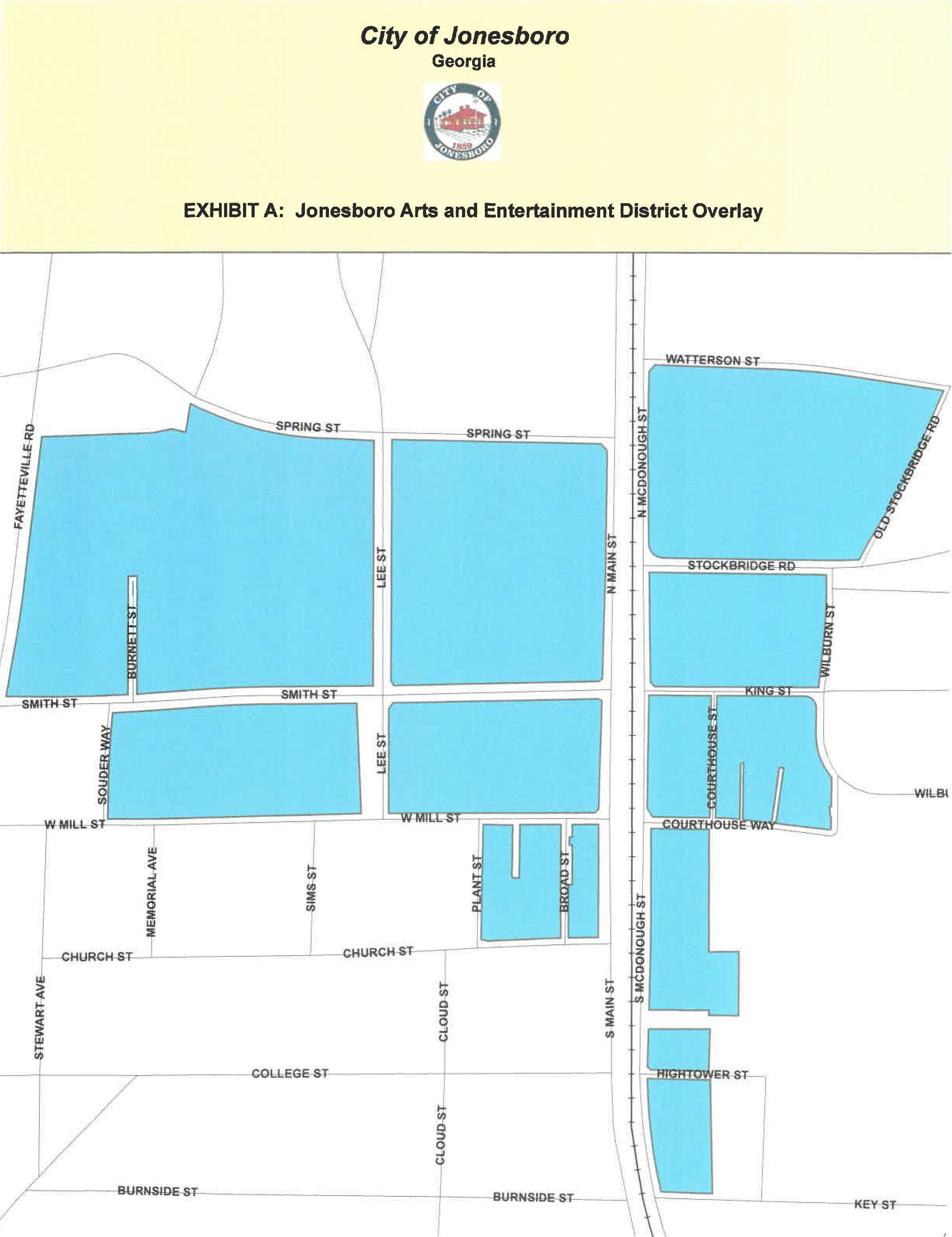
(f)
Scale. Downtown Jonesboro is the focus of the arts and entertainment district overlay. Jonesboro was established at a time when walking was the primary means of travel, and the downtown is characterized by a pedestrian scale. This scale is preserved by height limits inherent in the development intensity assigned to the downtown on Jonesboro's future development map and development standards of the arts and entertainment district overlay. A sense of place will be maintained by adherence to these height limits. Preservation of pedestrian scale is important as arts districts are typically designed to encourage walking to a variety of venues.
(g)
Additional uses encouraged in the arts and entertainment district overlay. Uses permitted by the underlying zoning are unaffected by adoption of the arts and entertainment district overlay; the following uses shall be specifically permitted in the arts and entertainment district overlay:
(1)
Arts uses:
a.
Art gallery.
b.
Artist studio.
c.
Artist studio workspace.
d.
Artist co-op to allow multiple artist spaces that are not bazaars, junk stores, specialty shops and flea markets, etc.
e.
Arts and crafts retail sales.
f.
Arts center.
g.
Arts related businesses and services such as craft shops, galleries and studios within which is conducted the preparation, display, or sale of art products such as antiques, collectibles, custom apparel, jewelry, paintings, photography, picture framing, pottery, sculpture, stained glass and similar arts, crafts merchandise, and activities such as set design and restoration of artwork.
h.
Arts supply store.
i.
Cabaret, concert hall or other performing arts space, dinner theater, legitimate theater or movie theater.
j.
Craftsman or artisan shop.
k.
Music store, musical instruments store.
l.
Performing arts ticket office or booking agency.
m.
Photographic studio.
n.
Recording studios, provided appropriate soundproofing is installed.
o.
Television and radio broadcast studio.
p.
Video and movie production.
(2)
Retail uses:
a.
Farmers market or green market.
b.
Framing shop.
c.
Pottery and ceramics shop.
d.
Growler shop.
(3)
Cultural and entertainment uses:
a.
Brew pubs, including outdoor seating.
b.
Microbreweries, subject to the provisions of chapter 6, "Alcoholic beverages and tobacco products."
c.
City-sponsored and/or approved outdoor cultural events and performances that feature visual art, music, dance, theater, performance art, science, design or cultural heritage.
d.
Live entertainment, provided that all establishments hosting live entertainment shall comply with any and all applicable noise regulations and ordinances of the city.
(4)
Educational uses:
a.
Art school and other visual and performing arts instruction including school of dance, photography, filmmaking, music, writing, painting, sculpting and printmaking, but excluding adult entertainment and erotic dance.
b.
Educational or instructional activities, including training, vocational or craft schools, the arts and personal development.
c.
Libraries.
d.
Museums.
e.
Social and philanthropic institutions.
f.
Training studios, including martial arts studios, gymnastics and yoga.
(h)
Prohibited uses: The following uses shall be prohibited in the arts and entertainment district overlay:
(1)
Any drive-through facility.
(2)
Any outdoor storage of materials or any outdoor processing, fabricating or repair work with the exception of work performed with hand tools or small power tools.
(3)
Use of any structure primarily for storage (meaning no more than 25 percent of the total interior space of said structure may be used for storage of goods, materials, or equipment).
(4)
Car wash.
(5)
C-store selling fuel.
(6)
Gas station.
(7)
Motor vehicle service or repair.
(8)
Tire stores.
(9)
Any use that involves the outdoor storage of materials or products. The production of offensive noise, vibration, smoke, dust or other particulate matter, heat, humidity, glare or other objectionable effect shall also be prohibited.
(i)
Accessory uses permitted:
(1)
Outdoor display of artwork and merchandise during hours of operation of the primary business or activity on the property.
(2)
Power tools. The use of hand tools is encouraged; the use of small power tools is allowed. All tools shall be used in compliance with the noise regulations and ordinances of the city.
(3)
Street performers.
(4)
Food trucks, in designated food truck courts only.
(5)
Consignment stores and thrift stores.
(6)
Makerspaces.
(j)
Public art. Placement or installation of outdoor sculpture and other art forms on private property intended to be viewed from a public right-of-way or other public property shall not be subject to setback standards of the applicable zoning district and shall not require a permit, provided that:
(1)
The art is not offered for sale;
(2)
The art does not constitute an advertisement; and
(3)
The placement does not impede the flow of pedestrian, bicycle or vehicle traffic or block motorist visibility at intersections, alleys or driveways.
(k)
Use specific standards. The following standards shall control the development and manner of operation of the following uses within the arts and entertainment district overlay:
(1)
Food truck court.
a.
Food truck courts may be established in free-standing commercial parking lots accessory to an operating, permitted use provided that (a) the lot has been designated for food truck courts, (b) the property is zoned H-1 or H-2, and (c) parking supply exists in excess of that required by ordinance or Code for uses or commercial space existing on the site and two off-street parking spaces shall be reserved for the exclusive use of customers of each food truck vendor. Such designation shall be subject to review and approval by the zoning administrator or his designee who shall maintain the following database:
1.
Property address and number of spaces designated as a "food truck court."
2.
Site sketch depicting the building, parking spaces and parking spaces so designated.
3.
Dimensions and color photos (front, both sides and rear) of the dispensing vehicle.
4.
A copy of all lease agreements between the property owner and/or landlord and any food truck vendor, including the specific space being leased which shall be marked on the ground.
5.
Proof of compliance with all Clayton County health department regulations.
6.
An occupational tax permit issued by the city, which permit shall be posted in the front window of the food truck vendor vehicle or trailer while in use.
b.
Food trucks shall not be permitted on the premises before 7:00 a.m. or after 10:00 p.m.
c.
Each food truck vendor shall obtain an annual transient merchants license prior to operating in any area designated as a food truck court.
d.
No minimum or maximum number of food trucks shall be established; food truck courts need not be contiguous and may be designated in several locations within a single lot.
e.
No wastes of any kind shall be discharged from a food truck. Trash receptacles shall be provided by the food truck vendor for customers to dispose of food wrappers, food utensils, paper products, cans, bottles, food and other such waste. Such receptacles shall be located no more than ten feet from the food truck. The food truck vendor shall be responsible for removing all trash, litter and refuse from the site at the end of each business day.
f.
No LED strip lighting shall be used in conjunction with any food truck court.
g.
No loudspeakers shall be used for announcements or hawking of products in conjunction with any food truck court.
h.
The property owner and/or landlord may provide limited seating on the food truck court to customers of the food truck vendor(s). Canopies for the protection of customers from the elements may also be provided by the property owner and/or landlord or the food truck vendor(s). Such canopies shall be temporary, located within three feet of the food truck, not exceed an area of 144 square feet and shall be subject to approval by the zoning administrator or his designee.
i.
A minimum distance of 100 feet shall be maintained between any food truck and the entrance to any permanent restaurant building.
j.
The food truck shall not be located within any required setback, any sight distance triangle or required buffer. Access aisles sufficient to provide emergency access to any food truck shall be provided subject to approval by the fire marshal.
k.
Sales of articles other than food shall be prohibited.
(2)
Kilns.
a.
The total volume of kiln space shall not exceed 24 cubic feet and no individual kiln shall exceed eight cubic feet.
b.
Kilns may be located outside. Outside kilns shall be set back a minimum of 25 feet from any boundary common to property zoned residential or in residential use.
(3)
Street performers.
a.
Street performers shall obtain a permit from the city.
b.
Performers shall operate only in designated areas.
c.
No street performer shall impede movement along a public sidewalk; a minimum sidewalk width of five feet, independent of the performance area, shall be maintained throughout any performance.
(l)
Signs. Signs with lights and movable elements that contribute to the unique character of the district shall be permitted. Such signs shall be subject to approval by the design review commission. Such approval is subject to the notice and public hearing requirement(s) as set forth in O.C.G.A. § 36-66-4(g).
(Ord. No. 2019-001, § 1, 3-11-2019; Ord. No. 2023-006, § 1(Exh. A), 7-10-2023)
Sec. 86-117. - Active senior district overlay.
(a)
Factual. In adopting the city's active senior district overlay zone (the "active senior district overlay"), the city seeks to establish vibrant hubs in and around its downtown core, which strive to improve both livability and walkability in this vital area. Because Jonesboro has suffered from the general lack of investment characterizing Atlanta's south side, reinforced by a failure of south side incomes and housing values to keep pace with Atlanta's north side, establishment of these hubs serves as an impetus to further reinvigorating development in the downtown area and as a source of a more diverse range of quality housing to supplement the city's aging housing stock.
(b)
Definitions. For definitions of specific terms, refer to Code section 86-62.
(c)
Purpose. The purpose of the active senior district overlay is to facilitate creation of a residential zone, or hub, which allows a mix of housing styles and types on the same property, which are intended to meet the needs of the 55-year-old plus, active-living demographic. The zone will also provide a range of recreational amenities for its residents. A complementary mix of shops, restaurants and entertainment venues nearby will support this use. Through quality development, these zones, or hubs, will serve as vibrant "junctions" within the interconnected downtown area. They are also expected to generate more interest in downtown Jonesboro through the "live here, work here, play here" philosophy, featuring walkable distances to all aspects of downtown life, from arts and entertainment to restaurants and other businesses and offices. The active senior district overlay features an expanded range of permitted uses focused on the residential needs of the 55-year-old plus, active-living demographic, while retaining all property rights established by the underlying zoning(s).
(d)
Applicability. Unless expressly modified by regulations in this article establishing the active senior district overlay, the regulations governing the use of land and structures shall be as set forth in the underlying zoning districts and as regulated by other provisions of this Code. Unless otherwise stated in this section, the current architectural design standards shall control development in the active senior district overlay, unless alternate provisions are adopted in the active senior district overlay. Exterior architectural design features shall be subject to review and approval by the design review commission. Where a conflict with other city code and ordinance provisions exists, the more permissive standard shall apply. The active senior district overlay shall supersede the requirements of the historic residential overlay and the assembly overlay, wherever they may overlap with its geographical boundaries.
(e)
Geography. Currently, the active senior district overlay occurs southwest of the intersection of North Avenue and North Main Street, running south behind parcels fronting the western side of North Main Street, and terminating north of parcels fronting the northern side of Pine Circle. The district is more specifically identified in the following figure entitled "Exhibit A: Jonesboro Active Senior District Overlay."
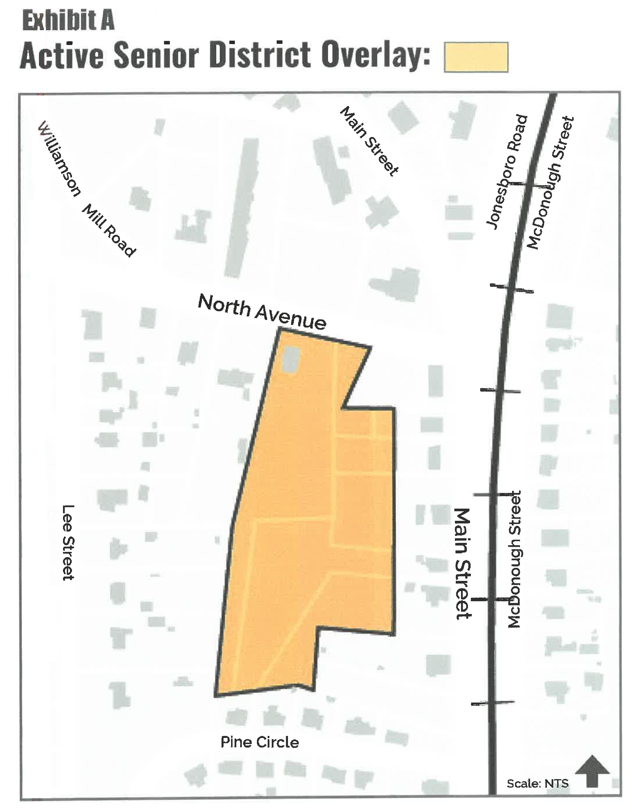
(f)
Scale. The junction of North Avenue and North Main Street, which is a "gateway point" into the City of Jonesboro, is the current focus of the active senior district overlay. Jonesboro is recognized for its historic downtown, which is characterized by a pedestrian scale. This scale is preserved by height limits inherent in the development intensity assigned to the downtown area on Jonesboro's future development map and development standards of the active senior district overlay. A sense of place will be maintained by adherence to these height limits. Preservation of pedestrian scale is important to the livability and walkability of the downtown area. Height of attached residential buildings shall not exceed four stories, or the highest point of the historic Clayton County courthouse.
(g)
Regulation of uses. Uses permitted by the underlying zoning(s) are unaffected by adoption of the active senior district overlay; the following uses shall be specifically permitted in the active senior district overlay:
(1)
Residential uses: Single-family detached dwelling, site-built;
(2)
Commercial/institutional uses: Any uses already permitted by right in the H-1 and H-2 zoning districts;
(3)
Prohibited uses: The following uses shall be prohibited in the active senior district overlay:
a.
Triplexes and quadruplexes;
b.
Any drive-through facility;
c.
Any outdoor storage of materials or any outdoor processing, fabricating or repair work with the exception of work performed with hand tools or small power tools;
d.
Use of any structure primarily for storage (meaning no more than 25 percent of the total interior space of said structure may be used for storage of goods, materials, or equipment);
e.
Car wash;
f.
Convenience store selling fuel;
g.
Gas station;
h.
Motor vehicle service or repair;
i.
Tire stores;
j.
Any use that involves the outdoor storage of materials or products. The production of offensive noise, vibration, smoke, dust or other particulate matter, heat, humidity, glare or other objectionable effect shall also be prohibited;
k.
Any industrial/manufacturing use;
l.
Adult entertainment.
(4)
Conditional uses: The following uses shall be permitted with an approved conditional use permit in the active senior district overlay:
a.
Two-family dwelling (duplex);
b.
Single-family attached dwelling (townhouses and condominiums), meeting the requirements of section 86-202;
c.
Multifamily (apartments), meeting the requirements of section 86-205;
d.
Mixed-use dwelling, including lofts, meeting the requirements of section 86-182.
(5)
Accessory uses.
a.
Recreational amenities for residents only, including, but not limited to, clubhouses, gazebos, swimming pools, and walking trails;
b.
Paved parking areas for residents only;
c.
Stick-built storage buildings directly related to building and grounds maintenance of the property, not to exceed 500 square feet;
d.
Mail kiosks;
e.
Necessary signage.
(h)
Minimum size of dwelling units. The required minimum size of dwelling units in the active senior overlay district is intended to reflect the unique needs of the 55-plus demographic with their emphasis on childless homes and low maintenance living spaces and the sizes specified below shall prevail over the regular size standards specified in section 86-205, R-M zoning. The intent of the active senior overlay district is smaller-sized, higher-quality dwelling units.
(1)
Single-family detached dwellings. 1,600 heated square feet per unit.
(2)
Duplex dwellings.
a.
One-bedroom units: 950 heated square feet per unit.
b.
Two-bedroom units: 1,150 square feet per unit.
c.
Three-bedroom units: 1,500 square feet per unit.
(3)
Single-family attached dwellings (townhouses and condominiums). 1,200 heated square feet per unit.
(4)
Multi-family (apartments).
a.
One-bedroom units: 700 heated square feet per unit.
b.
Two-bedroom units: 900 square feet per unit.
c.
Three-bedroom units: 1,100 square feet per unit.
(5)
Mixed-use dwelling, including lofts (no street level units allowed). 1,000 heated square feet per unit.
(i)
Density and maximum number of units.
(1)
Single-family attached dwellings (townhouses and condominiums).
a.
Maximum number of units per building: 8.
b.
Maximum number of units per development: 64.
c.
Maximum density: 8 units per acre.
(2)
Multi-family (apartments).
a.
Maximum number of units per building: 112.
b.
Maximum density: 14 units per acre.
(3)
Mixed residential product. May not exceed 14 units per acre for the district as a whole. A subdivision within a mixed residential project shall not result in a violation of this limitation.
(j)
Exterior architectural material standards. The following architectural standards shall apply to primary exterior facade materials:
(1)
Prohibited materials. Metal siding, vinyl siding, and smooth-faced concrete masonry units are prohibited.
(2)
Permitted primary materials. Primary building materials for all exterior wall facades shall be constructed of a minimum 30 percent full-depth brick (not veneers) on all sides, plus a combination of at least two of the following options: cast stone, high-quality synthetic stucco, cementitious siding (Hardiboard), or glass.
(3)
Permitted accent materials. Accent building materials for all exterior wall facades may include brick, textured concrete masonry units, wood panels (including wood shake), metal panels, and metal canopies.
(4)
Exceptions. Vinyl products shall only be used for soffits, eaves, and fascia.
(5)
Color. All materials shall be earth-tone in color, as approved by the design review commission, the historic preservation commission (where applicable), and the mayor and city council.
(6)
Roofing materials. All asphalt-shingle roofing shall consist of high-quality, architectural shingles, with a minimum 30-year warranty. Metal roofing is also permitted.
(k)
Building and unit design. Universal design (also known as "aging in place") is a method of design that seeks to create development that can be used by everyone, regardless of age or physical condition. All projects shall implement, at a minimum, the following universal design principles:
(1)
No-step entries.
(2)
Provide lever door handles and rocker light switches.
(3)
Provide additional closet rod brackets to allow potential access from a wheelchair.
(4)
Adequate lighting throughout the dwelling unit.
(5)
Room thresholds that are flushed.
(l)
Location of certain principal buildings. Buildings for townhouses, condominiums, apartments, and mixed-use dwellings shall be located as close as possible to street frontage and away from side and rear property lines, especially those property lines adjacent to single-family dwelling districts.
(m)
Signage. Signs shall conform to the standards of the city sign ordinance, article XVI. Sign design features shall be subject to review and approval by the design review commission.
(n)
Lighting. All outdoor lighting shall be night-sky friendly.
(o)
Access. Entryways to residential developments shall be located on roads with a minimum classification of collector or greater. Interior roads for residential developments shall not be used for general drive-thru traffic.
(p)
Buffering. Perimeter buffers for residential developments shall conform to the minimum requirements of article XV, unless additional requirements are imposed by mayor and city council. Despite the types of housing that may occur in this development, for the purposes of buffering, the entire property shall be treated as "attached residential." Buffers shall preserve existing vegetation to the maximum extent possible. Supplemental buffer plantings in certain areas may be necessary per the city zoning administrator. Stream and wetland buffering shall conform to article XIII.
(q)
Greenspace. Minimum 25 percent of gross site acreage. May include pervious amenity areas, stream buffers/setbacks, natural areas, but shall not include required perimeter buffers.
(r)
Amenities. Recreational amenities shall be appropriately distributed throughout the facility. Such facilities shall consist of open or enclosed areas for residents of the facility to congregate, for recreation and leisure. The following standards shall be utilized for recreational facilities:
(1)
The design and orientation of these areas should take advantage of available sunlight and should be sheltered from noise and traffic of adjacent street or other incompatible uses.
(2)
Each recreational facility shall have a focal point. The focal point may consist of, but need not be limited to, water fountains, landscape planters, monuments, waterways, ponds, artwork, trellises or gazebos. The focal point of all recreational facilities shall complement one another by maintaining a common theme, consistent furnishing and signage.
(s)
Landscaping. Landscaping of building foundations, parking lots, amenities, etc. shall conform to the minimum requirements of article XV, unless additional requirements are imposed by mayor and city council.
(t)
Security. Adequate security considerations shall be provided throughout the facility, including, at a minimum, the following features:
(1)
Provide clear, unobstructed sightlines from entries to the street or parking lot.
(2)
Provide clear sightlines to outdoor open areas from doorways and windows.
(3)
Light exterior spaces and internal common spaces with energy-efficient, vandal proof lamps and fixtures.
(4)
Create privacy for the ground-level unites by using landscaping or fencing to buffer them from the street or parking.
(5)
Pedestrian pathways to the entry, the parking, and the trash deposit area should be well-defined, well-lighted, and free from dense shrubs.
(6)
Design common spaces to encourage a sense of belonging and that relate to a discrete number of units so that these spaces encourage a sense of ownership.
(7)
Property shall have an ornamental access gate with residents provided fobs or cards for entry. If the gate operates by way of a telephone system, a ring-through feature shall be provided so that cars waiting at the gate entrance will not cause waiting or queuing problems should a telephone line be in use, or a pull-out area outside of traffic lanes shall be provided to allow telephoning without blocking access.
(u)
Maintenance. Continued good appearance of buildings within the facility depends on the extent and quality of maintenance. Materials and finishes shall be selected for their durability and wear, as well as for their beauty. Proper measures shall be taken for protection against weather, neglect, damage and abuse. Provision for washing and cleaning building and structures, and control of dirt and refuse, shall be included in the design. Configurations that tend to catch and accumulate leaves, dirt and trash shall be avoided. Regular schedules for daily, weekly, quarterly, and annual maintenance shall be implemented by both owners and staff.
(Ord. No. 2020-012, §§ 1, 2(Exh. A), 4-13-2020; Ord. No. 2021-001, § 1, 1-11-2021)
Sec. 86-118. - Gateway south district overlay.
(a)
Factual. In adopting the city's gateway south district overlay zone (the "gateway south district overlay"), the city seeks to redefine its southern limits, which, with a few recent exceptions, is an area that has become a largely one-dimensional "production corridor," with a significant amount of aging buildings of declining value. With the exception of the Tara Boulevard overlay district, the southern portion of the city lacks unifying, quality design guidelines to give it a new vitality and identity. Because Jonesboro has suffered from the general lack of investment characterizing Atlanta's south side, reinforced by a failure of south side incomes and housing values to keep pace with Atlanta's north side, establishment of this new district will serve as an impetus for reinvigorating development in the southern portions of the city and also serve as another source of more diverse, quality housing to supplement the city's aging housing stock.
(b)
Definitions. For definitions of specific terms, refer to Code section 86-62.
(c)
Purpose. The purpose of the gateway south district overlay is to facilitate creation of a vibrant zone, or hub, with an intelligent mix of new commercial, office, residential, and even industrial, uses that, through thoughtful planning and quality design guidelines, will improve the viability of this strategic area of the city. The residential component of this district will help development [of] a more diverse range of quality housing to supplement the city's aging housing stock, including housing options for the 55-year-old plus, active-living demographic. The close proximity of new businesses, offices, and residences will continue to bolster the city's "live here, work here, play here" philosophy. The gateway south district overlay features a specific range of permitted, prohibited, and conditional uses superior to, and independent of, the Tara Boulevard overlay district and other underlying zoning(s) and focused on the thoughtful reinvigoration of this area, in conjunction with the future goals and intent of the city's comprehensive plan.
(d)
Applicability. Unless expressly modified by regulations in this article establishing the gateway south district overlay, the regulations governing the use of land and structures shall be as set forth in the underlying zoning districts and as regulated by other provisions of this Code. Unless otherwise stated in this section, the current architectural design standards shall control development in the gateway south district overlay, unless alternate provisions are adopted in the gateway south district overlay. Exterior architectural design features shall be subject to review and approval by the design review commission. Where a conflict with other city code and ordinance provisions exists, the more restrictive standard shall apply. The gateway south district overlay shall supersede the requirements of the Tara Boulevard overlay and the assembly overlay, wherever they may overlap with its geographical boundaries.
(e)
Geography. The gateway south district overlay occurs along the entire southern city limits and its intersection with Tara Boulevard, South Main Street, and Turner Road, then running north along a line connecting the intersections of Highway 54 and Tara Boulevard, South Avenue and Tara Boulevard, Batiste Park Road and South Main Street, and Elaine Terrace and Turner Road. The district is more specifically identified in the figure entitled "Exhibit A: Jonesboro Gateway South District Overlay," as originally included with the ordinance from which this section is derived.
(f)
Scale. The corridors of Tara Boulevard and, to a lesser extent, South Main Street, serve as the main "gateway points" for citizens approaching the City of Jonesboro from the south, and are the current focus of the gateway south district overlay. Although Jonesboro is recognized for its distinctive and historic downtown, and recent residential and commercial developments to the north of downtown, the southern portion of the city currently suffers from a lack of identity and diversity of uses. A renewed sense of place in the southern portion of the city will be maintained by the strict building quality and use standards in the gateway south district overlay and will serve as a catalyst for other quality future development throughout Jonesboro.
(g)
Regulation of uses. Uses permitted by the underlying zoning(s) are unaffected by adoption of the gateway south district overlay, except as specified below; the following uses shall be specifically regulated in the gateway south district overlay:
(1)
Permitted uses.
a.
Single-family detached dwelling, site-built, as part of a planned major subdivision only;
b.
Hotels (except casino hotels) and motels (except extended stay facilities), that meet the specified requirements of this subsection 86-118(k)(4) and section 86-554;
c.
General medical centers/hospitals, that meet the specified requirements of this section and section 86-504, and not prohibited below.
(2)
Prohibited uses. The following primary uses, which otherwise may be permitted or allowed by conditional use permit in other city zoning districts, shall be prohibited in the gateway south district overlay:
a.
Community food services, such as food banks;
b.
Community housing services;
c.
Nursing care facilities, including nursing homes;
d.
Residential mental health facilities;
e.
Residential developmental disability homes (major disability);
f.
Residential mental and substance abuse care;
g.
Continuing care, assisted living facilities;
h.
Ambulance services (transportation);
i.
Blood and organ banks;
j.
Psychiatric and substance abuse hospitals;
k.
Other residential care facilities care, personal care homes;
l.
Other residential care facilities care, group homes for adults without major disabilities, and not involving mental health or substance abuse);
m.
Other residential care facilities care, youth homes;
n.
Racetracks, including small vehicles, go-karts and motorcycles;
o.
Amusement and theme parks;
p.
Amusement arcades, primarily indoor;
q.
Other amusement and recreation industries;
r.
Billiard and pool halls;
s.
Recreational shooting clubs;
t.
Hookah lounge (smoking bar, but not cigar lounge);
u.
Cigar lounges, with or without alcoholic beverage service;
v.
Bowling centers;
w.
Golf courses and country clubs;
x.
Motion picture theaters (including drive-ins);
y.
Zoos and botanical gardens;
z.
Construction offices, with or without outdoor storage;
aa.
All other non-depository credit intermediation, including pawn shops;
bb.
Other activities related to credit intermediation, including check cashing services;
cc.
Facilities support services;
dd.
Kidney dialysis centers;
ee.
Lessors of nonresidential building (except mini warehouses), including event centers (excluding funerals and wakes);
ff.
Massage therapy, state licensed only;
gg.
Temporary help services, manual labor pools;
hh.
Veterinary services, including animal hospitals;
ii.
Outdoor advertising, large-scale, including billboard displays;
jj.
All types of vehicle repair and maintenance;
kk.
All other travel accommodation, including short-term rentals (airbnbs);
ll.
Appliance repair and maintenance;
mm.
Armored car services;
nn.
Car washes;
oo.
Cemeteries;
pp.
Crematories, within funeral homes or stand alone;
qq.
Coin-operated laundries and dry cleaners, drop-off;
rr.
Commercial and industrial machinery and equipment (except automotive and electronic) repair and maintenance; no outdoor storage;
ss.
Small and heavy machinery and equipment rental and leasing;
tt.
Consumer electronics and appliances rental;
uu.
Recreational goods rental, including golf cart rentals:
vv.
All types of consumer goods rental;
ww.
Direct selling establishments, including fuel dealers;
xx.
Electronic and precision equipment repair and maintenance;
yy.
Electronic shopping and mail-order houses;
zz.
Funeral homes and funeral services;
aaa.
General rental centers;
bbb.
Home and garden equipment repair and maintenance;
ccc.
Linen and uniform supply;
ddd.
Miscellaneous personal services, including bail bonding, dating services, shoe-shine services, wedding planning, fortunetelling and similar uses;
eee.
Motor vehicle towing and storage;
fff.
Office machinery and equipment rental and leasing;
ggg.
Parking lots and garages, commercial;
hhh.
Passenger car rental and leasing;
iii.
Pet care, grooming, training, pet sitting (except veterinary services);
jjj.
Animal kennels/boarding;
kkk.
Animal rescue shelter, public or private;
lll.
Technical and trade schools;
mmm.
Apprenticeship training;
nnn.
Repossession services;
ooo.
Re-upholstery and furniture repair;
ppp.
Rooming and boarding houses;
qqq.
Services to buildings and dwellings (including pest control, janitorial services, landscape services, carpet and upholstery cleaning, pool maintenance, drain or gutter cleaning);
rrr.
Other support services, including packaging and labeling, convention and trade show organizers, inventory, traffic control, water conditioning, lumber grading and related services;
sss.
Telemarketing bureaus;
ttt.
Tour operators with tour vehicles;
uuu.
Truck, utility trailer, and RV (recreational vehicle) rental and leasing, including moving truck rental;
vvv.
Vending machine operators;
www.
Video tape and disc rental;
xxx.
Other schools and instruction;
yyy.
Vocational rehabilitation services;
zzz.
All types of waste collection and treatment;
aaaa.
Materials recovery facilities, including collection bins for recyclable materials;
bbbb.
Septic tank and related services;
cccc.
Automotive parts and accessories stores, with or without outdoor storage;
dddd.
Building material and supplies dealers, including lumber yards;
eeee.
All types of vehicle dealers, new or used;
ffff.
Wholesale trade agents and brokers, including automobile brokers (office only);
gggg.
Convenience food stores, with or without fuel pumps;
hhhh.
Gasoline stations and truck stops;
iiii.
Store retailers not specified elsewhere, including fireworks shops but not tobacco stores;
jjjj.
Food service contractors;
kkkk.
Home centers (building materials and supplies);
llll.
Lawn and garden equipment and supplies stores;
mmmm.
Nursery, garden, and farm supply stores;
nnnn.
Mobile food services, including carts, individual food trucks, and food truck courts;
oooo.
Motorcycle, boat, RV, ATV, and other vehicle dealers;
pppp.
Restaurants, limited-service, including fast food and take-out, with drive-through windows;
qqqq.
Tire dealers;
rrrr.
Truck transportation (freight);
ssss.
Used merchandise stores, including thrift stores and consignment stores;
tttt.
Warehouse clubs and supercenters;
uuuu.
All other miscellaneous store retailers, including flea markets;
vvvv.
Tobacco stores, cigar shops, and vape shops, but not cigar lounge;
wwww.
Mini-warehouses and self-storage units (indoor and outdoor);
xxxx.
All types of manufacturing not allowed by conditional use permit below;
yyyy.
Breweries, large-scale;
zzzz.
Distilleries, large-scale;
aaaaa.
Charter bus industry;
bbbbb.
Freight transportation arrangement;
ccccc.
Packing and crating;
ddddd.
Scenic and sightseeing transportation;
eeeee.
Special needs transportation;
fffff.
Interurban and rural bus transportation;
ggggg.
Taxi and limousine service;
hhhhh.
School and employee bus transportation;
iiiii.
Support activities for transportation;
jjjj.
Nursery, tree, and floriculture production;
kkkkk.
Animal, poultry, and egg production;
lllll.
Water and sewage systems, including treatment facilities;
mmmmm.
Adult entertainment facilities;
nnnnn.
Tattoo parlors;
(3)
Conditional uses. The following primary uses, which may otherwise be permitted in other city zoning districts, shall require a conditional use permit in the gateway south district overlay:
a.
Mixed-use dwelling, including lofts, meeting the requirements of section 86-182, and as part of a planned development only;
b.
Two-family dwelling (duplex) as part of a planned major subdivision only;
c.
Single-family attached (townhouses and condominiums), as part of a planned major subdivision only;
d.
Multifamily (apartments), as part of a planned development only;
e.
Bed and breakfast inns;
f.
Personal and household goods repair and maintenance, including jewelry, garments, watches, musical instruments and bicycles; no outdoor storage;
g.
Other household goods repair and maintenance;
h.
Floor covering stores;
i.
Hardware stores;
j.
Pet and pet supplies stores, no outdoor storage or displays;
k.
Outdoor farmers market;
l.
Warehousing and storage with no outdoor storage;
m.
Furniture and related product manufacturing, with no outdoor storage;
n.
Miscellaneous manufacturing (including toys, jewelry, silverware, medical/dental equipment and supplies, sporting goods, office supplies, signs, caskets, gaskets, home accessories, etc. and similar processing/assembly of products), with no outdoor storage;
o.
Postproduction and other related industries;
p.
Apparel and apparel accessories manufacturing, with no outdoor storage;
q.
Wood product manufacturing, including millwork, with no outdoor storage;
r.
Computer and electronic product manufacturing, with no outdoor storage;
s.
Rail transportation company (office only).
(4)
Permitted accessory uses. Regarding residential, office, and commercial uses:
a.
Recreational amenities for residential communities, including, but not limited to, clubhouses, gazebos, swimming pools, and walking trails;
b.
Paved parking areas for residents and patrons only;
c.
Stick-built storage buildings directly related to building and grounds maintenance of properties, not to exceed 500 square feet;
d.
Mail kiosks;
e.
Necessary signage.
(h)
Minimum size of dwelling units. One of the main focuses of the minimum size of dwelling units in the gateway south overlay district is to reflect the unique needs of the active, 55-plus demographic with their emphasis on childless homes and low maintenance living spaces and the sizes specified below shall prevail over the regular size standards specified in section 86-205, R-M zoning. The intent of the gateway south overlay district, regarding attached housing such as apartments, duplexes, and townhomes, is smaller-sized, higher-quality dwelling units. Ample-sized, single-family detached homes with high-quality architectural standards are also allowed in planned developments in this district.
(1)
Single-family detached dwellings: 1,600 heated square feet per unit.
(2)
Duplex dwellings:
a.
One-bedroom units: 1,000 heated square feet per unit.
b.
Two-bedroom units: 1,300 square feet per unit.
c.
Three-bedroom units: 1,500 square feet per unit.
(3)
Single-family attached dwellings (townhouses and condominiums): 1,200 heated square feet per unit.
(4)
Multifamily (apartments):
a.
One-bedroom units: 835 heated square feet per unit.
b.
Two-bedroom units: 1,038 square feet per unit.
c.
Three-bedroom units: 1,330 square feet per unit.
(5)
Mixed-use dwelling, including lofts (no street level units allowed): 1,000 heated square feet per unit.
(i)
Density and maximum number of residential units.
(1)
Single-family attached dwellings (townhouses and condominiums).
a.
Maximum number of units per building: Eight.
b.
Maximum number of units per development: 96.
c.
Maximum density: 12 units per acre.
(2)
Multi-family (apartments).
a.
Maximum number of units per building: None.
b.
Maximum density: 40 units per acre.
(j)
Maximum building height. Four stories and 60 feet. No building shall be erected that would exceed the elevation of the Clayton County courthouse. Buildings having a height greater than that of the courthouse may be approved, provided that the site elevation will permit such construction to remain below the highest point of the courthouse.
(k)
Exterior architectural design and material standards. The following minimum architectural standards shall apply to exterior facade materials. The design review commission and the mayor and city council may impose additional standards in the required developer's agreement.
(1)
Multifamily and townhomes/condominiums.
a.
Prohibited materials. Metal siding, vinyl siding, and smooth-faced concrete masonry units, as primary building materials, are prohibited.
b.
Permitted primary materials. Primary building materials for all exterior wall facades shall be constructed, at a minimum, of full-depth brick (not veneers) for the bottom two-thirds of each building, on all sides, plus a combination of at least two of the following options for the remaining one-third of the building: cast stone, cementitious siding (Hardiboard), or glass. (Note: Exterior facade delineations to not include windows or trim.)
c.
Permitted accent materials. Accent building materials for all exterior wall facades may include brick, textured concrete masonry units, wood panels (including wood shake), metal panels, and metal canopies.
d.
Exceptions. Vinyl products shall only be used for soffits, eaves, and fascia. Any window trim shall be cementitious siding (Hardiboard) only.
e.
Color. All materials shall be earth-tone in color, as approved by the design review commission and the mayor and city council.
f.
Roofing materials. All asphalt-shingle roofing shall consist of high-quality, architectural shingles, with a minimum 30-year warranty. Metal roofing is also permitted.
g.
Porches and balconies. All multifamily dwelling units shall each have minimum six-foot-deep exterior porches (ground floor) and balconies (upper floor), with direct access to the interior of each dwelling unit via sliding doors. Porches and balconies shall be partially contained on the open side by decorative wood railings. Ground floor porches facing inner courtyards shall each be provided with a self-latching gate for access to courtyard amenities.
h.
Developer's agreement. A developer's agreement specifying all pertinent exterior design standards shall be approved by the mayor and city council prior to construction of multifamily and townhome/condominium developments.
(2)
Two-family dwellings (duplexes).
a.
All duplexes shall be constructed with "cottage-style" exteriors.
b.
Prohibited materials. Metal siding, vinyl siding, and concrete block, as primary building materials, are prohibited.
c.
Permitted primary materials. Primary building materials for all exterior wall facades shall be constructed of either full-depth brick (not veneers) or cementitious siding (Hardiboard), or a combination thereof. For duplexes with cementitious siding as the primary exterior on all four sides, a full-depth brick water table shall be provided on all sides.
d.
Permitted accent materials. Accent building materials for all exterior wall facades may include brick and wood panels (including wood shake).
e.
Exceptions. Vinyl products shall only be used for soffits, eaves, and fascia. Any window trim shall be cementitious siding (Hardiboard) only.
f.
Color. All materials shall be earth-tone in color, as approved by the design review commission and the mayor and city council.
g.
Roofing materials. All asphalt-shingle roofing shall consist of high-quality, architectural shingles, with a minimum 30-year warranty. Metal roofing is also permitted.
h.
Developer's agreement. A developer's agreement specifying all pertinent exterior design standards shall be approved by the mayor and city council prior to construction of developments involving duplexes.
(3)
Mixed use dwelling, including lofts.
a.
No residential unit shall occupy a street level (ground floor) space.
b.
Prohibited materials. Metal siding, vinyl siding, and concrete block, as primary building materials, are prohibited.
c.
Permitted primary materials. Primary building materials for all exterior wall facades for street level uses (commercial, offices, etc.) shall be constructed, at a minimum, of 50 percent full-depth brick (not veneers) on all sides, plus a combination of at least two of the following options for the remaining half: cast stone, cementitious siding (Hardiboard), or glass. Primary building materials for all exterior wall facades for dwellings on upper floors shall be a combination of full-depth brick (not veneers), cast stone, cementitious siding (Hardiboard), or glass. Brick, stone, or cementitious siding used on dwellings shall match color of same materials used for street level uses.
d.
Permitted accent materials. Accent building materials for all exterior wall facades may include brick and wood panels (including wood shake).
e.
Exceptions. Vinyl products shall only be used for soffits, eaves, and fascia. Any window trim shall be cementitious siding (Hardiboard) only.
f.
Color. All materials shall be earth-tone in color, as approved by the design review commission and the mayor and city council.
g.
Roofing materials. All asphalt-shingle roofing shall consist of high-quality, architectural shingles, with a minimum 30-year warranty. Metal roofing is also permitted.
(4)
Hotels and motels.
a.
Must be located in a stand-alone building (no planned centers, connected storefronts sharing a common wall, or lots with zero lot line development or shared parking).
b.
Shall be no higher than four stories in height.
c.
Lodging rooms shall be accessed through a central lobby.
d.
Lodging rooms shall be cleaned by professional staff daily.
e.
No hotel or motel shall allow a person or persons to occupy any such facility for more than 30 days during a 180-day period, except where:
1.
Occupation of a hotel, motel, or extended stay facility in excess of 30 consecutive days in a 180-day period may occur when a specific business entity desires such occupation for an employment-related purpose which requires temporary occupancy, including, but not limited to, relocation service.
f.
A minimum 25-foot-wide buffer shall be maintained between built elements (including paved parking areas) of the proposed facility and any adjacent, single-family detached residential property.
g.
Prohibited materials. Metal siding, vinyl siding, and smooth-faced concrete masonry units, as primary building materials, are prohibited.
h.
Permitted primary materials. Primary building materials for all exterior wall facades shall be constructed, at a minimum, of full-depth brick (not veneers) for the bottom two-thirds of each building, on all sides, plus a combination of at least two of the following options for the remaining one-third of the building: cast stone, cementitious siding (Hardiboard), high-quality stucco or glass. (Note: Exterior facade delineations to not include windows or trim.)
i.
Permitted accent materials. Accent building materials for all exterior wall facades may include brick, textured concrete masonry units, wood panels (including wood shake), metal panels, and metal canopies.
j.
Exceptions. Vinyl products shall only be used for soffits, eaves, and fascia.
k.
Color. All materials shall be earth-tone in color, as approved by the design review commission and the mayor and city council.
l.
Roofing materials. All asphalt-shingle roofing shall consist of high-quality, architectural shingles, with a minimum 30-year warranty. Metal roofing is also permitted.
m.
Entrance features. All customer entrances located along the front facade, shall feature a combination of three or more of the following features: canopies and porticos, overhangs, recesses or projections, arcades, raised/corniced parapets, peaked roof forms, arches, display windows, and architectural details, such as tile work and moldings which are incorporated into the building structure and design.
n.
Minimum facade height. A minimum facade height of 18 feet shall be maintained on arterial and collector roadways.
o.
Roof features. Rooflines shall incorporate roof features (extensions and/or projections such as a gable, parapet, dormers or others) that achieve visual interest through variation of the roofline. These features shall conform to the following specifications:
1.
Roof features shall not exceed the average height of the supporting walls.
2.
The average height of parapets shall not exceed 15 percent of the height of the supporting wall. Parapets shall feature three-dimensional cornice treatments.
3.
Cornices shall have perceptible projection or overhanging eaves that extend past the supporting walls.
4.
The roof pitch of sloped roofs shall be a minimum of 4:12 (vertical to horizontal).
p.
Rooftop equipment. All rooftop equipment shall be screened from public view by parapets, dormers or other screens.
(5)
Other commercial and office buildings.
a.
For lots directly fronting Tara Boulevard or South Main Street:
1.
Prohibited materials. Metal siding, vinyl siding, and smooth-faced concrete masonry units, as primary building materials, are prohibited.
2.
Permitted primary materials. Primary building materials for the exterior wall facade most directly facing Tara Boulevard or South Main Street shall be constructed, at a minimum, of 70 percent full-depth brick (not veneers) plus the following options for the remainder of the wall facade: cast stone, cementitious siding (Hardiboard), high-quality stucco or glass. Primary building materials for exterior wall facades not directly facing, but still viewable from Tara Boulevard or South Main Street shall be constructed, at a minimum, of 50 percent full-depth brick (not veneers) plus the following options for the remainder of the wall facades: cast stone, cementitious siding (Hardiboard), high-quality stucco or glass. (Note: With the priority being majority brick facades, the 40 percent window coverage requirement for the Tara Boulevard overlay district will not be considered.)
3.
Permitted accent materials. Accent building materials for all exterior wall facades may include brick, textured concrete masonry units, wood panels (including wood shake), metal panels, and metal canopies.
4.
Exceptions. Vinyl products shall only be used for soffits, eaves, and fascia.
5.
Color. All materials shall be earth-tone in color, as approved by the design review commission and the mayor and city council.
6.
Roofing materials. All asphalt-shingle roofing shall consist of high-quality, architectural shingles, with a minimum 30-year warranty. Metal roofing is also permitted.
7.
Entrance features. All customer entrances located along the front facade, shall feature a combination of three or more of the following features: canopies and porticos, overhangs, recesses or projections, arcades, raised/corniced parapets, peaked roof forms, arches, display windows, and architectural details, such as tile work and moldings which are incorporated into the building structure and design.
8.
Minimum facade height. A minimum facade height of 18 feet shall be maintained on arterial and collector roadways.
9.
Roof features. Rooflines shall incorporate roof features (extensions, and/or projections such as a gable, parapet, dormers or others) that achieve visual interest through variation of the roofline. These features shall conform to the following specifications:
i.
Roof features shall not exceed the average height of the supporting walls.
ii.
The average height of parapets shall not exceed 15 percent of the height of the supporting wall. Parapets shall feature three-dimensional cornice treatments.
iii.
Cornices shall have perceptible projection or overhanging eaves that extend past the supporting walls.
iv.
The roof pitch of sloped roofs shall be a minimum of 4:12 (vertical to horizontal).
10.
Rooftop equipment. All rooftop equipment shall be screened from public view by parapets, dormers or other screens.
11.
Massing and modulation. The massing of building facades oriented to public streets shall incorporate cither modulation, defined here as a wave in the exterior wall, with horizontal breaks at least every 100 feet. Front facade design shall provide varying wall offsets and other architectural features to create horizontal (wall) and vertical building articulation.
(6)
Franchise restaurants and other national and regional chain businesses. The city recognizes that certain branding (logos and color schemes) must be preserved for these types of businesses and seeks a balance between brand recognition and quality exterior building materials. The city requires initial discussion and coordination with franchise businesses in order to avoid an exterior building that is an automatic, "cookie-cutter" template exhibited in other locations outside of the City of Jonesboro.
a.
For lots directly fronting Tara Boulevard or South Main Street:
1.
Prohibited materials. Metal siding, vinyl siding, and smooth-faced concrete masonry units, as primary building materials, are prohibited.
2.
Permitted primary materials. Primary building materials for the exterior wall facade most directly facing Tara Boulevard or South Main Street shall be constructed, at a minimum, of 50 percent full-depth brick (not veneers) plus the following options for the remainder of the wall facade: 25 percent ornamental stone and 25 percent glass. Primary building materials for exterior wall facades not directly facing, but still viewable from Tara Boulevard or South Main Street shall be constructed, at a minimum, of one-third full-depth brick (not veneers) plus the following options for the remainder of the wall facades: one-third ornamental stone and one-third glass. (Note: With the priority being majority brick facades, the 40 percent window coverage requirement for the Tara Boulevard overlay district will not be considered.)
3.
Permitted accent materials. Accent building materials for all exterior wall facades may include brick, textured concrete masonry units, wood panels (including wood shake), metal panels, and metal canopies.
4.
Exceptions. Vinyl products shall only be used for soffits, eaves, and fascia.
5.
Color. Except for essential logo and other branding displays, all exterior materials shall strive to be earth-tone in color, as approved by the design review commission and the mayor and city council.
6.
Roofing materials. All asphalt-shingle roofing shall consist of high-quality, architectural shingles, with a minimum 30-year warranty. Metal roofing is also permitted.
7.
Entrance features. All customer entrances located along the front facade, shall feature a combination of three or more of the following features: canopies and porticos, overhangs, recesses or projections, arcades, raised/corniced parapets, peaked roof forms, arches, display windows, and architectural details, such as tile work and moldings which are incorporated into the building structure and design.
8.
Roof features. Rooflines shall incorporate roof features (extensions, and/or projections such as a gable, parapet, dormers or others) that achieve visual interest through variation of the roofline. These features shall conform to the following specifications:
i.
Roof features shall not exceed the average height of the supporting walls.
ii.
The average height of parapets shall not exceed 15 percent of the height of the supporting wall. Parapets shall feature three-dimensional cornice treatments.
iii.
Cornices shall have perceptible projection or overhanging eaves that extend past the supporting walls.
iv.
Where possible, the roof pitch of sloped roofs shall be a minimum of 4:12 (vertical to horizontal).
9.
Rooftop equipment. All rooftop equipment shall be screened from public view by parapets, dormers or other screens.
b.
For lots fronting other interior streets within the gateway south overlay district:
1.
Prohibited materials. Metal siding, vinyl siding, and smooth-faced concrete masonry units, as primary building materials, are prohibited.
2.
Permitted primary materials. Primary building materials for the exterior wall facades viewable from the street(s) shall be constructed, at a minimum, of 40 percent full-depth brick (not veneers), minimum 30 percent clear glass, plus the following options for the remainder of the wall facades: ornamental stone, cementitious siding (Hardiboard), or high-quality stucco.
3.
Permitted accent materials. Accent building materials for all exterior wall facades may include brick, textured concrete masonry units, wood panels (including wood shake), metal panels, and metal canopies.
4.
Exceptions. Vinyl products shall only be used for soffits, eaves, and fascia.
5.
Color. Except for essential logo and other branding displays, all exterior materials shall strive to be earth-tone in color, as approved by the design review commission and the mayor and city council.
6.
Roofing materials. All asphalt-shingle roofing shall consist of high-quality, architectural shingles, with a minimum 30-year warranty. Metal roofing is also permitted.
7.
Entrance features. All customer entrances located along the front facade, shall feature a combination of three or more of the following features: canopies and porticos, overhangs, recesses or projections, arcades, raised/corniced parapets, peaked roof forms, arches, display windows, and architectural details, such as tile work and moldings which are incorporated into the building structure and design.
8.
Roof features. Rooflines shall incorporate roof features (extensions, and/or projections such as a gable, parapet, dormers or others) that achieve visual interest through variation of the roofline. These features shall conform to the following specifications:
i.
Roof features shall not exceed the average height of the supporting walls.
ii.
The average height of parapets shall not exceed 15 percent of the height of the supporting wall. Parapets shall feature three-dimensional cornice treatments.
iii.
Cornices shall have perceptible projection or overhanging eaves that extend past the supporting walls.
iv.
Where possible, the roof pitch of sloped roofs shall be a minimum of 4:12 (vertical to horizontal).
9.
Rooftop equipment. All rooftop equipment shall be screened from public view by parapets, dormers or other screens.
(l)
Multifamily special standards.
(1)
Universal design (also known as "aging in place") is a method of design that seeks to create development that can be used by everyone, regardless of age or physical condition. All projects shall implement, at a minimum, the following universal design principles:
a.
No-step entries;
b.
Provide lever door handles and rocker light switches;
c.
Provide additional closet rod brackets to allow potential access from a wheelchair;
d.
Adequate lighting throughout the dwelling unit;
e.
Room thresholds that are flushed;
f.
Minimum six-foot-deep porches and balconies.
(2)
Amenities. Recreational amenities shall be appropriately distributed throughout the facility. Such facilities shall consist of open or enclosed areas for residents of the facility to congregate for recreation and leisure. The following standards shall be utilized for recreational facilities:
a.
The design and orientation of these areas should take advantage of available sunlight and should be sheltered from noise and traffic of adjacent street or other incompatible uses.
b.
Each recreational facility shall have a focal point. The focal point may consist of, but need not be limited to, water fountains, landscape planters, monuments, waterways, ponds, artwork, trellises or gazebos. The focal point of all recreational facilities shall complement one another by maintaining a common theme, consistent furnishing and signage.
c.
Amenity buildings shall match the design, materials, and color of the principal buildings.
(3)
Maintenance of multifamily residential structures. Continued good appearance of buildings within the facility depends on the extent and quality of maintenance. Materials and finishes shall be selected for their durability and wear, as well as for their beauty. Proper measures shall be taken for protection against weather, neglect, damage and abuse. Provision for washing and cleaning building and structures, and control of dirt and refuse, shall be included in the design. Configurations that tend to catch and accumulate leaves, dirt and trash shall be avoided. Regular schedules for daily, weekly, quarterly, and annual maintenance shall be implemented by both owners and staff.
(4)
Security. Adequate security considerations shall be provided throughout the facility, including, at a minimum, the following features:
a.
Provide clear, unobstructed sightlines from entries to the street or parking lot.
b.
Provide clear sightlines to outdoor open areas from doorways and windows.
c.
Light exterior spaces and internal common spaces with energy-efficient, vandal proof lamps and fixtures.
d.
Create privacy for the ground-level units by using landscaping or fencing to buffer them from the street or parking.
e.
Pedestrian pathways to the entry, the parking, and the trash deposit area should be well-defined, well-lighted, and free from dense shrubs.
f.
Design common spaces to encourage a sense of belonging and that relate to a discrete number of units so that these spaces encourage a sense of ownership.
g.
Property shall have an ornamental access gate with residents provided fobs or cards for entry. If the gate operates by way of a telephone system, a ring-through feature shall be provided so that cars waiting at the gate entrance will not cause waiting or queuing problems should a telephone line be in use, or a pull-out area outside of traffic lanes shall be provided to allow telephoning without blocking access.
(m)
Signage. Signs shall conform to the standards of the city sign ordinance, article XVI. Sign design features shall be subject to review and approval by the design review commission.
(n)
Lighting. All outdoor lighting shall be night-sky friendly.
(o)
Sidewalks. Sidewalks shall be required within residential, commercial and/or office developments/subdivisions within the gateway south overlay district, on both sides of all interior streets. Sidewalks shall also be required along the entire perimeter of a development where such perimeters/parcel boundaries run or front along a public street, or along the entire extent of the parcel boundaries where access to adjacent lots may or are possible as a part of existing or future developments. Required sidewalks shall be located within the dedicated non-pavement right-of-way of roads and shall parallel the street pavement as much as possible; provided, however, the city manager may permit sidewalks to be designed and constructed so that they meander around permanent obstructions or deviate from a linear pattern for design purposes. Required sidewalks shall be a minimum of five feet wide. A median strip of grassed or landscaped areas at least two feet wide shall separate all sidewalks from adjacent curbs. Sidewalks shall be constructed in accordance with current Americans with Disabilities Act (ADA) specifications.
(p)
Buffering. Perimeter buffers for residential developments shall conform to the minimum requirements of article XV, unless additional requirements are imposed by [the] mayor and city council. Buffers shall preserve existing vegetation to the maximum extent possible. Supplemental buffer plantings in certain areas may be necessary per the city zoning administrator. Stream and wetland buffering shall conform to article XIII.
(q)
Greenspace. Minimum 25 percent of gross site acreage for each lot. May include pervious amenity areas, stream buffers/setbacks, natural areas, but shall not include required perimeter buffers.
(r)
Landscaping. Landscaping of building foundations, parking lots, amenities, etc. shall conform to the minimum requirements of article XV, unless additional requirements are imposed by [the] mayor and city council.
(s)
Street trees. For new developments within the gateway south overlay district, street trees shall be provided in medians and required landscaped strips adjacent to the rights-of-way of Tara Boulevard, South Main Street, and all new interior streets.
(1)
Landscape strips shall be a minimum of ten feet wide.
(2)
Street trees shall have a minimum two and one-half-inch caliper and 12 feet in height at the time of planting and be warranted by the developer for a period of two years from the date of acceptance by the City of Jonesboro.
(3)
Street trees shall be spaced a minimum of 30 feet on center.
(4)
Spacing of street trees and streetlight standards may be adjusted to account for driveways, utility poles, fire hydrants and other obstructions and to provide adequate visual clearance for intersections, driveways and traffic control devices.
(5)
No street tree or streetlight standard shall be placed within ten feet of another tree, streetlight standard, utility pole or within five feet of a fire hydrant.
(6)
Appropriate street tree species include:
a.
Red maple.
b.
Sugar maple.
c.
Willow oak.
d.
Savannah holly.
e.
Golden raintree.
f.
Southern magnolia.
g.
Sawtooth oak.
h.
Littleleaf linden.
i.
American elm (Dutch elm resistant cultivars).
j.
Chinese elm.
k.
Japanese zelkova.
l.
Other trees having similar characteristics to the above species and suitable for urban pedestrian environments, upon approval of the city arborist or his/her designee.
(7)
No more than 25 percent of the total number of the trees installed may be of any one genus.
(t)
[Stormwater detention.] All stormwater detention facilities in view of public streets or the fronts of primary buildings within the gateway south overlay district shall be completely enclosed by black, wrought iron fencing with a perimeter evergreen shrub hedge. Stormwater fencing shall be four feet tall, and the shrub hedge shall be a minimum three feet tall. Stormwater detention facilities not in view of public streets may use black, vinyl-coated chain link fence as fencing material, with a minimum three-foot tall, evergreen shrub hedge.
(Ord. No. 2021-005, § 1, 3-8-2021)
Sec. 86-119. - City Center mixed-use district.
(a)
Purpose. The purpose of the City Center mixed-use district is to facilitate creation of a vibrant zone, or hub, with an intelligent mix of quality commercial, institutional, and residential uses that, through thoughtful planning and quality design guidelines, will improve the viability of this strategic area of the city and complement the Jonesboro City Center. The residential component of this district will help development a more diverse range of quality housing to supplement the city's aging housing stock. The close proximity of new businesses, offices, and residences will continue to bolster the city's "live here, work here, play here" philosophy. The district will promote walkability in the downtown area, where residential uses are incorporated with commercial and institutional uses in a manner that invites use of nearby facilities and services. Designs and development scale that reinforce such integration are preferable to those that isolate residential uses from convenience services and employment opportunities. At the same time, retail and service establishments should be grouped for maximum pedestrian convenience in locations uninterrupted by residential or office/institutional occupancies. Such objectives may also be achieved by vertical separation of residential and office uses from retail and service areas to preserve the street level tradition of the latter uses. The City Center mixed-use district features a specific range of permitted and conditional uses superior to, and independent of, the MX mixed-use district zoning found elsewhere in the city. The district is focused on the thoughtful reinvigoration of this area, in conjunction with the future goals and intent of the city's comprehensive plan.
(b)
Definitions. For definitions of specific terms, refer to Code section 86-62.
(c)
Applicability. Unless otherwise stated in this section, the current architectural design standards shall control development in the City Center mixed-use district, unless alternate provisions are adopted in the City Center mixed-use district. Exterior architectural design features shall be subject to review and approval by the design review commission. Where a conflict with other city code and ordinance provisions exists, the more restrictive standard shall apply.
(d)
Geography. The City Center mixed-use district (CCM) is currently bounded by Lee Street to the east, Smith Street to the south, Fayetteville Road to the west, and the rear of existing parcels fronting Spring Street to the north. The district is more specifically delineated and color-coded on the current version of the City of Jonesboro Official Zoning Map.
(e)
Regulation of uses. The City Center mixed-use district seeks to identify specific types of quality commercial residential, and institutional uses which will support the Jonesboro City Center as a focal point of the city and serve as an impetus for quality development on parcels adjacent to the district. Uses not listed below in the permitted uses section and conditional uses section are not permitted in the City Center mixed-use district.
(1)
Permitted uses.
a.
Administration of government programs;
b.
Home occupation, meeting the requirements of section 86-274;
c.
Art center, not performing arts;
d.
Artist's studios, including maker spaces;
e.
Museums;
f.
Nature parks and other similar institutions;
g.
Passive parks, playgrounds and other open space amenities, including squares, greens and pocket parks (private);
h.
Accounting, tax preparation, bookkeeping, and payroll services;
i.
Architectural, engineering, land planning, drafting, surveying, mapping and related services;
j.
Building inspection services;
k.
Banks, credit unions and savings institutions;
l.
Computer systems design and related services;
m.
Corporate management offices, office only;
n.
Executive, legislative, and other general government support;
o.
Funds, trust, and other financial vehicles;
p.
Insurance carriers and related activities;
q.
Interior design, graphic design and other specialized design services;
r.
Justice, public order and safety activities;
s.
Legal services, including attorneys' offices;
t.
Offices of dentists;
u.
Mortgage and non-mortgage loan brokers;
v.
Newspaper, periodical, book, and database publishers, excluding adult entertainment materials;
w.
Office, administrative services;
x.
Real estate agents and brokers offices;
y.
Software publishers;
z.
Offices of physicians, except mental health specialists;
aa.
Advertising, public relations, and related services (indoor only);
bb.
Business service centers, including copy shops and mail centers;
cc.
Other business service centers, including internet cafe;
dd.
Credit bureaus;
ee.
Formal wear and costume rental;
ff.
Personal and household goods repair and maintenance, including jewelry, garments, watches, musical instruments and bicycles; no outdoor storage;
gg.
Photographic services and studios, including framing shops;
hh.
Shoe repair;
ii.
Travel agencies and reservation services;
jj.
Small-scale pottery and ceramics shop;
kk.
Sports and recreation instruction, including exercise and yoga;
ll.
Sports and recreation instruction, including gymnastics and martial arts;
mm.
Electronics and appliance stores, including computers and cameras;
nn.
Art dealers;
oo.
Art gallery;
pp.
Book stores and news dealers, excluding adult entertainment materials;
qq.
Clothing stores;
rr.
Clothing accessories stores;
ss.
Cosmetics, beauty supplies, and perfume stores;
tt.
Florists;
uu.
Furnishings stores (minor interior decor only);
vv.
Hobby, toy and game stores;
ww.
Arts and crafts retail sales, supply stores;
xx.
Jewelry, luggage, and leather goods stores;
yy.
Miscellaneous health and personal care stores, including health foods and specialty health products;
zz.
Musical instrument and supplies stores;
aaa.
Office supplies, stationery, and gift stores;
bbb.
Optical goods stores;
ccc.
Music stores (prerecorded tape, compact disc, and records);
ddd.
Restaurants, full-service, family and quality restaurants;
eee.
Restaurants, limited-service, including fast food and take-out, without drive-through windows;
fff.
Sewing, needlework, and piece goods stores;
ggg.
Shoe stores;
hhh.
Snack and nonalcoholic beverage bars, including cafes and coffee shops;
iii.
Specialty food stores, including meat, fish, fruit and vegetable markets, baked goods, candy and nut stores;
jjj.
Antique shops, but not flea markets;
kkk.
Micro-breweries;
lll.
Micro-distilleries;
mmm.
Brew pubs and growler shops;
nnn.
Outdoor farmers market;
ooo.
Mobile food services, including carts and individual food trucks;
ppp.
Fine art schools.
(2)
Permitted accessory uses. Regarding residential, office, and commercial uses.
a.
Recreational amenities for residential communities, including, but not limited to, clubhouses, gazebos, swimming pools, and walking trails;
b.
Paved parking areas for residents and patrons only;
c.
Stick-built storage buildings directly related to building and grounds maintenance of properties, not to exceed 500 square feet;
d.
Mail kiosks;
e.
Necessary signage;
(3)
Conditional uses.
a.
Townhomes;
b.
Condominiums;
c.
Mixed-use dwellings, including lofts, conforming to section 86-162 and this section;
d.
Apartment complexes;
e.
Churches and other places of worship;
f.
Performing arts theaters, drama, dance, music;
g.
Dinner theaters, cabaret, concert hall, live entertainment;
h.
Sports stadiums, coliseums, arenas, amphitheaters;
i.
Fitness and recreational sports centers, health clubs;
j.
Hotels (except casino hotels);
k.
Parking lots and garages, commercial, providing that they are completely concealed from view or underground;
l.
Tobacco stores, cigar shops, and vape shops, but not cigar lounge;
m.
Dance company studios, without theaters;
n.
Convention centers, convention and visitors bureaus;
o.
Dry-cleaning and laundry services (except coin-operated);
p.
Libraries and archives;
q.
Pharmacies and drug stores;
r.
Nursery school (child day care services) (out of home); and
s.
Adult day care center (out of home).
(f)
Site development parameters. The City Center mixed-use district shall be controlled by the following site design considerations:
(1)
Site designs and structures shall achieve a horizontal and vertical mix of uses.
(2)
All residential uses shall provide parking only at the rear of the building(s). All townhouse units shall be designed to have rear entry via rear alleys. If permitted, front-loaded driveways shall be scored or finished with decorative treatment, subject to approval by the design review commission, and, if applicable, the historic preservation commission.
(3)
Commercial, service, and office uses shall be concentrated for maximum pedestrian convenience and easily accessible to residents of the development as well as employees and visitors.
(4)
Streets, parking facilities and service areas shall be located and designed to segregate vehicles from pedestrian focal points and gathering areas. Such provisions shall facilitate pedestrian travel among major destinations within and adjacent to the district with a minimum of conflicts with vehicles.
(5)
For commercial, service, and office uses, a maximum of 25 percent of the required parking area may front on public rights-of-way. Site design shall serve to reduce the visibility of these areas and apparent size from public rights-of-way through screening such as evergreen landscaping.
(6)
All outside waste disposal and equipment areas shall be located in the rear yard to and shall be screened by a solid fence or wall and evergreen landscaping, having a minimum height of eight feet.
(7)
Building setbacks and separation and minimum lot area shall be approved by the mayor and city council on the proposed site plan.
(8)
Landscape buffering may be used when district uses abut incompatible existing uses at their common boundary. Such buffer(s) shall conform to the minimum planting standards of article XV, or greater standards as established by the mayor and city council. See subsection 86-119(h)(2) for more information.
(9)
Proposed landscaping materials, particularly street trees, shall be similar to or compatible with that of the Jonesboro City Center and Lee Street Park. See subsection 86-119(h)(4) for more information.
(10)
Proposed sidewalks shall provide connectivity to provide sidewalks along Fayetteville Road, Smith Street, and the Jonesboro City Center. Required sidewalks shall be located within the dedicated non-pavement right-of-way of roads and shall parallel the street pavement as much as possible; provided, however, the city manager may permit sidewalks to be designed and constructed so that they meander around permanent obstructions or deviate from a linear pattern for design purposes. Required sidewalks shall be a minimum of five feet wide. A median strip of grassed or landscaped areas at least two feet wide shall separate all sidewalks from adjacent curbs. Sidewalks shall be constructed in accordance with current Americans with Disabilities Act (ADA) specifications.
(11)
Pedestrian and greenspace network. Pedestrian ways through buildings shall relate to a network of greenspaces reserved for pedestrian use. Interior and exterior pedestrian ways shall be scaled appropriately to the anticipated foot traffic volumes and form a convenient network linking major concentrations of uses within the district. See 86-119(h)(3) for more information.
(12)
Proposed lighting (streets, parking, buildings, etc.) shall be similar to or compatible with that of the Jonesboro City Center and Lee Street Park and shall be night-sky friendly.
(13)
Off-street parking and loading requirements. Off-street parking shall be provided as specified in article XIII of this chapter. Each townhome or condominium dwelling shall provide for a minimum two-car garage and a minimum 18-foot-wide concrete driveway.
(g)
Architectural parameters. The City Center mixed-use district shall be controlled by the following building design considerations:
(1)
Residential uses shall comprise a minimum of 50 percent of the total floor area of an MX district; similarly, commercial/office uses shall also comprise a minimum of 25 percent of the total floor area of an MX district.
(2)
Dwelling units, including lofts, apartments, townhomes, condominiums, shall not be located on "storefront," that is, the ground floor of any building in the district.
(3)
Minimum size of dwelling units. The intent of the City Center mixed-use district, regarding attached housing such as apartments, condominiums, duplexes, and townhomes, is smaller-sized, higher-quality dwelling units, with high-quality architectural standards.
a.
Single-family attached dwellings (townhouses and condominiums): 1,600 heated square feet per unit.
b.
Multifamily (apartments).
1.
One-bedroom units: 1,000 heated square feet per unit.
2.
Two-bedroom units: 1,300 square feet per unit.
3.
Three-bedroom units: 1,500 square feet per unit.
c.
Mixed-use dwelling, including lofts (no street level units allowed): 1,500 heated square feet per unit.
(4)
Density and maximum number of residential units.
a.
Single-family attached dwellings (townhouses and condominiums):
1.
Maximum number of units per building: Eight.
2.
Maximum number of units per development: 96
3.
Maximum density: 12 units per acre.
b.
Multifamily (apartments):
1.
Maximum number of units per building: None.
2.
Maximum density: 12 units per acre.
(5)
Multifamily special design standards.
a.
Universal design (also known as "aging in place") is a method of design that seeks to create development that can be used by everyone, regardless of age or physical condition. All projects shall implement, at a minimum, the following universal design principles:
b.
Amenities. Recreational amenities shall be appropriately distributed throughout the facility. Such facilities shall consist of open or enclosed areas for residents of the facility to congregate, for recreation and leisure. The following standards shall be utilized for recreational facilities:
1.
The design and orientation of these areas should take advantage of available sunlight and should be sheltered from noise and traffic of adjacent street or other incompatible uses.
2.
Each recreational facility shall have a focal point. The focal point may consist of, but need not be limited to, water fountains, landscape planters, monuments, waterways, ponds, artwork, trellises or gazebos. The focal point of all recreational facilities shall complement one another by maintaining a common theme, consistent furnishing and signage.
3.
Amenity buildings shall match the design, materials, and color of the principal buildings.
4.
Rooftop amenities are allowed for apartment complexes, provided that the height restrictions of subsection 86-119(g)(7) for rooftop structures and their appurtenances are met.
(6)
Maximum building height. Four stories and 60 feet. No building shall be erected that would exceed the highest portion of the Jonesboro City Center.
(7)
Minimum width of each townhouse unit shall be 24 feet. Maximum building height for townhomes shall be three stories.
(8)
Exterior architectural design and material standards. The following minimum architectural standards shall apply to exterior facade materials. The design review commission and the mayor and city council may impose additional standards in the required developer's agreement.
a.
Multifamily and townhomes/condominiums.
1.
[Minimum.] A minimum of three different exterior elevations shall be provided for a townhouse development that exceeds two acres.
2.
Prohibited materials. Metal siding, vinyl siding, and smooth-faced concrete masonry units, as primary building materials, are prohibited.
3.
[Townhouse building facades.] Townhouse building facades shall visually differentiate individual units through the use of architectural materials; a minimum of 50 percent of the front elevation shall consist of brick or stone. Brick, stone, and/or cementitious siding (which may be board, shingle, or lap siding) variations may be approved by the community development director and/or design review commission and historic preservation commission. Split-faced concrete block, stucco, or granite block shall only be used in an accent capacity for any building elevation.
4.
Permitted primary materials. Primary building materials for all exterior wall facades shall be constructed, at a minimum, of full-depth brick (not veneers) for the bottom one-half of each building, on all sides, plus a combination of at least two of the following options for the remaining one-third of the building: cast stone, cementitious siding (Hardiboard), or glass. (Note: Exterior facade delineations to not include windows or trim.)
5.
Permitted accent materials. Accent building materials for all exterior wall facades may include brick, textured concrete masonry units, wood panels (including wood shake), metal panels, and metal canopies.
6.
Exceptions. Vinyl products shall only be used for soffits, eaves, and fascia. Any window trim shall be cementitious siding (Hardiboard) only.
7.
Color. All materials shall be muted color tones, as approved by the design review commission and the mayor and city council. No iridescent or luminescent color tones are allowed.
8.
Roofing materials. All asphalt-shingle roofing shall consist of high-quality, architectural shingles, with a minimum 30-year warranty. Metal roofing is also permitted.
9.
Rooftop amenities. Rooftop amenities are allowed for apartment complexes, provided that the height restrictions of subsection 86-119(g)(7) for rooftop structures and their appurtenances are met.
10.
Porches and balconies. All multifamily dwelling units shall each have minimum six-feet deep exterior porches (ground floor) and balconies (upper floor), with direct access to the interior of each dwelling unit via sliding doors. Porches and balconies shall be partially contained on the open side by decorative wood railings. Ground floor porches facing inner courtyards shall each be provided with a self-latching gate for access to courtyard amenities.
11.
Developer's agreement. A developer's agreement specifying all pertinent exterior design standards shall be approved by the mayor and city council prior to construction of multi-family and townhome/condominium developments.
b.
Mixed use dwelling, including lofts.
1.
[Limitation.] No residential unit shall occupy a street level (ground floor) space.
2.
Prohibited materials. Metal siding, vinyl siding, and concrete block, as primary building materials, are prohibited.
3.
Permitted primary materials. Primary building materials for all exterior wall facades for street level uses (commercial, offices, etc.) shall be constructed, at a minimum, of 50 percent full-depth brick (not veneers) on all sides, plus a combination of at least two of the following options for the remaining half: cast stone, cementitious siding (Hardiboard), or glass. Primary building materials for all exterior wall facades for dwellings on upper floors shall be a combination of full-depth brick (not veneers), cast stone, cementitious siding (Hardiboard), or glass. Brick, stone, or cementitious siding used on dwellings shall match color of same materials used for street level uses.
4.
Permitted accent materials. Accent building materials for all exterior wall facades may include brick and wood panels (including wood shake).
5.
Exceptions. Vinyl products shall only be used for soffits, eaves, and fascia. Any window trim shall be cementitious siding (Hardiboard) only.
6.
Color. All materials shall be muted color tones, as approved by the design review commission and the mayor and city council. No iridescent or luminescent tones are allowed.
7.
Roofing materials. All asphalt-shingle roofing shall consist of high-quality, architectural shingles, with a minimum 30-year warranty. Metal roofing is also permitted.
c.
Hotels.
1.
Must be located in a stand-alone building (no planned centers, connected storefronts sharing a common wall, or lots with zero lot line development or shared parking).
2.
Shall be no higher than three stories in height.
3.
Lodging rooms shall be accessed through a central lobby.
4.
Lodging rooms shall be cleaned by professional staff daily.
5.
No hotel shall allow a person or persons to occupy any such facility for more than 30 days during a 180-day period, except where:
i.
Occupation of a hotel, motel, or extended stay facility in excess of 30 consecutive days in a 180[-day] period may occur when a specific business entity desires such occupation for an employment-related purpose which requires temporary occupancy, including, but not limited to, relocation service.
6.
A minimum 25-foot-wide buffer shall be maintained between built elements (including paved parking areas) of the proposed facility and any adjacent, single-family detached residential property.
7.
Prohibited materials. Metal siding, vinyl siding, and smooth-faced concrete masonry units, as primary building materials, are prohibited.
8.
Permitted primary materials. Primary building materials for all exterior wall facades shall be constructed, at a minimum, of full-depth brick (not veneers) for the bottom one-half of each building, on all sides, plus a combination of at least two of the following options for the remaining one-third of the building: cast stone, cementitious siding (Hardiboard), high-quality stucco or glass. (Note: Exterior facade delineations to not include windows or trim.)
9.
Permitted accent materials. Accent building materials for all exterior wall facades may include brick, textured concrete masonry units, wood panels (including wood shake), metal panels, and metal canopies.
10.
Exceptions. Vinyl products shall only be used for soffits, eaves, and fascia.
11.
Color. All materials shall be muted color tones, as approved by the design review commission and the mayor and city council. No iridescent or luminescent color tones are allowed.
12.
Roofing materials. All asphalt-shingle roofing shall consist of high-quality, architectural shingles, with a minimum 30-year warranty. Metal roofing is also permitted.
13.
Entrance features. All customer entrances located along the front facade, shall feature a combination of three or more of the following features: canopies and porticos, overhangs, recesses or projections, arcades, raised/corniced parapets, peaked roof forms, arches, display windows, and architectural details, such as tile work and moldings which are incorporated into the building structure and design.
14.
Minimum facade height. A minimum facade height of 18 feet shall be maintained on arterial and collector roadways.
15.
Roof features. Rooflines shall incorporate roof features (extensions, and/or projections such as a gable, parapet, dormers or others) that achieve visual interest through variation of the roofline. These features shall conform to the following specifications:
i.
Roof features shall not exceed the average height of the supporting walls.
ii.
The average height of parapets shall not exceed 15 percent of the height of the supporting wall. Parapets shall feature three-dimensional cornice treatments.
iii.
Cornices shall have perceptible projection or overhanging eaves that extend past the supporting walls.
iv.
The roof pitch of sloped roofs shall be a minimum of 4:12 (vertical to horizontal).
16.
Rooftop equipment. All rooftop equipment shall be screened from public view by parapets, dormers or other screens.
d.
Other commercial and office buildings.
1.
Prohibited materials. Metal siding, vinyl siding, and smooth-faced concrete masonry units, as primary building materials, are prohibited.
2.
Permitted primary materials. Primary building materials for the exterior wall facade shall be constructed, at a minimum, of one-half full-depth brick (not veneers) plus the following options for the remainder of the wall facade: cast stone, cementitious siding (Hardiboard), high-quality stucco or glass.
3.
Permitted accent materials. Accent building materials for all exterior wall facades may include brick, textured concrete masonry units, wood panels (including wood shake), metal panels, and metal canopies.
4.
Exceptions. Vinyl products shall only be used for soffits, eaves, and fascia.
5.
Color. All materials shall be muted color tones, as approved by the design review commission and the mayor and city council. No iridescent or luminescent color tones are allowed.
6.
Roofing materials. All asphalt-shingle roofing shall consist of high-quality, architectural shingles, with a minimum 30-year warranty. Metal roofing is also permitted.
7.
Entrance features. All customer entrances located along the front facade, shall feature a combination of three or more of the following features: canopies and porticos, overhangs, recesses or projections, arcades, raised/corniced parapets, peaked roof forms, arches, display windows, and architectural details, such as tile work and moldings which are incorporated into the building structure and design.
8.
Minimum facade height. A minimum facade height of 18 feet shall be maintained on arterial and collector roadways.
9.
Roof features. Rooflines shall incorporate roof features (extensions, and/or projections such as a gable, parapet, dormers or others) that achieve visual interest through variation of the roofline. These features shall conform to the following specifications:
i.
Roof features shall not exceed the average height of the supporting walls.
ii.
The average height of parapets shall not exceed 15 percent of the height of the supporting wall. Parapets shall feature three-dimensional cornice treatments.
iii.
Cornices shall have perceptible projection or overhanging eaves that extend past the supporting walls.
iv.
The roof pitch of sloped roofs shall be a minimum of 4:12 (vertical to horizontal).
10.
Rooftop equipment. All rooftop equipment shall be screened from public view by parapets, dormers or other screens.
11.
Massing and modulation. The massing of building facades oriented to public streets shall incorporate either modulation, defined here as a wave in the exterior wall, with horizontal breaks at least every 100 feet. Front facade design shall provide varying wall offsets and other architectural features to create horizontal (wall) and vertical building articulation.
e.
Franchise restaurants and other national and regional chain businesses. The city recognizes that certain branding (logos and color schemes) must be preserved for these types of businesses and seeks a balance between brand recognition and quality exterior building materials. The city requires initial discussion and coordination with franchise businesses in order to avoid an exterior building that is an automatic, "cookie-cutter" template exhibited in other locations outside of the City of Jonesboro.
1.
Prohibited materials. Metal siding, vinyl siding, and smooth-faced concrete masonry units, as primary building materials, are prohibited.
2.
Permitted primary materials. Primary building materials for the exterior wall facade most directly facing Tara Boulevard or South Main Street shall be constructed, at a minimum, of 50 percent full-depth brick (not veneers) plus the following options for the remainder of the wall facade: 25 percent ornamental stone and 25 percent glass.
3.
Permitted accent materials. Accent building materials for all exterior wall facades may include brick, textured concrete masonry units, wood panels (including wood shake), metal panels, and metal canopies.
4.
Exceptions. Vinyl products shall only be used for soffits, eaves, and fascia.
5.
Color. Except for essential logo and other branding displays, all exterior materials shall be muted color tones, as approved by the design review commission and the mayor and city council. No iridescent or luminescent color tones are allowed, except for nationally or regionally recognized logos and branding.
6.
Roofing materials. All asphalt-shingle roofing shall consist of high-quality, architectural shingles, with a minimum 30-year warranty. Metal roofing is also permitted.
7.
Entrance features. All customer entrances located along the front facade, shall feature a combination of three or more of the following features: canopies and porticos, overhangs, recesses or projections, arcades, raised/corniced parapets, peaked roof forms, arches, display windows, and architectural details, such as tile work and moldings which are incorporated into the building structure and design.
8.
Roof features. Rooflines shall incorporate roof features (extensions, and/or projections such as a gable, parapet, dormers or others) that achieve visual interest through variation of the roofline. These features shall conform to the following specifications:
i.
Roof features shall not exceed the average height of the supporting walls.
ii.
The average height of parapets shall not exceed 15 percent of the height of the supporting wall. Parapets shall feature three-dimensional cornice treatments.
iii.
Cornices shall have perceptible projection or overhanging eaves that extend past the supporting walls.
iv.
Where possible, the roof pitch of sloped roofs shall be a minimum of 4:12 (vertical to horizontal).
9.
Rooftop equipment. All rooftop equipment shall be screened from public view by parapets, dormers or other screens.
(9)
Maintenance of multifamily residential structures. Continued good appearance of buildings within the facility depends on the extent and quality of maintenance. Materials and finishes shall be selected for their durability and wear, as well as for their beauty. Proper measures shall be taken for protection against weather, neglect, damage and abuse. Provision for washing and cleaning building and structures, and control of dirt and refuse, shall be included in the design. Configurations that tend to catch and accumulate leaves, dirt and trash shall be avoided. Regular schedules for daily, weekly, quarterly, and annual maintenance shall be implemented by both owners and staff.
(10)
Security of multifamily residential structures. Adequate security considerations shall be provided throughout the facility, including, at a minimum, the following features:
a.
Provide clear, unobstructed sightlines from entries to the street or parking lot.
b.
Provide clear sightlines to outdoor open areas from doorways and windows.
c.
Light exterior spaces and internal common spaces with energy-efficient, vandal proof lamps and fixtures.
d.
Create privacy for the ground-level units by using landscaping or fencing to buffer them from the street or parking.
e.
Pedestrian pathways to the entry, the parking, and the trash deposit area should be well-defined, well-lighted, and free from dense shrubs.
f.
Design common spaces to encourage a sense of belonging and that relate to a discrete number of units so that these spaces encourage a sense of ownership.
g.
Property shall have an ornamental access gate with residents provided fobs or cards for entry. If the gate operates by way of a telephone system, a ring-through feature shall be provided so that cars waiting at the gate entrance will not cause waiting or queuing problems should a telephone line be in use, or a pull-out area outside of traffic lanes shall be provided to allow telephoning without blocking access.
(h)
Miscellaneous standards.
(1)
Signage. Signs shall conform to the standards of the city sign ordinance, article XVI. Sign design features shall be subject to review and approval by the design review commission.
(2)
Buffering. Perimeter buffers for residential developments shall conform to the minimum requirements of article XV, unless additional requirements are imposed by mayor and city council. Buffers shall preserve existing vegetation to the maximum extent possible. Supplemental buffer plantings in certain areas may be necessary per the city zoning administrator. Stream and wetland buffering shall conform to article XIII.
(3)
Greenspace. Minimum 20 percent of gross site acreage for each lot. May include pervious amenity areas, stream buffers/setbacks, natural areas, but shall not include required perimeter buffers.
(4)
Landscaping. Landscaping of building foundations, parking lots, amenities, etc. shall conform to the minimum requirements of article XV, unless additional requirements are imposed by [the] mayor and city council. Proposed landscaping materials, particularly street trees, shall be similar to or compatible with that of the Jonesboro City Center and Lee Street Park.
(5)
Street trees. For new developments within the City Center mixed-use district, street trees shall be provided in medians and required landscaped strips adjacent to the rights-of-way of Fayetteville Road, Smith Street, Lee Street, and Spring Street. Proposed landscaping materials, particularly street trees, shall be similar to or compatible with that of the Jonesboro City Center and Lee Street Park.
a.
Landscape strips shall be a minimum of ten feet wide.
b.
Street trees shall have a minimum two and one-half-inch caliper and 12 feet in height at the time of planting and be warranted by the developer for a period of two years from the date of acceptance by the City of Jonesboro.
c.
Street trees shall be spaced a minimum of 30 feet on center.
d.
Spacing of street trees and streetlight standards may be adjusted to account for driveways, utility poles, fire hydrants and other obstructions and to provide adequate visual clearance for intersections, driveways and traffic control devices.
e.
No street tree or streetlight standard shall be placed within ten feet of another tree, streetlight standard, utility pole or within five feet of a fire hydrant.
f.
Appropriate street tree species include:
1.
Red maple.
2.
Sugar maple.
3.
Willow oak.
4.
Savannah holly.
5.
Golden raintree.
6.
Southern magnolia.
7.
Sawtooth oak.
8.
Littleleaf linden.
9.
American elm (Dutch elm resistant cultivars).
10.
Chinese elm.
11.
Japanese zelkova.
12.
Other trees having similar characteristics to the above species and suitable for urban pedestrian environments, upon approval of the city arborist or his/her designee.
g.
No more than 25 percent of the total number of the trees installed may be of any one genus.
h.
An appropriate landscape plan shall be reviewed and approved by the community development director prior to installation of the landscaping.
(6)
All stormwater detention facilities in view of public streets or the fronts of primary buildings within the City Center mixed-use district shall be completely enclosed by black, wrought iron fencing with a perimeter evergreen shrub hedge. Stormwater fencing shall be four feet tall, and the shrub hedge shall be a minimum three feet tall. Stormwater detention facilities not in view of public streets may use black, vinyl-coated chain link fence as fencing material, with a minimum three-foot tall, evergreen shrub hedge.
(Ord. No. 2021-009, §§ 1, 2(Exh. A), 5-10-2021; Ord. No. 2021-016, §§ 1, 2(Exh. A), 7-14-2021; Ord. No. 2022-005, § 1(Exh. A), 2-14-2022)