
Justin City Zoning Code
ARTICLE III
- ZONING DISTRICTS
Sec. 52-301. - Purpose.
To promote public health, safety, morals, or general welfare and protecting and preserving places and areas of historical, cultural, or architectural importance and significance.
(Ord. No. 793-25, § 2(Exh. A), 1-23-25)
Sec. 52-302. - Establishment of official zoning map.
(a)
Incorporated by reference; identification. The city is divided into zones or districts as shown on the official zoning map which, together with all explanatory matter thereon, is adopted by reference and declared to be part of this chapter. The official zoning map shall be identified by the signature of the mayor, attested by the city secretary, and bearing the seal of the city under the following words: "This is to certify that this is the official zoning map referred to in section 52-302 of the Code of Ordinances of Justin, Texas" together with the date of the adoption of the ordinance from which this chapter is derived.
(b)
Certification of amendments. When the city council approves changes to district boundaries or any other details shown on the official zoning map, these updates must be added to the map right away. The map will include a note stating: "On [date], the city council officially decided to make the following change(s) to the zoning map: [a short explanation of what was altered]." This note must be signed by the mayor and confirmed by the city clerk or zoning administrator. The ordinance that introduces these changes will also state that they won't take effect until they've been properly recorded on the zoning map. Any changes to this chapter that affect the zoning map won't start until the map has been updated to reflect the changes.
(c)
Unauthorized changes prohibited. The official zoning map can only be altered following the specific processes outlined in this chapter and as allowed by state law. If anyone makes changes to the map without permission, it's against the rules of this chapter. Such actions are subject to penalties described in the general provisions (chapter 1, section 1-10) of the Justin Code of Ordinances.
(d)
Zoning administrator's copy declared controlling. Regardless of the existence of purported copies of the official zoning map which may from time to time be made or published, the official zoning which shall be located in the city secretary's office, shall be the final authority as the current zoning status of land and water areas, buildings, and other structures in the city.
(e)
Replacement of official copy. In the event the official zoning map becomes damaged, destroyed, lost or difficult to interpret because of the nature or number of changes, and additions, the city council may by resolution adopt a new official zoning map, which shall supersede the prior official zoning map. The new official zoning map may correct drafting or other errors or omissions in the prior official zoning map, but no such correction shall have the effect of amending the original city zoning regulations or any subsequent amendment thereof. The new official zoning map shall be identified by the signature of the mayor attested by the city clerk and bearing the seal of the city under the following words: "This is to certify that this official zoning map supersedes and replaces the official zoning map adopted (date of adoption of map being replaced)."
(Ord. No. 793-25, § 2(Exh. A), 1-23-25)
Sec. 52-303. - Establishment of zoning districts and boundaries.
(a)
Districts. The city is divided into 12 districts as follows:
Zoning Districts
(b)
Zoning district conversions. Transition of previous zoning districts to the new districts according to the following table:
Zoning District Conversions
(Ord. No. 793-25, § 2(Exh. A), 1-23-25)
Sec. 52-304. - Rules for the interpretation of district boundaries.
Where uncertainty exists with respect to the boundaries of any of the districts shown on the zoning map, the following rules shall apply:
Rules for Zoning District Boundary Interpretations
(1)
Where district boundaries are indicated as approximately following the center lines of streets or highways, street lines or highway right-of-way lines, such center lines, street lines, or highway right-of-way lines shall be construed to be the boundaries.
(2)
Where district boundaries are so indicated that they approximately follow the lot lines, such lot lines shall be construed to be the boundaries.
(3)
Where district boundaries are indicated as approximately following a parallel to a drainage course or other prominent physical feature or parallel line shall be construed to be the boundaries.
(4)
Where district boundaries are so indicated that they are approximately parallel to the center lines or street lines of streets, or the center lines of right-of-way lines of highways, such district boundaries shall be construed as being parallel thereto and at such distance therefrom as indicated on the zoning map. If no distance is given, such dimension shall be determined by the use of the scale of the zoning map.
(5)
Where district boundaries are so indicated that they are approximately perpendicular to the center line or right-of-way lines of streets, highways, or drainage courses, such boundary line shall be interpreted as being perpendicular (form a right angle) to those features.
(6)
If unsubdivided property, the district boundary lines of the zoning map shall be determined by use of the scale appearing on the zoning map.
(7)
In the case of a district boundary line dividing a lot into two parts the district boundary line shall be construed to be the lot line nearest the district boundary line as shown.
(8)
Whenever any street, alley, or other public way is vacated by official action of the city council, the zoning district adjoining each side of such street, alley, or public way shall be automatically extended to the center of such vacation and all area included in the vacation shall then and henceforth be subject to all regulations of the extended districts.
(9)
Where the streets or alleys on the ground differ from the streets or alleys as shown on the zoning map, the streets or alleys on the ground shall control.
(Ord. No. 793-25, § 2(Exh. A), 1-23-25)
Sec. 52-305. - Residential Estate Single-Family (SF-RE).
(a)
Intent.
(1)
Provide appropriate locations for residential development that are consistent with the City of Justin Experience District (Future Land Use) Plan, as amended over time;
(2)
Ensure adequate light, air, and privacy for all dwelling units;
(3)
Appropriately address multi-modal transportation access and ensure adequate availability of public services and utilities;
(4)
Allow for a variety of housing types that meet the diverse needs of residents; and
(5)
Protect residential development from the encroachment of uses that are incompatible with residential uses.
In all residential zoning districts, complementary uses such as parks, open space, public schools, religious assemblies, minor public or private utilities, accessory buildings, and certain temporary uses are also allowed.
(b)
Purpose. Residential properties with larger acreage tracts. These properties may also be used for smaller homestead farms for agricultural uses in Justin.
Graphic Representation
Figure i: Lot Dimension Measurement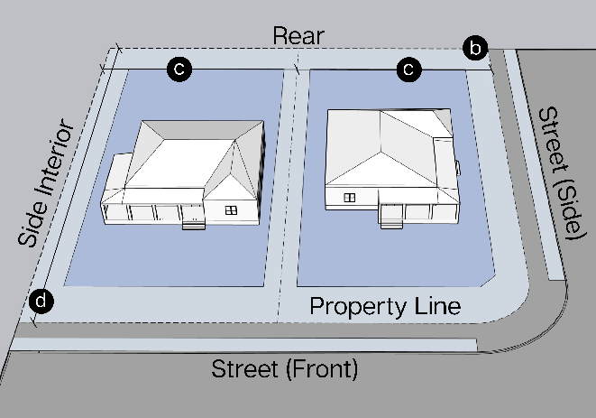
Density
(1)
Dwelling Units/Acre (maximum) 1.0
Lot dimensions
(1)
Lot Area (minimum) acres 1.0
(2)
Lot Width (minimum) feet 100
(3)
Lot Depth (minimum) feet 100
Figure ii: Setback Measurement
Setbacks
(1)
Street, Front (minimum) feet
Primary or Secondary Street
35
Local or Private Street
35
(2)
Street, Side (minimum) feet
All roadways
15
Alleys/private easements
10
(3)
Rear (minimum) feet
20
Alley/private easements
10
(4)
Side, Interior (minimum) feet 5
Height
(1)
Building Height (maximum) feet 35
Lot Coverage (maximum) Percentage
(1)
Total of all buildings on the lot 35%
Off-Street Parking and Loading
(1)
Number of off-street parking spaces, per dwelling unit 2.0
Notes
Flag pole structures are allowed to encroach on front setback ten feet outside of any easements, parking, or visibility triangles and are allowed to be up to 25 feet for residential uses. For non-residential uses up to 40 feet. A permit is not required until the flag pole is 30 feet or larger.
(Ord. No. 793-25, § 2(Exh. A), 1-23-25)
Sec. 52-306. - Single-Family Residential—Low (SF-1).
(a)
Intent.
(1)
Provide appropriate locations for residential development that are consistent with the City of Justin Experience District (Future Land Use) Plan, as amended over time;
(2)
Ensure adequate light, air, and privacy for all dwelling units;
(3)
Appropriately address multi-modal transportation access and ensure adequate availability of public services and utilities;
(4)
Allow for a variety of housing types that meet the diverse needs of residents; and
(5)
Protect residential development from the encroachment of uses that are incompatible with residential uses.
In all residential zoning districts, complementary uses such as parks, open space, public schools, religious assemblies, minor public or private utilities, accessory buildings, and certain temporary uses are also allowed.
(b)
Purpose. Residential properties with traditional lot size minimums. These single-family residences are the minimum standards for new single-family neighborhoods.
Graphic Representation
Figure i: Lot Dimension Measurement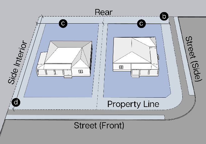
Density
(1)
Dwelling Units/Acre (maximum) 4.0
Lot dimensions
(1)
Lot Area (minimum) square feet 10,000
(2)
Lot Width (minimum) feet 80
(3)
Lot Depth (minimum) feet 100
Figure ii: Setback Measurement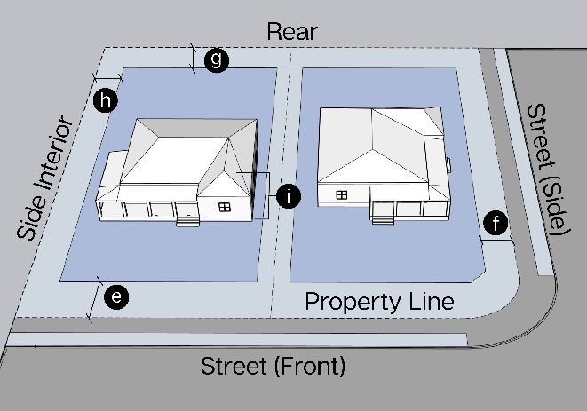
Setbacks
(1)
Street, Front (minimum) feet
Primary or Secondary Street
25
Local or Private Street
25
(2)
Street, Side (minimum) feet
All roadways
8
Alleys/private easements
8
(3)
Rear (minimum) feet
15
Alley/private easements
8
(4)
Side, Interior (minimum) feet 5
Height
(1)
Building height (maximum) feet 35
Lot Coverage (maximum) Percentage
(1)
Total of all buildings on the lot 65%
Off-Street Parking and Loading
(1)
Number of off-street parking spaces, per dwelling unit 2.0
Notes
Flag pole structures are allowed to encroach on front setback ten feet outside of any easements, parking, or visibility triangles and are allowed to be up to 25 feet for residential uses. For non-residential uses up to 40 feet. A permit is not required until the flag pole is 30 feet or larger.
(Ord. No. 793-25, § 2(Exh. A), 1-23-25)
Sec. 52-307. - Single-Family Residential—Medium (SF-2).
(a)
Intent.
(1)
Provide appropriate locations for residential development that are consistent with the City of Justin experience district (future land use) plan, as amended over time;
(2)
Ensure adequate light, air, and privacy for all dwelling units;
(3)
Appropriately address multi-modal transportation access and ensure adequate availability of public services and utilities;
(4)
Allow for a variety of housing types that meet the diverse needs of residents; and
(5)
Protect residential development from the encroachment of uses that are incompatible with residential uses.
In all residential zoning districts, complementary uses such as parks, open space, public schools, religious assemblies, minor public or private utilities, accessory buildings, and certain temporary uses are also allowed.
(b)
Purpose. Residential properties with traditional lot size minimums. These single-family residences are the minimum standards for new single-family neighborhoods.
Graphic Representation
Figure i: Lot Dimension Measurement
Density
(1)
Dwelling Units/Acre (maximum) 6.0
Lot dimensions
(1)
Lot Area (minimum) square feet 7,500
(2)
Lot Width (minimum) feet 70
(3)
Lot Depth (minimum) 100
Figure ii: Setback Measurement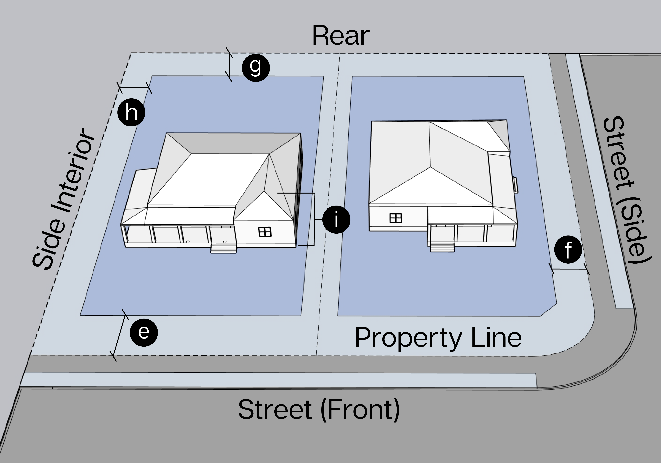
Setbacks
(1)
Street, Front (minimum) feet
Primary or Secondary Street
25
Local or Private Street
25
(2)
Street, Side (minimum) feet
All roadways
7
Alleys/private easements
7
(3)
Rear (minimum) feet
10
Alley/private easements
7
(4)
Side, Interior (minimum) feet 5
Height
(1)
Building Height (maximum) feet 35
Lot Coverage (maximum) Percentage
(1)
Total of all buildings on the lot 65%
Off-Street Parking and Loading
(1)
Number of off-street parking spaces, per dwelling unit 2.0
Notes
Flag pole structures are allowed to encroach on front setback ten feet outside of any easements, parking, or visibility triangles and are allowed to be up to 25 feet for residential uses. For non-residential uses up to 40 feet. A permit is not required until the flag pole is 30 feet or larger.
(Ord. No. 793-25, § 2(Exh. A), 1-23-25)
Sec. 52-308. - Old Town Residential (SF-OT).
(a)
Intent.
(1)
Provide appropriate locations for residential development that are consistent with the City of Justin experience district (future land use) plan, as amended over time;
(2)
Ensure adequate light, air, and privacy for all dwelling units;
(3)
Appropriately address multi-modal transportation access and ensure adequate availability of public services and utilities;
(4)
Allow for a variety of housing types that meet the diverse needs of residents; and
(5)
Protect residential development from the encroachment of uses that are incompatible with residential uses.
In all residential zoning districts, complementary uses such as parks, open space, public schools, religious assemblies, minor public or private utilities, accessory buildings, and certain temporary uses are also allowed.
(b)
Purpose. Residential properties with traditional lot size minimums. These single-family residences are the minimum standards for new single-family neighborhoods.
Graphic Representation
Figure i: Lot Dimension Measurement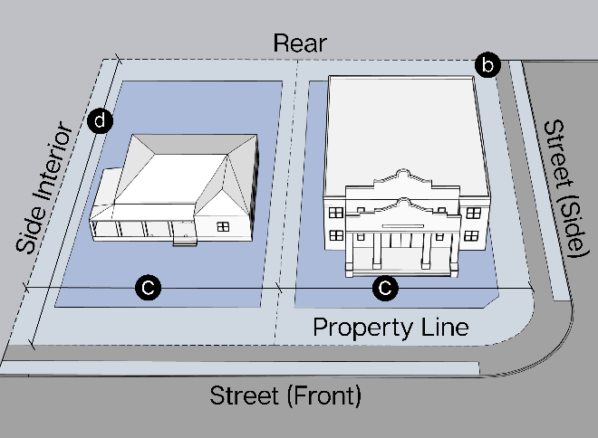
Density
(1)
Dwelling Units/Acre (maximum) 6.0
Lot Dimensions
(1)
Lot Area (minimum) square feet N/A
(2)
Lot Width (minimum) feet N/A
(3)
Lot Depth (minimum) feet N/A
Figure ii: Setback Measurement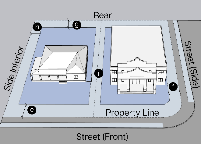
Setbacks
(1)
Street, Front (minimum) feet
Primary or Secondary Street
1
20
Local or Private Street
1
20
(2)
Street, Side (minimum) feet
All roadways
15
Alleys/private easements
10
(3)
Rear (minimum) feet
10
Alley/private easements
10
(4)
Side, Interior (minimum) feet 5
Height
(1)
Building Height (maximum) feet 35
Lot Coverage (maximum) Percentage
(1)
Total of all buildings on the lot N/A
Off-Street Parking and Loading
(1)
Number of off-street parking spaces, per dwelling unit 2 2.0
Notes
1 Front setback as listed or within four feet of the average setback on the same block face.
2 1.0 parking space per unit may be accommodated with on-street parking.
Flag pole structures are allowed to encroach on front setback ten feet outside of any easements, parking, or visibility triangles and are allowed to be up to 25 feet for residential uses. For non-residential uses up to 40 feet. A permit is not required until the flag pole is 30 feet or larger.
(Ord. No. 793-25, § 2(Exh. A), 1-23-25)
Sec. 52-309. - Missing Middle Residential (MM).
(a)
Intent.
(1)
Provide appropriate locations for residential development that are consistent with the City of Justin experience district (future land use) plan, as amended over time;
(2)
Ensure adequate light, air, and privacy for all dwelling units;
(3)
Appropriately address multi-modal transportation access and ensure adequate availability of public services and utilities;
(4)
Allow for a variety of housing types that meet the diverse needs of residents; and
(5)
Protect residential development from the encroachment of uses that are incompatible with residential uses.
In all residential zoning districts, complementary uses such as parks, open space, public schools, religious assemblies, minor public or private utilities, accessory buildings, and certain temporary uses are also allowed.
(b)
Purpose. Residential properties with medium densities, lots less than 6,000 square feet and including duplex, townhomes, and other missing middle housing types, up to ten dwelling units in a building.
Graphic Representation
Figure i: Lot Dimension Measurement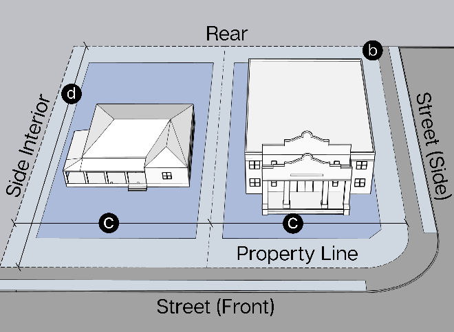
Density
(1)
Lot Area/Dwelling Unit
(maximum) per acre
18.0
Lot Dimensions
(1)
Lot Area (minimum)
per unit square feet
2,500
(2)
Lot Width (minimum) feet 25
(3)
Lot Depth (minimum) feet 50
Figure ii: Setback Measurement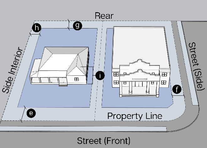
Setbacks
(1)
Street, Front (minimum) feet
Primary or Secondary Street
15
Local or Private Street
10
(2)
Street, Side (minimum) feet
All roadways
10
Alleys/private easements
5
(3)
Rear (minimum) feet
10
Alley/private easements
5
(4)
Side, Interior (minimum) feet 0
Height
(1)
Building Height (maximum) feet 35
Lot Coverage (maximum) Percentage
(1)
Total of all buildings on the lot 75%
Off-Street Parking and Loading
(1)
Number of off-street parking spaces, per dwelling unit 1 1.25
Notes
1 0.25 parking space per unit may be accommodated with on-street parking.
Flag pole structures are allowed to encroach on front setback ten feet outside of any easements, parking, or visibility triangles and are allowed to be up to 25 feet for residential uses. For non-residential uses up to 40 feet. A permit is not required until the flag pole is 30 feet or larger.
(Ord. No. 793-25, § 2(Exh. A), 1-23-25)
Sec. 52-310. - Multi-Family Residential (MF).
(a)
Intent.
(1)
Provide appropriate locations for residential development that are consistent with the City of Justin experience district (future land use) plan, as amended over time;
(2)
Ensure adequate light, air, and privacy for all dwelling units;
(3)
Appropriately address multi-modal transportation access and ensure adequate availability of public services and utilities;
(4)
Allow for a variety of housing types that meet the diverse needs of residents; and
(5)
Protect residential development from the encroachment of uses that are incompatible with residential uses.
In all residential zoning districts, complementary uses such as parks, open space, public schools, religious assemblies, minor public or private utilities, accessory buildings, and certain temporary uses are also allowed.
(b)
Purpose. Residential properties with high intensity, greater than ten units in a building. Can be used for higher intensity missing middle to apartment complexes.
Graphic Representation
Figure i: Lot Dimension Measurement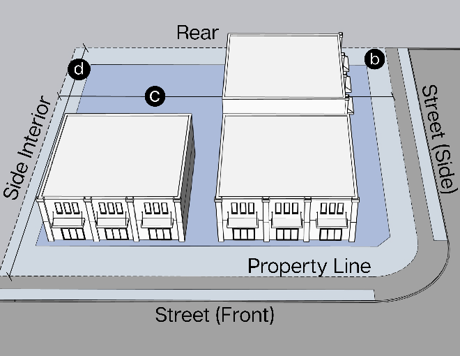
Density
(1)
Dwelling Units/Acre (maximum) 50
Lot Dimensions
(1)
Lot Area (minimum) square feet 10,000
(2)
Lot Width (minimum) feet 100
(3)
Lot Depth (minimum) feet 100
Figure ii: Setback Measurement
Setbacks
(1)
Street, Front (minimum) feet
Primary or Secondary Street
35
Local or Private Street
25
(2)
Street, Side (minimum) feet
All roadways
10
Alleys/private easements
5
(3)
Rear (minimum) feet
10
Alley/private easements
5
(4)
Side, Interior (minimum) feet 5
Height
(1)
Building Height (maximum) feet 45
(2)
Setback, above 35 feet 10
Lot Coverage (maximum) Percentage
(1)
Total of all buildings on the lot 75%
Off-Street Parking and Loading
(1)
Number of off-street parking spaces, per dwelling unit See Table 52-401B
Notes
Flag pole structures are allowed to encroach on front setback ten feet outside of any easements, parking, or visibility triangles and are allowed to be up to 25 feet for residential uses. For non-residential uses up to 40 feet. A permit is not required until the flag pole is 30 feet or larger.
(Ord. No. 793-25, § 2(Exh. A), 1-23-25)
Sec. 52-311. - Neighborhood Commercial (NC).
(a)
Intent.
(1)
Accommodate a range and different scales of non-residential uses, including office, retail, commercial, and service uses needed in Justin;
(2)
Encourage site planning, land use planning, and architectural design that create interesting and attractive environments;
(3)
Maintain and enhance the city's economic base and provide a range of shopping, entertainment, housing, lodging, and employment opportunities for the residents and visitors of Justin;
(4)
Minimize potential negative impacts of commercial and mixed-use development on adjacent residential neighborhoods; and
(5)
Help ensure that the appearance and operational impacts of commercial and mixed-use developments do not adversely affect the character of the areas in which they are located.
In all residential zoning districts, complementary uses such as parks, open space, public schools, religious assemblies, minor public or private utilities, accessory buildings, and certain temporary uses are also allowed.
(b)
Purpose. Non-residential uses operating as office, commercial, or neighborhood services.
Graphic Representation
Figure i: Lot Dimension Measurement
Density
(1)
Dwelling Units/Acre (maximum) N/A
Lot Dimensions
(1)
Lot Area (minimum) square feet 5,000
(2)
Lot Width (minimum) feet 50
(3)
Lot Depth (minimum) feet N/A
Figure ii: Setback Measurement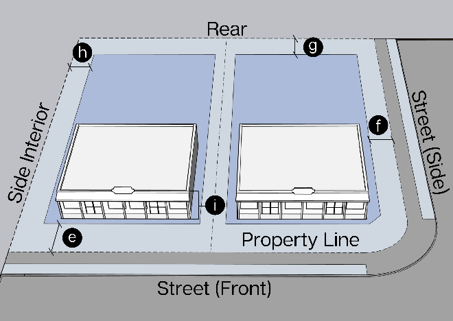
Setbacks
(1)
Street, Front (minimum) feet (see note 1)
Primary or Secondary Street
20
Local or Private Street
15
(2)
Street, Side (minimum) feet
All roadways
15
Alleys/private easements
5
(3)
Rear (minimum) feet
20
Alley/private easements
10
(4)
Side, Interior (minimum) feet
Abutting Res lot
20
Abutting any other lot
0
Height (maximum) feet
(1)
Building Height (maximum) feet 35
Lot Coverage (maximum) Percentage
(1)
Total of all structures on the lot 50%
Off-Street Parking and Loading
(1)
Number of off-street parking spaces See Table 52-401B
(2)
Access and driveway spacing to property from State Highways
TxDOT
Design Criteria
Notes
Flag pole structures are allowed to encroach on front setback ten feet outside of any easements, parking, or visibility triangles and are allowed to be up to 25 feet for residential uses. For non-residential uses up to 40 feet. A permit is not required until the flag pole is 30 feet or larger.
(Ord. No. 793-25, § 2(Exh. A), 1-23-25)
Sec. 52-312. - Regional Commercial (RC).
(a)
Intent.
(1)
Accommodate a range and different scales of non-residential uses, including office, retail, commercial, and service uses needed in Justin;
(2)
Encourage site planning, land use planning, and architectural design that create interesting and attractive environments;
(3)
Maintain and enhance the City's economic base and provide a range of shopping, entertainment, housing, lodging, and employment opportunities for the residents and visitors of Justin;
(4)
Minimize potential negative impacts of commercial and mixed-use development on adjacent residential neighborhoods; and
(5)
Help ensure that the appearance and operational impacts of commercial and mixed-use developments do not adversely affect the character of the areas in which they are located.
In all residential zoning districts, complementary uses such as parks, open space, public schools, religious assemblies, minor public or private utilities, accessory buildings, and certain temporary uses are also allowed.
(b)
Purpose. Non-residential uses operating as office, commercial, or neighborhood services
Graphic Representation
Figure i: Lot Dimension Measurement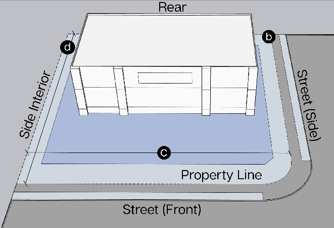
Density
(1)
Dwelling Units/Acre (maximum) N/A
Lot Dimensions
(1)
Lot Area (minimum) square feet 7,500
(2)
Lot Width (minimum) feet 50
(3)
Lot Depth (minimum) feet N/A
Figure ii: Setback Measurement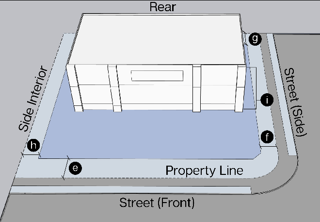
Setbacks
(1)
Street, Front (minimum) square feet
Primary or Secondary Street
20
Local or Private Street
20
(2)
Street, Side (minimum) feet
All roadways
15
Alley/private easements
5
(3)
Rear (minimum) feet
10
Alley/private easements
10
(4)
Side, Interior (minimum) feet
Abutting Res lot
20
Abutting any other lot
0
Height (maximum) feet
(1)
Building Height (maximum) feet 35
Lot Coverage (maximum) Percentage
(1)
Total of all structures on the lot 50%
Off-Street Parking and Loading
(1)
Number of off-street parking spaces See Table 52-401B
(2)
Access and driveway spacing to property from State Highways
TxDOT
Design Criteria
Notes
Flag pole structures are allowed to encroach on front setback ten feet outside of any easements, parking, or visibility triangles and are allowed to be up to 25 feet for residential uses. For non-residential uses up to 40 feet. A permit is not required until the flag pole is 30 feet or larger.
(Ord. No. 793-25, § 2(Exh. A), 1-23-25)
Sec. 52-313. - Mixed-Use (MU).
(a)
Purpose and intent.
(1)
The MU District is intended to encourage the creation of walkable development patterns in the area and connecting it to adjacent neighborhoods. The MU District is intended to be a live, work, and play area in the city. It is intended to be a mixed-use district with the higher density allowances compatible with a city center.
(2)
Development should facilitate pedestrian connections and soft transitions between residential and non-residential uses. Residential uses are encouraged on the upper floors of nonresidential establishments.
Graphic Representation
Figure i: Lot Dimension Measurement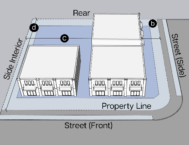
Density
(1)
Dwelling Units/Acre (maximum) 60
Lot Dimensions
(1)
Lot Area (minimum) square feet N/A
(2)
Lot Width (minimum) feet 20
(3)
Lot Depth (minimum) feet 50
Figure ii: Setback Measurement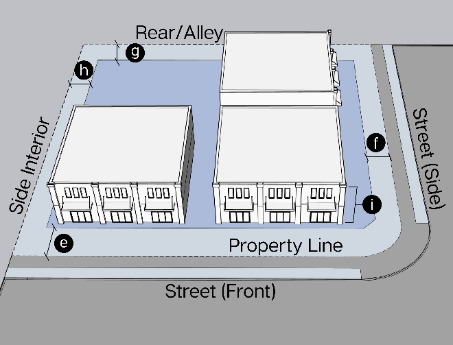
Setback Ranges (See Definitions)
(1)
Front, min./max. (feet)
Pedestrian-Priority Frontage
0 min
(see note 1)
10 max
Public Open Space, Trail
10 min
30 max
Public street or private
5 min
access easement
20 max
(2)
Side, min./max. (feet)
Pedestrian-Priority Frontage
0 min
15 max
Public street
10 min
No max
Interior Lot line
No min
No max
Private access easement or alley
5 min
No max
(3)
Rear min./max. (feet)
Alley (see note 2)
3 min
No max
All other conditions
10 min
No max
Building Standards (See Definitions)
(1)
Building height, max. (Stories/feet)
3 stories
or 45 feet
(2)
Lot coverage, max. (%) N/A
Notes
Flag pole structures are allowed to encroach on front setback ten feet outside of any easements, parking, or visibility triangles and are allowed to be up to 25 feet for residential uses. For non-residential uses up to 40 feet. A permit is not required until the flag pole is 30 feet or larger.
(Ord. No. 793-25, § 2(Exh. A), 1-23-25)
Sec. 52-314. - Light Industrial (LI).
(a)
Intent.
(1)
Accommodate a range of industrial uses, including storage, logistics, assembly, and manufacturing uses in Justin;
(2)
Encourage site planning, land use planning, and architectural design that create attractive but functional and safe environments;
(3)
Maintain and enhance the city's economic base and provide employment and manufacturing opportunities for Justin residents;
(4)
Minimize potential negative impacts of industrial uses on other adjacent uses; and
(5)
Help ensure that the appearance and operational impacts of industrial developments do not adversely affect the character of the areas in which they are located.
(b)
Purpose. Large scale manufacturing, warehouse, office, commercial, and regional shopping attractions.
Graphic Representation
Figure i: Lot Dimension Measurement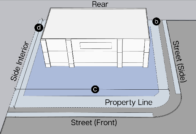
Density
(1)
Dwelling Units/Acre (maximum) N/A
Lot Dimensions
(1)
Lot Area (minimum) square feet N/A
(2)
Lot Width (minimum) feet 150
(3)
Lot Depth (minimum) feet N/A
Figure ii: Setback Measurement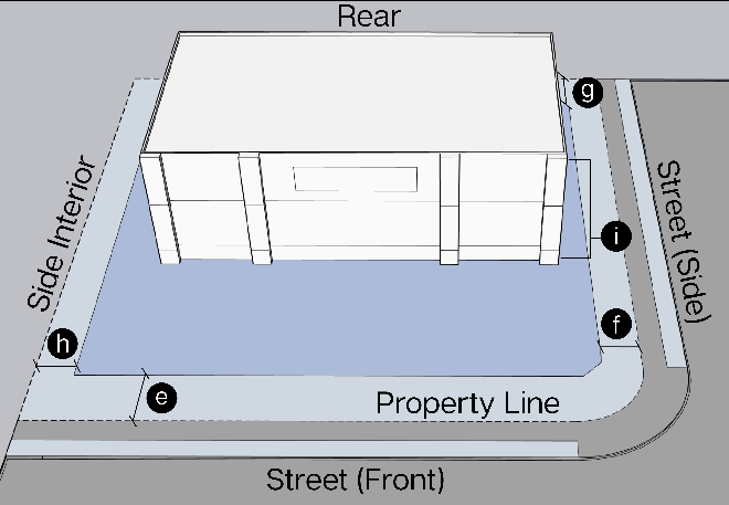
Setbacks
(1)
Street, Front (minimum) feet (see note 1)
Primary or Secondary Street
50
Local or Private Street
25
(2)
Street, Side (minimum) feet
All roadways
25
Alley/private easements
20
(3)
Rear (minimum) feet
Abutting Agriculture or Residential Lot
75
Abutting any other lot
0
(4)
Side, Interior (minimum) feet
Abutting Residential Lot
75
Abutting any other lot
0
Height
(1)
Building Height (maximum) feet 35
Lot Coverage (maximum) Percentage
(1)
All structures on the lot 50%
Off-Street Parking and Loading
(1)
Number of off-street parking spaces See Table 52-401B
(2)
Access and driveway spacing to property from State Highways
TxDOT
Design Criteria
Notes
Flag pole structures are allowed to encroach on front setback ten feet outside of any easements, parking, or visibility triangles and are allowed to be up to 25 feet for residential uses. For non-residential uses up to 40 feet. A permit is not required until the flag pole is 30 feet or larger.
(Ord. No. 793-25, § 2(Exh. A), 1-23-25)
Sec. 52-315. - Old Town (OT).
(a)
Purpose. The purpose of this district is to provide guidance on infill development standards within the historic old town area. The following standards shall apply only to those properties within the Old Town Overlay.
(b)
All development standards are set per the base zoning district according to article III, zoning districts and article IV, development standards.
(c)
Land uses permitted within the OT Overlay are regulated according to the schedule of uses.
(Ord. No. 793-25, § 2(Exh. A), 1-23-25)
Sec. 52-316. - Planned Development (PD)
(a)
Purpose. The purpose of this district is to accommodate planned associations of uses developed as integral land use units such as industrial parks or industrial districts; office, commercial or service centers; shopping centers; residential developments of multiple or mixed housing; or any appropriate combination of uses which may be planned, developed, and operated as integral land use units either by a single owner or combination of owners.
(b)
Application.
(1)
An application for a planned development district may be made to the city planning and zoning commission in the same manner that an application for any amendment to the city zoning regulations is made. Applications for approval of a planned development district shall be processed according to the procedure specified in section 52-316(e), and a site plan and related data shall be submitted for approval in accordance with the requirements in sections 52-316(g) and (h).
(2)
The city council, after public hearing and proper notice to all parties affected and after recommendation by the city planning and zoning commission, may authorize the creation of a planned development district on sites of three acres or more to accommodate various types of developments and combinations of developments.
(c)
Uses permitted.
(1)
The uses permitted in any specific planned development district shall be enumerated in the ordinance establishing such district, or by designated base zoning district in the planned development.
(2)
A mix of land uses is required for any PD, and the amount of land dedicated to a land use shall include at least three different uses and no more than 75 percent for any one use.
a.
Single-family residential.
b.
Missing middle residential.
c.
Multi-family residential.
d.
Non-residential or mixed-use.
e.
Open space, parks—No less than 10 percent of total acreage.
f.
Light industrial.
(d)
Height, floor area ratio, density, and parking and loading standards. The maximum height, lot width, lot depth, floor area ratio, and lot area, and the minimum off-street parking and loading requirements for uses proposed shall be established for each planned development district, and such standards and requirements shall comply with or be more restrictive than the standards established in the following districts for the specified type uses:
(e)
Procedure for establishing standards. In approving the development plan and the ordinance establishing the planned development district, the city council shall, after recommendation by the planning and zoning commission, specify such maximum height, floor area ratio, density and minimum off street parking and loading standards within limits of those specified in the districts listed for the specific uses involved as is appropriate for the development. The city council shall, after receiving the recommendation of the planning and zoning commission, establish the standards for yards, signs, building spacing, site coverage, access, screening walls or landscaping, building area, open space, pedestrian ways, public or private streets and alleys to be observed in a planned development district and such standards shall be specified in the ordinance establishing the district.
(f)
Development schedule.
(1)
An application for a planned development district shall, if the applicant desires or the planning and zoning commission or city council requires, be accompanied by a development schedule indicating the appropriate date on which construction is expected to begin and the rate of anticipated development to completion. The development schedule, if adopted and approved by the city council, shall become part of the development plan and shall be adhered to by the owner, developer, and his successors in interest.
(2)
Upon request of the planning and zoning commission, the developer shall report to the planning and zoning commission the actual development accomplished in the various planned development districts as compared with the development schedule.
(3)
The planning and zoning commission may, if in its opinion the owner or owners of property are failing or have failed to meet the approved schedule, initiate proceedings as provided in this section to amend the zoning district zoning map or the planned development district from the zoning district zoning map and placing the area involved in another zoning district. Upon the recommendation of the planning and zoning commission and for good cause shown by the owner and developer, the city council may also extend the development schedule or adopt such a new development schedule as may be indicated by the facts and conditions of the case.
(g)
Development plan required. An application for a planned development district shall include and be accompanied by a development plan that shall become a part of the amending ordinance and shall be referenced on the zoning district zoning map. Changes in the development plan shall be considered the same as changes in the zoning district zoning map and shall be processed as required in section 52-4, except that, changes of detail which do not alter the basic relationship of the proposed development to adjacent property and which do not alter the uses permitted or increase the density, floor area ratio, height or coverage of the site, or which do not decrease the off-street parking ratio, or reduce the yards provided at the boundary of the site as indicated on the approved development plan may be authorized by the zoning administrator. Any applicant may appeal the decision of the zoning administrator to the planning and zoning commission for review and decision as to whether an amendment to the planned development district ordinance shall be required.
(h)
Development plan contents.
(1)
The development plan shall include:
a.
A scale drawing showing any proposed public or private streets and alleys; building sites or building lots; any areas proposed for dedication or reserved as parks, parkways, playgrounds, utility and garbage easements, school sites, street widening, street changes; the points of ingress and egress from existing public streets on an accurate survey of the boundary of tract and topography with a contour interval of not less than five feet, or spot grades where relief is limited.
b.
Where multiple types of land use are proposed a land use plan delineating the specific areas to be devoted to various uses shall be required.
c.
Where building complexes are proposed, a site plan showing the location of each building and the minimum distance between buildings, and between buildings and the property line, street line or alley line shall be submitted. For buildings more than one story in height, except single-family and two-family residences, elevations or perspective drawings may be required in order that the relationship of the buildings to the adjacent property, open spaces, and to other features of the development plan may be determined. Such drawings need only indicate the height, number of floors, and exposures for access, light, and air.
d.
A plan indicating the arrangement and provision of off-street parking and off-street loading where required. Such a plan may be presented as a ratio of off-street parking and off-street loading area to building area when accompanied by a typical example indicating the feasibility of the arrangement proposed and when the areas where the example would be applied are dimensioned on a drawing of the entire site. Any special traffic regulation facilities proposed or required to ensure the safe function of the circulation plan shall also be shown.
e.
A designation of the maximum building coverage of the site shall be indicated upon the site plan.
f.
A screening and landscaping plan shall be required where such treatment is essential to the proper arrangement of the development in relation to adjacent property. Such plan shall, when required, include screening walls, ornamental plantings, playgrounds, wooded areas to be retained, lawns and gardens if such are determined to be necessary by the city council. An exception to the side yard requirements may be approved by the city council such that one side may be reduced to zero provided the other side is increased to a minimum of 18 feet. Where such use is adjacent to a residential district or is on a corner lot, a side yard shall be provided adjacent to the residential district or street.
g.
Any or all of the required features may be incorporated on a single drawing if such drawing is clear and capable of evaluation and interpretation.
(i)
Considered an amendment. Every planned development district approved under the provisions of the ordinance shall be considered an amendment to the city zoning regulations as applicable to the property involved. In carrying out the development of a planned development district, the development conditions and the development schedule, if required, shall be complied with and such conditions as specified for the development of a planned development district shall not be construed as conditions precedent to the approval of the zoning amendment, but shall be construed as conditions precedent to the granting of a certificate of occupancy and compliance as required by sections 52-405 and 52-2.
(Ord. No. 793-25, § 2(Exh. A), 1-23-25)
Sec. 52-317. - Schedule of uses.
The schedule of use regulations given below sets forth the allowable use of land and buildings in each of the classified districts. No land shall hereafter be used, and no building or structure shall hereafter be erected, altered, or converted which is arranged or designed or used for other than those uses specified for the district in which it is located.
Schedule of Uses
1 Must be permanently affixed to an approved foundation & be connected to all municipal utilities.
2 In conformance with City of Justin Gas Drilling Ordinance.
3 In conformance with City of Justin outdoor screening requirements section 52-403.
4 In conformance with conditions listed in section 52-318.
(Ord. No. 793-25, § 2(Exh. A), 1-23-25)
Sec. 52-318. - Permitted with criteria.
(a)
Applicability. Design criteria for all uses allowed under schedule of uses shall be regulated by article III, zoning districts and additional standard within article IV, development standards.
(b)
Additional criteria for considerations of a permitted use, denoted by 'PC' in the Schedule of Uses shall apply as follows:
(c)
Accessory dwelling units (ADU).
(1)
Any 10,000 square feet lot with, or zoned for, a principal single-family dwelling unit may have up to one ADU.
(2)
The zoning administrator may authorize an additional ADU if the property is in an SF-RE District and will be used for agricultural use employee housing.
(3)
An ADU may be any size, provided the proposed unit's total square footage is less than 50 percent of the primary dwellings and other setback and lot coverage requirements are satisfied.
(4)
An ADU shall not be taller than the primary structure.
(5)
An ADU shall not be set in the front yard of a primary structure.
(d)
Retail sales and services.
(1)
Gross building size limited to 10,000 square feet maximum.
(2)
Drive-throughs not permitted only permitted to the rear of the building, or to a side not facing a public right-of-way.
(e)
Temporary batch plant, concrete or asphalt.
(1)
Upon application, including a site plan, the city may authorize the issuance of a temporary batching plant permit, for a location on or adjacent to a major construction site in the city, for a period not to exceed six months with the following conditions:
a.
An 18-inch mound around the perimeter of the batch plant.
b.
A two-foot silt wall placed around the site.
c.
A water truck mitigating dust as requested by the city.
d.
Construction zone signage on any collector or thoroughfare road. Placement shall be determined by the public works director.
e.
A 500-foot minimum setback for a concrete batching plant from any existing residential uses.
f.
A 700-foot minimum setback for an asphalt batching plant from any existing residential uses.
(2)
City council shall have the sole authority to approve the permit. The permit may be issued with appropriate, reasonable conditions determined by the city council, including conditions for control of traffic, view from public or adjacent property, dust, light, noise, ingress and egress, and hours of operation.
(Ord. No. 793-25, § 2(Exh. A), 1-23-25)
Sec. 52-319. - Classification of new and unlisted uses.
The city acknowledges that new and unforeseen types of land use may emerge or seek establishment within its boundaries. To manage these situations, the process for classifying any new or unlisted land use is as follows:
(1)
The director of planning or designee appointed by the city manager, will present any new or unlisted land use issue to the city's planning and zoning commission. This request for clarification on how the land use should be zoned will include detailed information about the nature of the use, whether it involves residential areas, sales, manufacturing, the type of products involved, storage details, potential employment, and the expected levels of noise, smell, emissions, dust, hazardous materials, and vibrations.
(2)
The planning and zoning commission will review the characteristics and operational details of the proposed land use, assessing how well it fits with the permitted uses in different zones. The commission will decide on the most suitable zoning area for the use, guided by the intensity levels outlined in the Imagine Justin Comprehensive Plan.
(3)
After their evaluation, the planning and zoning commission will forward their conclusions and suggestions regarding the zoning of any new or unlisted land use to the city council. The city council will then either endorse the commission's recommendations or decide on an appropriate classification for the land use.
(Ord. No. 793-25, § 2(Exh. A), 1-23-25)
Sec. 52-320. - Unclassified areas.
(a)
After the city expands to include new areas, these areas will initially be classified under the SF-RE zoning category. This classification is temporary. The planning and zoning commission will review the new areas and suggest to the city council whether they should remain in the SF-LL RE zone or be reclassified. The areas will stay in the SF-RE zone until the city council amends this section to reflect any changes recommended by the commission.
(b)
If a street or alley is no longer in use and officially closed, the zoning district that applies to the properties next to that street or alley will be extended to the middle of the former street or alley.
(Ord. No. 793-25, § 2(Exh. A), 1-23-25)
Sec. 52-321. - Specific uses.
(a)
The city council can approve certain specific uses in designated areas, as identified in the schedule of uses, if three-fourths of its members agree. This decision comes after a public meeting, notifying all impacted parties, and getting advice from the planning and zoning commission that the use fits the city's overall plan. This process also includes making sure that the use won't negatively affect nearby properties. To apply, you need to submit a detailed site plan that shows the layout, including parking, building sizes, materials, locations, signage, how the site connects to public roads, any barriers like walls or fences, and how the proposed use relates to surrounding properties within 200 feet.
(b)
When the planning and zoning commission considers giving a permit for a specific use, they check that it will be in harmony with nearby buildings and land uses. They look at whether it meets city standards for street paving, sidewalks, access to public roads, drainage, parking, screening like walls or fences, open spaces, building heights, and construction quality. Additionally, the commission reviews:
(1)
If the proposed land use matches the Imagine Justin Comprehensive Plan; and
(2)
Any potential issues with lighting, noise, smells, etc., that might affect neighbors.
(c)
When a specific use permit is approved, it temporarily changes the zoning rules for the property in question. However, this change is not permanent. If the property is not used for six months or more, or if it is damaged and over half is destroyed, then the property must follow the original zoning rules unless a new permit is issued.
(d)
The city council may set certain requirements that must be met before the property can be used under the specific use permit. These requirements must be fulfilled to receive a certificate of occupancy from the building inspector.
(e)
A specific use permit will only be granted if the person applying for the permit, the property owner, and the permit holder agree to follow the rules and conditions outlined in the permit, which are detailed in the site plan.
(f)
After receiving a specific use permit, a building permit must be obtained within one year. The city council has the power to extend this period if the planning and zoning commission agrees.
(g)
If a building, premises, or land is currently operating under a specific use permit, it cannot be expanded, changed, structurally modified, or significantly altered without obtaining a new specific use permit for these changes.
(h)
The board of adjustment does not have the power to hear, review, overturn, or alter any decisions or actions related to the issuance, renewal, cancellation, or modification of a specific use permit.
(i)
Once the city council approves a specific use permit, the zoning map will be updated to show that the area is subject to certain conditions and restrictions. This update will include the appropriate zoning category for the approved use, marked with an 'S' for 'specific use.'
(j)
When the city council decides to issue a specific use permit, it may also impose additional conditions beyond those listed in subsection (a) if it believes these are in the public's best interest.
(k)
A specific use permit will remain valid until the business moves or has been closed for more than six months. If a new business wants to use the same location, it must apply for its own specific use permit.
(Ord. No. 793-25, § 2(Exh. A), 1-23-25)