
Justin City Zoning Code
ARTICLE V
- SUBDIVISION
Sec. 52-501. - General.
(a)
Purpose. In the interpretation and application of the provisions of these regulations, it is the intention of the city council that the principles, standards, and requirements provided for herein shall be minimum requirements for the platting and developing of subdivisions in the City of Justin and its jurisdiction, amending certain other ordinances of the city and superseding the previous subdivision chapter. Where other ordinances of the city are more restrictive in their requirements, such other ordinances shall control.
The distribution and relationship of residential, commercial, industrial, and agricultural uses throughout the community along with the system of improvements for thoroughfares, utilities, public facilities, and community amenities determine in large measure the quality of life enjoyed by the residents of the community. Health, safety, economy, amenities, environmental sensitivity, and convenience are all factors which influence and determine a community's quality of life character. A community's quality of life is of public interest. Consequently, the subdivision of land, as it affects a community's quality of life, is an activity where regulation is a valid function of municipal government. The regulations contained herein are designed and intended to encourage the development of a quality urban environment by establishing standards for the provision of adequate light, air, open space, storm water drainage, transportation, public utilities and facilities and other needs necessary for insuring the creation and continuance of a healthy, attractive, safe, and efficient community that provides for the conservation, enhancement, and protection of its human and natural resources. Through the application of these regulations, the interests of the public, as well as those public and private parties, both present and future, having interest in property affected by these regulations are protected by the granting of certain rights and privileges. By establishing a fair and rational procedure for developing land, the requirements in this chapter further the possibility that land will be developed for its most beneficial use in accordance with existing social economic and environmental conditions.
The procedure and standards for the development, layout, and design of subdivisions of land within the corporate limits and extraterritorial jurisdiction of the City of Justin, Texas are intended to:
(1)
Promote the health, safety, morals and general welfare of the community and the safe, orderly, and healthful development of the city;
(2)
Establish adequate policies and procedures to guide development of the city and its extraterritorial jurisdiction;
(3)
Provide for the establishment of minimum specifications for construction and engineering design criteria for public infrastructure improvements to maintain land values, reduce inconveniences to residents of the area, and to reduce related unnecessary costs to the city for correction of inadequate facilities that are designed to serve the public;
(4)
Ensure that development of land and subdivisions shall be of such nature, shape, and location that utilization will not impair the general welfare;
(5)
Ensure against the dangers of fires, floods, erosion, landslides, or other such menaces;
(6)
Preserve the natural beauty and topography of the city and to ensure appropriate development with regard to these natural features;
(7)
Realistically and harmoniously relate new development of adjacent properties;
(8)
Ensure that public facilities for streets, alleys, water distribution, drainage, collection and disposal of sanitary wastewater, and parks are available for every building site and with adequate capacity to serve the proposed subdivision before issuance of a certificate of occupancy or release of utility connections or final inspection within the boundaries of the plat;
(9)
Assure that new development adequately and fairly participates in the dedication and construction of public infrastructure improvements that are necessitated by or attributable to the development or that provide value or benefit that makes the development feasible;
(10)
Help prevent pollution, assure the adequacy of drainage facilities, control storm water runoff, safeguard both groundwater and surface water supplies, and encourage the wise use and management of natural resources throughout the city and its extraterritorial jurisdiction to preserve the integrity, stability, and beauty of the community and the value of the land; and
(11)
Promote and develop the utilization of land in a manner to assure the best possible community environment in accordance with the master plans and the zoning ordinance of the city;
(12)
Guide and assist the subdividers in the correct procedures to be followed and to inform them of the standards which shall be required;
(13)
Protect the public interest by supervising the location, design, class and type of streets, sidewalks, utilities and essential areas and services required;
(14)
Assist orderly, efficient and coordinated development within the extraterritorial jurisdiction;
(15)
Promote neighborhood conservation and prevent the development of slums and blight;
(16)
Harmoniously relate the development of the various tracts of land to the existing community and facilitate the future development of adjoining tracts;
(17)
Provide that the cost of improvements to minimum standards which primarily benefit the tract of land being developed be borne by the owners or subdividers of the tract, and that cost of improvements to minimum standards which primarily benefit the whole community be borne by the whole community;
(18)
Provide the best possible design for each tract being subdivided;
(19)
Provide the most attractive relationship between the uses of land and buildings and the circulation of traffic throughout the municipality, having regard to the avoidance of congestion in the streets and highways, and the pedestrian traffic movements appropriate to the various uses of land and buildings, and to provide the proper location and width of streets;
(20)
Establish adequate and accurate records of land subdivision;
(21)
Ensure that public or private facilities are available and will have a sufficient capacity to serve proposed subdivisions and developments within the territorial jurisdiction;
(22)
Encourage and promote open-space, park land and recreation space opportunities located within residential neighborhoods;
(23)
Provide for adequate light, air, and privacy; secure safety from fire, flood, and other danger; and prevent overcrowding of the land and undue congestion of population;
(24)
Guide public and private policy and action in providing adequate and efficient transportation systems, public utilities, and other public amenities and facilities; and
(25)
Encourage the development of a stable, prospering economic environment.
Minimum standards for development are contained in the zoning ordinance, the building and construction codes and in this chapter. However, the future land use plan expresses policies designed to achieve an optimum quality of development in the urban area. If only the minimum standards are followed, as expressed by the various ordinances regulating land development, a standardization of development will occur. This will produce a monotonous urban setting. Subdivision design should be of a quality to carry out the purpose and spirit of the policies expressed in the plan and in this chapter and is encouraged to exceed the minimum standards required herein.
(b)
Authority and jurisdiction. The following rules and regulations are hereby adopted as the subdivision regulations of the City of Justin, Texas, and shall be applicable to the filing of plats, the subdivision of land and the development of property, as that term is defined herein and in V.T.C.A., Local Government Code, Chapter 212, within the corporate city limits of the City of Justin as they may be from time to time adjusted by annexation or disannexation and within all the areas of the extraterritorial jurisdiction of the City of Justin as that area may exist from time to time as provided by V.T.C.A., Local Government Code, Chapter 42. The city shall have all remedies and rights provided by said Chapter 212 with regard to the control and approval of subdivisions and plats both within the city and within its extraterritorial jurisdiction.
As authorized by V.T.C.A., Local Government Code, Chapter 212, the provisions contained in the following sections of these subdivision regulations shall apply to any of the following forms or types of land subdivision and development activity within the city limits or its extraterritorial jurisdiction.
(1)
The division of land into two or more tracts, lots, sites, or parcels; or
(2)
All subdivisions of land, whether by metes and bounds division or by plat, which were outside the jurisdiction of the city's subdivision regulations in Denton County, Texas and which subsequently came within the jurisdiction of the city's subdivision regulations through:
a.
Annexation; or
b.
Extension of the city's extraterritorial jurisdiction.
(3)
The division of land previously subdivided or platted into tracts, lots, sites or parcels subject to and not in accordance with adopted city subdivision regulations in effect at the time of such subdividing or platting; or
(4)
The combining of two or more contiguous tracts, lots, sites or parcels for the purpose of creating one or more legal lots in order to achieve a more developable site except as otherwise provided herein; or
(5)
When a building permit is required on property for the following reasons but not limited to:
a.
New construction;
b.
Moving of a primary structure onto vacant property; or
(6)
For tracts where any public improvements are proposed; or
(7)
Whenever a property owner proposes to divide land lying within the City or its extraterritorial jurisdiction into two or more tracts for purpose of development, that results in parcels or lots all greater than five acres in size, or in the event that development of any such tract is intended, and where no public improvement is proposed to be dedicated, he shall first obtain approval of a development plat that meets the requirements of V.T.C.A., Local Government Code Chapter 212, subchapter B.
(c)
Owner consent. Except as otherwise expressly provided herein, the written consent of the owner of any tract of land to be subdivided in accordance with the terms of this chapter shall be required for any application relating to or for a plat, replat, pre-application proposal, plat amendment, or any application to be reviewed by the development review committee. The owner's representative may provide the required written consent in place of the owner if the representative has, in a form acceptable to the city attorney, express written authority to act on behalf of the owner. The owner's written consent shall be required in accordance with this section, regardless of whether this chapter refers to the party making application to the city pursuant to this chapter as "owner," "subdivider," "person," "developer" or "applicant."
(d)
Conformance with applicable rules and regulations. The subdivision regulations of this chapter are held to be the minimum requirements for the development of property within the city. In addition to the requirements established herein, all plats must conform to the following:
(1)
All applicable state statutory provisions contained in V.T.C.A., Local Government Code, Chapter 212.
(2)
The zoning ordinance, building and housing codes, and other applicable development codes of the city.
(3)
The official comprehensive land use plan; capital improvements program; master drainage plan; parks, recreation, and open space plan; transportation plan; and any other official plan adopted by the city council that influences the subdivision of property in the city.
(4)
Any regulations of the city and county health departments and appropriate state agencies.
(5)
The regulations of the state department of transportation when the subdivision abuts a state-maintained highway.
(6)
The standards, codes and regulations adopted for administration by the building official.
(7)
No building permit, or certificate of occupancy, or plumbing permit, or electrical permit, or utility tap or certificate of acceptance for required public improvements shall be issued by the city for any parcel or plat until:
a.
All water, wastewater, streets, drainage, electrical, public utilities and park improvements, whether they are public or private, as required by these regulations, have been constructed and accepted by the city in accordance with articles IV and V of this chapter, the city's technical construction standards and specifications (TCSS) or other applicable regulations; and
b.
To carry out the purposes hereinabove stated, it is declared to be the policy of the city to guide and regulate the subdivision and development of land in such a manner as to promote orderly growth both within the city and where applicable, within its extraterritorial jurisdiction, it is determined that:
1.
Land must not be platted until proper provision has been made for adequate public facilities for roadways, drainage, water, wastewater, public utilities, capital improvements, parks, recreation facilities, and rights-of-way for streets;
2.
Proposed plats, or subdivisions which do not conform to the policies and regulations shall be denied, or, in lieu of denial, disapproved conditioned on conformance with conditions; and
3.
There shall be an essential nexus between the requirement to dedicate rights-of-way and easements and/or to construct public works improvements in connection with a new subdivision and the need to offset the impacts on the city's public facilities systems created by such new development.
(8)
No transfer of land in the nature of a subdivision as defined herein shall be exempt from the provisions of this chapter unless otherwise specified, even though the instrument or document of transfer may describe land so subdivided by metes and bounds. The filing of any plan, plat, amended plat or replat without complying with the requirements of this chapter shall be deemed a violation of the provisions of this chapter and is hereby prohibited. The transfer of any land by the delivery of or by the filing of any instrument in the nature of a conveyance without having first complied with the requirements set forth herein shall be deemed a violation of the provisions of this chapter and is hereby prohibited. There is, however, excepted from the provisions of this chapter any conveyance transferring any land or interest in land to or from the State of Texas or City of Justin, Texas.
(e)
Conflicts.
(1)
In their interpretation and application, the provisions of these regulations shall be held to be the minimum requirements for the promotion of public health, safety, and general welfare. These regulations shall be construed broadly to promote the purposes for which they are adopted.
(2)
These regulations are not intended to interfere with, abrogate, or annul any other ordinance, rule or regulation, statute of other provision of law except as provided in these regulations. Where any provision of these regulations imposes restrictions different from those imposed by any other provision of these regulations, or other provision of law, the provision which is more restrictive or imposes higher standard shall control.
(3)
This chapter is not intended to revoke or repeal any easement, deed restriction, covenant, or any other private agreement. In no case is the city to be obligated to enforce the provisions of any easement, deed restriction, covenant, or other agreements between private parties.
(4)
If any part of the provision of these regulations or the application of these regulations to any person or circumstances is adjudged invalid by any court of competent jurisdiction, the judgment shall be confined in its operation to the part, provision, or application directly involved in the controversy in which the judgment shall be rendered and it shall not affect or impair the validity of the remainder of these regulations or the application of them to other persons or circumstances. The city council hereby declares that it would have enacted the remainder of these regulations even without any such part, provision, or application which is judged to be invalid.
(f)
Exemptions. The provisions of these subdivision regulations shall not apply to:
(1)
Land legally platted and approved prior to the effective date of these subdivision regulations except as otherwise provided for herein (construction of facilities shall conform to construction standards in effect at the time of construction); or
(2)
Land constituting a single tract, lot, site or parcel for which a legal deed of record describing the boundary of said tract, lot site or parcel was filed of record in the deed records of Denton County, Texas on or before March 24, 1997; or
(3)
Inheritance or gift of land within immediate family by metes and bounds of tracts on which no improvements or alteration is occurring; or
(4)
Existing cemeteries complying with all state and local laws and regulations (does not apply to new cemeteries or expansion of existing cemeteries); or
(5)
Divisions of land created by order of a court of competent jurisdiction; or
(6)
When a building permit is requested for unplatted or already platted parcels for the following activities:
a.
Replacement or reconstruction of an existing primary single-family or duplex structure but not to exceed the square footage of the original structure.
b.
Additions (increase in square footage of structure) constituting not over 60 percent of the existing structure's value and not over 50 percent of the gross floor area.
c.
Accessory buildings.
d.
Remodeling or repair (no expansion of square footage).
e.
Moving a structure off a lot or parcel or for demolition permit.
(g)
Saving provision. These regulations shall not be construed as abating any action now pending under, or by virtue of, prior existing subdivision regulations, or discontinuing, abating, modifying, or altering any penalty accruing or about to accrue, or as affecting the liability of any person, firm, or corporation, or as waiving any right of the city under any section or provision existing at the time of adopting of these regulations, or as vacating or annulling any rights obtained by any person, firm, or corporation, by lawful action of the city except as shall be expressly provided in these regulations.
(h)
Proportionality determination.
(1)
Prior to a decision by the planning and zoning commission on a final plat, replat, or development plat application or any other application for which an exaction is required as a condition of approval, the city engineer shall prepare a written statement affirming that each exaction requirement to be imposed as a condition of plat approval or permit approval is roughly proportionate to the demand created by the subdivision or development on the applicable public facilities system of the city, taking into consideration the nature and extent of the development proposed. In making this determination, the city engineer may consider:
a.
Categorical findings of the North Central Texas Council of Governments in developing standard specifications for public infrastructure improvements;
b.
The proposed and potential use of the land;
c.
The timing and sequence of development in relation to availability of adequate levels of public facilities systems;
d.
Impact fee studies, traffic impact studies, drainage studies or other studies that measure the demand for services created by developments and the impact on the city's public facilities system;
e.
The function of the public infrastructure improvements in serving the proposed subdivision or development;
f.
The degree to which public infrastructure improvements necessary to serve the proposed subdivision are supplied by other developments;
g.
The anticipated participation by the city in the costs of necessary public infrastructure improvements;
h.
The degree to which acceptable private infrastructure improvements to be constructed and maintained by the applicant will offset the need for public infrastructure improvements;
i.
Any reimbursements for the costs of public infrastructure improvements for which the proposed subdivision is eligible; and/or
j.
Any other information relating to the impacts created by the proposed subdivision or development on the city's public facilities systems.
(2)
Based upon the proportionality determination, the city engineer shall affirm that the exaction requirements of the subdivision ordinance, or other ordinance requiring the permit, as applied to the proposed subdivision or development, do not impose costs on the applicant for public infrastructure improvements that exceed those roughly proportionate to the impact of the proposed subdivision or development.
(3)
The city engineer may require that the applicant, at its expense, submit any information or studies that may assist in making the proportionality determination.
(4)
Rough proportionality determination. The planning and zoning commission and city council shall consider the city engineer's report concerning the proportionality of the exaction requirements in making a decision on a plat. The planning and zoning commission and the city council may consider the city engineer's report in granting a variance to the requirements of the subdivision ordinance.
The city official responsible for issuing any permit for which an exaction requirement is imposed as a condition of approval shall consider the city engineer's report concerning the proportionality of the exaction requirements in making its decision as to whether to grant the permit.
(5)
Rough proportionality appeal. An applicant for a plat or any development which imposes an exaction requirement as a condition of approval may file an appeal to contest any exaction requirement, other than impact fees, imposed as a condition of approval or in which the failure to comply is grounds for denying the plat application pursuant to the subdivision ordinance.
The purpose of a proportionality appeal is to assure that an exaction requirement imposed on a proposed plat or development as a condition of approval does not result in a disproportionate cost burden on the applicant, taking into consideration the nature and extent of the demands created by the proposed subdivision or development on the city's public facilities systems.
(6)
Appeals procedure. An applicant for a final, replat, development plat or an applicant seeking approval for any other application or permit or zoning for which an exaction requirement is imposed shall file a written appeal with the city secretary within ten days of the date the planning and zoning commission or the city official responsible for processing the application or issuing the permit takes action applying the exaction requirement. This may include denial of the permit or plat application. The applicant shall submit 15 copies of the appeal.
a.
A separate appeal form shall be submitted for each exaction requirement for which relief is sought. The city secretary shall forward the appeal to the city engineer for informational purposes and the city council for consideration;
b.
The applicant may request postponement of consideration of the applicant's plat application by the city council pending preparation of the study required by subsection 52-127(f)(5), in which case the applicant shall also waive the statutory period for acting upon a plat for the time necessary for the city council to decide the appeal;
c.
No subdivider's public improvement agreement or subdivider's agreement may be executed by the city until the time for appeal has expired or, if an appeal is filed, until the city council has made a determination with respect to the appeal;
d.
The appeal shall state the reasons that application of the exaction requirement is not roughly proportional to the nature and extent of the impact created by the proposed subdivision or development on the city's public facilities systems and does not reasonably benefit the proposed subdivision or development;
e.
The appellant shall submit to the city engineer 15 copies of a study in support of the appeal that includes, with respect to each specific exaction requirement appealed, the following information within 30 days of the date of appeal, unless a longer time is requested:
1.
Total capacity of the city's water, wastewater, roadway, drainage, or park system, as applicable, to be utilized by the proposed subdivision or development, employing standard measures of capacity and equivalency tables relating the type of development proposed to the quantity of system capacity to be consumed by the subdivision. If the proposed subdivision is to be developed in phases, such information also shall be provided for the entire development, including any phases already developed;
2.
Total capacity to be supplied to the city's public facilities systems for water, wastewater, roadway, drainage or parks, as applicable, by the exaction requirement. This information shall include any capacity supplied by prior exaction requirements imposed on the development;
3.
Comparison of the capacity of the applicable city public facilities systems to be consumed by the proposed subdivision or development with the capacity to be supplied to such systems by the proposed exaction requirement. In making this comparison, the impacts on the city's public facilities systems from the entire subdivision or development shall be considered;
4.
The amount of any city participation in the costs of oversizing the public infrastructure improvements to be constructed by the applicant in accordance with the city's requirements;
5.
Comparison of the minimum size and capacity required by city standards for the applicable public facilities systems to be utilized by the proposed subdivision or development with the size and capacity to be supplied by the proposed exaction requirement; and
6.
Any other information that shows the alleged disproportionality between the impacts created by the proposed development and the exaction requirement imposed by the city.
f.
The city engineer shall evaluate the appeal and supporting study and shall make a recommendation to the city council based upon the city engineer's analysis of the information contained in the study and utilizing the same factors considered by the engineer in making the original proportionality determination.
(7)
Council determination. The city council shall decide the appeal within 30 days of the date of final submission of any evidence by the applicant. Upon receipt of the final submission of evidence from the applicant, the city shall schedule a time and date for the city council to consider the appeal and shall cause the applicant to be notified at the address specified in the appeal form of the time, date and location at which the city council shall consider the appeal.
a.
The applicant shall be allotted time, not to exceed 30 minutes, to present testimony at the city council meeting. The council shall base its decision on the criteria listed in sections 52-501(h)(1) and 52-501(h)(6)e. and may:
1.
Deny the appeal and impose the exaction requirement in accordance with the city engineer's recommendation or the planning and zoning commission's decision on the plat or other development application;
2.
Grant the appeal, and waive in whole or in part an exaction requirement to the extent necessary to achieve proportionality; or
3.
Grant the appeal, and direct that the city participate in the costs of acquiring land for or constructing the public infrastructure improvement.
b.
In deciding an appeal, the city council shall determine whether application of the exaction requirement is roughly proportional to the nature and extent of the impact created by the proposed subdivision on the city's public facilities systems for water, wastewater, roadway, drainage, or park facilities, as applicable, and reasonably benefits the subdivision. In making such determination, the council shall consider:
1.
The evidence submitted by the applicant;
2.
The city engineer's report and recommendation, considering in particular the factors identified in sections 52-501(h)(1) and 52-501(h)(6)e.; and
3.
If the property is located within the city's extraterritorial jurisdiction, any recommendations from the county.
c.
The city council may require the applicant or the city engineer to submit additional information that it deems relevant in making its decision.
(8)
Action following decision of council.
a.
If the city council finds in favor of the applicant and waives the exaction requirement as a condition of plat approval, or modifies the exaction requirement to the extent necessary to achieve rough proportionality, the applicant shall resubmit the plat application to the planning and zoning commission or city official responsible for issuing the permit within 30 days of the date the city council takes action, with any modifications necessary to conform the plat with the city council's decision. The applicant shall not be deemed to have prevailed in the event that the city council modifies the exaction requirement.
b.
If the city council finds in favor of an applicant for any other development related application or permit and waives the exaction requirement as a condition of permit approval, or modifies the exaction requirement to the extent necessary to achieve rough proportionality, the applicant shall resubmit the permit application to the responsible official within 30 days of the date the city council takes action, with any modifications necessary to conform the application with the city council's decision. Failure to do so will result in the expiration of any relief granted by the city council.
c.
If the city council denies the appeal and the applicant has executed a waiver of the statutory period for acting upon a plat, the city shall place the plat application on the agenda of the planning and zoning commission within 30 days of the city council's decision.
d.
If the rough proportionality appeal was submitted appealing the imposition of an exaction requirement for a plat application, and city council grants relief to an applicant but the applicant fails to conform the plat to the city council's decision within the 30-day period provided, the relief granted by the city council on the appeal shall expire and plat shall become null and void.
e.
If the plat application is modified to increase the number of residential dwelling units or the intensity of non-residential uses, the director of planning or city engineer may require a new study to validate the relief granted by the city council.
f.
If the plat application for which relief was granted is denied on other grounds, a new appeal shall be required on any subsequent application.
(9)
Appeal of the city council decision. An applicant may appeal the decision of the city council to the county or district court of the county in which the development is located within 30 days of the date that the council issues its final decision. In the event that the applicant prevails in such action, the applicant will be entitled to attorneys' fees and costs, including expert witness fees.
(Ord. No. 793-25, § 2(Exh. A), 1-23-25)
Sec. 52-502. - Administration.
(a)
Modifications, waivers, and exceptions. The city council may approve waivers to these subdivision regulations so that substantial justice may be done, and the public interest secured when it finds that unreasonable hardships or difficulties may result from strict compliance with these regulations, and/or the purposes of these regulations may be served to a greater extent by an alternative proposal. Any variance granted shall not have the effect of nullifying the intent and purpose of these regulations. When considering a waiver, the city council shall consider the following:
(1)
The granting of the waiver will not be detrimental to the public safety, health, or welfare or injurious to other property;
(2)
The conditions upon which the request for a waiver is based are unique to the property for which the waiver is sought and are not applicable generally to other property.
(3)
Because of the physical surroundings, shape or topographical conditions of the specific property involved, a particular hardship to the owner would result as distinguished from a mere inconvenience, if the strict letter of these regulations is carried out;
(4)
The waiver will not, in any manner, vary the provisions of the zoning ordinance or future land use plan, thoroughfare plan, and other adopted plans, except that those documents may be amended in the manner prescribed by law.
(b)
Enforcement of chapter regulations.
(1)
Violations and penalties. Any person, firm or corporation who violates any of the provisions of this chapter or who fails to comply with any provision hereof shall be guilty of a misdemeanor and upon conviction, shall be subject to a fine not to exceed $500.00 and each day that such violation continues shall constitute a separate offense. Prosecution or conviction shall not be a bar to any other remedy authorized by this or other law.
(2)
Civil enforcement. Appropriate civil actions and proceedings may be maintained in law or in equity to prevent unlawful construction, to recover damages, to impose additional penalties, to restrain, correct, or abate a violation of these regulations, whether such violation occurs with respect to lands within the corporate boundaries of the city or within the city's extraterritorial jurisdiction. These remedies shall be in addition to the penalties described above.
(3)
Payment of all indebtedness. No person who owes delinquent taxes, delinquent paving assessments or any other delinquent debts or obligations, and which are directly attributable to a piece of property shall be allowed to record an approved plat until the taxes, assessments, debts, or obligations directly attributable to said property and owned by the owner or previous owner thereof shall have been first fully discharged by payment, or until an arrangement satisfactory to the director of planning has been made for the payment of such debts or obligations. It shall be the applicant's responsibility to provide evidence or proof that the taxes have been paid at the time of platting.
(4)
Proof of paid taxes shall be in the form of a tax certificate bearing the seal of the county tax assessor, procured less than 30 days prior to time of platting. The certificate(s) must attest to paid taxes on all property being platted.
(c)
Amendments. For the purpose of protecting the public health, safety and general welfare, the planning and zoning commission and city council may from time to time propose amendments to these regulations which shall then be approved or disapproved by the city council at a public meeting.
(d)
Completeness determination and misrepresentation.
(1)
The city shall have the right to deny or delay a hearing if the person or applicant proposing a subdivision of land does not:
a.
Submit all the information necessary and required for a pre-application proposal and/or plat application by the required deadlines;
b.
Pay the required application fees;
c.
Fail to provide any other items or information as prescribed by this and other applicable sections.
(2)
It shall be unlawful for any person to knowingly or willfully misrepresent or fail to include, any information required by this chapter on any application for annexation, zoning, development, or subdivision of property.
(3)
Penalties and exceptions. If any applicant for such hearing, or any owner of property subject to such hearing, shall allow such hearing before the planning and zoning commission and/or the city council to be heard in violation of any of the provisions of this chapter, such person shall be deemed guilty of a misdemeanor and upon conviction thereof shall be subject to a penalty as per section 52-502.
(Ord. No. 793-25, § 2(Exh. A), 1-23-25)
Sec. 52-503. - Pre-application.
(a)
Applicability.
(1)
A pre-application proposal may be required at the discretion of the Development Review Committee or director of planning for all preliminary and final plats.
(2)
The pre-application proposal required by this chapter is not a plat. The submission of a preapplication proposal does not constitute and shall not be construed as the submission of or filing of a plat within the meaning of this chapter or within the meaning of the laws of the State of Texas or of the United States, including, without limitation, V.T.C.A., Local Government Code, Chapter 212.
(3)
A fee shall be collected for pre-application conferences. The fee shall be set via resolution by the city council from time to time. A fee shall be collected for the formal application prior to the commencement of review in earnest. The fee shall be set via resolution by the city council from time to time.
(b)
Purpose.
(1)
Provide the city with information needed for proper enforcement of the provisions of this chapter, including information not evidenced on the plat; and
(2)
To facilitate cooperation between city staff and the subdivider so that the proposed plat application ultimately submitted to the city acceptable and in proper form.
(3)
To save time, money, and to avoid unnecessary delays.
(Ord. No. 793-25, § 2(Exh. A), 1-23-25)
Sec. 52-504. - Preliminary plats.
(a)
Applicability. A preliminary plat shall be required when subdividing and developing property in phases derived from one parent tract or contiguous land under the same ownership.
(b)
Approval authority.
(1)
Preliminary plats that meet all applicable requirements shall be approved by the director of planning.
(2)
Preliminary plats that are requesting waivers of certain requirements shall be approved by the city council with a planning and zoning commission recommendation. Waivers requested shall be derived from the regulations derived from the subdivision chapter and not from zoning requirements.
(3)
An approved preliminary plat shall be valid for a period not to exceed one year after the date of approval. A one-time, six-month extension may be granted by the development review committee, provided that a written request for an extension signed and filed by the subdivider prior to the expiration of the preliminary plat. If a preliminary plat is not acted upon within the time period set forth herein, the subdivider will be required to file a new pre-application proposal and pay all applicable fees.
a.
In determining whether to grant a request for extension, the development review committee shall take into account the reasons for lapse, the ability of the property owner to comply with any conditions attached to the original approval and the extent to which newly adopted subdivision regulations shall apply to the plat or study. The committee shall extend or reinstate the plat or study, or deny the request, in which case the property owner must submit a new application for approval and pay all applicable fees.
(c)
General requirements.
(1)
All submittals shall be digital format in portable document format (PDF) as one file.
(2)
The preliminary plat shall be submitted to the city with the filing fee as approved and adopted by city council separate resolution.
(3)
The preliminary plat shall be in accordance with the master plan including all adopted water, sewer, future land uses, and thoroughfare plans.
(4)
The preliminary plat shall be prepared by an engineer, land planner, surveyor, or other qualified individual.
(5)
A preliminary plat shall include all contiguous property under the ownership or control of the applicant. It may contain more than one phase which, if so, shall be clearly identified.
(6)
It shall be a requirement that the preliminary plat show the entire parent survey or tract of land to be subdivided, even if the subdivider proposes to develop the parent tract or land in survey in future phases. Incrementally carving out select lots from the original survey or tract of land without showing the entire survey and tract and availing known intent and purpose for the remainder is prohibited.
(7)
The preliminary plat shall be accompanied by a preliminary water plan, a preliminary sewer plan, a preliminary street plan and a preliminary drainage plan for concept review of engineering problems for review and comment.
(8)
No construction work shall begin on the proposed improvements in the proposed subdivision prior to approval of the final plat and a preconstruction meeting has been held and agreed to by the city and subdivider.
(d)
Review and decision.
(1)
Process.
a.
Standard.

b.
Waivers requested.

(2)
Reviews.
a.
Standard of approval. No preliminary plat shall be approved unless the following standards have been met:
1.
The preliminary water plan, preliminary sewer plan, preliminary street plan and the preliminary drainage plan have been submitted to the development coordinator and approved by the development review committee at the discretion of the development coordinator.
2.
The preliminary plat conforms to applicable zoning and other regulations.
3.
The preliminary plat meets all other requirements of these regulations.
b.
Proposed preliminary plats or subdivisions which do not conform to the policies and regulations shall be denied, or in lieu of denial, conditionally denied based on conformance with conditions. Except as provided herein, approval of a preliminary plat constitutes authorization for the property owner, upon fulfillment of all requirements of approval or conditions which have been met as a part of a conditional denial, to submit an application for final plat approval. If required, a public improvements agreement or any other necessary agreement must be approved prior to approval of the final plat.
(Ord. No. 793-25, § 2(Exh. A), 1-23-25)
Sec. 52-505. - Final plats.
(a)
Approval authority.
(1)
Final plats that meet all applicable requirements shall be approved by the director of planning.
(2)
Final plats that are requesting waivers of certain requirements shall be approved by the city council with a planning and zoning commission recommendation. Waivers requested shall be derived from the regulations derived from the subdivision chapter and not from zoning requirements.
(b)
General requirements.
(1)
All submittals shall be digital format in portable document format (pdf) in one file.
(2)
The final plat, amending plats, and replats shall be prepared by a registered public land surveyor or state licensed land surveyor. Construction plans shall be prepared by a professional engineer licensed in the State of Texas as required by state law governing such professions in accordance with this chapter. Plans submitted for review by the city shall be dated and bear the responsible engineer's name, license or registration number, and the designation of "professional engineer," or "P.E.", and an appropriate stamp or statement near, the engineer's identification, stating that the documents are for preliminary review and are not intended for construction. Construction plans acceptable to the city shall bear the seal and signature of the engineer and the date signed on all sheets of the plans.
(3)
Required plans and studies shall include as a minimum:
a.
Water plan including water mains, service connections, and any special structures such as wells, elevated storage tanks, and pump stations;
b.
Sanitary sewer plan including sanitary sewer mains, service connections and any special structures or facilities, such as lift stations, septic systems, lagoons, oxidation ponds, and package plants;
c.
Street plan including street design and layout with proposed ROW and street paving widths, a street light plan, and any special design requirements or needs as requested by city staff or applicant, such as detailing: Boulevard entrances, off-site improvements, ROW expansion or roadway dedication needs, etc.; and
d.
Drainage plan including stormwater drainage mains, channels, culverts, bridges, retention or detention ponds, and other major drainage facilities.
(4)
The final plat shall be in accordance with the preliminary plat, as approved, and incorporate all conditions, changes, directions and additions as approved. The final plat shall not be submitted prior to approval of the preliminary plat and shall contain all the required information required herein for a valid final plat submittal. A final plat shall not be accepted by the city if a preliminary plat has expired and become void. At the time the subdivider files the final plat with the development coordinator, the subdivider shall also file a certificate showing that all taxes have been paid on the tract to be subdivided and that no delinquent taxes exist against the property.
(5)
The final plat shall constitute only that portion of the approved preliminary plat which the subdivider proposes to record and then develop, provided, however, that such portion conforms to all the requirements of these regulations.
(6)
An amending plat may be issued and recorded in accordance with Local Government Code Section 212.016.
(7)
Additional notifications may be required with certain replats in accordance with Local Government Code Section 212.015.
(8)
Before approval of any final plat, if applicable, the subdivider shall have executed a public improvements agreement and provided a security deposit.
(9)
The subdivider and/or applicant shall return copies of the final plat, as approved, with any other required documents and necessary fees attached thereto to the development coordinator within 30 days in accordance with requirements established by the city. All easements shall be included as required by utility companies or the city prior to filing and a copy of letters from each applicable utility company shall be submitted to the development coordinator stating that the plat contains the proper easements or a statement of their approval of the abandonment or vacation of easements. Mylars, reductions, tax certificate and copies as may be required by the Denton County clerk, in addition to mylar copies required by the city, shall be returned to the city secretary with the required fees. If the required copies are not returned to the city within the specified time, the city council approval of the final plat shall be null and void unless an extension is granted by the city council.
(10)
After approval of the plat, plans, and specifications by the city, the subdivider shall cause a contractor to install the facilities in accordance with the approved plans and standard specifications of the city and at the subdivider's expense. The subdivider shall employ engineers, surveyors, and other professionals as necessary to design, stake and supervise the construction of such improvements and shall cause his contractor to construct the said improvements in accordance with these regulations. The public works department shall inspect the installation of the improvements.
(11)
The approved, final construction plans shall be valid for a period of one year after approval by the director of planning or their designee in consultation with the city engineer. The director of planning may grant a one-time, one-year extension, after which the plans must be resubmitted for approval if no construction has occurred.
(12)
When all of the improvements have been completed and are found to be installed in accordance with the approved final construction plans and specifications and upon receipt by the city of a maintenance bond (100 percent for two years), the subdivider's engineer shall submit to the city one complete digital set (including CAD and GIS files) of full size plan drawings showing all changes made in the plans during construction and containing on each sheet an "as built" stamp bearing the signature of the engineer and date. After review and approval of the preceding set of "as built" plans, one portable document format (pdf) set of "as-built" plans and a letter stating the contractor's compliance with these regulations shall be submitted by the subdivider's engineer. After receipt of the required plans and letter, the director of public works shall receive and accept for the city the title, use and maintenance of the improvements.
(c)
Review and decision.
(1)
Process.
a.
Standard.

b.
Waivers requested.

(2)
Reviews.
a.
Standard of approval. No final plat shall be approved unless the following standards have been met:
1.
The water plan, sewer plan, street plan and the drainage plan have been submitted to the development coordinator and approved by the development review committee at the discretion of the development coordinator.
2.
The final plat conforms to applicable zoning and other regulations.
3.
The final plat meets all other requirements of these regulations.
b.
Proposed final plats or subdivisions which do not conform to the policies and regulations shall be denied, or in lieu of denial, conditionally denied based on conformance with conditions. Applicants wishing to submit for a waiver shall reapply with a new plat submittal.
c.
If required, a public improvements agreement or any other necessary agreement must be approved prior to approval of the final plat.
(3)
Official filing.
a.
Upon approval of a plat, the plat may be submitted for recording subject to the following.
1.
The applicant must submit recording fees, the required number of copies of the plat, and other items required for plat execution, as determined by the director of planning, to the city for recording with the county. The director will obtain the necessary signatures or certifications required for the type of plat.
b.
Plats will be recorded with the Denton County Clerk after:
1.
All conditions of approval have been met;
2.
All required public improvements have been completed and accepted by the city, as applicable;
3.
All necessary fiscal agreements approved by the city have been fully executed by all parties;
4.
All applicable fees, assessments, and delinquent taxes have been paid; and
5.
All county filing requirements have been met.
(d)
Vacation of plats. All actions for vacation of a plat must be consistent with V.T.C.A., Local Government Code, Chapter 212 and shall follow the process for approval of a final plat.
(Ord. No. 793-25, § 2(Exh. A), 1-23-25)
Sec. 52-506. - Design requirements.
(a)
Document requirements.
(1)
Preliminary plat.
a.
A legible vicinity or location map that delineates the location of the proposed preliminary plat in the city;
b.
Boundary lines, abstract lines, survey lines, corporate boundaries, existing or proposed highways and streets, bearings, and distances sufficient to locate the exact area proposed for the subdivision;
c.
The name and location of all adjoining subdivisions or property owners shall be drawn to the same scale and shown in dotted lines adjacent to the tract proposed for subdivision in sufficient detail to show accurately the existing street and alleys and other features that may influence the layout of development of the proposed subdivision; adjacent unplatted land shall show property lines and owners of record. The subdivision name shall not duplicate any existing subdivision name. If the property is part of an existing subdivision, the existing subdivision name shall be used. If no subdivision name has been chosen, the name of the property as it is commonly or locally known shall be indicated;
d.
The location and width of all streets and alleys, rights-of-way, sidewalks, and easements existing or proposed within the subdivision limits. Proposed street names are required to be shown on all new streets. Approved street names are required at the time the final plat is approved;
e.
The location of all existing property lines, existing lot and block numbers and date recorded, buildings, existing sewer or water mains, gas mains or other underground structures, easements of record or other existing features within the area proposed for subdivision;
f.
Proposed arrangement and square footage of lots (including lot and block numbers county recording information and building lines) and proposed use of same;
g.
The title under which the proposed subdivision is to be recorded, the name and address of the owner with the name and address of the planner, engineer, or registered public surveyor preparing the drawing. The subdivision name shall not be duplicated, but phasing identification is allowed. The city shall determine if the proposed subdivision identification will be in conflict with existing plats;
h.
Sites, if any, to be reserved or dedicated for parks, or other public use, and any private restrictions;
i.
Scale, north arrow, date and other pertinent data oriented to the top or left side of the sheet; contours with intervals of two feet or less shown for the area with all elevations on the contour map referenced to the latest U.S.C. and G.S. data. Contours are required for subdivisions of three lots or more, unless otherwise specified by the development coordinator;
j.
Areas contributing drainage to the proposed subdivision shall be shown on the preliminary plat or the drainage plans, as necessary. This includes: Any watercourses, waterbodies, floodplains, floodways, flood hazard areas, significant tree masses, slopes, or other natural features within the area to be subdivided, or any similar natural feature located outside the area but which contributes to the assessment of the drainage plan submitted by the applicant. Locations proposed for drainage discharge from the site shall be shown by directional arrows;
k.
All physical features of the property to be subdivided including location and size of all water courses, 100-year floodplain according to Federal Emergency Management Agency (FEMA) information, ravines, channels, bridges, culverts, existing structures, drainage area in acres or area draining into subdivisions, the outline of major wooded areas or the location of major or important individual trees, and other features pertinent to subdivision. Properties impacted by areas of special flood hazard shall comply with the requirements of the city's flood damage prevention regulations;
l.
The proposed preliminary designs of all water, sewer, street including street lighting and drainage infrastructure (including sizes) to be constructed in the subdivision shall be shown on separate maps using the preliminary plat as a base map. These preliminary plans include as a minimum the following:
1.
Preliminary water plan. Water mains, service connections and any special structures such as wells, elevated storage tanks and pump stations;
2.
Preliminary sanitary sewer plan. Sanitary sewer mains, service connections and any special structures or facilities, such as lift stations, septic systems, lagoons, oxidation ponds, and package plants;
3.
Preliminary street plan. Street design and layout with proposed ROW and street paving widths, a street light plan, and any special design requirements or needs as requested by city staff or applicant, such as detailing: Boulevard entrances, off-site improvements, ROW expansion or roadway dedication needs, etc.; and
4.
Preliminary drainage plan. Stormwater drainage mains, channels, culverts, bridges, retention or detention ponds, and other major drainage facilities.
m.
Where a subdivision is proposed to occur in phases, the subdivider, in conjunction with submission of the preliminary plat, shall provide a schedule of development. The dedication of rights-of-way for streets and street improvements, whether on-site or offsite, intended to serve each proposed phase of the subdivision shall be shown along with the proposed roadway improvements for each section. The city council shall determine whether the proposed streets and street improvements are adequate pursuant to standards herein established and may require that a traffic impact analysis be submitted for the entire project or such phases as the council determines to be necessary to adjudge whether the subdivision will be served by adequate streets and thoroughfares;
n.
For land lying in the corporate limits of the city, all zoning districts and proposed changes in zoning contemplated at the time of filing the pre-application proposal. This shall also include setback information relating to the existing and/or proposed zoning district as required. The subdivider shall also show the proposed land use for all lots, which shall conform to the city comprehensive plan;
o.
The location of all existing or abandoned oil or gas wells, oil or gas pipelines and other appurtenances associated with the extraction, storage, production and distribution of natural gas or petroleum products, and all related easements on the site or on immediately adjacent property;
p.
Any proposed supplemental transportation systems, showing the layout and dimensions of walkways, sidewalks, bike trails, and other related improvements;
q.
The location and dimension of any existing structures, fences, paved areas, cemeteries, or other existing features within the proposed subdivision;
r.
Typical cross-section of proposed street improvements;
s.
The approximate dimension, location, and area of all parcels of land to be set aside for public or private parks, playgrounds or other common use of property, including area set aside for common use by the home owners association in the proposed subdivision. Such park dedication shall be shown on the plat.
t.
The following statistical data in the title block:
1.
The total number of units per acre;
2.
The total number of lots per phase or for the entire development; and
3.
The number of dwelling units, the acreage, and the gross residential density by housing type as defined by zoning designation.
u.
A declaration confirmed by engineering analysis (if required by the city engineer), and prepared by an engineer professionally licensed in the State of Texas, stating that the existing utility main(s) or roadway network serving a proposed subdivision is adequate. The need for additional information shall be determined as follows: Upon receipt of a pre-application proposal, the city engineer shall review the proposed development. The city engineer shall determine whether further, detailed studies shall be required to assess the development's impact on the existing water, wastewater or roadway system. If the city engineer determines that further study is necessary to confirm the adequacy of the existing utility mains or roadway network to serve the new development, the preapplication proposal shall be marked, identifying the point from which the subdivider's engineer shall be required to confirm by engineering analysis the adequacy of the existing utility or roadway system to serve the proposed development. Such analysis shall be provided to the city engineer prior to the development review committee (DRC) comment and plat application deadline in order to be placed on the agenda for the required public hearings. The city engineer shall forward the review of the engineering report or study to the planning and zoning commission and council for their consideration;
v.
The following notice shall be placed near the lower right-hand corner of the page of each preliminary plat if not requiring waivers:
"Preliminary Plat"
"Approved by the Development Services Department" Date _______
___________
Director or designee, Development Services
___________
Attest, City Secretary
w.
The following notice shall be placed near the lower right-hand corner of the page of each preliminary plat if requiring waivers:
"Preliminary Plat"
"Approved by the Planning and Zoning Commission" Date _______
___________
Chair, Planning and Zoning Commission
___________
Attest, City Secretary
"Approved by the City Council" Date _______
___________
Mayor, City of Justin
___________
Attest, City Secretary
(2)
Final plat.
a.
A legible vicinity or location map that delineates the location of the final plat in the city;
b.
The exterior boundary of the subdivision shall be indicated by a distinct bold solid line and corner markers by individual symbols.
c.
The length and bearing of all straight lines, radii, arc lengths, tangent length and central angles of all curves shall be indicated along the lines of each lot. The curve data pertaining to block or lot boundary may be placed in a curve table. Any private deed restrictions shall be submitted with the plat.
d.
The names of all adjoining subdivisions, the dimensions of all abutting lots, lot and block numbers and accurate reference ties to courses and distances of at least one recognized land corner shall be shown. X and Y coordinates shall be provided for all lot corners and right-of-way information. A listing of the lots and their collating area in square feet shall be provided either on the plat or separately.
e.
The names and accurate location of all adjacent streets. A letter from Denton County approving street names is required prior to filing the final plat with the city on property located within the city's extra territorial jurisdiction.
f.
The location and dimension of any utility easement adjoining or abutting the subdivision or proposed within the subdivision shall be shown. It shall be the applicant's responsibility to coordinate with appropriate utility companies for placement of utility easements.
g.
The description and location of all survey monuments placed in the addition or subdivision shall be shown.
h.
The final plat shall contain a title block in the lower right corner of the page. The words "final plat", the name of the addition or subdivision, the name of the owners, their address and telephone number, and the address and legal description of the project shall be shown in the title block. The final plat shall provide the name of the engineer/surveyor, north point, date of preparation and date of revisions. The graphic scale shall be not less than one-inch equals 100 feet. Located near the lower right-hand corner, provide a place for the Denton County recording information acceptable to Denton County. The plat shall be signed and sealed.
i.
Floodplain restrictions.
1.
If a floodplain easement is required or proposed, the following full statement of restriction shall be placed in the dedication instrument on the subdivision plat.
"FLOODPLAIN RESTRICTION
No construction shall be allowed within the floodplain easement, without the prior written approval of the city. In order to secure approval, detailed engineering plans and/or studies for the improvements, satisfactory to the city, shall be prepared and submitted by the party or parties wishing to construct within the floodplain. Where construction is permitted, all finished floor elevations shall be a minimum of two feet above the 100-year design frequency storms elevation. Any construction approved within the floodplain shall not unacceptably increase the 100-year design frequency storm elevation."
2.
The following statement shall be required when an unlined improved drainage channel, in a drainage easement, or when a floodplain easement is proposed.
"FLOODPLAIN/DRAINAGEWAY MAINTENANCE
The existing creeks, streams, or ponds (drainage ways) traversing along or across portions of this addition, will remain unobstructed at all times and will be maintained by the individual lot owners, homeowner's association or approved maintenance entity whose lots are traversed by or adjacent to the drainage ways. The City of Justin will not be responsible for the maintenance, erosion control, and/or operation of said drainage ways. Property owners shall keep the adjacent drainage ways traversing their property clean and free of debris, silt or other substances which would result in unsanitary conditions, and the city shall have the right of entry for the purpose of inspecting the maintenance work performed by the property owners. The drainage ways are occasionally subject to storm water overflow and/or bank erosion that cannot be defined. The City of Justin shall not be liable for any damages resulting from the occurrence of these phenomena, nor the failure of any structure(s) within the drainage ways. The drainage way crossing each lot is contained within the floodplain easement lines as shown on the plat."
3.
If a floodway easement is required or proposed, the following full statement of restriction shall be placed in the dedication instrument of the subdivision plat.
"FLOODWAY RESTRICTION
No encroachment, including fill, new construction or improvements shall be allowed within the floodway easement."
j.
The minimum floor elevations of building foundations shall be shown on lots adjacent to a floodway, floodplain, or other areas susceptible to flooding. All minimum floor elevations shall be consistent with Code of Ordinances chapter 18—environment article II.
k.
An owner's certificate shall be attached to and be a part of the final subdivision plat and shall contain a minimum of the following information:
1.
A statement that the subdivided area is legally owned by the applicant.
2.
An accurate legal metes and bounds description by the line bearing, line distance and necessary curve data, of all lines bounding the property with descriptions correlated to a permanent survey monument.
3.
A statement signed by the owner and acknowledged before a notary public as to the authenticity of the signatures, saying that the owner adopts the plat as shown, described, and named and they do dedicate to the public forever the streets and alleys shown on the plat. The owner further reserves any easement areas shown for mutual use of all public utilities desiring to use the same. Any public utility shall have the right to remove and keep removed all or any part of any vegetative growth for construction or maintenance, or efficiency of its respective system in these easements and all or any part of, any growth or construction which in any way hinders or interferes with the right of ingress and egress to these easements for any necessary use without asking anyone's permission.
4.
A registered public land surveyor's certificate, with a place for signatures.
5.
A place for plat approval signature of the authorizing administrator and a place for the secretary to attest such signature and the approval dates.
(i)
Owner's certificate (example).
STATE OF TEXAS §
COUNTY OF DENTON §
WHEREAS, (John Doe and Jane Doe) are the Owners of a tract of land, situated in the XYZ Survey, Abstract No. 999, Denton County, Texas and being out of a ___ acre tract conveyed to them by Joe Smith and Tom Smith and a ___ tract conveyed to them by John Smith and being more particularly described as follows:
(Enter accurate metes and bounds property description here)
NOW, THEREFORE, KNOWN ALL MEN BY THESE PRESENTS:
That ________ acting herein by and through its duly authorized officers, does hereby adopt this plat designating the hereinabove described property as _______, an addition to the City of Justin, Texas, and does hereby dedicate, in fee simple, to the public use forever, the streets and alleys shown thereon. The streets and alleys are dedicated for street purposes. The Easements and public use areas, as shown, are dedicated for public use forever, for the purposes indicated on this plat. No buildings, fences, trees, shrubs or other improvements or growths shall be constructed or placed upon, over or across the Easements as shown, except that landscape improvements may be placed in Landscape Easements, if approved by the City of Justin. In addition, Utility Easements may also be used for the mutual use and accommodation of all public utilities desiring to use or using the same unless the easement limits the use to particular utilities, said use by public utilities being subordinate to the Public's and City of Justin's use thereof. The City of Justin and public utility entities shall have the right to remove and keep removed all or parts of any buildings, fences, trees, shrubs or other improvements or growths which may in any way endanger or interfere with the construction, maintenance, or efficiency of their respective systems in said Easements. The City of Justin and public utility entities shall at all times have the full right of Ingress and Egress to or from their respective easements for the purpose of constructing, reconstructing, inspecting, patrolling, maintaining, reading meters, and adding to or removing all or parts of their respective systems without the necessity at any time procuring permission from anyone.
This plat approved subject to all platting ordinances, rules, regulations and resolutions of the City of Justin, Texas.
WITNESS, my hand, this the ___ day of _______, 20___.
BY:
___________
Authorized Signature or Owner
___________
Printed Name and Title
STATE OF TEXAS §
COUNTY OF DENTON §
Before me, the undersigned authority, a Notary Public in and for said County and State, on this day personally appeared John Doe and Jane Doe, Owners, known to me to be the persons whose names are subscribed to the foregoing instrument and acknowledged to me that they each executed the same for the purpose and considerations therein expressed.
Given under my hand and seal of office, this ___ day of _______.
___________
Notary Public in and for the State of Texas
(ii)
Surveyor's certificate (example).
KNOW ALL MEN BY THESE PRESENTS:
That I, ________, do hereby certify that I prepared this plat from an actual and accurate survey of the land and that the corner monuments shown thereon as set were properly placed under my personal supervision in accordance with the Subdivision Regulations of the City of Justin, Texas.
___________ SEAL
Registered Public Surveyor
STATE OF TEXAS §
COUNTY OF DENTON §
Before me, the undersigned authority, a Notary Public in and for said County and State, on this day personally appeared ________ Surveyor, known to me to be the person whose name is subscribed to this plat.
Given under my hand and seal of office, this ___ day of _______.
___________
Seal Notary Public in and for the State of Texas
(SIGNATURES REQUIRED FOR COUNCIL APPROVAL)
Approved by the Planning and Zoning Commission Date
_______
___________
Chair, Planning and Zoning Commission
___________
Attest, City Secretary
Approved by the City Council Date _______
___________
Mayor, City of Justin
___________
Attest, City Secretary
(SIGNATURE BLOCK FOR PLATS APPROVED BY CITY STAFF)
Approved by the Development Services Department Date _______
___________
Director or Designee, Development Services
___________
Attest, City Secretary
(iii)
Visibility, access, and maintenance easements (example).
The area or areas shown on the plat as "VAM" (visibility, access, and maintenance) easements(s) are hereby given and granted to the city, its successors and assigns, as an easement to provide visibility, right of access, and maintenance upon and across said VAM easement. The city shall have the right but not the obligation to maintain any and all landscaping within the VAM easement. Should the city exercise this maintenance right, it shall be permitted to remove and dispose of any and all landscaping improvements, including without limitation, any trees, shrubs, flowers, ground cover and fixtures. The city may withdraw maintenance of the VAM easement at any time. The ultimate maintenance responsibility for the VAM easement shall rest with the owners. No structure, object, or plant of any type may obstruct vision from a height of 24 inches to a height of 11 feet above the top of the curb, including, but not limited to buildings, fences, walks, signs, trees, shrubs, cars, trucks, etc., in the VAM easement as shown on this plat. The city shall also have the right but not the obligation to add any landscape improvements to the VAM easement, to erect any traffic control devices or signs on the VAM easement and to remove any obstruction thereon. The city, its successors, assigns, or agents shall have the right and privilege at all times to enter upon the VAM easement or any part thereof for the purposes and with all rights and privileges set forth herein.
(iv)
Fire lanes (example).
That the undersigned does hereby covenant and agree that he (they) shall construct upon the fire lane easements, as dedicated and shown hereon, an approved, hard surface (hot mix asphalt concrete 'HMAC' or concrete) and that he (they) shall maintain the same in a state of good repair at all times and keep the same free and clear of any structures, fences, trees, shrubs, or other improvements or obstruction, including but not limited to the parking of motor vehicles, trailers, boats or other impediments to the access of fire apparatus. The maintenance of paving on the fire lane easements is the responsibility of the owner, and the owner shall post and maintain appropriate signs and/or markings in conspicuous places along such fire lanes, stating, "Fire Lane, No Parking/Tow-Away Zone." The police or his duly authorized representative is hereby authorized to cause such fire lanes and utility easements to be maintained free and unobstructed at all times for fire department and emergency use.
(b)
Lots.
(1)
Lots shall conform to the minimum requirements of the established zoning district.
(2)
Each lot shall front on either a public street or a private street or easement that has access to a public street. Lots shall also have a minimum of 35 feet frontage along a dedicated street or easement.
(3)
Irregular-shaped lots shall have sufficient width at the building line to meet frontage requirements of the appropriate zoning district. Also, the rear width shall be sufficient to provide access for all necessary utilities including refuse collection when alleys are present.
(4)
Side lot lines shall be generally at right angles or radial to street lines.
(5)
Double frontage lots shall be avoided except where essential to provide separation of residential development from thoroughfares or to overcome specific disadvantage to topography and orientation. Where lots have double frontage, a front building line shall be established for each street.
(6)
Double frontage lots in residential subdivisions will not be allowed without providing screening walls/fences in accordance with the city's screening standards.
(7)
Flag lots shall not be permitted.
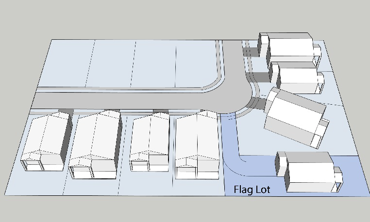
Figure 2—Flag Lot Example
(c)
Blocks.
(1)
The length, width, and shapes of blocks shall be determined with due regard to:
a.
Provision of adequate building sites suitable for the special needs or the type of use contemplated.
b.
Zoning requirements as to lot sizes, setbacks, and dimensions.
c.
Needs for convenient access, circulation, control, and safety of street traffic.
(2)
In general, intersecting streets, determining the blocks, lengths, and widths, shall be provided at such intervals as to serve cross-traffic adequately, provide adequate fire protection, and to meet existing streets or customary subdivision practices. Where existing subdivision controls, the block lengths shall not exceed 1,200 feet in length. Where no existing subdivision controls, the blocks shall not be less than 500 feet in length; however, in cases where physical barriers or property ownership creates conditions where it is appropriate that these standards be varied, the length may be increased or decreased to meet the existing conditions having due regard for connecting streets, circulation of traffic and public safety.
(d)
Streets and alleys.
(1)
The arrangement, character, extent and location of all streets shall conform to the requirements of this chapter, the city master plan and technical construction standards and specifications and shall be considered in their relation to existing and planned streets or driveways, to topographical conditions, to drainage constraints, to public safety and in their appropriate relations to the proposed uses of the land to be served by such streets. Reserve or residual strips of land controlling access to or egress from other property, or having the effect of restricting or damaging the adjoining property for subdivision purposes or which will not be taxable or accessible for special improvements shall not be permitted in any subdivision.
(2)
Proposed streets shall provide a safe, convenient and functional system for vehicular and pedestrian circulation and shall be properly related to the master plan and any amendments thereto, and shall be appropriate for the particular traffic characteristics of each proposed subdivision or development.
(3)
Any land study or subdivision plat involving a change to a proposed alignment shown in the master plan must be preceded by submission of a request for change to the city staff and the planning and zoning commission. The commission will forward a recommendation to the city council to either disapprove the request or approve an amendment changing the alignment shown in the plan.
(4)
When a street is not shown on the master plan, the arrangement of streets in a subdivision shall:
a.
Provide for the continuation or appropriate projection of existing streets in surrounding areas;
b.
Conform to a plan for the neighborhood approved or adopted by the city to meet a particular situation where topographical or other conditions make continuance or conformity to existing streets impracticable;
c.
Provide for future access to adjacent vacant areas which will likely develop under a similar zoning classification;
d.
Not conflict in any way with existing or proposed driveway openings;
e.
Allow for the appropriate dedication and/or improvement on each plat application to meet the minimum street construction and right-of-way standards.
(5)
All dedicated public streets shall conform to the requirements set forth in the City of Justin Technical Construction Standards and Specifications (TCSS) Manual.
a.
Additional right-of-way other than the minimums shown above in the TCSS manual, may be required at intersections and high volume driveways for turning lanes. This additional right-of-way will be determined by the city during the design phase of the street system and before submittal of the final plat.
b.
All proposed streets shall be planned, designed and constructed based on their anticipated function, traffic volumes, adjacent land use and system continuity.
c.
Where a subdivision abuts or contains an existing or proposed primary thoroughfare, the city may require marginal access streets, reverse frontage (lots which back to the primary thoroughfare), deep lots with rear service alleys, or such treatment as may be necessary for adequate protection to residential properties and to afford separation of through and local traffic.
(6)
Residential streets shall be so laid out that their use by through traffic will be discouraged, but access is provided to adjacent subdivisions.
(7)
Intersecting streets with centerline offsets of less than 125 feet shall be avoided. Greater centerline offsets as may be required by the city shall be provided where necessary.
(8)
Reserve strips controlling access to streets or alleys shall be prohibited except where their control is definitely placed by the city under conditions approved by the planning and zoning commission and city council.
(9)
Construction of half streets shall be prohibited, except when essential to the reasonable development of the subdivision in conforming with the requirements of this chapter and the master plan, and where the city finds it will be practical to require the dedication of the other one-half when the adjoining property is subdivided. If the owner or subdivider is responsible for one-half of the street, the owner or subdivider shall escrow the amount of the construction cost of the facility, unless the city participates in the construction of the facility. Whenever a partial street previously has been platted along a common property line, the other portion of the street shall be dedicated. Improvements shall be made to all on-site facilities as defined herein (see definitions, Appendix A).
(10)
A street ending permanently in a cul-de-sac shall not be longer than 600 feet and at the closed end shall have a turnaround provided for, having an outside roadway diameter of at least 80 feet and a street property line diameter of at least 100 feet. The cul-de-sac shall be measured from the centerline of the intersecting street to the centerline of cul-de-sac turnaround. A street ending in a temporary cul-de-sac to allow for subsequent phasing of the development or continuation of a road at a later date may be used, provided that: The closed end shall have a turnaround outside roadway diameter of at least 80 feet with the roadway base, materials and design thickness to be approved by the city engineer; the easement or proper dedication shall be in place to allow for the public usage of the temporary cul-de-sac; and, the subdivider shall provide surety in the amount to cover a standard cul-de-sac design meeting the standard specifications of the city for a permanent cul-de-sac. If necessary, the city may draw from the surety in order to construct the permanent cul-de-sac prior to the term of the filed surety expiring.
(11)
Dead end streets are not allowed except to provide for access to adjacent land areas and in no case shall be more than 250 feet in length or equal to one lot depth, whichever is greater. Any dead end street of a permanent or a temporary nature, if longer than 250 feet, shall have a surfaced turning area 80 feet in diameter for a cul-de-sac. Where adjacent property contains an existing dead end street over 250 feet in length without a cul-de-sac which abuts the proposed subdivision, the public works director shall require the subdivider to construct a cul-de-sac as provided above.
(12)
New streets which are an extension of existing streets shall bear the names of existing streets and shall be dedicated at equal or greater widths than the existing streets but not less than those presented in the TCSS manual. No new street names shall be used which will duplicate or be confused with the names of existing streets. Street names shall be subject to the approval of the city council based on the street names approved on the preliminary plat.
(13)
All new streets dedicated within a subdivision shall be constructed in accordance with the current approved design requirements, TCSS manual and any other relevant policy or regulation at the time at which the final plat is approved.
(14)
Subdivisions generally shall provide one point of access in each direction (north, east, south and west) to adjacent property or to a thoroughfare. All residential developments shall provide no less than one entrance for each 50 lots including stubs for future development or connection to an existing thoroughfare or collector.
(15)
At any time during the pre-application proposal or plat application process, the city engineer may require a sight-distance study and/or a traffic impact analysis for any portion of the tract to be subdivided. The plat or any related development application which requires a traffic impact analysis or study shall be held as 'incomplete' by the city and not scheduled for a public hearing until the results of the completed study or traffic impact analysis has been submitted to, and reviewed by the city engineer and any affected public agency [such as the State of Texas if required]. Based on the study or analysis, the city engineer may impose stricter standards on the proposed plat in accordance with article III of this chapter. The city engineer shall forward a report on the traffic impact analysis or study to the planning and zoning commission and council at the next available public hearing to assist in their determination of the impact of the development to the existing and proposed roadway infrastructure, as well as assess any safety concerns.
(16)
Streets which dead end at power lines or similar rights-of-way, and which are intended for future extension across these rights-of-way, shall be constructed in the right-of-way for half the distance across the rights-of-way. Streets which dead end at railroad rights-of-way shall not be required to be constructed over the railroad right-of-way by the subdivider but an agreement must be reached regarding the timing and construction of the crossing by the railroad owner.
(17)
Lot addressing procedures:
a.
Site addressing shall be performed by the designated city staff in accordance with the adopted addressing procedures as follows and with the adopted addressing standards. No address shall be issued prior to approval of and submission of final documents for recording of subdivisions.
b.
Upon recording of a final plat, replat, or amending plat, addresses shall be assigned to each lot created by such plat. Whenever possible, a current or previous address of an unplatted parcel of land shall be assigned if the address meets the following criteria:
c.
The address is in accordance with the adopted addressing standards.
d.
The address conforms with any existing address sequence.
e.
The general principles of assigning addresses are:
f.
Address numbers should not be longer than four numeric digits nor less than three.
g.
Alphanumeric designations (ex. 1200A) shall only be used for addressing utilities such as standalone meters or boxes.
h.
Numbering should be uniform, consecutive, and expandable.
i.
Numbers should be assigned in standard intervals along road frontage.
j.
Even numbers should always be on one side of the road and odd numbers on the other based upon the direction the road is traveling in relation to the point of origin designated in the adopted addressing standards.
k.
Numbering should be comparable on parallel streets.
l.
The numbering system should accommodate existing addressing schemes.
m.
The designated city staff will be responsible for assigning and distributing assigned addresses to all necessary government offices, including Denton County 9-1-1, utility companies both public and private, and the developer or their designee.
n.
A property owner may request an address change in writing to the designated city staff stating the purpose of the request.
o.
A new address will be considered and assigned based on circumstances outlined in the adopted addressing standards.
p.
Notifications for address changes will be supplied to the same agencies that regularly assigned addresses are distributed to.
(18)
Street naming procedures:
a.
The developer shall name streets in conformance with the following considerations and the adopted addressing standards. City staff may deny or recommend alternative street names and reserves the right for final determination.
b.
Names of new streets shall not duplicate or cause confusion with the names of existing streets unless the new streets are a continuation of or in alignment with existing streets. New streets that are an extension of existing streets shall bear the names of existing streets and shall be dedicated at equal or greater widths than the existing streets. Where the streets will not be extended or end in a cul-de-sac, new names may be assigned.
c.
Street names that are spelled differently but sound the same shall be avoided.
d.
Road names that are obviously offensive, libelous or derogatory in spelling or pronunciation are discouraged.
e.
Special characters are not permitted in road names (i.e., hyphens, periods, apostrophes, etc.).
f.
All street names shall contain only one street suffix.
(19)
Alleys shall be generally optional in all zoning districts. Alleys, or loading courts, with a minimum paved width of 20 feet or in lieu thereof, off-street loading space, may be provided in commercial and industrial areas. Alleys shall be provided where alleys of adjacent subdivisions already platted would be closed or dead-ended by failure to provide alleys in the new subdivision. New residential alleys, if provided or required as noted above, shall have a minimum paved width of 15 feet and a right-of-way width of 20 feet.
(e)
Easements.
(1)
Easements across lots or centered on rear or side lot lines shall be provided for utilities where necessary and shall be of such widths as may be reasonably necessary for the utility or utilities using same. A minimum utility easement 15 feet in width adjacent to all street rights-of-way shall be provided for gas, electric, telephone, communications, television and other utilities approved by the city. A minimum five-foot utility easement shall be located along all side and rear property lines, unless determined otherwise by the city. It shall be the subdivider's responsibility to determine appropriate easement widths as required by other utility companies.
(2)
City water and city wastewater mains will generally be installed is street right-of-way. The following minimum easement width requirements are for city water and city wastewater mains not installed in street right-of-way:
a.
Where a city water main less than 16-inch (ID) or sanitary sewer main less than 18-inch (ID) crosses private property, at a maximum depth of ten feet (measured from ground level to flowline of pipe), a minimum 15-foot wide permanent utility easement (UE) centered on the utility is required.
b.
For larger main sizes, where the maximum depth is ten feet, the following table shall apply:
c.
For all water and wastewater mains with depths greater than ten feet (measured from ground level to flowline of pipe), the following equation will apply:
Minimum easement width = ((depth of pipe) x 2) + (OD of pipe) + (2 feet)
Note that OD in the equation is outside diameter. Easement width shall be rounded up to nearest five feet. Easement shall not exceed 50 feet in width unless required by special circumstances.
(3)
Where a subdivision is traversed by a watercourse, drainage way, or channel, there shall be provided a drainage easement conforming substantially with such course width plus an additional width of 15 feet on each side of the watercourse, drainage way or channel for access and maintenance. Parallel streets or parkways may be required adjacent to creeks or drainage ways to provide maintenance access or access to recreation areas.
(4)
A lot area shall be computed inclusive of all easements. There shall be a minimum buildable area, exclusive of easements, for each lot.
(5)
Where alleys are not provided in a residential subdivision, a minimum ten-foot utility easement shall be provided along the rear of all lots within the subdivision. Where there are no adjoining easements existing, a minimum of ten feet will be required.
(6)
A 25-foot by 25-foot triangular visibility, access and maintenance easement (VAM) is required on corner lots at the intersection of two streets. A 25-foot by 25-foot triangular visibility, access and maintenance easement (VAM) is required on lots at the intersection of an alley and a street. In all such cases, the full VAM statement of restriction contained herein, shall be placed in the dedication instrument or on the face of the plat.
(7)
Fire lane easements shall be provided at locations directed by the development review committee. These easements shall have a minimum width of 24 feet and a minimum height clearance of 14 feet. Any emergency access and fire lane easement more than 100 feet in length shall either connect at each end to a dedicated public street or be provided with a cul-de-sac having a minimum diameter of 100 feet with an additional distance of ten feet on all sides clear of permanent structures. The paved width of an emergency access easement may be reduced to, but not below, 20 feet provided that curbs shall not exceed five inches in height, and further provided that there shall be no obstructions which will interfere with the use of the full 24-foot width of the easement by emergency vehicles and their appurtenances.
(8)
No building or structure shall be constructed over or into an easement. If any building, structure of physical improvement is within an easement, it shall be the sole responsibility of the property owner to remove or abate the obstruction immediately at their sole cost. If the owner of the property does not remove the obstruction, the city may remove the obstruction and file a property lien and other applicable fees and/or fines against the property.
(f)
Water and wastewater.
(1)
All new subdivisions shall be connected with an approved water system designed, constructed, and capable of providing water for health and emergency purposes, including fire suppression. All subdivisions must be served by an approved means of wastewater collection and treatment. The city may require the phasing of development and/or improvements in order to maintain adequate wastewater capacity. It shall be the subdivider's responsibility to extend utility lines to provide water or sanitary sewer service.
(2)
It shall be the subdivider's responsibility to design all improvements according to the latest edition of the City of Justin Technical Construction Standards and Specifications Manual. The city may require that the subdivider oversize the water system and/or the sanitary sewer system where necessary to serve land other than the tract or lots to be platted, including the oversizing of off-site water or wastewater mains necessary to extend service to the property to be platted.
(3)
Extension of all utilities adjacent to any subdivision shall be made along the entire frontage of the subdivision adjacent to street or thoroughfare. If the subdivision is not adjacent to a thoroughfare, the extension of utilities shall be accomplished in a manner to allow future connection to said utilities by new subdivisions. If new subdivisions will never be constructed beyond a developing subdivision due to physical constraints, the development coordinator in consultation with the public works director/city engineer may waive the requirement for adjacent utility line construction.
(4)
Installation of utilities not specifically referenced herein shall comply with the Texas Commission on Environmental Quality (TCEQ) rules and regulations.
(g)
Storm drainage. Drainage improvements shall be designed and developed in accordance with the City of Justin Technical Construction Standards and Specifications (TCSS) Manual. The following requirements shall also govern the design of all drainage facilities within the corporate limits of the City of Justin, Texas, and its extraterritorial jurisdictional area:
(1)
The drainage facilities within the proposed subdivision shall be designed to accept the ultimate development stormwater runoff from upstream areas, carry the stormwater runoff through the proposed subdivision and discharge the stormwater runoff appropriately downstream.
(2)
The owner's engineer shall determine the effect of each additions storm runoff, including all upstream runoff, on the existing drainage facilities immediately downstream of the addition. Where it is determined that existing capacity is not available immediately downstream and that property owned by others will be adversely affected with the calculated runoff, the owner's engineer shall design a drainage system, detention facility or parallel system to mitigate the problem. The city council may withhold approval of the plat until such mitigation has been provided.
(3)
Lakes, detention ponds and retention ponds will be considered, and may be constructed, provided they are approved by the city council in consultation with the development review committee. The city may assume maintenance responsibilities for this type of facility only if it is wholly contained within an area the city can utilize for parks, recreational or other public purposes. If not accepted by the city, necessary floodplain easements and maintenance agreements shall be provided to insure maintenance of the facility.
(4)
Where topography or other conditions are such as to make impractical the inclusion of drainage facilities within public rights-of-way, drainage easements shall be provided across private property to an acceptable outfall or to other public right-of-way.
a.
Drainage easements with a minimum width of 15 feet shall be provided for existing and proposed underground drainage systems. When the system consists of larger diameter pipe or when the depth of the system or the soil conditions dictate, additional easement width shall be provided.
b.
Drainage easements along proposed or existing improved drainage channels shall provide sufficient width to include a channel designed to convey a 100-year design frequency storm plus one foot of free board within its banks and an additional width of 15 feet along each side shall be required to provide ingress and egress for proper maintenance of the facility. The access portion of the easement shall be above the 100-year design frequency storm elevation and accessible to vehicles and equipment. The entire drainage easement shall remain unobstructed at all times. Access to the channel easement must also be provided at a maximum of 1,200 foot spacing along streets or other public right-of-way.
c.
When a proposed drainage system will convey or discharge storm flow across or onto private property outside the subdivision or addition, appropriate drainage easements must be secured by the subdivider.
d.
The widths and lengths of the drainage easements described in items (1) through (3) above shall be substantiated by a drainage study and drainage calculations or other criteria submitted to and approved by the city.
(5)
Proposed subdivisions containing a Federal Emergency Management Agency (FEMA) area of special flood hazard must comply with the provisions of the city's flood damage prevention regulations. Floodplain easements shall be provided along natural channels, major creeks, lakes, detention ponds and retention ponds. Floodplain easements shall encompass all areas beneath the water surface elevation resulting from a storm whose design frequency is 100 years, plus such additional width as may be required to provide ingress and egress to allow for the maintenance of the facility and for the protection of adjacent property, as determined and required by the city. The access portion of the easement shall be above the 100-year design frequency storm elevation.
a.
All floodplains or regulated floodways presented on the flood insurance rate map (FIRM) shall be shown on the plat. If the above referenced maps do not specify a flood area along any of the above creeks or their tributaries, it shall be the subdivider's responsibility to establish and identify needed easements.
b.
The city council may, when it deems it necessary for the health, safety or welfare of the present and future population of the area and necessary to the conservation of water, wastewater and drainage facilities prohibit development of any portion of the property which lies within a floodplain. Such a floodplain shall be preserved from any and all destruction or damage resulting from clearing, grading, or dumping of earth, waste material, or stumps, except as specifically approved by the city. When floodway easements, within a floodplain easement, are required or proposed, they shall be shown along the improved or unimproved drainage way. Floodway easements are the unobstructed portion of the floodplain consisting of the primary channel and overbank areas capable of conveying the 100-year frequency discharge without increasing the design flood elevations as defined by FEMA.
(6)
In those cases where the proposed improvements or development plans alter and/or impact a FEMA floodplain or floodway easement, the subdivider shall apply to and submit to FEMA, and any other regulatory agencies all engineering data and information requested to obtain an approved "letter of map revision." Only after a new or revised floodplain or floodway area is designated by FEMA will the city approve the proposed plans.
(7)
Maintenance agreements between an approved maintenance entity and the city shall be required when an improved drainage channel, in a drainage easement, is constructed as an unlined channel or when a floodplain easement is proposed.
a.
An individual residential lot owner does not constitute a maintenance entity. A maintenance entity may include homeowner's associations, apartment complexes, or similar groups. The maintenance entity's by-laws and covenants filed of record, shall provide for ongoing maintenance. The agreement shall authorize a lien against individual abutting lots in favor of the city to secure payment to the city for any expenses incurred by the city for maintenance in the event of default by the maintenance entity.
b.
An owner or owners of a nonresidential property or properties may create a maintenance entity to maintain drainage or floodplain easements, provided the entity's by-laws and covenants filed of record, provide; for on-going maintenance. Such agreements shall authorize a lien against individual abutting properties in favor of the city to secure payment for any expenses incurred if the maintenance entity is not properly maintaining the creek or drainage way, in the city's sole opinion.
(8)
Border channels shall be improved as per the "public improvements policy" at the time of development unless conditions preclude improvements, at that time, as determined by the development review committee. In no case shall property adjacent to a recognized drainage way be final platted unless provisions are made for making it conform to all city drainage and/or floodplain criteria. The design shall protect all platted property and shall not adversely affect property owned by others. The developing party is responsible for constructing, if necessary, a reasonable portion of the drainage way applicable to the property being developed. In no case shall any segment or portion of the drainage way be neglected by the present or future development. This may require the platting of a floodplain easement, as described above, and entering into a maintenance agreement for the property to be final platted.
(Ord. No. 793-25, § 2(Exh. A), 1-23-25)
Sec. 52-507. - Required improvements.
(a)
General.
(1)
The requirements of these subdivision regulations are designed and intended to ensure that all improvements are installed properly and:
a.
The city can provide for the orderly and economical extension of public facilities and services;
b.
All purchasers of property within the subdivision shall have a usable, buildable parcel of land;
c.
It is necessary and desirable to provide for dedication of rights-of-way and easements for public works improvements to support new development at the earliest stage of the development process;
d.
The city desires to assure both that impacts of new development are mitigated through contributions of rights-of-way, easements and construction of capital improvements, and that a new development be required to contribute not more than its proportionate share of such costs; and
e.
Proposed public works improvements serving new development shall conform to and be properly related to the public facilities elements of the city's adopted master plan, other adopted master plans for public facilities and services, and applicable capital improvements plans, and shall meet the service levels specified in such plans.
(2)
The land to be subdivided or developed must be served adequately by essential public facilities and services. No subdivision related application, plat or development shall be approved unless and until adequate public facilities exist or provision has been made for the installation of all water, wastewater, storm drainage, street, park facilities, street light improvements and electrical facilities which are necessary to serve the development proposed, whether or not such facilities are to be located within the property being platted or offsite. This policy may be defined further and supplemented by other ordinances adopted by the city. The public improvements required by the city for the acceptance of the subdivision shall include, but are not limited to those set forth in these regulations, the city TCSS Manual and this Code.
(3)
All aspects of the design and implementation of public improvements shall comply with the current local, state and federal design standards and any other applicable City Codes and ordinances, including the preparation and submittal of construction plans and specifications. Technical construction standards and specifications for all improvements shall be made in compliance with this chapter, the city's TCSS Manual and this Code, unless otherwise specified in the following sections.
a.
The standards established in this chapter, the TCSS Manual and this Code are for the proper dedication and construction of public works improvements and infrastructure and are based upon engineering studies and historical usages and demands by different categories of development. These regulations identify certain minimum requirements and sizes for utilities, roadways, parks and other facilities that the city council has determined to be necessary in order to provide the minimum level of service necessary to protect or promote the public health, safety, and welfare and to assure the quality of life currently enjoyed by the citizens of Justin. It is the intent of these regulations that no development shall occur until and unless these minimum levels of service are met. Therefore, each subdivision in the city shall be required to dedicate, construct and/or upgrade required facilities and infrastructure to a capacity that meets these minimum levels.
b.
For each category of public infrastructure, a minimum standard of infrastructure, and in some cases, service level, has been developed based upon historic studies and construction projects of the city and other cities. These minimum standards take into consideration the soil conditions and topographic configuration of the city, the use and impact analyses of the North Central Texas Council of Governments in developing standard specifications for public works installation, and other historical use and performance experiences of the city that reflect the minimum level of facilities and services that must be built to meet the health, safety and welfare of the citizens of Justin.
c.
In order to maintain prescribed levels of public facilities and services for the health, safety and general welfare of its citizens, the city may require the dedication of easements and rights-of-way for the construction of on-site or off-site public works improvements for water, wastewater, road, drainage or park facilities to serve a proposed subdivision, or require the payment of fees in lieu thereof. If adequate levels of public facilities and services cannot be provided concurrent with the schedule of development proposed, the city may deny the subdivision until the public facilities and services can be provided or require that the development be phased so that the availability and delivery of facilities and services coincides with the demands for the facilities created by the development.
d.
Whenever the city council determines that levels of service in excess of these minimum standards are necessary in order to promote the orderly development of the city, the owner shall qualify for reimbursement for any costs in excess of the minimum levels of service through city participation, to the extent funds are available by a pro rata reimbursement policy or other means adopted by the city.
(4)
The subdivider/owner shall employ an engineer proficient in civil engineering and licensed or registered by the State of Texas for preparation of the drainage plan, cost estimates and, construction plans and specifications for all public improvements.
(5)
The city shall require an initial demonstration that a proposed subdivision shall be adequately served by public facilities and services at the time for approval of the first development application that portrays a specific plan of development, including but not limited to a petition for establishing a planned development zoning district or other overlay zoning district, a public improvements agreement, development agreement or a pre-application proposal for a plat which requires public improvements.
(6)
The obligation to dedicate rights-of-way for or to construct one or more public works improvements to serve a new subdivision may be deferred until approval of a subsequent phase of the subdivision where, in the opinion of the city engineer, the right-of-way dedication and/or construction of the infrastructure is necessary to meet the minimum standards or intent of this chapter or other adopted policy of the city, upon written request of the property owner or at the city's own initiative. As a condition of deferring the obligation, the city may require that the subdivider include provisions in the public improvements agreement or development agreement specifying the time for dedication of rights-of-way for or construction of public works improvements serving the subdivision.
(7)
All directly adjacent overhead lines shall be buried underground at the developer's expense that involve a dedication of right-of-way or a development of more than ten lots.
(8)
Timing of improvements:
a.
The city will require that all public improvements be installed and accepted by the city prior to the filing of the final plat by the city secretary.
b.
The city may permit or require the deferral of the construction of public improvements if in its judgment, deferring the construction would not result in any harm to the public, or offer significant advantage in coordinating the site's development with adjacent properties and off-site public improvements. Any required public improvement(s) approved for deferred construction shall be provided for as required in the public improvement's agreement prior to the approval of the final plat.
c.
If the city does not require that all public improvements be installed and accepted by the city prior to signing of the final plat, it shall require that the applicant execute a public improvements agreement and provide security for the agreement.
(b)
Streets.
(1)
All streets, alleys and other improvements within the public right-of-way shall be designed and constructed in accordance with the requirements of this chapter, and the City of Justin's Technical Construction Standards and Specifications (TCSS).
(2)
Proposed roads shall provide a safe, convenient and functional system for vehicular, bicycle and pedestrian circulation and shall be properly related to the applicable thoroughfare plan and any amendments thereto and shall be appropriate for the particular traffic characteristics of each proposed subdivision or development. New subdivisions shall be supported by a thoroughfare network having adequate capacity, and safe and efficient traffic circulation. Each development shall have adequate access to the thoroughfare network.
(c)
Monuments and markers.
(1)
Permanent survey markers. All boundary corners, block corners, etc., as established in the process of creating a subdivision plat shall comply with the Texas Board of Professional Land Surveying Practices Act and General Rules of Procedures and Practices.
(2)
SPC coordinates. A minimum of two monuments at prominent locations (block corners, boundary corners, etc.) within a subdivision shall have Texas State Plane Coordinates (SPC) in U.S. Survey Feet noted on the subdivision plat. The Texas State Plane Coordinate (SPC) shown on the subdivision plat shall have the appropriate metadata listed.
(3)
Elevation data. A minimum of two monuments at prominent locations (block corners, boundary corners, etc.) within a subdivision of which require minimum finished floor elevations on all or part of the lots shall have the mean sea level elevations noted on the subdivision plat. The mean sea level elevations shown on the subdivision plat shall have the appropriate metadata listed.
(d)
Storm drainage.
(1)
All storm drainage facilities shall be designed and constructed in accordance with the requirements of this chapter and the City of Justin's Technical Construction Standards and Specifications (TCSS).
(2)
Drainage improvements serving new development shall be designed to prevent overloading the capacity of the downstream drainage system. The city may require the phasing of development, the use of control methods such as retention or detention, the construction of off-site drainage improvements, or drainage impact fees in order to mitigate the impacts of the proposed subdivision. The applicant may propose and the city may require the phasing of development and/or improvements in order to accommodate appropriate drainage design.
(e)
Wastewater.
(1)
All wastewater facilities shall be designed and constructed in accordance with the requirements of this chapter, the city's sewer master plan and the City of Justin's Technical Construction Standards and Specifications (TCSS).
(2)
All lots to be platted or land to be developed shall be served by an approved means of wastewater collection and treatment. The city shall be responsible for determining compliance with the city's TCSS and the approved means of wastewater collection and treatment. The applicant may propose and the city may require the phasing of development and/or improvements in order to maintain adequate wastewater capacity. It shall be the responsibility of the subdivider to extend the central wastewater main through the entire public or private street frontage or through the platted or developed subdivision or lot in order to allow for the continuation and extension of public services in order to accommodate growth.
(f)
Water.
(1)
All water facilities shall be designed and constructed in accordance with the requirements of this chapter, the city's water master plan and the city's Technical Construction Standards and Specifications (TCSS).
(2)
All lots to be platted or land to be developed shall be connected to an approved water system which has capacity to provide water for domestic use and emergency purposes, including adequate fire suppression. The applicant may propose and the city may require the phasing of development and/or improvements in order to maintain adequate water capacity. It shall be the responsibility of the subdivider to extend the central water main through the entire public or private street frontage or through the platted or developed subdivision or lot in order to allow for the continuation and extension of public services in order to accommodate growth.
(g)
Parks and open spaces.
(1)
Need and purpose. This section will ensure the provision of adequate park and recreational areas that are needed for healthy residential neighborhoods within the city. Neighborhood park facilities that are close to each home and are developed to allow full recreational fulfillment are vital to the health and welfare of each and every citizen within the city. New residential development or an increase in density by redevelopment in existing neighborhoods creates the need for additional park and recreation facilities. This policy governs all park dedication and improvement requirements for subdividers who are required to file a pre-application. Proposal or plat application under this section. This policy also provides for needed land acquisition for parks that serve new residential development or an increase in density by redevelopment in existing neighborhoods. The city has developed and adopted general planning standards for parks that are included within the city's master park, recreation and open space plan.
(2)
Planning.
a.
The city will require residential subdividers to dedicate land and recreation improvements for parks or pay a fee in lieu thereof as a condition of the platting process, just as land for streets, alleys, utility easements and other improvements directly attributable to the development of a new residential neighborhood are dedicated. The development review committee and subdivider will negotiate a combination of fees and park land dedication or cash-in-lieu thereof that satisfies the requirements of this chapter. Terms of this negotiation will be presented to the planning and zoning commission for recommendation and ultimately to the city council for approval.
b.
The overall program and full implementation of this section (park dedication policy) shall generally follow the city's master park, recreation and open space plan. The development review committee may develop implementation guidelines to ensure the fair and objective application of this park dedication policy.
c.
Where recreation facilities are built for the residents of a subdivision development, a credit may be given to the subdivider for all or a portion of the land dedication (or fee in-lieu thereof) and the park development fee based on the value of the developed park (see development options and credits). At the discretion of the development review committee, a credit of up to 100 percent of the total amount of the park development fee may be issued.
d.
Park infrastructure. The subdivider will bear the cost of all improvements, including streets, water, sewer, storm drainage and street frontage directly related to park sites between three and 20 acres in size. The subdivider will provide no less than 150 feet of street frontage for each three acres of park land. The required frontage can be a combination of contiguous park access drives, street frontage or access easements. Credit may also be given for access easements that allow access into the park from the surrounding neighborhood.
(3)
Site selection/characteristics of parks.
a.
In selecting a site for a park, the city will avoid an accumulation of non-contiguous parcels of land or an accumulation of land unsuitable for park purposes.
b.
Parks sites will be selected on the basis of obtaining natural, park-like settings where available and will consist of diverse topography and open space suitable for the development of recreational facilities.
c.
If a subdivision cannot provide the minimum three-acre parcel or a smaller parcel which can potentially be contiguous to existing or future park parcels, then a fee in lieu of park land or a combination of fee and park land dedication will be required at the discretion of the development review committee (DRC) during the pre-application proposal process.
d.
Park sites will be located, whenever possible, adjacent to and contiguous with school sites and other public or non-profit agency sites in order to make maximum use of common public facilities and grounds.
e.
Careful consideration will be given to the need for development of linear parks around natural drainage and wooded areas that provide potential recreational uses. Floodplain (based upon 100-year storm) and floodway will be accepted for park development in the following ratios.
1.
Floodplain and natural drainage areas should not exceed 75 percent of the total park site.
2.
At least 50 percent of required dedicated park land should have slopes in range of two to five percent, well-drained, and suitable for active use development.
3.
There will be no reduction in credit for dedication of floodplain as compared to non-floodplain property, provided the dedication satisfies provisions (1) and (2) above.
4.
When development occurs near a floodway that is designated as part of the city's greenbelt/trail system or determined to be suitable for trail development by the development coordinator, the subdivider will be required to develop that section of the greenbelt/trail system that occurs within his/her development. The subdivider will construct the trails and adjacent facilities in accordance with planning and development department design criteria and specifications. In order to facilitate greenbelt/trail development, the development review committee may, at their discretion, credit the subdivider up to 100 percent of the required land dedication and development fee. The cost for the trail's development will be borne by the subdivider and will not exceed the required park development fee.
5.
Proposed park land boundaries of park dedications will provide reasonable access to improved street frontage for readily accessible entry into the park area by the public.
(4)
Land dedication. Any required conveyance of land attributed to a proposed residential subdivision/(re)development will be roughly proportionate to the its number of residential units and population density.
a.
Minimum requirement. For each submitted residential subdivision plat, the minimum park land dedication requirement is one acre of park land per 25 units, as shown on the total build-out for the development (inclusive of all phases). This property is accepted at the ratios and specifications as set forth in section 52-507(3) (Site selection and characteristics of parks). The cash-in-lieu portion of the land dedication is contained within the city's adopted fee schedule. The city council may review the cash-in-lieu of rate and adjust the rate via adoption of the fee schedule resolution. Existing planned development zoning districts establishing pre-approved site layout and geometry (prior to the effective date of the ordinance from which this chapter is derived) shall pre-empt the requirements set forth herein.
b.
Where a subdivision plat is submitted indicating multi-family or any type of single-family attached (patio home, town home, two-family, duplex, etc.) residential development, and a table of information is not provided indicating the number of dwelling units, the city may assume the highest density allowed in the zoning classification to be applied to the property by which to determine projected population in order to determine park dedication policy requirements. It is the responsibility of the applicant to ensure the provision of dwelling-unit information.
c.
All determinations of required land dedication will be based upon review of all preapplication proposals submitted through the city's planning and development department. Failure to indicate proposed park dedications or fee-in-lieu-of dedication on the submitted pre-application proposal will be sufficient grounds for the city to reject the application, or to deny any concept plan, or plat application. Upon final agreement between the DRC and the subdivider regarding mutually acceptable park land, such land will be indicated on the revised plat application prior to the DRC comment and plat application deadline. Such park property will be conveyed by general or special warranty deed before release of the final plat on any or all portions of the subdivision thereof by the city for filing in the county plat records. Submission of park dedication documents is required for final plat approval. Park dedication documents include, but are not limited to:
1.
A metes and bounds description of the park dedication property.
2.
A survey plat of the park property only.
3.
A copy of the subdivider's deed for the property (demonstrating ownership and right to dedicate to city).
4.
An environmental statement (ESA Phase 1) that indicates that the park site (or the subdivision from which the park is dedicated) is free of environmental contamination or hazards.
5.
Documents conveying ownership to the city which may be either:
(i)
A special warranty deed and title policy provided by subdivider to city insuring the city in an amount equal to the value of the dedicated property; or
(ii)
General warranty deed.
d.
The city prefers the land required to be conveyed for park dedication to be located inside the subdivision development. The city council may alternatively choose to accept land conveyed for park dedication at a location outside the subdivision development so long as the land is of such proximity to the development so as to serve or benefit the neighborhood residents or better further the city's master park plan.
e.
If a replat is filed, the dedication requirements will be controlled by the policy in effect at the time of replat. Additional land dedication (or fee in lieu of) will be required if the actual density of residential units constructed on the property is greater than the former assumed density or additional requirements are in force as a result of the adoption of this policy.
f.
The city may, at its discretion, proceed to conduct such initial construction inspections, environmental tests and surveys on the land and improvements as it may deem appropriate, and the subdivider must grant to the city and its agents and employees such reasonable access to the land as is necessary to conduct such construction inspections, surveys, and tests.
g.
If the results of such construction inspections, surveys and tests indicate a reasonable possibility of construction failure, construction dumping, flawed construction, environmental contamination or the presence of environmental hazards, the city may require further surveys and tests to be performed at the subdivider's expense as the city may deem necessary prior to its acceptance of the dedication and improvements; or in the alternative, the subdivider may be required to identify alternative property or pay the fees in lieu of such park land dedication.
(5)
Payment of fees in lieu of park land dedication.
a.
If the calculation for required park dedication within the proposed subdivision development results in less than three acres and/or does not meet site selection criteria pursuant to section 52-507 of this policy, the subdivider may pay, and/or the DRC may require a fee in lieu of park land dedication.
b.
All fees collected in lieu of park land will be dedicated for the purpose of providing adequate park land or the maintenance or expansion of existing park land proximate to the residential subdivision development(s). However, if acquisition and development of a park is not achievable within the proposed development the development review committee, in its sole discretion, may determine that the park and recreational needs of the proposed subdivision development would be better served by the expansion of existing park sites located within or near the same neighborhood unit where the proposed subdivision development is located.
c.
The amount of the fee in lieu of park land dedication will be determined by the following method:
1.
The amount equal to the fair market value of the required land dedication and, if applicable, less a credit for the value of the land actually dedicated for park and recreational purposes. The fair market value will be determined by the city as determined through independent appraisals of comparable properties.
2.
When the subdivider disagrees with the city's fees, the subdivider at their own expense may obtain an appraisal of the property by a State of Texas certified real estate appraiser, mutually agreed upon by the city and the subdivider, which may be considered by the city in determining fair market value.
3.
If the property was acquired by the subdivider within the last year, the subdivider may submit the contract for sale or appraisal documents related to the acquisition of the property to be considered by the city in determining fair market value.
d.
All fee payments made in lieu of land dedication in accordance with this policy will be pro-rated on a per dwelling unit charge based on the fair market value of the required dedication of the land and relative to the number of dwelling units included in the final plat submittal. Fees assessed at the time of final plat submittal will be based upon the current dedication requirements as listed in the most recent fiscal year's fee schedule for park land dedication fees per dwelling unit. That fee will remain unchanged over the life of the development.
(6)
Open space and park land offsets. Should the density caps contained within a given zoning district result in unused acreage or "open space" in a development, the additional "space" will offset the corresponding amount of park land dedication, providing the land meets the following requirements:
a.
The additional "open space" is suitable to provide useful recreational functions such as: Linear destination trails (those trails designed to conduct residents to the planned interlinking city wide trail system), connectivity to neighborhood facilities including shopping or schools and active park/recreation facilities.
b.
The "open space" meets the requirements listed in section 52-507(3) (Site selection and characteristics of parks).
c.
Unless otherwise specified and dedicated as public space on the final plat and filed for record, property designated as "open space" is maintained by the development through the institution of a home owners association (HOA). This maintenance responsibility will be shown on the HOA deeds and covenants, and shall be provided to the city at any time upon request.
(7)
Park development required.
a.
The subdivider will bear a proportionate share of the cost of improvements of a park through payment of a park development fee. Such fee can include the following recreational facilities as a minimum configuration for each three acres of park land:
1.
Playground.
2.
Picnic shelter.
3.
Practice baseball/softball field with backstop or soccer field with goals.
4.
Walking trail.
5.
Multi-use slab with weatherproof basketball backboard and goal.
6.
Site grading and preparation.
7.
Turf and vegetation.
8.
Paved parking areas.
b.
The park development fee is based on the costs incurred to purchase, erect and construct the minimal park amenities identified in section 52-507(7)a., on a three-acre tract of park land. This fee will be prorated on a per acre basis according to the park land dedication requirements of a particular development. The park development fee may be adjusted from time to time based on the annual amount of the change in the consumer price index; provided, however, that the city council retains the right to adjust the fee in an amount greater than the annual amount of change in the consumer price index. This fee will be over and above the amount needed for park land dedication (or cash in lieu of) and infrastructure development.
(8)
Development options and credits. Subdividers may select option one or two in consultation with the development review committee.
a.
If mutually agreed upon by the subdivider and the development review committee, the subdivider may choose to develop the park site prior to final plat approval in lieu of submitting the park development fee. Should the subdivider choose this option, construction of the park will be accomplished pursuant to a three-party "subdivider's public improvement agreement" between the subdivider, the city and the contractor chosen by the subdivider. The cost paid by the subdivider to provide the park and recreation amenities may offset the required subdivider's public improvement agreement up to 100 percent. The park development fee will not exceed the estimated cost the city would incur to construct similar facilities. Prior to approval of a park development agreement, the subdivider must submit a conceptual master plan indicating the proposed park facilities and their locations. Upon approval of the proposed park development plan the subdivider may authorize preparation of construction documents for park development.
b.
In the event that the development review committee and the subdivider reach an agreement for park development prior to final plat approval, the subdivider will be required to submit park development construction plans that conform to planning and development department design, construction and specification standards. The planning and development department and the public works department will review the construction documents for compliance with city park construction requirements. The subdivider must allow city inspections of the park improvements. Prior to final plat approval the park construction must be approved and accepted by the city; or in the alternative;
c.
The subdivider will pay the required park development fee and the park will be scheduled for development by the public works director.
(9)
Additional information concerning fees.
a.
All required fees must be paid and received before the recording/filing of the final plat (or any portions thereof) in the county plat records.
b.
All payments made in accordance with this policy will be deposited in a designated fund as established by the city. The city will account for all such funds paid with reference to each subdivision development. Interest earned on accumulated park acquisition and development fees designated for a specific subdivision development will be used for additional acquisition and development as described in this policy.
c.
"Open space" offsets in section 52-507(f) (Open space and park land offsets) do not apply to the park development fee. All fees will be based upon the total park land provided with a development, whether acquired as "open space" or other dedicated park land.
(10)
Decision making; appeals.
a.
Unless otherwise provided in this policy, any decision will initially be made by the development review committee during the pre-application proposal and/or plat review process. The director of planning, or his/her designee, will be an integral part of the decision-making process for the development review committee on matters regarding parks and open space.
b.
Decisions of the development review committee with regard to this policy may be appealed first to the director of planning, then to the parks board for recommendation, then to the city council or final action.
(Ord. No. 793-25, § 2(Exh. A), 1-23-25)