
Kansas City City Zoning Code
200 SERIES
OVERLAY AND SPECIAL PURPOSE DISTRICTS
88-220 - RESERVED
Editor's note— Ord. No. 180027, § B, adopted March 1, 2018, amended the Code by repealing former 88-220. Former 88-220 pertained to SRO, Special Review Overlay Districts, and derived from Ord. No. 160759, adopted October 20, 2016.
88-205-01 - GENERAL
Overlay districts are for areas of the city that have unique qualities requiring special treatment or locations where special approaches to development may be warranted. They are established as a means of addressing specific aspects of land use control or development design that transcend base zoning district provisions. Overlay districts permit greater design flexibility than otherwise permitted by the conventional standards of this zoning and development code. As the name implies, overlay districts "over-lay" applicable base district classification to alter some or all of the zoning regulations that apply to particular sites. Overlay districts may be appropriate in areas where there are natural resource considerations, where historic preservation is needed, where there is the need to balance institutional development with the need to preserve surrounding neighborhoods, to maintain community character, for infrastructure protection or to accomplish city policy objectives for specific areas.
(Ord. No. 160759, § 1, 10-20-2016)
88-205-02 - PURPOSE
The purpose of overlay districts is to allow the city to establish special land use regulations, standards, or procedures in areas with unique land use, site planning, building design or environmental resource issues. An overlay may protect and preserve established character of existing areas of historical note or architectural merit by limiting provisions of underlying base districts in order to more effectively match the density and intensity or established character of the area. The overlay may control demolitions and regulate the preservation, restoration, and rehabilitation of existing structures as well as the design of new infill construction. The overlay may also be used to establish allowable land uses that are more prohibitive than the underlying district and to establish specific design guidelines that are more detailed than the standards of this zoning and development code. Overlay zoning districts are intended to:
88-205-02-A. Protect an area's rare, unique or distinctive character through the use of development/design standards and guidelines to:
1.
encourage development that conforms to the size, orientation, and setting of existing buildings; and
2.
regulate building setbacks and orientation, lot dimension, site/building design, and related physical characteristics that exemplify the positive characteristics of an area;
88-205-02-B. Reduce the need for zoning variances for development that conforms to the site, orientation, and setting of existing buildings in an area;
88-205-02-C. Conserve cultural resources, preserve historic resources, stabilize property values, and reduce investment risks within an identified area;
88-205-02-D. Maintain and promote the economic vitality of an area; and establish development/design standards to implement an adopted neighborhood or area plan.
(Ord. No. 160759, § 1, 10-20-2016)
88-205-03 - ESTABLISHMENT
88-205-03-A. Overlay districts must be established in accordance with the zoning map amendment procedures of 88-515. Historic Overlay districts must be established in accordance with the procedures of 88-580.
88-205-03-B. Components that may be included in an overlay district ordinance are:
1.
purpose statement, tying the overlay to the goals and objectives of the comprehensive plan, citing the public necessity behind the intent and making a direct connection to protecting the public health, safety, morals, general welfare, and aesthetics;
2.
location and area of applicability;
3.
spatial definitions, with rules for spatial definition as simple and understandable as possible (Provide the information in a way the public can understand. Use graphics as much as possible);
4.
procedures for applications, specifying any additional information needed to demonstrate compliance with the overlay district regulations;
5.
special definitions, as needed;
6.
standards for review and approval to be used by review and decision-making bodies;
7.
permitted, prohibited and special uses;
8.
review and decision-making bodies charged with reviewing development applications and determining compliance with overlay district regulations;
9.
appeals process; and
10.
variance and administrative adjustment rules, if different for the overlay district.
88-205-03-C. Multiple historic and/or neighborhood overlays may not be designated over any individual property.
88-205-03-D. Historic, neighborhood, and design review overlays and any associated standards or guidelines must reflect the prevalent intensity and consistent building design in the neighborhood, to ensure that new development reflects the identifiable physical character of the area.
88-205-03-E. Applications for establishment of a neighborhood conservation overlay must be accompanied by the fee amount that has been established by the city council. Application fees are nonrefundable 5 working days after application filing, provided that the city planning and development director may grant a partial refund for good cause shown by the applicant.
1.
a petition requesting overlay district designation signed by a simple majority (50 percent + 1 property owner) of the property owners within the proposed district; or
2.
the city council or the city planning and development director, acting on the city's behalf.
(Ord. No. 140919, § A, 11-13-2014; Ord. No. 150600, § A, 7-23-2015; Ord. No. 160759, § 1, 10-20-2016; Ord. No. 180027, § A, 3-1-2018)
Editor's note— Ord. No. 160759, adopted October 20, 2016, amended the Code by repealing former § 88-205-03, and renumbering former §§ 88-205-04—88-205-08 as new §§ 88-205-03—88-205-07. Former § 88-206-03 pertained to types of overlay districts, and derived from Ord. No. 140919, adopted November 13, 2014.
88-205-04 - DESIGN GUIDELINES AND STANDARDS
88-205-04-A. Overlay regulations may be used to replace all zoning or some of the base zoning restrictions. They may also be used to enact new regulations for an area.
88-205-04-B. An overlay may encompass one or more base zoning districts.
88-205-04-C. When overlay district standards conflict with applicable base district standards or other regulations of this zoning and development code, the regulations of the overlay district always govern.
88-205-04-D. When no overlay district standards are specified, the base district standards and all other applicable regulations of this zoning and development code will govern.
88-205-04-E. When development/design guidelines have been approved, each building permit application for new construction or exterior alteration within the designed overlay district must comply with those standards.
88-205-04-F. Overlay district regulations may allow for the modification of any of the following standards within the zoning and development code:
1.
land uses (principal or accessory);
2.
lot and building standards (e.g., density, lot area, setbacks, height);
3.
site design standards including building coverage; required open space; location of driveways, parking pads, and garages;
4.
landscaping and buffering standards, layout of public way, vehicular and pedestrian circulation patterns;
5.
sign standards;
6.
lighting standards; or
7.
other zoning-related standards necessary to address unique zoning, platting or development features.
88-205-04-G. An overlay district may allow for restrictions on building design or placement details, including scale, mass, materials, and architectural style.
88-205-04-H. Where appropriate, an overlay may require the application of specific design guidelines in the review of development.
1.
Such guidelines must be established as part of the overlay district at the time of adoption. The review process must be included in the design guidelines.
2.
Guidelines for new infill construction within an overlay district may be different than those for existing buildings.
(Ord. No. 160759, § 1, 10-20-2016; Ord. No. 180027, § A, 3-1-2018)
Note— Former 88-205-05. See editor's note, § 88-205-03
88-205-05 - AMENDMENT OR REMOVAL OF AN OVERLAY
88-205-05-A. MAJOR AMENDMENTS.
Major amendments to overlay district regulations must be reviewed and approved in accordance with the procedures of 88-515, or in case of Historic Overlay districts in accordance with 88-580. Major amendments to overlay districts include one or more changes, in cumulative total (when compared to the original overlay regulations) that would:
1.
further restrict allowed uses;
2.
add and/or remove part or all of an area from the overlay boundaries;
3.
change design regulation requirements; or
4.
result in any other change that the city planning and development director determines will have impacts that warrant a full review of the application.
88-205-05-B. MINOR AMENDMENTS.
Any application for an amendment to an approved overlay district that does not meet the criteria for a major amendment will be considered a minor amendment. Minor amendments must be approved in accordance with the procedures of 88-510. Additions of uses to the zoning and development code may also be applied to adopted overlay districts through the text amendment process.
(Ord. No. 160759, § 1, 10-20-2016; Ord. No. 180027, § A, 3-1-2018)
Note— Former 88-205-06. See editor's note, § 88-205-03
88-205-06 - VARIANCES AND ADMINISTRATIVE ADJUSTMENTS
Within any established overlay district, applicants may seek authorized zoning variances pursuant to 88-565 except as modified by the provisions of this section but may not seek administrative adjustments pursuant to procedures 88-570 unless specifically permitted by the enabling overlay district ordinance.
(Ord. No. 160759, § 1, 10-20-2016)
Note— Former 88-205-07. See editor's note, § 88-205-03
88-205-07 - DOCUMENTATION OF OVERLAYS
88-205-07-A. Once an overlay district is approved by the city council, the city planning and development department must amend the official zoning maps to identify the overlay district boundaries and designation, together with the underlying zoning designation.
88-205-07-B. The city planning and development department must maintain a list of established overlay districts by type.
88-205-07-C.
(Ord. No. 160759, § 1, 10-20-2016; Ord. No. 180027, § A, 3-1-2018; Ord. No. 190501, § A, 7-11-2019; Ord. No. 231047, § 1, 3-7-2024)
Note— Former 88-205-08. See editor's note, § 88-205-03
88-210-01 - PURPOSE
The purpose of the CXO, adult entertainment overlay district is to identify and prescribe specific requirements and conditions for the location of certain defined adult entertainment activities. The district is designed as an overlay district in certain zoning districts based on the regional character of the activities. Adult entertainment uses do not occur on a frequent basis and require separate and specifically designed regulations for their development. Such adult entertainment uses are recognized as having serious objectionable operational characteristics, particularly if several of such uses are concentrated, thereby having a deleterious effect upon adjacent areas. The location of such uses has an additional deleterious effect upon adjacent areas and could contribute to the blighting and downgrading of the surrounding neighborhood. The special regulation of adult entertainment uses is necessary to ensure that the adverse effect of such uses will not contribute to the blighting or downgrading of surrounding neighborhoods, whether residential or nonresidential, by location or concentration, and to ensure the stability of such neighborhoods.
(Ord. No. 160759, § 1, 10-20-2016)
88-210-02 - ESTABLISHMENT OF CXO OVERLAY DISTRICT
88-210-02-A. The CXO overlay district may be established only in accordance with the zoning map amendment procedure of 88-515, provided that the city plan commission must recommend and the city council must find that:
1.
the proposed CXO district meets all requirements of this zoning and development code without exception; and
2.
the proposed use to be constructed or operated will neither negatively impact nor materially injure property within 1,000 feet of the proposed CXO district boundaries.
88-210-02-B. No CXO district may be established without the submission and approval of a development plan. Failure to comply with the development plan approved and established as part of the CXO district is an express violation of this zoning and development code, enforceable under 88-615.
88-210-02-C. The CXO overlay district may be established only in combination with B4, DC, M1, M2, and M3 districts.
88-210-02-D. A CXO district may be established only if the boundaries of the district are at least 1,000 feet from any church or place of worship, day care facility, public park, educational institution, library, museum, cultural exhibit, community center, R district, AG-R district, children's amusement park, or residential building.
(Ord. No. 160759, § 1, 10-20-2016)
88-210-03 - LOCATION AND SITE REQUIREMENTS
Any adult cabaret, bathhouse, massage shop, or modeling studio must meet the following location and site requirements:
88-210-03-A. Not more than 2 adult businesses may be located within 1,500 feet of each other (regardless of whether such uses are located in different zoning districts) as measured in a straight line from the lot line of the affected properties; provided, however, that the development plan that is approved with the establishment of a CXO district may provide for multiple adult businesses within the same facility.
88-210-03-B. All access must be provided from a major thoroughfare.
88-210-03-C. The property on which such use is located must have a minimum of 50 feet of street frontage.
88-210-03-D. The property on which the use is located must be screened by a solid masonry wall at least 6 feet in height along the side and rear property lines, provided that the parking lot may be screened by decorative fencing such as wrought iron or brick and need not be screened by a solid masonry wall.
88-210-03-E. The facility in which the use is located and the parking for such facility must have a front setback of at least 20 feet, a minimum side setback of 10 feet, and a minimum rear setback of 10 feet provided that where the use is proposed in an existing building, the setback requirements need not be met.
88-210-03-F. Off-street parking and landscaping requirements must be met, except that the city council may approve a development plan that does not comply with the off-street parking requirements when they determine that parking provided is consistent with sound planning principles in consideration of anticipated use, transit accessibility and off-site parking availability. The parking provided on the development plan must remain available and will constitute a violation if not provided.
88-210-03-G. The facility in which the use is located and the parking for such facility must have a front setback of at least 20 feet, a minimum side setback of 10 feet, and a minimum rear setback of 10 feet provided that where the use is proposed in an existing building, the setback requirements need not be met.
88-210-03-H. The facility in which the use is located must be designed so that all openings, entries and windows prevent view into such facilities from any sidewalk, walkway, street, or other public area, provided that the development plan may provide for openings into such facility where needed for security reasons if no merchandise or pictures can be viewed from the openings.
88-210-03-I. The facility in which such use is located is limited to one wall-mounted sign no greater than one square foot of sign area per linear foot of wall length, not to exceed a total of 50 square feet, provided that the city council may approve the location of up to 3 signs that collectively may not exceed a total of 50 square feet in area. Signs may not flash, blink, or move by mechanical means and may not extend above the roofline of the building. Further, no merchandise or pictures of products or entertainment on the premises may be displayed in window areas or any area where such merchandise or pictures can be viewed from the sidewalk in front of the building. Flashing lights or lights that give the impression of motion or movement are not permitted.
(Ord. No. 160759, § 1, 10-20-2016)
88-210-04 - LOCATION OF USES OUTSIDE CXO DISTRICT
No adult cabaret, bathhouse, massage shop, or modeling studio is permitted except within a CXO district. Motion picture arcade booths and motion picture arcade booth establishments are expressly prohibited in the CXO district and in all other zoning districts, regardless of whether such uses are determined to be principal or accessory uses.
(Ord. No. 160759, § 1, 10-20-2016)
88-215-01 - PURPOSE
Special character overlay districts are a means for incorporating various development and/or use regulations across a specified area. These districts may be used to preserve and promote the historic and/or unique character of neighborhoods, corridors and commercial nodes.
(Ord. No. 160759, § 1, 10-20-2016)
88-215-02 - SPECIAL CHARACTER DISTRICTS
88-215-02-A. The TCO, Troost Corridor Overlay District, is intended to preserve and maintain the urban fabric while promoting quality uses and businesses desiring to improve the area, and to encourage appropriate redevelopment by restricting certain land uses. The TCO is generally bounded by 22nd Street on the north, Volker Boulevard/Swope Parkway on the south, and one-half block east and west of Troost Avenue.
88-215-02-B. The ICO, Independence Corridor Overlay District, aims to promote design excellence and walkability for the area. The ICO generally includes all parcels on the Independence Corridor from Forest Avenue on the west to Ewing Avenue on the east, and all parcels two blocks south of Independence Boulevard on Paseo Boulevard, and two blocks south of Independence Boulevard on Prospect Avenue.
88-215-02-C. The WHO, Wornall Homestead Overlay District, addresses elements of land use control as well as approaches to the design of new, restored or renovated structures inside its boundaries. The WHO generally includes 392 lots consisting of about 97 acres within the Wornall Homestead neighborhood, generally bound by 57th St to the north, on the east by Brookside Blvd and Main St north of E 59th St and the trolley trail right-of-way south of E 59th St. Brookside business district to the south, and Wornall Rd to the west.
88-215-02-D. The MCO, Main Corridor Overlay, provides regulations for a cohesive development pattern along Main Street and major intersecting corridors. The regulations create design standards that promote the use of transit, context sensitive density, pedestrian friendly spaces, and overall design excellence. This overlay generally includes all parcels on the Main Street Corridor from Pershing Road to Emanuel Cleaver II Boulevard.
88-215-02-E. The PBO, Plaza Bowl Overlay, ensures that future expansion with the area generally located on the south and north sides of 47th Street (extending northerly to the north side of 46th Terrace), between Madison Avenue on the west and J.C. Nichols Parkway on the east will continue in a quality manner, respectful of the current design of the Plaza. The overlay codifies height and use recommendations of the Midtown Plaza Area Plan.
(Ord. No. 160759, § 1, 10-20-2016; Ord. No. 180027, § A, 3-1-2018; Ord. No. 190501, § B, 7-11-2019)
88-225-01 - PURPOSE
Neighborhood Conservation Overlay districts are used to identify sites and areas within the city that represent clearly defined neighborhoods or commercial areas with predominantly consistent historic or architectural character. Although neighborhood overlay districts typically protect groups of buildings that have some historical significance, historic preservation is not the only goal. Neighborhood overlay districts seek to preserve an area's cultural, architectural, and aesthetic ambience. The purpose of the NCO, Neighborhood Conservation Overlay district, is to protect and preserve the established character of existing neighborhoods by limiting the flexibility of underlying base zoning to more effectively match the density, intensity or established character of an existing area. The NCO district may also be used to establish specific design guidelines that are more detailed than the standards of this ordinance.
(Ord. No. 160759, § 1, 10-20-2016)
88-225-02 - APPLICATION FILING
88-225-02-A. An NCO district application may be initiated by:
1.
a petition requesting NCO district designation signed by a simple majority (50 percent + 1 property owner) of the property owners within the proposed district; or
2.
the city council or the city planning and development director, acting on the city's behalf.
88-225-02-B. Each NCO district must be established by a separate NCO district ordinance.
88-225-02-C. The standards or guidelines proposed for the overlay must be included with the application for designation. The associated standards and guidelines:
1.
Must reflect the prevalent intensity and consistent building design in the neighborhood, to ensure that new development reflects the identifiable physical character of the area.
2.
May but are not required to include design features (e.g., front porches, window style, color, etc.); type/style of architecture; location, size, scale, and massing relative to adjacent structures; and other features that specifically relate to the district as a whole and any and all subdistricts being established.
3.
Must identify projects which may be approved by the city planning and development director as described in 88-225-06 and projects which must be reviewed by the overlay design review board.
88-225-02-D. The application must include or be accompanied by the following:
1.
Application fee.
2.
Map showing the existing zoning and uses on all of the land in the area of request, and on all of the land within 300 feet, including streets and alleys, measured from the boundary of the area of request.
3.
A list of the names and addresses of all property owners in the area of request.
4.
A list of all neighborhood associations or other organizations representing the interests of property owners in the area of request. This list should include information as the officers' names, mailing addresses, and phone numbers.
5.
A statement of justification. This statement should:
a.
point out the factors which render the area of request eligible for NCO district classification; and
b.
explain in detail how and why such a classification would be in the best interest of the city as a whole.
6.
A description of the prevalent architectural and cultural attributes of the area, supported by a map denoting examples of such attributes.
7.
Any additional information that the city planning and development director determines to be necessary competent and sufficient review of the application.
(Ord. No. 160759, § 1, 10-20-2016)
88-225-03 - DETERMINATION OF ELIGIBILITY FOR NCO DISTRICT
88-225-03-A. In reviewing and making decisions on NCO district applications, the city planning and development director, overlay design review board, city plan commission, and city council must consider at least the following factors:
1.
conformance with adopted plans and planning policies;
2.
zoning and use of nearby property;
3.
physical character of the area; and
4.
the extent to which designation of the NCO district will either improve or detrimentally affect nearby properties.
88-225-03-B. To be eligible for NCO district classification, an area must satisfy all of the following criteria:
1.
The area must contain at least one blockface.
2.
The area must be either "stable" or "stabilizing."
3.
The area must contain significant architectural, natural or cultural attributes.
4.
The area must have a distinctive atmosphere or character that can be conserved by protecting or enhancing its architectural or cultural attributes.
5.
The district must be a contiguous area of at least 10 acres, provided that the overlay design review board may recommend and the city council may approve an NCO district with less than 10 acres if the city council determines that the area has an identifiable character and that an NCO district will help stabilize the tax base, encourage investment, and promote the preservation of architectural, natural and/or cultural resources.
(Ord. No. 160759, § 1, 10-20-2016)
88-225-04 - DESIGNATION OF DISTRICT AND SUBDISTRICT
NCO districts may be designated only in accordance with the zoning map amendment procedures of 88-515, except as modified by the provisions of this series.
88-225-04-A. An NCO district may be established as one district or may be composed of various subdistricts that have certain common requirements but differ in certain elements, while remaining complementary to the district as a whole.
88-225-04-B. The designation of an NCO district must include:
1.
designation of a specific area by rezoning as an overlay district (in the case of subdistricts, each subdistrict must be separately described);
2.
development of specific standards and guidelines related to all or any of the standards for scale and form, facade composition, site design, intensity, garages, and accessory structures, etc. applicable to the district as a whole and to any subdistricts.
3.
identification of uses, in the district as a whole or in any or all subdistricts, that would otherwise be allowed in the underlying base zoning district but are prohibited in the NCO district or one or more subdistricts as consistent with the purposes of the NCO district.
88-225-04-C. Applications initiated by petition for NCO district designation must be submitted to the city planning and development director.
1.
The city planning and development director must review NCO district applications for completeness and determine if additional information is needed. The city has 28 days from the date the application is submitted to determine whether it is complete. A determination of completeness, however, does not preclude the city from requesting additional information.
2.
The city planning and development director must determine the eligibility of an area being considered for NCO district designation based on 88-225-03. If the city planning and development director determines that the area is not eligible for NCO district designation, the applicant must be notified of this fact in writing through the mail to the address shown on the application. The decision of the planning and development director that an area is not eligible for NCO district designation may be appealed to the overlay design review board.
3.
An appeal under 88-225-04-C.2 may be made only by filing a written request with the city planning and development director. The request must be filed within 30 days of the date of the decision of the city planning and development director. In considering the appeal, the sole factor to be considered is whether the city planning and development director erred in their determination of eligibility. The overlay design review board must consider the same standards that were required to be considered by the city planning and development director in making their determination.
4.
The overlay design review board's determination of eligibility on appeal is final. If the board determines that the area is not eligible for NCO district designation, no further applications for NCO district classification may be considered for the area of request for 2 years from the date of its decision.
5.
If the area is determined to be eligible for NCO district designation, the city planning and development director must schedule a public meeting for the purpose of informing property owners in the proposed district of the nature of the pending request. The planning and development director must send notice of the time and place of the meeting by mail to property owners within the proposed district and registered neighborhood organizations whose boundaries include all or a portion of the proposed NCO district.
6.
If the city planning and development director determines the application is complete and the area is eligible, a letter of completeness and eligibility must be issued to the applicant. The decision of the city planning and development director that an area is eligible for NCO district designation may not be appealed.
88-225-04-D. OTHER THAN PETITION INITIATED APPLICATIONS
1.
The city planning and development director must determine the eligibility of the application area in accordance with 88-225-03 and prepare the application in accordance with 88-225-02-D.
2.
Once an area is determined eligible for NCO district classification:
3.
A public meeting must be scheduled to inform property owners in the proposed district of the nature of the pending NCO district request. The notice of the time and place of the meeting must be mailed to all property owners and registered neighborhood organizations in the proposed district.
4.
Following the initial meeting, community meetings must be held to receive input from property owners to determine the characteristics of the neighborhood and regulations needed in the NCO district ordinance to preserve those characteristics. Planning staff will work with the neighborhood to create the standards and guidelines. A draft of the NCO district ordinance will be made available for review.
88-225-04-E. HEARING, RECOMMENDATION, AND FINAL ACTION
1.
The overlay design review board must hold a public hearing on the proposed NCO district ordinance and standards and guidelines. Notices must be provided in accordance with 88-225-04. Following the close of the hearing, the overlay design review board must act in accordance with 88-605-05-F. to recommend to the city plan commission that the application for NCO district designation be approved, approved with modifications, or denied. The overlay design review board may also act to continue the matter for further deliberation. If the overlay design review board does not act on an application for NCO district designation within 60 days of the date of the public hearing, the proposed zoning amendment must be forwarded to the city plan commission with no recommendation.
2.
The hearing and recommendation by the city plan commission must be in accordance with 88-515-06 except that the city plan commission may return the application to the overlay design review board for further consideration, together with a written explanation of the reasons for doing so.
3.
The hearing and final action by the city council must be in accordance with 88-515-07.
(Ord. No. 160759, § 1, 10-20-2016)
88-225-05 - CERTIFICATE OF APPROPRIATENESS APPROVAL PROCESS
88-225-05-A. All new construction, alternations to existing structures, exterior work visible from a public street or alley, movement of structures into or out of a NCO district or demolition of structures by any means or process is subject to design review per the requirements of this article and the controlling NCO district regulations. A certificate of appropriateness from the overlay design review board or city planning and development director as appropriate must be obtained prior to the issuance of a building permit.
88-225-05-B. No building or grading permit for such exterior work may be issued unless the work described in or occasioned by the permit conforms to all requirements of the controlling NCO district.
88-225-05-C. In order to ensure that the proposal complies with controlling NCO district regulations, an applicant for such certificate of appropriateness must:
1.
submit all required materials to the city planning and development director as defined in the rules and regulations of the overlay design review board; and
2.
receive approval of the plans or modify the plans in accordance with the recommendations of the overlay design review board or city planning and development director as appropriate. If the latter, the plans must be resubmitted to the city planning and development director for final approval prior to the issuance of the building permit.
(Ord. No. 160759, § 1, 10-20-2016)
88-225-06 - ADMINISTRATIVE CERTIFICATES OF APPROPRIATENESS
88-225-06-A. The city planning and development director is hereby authorized to issue administrative certificates of appropriateness for projects within an NCO district without review by the overlay design review board if the proposed scope of work is under the purview of the city planning and development director as defined in a resolution adopted by the overlay design review board consisting of the core members and the neighborhood representatives of the designated NCO district.
88-225-06-B. The city planning and development director may refer any project to the overlay design review board upon which it might not otherwise act, due to the complexity of the project or uncertainty as to its consistency with the district guidelines.
88-225-06-C. If the city planning and development director refuses to approve the certificate of appropriateness, the applicant may appeal to the overlay design review board and request an interpretation of the regulation affecting the applicant.
88-225-06-D. For city planning and development director certificate of appropriateness applications, public notice must be mailed to the applicant, property owners of sites directly abutting the subject parcel(s), and the site's NCO design review board district representatives no less than 7 days prior to the scheduled date of determination. The notice must identify the subject parcel, describe the request, and identify the date of director determination on the administrative certificate of appropriateness application. The notice must also identify the opportunity to provide input prior to the determination and the right and rules to appeal the determination to the overlay design review board.
88-225-06-E. The city planning and development director must send a written report of all certificate of appropriateness applications submitted for staff approval along with decision notation for each NCO district to the overlay design review board on a monthly basis.
(Ord. No. 160759, § 1, 10-20-2016)
88-225-07 - OVERLAY DESIGN REVIEW BOARD REVIEW CERTIFICATES OF APPROPRIATENESS
88-225-07-A. PUBLIC HEARING NOTICE
Notices of public hearing must be provided in accordance with 88-515-04.
88-225-07-B. HEARING AND FINAL DECISION
1.
The overlay design review board must hold at least one public hearing on all certificate of appropriateness applications that are not eligible for staff approval. Following the close of the hearing, the board must act, in accordance with 88-605-05-F to approve, approve with modifications, or deny the application.
2.
In the event of a tie vote or the inability of the overlay design review board to act on a certificate of appropriateness application under this section, the application will be deemed to have been denied.
3.
The overlay design review board must enter its order and record in writing its decision and the facts upon which its decision were based. An order of approval must describe in detail the work that was approved, the approved materials, and the approved manner of carrying out the work.
88-225-07-C. The overlay design review board may grant a rehearing if the rehearing request includes new evidence to be presented that was not available at the time of the original hearing. The request for a rehearing must be made within 30 days of the date of the overlay design review board's original action. No more than one rehearing is permitted.
88-225-07-D. Appeals from certificate of appropriateness application decisions of the overlay design review board may be made to the board of zoning adjustment in accordance with 88-575.
(Ord. No. 160759, § 1, 10-20-2016)
88-225-08 - FAILURE TO COMPLY
Any person who violates the provisions of the controlling NCO district ordinance once established will be deemed in violation of this zoning and development code and the penalties and enforcement procedures set forth in 88-615 will apply.
(Ord. No. 160759, § 1, 10-20-2016)
88-225-09 - LAPSE OF APPROVAL
Unless the applicant submits a fully completed building permit application necessary to bring about the approved project, or if no building permit application is required, substantially commences the approved project within 18 months from the date of approval, staff approval, overlay design review, or board of zoning adjustment approval will expire and be null and void. For the purposes of this section, the date of approval is the date on which the written notification is mailed to the applicant.
(Ord. No. 160759, § 1, 10-20-2016)
88-225-10 - REVIEW OF NCO DISTRICT REGULATIONS
Five years after the enactment of an NCO district and every 5 years thereafter, the city planning and development director must review the appropriateness of the NCO district regulations and recommend changes, modification, or termination of the regulations to the overlay design review board if appropriate.
(Ord. No. 160759, § 1, 10-20-2016)
88-225-11 - CHANGE, MODIFY, OR TERMINATE NCO DISTRICT
An application to change, modify, or terminate an approved NCO district must be filed with the city council. The process for approving or disapproving all proposed changes, modifications, and terminations must be in accordance with the procedures of 88-225-04-E.
(Ord. No. 160759, § 1, 10-20-2016)
88-230-01 - PURPOSE
The regulations of this article are primarily intended preserve and enhance the character of pedestrian-oriented streets and, in turn, to promote street-level activity, economic vitality, and pedestrian safety and comfort.
(Ord. No. 160759, § 1, 10-20-2016)
88-230-02 - APPLICABILITY
The standards of this article apply to all development in PO districts unless otherwise expressly stated.
(Ord. No. 160759, § 1, 10-20-2016)
88-230-03 - STANDARDS
88-230-03-A. BUILDING PLACEMENT
1.
Buildings must abut the sidewalk or be located within 5 feet of the sidewalk along front property lines.
2.
These building placement standards do not apply to permitted arcades, public plazas or parks, or recessed entries.
3.
Detached houses are exempt from these building placement standards.
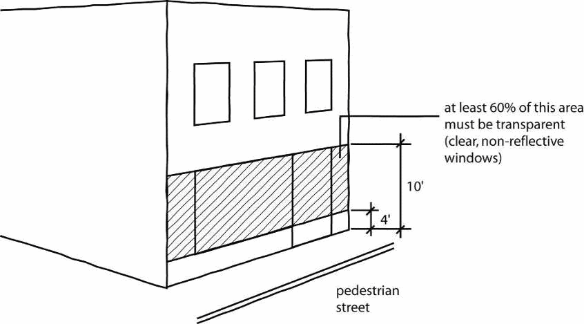
88-230-03-B. GROUND-FLOOR TRANSPARENCY
1.
At least 60% of the street-facing building facade between 4 feet and 10 feet above the sidewalk must be comprised of windows that allow views of indoor commercial space or product display areas. On corner lots, this 60% transparency requirement applies only along one street. The minimum transparency standard abutting secondary streets is 40%.
2.
Display windows that do not provide views into the interior of the building may be counted towards satisfying up to 50% of the minimum transparency requirements, provided that they are internally illuminated and are at least 2 feet in depth.
3.
The bottom of any window or product display window used to satisfy these transparency requirements may not be more than 4.5 feet above the adjacent sidewalk.
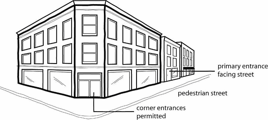
88-230-03-C. DOORS AND ENTRANCES
1.
Buildings must have a working public entrance door facing the street. Entrances at building corners may be used to satisfy this requirement.
2.
Building entrances may include doors to individual shops or businesses, lobby entrances, entrances to pedestrian-oriented plazas, or courtyard entrances to a cluster of shops or businesses.
88-230-03-D. PARKING
1.
No off-street parking is required for nonresidential uses unless such uses exceed 4,000 square feet of gross floor area, in which case off-street parking must be provided for the floor area in excess of 4,000 square feet (see 88-420 for off-street parking ratios).
2.
Any off-street parking that is provided must be located behind the building or within or under the building.
3.
When the depth of the lot is insufficient to permit required parking to the rear of the building, parking may be located to the side of the building, provided that it does not occupy more than 50% of the street frontage and it is screened from view of the street by a brick wall, wrought-iron or decorative fence, or landscaping between 18 and 42 inches in height. Chain link fences are prohibited.
88-230-03-E. DRIVEWAYS AND VEHICLE ACCESS
Driveways and vehicle access, when provided, must come from an alley or side street if either is present.
88-230-03-F. SIGNS
All signs in P/O district must comply with the standards of 88-445-09.
88-230-03-G. GROUND FLOOR COMMERCIAL FLOOR SPACE
All buildings constructed in the PO district must comply with the following ground space requirements:
1.
The minimum floor-to-ceiling height of all ground floor space in the building must be at least 13 feet.
2.
Commercial and other nonresidential uses allowed in the subject zoning districts must occupy at least 800 square feet or 50% of the building's ground floor area, whichever is greater.
(Ord. No. 120783, § 1, 10-4-2012; Ord. No. 160759, § 1, 10-20-2016)
88-235-01 - PURPOSE
Historic Overlay districts are used to identify sites and areas within the city with structures and groupings of structures that are of historic, stylistic or thematic significance, as identified by historic resources surveys. The HO, Historic Overlay district is intended to help protect, preserve, and enhance places, districts, sites, buildings, structures, and other features having a special historical, architectural, cultural, or aesthetic value. The HO district is further intended to:
88-235-01-A. stimulate revitalization and preservation of the residential, civic, and business areas;
88-235-01-B. promote economic progress through heritage tourism;
88-235-01-C. provide for the designation, protection, preservation, rehabilitation, and restoration of historic districts and properties; and facilitate the city's efforts to participate in federal or state historic preservation programs.
(Ord. No. 160759, § 1, 10-20-2016)
88-235-02 - EFFECT
The HO district is an overlay zoning classification that establishes additional restrictions and standards on those uses permitted by the underlying zoning district. In the event of conflict between the overlay zoning district regulations and the regulations of the underlying zoning district, the overlay zoning regulations govern. In all other cases, both the overlay zoning and underlying zoning regulations apply.
(Ord. No. 160759, § 1, 10-20-2016)
88-235-03 - USES
The use regulations of the underlying zoning district govern. The HO district does not impose any additional use restrictions.
(Ord. No. 160759, § 1, 10-20-2016)
88-235-04 - DEVELOPMENT/DESIGN STANDARDS
In establishing an HO district, the historic preservation commission and city plan commission are authorized to propose and the city council is authorized to adopt, district-specific development and design standards to guide development and redevelopment within the subject HO district. When development and design standards have been approved, each application for new construction or alteration of an existing building within the designated HO must comply with those standards. When there are conflicts between the standards of the underlying base zoning district and adopted HO district design/development standards, the HO design/development standards will govern.
(Ord. No. 140919, § A, 11-13-2014; Ord. No. 160759, § 1, 10-20-2016)
88-235-05 - ESTABLISHMENT OF HO DISTRICT
Historic Overlay districts may be established only in accordance with the procedures of 88-580.
(Ord. No. 160759, § 1, 10-20-2016)
88-235-06 - REQUIREMENT FOR A CERTIFICATE OF APPROPRIATENESS
The review and approval procedures and criteria for Certificate of Appropriateness are specified in 88-585.
(Ord. No. 160759, § 1, 10-20-2016)
88-250-01 - PURPOSE
Like overlay zoning districts, special purpose zoning districts are tools for dealing with special situations or accomplishing special planning and zoning goals. Unlike overlay districts, special purpose districts are base zoning classifications; they do not over-lay other base zoning districts.
88-250-02 - ESTABLISHMENT
Special purpose zoning districts may be established, amended, or removed only in accordance with the zoning map amendment procedures of 88-515.
88-250-03 - LIST
The city's special purpose districts are listed below.
(Ord. No. 180027, § A, 3-1-2018
88-255-01 - PURPOSE AND INTENT
88-255-01-A. The SC, Shoal Creek district is intended for application only the Shoal Creek development, which was originally approved through the (former) master planned community (MPC) regulations. The district is intended to accommodate and encourage specific design criteria that will be environmentally sensitive, public service-efficient, and demonstrate progressive and innovative land planning, site planning, engineering, and architectural methods and techniques. The district provides a method to address the concerns identified in the comprehensive plan of the city and issues related to providing basic public services, such as water and sewer extensions, construction of public streets and use of open space.
88-255-01-B. The SC district is further intended to:
1.
identify sensitive use and protection of the natural environment and open space consisting of natural features, undisturbed areas, greenbelts, parks, plazas, and landscaped areas for the use and enjoyment of all residents and visitors;
2.
preserve and enhance existing man-made and natural environs on the site;
3.
create individual neighborhoods limited in size to optimize the pedestrian experience;
4.
provide a variety of housing types to promote a diversity of housing stock and neighborhoods;
5.
provide a variety of retail, office, and commercial uses to offer local employment;
6.
provide a network of interconnecting streets within the neighborhood that serve pedestrians and automobiles in a safe, aesthetic and efficient manner;
7.
provide a neighborhood design that accommodates a variety of transportation modes and transit systems;
8.
designate sites for civic buildings, focal points, landmarks, public open space and community identity;
9.
define public space and create a diverse environment by establishing proportions governing building setbacks, bulk, form, and character;
10.
support compact and mixed use development patterns that reduce long commutes, retain open spaces, and minimize costs for public services and facilities;
11.
advance new and innovative master planning, site planning, engineering and architectural methods and techniques;
12.
encourage flexibility and creativity in proposing new planning concepts that are responsive to changing economic and market conditions; and
13.
encourage the location of new community anchors along existing or proposed transit corridors to create critical mass.
88-255-01-C. APPLICABILITY
SC zoning may be applied only to lands included within the Shoal Creek development originally approved through the MPC, master planned community provisions of the zoning ordinance in effect prior to January 1, 2011.
88-255-02 - GENERAL REQUIREMENTS
88-255-02-A. A master plan must be prepared for all of the land area included within the proposed SC district, in compliance with the regulations and requirements of this article.
88-255-02-B. An application for SC zoning must be accompanied by a community master plan and a traffic study.
88-255-02-C. No land proposed for any SC district, the location of which would include land both within and outside the city limits, may be considered. The portions lying within the city and outside the city limits will be considered separately and not as part of the entire development.
88-255-03 - COMMUNITY MASTER PLAN
A community master plan is a narrative and illustrative plan which presents a unified and organized strategy for development and service facilities having a logical relationship to the property as a whole. A community master plan must consist of all of the following:
88-255-03-A. Project summary setting forth a general description of the overall development, a survey of existing conditions including existing zoning districts, vegetation, slopes, water resources, and floodplains and a division of the land into subareas based upon natural or man-made physical boundaries which are referred to individually as a "neighborhood."
88-255-03-B. Land use plan, including a graphic plan designating acreage and general locations for proposed uses, written development standards that identify permitted uses, quantify the intensity of uses, and establish parking, building height, and setback requirements. The land use plan may propose subdistricts within the district and provide for particular standards within each subdistrict. For purposes of the SC district, "subdistrict" is an area within the overall SC that may incorporate general requirements of the SC district or that may have standards distinct and unique from other areas within the SC.
88-255-03-C. Infrastructure plan, including a traffic impact study, street sections and provisions for public utilities, street lighting, and storm drainage facilities to serve the site.
88-255-03-D. Community facilities plan, including provisions for parks and recreation facilities, open space, school, fire stations, and other public safety facilities.
88-255-03-E. Community design plan, describing the design intent for the community as a whole and the neighborhoods that comprise the community through community-wide design goals, objectives, and guiding principles depicted in an illustrative plan.
88-255-03-F. Implementation and outline of the processes required to initiate construction and provide management and administration for the community as it builds out.
88-255-04 - USES
In the SC district, no building or land may be used and no building may be erected, altered or enlarged, unless it is arranged, intended or designed for other than one or more of the following uses and unless it meets the performance standards set forth in 88-255-05.
88-255-04-A. PRINCIPAL USES
1.
Apartments (including, but not limited to, row houses, and townhouses).
2.
Bakery.
3.
Banks, credit unions, savings and loan associations, and other financial services.
4.
Barbershops or beauty shops.
5.
Bus or other transit stations for passenger pickup and discharge only.
6.
Churches, synagogues, mosques, schools, libraries, community centers, private clubs, recreational areas, museums, and art galleries.
7.
Clinics and hospitals.
8.
Day care facilities.
9.
Gas/convenience stores.
10.
Gyms and health clubs.
11.
Hotels.
12.
Light industrial uses.
13.
Offices - administrative, professional, general, and medical.
14.
Public parking lots or stations for passenger cars or taxicabs.
15.
Repair shops for motor vehicles, appliances, and household items.
16.
Residential dwellings: Detached houses, attached houses, and two-unit houses
17.
Restaurants excluding "drive-in" and "drive-thru" restaurants unless specifically designated in the development plan.
18.
Retail sales and services.
19.
Studios.
20.
Theaters.
21.
Veterinary services.
22.
Warehouses.
88-255-04-B. ACCESSORY USES
Any use which is accessory and incidental to any enumerated principal use is permitted if it meets the performance standards set forth in 88-255-05.
88-255-04-C. OTHER USES
Any use (including a temporary use) not specifically set forth herein, and not a prohibited use, may be considered as a permitted use when specifically shown and identified in any community master plan.
88-255-04-D. PARKING AND LOADING
Except as specified in the community master plan, the parking and loading provisions of 88-420.
88-255-05 - PERFORMANCE STANDARDS
The following provisions, standards, and specifications apply uniformly to all uses in an SC district.
88-255-05-A. All activities, including all storage involving flammable and explosive materials, must be limited to an area with adequate safety devices against the hazard of fire and explosion, adequate fire-fighting and fire suppression equipment, and devices standard in the industry.
88-255-05-B. Burning of waste materials in open fires is prohibited at any point unless authorized by fire department permit, subject to such conditions as may be prescribed by the fire department in each case. The relevant provision of state and local laws and regulations also apply.
88-255-05-C. No activities are permitted that violate the Requirements and Standards of the Radiation Protection Regulations of the Missouri State Board of Health, and no electrical disturbance or any disturbance resulting from radio or television transmission will be tolerated which affects adversely the operation at any point of any equipment other than that of the creator of such disturbance.
88-255-05-D. At the point of measurement specified herein the sound pressure level of noise radiated from a facility at nighttime may not exceed 40 decibels or the average sound level of the street traffic noise nearest the noise generator, whichever is higher, in any octave band of frequency above 300 cycles per second.
1.
Between the hours of 6:00 am and 8:00 pm the sound pressure level of noise radiated from a facility may not exceed 65 decibels in residential areas and 95 decibels in all other areas, or 10 decibels above the average sound level of the existing background noise in the locality of the noise generator, whichever is higher, in an octave band of a frequency above 300 cycles per second.
2.
The sound pressure level must be measured with a sound level meter and an octave-band analyzer that conform to the specifications published by the American Standards Association.
3.
Below 300 cycles per second maximum sound pressure must conform to the following table:
4.
Notwithstanding the foregoing, nothing set forth herein will be deemed to authorize any activity which would otherwise be considered a violation of chapter 46, Code of Ordinances.
88-255-05-E. No vibration is permitted that is discernible without instruments at the points of measurement.
88-255-05-F. No emission is permitted at any point, from any chimney or otherwise, of visible grey smoke of shade equal to or darker than No. 2 on the Power's Micro-Ringlemann Chart, published by McGraw-Hill Publishing Company, Inc. and copyrighted 1954 (being a direct facsimile reproduction of the Standard Ringlemann Chart as issued by the United States Bureau of Mines), except that visible grey smoke of a shade equal to No. 2 on said chart may be emitted for 4 minutes in any 30 minutes. Notwithstanding the foregoing, nothing set forth herein will be deemed to authorize any activity which would otherwise be considered a violation of Chapter 8, Code of Ordinances.
88-255-05-G. No emission is permitted of odorous gases or other odorous matter in such quantities as to be unreasonably offensive at the points of measurement.
88-255-05-H. No emission is permitted that which can cause excessive soiling at any point. Fly ash or other particulate matter resulting from the burning of combustible materials may not exceed a loading in the stack or vent gases of eighty-five one hundredths point per 1000 pounds of conveying gas (twenty-five one hundredths grain per cubic foot measured at 5000 and 50% excess air).
88-255-05-I. No direct or sky-reflected glare is permitted, whether from floodlight, high temperature processes such as combustion or welding or otherwise which are unreasonably objectionable at the points of measurement. All lights must be so installed as to deflect from adjacent residential developments and streets.
88-255-05-J. No discharge is permitted at any point into any public sewer, private sewage disposal system, stream or into the ground, of any materials of such nature or temperature which may contaminate any water supply, interfere with the orderly operation of public sewage collection and treatment systems or otherwise cause the emission of dangerous or offensive elements except in accord with standards approved by the appropriate state and local officials, or standards equivalent to those approved by said authorities for similar uses.
88-255-05-K. No outside storage of any kind is permitted.
88-255-05-L. No land or building in the SC district may be used or occupied in any manner so as to create any dangerous, injurious, noxious or otherwise objectionable fire, explosive or other hazards (including possible potential hazards), noise vibration, smoke, dust, odor, or other form of air pollution, heat, cold, dampness, electrical or other substance, condition or element (referred to herein as "dangerous and objectionable elements") in such a manner or in such amount as to adversely affect the surrounding area. Nor may any activity not expressly prohibited by this section be undertaken and maintained unless it conforms to the regulations limiting dangerous and objectionable elements at the point of the determination of their existence.
88-255-06 - PUBLIC IMPROVEMENTS
The SC district is intended to provide not only a mix of uses and dwelling types and uses but to also encourage the use of alternative standards for public improvements based on the approved community master plan. The community master plan must specify the variations from the city's Standards, Specifications, and Design Criteria for streets, sidewalks, storm sewers, streetlights, and any other public improvement if variations are proposed. In addition to identification of such variations, the community master plan must describe under which circumstances the variations may be used. In the course of carrying out the community master plan, additional variations to the city's Standards, Specifications, and Design Criteria for public improvements may be requested to the city's Standards, Specifications, and Design Criteria for public improvements by the applicant for review and approval by the appropriate city department. Regional detention facilities are encouraged and should be considered.
88-255-07 - NEIGHBORHOOD PLAN
88-255-07-A. After establishment of an SC district but prior to approval of any final plan or final plat affecting an area within a neighborhood, the applicant must submit for approval a neighborhood plan identifying the improvements for storm drainage, sanitary sewer, water lines, street construction, and park dedication. Prior to the submission of the neighborhood plan, the applicant must submit a proposal to conduct a meeting in the vicinity of such Neighborhood Plan to solicit comments from adjoining property owner s. The neighborhood plan must be reviewed and approved by the appropriate city department prior to any approval of a final plan or final plat for the neighborhood.
88-255-07-B. A neighborhood plan is a narrative and illustrative plan which presents a program for public facilities related to the neighborhood as a whole. A neighborhood plan must consist of all of the following:
1.
Land use plan, including a graphic plan designating acreage and locations for proposed uses, preliminary yields for each identified permitted use within the neighborhood and preliminary lots or parcels with configuration and dimensions.
2.
Infrastructure plan, including a proposed street and public right-of-way layout, capacity and dimensions, and utilities master studies to establish capacities, sizing, and linkages with off-site facilities.
3.
Community facilities plan, including general locations and sizes of public and private parks, open space, and other community facilities (schools, public safety and other similar uses).
4.
Community design for neighborhood with design guidelines addressing architecture and materials, landscaping, fencing, and signage.
5.
Implementation with subarea and construction phasing, private design review details, and timing of dedication, and construction of public and private facilities.
88-255-08 - FINAL PLAT AND FINAL PLAN
88-255-08-A. FINAL PLAT
Prior to the issuance of a building permit for any construction within an SC district, the area included within the building permit must be platted. At the option of the applicant, any portion of the community master plan may serve also as the preliminary subdivision plat. Such option must be declared prior to the hearing before the city plan commission. At the time of submission of a final plat, the applicant for the final plat must provide an audit of the neighborhood development as of the date of the submission of the application for a final plat demonstrating that densities established by the community and neighborhood plans have not been exceeded and further that the audit identify the existing parkland dedication and any deficiencies or surpluses in the amount of required dedication.
88-255-08-B. FINAL PLAN
1.
Prior to the issuance of any building permit within the area zoned SC, the applicant for the building permit must present a final plan for review and approval by the city plan commission. In the case of detached house residential development, the final plat will serve as the final plan. The final plan must include specific information regarding the location of the proposed use on the property subject to the final plan defined by legal description, precise setback distances, specific methods of light, landscaping, grading, and architectural characteristics, if required, and any other information necessary to effectuate the purpose of the district. The city plan commission must consider whether the final plan is in substantial compliance with the intent of the community master plan and consistent with the neighborhood plan including any variations or modifications approved by the city planning and development director as part of the neighborhood plan approval process. If the city plan commission determines that the final plan is in compliance with the approved community master plan, the commission must approve the final plan and so advise the city planning and development director. If the city plan commission determines that the final plan is not in substantial compliance with the approved plans, the applicant may elect to proceed as identified in 88-255-09.
2.
At the time of approval of the final plan (or final plat for residential) the applicant may request and the commission may approve variations or modifications to the bulk and area standards requested by the applicant subject to consideration of the following criteria:
(a)
The modification is limited to a use specifically set forth for the subdistrict or a use which is compatible with other uses permitted in the subdistrict;
(b)
The modification is limited to application of the standards of the subdistrict and may not permanently alter such standards;
(c)
Except for the specific modification, the other standards of the subdistrict will remain in effect;
(d)
The modification must reflect the spirit and intent of the SC district as a whole and must maintain any unique planning design which are inherent to the development of the neighborhood area.
(e)
Absent approvals provided herein the standards for a subdistrict (or incorporated provisions of other zoning regulations) apply without exception.
3.
In the course of implementing the approved final plan, certain revisions or adjustments of detail may be permitted if approved by the city planning and development director. However, such revision or adjustment of detail must be in substantial compliance with the final plan approved by the city plan commission. If the city planning and development director finds that such revisions or adjustments of detail are not in conformance with the approved final plan, the applicant may submit a new final plan to the city plan commission for its review and approval.
(Ord. No. 220398, § 1, 5-19-2022)
88-255-09 - AMENDMENTS TO APPROVED PLANS
88-255-09-A. If the city plan commission determines that the final plan is not in substantial compliance with the approved community master plan subject to any variations or modifications submitted as part of the final plan or final plat (as provided above), the commission must deny the request. The applicant may resubmit a revised final plan which does conform with the approved community master plan or may file an amended community master plan in the same manner as provided for a zoning map amendment. Provided, however, if the community master plan identifies neighborhoods, no amendment need include information other than that required to amend the neighborhood plan notwithstanding any other provision to the contrary.
88-255-09-B. Requests to amend an approved plan must be processed as a zoning map amendment in accordance with 88-515, except that the city planning and development director is authorized to approve minor amendments to the SC plan in accordance with the administrative adjustment procedures of 88-570 (see specifically 88-570-02-H).
88-255-09-C. The perimeter boundaries of an established SC district may be modified from time to time by the original applicant or its assignee in the same manner as provided for a zoning map amendment. Such modification may be to an existing neighborhood or may establish a new neighborhood or may be to an existing subdistrict.
(Ord. No. 120783, § 1, 10-4-2012; Ord. No. 250327, § 1, 5-1-2025)
88-260-01 - PURPOSE
The purpose of the UR, Urban Redevelopment district is to promote development and redevelopment of underdeveloped and blighted sections of the city and to accommodate flexibility in design to help ensure realization of the stated purposes of an approved plan for redevelopment. UR districts are further intended to promote the following objectives:
88-260-01-A. a more efficient and effective relationship among land use activities;
88-260-01-B. preservation and enhancement of natural, cultural and architectural resources and features;
88-260-01-C. enhancement of redevelopment areas to accommodate effective redevelopment; and
88-260-01-D. seamless and compatible integration of redevelopment projects into the development patterns that exist or that are planned to exist within the subject area.
88-260-02 - REZONING PROCEDURE; ELIGIBILITY FOR UR ZONING
88-260-02-A. A preapplication consultation is required in accordance with 88-505-02 prior to the filing of a zoning map amendment application to District UR.
88-260-02-B. Property may be rezoned to the UR district in accordance with the zoning map amendment procedures of 88-515, except as modified by the specific provisions of this article. An application for an urban redevelopment district must be accompanied by a preliminary development plan. The plan must include information as required by city planning and development department staff.
88-260-02-C. The UR district may be applied only to property that has been designated as a blighted area, a conservation area, or an economic development area.
88-260-02-D. Designation of an area as a blighted area, a conservation area, or an economic development area must follow the provisions of the Land Clearance for Redevelopment Law (RSMo 99.300), Real Property Tax Increment Allocation Redevelopment (RSMo 99.800), Urban Redevelopment Corporations Law (RSMo ch. 353) or Planned Industrial Expansion Authority (RSMo 100.300).
88-260-02-E. Designation as a blighted area, a conservation area, or an economic development area and approval of a plan for redevelopment should occur simultaneously with the processing of a zoning map amendment to the UR district and city plan commission review. The city plan commission must conduct a public hearing on the application for UR zoning and forward its recommendation to city council.
88-260-02-F. An application for a UR district may not be considered by the city council until after the statutory agency has recommended the declaration of the area as a blighted area, a conservation area, or an economic development area and has recommended approval of the a plan for the redevelopment of the property.
88-260-03 - USE REGULATIONS AND LOT AND BUILDING STANDARDS
Properties within the UR district are subject to the use regulations and lot and building standards established at the time of preliminary development plan approval by the city council. The use and development standards established for the subject UR district must be in general conformance with the approved area plan and be compatible with desirable land use and development patterns in the surrounding area.
Short-term rental use as defined in Chapter 56 of this code of ordinances shall be allowed as follows:
(1)
non-resident short term rentals as defined in Chapter 56 of this code of ordinances shall be allowed subject to the requirements of Chapter 56 of this code of ordinances, including the prohibition on non-resident short term rentals operating in structures or on a parcel that receives any City incentives, when a previously approved UR preliminary development plan is not exclusively comprised of uses in the residential use group as defined by Section 88-805-02 of this zoning and development code, or in the case of a proposed UR preliminary development plan when such plan is not exclusively comprised of uses in the residential use group as defined by Section 88-805-02 of this zoning and development code and when the Council expressly authorizes non-resident short term rentals when approving the UR preliminary development plan. In the event that an UR preliminary development plan is later amended to remove the non-residential use component of the plan, or in the event a final UR plan proposes removing the non-residential use component of the plan, non-resident short term rentals shall not be allowed.
(2)
resident short-term rentals as defined in Chapter 56 of this code of ordinances shall be allowed.
(Ord. No. 170771, § 1, 2-22-2018; Ord. No. 230267, § 2, 5-4-2023)
88-260-04 - OTHER DEVELOPMENT STANDARDS
Properties within the UR district are subject to the development standards found within the 400 Series of this zoning and development code unless otherwise expressly approved by the city council at the time of preliminary development plan approval.
88-260-05 - DEVELOPMENT PLANS
88-260-05-A. No building permit may be issued for development in the UR district until a final development plan has been approved by the city planning and development department director, except that:
1.
a building permit may be issued for nonconforming uses and structures without an approved final development plan; or
2.
the owner of any property that is the subject of eminent domain but that has not been acquired by the condemning authority may continue to use the property for any use existing immediately preceding establishment of UR district. At the time of request for a permit, the property owner must file an affidavit with the city planning and development director stating that the property owner is not in any way affiliated with the condemning authority and further has no intention of securing any of the benefits provided under the plan for redevelopment approved pursuant to the declaration of blight.
88-260-05-B. The final development plan must be reviewed for compliance with the preliminary development plan approved by city council at the time of rezoning to the UR district. If it is determined that the final development plan does not conform to the requirements of the preliminary development plan approved by city council at the time of rezoning, the city planning and development director must notify the developer in writing of the specific deficiencies that exist. Upon receipt of the notice of noncompliance, the developer has the following options:
1.
correct the final development plan to conform to the approved preliminary development plan;
2.
file a preliminary development plan amendment request pursuant to 88-260-06; or
3.
file an appeal of the final development plan review decision in accordance with 88-530-12.
88-260-06 - AMENDMENTS TO APPROVED PRELIMINARY DEVELOPMENT PLANS
88-260-06-A. In the course of carrying out any part of the development plan for a UR district, the developer may submit a request for an amendment of the approved preliminary development plan. Requests to amend a preliminary development plan must be processed as a zoning map amendment in accordance with 88-515, except that the city planning and development director is authorized to approve minor amendments to UR district preliminary development plans in accordance with the administrative adjustment procedures of 88-570 (see specifically, 88-570-02-H).
88-260-06-B. If any development plan covering all or a portion of a UR district is abandoned, or if any phase is not completed within the time frame established at the time of rezoning and preliminary development plan approval, or if the required declaration of blighted area, conservation area, or economic development area is declared null and void by any court of competent jurisdiction, the city planning and development director may recommend that the area be rezoned to its former or other appropriate classification.
(Ord. No. 250327, § 2, 5-1-2025)
88-265-01 - PURPOSE
The US, Underground Space district is a special purpose zoning district established for the following purposes:
88-265-01-A. to accommodate and permit the reasonable utilization of underground space;
88-265-01-B. to protect other properties and persons from adverse effects caused by activities in underground space; and
88-265-01-C. to protect the health, safety and welfare of persons in or around underground facilities.
88-265-02 - ESTABLISHMENT OF DISTRICT
88-265-02-A. The US district may be established when either of the following conditions exists:
1.
Where usable underground space exists; or
2.
Where limestone or other subsurface-located material intended to be extracted exists that adjoins an existing US district or where the surface land at the entrance has an M zoning classification.
88-265-02-B. The US zoning classification may be established, amended, or removed only in accordance with the zoning map amendment procedures of 88-515. The only difference is that the US district provisions apply only to the subsurface and do not affect the zoning classification of the surface above the US district.
88-265-02-C. The initial designation or amendment must be accompanied by a certified survey map showing the extent of existing underground mining and all points of access to the surface, whether they are vehicle entrances or other entrances for ventilation or utility purposes.
88-265-03 - USES
The following uses are permitted by right in the US district:
88-265-03-A. Any use permitted by right or by special use permit in the zoning district controlling the surface property at the primary entrance (that having the most traffic) to the underground space is permitted in the US district under the same terms as apply in the surface district.
88-265-03-B. When not allowed by the surface zoning classification, extraction may be allowed by special use permit in accordance with 88-525.
88-265-03-C. Other allowed uses may be identified for the subject US district by the city council at the time the US district is established, provided that such use is not otherwise prohibited by the building code, fire code, or other relevant city ordinance.
88-265-04 - STANDARDS AND REQUIREMENTS
Underground space in the US district is subject to the following standards and requirements:
88-265-04-A. BUILDING PERMITS
Underground space must have a valid building permit to develop a habitable underground building and to qualify for a certificate of occupancy.
88-265-04-B. ACCESS
The entrances to all US district must be through property owned or controlled by the owners or operators of the underground space. Such entrance property must connect immediately to the major thoroughfare system, without first proceeding through or by other properties; or such entrances must be on property properly zoned to contain the uses developed within the underground space.
88-265-04-C. SAFETY
In order to qualify for building permits or certificates of occupancy, the owners or operators of underground space must have on file with the city plan commission a certificate by a registered professional engineer regarding the structural integrity of the underground space. Such certificate may provide for exceptions or conditions that must be adhered to as a condition of building permit approval. Certificates will be valid for newly added or mined-out areas if so indicated on the certificate. Such certificate must be dated within the past 10 years to be valid for its application to new areas.
88-265-04-D. SURFACE ZONING EXCLUSION
With the exceptions as noted in this section, all US districts are separate from the provisions of the surface zoning districts even though they may underlie them.
88-265-04-E. SURFACE AND SPECIAL EASEMENTS
Penetrations from US districts to the surface property above it are permitted without regard to conforming to the provisions of such surface zoning district, provided that such penetrations are for the purpose of connecting utilities or to contain safety, relief, or life-support systems to the underground. All penetrations must be contained within a special easement to the underground development owner or operator to ensure its perpetuity or continued service to the safety and convenience of the underground development, or, if appropriate, to the city.
88-265-04-F. BUILDING REGULATIONS
Building regulations relating to underground space can be found in §18-261 et seq.
88-270-01 - PURPOSE
The AG-R, Agricultural-Residential district is primarily intended for areas of the city on the outer edge of urbanized development. Subdivision of land to higher density development is usually premature, due to lack of adequate utility services, roadways and other transportation systems. Land use regulations and lot and building standards are primarily geared to agricultural activities and very low-density residential development.
88-270-02 - USES
88-270-02-A. USES PERMITTED SUBJECT TO DEVELOPMENT PLAN APPROVAL
The following uses are permitted as-of-right in the AG-R district, subject to development plan review and approval in accordance with 88-517.
1.
Utilities and Services
2.
Funeral and Interment Service (cemetery/columbarium/mausoleum only)
3.
School
4.
Religious Assembly
5.
Park/Recreation
6.
Sports and Recreation, Participant (Outdoor)
7.
Entertainment Venues and Spectator Sports
8.
Lodging (camp grounds only)
9.
Animal Service (veterinary only)
10.
Horticultural services
11.
Nurseries for trees, plants, and shrubs including retail sale when grown on the premises
12.
Mining and quarrying, subject to 88-355 (asphalt plants and concrete mixing plants may be allowed as accessory uses)
13.
Wireless communication facilities, subject to 88-385
88-270-02-B. USES PERMITTED WITHOUT DEVELOPMENT OR PROJECT PLAN APPROVAL
The following uses are permitted as of right in the AG-R district.
1.
Detached houses (including short term rental in accordance with 88-321)
2.
Orchards
3.
Agriculture, Crop or Animal
4.
Agricultural services, such as grist milling, corn shelling, hay baling and threshing services
5.
Sorting, grading, and packaging of fruits and vegetables and retail fruit and vegetable stands for products grown on the premises
6.
Animal Services, Stables
88-270-02-C. Uses not expressly permitted or authorized by the city planning and development director as similar uses are prohibited in the AG-R district.
88-270-02-D. SPECIAL STANDARDS ADJACENT TO PARKS, BOULEVARDS AND PARKWAYS
RESERVED
(Ord. No. 120783, § 1, 10-4-2012; Ord. No. 150313, § A, 4-30-2015; Ord. No. 160759, § 1, 10-20-2016; Ord. No. 170771, § 1, 2-22-2018; Ord. No. 220398, § 1, 5-19-2022)
88-270-03 - LOT AND BUILDING STANDARDS
88-270-03-A. MAXIMUM BUILDING HEIGHT
The maximum building height shall be 35 feet
88-270-03-B. MINIMUM LOT AREA
1.
For detached houses: 40 acres
2.
For religious assembly and elementary schools: 5 acres
3.
For secondary junior and senior high schools and institutions of higher learning: 10 acres
88-270-03-C. SETBACKS
Minimum setback from all property lines: 30 feet, provided that detached houses may, as an alternative, provide a rear setback of not less than 20 feet for decks and balconies that are 500 square feet or smaller in area.
(Ord. No. 120783, § 1, 10-4-2012)
88-275-01 - PURPOSE
The KCIA, Airport district is primarily intended to promote airport and/or conservation uses in the immediate vicinity of Kansas City International Airport and to limit residential development and certain commercial uses that are incompatible with the use of the airport and related airport uses. The KCIA district is further intended to provide services to the airport and related airport services.
88-275-02 - USES
88-275-02-A. The following uses are permitted as-of-right in the KCIA district without approval of a site plan:
1.
Agriculture, Crop or Animal
2.
Agricultural services, such as grist milling, corn shelling, hay baling, and threshing services, including sorting, grading and packaging of fruits and vegetables and retail fruit and vegetable stands for products grown on the premises
3.
Animal Services, Stables
88-275-02-B. The following uses are permitted in accordance with procedures of 88-530:
1.
Airports, public, including passenger and freight terminals, aircraft storage, maintenance, and related services for aircraft and air passengers
2.
Eating and Drinking Establishments
3.
Entertainment Venues and Spectator Sports
4.
Funeral and Interment Service (cemetery/columbarium/mausoleum only)
5.
Gasoline and Fuel Sales
6.
Lodging
7.
Manufacturing, Production and Industrial Services
8.
Mining and Quarrying subject to 88-350-02-D
9.
Park/Recreation
10.
Religious Assembly
11.
Retail Sales
12.
Sports and Recreation, Participant
13.
Utilities and Services
14.
Other commercial and industrial uses that are compatible with airport operations.
88-275-02-C. Uses not expressly permitted or authorized by the city planning and development director as similar uses are prohibited in the KCIA district.
88-275-02-D. SPECIAL STANDARDS ADJACENT TO PARKS, BOULEVARDS, AND PARKWAYS
RESERVED
(Ord. No. 130441, § 1, 7-11-2013; Ord. No. 150600, § A, 7-23-2015; Ord. No. 220398, § 1, 5-19-2022)
88-275-03 - LOT AND BUILDING STANDARDS
88-275-03-A. MAXIMUM BUILDING HEIGHT
None, except as may be limited by FAA or airport-related regulations.
88-275-03-B. MINIMUM LOT AREA
5 acres.
88-275-03-C. SETBACKS
Minimum setback from all property lines: 30 feet.
88-280-01 - PURPOSE
88-280-01-A. GENERAL
The MPD, Master Planned Development district is intended to accommodate development that may be difficult if not impossible to carry out under otherwise applicable zoning district standards. Examples of the types of development that may benefit from the MPD zoning tool include the following:
1.
ENHANCED PROTECTION OF NATURAL RESOURCE AREAS
Developments that offer enhanced protection of natural resources and sensitive environmental features, including streams, water bodies, floodplains, wetlands, steep slopes, woodlands, wildlife habitats, and native plant communities.
2.
TRADITIONAL URBAN DEVELOPMENT
Developments characterized by lot configurations, street patterns, streetscapes, and neighborhood amenities commonly found in urban neighborhoods platted or otherwise created before the 1950s.
3.
MIXED-USE DEVELOPMENT
Developments that contain a complementary mix of residential and nonresidential uses.
4.
MIXED HOUSING DEVELOPMENT
Residential developments containing a mix of housing types such as detached house, attached house, multi-unit house, etc., such as those formerly approved with a community unit project application.
88-280-01-B. SPECIFIC OBJECTIVES
Different types of MPDs will promote different planning goals. In general, however, MPDs are intended to promote the following objectives:
1.
flexibility and creativity in responding to changing social, economic, and market conditions and that results in greater public benefits than could be achieved using conventional zoning and development regulations;
2.
implementation and consistency with the city's adopted plans and policies;
3.
efficient and economical provision of public facilities and services;
4.
sustainable, long-term communities that provide economic opportunity and environmental and social equity for residents;
5.
variety in housing types and sizes to accommodate households of all ages, sizes, incomes and lifestyle choices;
6.
compact, mixed-use development patterns where residential, commercial, civic, and open spaces are located in close proximity to one another;
7.
a coordinated transportation systems that includes a inter-connected hierarchy of appropriately designed improvements for pedestrians, bicycles, and vehicles;
8.
compatibility of buildings and other improvements as determined by their arrangement, massing, form, character, and landscaping to establish a high-quality livable environment;
9.
the incorporation of open space amenities and natural resource features into the development design;
10.
low-impact development (LID) practices; and
11.
attractive, high-quality landscaping, lighting, architecture, and signage that reflects the unique character of the development.
(Ord. No. 120783, § 1, 10-4-2012)
88-280-02 - PROCEDURE
MPDs must be reviewed and approved in accordance with the procedures of 88-520.
88-280-03 - DEVELOPER'S STATEMENT OF INTENT
Each MPD application must include a written explanation from the applicant describing the community benefits of the proposed development and how the proposed development provides greater benefits to the city than would a development carried out in accordance with otherwise applicable zoning and development code standards.
88-280-04 - USE REGULATIONS AND LOT AND BUILDING STANDARDS
The use regulations and lot and building standards that apply within a MPD zoning district must be established at the time of preliminary development plan approval by the city council. Allowed uses, residential densities and nonresidential intensities must be consistent with any approved plans for the area.
Short-term rental use as defined in Chapter 56 of this code of ordinances shall be allowed as follows:
(1)
non-resident short term rentals as defined in Chapter 56 of this code of ordinances shall be allowed subject to the requirements of Chapter 56 of this code of ordinances only when a previously approved MPD preliminary development plan approves a development that is not exclusively comprised of uses in the residential use group as defined by Section 88-805-02 of this zoning and development code, or in the case of a proposed MPD preliminary development plan when such plan is not exclusively comprised of uses in the residential use group as defined by Section 88-805-02 of this zoning and development code and when the Council expressly authorizes non-resident short term rentals when approving the MPD preliminary development plan. In the event that a MPD preliminary development plan is later amended to remove the non-residential use component of the plan, or in the event a final MPD plan proposes removing the non-residential use component of the plan, non-resident short term rentals shall not be allowed.
(2)
resident short-term rentals as defined in Chapter 56 of this code of ordinances shall be allowed.
(Ord. No. 230267, § 2, 5-4-2023)
88-280-05 - OTHER DEVELOPMENT STANDARDS
88-280-05-A. Unless otherwise expressly approved by the city council at the time of preliminary development plan approval, properties within the MPD district are subject to all other applicable provisions of this zoning and development code. The city council is authorized to approve MPDs that deviate from strict compliance with otherwise applicable standards of this zoning and development code if they determine that the resulting development provides a greater level of public benefit than would normally be expected for projects developed in strict compliance with this zoning and development code.
88-280-05-B. The MPD district is expressly intended to accommodate the use of alternative standards for public improvements based on the approved development plans. The preliminary development plan must specify the deviations from the city's Standards, Specifications, and Design Criteria for streets, sidewalks, stormwater management, and any other public improvement if deviations from otherwise applicable standards are proposed.
88-280-06 - APPROVAL CRITERION
MPD zoning may be approved only when the city council, after receiving the recommendation of the city plan commission, determines that the proposed development cannot be reasonably accommodated by other available regulations of this zoning and development code, and that a MPD would result in a greater benefit to the city as a whole than would development under conventional zoning district regulations. Such greater benefit may include implementation of adopted planning policies, natural resource preservation, urban design, neighborhood/community amenities, or a general level of development quality.
88-285-01 - INTRODUCTION
88-285-01-A. PURPOSE AND INTENT
The following regulations create development and site design standards that promote the recommendations outlined in the Westport District Master Plan. The Westport Overlay aims to provide a cohesive development pattern along Westport Road and Pennsylvania Avenue, the primary pedestrian-oriented corridors in the Westport district. This overlay generally extends along Westport Road from Southwest Trafficway to the boundary of the MCO district, and along Pennsylvania from 39th Street to 43rd Street (Figure 1). The intent of the overlay district is to:
1.
Protect and encourage smaller-scale, fine grain development that reinforces that distinct character of Westport.
2.
Promote incremental growth to allow the district to evolve, while ensuring that future development is compatible with the surrounding context.
3.
Promote a mix of pedestrian-oriented uses that are compatible with the Westport Plan's vision and goals.
4.
Strengthen the active, street-front development pattern to improve the public realm and enhance access to the district.
5.
Enhance public spaces within Westport to further foster community and support businesses.
6.
Manage the impact of parking facilities to enhance accessibility, while understating the prominence of lots and garages along the streetscape.
7.
Celebrate the history of Westport by promoting walkable, human-scaled development patterns.
8.
Promote high-quality development that enhances the shared value of Westport.
Figure 1. Westport Overlay District Boundary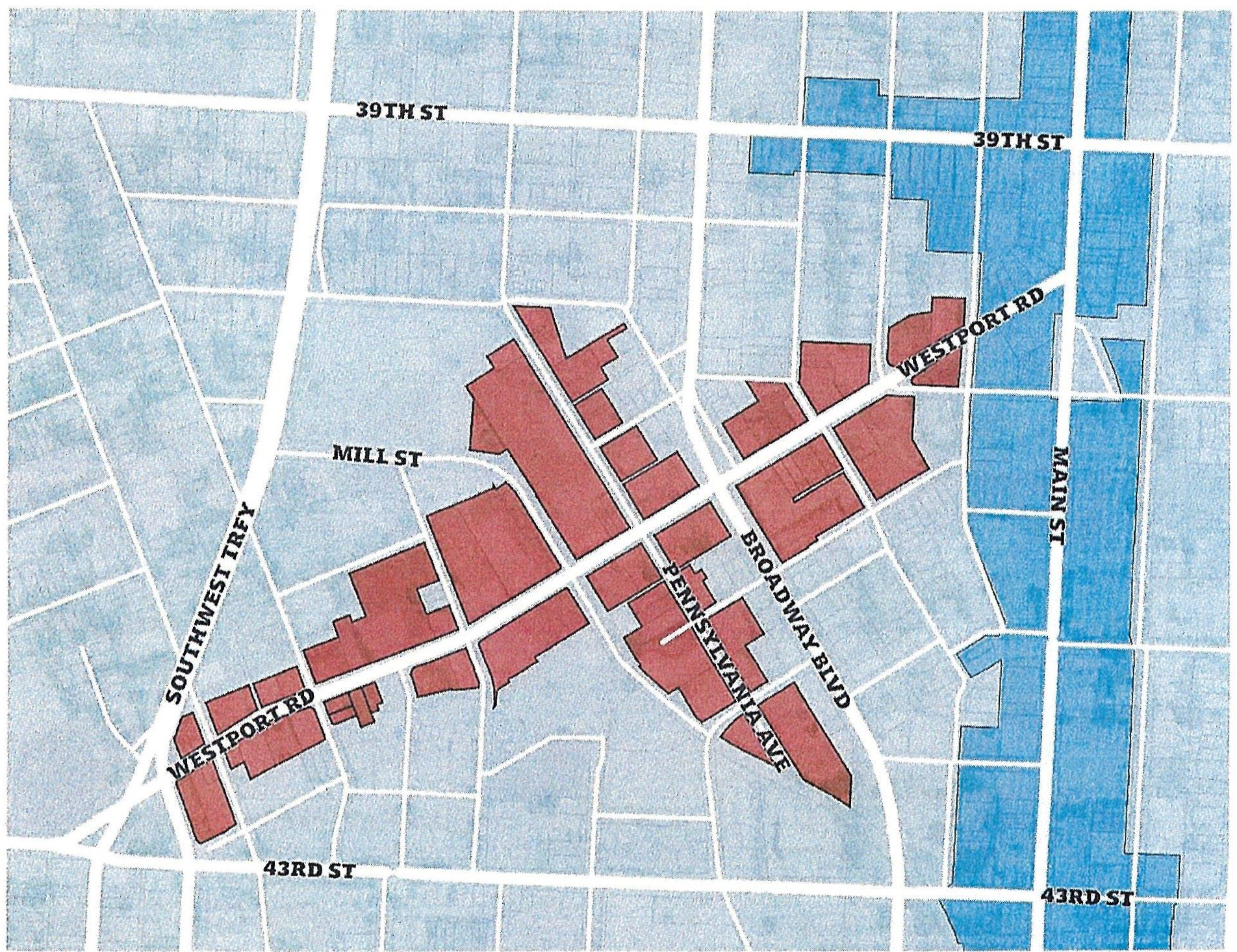
88-285-01-B. APPLICABILITY
1.
The standards of this article apply to all development in the Westport Overlay district. This document establishes the development standards that vary from the underlying base zoning for the properties in the Westport Overlay District. All provisions described below as regulatory in nature have the same force and effect as, but are variations from, the standards set forth in Chapter 88 of the Zoning and Development Code of Kansas City, Missouri.
2.
If provisions of this overlay district are inconsistent with Chapter 88, the provisions of this overlay district shall apply.
3.
If provisions of this overlay district are inconsistent with a Historic Overlay District, then the provisions of the Historic Overlay District shall apply.
4.
Existing MPD and UR districts are exempt from the standards of this document. However, when new MPD or UR plans are adopted the standards of this document shall be met.
5.
Buildings listed on the Kansas City and/or National Register of Historic Places, and following the Secretary of the Interior's Standards through the National Parks Service, shall be exempt from the Lot and Building Standards, Architectural Materials, Façade Articulation and Composition and Transparency standards of this overlay. A letter from the Historic Preservation Commission is required at the time of Application submittal to ensure the building meets Secretary of Interior standards.
6.
Other than as set forth below, the underlying zoning and the regulations and standards included in the Zoning and Development Code, Chapter 88, prescribed for the areas rezoned to this overlay district shall remain unchanged and shall continue to apply.
a.
NEW DEVELOPMENT.
Full compliance with this article applies to all new buildings constructed within this district.
b.
ENLARGEMENTS AND EXPANSIONS.
Full compliance with this article applies only to the enlargement or expansion area. Enlargements or expansions must be reviewed and approved by the City Planning and Development Department in accordance with the required entitlement process.
c.
FAÇADE CHANGES.
Compliance with this article applies to façade changes to existing buildings.
d.
CHANGE OF USE OR OCCUPANCY.
Compliance with use standards apply whenever the use or occupancy of a property changes.
e.
SIGNAGE.
Compliance with signage standards apply when a permit is required.
(Ord. No. 230498, § 1, 6-15-2023)
88-285-02 - ALLOWED USES
88-285-02-A TABLE OF ALLOWED USES
Use categories and general uses have been established for principal uses of land and buildings. Table 1 indicates permitted uses (■) subject to general district and building development standards, special uses (S) subject to the discretionary review process, prohibited uses (-), and additional use-specific standards, applicable to all underlying zoning districts in the overlay district.
(Ord. No. 230498, § 1, 6-15-2023)
88-285-03 - LOT AND BUILDING STANDARDS
88-285-03-A GENERAL STANDARDS
The following Lot and Building Standards apply to all new construction within the overlay district:
[l]
Minimum Building Frontage, Front and Side Yard Setbacks may be expanded to accommodate usable open space according to Section 88-285-05-B.
[2]
Non-street setbacks shall be as specified by the building code for each class of building.
[3]
Maximum building height may be altered according to Section 88-285-03-C.5.
[4]
For the purposes of this ordinance, height shall be measured from the highest elevation curb of the abutting street adjacent to [he subject property.
88-285-03-B FRONTAGE AND SETBACK EXCEPTIONS
The following are exceptions to the frontage and setback limits in Table 2:
1.
ALL PROJECTIONS.
Any projections over public rights-of-way, or any similar area designed for pedestrian circulation, shall be at least 8 feet above the grade, and in no case within 5 feet of any curb for a street, through access drive or other area designed for vehicles. All projections shall receive approval from the appropriate entity prior to installation.
2.
ENTRY FEATURES.
Primary entry features such as porticos, stoops, or unenclosed porches may extend up to 6 feet into the required front setback. Entry features shall not encroach on any easement, encroachments must ensure a minimum of 10 feet of passable sidewalk width.
3.
USABLE OPEN SPACE FRONTAGE.
Usable open space along the lot frontage, including patios, courtyards, outdoor recreational areas, and outdoor entertainment venues, shall conform to the site design standards in Section 5-2.
4.
MECHANICAL EQUIPMENT.
Mechanical equipment shall be screened as required by Chapter 88 of the Zoning and Development Code.
5.
MULTIPLE BUILDINGS.
Multiple buildings are allowed on one lot. The buildings shall meet the development requirements found in Chapter 88 of the Zoning and Development Code and receive approval through the proper entitlement.
Figure 2 - Maximum Height Allowances
88-285-03-C HEIGHT EXCEPTIONS
The following are exceptions to the height limits in Table 2:
1.
GENERALLY.
Building elements integral to the design and construction of the building, such as parapet walls, false mansards, or other design elements essential to a quality appearance of the building may extend up to 6 feet above the roof deck of a flat roof.
2.
ARCHITECTURAL FEATURES.
Architectural features such as chimneys, ornamental towers or spires, and similar accessory features that are less than 20% of the building footprint may extend up to 50% above the actual building height.
3.
MECHANICAL EQUIPMENT.
Functional and mechanical equipment such as elevator bulkheads, cooling towers, smokestacks, roof vents or other equipment may be built up to their necessary height in accordance with building codes. Roof mounted mechanical equipment shall be property screened as required by 88-425-07 of the Zoning and Development Code.
4.
ACCESSORY STRUCTURES.
Accessory site structures such as flag poles, monuments, water towers, may have a height limit of 50 feet, but shall be setback a distance of at least ⅓ its height from the property line.
5.
PUBLIC PARKING ARRANGEMENT.
The City may approve a height bonus of up to two additional stories with a maximum height of 5 stories if at least 100 parking spaces or 20% of the parking spaces, whichever is greater is provided subject to an agreement between the Property Owner and the City. Parking is permitted by Special Use Permit subject to the provisions of Section 88-285-05-B of this Chapter.
(Ord. No. 230498, § 1, 6-15-2023)
88-285-04 - BUILDING COMPOSITION STANDARDS
88-285-04-A. MATERIALS
1.
PRIMARY MATERIALS.
Materials identified with a "PM" on Table 3 are Primary Materials and allowed on all stories of a structure.
2.
SECONDARY MATERIALS.
Materials identified with a "SM" on Table 3 are Secondary Materials. Permitted secondary materials shall be used as accent material on the first story and shall not exceed 30% of the first story façade. Permitted secondary materials may be used on the second story and above of a structure or for the required building elements.
3.
PROHIBITED MATERIALS.
Materials identified with an "-" on Table 3 are expressly prohibited.
4.
PRESERVATION OF MATERIALS.
Preservation or restoration of original façade materials is desired in existing structures. Applied 'faux' façades or other not permitted non-original materials are not desired.
5.
DETERMINATION OF SIMILAR MATERIALS.
When a specific material cannot be readily classified, the City Planning and Development Director is authorized to determine the most similar, thus most appropriate, material based on the following considerations:
a.
the appearance of the material;
b.
the durability of the material;
c.
the method of installing the material;
d.
the location of the material; and
e.
relevant information provided by the International Building Code.
6.
EXCEPTIONS TO MATERIAL LIMITATIONS FOR STOREFRONTS.
Wood and metal may encompass more than 30% of a first-floor façade when used in a clearly articulated first-floor storefront system.
[1]
For the purposes of this ordinance, Electronic/Digital Façades are defined as an electronic/digitally illuminated façade surface exceeding 50% of any wall plane on a building, or 150 square feet, whichever is less.
[2]
For the purposes of this ordinance, first-floor and upper-floor windows complying with the transparency requirements of Table 4 are exempt from the maximum façade coverage area for secondary materials.
88-285-04-B. MASSING AND FAÇADE COMPOSITION
1.
GENERAL STANDARDS.
Table 4 establishes design standards applying to the massing and façade composition of buildings fronting on Westport Road and/or Pennsylvania Avenue in this overlay.
2.
COMPOSITION.
Façade composition refers to the use of materials, fenestration and architectural details and ornamentation to add interest and uniqueness to buildings and activate or emphasize certain spaces around a building. In addition to the standards outlined in Table 4, the following must be met:
a.
Blank walls and wall planes shall be broken up clearly with elements that add architectural interest and variety, such as projections, recesses, offsets, windows, painted features, or blank window openings trimmed with frames, sills or lintels.
b.
Façade composition shall establish a base, body and top of building and shall distinguish different structural components with varying material and color.
3.
ENTRANCES.
Entrances shall be clearly defined on all front façades with at least one of the following elements and be located at intervals specified in Table 4:
a.
A single-story architectural emphasis such as raised parapets or gables, canopies, porticos, overhangs, pediments, or arches;
b.
Transoms and/or display windows that frame and emphasize the entry;
c.
Architectural details such as tile work and moldings, columns, pilasters, or other similar material changes; OR
d.
Integral planters or wing walls associated with a recessed or projecting entry court or plaza that integrates more formal landscape and hardscape designs.
Figure 3 - Transparency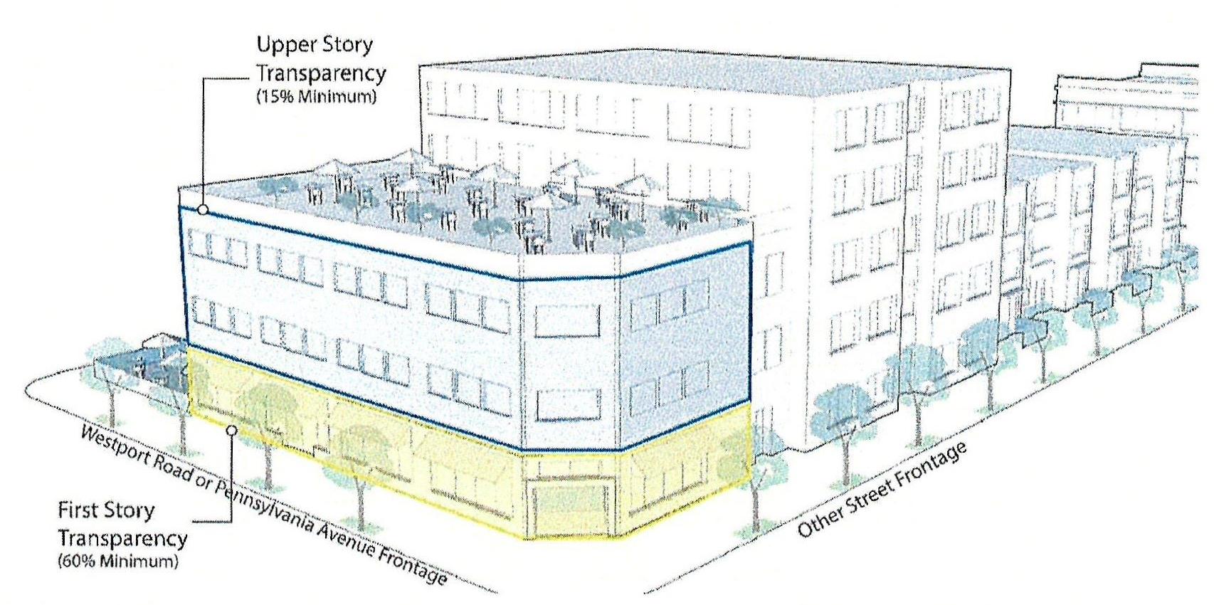
4.
TRANSPARENCY.
Buildings shall have the percentage of openings specified in Table 4, based on the following:
a.
The transparent facade determined by Table 4 must be comprised of windows between 2 feet and 10 feet above the sidewalk or transparent doors that allow clear views of indoor space or product display areas.
b.
On corner lots, 60% first-floor transparency is required where building façades abut Westport Road.
c.
Façades fronting parkways and boulevards shall comply with the standards set forth in 88-323 "Boulevard and Parkway Standards."
d.
First-floor uses that are solely for residential purposes may reduce their transparency to 40%.
e.
Display windows that do not provide views into the interior of the building may be counted towards satisfying up to 50 percent of the minimum ground-level transparency requirements, provided that they are internally illuminated and are at least 3 feet in depth.
f.
No existing building shall be altered in such a way that reduces transparency below the required or existing amount.
g.
Illumination of windows, display windows, and primary entrances shall not have any effects of movement, flashing, scintillation, rolling, dissolving, fading or similar effects and shall be in compliance with Section 88-430 of the Zoning and Development Code.
(Ord. No. 230498, § 1, 6-15-2023)
88-285-05 - SITE DESIGN STANDARDS
88-285-05-A. BUILDING ACCESS
Primary entrances shall comply with the following standards:
1.
DIRECT ACCESS REQUIRED.
Primary entrances shall provide direct public access from the adjacent rights-of-way in compliance with the Pedestrian Standards as stated in 88-450 of the Zoning and Development Code.
2.
CORNER LOTS.
On corner lots, corner entrances are encouraged.
Figure 4 - Minimum Building Frontage and Usable Open Space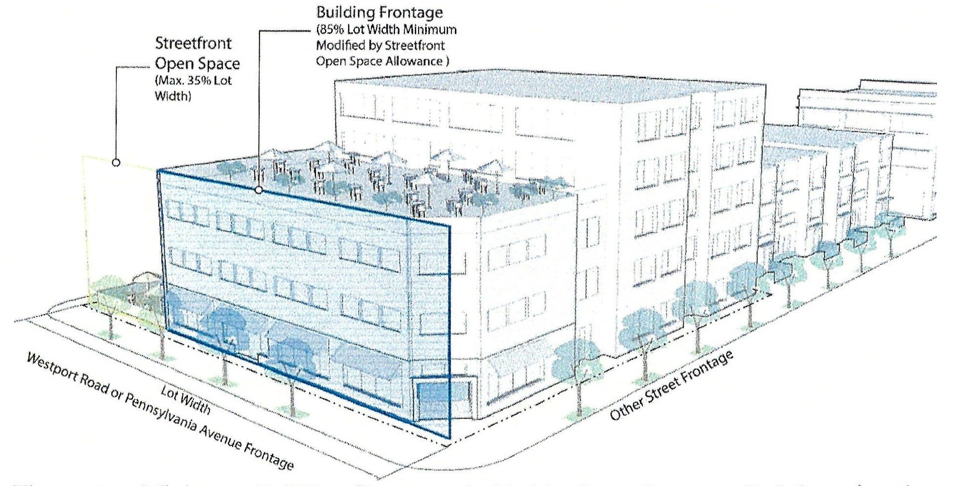
Buildings fronting Westport Road or Pennsylvania Avenue are required to occupy at least 85% of the lot's width, unless usable open space complying with Section 88-285-05-B is included. Usable open space may occupy up to 35% of the lot's width.
88-285-05-B. USABLE OPEN SPACES
Building frontage and setbacks in Table 2 may be modified to accommodate usable open space, including patios, courtyards, outdoor recreational areas, and Outdoor entertainment venues. Usable open spaces shall conform to the following standards:
1.
LOCATION.
Open space must directly abut the streetscape.
2.
FRONTAGE EXTENT ALLOWANCE.
Open space shall not exceed 35% of the total lot frontage along Westport Road and/or Pennsylvania Avenue.
3.
SIZE.
Open space shall be at least 15 feet in all directions. Open space shall not exceed 20,000 square feet.
4.
ALLOWED USES.
Open space may be used for dining, gathering, recreation, or similar uses. Open space shall not be used for outdoor storage. Outdoor uses shall be accessory to the principal use.
5.
ENCLOSURE.
Open space may be enclosed with a permanent rail or wall constructed of metal, masonry, or wood, not exceeding 36 inches in height. Enclosed usable open spaces may include an entry along the perimeter to accommodate public access of at least 36 inches wide.
6.
ACTIVATION.
Usable open space shall be designed as active social space. For the purposes of this ordinance, "Usable Open Space" shall not be interpreted as vehicular use areas such as parking or loading facilities, landscape areas, or stairways. At a minimum, open space shall be designed to include two of the following elements:
a.
Movable furniture;
b.
Interactive art installation;
c.
Planters with seasonal or ornamental plantings;
d.
Water element such as a fountain;
e.
Shade elements.
88-285-05-C. VEHICLE PARKING FACILITIES
Uses in the Westport Overlay are exempt from the parking standards of Section 88-420-06 of the Zoning and Development Code of Kansas City, Missouri. Where the expansion or addition of parking is allowed through special use permit, the following standards apply:
1.
UNDERSTATED PARKING REQUIRED.
Parking facilities shall not directly abut Westport Road or Pennsylvania Avenue. Any off-street parking provided must be located behind, within, or under the building, unless determined otherwise by the Planning Director.
2.
PARKING GARAGES.
Where permitted, tenant spaces shall be included on the ground level of parking garage façades fronting on Westport Road or Pennsylvania Avenue.
3.
ACCESS AND CIRCULATION.
Access shall be taken from alternative streets or alleys where available. Permitted parking facilities shall not be accessed from Westport Road or Pennsylvania Avenue, except where determined otherwise by the Planning Director.
4.
PARKING MAXIMUMS.
Where approved through special use permit, no use shall provide more than 20% of minimum required parking in Section 88-420-04 of the Zoning and Development Code. In addition, any parking permitted over 20% shall require mitigating potential impacts of more parking through one or more of the following strategies:
a.
Provide shared parking for other uses on the block or adjacent blocks.
b.
Design all parking areas over the minimum as dual-purpose space, such as plazas, playgrounds, event areas for regular use of the space during nonpeak times.
c.
Use alternative surface areas designed to infiltrate stormwater.
d.
Provide additional buffers and site open spaces to screen parking and provide more active usable outdoor spaces for people in relation to the streetscape, of at least a 10% increase in the open space or buffers and at least a 25% increase in the amount of landscape material required for the parking.
88-285-05-D. BICYCLE PARKING FACILITIES
Short-term and long-term bicycle parking is required according to Section 88-420-09 of the Zoning and Development Code of Kansas City, Missouri.
88-285-05-E. SCREENING, FENCING AND WALLS
1.
MECHANICAL/UTILITY EQUIPMENT.
In addition to Section 88-425-08 of the Zoning and Development Code of Kansas City, Missouri) the following standards must be met:
a.
Dumpsters and ground level mechanical/utility equipment must be located in the rear yard or can be located in the side yard if setback 10 feet from Westport Road or Pennsylvania Avenue.
b.
Dumpsters shall not be visible from the public right-of-way.
c.
Access for dumpsters and mechanical/utility equipment may be shared with any access for required parking.
2.
FENCING AND WALLS.
Fencing and walls within the overlay district shall comply with the following standards:
a.
No fence over 72 inches shall be erected on any lot.
b.
Per the Boulevard and Parkway Standards in Section 88-323, fencing on a boulevard must be of steel, iron, concrete, stone, or brick.
c.
Barbed-wire, razor wire, metal sheeting, wood picket, stockade, chain link fencing, or similar materials are prohibited fencing materials in the Overlay District.
d.
Within 20 feet of the Westport Road or Pennsylvania Avenue right-of-way lines:
i.
Fencing shall meet or exceed 80 percent transparency.
ii.
The finished side of the fence or wall shall face the adjacent property or the street.
iii.
Fences used to enclose a vehicular use area shall be at minimum 36 inches in height, made of decorative wrought iron or other metal picket, and located within the required perimeter landscape butter.
iv.
Freestanding walls shall not exceed 36 inches in height. Fencing or a combination of fencing and a freestanding wall shall not exceed 72 inches in height.
v.
Retaining walls adjacent to Westport Road or Pennsylvania Avenue shall not exceed 48 inches in height.
vi.
Freestanding and retaining walls shall be constructed of brick, pre-cast concrete, cast-in-place concrete-textured, stone or cast stone.
(Ord. No. 230498, § 1, 6-15-2023)
88-285-06 - SIGNS
88-285-06-A. SIGN TYPES & ALLOWANCES
All signage must receive approval of a sign permit, and shall comply with the following standards:
88-285-06-B MONUMENT SIGNS
1.
Monument signs are prohibited, unless on a lot with a minimum of 100 feet of frontage and applies with at least one of the following criteria:
a.
The lot is developed with an existing principal structure and is setback at least 30 feet from the property line adjacent to Westport Road;
b.
The lot has an existing pole sign. The pole sign may be replaced with a monument sign;
c.
The sign is attached to or incorporated into a freestanding wall or retaining wall.
d.
The site is an official local or national historic landmark or a contributing building within an official local or national historic district.
e.
When attached to a wall or fence, Monument signs shall not project more than 3 inches from the face of the wall or fence.
2.
When allowed, one monument sign is permitted per street frontage. When allowed Monument signs must meet the following standards:
a.
Shall not exceed 20 square feet in area and 4 feet in height.
b.
Monument signs shall be set upon a solid base of material and constructed of primary materials matching the principal building.
c.
Sign material shall consist of pin-mounted channel letters, die cut graphics, and/or engraved text.
d.
The area surrounding the monument sign shall be landscaped.
e.
Monument signs shall be setback in accordance with one of the following standards:
i.
On interior lots, monument signs shall be set back a minimum of 5 feet from the property line.
ii.
On corner lots, monument signs shall be set back a minimum of 10 feet from property line.
iii.
When attached to a wall or fence, signs shall not extend above the top of the wall or fence.
88-285-06-C. PROJECTING SIGNS
Projecting signs shall comply with the standards as listed in Section 88-445-08-E of the Zoning and Development Code,
88-285-06-D. WALL SIGNS
Wall signs shall be permanently attached to the building and parallel to its surface, and shall comply with the following:
1.
Wall signs shall be die cut and/or channel letter signs.
2.
Signs located on the ground level of the building shall be pin-mounted.
3.
Raceway-mounted channel letter signs are allowed on the second story and above. Raceways shall be painted or designed to match the material on which the sign is affixed.
4.
Hand-painted wall signs are subject to administrative approval by the director of City Planning and Development. On the front or street-side façade of a building, hand-painted signs may not exceed 10 percent of the wall area and count as one wall sign per 88-285-06-A. Hand-painted signage located on a non-street side façade shall not exceed 50 percent of the façade area and shall be the only sign on that façade.
88-285-06-E. INCIDENTAL SIGNS
Incidental signs are permitted in the district, according to the standards of Chapter 88-445-08-G.
88-285-06-F. ROOF SIGNS
Supporting structure for a roof sign must comply with all applicable engineering and code requirements. Roof signs shall be die cut and/or channel letter signs. Supporting structures must consist of the fewest number of supporting members without embellishments. Roof signs are permitted on buildings if the top of the highest portion of the roof is at least 30 feet above grade. The maximum horizontal dimension of a roof sign may not exceed 50 percent of the width of the wall it most closely parallels or 20 feet, whichever is less. The maximum height of a roof sign and its supporting structure may not exceed 6 feet, measured from the elevation of top of the highest parapet to the top of the sign. Roof signs shall not be constructed of wood.
88-285-06-G. HISTORICAL SIGNS
Historical wall signs, hand-painted signs, neon signs, and projecting signs that advertise closed or off-site businesses may remain and shall not count toward any signage requirements if established more than 25 years from the date of application. Historical signs may be removed and reinstalled for restoration. Historical signs may be replicated if the new sign is the same size and material. Retention of historical signs must receive approval by the director of City Planning and Development. In no case shall a pylon sign be considered a historical sign.
88-285-06-H. NEON AND ELECTRONIC SIGNAGE
Animated neon signs may be permitted with administrative approval of the director of City Planning and Development. Electronics digital, and/or motorized signs, and outdoor advertising signs are prohibited within the district.
(Ord. No. 230498, § 1, 6-15-2023)