
Kansas City City Zoning Code
400 SERIES
DEVELOPMENT STANDARDS
88-408 - PARKLAND DEDICATION
In subdividing land, re-subdividing an existing plat, or otherwise creating any new residential unit(s), a developer must provide suitable sites for parks, playgrounds or other public or private recreational areas or open spaces. This parkland requirement may be met by dedication of land to the city for park purposes, platting of private open space tracts for recreational purposes per an approved plan, payment in lieu of parkland, or any combination thereof.
88-408-A. CALCULATION OF LAND DEDICATION REQUIREMENTS
Parkland dedication requirements are calculated in 4 steps, as follows:
1.
First, multiply the number of detached houses to be included in the development times 3.7 people per dwelling unit; then multiply the resulting number times 0.006 of an acre per person.
2.
Second, multiply the number of dwelling units in semi-attached houses to be included in the development times 3 people per dwelling unit; then multiply the resulting number times 0.006 of an acre per person.
3.
Third, multiply the number of dwelling units in multi-unit buildings to be included in the development times 2 people per unit; then multiply the resulting number times 0.006 of an acre per person.
4.
Finally, add the results of the preceding detached house, two-unit house and multi-unit building land dedication calculations. This sum represents the development's total parkland dedication requirement, which may be satisfied by the actual dedication of land or through the payment of money in lieu of dedication, in accordance with the provisions of this section.
88-408-B. LAND DEDICATION GENERALLY
1.
The dedication of land for park uses must be at locations designated in the comprehensive plan, or the official parks plan adopted by the board of parks and recreation commissioners, or as determined by the developer and the staff of the city planning and development and parks and recreation departments.
2.
When the required parkland dedication is less than 4 acres, the city plan commission or staff may require the open space to be located at a suitable place on the periphery of the development, so a more usable tract will result when additional open space is obtained when adjacent land is subdivided.
3.
If the development is being platted, the developer must dedicate such approved parkland to the city for park purposes as a condition of final subdivision approval.
4.
All land to be dedicated to the city for park purposes must have the prior approval of the board of parks and recreation commissioners, and must be shown and marked on any plat as "dedicated to Kansas City, Missouri, for park and recreation purposes." The number of the board resolution approving the dedication must be shown on the plat.
5.
Notwithstanding anything else contained in this section, if the developer and the staff of the city planning and development and parks and recreation departments are unable to agree upon the location of the land to be dedicated as required under this section, then the developer must pay money in lieu of land dedication, as required in 88-408-C.
6.
Also, notwithstanding anything else contained in this section, if the required parkland dedication is less than 2 acres, then the city may elect to require the developer to pay money in lieu of land dedication, as required in 88-408-C.
88-408-C. PAYMENT IN LIEU OF LAND DEDICATION
1.
Notwithstanding anything contained in 88-408-B, the developer may elect, at any time before approval of the preliminary plat by the development review committee or the city plan commission, to pay money in lieu of dedicating land.
2.
When the developer elects to pay money in lieu of dedicating land, the developer must, before recording the subdivision plat or minor subdivision, or (if platting or minor subdivision is not required) receiving a certificate of occupancy for a new residential unit, deposit with the city treasurer a monetary payment to the parks and recreation acquisition or development trust fund equal to the required parkland dedication (calculated pursuant to 88-408-A) multiplied by the current year's price for the calendar year in which the approval is granted (date of preliminary plat approval by the development review committee or the city plan commission, administrative approval of minor subdivision, or — in the absence of platting or minor subdivision — issuance of a building permit for a newly created unit) less a credit based on the ratio that any land actually dedicated for park purposes bears to the required parkland dedication. The monetary payment must be without recourse or the right of recovery. For purposes of administering this provision, "current year's price" means the average cost per acre actually paid by the city for all purchases of tracts of parkland of 49 acres or less, whether through negotiation or condemnation, but excluding all acquisitions wholly or partially obtained through gift, during the 5 calendar years immediately preceding the subject calendar year.
3.
Money-in-lieu funds paid to the city before May 1, 2003, must be used for the acquisition, development, or improvement of a public park, generally within one mile of the periphery of the subdivision for which they were paid.
4.
Money-in-lieu funds and the accrued interest on the funds, paid to the city on or after May 1, 2003, must be used for the acquisition, development, or improvement of a public park, generally within 3 miles of the periphery of the subdivision for which they were paid. Funds must be used for such purposes within 15 years of the date the payment is received by the city, provided that any such funds that are used for parks located more than one mile from the periphery of the subdivision for which they were paid will not be used for a neighborhood park, as defined by parks and recreation department standards.
88-408-D. CREDITS
In calculating land dedication and money in lieu requirements, an applicant proposing to replat land, convert existing residential units to condominiums, or create new residential units must be given credit for any previous parkland dedications or monetary payments in lieu for the subject property.
88-408-E. PRIVATE DEVELOPMENT AND OPERATION OF RECREATIONAL OPEN SPACE
The applicant may elect to comply with the land dedication/fee-in-lieu requirements of this section by providing an area that meets the minimum standards of 88-408-B, provided that such area must be developed and maintained by the developer or by the lot owners in the subdivision as private property under a legal arrangement approved by the city attorney as adequate to ensure its continued operation and maintenance. The city may require that such private open space area be improved as a useable recreation area, with trails, ball fields, playgrounds or other active recreation amenities.
88-408-F. QUALITY OF DEDICATED PARK SITES
Lands to be dedicated in accordance with the parkland dedication requirements of this section are subject to the following standards:
1.
Land proposed to be dedicated for park and recreation use must be suitable for such use and receive the approval of the director of parks and recreation and the city plan commission.
2.
If the minimum parkland dedication requirement exceeds 10 acres, the parks and recreation department may require that the dedication comprise more than one parcel within the subdivision, subject to the approval of the city plan commission.
3.
The dedicated parkland must be a cohesive whole, but may be of irregular outline or shape.
4.
The developer may, with the concurrence of the parks and recreation department, make improvements or provide recreational facilities. The developer must improve the land to be dedicated as follows:
a.
If the required parkland dedication is 4 acres or less, the developer must provide within the park area, as approved by the city plan commission, a play area of 20,000 square feet with not more than a 4% gradient or which could reasonably be graded to such.
b.
If the required parkland dedication is 9 acres or more, provide a play and game area within the park area of not less than 85,000 square feet with a maximum gradient of 4% or which could reasonably be graded to such.
c.
If the required parkland dedication is between 4 acres and 9 acres, provide a proportionate share of game area.
d.
Any land within the park area disturbed by construction activity must have topsoil restored and the soil stabilized by appropriate vegetative cover.
5.
Each park open space must have frontage on a public street as the city plan commission deems necessary to provide acceptable access to the open space from a public street, taking into account the amount of frontage reasonably required by the circumstances of the particular open space. This frontage may serve as a corridor from the public street to the main body of the park area as the city plan commission deems necessary to provide acceptable access to the open space from the public street. This corridor must have a gradient adequate for pedestrian or vehicle use.
88-408-G. ADDITIONAL RECREATIONAL RESERVATIONS
The provisions of this section are minimum standards. Nothing in this section is to be construed as prohibiting a developer from dedicating or reserving other land for recreation purposes in addition to the requirements of this section.
88-408-H. TRAILS
Trails may be counted toward satisfying the parkland dedication requirements of 88-408. Unless otherwise expressly approved at the time of subdivision approval, the maximum credit allowed is 50 feet times the length of the dedicated trail segment. Decision-making bodies are authorized to allow greater land dedication credit if the trail provides immediate access to a useable open space or recreation amenity or it otherwise provides greater amenity value than a linear trail corridor.
(Ord. No. 150350, § A, 5-21-2015; Ord. No. 220398, § 1, 5-19-2022)
88-420 - PARKING AND LOADING[1]
Editor's note— Ord. No. 160454, § B, adopted June 23, 2016, amended the Code by repealing former 88-420, and adding a new 88-420. Former 88-420 pertained to similar subject matter, and derived from Ord. No. 120138, adopted March 8, 2012; Ord. No. 120697, adopted August 23, 2012; Ord. No. 120783, adopted October 4, 2012; Ord. No. 120939, adopted December 20, 2012; Ord. No. 130441, adopted July 11, 2013; Ord. No. 140919, adopted November 13, 2014; Ord. No. 150600, adopted July 23, 2015; and Ord. No. 151013, adopted December 10, 2015;
88-405-01 - PURPOSE AND INTENT
In addition to promoting the general purposes of this zoning and development code, the subdivision design and improvement standards of this article (and the subdivision review and approval procedures of 88-540 through 88-555) are intended to help:
88-405-01-A. facilitate the creation of accurate and permanent public records of the separate interests created and conveyed by the subdivision of land, thereby helping to protect private property rights;
88-405-01-B. promote the timely and coordinated provision of required multi-modal transportation improvements, utilities and other facilities and services to new land developments;
88-405-01-C. provide needed public open spaces and building sites in new land developments through the dedication or reservation of land for recreational, educational, other public purposes or the provision of funds in lieu of dedication; and
88-405-01-D. ensure that proposed lots are capable of being built upon in accordance with applicable city regulations.
88-405-02 - COMPLIANCE WITH APPLICABLE REGULATIONS
All subdivisions and all improvements required or allowed by this zoning and development code are subject to compliance with the following:
88-405-02-A. this zoning and development code;
88-405-02-B. state statutes;
88-405-02-C. building and housing codes;
88-405-02-D. the comprehensive plan, major street plan, public utilities plan, master watershed plans, and capital improvements program of the city, including all streets, drainage systems and parks shown on the major street plan or comprehensive plan, as adopted;
88-405-02-E. rules of the state highways and transportation department, if the subdivision contains or abuts a state highway;
88-405-02-F. standards and regulations adopted by all boards, commissions, departments, divisions, agencies, and officials of the city adopted pursuant to any law or ordinance;
88-405-02-G. the city's Standards, Specifications, and Design Criteria, which must be adopted by ordinance in accordance with 88-590; and
88-405-02-H. all other local, state and federal requirements.
88-405-02-I. STANDARDS, SPECIFICATIONS, AND DESIGN CRITERIA
The city's standards, specifications, and design criteria consist of the department of public works' standards, specifications, and design criteria and the department of water services' standards, specifications, and design criteria, as adopted, supplemented and revised in accordance with the procedures of article 88-590. All subdivision improvements constructed or modified must comply with standards, specifications, and design criteria, which are available to the public in the offices of the director of public works and director of water services.
88-405-03 - IMPROVEMENTS REQUIRED
88-405-03-A. Developers (subdividers) are responsible for the construction and installation of the following improvements in accordance with the standards of this zoning and development code.
1.
all streets within the subdivision and improvements to existing streets required for safe and adequate access to the subdivision as may be required by this zoning and development code;
2.
street signs;
3.
sidewalks and trails;
4.
water supply and wastewater systems, other than individual wells and individual sewage disposal systems;
5.
surface drainage and storm sewers;
6.
stormwater management facilities;
7.
erosion and sedimentation control devices;
8.
utilities;
9.
survey monuments;
10.
street lights;
11.
any other on- or off-site improvements required at the time of plat approval; and
12.
street tree planting plan.
88-405-03-B. Developers are responsible for maintaining required improvements until such time as they are accepted by the city or transferred to a property owner's association.
88-405-03-C. If the developer files a final plat for only a portion of the subdivision for which a preliminary plat was approved, the improvements required to be constructed, installed, and maintained in accordance with that final plat must be those improvements that the development review committee deems necessary to serve the lots shown on the proposed final plat.
(Ord. No. 120783, § 1, 10-4-2012)
88-405-04 - REQUIRED DEDICATIONS AND RESERVATIONS
In subdividing land, re-subdividing an existing plat, or creating any new residential units, a developer must dedicate rights-of-way for public streets and conform to adopted plans in providing suitable sites for parks, playgrounds, or other public or private recreational areas or open spaces in accordance with the standards of this zoning and development code. All areas to be dedicated or reserved must be indicated on the preliminary plat. A developer must provide a release or subordination of any dedicated right-of-way from and subordination of any deeds of trust to any building lines, lot lines, and easements on the plat, as required by the director.
(Ord. No. 150350, § A, 5-21-2015; Ord. No. 160341, § 1, 5-12-2016; Ord. No. 240468, § 1, 6-18-2024)
88-405-05 - LOTS
88-405-05-A. The size, shape, and orientation of lots must comply with applicable zoning district standards and be appropriate for the location, topography, and physical features present and for the type of development and use contemplated.
88-405-05-B. All lots must have an approved form of access to a public street
88-405-05-C. Minimum lot dimensions, building setback lines, and lot areas must conform to applicable zoning district requirements. Lots that are not served by a public sewer must have a minimum area of at least 3 acres.
88-405-05-D. Lot lines should follow municipal boundary lines rather than cross them.
88-405-05-E. Double-frontage and reverse-frontage lots may be approved at the time of preliminary plat approval when necessary to provide separation of residential development from through traffic or overcome specific disadvantages of terrain and orientation.
88-405-05-F. Residential lots may not be platted so that rear or side lot lines directly abut major street rights-of-way. When residential lots are platted with rear or side lot lines "facing" major streets a minimum 30-foot "no build" buffer must be established between the major street right-of-way and the abutting residential lot. The entire 30-foot "no-build" buffer must be platted as a private open space tract to be maintained by a property owners association. No buildings or structures (including fences and walls) may be located in required no-build buffers. Private open space tracts may be used for stormwater BMPs.
88-405-05-G. Depth and width of lots reserved or laid out for commercial or industrial use must be adequate to provide for the off-street service and parking facilities required by the type of use and development contemplated.
88-405-06 - BLOCKS
88-405-06-A. The length, width, and shape of blocks must be suited for the planned use of the land, zoning requirements, and need for convenient access, control and safety of street traffic and the limitations, and opportunities relating to the terrain and natural environment.
88-405-06-B. Blocks may not exceed 600 feet in length in residential subdivisions with a gross density of 4 or more dwelling units per acre. In lower density residential subdivisions blocks may not exceed 1,200 feet in length. The city planning and development director is authorized to allow longer block lengths if the director determines that (1) topography, sensitive natural resources or other physical constraints make shorter block lengths undesirable or impractical; (2) the design ensures adequate access for emergency vehicles and (3) the design promotes reasonable, safe and convenient non-motorized transportation access to existing or reasonably anticipated future streets, schools, shopping areas, parks, trails, open spaces, transit stops and similar areas.
(Ord. No. 120697, § 1, 8-23-2012; Ord. No. 240468, § 1, 6-18-2024)
88-405-07 - SIDEWALKS
Sidewalks must be provided in accordance with the department of public works' Standards, Specifications, and Design Criteria. Decision making bodies are authorized to allow trails to be substituted for sidewalks.
88-405-08 - TRAILS
Refer to Citywide Trails Plan for trail requirements.
88-405-09 - STORMWATER MANAGEMENT
Developers are responsible for designing and installing drainage and stormwater management facilities in accordance with all applicable city requirements.
88-405-10 - STREETS
88-405-10-A. TRAFFIC MOVEMENT AND PEDESTRIAN CIRCULATION PRINCIPLES
The street and pedestrian circulation layout for all new subdivisions must conform to the arrangement, width and location indicated on the major street plan, comprehensive plan, the walkability plan, complete streets ordinance, or approved area plan. Street and pedestrian circulation systems must be laid out and designed with due regard for topography and drainage and to:
1.
create an integrated system of lots, streets, trails, and infrastructure that provides for efficient movement of pedestrians, bicycles, and automobiles within the subdivision and to and from adjacent development;
2.
provide for the efficient movement of through traffic by providing an interconnected hierarchy of streets in order to avoid isolation of residential areas and over-reliance on major roads;
3.
provide safe and attractive pedestrian routes to nearby commercial centers, as well as nearby public/civic, employment, and recreation uses; and
4.
be uncomplicated, so that emergency services, public services, and visitors can find their way to their intended destinations.
88-405-10-B. CONNECTIONS TO ABUTTING PROPERTY
1.
A network of interconnected streets is intended to:
(a)
provide safe, convenient, and efficient means of access to lots;
(b)
promote orderly development patterns;
(c)
facilitate the effective and efficient provision of emergency and public services; and
(d)
avoid degradation of traffic carrying capacity on the major street network.
2.
Streets in new subdivisions must connect with dedicated streets in adjacent subdivisions and provide for future extension of streets into adjacent areas that are likely to be developed in the future. Waivers to street connection requirements may be approved in accordance with 88-405-25 if topography, sensitive natural resources or other physical constraints make such connections undesirable or impractical.
3.
Streets proposed for future extension ("stub streets") must be terminated with temporary turnarounds when the stub street extends 150 feet or more from the nearest intersecting street right-of-way or when more than one lot will have access solely from the stub street. Stub streets are subject to the maximum cul-de-sac length standard of 88-405-10-C.
4.
Temporary turnarounds must be constructed in accordance with the city's Standards, Specifications, and Design Criteria. Unless otherwise expressly approved they must be located on (off-site) adjacent property. An off-site temporary roadway easement is required and evidence of such a recorded easement must be submitted at the time of application for permit. If the developer owns the off-site property, the temporary roadway easement may be recorded simultaneously with the final plat for the subject property.
5.
If providing a temporary turnaround on (off-site) adjacent property is not practical or the developer is not able to obtain the required off-site temporary easement, the director of public works may approve one of the following options:
(a)
elimination of the off-site temporary turnaround in lieu of an on-site permanent concentric bubble right-of-way curbed turn-around centered on the extending street centerline prior to the termination point of the street extension (minimum lot sizes, dimensions, and setbacks must be maintained for lots fronting on the turn-around right-of-way); or
(b)
provision of an on-site, non-concentric bubble temporary turn-around on one or more lots and provision of a temporary easement encumbrance over the entire lot or lots affected by the turn-around. If a portion of a lot is encumbered by the turn-around, the entire lot must be covered by the easement without exception. The easement will be retained until the street is extended in a subsequent phase or plat, the temporary turn-around is removed, all permanent street improvements are completed and accepted across the lot or lots, thus eliminating the need for the temporary turn-around and easement.
6.
The developer must post a sign at the terminus of all stub streets indicating that the stub street is intended to be opened to through traffic when the adjacent property is developed. The sign must state "FUTURE THROUGH STREET. TO BE CONNECTED WHEN ABUTTING PROPERTY DEVELOPS." The city may provide specifications for required signs.
88-405-10-C. CUL-DE-SACS
1.
Cul-de-sacs streets may not exceed 600 feet in length unless otherwise expressly approved by the city planning and development director or city plan commission. In no event may a cul-de-sac street be approved that exceeds 1,320 feet in length or that serves more than 20 dwelling units. The length of a cul-de-sac street is measured from the center point of its turnaround, along the centerline of its right-of-way to the nearest edge of the right-of-way of the nearest intersecting street.
2.
A pedestrian access easement must be provided to connect from the terminus of the cul-de-sac streets with existing or reasonably anticipated future streets, schools, shopping areas, parks, trails, open spaces, transit stops and similar areas. The city planning and development director is authorized to waive this pedestrian access easement requirement when a pedestrian connection is deemed impractical or will not serve the intended purpose of providing safe and convenient non-motorized transportation access to such areas.
3.
Turnarounds at the end of cul-de-sac streets must be constructed in accordance with the city's Standards, Specifications, and Design Criteria.
88-405-10-D. INTERSECTIONS
1.
Streets must intersect each other at right angles unless otherwise dictated by pedestrian and vehicle safety, topography, or other factors of environmentally sensitive site design.
2.
Intersection radii must comply with the city's Standards, Specifications, and Design Criteria, provided that the director of public works may require a greater or reduced radius when anticipated traffic or roadway and intersection improvements warrant.
88-405-10-E. RIGHT-OF-WAY WIDTH
Proposed streets must have a right-of-way width that will safely accommodate the transportation (vehicular, pedestrian, and bicycle) improvements and street cross-sections needed to provide appropriate, safe, and adequate access to the subject development, in accordance with the city's Major Street Plan and Standards, Specifications, and Design Criteria.
88-405-10-F. CROSS-SECTION DESIGN
1.
DESCRIPTION
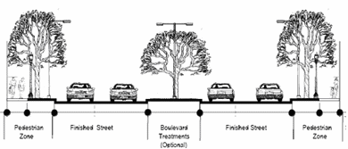
(a)
FINISHED STREET
The finished street component of a street cross-section is the portion of the right-of-way comprised of the paved street from curb to curb, or edge to edge where curb and gutter is not provided. The finished street includes the following elements:
(1)
vehicle travel lanes;
(2)
on-street parking, where applicable;
(3)
turn lanes, where necessary;
(4)
on-street bicycle facilities, where applicable; and
(5)
finished street edge (e.g., curb/gutter, swale/ditch, shoulder, and street lighting.)
(b)
PEDESTRIAN ZONE
The pedestrian zone component of a street cross-section is the portion of the right-of-way that primarily accommodates pedestrian movement and buffers pedestrians and adjacent land uses from moving vehicles on the finished street. The pedestrian zone includes the following elements:
(1)
pedestrian facility (e.g., sidewalk or trail), providing dedicated areas for pedestrian travel along streets;
(2)
amenity/buffer area (e.g., tree lawn, vegetated natural buffer, expanded sidewalk), providing separation of pedestrians from moving vehicle lanes and providing a landscape amenity or occasionally street furniture along the street; and
(3)
off-street bicycle facilities (optional), providing dedicated or shared off-street bicycle facilities along bike routes in areas where on-street facilities would be inappropriate or impractical.
(c)
BOULEVARD TREATMENT
The boulevard treatment is an optional component of a street cross-section that includes a landscaped median as the focal point of the street and may include additional design elements such as frontage access lanes (i.e., "slip roads"), buffer strips, and parking.
2.
REQUIRED IMPROVEMENTS
Street cross-sections must be designed and constructed in accordance with adopted public works standards or plans found to be in general compliance with this ordinance during the subdivision approval process.
88-405-10-G. GRADES
Street grades must provide safe and convenient traffic conditions while avoiding excessive grading and unnecessary removal of ground cover and tree growth. Street grades must comply with the Public Works's Standards, Specifications, and Design Criteria.
88-405-10-H. VERTICAL CURVATURE
All changes in street grade must be connected by vertical curves and be designed for safe stopping sight distances and safe sight distance at the entrance to subdivisions, in accordance with the Public Work's Standards, Specifications, and Design Criteria. The development review committee is authorized to require that applicants submit a sight distance analysis at the time of preliminary subdivision plat review.
88-405-10-I. HORIZONTAL CURVATURE
The required centerline radius of horizontal curves must be based on engineering considerations of topography, length of street, number of curves and other factors, as determined by the of public works. Horizontal curves on arterial streets must be designed in accordance with the Public Work's Standards, Specifications, and Design Criteria.
88-405-10-J. ALLEYS
Alleys and service lanes are permitted and encouraged within new subdivisions. Alleys, whether public or private, must comply with the department of public works' Standards, Specifications, and Design Criteria or plans found to be in general compliance with this ordinance during the subdivision approval process. Dead-end alleys are prohibited.
88-405-10-K. HALF STREETS
Where an existing dedicated or platted half street is adjacent to the tract being subdivided, the other half of the street right-of-way must be dedicated by the subdivider in conformance with the requirements of the major street plan. Half street dedications for minor or access streets are not permitted unless there is satisfactory agreement with the city that both adjacent developers agree to dedicate and construct one-half of the street.
88-405-10-L. STREET NAMES
Street names must be assigned by the street naming committee at the time of preliminary plat approval. The developer must submit a street name sign plan with the preliminary plat submittal. The street name sign plan must be drawn at a readable scale that shows the proposed street layout with proposed names, perimeter streets and street names, lot lines, and proposed street name sign locations, with a note stating the names to be put on each sign. The sign locations, size, and message must comply with department of public works' "Specifications for Fabricating and Installing Street Name Signs."
88-405-10-M. BOULEVARD AND PARKWAY DESIGN STANDARDS
Construction of any street that has been designated as a boulevard or parkway on the major street plan, or a park under the jurisdiction of the board of parks and recreation commissioners must conform to the design standards that have been adopted and approved by the city council as part of the Boulevard and Parkway Standards.
88-405-10-N. SUBORDINATION AGREEMENTS
1.
PURPOSE
The city requires that street rights-of-way dedicated to the public be and remain available for access to individual properties and to other streets and roadways. In order to ensure that the rights of the public to the use of street right-of-way will not be infringed upon, this section requires that any utility or other easement be subordinate to the rights of the public in the street right-of-way, except as otherwise expressly stated.
2.
CONTENTS OF SUBORDINATION AGREEMENT
(a)
In the case of a dedication of right-of-way that involves dedication over a pre-existing utility easement before the dedication of the right-of-way to the city, a subordination agreement must include an agreement by the easement holder to subordinate its easement to the city's public right-of-way subject to the rights of the easement holder to be reimbursed if future improvements to the right-of-way require the relocation or adjustment of the utility's facilities located within the easement or cause conditions that constructively require the relocation or adjustment of the utility's facilities located within the easement. Agreements that include the following provisions are acceptable to the city:
(1)
The city agrees that utility's obligation to relocate is dependent upon the city providing the utility with an easement for the relocation; and
(2)
The city agrees that if future improvements to the right-of-way require the relocation or modification or other adjustment of the utility's facilities located in the easement, the city will not require the utility to pay the cost of relocating, modifying, or adjusting its facilities. In those cases, the agreement must also provide that if the utility's future improvement, reconstruction, or maintenance of its facilities located in the easement damages the right-of-way, the utility will repair or replace the existing right-of-way in accordance with city standards in effect on the date of damage. Notwithstanding anything contained herein to the contrary, should the improvements set forth in the construction plan or plans for improvements required by the final plat within the new right-of-way require the relocation or other adjustment of the utility's facilities located in the easement or cause conditions that constructively require the relocation or adjustment of the utility's facilities located within the easement, the developer will be responsible for all costs associated with relocating, modifying, or adjusting in any way the utility's facilities, including easement acquisition costs, associated with the improvements.
(b)
In the case of a dedication of right-of-way to the city that involves a utility easement that was recorded after the site or development plan, or preliminary plat, whichever occurs earlier, was submitted for approval, a subordination agreement must include the agreement by the easement holder to subordinate its easement to the city's public right-of-way without a requirement for the easement holder to be reimbursed if it is required to relocate its existing facilities located within the easement. The agreement must also provide that if the utility's future improvement, reconstruction or maintenance of its facilities located in the easement damages the right-of-way, the utility will repair or replace the existing right-of-way in accordance with city standards in effect on the date of damage. Notwithstanding anything contained herein to the contrary, this subsection will not apply to situations where the developer granted the utility easement before January 1, 2011 or where the utility easement was provided to the utility company under condemnation or the threat of condemnation; in those situations, the subordination agreement as required in subsection 2(a) will be acceptable.
3.
EXCEPTION REQUESTS
In the case of special circumstances where a developer is unable to obtain the subordination from the easement holder or is unable to obtain the form of the subordination agreement as required in subsection 2, a developer may request at the time of final plat approval by the city council an exception to the requirement for the subordination of the easement or to the form of the required subordination agreement as delineated above in subsection 2. This request may be approved by the city council in consideration of all of the following information:
(a)
the utility or easement holder consents to the dedication of the right-of-way over its easement;
(b)
the date the utility obtained the easement and a copy of the easement;
(c)
the name of the entity that granted the easement to the utility;
(d)
a description of the facilities located in the easement; and
(e)
an explanation of the steps taken by the applicant to minimize the crossings of the streets with the utility easements;
(f)
the efforts made by the developer to obtain the subordination from the easement holder or to the obtain the subordination agreement in the form delineated in subsection 2 from the easement holder; and
(g)
the city council may require the developer to submit additional information to support its request, including an estimate from the utility of how much it would cost to relocate the facilities located in the easement and an explanation of the likelihood that future improvements to the right-of-way will require a relocation or adjust to the utilities' facilities.
4.
GRANT OF EXCEPTION
In reviewing the request for an exception to the requirement for subordination of the easement or for the use of a subordination agreement in a form other than as provided in subsection 2, the city council may consider all of the following:
(a)
that there are special circumstances or conditions affecting the property that were not caused by the developer;
(b)
that approval of the plat without the subordination or without the form required by subsection 2 is necessary for reasonable and acceptable development of the property in question, taking into account whether there is another solution, feasible for the developer to pursue, that would induce the holder of the easement to subordinate its easement to the city's new right-of-way in conformance with subsection 2; and
(c)
that approval of the exception to the requirement for a subordination or for a form that conforms to the requirements of subsection 2 will not be detrimental to the public welfare, taking into account whether the potential financial burden to the city is outweighed by the benefit of the new development.
(Ord. No. 120697, § 1, 8-23-2012; Ord. No. 120783, § 1, 10-4-2012; Ord. No. 240468, § 1, 6-18-2024)
88-405-11 - EASEMENTS AND UTILITIES
88-405-11-A. Easements must be provided by the developer when authorized decision-making bodies determine that such easements are necessary or desirable to accommodate utilities, drainage facilities (surface or subsurface), best management practices, pedestrian access, emergency vehicle access or other required improvements. The intended use, location, and dimensions of any easements that are provided must be shown on the preliminary plat.
88-405-11-B. Utility facilities that serve multiple properties and that are located outside of the public right-of-way must be located in utility easements with a minimum width of 15 feet. Utility easements must be shown on the preliminary plat. See 88-425-08-B for additional utility cabinet location and screening requirements.
88-405-12 - TRACT ACCESS
Unobstructed vehicle access-ways must be provided to open space areas and other common areas within subdivisions. Required tract access-ways must:
88-405-12-A. provide vehicle and pedestrian access from an approved street to the open space or common area feature;
88-405-12-B. have a minimum width of 20 feet with grades of no more than 15%;
88-405-12-C. be unobstructed by any fence, wall or locked gate;
88-405-12-D. have an all-weather surface or pervious paving adequate to accommodate anticipated maintenance and emergency access needs for the type of use in the open space or common area tract.
88-405-13 - PROPERTY CONTAINING WATER BODIES OR WATERCOURSES
If property being subdivided contains a water body or portion of a water body, lot lines must be drawn to distribute the entire ownership of the water body among abutting lot owners. The city plan commission may approve an alternative plan whereby the ownership of, and responsibility for, public safety and safe maintenance of the water body is so placed that will not become a city responsibility. No more than 25% of the minimum area of a lot required under the zoning ordinance may be satisfied by submerged land. If a watercourse separates the buildable area of a lot from the street by which it has access, provisions must be made for installation of a culvert or other structure that complies with adopted standards.
88-405-14 - DAMS
Where dams are proposed in any subdivision, they must be designed by registered professional engineers. A preliminary engineering report, including soil investigations, and design performance levels, must be submitted for review with the preliminary plat. The preliminary engineering report will be reviewed for general compliance with adopted standards. A final engineering report must be provided before any permits are issued. The final engineering report must provide detailed hydrological and hydraulic performance results. The developer's registered professional engineer must certify that the dam was constructed in accordance with the submitted plans and specifications. This certification must be provided before issuance of certificates of occupancy (temporary or permanent) and before the release of applicable financial guarantees.
88-405-15 - PUBLIC USES AND SERVICE AREAS
In the design of the plat, due consideration must be given to the dedication or reservation of suitable sites of adequate area for future schools, parks, playgrounds, regional stormwater management facilities, drainageways, and other public purposes as designated in the comprehensive plan or area plan. In the location of such sites, consideration must be given to the preservation of scenic and historic sites, stands of fine trees, marshes, lakes and ponds, watercourses, watersheds, and ravines.
88-405-16 - SUITABILITY OF LAND
Land subject to flooding, improper drainage or erosion, or extreme topography, or which, for other reasons, is unsuitable for development, may not be platted for any use that will constitute a danger to health or safety or property destruction.
88-405-17 - RESERVED
Editor's note— Ord. No. 150350, § B, adopted May 21, 2015, amended the Code by repealing former 88-405-17 in its entirety. Former 88-405-17 pertained to parkland dedication, and derived from the original zoning ordinance. Similar provisions can found in 88-408.
88-405-18 - OTHER PUBLIC USES
88-405-18-A. PLAT TO PROVIDE FOR PUBLIC USES; DETERMINATION OF NECESSITY
1.
The developer must suitably incorporate into the preliminary plat other public uses as indicated in the comprehensive plan. Other public uses include such uses as a school, recreation uses in excess of the requirements in 88-405-17, or any other similar public uses as indicated by the developer or as required by any provision of this zoning and development code.
2.
The determination of necessity for acquisition of such other public uses will be by the city plan commission as part of the development phase, in accordance with 88-405-18-B. If the determination is made to acquire the site by the city or other public agency, the site must be suitably incorporated by the developer into the preliminary plat and final plat.
88-405-18-B. REFERRAL OF PLAT TO PUBLIC BODY
The secretary of the city plan commission must refer the preliminary plat to the public body concerned with the proposed acquisition for its consideration and report. Alternate areas for such acquisition may be proposed. The secretary of the city plan commission must invite the public body or agency to respond at the development review committee meeting when the proposal will be discussed. The agency's recommendation, if affirmative, must include a map showing the boundaries and area of the parcel to be acquired and an estimate of the time required to complete the acquisition.
88-405-18-C. NOTICE TO PROPERTY OWNER OF ACQUISITION BY PUBLIC BODY
Upon receipt of an affirmative report pursuant to 88-405-18-B, the secretary of the city plan commission must notify the subdivider and require designation of the area proposed to be acquired by the city or other public body on the final plat.
88-405-18-D. DURATION OF LAND RESERVATION BY PUBLIC BODY
The acquisition of the land reserved by the city or other public body on the final plat must be consummated within 12 months of written notification from the owner of the owner's intent to develop the land. Such letter of intent must be accompanied by a sketch plat of the proposed development and a tentative schedule of construction. Failure on the part of the city or other public agency to consummate acquisition within the prescribed 12 months will result in the removal of the reserved designation from the property involved and the freeing of the property for development in accordance with this zoning and development code. The developer must replat this parcel in accordance with the provisions of this zoning and development code.
88-405-19 - SURVEY MONUMENTS
88-405-19-A. PERMANENT REFERENCE POINTS
The developer's registered land surveyor must install permanent reference points on all perimeter corners of the property and must tie all property corners to the city grid system.
88-405-19-B. STANDARDS FOR SURVEY
1.
A coordinate point within one-half mile of the subdivision, through which the surveyor must traverse with the perimeter survey work, must be provided. The traverse from the point furnished by the city, the boundary of the subdivision, and closure to the beginning coordinate point must be a minimum of third order, class I, as defined in the current Classification Standards of Accuracy and Specifications for Geodetic Control Surveys, 10 CSR 30-4, Missouri Code of State Regulations.
2.
The subdivision survey must conform to all city requirements the procedures established by the director of public works and must be based on the current Minimum Standards for Property Boundary Surveys, 10 CSR 30-2, Missouri Code of State Regulations.
88-405-20 - NONRESIDENTIAL SUBDIVISIONS
88-405-20-A. GENERALLY
1.
If a proposed subdivision includes land that is zoned for commercial, industrial or other nonresidential purposes, the layout of the subdivision with respect to such land must make provision as the city plan commission may require pursuant to this zoning and development code.
2.
Nonresidential subdivisions are subject to all the requirements of development plan approval set forth in this zoning and development code.
88-405-20-B. STANDARDS
In addition to complying with the subdivision design and improvement standards of this zoning and development code, developers of nonresidential subdivisions must demonstrate to the satisfaction of the city plan commission that the street, parcel, and block pattern proposed is specifically adapted to the uses anticipated and takes into account other uses in the vicinity. The following principles must be observed:
1.
Proposed industrial parcels must be suitable in area and dimensions to the types of industrial development anticipated.
2.
Street rights-of-way and pavement must be adequate to accommodate the type and volume of traffic to be generated.
3.
Special requirements may be imposed by the city with respect to street, curb, gutter, and sidewalk design and construction.
4.
Special requirements may be imposed by the city with respect to the installation of public utilities, including water, sewer, and stormwater drainage.
5.
Every effort must be made to protect adjacent residential areas from potential nuisance from proposed nonresidential subdivisions, including the provision of extra depth in parcels backing upon existing or potential residential development.
6.
Streets carrying nonresidential traffic, especially truck traffic, should not normally be extended to the boundaries of abutting residential areas.
88-405-21 - INSTALLATION OR FINANCIAL GUARANTEE OF REQUIRED IMPROVEMENTS
88-405-21-A. PREREQUISITE TO RELEASE OF FINAL SUBDIVISION PLAT FOR RECORDING
1.
After construction plans have been reviewed for compliance with applicable requirements but before a final subdivision plat is released by the city for recording, the developer must install or guarantee the completion of required improvements and guarantee maintenance of such improvements.
2.
If the developer chooses to complete required improvements prior to release of a final plat for recording, the developer must obtain construction permits and post required maintenance guarantees for the installed improvements.
3.
If the developer chooses not to install required improvements before release of the final subdivision plat for recording, the developer must obtain construction permits and post a financial guarantee of performance and maintenance in accordance with 88-405-21-B.
88-405-21-B. FINANCIAL GUARANTEES
Financial guarantees for temporarily deferred improvements must be provided in the form of bonds, escrow, or letters of credit in accordance with this subsection.
1.
BONDS
(a)
The developer may post a performance bond for all or a portion of the required improvements, in an amount estimated by the director of public works or director of water services (as applicable) to be sufficient to cover the entire cost of construction, engineering, installation, and dedication of the improvements to be covered by the bond. Bonds for partial improvements may be accepted only if the balance of the public improvements are completed before release of the final plat for recording.
(b)
Performance bonds must comply with the requirements of RSMo 89.410 and are subject to approval by the director of finance.
(c)
Within 2 years of the date that the performance bonds are posted, the developer must obtain all required construction permits and post performance and maintenance bonds for completion of the required improvements. The director of public works or director of water services (as applicable) may, upon proof of hardship, extend the 2-year life of the bond for a maximum of one additional year. Further extensions may be granted by the city council. In the event of any time extension, the director of public works or director of water services (as applicable) may require an increase in the bond amount if the director determines that the original bond amount will not be sufficient to cover the costs of construction, engineering, installation, and dedication of the improvements to be covered by the bond.
(d)
The city is authorized to delay release of final plats for subsequent phases of the subdivision until required public improvements are installed in accordance with the construction permit and bond provisions.
(e)
The city is authorized to accept one bond on a project with work performed for the public works department and water services department.
2.
ESCROW OR LETTER OF CREDIT
(a)
The developer may enter into an escrow or a letter of credit agreement with the city. This form of financial guarantee requires that the applicant place in escrow or submit a letter of credit in an amount estimated by the director of public works or director of water services (as applicable) to be sufficient to cover the entire cost of construction, engineering, installation, and dedication of the improvements to be covered by the financial guarantee. Unless a completion date is properly extended by the director of public works or director of water services (as applicable) for the escrow or letter of credit agreement, public improvements must be completed in accordance with the following timetable:
(b)
The escrow or letter of credit agreement must be submitted before the final plat is forwarded to the city council.
(c)
The city is authorized to delay release of final plats for subsequent phases of the subdivision until required public improvements are installed.
(Ord. No. 240468, § 1, 6-18-2024)
88-405-22 - DEFERRAL OF REQUIRED SUBDIVISION IMPROVEMENTS
88-405-22-A. Requests to defer installation of required subdivision improvements and post financial guarantees must be submitted with the preliminary plat. Deferral requests will be considered as part of the preliminary plat review process.
88-405-22-B. The city is authorized to delay release of final plats for subsequent phases of the subdivision until required public improvements are installed.
88-405-22-C. Requests to defer installation of required subdivision improvements may be conditioned upon the developer's payment of the estimated proportionate share of the cost of the future improvements to the city prior to acceptance of the final subdivision plat by the city council and issuance of certificates of occupancy. Estimated costs must be based on estimates equivalent to city cost to construct the improvements.
88-405-22-D. Payments may be in cash or another form of acceptable security approved during the preliminary plat review process.
88-405-22-E. For purposes of estimating street improvement contributions on collector or local street classifications, the starting rate (based on average city improvement costs) is $221.20 per linear foot, with adjustments made to increase or decrease the rate when existing constraints or conditions dictate a higher or lesser estimated cost.
88-405-22-F. The city manager has the authority to make adjustments to the starting rate on an annual basis to reflect an increase equal to an increase in the consumer price index (all items/all urban consumers/Kansas City, Missouri-Kansas) published by the United States Department of Labor, Bureau of Labor Statistics, provided that the increase is reflective of the city costs for such improvement.
88-405-22-G. If the average costs fall below the rate being charged, the rate must be reduced so that it is equal to or less than the average city costs for such improvements. The adjustments must be made annually by the city manager in conjunction with the adoption of the annual budget of the city by filing a notice with the city clerk.
88-405-23 - MAINTENANCE OF IMPROVEMENTS
The developer must maintain all subdivision improvements until final acceptance of such improvements by the city.
88-405-24 - PROPERTY OWNERS ASSOCIATIONS
88-405-24-A. ESTABLISHMENT
If a property owners association is assigned responsibility for the maintenance and control of streets, open space, recreational facilities, or any other common areas and facilities within a subdivision, that property owners association must have legal authority to maintain and exercise control over the common areas and facilities, including the power to compel contributions from residents or property owners to cover their proportionate share of the costs associated with the maintenance of the common areas and facilities.
88-405-24-B. DOCUMENTATION
1.
Documents providing for the establishment of a property owners association must be submitted to the city planning and development director before release of a final plat for recording.
2.
The city's review is limited to ensuring that the property owners association has clear legal authority to maintain and exercise control over the common areas and facilities, including the power to compel contributions from residents and property owners to cover their proportionate share of the costs associated with the maintenance of the common areas and facilities.
88-405-25 - WAIVERS AND MODIFICATIONS OF SUBDIVISION DESIGN/IMPROVEMENT STANDARDS
88-405-25-A. GENERAL AUTHORITY
Whenever it is found that the land included in a subdivision division plat presented for approval is of such size or shape or is subject to or is affected by such topographical conditions, or is to be devoted to such uses, that full compliance with the subdivision design and improvement standards of this Chapter is impossible or impractical, the city plan commission may recommend and the city council may authorize waivers or modifications to such standards so that substantial justice may be done and the public interest secured.
88-405-25-B. PROCEDURE
Waivers and modifications must be identified on the preliminary plat and must be considered as part of the subdivision review and approval process.
88-405-25-C. REVIEW CRITERIA
To recommend or approve a waiver or modification of subdivision design and improvement standards, the city plan commission and city council must determine that all of the following conditions exist:
1.
that there are special circumstances or conditions affecting the property;
2.
that the waiver or modification is necessary for reasonable and acceptable development of the property in question and is not a greater modification or waiver than is required to allow reasonable and acceptable development of the subject property; and
3.
that the granting of the waiver or modification will not be detrimental to the public welfare or injurious to other property in the vicinity in which the subject property is situated.
88-405-26 - PLATS STRADDLING JURISDICTIONAL BOUNDARIES
Wherever access to a subdivision is required across land within another municipality or political jurisdiction, the city plan commission may request an opinion from the city attorney that access is legally established and also from the director of public works to ensure that the access road is adequately improved or that a performance bond has been duly executed and is sufficient to ensure construction of the access road.
(Ord. No. 240468, § 1, 6-18-2024)
88-410-01 - PURPOSE/DESCRIPTION
88-410-01-A. The regulations of this section are intended to encourage subdivision design that is more efficient and provides more open space and greater natural resource protection than conventional development designs. Open space development and conservation development designs allow more compact and less costly networks of roads and utilities. They can also help reduce stormwater run-off and non-point source pollutant loading rates and can be used to preserve an area's semi-rural character. Open space developments and conservation developments are intended to reduce stormwater runoff and flooding, preserve natural resources, protect water quality, and encourage the provision of needed open space and recreational amenities for residents.
88-410-01-B. The open space development and conservation development standards of this section require that a specified portion of each development be set aside and permanently preserved as open space. The primary difference between "open space" developments and "conservation" developments is the amount of open space that must be preserved.
88-410-01-C. The required open space area within open space developments or conservation developments can be used to provide recreational opportunities for the subdivision's residents and/or to conserve and protect significant natural resources, such as stream buffers.
88-410-02 - SITE AREA AND OPEN SPACE REQUIREMENTS
Open space developments and conservation developments must comply with the minimum site area and minimum open space standards of 88-110-0605-B (Table 110-2).
88-410-03 - LOT AND BUILDING STANDARDS
Open space developments and conservation developments must comply with the lot and building standards of 88-110-0605-B (Table 110-2) except as expressly stated in this zoning and development code.
88-410-04 - MAXIMUM DENSITY AND NET SITE AREA
88-410-04-A. The maximum number of dwelling units allowed within an open space developments or conservation development is computed by dividing the net area of the site by the applicable minimum-lot-area-per unit standard 88-110-0605-B (Table 110-2). Net site area is to be calculated by subtracting all of the following from the site's gross land area:
1.
the streamside zone of required stream buffers (see 88-415-03-A);
2.
the middle zone of required stream buffers (see 88-415-03-B); and
3.
water bodies with a contiguous area of more than 5,000 square feet.
88-410-04-B. If the open space developments or conservation development site (subdivision) is located in more than one zoning district, the maximum number of dwelling units allowed must be determined separately for each portion of the site lying within a different zoning district. Density may be transferred from one portion of the site to another, provided that such transfers do not result in an increase in the number of dwelling units allowed on the overall site.
88-410-05 - GENERAL DEVELOPMENT DESIGN
88-410-05-A. Open space developments and conservation developments are subject to all other subdivision design and improvement standards of this zoning and development code unless otherwise expressly stated.
88-410-05-B. Lots and development sites within open space developments and conservation developments must, to the maximum extent practical, be located outside of areas containing woodlands, grasslands, surface waters, steep slopes drainageways, rock outcroppings, and other natural resource features.
88-410-05-C. Impervious areas must be limited and, to the maximum extent practical, be sited and designed to minimize stormwater runoff impact to the watershed's receiving waters by:
1.
minimizing concentrated stormwater flow;
2.
breaking up or disconnecting large areas of impervious surface into smaller areas;
3.
maximizing the use of sheet flow through vegetated areas; and
4.
maximizing the flow length through vegetated areas.
88-410-06 - OPEN SPACE
88-410-06-A. GENERAL
Open space provided to meet minimum open space requirements must be in one or more parcels dedicated or otherwise protected as permanent, active or passive open space. Any city-accepted parkland or open space area under 88-405-17 will be counted towards meeting minimum open space standards.
88-410-06-B. USE, LOCATION AND DESIGN
1.
Open space must be dedicated or reserved for one or more of the following uses:
(a)
conservation of, and avoidance of development in, any readily identifiable natural hazard areas, i.e., areas that potentially pose a significant hazard to people or property (e.g., drainageways, wetlands, and lands whose slope and/or soils make them particularly susceptible to subsidence or erosion when disturbed by development activities);
(b)
conservation and protection of mature riparian vegetation within the outer zone of a stream buffer;
(c)
conservation and protection of any identified significant natural areas (e.g., rare plant communities and wildlife habitat) or other environmentally sensitive areas where development might threaten water quality or ecosystems;
(d)
conservation and protection of any identified significant historic or cultural resources; or
(e)
provision of active and/or passive outdoor recreation opportunities (e.g., ball fields, playgrounds, tennis courts, swimming pools, basketball courts, golf courses, bikeways, walking trails, nature trails, and picnic areas), either for the general public or for the subdivision's residents or employees and their guests. (Note: this provision is not intended to preclude a membership requirement or monetary charge for use of recreation facilities such as a golf, swim, or tennis club, as long as subdivision residents have an opportunity to join the club or pay to use club facilities.)
2.
Highest priority for the location, design, and use of open space must be given to conserving, and avoiding development in, any natural hazard areas on the subdivision site.
3.
Open space may contain active recreation areas (e.g., golf courses) and only such buildings, structures, accessways and parking facilities as are necessary and accessory to its principal uses (e.g., pedestrian paths, recreational club houses, utility lines, driveways, parking areas). All active recreation areas, permanent structures, and impervious surfaces must be of a "low-impact" design, and management practices must be instituted to protect and enhance the natural character and function of the open space. Such development requires:
(a)
a tree and native vegetation preservation plan that limits site disturbance to the minimum required for construction and protects mature vegetation areas from degradation;
(b)
landscaping using native or naturalized plant species;
(c)
low-input, natural vegetation management practices; and
(d)
stormwater best management practices.
4.
Open space areas may be used for stormwater management in accordance with the city's Standards, Specifications, and Design Criteria and the city's Manual of Best Management Practices for Stormwater Quality.
5.
Open space areas may not be used for irrigation of reclaimed wastewater.
6.
The location, size, character, and shape of required open space must be appropriate for its intended use (e.g., open space proposed to be used for recreation, particularly active recreation, should be located and designed so that it can be accessed conveniently and safely by intended users, and open space to be used for ball fields, playing fields, or other active recreational facilities should be located on land that is relatively flat and dry).
88-410-06-C. OWNERSHIP AND MANAGEMENT OF OPEN SPACE
1.
The applicant must identify the owner of the open space. The designated owner and the owner's successors are responsible for maintaining the open space and any associated facilities. If a property owners association is the owner, membership in the association is mandatory and automatic for all property owners of the subdivision and their successors. If a property owners association is the owner, the property owners association must have lien authority to ensure collection of dues from all members.
2.
The applicant must submit a management plan for the open space and all common areas. The management plan must:
(a)
allocate responsibility and guidelines for the maintenance and operation of the open space and any associated facilities, including provisions for ongoing maintenance and for long-term capital improvements;
(b)
estimate the costs and staffing requirements needed for maintenance, operation and insurance and outline the means by which necessary funding will be obtained or provided;
(c)
provide that any changes to the management plan be approved by the development review committee; and
(d)
provide for enforcement of the management plan.
3.
In the event the party responsible for maintenance of the open space fails to maintain all or any portion in reasonable order and condition, the city may assume responsibility for its maintenance and may enter the premises and take corrective action, including the provision of extended maintenance. The costs of such maintenance, plus any administrative costs and penalties, may be charged to the owner, property owner association, or to the individual property owners that make up the property owners association. Unpaid costs will become a lien on all subdivision properties.
88-410-06-D. BOUNDARY MARKERS
1.
Boundary markers must be put in place clearly marking required open space areas before, during, and after construction.
2.
Boundary markers must be installed at the intersection of private lot lines with the outer edge of the permanent open space area before receiving final city approval of plans for clearing, grading, or sediment and erosion control.
3.
Construction fencing must be placed at the outer edge of the existing vegetation to be preserved in the permanent open space area. This fencing must be maintained throughout the construction process.
4.
Permanent signs must be placed at the edge of the permanent open space. as follows:
(a)
For single-lot developments, signs must be posted every 100 feet along the open space boundary.
(b)
For multiple lots located along an open space set-aside, signs must be located at the intersection of every other lot line along the open space.
5.
Required signs must read: "Permanent Open Space Set-Aside - Do Not Disturb (City Code 88-410)," with the sign message located approximately 4 feet above the ground. Signs must be maintained and remain legible at all times.
88-410-06-E. LEGAL INSTRUMENT FOR PERMANENT PROTECTION
1.
The open space must be protected in perpetuity by a binding legal instrument that is recorded with the deed. The legal instrument must be one of the following:
(a)
a permanent conservation easement (RSMO 67.880) in favor of either:
(1)
a land trust or similar conservation-oriented non-profit organization with legal authority to accept such easements. The organization must be bona fide and in perpetual existence and the conveyance instruments must contain an appropriate provision for transfer in the event the organization becomes unable to carry out its functions;
(2)
a governmental entity (if the entity accepting the easement is not the city, then a third right of enforcement favoring the city must be included in the easement);
(b)
an open space tract protected by a permanent restrictive covenant for conservation purposes in favor of a governmental entity; or
(c)
an equivalent legal tool that provides permanent protection, as approved by the city attorney.
2.
The instrument for permanent protection must include clear restrictions on the use of the open space. These restrictions must include all restrictions contained in this section, as well as any further restrictions the applicant chooses to place on the open space.
88-415-01 - PURPOSE
In the Kansas City region and throughout the nation, vegetated stream buffers have been clearly shown to protect stream stability and related infrastructure, improve water quality, conserve wildlife habitat and provide flood water conveyance. The stream buffer standards of this article are intended to protect public safety and public infrastructure investments while mitigating the adverse environmental impacts that development can have on streams and associated natural resource areas. Other purposes of the stream buffer regulations include:
88-415-01-A. helping protect life and property;
88-415-01-B. improving stormwater management and helping to prevent flooding;
88-415-01-C. protecting environmental quality, including the quality of water resources and wildlife habitat;
88-415-01-D. decreasing infrastructure repair, maintenance and replacement costs;
88-415-01-E. providing open space amenities;
88-415-01-F. providing potential opportunities for trail location;
88-415-01-G. increasing the public's knowledge and understanding of natural resource protection issues and
88-415-01-H. providing certainty as well as flexibility in order to maximize sustainable economic development.
(Ord. No. 220322, § 1, 4-21-2022)
88-415-02 - SCOPE AND APPLICABILITY
88-415-02-A. The stream buffer standards of this article apply to all stream corridors identified on the Kansas City Natural Resource Map. In the event of conflict between the stream buffer standards of this article and the stream buffer provisions of the city's Standards, Specifications, and Design Criteria, the stream buffer standards of this article govern. If a variance is obtained, the stream buffer provisions apply to the relocated stream and mitigated natural resources. For the purpose of this article, storm sewer systems, human-made channels (except those designed to function as natural streams), and roadside ditches are not considered streams and are not subject to the stream buffer provisions of this article.
88-415-02-B. In the event of conflict between the stream buffer regulations of this article and Federal Aviation Administration (FAA) requirements, FAA requirements govern.
88-415-02-C. The stream buffer regulations of this article are not intended to prohibit maintenance of existing city-owned facilities within the stream buffer, nor do the regulations require the removal of lawfully established facilities or improvements from the stream buffer area.
88-415-02-D. Beginning February 14, 2009, the stream buffer regulations of this article (88-415) will apply to all applications for approval of development plans, project plans, preliminary plats, final plats, and amendments to such plans or plats except as follows:
1.
If the city plan commission has not recommended approval of a final plat for a unified development plan, preliminary plan, development plan, special use permit or any other Board of Zoning Adjustment approval, or preliminary plat that was approved before January 1, 2003 (referred to as a "pre-2003 approved plan"), the regulations of this article will not apply to any phases of the pre-2003 approved plan as long as the city plan commission recommends approval of the first final plat within one year of the date that the city planning and development director sends certified mail notice of this requirement to the subject property owner.
2.
If the city plan commission has recommended approval of a final plat for a pre-2003 approved plan before February 14, 2009, the regulations of this article will not apply to any phases of the pre-2003 approved plan as long as the city plan commission recommends approval of the next final plat for the pre-2003 approved plan by February 14, 2014.
3.
In all other cases where a unified development plan, preliminary plan, development plan or preliminary plat has been approved after January 1, 2003 and before February 14, 2009, the regulations of this article will not apply to any phases of the unified development plan, preliminary plan, development plan or preliminary plat as long as the city plan commission recommends approval of the next final plat by February 14, 2014.
4.
If the requirements of 88-415-02-D.1, 88-415-02-D.2 and 88-415-02-D.3 have been met, the regulations of this article will not apply to any phases of the unified development plan, preliminary plan, development plan or preliminary plat as long as the city plan commission recommends approval of each subsequent final plat within 3 years of the date that city plan commission recommended approval of the immediately preceding final plat.
5.
The regulations of this article will not apply to amended development plans or amended preliminary plats if no significant changes are made. A significant change is any change that: (1) adds additional land area to the approved plan; (2) changes the overall land use in a way that would increase stormwater runoff volumes and rates; (3) increases the number of lots by 10% or more (as compared to the number of lots included in the originally approved plan/plat); or (4) increases the developed area by 10% or more (as compared to the originally approved plan/plat).
6.
The regulations of this article will not apply to amended development plans or amended preliminary plats if the proposed changes to the development plan or preliminary plat are not located in an area on the development plan or preliminary plat where the buffer requirements would normally apply. If the proposed changes are located in an area where the stream buffer requirements would normally apply, then the amendment of that area on the plan/plat must comply with the regulations of this article for the amended area only.
88-415-02-E. The water services director is authorized to approve an extension of the time frames established in 88-415-02-D.1, 88-415-02-D.2, 88-415-02-D.3, and 88-415-02-D.4 for a maximum of one year. Extension requests must be submitted in writing and include an explanation and justification for the request.
88-415-02-F. For purposes of this section 88-415-02, "unified development" means a development consisting of one or more zoning or subdivision applications that were approved by city council on or about the same date on contiguous property through the same applicant. Additionally, for purposes of this section, commercial and residential plans approved collectively as one unified development (although approved through separate ordinances and plans) will be construed to be a single approved preliminary plan or phase.
(Ord. No. 190911, § A, 12-5-2019; Ord. No. 220322, § 1, 4-21-2022; Ord. No. 240468, § 1, 6-18-2024)
88-415-03 - BUFFER ZONES
Required stream buffer widths are measured horizontally from the edge of stream. Stream buffer zones do not apply to water structures such as ponds and lakes. The overall required buffer is organized into 3 zones, as follows:
88-415-03-A. STREAMSIDE ZONE
The streamside zone extends 25 feet landward from the edge of stream. Where wetland fills, alteration of adjacent vegetated stream buffers and mitigation are approved by the U.S. Army Corps of Engineers, the streamside zone will be adjusted to exclude filled wetlands.
88-415-03-B. MIDDLE ZONE
The middle zone extends landward from the outer edge of the streamside zone and encompasses the FEMA- or city-designated 1% (i.e., 100-year) floodplain where applicable, or the limits of the 1% (i.e., 100-year) conveyance, as determined by a qualified engineer using city-approved methods; and jurisdictional wetlands as determined using U.S. Army Corps of Engineers delineation methods or other city-approved means. Where wetland fills, alteration of adjacent vegetated stream buffers and mitigation are approved by the U.S. Army Corps of Engineers, the middle zone will be adjusted to exclude filled wetlands and include any mitigated wetlands contiguous to the floodplain or flood conveyance if required by the U.S. Army Corps of Engineers. Where the FEMA floodplain, 1% (i.e., 100-year) conveyance, or jurisdictional wetlands as defined above fall inside the outer limits of the streamside zone, the middle zone width as measured from the outer edge of the stream side zone is zero feet wide.
88-415-03-C. OUTER ZONE
The outer zone extends landward 75 feet from the outer edge of the middle zone, or in such cases where the middle zone is zero, from the outer edge of the streamside zone. When slopes exceeding 15% or mature riparian vegetation areas are contiguous with the middle zone boundary, the width of the outer zone is expanded to encompass such resource areas. Where wetland fills, alteration of adjacent vegetated stream buffers and mitigation are approved by the U.S. Army Corps of Engineers, the outer zone will be adjusted to exclude filled wetlands. Mature riparian vegetation includes vegetation areas that are field-surveyed, as described in 88-415-07-D. The maximum extent of the outer zone is established, at the landowner's election, as follows:
1.
If 100% of the outer zone area is set aside and protected as permanent open space, the maximum extent of the outer zone is 150 feet, as measured from the edge of the middle zone.
2.
If portions of the outer zone are to be developed in accordance with 88-415-05-C.2 through 88-415-05-C.4 and 88-415-07-C., the maximum extent of the outer zone is 250 feet.
(Ord. No. 120783, § 1, 10-4-2012; Ord. No. 220322, § 1, 4-21-2022)
88-415-04 - FLEXIBILITY
88-415-04-A. The stream buffer regulations of this article have the effect of limiting development near streams identified on the Kansas City Natural Resource Map.
88-415-04-B. To help offset potential adverse impacts on development yields for property near stream corridors, property owners are encouraged to use the open space development and conservation development options of 88-410 for residential development.
(Ord. No. 220322, § 1, 4-21-2022)
88-415-05 - ALLOWED USE OF BUFFER ZONES
Stream buffers—including any floodplains, wetlands, slopes over 15%, and mature riparian vegetation areas—must be managed to enhance and maximize their natural resource value. Management includes specific limitations on alteration of the natural conditions of these resources. The following practices and activities are allowed within stream buffers. If this code conflicts with the American Public Works Association Section 5600 Storm Drainage Systems and Facilities ("APWA 5600") design standard, the Code of Ordinances governs.
88-415-05-A. STREAMSIDE ZONE
1.
Activity in the streamside zone is limited to vegetation management to maintain healthy, existing, native vegetation; streambank stabilization; road, trail, and utility crossings; and stormwater outfalls designed in accordance with the city's Standards, Specifications, and Design Criteria. Stream access for fishing and wildlife viewing and trail overlook areas are allowed if they are in compliance with the city's Standards, Specifications, and Design Criteria and maintain the integrity of the stream buffer.
2.
Stormwater detention, as defined in APWA 5600, is allowed in the streamside zone when the stormwater detention is accomplished by 1) utilizing a road, trail (see 88-415-05-A.3) or utility crossing if riparian vegetation is planted in the project area in an amount that is equal to the amount disturbed by the detention dam and the buffer or 2) the stormwater detention system meets the following requirements:
a.
is designed to provide 20 percent more stormwater detention than required by APWA 5600 design standards;
b.
does not change the existing topography or native vegetation; and
c.
and the linear crossing of the streamside zone does not exceed 200 feet in cleared width of the detention basin structure.
3.
Trails may encroach into the streamside zone only when the water services director determines that alternative alignments are not feasible because of topography, the presence of existing structures such as bridges or flood control levees, the inability to acquire property to accommodate other trail alignments, or that the trail represents the termini of existing trails and trail rights-of-way. Streambanks and natural resource areas affected by allowed encroachments must be stabilized in accordance with 88-415-05-A.1, the city's Standards, Specifications, and Design Criteria, and natural resources must be mitigated in accordance with 88-415-07-C and 88-415-08-B.4.
4.
This subsection does not apply to public utility or trail corridors when ownership, an easement, or a binding access agreement is secured prior to February 14, 2009.
88-415-05-B. MIDDLE ZONE
Any activity allowed in the streamside zone is allowed in the middle zone. The following additional uses and activities are also allowed in the middle zone:
1.
underground utility corridors that are fully vegetated and designed in accordance with the city's Standards, Specifications, and Design Criteria and all applicable state and federal requirements; and
2.
paved and unpaved recreational trails for hiking and biking.
88-415-05-C. OUTER ZONE
Any activity allowed in the streamside and middle zones is allowed in the outer zone. The following additional uses and activities are also allowed in the outer zone:
1.
BMPs as outlined in the Manual of Best Management Practices (BMPs) for Stormwater Quality and used in conjunction with the city's Standards, Specifications and Design Criteria. BMPs and related activities include:
a.
stormwater management;
b.
BMP maintenance such as sediment removal and harvesting of vegetation; and
c.
stormwater discharge with appropriate energy dissipation and native vegetation to preserve the integrity of the area.
2.
Property owners may establish the maximum outer zone width in accordance with 88-415-03-C.2 and may develop in the outer zone, subject to the following standards:
a.
no more than 40% of the outer zone area may be disturbed (i.e., cleared of mature riparian vegetation and/or graded) unless mitigation is provided in accordance with 88-415-07-C);
b.
no more than 50% of the outer zone area may be disturbed where mitigation is provided in accordance with 88-415-07-C; and
c.
in all cases, the first 25 feet must be maintained as a no-build area, except for activities as allowed in 88-415-05-D.
3.
Areas required to be undisturbed within the outer zone may not contain permanent buildings, structures, impervious cover or active recreation facilities, such as golf courses or athletic fields.
4.
Property owners may elect to establish the maximum outer zone width or in accordance with 88-415-03-C.2 may also elect to use the conservation development option of 88-410 for residential development within the outer zone. In such cases, they may elect to establish a conservation subdivision for the entire development site or confine the conservation subdivision to the outer zone area only. When a conservation subdivision is confined to the outer zone area, minimum conservation subdivision open space requirements apply only to the outer zone area.
For nonresidential development that includes protected stream corridors, building heights may be increased by up to 20% over otherwise applicable height limits, and minimum off-street parking ratios may be reduced by up to 20%.
88-415-05-D. ALL STREAM BUFFER ZONES
In addition to the activities expressly allowed in the streamside, middle and outer stream buffer zones pursuant to 88-415-05-A, 88-415-05-B, and 88-415-05-C, the following uses and activities are allowed in all stream buffer zones and do not require mitigation provided that mature riparian vegetation is disturbed as little as is reasonably practical:
1.
BMPs as outlined in the Manual of Best Management Practices (BMPs) for Stormwater Quality. See 88-415-05-C.1;
2.
existing and ongoing agricultural activities (except in the streamside zone);
3.
maintenance/repair of public rights-of-way, streets, and public structures;
4.
site investigation work including surveys, soil logs, percolation tests, and special tests;
5.
reconstruction, remodeling, or maintenance of existing structures as long as these activities do not expand into and/or adversely impact the buffers;
6.
control of noxious and/or invasive vegetation;
7.
emergency actions necessary to prevent dangers to public health or safety, environmental degradation, or public and private property;
8.
wetland fills, alteration of adjacent vegetated stream buffers and mitigation approved by the U.S. Army Corps of Engineers; and
9.
open space uses that protect natural resources such as wildlife sanctuaries, forest preserves, nature centers, picnic areas, and similar uses, as well as game farms, fish hatcheries, hunting or fishing preserves or other activities designed for the protection or propagation of wildlife.
(Ord. No. 120783, § 1, 10-4-2012; Ord. No. 220322, § 1, 4-21-2022)
88-415-06 - PROHIBITED ACTIVITIES AND USES
Any activity or use that is not identified as being allowed within required stream buffers is prohibited. Streams regulated by this article may not be enclosed, relocated, dammed, or inundated unless all necessary city, state and federal approvals are first obtained.
(Ord. No. 220322, § 1, 4-21-2022)
88-415-07 - ADDITIONAL STANDARDS
The following additional standards apply within stream buffers.
88-415-07-A. CONTINUOUS VEGETATION
When existing vegetation within stream buffers is disturbed, required buffers must be revegetated with appropriate native riparian vegetation, unless mitigation is granted per 88-415-07-C.
88-415-07-B. STORMWATER DISCHARGE
Direct stormwater discharge into stream channels is allowed only in accordance with the city's Standards, Specifications, and Design Criteria.
88-415-07-C. MITIGATION
1.
Property owners who elect to establish the maximum outer zone width in accordance with 88-415-03-C.2 may exceed the 40% disturbance limit established in 88-415-05-C.2 (a) by an additional 10%, up to 50%. This additional disturbance is allowed if offset by mitigation. Mitigation can be accomplished through purchasing federal mitigation credits including compensatory mitigation or through mitigation areas as described herein.
2.
Federal mitigation credits including compensatory mitigation shall be in accordance with a U.S. Army Corps of Engineers Permit under Section 404 of the Clean Water Act (33 USC 1344) and implementing regulations (33 CFR 320-332) and mitigation banks shall be located in the Missouri River Basin within the greater Kansas City area.
3.
Mitigation areas must be equal or greater than the additional disturbed land area. The mitigation areas shall be added to the outer zone and the applicant shall mitigate the impacts by maintaining natural resource functions, including: base flood elevations, stream stability and geomorphology, and by replacing existing mature riparian vegetation with an equivalent amount of appropriate native riparian vegetation.
4.
Mitigation areas become part of the property's permanent open space and must be:
a.
contiguous to the original outer zone;
b.
permanently stabilized where slopes greater than 15% are present;
c.
revegetated in accordance with 88-415-07-A;
d.
established and maintained in accordance with the provisions of this article and Article 88-410;
e.
designed, established, and maintained in accordance with the city's Standards, Specifications and Design Criteria and applicable state and federal laws and regulations; and
f.
completed during the development phase in which disturbance occurs, if applicable.
g.
additional mitigation requirements are found in 88-415-08-B.4.(a) through (g).
5.
The mitigation standards of this section also apply whenever an exception to stream buffer standards is approved under 88-415-08-B.
88-415-07-D. BUFFER PLAN
1.
A stream buffer plan must be provided when the stream buffer standards apply. The plan must delineate the buffer zones and the proposed development site in relation to:
a.
the FEMA- or city-designated floodplain or the estimated 1% flood conveyance, as determined by a qualified engineer using city-approved methods;
b.
wetlands within or adjacent to the floodplain or required stream buffer;
c.
slopes in excess of 15% within or adjacent to the floodplain, as field-surveyed; and
d.
mature riparian vegetation, including woodlands, wetlands, and other habitat areas identified by a field survey.
2.
A preliminary buffer plan must be submitted for city review with preliminary plats and site or development plans. The preliminary buffer plan must include a plan at a scale no smaller than 1" = 100' showing at minimum:
a.
existing topography with at least 2-foot contour intervals;
b.
approximate stream locations based on approved city geographic information system mapping or city-approved mapping from state and federal agencies;
c.
approximate boundary of the FEMA- or city-designated floodplain based on city-approved geographic information system mapping or federal mapping;
d.
approximate 1% flood conveyance limits where no regulatory floodplain is identified as determined by a qualified engineer using city-approved methods;
e.
approximate wetland locations from the Mid-America Regional Council Natural Resource Inventory, or the U.S. Fish and Wildlife Service National Wetlands Inventory;
f.
approximate boundary of existing, mature riparian vegetation based on a field survey;
g.
slopes of 15% or greater in each sub-drainage area based on city-approved geographic information system mapping or a site topographic survey;
h.
the location of proposed structures or activities;
i.
identification of required stream buffer zones based on city-approved geographic information system mapping or a site topographic survey and a survey of mature riparian vegetation;
j.
the total acreage of mature riparian vegetation and steep slopes in the outer zone;
k.
the location and total acreage of proposed clearing and grading in the outer zone and the percentage of proposed outer zone area to be cleared (if applicable in accordance with 88-415-03-C88-415-03-C; and
l.
the limits and total acreage of proposed mitigation of outer zone vegetation, and the percentage of outer zone area to be mitigated (if applicable in accordance with 88-415-07-C).
3.
The final buffer plan must be submitted for city review with or be included in final plats and site or development plans. The final buffer plan must include a plan at a scale not smaller than 1" = 100' showing at a minimum:
a.
existing topography with at least 2-foot contour intervals;
b.
field delineated, marked, and surveyed streams and wetlands;
c.
field delineated, marked, and surveyed mature riparian vegetation limits as described in 88-415-07-D.4;
d.
existing sub-drainage areas of the site;
e.
slopes of 15% or greater in each sub-drainage area based on a site topographic survey;
f.
the location of proposed structures or activities;
g.
the location of field delineated and surveyed stream buffer zones;
h.
the total acreage of mature riparian vegetation and steep slopes in the outer zone;
i.
the location and total acreage of proposed clearing and grading in the outer zone, and the percentage of proposed outer zone area to be cleared (if applicable in accordance with 88-415-03-C88-415-03-C; and
j.
the limits and total acreage of proposed mitigation of outer zone vegetation and the percentage of outer zone area to be mitigated (if applicable in accordance with 88-415-07-C).
4.
Field surveys of mature riparian vegetation must identify the limits of the mature riparian vegetation for inclusion with the preliminary and final buffer plans, to a maximum of 250 feet from the edge of the middle zone or 150 feet from the edge of the middle zone at the property owner's election pursuant to 88-415-03-C88-415-03-C. At a minimum, a licensed surveyor, professional engineer, or landscape architect must delineate the existing edge of the tree canopy. The survey must identify the critical root zone of all trees at the mapped canopy cover boundary with a diameter breast height (DBH) of 10 inches or greater. The surveyor may identify specific tree species to more accurately delineate the riparian vegetation boundary if the mature vegetation appears to extend into uplands. The riparian boundary is assumed to exist when less than 50% of the mature trees (10-inch DBH or greater) are of riparian or bottomland species as defined by The Terrestrial Natural Communities of Missouri (Nelson 2006) and approved by the city. The surveyor must delineate the canopy cover boundary of the mature riparian tree specimens.
88-415-07-E. BOUNDARY MARKERS
1.
Boundary markers must be put in place clearly marking required stream buffers before, during, and after construction.
2.
Boundary markers must be installed at the intersection of private lot lines with the outer edge of the permanent open space before receiving final city approval of plans for clearing, grading, or sediment and erosion control.
3.
Construction fencing must be placed at the outer edge of the permanent open space in the outer zone to delineate the buffer. This fencing must be maintained throughout the construction process.
4.
Permanent signs must be placed at the edge of the permanent open space after construction to denote the buffer as follows:
a.
For single-lot developments, signs must be posted every 100 feet along the boundary of the permanent open space.
b.
For multiple lots located along a buffer, signs must be located at the intersection of every other lot line along the boundary of the permanent open space.
5.
Required signs must read: "Protected Stream Buffer - Do Not Disturb (City Code Section 88-415)," with the sign message located approximately 4 feet above the ground. Signs must be maintained and remain legible at all times.
(Ord. No. 120783, § 1, 10-4-2012; Ord. No. 220322, § 1, 4-21-2022)
88-415-08 - ADMINISTRATION AND PROCEDURES
88-415-08-A. REVIEW FOR COMPLIANCE
Review for compliance with these standards will be conducted in conjunction with platting. Developments that are not subject to platting, will be subject to site or development plan review, which must be conducted prior to application for a building permit.
88-415-08-B. EXCEPTIONS
Exceptions to the stream buffer standards of this section may be approved by the city council subject to all applicable city, state, and federal regulations. When exceptions are approved, applicants must mitigate impacts in accordance with the mitigation standards 88-415-07-C.
1.
In order to approve an exception request, the city council must find that strict application of one or more stream buffer standards would result in an unnecessary hardship for the subject property and that such unnecessary hardship is unique to the subject property and not generally applicable to other similarly situated property. In order to approve the exception request, the city council must also determine that adequate mitigation measures in accordance with 88-415-07-C will be provided in conjunction with the project.
2.
Applicants must submit a stream buffer exception application and mitigation plan to the water services director in a form and manner required by the water services director. The exception application and/or mitigation plan must include the following:
a.
a written description of the perceived hardship;
b.
a description of all measures taken to avoid or otherwise minimize encroachment into the buffer zone (beyond the extent of encroachment allowed by 88-415-05-C.2);
c.
proposed mitigation for any encroachment, as required by 88-415-08-B.4; and
d.
a preliminary buffer plan, as required by 88-415-07-D that clearly displays the location and total acreage of proposed clearing and grading, and the percentage of outer zone area proposed to be cleared. The buffer plan must also include the limits and total acreage of proposed mitigation, and ratio of proposed mitigation to cleared area.
3.
The water services director must review the plan for compliance with the stream buffer regulations of this article and approve, approve with conditions or deny the application for exception. An exception may be approved when the water services director determines that a bona fide hardship exists and when the integrity of the stream corridor will be protected through avoidance, minimization, and appropriate mitigation measures.
4.
Disturbed natural resources must also be mitigated in conjunction with 88-415-07-C. Any additional mitigation beyond that allowed in 88-415-07-C must comply with the following criteria. Federal mitigation credits, revegetation or restoration of any portion of the original disturbance counts toward the required mitigation.
a.
Mitigation of outer zone vegetation that is contiguous to the remaining outer zone vegetation must be provided at a ratio of 1.5 units of mitigation area to 1 unit of existing outer zone area.
b.
Mitigation of outer zone vegetation that is not contiguous to the remaining outer zone vegetation but is along the same stream reach must be provided at a ratio of 2 to 1.
c.
Mitigation of outer zone vegetation that is not located along the same stream reach, but is provided within the same watershed, must be provided at a ratio of 2.5 to 1.
d.
Mitigation of outer zone vegetation that is not located in the same watershed must be provided at a ratio of 3 to 1.
e.
In all cases, a continuous outer zone vegetation connection of at least 25 feet must be maintained to avoid fragmenting the vegetated area.
f.
Encroachment into the middle or streamside zones or alteration of the stream channel must be mitigated at a ratio of 4 to 1.
g.
The water services director may approve mitigation at city-designated locations in lieu of locations owned or controlled by the applicant.
5.
Utilities may encroach into the streamside zone only when available system connection points physically preclude an alignment farther from the edge of stream, or, in the case of sanitary and storm sewers, when the controlling elevations provide insufficient head for normal system function. Streambanks and natural resource areas affected by allowed encroachments must be stabilized in accordance with the city's Standards, Specifications, and Design Criteria, and natural resources must be mitigated in accordance with 88-415-07-C and 88-415-08-B.4.
88-415-08-C. MAP REVISIONS
The water services director is authorized to maintain, update and make corrections to the Kansas City Natural Resource Map to ensure its accuracy. When map updates add stream reaches or otherwise propose to or have the effect of expanding the land area affected by the stream buffer regulations of this article, the water services director shall cause all affected owners to be noticed in the same manner as zoning map amendments (See 88-515-04).
(Ord. No. 220322, § 1, 4-21-2022; Ord. No. 240468, § 1, 6-18-2024)
88-415-09 - OWNERSHIP AND RESPONSIBILITY FOR STREAM BUFFERS
Stream buffers must be established and recorded by the developer or property owner. Particular zones may be established and protected by different methods. One or more of the following methods must be used to provide for the preservation of the stream buffer in perpetuity:
88-415-09-A. drainage or conservation easements;
88-415-09-B. inclusion in a development's common area through a restrictive covenant involving both the city and the property owners association; or
88-415-09-C. dedication to the city with the city's acceptance.
(Ord. No. 220322, § 1, 4-21-2022)
88-415-10 - INSPECTIONS
Required stream buffers must be inspected by the water services director to confirm that such buffers conform to the approved stream buffer plan prior to recording of a plat or prior to the issuance of a building permit by the city planning and development director, whichever occurs first. The property owner shall cause the stream buffer to be accessible to the water services director to facilitate inspection, construction, maintenance, and other activities related to the stream and public infrastructure in the buffer area.
(Ord. No. 220322, § 1, 4-21-2022; Ord. No. 240468, § 1, 6-18-2024)
88-415-11 - PLAN REVIEW PROCESS
Upon the filing of any application required by this zoning and development code, the director of water services shall evaluate:
88-415-11-A. When a regulated stream or floodplain is present on the subject property; or
88-415-11-B. When a regulated stream is located on an adjacent property and within 200 feet of the subject property; or
88-415-11-C. When the outside edge of a 100-year floodplain, with or without a regulated stream contained therein, is located on adjacent property and is within 150 feet of the subject property.
(Ord. No. 220322, § 1, 4-21-2022; Ord. No. 240468, § 1, 6-18-2024)
88-420-01 - PURPOSE AND SCOPE
88-420-01-A. The regulations of this article are intended to ensure provision of off-street parking and loading facilities in rough proportion to the generalized parking and loading demands of different land uses. By requiring such facilities, it is the intent of this article to help avoid the negative impacts associated with spillover parking into adjacent neighborhoods, while at the same time avoiding the negative environmental and urban design impacts that can result from parking facilities and other vehicular use areas.
88-420-01-B. The regulations promote flexibility and recognize that excessive off-street parking conflicts with the city's policies related to transportation, land use, urban design, historic preservation, and sustainability.
(Ord. No. 160454, § B, 6-23-2016)
88-420-02 - APPLICABILITY
88-420-02-A. NEW DEVELOPMENT
Unless otherwise expressly stated, the parking and loading standards of this article apply to all new buildings constructed and all new uses established in all zoning districts after September 10, 1951.
88-420-02-B. ENLARGEMENTS AND EXPANSIONS
1.
Unless otherwise expressly stated, the parking and loading standards of this article apply whenever an existing building or use is enlarged or expanded to include additional dwelling units, floor area, seating capacity, employees or other units of measurement used for establishing off-street parking and loading requirements.
2.
In the case of enlargements or expansions triggering requirements for additional parking or loading, additional off-street parking and loading spaces are required only to serve the enlarged or expanded area, not the entire building or use. In other words, there is no requirement to address lawfully existing parking or loading deficits.
88-420-02-C. CHANGE OF USE OR OCCUPANCY
Unless otherwise expressly stated, when the use or occupancy of property changes, additional off-street parking and loading facilities must be provided to serve the new use or occupancy only when the number of parking or loading spaces required for the new use or occupancy exceeds the number of spaces required for the use that most recently occupied the building, based on the standards of this zoning and development code. In other words, "credit" is given to the most recent lawful use of the property for the number of parking spaces that would be required under this zoning and development code, regardless of whether such spaces are actually provided. A new nonresidential use is not required to address a lawful, existing parking deficit.
88-420-02-D. ACCESSIBLE PARKING SPACES
Whenever parking facilities are provided, either existing or to be developed, accessible parking spaces shall be provided in accordance with 88-420-14.B.
(Ord. No. 160454, § B, 6-23-2016; Ord. No. 190911, § A, 12-5-2019)
88-420-03 - DAMAGE OR DESTRUCTION
When a use that has been damaged or destroyed by fire, collapse, explosion, or other cause is re-established, off-street parking or loading facilities must also be re-established or continued in operation in an amount equal to the number maintained at the time of such damage or destruction. It is not necessary, however, to restore or maintain parking or loading facilities in excess of those required by this zoning and development code.
(Ord. No. 160454, § B, 6-23-2016)
88-420-04 - EXEMPTIONS, REDUCTIONS AND SPECIAL AREA STANDARDS
88-420-04-A. DC ZONING DISTRICT
No off-street parking is required in the DC (Downtown Core) zoning district.
88-420-04-B. DX ZONING DISTRICT
Nonresidential uses in the DX district outside of the Crossroads area are not required to provide off-street parking unless such uses exceed 4,000 square feet of gross floor area, in which case off-street parking must be provided for the floor area in excess of 4,000 square feet.
88-420-04-C. CROSSROADS AREA
1.
Retail sales-related uses in the Crossroads area are not required to provide off-street parking for the first 4,000 square feet of gross floor area. For purposes of this paragraph, "retail sales-related uses" include general retail sales, food and beverage retail sales; and other uses that are primarily involved in the sales of goods to the general public.
2.
Restaurants in the Crossroads area are not required to provide off-street parking spaces for the first 2,000 square feet of gross floor area, per building.
88-420-04-D. BROOKSIDE BUSINESS DISTRICT AREA
There are no minimum nonresidential parking requirements or residential parking requirements for residential units in mixed-use structures in the Brookside Business District Area. Individual non-residential uses may not provide more than 1.5 times the minimum parking requirements of 88-420-06 on the same lot or on a combination of the same and contiguous lots in any zoning district, provided however, any individual use that would require 4 or fewer spaces may provide up to 6 parking spaces. Multiple tenants in a common structure or structures sharing a common wall will be considered an individual use for purposes of this calculation. Mixed-use structures may provide a maximum of one parking space per dwelling unit for purposes of this calculation.
88-420-04-E. DOWNTOWN LOOP
Uses within the Downtown Loop are not required to provide off-street parking or loading.
88-420-04-F. B1 ZONING DISTRICT
Nonresidential uses in the B1 district are not required to provide off-street parking unless such uses exceed 2,000 square feet of gross floor area, in which case off-street parking must be provided for the floor area in excess of 2,000 square feet.
88-420-04-G. PEDESTRIAN-ORIENTED OVERLAY DISTRICT
Nonresidential uses that are subject to the P/O district regulations of 88-230 are not required to provide off-street parking unless such uses exceed 4,000 square feet of gross floor area, in which case off-street parking must be provided for the floor area in excess of 4,000 square feet.
88-420-04-H. LANDMARKS AND HISTORIC DISTRICTS
1.
No off-street parking or loading spaces are required for rehabilitation or reuse of an official local or national historic landmark.
2.
No off-street parking or loading spaces are required for rehabilitation or reuse of an existing contributing building within an official local or national historic district.
88-420-04-I. WESTPORT AREA
Restaurants in the Westport Area must provide off-street parking at a minimum rate of 2.5 spaces per 1,000 square feet.
88-420-04-J. RAPID TRANSIT STOPS
Special parking regulations apply to uses on lots located within 1,000 feet of a rapid transit stop, as follows.
1.
Office and manufacturing uses are not required to provide off-street parking spaces for the first 10,000 square feet of gross floor area.
2.
The following uses are not required to provide off-street parking for the first 4,000 square feet of gross floor area: artist work or sales space, food and beverage retail sales, personal improvement service, and retail sales. Uses may not exceed otherwise applicable minimum off-street parking requirements by more than 3 spaces or 33%, whichever is greater, unless such "extra" spaces are provided in a parking garage.
3.
Restaurants are not required to provide off-street parking for the first 2,000 square feet of gross floor area per building.
4.
The above exemptions may be used in combination with any other exemption, reduction, or special area standards.
88-420-04-K. EFFECT OF VEHICLE PARKING REDUCTION OR EXEMPTION ON BICYCLE PARKING REQUIREMENTS
The bicycle parking requirements of 88-420-09 apply regardless of any vehicle parking exemptions and reductions authorized in this section (88-420-04).
88-420-04-L. DOWNTOWN STREETCAR AREA
Uses within the Downtown Streetcar Area are not required to provide off-street parking.
88-420-04-M. AFFORDABLE HOUSING
For a multi-unit building with more than 10 units, when at least twenty percent (20%) of the total number of units is provided as affordable housing, parking shall be required in the amount of 0.5 space per dwelling unit. However, if required parking is less than 0.5 space per dwelling unit due to other provisions of this section 88-420-04, the lesser requirement is applicable.
88-420-04-N. SINGLE FAMILY OR DUPLEX STRUCTURE
For any detached house or semi-attached house on a lot platted prior to September 10, 1951, no off-street parking shall be required.
88-420-04-O. INFILL RESIDENTIAL DEVELOPMENT STANDARDS
See 88-110-07 for special parking and loading standards that apply to infill residential development. If the standards of this section conflict with those in 88-110-07, the standards of 88-110-07 shall apply. All other standards of this section shall apply to infill residential development.
88-420-04-P. INFILL RESIDENTIAL DEVELOPMENT PARKING STANDARDS
Any infill residential development of 8 or fewer units is exempt from the minimum parking requirement.
(Ord. No. 160454, § B, 6-23-2016; Ord. No. 180723, § A, 4-18-19; Ord. No. 190501, § B, 7-11-2019; Ord. No. 220398, § 1, 5-19-2022; Ord. No. 220997, § 2, 1-5-2023)
88-420-05 - COMPLIANCE REQUIRED
Existing parking and loading spaces may not be reduced below the minimum ratios established in this article or increased above any maximum parking ratios established in this article.
(Ord. No. 160454, § B, 6-23-2016)
88-420-06 - PARKING RATIOS
Except as otherwise expressly stated, off-street parking must be provided in accordance with the following minimum ratios. In lieu of complying with these minimum standards, applicants may apply for approval of an alternative compliance parking plan, in accordance with 88-420-15. See also the exemptions reductions and special area standards of 88-420-04. Bicycle parking must be provided in accordance with 88-420-09.
(Ord. No. 160454, § B, 6-23-2016; Ord. No. 190501, § A, 7-11-2019; Ord. No. 220398, § 1, 5-19-2022)
88-420-07 - CALCULATIONS
The following rules apply when calculating the number of parking spaces required:
88-420-07-A. MULTIPLE USES
Unless otherwise expressly stated, lots containing more than one principal use must provide parking in an amount equal to the total (cumulative) requirements for all principal uses.
88-420-07-B. AREA-BASED STANDARDS
Unless otherwise expressly stated, all area-based (square footage) parking standards must be computed on the basis of gross floor area, which is to be determined by the outside dimensions of the building, less any area within the building devoted to parking. The city planning and development director is authorized to determine the floor area measurement of uses not located within buildings, based on the nature of the use, the expected duration of use and the amount of customer and employee-related vehicle traffic expected to be generated by the outdoor area.
88-420-07-C. EMPLOYEE- OR OCCUPANCY-BASED STANDARDS
1.
For the purpose of calculating parking requirements based on employees, students, or other occupants, calculations are to be based on the total persons and employees present or on duty at any one time when the maximum functional use of the building or land is being made.
2.
The number of persons in assembly areas with fixed seating or a designed functional seating capacity is to be based on maximum functional seating capacity.
3.
The number of persons in assembly areas without fixed seating or without a designed functional seating capacity is to be based on the total net floor area actually used for public assembly, divided by 15.
4.
If more than one assembly area within a building is used simultaneously by different adult persons, then the capacity of all such assembly areas must be computed.
5.
If several assembly areas within a building are not used simultaneously but are used by the same group of persons separately at different times, then the computation is to include only the assembly area comprising the maximum simultaneous occupancy.
(Ord. No. 160454, § B, 6-23-2016)
88-420-08 - ESTABLISHMENT OF OTHER PARKING RATIOS
88-420-08-A. Upon receipt of an application of a use for which no parking ratio is established in 88-420-06, decision-making bodies may apply the parking ratio that applies to the most similar use or establish a different minimum parking requirement on the basis of parking data provided by the applicant and the city planning and development department.
88-420-08-B. When the use requires special use or similar approval, the final decision-making body on the special use or other approval is authorized to establish the applicable parking ratio. When the use is permitted, the city planning and development director is authorized to establish the applicable parking ratio.
88-420-08-C. Parking data and studies must include estimates of parking demand based on reliable data collected from comparable uses or on external data from credible research organizations. Comparability will be determined by density, scale, bulk, area, type of activity and location. Parking studies must document the source of all data used to develop recommended requirements.
(Ord. No. 160454, § B, 6-23-2016)
88-420-09 - BICYCLE PARKING
88-420-09-A. GENERAL
This section establishes requirements for short-term bicycle parking and long-term bicycle parking.
88-420-09-B. SHORT-TERM
Short-term bicycle parking is generally intended to serve the needs of cyclists who park their bicycles for short time periods, including customers, clients, and students.
1.
SPACES REQUIRED
a.
Short-term bicycle parking is required for multi-unit residential buildings containing more than 12 dwelling units and all nonresidential development. Unless otherwise expressly stated, all multi-unit residential buildings containing more than 12 dwelling units and all nonresidential uses must provide at least 3 short-term bicycle parking spaces or short-term bicycle spaces equal in number to at least 10% of the actual number of off-street vehicle parking spaces provided, whichever is greater.
b.
The following minimum short-term bicycle parking requirements apply to colleges, universities, schools, and libraries:
1.
Elementary and middle school: 1 space per 7 students;
2.
High school: 1 space per 10 students;
3.
Colleges and universities: 1 space per 4 students; and
4.
Libraries: 1 space per 5 vehicle parking spaces.
c.
After the first 50 short-term bicycle parking spaces are provided, additional short-term bicycle parking spaces must be provided at 50% of the otherwise required ratio.
2.
DESIGN AND LOCATION
a.
GENERAL
"Inverted-U" bike racks are required for short-term bicycle parking spaces. The city planning and development director is authorized to approve alternative designs that offer an equivalent level of safety, security, and effectiveness. In all cases, required short-term bicycle parking spaces must:
1.
consist of bike racks or lockers anchored so that they cannot be easily removed;
2.
be of solid construction, resistant to rust, corrosion, hammers, and saws;
3.
allow both the bicycle frame and the wheels to be locked using a standard U-lock;
4.
be designed so that they will not cause damage to the bicycle; and
5.
facilitate easy locking without interference from or to adjacent bicycles.
b.
SIZE
Required short-term bicycle parking spaces must have minimum dimensions of 2 feet in width by 6 feet in length, with a minimum overhead vertical clearance of 7 feet.
c.
LOCATION
1.
Required short-term bicycle parking spaces may be located indoors or outdoors.
2.
Such spaces must be located on private property unless a right-of-way encroachment permit is obtained in accordance with Section 18-40, of the city code.
3.
Required short term-bicycle facilities must be located in highly visible, active, well-illuminated areas that do not interfere with pedestrian movements.
4.
Required short term-bicycle facilities must be located as near as practicable to the building, in an area that is visible to customers and employees entering and leaving the premises.
5.
If required short-term bicycle parking facilities are not visible from the abutting street or the public building entrance, signs must be posted indicating their location.
6.
Short-term bicycle parking spaces located within parking structures must be located on the ground level.
88-420-09-C. LONG-TERM
Long-term bicycle parking is generally intended to serve the needs of cyclists who park their bicycles for long time periods, including employees and residents.
1.
SPACES REQUIRED
Long-term bicycle parking is required in accordance with the following minimum ratios:
a.
DESIGN AND LOCATION
1.
General
In all cases, required long-term bicycle parking spaces must:
a.
consist of bike racks or lockers anchored so that they cannot be easily removed;
b.
be of solid construction, resistant to rust, corrosion, hammers, and saws;
c.
allow both the bicycle frame and the wheels to be locked using a standard U-lock;
d.
be designed so as not to cause damage to the bicycle; and
e.
facilitate easy locking without interference from or to adjacent bicycles.
2.
Size
Required long-term bicycle parking spaces must have minimum dimensions of 2 feet in width by 6 feet in length, with a minimum overhead vertical clearance of 7 feet.
3.
Location
Required long-term bicycle parking must be provided in at least one of the following locations:
a.
in a locked room;
b.
in an individual or community storage area;
c.
in a bicycle locker;
d.
in a locked area that is enclosed by a fence or wall with a minimum height of 8 feet;
e.
in a private garage serving a dwelling within a multi-unit (residential) building;
f.
inside a residential dwelling unit if the dwelling unit has an exterior ground floor entry;
g.
in an area within clear view of an attendant or security personnel;
h.
in an area continuously monitored by security cameras; or
i.
in an area that is visible to customers and employees entering and leaving the premises.
4.
Covers
Long term bicycle parking spaces may be provided either indoors or outdoors. All outdoor spaces must be covered by a roof overhang, canopy, awning, or other approved structure, or be enclosed within a bicycle locker.
88-420-09-D. NON-ACCESSORY PARKING FACILITIES
Non-accessory parking facilities containing more than 50 parking spaces must provide at least two long-term bicycle parking spaces for each 50 vehicle parking spaces within the parking facility.
88-420-09-E. ADMINISTRATIVE ADJUSTMENTS
The city planning and development director is authorized to approve an administrative adjustment reducing the number of bicycle spaces required for a particular use in accordance with 88-570.
88-420-09-F. INCENTIVE FOR OTHER BICYCLE FACILITIES
See 88-420-16-K.
(Ord. No. 160454, § B, 6-23-2016)
88-420-10 - MOTORCYCLE AND SCOOTER PARKING
For any nonresidential use providing 50 or more off-street spaces, a maximum of 3 required off-street parking spaces per 50 vehicle spaces may be reduced in size or otherwise redesigned to accommodate parking for motorcycles and scooters. When provided, motorcycle and scooter parking must be identified by a sign.
(Ord. No. 160454, § B, 6-23-2016)
88-420-11 - USE OF PARKING AREAS IN ALL DISTRICTS
88-420-11-A. Off-street parking facilities may be used solely for the temporary parking of licensed motor vehicles in operating condition. Required parking facilities may not be used for the display of goods for sale or lease or for storage of building materials.
88-420-11-B. Off-street parking spaces are intended to serve residents, tenants, patrons, employees, or guests of the principal use. Off-street parking spaces that are required by this zoning and development code must be maintained for the life of the principal use.
88-420-11-C. No motor vehicle repair work of any kind is permitted in a parking facility.
(Ord. No. 160454, § B, 6-23-2016)
88-420-12 - VEHICULAR USE AREAS IN RESIDENTIAL DISTRICTS
88-420-12-A. PURPOSE
The size and placement of vehicular use areas are regulated in order to enhance the appearance and character of residential districts.
88-420-12-B. LOCATION AND DESIGN
The following provisions apply to detached houses, zero lot line houses, cottage houses, attached houses, two-unit houses, and multi-unit houses. Multiplex and Multi-unit Buildings and uses as permitted in residential districts shall comply with 88-420-15, except as otherwise expressly stated. These standards apply to required and non-required parking.
1.
Parking on a driveway that leads to a parking space meeting the requirements of Table 420-3 is allowed. Parked vehicles shall not extend into any public right-of-way.
2.
All remaining areas not used as a vehicular use area must be landscaped.
3.
All vehicular use areas established either after September 10, 1951 or after annexation by the city shall be continuously paved with pavers or a permanent asphaltic or concrete paving unless otherwise allowed. Ribbon driveways shall be considered continuously paved. Pervious and impervious materials are allowed.
4.
Properties zoned AG-R, R-80, R-10 with an area of at least 3 acres may have a gravel driveway and residential parking spaces if the following are met:
a.
Any driveway and/or parking space must be paved for the first 25 feet from the right-of-way.
b.
The surface of the driveway and residential parking space must meet the requirements of 88-420-15-M.
88-420-12-C. USE
1.
Off-street parking located outside of an enclosed building in residential districts may be used solely for the parking of passenger motor vehicles.
2.
Commercial vehicles shall not be parked in any R district except for the temporary purposes of making deliveries or providing services.
3.
Any use as permitted in Districts R-80 an AG-R may park commercial vehicles being used in conjunction with their services and activities.
4.
Any public/civic use as permitted in an R district may park emergency vehicles in conjunction with their services and activities.
5.
No busses of any kind shall be parked in an R district. However, the users of any public/civic or group living use permitted in an R district, may park busses on their lots in conjunction with their services and activities.
(Ord. No. 160454, § B, 6-23-2016; Ord. No. 160759, § 1, 10-20-2016)
88-420-13 - LOCATION OF PARKING AREAS
88-420-13-A. GENERAL
Except as otherwise expressly stated in this zoning and development code, required parking spaces must be located on the same lot as the use to be served by the parking. Accessory parking areas require the same or a more intensive zoning classification than that required for the most intensive of the uses served by the accessory parking area, unless approved as a special use pursuant to 88-525.
88-420-13-B. In O, B, and M districts, and multiplex and multi-unit buildings, parking facilities are prohibited in required front and side setback areas and in required landscape areas. See 88-425-05 for information on vehicular use area perimeter landscaping requirements.
88-420-13-C. Access to off-street parking areas serving nonresidential uses may not traverse residentially zoned property.
(Ord. No. 160454, § B, 6-23-2016)
88-420-14 - ACCESSIBLE PARKING
88-420-14-A. GENERAL
This section establishes requirements for accessible parking. When accessible parking spaces are required by this section, they shall be designed and constructed in accordance with this section. Where passenger loading zones are provided, they shall be accessible in accordance with this section.
88-420-14-B. MINIMUM REQUIRED NUMBER OF ACCESSIBLE PARKING SPACES
Where parking facilities are provided, accessible parking spaces shall be provided in accordance with the following minimum ratios. Each parking facility on a site shall be calculated separately.
1.
VAN ACCESSIBLE SPACES
One van accessible parking space shall be provided for every six accessible parking spaces required by this section, with at least one van accessible parking space provided.
2.
EXCEPTIONS
a.
Detached houses, zero lot line houses, cottage houses, attached houses, and two-unit houses are exempt from providing accessible parking spaces.
b.
Parking facilities used exclusively for the storage of motor vehicles shall not be required to provide accessible parking provided that parking facilities accessed by the public comply with this section.
c.
Ten percent of patient and visitor parking spaces provided to serve hospital outpatient facilities shall comply with Table 420-4.
d.
Twenty percent of patient and visitor parking spaces provided to serve rehabilitation facilities specializing in treating conditions that affect mobility and outpatient physical therapy facilities shall comply with Table 420-4.
88-420-14-C. DESIGN AND CONSTRUCTION OF ACCESSIBLE PARKING FACILITIES
Accessible car and van parking spaces shall comply with this section.
1.
LOCATION
a.
Accessible parking spaces shall be located on the shortest possible accessible route of travel to an accessible building entrance. In facilities with multiple accessible building entrances with adjacent parking, accessible parking spaces shall be dispersed and located near the accessible entrances. Wherever practical, the accessible route of travel shall not cross lanes of vehicular traffic. Where crossing traffic lanes is necessary, the route of travel shall be designated and marked as a crosswalk.
b.
All van parking spaces shall be permitted to be grouped on one level within a multi-story parking facility.
c.
Parking spaces shall be permitted to be located in different parking facilities if substantially equivalent or greater accessibility is provided in terms of distance from an accessible entrance or entrances, parking fee, and user convenience.
2.
ACCESS AISLES
a.
Accessible parking spaces and loading zones shall have an adjacent access aisle.
b.
Access aisle shall adjoin an accessible route.
c.
Two parking spaces are permitted to share a common access aisle.
d.
Access aisles shall be marked so as to discourage parking in them.
e.
Access aisles shall not overlap the vehicular way. Access aisles are permitted to be placed on either side of the parking space except for angled van parking spaces which shall have access aisles located on the passenger side of the parking spaces.
f.
Access aisles shall be at the same level as the parking spaces they serve.
3.
SIGNAGE
a.
Each accessible parking space shall be identified by signage.
b.
Parking space identification signs shall include the International Symbol of Accessibility.
c.
Signs identifying van parking shall contain the designation "van accessible."
d.
Signs shall be 60 inches minimum above the ground surface of the parking space measured to the bottom of the sign.
4.
MATERIAL AND DESIGN
a.
Accessible vehicular use areas shall be firm, stable, smooth and slip-resistant and shall have a slope not to exceed one vertical in 48 horizontal. Accessible vehicular use areas shall be surfaced with a permanent asphaltic or concrete paving.
b.
Where a curb exists between a parking lot surface and a sidewalk surface, an inclined curb ramp or a curb cut shall be provided. Curb ramps shall not be less than 36 inches in width, exclusive of the required side slopes. The maximum slope of the curb ramp or curb cut shall not exceed one vertical in 12 horizontal. The maximum side slopes of the curb ramps or curb cuts shall not exceed one vertical in ten horizontal. Built-up curb ramps shall be located so as not to project into vehicular ways or to be located within accessible parking spaces.
5.
MARKING
a.
Where parking spaces are marked with lines, width measurements of parking spaces and access aisles shall be made from the centerline of the markings. Where parking spaces or access aisles are not adjacent to another parking space or access aisle, measurements shall be permitted to include the full width of the line defining the parking space or access aisle.
(Ord. No. 160454, § B, 6-23-2016; Ord. No. 190911, § A, 12-5-2019)
88-420-15 - PARKING AREA DESIGN
88-420-15-A. PARKING SPACE DIMENSIONS
1.
A parking space shall provide for the following in length and width for space:
2.
Parallel parking spaces shall provide a minimum of four additional feet of unobstructed maneuvering space in the length dimension. The maneuvering space may be located within the designated parking space itself, or adjacent to either or both ends of the space. If provided partially or wholly outside the designated parking space itself, the maneuvering space may include the area of drive aisles, but shall not include curb overhangs, public right-of-way or other designated parking spaces.
88-420-15-B. PARKING AISLE DIMENSIONS
1.
Aisle widths for access to parking spaces shall provide a minimum as follows:
2.
In either situation, an aisle serving two or more angles of parking or size of spaces shall comply with the greater width required.
3.
The city planning and development director may approve the use of other commonly recognized national standards in lieu of these requirements in accordance with section 18-6 of the Code of Ordinances.
88-420-15-C. MATERIALS
1.
Parking surfaces shall be kept in good repair at all times. The parking surface shall not be allowed to degenerate to a point of disrepair where there is loose gravel or potholes, or to a condition where mud or gravel may be tracked onto the street. All screening and barriers shall be maintained in good condition and shall not be allowed to fall into a state of disrepair.
2.
All vehicular use areas established either after September 10, 1951 or after annexation by the city shall be continuously paved with pavers or a permanent, asphaltic or concrete paving unless otherwise allowed. Pervious and impervious materials are allowed.
3.
Gravel vehicular use areas shall be paved when providing parking and/or loading for new buildings or building expansions which constitute a major amendment per 88-516-06-A or require a project plan per 88-518.
88-420-15-D. LIGHTING
Parking facilities which are normally used by employees and the general public during the hours of darkness after 6:00 p.m. shall be provided with lighting meeting the requirements of 88-430.
88-420-15-E. INGRESS/EGRESS
All nonresidential parking areas must be designed to allow vehicles to enter and exit (to the street) in a forward motion.
88-420-15-F. LANDSCAPING
Parking areas must be designed to comply with the vehicular use area landscaping requirements of 88-425.
88-420-15-G. STORMWATER
Parking facilities must comply with the stormwater management and water quality requirements of the city's Standards, Specifications and Design Criteria, including the incorporation of Best Management Practices.
88-420-15-H. LARGE PARKING AREAS
Surface parking lots (i.e., outdoor, ground-level parking lots) containing more than 250 parking spaces must:
1.
be visually and functionally segmented into smaller parking bays by interior landscaping in accordance with 88-425-06 to reduce visual and stormwater runoff-related impacts;
2.
provide safe, visible access for non-motorized traffic to and through the development site through such techniques as changes in paving surface materials, landscaped pedestrian walkways or pedestrian refuge islands and safety and directional lighting; and
3.
use traffic calming techniques for pedestrian safety.
88-420-15-I. SMALL CAR PARKING
All parking facilities shall accommodate a standard-sized car; however, the city planning and development director may approve the use of facilities for smaller cars provided sufficient evidence is presented showing the need for such facilities. Such smaller facilities shall not exceed 50 percent of the total number of spaces and shall be shown on a parking plan. Small car parking spaces shall be identified by painted pavement or signage.
88-420-15-J. ATTENDANT BUILDINGS AND TICKET MACHINES
Attendant buildings and ticket machines, when provided, shall be located inside the vehicular use area at least 20 feet away from the entrance to minimize congestion on public property, except where compliance would require the alteration or relocation of an existing permanent structure.
88-420-15-K. MANEUVERING IN THE PUBLIC RIGHT-OF-WAY
No vehicular use area shall use the public sidewalk, parkway, street or thoroughfare for parking or unparking operations.
88-420-15-L. WHEEL STOPS
A curb or wheel stop shall be provided for all parking spaces adjacent to planting or pedestrian areas to prevent parked vehicles from overhanging those areas.
88-420-15-M. GRAVEL
When allowed, gravel vehicular use areas shall comply with the following standards:
1.
The surface of the vehicular use area shall consist of a uniform layer of gravel evenly distributed from edge to edge and shall be free of bare spots and vegetation.
2.
The depth of the gravel layer shall be at least 2 inches.
3.
The material used for a gravel vehicular use area shall be rock or crushed stone not more than 2 inches in diameter and shall not contain dirt, sticks, construction debris or other foreign material. Sand, rock dust or other similar material less than one-eighth inch in diameter is not prohibited, but shall not be included in the measurement of minimum gravel depth.
(Ord. No. 160454, § B, 6-23-2016; Ord. No. 160759, § 1, 10-20-2016)
88-420-16 - ALTERNATIVE COMPLIANCE PARKING PLANS
88-420-16-A. SCOPE
This section authorizes several alternatives to strict compliance with the standards of this article.
88-420-16-B. APPLICABILITY
Applicants seeking approval of an alternative compliance parking plan must secure approval of such plan in accordance with the provisions of this section.
88-420-16-C. CONTENTS
Alternative compliance parking plans must be submitted in a form established by the city planning and development director and made available to the public. At a minimum, such plans must detail the type of alternative proposed and the rationale for such a proposal, including any supporting research or documentation required by the director.
88-420-16-D. REVIEW AND APPROVAL PROCEDURE
Applications for alternative compliance parking plans constitute an application for a site plan approval under Section 88-530. The city planning and development director is authorized to approve, approve with conditions, or deny alternative compliance parking plans in accordance with the site plan review procedure of 88-530.
88-420-16-E. RECORDING
The city planning and development director is authorized to require that an attested copy of an approved alternative compliance parking plan be filed with the appropriate county recorder of deeds office whenever the director deems necessary to ensure long-term availability and viability of the alternative parking arrangement. When recording of an agreement is required by the city planning and development director, no building permit, parking facilities permit, or occupancy certificate may be issued without proof of recordation.
88-420-16-F. VIOLATIONS
Violations of an approved alternative compliance parking plan will be considered violations of this zoning and development code and be subject to the penalty and enforcement provisions of 88-615.
88-420-16-G. APPROVAL CRITERIA
The city planning and development director is authorized to approve an alternative compliance parking plan if the applicant demonstrates to the satisfaction of the city planning and development director that the proposed plan:
1.
will comply with all applicable requirements of this section;
2.
will not adversely affect surrounding neighborhoods;
3.
will not adversely affect traffic congestion and circulation; and
4.
will have a positive effect on the economic viability or appearance of the project or on the environment.
88-420-16-H. AUTHORIZED ALTERNATIVES
The city planning and development director is authorized to approve alternative compliance parking plans for the following:
1.
Shared parking (See 88-420-16-1);
2.
Off-site parking (See 88-420-16-J);
3.
Special facilities for cyclists (See 88-420-16-K);
4.
Valet parking (See 88-420-16-L);
5.
Transportation demand management programs (See 88-420-16-M);
6.
Transit accessibility (See 88-420-16-N);
7.
Pervious parking surfaces (See 88-420-16-O);
8.
Car-share vehicle spaces (See 88-420-16-P); and
9.
Gravel parking (See 88-420-16-Q).
88-420-16-I. SHARED PARKING
1.
DESCRIPTION
Shared parking represents an arrangement in which two or more uses with different peak parking periods (hours of operation) use the same off-street parking spaces to meet their off-street parking requirements.
2.
AUTHORIZATION AND CRITERIA
a.
The city planning and development director is authorized to approve an alternative compliance parking plan allowing shared parking arrangements for uses with different hours of operation.
b.
The city planning and development director may permit up to 100% of the parking required for one use to be supplied by the off-street parking spaces provided for another use if the city planning and development director determines that the various activities will have peak parking demands at different periods of the day or week.
c.
In order to approve an alternative compliance parking plan for shared parking, the city planning and development director must find, based on competent evidence provided by the applicant, that there is no substantial conflict in the principal operating hours of the uses for which the sharing of parking is proposed.
d.
A request for approval of a shared parking arrangement must be accompanied by such information determined by the city planning and development director to be necessary to evaluate the peak parking demand characteristics or difference in hours and/or days of operation, including, but not limited to, a description of the uses and their operational characteristics, a development plan, and a parking study prepared by a licensed professional traffic engineer or equivalent qualified professional which justifies the reduction in parking requested.
3.
LOCATION OF SHARED PARKING FACILITY
A use for which shared parking is proposed must be located within 1,000 feet walking distance of the shared parking, measured from the entrance of the use to the nearest parking space within the shared parking facilities.
4.
AGREEMENT
An agreement providing for the shared use of parking areas, executed by the parties involved, must be filed with the city planning and development director in a form approved by the city planning and development director. Shared parking privileges will continue in effect only as long as the agreement, binding on all parties, remains in force. Agreements must guarantee long-term availability of the parking, commensurate with the use served by the parking. If a shared parking agreement lapses or is no longer valid, then parking must be provided as otherwise required by this article.
88-420-16-J. OFF-SITE PARKING
The city planning and development director may permit any off-street parking spaces to be located on a remote and separate lot from the lot on which the principal use is located, subject to the standards of this section.
1.
LOCATION
No off-site parking space may be located more than 1,000 feet from the primary entrance of the use served, measured along the shortest legal, practical walking route. This distance limitation may be waived by the city planning and development director if adequate assurances are offered that van or shuttle service will be operated between the shared lot and the principal use.
2.
ZONING CLASSIFICATION
Off-site parking areas are accessory to the principal uses that the parking spaces serve. Off-site parking areas require the same or a more intensive zoning classification than that required for the most intensive of the uses served by the off-site parking area unless approved as a special use pursuant to 88-525.
3.
OFF-SITE PARKING AGREEMENT
An agreement providing for the use of off-site parking, executed by the parties involved, must be filed with the city planning and development director, in a form approved by the city planning and development director. Off-site parking privileges will continue in effect only as long as the agreement, binding on all parties, remains in force. Agreements must guarantee long-term availability of the parking, commensurate with the use served by the parking. If an offsite parking agreement lapses or is no longer valid, then parking must be provided as otherwise required by this article.
4.
EXEMPTION
Off-site parking in facilities in O, B, D, and M districts which meet the location and zoning classification requirements indicated in this section and which are in the same ownership as the lot to be served will not require approval of an alternative compliance parking plan per 88-420-15.
88-420-16-K. SPECIAL FACILITIES FOR BICYCLISTS
The city planning and development director may authorize up to a 15% reduction in the number of required off-street parking spaces for developments or uses that make special provisions to accommodate bicyclists. Examples of eligible accommodations include enclosed bicycle lockers, employee shower facilities, dressing areas for employees, and on-site public bicycle sharing stations. A reduction in required vehicle parking does not entitle the applicant to a reduction in required bicycle parking.
88-420-16-L. VALET PARKING
The city planning and development director may authorize valet parking as a means of satisfying up to 100% of otherwise applicable off-street parking ratios. In order to approve an alternative parking plan for valet parking the city planning and development director must determine that the proposal satisfies the approval criteria of 88-420-15-G and that the valet parking will not cause interference with the public use of rights-of-way or imperil public safety.
88-420-16-M. TRANSPORTATION DEMAND MANAGEMENT PROGRAMS
The city planning and development director may authorize up to a 50% reduction in the number of required off-street parking spaces for large employers (150 employees or more) that institute and commit to maintain a transportation demand management program, in accordance with the standards of this section.
1.
REQUIRED STUDY
The applicant must submit a report to the city planning and development director that clearly indicates the types of transportation demand management activities and measures proposed.
2.
TRANSPORTATION MANAGEMENT ACTIVITIES
The following transportation demand management activities may qualify for a reduction in otherwise required off-street parking ratios:
a.
The appointment of a transportation coordinator with responsibility for disseminating information on transit, ride-sharing and other alternative transportation options.
b.
The institution of off-peak work schedules, allowing employees to arrive at times other than the peak morning commute period. The peak morning commute period is defined as 7:00 a.m. to 9:00 a.m.
c.
The provision of specially marked spaces for each registered car pool and vanpool vehicle.
d.
The provision of cash or in-kind financial incentives for employees commuting by car pool, vanpool, and public transit.
88-420-16-N. TRANSIT ACCESSIBILITY
The city planning and development director may authorize up to a 25% reduction in office parking ratios for uses located within 1,000 feet of a transit stop with 30-minute or more frequent service during the hours of 7:00 a.m. to 9:00 a.m. This reduction may not be applied in conjunction with the special rapid transit provisions of 88-420-04-J.
88-420-16-O. PERVIOUS PARKING SURFACES
The city planning and development director may authorize a portion of required off-street parking spaces to be provided on pervious surfaces if the city planning and development director finds that such spaces will be used only intermittently, either for special events or for seasonal peak parking demands or overflows in patronage of the principal use or uses.
1.
The decision of the city planning and development director must indicate what number or percentage of required parking spaces may be provided on pervious surfaces.
2.
The city planning and development director is authorized to determine acceptable pervious surfaces.
3.
Parking spaces, aisles, etc. must be marked by flags, biodegradable dyes or paints, or some other method that does not kill grass or plants.
4.
Pervious parking areas must be adequately drained.
88-420-16-P. CAR-SHARE VEHICLES
The city planning and development director may authorize a portion of a development's required off-street parking to be met by providing car-share vehicle parking on the development site, as follows:
1.
For any development, one parking space or up to 5% of the total number of required spaces, whichever is greater, may be reserved for use by car-share vehicles. The number of required parking spaces may be reduced by one space for every parking space that is leased by a car-share program for use by a car-share vehicle. Parking for car-share vehicles may be provided in any non-required parking space.
2.
For any development that (a) is required to provide 20 or more spaces and (b) provides one or more spaces for car-share vehicles, the number of required parking spaces may be reduced by 3 spaces for each reserved car-share vehicle parking space or by 15% of the total number of required spaces, whichever is less. An agreement between the property owner and a car-share program must be filed with the city planning and development director, in a form approved by the city planning and development director. The parking reduction will continue in effect only as long as the agreement, binding on all parties, remains in force. Agreements must guarantee long-term availability of the car-share vehicles. If the agreement lapses or is no longer valid, then the normally required parking spaces must be provided as otherwise required by this article.
88-420-16-Q GRAVEL PARKING
The city planning and development director may authorize a portion of a development's off-street parking and vehicular use areas to be gravel subject to the standards of this section.
1.
Gravel vehicular use areas shall only be permitted on lots within M1 and M2 districts with a minimum lot size of 5 acres, and M3 and M4 districts with no minimum lot size.
2.
Gravel is prohibited within 25 feet of public right-of-way or within 10 feet of any property line, whichever is greater.
3.
All gravel areas situated on a lot with side or rear property lines contiguous with property in an R or D district must be screened along such side or rear property lines with a continuous row of evergreen shrubs and/or trees to form a continuous visual screen at least 3 feet in height after the first growing season.
4.
Gravel may not be used for parking intended for use by the public.
5.
Gravel surfacing may not be used for the parking or storage of wrecked, salvaged, dismantled, or inoperable vehicles.
6.
Gravel is not permitted on any lot or portion of a lot with a slope greater than 4 to 1.
7.
Gravel surfaces shall comply with the standards of 88-420-15-M.
(Ord. No. 160454, § B, 6-23-2016; Ord. No. 170360, § 1, 6-15-2017; Ord. No. 220454, § 1, 8-11-2022; Ord. No. 250528, § 1, 7-24-2025)
88-420-17 - LOADING
88-420-17-A. RATIOS
Off-street loading spaces must be provided in accordance with the following schedule:
88-420-17-B. DESIGN AND LOCATION
1.
PLANS
Plans for location, design, and layout of all loading spaces must be indicated on required development plans.
2.
SPACE SIZE
Off-street loading spaces, excluding maneuvering areas, must be at least 10 feet wide and 25 feet long unless off-street loading will involve the use of semi-tractor trailer combinations or other vehicles in excess of 25 feet in length, in which case the minimum size of a space is 12 feet by 60 feet.
3.
SURFACING AND MAINTENANCE
All off-street loading areas must be paved.
4.
SIGNS
"No Idling" or "Idle-Free Zone" signs must be posted in all off-street loading areas.
5.
LOADING, UNLOADING, AND MANEUVERING
Unless otherwise approved by the city planning and development director, all loading and unloading spaces and related maneuvering areas must be located on the subject lot and may not be located in the right-of-way.
(Ord. No. 160454, § B, 6-23-2016)
88-420-18 - OUTDOOR SEATING FOR EATING AND DRINKING ESTABLISHMENTS
88-420-18-A. PURPOSE
To allow eating and drinking establishments to use underutilized outdoor space for dining and seating purposes.
88-420-18-B. AUTHORIZATION
Notwithstanding Section 88-420-11 and the parking ratios set forth in Section 88-420-06, eating and drinking establishments as defined in Section 88-805-04-I may use parking lots and open space for outdoor seating and dining space, and for no other use other than parking and open space, in conformance with the provisions of this zoning and development code.
88-420-18-C. STANDARDS AND CONDITIONS
Parking lots and open space may be used for outdoor seating at eating and drinking establishments, subject to the following standards and conditions:
1.
Seating in parking lots shall only be permitted in striped parking spaces; no seating shall be permitted in drive aisles.
2.
Open space or other areas of the subject property may also be used for seating.
3.
Driveways or entrances to vehicular use areas from the public right-of-way shall not be obstructed.
4.
Landscaped areas or areas designated for stormwater management shall not be used for outdoor seating.
5.
Americans with Disabilities Act ("ADA") parking spaces shall not be used for outdoor seating.
6.
Seating shall be ADA accessible.
7.
Pedestrian paths such as sidewalks or crosswalks shall not be obstructed.
8.
The property owner shall supervise and maintain outdoor seating areas in a clean, orderly and safe condition and in such manner as to protect the public health and safety. All tables, chairs, seating areas, umbrellas, tents, and any other furnishings or equipment used in outdoor seating areas shall be kept and maintained in good repair.
9.
Service of alcohol shall be permitted, provided the property owner meets the requirements of Chapter 10 of the City Code, as required.
10.
Parking lots and open space used for outdoor seating shall be restored to their original condition and use when not in use for outdoor seating.
88-420-18-D. ENFORCEMENT
Violations, penalties and enforcement shall be as stated in Section 88-615 of this zoning and development code.
(Ord. 210256, § A, 4-8-2021)
88-424-01 - SCOPE AND PURPOSE
The intent of this section is to preserve and advance the aesthetic, economic, and environmental benefits of a high-quality urban forest, by protecting trees and mitigating any unnecessary removal of trees. Trees provide multiple benefits such as stormwater management, runoff infiltration, and air quality improvement that will take replacement trees decades to match, making them critical to retain. Further, a healthy tree canopy cover enhances the city's natural beauty and improves health, safety, and general welfare of Kansas City residents.
To further the intent of this section which is to preserve and enhance the city's tree canopy cover, certain criteria are followed. The Urban Forest Master Plan, adopted by City Council Resolution No. 200143 on May 21, 2020, established a goal of 35 percent tree canopy cover for the city. This is affirmed by Kansas City's Climate Protection and Resiliency Plan. Additionally, this section furthers other proposed and city council approved plans including the Climate Protection and Resiliency Plan, the IBC Energy Code, and the proposed KC Spirit Playbook.
This section sets forth regulations for the preservation, protection, planting, maintenance, and removal of trees within the city, to accomplish the following objectives:
88-424-01-A. Preserve the character of Kansas City's existing tree canopy cover by preventing indiscriminate removal or destruction of trees.
88-424-01-B. Acknowledge the environmental benefits of site design that retains existing tree canopy cover and requires additional landscaping during development.
88-424-01-C. Retain protected trees and limit unnecessary removal prior to and during development by establishing tree protection measures during development.
88-424-01-D. Allow mitigation or payment to the Capital Improvement Sales Tax Fund-Tree Planting as required by 88-424-02, Applicability, while emphasizing the difficulty in replacing trees.
88-424-01-E. Support ecosystem services and natural environments, protect riparian banks and beds to prevent erosion and sedimentation, filter and control stormwater, reduce carbon sequestration, and improve energy conservation through tree canopy shade.
88-424-01-F. Encourage walking and activities and enable activity in neighborhoods to provide "eyes on the street" to assist with crime mitigation.
88-424-01-G. Enhance transition to and enable compatibility between varying land uses, buffer noise, and provide visual screening.
88-424-01-H. Protect and enhance property values, maintain investment by the private sector and the city, further stimulate economic activity, and encourage beautification.
(Ord. No. 220961, § 1, 3-16-2023)
88-424-02 - APPLICABILITY
Requirements of this section are applicable to requests for the following permits and approvals in conjunction with land disturbance and development, as follows:
88-424-02-A. Any permit for land/site disturbance, including utility plans, which involves clearing, cutting, grubbing, or grading on one acre or more. No permit shall be issued prior to approval of the tree preservation and protection plan.
88-424-02-B. Development of property requiring development plan (including UR, MPD, and major amendments), project plan, special use permit, or preliminary plat, as defined in this chapter.
88-424-02-C. Application for building permit (site plan approval, per 88-530) disturbing more than 10,000 sq. ft. of property but not requiring a development plan, project plan, preliminary plat, or final plat approval, unless a tree preservation and protection plan has been approved for a larger area that includes the subject site.
88-424-02-D. This section does not supersede and shall be implemented in accordance with other provisions of this chapter including 88-415 Stream Buffers and 88-425 Landscaping, and 88-410 Open Space Developments and Conservation Developments.
(Ord. No. 220961, § 1, 3-16-2023)
88-424-03 - EXEMPTIONS
88-424-03-A. Application for building permit for a single family detached house on a single previously platted lot.
88-424-03-B. Projects not listed in the Applicability section above.
88-424-03-C. Projects in which no tree canopy cover will be impacted or removed, certified by a statement submitted by an SAF certified forester, ISA certified arborist, professional landscape architect, or a professional engineer registered in the State of Missouri. The statement shall be placed on required plans and plats.
88-424-03-D. City capital improvement projects which are subject to provisions of (Administrative Regulation) AR 5-7 Tree Canopy Preservation & Expansion.
88-424-03-E. Emergency tree removal due to storm damage, accidental causes, or to ensure public safety when pruning is impractical, as determined by the city forester.
88-424-03-F. Tree removal on properties owned by the Kansas City Aviation Department, where such removal is required by Federal Aviation Administration or Transportation Security Administration regulations.
88-424-03-G. Pruning or removal by public utilities of trees that encroach upon electric, telephone, or cable television transmission lines, or gas, sewer, or water pipes; as specified by Federal or State regulations, or by agreements with the City.
88-424-03-H. Existing orchards, nurseries, or tree farms, where product is removed for sale and replaced, unless such use is ceased for future development.
88-424-03-I. Properties with existing agricultural uses for at least one planting season.
88-424-03-J. Owners and occupants of premises containing a dwelling structure, performing regular maintenance and cultivation of trees on the premises as required by 48-29 and 48-30 of the Kansas City Code of Ordinances.
88-424-03-K. Owners and occupants of non-residential premises performing regular maintenance and cultivation of trees on the premises as required by 56-433 of the Kansas City Code of Ordinances.
88-424-03-L. A development plan (including rezoning to UR or MPD), project plan, special use permit, or preliminary plat that has been previously approved; or an application for approval of such that has been deemed complete and is proceeding through the approval process.
88-424-03-M. Mitigation within the stream buffer as required by 88-415.
(Ord. No. 220961, § 1, 3-16-2023)
88-424-04 - PROTECTED TREE CANOPY COVER
Areas of contiguous tree canopy cover of one acre or more on the entire development site shall be preserved and protected. However, if proposed development of the property cannot be designed to allow preservation of all or portions of the existing tree canopy cover, mitigation per 88-424-05 or payment of money in lieu per 88-424-12 shall be required.
(Ord. No. 220961, § 1, 3-16-2023)
88-424-05 - MITIGATION
Preservation of tree canopy cover is prioritized. If preservation cannot be achieved, mitigation shall be required.
88-424-05-A. Mitigation may be achieved either through on-site planting of trees at the rate specified in 88-424-07 or by payment to the Capital Improvement Sales Tax Fund-Tree Planting at a rate per caliper inch of tree as determined by the city forester, per 88-424-13. Any combination of on-site planting of trees or payment may be utilized.
88-424-05-B. Offsets to required mitigation are as follows:
1.
Trees planted as required by 88-425 Landscaping and Screening may be counted toward caliper inches required for mitigation.
2.
Undisturbed acreage of stream buffer area per 88-415.
3.
Undisturbed acreage of all contiguous tree canopy cover of one acre or more.
88-424-05-C. Trees planted to meet mitigation requirements shall be species native to the region or native cultivars, when available, or selected from the city's list of approved tree species. Species selection shall be based upon the amount of space available for proper growth on the site and provide desired diversity. Beyond trees to be planted as required by 88-425 Landscaping and Screening, trees planted to achieve mitigation shall be planted in areas of the site where they will achieve the highest environmental benefits of tree canopy cover, such as within stream buffers, riparian areas, detention areas, or areas of steep slope that cannot be developed.
88-424-05-D. Trees planted to meet mitigation requirements will be factored into the runoff curve number (CN) in mitigation areas on the site. The runoff curve number used for a specific location on a specific project will be determined by the cover type and the hydrologic soil group for that site from the SCS TR-55 tables and reviewed by the director of water services.
(Ord. No. 220961, § 1, 3-16-2023)
88-424-06 - REQUIRED PLANS
88-424-06-A. PLAN PREPARATION
The plan must be prepared by an ISA certified arborist, an SAF certified forester, a professional engineer, or a professional landscape architect registered in the State of Missouri. The two plans required - Existing Conditions Tree Plan and Tree Preservation and Mitigation Plan - may be combined.
88-424-06-B. PLAN CONTENT FOR EXISTING CONDITIONS TREE PLAN
The plan shall portray and denote areas of existing tree canopy cover, specifically:
1.
Cloud showing all existing and contiguous tree canopy cover of one acre or greater across the entire development site area.
88-424-06-C. PLAN CONTENT FOR TREE PRESERVATION AND MITIGATION PLAN
The plan shall include information as required above, with additional information regarding mitigation (if mitigation is required). This information shall also be shown on the landscaping plan required per 88-425 Landscaping and Screening.
1.
Site layout.
2.
Areas of existing tree canopy cover to remain.
3.
Areas of existing tree canopy cover to be removed, denoting contiguous tree canopy acreage to one decimal point.
4.
Note stating that no mitigation shall be required if contiguous tree canopy cover is less than one acre.
5.
Information regarding any required mitigation per 88-424-07, including:
a.
chart showing acreage of contiguous tree canopy of one acre or greater to be removed and preserved, and required caliper inches for mitigation; location of trees to be planted, denoting trees required to meet 88-425 Landscaping and Screening and those planted to further meet required mitigation; location and acreage of all stream buffer zones and areas to be disturbed; and
b.
payment to the Capital Improvement Sales Tax Fund-Tree Planting when used for full mitigation efforts or in combination with planting mitigation.
6.
Any additional information, such as the intent to apply for alternative compliance per 88-424-10.
88-424-06-E. PLAN APPROVAL
If the decision-making body for any development plan per 88-517, project plan per 88-518, master planned development per 88-520, special use permit per 88-525, urban redevelopment district per 88-260, and site plan per 88-530 finds that trees were removed prior to application filing or approval of said plan as a means of circumventing the requirements of this ordinance, such action shall be grounds for disapproval of said application unless otherwise exempt per 88-424-03.
(Ord. No. 220961, § 1, 3-16-2023)
88-424-07 - MITIGATION RATE
88-424-07-A. The following mitigation rate is applicable to tree canopy cover removed. Required mitigation shall be calculated as follows:
1.
First, calculate the total acreage of contiguous canopy cover to be removed on the entire development site. Subtract total acreage of all areas of contiguous tree canopy cover of one acre or more preserved outside of any stream buffers.
2.
Second, subtract all undisturbed acres of stream buffer.
3.
Third, multiply the acreage calculated in step two by 0.35.
4.
Fourth, multiply the acreage calculated in step three by 150 caliper inches.
5.
Fifth, subtract the total caliper inches of trees provided for required landscaping per 88-425.
6.
The final result is the number of caliper inches required for mitigation. Caliper inches of trees planted shall satisfy this requirement, meaning, a two-inch caliper tree shall satisfy two inches of required mitigation. Payment in-lieu calculation can be found in 88-424-12.
88-424-07-B. OPEN SPACE DEVELOPMENTS AND CONSERVATION DEVELOPMENTS
Mitigation rates shall be reduced by 50% for trees removed if a development plan is approved pursuant to 88-410 Open Space Developments and Conservation Developments.
(Ord. No. 220961, § 1, 3-16-2023)
88-424-08 - COMPLIANCE
Prior to issuance of a final certificate of occupancy, all trees shown on the approved tree preservation/mitigation and landscape plans for the completed phase of development must be in place and in vigorous growing condition, as certified by a sealed letter submitted by an SAF certified forester, an ISA certified arborist, or a professional landscape architect licensed in the State of Missouri. Further, if any easements are platted or dedicated, copies of the recorded easements and as-built drawings shall be submitted, showing location of the stream buffer and all preserved tree areas.
(Ord. No. 220961, § 1, 3-16-2023)
88-424-09 - IMPLEMENTATION OF PLANS AND AGREEMENTS
88-424-09-A. PRESERVATION AND PROTECTION UNDER APPROVED PLAN
Trees planted or preserved in accordance with the approved preservation and protection plan, mitigation plan, and landscape plan per 88-425 are protected in perpetuity. Platting of tree preservation tracts or easements is required with preliminary plat submittal. Location of these tracts or easements and language shall be shown on all approved plans, preliminary plat, and final plat. Adjustments to the final plat are permitted in conformance with 88-555-04.
1.
Areas within which tree canopy cover is to be preserved shall be platted as "tree preservation tracts or easements." These tracts or easements may also include stream buffer corridors.
2.
Areas within which trees are to be planted to meet required mitigation shall be platted as "tree preservation tracts or easements" and shown on approved plans and on the final plat. Individual trees to be planted per an approved landscape plan per 88-425 are not required to be in tracts or easements.
(Ord. No. 220961, § 1, 3-16-2023)
88-424-10 - ADMINISTRATIVE ADJUSTMENTS FOR ALTERNATIVE COMPLIANCE
88-424-10-A. The city planning and development department director is authorized to approve an administrative adjustment allowing for alternative compliance with the tree preservation and protection standards of this article.
88-424-10-B. Alternative compliance may be approved when the city planning and development department director determines that the proposed alternative would be at least as effective as strict compliance in meeting the overall intent of the standards.
88-424-10-C. Alternative compliance may also be approved when the city planning and development department director determines that:
1.
Conditions and circumstances upon which the waiver or modification is sought are not caused by the applicant; and
2.
That alternative preservation will be provided to off-set the waiver or reduction in otherwise applicable standards.
88-424-10-D. The city planning and development director is expressly authorized to approve such alternative mitigation treatments as:
1.
Restored natural prairie, wetlands, or oak savanna on a one for one acre basis.
2.
Green roofs on a minimum of 75% of structures.
3.
Enhanced green infrastructure beyond minimum BMP requirements on a one for one acre basis.
4.
Installation of renewable energy resources that serve a minimum of 50% of the development area.
5.
Removal of one or more acres of invasive species replaced with native species.
6.
Conservation of tree canopy area on other properties owned by the same developer, with the implementation of tree preservation tracts or easements, to be used to satisfy mitigation requirements for a maximum of one other entitlement project.
7.
Other alternatives that directly support the Scope and Purpose of this ordinance.
(Ord. No. 220961, § 1, 3-16-2023)
88-424-11 - TREE PROTECTION MEASURES AND PROHIBITIONS
A preliminary site inspection at the time of site disturbance permit approval will be conducted by the city planning and development department to ensure compliance with the tree preservation and protection plan.
88-424-11-A. TREE PROTECTION MEASURES
All trees to remain, per the approved tree preservation and protection plan, shall be protected during construction by fencing and barriers as shown on the approved tree preservation and protection plan and on construction documents. All measures shall be erected and in place prior to commencement of any land disturbance, demolition, or construction activity. Protective/temporary fencing shall be required for all protected trees to remain to prevent infringement on the root system from any construction-related activities.
1.
Construction fencing shall be placed at the outer edge of the delineated tree preservation area. This fencing shall be maintained throughout the construction process.
88-424-11-B. PROHIBITED ACTIVITIES
The following activities are prohibited within the tree preservation easements and tracts:
1.
Storage of materials for construction.
2.
Collection of waste accumulated due to excavation, demolition, or construction activities.
3.
Cleaning of equipment or depositing materials or liquids, including but not limited to paint, solvents, asphalt, concrete, or mortar.
4.
Attachment of signs, wires, nails, or similar materials to a protected tree.
5.
Vehicular and construction equipment traffic or parking.
6.
Grade changes, including filling or excavating, or other land disturbance unless authorized by 88-415.
7.
Soil compaction within the drip line of the area resulting from vehicular traffic or storage of equipment.
(Ord. No. 220961, § 1, 3-16-2023)
88-424-12 - PAYMENT IN LIEU OF PLANTING TREES AS REQUIRED WITH MITIGATION
88-424-12-A. Notwithstanding anything contained in 88-424, the developer may elect, at the time of preliminary plat application, to pay money to the Capital Improvement Sales Tax Fund—Tree Planting in lieu of, or in combination with planting trees on-site. The payment rate at the time of preliminary plat approval shall remain in effect until the money in lieu is deposited.
88-424-12-B. When a developer elects to pay money in lieu of planting for mitigation, the required payment must be deposited prior to recording the subdivision plat or minor subdivision or (if platting or minor subdivision is not required) receiving a certificate of occupancy.
88-424-12-C. Calculation of payment to meet mitigation requirements shall be as follows:
1.
The payment for trees removed is based upon the number of tree caliper inches required for mitigation, multiplied by the average cost per caliper inch for trees, including planting and maintenance, per acre of tree canopy cover removed.
2.
The tree replacement cost per caliper inch is established by wholesale tree prices and the average costs of current tree planting contract rates, and will include all costs for materials, labor, maintenance, and warranty. The tree replacement cost per caliper inch shall be a maximum of $185.
3.
The average tree cost per caliper inch, and the maximum cost per inch, will be reviewed annually by the city forester and adjusted according to changes in the market price for trees and the consumer price index.
(Ord. No. 220961, § 1, 3-16-2023)
88-424-13 - CAPITAL IMPROVEMENT SALES TAX FUND—TREE PLANTING
88-424-13-A. PURPOSE
The purpose of the Capital Improvement Sales Tax Fund—Tree Planting is to facilitate tree planting, to ensure mitigation or tree replacement when tree preservation or tree mitigation standards are not met on a particular development site, and to advance the City's goals for the urban forest and intent to achieve equitable distribution of tree-related benefits across the City.
88-424-13-B. COLLECTION AND EXPENDITURES
The City shall provide separate accounts within the Capital Improvement Sales Tax Fund—Tree Planting based on the geographic areas of the six City Council Districts (district accounts). Additionally, the City shall provide a separate account (citywide account) that will provide funds to be used anywhere within the City. Half of the funds collected pursuant to this section shall be deposited into the district account from which the fee was collected, and such funds may only be used within such Council Districts. The remaining half of the funds shall be deposited into the citywide account. Money in the Capital Improvement Sales Tax Fund—Tree Planting district accounts and citywide account may only be used for the following purposes:
1.
To plant trees and maintain newly established trees on public property, including within street rights-of-way. Planting trees includes the cost of materials and labor necessary to install and maintain a tree during the warranty period.
2.
Expenditures may include but are not limited to labor, materials, maintenance, administration, education, and outreach for both City staff and contracted services.
88-424-13-C. PAYMENT
Payment to the Capital Improvement Sales Tax Fund—Tree Planting citywide account and district accounts may occur through a number of means, including:
1.
Payment made in lieu of tree mitigation as part of a permit issued as stated in Section 88-424-10;
2.
Payment made in lieu of preservation or planting where site or street characteristics or development requirements make it infeasible to meet the requirements of Section 88-424.
3.
Payment of restoration fees for enforcement actions for trees; and
4.
Voluntary contribution.
88-424-13-D. ADMINISTRATION OF THE CAPITAL IMPROVEMENT SALES TAX FUND—TREE PLANTING
Funds deposited into the Capital Improvement Sales Tax Fund—Tree Planting citywide account and district accounts are administered by the director of parks and recreation, shall be maintained in dedicated separate accounts, and are independent of the general fund. In the case of funds deposited into district accounts, the director of parks and recreation shall consult with the council members of the district before allocating funds from such accounts. Any balance in the Tree Planting Fund citywide account and district accounts will be carried forward into subsequent fiscal years. Funds collected must be used within 15 years of the date payment is received as listed in 88-424-13-B.
(Ord. No. 220961, § 1, 3-16-2023; Ord. No. 240447, § A, 6-27-2024)
88-425-01 - SCOPE AND PURPOSE
The regulations of this article establish minimum requirements for street tree planting, parking lot/vehicular use area landscaping (perimeters and interior areas), and screening and buffering of outdoor display, storage, and work areas and loading areas. The regulations are intended to advance the general purposes of 88-10-05 including the following:
88-425-01-A. enhance the city's image and appearance;
88-425-01-B. protect and improve environmental conditions by providing shade, air purification, oxygen regeneration, filtering of stormwater runoff, and abatement of noise, glare and heat; and
88-425-01-C. help mitigate possible adverse impacts of higher intensity land uses located adjacent to lower intensity land uses.
(Ord. No. 150378, § A, 5-21-2015)
88-425-02 - RELATIONSHIP TO STORMWATER MANAGEMENT
Required landscape areas may be used for stormwater management in accordance with the city's Standards, Specifications, and Design Criteria and the city's adopted Manual of Best Management Practices for Stormwater Quality.
88-425-03 - STREET TREES
88-425-03-A. APPLICABILITY
The street tree planting requirements of this section apply to all of the following, unless expressly exempted:
1.
construction of any principal building; and
2.
any addition to or enlargement of an existing principal building when the addition or enlargement exceeds 10 percent of gross floor area.
88-425-03-B. EXEMPTIONS
1.
Street trees are not required to be installed or maintained in the following locations:
a.
above an area containing soil of a depth of less than 6 feet, not including sidewalk pavement; and
b.
any areas determined by the director of parks and recreation to be unsuitable or unsafe for street trees.
2.
When street trees are not required pursuant to 88-425-03-B.1, the director of parks and recreation may require alternative landscape treatments, in accordance with 88-425-13.
88-425-03-C. TREE PLANTING REQUIREMENTS
1.
NUMBER
At least one street tree is required for each 30 feet of street frontage.
2.
LOCATION
Required street trees must be installed within the street right-of-way or within 10 feet of the street right-of-way. If street trees are to be located outside of the right-of-way, the city is authorized to require the establishment of a 15-foot landscape maintenance easement.
3.
SPACING
Street trees need not be regularly spaced. The director of parks and recreation is authorized to determine the final location of street trees, based on site factors such as the location of utilities and driveways, intersection visibility requirements and other factors.
4.
SIZE
Street trees installed to satisfy the requirements of this section must comply with the minimum size requirements of 88-425-10-B.2 except that on lots abutting parkways and boulevards, street trees must have a minimum caliper of 2.0 inches.
(Ord. No. 120783, § 1, 10-4-2012; Ord. No. 130441, § 1, 7-11-2013)
88-425-04 - GENERAL LANDSCAPING REQUIREMENTS
88-425-04-A. SETBACKS AND OPEN SPACE
The setback and open space areas required by this zoning and development code must be landscaped, except where they are:
1.
occupied by approved structures or paving;
2.
screened from public view; or
3.
retained in their natural (vegetated) state.
88-425-04-B. PRIVATE OPEN SPACE TRACTS
Private open space tracts platted in accordance with 88-405-05 and 88-408 must be landscaped. A landscape plan must be submitted for site plan approval per 88-425-12. Landscaping of the tract shall be done by the developer and occur within one year of platting of the tract or prior to issuance of any building permits for structures on lots within the subdivision, whichever occurs first.
88-425-04-C. UNUSED AREAS
Any area of a site not intended for a specific use, including a commercial pad site intended for future development, must be landscaped unless retained in its natural state.
88-425-04-D. TREES
Trees must be planted within general landscaping areas on sites used or zoned for public, civic, office, business, or commercial use. At least one tree must be provided per 5,000 square feet of principal building coverage (building footprint). The city planning and development director is authorized to reduce general tree planting requirements of this section when it is determined that the area available for planting will not accommodate the number of trees otherwise required by this subsection.
88-425-04-E. GARDEN AREAS
Garden areas may be determined to be landscaped area for the purposes of determining compliance with general landscaping requirements in residential and mixed-use developments.
(Ord. No. 120697, § 1, 8-23-2012; Ord. No. 160341, § 1, 5-12-2016)
88-425-05 - PERIMETER LANDSCAPING OF VEHICULAR USE AREAS
88-425-05-A. APPLICABILITY
Unless otherwise expressly stated, the perimeter landscaping standards of this section apply to all of the following in all zoning districts:
1.
the construction or installation of new vehicular use areas;
2.
the repair, rehabilitation or expansion of existing vehicular use areas, if such repair, rehabilitation or expansion would increase the area of the vehicular use area by more than 20%;
3.
existing vehicular use areas that are accessory to an existing principal building if the building or any portion of the building is expanded or enlarged and the expansion increases the existing floor area by more than 50% or 5,000 square feet, whichever is less; and
4.
the excavation and reconstruction of existing vehicular use areas if such excavation and reconstruction involves the removal of 50% or more of the asphalt, concrete or other pavement devoted to vehicular use.
88-425-05-B. ADJACENT TO STREETS
When a vehicular use area is located adjacent to a public right-of-way, perimeter landscaping must be provided to provide physical and visual separation between the vehicular use area and the right-of-way. This requirement applies only when there are no intervening buildings between the right-of-way and the vehicular use area. Trees planted to satisfy the street tree planting requirements of 88-425-03 may be counted toward satisfying the tree planting requirements of 88-425-05-B.
1.
Perimeter landscaping adjacent to street rights-of-way must be provided in the form of a perimeter landscape buffer strip located between the vehicular use area and the street right-of-way.
2.
Except as provided below for vehicular use areas within the downtown loop, the landscape buffer strip must be at least 10 feet in width and be planted with at least one tree per 30 linear feet of landscape strip and enough evergreen shrubs to form a continuous visual screen at least 3 feet in height after the first growing season.
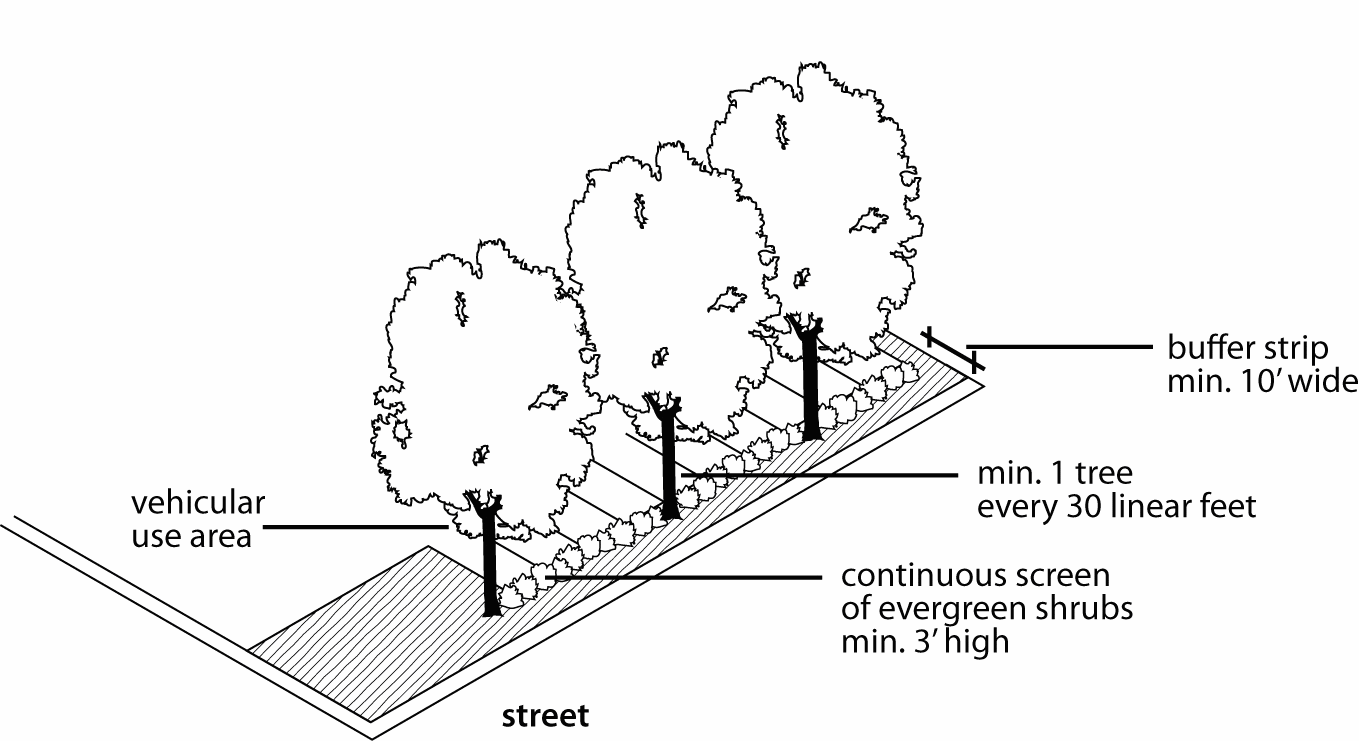
3.
Ground cover plants must cover the remainder of the required landscape strip.
4.
A masonry wall, planter, or berm may be substituted for shrubs, but trees and ground cover are still required.
5.
Shrubs and walls must be located on the interior of the perimeter landscape buffer strips; trees must be on the outside (street side) of the shrubs or wall.
6.
On sites containing more than 250 surface (outdoor, at-grade) parking spaces, when a vehicular use area is adjacent to a public right-of-way, required perimeter landscaping must be provided in the form of:
(a)
a berm with a minimum height of 3 feet and a maximum slope of 3:1, planted with at least 3 trees and 25 shrubs per 100 feet of berm length; or
(b)
a landscape buffer strip with a minimum width of 25 feet, planted with at least 6 trees and 35 shrubs per 100 feet of buffer length.
7.
Within the downtown loop, the landscape buffer strip:
(a)
may be reduced to 3 feet in width, with construction of a minimum three-foot high decorative metal or wrought iron fence or brick, stone, cast stone, or stamped concrete wall. The strip must be planted with enough evergreen shrubs to form a continuous visual screen at least 3 feet in height after the first growing season; and
(b)
shall not be required when adjacent to any public alley.
88-425-05-C. ADJACENT TO RESIDENTIAL ZONING DISTRICTS
When a vehicular use area is adjacent to a residential zoning district, except when the vehicular use area serves a use permitted within that residential zoning district, perimeter landscaping must be provided to provide physical and visual separation between the vehicular use area and the residential zoning district.
1.
Perimeter landscaping adjacent to residential zoning districts must be provided in the form of a perimeter landscape strip or berm located between the vehicular use area and the residential zoning district.
2.
The landscape buffer strip must be at least 10 feet in width and be planted with enough evergreen shrubs to form a continuous visual screen at least 4 feet in height after the first growing season.
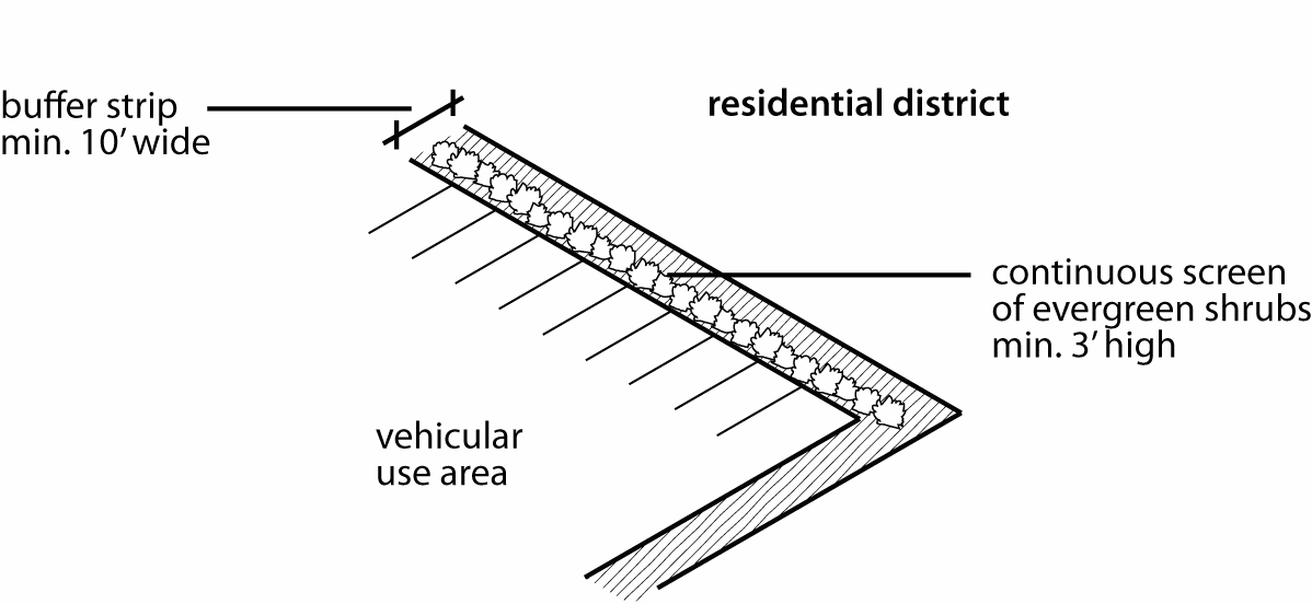
3.
Ground cover plants must cover the remainder of the required landscape strip.
4.
A masonry wall or opaque wood fence with a minimum height of 5 feet may be substituted for shrubs, but ground cover is still required within the landscape buffer strip.
5.
On sites containing more than 250 surface (outdoor, at-grade) parking spaces, the perimeter landscape buffer requirements of 88-425-05-B.6 apply.
88-425-05-D. ADJACENT TO PARKWAYS
When a vehicular use area is adjacent to a parkway, perimeter landscaping must be provided for physical and visual separation between the vehicular use area and the parkway right-of-way in the form of trees (deciduous and evergreen) and shrubbery to form a continuous visual screen at least 4 feet in height after the first growing season, consisting of either:
1.
a berm with a minimum height of 4 feet and a maximum slope of 3:1, planted with at least 3 trees and 25 shrubs per 100 feet of berm length; or
2.
a landscape buffer strip with a minimum width of 30 feet, planted with at least 6 trees and 35 shrubs per 100 feet of buffer length.
(Ord. No. 120783, § 1, 10-4-2012; Ord. No. 130441, § 1, 7-11-2013; Ord. No. 150378, § A, 5-21-2015; Ord. No. 150544, § 1, 7-23-2015)
88-425-06 - INTERIOR LANDSCAPING OF PARKING LOTS
88-425-06-A. APPLICABILITY
Unless otherwise expressly stated, the interior landscaping standards of this section apply to all of the following in all zoning districts:
1.
the construction or installation of any new parking lot containing 25 or more parking spaces in the Crossroads area or 10 or more parking spaces outside the Crossroads area;
2.
the expansion of existing parking lots, if the expansion would create 25 or more parking spaces in the Crossroads area or 10 or more new parking spaces outside the Crossroads area, in which case the requirements of this section apply only to the expanded area; and
3.
the excavation and reconstruction of existing parking lots containing 25 or more parking spaces in the Crossroads area or 10 or more parking spaces outside the Crossroads area if such excavation and reconstruction involves the removal of 50% or more of the asphalt, concrete or other parking lot surface material.
88-425-06-B. MINIMUM INTERIOR LANDSCAPE AREA
1.
At least 35 square feet of interior landscape area must be provided for each parking space. If compliance with this standard would result in the loss of existing required parking spaces, the amount of parking required is automatically reduced by the amount needed to accommodate the required interior landscaping.
2.
When at least 50% of interior parking lot landscape area consists of depressed bioretention areas used for storm water management the minimum landscaped area requirement is reduced from 35 square feet per parking space to 28 square feet per parking space. In order to receive this bioretention credit, the ponding area must be at least 6 inches and not more than 18 inches in depth and planted with native wildflowers/forbs and grasses.
88-425-06-C. RELATIONSHIP TO PERIMETER LANDSCAPING STANDARDS
Landscape area provided to satisfy the perimeter landscape standards of 88-425-05 may not be counted toward satisfying the interior landscaping standards of this section.
88-425-06-D. LOCATION
Required interior landscaping must be designed to enhance the appearance and safety of the parking lot area. Landscaping must be reasonably dispersed throughout parking area. Reduced dispersal is allowed if landscape planting areas are combined to form larger, functional bioretention areas.
88-425-06-E. PLANT MATERIALS
1.
TREES
One tree is required per 5 parking spaces.
2.
SHRUBS
One shrub is required per parking space.
3.
GROUND COVER
Ground cover plants must cover all interior landscape areas.
(Ord. No. 120697, § 1, 8-23-2012)
88-425-07 - SCREENING OF PARKING GARAGES
Parking floors within multi-story parking garages must be screened or concealed by one or more of the following methods:
88-425-07-A. GROUND-FLOOR RETAIL/OFFICE
When a parking garage is proposed for a street where the predominant use is retail or office, the garage's ground-level street frontage (except for driveways and pedestrian entrances) must be improved with retail, office of other active use types, as permitted by the subject zoning district. Ground-floor space improved with retail, office or other active uses must include display windows, lighting, architectural treatments, or landscaping that enhances the pedestrian environment.
88-425-07-B. GROUND-FLOOR RESIDENTIAL
Where permitted, ground-floor residential use may be used to conceal a parking garage.
88-425-07-C. LANDSCAPING
1.
Landscaping may be required for all parking garages (except fully enclosed garages) at ground-level or on each street façade above ground-level in the form of perimeter planters within openings, upper-level landscaped setbacks and/or the incorporation of hanging baskets, flower boxes or planting trellises.
2.
A parking garage that does not incorporate ground-floor nonresidential or residential use or is not otherwise screened or concealed at street frontages on the ground level, must provide a densely planted landscape perimeter that is a minimum of 10 feet in depth for any garage of less than 5 levels and 20 feet in depth for any garage with 5 levels or more.
88-425-07-D. UPPER-LEVEL SCREENING
In lieu of landscaping, on upper levels of a parking garage, the parking may be screened by business or residential uses, glazing, metal grillwork, louvers, and other architectural treatments.
(Ord. No. 130441, § 1, 7-11-2013)
88-425-08 - SCREENING OF CONTAINERS AND MECHANICAL/UTILITY EQUIPMENT
88-425-08-A. DUMPSTERS
Trash containers, dumpsters, trash compactors, and recycling bins associated with multiplex, multi-unit residential, and nonresidential uses must be screened from public view on all sides with a solid fence, wall, or gate constructed of cedar, redwood, masonry or other similar building material reflecting the overall design of the site, and be appropriately landscaped.
88-425-08-B. MECHANICAL EQUIPMENT AND UTILITY CABINETS
1.
Above-ground utility cabinets that serve multiple properties (including maintenance and access areas) must be located in the public right-of-way or within utility easements. When located in easements, such cabinets must be located as far as practicable from the street right-of-way and in locations that are least visible from rights-of-way. All locations must comply with intersection sight distance requirements and comply with required separation distances (between cabinets and other structures).
2.
Above-ground utility cabinets that are 30 or more inches in height or width and visible from the right-of-way must be screened from public view with landscaping or with an architectural treatment compatible with the building design and character of the surrounding area. No certificate of occupancy will be issued until required screening is in place.
3.
If above-ground utility cabinets are installed in an existing neighborhood (i.e., where principal buildings already exist on the subject lot), the utility provider is responsible for installation of required screening. Requirements for screening apply to new cabinets, as well as replacement of existing cabinets. The city planning and development director is authorized to approve alternative screening requirements or to waive screening requirements when soil conditions or other site constraints prevent strict compliance with otherwise applicable screening standards.
4.
Above-ground utility cabinets that are 30 or more inches in height or width and visible from the right-of-way must be oriented so that cabinet doors face away from the street right-of-way to the maximum practical extent. This requirement is intended to promote screening on the sides of the cabinet most likely to be visible from the right-of-way.
5.
Other ground-mounted or building-mounted mechanical equipment accessory to nonresidential buildings and nonresidential development must be screened from public view with landscaping or with an architectural treatment compatible with the building design and character of the surrounding area.
6.
Underground placement of mechanical equipment and utility cabinets must be considered whenever technologically and economically feasible.
88-425-08-C. All buildings or building additions in office, commercial or industrial districts must provide a solid screen fence or wall not less than 6 feet in height along all rear and side property lines that abut R zoning districts, except that such screening may not extend in front of the building line or in front of abutting dwellings. Such screening is not required when similar screening exists on the abutting residential property.
88-425-08-D. ROOF-MOUNTED MECHANICAL EQUIPMENT
Roof-mounted mechanical equipment (e.g., air conditioning, heating, cooling, ventilation, exhaust and similar equipment, but not solar panels, wind energy or similar renewable energy devices) over 30 inches in height and visible from the public right-of-way must be screened from view in one of the following ways:
1.
A parapet along façades facing the public right-of-way that is as tall as the tallest part of the equipment;
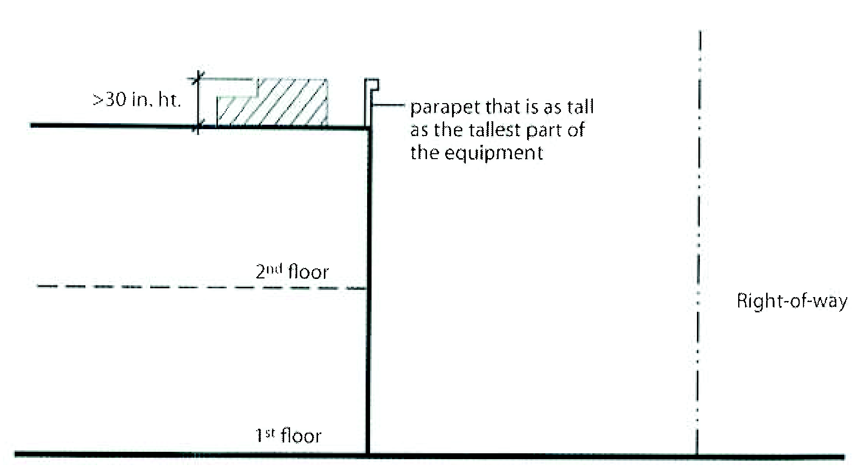
2.
A solid screen around the equipment that is as tall as the tallest part of the equipment, with the screen an integral part of the building's architectural design; or
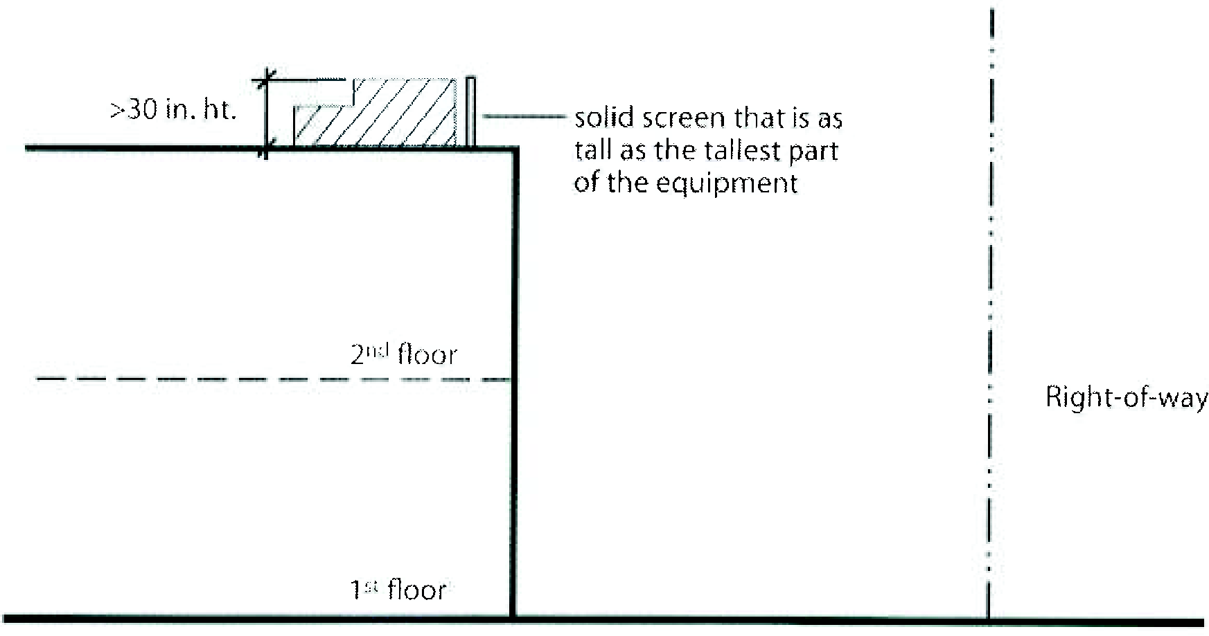
3.
An equipment setback from roof edges visible from the public right-of-way that is at least 3 feet in depth for each one foot of equipment height.
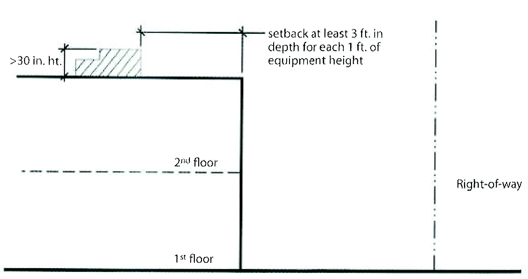
(Ord. No. 120783, § 1, 10-4-2012)
88-425-09 - SCREENING AND BUFFERING OF OUTDOOR USES
88-425-09-A. OUTDOOR RETAIL
1.
SCREENING FROM R AND DR DISTRICTS
All areas situated on a lot with side property lines or rear property lines contiguous with property in an R or DR district must be effectively screened along such side property lines or rear property lines by a wall or fence with a minimum height of 6 feet and a maximum height of 8 feet. Fences and walls must be:
a.
Solid masonry and/or wood; or
b.
Wrought iron or other similar decorative metal fencing or vinyl coated chain-link planted with a continuous row of evergreen shrubs and or trees to form a continuous visual screen at least 3 ft. in height after the first growing season.
88-425-09-B. OUTDOOR WORK AREAS, WAREHOUSING, WHOLESALING, STORAGE AND FREIGHT MOVEMENT, AND TOWING AND VEHICLE STORAGE
1.
REQUIRED FENCING
Outdoor uses shall be secured by a fence with a minimum height of 6 feet and a maximum height of 8 feet.
2.
SCREENING FROM OTHER ZONING DISTRICTS
All areas situated on a lot with side property lines or rear property lines contiguous with property in an R or DR district must be effectively screened along such side property lines or rear property lines by a wall or fence. Fences and walls must be:
a.
Solid masonry and/or wood; or
b.
Wrought iron or other similar decorative metal fencing or vinyl coated chain-link planted with a continuous row of evergreen shrubs and or trees to form a continuous visual screen at least 3 ft. in height after the first growing season,
3.
SCREENING FROM PUBLIC STREETS
All outdoor use areas must be screened from view of public streets (other than alleys), as follows:
a.
By either permitted structures and/or by a continuous row of evergreen shrubs and/ or trees to form a continuous visual screen at least 3 ft. in height after the first growing season.
b.
Such screening must be located between the perimeter of the outdoor use area and any property line abutting a public street.
c.
In B and D districts, any fencing adjacent to a public street shall be wrought iron or other similar decorative metal fencing. In M districts fencing adjacent to public streets shall be either vinyl coated chain-link or wrought iron or other similar decorative metal fencing.
88-425-09-C. SCREENING AND BUFFERING OF JUNK/SALVAGE YARDS
1.
All junk and salvage materials must be stored within completely enclosed buildings or surrounded by a solid fence or wall with a minimum height of 8 feet.
2.
A row of evergreen trees shall be planted on the outside of said fence or wall. Trees shall be planted 20 feet apart on center.
(Ord. No. 120783, § 1, 10-4-2012; Ord. No. 170061, § A, 3-23-2017)
88-425-10 - LANDSCAPING AND SCREENING MATERIAL
88-425-10-A. GENERAL
1.
APPLICABILITY
The standards of this section apply to all landscaping, plant materials, and fences or walls used to satisfy the landscaping and screening requirements of this zoning and development code.
2.
PLANT SELECTION
Plants used to satisfy the requirements of this zoning and development code must meet or exceed the plant quality standards of American Association of Nurserymen and the Kansas City Nursery and Landscape Association. Plants used to satisfy the requirements of this article must be native or naturalized species.
3.
ARTIFICIAL PLANTS
No artificial plants or vegetation may be used to satisfy the landscaping and screening requirements of this zoning and development code.
88-425-10-B. TREES
1.
TYPES
Unless otherwise expressly stated, required trees may be broadleaf (deciduous) or conifers (evergreen).
2.
SIZE
Trees provided to satisfy the requirements of this zoning and development code must comply with the following minimum size requirements:
a.
broadleaf trees must have a minimum caliper of 2.0 inches; and
b.
evergreen trees must have a minimum planted height of 5 feet.
3.
SPECIES
If more than 8 trees are required, no more than 40% may be of a single species. If more than 25 trees are required, no more than 25% may be of a single species. This requirement applies to trees being planted, not to existing trees.
88-425-10-C. SHRUBS
1.
All shrubs must have a minimum planted height of 2 feet and a minimum height of 3 feet after the second full growing season.
2.
Broadleaf shrubs must have a minimum container size of 2 gallons.
3.
Evergreens must have a minimum container size of 5 gallons.
4.
Shrubs may also be balled and burlapped.
5.
If more than 25 shrubs are required, no more than 75% may be of a single species.
88-425-10-D. GROUND COVER
1.
All required landscape areas that are not planted with trees or shrubs must be covered with ground cover plants, which may include grasses. Mulch must be confined to areas underneath trees and shrubs and is not an allowed substitute for ground cover.
2.
Ground cover plants other than grasses must be within minimum 4-inch pot or plug. Area planted in ground cover plants other than grasses must be planted at distances appropriate for the species and at a density that will achieve complete coverage after the second full growing season.
88-425-10-E. FENCES AND WALLS
Unless otherwise specified within this section for properties within the downtown loop:
1.
WALLS
Walls or planters must be constructed of brick, stone or other durable masonry material approved by the city planning and development director.
2.
FENCES
Fences must be durable and constructed of wood, decorative rigid vinyl (polyvinyl chloride), metal or wrought iron. Fence posts must be structurally stable. The finished side of the fence must face the adjacent property or street. Chain-link fencing may not be used to satisfy landscaping and screening requirements.
88-425-10-F. PROHIBITED PLANTS (RESERVED)
88-425-10-G. EXISTING TREES AND VEGETATION (RESERVED)
(Ord. No. 120783, § 1, 10-4-2012; Ord. No. 130441, § 1, 7-11-2013; Ord. No. 150378, § A, 5-21-2015; Ord. No. 220961, § 3, 3-16-2023)
88-425-11 - INSTALLATION AND MAINTENANCE
88-425-11-A. INSTALLATION
1.
GENERAL
a.
All landscaping must be installed according to sound nursery practices in a manner designed to encourage vigorous growth.
b.
All trees must be staked and include at least 2 inches of organic mulch over the planting area.
c.
Landscape plant material suitable for planting must be balled and burlapped or container grown. In all cases, a planting area that is at least twice the diameter of the root system or the container should be prepared.
2.
IRRIGATION
All required landscaped areas must provide irrigation in accordance with one of the following 3 options:
a.
a permanent, built-in irrigation system with an automatic controller;
b.
a temporary irrigation system designed and certified by a licensed landscape architect as part of the landscape plan, which provides sufficient water to ensure that the plants will become established; or
c.
irrigation by hand.
3.
PROTECTION
All required landscaped areas, particularly trees and shrubs, must be protected from potential damage by adjacent uses and development, including parking and storage areas.
4.
TIMING OF INSTALLATION
Prior to issuance of a final certificate of occupancy, all landscaping as shown on the approved landscape plan, including trees, plant material and structural elements, must be in place and healthy, as certified by a sealed letter submitted by a registered landscape architect licensed in the State of Missouri.
88-425-11-B. MAINTENANCE
1.
The property owner or successors in interest are jointly and severally responsible for proper maintenance of landscaped areas in accordance with the approved landscape plan.
2.
Landscaping must be continuously maintained including necessary watering, weeding, pruning, pest control, and replacement of dead or diseased plant material. Any replacement of dead or diseased plant material must comply with the approved landscape plan and must occur as soon as practical, no later than the next planting season.
3.
Failure to comply with an approved landscaping plan constitutes a violation of this zoning and development code and is subject to penalties and enforcement under 88-615.
(Ord. No. 120783, § 1, 10-4-2012; Ord. No. 150600, § A, 7-23-2015; Ord. No. 160341, § 1, 5-12-2016)
88-425-12 - LANDSCAPE PLANS
Landscape plans must accompany all required development and site plans, site plans for special use permit, and final development plans in Districts MPD and UR, and site plans for setback and open space tracts (88-425-04). All landscaping plans must be sealed and certified by a registered landscape architect licensed in the State of Missouri and include information as required by city planning and development department staff.
(Ord. No. 120783, § 1, 10-4-2012; Ord. No. 150313, § A, 4-30-2015; Ord. No. 160341, § 1, 5-12-2016)
88-425-13 - ADMINISTRATIVE ADJUSTMENTS FOR ALTERNATIVE COMPLIANCE
88-425-13-A. The city planning and development director is authorized to approve an administrative adjustment allowing for alternative compliance with the landscaping and screening standards of this article.
88-425-13-B. Alternative compliance may be approved when the city planning and development director determines that the proposed alternative would be at least as effective as strict compliance in meeting the overall intent of the standards.
88-425-13-C. Alternative compliance may also be approved when the city planning and development director determines that:
1.
strict application of the provisions would deprive the applicant of the reasonable use of the land or would otherwise impose an unreasonable hardship upon the applicant;
2.
conditions and circumstances upon which the waiver or modification is sought are not caused by the applicant; and
3.
that alternative landscape treatments will be provided to off-set the waiver or reduction in otherwise applicable standards.
88-425-13-D. The city planning and development director is expressly authorized to approve such alternative landscape treatments as:
1.
landscaped earth berms;
2.
raised planters;
3.
hanging baskets;
4.
flower boxes;
5.
planting trellises;
6.
roof-top gardens;
7.
perimeter plantings on roof-tops, decks or balconies;
8.
pedestrian lighting;
9.
flag or banner poles;
10.
benches and seating areas;
11.
vine-covered fences, walls or trellises;
12.
brick walls;
13.
public art installations; and
14.
additional landscaping and tree planting elsewhere on the site that will be visible from public right-of-way.
15.
Payment into the Capital Improvement Sales Tax Fund-Tree Planting.
(Ord. No. 220961, § 4, 3-16-2023)
88-430-01 - PURPOSE
The outdoor lighting standards of this article are intended to protect the public health and general welfare by controlling the adverse impacts of glare and light trespass associated with poorly shielded or inappropriately directed lighting fixtures.
88-430-02 - APPLICABILITY
Unless otherwise expressly exempted, the regulations of this article apply to all uses.
88-430-03 - EXEMPTIONS
The following are expressly exempt from the outdoor lighting regulations of this article:
88-430-03-A. airport runway and aviation safety lights required by the FAA (e.g., warning lights on radio, communication and navigation towers);
88-430-03-B. outdoor lights on lots occupied by residential buildings containing fewer than 4 dwelling units;
88-430-03-C. temporary holiday light displays;
88-430-03-D. outdoor light fixtures producing light directly by the combustion of fossil fuels, such as, kerosene lanterns or gas lamps;
88-430-03-E. city street lighting system, provided that city street lights should comply with the fixture and shielding standards of 88-430-05 wherever practical;
88-430-03-F. luminous tube lighting;
88-430-03-G. lighting of official government flags;
88-430-03-H. lights associated with outdoor recreation uses, which are subject only to the standards of 88-430-07; and
88-430-03-I. construction and emergency lighting used by construction workers or police, firefighting, or medical personnel, provided the lighting is temporary and is discontinued immediately upon completion of the construction work or abatement of the emergency requiring the lighting.
88-430-04 - GENERAL REGULATIONS AND STANDARDS
88-430-04-A. Flashing, revolving, or intermittent exterior lighting visible from any property line or street is prohibited. This shall not include motion-activated security lighting.
88-430-04-B. High-intensity light beams, such as outdoor searchlights and lasers, are prohibited unless expressly approved for temporary use in accordance with the special use procedures of 88-525.
(Ord. No. 130441, § 1, 7-11-2013)
88-430-05 - FIXTURES AND SHIELDING
88-430-05-A. All outdoor light sources that produce more than 4,050 lumens must be at least partially shielded. For the purposes of this provision, "partially-shielded" or "semi-cutoff" means an outdoor light fixture shielded so that no more than 2.5% of the light emitted directly from the lamp or indirectly from the fixture is projected at angles above a horizontal plane extending from the bottom of the fixture.
Partially Shielded, Semi-Cutoff Fixture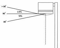
88-430-05-B. Light fixtures mounted under gas station canopies must be completely recessed into the canopy with flat lenses that are translucent and completely flush with the bottom surface (ceiling) of the canopy.
88-430-05-C. SPILLOVER LIGHT
Spillover light may not exceed 0.186 foot-candle onto R-zoned property or 1.0 foot-candle onto public rights-of-way measured at grade along the property line.
88-430-05-D. GLARE
All outdoor lighting must be reflected away from residences and streets.
(Ord. No. 170360, § 1, 6-15-2017)
88-430-06 - EXTERIOR LIGHTING PLAN
88-430-06-A. WHEN REQUIRED
An outdoor lighting plan must be submitted as part of any special use or development plan application. The lighting plan must be reviewed to determine whether the proposed outdoor lighting complies with the standards of this article.
88-430-06-B. INFORMATION REQUIRED
Outdoor lighting plans must include a photometric study and data on the types of lighting fixtures to be used. The photometric plan must include all of the following unless the city planning and development director determines that a thorough review and determination is possible without such information:
1.
scale drawing of the site with all outdoor lighting fixture locations identified;
2.
fixture specifications indicating the type of fixture, height, shielding, luminaire type and wattage;
3.
lamp type and size;
4.
a point-by-point illumination array for off-street parking areas and other vehicular use areas and along the property lines. The point-by-point array must indicate site illumination at (minimum) 10-foot intervals along the property line and at 20-foot intervals on the interior of the site.
88-430-06-C. CERTIFICATION REQUIRED
Prior to issuance of a final certificate of occupancy, a sealed letter by a licensed engineer shall be submitted, stating that photometries on the site comply with the approved photometric plan.
(Ord. No. 120783, § 1, 10-4-2012; Ord. No. 150313, § A, 4-30-2015; Ord. No. 160341, § 1, 5-12-2016)
88-430-07 - ALTERNATIVE COMPLIANCE AND SPECIAL STANDARDS FOR OUTDOOR RECREATION USES
Because of their unique requirements for nighttime visibility and their limited hours of operation, the city planning and development director is authorized to permit alternative means of compliance for outdoor recreation uses. In approving an alternative compliance lighting plan, the city planning and development director is authorized to impose reasonable conditions to help mitigate potential adverse impacts. Such conditions include limiting pole/fixture heights; limiting hours of operation; requiring special setbacks, landscaping, screening, or cutoff fixtures; and other techniques.
88-435-01 - APPLICABILITY
The standards of this article do not apply to the sales of food, flowers, newspapers, periodicals and similar materials that are not left outdoors overnight. Additionally, these standards do not apply to approved temporary uses.
88-435-02 - OUTDOOR DISPLAY
88-435-02-A. CLASS A OUTDOOR DISPLAY
1.
DEFINED
Class A outdoor displays are areas outside of a completely enclosed building or structure used to display goods for sale to the general public as part of and subordinate to retail sales or similar business establishment. This includes but is not limited to garden supplies, building supplies, and plant materials.
2.
REGULATED
Class A outdoor display areas are allowed in association with any retail or similar business establishment, provided they comply with the following standards:
a.
Outdoor display areas must be located outside of drive aisles, fire lanes, and required parking spaces;
b.
Outdoor display areas are prohibited in any required setback or within the first 50% of the yard area as measured between the right-of-way and the building line;
c.
Outdoor display areas may not be closer than 5 feet to any public building entrance;
d.
Individual items attached to a building wall surface may not exceed 8 feet in height above grade;
e.
Stacked items may not exceed a total of 7 feet in height above grade;
f.
Outdoor display areas may not exceed 15% of the gross floor area of the principal building on the lot.
3.
SITE PLAN REVIEW
Review for compliance with these standards must occur at the time of site plan or development plan review for the principal use. Otherwise site plan approval is required prior to establishment of an outdoor display area.
88-435-02-B. CLASS B OUTDOOR DISPLAY
1.
DEFINED
Class B outdoor displays are areas where the majority of the retail space is outdoors and items are for sale to the general public. This includes but is not limited to garden nurseries, vehicles sales and services, manufactured home sales, recreational and play equipment sales, and other similar uses.
2.
REGULATED
Class B outdoor display areas are allowed in B3, B4, and M zoning districts provided they comply with the following standards:
a.
Outdoor display areas must be located outside of drive aisles, fire lanes, and parking spaces;
b.
Outdoor display is prohibited in any required setback or within 20 feet of any property or right-of-way line, whichever is greater; and
c.
Outdoor display areas must be fully screened from ground level view of adjacent R-zoned properties.
(Ord. No. 120783, § 1, 10-4-2012; Ord. No. 120939, § 2, 12-20-2012; Ord. No. 140919, § A, 11-13-2014)
88-435-03 - OUTDOOR STORAGE
88-435-03-A. REGULATIONS
Outdoor storage as allowed per Tables 120-1 and 140-1, provided it complies with the following standards:
1.
Outdoor storage areas must be located outside of drive aisles, fire lanes, parking spaces, and any required setback;
2.
In the B4 district outdoor storage is prohibited in any required setback or within 20 feet of any property or right-of-way line, whichever is greater;
3.
In the M districts, outdoor storage is prohibited in any required setback or within 10 feet of any property or right-of-way line, whichever is greater;
4.
In the B4 district, outdoor storage may not cover an area exceeding 50% of the lot area and may not be located between the building line and any public right-of-way.
5.
Outdoor storage is allowed as an accessory use in the B4 and all M districts if such storage is a customary accessory use to the principal use on a site.
6.
Outdoor storage must be screened in accordance with the standards of 88-425-09.
(Ord. No. 120783, § 1, 10-4-2012; Ord. No. 130441, § 1, 7-11-2013; Ord. No. 140919, § A, 11-13-2014; Ord. No. 150600, § A, 7-23-2015)
88-435-04 - OUTDOOR WORK AREAS
Outdoor work areas are allowed in M2 and M3 districts. Outdoor work areas must be buffered and screened in accordance with the standards of 88-425-09.
88-440-01 - PURPOSE
The regulations of this article are intended to help ensure that the traffic and transportation impacts of proposed developments are identified, evaluated, and mitigated as necessary. The purpose of a transportation impact study is to assess the effects that development will have on traffic conditions, transit users, pedestrians, bicyclists, and neighborhood livability.
88-440-02 - WHEN REQUIRED
88-440-02-A. A traffic impact study is required at the time of application for approval of any special use permit, preliminary subdivision plat, or other similar site-specific development plan if:
1.
the proposed development, or phases of development, or contiguous tracts under the same ownership, would accommodate or could be expected to generate 100 or more added vehicle trips to or from the site during the peak traffic hour (based on the proposed development or the adjacent roads and intersections); or
2.
the proposed development, or phases of development, or contiguous tracts under the same ownership, would accommodate or could be expected to generate 1,000 or more added vehicle trips to or from the site during a 24-hour period (based on the proposed development or the adjacent roads and intersections).
88-440-02-B. In calculating the number of added vehicle trips expected to be generated, trip generation rates must be obtained from the most recent editions of Trip Generation and Trip Generation Handbook, published by the Institute of Transportation Engineers (ITE). Only "new" vehicle trips will be counted; no pass-by or internal trip capture will be used in calculating "added vehicle trips."
88-440-02-C. The city planning and development director may waive the requirement for a traffic impact study, in whole or in part, when the applicant shows that the proposed development's impact on adjacent roads intersections, pedestrian, bicycle and transit facilities will be minimal and insignificant, or will be no greater than those projected by a traffic impact study prepared and submitted within the past 2 years for the same site under the same or similar background conditions. The city planning and development director must document the reasons for any waiver.
88-440-03 - LEVEL OF SERVICE STANDARDS
88-440-03-A. The traffic impact study must demonstrate that the proposed development would not cause build-out-year, peak-hour levels of service on any arterial or collector road or intersection within the study area to fall below Level of Service (LOS) "D," as defined by the latest edition of the highway capacity manual, or, where the existing level of service is already LOS "E" that the proposed development would not cause the LOS to fall to the next lower letter grade.
88-440-03-B. If the road segment or intersection is already LOS "F," the traffic impact study must demonstrate that the proposed development, with any proposed improvements, would not cause build-out year peak-hour operation to degrade more than 5% of the total delay on any intersection approach.
88-440-03-C. To the extent that application proposes specific access points, the study must also demonstrate that the proposed development would avoid unsafe conditions on adjacent roads.
88-440-03-D. The traffic impact study must include an assessment of the proposed development's impacts on pedestrian level of service as established in the Kansas City Walkability Plan. This assessment must be in the form of a pedestrian impact study, which must be prepared in accordance with the methodology contained in "Appendix C" of the Walkability Plan. The pedestrian impact study must demonstrate that the proposed development meets the minimum level of service standards by measurement and area type.
88-440-03-E. The traffic impact study must also address on-street parking impacts; the availability of transit service and facilities and connections to transit; impacts on immediate and adjacent neighborhoods; and the convenience and safety effects on all modes of transportation.
88-440-03-F. Failure to meet these standards may serve as a basis for denying the application, or for conditioning approval of the application or application on provision of improvements or other mitigation measures needed to correct deficiencies due to the proposed development's impacts.
88-440-04 - STUDY AREA
The traffic impact study must address the proposed development's traffic impacts on at least:
88-440-04-A. Roads, sidewalks, bicycle routes, transit facilities and intersections within the development site, as designated by planning and development department staff;
88-440-04-B. road segments, sidewalks, bicycle routes, transit facilities and intersections abutting the development site as designated by planning and development department staff; and
88-440-04-C. off-site road segments and intersections where traffic from the proposed development is expected to account for at least 10% of the road's or intersection approach leg's average daily traffic
88-440-05 - QUALIFICATIONS
Traffic impact studies must be prepared by a licensed professional engineer.
88-440-06 - STUDY CONTENTS
Traffic impact studies must include charts, graphics, and narrative presenting at least the following information:
88-440-06-A. a description of existing land uses and development intensities in the study area, the location and characteristics of roads, sidewalks, bicycle routes, transit facilities and intersections in the study area, and the existing traffic volumes and conditions (including levels of service) of those facilities;
88-440-06-B. a description of the location and traffic-related characteristics (land use, intensity, expected date of full build-out and occupancy, vehicular access points, pedestrian connections, bicycle routes and transit facilities and characteristics, etc.) of the proposed development and other developments in the study area that are under construction, approved, or pending approval, as well as roadway and other transportation facilities and improvements in the study area that are under construction, programmed, or planned;
88-440-06-C. projections of future background traffic (existing vehicular, pedestrian, bicycle and transit volumes forecasted to build-out year levels based on agreed upon traffic growth rate) plus traffic generated by other development in the study area that is under construction, approved, or pending approval, future site traffic and total future traffic (the sum of future background traffic and future site traffic);
88-440-06-D. future background and site traffic projections must be made for the peak hours (as identified by planning and development department staff) of the adjacent road segments and intersections and for the development's expected full build-out and occupancy date, and must include trip generation, trip distribution (using pre-approved distribution by planning and development department staff), and traffic assignment estimates;
88-440-06-E. studies of the proposed development's incremental impacts on:
1.
road capacity during peak hours at all site access points and at road segments and intersections in the study area (including determination of the level of service for the road segments and intersections, queuing vs. existing/proposed storage);
2.
the need for signalization of intersections in the study area;
3.
pedestrian, bicycle and transit-user safety and convenience; and
4.
existing or potential high accident areas (as referenced in the adopted transportation plan or determined by planning and development department staff);
88-440-06-F. a qualitative study/review of sight distance at access points, when required by planning and development department staff;
88-440-06-G. a description of the location, nature, and extent of site access and transportation improvements and other measures recommended to mitigate any failure to meet traffic operation standards due to the proposed development's traffic impacts, including the expected effectiveness of each mitigation measure in addressing deficiencies, the feasibility of implementing the measures, suggested allocation of responsibility for funding and implementing the measures, the measures' relationship to planned public transportation improvements, and a suggested time schedule for the implementation of the measures;
88-440-06-H. résumés of the preparers of the study, demonstrating specific education, training, and professional experience in traffic-related studies and, if the study involves roadway or traffic signal design, traffic engineering; and
88-440-06-I. identification of all assumptions and data sources used in its projections, studies, and recommendations.
88-445-01 - INTENT AND APPLICABILITY
88-445-01-A. INTENT
The intent of this chapter is to provide an orderly, effective and reasonable control of off-premises and on-premises signs, thereby halting indiscriminate sign proliferation and enhancing the visual environment of the city and to achieve balance among the following different and at times, competing goals:
1.
to encourage the effective use of signs as a means of communication for businesses, organizations and individuals in Kansas City;
2.
to provide for adequate way-finding in the community, thus reducing traffic congestion;
3.
to provide adequate means of business identification, advertising and communication;
4.
to prohibit signs of such excessive size and number that they obscure one another to the detriment of the economic and social well-being of the city;
5.
to protect the safety and welfare of the public by minimizing hazards to vehicles and pedestrians;
6.
to preserve property values by preventing unsightly and chaotic signage that has a blighting influence on the city;
7.
To differentiate among those signs that, because of their location, lighting, movement or other characteristics may distract drivers on public streets and those that may provide information in a safer manner;
8.
to minimize the possible adverse effects of signs on nearby public and private property;
9.
to implement the goals of the comprehensive plan,
10.
to protect the constitutional rights of our citizens.
88-445-01-B. SIGNS EXEMPT FROM REGULATION
The following signs are exempt from regulation under this chapter:
1.
any public notice or warning required by a valid and applicable federal, state, or local law, regulation, or ordinance, or by order of a court of competent jurisdiction;
2.
any sign not visible from a right-of-way or from any property other than the property on which it is located;
3.
traffic control signs on private property, such as Stop, Yield, and similar signs, the faces of which meet standards set forth in the Manual on Uniform Traffic Control Devices and which contain no commercial message of any sort; and
4.
numbers, letters and symbols or other configurations not representing a commercial message which are etched as metal or masonry cornerstone plates or imbedded into the facade of any building or other structure.
88-445-01-C. SIGN PERMITS
Signs may only be constructed after issuance of a sign permit according to the regulations of the building code.
88-445-01-D. PROHIBITED SIGNS
1.
The following signs are expressly prohibited in all districts:
(a)
animated signs;
(b)
banners, except as specifically allowed as special event temporary signs elsewhere in this chapter; pennants; and wind-blown signs;
(c)
portable signs;
(d)
vehicle signs; for purposes of this section, a vehicle parked containing a commercial message or image and regularly parked on the street side of any business and not regularly and customarily used in the business;
(e)
signs on benches;
(f)
signs on trees;
(g)
signs on utility poles (not within the right-of-way), other than signs installed by the utility and related to the utility facility;
(h)
signs blocking required means of egress from a building; and
(i)
signs within the public right-of-way or on public property, except signs posted in accordance with this chapter, or projecting signs as allowed by this chapter.
2.
The list of prohibited sign types is not exclusive; any sign that is not exempt from this chapter, not established as a lawful nonconforming sign, or not expressly allowed by this chapter is a prohibited sign.
88-445-01-E. APPLICABILITY
No sign or outdoor advertising device as defined by this development code may be placed, erected, altered, rebuilt, enlarged, extended, relocated, maintained, or allowed to remain except according to the regulations of this chapter.
(Ord. No. 120783, § 1, 10-4-2012; Ord. No. 150444, § 1, 7-23-2015)
88-445-02 - SIGN MEASUREMENT AND INTERPRETATION
88-445-02-A. SIGN AREA
1.
The area of a cabinet sign will be computed by the smallest rectangle or circle necessary to encompass the entire perimeter enclosing the extreme limit of all elements composing such sign but not including any structural elements lying outside the limits of the sign and not forming an integral part of the display.
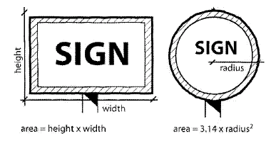
2.
The area of a channel sign (individual letters, numbers, or symbols with no background) will be measured by the sum of all rectangular areas necessary to encompass each letter, number, or symbol.

3.
Except for cabinet sign or channel signs as defined above, the area of a sign upon a wall, canopy, awning, or marquee shall be computed by the smallest rectangle or circle necessary to encompass the entire perimeter enclosing text and logo, but not including any structural elements lying outside the limits of the sign and not forming an integral part of the display.
4.
Each individual message or logo separated by 18 inches or a space equal in width to two letters of the sign, whichever is greater, will be counted as one sign toward the maximum number allowed per elevation.
5.
When the sign faces of a double-faced sign are parallel and the distance between the faces is 3 feet or less, only one display face will be measured in computing sign area. If the two faces of a double-faced sign are of unequal area, the area of the sign will be the area of the larger sign. In all other cases, the areas of all faces of a multi-faced sign will be added together to compute the area of the sign.
6.
The area of an outdoor advertising sign will be computed as in 1, above, except that, temporary cutouts and extensions installed for a specific display will not be considered to be an increase in the size of the permanent display; provided that the actual square footage of such temporary cutouts or extensions may not exceed 20 percent of the permanent display area.
88-445-02-B. SIGN HEIGHT MEASUREMENT
The height of a sign or sign structure is measured from the lowest point of the ground
directly below the sign to the highest point on the sign or sign structure.
88-445-02-C. SIGN CLEARANCE MEASUREMENT
Clearance is measured from the highest point of the ground directly below the sign to the lowest point on the sign structure enclosing the sign face.
88-445-02-D. SIGNS INSIDE WINDOWS
Signs inside windows and doors which are visible from any right-of-way may not cover more than 15% of the window or door and may not include any digital or electronic changing display.
(Ord. No. 150444, § 1, 7-23-2015)
88-445-03 - NONCOMMERCIAL SIGNS; SUBSTITUTION OF MESSAGES
88-445-03-A. Any sign allowed or that would be allowed without permit, by sign permit, by special use permit, or by variance, may contain, in lieu of any other message or copy, any lawful noncommercial message that does not direct attention to a business, product, commodity or service for sale or lease, or to any other commercial interest or activity, so long as the sign complies with the size, height and other requirements of this chapter.
88-445-03-B. It is the city's policy to regulate signs in a constitutional manner that is content neutral as to noncommercial signs.
88-445-04 - SEVERABILITY AND CONSTRUCTION OF SIGN REGULATIONS
88-445-04-A. GENERALLY
If any part, section, subsection, paragraph, subparagraph, sentence, phrase, clause, term, or word of the provisions of this chapter related to signs is declared unconstitutional by the valid judgment or decree of any court of competent jurisdiction, the declaration of such unconstitutionality does not affect any other part, section, subsection, paragraph, subparagraph, sentence, phrase, clause, term or word of this chapter.
88-445-04-B. SEVERABILITY WHERE LESS SPEECH RESULTS
Without diminishing or limiting in any way the declaration of severability set forth above in 88-445-04-A, or elsewhere in this chapter in this zoning and development code, if any part, section, subsection, paragraph, subparagraph, sentence, phrase, clause, term or word of this chapter is declared unconstitutional, that does not affect any other part, section, subsection, paragraph, subparagraph, sentence, phrase, clause, term or word of this chapter, even if such severability would result in a situation where there would be less speech, whether by subjecting previously exempt signs to permitting or otherwise.
88-445-04-C. SEVERABILITY OF PROVISIONS PERTAINING TO PROHIBITED SIGNS
Without diminishing or limiting in any way the declaration of severability set forth above in 88-445-04-A, or elsewhere in this chapter or in this zoning and development code, if any part, section, subsection, paragraph, subparagraph, sentence, phrase, clause, term, or word of this article or any other laws declared unconstitutional by valid judgment or decree of any court of competent jurisdiction, the declaration of such unconstitutionality does not affect any other part, section, subsection, paragraph, subparagraph, sentence, phrase, clause, term, or word of this chapter that pertains to prohibited signs, including specifically those signs and sign types prohibited and not allowed anywhere or in specific locations under this chapter. Furthermore, if any part, section, subsection, paragraph, subparagraph, sentence, phrase, clause, term, or word of this chapter is declared unconstitutional by the valid judgment or decree of any court of competent jurisdiction, the declaration of such unconstitutionality does not affect any other part, section, subsection, paragraph, sentence, phrase, clause, term, or word of this chapter.
88-445-04-D. SEVERABILITY AND CONSTRUCTION RELATED TO NONCOMMERCIAL SIGNS
This chapter, including provisions for the substitution of messages must be broadly construed to allow noncommercial messages, subject only to size, height, location and number limits that would apply to any sign bearing any message in that zoning district; any provision which is construed to limit the use of an apparently permitted sign for a noncommercial message should be disregarded in the administration of this chapter and struck down as unconstitutional and severed by any court considering it.
88-445-05 - SIGNS IN THE PUBLIC RIGHT-OF-WAY AND ON PUBLIC PROPERTY
88-445-05-A. SIGNS PERMITTED
Only the following signs are permitted in the right-of-way and on public property unless upon issuance of an encroachment permit by the city:
1.
Signs installed by any of the following and directly related to the use of the right-of-way or public properly, including the control and direction of traffic:
a.
City, county or state government entities;
b.
Any transit company authorized to provide service to or through Kansas City;
c.
Any public utility with a franchise or other agreement with Kansas City; or
d.
Any other government entity or person expressly authorized by local, state, or federal law to install a sign in the right-of-way.
2.
Unless as stated in subsection 3. below, no sign permitted by this section may contain any commercial message or image, and no such sign may be animated or lighted, unless the commercial message or image, animation, or lighting is expressly required by a valid and applicable local, state, or federal law.
3.
Electronic, digital, or motorized monument or wall signs may be permitted in conjunction with a transit station or shelter or other public installation, subject to an agreement with the city specifying location, orientation, height, size, type and other details of the signage. Any electronic or digital sign allowed must comply with the following requirements:
a.
Changes of image must not flash or scroll;
b.
Electronic and digital signs must use automatic level controls to reduce light levels at night and under cloudy and other darkened conditions, in accordance with the standards set forth in this subsection. All electronic and digital signs must have installed ambient light monitors, and must at all times allow such monitors to automatically adjust the brightness level of the electronic sign based on ambient light conditions. Maximum brightness levels for electronic and digital signs may not exceed 5000 nits when measured from the signs face at its maximum brightness, during daylight hours, and 500 nits when measured from the signs face at its maximum brightness between sunset and sunrise, as those times are determined by the National Weather Service.
88-445-05-B. OTHER SIGNS
Any other sign placed or installed in the right-of-way will be deemed an unlawful sign and an abandoned sign and will be subject to immediate removal by the City of Kansas City, without compensation to the owner. The owner or other person placing the sign will be subject to the penalty provisions of 88-615.
(Ord. No. 140920, § A, 11-13-2014)
88-445-06 - SIGNS IN RESIDENTIAL DISTRICTS
88-445-06-A. RESIDENTIAL SIGNS
Only the following signs are allowed in residential zoning districts (including AG-R):
1.
GENERAL RULES
a.
LIGHTING.
Except where otherwise specified, signs in residential districts may be externally illuminated only, unless otherwise specified.
b.
FLASHING, MOVING AND SIMILAR SIGNS
Flashing, moving, animated, wind-blown, or other signs that move or simulate movement are prohibited.
c.
TRAFFIC CONTROL SIGNS
In addition to other signs permitted under this section, any lot or parcel containing more than 4 dwelling units, a permitted institutional use, or a permitted commercial use, may contain signs conforming with the Manual of Uniform Traffic Control Devices and not containing any commercial message.
d.
MESSAGES
Any sign allowed under this section may bear a noncommercial message. Limited commercial messages are allowed, in accordance with express provisions of this section, but such commercial messages may not advertise or direct attention to a business or commercial activity other than one lawfully conducted on the premises, as expressly allowed under this section.
e.
SETBACK
Signs placed on a corner lot shall not extend forward of a diagonal line which intersects the front and side property lines of the lot at points 20 feet distant from the common intersection of the front and side property lines or, if the corner of the lot is platted on a radius, the extension of the front and side property lines to a point of common intersection. Signs placed on an interior lot shall be set back a minimum of 5 feet from the right-of-way line.
2.
DETACHED HOUSE AND SEMI-ATTACHED HOUSE
A lot with a principal use of a detached house or semi-attached house may have:
a.
For each entrance (excluding garage entrances) to a dwelling unit, one wall sign, not to exceed 80 square inches in area.
b.
One interim sign bearing a noncommercial message or a message related to the sale, lease, rental, or construction of the home. Such sign may not exceed 8 square feet in area or 4 feet in height.
c.
Additional interim signs not bearing commercial messages. No such sign may exceed 8 square feet in area or 4 feet in height. A maximum of 16 square feet of sign area is allowed per lot.
d.
During the period from 6 weeks prior to a public election to be held in Kansas City to 2 weeks after such election, each lot may display additional signs not bearing commercial messages. No such sign may exceed 8 square feet in area or 4 feet in height.
3.
MULTI-UNIT BUILDINGS
A lot with a principal use of a multi-unit building may have:
a.
WALL SIGNS
1.
One wall sign per building not to exceed 12 square feet in area. The message on such sign may include a commercial message related to the sale, lease, or rental of units in the building or complex.
2.
For each building entrance providing access to multiple dwelling units, an additional sign to identify the dwelling units in that building, not to exceed 4 square feet in area, provided that no message on such sign other than a word such as "directory" or similar identifying word may be legible from a location on the public right-of-way or on private property other than that which is part of the same complex.
3.
For each entrance (excluding garage entrances) to an individual dwelling unit, one wall sign, not to exceed 80 square inches in area.
4.
For any multi-unit residential building containing one or more offices, as permitted under the zoning for the district, one additional wall sign is permitted, which sign may not exceed 16 square feet in area. The wall sign may bear a commercial message related to activities lawfully conducted on the premises or a noncommercial message.
b.
INCIDENTAL SIGNS
One additional sign per driveway is permitted, which sign may not exceed 36 inches in height and 2 square feet in area. Such sign may not contain a commercial message.
c.
INTERIM SIGNS
(1)
One interim sign bearing a noncommercial message or a message related to the sale, lease, rental, or construction of the units. Such sign may not exceed 8 square feet in area or 4 feet in height.
(2)
Additional interim signs not bearing commercial messages. No such sign may exceed 8 square feet in area or 4 feet in height. A maximum of 16 square feet of sign area is allowed per lot.
(3)
During the period from 6 weeks prior to a public election to be held in Kansas City to 2 weeks after such election, each lot may display additional signs displaying noncommercial messages. No such sign may exceed 8 square feet in area or 4 feet in height.
4.
INSTITUTIONAL AND OFFICE USES
A lot with an institutional use as its principal use, such as a church, school, police or fire station, community center, public park, an office building, or other permitted principal uses not described herein, may have:
(a)
MONUMENT SIGNS
One monument sign per street frontage which may not exceed 32 square feet in area or 6 feet in height. One sign per lot may include changeable copy, but the changeable copy feature must use direct human intervention for changes and may not include any form of digital or electronic display. Such sign may be internally or externally illuminated.
(b)
WALL SIGNS
One wall sign per public entrance, which may not exceed 20 square feet in area. Such sign may not include any form of digital or electronic display. Such sign may be internally or externally illuminated.
(c)
INCIDENTAL SIGNS
1.
One sign per driveway is permitted, which may not exceed 42 inches in height and 6 square feet in area.
2.
Incidental signs must be set back a minimum of 10 feet from all property lines.
3.
Such sign may not contain a commercial message but may include the logo of the institutional use.
(d)
INTERIM SIGNS
1.
One interim sign bearing a noncommercial message or a message related to the sale, lease, rental, or construction of the property. Such sign may not exceed 8 square feet in area or 4 feet in height.
2.
Additional interim signs not bearing commercial messages. No such sign may exceed 8 square feet in area or 4 feet in height. A maximum of 16 square feet of sign area is allowed per lot.
3.
During the period from 6 weeks prior to a public election to be held in Kansas City to 2 weeks after such election, each lot may display additional signs not bearing commercial messages. No such sign may exceed 8 square feet in area or 4 feet in height.
5.
HOSPITAL SIGNS
A signage plan portraying signs necessary for the proper identification of the facilities within a hospital may be approved by special use permit. Such signs shall be on-premises signs and limited to proper identification of the facilities. Such signs may be internally or externally illuminated.
6. RESIDENTIAL ENTRANCE SIGNS
One monument sign is allowed at each street entrance, identifying the name of the residential neighborhood or multi-unit complex or building. The area of the sign face shall not exceed 32 square feet in area or 6 feet in height; however, the monument structure on which the sign is located may be approved for up to 25 feet in height through the project plan process.
7.
INTERIM SUBDIVISION DEVELOPMENT SIGNS
As an interim use accessory to the permitted activity of lawful subdivision development in a development which will contain at least 20 dwelling units, interim identification signs are permitted, provided that such signs may not exceed 100 square feet in sign area nor more than 15 feet in height; if there is more than one such sign, such signs must be at least 1,000 feet apart. Each such sign may remain in place until 90 percent of the lots in the sector are sold, but no longer than 18 months from the date of erection. All such signs must be located at least 15 feet from the pavement edge or edge of the street or thoroughfare to which it is directed, but not within the sight triangle. All such signs must be within the development or within 2000 feet of the development. These signs may not be illuminated.
8.
GROUP HOMES
A lot with a principal use of a group home may have:
(a)
For each entrance (excluding garage entrances) one wall sign, not to exceed 80 square inches in area.
(b)
One interim sign bearing a noncommercial message or a message related to the sale, lease, rental, or construction of the home. Such sign may not exceed 8 square feet in area or 4 feet in height.
(c)
Additional interim signs not bearing commercial messages. No such sign may exceed 8 square feet in area or 4 feet in height. A total of 16 square feet of sign area is allowed per lot.
(d)
During the period from six weeks prior to a public election to be held in the city to two weeks after such election, each lot may display additional signs not bearing commercial messages. No such sign may exceed 8 square feet in area or 4 feet in height.
9.
OTHER PRINCIPAL USES AND VACANT LOTS
A lot with a principal use not described in this section, or a vacant lot may have:
(a)
One interim sign bearing a noncommercial message or a message related to the sale, lease, rental, or construction of the property. Such sign may not exceed 8 square feet in area or 4 feet in height.
(b)
Additional interim signs not bearing commercial messages. No such sign may exceed 8 square feet in area or 4 feet in height. A total of 16 square feet of sign area is allowed per lot.
(c)
During the period from six weeks prior to a public election to be held in the city to two weeks after such election, each lot may display additional signs not bearing commercial messages. No such sign may exceed 8 square feet in area or 4 feet in height.
10.
AUXILIARY PARKING
Signs to identify parking areas allowed by special use permit shall be approved in conjunction with such special use permit, although no sign may exceed 12 square feet in area or 6 feet in height. Such signs may show only the hours in which the parking lot is open and the persons authorized to use the parking area.
(Ord. No. 120783, § 1, 10-4-2012; Ord. No. 150600, § A, 7-23-2015; Ord. No. 170365, § A, 5-25-2017; Ord. No. 200909, § 1, 11-12-2020; Ord. No. 220398, § 1, 5-19-2022)
88-445-07 - SIGNS IN NON-RESIDENTIAL DISTRICTS (OFFICE, COMMERCIAL AND MANUFACTURING)
Signs to identify parking areas allowed by special use permit shall be approved in conjunction with such special use permit, although no sign may exceed 12 square feet in area or 6 feet in height. Such signs may show only the hours in which the parking lot is open and the persons authorized to use the parking area.
The following business advertising signs are permitted in non-residential districts. Signs within the P/O, pedestrian-oriented overlay district must comply with the requirements of 88-445-09.
(Ord. No. 120783, § 1, 10-4-2012; Ord. No. 151013, § A, 12-10-2015; Ord. No. 180600, § 1, 8-23-2018; Ord. No. 190501, § A, 7-11-2019)
88-445-08 - ADDITIONAL REQUIREMENTS FOR SPECIFIC SIGN TYPES IN NON-RESIDENTIAL DISTRICTS
88-445-08.A. MONUMENT SIGNS
1.
All monument signs must be set back a minimum of 10 feet from the property line.
2.
All monument signs must be set upon a solid base of material and design compatible with that of the development. The width of the base must be a minimum of 75 percent of the width of the widest part of the sign.
3.
Electronic, digital, or motorized monument signs are permitted in Districts B4, UR, D, and M, provided that the message or image does not change more than once every hour, and provided that the sign complies with the following requirements:
(1)
There may be no effects of movement, flashing, scintillation, or similar effects;
(2)
Changes of image must be instantaneous as seen by the human eye and may not use fading, rolling, window shading, dissolving, or similar effects as part of the change;
(3)
Electronic and digital signs must use automatic level controls to reduce light levels at night and under cloudy and other darkened conditions, in accordance with the standards set forth in this sub-section. All electronic and digital signs must have installed ambient light monitors, and must at all times allow such monitors to automatically adjust the brightness level of the electronic sign based on ambient light conditions. Maximum brightness levels for electronic and digital signs may not exceed 5000 nits when measured from the signs face at its maximum brightness, during daylight hours, and 500 nits when measured from the signs face at its maximum brightness between sunset and sunrise, as those times are determined by the National Weather Service.
(4)
The sign must be located at least 250 feet from any residentially zoned and occupied property, and must be located on a major thoroughfare.
4.
Monument signs used to identify a development district must be located on a major thoroughfare.
88-445-08-B. OVERSIZED MONUMENT SIGNS
1.
Oversized monument signs must be set back a minimum of 20 feet from the property line and must be located on a major thoroughfare as designated by the Major Street Plan.
2.
All monument signs must be set upon a masonry base of material and design compatible with that of the development. The width of the base must be a minimum of 75 percent of the width of the widest part of the sign.
3.
Electronic, digital, or motorized signage is not permitted.
4.
The design of the sign must be in character with the architecture and material of the development it identifies.
5.
When an oversized monument sign is used to identify a development district, additional development district monument signs are not permitted.
6.
A special use permit is required for oversized monument signs.
88-445-08-C. WALL SIGNS
1.
Wall signs must be permanently attached to the building and parallel to its surface, extending no more than 12 inches from the wall.
2.
Wall signs may be placed on a parapet wall of a building, as provided in 88-810-1860. The parapet wall upon which a sign is placed may extend no more than 6 feet above the lowest parapet wall of the building.
3.
Electronic, digital or motorized wall signage is not permitted unless through administrative adjustment in accordance with 88-570-02-K.
88-445-08-D. AWNING, CANOPY, MARQUEE AND UNDER-MARQUEE SIGNS
1.
No awning, canopy, marquee or under-marquee sign may project above the parapet of the building.
2.
The maximum length of under-marquee signs shall be ½ the distance the marquee or canopy projects from the wall, or 8 feet, whichever is less.
3.
Under-marquee signs may not hang more than 24 inches below the lowest point on the marquee or canopy.
4.
All awning, canopy, marquee and under-marquee signs must have a minimum clearance of 8 feet above the sidewalk or ground below.
5.
Electronic, digital, or motorized signage is not permitted.
6.
In calculating the area permitted for canopy signage for gas and fuel sales establishments, the longest length of the canopy shall be utilized to calculate the 10% wall area permitted for the canopy signage, and this canopy signage may be placed on any side of the canopy.
88-445-08-E. PROJECTING SIGNS
1.
Maximum thickness of projecting signs is 50% of its projecting distance.
2.
Projecting signs may not project more than 4 feet from the building wall. For signs installed radially on building corners, maximum projection is 5 feet.
3.
Projecting signs may not project above the parapet of the building.
4.
The minimum clearance required for projecting signs is 8 feet.
5.
Electronic, digital, or motorized signage is not permitted.
88-445-08-F. ROOF SIGNS
1.
Roof signs are permitted only as follows:
(a)
in nonresidential zoning districts within the area bound by the Missouri River, Paseo Boulevard, 31 st Street, and State Line; or
(b)
within the M2-3 district, on a roof that is set back at least 1,000 feet from all property lines.
2.
The supporting structure for a roof sign must comply with all applicable engineering and code requirements. Such supporting structures must consist of the fewest number of supporting members without embellishments, consistent with all applicable municipal code requirements.
3.
Roof signs are not permitted on buildings unless the top of the highest portion of the roof is at least 50 feet above grade.
4.
The maximum horizontal dimension of a roof sign may not exceed 50% of the width of the wall it most closely parallels.
5.
The maximum height of a roof sign and its supporting structure may not exceed 26 feet, measured from the elevation of top of the highest parapet to the top of the sign.
6.
Electronic, digital, or motorized signage is not permitted.
88-445-08-G. INCIDENTAL SIGNS
1.
Incidental signs must be set back a minimum of 10 feet from all property lines.
2.
An incidental sign may include the logo of the establishment.
3.
Electronic, digital, or motorized signage is not permitted.
88-445-08-H. INTERIM SIGNS
1.
Interim signs are not permitted within 2,000 feet of another such sign in the same development.
2.
City plan commission approval is required for interim signs, except real estate signs or noncommercial signs.
3.
The sign must be removed within 3 years or upon completion of development, whichever occurs first. The city plan commission may approve one extension of up to 3 years, provided an application for extension is made prior to the expiration of the original approval.
4.
Electronic, digital, or motorized signage is not permitted.
88-445-08-I. SPECIAL EVENT TEMPORARY SIGNS, INCLUDING BANNERS
1.
Special event temporary signage, including banners will be allowed upon issuance of a permit.
2.
Signs will be permitted to be displayed a maximum of either one 60-day period per year or two 30-day periods per calendar year.
3.
Banners or flags will be permitted to be displayed a maximum of four 30-day periods per calendar year. In no case may a 30-day period be carried over from month to month, however.
4.
No temporary sign may advertise or promote any commercial enterprise or event not conducted on the same building lot;
5.
Temporary signs must be designed, constructed or mounted so as to be reasonably stable under all weather conditions, including high winds;
6.
At the expiration of the permitted period(s) for the temporary signs, the signs must be removed.
88-445-08-J. ORNAMENTAL TOWER SIGN
1.
Signs are permitted on ornamental towers when a tower or structure is an integral part of the architectural plan of a building, and may extend beyond the roof level of the building provided that the height of the tower does not exceed the maximum height permitted in the district.
2.
Towers or structures with signs must be separated by 500 feet.
3.
Such signs must face upon the interior of the center or on the principal street upon which the center fronts.
88-445-08-K. ILLUMINATION OF SIGNS
1.
Any outdoor lighting arrangement for the illumination of a sign which would be visible from any property in an adjoining residential zoning district (including AG-R) must be so designed that no flashing or direct glare from any light source is focused, beamed or directed toward such property.
2.
Flashing lights, rapidly changing or blinking illumination, rotating beams, or illumination resembling emergency lights are prohibited.
3.
The electric supply for all illuminated signs must be located underground unless otherwise expressly approved by the city planning and development director.
4.
Spillover light onto R-zoned property or public rights-of-way may not exceed 2 lux, measured at grade along the property line.
88-445-08-L. HOSPITAL SIGNS
A signage plan portraying signs necessary for the proper identification of the facilities within a hospital may be approved by special use permit. Such signs shall be on-premises signs and limited to proper identification of the facilities. Such signs may be internally or externally illuminated.
88-445-08-M. SIDEWALK SIGNS
In non-residential districts, the owner or operator of a business may place a sidewalk sign on a sidewalk to direct attention to a business offering a product, commodity, or service for sale or lease. Alternatively, such sign may contain any lawful noncommercial message pursuant to section 88-445-03. Although no permit is required, placement of a sidewalk sign is subject to the following restrictions:
1.
the sign may only direct attention to a business that has an entry to and is immediately adjacent to the sidewalk upon which the sign is placed;
2.
the sign shall not be permanently attached to the ground or a structure;
3.
the sign may be placed only during hours the business is open and shall be removed otherwise;
4.
only one sign per business is permitted, and the sign shall not be located within 15 feet of another such permitted sign;
5.
no sign shall exceed 2.5 feet in width or 4 feet in height, and the minimum height shall be 2.5 feet;
6.
no sign shall have protrusions or extensions;
7.
the sign shall be placed to ensure a minimum of 5 feet of horizontal sidewalk clearance;
8.
the sign must be placed within 2 feet of the wall of the building within which the business is located;
9.
placement shall not obstruct any points of ingress or egress to a building;
10.
no sign may be animated or lighted; and
11.
proof of liability insurance shall be maintained, with the City as an additional insured, with a policy meeting the following conditions:
a.
Liability insurance with either a combined single-limit policy of $500,000.00, or a split-limit policy of $100,000.00/$300,000.00 bodily injury and $100,000.00 property damage.
(Ord. No. 120783, § 1, 10-4-2012; Ord. No. 140398, § A, 6-17-2014; Ord. No. 150444, § 1, 7-23-2015; Ord. No. 170365, § A, 5-25-2017; Ord. No. 170566, § A, 9-7-2017; Ord. No. 180600, § 1, 8-23-2018)
88-445-09 - SIGNS IN THE PO, PEDESTRIAN-ORIENTED OVERLAY DISTRICT
Three wall signs are permitted per building elevation, covering a maximum of 10 percent of the total wall area including the area of all awning, canopy, marquee, and under-marquee signs. Wall signs may be internally or externally illuminated and must comply with the standards of 88-445-08-C.
Awning, canopy, marquee, and under-marquee signs are permitted, and are included in the maximum area allowed for wall signs. Such signs may be internally or externally illuminated and must comply with 88-445-08-D.
One projecting sign is allowed per building wall, in lieu of one permitted wall sign. If mounted perpendicular to the building wall, the sign must not exceed 12 square feet in area; if mounted radially on a building corner, it must not exceed 40 square feet in area. The sign may not exceed 50 percent of its projecting distance in thickness.
Projecting signs may be internally or externally illuminated, and may not project more than 4 feet from the building face, with a minimum clearance of 8 feet. On building corners, the sign may project no more than 5 feet. Projecting signs must comply with 88-445-08-E.
Incidental signs are permitted in the district, according to the standards of 88-445-08-G.
Business advertising signs are prohibited on premises occupied as residential, institutional, or noncommercial use; in buildings of mixed occupancy, business advertising signs are allowed on or below any level of the building occupied by a commercial use.
Monument signs, electronic, digital, and motorized signs, changeable copy panels, and outdoor advertising signs are prohibited in this district.
(Ord. No. 160759, § 1, 10-20-2016)
88-445-10. - SIGNAGE PLAN
88-445-10-A. APPLICABILITY
A signage plan must be submitted in conjunction with the review and approval of:
1.
development plans, according to the review procedure of 88-517. When development plan review is required, signage shall be shown and approved as part of the plan.
2.
final UR or MPD development plan.
3.
site plans, according to the review procedure of 88-530.
4.
special use permits, according to the review procedure of 88-525.
5.
any overlay or special purpose districts.
6.
sign permit application.
88-445-10-B. SIGNAGE PLANS
1.
Signage plans must include specifications for:
a.
type of signs (wall or monument);
b.
size (sign area and dimensions);
c.
materials;
d.
type of illumination;
e.
landscaping, in accordance with any required plan; and
f.
location, as well as any other standards necessary for proper development.
2.
No sign may be erected in contravention of the design standards.
3.
Minor modifications to signage shown on final development plans, development plans, site plans, or special use approvals, or replacement signage, may be approved by the city planning and development director according to 88-570.
4.
For those development districts which have received approval prior to the effective date of this ordinance, a signage plan as provided above may be submitted at any time prior to the issuance of a permit for a sign. Minor modifications or replacement signage may be approved by the city planning and development director.
(Ord. No. 120939, § 2, 12-20-2012)
88-445-11. - COUNCIL APPROVED SIGNAGE PLAN
88-445-11-A. PURPOSE
The Council Approved Signage Plan approval process is intended to integrate the design of the signs proposed for a development project with the design of the structures, into a unified architectural statement and allow flexibility in the size, height, duration, number, and type of allowed signs. A Council Approved Signage Plan provides a means for defining common sign regulations for large or unique developments, to encourage maximum incentive and latitude in the design and display of signs and to achieve, not circumvent, the intent of this chapter.
88-445-11-B. APPLICABILITY
1.
An applicant may apply for Council Approved Signage Plan approval for any property zoned B3, B4, D, UR, M, MPD, SC, or KCIA having a minimum of 10 contiguous acres of area, except that the minimum zoning and acreage requirement shall not apply to property within the downtown loop and except that the minimum acreage requirement shall not apply to any property located along an interstate highway within one mile of a sports complex stadium. Approval of a Council Approved Signage Plan shall require findings specific to the request that reflect the land use and design elements which specifically relate to the special circumstances associated with the application.
2.
An applicant may apply for a Council Approved Signage Plan for any lot zoned R containing a minimum of 15 acres, or for any lot (or any two contiguous lots under common ownership) containing a minimum of 10 acres, located adjacent to an arterial (as shown on the major street plan) to allow the installation of a noncommercial digital sign face on one otherwise allowable monument sign, in accordance with 88-445-06-A.4., and further subject to the standards of 88-445-11-E.
88-445-11-C. APPROVAL AUTHORITY
A Council Approved Signage Plan may be approved by the city council after recommendation of the city plan commission. A public hearing will be held by both the commission and a city council committee on the proposed plan before approval or denial. Notification of the city plan commission hearing shall be given in accordance with 88-515-04.
88-445-11-D. APPLICATION REQUIREMENTS
An application for a Council Approved Signage Plan shall include all information and materials required by 88-445-10-B.
88-445-11-E. STANDARDS
A Council Approved Signage Plan shall comply with the following standards:
l.
The plan shall comply with the purpose of this chapter and the overall intent of this section.
2.
The signs shall enhance the overall development, be in harmony with, and relate visually to other signs included in the Council Approved Signage Plan, to the structures and/or developments they identify, and to surrounding development and neighborhoods.
3.
The signs will not create a safety or traffic hazard.
4.
The plan shall accommodate future revisions that may be required because of changes in use or tenants.
5.
The plan shall comply with the standards of this chapter. Except for a Council Approved Signage Plan for any property zoned R, flexibility is allowed with regard to sign area, number, location, duration, type, and/or height to the extent that the Council Approved Signage Plan will enhance the overall development and will more fully accomplish the purposes of this chapter.
6.
Banner signs shall only be allowed if attached to light poles with frames on the top and bottom of the banners.
7.
Neither the proposed message to be displayed nor the character of the use on the property may be a factor in the decision to approve the signage plan.
8.
A Council Approved Signage Plan for any property zoned R submitted in accordance with 88-445-11-B.2. must comply with the following and is not subject to the flexibility of item 5. above:
a.
Only one monument sign, in lieu of an otherwise allowed monument sign per 88-445-06, is allowed.
b.
The sign may not exceed 32 square feet in area and 6 feet in height.
c.
The message or image may not change more than once every hour.
d.
Changes of image must be instantaneous as seen by the human eye and may not use fading, rolling, window shading, dissolving, or similar effects as part of the change.
e.
Digital signs must use automatic level controls to reduce light levels at night and under cloudy and other darkened conditions, in accordance with the standards set forth in this subsection. All digital signs must have installed ambient light monitors, and must at all times allow such monitors to automatically adjust the brightness level of the electronic sign based on ambient light conditions, not to exceed 1 nit (0.3 foot candles) above ambient light. Additionally, maximum brightness levels for electronic and digital signs may not exceed 5,000 nits when measured from the sign's face at its maximum brightness during daylight hours, and 500 nits when measured from the sign's face at its maximum brightness between sunset and sunrise, as those times are determined by the National Weather Service. Measurements shall be taken perpendicularly from each sign face at a distance of not more than 57 feet from the sign face.
f.
The sign must be located at least 100 feet from any other residentially zoned and occupied property, and must be set back at least 100 feet from the edge of any right-of-way.
g.
No commercial message or image may be displayed on such sign.
h.
The sign must not be located within 150 feet of a public park or a parkway or boulevard.
i.
The sign must not be located on a lot that is within a designated conservation or historic district or a lot where there exists a designated historic landmark.
j.
The sign may not be illuminated between the hours of 10:00 p.m. and 7:00 a.m.
k.
The background color of the sign shall not be white.
l.
The digital display must be turned off if the display is not properly functioning.
m.
The monument sign must be set upon a solid base of material and design compatible with that of the development, and the width of the base must be a minimum of 75 percent of the width of the widest part of the sign.
n.
The noncommercial digital sign may only be allowed as an accessory use located on the same lot(s) as the principal noncommercial use.
88-445-11-F. TIME FOR DETERMINATION
The city plan commission shall make its recommendation on the Council Approved Signage Plan within sixty days of the applicant's submittal of all required information and materials, unless the applicant has requested a time extension or continuance which has delayed the process. The city council shall make its determination within thirty days after the city plan commission's recommendation, unless the applicant has requested a time extension or continuance which has delayed the process.
88-445-11-G. REVISIONS TO COUNCIL APPROVED SIGNAGE PLAN
Minor revisions to a Council Approved Signage Plan may be approved by the city planning and development director if the intent of the original approval is not affected. Revisions that would substantially deviate from the original approval shall require the approval of a new Council Approved Signage Plan.
88-445-11-H. CERTIFICATION
Within 30 days of the installation of any electronic or digital sign approved by a Council Approved Signage Plan, the applicant shall submit certification provided by a qualified individual or company as to compliance with provisions of this section or as specifically required by the city council in its approval of the plan.
(Ord. No. 150312, § A, 4-30-2015; Ord. No. 151013, § A, 12-10-2015; Ord. No. 180600, § 1, 8-23-2018; Ord. No. 200293, § 1, 6-18-2020)
88-445-12. - SIGN VARIANCES
The Board of Zoning Adjustment may grant variances to the requirements for signs, except as to type and number, and except as to sign location and spacing requirements for outdoor advertising signs, in accordance with the procedures of 88-565 of this chapter. The Board shall make its determination within sixty days after application, unless the applicant has requested a time extension or continuance which has delayed the process.
88-445-13. - STADIUM DEVELOPMENT SIGNAGE
The City recognizes that there is a public need for publicly funded or subsidized stadium developments to have adequate signage which may be different than or greater in number or size than signage that is allowed for other uses. The City also recognizes that the uniqueness of a stadium development may require greater flexibility in the development's sign approval process. Therefore, for developments including a stadium with available seating in excess of 10,000, and which may include retail, entertainment, and office uses that are included in a unified development plan, the signage permitted shall be the signage approved by the Council as part of development plan approval.
88-445-14. - OUTDOOR ADVERTISING SIGNS
88-445-14.A. PURPOSE
The purpose of this section is to preserve and promote the public health, safety, and welfare and to provide an orderly, effective and reasonable control of off-premise signs, thereby halting sign proliferation, reducing distractions to drivers and enhancing the visual environment and community character of the city.
88-445-14-B. REGULATIONS
Outdoor advertising signs are not permitted in Kansas City except within 660 feet of the right-of-way of highways located on the interstate, federal-aid primary system as it existed on June 1, 1991, or the national highway system, and only in accordance with the following conditions:
1.
SIGN LOCATION
(a)
Outdoor advertising signs may not be located within 500 feet of any improvements which are wholly occupied as a residential, institutional, or other noncommercial or nonindustrial use.
(b)
Outdoor advertising signs may not be located within 500 feet of any boulevard or parkway under the jurisdiction and control of the board of parks and recreation commissioners.
(c)
Outdoor advertising signs may not be located within 500 feet of a public park, playground, school, library, auditorium, stadium, or other publicly owned building used by the general public.
(d)
Outdoor advertising signs may not be located within 500 feet of property with frontage upon the same highway or interstate and which is located within a residential zoning district (including AG-R).
(e)
Outdoor advertising signs may not be attached to the wall or roof of any building.
(f)
Outdoor advertising signs may not be located within 500 feet of an interchange or intersection at grade. Such 500 feet must be measured from the beginning or ending of the pavement widening at the exit from or entrance to the main traveled way.
(g)
Outdoor advertising signs are allowed only on property that is zoned M1-5 or M3-5.
(h)
No outdoor advertising sign may be located on, or project over, any public property, right-of-way, utility easement, or drainage easement.
(i)
Outdoor advertising signs may not be located within 660 feet of the right-of-way for the Broadway Bridge, Broadway Extension, or U.S. Highway 169 in the area between 5th Street on the south and Briarcliff Parkway/Extension on the north.
2.
SIZE, HEIGHT AND OTHER DIMENSIONS, AND APPEARANCE
(a)
HEIGHT
Outdoor advertising signs, including their supporting structures, may not exceed 35 feet in height from grade.
(b)
GROSS AREA OF SIGNS
The maximum gross area of any outdoor advertising sign may not exceed a total of 300 square feet.
(c)
No three-sided signs are permitted.
(d)
If an outdoor advertising sign has messages mounted on each side of the sign structure, the 2 sign faces must be parallel and be no more than 5 feet apart.
(e)
Outdoor advertising signs may not have more than one area/face on each side of the sign structure.
(f)
Exposed back of signs, poles and other support structures must be painted black, dark green or dark brown presenting an attractive and finished appearance which will blend with natural surroundings in order to further accomplish the objectives of this chapter.
3.
LIGHTING, ANIMATION AND ELECTRONIC OPERATION OF SIGNS
(a)
Lighting of billboards must be shielded to prevent beams or rays from being directed at any portion of a traveled roadway or an occupied residential area and may not be of such intensity or brilliance as to cause glare or impair vision or interfere with the residential use of property or the safe operation of motor vehicles.
(b)
No outdoor advertising sign may have any revolving, moving, flashing, blinking, or animated characteristics.
(c)
No outdoor advertising sign may have any electronic, digital, tri-vision or other changeable copy display.
4.
MINIMUM SPACING REQUIREMENTS
(a)
No outdoor advertising sign structure hereafter erected may be less than 4200 feet from any other existing outdoor advertising structure on either side of the highway or interstate.
(b)
Such minimum spacing distance must be measured along the centerline of the highway or interstate from a point opposite any edge of an outdoor advertising sign structure and perpendicular to the centerline of such highway or interstate.
5.
LEGAL NONCONFORMING OUTDOOR ADVERTISING SIGNS
Legal nonconforming outdoor advertising signs may remain, subject to the following provisions in addition to the provisions of 88-445-15-C.:
(a)
Legal nonconforming outdoor advertising signs may be repaired as needed to maintain the safety and appearance of the sign face and structure.
(b)
Lighting and/or electronic or digital displays may not be added to legal nonconforming signs, unless as permitted under 88-445-14-B.5.(k).
(c)
Should a legal nonconforming outdoor advertising sign be destroyed by any means or deteriorate to an extent of more than 50 percent of its replacement cost at time of the destruction or deterioration, it may not be reconstructed and must be removed.
(d)
A legal nonconforming outdoor advertising sign may not be enlarged or altered in a way which increases its nonconformity, but any structure or portion thereof may be altered to decrease its nonconformity.
(e)
Should such legal nonconforming outdoor advertising sign be moved for any reason for any distance whatever, it must thereafter conform to the regulations of the district in which it is located after it is moved.
(f)
Legal nonconforming outdoor advertising signs may not be enlarged or extended, nor may the height be increased.
(g)
If a legal nonconforming outdoor advertising sign remains blank for a continuous period of 45 days, that outdoor advertising sign is deemed abandoned and no longer be deemed a legal nonconforming sign, and the owner will have 30 days to remove the sign. The notice and cure periods of section 88-445-14-B.7(c)(1) and sections 88-445.15-A and 88-445-15-C.6 shall not apply to "blank" nonconforming outdoor advertising signs. For purposes of this section, a sign is "blank" if:
(1)
It advertises a business, service, commodity, accommodation, attraction, event, or other enterprise or activity that is no longer operating or being offered or conducted; or
(2)
The advertising message it displays becomes illegible in whole or substantial part; or
(3)
No advertising copy is visible on the sign; or
(4)
The advertising copy promotes only the rental of the sign.
(h)
Legal nonconforming outdoor advertising signs using electronic or video technology must comply with the following requirements:
(1)
Such technology must be programmed so that the message or image on the sign changes no more often than once every 8 seconds;
(2)
There may be no effects of movement, flashing, scintillation, or similar effects in the individual images;
(3)
Changes of image must be instantaneous as seen by the human eye and may not use fading, rolling, window shading, dissolving, or similar effects as part of the change;
(4)
Video technology in billboards must use automatic level controls to reduce light levels at night and under cloudy and other darkened conditions, in accordance with the standards set forth in this subsection. All electronic, video or digital display unit signs must have installed ambient light monitors, and must at all times allow such monitors to automatically adjust the brightness level of the electronic sign based on ambient light conditions. Maximum brightness levels for electronic, video or digital display signs may not exceed 5,000 nits when measured from the signs face at its maximum brightness, during daylight hours, and 500 nits when measured from the signs face at its maximum brightness between sunset and sunrise, as those times are determined by the National Weather Service.
(i)
Nonconforming outdoor advertising signs must comply with subsection 6 of this section.
(j)
Notwithstanding the specific provisions of this subsection or any other provision in this chapter concerning signs, one or more existing legal nonconforming signs which is located within 660 feet of an interstate highway may be altered by installing an electronic, digital, or other changeable copy display and the required supporting structures, cabinets, and electronic fixtures, or a tri-face or tri-vision changeable copy display, under the following conditions:
(1)
The alteration of the existing legal nonconforming signs are done in conjunction with the removal of a separate legal nonconforming sign located in the city that is the subject of a condemnation action or under threat of condemnation by the city or other condemning authority.
(2)
The removal of the separate legal nonconforming sign is necessary to accomplish a public purpose.
(3)
The separate legal nonconforming sign to be removed is located in a redevelopment area established by the city council pursuant to the Real Property Tax Increment Allocation Redevelopment Act, the Urban Redevelopment Corporations Law, the Land Clearance for Redevelopment Authority Law, or the Planned Industrial Expansion Law.
(4)
The removal of the separate legal nonconforming sign will result in an overall decrease in the total number of legal nonconforming signs in the city and, upon the removal of the separate legal nonconforming sign, and the alteration of the existing legal nonconforming sign, the nonconforming signage rights of the separate legal nonconforming sign owner shall be discontinued, abandoned, or otherwise terminated.
(5)
The alteration of the existing legal nonconforming sign shall be done in conjunction with a plan approved by the city council in settlement of a condemnation action or under threat of condemnation by the city or other condemning authority.
(k)
Notwithstanding the specific provisions of this subsection or any other provision in this chapter concerning signs, an existing legal nonconforming sign which is located within 660 feet of an interstate highway may be altered by installing an electronic or digital display, and the required supporting structures, cabinets, and electronic fixtures, under the following conditions:
(1)
Notwithstanding the specific provisions of this subsection or any other provision in this chapter concerning signs the sign owner, lessee, or licensee shall apply for and must obtain a sign permit from the city planning and development director prior to any conversion.
(2)
No digital conversion shall be permitted:
a.
Along Interstate Highway 49 or that portion of U.S. Highway 71 located south of Interstate Highway 70 to Red Bridge Road;
b.
Within an R zoning classification or within 250 feet of any improvement wholly occupied as residential;
c.
Directed toward and within 500 feet any residential unit located in an R zoning classification; or
d.
Within 1,400 feet of an existing electronic or digital outdoor advertising sign on the same side of the interstate highway.
(3)
The application shall be accompanied by a signage plan including:
a.
The location and size in square footage of the legal nonconforming sign to be converted;
b.
The locations and sizes in square footage of the existing signs to be removed;
c.
The submission of stamped drawings from an engineer, showing required structural replacements, upgrades and alterations, if any, necessary to support the weight of the added digital technology necessary for the conversion of a legal nonconforming sign; and
d.
A statement that the signs being removed meet the removal criteria in this subsection.
(4)
In the case of a digital conversion, at least 7 times the surface square footage for poster board signs (10'6" × 22'9") and junior poster board signs (6' × 12') and 3 times the surface square footage for bulletin board signs (14' × 48') shall be removed in conjunction with the conversion of the approved electronic or digital display. All other signs or sign faces located on the structure of the existing sign to be removed, along with the structure, shall also be removed.
(5)
Issuance of the permit shall be conditioned upon removal of existing signs and structures, as identified on the signage plan, prior to activation of electronic or digital display. Upon the issuance of the permit the applicant may begin removing the existing signs and structures identified on the signage plan and begin the conversion of the existing sign to electronic or digital display. The electronic or digital display may not be activated until the city planning and development director has authorized such activation pursuant to this subsection and the conditions of the permit. Upon the removal of the existing signs and structures to be removed pursuant to the permit, the applicant shall submit certification and evidence of removal in the form required by the city planning and development director. Within 30 calendar days of receipt of such certification and evidence, the city planning and development director shall review the certification and evidence that the signs and existing structures have been removed and notify the applicant in writing as to whether or not there are any deficiencies in the removal of the signs and structures or whether activation of electronic or digital display may occur. Any denial of activation of the electronic or digital display shall include a written explanation of such deficiencies. The applicant shall have 60 days to address any deficiencies. Failure of the applicant to satisfy all conditions of the permit, including removal of all signs and structures within this period, violates this subsection and shall be grounds for revocation of the permit. Further, activation of electronic or digital display prior to approval by the city planning and development director shall be grounds for revocation of the permit.
(6)
Subject to approval of the city planning and development director, at any time prior to removal of the existing signs, the applicant may identify alternate signs to be removed in the event the applicant incurs issues in the removal of the signs previously identified for removal, provided that the total amount of square footage of sign surface to be removed has been met or exceeded.
(7)
The exact locations of any signs that are removed pursuant to this subsection shall continue to be used for the purpose of future calculations regarding spacing between outdoor advertising signs, such that the removal of one sign does not allow for construction of a new sign in the same area.
(l)
Digital conversion pursuant to this subsection shall not constitute maintenance or repair subject to other provisions governing maintenance and repair under this chapter.
(m)
No sign owner, lessee, or licensee may have more than eleven permits for electronic or digital displays within the corporate limits of the city at any one time.
(n)
All sign companies shall make their electronic/digital signs available for emergency weather announcements or alerts, at no charge, as requested by the city manager. In addition, the city shall have the use of any electronic/digital sign for public service announcements on a space available basis pursuant to a written request from the city manager.
(o)
Notwithstanding the specific provisions of this subsection or any other provisions in this chapter concerning signs, an existing electronic/digital display outdoor advertising sign may be relocated to another location on an interstate highway that contains an existing sign without electronic or digital display meeting the state's requirements contained in RSMo § 226.500 et seq., and the city's Code of Ordinances, except that no relocation shall be permitted:
(1)
Along Interstate Highway 49 or that portion of US Highway 71 located south of Interstate Highway 70 to Red Bridge Road;
(2)
Within an R zoning classification or within 250 feet of any improvement wholly occupied as residential;
(3)
Directed toward and within 500 feet of any residential unit located in an R zoning classification; or
(4)
Within 1,400 feet of an existing electronic or digital outdoor advertising sign on the same side of the interstate highway.
6.
MAINTENANCE
All outdoor advertising signs, including the sign faces, poles, supports, and braces, must be kept in good repair and free from tears, rust, and other indicia of deterioration.
7.
ENFORCEMENT AND RECORDKEEPING
(a)
The city planning and development director is authorized to enforce the provisions of this ordinance.
(b)
The city planning and development director must maintain a master record of all outdoor advertising signs in the city by location.
(c)
The city planning and development director may order the removal of any outdoor advertising sign that is not maintained as required by this section, or any sign that is not in compliance with any other provision of this section or the Code of Ordinances.
(1)
For an outdoor advertising sign that is not being maintained as required by this section, or a nonconforming sign that is not in compliance with the electronic or video technology requirements above, the city planning and development director must provide written notice to the signs record owner of the signs deficiencies, and the owner must be given 30 days from the date of the notice to remove the sign or bring the sign into compliance with these requirements.
(2)
For an outdoor advertising sign that is in not in compliance with any other provision of this zoning and development code, the city planning and development director will provide written notice to the signs record owner of the signs deficiencies, and the owner must be given 30 days from the date of the notice to remove the sign.
(3)
The city planning and development director's determination that the sign is not in compliance with this zoning and development code may be appealed to the board of zoning adjustment within 15 days of the city planning and development director's determination.
8.
REGISTRATION
A.
All new or existing outdoor advertising signs in Kansas City shall be registered with the City Planning and Development Department.
B.
The owner of any existing outdoor advertising sign is required to register each sign within 90 days from the effective date of this ordinance, or within 30 days of the installation of any new sign. If the sign owner does not register the sign within the time periods required herein, the owner of the property on which the sign is located must register the sign within 30 days after the deadline for the sign owner to register the sign.
C.
The registration shall identify the size, height and type (electronic, static, trivision, etc.) of each sign, shall include a photograph of the sign face(s) and structure of each sign, shall provide an address, if one is available, the geographical coordinates of the sign location, and a detailed description of its location, shall state the date on which it was installed, if known, and shall provide contact information for a representative of the sign's owner.
D.
The registration shall be on a form provided by the City. The Department shall allow electronic registration.
E.
Sign registration is transferable and in the event of sale of the sign, the buyer and seller shall be responsible to send written notification of the sale to the Department within 30 days of the sale.
F.
Any outdoor advertising sign that is removed or structurally altered (as allowed by the provisions of this Code) shall be reported to the Department within 30 days of such removal or structural alteration.
G.
The owner of the sign shall identify each sign by an identification number which shall be placed permanently on the sign, and shall report the identification number to the City with the registration. Said identification number may be the same as the identification number that is used by the Missouri Department of Transportation for such signs located within its jurisdiction. The identification number shall be displayed on both sides of the head of the sign, and shall be at least 6 inches tall if the sign face is at least 300 square feet, or at least 2½ inches tall on smaller signs, and shall be legible from the roadway.
H.
The failure to comply with the requirements of this subsection 88-445-14-B-8 shall be a violation of this Zoning and Development Code. An affidavit of the Director stating that the sign in question is not registered in accordance with the requirements herein shall be prima facie evidence of the failure to register.
I.
The Director of City Planning and Development may extend any deadlines herein for good cause shown.
(Ord. No. 120817, § A, 12-13-2012; Ord. No. 141042, § A, 1-15-2015; Ord. No. 170365, § A, 5-25-2017; Ord. No. 190514, § 1, 1-9-2020)
88-445-15 - UNSAFE SIGNS, SIGNS IN DISREPAIR AND NONCONFORMING SIGNS
88-445-15-A. UNSAFE SIGNS
If the city planning and development director find that any sign is unsafe or insecure, or is a menace to the public, they must give written notice to the owner or lessee.
1.
If the owner or lessee fails to remove or alter the sign to bring it into compliance with this chapter within 30 days after the notice, the subject owner or lessee will be deemed in violation of this chapter.
2.
The city planning and development director is authorized to cause any sign that is an immediate peril to persons or property to be removed immediately and without notice to the owner or lessee.
88-445-15-B. SIGNS IN DISREPAIR
Any sign that is excessively weathered or faded or upon which the paint has excessively peeled or cracked or has panel(s) missing, or is otherwise in disrepair, must, with its supporting members, be immediately removed or restored to a good state of repair.
88-445-15-C. NONCONFORMING SIGNS
1.
CONTINUANCE AND MAINTENANCE OF NONCONFORMING SIGNS
Subject to the restrictions of this section, nonconforming signs that were otherwise lawful at the time of installation may be continued. Routine maintenance of legal nonconforming signs is allowed, as defined in Section 88-810-992.
2.
ALTERATIONS AND EXPANSIONS OF NONCONFORMING SIGNS
No structural alteration, enlargement, expansion or change in sign type may be made to a nonconforming sign unless the alteration, enlargement, expansion or change will result in elimination of the nonconforming aspects of the sign. Illumination, including electronic or digital sign faces, may not be added to any nonconforming sign.
3.
STRUCTURAL REPAIRS
a.
Subject to compliance with the Code and the issuance of a building permit, and subject to the limitations in b., below, the following structural repairs may be made to a legally nonconforming sign:
(1)
Adding guys or struts for the stabilization of the sign; and
(2)
Replacement of any pole or beam for the stabilization of the sign.
b.
Within any five-year period, the total cumulative cost of the repairs under this subsection may not exceed 50% of the replacement cost of the sign, and the repair activity may not result in a change in the material of the replaced element of the nonconforming sign or an enlargement, expansion, alteration, or other change to the sign including, but not limited to, the relocation or expanded dimension of poles and beams. Each application for a sign permit for repair of a legally nonconforming sign under this subsection shall be accompanied by an estimate from a sign fabricator of: (i) the current actual market cost of labor and materials for the replacement of the sign and (ii) the current actual market cost of labor and materials for the proposed repair. The estimate shall itemize each element of cost and shall be subject to review and approval by the Director of City Planning and Development, or designee, who may request additional data and information, The Director shall review and act within fourteen (14) days of the date of the submission of the complete application for sign permit.
4.
RELOCATION—GENERALLY
Except as otherwise allowed by this Chapter, a nonconforming sign may not be moved to another location unless doing so would bring the sign into complete conformity with the provisions of this chapter.
5.
RELOCATION FOR PUBLIC PURPOSE
Notwithstanding the specific provision in subsection 4 above, or any other provision in this Chapter concerning signs, a nonconforming sign may be moved to another location without conforming to the provisions of this chapter under the following conditions:
a.
An eminent domain action has been filed in court by the City or the State of Missouri to effect the removal of the sign, or the sign is under threat of condemnation by the City or the State of Missouri.
b.
The relocation of the sign is necessary to accommodate a public purpose in the construction or improvement of facilities of public interest.
c.
The sign will be relocated on the same or adjoining property as the existing current site, as necessary to resolve any public purpose concerns, but will not be moved more than 300 feet. "Property" as used herein means a lot as shown on a plat of a subdivision recorded or registered pursuant to statute or a parcel of land as designated by the property owner to be used, developed or built upon as a unit under single ownership or control.
d.
The relocation of the sign must be in conjunction with the removal of one or more legally nonconforming outdoor advertising sign(s) (including structures), which removal meets one of the following two criteria:
1.
A single sign is to be removed which contains at least two sign faces, each of which is at least 100% as large as the largest sign face on the sign being relocated, and is located on property zoned B-1, B-2, or B-3, or
2.
More than one sign is to be removed and at least one of the signs to be removed contains a sign face that is at least 238 square feet in size, and the cumulative sign face square footage being removed equals or exceeds at least 125% of cumulative square footage of the sign face(s) of the sign being relocated. The sign face square footage will be calculated by adding the square footage of each face of a multi-faced sign.
e.
The sign will not be enlarged, including its sign face, height and width. The sign may be externally illuminated if the sign was externally illuminated before being relocated, and an electrical permit may be issued for such illumination. Electronic, digital or tri-vision sign faces will be allowed on the relocated sign if and to the extent that electronic, digital or tri-vision sign faces existed on the sign being relocated.
f.
The relocation and sign removal must be approved by the Board of Zoning Adjustment, after written notice is provided to any registered neighborhood group or business association with boundaries within 500 feet of the sign proposed to be relocated, considering the following criteria:
1.
The removal of the proposed sign or signs will have a greater positive impact on the improvement of the city's residential and commercial neighborhoods than would the removal of the sign proposed to be relocated because of the signs' relative locations, with at least the following factors being considered:
a.
The removal of signs in less intensive zoning districts will have a greater positive impact.
b.
The removal of signs nearer residential properties will have a greater positive impact.
c.
Signs located within 500 feet of any residentially used or zoned property, any institutional use, or any boulevard, park or parkway have an adverse impact on neighborhoods.
d.
The Board of Zoning Adjustment shall consider the impact of the proposed relocation and removal on scenic, natural, historic or other features in the areas surrounding the signs.
2.
The sign or signs to be removed are not abandoned, as defined in 88-445-15.C.6, below;
3.
The sign or signs to be removed have contained paid advertising in the last 90 days and therefore are not "blank" as defined in 88-445-14.
4.
An application to the Board of Zoning Adjustment is filed within 180 days from the date of the final action in the condemnation proceedings, as may be extended by the Director of City Planning and Development.
g.
Reserved.
h.
Relocations under this section of signs which are not outdoor advertising signs, as defined in 88-810-1770, are not subject to the conditions set forth in 88-445-15.C.5.d and 88-445-15.C.5.f.
i.
The relocation of the sign must be approved as part of, and must resolve the actual or threatened eminent domain action. Nothing in this section will be deemed to eliminate or reduce the City Attorney's discretion in its representation of the City in any eminent domain action.
6.
ABANDONMENT OF NONCONFORMING SIGN
Nonconforming signs will be deemed abandoned if they are not maintained in good structural condition and in compliance with all city codes. Nonconforming signs that are structurally unsound, rotted, excessively weathered or faded, contain inoperable electrical equipment, or are otherwise in an obvious state of disrepair will also be deemed abandoned. On-site commercial signs will be deemed abandoned if they are blank or advertise a business, activity, product or service that is no longer operating or available on the property on which the sign is located. Once a nonconforming sign is deemed abandoned, and notice is given, the entire sign, including any structure which only supports the sign, must be removed within 30 days by the sign owner, owner of the property where the sign is located, or other person having control over the sign.
(Ord. No. 110794, § A, 12-1-2011; Ord. No. 120190, § A, 7-19-2012; Ord. No. 120915, § A, 12-20-2012; Ord. No. 150444, § 1, 7-23-2015; Ord. No. 170360, § 1, 6-15-2017; Ord. No. 210898, § 1, 10-7-2021; Ord. No. 250440, § 1, 6-26-2025)
88-450-01 - PURPOSE
The pedestrian standards of this section are intended to promote a safe, attractive and usable pedestrian circulation system to avoid conflict between pedestrians and traffic.
(Ord. No. 150544, § 1, 7-23-2015)
88-450-02 - APPLICABILITY
The pedestrian standards of this section apply to all projects requiring development plan approval per 88-260, 88-517, project plan review per 88-518; or 88-520 or site plan approval per 88-530 and to all projects adjacent to and within 150 feet of a boulevard or parkway.
(Ord. No. 150544, § 1, 7-23-2015; Ord. No. 170806, § A, 10-12-2017)
88-450-03 - STANDARDS
88-450-03-A. PUBLIC SIDEWALKS
The city is authorized to require the installation of public sidewalks subject to the applicability of this section, including with the issuance of a building permit for any platted lot where sidewalks have not been constructed.
88-450-03-B. ON-SITE PEDESTRIAN CIRCULATION
Where practical or as otherwise approved in conjunction with a development plan or site plan, an on-site pedestrian circulation system must be provided in accordance with the following requirements:
1.
Connection to the Street. The on-site pedestrian circulation system must connect all adjacent public rights-of-way to the main building entrance. The connection must follow a direct route and not involve significant out-of-direction travel for system users.
2.
Connection to Neighboring Areas. The on-site pedestrian circulation system must provide at least one connection to all adjacent properties. The connections must run to the property line and connect to existing paths or sidewalks on neighboring properties or to the likely location of future paths or sidewalks on those properties. However, when the city planning and development director determines that no paths or sidewalks exist on a neighboring property or it is not possible to determine the likely location of future path or sidewalk connections and that extending a connection would create a safety hazard on either property, no connection is required.
3.
Internal Connections. The on-site pedestrian circulation system must connect all buildings on the site and provide connections to other areas of the site likely to be used by pedestrians, such as parking areas, bicycle parking, recreational areas, common outdoor areas, and pedestrian amenity features.
88-450-03-C. DESIGN
1.
Public Sidewalks. Public sidewalks must be designed and constructed in accordance with the department of public works' Standards, Specifications and Design Criteria.
2.
On-Site Pedestrian Circulation. Required on-site pedestrian circulation facilities must be designed and constructed in accordance with the following requirements:
a.
The on-site pedestrian circulation system must be paved and be at least 5 feet in width.
b.
When the on-site pedestrian circulation system crosses driveways, parking areas or loading areas, it must be clearly marked or distinguished to avoid conflict between pedestrians and traffic through the use of raised pedestrian crossings, change in paving material or embossed striping, bollards, landscaping, or other approved method. Painted striping does not meet this requirement.
c.
When the on-site pedestrian circulation system is parallel and adjacent to an auto travel lane, it must be a raised path at least 6 inches above the auto travel lane surface or be separated from the auto travel lane by a raised curb, bollards, landscaping or other approved physical barrier. Any raised paths must meet accessibility requirements.
(Ord. No. 150544, § 1, 7-23-2015)