
Kenosha City Zoning Code
SECTION 13
0.- AIRPORT OVERLAY DISTRICT AIR
13.01.- Purpose.
The intent and purpose of the Airport Overlay District is to impose land use controls which are in addition to those in the Underlying Zoning District classification that will protect Airport operations and ensure a compatible relationship between Airport operations and other land uses in the vicinity of these Airport operations.
13.02. - Statutory Authorization.
This Ordinance is adopted pursuant to Wis. Stats. §§ 62.23 and 114.136.
13.03. - Jurisdiction.
The jurisdiction of this Ordinance shall extend over all lands and waters within the boundaries set forth herein, but not to exceed three (3) miles of the boundaries of the Kenosha Regional Airport.
13.04. - Definitions.
Words used in the present tense include the future, words in the singular number include the plural number, and words in the plural number include the singular number. The word "shall" is mandatory, not permissive. All distances, except for height limitations, shall be measured horizontally.
Airport. Kenosha Regional Airport (See Section 2.05.D.1. of the Zoning Ordinance).
Airport Layout Plan. The Kenosha Regional Airport Layout Plan, a scaled drawing of existing and proposed land and facilities necessary for the operation and development of Airport.
Approach Zone. The area of aircraft approach to Airport as defined in F.A.A. Advisory Circular 150/5300-13, Airport Design.
Avigation. The handling and guidance of aircraft in the air or on the Airport.
Avigation Easement. An easement drafted by the City Attorney and approved by the Airport Commission from the property owner to and for the benefit and protection of the City and Airport, addressing issues such as noise and height of objects of natural growth, which is recorded with the Register of Deeds for Kenosha County.
Building. Building or structure (anything built or constructed).
Construction. The erection of or addition to any building or structure of either a permanent or temporary nature.
DNL. Yearly day-night average sound level.
Height. The top of a building or structure, including any appurtenance installed thereon, or the top of any object of natural growth.
Person. Any individual, firm, partnership, corporation, company, association, or body politic and any trustee, receiver, assignee or other similar representative thereof.
Place of Assembly. All buildings or parts of buildings, where people gather for theater, recreation, entertainment, worship, educational, or dining purposes, as a principal use.
Runway. A portion of Airport having a surface constructed and maintained for the taking off and landing of aircraft.
Underlying Zone. The zoning district classification within an overlay district determining permitted, conditional and prohibited land uses.
13.05. - Airport Overlay Districts, Permitted Uses, and Development Standards.
The Airport Overlay Districts, permitted uses and development standards are:
A.
Airport Operations Overlay District (AIR-O). This District shall include all Airport property which is owned by the City of Kenosha.
1.
Permitted Uses. All uses permitted in Chapter XVIII of the Code of General Ordinances and air navigation facilities.
2.
Development Standards. All commercial uses shall meet the Minimum Standards, Requirements and Qualifications for Commercial Service Operators under Chapter XXV of the Code of General Ordinances.
B.
Airport Overlay District Runway Protection (AIR-1). This District shall include all property in the Runway Protection Zone, subject to crash hazard, within the boundaries of the District set forth herein. No buildings or structures are permitted within this zone and the height of natural growth is regulated.
1.
Permitted Uses.
a.
Agriculture; crops only.
b.
Air navigation facilities.
C.
Airport Overlay District Noise Cone (AIR-2). This District shall include all property in the Noise Zone, subject to crash hazard and having a noise exposure of 65 DNL or greater due to the operation of aircraft, within the boundaries of the District set forth herein. New residential uses and uses providing overnight lodging or sleeping accommodations, or uses providing a place of assembly are prohibited in this District.
1.
Permitted Uses.
a.
All uses permitted in District AIR-1.
b.
All uses which are either permitted or conditional in the underlying zoning district, excluding residential uses, any use which provides overnight lodging and/or sleeping accommodations, and any use which provides a place of assembly. New accessory structures for existing residential uses are permitted provided no living area is included in the accessory structure. Air navigation facilities are permitted.
2.
Development Standards. All uses shall meet the following standard: Construction techniques to provide a minimum of twenty (20) decibels extra noise reduction, as determined by the Department of City Inspections, over the minimum standards contained in State Building Codes.
D.
Airport Overlay District Approach (AIR-3). This District shall include all property in the Approach Zone, having a noise exposure of less than 65 DNL due to the operation of aircraft, within the boundaries of the District set forth herein.
1.
Permitted Uses. All uses which are either permitted or conditional in the underlying zoning district. Existing residential uses, and any existing use which provides overnight lodging and/or sleeping accommodations are permitted. New residential uses and any new use which provides overnight lodging and/or sleeping accommodations, and additions to residential uses and additions to uses which provide overnight lodging and/or sleeping accommodations are permitted, upon first paying the fee for preparation of an Avigation Easement established by the Common Council, from time to time, by Resolution, and executing and recording an Avigation Easement. Air navigation facilities are permitted.
2.
Development Standards. All uses shall meet the following standard: Construction techniques to provide a minimum of five (5) decibels extra noise reduction, as determined by the Department of City Inspections, over the minimum standards contained in State Building Codes.
E.
Airport Overlay District Overflight (AIR-4). This District shall include all property in the Overflight Zone within three (3) miles of the Airport boundaries located within the Horizontal Surface and/or the 20:1 Conical Surface Area as designated in the Federal Aviation Regulation Part 77, and having a noise exposure of less than 65 DNL due to the operation of aircraft. Nonresidential land uses are limited by Airport Site Plan Review conditions.
F.
Airport Overlay District Height (AIR-5). This District shall include all property in the Height Zone within three (3) miles of the Airport boundaries which is regulated by the height restrictions of this Ordinance.
1.
Permitted Uses. All uses which are either permitted or conditional in the underlying Zoning District, subject to the height limitations designated on the Kenosha Regional Airport Zoning and Height Limitation Map. Air navigation facilities are permitted.
G.
Overlay District Boundaries.
1.
Amendment. The boundaries of the Districts in this Section XIII are subject to amendment as changes occur in the takeoff and approach paths of aircraft, Airport operations, and runway extensions or modifications which are made in conformance with an adopted Airport Layout Plan.
2.
Determination of District Boundaries.
a.
Where a parcel of property is divided by an Airport Overlay District boundary, only such portions of that parcel of property actually within the boundary lines of any Airport Overlay District shall be considered included therein.
b.
Airport Overlay Districts may overlap, in which event a parcel of property shall be subject to the requirements of each District affecting or dividing the property.
13.06. - Official Zoning Maps.
The location and boundaries of the Districts shown on Appendix 13.06-1 shall be shown on the "Official Zoning Map, City of Kenosha, Wisconsin" and the "Kenosha Regional Airport Zoning and Height Limitation Map" dated May 25, 1988, shown on Appendix 13.06-2 are adopted, incorporated herein by reference, and are on file in the Department of City Development.
13.07. - General Regulations.
The following requirements shall apply to all Airport Overlay Districts (AIR).
A.
Interference With Avigation. Notwithstanding any other provision of this Section XIII, no use shall be made of land within any Airport Overlay District in such a manner as to:
1.
Release into the air any substance which would impair visibility or otherwise interfere with the operation of aircraft;
2.
Produce light emissions, either direct or indirect (reflective) which would interfere with the operation of aircraft;
3.
Produce electrical, magnetic or other emissions which would interfere with the operation of aircraft, aircraft communication or aircraft guidance systems; or
4.
Attract birds, waterfowl, or wildlife, in a manner that creates a hazard to avigation.
5.
Create a hazard to avigation in any other manner.
B.
Flammable and/or Combustible Material. The following requirements shall apply to all Airport Overlay Districts. All technical terms shall be interpreted as defined in the Wisconsin State Statutes and Wisconsin Administrative Code.
1.
The manufacture of flammable and/or combustible liquid and solid materials is prohibited.
2.
The handling and storage of flammable and/or combustible liquid and solid materials and materials which produce flammable or combustible vapors or gases shall be in accordance with State laws, rules and regulations and lawful administrative orders.
13.08. - Prohibitions.
A.
No person shall develop or maintain land or construct any building or structure, or improve land in any Airport Overlay District(s) shown on Appendix 13.06-1, in which situated, contrary to the requirements of this Section 13.
B.
No building, structure or object of natural growth shall exceed the height limitation of the Underlying Zoning District, or be in excess of the height limitation indicated on the Kenosha Regional Airport Zoning and Height Limitation Map dated May 25, 1988, shown on Appendix 13.06-2. In the event of a conflict, the more stringent requirement shall apply.
C.
No Building, Land Use or Zoning Permits or approvals shall be issued by the City, County, or any Village or Town, which will permit any development or land use, contrary to this Section 13.
13.09. - Nonconforming Uses.
A.
The lawful use of land, buildings and structures existing at the time of the adoption or amendment of any Ordinance under the authority of this Section 13 and the Zoning Ordinance may be continued, although such use does not conform with the provisions of this Section 13. The expansion or enlargement of a nonconforming use, where permitted, shall be in conformity with this Section 13 and the Zoning Ordinance. The Common Council of the City of Kenosha may remove such nonconforming use or acquire the necessary air right over the same by purchase or exercise of the right of eminent domain in the manner provided by Wis. Stats. ch. 32.
B.
Exception. A single-family residence in AIR-2 located in an underlying agricultural or single-family Zoning District within the City or County, which was in existence, under construction, or under a construction permit on October 7, 1994, may continue in residential use. However, a residential building which is damaged to the extent that its nonconforming status is lost, may be rebuilt upon the owner first paying the fee for preparation of an Avigation Easement established by the Common Council, from time to time, by Resolution, and executing and recording an Avigation Easement, subject to the following conditions:
1.
The use of the nonconforming property must be in compliance with the regulations of the underlying Zoning District.
2.
A nonconforming residential building which is damaged to any extent or destroyed, may be repaired or replaced with a building of equal or less square footage subject to compliance with the height limitations of this Section 13 and construction techniques being used which would decrease the noise associated with the Airport operation, to include additional insulation and air conditioning as required and approved in the Building Permit.
3.
Nothing contained in this exception shall permit the construction of any additional residential buildings in AIR-2 on a nonconforming lot, irrespective of whether or not there has been a land division since October 7, 1994.
4.
A nonconforming residential building may only be rebuilt under this Section 13 upon the condition that the property owner obtain a Building Permit within three hundred sixty-five (365) days of the residential building being damaged or destroyed.
5.
A nonconforming residential building may not be expanded as to square footage, except upon obtaining an exception from this Ordinance from the Zoning Board of Appeals.
The Director of the Department of City Development, or designee thereof, is authorized to accept, execute and record such document on behalf of the City.
13.10. - Site Plan Review Required.
A.
Requirement and Purpose. A Site Plan Review is required to ensure that proposed development within designated Airport Overlay Districts complies with the requirements of any applicable Airport Overlay District.
B.
Applicability. The Site Plan Review procedure of this Section 13.09 shall apply to all nonresidential uses which are located within Airport Overlay Districts AIR-2, AIR-3 and AIR-4.
C.
Building, Land Use And Zoning Permits And Approvals. No Building, Land Use, or Zoning Permits or approvals shall be issued by the City, County or any village or town, for a building located within Airport Overlay Districts AIR-2, AIR-3 and AIR-4 until a Site Plan has been submitted to and approved by the Director of the Department of City Development as being in compliance with this Section 13.
D.
Site Plan.
1.
A Site Plan shall be submitted to the Director of the Department of City Development for approval prior to the issuance of Building, Land Use, or Zoning Permits or approvals in Airport Overlay Districts AIR-2, AIR-3 and AIR-4. All building plans shall be in compliance with an approved Site Plan. The applicant shall submit copies of the Site Plan in an electronic format acceptable to the Department of City Development accompanied by the plan review fee established therefor by the Common Council, from time to time, by Resolution. The plan review fee shall be in addition to any other fees required by any Ordinance. The plan review fee will be collected for any reviews that are done outside of the City of Kenosha. Airport Review fees within the City of Kenosha are included with the Conditional Use Permit/Site Plan Review fee.
2.
Pre-Application Conference. Prior to the official submission of the Site Plan Review application, the owner or owner's agent filing the application may meet with the Department of City Development to discuss the scope and nature of the contemplated development.
E.
Review. The Director of the Department of City Development shall, upon receipt of the Site Plan, distribute copies to such other departments and government agencies as the Director of the Department of City Development deems necessary. Departments and agencies receiving copies of the Site Plan shall, within fifteen (15) working days of receipt of the Site Plan, submit to the Director of the Department of City Development their written recommendation and comments concerning the plan, if any. The Director of the Department of City Development shall, within twenty-five (25) working days of the filing of the application, either approve or deny the application with due consideration to the requirements of this Section 13, and compliance with duly adopted plans and studies. A lack of timely action shall not result in approval.
F.
Amendments. Any amendment to the approved Site Plan shall require the resubmission of the Site Plan to the Director of the Department of City Development for review and action in the same manner as the original application for review and approval.
G.
Site Plan Submission. The following information shall be submitted with the Site Plan application:
1.
Site location, size and adjacent land uses.
2.
Dimensional layout, with location, size and height of all buildings.
3.
The location and size of all above and below ground storage containers for flammable and/or combustible liquids and materials.
4.
Size and location of all vehicular access points, streets and parking areas.
5.
Major physical features such as creeks, ponds, detention/retention basins, topography and easements.
6.
Diagrams to include the location, dimensions, and angles of any light reflective surfaces proposed in the development design, including detail on any exterior lighting.
7.
Proposed drainage plan.
8.
Additional information as required by the Director of the Department of City Development in order to ensure development compliance with this Section 13.
H.
Review Standards. Site Plan applications shall be reviewed in accordance with this Section 13 and the following standards:
1.
There shall not be a reasonable potential for the land use interfering with avigation as determined by Section 13.07.C.
2.
Flammable and/or combustible liquids and materials shall not create a hazard to avigation or Airport use as determined by Section 13.07.D.
3.
The height of buildings, structures or objects of natural growth shall be in compliance with the Kenosha Regional Airport Zoning and Height Limitation Map and the requirements of the underlying Zoning District.
4.
The land use shall be consistent with the permitted uses of the Airport Overlay District.
5.
Noise abatement construction techniques shall be implemented which provide the required noise level reduction of this Section 13.
I.
Time Limit to Obtain Building Permit. A Building Permit shall be obtained by the applicant within twelve (12) months of the date of approval of the Site Plan. The Director of the Department of City Development may, upon written request from the applicant, grant one (1) extension not to exceed twelve (12) months if, in the judgment of the Director of the Department of City Development, additional time is warranted. The Site Plan approval shall expire and be null and void in the event an applicant has not obtained a Building Permit within the specified time.
J.
Development of Property. The development of property shall be in compliance with an approved Site Plan, this Section 13, the City Zoning Ordinance, where applicable, and other applicable State and local laws, rules and regulations.
K.
Appeals, Variances, and Exceptions. Appeals, variances and exceptions to this Section 13 are governed by Section 9, Zoning Ordinance, subject to the fees provided in Section 11 of the Zoning Ordinance.
1.
Variances. Under no circumstances shall a variance be given for a height limitation, a land use not authorized by this Section 13 or the Zoning Ordinance, or a prohibited land use except for the following:
a.
Exception for Addition to Residential Building. The City Zoning Board of Appeals may consider and grant an exception from this Section 13 to permit an addition to an existing residential building in AIR-2, but the application shall not be reviewed and acted upon until the Airport Commission has made a recommendation on whether the exception will create a hazard to avigation or Airport operation. The standard of review for the application is the best interest of the Airport. The exception, if granted, may be subject to reasonable conditions and limitations.
b.
Exception for Public Safety Communication Tower. The Common Council may consider and grant an exception from this Section 13 to permit construction of a Public Safety Communication Tower that exceeds the Height Limitation Map dated May 25, 1988, but the application shall not be reviewed and acted upon until the Federal Aviation Administration (FAA) and then the Airport Commission has made a recommendation on whether the exception will create a hazard to avigation or Airport operation. The standard of review for the application is the best interest of the Airport. The exception, if granted, may be subject to reasonable conditions and limitations.
L.
Distribution of the Approved Site Plan. One (1) copy of the approved Site Plan shall be submitted to the Director of the Department of City Development for use in issuing Building Permits. If an approved Site Plan affects property located outside the City of Kenosha corporate limits, a copy of the approved Site Plan shall be forwarded to the Building Inspector of the jurisdiction in which the property subject to the Site Plan is located.
(Ord. No. 49-24, §§ 2, 3, 12-2-2024)
13.11. - Administration and Enforcement.
The Administrator shall administer and enforce this Section 13 with respect to any parcel of property located within an Airport Overlay District.
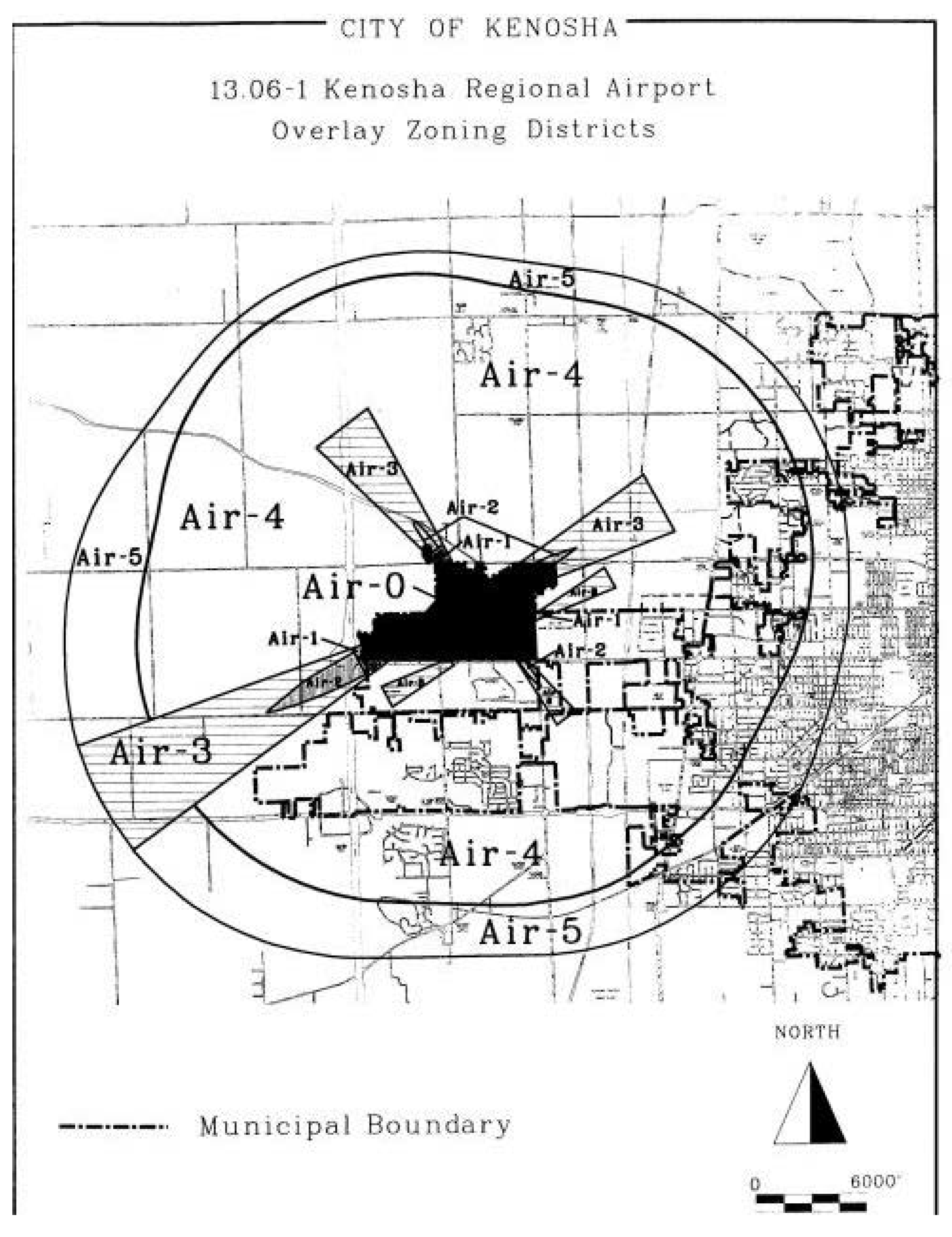
APPENDIX 13.06-1
KENOSHA REGIONAL AIRPORT OVERLAY ZONING DISTRICTS
APPENDIX 13.06-2
AIRPORT HEIGHT LIMITATION ZONING MAP