
Kenosha City Zoning Code
SECTION 14
0.- SITE PLAN REVIEW
14.01.- Purpose and Application.
The purpose of this Section is to provide a process to review and approve Site Plans for land uses which are subject to a Building and/or Conditional Use Permit.
This Section does not apply to one- and two-family residential units. This Section does apply to the new construction or erection of any building or structure, to any addition to a building or structure, to any exterior building alteration, or to any site changes or modifications, including, but not limited to, site paving.
14.02. - Site Plan Review and Other Permits Required.
A.
Site Plan Review. A review of a Site Plan which is subject to this Section is a condition precedent to the issuance of a Building, Conditional Use and/or Occupancy Permit being reviewed or issued.
B.
Other Permits Required. Certain land development and land uses may require permits other than a Building and/or Conditional Use Permit, such as, but not limited to:
1.
Erosion Control Permit, Chapter XXXIII, Code of General Ordinances.
2.
Tree Protection Permit, Section 34.10, Code of General Ordinances.
3.
Sign Erection Permit, Chapter XV, Code of General Ordinances.
4.
Move a Building Permit, Section 9.12, Code of General Ordinances.
5.
Raze a Building Permit, Section 9.11, Code of General Ordinances.
6.
Occupancy Permit, Section 8.04, Zoning Ordinance.
7.
Shoreland-Wetlands Permit, Section 8.05, Zoning Ordinance.
8.
Airport Protection Site Plan Review, Section 13, Zoning Ordinance.
9.
Public Right-of-Way Work Permit, Section 5.04, Code of General Ordinances.
10.
Sidewalk and Driveway Approach Permit, Sections 5.05, 5.08 and 5.085, Code of General Ordinances.
11.
Swimming Pool and Hot Tub Permit, Section 9.22, Code of General Ordinances.
12.
Water and Sanitary Sewerage Connection Permit, Section 32.05, Code of General Ordinances.
13.
Parking Facilities Permit, Section 5.08, Code of General Ordinances.
14.
Licenses to operate particular business as required by Chapters III, IV, X, XII, XIII and XIV of the Code of General Ordinances.
15.
Such other licenses, approvals and permits as are, or in the future may be, required by the Zoning and Code of General Ordinances.
14.03. - Review Authority.
The Permit Review Authority shall be the Director of the Department of City Development, which shall have authority to approve or reject Site Plans or approve with modifications.
14.04. - Application for Site Plan Review.
Applications for Site Plan Review may be obtained from and shall be filed with the Department of City Development. The application shall be made on City forms, which are fully, accurately and legibly completed, and which include mandatory submittals and such optional submittals as are required by the Review Authority in an electronic format acceptable to the Department of City Development. The Site Plan Review Fee therefor, established by the Common Council, from time to time, by Resolution, shall be paid at the time of application. However, any applicant who has paid a Site Plan Review or Conditional Use Permit Fee is exempt from the payment of such fee for an Airport Protection Site Review. The fee shall be determined by locating both the size of the building or addition and the gross acreage of the site in the table. If the building size or addition and the gross acreage of the site determine two (2) different fees, the greater of the two (2) fees shall determine the cost. The application fee entitles the applicant to two (2) permitted reviews: one (1) initial review and one (1) resubmittal. All further resubmittals submitted after the two permitted reviews will be conducted upon payment of a resubmittal fee therefor, established by the Common Council, from time to time, by Resolution.
(Ord. No. 49-24, § 4, 12-2-2024)
14.05. - Amendments.
Any change to an approved Site Plan shall require the submission of revised plans, payment of the fee therefor established by the Common Council, from time to time, by Resolution, and approval by the Review Authority.
14.06. - Application Forms and Submittals.
A.
Written Application. Every applicant for a Site Plan Review shall complete an application containing the following information:
1.
Name, address and phone number of the applicant.
2.
If the applicant is not the owner of the property in question:
a.
the name, address and phone number of the owner;
b.
the interest of the applicant in subject property; and
c.
written consent by the owner to the filing of the application.
3.
Date of the application.
4.
Identification of the property in question by street address and by parcel number. If there is no street address, the applicant must provide a description of the location of the property in relation to surrounding streets and properties.
5.
Description of the nature of the proposed development or redevelopment, and the proposed land use(s), including accessory uses.
6.
Certifications from the appropriate agencies that proposed utility systems are or will be adequate to handle the proposed development, and that all necessary rights-of-way or easements have been provided.
7.
Time schedules for the completion of phases in staged development.
B.
Conditional Uses. Where the Site Plan Review is for a conditional use, the additional submittals required for a Conditional Use Permit application shall be included, in addition to the Development Plans herein required.
C.
Development Plans. The following plans as identified in Section 4.0 must be submitted for review, whether or not the use is a conditional use:
1.
Building Plan.
2.
Site Plan.
3.
Landscape Plan.
4.
Utility Plan.
5.
Drainage Plan.
6.
Operational Plan in conformance with Section 4.03.A.3.
Two (2) or more plans may be combined, but in no case shall the combined plan fail to show any of the items required for each individual plan. For example, site plans and landscape plans may be suitable for combination.
D.
General Requirements. All building plans, site plans, drainage plans, landscape plans, utility plans, elevations, and sections shall be drawn to such a scale that all features required to be shown on the plans are readily discernible. Building floor plans and elevations may be drawn to an architect's scale, all other plans shall use an engineering scale. For site, drainage, landscape, and utility plans (as differentiated from elevations and sections), the scale used shall be the same for each plan, which shall be no smaller than one (1) inch equals fifty (50) feet, except that for properties with unusual characteristics, the Director of the Department of City Development may waive this requirement.
The following shall be shown on each plan, elevation, or section:
1.
The name of the applicant.
2.
The name and location of the development, and the title of the plan; e.g., "Site Plan," "Landscape Plan."
3.
Scale and north arrow.
4.
The date of the original plan and the date(s) of any revisions.
5.
The license number, seal, and signature of any professionals involved in the preparation of the plans.
E.
Optional Submittals. Whenever it is determined by the Review Authority that the characteristics of the proposed development require additional information or documentation to permit a comprehensive review, such information or documentation shall be provided by the applicant after receiving a written request from the Review Authority. The following is a representative, but not exclusive, list of the optional submittals that may be requested:
1.
Traffic Impact Statement which analyzes adjoining street capacity and current volumes, trip generation rates expected for the development, and expected increase or decrease in volumes on adjoining streets and impacted arterials. The traffic impact statement shall identify the size, location, and characteristics of roadway or traffic control improvements necessitated by the proposed development to maintain existing levels of service on public thoroughfares. The analysis shall identify the impact of the development on pedestrian or vehicular safety and congestion. The impact analysis shall be required when the total floor space of the development on a single parcel or contiguous parcels totals one hundred thousand (100,000) square feet or more.
2.
Environmental Impact Statement, including its effect on historically significant or ecologically fragile wetlands, floodplains, streams, lakes, woodlands, etc.
3.
Photometric plot of the illuminating effect of all exterior lighting fixtures on the site and adjacent property and rights-of-way.
4.
Description of any unusual characteristics of the site which might affect surrounding development.
5.
Drainage calculations.
6.
Street perspectives showing view corridors.
7.
Legal documentation establishing homeowners associations or other legal entities, responsible for control over required common areas and facilities.
8.
Historic Site or Historic District Impact Statement.
F.
Preliminary Review. The applicant shall meet with Department of City Development staff prior to submitting an application to review the application requirements and review process and to determine whether any optional submittals will be required.
G.
Notifications. Site Plan Reviews. The alderman of the aldermanic district in which a site is planned for development shall receive a copy of the application from the Department of City Development.
H.
Department of City Development and City Department Review. The Department of City Development will forward copies of the plans and applications to relevant City departments for review. The Department of City Development and City departments will review the plans using the Development Standards of this Section. The Departmental review shall be completed no later than twenty (20) working days following the receipt of a complete application, excluding the day the application was received. The Department of City Development shall advise the applicant, in writing, of the department comments, recommendations, approvals or disapprovals within forty (40) days of the receipt of a complete application.
I.
Review Authority Decision. The Review Authority will review the application and shall either approve or deny the application, or approve with conditions based upon the standards of this Section and the comments of relevant departments.
A copy of the decision of the Review Authority shall be mailed to the applicant.
J.
Permits. No building or construction or Site Work Permits shall be issued by the Director of Department of City Inspections until the Review Authority has reviewed and approved the Site Plan.
Footing and Foundation Permits may only be granted if each of the following conditions are met:
1.
The Review Authority has granted conditional approval with respect to such work, after receiving the written recommendation of reviewing agencies.
Within ten (10) working days of receipt of the permit information, the review agencies will recommend, via a transmittal form, whether a Footing and Foundation Permit should be issued prior to formal Site Plan approval. If one (1) or more reviewing agency recommends that the Footing and Foundation Permit should not be granted, and the applicant still desires the permit, then within five (5) working days a representative from each reviewing agency will meet and delineate the requirements that must be fulfilled prior to the issuance of a permit. If agreement is not reached, a Footing and Foundation Permit shall not be issued. Permits may be withheld in order to protect the public safety and welfare of the community, or if in the opinion of the reviewing agency, there is a need for additional information.
2.
Footing and Foundation Permit approval shall be subject to a specific timetable which specifies project completion dates which must be met.
K.
Appeals. Any petitioner/applicant objecting to any decision of Review Authority—Department of City Development—DCD related to Site Plan Review may appeal the decision to the City Plan Commission. Any petitioner/applicant objecting to any decision of Review Authority—City Plan Commission—CPC related to Site Plan Review may appeal the decision to the Common Council. Such appeals shall be filed, accompanied by the fee therefor established by the Common Council, from time to time, by Resolution, with the City Clerk/Treasurer within thirty (30) days of the decision with the Department of City Development or City Plan Commission.
The City Plan Commission or Common Council shall hold a hearing of an appeal within forty-five (45) days of the filing of the appeal. The City Plan Commission or Common Council shall notify the appellant of the hearing by mail. At the hearing, the appellant shall appear in person or by agent or attorney
L.
Expiration of Site Plan Review Approvals for Failure to Timely Obtain a Construction Permit or Obtain an Occupancy Permit.
1.
Site Plan Review with a Single Building or Use. Either the first required Construction Permit, or in the event that no Construction Permit is required, the Occupancy Permit, must be obtained within twelve (12) months of the date of approval of the Site Plan Review by the Review Authority. The twelve-month period from Site Plan Review approval may be extended by the Review Authority once for up to an additional twelve (12) months. This provision does not apply to planned developments which are governed by the revocation procedure outlined in Section 3.22 of this Ordinance.
2.
Site Plan Review with Multiple Buildings. The first required Construction Permit must be obtained within twelve (12) months of the date of Site Plan Review approval by the Review Authority. Required Construction Permits shall be obtained for all remaining buildings within twenty-four (24) months of the date of the Site Plan Review approval by the Review Authority, or within an extension of the twenty-four-month period from approval by the Review Authority. Only one (1) extension of the twenty-four-month period from approval may be granted, and such extension may not exceed an additional twelve (12) months.
3.
Expiration. If neither a first required Construction Permit nor an Occupancy Permit has been issued within the time periods required in this paragraph 14.06.L., the Site Plan Review approval expires.
M.
Conditions to Run with the Land. Any conditions applied to an approved Site Plan Review shall run with the land and be binding upon the owner/occupier of the land and upon any subsequent successor owners and occupiers of the land. All conditions applied shall be maintained indefinitely by the property owner/occupier unless and until otherwise approved by the review authority.
(Ord. No. 49-24, §§ 5, 6, 12-2-2024)
14.07. - Development Standards.
To establish and define criteria for the review process set forth in this Ordinance, the following Development Standards for all uses requiring Site Plan Review are created.
A.
General Provisions.
1.
The development standards provided herein are minimum standards and additional standards or conditions may be required for individual developments when the circumstances warrant.
2.
Should the development standards conflict with any other provision of the Ordinance, the most restrictive provision shall apply.
3.
The Development Plans shall serve as the review documents which the Review Authority will use in the analysis of the application for Site Plan Review.
B.
Building Plans. Building Plans shall show and include:
1.
Design and Architecture of Buildings. Elevation shall be provided and dimensioned. Plans shall be drawn to sufficient detail so that all room sizes, wall openings, building projections and locations of all exterior HVAC and utility services equipment can be identified.
2.
Materials and colors of exterior surfaces such as walls, roofs, and window trim shall be indicated.
3.
Details on fire detection, fire alarm and other safety devices, including fire suppression, sprinkler, standpipe, and restaurant hood suppression systems shall be provided for review and be approved by the Kenosha Fire Department.
4.
Building size and scale should reflect the physical scale of the surrounding area and the scale of surrounding buildings.
5.
The location and orientation of building elements, such as balconies or porches, should reflect the orientation of surrounding buildings and structures.
6.
Rooms used for residential purposes shall provide adequate living area, as required in the Minimum Housing Code of the Code of General Ordinances.
7.
The materials and design of buildings, structures and additions should complement the surrounding area.
8.
Building design shall be in compliance with the Americans With Disability Act.
9.
Building address shall be clearly displayed on building.
10.
Commercially and institutionally used buildings authorized to be constructed within the City shall conform with the design guidelines hereinafter set forth:
a.
Building faces of all commercially and institutionally used principal buildings shall be constructed primarily of architectural masonry, wood, glass or a combination of these materials. The previous sentence notwithstanding, architectural metal panels may be used as a secondary material on a face of a principal building, if the percentage of the face covered by the architectural metal panels is less than the percentage of the face covered by at least one (1) of the materials identified in the previous sentence, and also if such use is pursuant to plans approved by the Review Authority illustrating the design in a manner such that the relative percentages of material used for the face may be determined. Subject to design requirements of other ordinance sections, building faces of all commercially and institutionally used accessory buildings must be constructed of architectural masonry, wood, glass, architectural metal panels or a combination of these materials in any proportion. Ribbed or corrugated metal siding shall not be permitted on any building face. Smooth face concrete blocks shall not be permitted on any building face, except when used for accent banding, which shall not be wider than three (3) adjacent courses and not more than six (6) courses on any building face. Exterior Insulated Finish Systems (EIFS) shall only be allowed on the first floor of any building as an accent material above a window, entrance or other similar architectural feature. Exterior Insulated Finish Systems shall be allowed as a primary material above the first floor.
b.
Split-faced or decorative concrete block shall not be painted or stained after installation without the approval of the Review Authority.
c.
Articulation on the rooflines shall be provided by using a pitched roof, a partial roof or parapet walls with a minimum height difference of two (2) feet.
d.
Rooftop mechanicals shall be concealed in order to prevent their visibility from grade level as measured from the lot lines and abutting street rights-of-way. Rooftop mechanical screening shall be compatible with the design, color and materials of the building(s).
e.
Materials and colors of buildings within a Unified Business District or Large Scale Commercial Development shall be consistent among all building(s).
f.
Articulation of building façades shall comply with the following design standards:
(1)
Recesses and/or projections shall comprise at least twenty (20) percent of each façade length, with articulation as deemed acceptable by the Review Authority such as false windows or articulation of materials. In no event shall an uninterrupted façade extend more than one hundred (100) feet.
(2)
Windows, awnings, arcades or similar architectural elements deemed acceptable by the Review Authority shall total at least sixty (60) percent of each façade length which faces a public street or private street.
(3)
The principal entrance to a commercial, office or institutional building in the B-4 District shall be required to have:
(a)
Ornamentation around the door; and
(b)
At least one (1) of the following: recessed entrance (recessed at least three (3) feet); protruding entrance (protruding at least three (3) feet); canopy (extending at least five (5) feet); portico (extending at least five (5) feet); or an overhang (extending at least five (5) feet).
g.
Metal roofs and/or awnings shall only be permitted when the roofing material meets the minimum standards of the International Building Code.
11.
Multifamily buildings authorized to be constructed within the City shall conform with the exterior building variation guidelines hereinafter set forth:
a.
Exterior building variation is required on multifamily buildings that contain eight (8) or more units. One-quarter (¼) of units within the building shall differ from the other units by symmetrically changing the location, pattern or form of at least two (2) of the following architectural elements:
(1)
Balconies, porches or verandas;
(2)
Window type and fenestration;
(3)
Roof pitch or design;
(4)
Exterior materials;
(5)
Height;
(6)
Change in material and/or color in a vertical bay;
(7)
Other exterior building modifications approved by the Review Authority.
b.
Each building in a multifamily development that consists of two (2) or more buildings shall differ from each adjacent and facing building by using at least two (2) of the following criteria:
(1)
Shifted building orientations of at least forty-five (45) degrees between buildings;
(2)
Façade width, height, and symmetry;
(3)
Roof pitch or design;
(4)
Total number, type, or symmetrical location of doors, windows, or architectural properties and the exterior building materials;
(5)
Architectural relief of buildings; i.e., dormers, porches;
(6)
Change in material and/or color in a vertical bay;
(7)
Other exterior building modifications approved by the Review Authority.
c.
Front facing attached garage entrance doors on multifamily buildings shall be no closer to the lot line than the façade of the principal building. This requirement applies to elevations that are abutting a public street or private street.
d.
Detached garages of multifamily buildings shall be constructed entirely of architectural masonry. The materials on the detached garages shall be compatible with the materials used on the primary buildings.
e.
Building faces of all multifamily buildings shall be constructed entirely of architectural masonry and/or glass. The previous sentence notwithstanding, architectural metal panels with concealed fasteners may be used as a tertiary material on a face of a multifamily building, if the percentage of the face covered by the architectural metal panels is less than the percentage of the face covered by architectural masonry and is less than the percentage of the face covered by glass, if such use is pursuant to plans approved by the Review Authority illustrating the design in a manner such that the relative percentages of material used for the face may be determined. Architectural metal panels shall only be allowed on the first floor of any building as an accent material above a window, entrance or other similar architectural feature.
12.
Industrial buildings authorized to be constructed within the City shall conform with the design guidelines hereinafter set forth:
a.
Building exteriors of all new industrial buildings shall be constructed entirely of architectural masonry, Exterior Insulated Finish System, architectural composite aluminum or steel panels, glass, or any combination of these materials. Other decorative and textured materials may also be used to meet these requirements when authorized by the City Plan Commission. Aviation related buildings located at the Kenosha Regional Airport are exempt from these requirements.
b.
Additions to industrial buildings shall be constructed entirely with materials that are comparable with the materials of the existing building. On an existing industrial building that does not have architectural masonry, Exterior Insulated Finish System, architectural composite aluminum or steel panels, glass, or any combination of these materials on a minimum of two-thirds (⅔) of the exterior of any side which abuts a public street or residential district, building additions shall comply with the following requirements:
(1)
Any addition to an existing building which creates an exterior side which abuts a public street or a residential district shall consist of architectural masonry, Exterior Insulated Finish System, architectural composite aluminum or steel panels, glass, or any combination of these materials on a minimum of the lower two-thirds (⅔) of the building exterior sides of both the addition and existing building which abuts a public street or a residential district. Exceptions to the two-thirds (⅔) requirement for any existing building exterior side which abuts a public street or residential district that has less than two-thirds (⅔), but at least one-third (⅓) architectural masonry, Exterior Insulated Finish System, architectural composite aluminum or steel panels, glass or any combination of these materials, may be granted when so authorized by the City Plan Commission.
(2)
Any additions to existing buildings which are subject to the requirements of Paragraph 12.b.(1) above, and have an exterior side which abuts an interior side lot line and is adjacent to the front exterior shall be constructed with architectural masonry, Exterior Insulated Finish System, architectural composite aluminum or steel panels, glass, or any combination of these materials on the lower two-thirds (⅔) of the building exterior for a minimum of twenty (20) feet from the building front or to a natural dividing point approved by the City Plan Department. Exceptions to the twenty (20) foot requirement for any existing building exterior side which abuts an interior side lot line and is adjacent to the front exterior that has less than two-thirds (⅔), but at least one-third (⅓) architectural masonry, Exterior Insulated Finish System, architectural composite aluminum or steel panels, glass or any combination of these materials on the front twenty (20) feet may be granted when so authorized by the City Plan Commission.
C.
Site Plans. Site Plans shall show and include:
1.
Dimensions of the development site, indicated along the property line. Distances to all buildings, structures and freestanding signs, on adjoining properties and building setbacks shall be indicated.
2.
The location, footprint and outside dimensions of buildings, structures, and freestanding signs.
3.
Existing and proposed pedestrian and vehicular access points, streets, drives, alleys, bicycle paths, bridges, intersections, and other pedestrian and vehicular circulation elements, labeled with street names, dimensioned in feet and tenth and hundredths, and with surface materials identified; i.e., asphalt, sod, etc.
4.
Vehicle accommodation areas (including parking areas, loading areas, and circulation areas), with the surface material identified and showing the layout of parking spaces and direction of travel lanes, aisles, or driveways.
5.
Front, side, and rear yards, labeled as such and dimensioned.
6.
Location and dimensions of all existing or planned easements, lands subject to deed restrictions or protective covenants, rights-of-way, and required emergency accessways.
7.
Identification of all land to be dedicated or reserved for public use, with the use named.
8.
The location, elevation and dimensions of walls and fences that are to be permanent improvements to the site or erected temporarily during construction.
9.
The location, elevation and dimensions of outdoor lighting fixtures, if any.
10.
With respect to construction of two hundred fifty thousand (250,000) square feet, or greater, of building development or expansion on a single parcel or contiguous group of parcels, a three-dimensional model or other depiction or color rendering of proposed buildings, the site, and its immediate vicinity. This model shall be at a minimum scale of one (1) inch equals fifty (50) feet. It shall show all proposed buildings, roads, vehicular and pedestrian circulation elements, parking lots or parking structures, existing vegetation to remain, proposed landscaping, and any other significant natural features.
11.
A legal description and certified survey of the property. Any easement, covenant or right-of-way, existing or planned, which creates site design constraints shall be indicated. Any design adjustments to these constraints shall not adversely impact the intent of these standards or the provisions of this ordinance. Location of any floodplain, wetland, and shoreland boundary shall be shown.
12.
The location, proportion, and orientation of buildings or structures should compliment the location, proportion and orientation of surrounding land forms, buildings or structures.
13.
Surrounding Land Uses and Respective Zoning Classifications. The Review Authority shall consider the impact of the proposed development on the comprehensive plan, any neighborhood plan, and the Official Zoning Map, as amended. The Review Authority shall use the following criteria when assessing the development's impact on surrounding land uses: the development shall be consistent with the objectives of the comprehensive plan, and any relevant neighborhood plan, the development shall be compatible with the character and objectives of the zoning district or districts within which it is located, and the development shall be compatible with the character of the neighborhood which surrounds the development.
14.
Site access governed by the following criteria:
a.
Site entrance drive dimensions such as widths, radii and visibility triangles.
b.
Development shall provide the least number of ingress/egress points along a street necessary for safe and efficient traffic flow. A minimum separation of three hundred (300) linear feet of street frontage shall be required, except that each development or parcel shall be allowed at least one (1) ingress/egress location, or access via cross access easements, through adjoining property. The location of all access points shall be determined by the Review Authority.
c.
Individual development vehicular entrances shall be at least one hundred twenty-five (125) feet apart.
d.
Vehicular entrances shall follow the recommended safety guidelines established by the Wisconsin Department of Transportation.
e.
An adequate internal stacking distance, as deemed to be safe by the City Traffic Engineer, shall be provided from the property line at each entrance.
f.
Appropriate traffic control measures including signs, crosswalks, etc. shall be utilized at all entrances to public rights-of-way.
g.
Adjacent development shall share a common entrance drive, where possible.
h.
Access to adjoining sites shall be coordinated, where possible.
(1)
At least one (1) vehicular and pedestrian access point to each adjoining site shall be granted by cross easements.
(2)
Cross access easements should not occur within interior lawn parks.
(3)
Cross access easements shall be a minimum of thirty (30) feet wide.
(4)
Cross access easements are encouraged behind buildings to encourage linked rear parking areas.
(a)
Vehicular access to any nonresidential structure, use, parking or loading facility shall not be gained across land zoned for a residential use, except where authorized by the Review Authority, with due consideration to special circumstances.
15.
Parking Lots and Parking Structures. This Section sets forth standards for the design of parking areas in a manner that will reduce the negative visual impacts of large expanses of impervious surface while maintaining maximum safety standards. In addition to these standards, parking lot layout shall conform with Section 5.08 of the Code of General Ordinances, "Parking Facilities."
a.
Layout.
(1)
Building entrances shall be accessible from adjacent parking areas by means of a minimum five-foot wide paved walkway, as shown on Figure 1.
(2)
Parking adjacent to the front of buildings, except within the B-3 districts, shall maintain a seven-foot separation from the building to accommodate pedestrian circulation.
b.
Parking Lot Design.
(1)
Parking lots shall be designed and constructed in accordance with Section 5.08 of the Code of General Ordinances, "Parking Facilities."
(2)
Parking lots shall be paved with asphaltic concrete or Portland cement concrete.
16.
Traffic Circulation. Clear and identifiable patterns of circulation are critical to minimizing potentially dangerous conflicts between pedestrian, automobile, and truck traffic. The intent of this Section is to establish standards which create a separation of noncompatible traffic, and create patterns that are clearly oriented to the needs of each, to minimize conflict.
a.
Pedestrian Access.
(1)
There shall be a minimum of a five-foot wide paved walkway provided to each building entrance from parking areas and from public sidewalks.
(2)
Pedestrian walkways shall be provided for access to adjacent properties and be handicap accessible.
(3)
Drainage improvements shall not pass over pedestrian walks.
(4)
Pedestrian walks shall not exceed a longitudinal slope of five (5) percent or a side slope of three (3) percent as measured over a ten-foot interval.
b.
Traffic Circulation Lanes.
(1)
Internal circulation lanes shall be no closer to the right-of-way than the minimum required stacking distance at the site driveway exit/entry as required by the City Traffic Engineer.
(2)
Site cross-access lanes shall be provided. Cross access lanes should be a minimum of twenty-four (24) feet wide.
(3)
Traffic lanes shall be clearly separated from parking and pedestrian areas through the use of landscaped islands, barrier curbs, or lane striping.
(4)
Vision clearance as specified in Section 2.06 of the Zoning Ordinance shall be utilized within parking areas as deemed necessary by the Administrator.
(5)
Truck traffic should be routed directly to service area without passing through parking or pedestrian areas.
(6)
Service truck parking should only be allowed within designated service areas.
(7)
Unless otherwise exempt by the Chief of Kenosha Fire Department, all circulation lanes adjoining the perimeter of buildings shall be designated as fire lanes.
17.
Protection of Natural Features.
a.
Preservation. All new development shall preserve, enhance, or protect existing natural features. The Site Plan or accompanying documents shall evidence the means by which the development addresses the following:
(1)
Minimize disruption of existing natural features, and wherever possible, incorporating them into the overall design.
(2)
Prior to development, protecting all natural elements from damage due to construction activities.
(3)
Comply with Chapter XXXIII of the Code of General Ordinances, entitled "Erosion Control."
(4)
Comply with Section 34.10 of the Code of General Ordinances, entitled "Tree Protection."
b.
Open Space. The following specific areas shall be preserved as undeveloped open space:
(1)
Wetlands as described in Section 404 Federal Water Pollution Control Act Amendments of 1972 and delineated on the Wisconsin Department of Natural Resources Wetland Inventory Map, verified by on-site inspection by a qualified wetlands consultant.
(2)
Lands in a designated floodway or floodplain. Lands within a floodplain may be used for parking and recreational uses provided all required permits are obtained.
(3)
Steep slopes in excess of twenty (20) percent as measured over a ten-foot interval, unless appropriate engineering measures are taken.
(4)
Habitats of endangered wildlife or vegetation as identified by the Federal and/or Wisconsin Department of Natural Resources.
18.
Multifamily Development Entranceways, Landscaped Islands and Parking Lots. Entranceways, landscaped islands and parking lots that abut a public street shall be curbed in multifamily developments between the first building and right-of-way line.
D.
Utility Plans. Utility Plans shall show and include:
1.
Location and dimensions, in length and diameter where applicable, of all aboveground and underground conduits and utility lines: storm and sanitary sewers, water mains, electrical, natural gas, and communication (cable television, telephone, etc.) lines.
2.
Location of all utility connections and metering facilities, including fire hydrants, Fire Department connections, existing wells, pumping stations and lift stations.
3.
Road and paving cross-sections and details.
4.
Location and footprint of any and all buildings and structures, in outline.
5.
Locations and names of existing and proposed streets and intersections, and the location of parking lots, sidewalks, and bike paths, and other elements of vehicular and pedestrian circulation.
6.
Plumbing plans showing in detail, the size and location of all water meters.
7.
Storm sewer, sanitary sewer, and water utility systems, as outlined in the Utility Plan, shall meet the requirements of Chapter V and Chapter XXXII of the Code of General Ordinances. These provisions may require the designation of easements providing access for public utility purposes.
8.
Electric, gas and telephone utility systems, as designated on the Utility Plan, shall meet the requirements of the respective utility company's rules and regulations.
9.
Cable television systems, as designated on the Utility Plan, shall meet the requirements of Chapter XXVI, "Cable TV," of the Code of General Ordinances.
10.
Utility systems shall be placed in accordance with City Ordinances and utility companies' rules and regulations. The Review Authority may require the underground installation of lines and distribution points, the elimination of poles and overhead lines, or the simultaneous organization and installation of utility systems.
11.
Exterior lighting is intended to promote a safe and attractive character throughout Kenosha without creating a nuisance to adjacent properties. All exterior lighting shall comply with the following standards:
a.
Light fixtures shall be selected with care to ensure that they are appropriately scaled in relation to their setting and to ensure that they are of a style that is compatible with the character of their immediate environment.
b.
Luminaries shall be aimed, shielded, or relocated so as to minimize glare.
c.
The maximum allowable light spillover to an adjacent residential property shall be 0.5 foot candles measured at the property line, four (4) feet above grade; for all other types of land uses, the maximum allowable light spillover shall be 0.75 average foot candles, measured in the same manner.
d.
Lighting levels shall be measured in foot candles with a direct-reading, portable light meter. The meter sensor shall be mounted not more than four (4) feet above the ground line in a horizontal position. Readings shall be taken only after the cell has been exposed long enough to provide a constant reading. Measurements shall be made after dark with the light sources in question on, then with the same sources off. The difference between the two (2) readings shall be compared to the maximum permitted illumination.
e.
All lighting wires/cables shall be placed underground.
f.
Accent lighting should be used to highlight architectural and landscape design elements when appropriate.
g.
At the time any exterior lighting is installed or substantially modified, an exterior lighting plan shall be submitted to the Department of City Development and Traffic Engineer in order to determine whether the requirements of this Section have been met.
h.
Illumination of uses shall meet the minimum standards of Illuminating Engineering Society of North America (IES).
i.
Pedestrian walkways and parking areas shall be illuminated to a sufficient level so as to provide for security.
E.
Drainage Plan. Drainage Plan shall show and include:
1.
Existing topography by contours related to USGS survey datum or other datum approved by the City Engineer. The contour interval shall be not greater than two (2) feet (a one-foot interval is recommended) and shall extend at least twenty (20) feet beyond the site. The City Engineer may require site elevations beyond twenty (20) feet of the site. Spot elevations of existing buildings, structures, high points, and wet areas or flood elevations shall be shown.
2.
Floodplain, shoreland, environmental corridors, and wetland boundaries, if applicable.
3.
Soil characteristics.
4.
The location, capacity, and dimensions of on-site storm water drainage facilities, including manholes, pipes, curbs, gutters, curb inlets, curb cuts, and drainage grates and design calculators shall be provided.
5.
Location, extent, and typical cross sections and slope ratios of all storm water retention and detention areas and drainageways. Location and elevations at top and bottom of proposed retaining walls.
6.
The location and footprint of any and all buildings and structures.
7.
The locations and names of existing and proposed streets and intersections, and the location of parking lots, sidewalks, bike paths, and other elements of vehicular and pedestrian circulation.
8.
All development shall comply with the City's Land Division and Zoning Ordinance requirements for storm water retention and detention. Storm water retention and detention basins, including underground retention and detention basins, shall be constructed and operational prior to the issuance of a Footings and Foundation Permit. Underground storm water retention and detention basis shall only be allowed upon approval and recording of a Storm Water Maintenance Agreement.
9.
Erosion control measures shall be exercised during construction to prevent unnecessary soil erosion from steep slopes, drainageways and topsoil stock piles as required by Chapter XXXIII of the Code of General Ordinances, "Construction Site Maintenance Erosion Control." Erosion control measures shall be identified on the site plan or in supporting documents.
10.
A topographic analysis by the review authority shall consider: contours, elevations, and slopes; spot elevations of existing buildings and structures; spot elevations of rock outcroppings, high points, water courses, depressions, ponds, and marsh areas, with any previous flood elevations; floodplain boundaries, if applicable; and test pits or borings if required to determine subsoil conditions.
11.
The Review Authority shall analyze the Drainage Plan to assure that the following conditions are met:
a.
Surface water runoff on the site shall be absorbed or retained on the site so that the rate of flow of surface water leaving the site would not be greater than if the site had remained undeveloped.
b.
Surface water from the site shall be discharged to a City storm sewer or ditch, where available and of sufficient capacity to handle the flow.
c.
Surface water flow may be directed onto adjoining private property only under the following circumstances:
(1)
The surface water follows a predevelopment drainage course.
(2)
The property owner of the site being developed executes an Indemnity and Hold Harmless Agreement with the City, drafted by the City Attorney.
(3)
Private drainage tiles may be connected to those on adjacent property only with the written permission of said property owner.
d.
Nonresidential uses and all parking areas shall not discharge surface water onto any property zoned residential unless such drainage is approved by the City Engineer.
e.
All floodland developments shall be elevated or floodproofed to an elevation at least two (2) feet above the elevation of the one hundred-year recurrence interval flood.
f.
Floodland developments shall not increase flood stages and flood discharges beyond the limits set forth in Sections 3.20 and 3.21 of this Ordinance.
12.
The Review Authority may require site grading:
a.
To create drainage swales.
b.
To create berms as noise, wind, or visual barriers.
c.
To correct undesirable landforms.
d.
To raise the ground level above unfavorable subgrade conditions such as groundwater.
e.
To create, emphasize or control circulation routes such as paths or roads.
f.
To relate the site to the surrounding area.
g.
To prevent erosion and sedimentation.
h.
To provide storm water retention or detention basins for development of five (5) acres or more when such basins or other retention means are required to retain and limit any surface water runoff to its original rate of flow and point of discharge prior to development.
F.
Landscape Plans. Landscape Plans shall show and indicate:
1.
The location and footprint of any and all buildings and structures.
2.
Dimensions of development site, indicated along the property line.
3.
Existing and proposed streets, drives, sidewalks, alleys and intersections, pedestrian and vehicular access points, bicycle paths, bridges, and other pedestrian and vehicular circulation elements, labeled with street names and dimensioned. Surface materials shall also be identified.
4.
Location and dimensions of parking lots, parking spaces, and parking lot accessways.
5.
Location and dimensions of all existing or planned easements, lands subject to covenant, lands to be dedicated or devoted to public use, and rights-of-way.
6.
The location and dimensions of snow removal and storage areas.
7.
The location and dimensions of outdoor lighting fixtures, freestanding signs, permanent or temporary walls and fences, waste and trash disposal facilities, surface utility structures, and other freestanding structural features.
8.
The location and dimensions of playgrounds, tot lots, and other recreational facilities.
9.
Details of all permanent fences and walls to be constructed on the site, including dimensioned elevations and materials schedules.
10.
Existing and proposed contours and grades, including the location, slope ratios (horizontal to vertical), of all proposed berming, at a one-foot contour interval. Location, extent, and general elevations and slope ratios of all surface water retention and detention areas and drainageways. Elevations at top and bottom of all proposed retaining and screening walls and fences. Existing lines should be shown as dotted lines.
11.
All plants shall only be labeled or identified on the plan as either a coniferous or deciduous plant. The location, quantity, installation size, and distance between plants shall be identified.
12.
Specification of the type and boundaries of all proposed ground cover, including both scientific and common names of all proposed plant materials.
13.
The location of paving materials and non-living ground cover which is identified by description and brand names.
14.
Location, species, and size of all existing trees that are three (3) inches or larger in diameter, measured fifty-four (54) inches above natural grade. Any trees to be removed should be clearly identified. Trees measuring three (3) inches or greater which will be used to meet landscape requirements shall also be indicated. If required for reasons of clarity, this information may be depicted as a supplemental illustration.
15.
Tree line of wooded areas.
16.
Orchards or other agricultural groves by common or scientific name.
17.
A Landscape Improvement Table with the following information:
a.
Square footage of parking lot area.
b.
Square footage, and percentage of interior parking lot landscape area expressed as a ratio to total parking lot area.
c.
Number of trees provided for parking lot interior.
d.
Plant quantities provided for buffer strips and medians.
e.
Square footage of interior open spaces.
f.
Number of trees on interior open spaces.
18.
Proposed location of all utilities on the site; i.e., gas, water, sewer, cable, irrigation, drainage, etc.
19.
Compliance with Section 4.06 of the Zoning Ordinance, entitled "Landscape Standards" and Section 34.10 of the Code of General Ordinances, entitled "Tree Protection."
20.
Plan should identify how plantings and buffer area will be maintained including location of any irrigation systems.
21.
Recommended Trees, Shrubs and Ground Cover. Species and/or varieties of trees, shrubs and ground cover shall be those recommended by the City Forester or the most recent version of "A Guide To Selecting Landscape Plants For Wisconsin," by E.R. Hasselkus.
The following criteria shall also govern selection:
a.
Size in relation to proximity to buildings, utilities, entrances, pedestrian walkways, roads and other improvements.
b.
Species in relation to plant hardiness (Zones 5 through 2), disease or insect resistance, and low maintenance.
14.08. - Site Landscape Standards.
A.
Intent. The following landscape standards shall be established as part of the Landscape Plan to ensure that:
1.
Neighboring properties are shielded from subject site uses.
2.
Subject site is shielded from the negative impacts of adjacent uses, including streets or railroads.
3.
The appearance and desirability of the development contributes to the overall attractiveness and health, safety and welfare of the City.
B.
General Requirements. The following shall establish the standards for the preparation and submission of required plans for landscape and screening.
1.
Landscape Plan Required. A Landscape Plan shall be required for all projects requiring Site Plan Review.
2.
Content of Landscape Plan. At a minimum, all Landscape Plans shall include or have attached thereto the information required in Section 14.07.F. of the Zoning Ordinance.
3.
Tree Protection Plan shall show existing trees, trees to be removed, and indicate how existing trees will be protected on the site.
C.
Timing of Landscape Improvements. All required landscaping shall be installed prior to the issuance of a Certificate of Occupancy. However, a temporary Certificate of Occupancy may be issued if weather conditions prevent installation of all or portions of the landscape materials, provided the developer enters into a written agreement which sets forth the date at which time all landscaping is to be completed and deposits with the City Clerk/Treasurer a cash bond, letter of credit or other "assurance" as approved by the City Attorney, for the completion of all landscaping. The amount of the assurance, as determined by the City Forester, shall reasonably compensate the City for its cost of completion of any landscaping improvements not completed by the agreed date.
D.
Landscape Open Space. All open space or open areas required by the yard requirements of the zoning district or as required for storm water control or other purposes in the Site Development Standards shall be landscaped in accordance with the standards set forth in this Section. Unless otherwise identified, all development shall contain a minimum of fifteen (15) percent of the site in landscaped open space, including interior lawn parks, buffer strips, parking lot landscaping, and site interior landscaping.
E.
Flexibility in the Administration of Required Landscape Standards.
1.
To meet the objectives of this Section, the following landscape requirements are hereby established. These standards provide specific requirements for site landscaping. However, the City recognizes that, because of the wide variety of types of developments and sites and the relationships between them, it is neither possible nor prudent to establish inflexible landscaping requirements. Therefore, the City may either require more intensive or allow less intensive landscaping whenever it finds that such deviations will satisfy the intent set forth in this Section.
2.
Whenever the City allows or requires deviation from the requirements set forth in this Section, it shall enter on the face of the Landscape Plan the reasons for allowing or requiring deviation from the requirements of this Section.
F.
Types of Landscaped Areas. This Chapter regulates landscaping of five (5) distinct areas of the parcel being developed as follows:
1.
Interior Lawn Park. A landscaped open space directly abutting a public street right-of-way.
2.
Lawn Park. The unpaved portion of the public street right-of-way between a curb or curbline and sidewalk.
3.
Buffer Strip Area. A landscaped area intended to separate two (2) adjacent land uses or properties from one (1) another, and soften land use incompatibility.
4.
Parking Lot Landscaping. Landscaped area within or surrounding a parking area, used to soften the visual and environmental character of paved parking areas.
5.
Site Interior Landscaping. The open space area surrounding buildings intended to enhance building and site character excluding the interior lawn park, parking lot landscaping, and perimeter landscape area.
See Figure 2 which provides a graphic illustration of each area above described.
G.
Multiple Family Site Landscaping Requirements. The following landscape requirements apply to multifamily residential uses:
1.
Interior Lawn Park Landscaping. Interior lawn park landscaping is required of developments in order to screen vehicular parking which may be viewed from the public rights-of-way, as shown in Figure 3.
Interior lawn park landscape standards for multiple-family residential uses in all zones other than within the B-3 Central Business District are indicated in Table 1, except where vehicular site lines may be impaired.
Landscape screening as shown on Figure 4 shall consist of one (1) or a combination of the following along at least fifty (50) percent of the frontage.
a.
Masonry walls compatible with proposed building design and landscaped with foundation plantings.
b.
Screen fence of wood or approved material at least seventy-five (75) percent opaque and landscaped with foundation plantings.
c.
Planting screen, including earth berming, ornamental and evergreen trees, shrubs and groundcover.
2.
Lawn Park Landscaping. Lawn park landscaping is required of development in order to provide street tree plantings along public rights-of-way.
A minimum of one (1), two-inch caliper deciduous tree is required for every forty (40) linear feet of lawn park frontage.
Lawn park shade trees not required when plans show deciduous trees in interior lawn park within thirty-five (35) feet of lawn park curb line.
3.
Buffer Strips. All developments shall create a buffer between land uses promoting a sense of privacy and security. Buffers shall be composed of landscape plantings, earth berming and/or screen fencing as required for intended land use, as indicated in Table 2. Figure 5 illustrates the options which are permitted in the buffer strip.
Buffer strips shall be provided along the periphery of the development site except where cross access, utilities or special circumstances prohibit.
Shrubs are intended to be planted in groupings or hedges through the buffer strip, at a minimum height of twenty-four (24) inches.
Screen fencing or walls shall be of wood, face brick or other approved material.
4.
Site Interior Landscaping. Site interior landscaping should utilize plant materials, earth berming and screening elements to functionally screen and aesthetically enhance site and building characteristics, through the implementation of the following standards:
a.
Between Buildings.
(1)
There should be sufficient quantities of shade, ornamental and evergreen trees, shrubs, and groundcovers to adequately screen undesirable views and create a sense of privacy at the side and rear of adjacent buildings.
(2)
There should be a minimum quantity of one (1) shade tree for every five thousand (5,000) square feet of open space between and at the rear of buildings. This quantity should be calculated separately from and not be counted toward any buffer strip or interior lawn park quantity requirements.
(3)
Up to fifty (50) percent of the shade trees required may be substituted with ornamental or coniferous trees.
(4)
All designated lawn areas between or around buildings should be sodded. Seed may be used if an irrigation system is installed in this area.
b.
Foundation Planting.
(1)
A minimum five-foot wide landscape area should be provided along fifty (50) percent of building walls.
(2)
This landscape area should be planted with a balance of ornamental and coniferous trees, shrubs and groundcovers. Trees must be columnar in form when planted within twenty (20) feet of a building overhang.
(3)
Plantings should emphasize softening of the large expanses of building walls length and height, accent building entrances and architectural features and screen mechanical equipment adjacent to buildings.
c.
Utility and Mechanical Equipment Screening.
(1)
All freestanding utility and mechanical equipment shall be screened from view through the use of evergreen plant materials or fencing compatible with proposed building design.
(2)
Trash dumpsters shall be screened with fencing of decorative wood or masonry at least six (6) feet in height, with a solid, attractive single or double access gate on one (1) side only, and with shrubs or trees, as shown in Figure 6.
H.
Commercial Site Landscaping Requirements. The following landscape requirements refer to commercial uses, which include all commercial, office and institutional uses.
1.
Interior Lawn Park Landscaping. Interior lawn park landscaping is required of developments in order to screen vehicular parking which may be viewed from the public rights-of-way. (See Figure 7.)
Interior lawn park landscape standards for commercial uses in all zones are indicated in Table 3.
Parking lot frontage shall be screened to a height of three (3) feet along at least fifty (50) percent of the frontage, as shown on Figure 7.
a.
Notwithstanding the provisions of Subsection 14.08.H.1, where there was an acquisition by the State of Wisconsin, for the purpose of providing a public frontage road, of privately held property adjacent to a previously approved buffer strip (as defined under Subsection 14.08.H.3) resulting in the approved buffer strip, or a residual portion thereof, becoming an interior lawn park landscaping area (as defined under Subsection 14.08.H.1) the City shall not require the relocation, expansion or change in dimensions of the resulting interior lawn park landscaping area if any such relocation, expansion or modification would result in a loss of required parking spaces.
2.
Lawn Park Landscaping. Lawn park landscaping is required of development in order to provide street tree plantings. Lawn park landscape standards for commercial uses shall include one (1), two-inch caliper deciduous tree for every forty (40) feet of street frontage.
Lawn park trees are not required when plans show shade trees in interior lawn park within thirty-five (35) feet of lawn park curb line.
Lawn park trees shall conform to Chapter XXXIV of the Code of General Ordinances.
3.
Buffer Strips. All commercial developments shall create a buffer between land uses. Buffers shall be composed of landscaping plantings, earth berming or screen fencing. Figures 8 and 9 and Table 4 illustrate permissible buffer strip options.
Buffer strips shall be provided along the periphery of the development site, except where cross access, utilities or special circumstances prohibit.
Ornamental clump trees shall be a minimum of five (5) feet; all other ornamental trees shall be a minimum of two-inch caliper.
Shrubs shall be planted in groupings or hedges through the buffer strip.
Screen fencing or walls of wood, face brick, or other approved material, shall be provided.
4.
Site Interior Landscaping. Site interior landscaping shall utilize plant materials, earth berming and screening elements to functionally screen and aesthetically enhance site and building characteristics.
a.
Between Buildings.
(1)
There shall be sufficient quantities of deciduous, ornamental and coniferous trees, shrubs and groundcovers to adequately screen undesirable views at the sides and rear of buildings.
(2)
All designated lawn areas between or around buildings shall be sodded. Seed may be used if an irrigation system is provided.
b.
Foundation Planting.
(1)
A five-foot wide landscape area should be provided adjacent to all building walls. All trees shall be planted a minimum of ten (10) feet from building overhangs and only columnar trees may be planted within twenty (20) feet of a building overhang.
(2)
The landscaped area should be planted with a balance of ornamental and coniferous trees, shrubs, and groundcovers.
(3)
Plantings should emphasize softening of large expanses of building walls length and height, accent building entrances and architectural features and screen mechanical equipment adjacent to buildings.
c.
Service Area Screening.
(1)
All service areas such as loading docks, freestanding utility and mechanical equipment shall be screened from view through the use of coniferous plant materials or fencing compatible with proposed building design.
(2)
Trash dumpsters and other waste receptacles or equipment shall be screened with fencing of decorative wood or masonry six (6) feet in height, with shrubbery or trees and a solid, attractive single or double access gate on one (1) side only, and with shrubs and trees, as shown in Figure 6.
I.
Industrial Use Landscape Requirements. The following landscape requirements apply to industrial uses:
1.
Interior Lawn Park Landscaping. Interior lawn park landscaping is required of developments in order to screen vehicular parking which may be viewed from the public right-of-way.
Interior lawn park landscape standards for industrial uses in all zones are illustrated in Table 5.
Parking lot frontage shall be screened, except where vehicular sight lines may be impaired, as shown in Figure 10.
2.
Lawn Park Landscaping. Lawn park landscaping is required of developments in order to provide street trees.
Lawn park landscape standards for industrial uses in all Industrial Districts shall include one (1) two-inch caliper tree for every forty (40) linear feet of street frontage.
Lawn park trees not required when plans show deciduous trees in interior lawn park within thirty-five (35) feet of lawn park curb line. Lawn park trees shall conform to Chapter XXXIV of the Code of General Ordinances.
3.
Buffer Strips. All Development shall create a buffer between land uses promoting a sense of privacy, as illustrated in Tables 6, 7 and 8. Buffers may be composed of landscape plantings, earth berming and screen fencing as required for intended land-use, specified below. Buffer strip plants shall contain deciduous, ornamental or coniferous trees or combination thereof. Figures 11, 12, and 13 illustrate the options which are permitted in buffer strips, in relation to adjacent zoning districts.
Shrub beds should be used especially when deciduous trees represent fifty (50) percent or more of plantings. A larger number of coniferous trees and shrubs must be used when land uses conflict such as between industrial land use adjacent to residential land uses.
Buffer Strips shall be provided along the periphery of the development site except where cross access, utilities or special circumstances prohibit.
Shrubs are intended to be planted in groupings or hedges through the buffer strip.
Screen fencing or walls of wood, face brick or other approved material six (6) feet high, at least seventy-five (75) percent opaque, or earth berming at a maximum slope of 3:1 (horizontal to vertical) shall be provided.
4.
Site Interior Landscaping. Site interior landscaping should utilize plant materials, earth berming and screening elements to functionally screen and aesthetically enhance site and building characteristics, through the implementation of the following standards:
a.
Foundation Planting.
(1)
At minimum there shall be a five-foot wide landscape area along fifty (50) percent of any building wall or portion of wall visible from the public right-of-way.
(2)
These plantings should emphasize softening of large expanses of building walls length and height, accent building entrances and architectural features.
b.
Service Area Screening.
(1)
All service areas, activities and facilities shall be substantially screened from view through the use of coniferous plant materials and/or fencing compatible with proposed building design.
(2)
Trash dumpsters and other waste receptacles or equipment shall be screened with fencing of decorative wood or masonry six (6) feet in height with a solid, attractive single or double access gate on one (1) side only, and with shrubs and trees, as shown on Figure 6.
J.
Parking Lot Landscaping. Landscaping shall be provided within all parking lots. Parking lot plantings shall provide screening, shade, subdivided space, and are intended to reduce glare and heat from pavement surfaces, by meeting the following standards:
1.
Each parking row, regardless of its length, should begin and end with a landscape island with barrier type curbs.
2.
No parking space shall be more than ninety (90) linear feet away from either a landscaped parking island or landscaped buffer strip, foundation planting or landscaped interior lawn park.
3.
All parking lots or portions of parking lots adjacent to Buffer Strips or Interior lawn parks which are adjacent to any residential properties shall be screened from view by landscaping, fencing, berming, and/or a combination thereof.
4.
Shrubs within parking lot islands shall be maintained at a height not to exceed three (3) feet.
5.
Parking lot landscape areas shall have a minimum width of eight (8) feet, measured from back of curb to back of curb and a depth equal to the depth of the parking stall, as shown in Figure 14. Irregularly shaped planting islands may be permitted upon approval by the City Forester. Landscape islands shall include at least one (1) two and one-half-inch deciduous caliper tree. Additional trees may be required depending on the size of the island and the location of parking lot lighting.
FIGURE 1
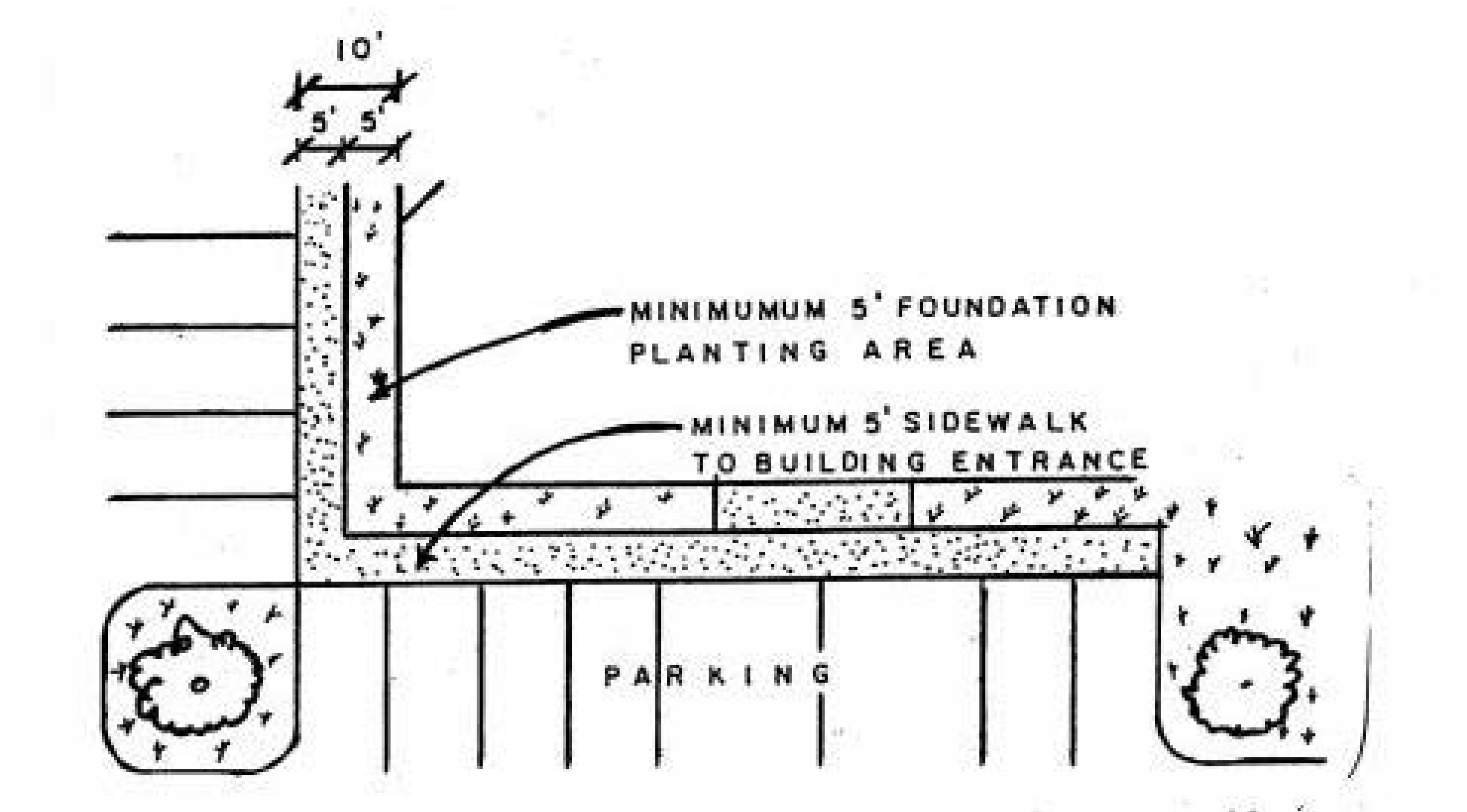
FIGURE 2
LANDSCAPED AREAS
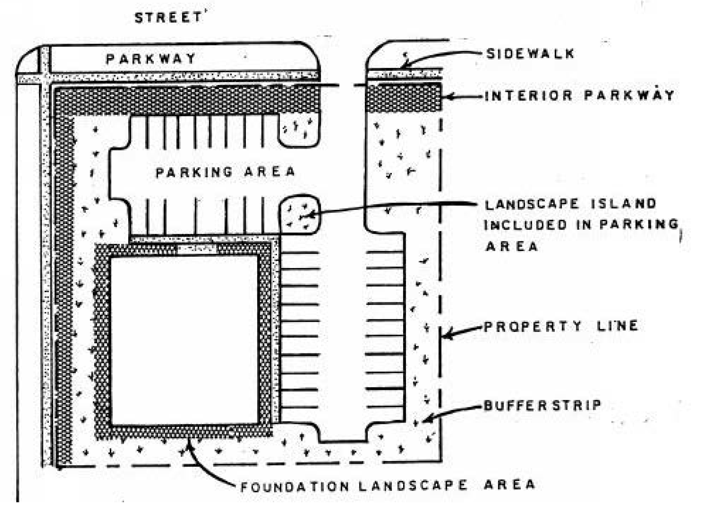
FIGURE 3
MULTIFAMILY INTERIOR
LAWN PARK LANDSCAPING
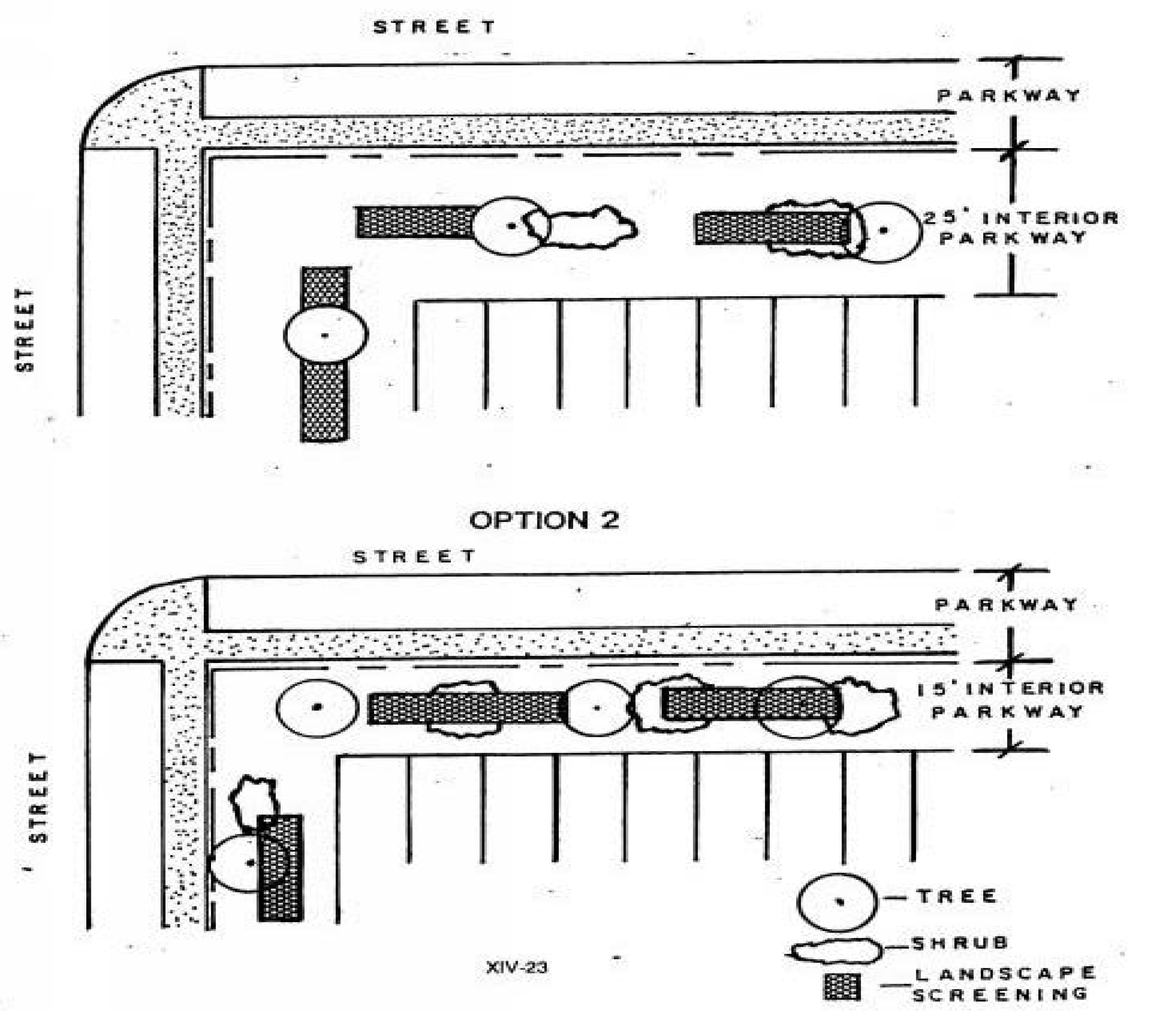
FIGURE 4
LANDSCAPE SCREENING OPTIONS
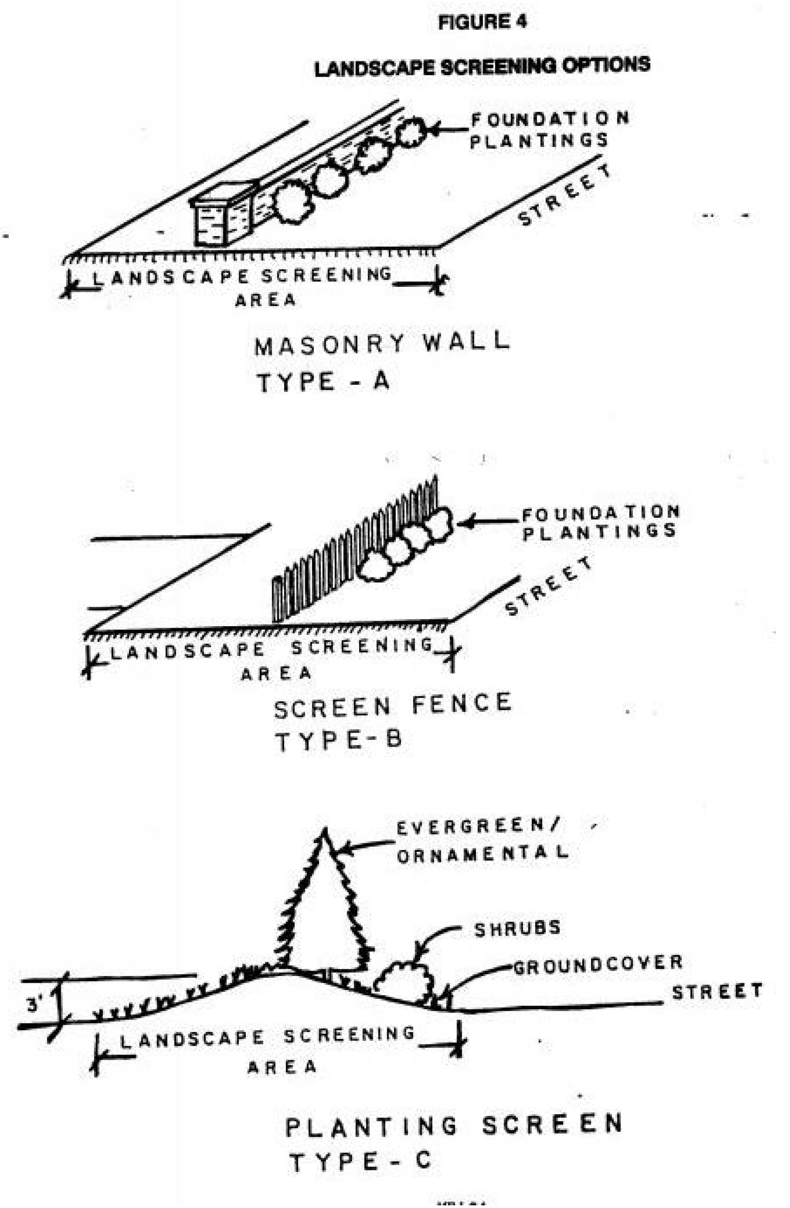
FIGURE 5
MULTIFAMILY BUFFER STRIPS
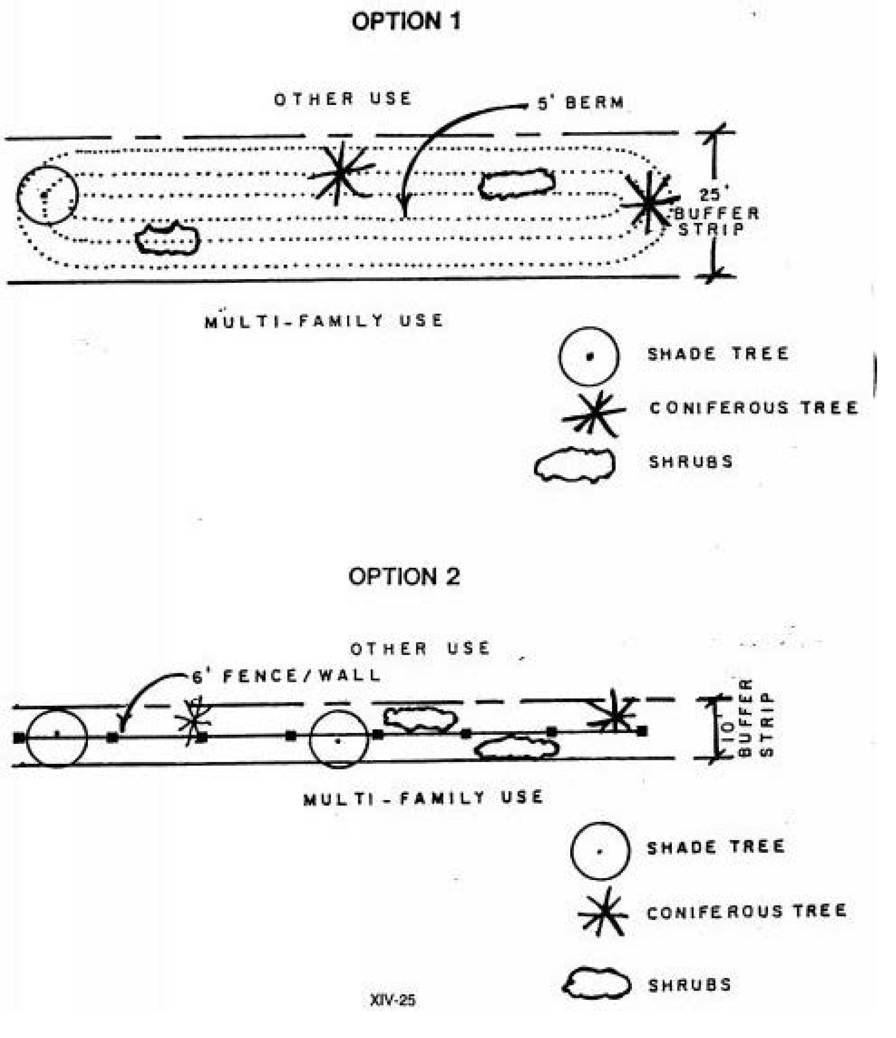
FIGURE 6
SERVICE AREA SCREENING
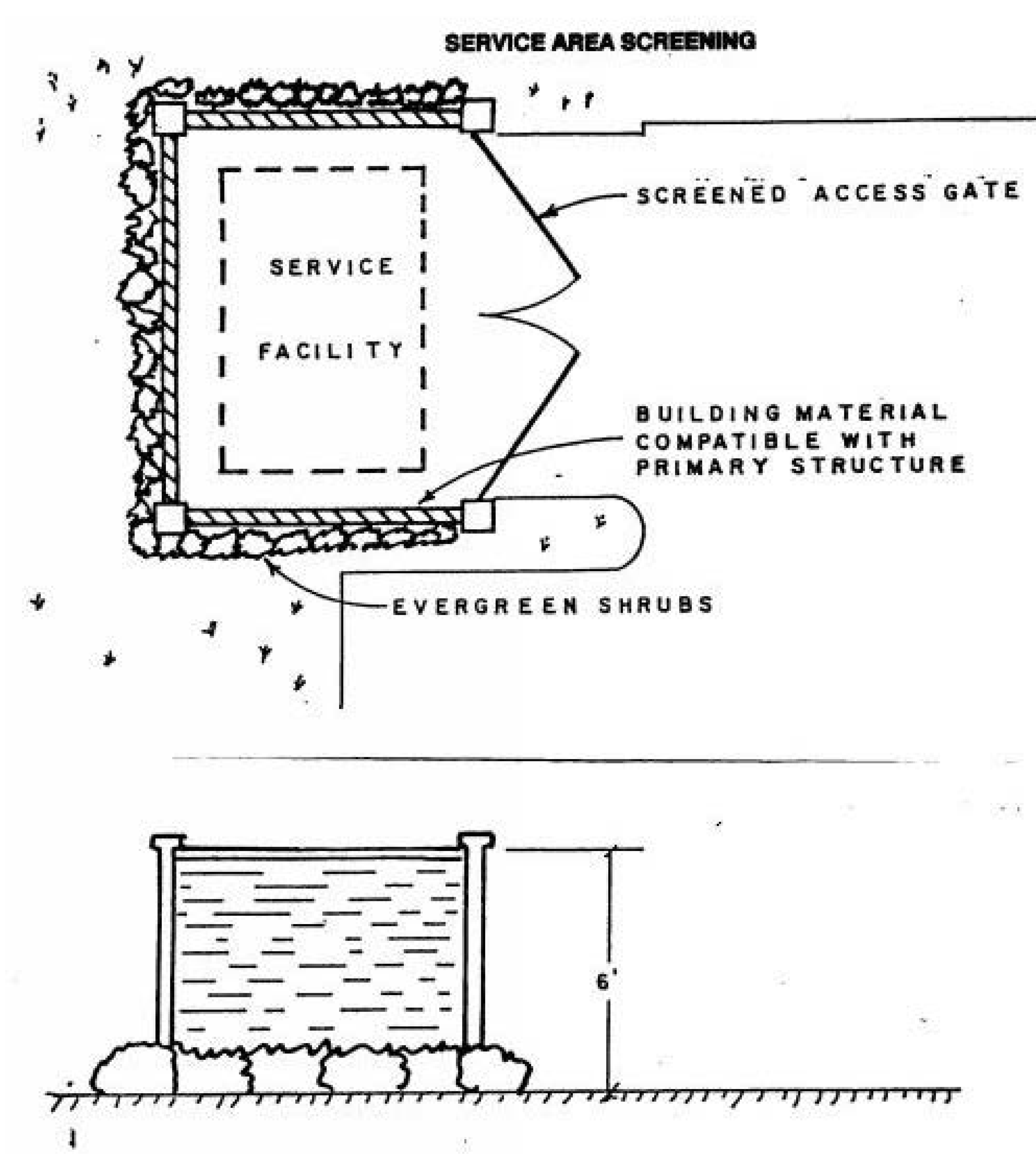
FIGURE 7
COMMERCIAL INTERIOR
LAWN PARK LANDSCAPING
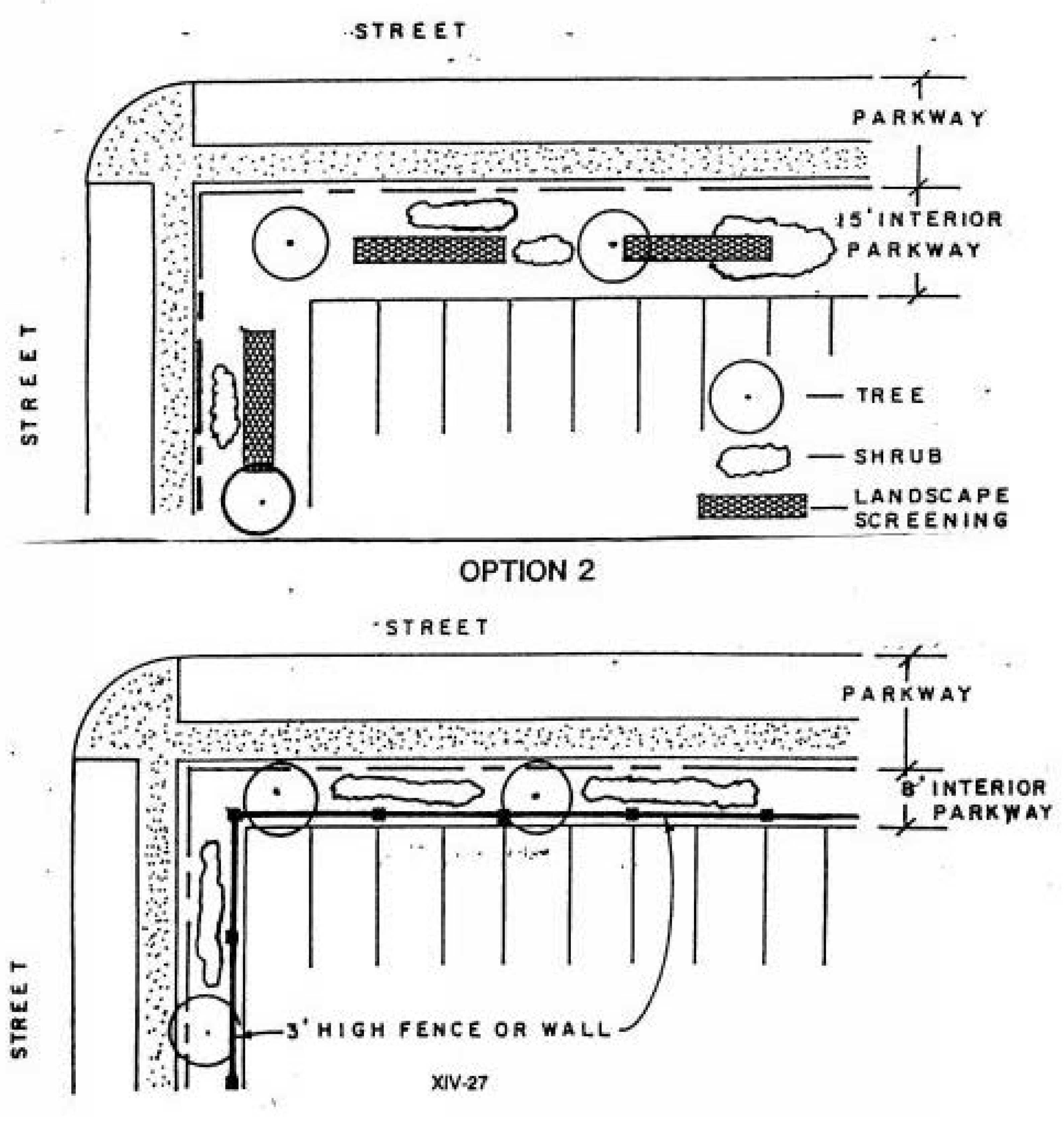
FIGURE 8
COMMERCIAL BUFFER STRIP
ABUTTING RESIDENTIAL ZONE
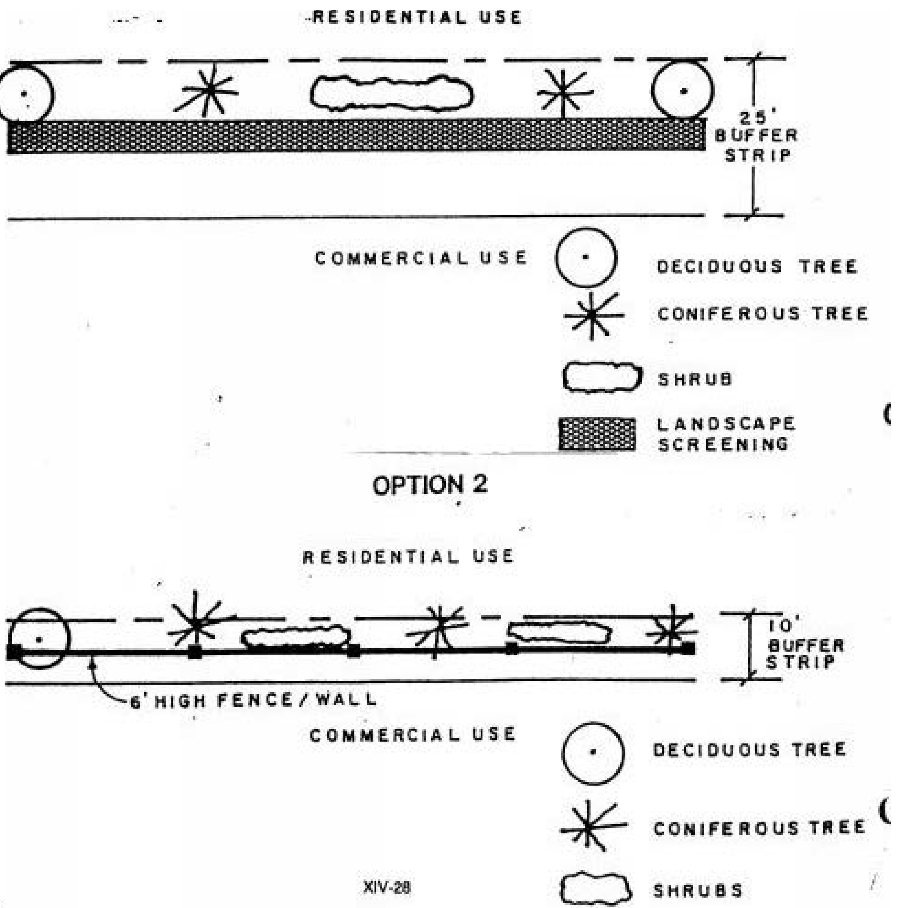
FIGURE 9
COMMERCIAL BUFFER STRIPS
ABUTTING NONRESIDENTIAL ZONE
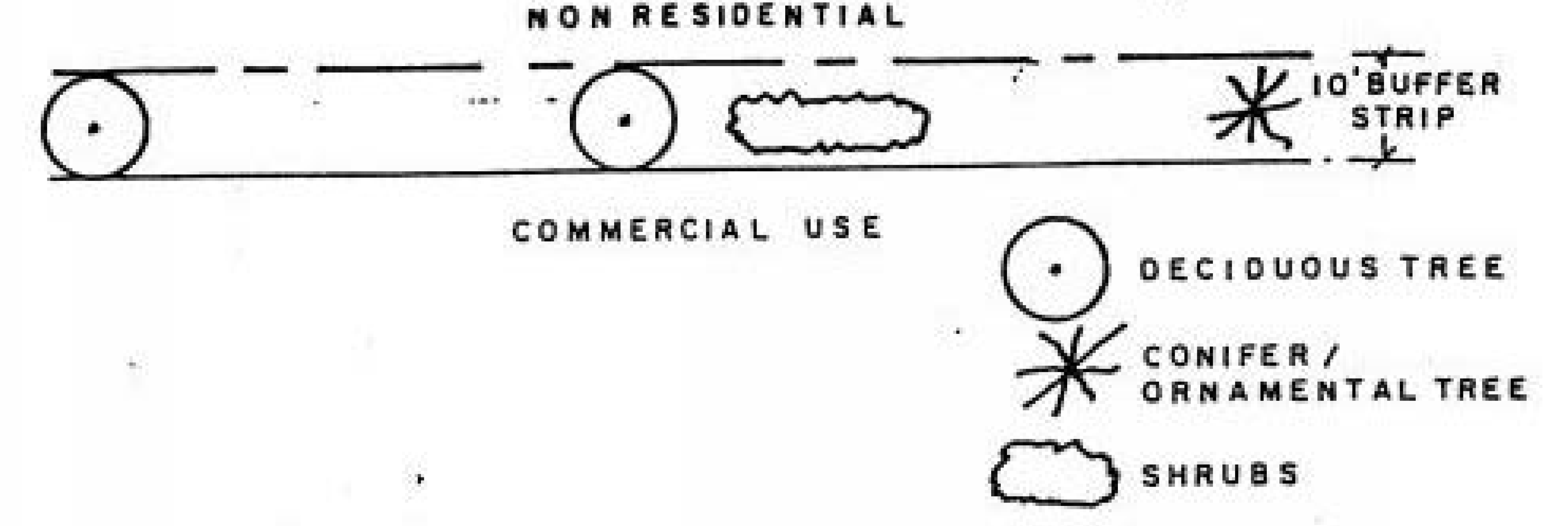
FIGURE 10
INDUSTRIAL INTERIOR LAWN PARK LANDSCAPES
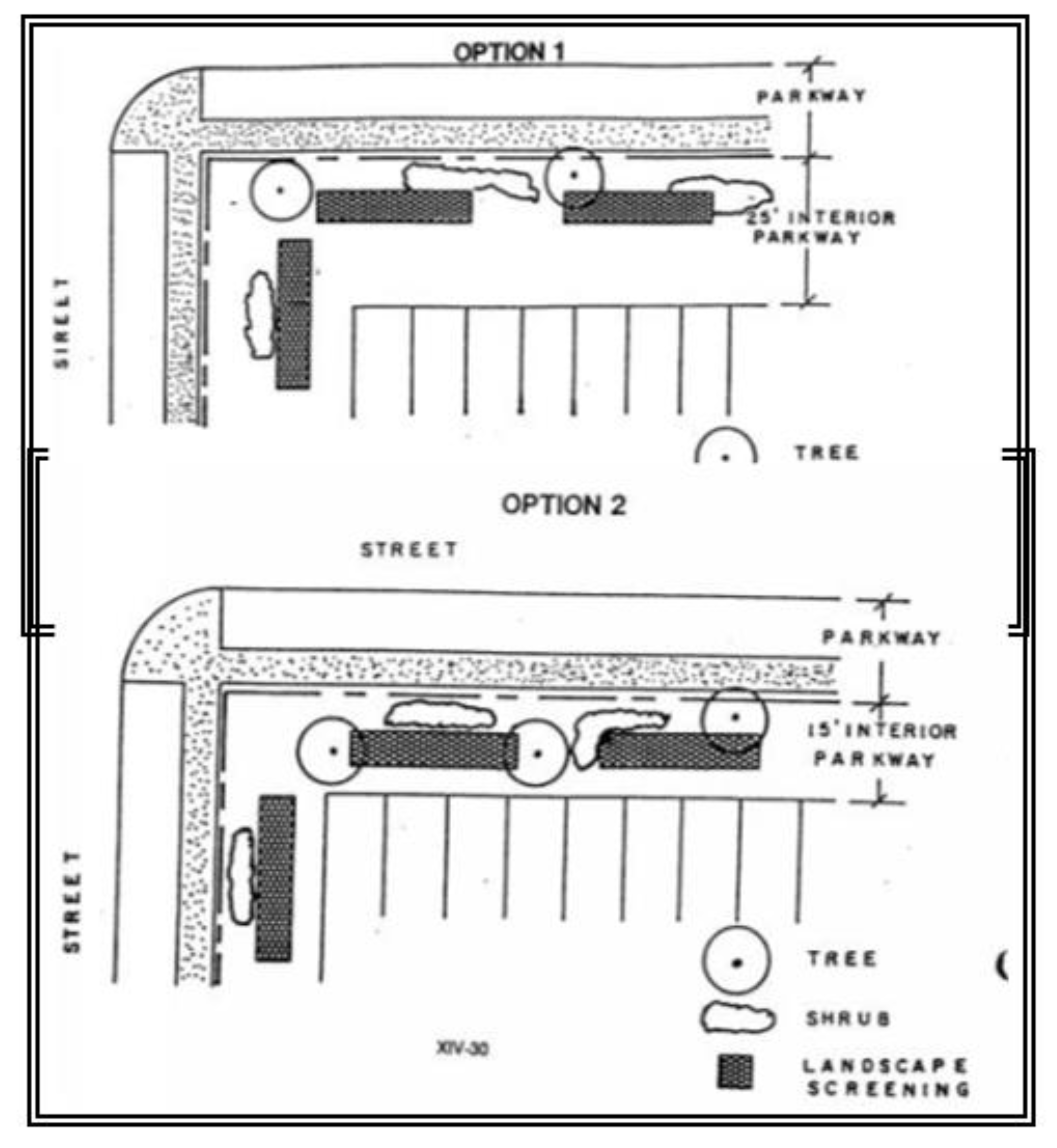
FIGURE 11
INDUSTRIAL BUFFER STRIP
ABUTTING RESIDENTIAL ZONE
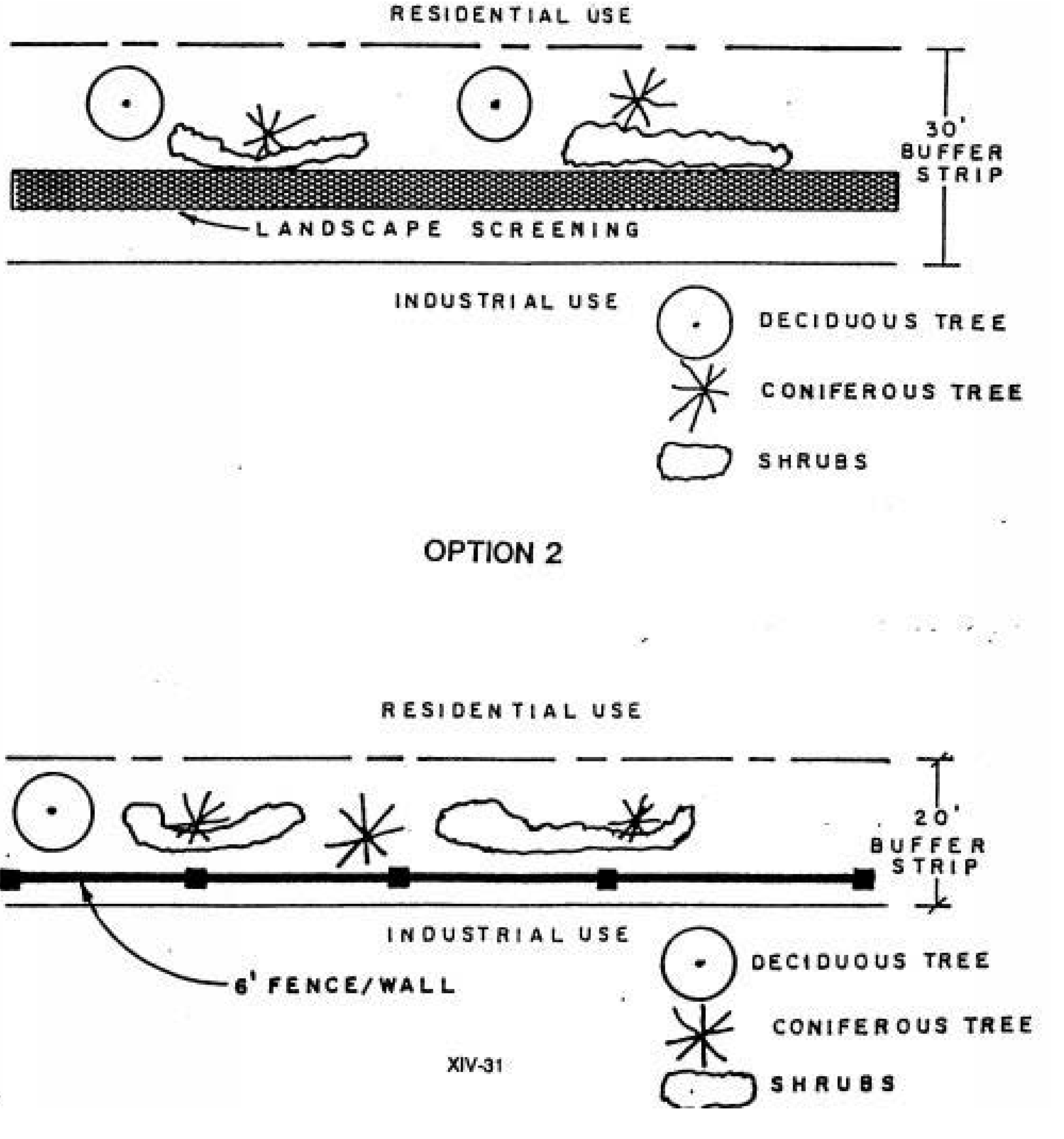
FIGURE 12
INDUSTRIAL BUFFER STRIP
ABUTTING NONRESIDENTIAL ZONE
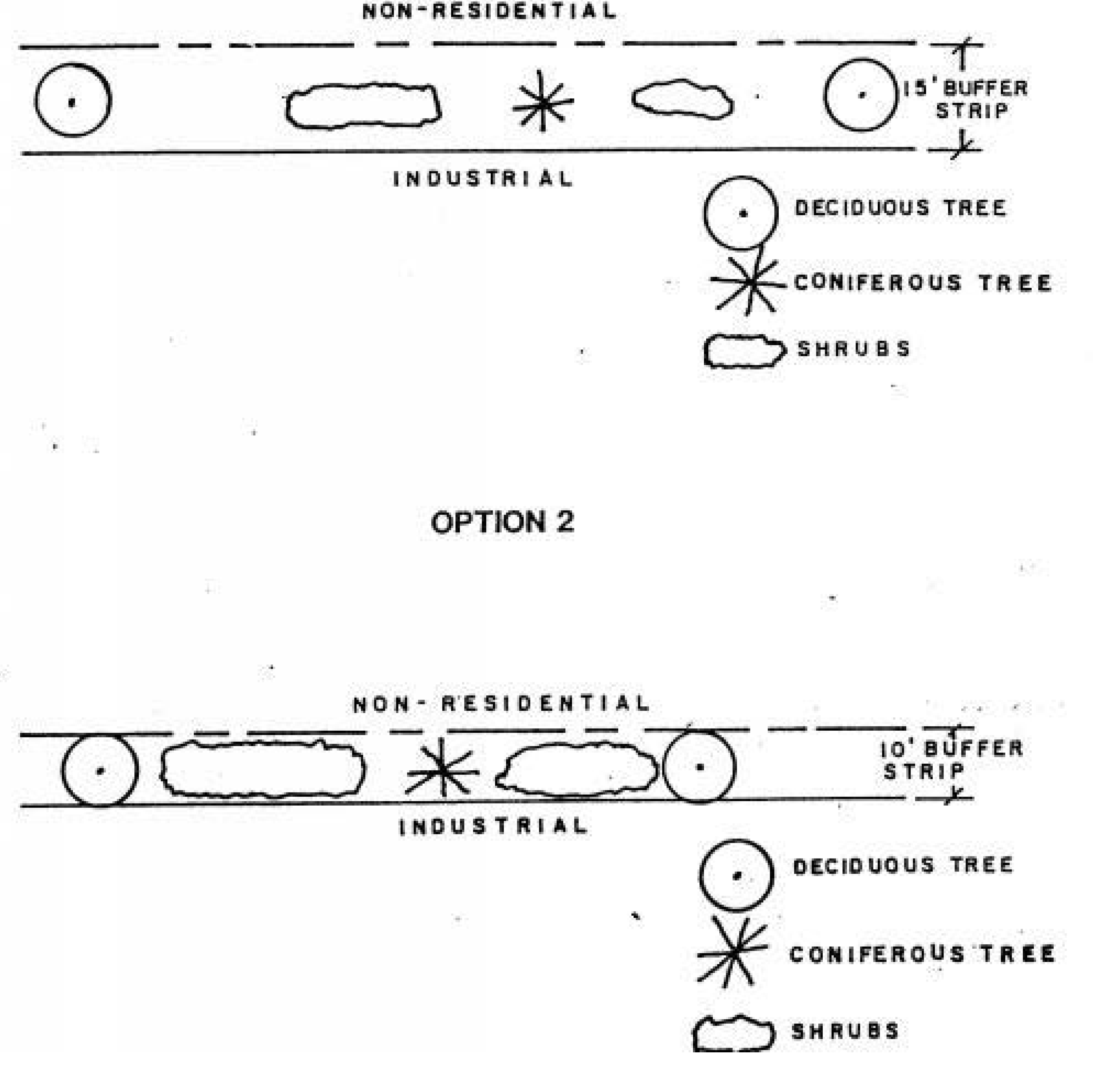
FIGURE 13
INDUSTRIAL BUFFER STRIP
ABUTTING INDUSTRIAL ZONE
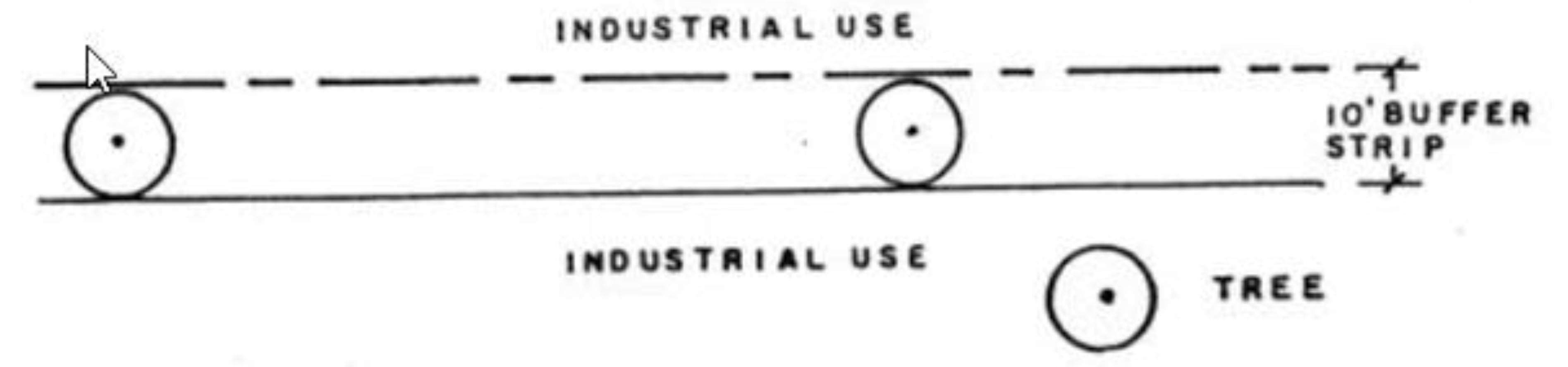
FIGURE 14
TYPICAL PARKING LOT PLANTING ISLAND
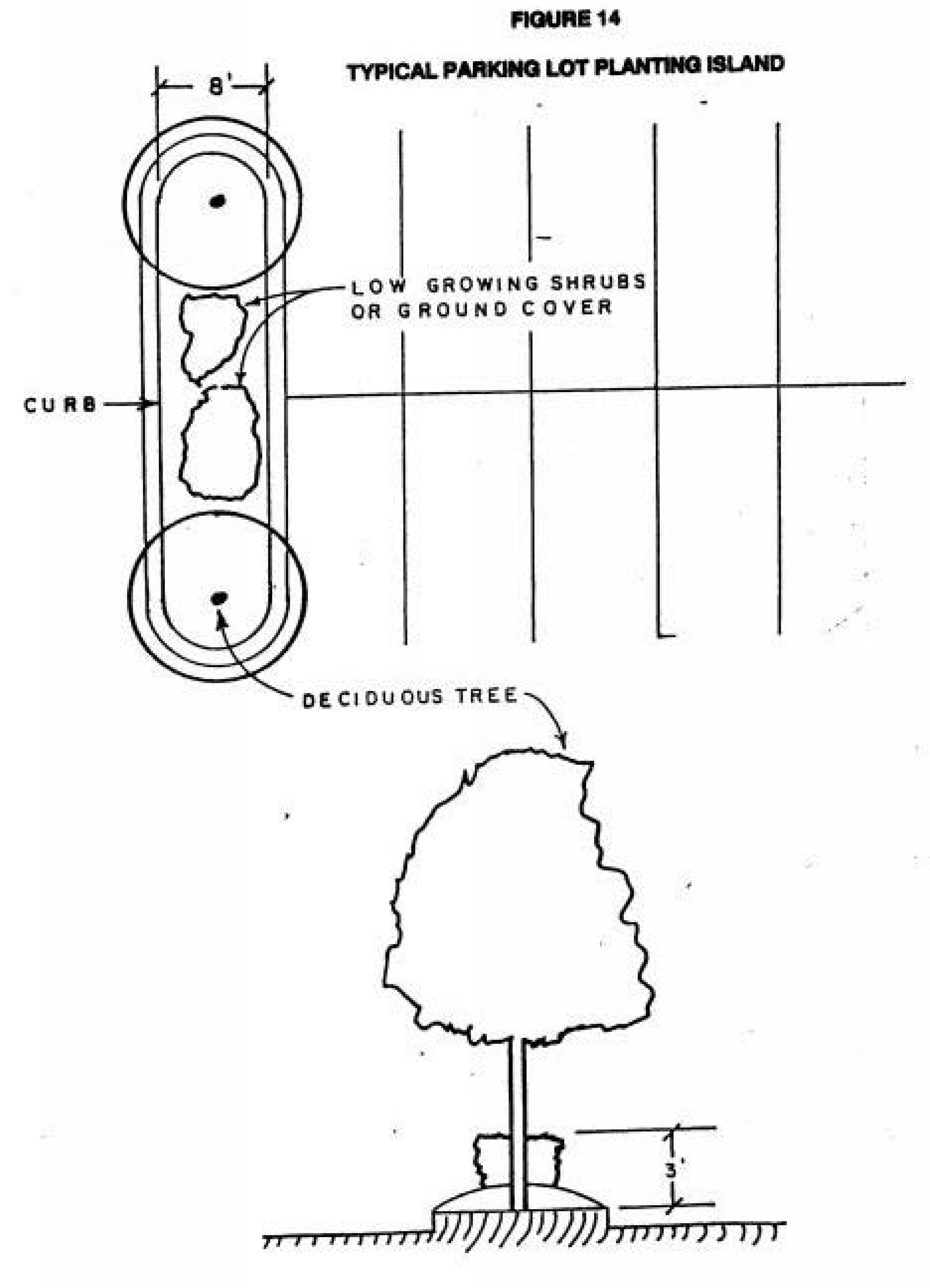
TABLE 1
INTERIOR LAWN PARK LANDSCAPING FOR MULTIFAMILY RESIDENTIAL DEVELOPMENT
TABLE 2
BUFFER STRIPS FOR MULTIFAMILY RESIDENTIAL USES
TABLE 3
INTERIOR LAWN PARK LANDSCAPING FOR COMMERCIAL USES
TABLE 4
BUFFER STRIPS FOR COMMERCIAL USES
TABLE 5
INTERIOR LAWN PARK LANDSCAPING FOR INDUSTRIAL DEVELOPMENT
TABLE 6
BUFFER STRIPS FOR INDUSTRIAL USES
TABLE 7
BUFFER STRIPS FOR INDUSTRIAL USES
TABLE 8
BUFFER STRIPS FOR INDUSTRIAL USES