
King City City Zoning Code
ARTICLE I
- Introduction and General Provisions
Chapter 16.04
TITLE
16.04.010 - Title.
This title shall be known as the King City Community Development and Zoning Code.
(Ord. 96-4 § 1 (part), 1996)
16.08.010 - Purpose.
The purpose of this title is to implement the King City comprehensive plan through the adoption and coordination of planning development and zoning regulations which provide for the health, safety and general welfare of the citizens of King City.
(Ord. 96-4 § 1 (part), 1996)
16.12.010 - Scope.
Land within King City may be used, or developed by land division or otherwise, and a structure may be used or developed by construction, reconstruction, alteration, occupancy or otherwise only as the comprehensive plan and this title permit. The provisions of this title apply to any person developing land or a structure, and to the person's successor(s) in interest.
(Ord. 96-4 § 1 (part), 1996)
16.16.010 - Compliance.
All development of land or structures in King City shall comply with the King City Comprehensive Plan, King City Water and Sewer Guidebook, King City Charter, and applicable regional, state, federal and local laws. Determination of compliance with regional, state, federal or local laws shall be made by the applicable regional, state, federal or local authority responsible for administering the subject law(s). A determination of compliance with such law shall not be a standard or condition of approval, except that proof that mandatory permits have been obtained may be required by specific standards of this title or as a condition of approval imposed by the approval authority. Nothing in this title shall relieve a use or development from compliance with other applicable laws except as provided herein.
(Ord. 96-4 § 1 (part), 1996)
(Ord. No. 2023-07, § 4(Exh. D), 1-17-2024)
16.16.020 - Minimum requirements.
Unless otherwise specified, the provisions of this title shall be held to be minimum requirements. Where this title imposes greater restrictions than are imposed or required by other provisions of law or by other rules or regulations, the provisions of this title shall control.
(Ord. 96-4 § 1 (part), 1996)
16.20.010 - Severability.
If any portion of this title is for any reason held invalid or unconstitutional by a court of competent jurisdiction, such portion shall be deemed a separate, distinct and independent provision and such holding shall not affect the validity of the remaining portions of this title.
(Ord. 96-4 § 1 (part), 1996)
16.24.010 - Meaning of words generally.
A.
All of the terms used in this title have their commonly accepted dictionary meaning unless they are specifically defined in this chapter or the context in which they are used clearly indicates to the contrary.
B.
All words used in the present tense include the future tense.
C.
The words "shall" and "must" are mandatory and the word "may" is permissive.
(Ord. 96-4 § 1 (part), 1996)
16.24.020 - Definitions of specific terms.
As used in this title the following words and phrases shall mean:
"Abut/abutting" means two or more properties or lots joined by a common boundary or point.
"Access" means the right to cross between public and private property allowing pedestrians, bicyclists, and vehicles to enter and leave property.
"Accessory building or structure" means a structure incidental and subordinate to the main use of a property, is located on the same lot as the main use, and is not a dwelling unit.
"Accessway" means any off-street way, which is intended for the primary use of pedestrians and/or bicyclists.
"Adult foster home" means an adult foster home licensed by or under the authority of the state (Mental Health and Developmental Services Division), which provides residential care alone or in conjunction with treatment or training or a combination thereof for less than six individuals. These individuals need not be related. Staff persons needed to meet licensing requirements shall not be counted in the number of facility residents, and need not be related to each other or to any resident of the residential home.
"Appeal" means a request that a final decision by an approval authority be considered by a higher authority as described in this title.
"Applicant" means a person who applies for a land use review or building permit. An applicant can be the owner of the property or someone who is representing the owner such as a builder, attorney, developer, optional purchaser, consultant or architect.
"Approval authority" means either the city manager, planning commission or city council.
"Bikeway" means any road, path or way open to bicycle travel regardless of whether such facilities are designed for the preferential use of bicycles or are to be shared with other transportation modes. This includes a shared roadway, shoulder bikeway, bike lane or accessway.
"Building" means any structure having a roof supported by columns or walls and used for housing or enclosure of persons, animals, or property of any kind.
"Building height" means the vertical distance between the highest point of a structure and the average grade along the front foundation.
"Caliper" means the thickness or diameter of a tree measured six inches above the ground or root ball.
"City" means the city of King City, Oregon.
"City council or council" means the city council for the City of King City, Oregon.
"City manager or manager" means the administrative head of the city or such other city employee or consultant who may from time to time be designated by the city manager to perform the functions delegated to the city manager.
"Co-location" means the placement of two or more wireless communication antenna systems or platforms by separate FCC license holders on any structure including a building, water tank, or wireless communication structure.
"Complete application" means the submittal of materials by an applicant in support of a land use application which contains all of the necessary information required by this title. If the total submittal is determined to be incomplete by the city manager, and the applicant chooses to rely only on the material submitted, the application shall be considered to be complete thirty days after the applicant is informed that the application is deficient.
"Comprehensive plan" means the current King City Comprehensive Plan.
"Cutting" means falling or removal of a tree, or any procedure the natural resort of which is to cause the death or substantial destruction of a tree. Cutting does not include normal trimming, pruning or topping of trees.
"De novo" means beginning a new hearing with no reliance on the record of previous decisions or hearings.
"Density" means the intensity of residential land use expressed as the number of dwelling units per gross acre.
"Development" means any short plat, partition, subdivision or planned unit development that is created under the city's land division or zoning regulations. It also refers to any man-made change to improved or unimproved real estate, including, but not limited to, construction, installation or change of a building or other structure, change in use of building or structure, land division, establishment, or termination of right of access, storage on the land, tree cutting, drilling, and site alteration such as that due to land surface improvements for use as parking, excavation or clearing.
"Discretionary" means the freedom to make choices using criteria that may be interpreted in a variety of ways depending upon the circumstances of the land use decision.
"Drainageway" means a normal stream or drainage channel needed to convey waters of a twenty-five-year storm.
"Drip line" means the ground within the perimeter of the foliage of a tree.
"Dwelling unit" means a single unit providing complete, independent living facilities for one or more persons including permanent provisions for living, sleeping, cooking, eating and sanitation.
"Easement" means the right to use land in a limited way for a stated purpose.
"Family" means one or two individuals or two or more persons related by blood, marriage, legal adoption or legal guardianship, living together as one housekeeping unit using one kitchen and providing meals or lodging to not more than two additional persons, excluding servants.
Floodplain definitions.
1.
"Appeal" means a request for a review of the interpretation of any provision of Chapter 16.140 or a request for a variance.
2.
"Base flood" means the flood having a one percent change of being equaled or exceeded in any given year.
3.
"Basement" means any area of the building having its floor subgrade (below ground level) on all sides.
4.
"Below-grade crawl space" means an enclosed area below the base flood elevation in which the interior grade is not more than two feet below the lowest adjacent exterior grade and the height, measured from the interior grade of the crawlspace to the top of the crawlspace foundation, does not exceed four feet at any point.
5.
"Conditional letter of map revision (CLOMR)" means a letter from FEMA commenting on whether a proposed project, if built as propose, would meet the minimum NFIP standards or proposed hydrology changes.
6.
"Critical facility" means a facility for which even a slight chance of flooding might be too great. Critical facilities include, but are not limited to, schools, nursing homes, hospitals, police, fire and emergency response installations, installations which produce, use or store hazardous materials or hazardous waste.
7.
"Development" means any man-made change to improved or unimproved real estate, including, but not limited to, buildings or other structures, mining, dredging, filling, grading, paving, excavation or drilling operations or storage of equipment or materials located within the special flood hazard area.
8.
"Drainage hazard area" Those areas subject to flooding as the result of a twenty-five year storm.
9.
"Elevated building" means, for insurance purposes, a nonbasement building which has its lowest elevated floor raised above ground level by foundation walls, shear walls, posts, piers, pilings, or columns.
10.
"Existing manufactured home park or subdivision" means a manufactured home park or subdivision for which the construction of facilities for servicing the lots on which the manufactured homes are to be affixed (including, at a minimum, the installation of utilities, the construction of streets, and either final site grading or the pouring of concrete pads) is completed before the effective date of the adopted floodplain management regulations.
11.
"Expansion to an existing manufactured home park or subdivision" means the preparation of additional sites by the construction of facilities for servicing the lots on which the manufactured homes are to be affixed (including the installation of utilities, the construction of streets, and either final site grading or the pouring of concrete pads).
12.
"Flood" or "flooding" means:
a.
A general and temporary condition of partial or complete inundation of normally dry land areas from:
i.
The overflow of inland or tidal waters.
ii.
The unusual and rapid accumulation of runoff of surface waters from any source.
ii.
Mudslides (i.e., mudflows which are proximately caused by flooding as defined in subsection 1.b. of this definition and are akin to a river of liquid and flowing mud on the surfaces of normally dry land areas, as when earth is carried by a current of water and deposited along the path of the current.
b.
The collapse or subsidence of land along the shore of a lake or other body of water as a result of erosion or undermining caused by waves or currents of water exceeding anticipated cyclical levels or suddenly caused by an unusually high water level in a natural body of water, accompanied by a severe storm, or by an unanticipated force of nature, such as flash flood or an abnormal tidal surge, or by some similarly unusual and unforeseeable event which results in flooding as defined in Subsection 1.a. of this definition.
13.
"Flood insurance rate map (FIRM)" means an official map on which the Federal Insurance Administrator has delineated both the special hazard areas and the risk premium zones applicable to the community. A FIRM that has been made available digitally is called a Digital Flood Insurance Rate Map (DFIRM).
14.
"Flood insurance study" means the official report provided by the Federal Insurance Administration that is an examination, evaluation, and determination of mudslide (i.e., mudflow) and/or flood-related erosion hazards.
15.
"Floodway" means the channel of a river or other watercourse and the adjacent land areas that must be reserved in order to discharge the base flood without cumulatively increasing the water surface elevation more than one foot.
16.
"Letter of map change (LOMC)" means an official FEMA determination, by letter, to amend or revise effective flood insurance rate maps and/or flood insurance studies. LOMCs are issued in the following categories:
a.
Letter of Map Amendment (LOMA). An amendment to the flood insurance rate maps based on technical data showing that an existing structure or parcel of land that has not been elevated by fill (natural grade) was inadvertently included in the special flood hazard area because of an area of naturally high ground above the base flood.
b.
Letter of Map Revision (LOMR). LOMR-F (Letter of Map Revision based on Fill) is a letter from FEMA stating that an existing structure or parcel of land that has been elevated by fill would not be inundated by the base flood.
17.
A LOMR revises the current flood insurance rate map and/or flood insurance study to show changes to the floodplains, floodways or flood elevations. LOMRs are generally based on manmade alterations that affected the hydrologic or hydraulic characteristics of a flooding source and thus result in modification to the existing regulatory floodway, the effective base flood elevation, or the special flood hazard area. It is recommended a conditional letter of map revision be approved by FEMA prior to issuing a permit to start a project if the project has a potential to affect the special flood hazard area. (see conditional letter of map revision)
18.
"Lowest floor" means the lowest floor of the lowest enclosed area (including basement). An unfinished or flood-resistant enclosure, usable solely for parking of vehicles, building access or storage, in an area other than a basement area, is not considered a building's lowest floor, provided that such enclosure is not built so as to render the structure in violation of the applicable non-elevation design requirements of this chapter found at Section 16.140.070.B.5 of this chapter.
19.
"Manufactured home" means a structure, transportable in one or more sections, which is built on a permanent chassis and is designed for use with or without a permanent foundation when attached to the required utilities. The term "manufactured home" does not include a "recreational vehicle."
20.
"Manufactured home park or subdivision" means a parcel (or contiguous parcels) of land divided into two or more manufactured home lots for rent or sale.
21.
"New construction" means structures for which the "start of construction" commenced on or after the effective date of a floodplain management regulation adopted by a community and includes any subsequent improvements to such structures.
22.
"Recreational vehicle" means a vehicle which is:
a.
Built on a single chassis;
b.
Four hundred square feet or less when measured at the largest horizontal projection;
c.
Designed to be self-propelled or permanently towable by a light-duty truck; and
d.
Designed primarily not for use as a permanent dwelling but as temporary living quarters for recreational, camping, travel, or seasonal use.
23.
"Special flood hazard area" means the land in the floodplain with a one percent or greater chance of flooding in any given year. It is also referred to as the one hundred-year floodplain. This area is shown on the Flood Insurance Rate Maps (FIRM) with the letter designation "AE" in the King City area.
24.
"Start of construction" includes substantial improvement, and means the date the building permit was issued, provided the actual start of construction, repair, reconstruction, rehabilitation, additional placement or other improvement was within one hundred eighty days of the permit date. The actual start means either the first placement of permanent construction of a structure on a site, such as the pouring of slab or footings, the installation of piles, the construction of columns, or any work beyond the stage of excavation; or the placement of a manufactured home on a foundation. Permanent construction does not include land preparation, such as clearing, grading and filling; nor does it include the installation of streets and/or walkways; nor does it include excavation for a basement, footings, piers, or foundations or the erection of temporary forms; nor does it include the installation on the property of accessory buildings, such as garages or sheds not occupied as dwelling units or not part of the main structure. For a substantial improvement the actual start of construction means the first alteration of any wall, ceiling, floor, or other structural part of a building, whether or not that alteration affects the external dimensions of the building.
25.
"Structure" means a walled and roofed building, a modular or temporary building, or a gas or liquid storage tank that is principally above ground.
26.
"Substantial damage" means damage of any origin sustained by a structure whereby the cost of restoring the structure to its before damaged condition would equal or exceed fifty percent of the market value of the structure before the damage occurred.
27.
"Substantial improvement" means any reconstruction, rehabilitation, addition, or other improvement of a structure, the cost of which equals or exceeds fifty percent of the market value of the structure before the "start of construction" of the improvement. This term includes structures which have incurred "substantial damage", regardless of the actual repair work performed. The term does not include either:
a.
Any project for improvement of a structure to correct existing violations of state or local health, sanitary, or safety code specifications which have been identified by the local code enforcement official and which are the minimum necessary to assure safe living conditions; or
b.
Any alteration of a "historic structure", provided that the alteration will not preclude the structure's designation as a "historic structure."
28.
"Variance" as applied in Chapter 16.140 means a grant of relief from the requirements of Chapter 16.140 which permits construction in a manner that would otherwise be prohibited by Chapter 16.140.
29.
"Water dependent" means a structure for commerce or industry which cannot exist in any other location and is dependent on the water by reason of the intrinsic nature of its operations.
"Floor area ratio (FAR)" means the amount of building floor area in relation to the amount of site area, expressed in square feet. For example, a floor area ratio of two to one means there is two square feet of floor area for every one square foot of site area. Public utility easements may be excluded from the site area when calculating the FAR.
"Frontage length" means the length of a property frontage along a street right-of-way. In the case of corner lots, the right-of-way of the intersecting street or streets shall not be included in measuring this distance.
"Greenways" means any off-street way, which is intended for travel use by pedestrian and bicyclists, but also intended for recreational use. Greenways may include linear parks, open space corridors or multi-purpose corridors, as long as they are particularly intended for travel use by pedestrians and bicyclists.
"Impervious surface" means pavement, maintained gravel areas, structures, public and private roadways, sidewalks, roofs, and other hard surfaces which are not specifically designed to allow water to infiltrate.
"Landscaped open space" means lot area exclusive of building, roofed areas, parking and driveways, planted and maintained in grass, shrubbery or trees.
"Landform alteration" means any man-made change to improved or unimproved real estate, including, but not limited to, the addition of buildings or other structures, mining, quarrying, dredging, filling, grading, earthwork, construction, stockpiling of rock, sand, dirt or gravel or other earth material, paving, excavation or drilling operations located within a sensitive land area.
"Legislative" refers to an amendment to this title or the comprehensive plan or a land use decision that applies to a large number of individuals or properties.
"Live-work unit" means a dwelling unit where residential and nonresidential spaces are combined and where the dwelling unit is the principal residence of the business operator/proprietor. Nonresidential spaces are typically located on the ground floor with separate access and residential spaces are located on upper floors or the rear of the building.
"Loading area" means the area available for the maneuvering and short-term parking of vehicles engaged in delivering and loading of passengers, freight or other articles.
"Lot" means a parcel or tract of land.
"Lot area" means the total horizontal area within the lot lines of a lot exclusive of streets and easements of access to other property.
"Lot, corner" means a lot that is located at the intersection of two or more public street rights-of-way.
"Lot coverage" means the percentage of a lot that may be covered by impervious surface including buildings, driveways, sidewalks and parking areas.
"Lot depth, average" means the depth of the lot measured from the midpoint of the opposing side lot lines.
"Lot, interior" means a lot that has street frontage on only one side.
"Lot line" means the legal boundary of a parcel, tract of land or lot.
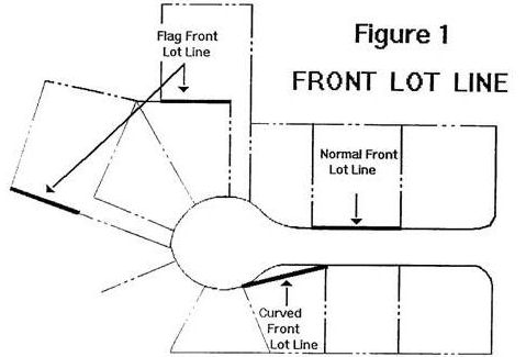
1.
A "front lot line" is a lot line that abuts a street.
2.
A "rear lot line" is a lot line that is opposite from the front lot line. In the case of more than one front lot line, the rear lot line shall only correspond with one of the front lot lines. If a lot has street frontage on opposing sides, the rear lot line shall correspond with the street frontage where vehicular access is not allowed or provided.
3.
"Side lot lines" are the remaining property boundaries that are neither front or rear lot lines.
"Lot line adjustment" means a modification to the common boundaries of two or more parcels or tracts of land which does not result in the creation of any additional parcels or tracts of land.
"Lot width, average" means the width of the lot measured from the midpoint of the front and rear lot lines.
"Mixed solid waste" means solid waste that contains recoverable or recyclable materials, and materials that are not capable of being recycled or recovered for further use.
"Monument" means a fixed, permanent and visible landmark indicating property boundaries.
"Nonconforming use or structure" means a lawfully existing use or structure that was approved or established prior to an amendment to this title for which it does not comply.
"Non-residential building" means a structure that is used for any non-residential function, including, but not limited to, office, retail, educational and institutional uses.
"Off-site" means all lands or facilities which are within the analysis area but is not on-site.
"On-site" means all lands in the development application and one-half the right-of-way (to centerline) of roads lying adjacent to such lands.
"Owner" means the owner of record of real property as shown on the latest tax rolls of Washington County, or by the deed records of said county, or a person who is purchasing a parcel of property under contract.
"Parking space" means a space designed to provide for the short-term or long-term storage of motor vehicles.
"Partition" means a division of a parcel or tract of land into two or three lots within a calendar year.
"Partition" does not include:
1.
A division of land resulting from a lien foreclosure, foreclosure, foreclosure of a recorded contract for the sale of real property or the creation of cemetery lots;
2.
An adjustment of a property line by the relocation of a common boundary where an additional lot is not created and where the existing unit of land reduced in size by the adjustment complies with all applicable ordinance provisions; or
3.
A sale or grant by a person to a public agency or public body for state highway, county road, city street or other right-of-way purposes.
"Patio cover" means a one-story structure erected above a patio which does not exceed twelve feet in height.
"Patio enclosure" means a patio having a cover and one to three walls built in compliance with Section 4901 of the uniform building code. Enclosure walls may have any configuration, provided the open area of the longer wall and one additional wall is equal to at least sixty-five percent of the area below a minimum of six feet eight inches of each wall, measured from the floor. Openings may be enclosed with insect screening or plastic that is readily removable translucent or transparent plastic not more than 0.125 inches in thickness.
"Pedestrian oriented uses" means those land uses which by their nature or neighborhood orientation attract a greater than average level of pedestrian use. Pedestrian oriented uses include but are not limited to schools, parks, transit stops, recreation centers and neighborhood commercial centers.
"Person" means an individual, firm, partnership, corporation, company, associations, syndicate or any legal entity, and including any trustee, receiver, assignee or other similar representative thereof.
"Planning commission" or "commission" means the planning commission of King City, Oregon.
"Plat" includes a final subdivision plat or replat containing all the descriptions, locations, dedications, specifications, provisions and information concerning a subdivision, suitable for filing under the regulations of this title and state law.
"Principal street" means the street adjacent to a property with the highest transportation hierarchy classification. Other abutting streets, if any, are deemed to be secondary streets. Determination of the principal street shall be done using the following priority:
• Arterial street;
• Collector street;
• Neighborhood collector street; and
• Local street.
"Quasi-judicial" means a land use action which involves the application of adopted comprehensive plan policies and the provisions of this title to a specific land use application, effecting identified parcels of land or property owners.
"Reserve strip" means a strip of land reserved between the end or side of a street or alley and on abutting parcel of land, or a strip of land between a dedicated street of less than full width and an abutting parcel of land, held for future street extension or widening.
"Right-of-way" means the area between boundary lines of a public way.
"Riparian area" means the area adjacent to a river, lake or stream, which is the area of transition from an aquatic ecosystem to a terrestrial ecosystem. For the purposes of this title they shall include areas within seventy-five feet of the top of bank for the Tualatin River.
"Road" or "street" means a public or private way that is created to provide access for persons to one or more lots, parcels or tracts of land.
"Sensitive lands" means those areas that are within a drainageway, one hundred-year flood plain, or wetland as defined in this title.
"Setback" means the shortest horizontal distance between the wall or foundation of a building and property line with the exception of garage setback.
1.
"Front setback" is measured from a front lot line.
2.
"Garage setback" is measured from a street lot line to the entrance to a garage or carport, following the center of the driveway.
3.
"Rear setback" is measured from a rear lot line.
4.
"Side setback" is measured from an interior side lot line.
5.
"Street setback" is measured from a side lot line which abuts a street.
"Sidewalk" means a concrete way located generally parallel to a street within the right-of-way which meets adopted design standards. It is primarily intended for use by pedestrians.
"Sidewalk zones" refers to three different zones on public sidewalks that include:
• "Clear zone," which is the unobstructed portion for walking.
• "Street tree and furniture zone," which is the portion of the sidewalk adjacent to the curb in which street trees may be planted. This zone is also intended for the placement of street furniture including seating, street lights, waste receptacles, fire hydrants, traffic signs, newspaper vending boxes, bus shelters, bicycle racks, public utility equipment, and similar elements in a manner that does not obstruct pedestrian access or motorist visibility.
• "Supplemental zone," which lies between the clear zone and the street-facing building façade or front yard landscaping. This zone is intended to public uses including window shopping, plaza, outdoor cafe, or patio.
"Sight obscuring" refers to any fence, wall or vegetation which conceals or makes indistinct any object viewed through such a fence, wall or vegetation. To be sight obscuring, vegetation must be capable of providing this level of screening within two years after planting.
Sign Definitions (related to Chapter 16.148):
1.
"Abandoned sign" means a sign associated with a business, lessor, owner, product, use of property or activity which ceases or is no longer conducted or available on the premises where such sign is displayed.
2.
"Alteration" means a structural, visual, electrical or mechanical modification to a sign. "Alteration" includes change of copy, the addition or removal of parts, and the replacement of parts, but does not include normal, periodic maintenance.
3.
"Banner" means nonrigid material mounted to allow movement caused by the wind. National flags, flags of political subdivisions and symbolic flags of an institution, group or business are excluded.
4.
"Bulletin board" means a permanent freestanding or wall mounted, metal framed, enclosed sign with dark background, and changeable letters no larger than two inches and used primarily for non-commercial public announcements.
5.
"Canopy" means a rigid non-movable roof-like structure.
6.
"Development" means any man-made change to improved or unimproved real property including, but not limited to, a building or group of architecturally related buildings, other structures, subdivision or land partition, landscaping, grading, filling, paving and placement of a sign.
7.
"Directory sign" means a sign listing the names, uses or locations of not less than three businesses or activities, conducted within a building or group of architecturally related buildings.
8.
"Fascia" means the flat surface or band attached to the front of a sloping roof or the edge of a flat roof. It is parallel to the front of the building and perpendicular to the ground. It is not to be construed as the underside of the roof canopy.
9.
"Flashing sign" means a sign with intermittent illumination, except time or temperature signs.
10.
"Freestanding sign" means a sign attached to the ground by one or more poles, columns or similar supports and not attached to a building.
11.
"Frontage" means the length of a property line abutting a public right-of-way.
12.
"Height" or "height of sign" means the vertical distance from ground level to the highest point of a sign or any vertical and projection thereof.
13.
"Illegal sign" means a sign which is erected, constructed, altered, relocated or maintained in violation of any of the provisions of this chapter.
14.
"Incidental sign" means a permanent directional sign, intended for the convenience of the public and limited to information such as hours, telephone numbers, credit cards, entrance, exit, open, closed and information required by law.
15.
"Lawn sign" means a freestanding sign made of lightweight materials such as cardboard or vinyl that is supported by a frame, pole, or other support structure placed directly in the ground without foundation or other anchor.
16.
"Marquee" means a projection, permanent, roofed structure attached to and supported by a building.
17.
"Nameplate" means a non-illuminated wall sign identifying only the name and occupation of the occupant of the premises.
18.
"Nonconforming sign" means a sign lawfully erected and existing prior to the adoption of this chapter, but which does not meet the requirements of this chapter.
19.
"Obscene sign" means a sign which contains words or pictures in which the dominant theme taken as a whole appeals to the prurient interest in sex or is patently offensive because if affronts the contemporary community standard relating to the description or representation of sexual material which is without redeeming social value.
20.
"Obstructing sign" means a sign which interferes with the use of a fire escape, exit or a window such that light, ventilation or ingress and egress is reduced below the minimum required by law.
21.
Reserved.
22.
"Pennant" means a triangular flag which is tapered to a point or swallow tail.
23.
"Permit review" means consideration by the planning commission or city manager of permit application for new signs, sign changes, alterations, relocations, construction and new development.
24.
"Portable sign" means a sign which is not permanently affixed to a building, structure or the ground. Portable signs include, but are not limited to, A-frames, sandwich boards and portable reader boards.
25.
"Projecting banner" means a banner attached to a flagpole or similar support which is attached to or projects from a structure or building face.
26.
"Public sign" means a sign erected and maintained by a municipal, state or federal government, or any political subdivision or agency thereof.
27.
"Reader board" or "changeable copy sign" means a sign which is not enclosed in a case and is characterized by changeable track-mounted copy, which is changed.
28.
"Roof sign" means a sign not to exceed four feet in height erected and maintained upon or against a sloped flat roof of a building, including signs attached to any structure containing mechanical equipment. Roofs included in this definition include mansard, gable, pitched or flat roofs.
29.
"Rotating sign" or "moving sign" means a sign or portion thereof designed to move as a result of an internal mechanism or the wind. Such signs shall not include banners or flags.
30.
"Sign" means ad identification, description, illustration, symbol or device, but not an architectural feature of a building which is affixed directly or indirectly upon a building, vehicle, structure or lane. Signs identify or direct attention to a product, place, activity, person, institution, business, use, idea, belief, candidate or political issue.
31.
"Sign area" shall include the entire sign, including face, frame, graphic information incidental to its decoration, and any spacing between letters, figures and designs. The sign area shall not include the sign structure. When the sign consists only of letters, figures or designs which are engraved, painted, projected or fixed on a wall, monument, roof or a window sign, total area of the sign shall be the area of the smallest geometric shape or combination of the regular geometric shapes with which all of the fixed lettering, spacing between letters and graphic information is displayed.
32.
"Sign face" means the surface to which letters and graphic information are affixed in order to make a sign.
33.
"Sign structure" means one or more supports, uprights, braces, cables or other framework of a sign.
34.
"Shingle sign" means a rigid sign which projects from a wall, or hangs from a building canopy, is perpendicular to the building and horizontal to the ground.
Solar Definitions (related to Chapters 16.116 and 16.204):
1.
"Crown cover" the area within the drip line or perimeter of the foliage of a tree.
2.
"Exempt tree or vegetation" means the full height and breadth of vegetation that the city manager has identified as "solar friendly" that are listed and kept on file in city hall, and any vegetation listed on a plat map, or a document recorded with the plat.
3.
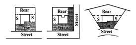
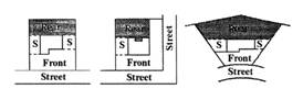
"Front lot line" means, for purposes of the solar access regulations, a lot line abutting a street. For corner lots the front lot line is that with the narrowest frontage. When the lot line abutting a street is curved, the front lot line is the chord or straight line connecting the ends of the curve. For a flag lot, the front lot line is the shortest lot line adjoining the pole portion of the lot, excluding the unbuildable portion of the pole (see Figure 1).
4.
"Non-exempt tree or vegetation" refers to vegetation that is not exempt.
5.
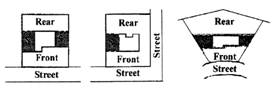
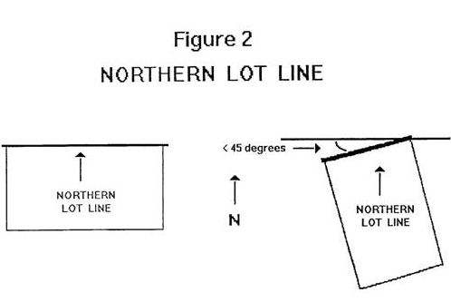
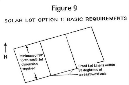
"Northern lot line" means the lot line that is the smallest angle from a line drawn east-west and intersecting the northernmost point of the lot, excluding the pole portion of a flag lot. If the north line adjoins an undevelopable area other than a required yard area, the northern lot line shall be at the north edge of such undevelopable area. If two lot lines have an identical angle relative to a line drawn east-west, or if the northern lot line is less than thirty-five feet, then the northern lot line shall be a line thirty-five feet in length within the lot parallel with and at a maximum distance from the front lot line (see Figure 2).
6.
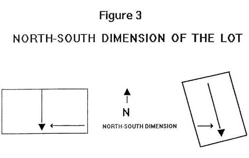
"North-south dimension" means the length of a line beginning at the mid-point of the northern lot line and extending in a southerly direction perpendicular to the northern lot line until it reaches a property boundary (see Figure 3).
7.
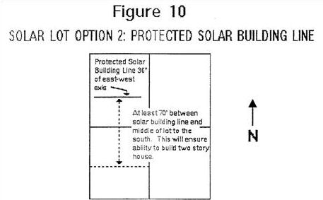
"Protected solar building line" means a line on a plat or map recorded with the plat that identifies the location on a lot where a point two feet above may not be shaded by structures or non-exempt trees (see Figure 10).
8.
"Shade" means a shadow cast by the shade point of a structure or vegetation when the sun is at an altitude of twenty-one and three-tenths degrees and an azimuth ranging from twenty-two and seven-tenths degrees east and west of true south.
9.
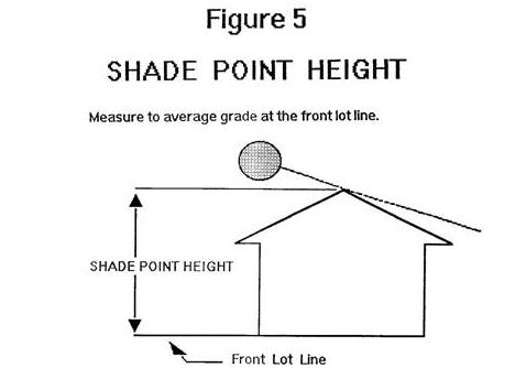
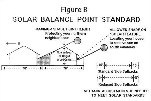
"Shade point" means the part of a structure or non-exempt tree that casts the longest shadow onto the adjacent northern lot(s) when the sun is at an altitude of twenty-one and three-tenths degrees and an azimuth ranging from twenty-two and seven-tenths degrees east and west of true south; except a shadow caused by a narrow object such as a mast or whip antenna, a dish antenna with a diameter of three feet or less, a chimney, utility pole or wire. The height of the shade point shall be measured from the shade point to either the average elevation at the front lot line or the elevation at the midpoint of the front lot line. If the shade point is located at the north end of a ridgeline of a structure oriented within forty-five degrees of a true north-south line, the shade point height computed according to the preceding sentence may be reduced by three feet. If a structure has a roof oriented within forty-five degrees of a true east-west line with a pitch that is flatter than five feet (vertical) in twelve feet (horizontal) the shade point will be the eave of the roof. If such a roof has a pitch that is five feet in twelve feet or steeper, the shade point will be the peak of the roof (see Figures 4 and 5).
10.
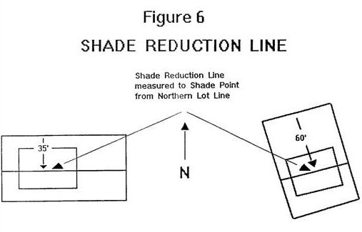
"Shade reduction line" means a line drawn parallel to the northern lot line that intersects the shade point (see Figure 6).
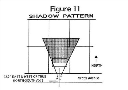
11.
"Shadow pattern" means a graphic representation of an area that would be shaded by the shade point of a structure or vegetation when the sun is at an altitude of twenty-one and three-tenths degrees and an azimuth ranging between twenty-two and seven-tenths degrees east and west of true south (see Figure 12).
12.
"Solar feature" means a device or combination of devices or elements that does or will use direct sunlight as a source of energy for such purposes as heating or cooling of a structure, heating or pumping of water, and generating electricity. Examples of a solar feature include a window or windows that contain(s) at least twenty square feet of glazing oriented within forty-five degrees east and west of true south, a solar greenhouse or a solar hot water heater. A solar feature may be used for purposes in addition to collecting solar energy, including, but not limited to, serving as a structural member or part of a roof, wall or window. A south-facing wall without windows and without other features that use solar energy is not a solar feature for purposes of this title.
13.
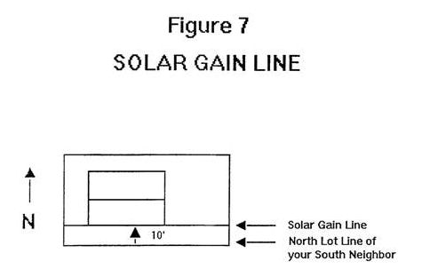
"Solar gain line" means a line parallel to the northern property line(s) of the lot(s) south of and adjoining a given lot, including lots separated only by a street, that intersects the solar feature on that lot (see Figure 7).
14.
"South" or "south facing" means true south, or twenty degrees east of magnetic south.
15.
"Sunchart" means one or more photographs that plot the position of the sun between ten-thirty a.m. and one-thirty p.m. on January 21, prepared pursuant to guidelines issued by the planning director. The sunchart shall show the southern skyline through a transparent grid on which is imposed solar altitude for a forty-five-degree and thirty minute northern latitude in ten-degree increments and solar azimuth from true south in fifteen-degree increments.
16.
"Undevelopable area" means an area that cannot be used practicably for a habitable structure, because of natural conditions, such as slopes exceeding twenty percent in a direction greater than forty-five degrees east or west of true south, severe topographic relief, water bodies or conditions that isolate one portion of a property from another portion so that access is not practicable to the unbuildable portion; or man-made conditions, such as existing development which isolates a portion of the site and prevents its further development; setbacks or development restrictions that prohibit development of a given area of a lot by law or private agreement; or existence or absence of easements or access rights that prevent development of a given area.
"Source separated recyclables" means at a minimum, recyclable materials designated "principle recyclable materials" by the State Environmental Quality Commission under ORS 495A.025, with the exception of yard debris. Currently these materials include newspaper, ferrous and non-ferrous scrap metal, used motor oil, corrugated cardboard, aluminum, container glass, office paper and tin cans (OAR 340-60-030).
"Specified anatomical areas" means uncovered or less than opaquely covered, post-pubertal human genitals, public areas, post-pubertal human female breast below a point immediately above the top of the areola, or the covered human male genitals in a discernibly turgid state.
"Specified sexual activities" means human genitals in a state of sexual stimulation or arousal, acts of masturbation, sexual intercourse, sodomy, flagellation, torture or bondage either real or simulated.
"Storage area" means the space necessary to store mixed solid waste and source separated recyclables that accumulate between collection days.
"Street" means a way which provides access to property, or provides travel between places by means of vehicles or other modes. A street will typically include sidewalks and may also serve as a bikeway.
"Structure" means something constructed or built, or a piece of work artificially built up or composed of parts joined together in some definite manner. Also, see the definition for "building."
"Structural alteration" means a change to the supporting members of a structure or building including foundations, bearing walls or partitions, columns, beams, girders, or any structural change in the roof or in the exterior walls.
(Ord. 102 s (1.030), 1986)
"Subdivide land" means to divide land into four or more lots within a calendar year when such area or tract of land exists as a unit or contiguous units of land under single ownership at the beginning of such year.
"Subdivider" or "developer" means that if an agency or agent is employed by the subdivider or developer to subdivide or develop, the responsibilities stated in this code will extend to such agency or agent in order that no evasion of such responsibilities may occur.
"Subdivision" means either an act of subdividing land or an area or a tract of land subdivided.
"Top of bank" means the stage or elevation at which water overflows the natural banks of streams or other waters and begins to inundate the upland. In the absence of physical evidence, the two-year recurrence interval flood elevation may be used to approximate the top of bank.
"Tract" means a parcel of land being subdivided.
"Tree" means a living, standing woody plant having a trunk diameter six inches or more in diameter at breast height (dbh) of six inches or more in diameter, maximum cross section, greater at four feet above mean ground level at the base of the trunk.
"Tree canopy" means the total ground area covered by a tree or grove of trees, as measured at the outer limit of tree branches or crown, projected to the ground. This is also referred to as the tree drip line.
"Tree grove" means a group of trees with an average diameter at breast height (dbh) of six inches or greater and height over thirty feet that form a contiguous canopy with an average diameter of at least one hundred fifty feet.
"Underdeveloped" means a lot or parcel that has not been fully improved to a use permitted by the primary district through a city manager or planning commission review procedure, excluding the following uses: home occupations, temporary uses, accessory uses and structures and a detached dwelling.
"Utilities" refers to infrastructure services which need to be located in or near the area where the service is provided. Basic utility uses generally do not have regular employees at the site. Services may be public or privately provided. Examples include water and sewer pump stations; electrical substations; water towers and reservoirs; stormwater retention and detention facilities; telephone exchanges; recycling drop-off; mass transit stations or turnarounds; park-and-ride facilities for mass transit, but does not include wireless communication facilities and wireless communication structures as defined in this section.
Wetland Protection Area Definitions (related to Chapter 16.114.080 Kingston Terrace District Goal 5 Safe Harbor Review):
1.
"Jurisdictional delineation" means a delineation of the wetland boundaries that is approved by the Oregon Department of State Lands (DSL). A delineation is a precise map and documentation of actual wetland boundaries on a parcel, whereas a determination may only be a rough map or a presence/absence finding. [See OAR 141-90-005 et seq. for specifications for wetland delineation or determination reports.]
2.
"Kingston Terrace District Locally Significant Wetland Resource Map" means the locally adopted map used as the basis for Section 16.114.080, which incorporates Oregon Department of State Lands (DSL), approved Local Wetland Inventory (LWI) map and identifies locally significant wetlands.
3.
"Local Wetlands Inventory (LWI)" means maps and report entitled [list report that inventories wetlands] and any subsequent revisions as approved by the Oregon Department of State Lands.
4.
"Locally significant wetland (LSW)" means a wetland that is determined to be significant under the criteria of OAR 141-86-0300 et seq. These criteria include those wetlands that score a high rating for fish or wildlife habitat, hydrologic control, or water quality improvement functions.
5.
"Oregon Freshwater Wetland Assessment Methodology (OFWAM)" means a wetland function and quality assessment methodology developed by the Oregon Department of State Lands.
6.
"Wetland" means an area inundated or saturated by surface or ground water at a frequency and duration sufficient to support, and which, under normal circumstances do support, a prevalence of vegetation typically adapted for life in saturated soil conditions.
7.
"Wetland protection area" means an area subject to the provisions of this chapter that includes all wetlands determined to be locally significant.
"Wireless communication facility" means an unstaffed facility for transmitting or receiving radio frequency (RF) signals, often consisting of an equipment shelter, cabinet or other enclosed structure. These include both private and public utility facilities. Examples include, but are not limited to, cellular telephone antenna, and microwave facilities. It excludes radio antenna (including amateur short wave radio), television antenna, and television receiving dishes for private or nonprofit use.
"Wireless communication structure" means a tower, pole, mast, or similar structure which is used to support a wireless communication facility.
"Yard, front" means a yard extending across the full width of the lot, the depth of which is the minimum horizontal distance between the front lot line and a line parallel thereto at the nearest point of the main building.
"Yard, rear" means a yard extending across the full width of the lot between the rear main building and the nearest point of the rear lot line.
"Yard, side" means a yard between the main building and the side lot line extending from the front yard or front lot line where no front yard is required, to the rear yard. The width of the required side yard shall be measured horizontally from the nearest point of the side lot line to the nearest part of the main building.
(Ord. O-08-02 § 1 (part), 2008; Ord. O-02-4 § 2 (part), 2002; Ord. 96-4 § 1 (part), 1996)
(Ord. No. O-98-01, § 2, 10-7-1998; Ord. No. O-2016-03, § 1(Exh. A), 9-21-2016; Ord. No. O-2018-04, § 2(Exh. B), 8-1-2018; Ord. No. O-2018-05, § 1(Exh. A), 10-17-2018; Ord. No. O-2020-01, § 1(Exh. A), 8-19-2020; Ord. No. 2023-04, § 1(Exh. A), 10-18-2023)
16.24.030 - Definitions of land use types.
A.
The purpose of the section is to classify land uses and activities into use categories on the basis of common functional, product or physical characteristics. Characteristics include the type and amount of activity, the type of customers or residents, how goods or services are sold or delivered, and certain site factors. The types of uses allowed in the various zones are based on the goals and policies of the comprehensive plan.
B.
Considerations.
1.
Uses are assigned to the category whose description most closely describes the nature of the primary use. Developments may have more than one primary use, and accessory activities may also be present. Primary and accessory uses are addressed in subsections (2) and (3) of this section.
2.
The following factors are considered to determine what category the use is in, and whether the activity(ies) constitute primary or accessory uses:
a.
The description of the activity(ies) in relationship to the characteristics of each use category;
b.
The relative amount of site or floor space and equipment devoted to the activity;
c.
The relative amount of sales from each activity;
d.
The number and type of customers for each activity;
e.
The relative number of employees in each activity;
f.
Hours of operation;
g.
Building and site arrangement;
h.
The number and type of vehicles used with the activity;
i.
The relative number of vehicle trips generated by the activity(ies);
j.
Signs;
k.
How the use advertises itself; and
l.
Whether the activity(ies) would be likely to be found independent of the other activities on the site.
3.
Multiple Primary Uses. When a development has a number of primary uses that fall within one use category, then the development is assigned to that use category. For example, if a development includes a grocery store and pharmacy, the development would be classified as a commercial retail sales and service use.
When the primary uses in a development are within different use categories, each primary use is classified in the applicable category and is subject to the regulations for that category.
4.
Accessory Uses. These uses are allowed by right and are regulated in conjunction with the primary use unless otherwise stated in this title.
5.
Examples and Exceptions. To help illustrate the types of uses allowed or not allowed under a specific uses category, examples and/or exceptions are given. They are based on the common meaning of the terms and not on what a specific use may call itself.
C.
Residential Use Types.
"Common courtyard" means a common area for use by residents of a cottage cluster. A common courtyard may function as a community yard. Hard and soft landscape features may be included in a common courtyard, such as pedestrian paths, lawn, groundcover, trees, shrubs, patios, benches, or gazebos.
"Cottage" means an individual dwelling unit that is part of a cottage cluster.
"Cottage cluster" means a grouping of no fewer than four detached dwelling units per acre with a footprint of less than nine hundred square feet each that includes a common courtyard. Cottage cluster units may be located on a single lot or parcel, or on individual lots or parcels.
"Cottage cluster project" means a development site with one or more cottage clusters. Each cottage cluster as part of a cottage cluster project must have its own common courtyard.
"Dwelling, multi" means a structure that contains five or more dwelling units which may share common walls, floors or ceilings with one or more than two dwelling units on one lot. Dwelling units may be attached or detached.
"Dwelling, single-family attached" means a dwelling unit, located on its own lot, that shares one or more common or abutting walls with one or more dwelling units. It does not share common floors or ceilings with other dwelling units. Also referred to as a townhome or townhouse.
"Dwelling, single-family detached" means a detached dwelling unit located on its own lot.
"Dwelling unit, accessory" means a second and independent living unit created on a lot with a primary dwelling, which may be an attached or detached single-family dwelling or manufactured home. This second unit is created auxiliary to, and is always smaller than the primary dwelling. It has a separate kitchen, living, bathroom, and sleeping facilities within the primary dwelling or in a separate accessory building on the same lot as a primarily dwelling. Because it is considered as an accessory use, this type of residential unit is not included in density calculations.
"Duplex" means a structure that contains two primary dwelling units on one lot. The units may share common walls, floors or ceilings.
"Family care" includes two types of child care services and one type for adults.
1.
"Family day care" as defined by Oregon State Statute, refers to the provision of day care services for children, with or without compensation, in the home of the caregiver. Family day care may provide care for six or fewer children full-time, with an additional four or fewer full-time or part-time children. During the school year, a family day care provider may care for four additional day care children on days and during the hours school is not in session. Such children must be at least an age up to a maximum of four hours per day. No more than a total of ten children including the provider's own children may be present at any one time.
2.
"Day care group home" as defined by Oregon State Statute, is one in which care is provided in the home of the caregiver, with or without compensation, for seven through twelve children. It is subject to certification by the Children Services Division. For the purposes of this section, "full-time" is defined as eight or more hours in a twenty-four-hour period. "Part-time" is defined as four or fewer hours in a twenty-four-hour period.
3.
"Adult day care" means a community-based group program designed to meet the needs of functionally or cognitively impaired adults through an individual plan of care. It is a structured, comprehensive program that provides a variety of health, social and related support services in a protective setting during part of a day but for less than twenty-four hours. These facilities have an enrollment of ten or more individuals.
"Fourplex" means a structure that contains four primary dwelling units on one lot. The units may share common walls, floors or ceilings.
"Manufactured home" means a structure constructed for movement on the public highways that has sleeping, cooking and plumbing facilities, that is intended for human occupancy, that is being used for residential purposes and that was constructed in accordance with federal manufactured housing construction and safety standards regulations in effect at the time of construction. It does not mean any building or structure subject to the structural specialty code adopted pursuant to ORS 455.100 to 455.450, any unit identified as a recreational vehicle by the manufacturer, or a modular home.
"Mobile home" means a structure constructed for movement on the public highways that has sleeping, cooking and plumbing facilities, that is intended for human occupancy, that is being used for residential purposes and that was constructed between January 1, 1962, and June 15, 1976, and which met the construction requirements of Oregon mobile home law in effect at the time of construction.
"Manufactured/mobile home park" means a lot or parcel of land under single ownership on which two or more manufactured or mobile homes are occupied as residences. The manufactured/mobile home sites usually are rented or leased.
"Manufactured home/mobile home subdivision" means a subdivision designed and approved for the sale of lots exclusively for manufactured and/or mobile homes.
"Recreational vehicle" means a unit, with or without motive power, which is designated for human occupancy, and is used temporarily for recreational or emergency purposes as defined in the Oregon Administrative Rules OAR 918-650-0005 (18).
"Recreational vehicle park" means a plot of land upon which two or more recreational vehicle sites are located, established or maintained for occupancy by recreational vehicles of the general public as temporary living quarters for recreational or vacation purposes as defined in the Oregon Administrative Rules OAR 918-650-0005 (17)(c).
"Residential facility" means a residential care, residential training, or residential treatment facility licensed or registered by the state (Mental Health and Developmental Services Division) as defined in ORS 443.400 where residential care alone or in conjunction with treatment or training or a combination thereof is provided for six to fifteen individuals who need not be related. Staff persons needed to meet licensing requirements shall not be counted in the number of facility residents, and need not be related to each other or to any resident of the residential facility.
A residential facility does not include a residential school; state or local correctional facility; juvenile training school; youth care center operated by a county juvenile department; juvenile detention facility; nursing home; family care facility; or children's day care as defined by state law.
"Residential home" means a residential treatment or training or an adult foster home licensed by or under the authority of the state (Mental Health and Developmental Services Division), which provides residential care alone or in conjunction with treatment or training or a combination thereof for less that six individuals. These individuals need not be related. Staff persons needed to meet licensing requirements shall not be counted in the number of facility residents, and need not be related to each other or to any resident of the residential home.
"Triplex" means a structure that contains three primary dwelling units on one lot. The units may share common walls, floors or ceilings.
D.
Commercial Use Types.
"Motel" refers to establishments primarily engaged in the provision of lodging services on a temporary basis with incidental food, drink and other sales and services intended for the convenience of guests.
"Office" means a use that is conducted in an office setting generally for business, government, professional, medical or financial services.
Examples include professional services such as lawyers, accountants, engineers or architects; financial businesses such as lenders, brokerage houses, bank headquarters or real estate agents; data processing; sales offices; government offices and public utility offices; television and radio studios; medical and dental clinics, medical and dental labs; and blood-collections facilities.
"Retail sales and service" means businesses that are involved in the sale, lease or rent of new or used products to the general public. They may also provide personal services or entertainment, or provide product repair or services for consumer and business goods. Such uses are conducted indoors with limited provisions in this title to allow outdoor storage of material or merchandise. Categories and examples of retail sales and service uses include:
1.
"Sales-oriented" stores selling, leasing or renting consumer, home and business goods including appliances, art supplies, bicycles, clothing, dry goods, electronic equipment, fabric, furniture, garden supplies, gifts, groceries, hardware, home improvements, household products, jewelry, liquor, pets, pet food, pharmaceuticals, plants, printed material, stationery and food sales.
2.
"Personal service-oriented" businesses such as branch banks; urgency medical care; dental and medical offices; laundromats; photo or laundry drop-off; photographic studios; photocopy and blueprint services; hair, business, and other trade schools; dance or music classes; veterinarians; and animal grooming.
3.
"Entertainment-oriented" businesses such as restaurants, cafes and delicatessens; bowling alleys; health clubs; gyms; and membership clubs and lodges.
4.
"Repair-oriented" businesses such as repair of televisions, bicycles, clocks, watches, shoes, guns, appliances and office equipment; tailor; locksmith; and upholsterer.
5.
"Drive-through facilities" such as vehicle drive up windows associated with restaurants, banks, laundries, photo processing and similar uses.
Uses not included, thus prohibited, as part of this definition are:
1.
Lumber yards and other building material sales that sell primarily to contractors and do not have a retail orientation;
2.
Landscape materials stored outside, including bark chips, rock, fertilizer and compost;
3.
Repair, sale, rental or leasing of commercial or consumer vehicles (except for that allowed as quick vehicle service), motorcycles, trucks, and industrial vehicles and equipment;
4.
Self-service storage as defined in this chapter;
5.
Establishments having any merchandise items, books, magazines, other publications, films or videotapes which are for sale, rent or viewing on the premises and which are distinguished or characterized by their emphasis on matters depicting the specified sexual activities or specified anatomical areas defined herein;
6.
Establishments where entertainment includes matters depicting specified sexual activities or specified anatomical areas as defined herein.
"Quick vehicle servicing" means a business that provides direct services for motor vehicles where the driver generally waits in the car before and while the service is performed. The use includes a drive-through facility and the area where the service is performed. Examples include:
1.
Full-service and mini-serve gas stations;
2.
Unattended card key stations;
3.
Car washes;
4.
Quick lubrication services. This use type does not include servicing of vehicles over ten thousand pounds gross cargo weight (except for gasoline), body repairs, welding or painting.
"Self-service storage" means facilities that provide separate storage areas for rent which are available to individuals or businesses. The storage areas are designed to allow private access by the tenant for storing or removing personal property.
"Street tree" means a tree along public street frontage, which is located within or adjacent to a public street right-of-way or easement.
E.
Public and Institutional Use Types.
"Community services" means uses of a public, nonprofit or charitable nature generally providing a local service to people of the community. Generally, they provide other service on the site or have employees at the site on a regular basis. The service is ongoing, not just for special events. Community centers or facilities are open to the general public or have membership provisions that are open to the general public to join at any time (for instance, any senior citizen could join a senior center). The use may also provide special counseling, education or training of a public, nonprofit or charitable nature. Examples include libraries, museums, senior centers, community centers, publicly owned swimming pools, youth club facilities, hospices, drug and alcohol centers, social service facilities, vocational training for the physically or mentally disabled, crematoriums and mausoleums. Not included as part of this definition are:
1.
Private lodges;
2.
Clubs; or
3.
Private or commercial athletic or health clubs (these uses are classified as retail sales and service).
"Hospital" means a use which provides medical or surgical care to patients and offers overnight care.
"Parks and open space" means land that is primarily left in a natural state or landscaped with few structures. Examples include parks, playgrounds, golf courses, cemeteries, public squares, recreational trails, botanical gardens and nature preserves.
"Public safety facilities" means public uses that provide safety and emergency services to the general public. Examples include police stations, fire stations and ambulance stations.
"Religious assembly" means institutions that are intended to primarily provide meeting areas for religious activities. Examples include churches, temples, synagogues and mosques.
"Schools" refer to public and private primary, elementary, middle, junior high or high schools that provide state mandated basic education.
"Utilities" refers to infrastructure services which need to be located in or near the area where the service is provided. Basic utility uses generally do not have regular employees at the site. Services may be public or privately provided. Examples include water and sewer pump stations; electrical substations; water towers and reservoirs; stormwater quality, retention and detention facilities; telephone exchanges; recycling drop-off; mass transit stops, stations or turnarounds, and park-and-ride facilities for mass transit.
(Ord. O-03-2 § 1 (part), 2003; Ord. O-02-4 § 2 (part), 2002; Ord. 96-4 § 1 (part), 1996)
(Ord. No. O-2015-01, § 1(Exh. A), 3-18-2015; Ord. No. O-2020-01, § 1(Exh. A), 8-19-2020; Ord. No. O-2021-01, § 2(Exh. B), 8-18-2021; Ord. No. 2023-04, § 1(Exh. A), 10-18-2023)
16.24.040 - Solar access figures.
(Ord. 96-4 § 1 (part), 1996)
16.28.010 - Purpose.
The following are the major participants in the planning process in King City. The purpose of this chapter is to describe the roles of these parties.
(Ord. 96-4 § 1 (part), 1996)
16.28.020 - City council.
The city council is the policy and ultimate decision making body for the city. The council will follow the provisions of Chapter 2.04 of this code. In addition, the council may:
A.
Create a planning commission or commissions which shall act as the planning and development advisory body(s) to the council and shall have such other powers and authority as described in this title or as may be specified by the council;
B.
Create advisory committee(s) to advise the council on land use issues; and
C.
Delegate final decision making authority to the city manager or planning commission as described in this title.
(Ord. 96-4 § 1 (part), 1996)
16.28.030 - Planning commission.
The planning commission shall serve at the pleasure of the city council.
A.
The council shall appoint the members of the commission as provided in Chapter 2.16 of this code.
B.
The planning commission shall advise the city council on legislative planning and development issues including but not limited to comprehensive plan amendments, annexation applications and amendments to this title.
C.
The planning commission shall have decision making authority as provided by this title.
(Ord. 96-4 § 1 (part), 1996)
16.28.040 - City manager.
The office of the city manager is established in Chapter 2.08 of this code. As a part of the duties of this office, the city manager shall be responsible for the administration of the planning and development activities within the city and shall be the chief administrator in charge of planning. The city manager may delegate all or a portion of these responsibilities to other qualified individuals. The city manager's duties are described in this title and include but are not limited to the following:
A.
Scheduling of applications and land use cases;
B.
Issuing legal notice as required by this title;
C.
Maintaining agendas, minutes, records and files, and;
D.
Providing professional expertise, staff assistance, and information to the public, city council and planning commission.
(Ord. 96-4 § 1 (part), 1996)