
King City City Zoning Code
ARTICLE III
Land Use Districts
Chapter 16.84 - SINGLE USE RESIDENTIAL ZONES[2]
Note— Prior Ch. 16.84 derived from Ords. 96-4 and O-99-6.
Chapter 16.108 - COMMUNITY FACILITIES ZONE (CF)
Sections:
16.80.010 - Districts generally.
All lands, tracts and area within the corporate limits of the city area are included within one of the following described land use zoning districts. The purpose of use, classification and uses of each tract within the corporate limits of the city shall be limited to those applicable to the zoning classification district within which such tract or lands are situated.
(Ord. O-99-6 § 1 (part), 1999: Ord. 96-4 § 1 (part), 1996)
16.80.020 - Zoning classification districts.
The city is divided into the following zoning classification districts, with applicable abbreviated designation, shall be as follows:
(Ord. O-02-4 § 2 (part), 2002: Ord. O-99-6 § 1 (part), 1999: Ord. 96-4 § 1 (part), 1996)
(Ord. No. O-2020-01, § 1(Exh. A), 8-19-2020; Ord. No. O-2021-01, § 2(Exh. B), 8-18-2021; Ord. No. 2023-04, § 1(Exh. A), 10-18-2023)
16.80.030 - Location of districts.
A.
The boundaries for the districts listed in this chapter are indicated on the city zoning map which is adopted by reference. The boundaries shall be modified in accordance with the provisions of this code.
B.
The boundaries, legends, symbols, notations and references of each of the zoning classification districts as depicted on the city zoning map are adopted by reference.
C.
Unless otherwise specified, district and subdistrict boundaries are section lines, subdivision lines, lot lines, center lines of street right-of-way, or such lines extended.
(Ord. 96-4 § 1 (part), 1996)
16.80.040 - Zoning map.
The city zoning map is attached to the ordinance codified in this title and by this reference made a part hereof, bearing the signatures of the mayor and city recorder of the city, and entitled "City of King City Zoning Map" dated with the effective date of the ordinance codified in this title. It shall be maintained without change on file at all times in the office of the city recorder.
(Ord. O-99-6 § 1 (part), 1999: Ord. 96-4 § 1 (part), 1996)
16.80.050 - Zoning of annexed areas.
A.
Zoning regulations applicable to an area prior to annexation to the city shall continue to apply and shall be enforced by the city until a zone change for the area has been adopted by the city council. The city may, in a resolution favoring annexation of property to the city may, conduct such proceedings as may be necessary to establish the zoning and land uses of the property to the requirements of this title and the comprehensive plan.
B.
The city may also enter into zoning and land use agreements with owners of property prior to annexation, provided the proceedings follow all requirements of this title for zone changes.
(Ord. O-99-6 § 1 (part), 1999: Ord. 96-4 § 1 (part), 1996)
16.80.060 - Additional yard and setback requirements.
A.
Substandard Street Right-of-Way.
1.
Where a yard or setback abuts a street having insufficient right-of-way width, the minimum yard or setback requirement shall be increased by the amount of right-of-way, measured from the street centerline, necessary to meet applicable city, county, or state standards.
2.
The applicable street right-of-way width standards, measured at right angles to the street centerline, are as follows:
a.
Pacific is Highway (State Route 99W)—Applicable right-of-way requirement from centerline as determined by the Oregon Department of Transportation;
b.
Beef Bend Road—Thirty-three feet;
c.
131st Avenue, between Beef Bend Road and Fischer Road—Thirty-three feet;
d.
Fischer Road—Thirty-three feet;
e.
116th Avenue, between Queen Elizabeth and Pacific Highway—Thirty feet;
f.
Royalty Parkway, between Pacific Highway and 116th Avenue—Thirty feet; and
g.
All other city streets—Twenty-five feet.
B.
Projections into Required Yards.
1.
Cornices, eaves, belt courses, sills, canopies, fireplace chimneys or similar architectural features may extend or project a maximum of thirty-six inches into a required yard provided the width of such yard is not reduced to less than three feet.
2.
Open porches, decks or balconies not more than thirty-six inches in height and not covered by a roof or canopy, may extend or project a maximum of thirty-six inches into a required yard area provided the yard area is not reduced to less than three feet. Such building additions located in a rear or side yard shall be screened from abutting properties.
3.
Porches, decks, or balconies than exceed thirty-six inches in height or are covered by a roof or canopy shall comply with the setback standards of the applicable zone.
(Ord. O-99-6 § 1 (part), 1999: Ord. 96-4 § 1 (part), 1996)
16.80.070 - Exceptions to building height requirements.
Projections such as chimneys, spires, domes, elevator shaft housings, towers, aerials, flag poles, utility poles and other similar structures not used for human occupancy, are not subject to the building height limitations of this title. (See 16.176.050(A)(4).)
(Ord. O-99-6 § 1 (part), 1999: Ord. 96-4 § 1 (part), 1996)
16.80.080 - Other requirements.
A.
No temporary structure, trailer, recreational vehicle or other structure shall be placed on a lot for dwelling purposes, except during periods of construction when one such dwelling is allowed and approved by the city manager for a building project.
B.
No signs or other advertising devices except real estate signs shall be placed on a lot without the express permission of the city manager.
C.
No homeowners' association governing documents or deed restrictions shall be recorded to regulate housing types, including accessory dwelling units, or impose any standards, including owner occupancy, which would have the effect of prohibiting or limiting the type or density of housing that would otherwise be allowable under this code. Any such restriction recorded on or after January 1, 2020, and that restriction violated state housing laws, shall be deemed void and removed pursuant to this section and applicable state housing law.
(Ord. O-99-6 § 1 (part), 1999: Ord. 96-4 § 1 (part), 1996)
(Ord. No. O-2015-01, § 1(Exh. A), 3-18-2015; Ord. No. O-2020-01, § 1(Exh. A), 8-19-2020)
16.82.010 - Purpose.
A.
It is not possible to contemplate all of the various uses which must be compatible within a zoning district. Therefore, unintentional omissions occur.
B.
The purpose of this chapter is to establish a procedure for determining whether certain specific uses would have been permitted in a zoning district had they been contemplated and whether such unlisted uses are compatible with the listed uses.
(Ord. O-99-6 § 1 (part), 1999: Ord. 96-4 § 1 (part), 1996)
16.82.020 - Definition.
An unlisted use is a use which is not listed as either a use permitted outright or a conditional use in a particular zone.
(Ord. O-99-6 § 1 (part), 1999: Ord. 96-4 § 1 (part), 1996)
16.82.030 - Administration.
A.
The city manager shall maintain a list by zoning district of unlisted uses approved by the planning commission and the list shall have the same effect as an amendment to the use provisions of the applicable zone.
B.
Requests to approve an unlisted use shall be administered as a planning commission review in accordance with Article II of this title.
(Ord. O-99-6 § 1 (part), 1999: Ord. 96-4 § 1 (part), 1996)
16.82.040 - Approval standards.
The planning commission shall approve an unlisted use application based on findings that all of the following criteria are satisfied:
A.
The use is not specifically listed in another zone as either a permitted use or a conditional use;
B.
The use is consistent with the comprehensive plan;
C.
The use is consistent with the intent and purpose of the applicable zoning district;
D.
The use is similar to and of the same general type as the uses listed in the zoning district;
E.
The use has similar intensity, density and offsite impacts as the uses listed in the zoning district; and
F.
The use has similar impacts on the community facilities as the listed uses.
(Ord. O-99-6 § 1 (part), 1999: Ord. 96-4 § 1 (part), 1996)
16.84.010 - Housing types permitted by single dwelling residential zone.
A housing type is not a use category. It describes a type of development that can contain a residential use.
P - Permitted N - Not permitted
(Ord. No. O-2021-01, § 2(Exh. B), 8-18-2021)
Editor's note— Ord. No. O-2021-01 amended § 16.84.010 in its entirety to read as herein set out. Formerly § 16.84.010 was entitled "Purpose" and derived from Ord. O-02-4 § 2 (part), 2002.
16.84.020 - Permitted Uses.
A permitted use is a use, which is allowed outright, but is subject to all applicable provisions of this title. If a use is not listed as a permitted use, it may be held to be a similar unlisted use under the provisions of Chapter 16.82. Permitted uses in the R-9 zone are:
A.
Residential home;
B.
Manufactured/Mobile home parks and subdivisions;
C.
Family day care (family care); and
D.
Park and open space created as part of a subdivision or planned development.
(Ord. O-03-2 § 1 (part), 2003; Ord. O-02-4 § 2 (part), 2002)
(Ord. No. O-2021-01, § 2(Exh. B), 8-18-2021)
16.84.030 - Conditional uses.
A conditional use is a use, which is subject to a discretionary decision by the planning commission. The approval criteria are set forth in Chapter 16.156. If a use is not listed as a conditional use, it may be held to be a similar unlisted use under the provisions of Chapter 16.82. Conditional uses in the R-9 district are:
A.
Schools;
B.
Utilities;
C.
Community services;
D.
Parks and open space not created as part of a subdivision or planned development;
E.
Religious assembly;
F.
Public safety facilities;
G.
Day care group home (family care); and
H.
Recreation vehicle and boat storage serving only the residents within the development.
(Ord. O-02-4 § 2 (part), 2002)
16.84.040 - Dimensional and density requirements.
The dimensional and density requirements for single dwelling residential zones are:
1 Townhouse lots may be a minimum of one thousand five hundred square feet.
2 Townhouse lots may have a minimum width of twenty feet.
3 Minimum average lot width, in feet: twenty-four.
4 For zero-foot setback buildings, set back is zero feet. In all cases, zero-foot setback buildings shall either: (1) be attached at the property line; or (2) have a minimum separation of six feet.
5 Side yard of five feet for a one-story structure, and ten feet for two-story structures.
6 Zero feet for a detached accessory dwelling unit or building less than or equal to eighteen feet in height.
7 Zero—six feet or ≥ eighteen feet to a garage entrance to an alley.
8 Maximum coverage cannot apply to Cottage Clusters.
* In addition, building setbacks for each type of structure must comply with the current Oregon Building Code.
(Ord. O-02-4 § 2 (part), 2002; Ord. No. O-2020-01, § 1(Exh. A), 8-19-2020; Ord. No. O-2021-01, § 2(Exh. B), 8-18-2021)
16.84.050 - Design requirements.
In addition to the dimensional requirements in Section 16.84.040, the following design requirements shall apply:
Figure 1
Figure 2
(Ord. O-02-4 § 2 (part), 2002; Ord. No. O-2020-01, § 1(Exh. A), 8-19-2020)
16.84.060 - Cottage clusters.
A.
Development and Siting Standards.
1.
Setbacks. Cottage cluster buildings shall satisfy the setback standards in 16.84.040 except as modified in this section (16.84.060).
2.
Building separation. The minimum internal building separation shall be determined by the Oregon Building Code.
3.
Unit size, average. The maximum average floor area for a cottage cluster is one thousand four hundred square feet per dwelling unit. Community buildings shall be included in the average floor area calculation for a cottage cluster.
4.
Maximum building footprint. The maximum building footprint is nine hundred square feet per dwelling unit. Attached garage or carport may be exempt for up to two hundred square feet of the building footprint calculation.
5.
Building height. The maximum building height for all structures is twenty-five feet.
B.
Design Standards.
1.
Cottage orientation. Cottages must be clustered around a common courtyard, meaning they abut the associated common courtyard or are directly connected to it by a pedestrian path, and must meet the following standards:
a.
Each cottage within a cluster must either abut the common courtyard or must be directly connected to it by a pedestrian path.
b.
A minimum of fifty percent of cottages within a cluster must be oriented to the common courtyard and must:
i.
Have a main entrance facing the common courtyard;
ii.
Be within ten feet from the common courtyard, measured from the façade of the cottage to the nearest edge of the common courtyard; and
iii.
Be connected to the common courtyard by a pedestrian path.
c.
Cottages within twenty feet of a street property line may have their entrances facing the street provided they comply with the front and front porch standards in Section 16.84.040.
d.
Cottages not facing the common courtyard or the street must have their main entrances facing a pedestrian path that is directly connected to the common courtyard.
2.
Common courtyard design. Each cottage cluster must share a common courtyard in order to provide a sense of openness and community of residents. Common courtyards must meet the following standards:
a.
The common courtyard must be a single, contiguous piece.
b.
Cottages must abut the common courtyard on at least two sides of the courtyard.
c.
The common courtyard must contain a minimum of one hundred fifty square feet per cottage within the associated cluster.
d.
The common courtyard must be a minimum of fifteen feet wide at its narrowest dimension.
e.
The common courtyard shall be developed with a mix of landscaping, lawn area, pedestrian paths, and/or paved courtyard area, and may also include recreational amenities. Impervious elements of the common courtyard shall not exceed seventy-five percent of the total common courtyard area.
f.
Pedestrian paths must be included in a common courtyard. Paths that are contiguous to a courtyard shall count toward the courtyard's minimum dimension and area. Parking areas, required setbacks, and driveways do not qualify as part of a common courtyard.
3.
Community buildings. Cottage cluster projects may include community buildings for the shared use of residents that provide space for accessory uses such as community meeting rooms, guest housing, exercise rooms, day care, or community eating areas. Community buildings must meet the following standards:
a.
Each cottage cluster is permitted one community building, which shall count towards the maximum average floor area.
b.
A community building that meets the development code's definition of a dwelling unit must meet the maximum nine hundred square foot footprint limitation that applies to cottages, unless a covenant is recorded against the property stating that the structure is not a legal dwelling unit and will not be used as a primary dwelling.
4.
Pedestrian access.
a.
An accessible pedestrian path must be provided that connects the main entrance of each cottage to the following:
i.
The common courtyard;
ii.
Shared parking areas;
iii.
Community buildings; and
iv.
Sidewalks in public rights-of-way abutting the site or rights-of-way if there are no sidewalks.
b.
The pedestrian path must be hard-surfaced and a minimum of four feet wide.
5.
Windows. Cottages within twenty feet of a street property line must meet any window coverage requirement that applies to detached single-family dwellings in the same zone.
6.
Parking design, clustered. Clustered parking: Off-street parking may be arranged in clusters, subject to the following standards:
a.
Cottage cluster projects with fewer than sixteen cottages are permitted parking clusters of not more than five contiguous spaces.
b.
Cottage cluster projects with sixteen cottages or more are permitted parking clusters of not more than eight contiguous spaces.
c.
Parking clusters must be separated from other spaces by at least four feet of landscaping.
d.
Clustered parking areas may be covered.
7.
Parking location and access.
a.
Off-street parking spaces and vehicle maneuvering areas shall not be located:
i.
Within of twenty feet from any street property line, except alley property lines;
ii.
Between a street property line and the front façade of cottages located closest to the street property line. This standard does not apply to alleys.
8.
Parking location and access, screening. Landscaping, fencing, or walls at least three feet tall shall separate clustered parking areas and parking structures from common courtyards and public streets.
9.
Parking location and access, garages, and carports.
a.
Garages and carports (whether shared or individual) must not abut common courtyards.
b.
Individual attached garages up to two hundred square feet shall be exempted from the calculation of maximum building footprint for cottages.
c.
Individual detached garages must not exceed four hundred square feet in floor area.
d.
Garage doors for attached and detached individual garages must not exceed twenty feet in width.
10.
Existing structures. On a lot or parcel to be used for a cottage cluster project, an existing detached single-family dwelling on the same lot at the time of proposed development of the cottage cluster may remain within the cottage cluster project area under the following conditions:
a.
The existing dwelling may be nonconforming with respect to the requirements of this code.
b.
The existing dwelling may be expanded up to the maximum height or the maximum building footprint; however, existing dwellings that exceed the maximum height and/or footprint of this code may not be expanded.
c.
The floor area of the existing dwelling shall not count towards the maximum average floor area of a cottage cluster.
d.
The existing dwelling shall be excluded from the calculation of orientation toward the common courtyard.
(Ord. No. O-2021-01, § 2(Exh. B), 8-18-2021)
16.88.010 - Reserved.
Editor's note— Ord. No. O-2021-01, § 2(Exh. B), adopted Aug. 18, 2021, deleted § 16.88.010 entitled "Purpose," which derived from: Ord. O-99-6 § 1 (part), 1999; and Ord. 96-4 § 1 (part), 1996.
16.88.020 - Permitted uses.
A permitted use is a use, which is allowed outright, but is subject to all applicable provisions of this title. If a use is not listed as a permitted use, it may be held to be a similar unlisted use under the provisions of Chapter 16.82. Permitted uses in the SF zone are:
A.
Residential home.
(Ord. O-03-2 § 1 (part), 2003; Ord. O-99-6 § 1 (part), 1999: Ord. 96-4 § 1 (part), 1996)
(Ord. No. O-2021-01, § 2(Exh. B), 8-18-2021)
16.88.030 - Conditional uses.
A conditional use is a use which is subject to a discretionary decision by the planning commission. The approval criteria are set forth in Chapter 16.156. If a use is not listed as a conditional use, it may be held to be a similar unlisted use under the provisions of Chapter 16.82. Conditional uses in the SF district are:
A.
Schools;
B.
Utilities;
C.
Community services;
D.
Parks and open space;
E.
Religious assembly; and
F.
Public safety facilities.
(Ord. O-99-6 § 1 (part), 1999: Ord. 96-4 § 1 (part), 1996)
16.88.040 - Dimensional and density requirements.
Eighty percent of the maximum density allowed by the requirements of this chapter.
(Ord. O-99-6 § 1 (part), 1999: Ord. 96-4 § 1 (part), 1996)
(Ord. No. O-2020-01, § 1(Exh. A), 8-19-2020; Ord. No. O-2021-01, § 2(Exh. B), 8-18-2021)
16.92.010 - Reserved.
16.92.020 - Permitted uses.
A permitted use is a use, which is allowed outright, but is subject to all applicable provisions of this title. If a use is not listed as a permitted use, it may be held to be a similar unlisted use under the provisions of Chapter 16.82. Permitted uses in the AT zone are:
A.
Residential home;
B.
Manufactured/mobile home parks and subdivisions;
C.
Duplex; and
D.
Dwelling, accessory.
(Ord. O-03-2 § 1 (part), 2003; Ord. O-99-6 § 1 (part), 1999: Ord. 96-4 § 1 (part), 1996)
(Ord. No. O-2021-01, § 2(Exh. B), 8-18-2021)
16.92.030 - Conditional uses.
A conditional use is a use which is subject to a discretionary decision by the planning commission. The approval criteria are set forth in Chapter 16.156. If a use is not listed as a conditional use, it may be held to be a similar unlisted use under the provisions of Chapter 16.82. Conditional uses in the AT district are:
A.
Schools;
B.
Utilities;
C.
Community services;
D.
Parks and open space;
E.
Religious assembly;
F.
Public safety facilities; and
G.
Residential facility.
(Ord. O-99-6 § 1 (part), 1999: Ord. 96-4 § 1 (part), 1996)
16.92.040 - Reserved.
Editor's note— Ord. No. O-2021-01, § 2(Exh. B), adopted Aug. 18, 2021, deleted § 16.92.040 entitled "Dimensional and density requirements," which derived from: Ord. O-99-6 § 1 (part), 1999; Ord. 96-4 § 1 (part), 1996; Ord. No. O-2015-01, § 1(Exh. A), adopted Mar. 18, 2015; and Ord. No. O-2020-01, § 1(Exh. A), adopted Aug. 19, 2020.
16.94.010 - Reserved.
Editor's note— Ord. No. O-2021-01, § 2(Exh. B), adopted Aug. 18, 2021, deleted § 16.94.010 entitled "Purpose," which derived from: Ord. O-02-4 § 2 (part), 2002.
16.94.020 - Permitted uses.
A permitted use is a use, which is allowed outright, but is subject to all applicable provisions of this title. If a use is not listed as a permitted use, it may be held to be a similar unlisted use under the provisions of Chapter 16.82. Permitted uses in the R-12 zone are:
A.
Residential home;
B.
Manufactured/mobile home parks and subdivisions;
C.
Family day care (family care);
D.
Residential facility;
E.
Parks and open space created as part of a subdivision or planned development; and
F.
Dwelling, accessory.
(Ord. O-03-2 § 1 (part), 2003; Ord. O-02-4 § 2 (part), 2002)
(Ord. No. O-2021-01, § 2(Exh. B), 8-18-2021)
16.94.030 - Conditional uses.
A conditional use is a use, which is subject to a discretionary decision by the planning commission. The approval criteria are set forth in Chapter 16.156. If a use is not listed as a conditional use, it may be held to be a similar unlisted use under the provisions of Chapter 16.82. Conditional uses in the R-12 district are:
A.
Schools;
B.
Utilities;
C.
Community services;
D.
Parks and open space not created as part of a subdivision or planned development;
E.
Religious assembly;
F.
Public safety facilities;
G.
Day care group home (Family care); and
H.
Recreation vehicle and boat storage serving only the residents within the development.
(Ord. O-02-4 § 2 (part), 2002)
16.94.040 - Reserved.
Editor's note— Ord. No. O-2021-01, § 2(Exh. B), adopted Aug. 18, 2021, deleted § 16.94.040 entitled "Dimensional and density requirements," which derived from: Ord. O-02-4 § 2 (part), 2002; and Ord. No. O-2020-01, § 1(Exh. A), adopted Aug. 19, 2020.
16.94.050 - Design requirements.
In addition to the dimensional requirements in Section 16.94.040, the following design requirements shall apply:
Figure 1
Figure 2
(Ord. O-02-4 § 2 (part), 2002; Ord. No. O-2020-01, § 1(Exh. A), 8-19-2020)
16.96.010 - Reserved.
Editor's note— Ord. No. O-2021-01, § 2(Exh. B), adopted Aug. 18, 2021, deleted § 16.96.010 entitled "Purpose," which derived from: Ord. O-99-6 § 1 (part), 1999; and Ord. 96-4 § 1 (part), 1996.
16.96.020 - Permitted uses.
A permitted use is a use, which is allowed outright, but is subject to all applicable provisions of this title. If a use is not listed as a permitted use, it may be held to be a similar unlisted use under the provisions of Chapter 16.82. Permitted uses in the AT zone are:
A.
Residential home;
B.
Manufactured/mobile home parks and subdivisions;
C.
Family day care (family care); and
D.
Residential facility;
E.
Dwelling, accessory.
(Ord. O-03-2 § 1 (part), 2003; Ord. O-99-6 § 1 (part), 1999: Ord. 96-4 § 1 (part), 1996)
(Ord. No. O-2021-01, § 2(Exh. B), 8-18-2021)
16.96.030 - Conditional uses.
A conditional use is a use which is subject to a discretionary decision by the planning commission. The approval criteria are set forth in Chapter 16.156. If a use is not listed as a conditional use, it may be held to be a similar unlisted use under the provisions of Chapter 16.82. Conditional uses in the R-15 district are:
A.
Schools;
B.
Utilities;
C.
Community services;
D.
Parks and open space;
E.
Religious assembly;
F.
Public safety facilities; and
G.
Day care group home (family care).
(Ord. O-99-6 § 1 (part), 1999: Ord. 96-4 § 1 (part), 1996)
16.96.040 - Reserved.
Editor's note— Ord. No. O-2021-01, § 2(Exh. B), adopted Aug. 18, 2021, deleted § 16.96.040 entitled "Dimensional and density requirements," which derived from: Ord. O-99-6 § 1 (part), 1999; Ord. 96-4 § 1 (part), 1996; and Ord. No. O-2020-01, § 1(Exh. A), adopted Aug. 19, 2020.
16.100.010 - Reserved.
Editor's note— Ord. No. O-2021-01, § 2(Exh. B), adopted Aug. 18, 2021, deleted § 16.100.010 entitled "Purpose," which derived from: Ord. O-99-6 § 1 (part), 1999; and Ord. 96-4 § 1 (part), 1996.
16.100.020 - Permitted uses.
A permitted use is a use which is allowed outright, but is subject to all applicable provisions of this title. If a use is not listed as a permitted use, it may be held to be a similar unlisted use under the provisions of Chapter 16.82. Permitted uses in the AT zone are:
A.
Residential home;
B.
Manufactured/mobile home parks and subdivisions;
C.
Family day care (family care);
D.
Residential facility; and
E.
Dwelling, accessory.
(Ord. O-03-2 § 1 (part), 2003; Ord. O-99-6 § 1 (part), 1999: Ord. 96-4 § 1 (part), 1996)
(Ord. No. O-2021-01, § 2(Exh. B), 8-18-2021)
16.100.030 - Conditional uses.
A conditional use is a use which is subject to a discretionary decision by the planning commission. The approval criteria are set forth in Chapter 16.156. If a use is not listed as a conditional use, it may be held to be a similar unlisted use under the provisions of Chapter 16.82. Conditional uses in the R-24 district are:
A.
Schools;
B.
Utilities;
C.
Community services;
D.
Parks and open space;
E.
Religious assembly;
F.
Public safety facilities;
G.
Day care group home and adult day care (family care); and
H.
Recreational vehicle parks.
(Ord. O-03-2 § 1 (part), 2003; Ord. O-99-6 § 1 (part), 1999: Ord. 96-4 § 1 (part), 1996)
16.100.040 - Reserved.
Editor's note— Ord. No. O-2021-01, § 2(Exh. B), adopted Aug. 18, 2021, deleted § 16.100.040 entitled "Dimensional and density requirements," which derived from: Ord. O-99-6 § 1 (part), 1999; Ord. 96-4 § 1 (part), 1996; and Ord. No. O-2020-01, § 1(Exh. A), adopted Aug. 19, 2020.
16.102.010 - Purpose.
The purpose of the NMU zone is to provide a mix of residential, retail, service, and business needs of surrounding residential neighborhoods while maintaining a compatible scale and character with those neighborhoods. It is intended for relatively small sites within or adjacent to residential neighborhoods.
(Ord. No. 2018-04, § 2(Exh. B), 8-1-2018)
16.102.020 - Permitted uses.
A permitted use is a use which is allowed outright but is subject to all applicable provisions of this title. If a use is not listed as a permitted use, it may be held to be a similar unlisted use under the provisions of Chapter 16.82. Permitted uses in the NMU district are as follows:
A.
Dwelling, single-family attached and detached 0-foot side yard;
B.
Dwelling, multi-family;
C.
Duplex;
D.
Dwelling, accessory;
E.
Office;
F.
Retail sales and service conducted entirely indoors except for outdoor display as provided in 16.102.060.C, or is subject to liquor license review according to Chapter 5.05 of this title;
1.
Sales-oriented;
2.
Personal service-oriented; and
3.
Entertainment-oriented.
G.
Live-work unit approved as a Type I or II home occupation as provided in Chapter 16.172;
H.
Community services;
I.
Religious assembly;
J.
Family care;
K.
Residential facility; and
L.
Adult day care (family care).
(Ord. No. 2018-04, § 2(Exh. B), 8-1-2018; Ord. No. O-2020-01, § 1(Exh. A), 8-19-2020)
16.102.030 - Conditional uses.
A conditional use is a use which is subject to a discretionary decision by the planning commission. The approval criteria are set forth in Chapter 16.156. If a use is not listed as a conditional use, it may be held to be a similar unlisted use under the provisions of Chapter 16.82. Conditional uses in the NMU district are as follows:
A.
Live-work unit that does not qualify for Type I or II home occupation approval as provided in Chapter 16.172;
B.
Retail sales and service conducted partially or completely outside of a building or subject to liquor license review according to Chapter 5.05 of this title;
1.
Sales-oriented,
2.
Personal service-oriented, and
3.
Entertainment-oriented.
C.
Utilities;
D.
Public safety facilities; and
E.
Parks and open space.
(Ord. No. 2018-04, § 2(Exh. B), 8-1-2018)
16.102.040 - Dimensional and density requirements.
A.
The dimensional requirements in the NMU district are:
Dimensional Requirements Table
1 In addition, setbacks for each type of structure must comply with the current Oregon
Building Code.
2 ;hg;The landscaped area per lot may be reduced when common open space is provided.
In this case, the total landscaped area on lots and common areas must total a minimum
of 20%.
3 ;hg;Building height may be increased to a maximum of 45 feet as provided in Figure
1.
4 ;hg;Floor area ratios (FARs) apply to the total floor area in a mixed-use project
regardless of the use.
B.
The maximum building height of thirty-five feet in subsection A of this section shall increase one foot for each additional foot of building setback over twenty-five feet from a residential zoning district, up to a maximum building height of forty-five feet as illustrated in Figure 1. In the case of a public street right-of-way lying between the NMU Zone and a residential zone, the setback shall be calculated using the right-of-way centerline in lieu of the property line.
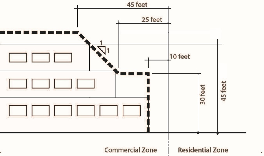
Figure 1. Building Height
(Ord. No. 2018-04, § 2(Exh. B), 8-1-2018; Ord. No. O-2020-01, § 1(Exh. A), 8-19-2020)
16.102.050 - Design requirements.
In addition to the dimensional requirements in Section 16.102.040, the following design requirements of this section shall apply.
A.
Residential development shall comply with the following standards:
Design Requirements Table—Residential Development
B.
Non-residential and mixed-use development shall comply with the following standards:
Design Requirements Table: Non-Residential and Mixed-Use Development
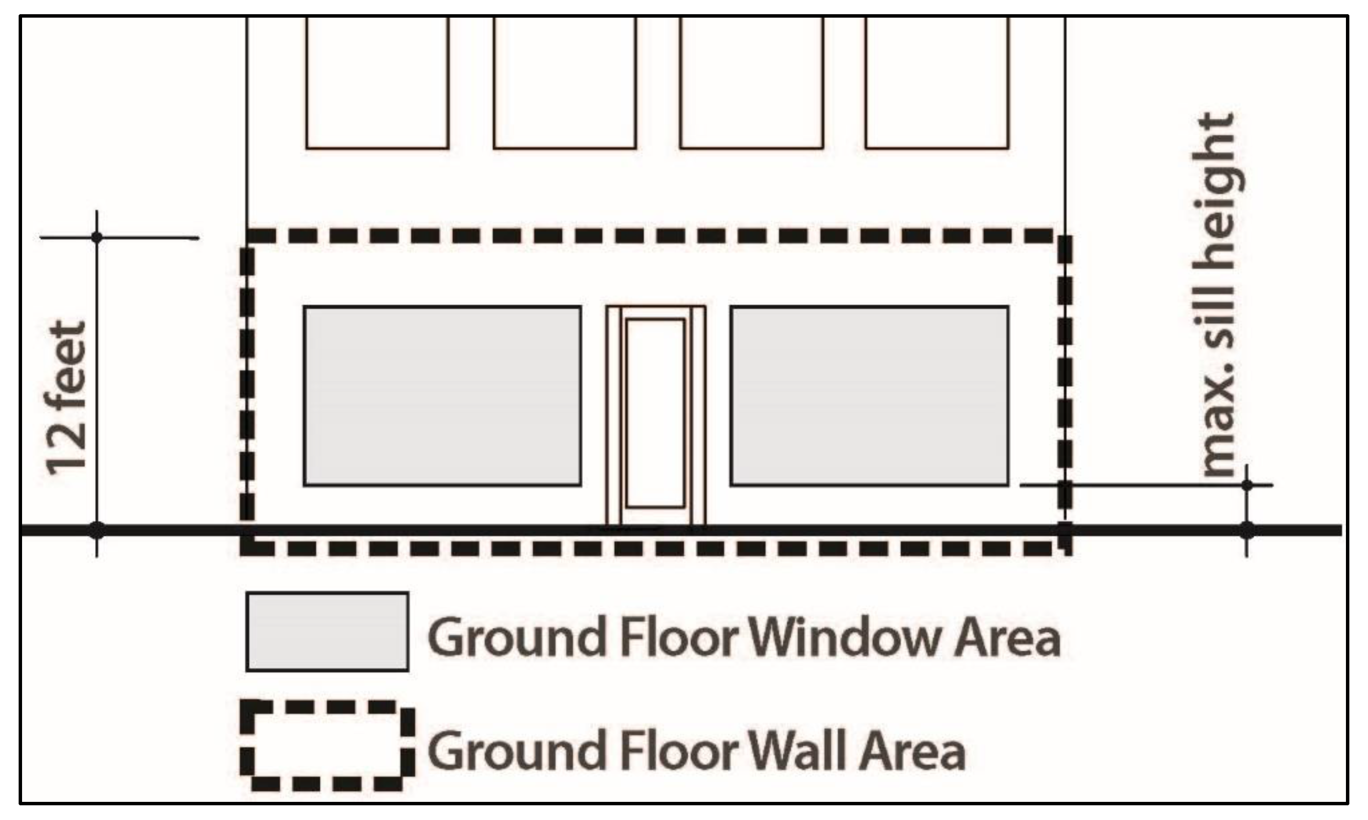
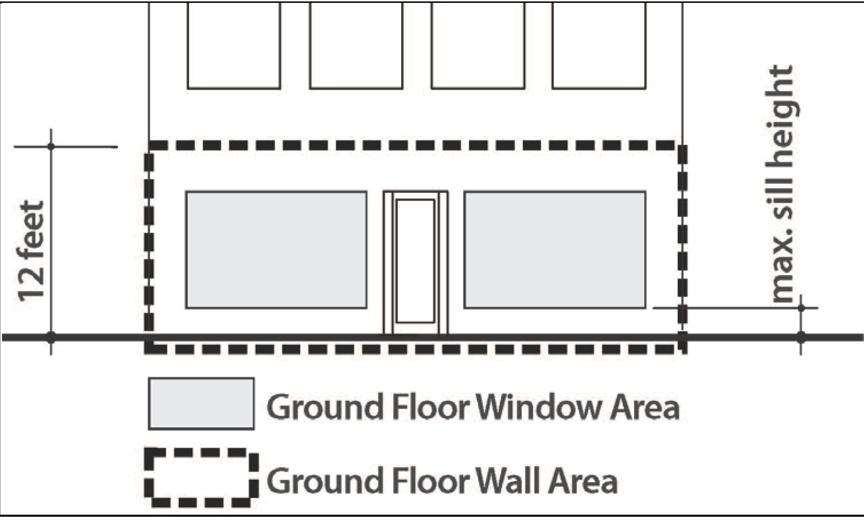
Figure 2. Minimum Glazing Area
(Ord. No. 2018-04, § 2(Exh. B), 8-1-2018)
16.102.060 - Additional requirements.
A.
Street Frontage Improvement Standards.
1.
Street frontage improvements shall be determined by the city engineer.
2.
For mixed-use or commercial development, the following additional street frontage improvements elements (Figure 3.) shall be required:
a.
A sidewalk clear zone with a minimum width of 6 feet; and
b.
Street furniture zone with a minimum width of 5 feet, including the curb.
3.
An optional supplemental zone may (Figures 3. and 4.) be provided between the building the clear zone for residential, commercial, or mixed-use development subject to the following standards:
a.
A maximum depth between the clear zone and building façade of 20 width of feet;
b.
Use of this area for additional sidewalk width, patio, landscaping or similar improvements; and
c.
No vehicle driveways, parking, or loading are permitted within a supplemental zone.
4.
The street furniture zone may be used for on-street parking provided:
a.
The clear zone retains a minimum width of six feet (Figure 5); and
b.
The street requirements in Sections 16.124.050 and 060 are met.
Figure 3. Street Frontage Improvement Elements
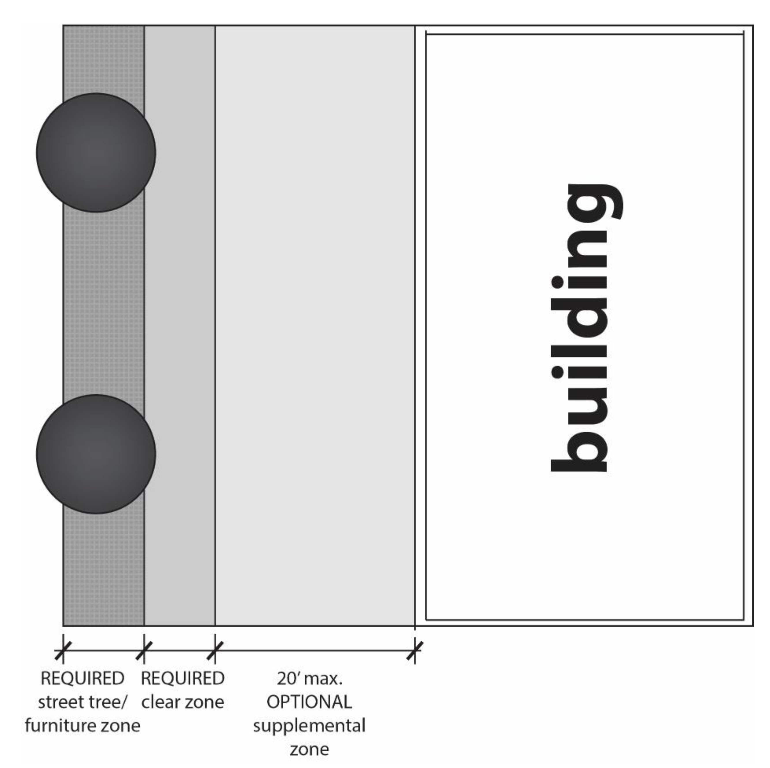
Figure 4. Supplemental Zone
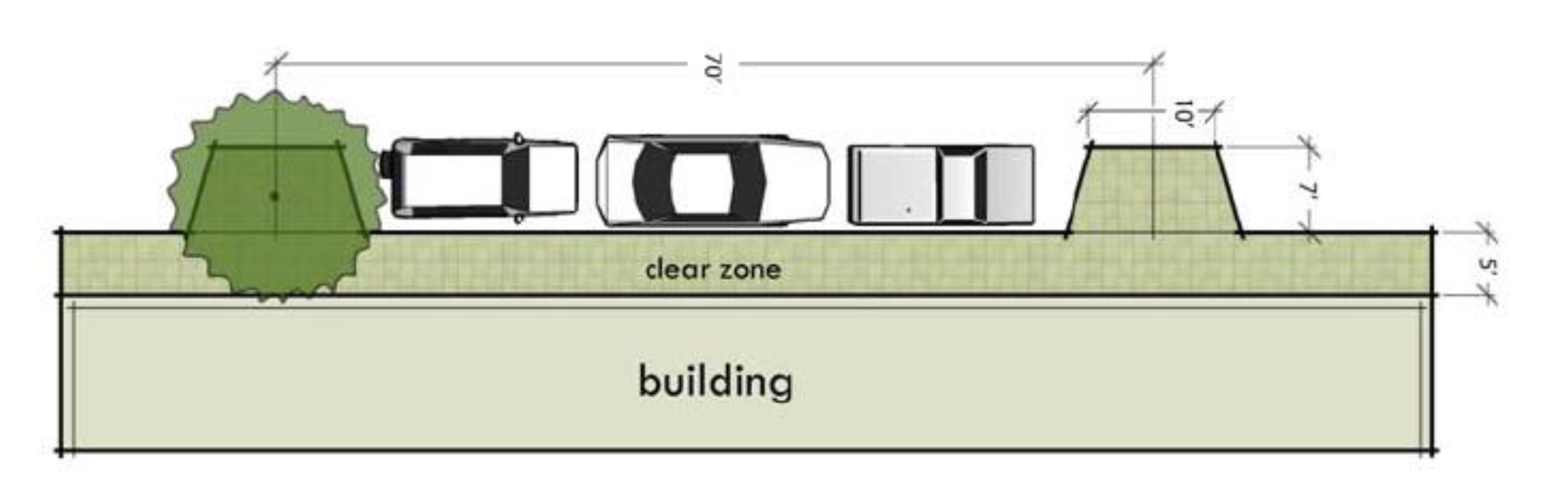
Figure 5. On-Street Parking in the Furniture Zone
B.
Building Placement and Frontage Standards.
1.
A minimum of fifty percent of the property frontage length along the site's principal street must consist of continuous building façade built up to the property line, clear zone, or supplemental zone, if one is provided (Figure 6).
2.
For corner lots, a minimum of forty percent of the property frontage length along the site's secondary street, which intersects with the primary street, must consist of continuous building façade built up to the property line, clear zone, or supplemental zone, if one is provided (Figure 7).
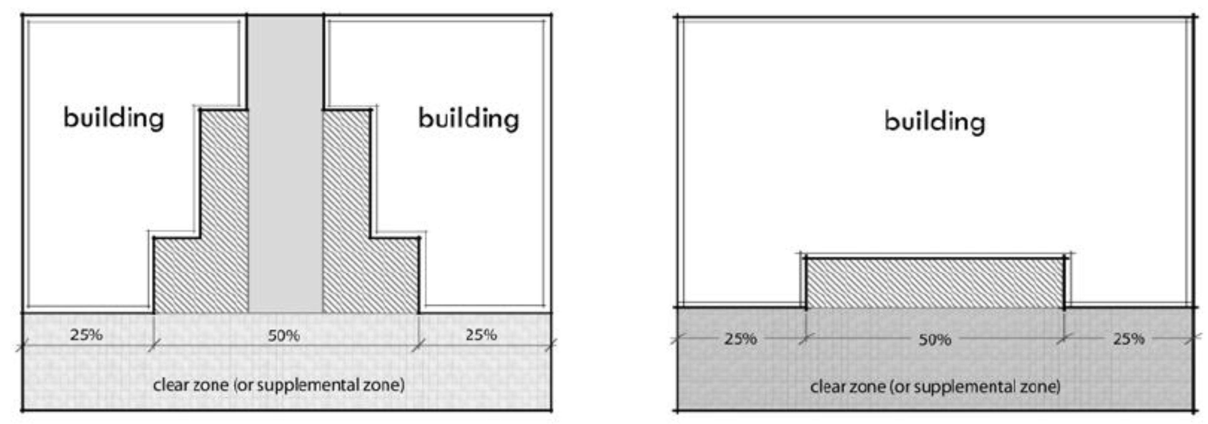
Figure 6. Building Façade Location along the
Principal Street
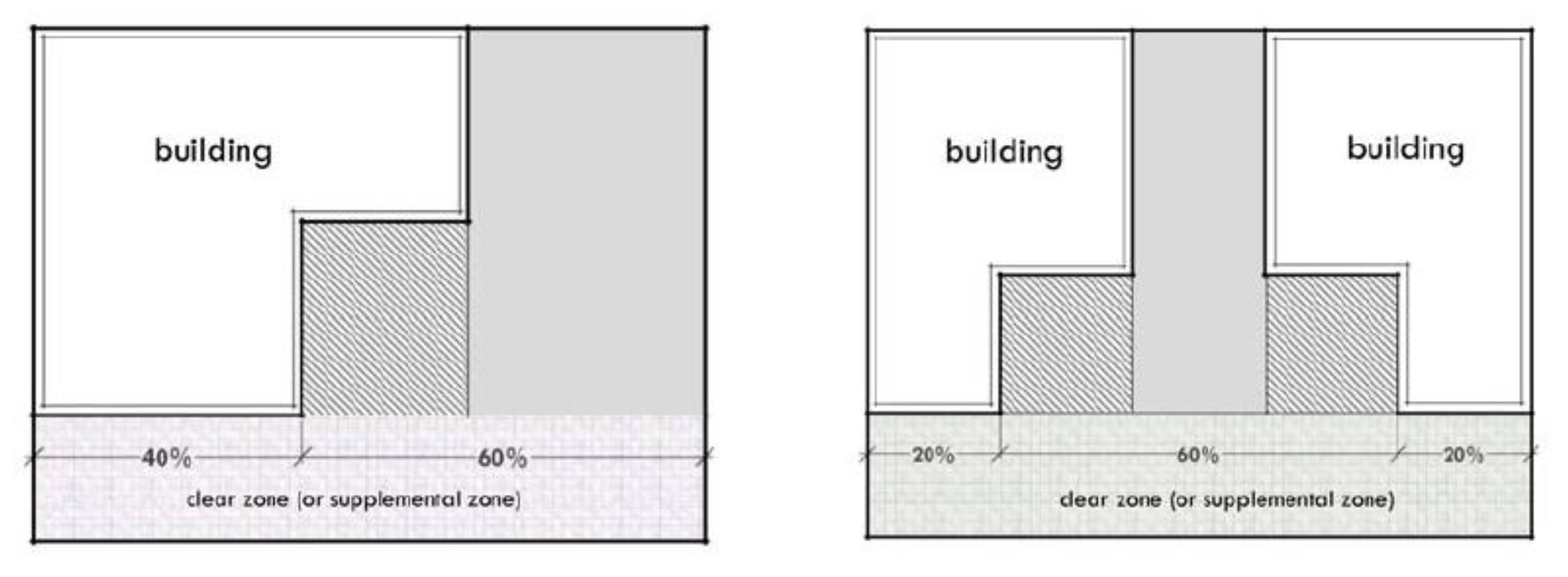
Figure 7. Building Façade Location along a
Secondary Street
C.
Outdoor Display.
1.
Except as provided in subsection 2. of this section, all business and display of merchandise shall be conducted wholly within an enclosed building.
2.
Subject to an administrative review and approval by the city manager, outdoor storage and display may be permitted when all of the following conditions are satisfied:
a.
The amount of outdoor storage and display of merchandise does not exceed five percent of the gross floor area of the business;
b.
Pedestrian, bicycle, wheel chair and motor vehicle access to and within the property is not impeded in any way;
c.
The clear zone and street furniture zone are not used for this purpose;
d.
The outdoor storage and display is in conformity with any conditions of development permit or building permit approval; and
e.
The outdoor storage and display satisfies all relevant provisions of this title and other applicable requirements of this code.
D.
Outdoor Activities.
1.
Exterior work activities, including product storage or assembly are prohibited in the NMU Zone.
2.
Outdoor eating areas, entertainment, outdoor markets, and similar activities are allowed in the NMU Zone. However, they shall be prohibited within the clear zone and street furniture zone.
3.
Permitted outdoor activities shall be located a minimum of twenty feet from any adjacent residential zoning district. This setback area shall be landscaped and include a solid wall or fence with a minimum height of six feet to enhance privacy and attenuate potential noise impacts.
4.
Outdoor speakers - Exterior speakers may be used provided:
a.
They are only in use during the hours of operation, but no later than ten p.m.; and
b.
They are not audible beyond the property line.
E.
Surface Parking Location.
1.
Surface parking shall be prohibited between the front of buildings and the front lot line or clear zone;
2.
Surface parking shall be located a minimum of ten feet from any adjacent residential zoning district. This setback area shall be landscaped and include a wall or fence with a minimum height of six feet or evergreen vegetation that would provide screening equivalent to a fence.
3.
Surface parking located along a street frontage shall have a landscape buffer with a minimum width of five feet that is designed to provide screening of vehicles.
F.
Loading and Service Areas and Mechanical Equipment.
1.
All loading areas, exterior garbage cans, garbage collection and recycling areas shall be screened from the street and adjacent properties. Fencing and/or landscaping of sufficient density and height shall be provided to screen such areas from view.
2.
Mechanical equipment located on the ground, such heat pumps, cooling equipment, and generators shall be screened from the street and any adjacent residentially zoned properties.
3.
Mechanical equipment placed on roofs must be screened with a parapet or other screen around the equipment that is as tall as the highest point of the equipment.
4.
In addition to the above requirements for mechanical equipment, exhaust fans for kitchens shall be located a minimum of fifty feet from a residential zone.
G.
Exterior Lighting.
1.
On-site pedestrian walkways must be lighted to a level where the circulation system can be used at night by employees, residents, and customers.
2.
Exterior lighting shall be located and designed to not shed light or glare on nearby properties.
H.
Exterior Finish Materials -
1.
Street-facing facades shall consist predominantly of a simple palette of durable materials such as brick, stone, stucco, wood siding, and wood shingles.
2.
Split-faced block and gypsum reinforced fiber concrete shall only be used in limited quantities.
3.
Fencing shall be made of durable and attractive materials. The following fence materials are prohibited:
a.
Plastic or vinyl; and
b.
Chain link.
4.
The following building materials are prohibited on street facades and shall not collectively be used on more than fity percent of any other building façade:
a.
Vinyl PVC siding;
b.
T-111 plywood;
c.
Exterior insulation finishing (EIFS);
d.
Corrugated metal;
e.
Opaque glass; and
f.
Sheet pressboard.
I.
Hours of Operation. To maintain a compatible relationship with surrounding residential uses, business hours shall be between the hours of eight a.m. and ten p.m. No business shall be conducted outside of these time limits unless approved as a conditional use as provided in this title.
(Ord. No. 2018-04, § 2(Exh. B), 8-1-2018)
16.104.010 - Purpose.
The purpose of the LC zone is to provide a mix of retail, service, and business needs along with complementary residential uses for the community while maintaining a compatible relationship with surrounding residential neighborhoods.
(Ord. O-99-6 § 1 (part), 1999: Ord. 96-4 § 1 (part), 1996)
(Ord. No. O-2015-01, § 1(Exh. A), 3-18-2015)
16.104.020 - Permitted uses.
A.
A permitted use is a use which is allowed outright, but is subject to all applicable provisions of this title. If a use is not listed as a permitted use, it may be held to be a similar unlisted used under the provisions of Chapter 16.82. Permitted uses in the LC district are as follows:
1.
Dwelling, multi-family;
2.
Office;
3.
Retail sales and service;
a.
Sales-oriented,
b.
Personal service-oriented, and
c.
Repair-oriented;
4.
Motel;
5.
Community services;
6.
Religious assembly;
7.
Residential facility; and
8.
Adult day care (family care).
(Ord. O-99-6 § 1 (part), 1999: Ord. 96-4 § 1 (part), 1996)
(Ord. No. O-2015-01, § 1(Exh. A), 3-18-2015)
16.104.030 - Conditional uses.
A conditional use is a use which is subject to a discretionary decision by the planning commission. The approval criteria are set forth in Chapter 16.156. If a use is not listed as a conditional use, it may be held to be a similar unlisted use under the provisions of Chapter 16.82. Conditional uses in the LC district are as follows:
A.
Retail sales and service;
1.
Drive-through facilities; and
2.
Entertainment-oriented;
B.
Quick vehicle servicing;
C.
Self-service storage;
D.
Hospital;
E.
Utilities;
F.
Public safety facilities; and
G.
Parks and open space.
(Ord. O-03-2 § 1 (part), 2003: Ord. O-99-6 § 1 (part), 1999: Ord. 96-4 § 1 (part), 1996)
(Ord. No. O-2015-01, § 1(Exh. A), 3-18-2015)
16.104.040 - Dimensional requirements.
A.
The dimensional and density requirements of the LC district are:
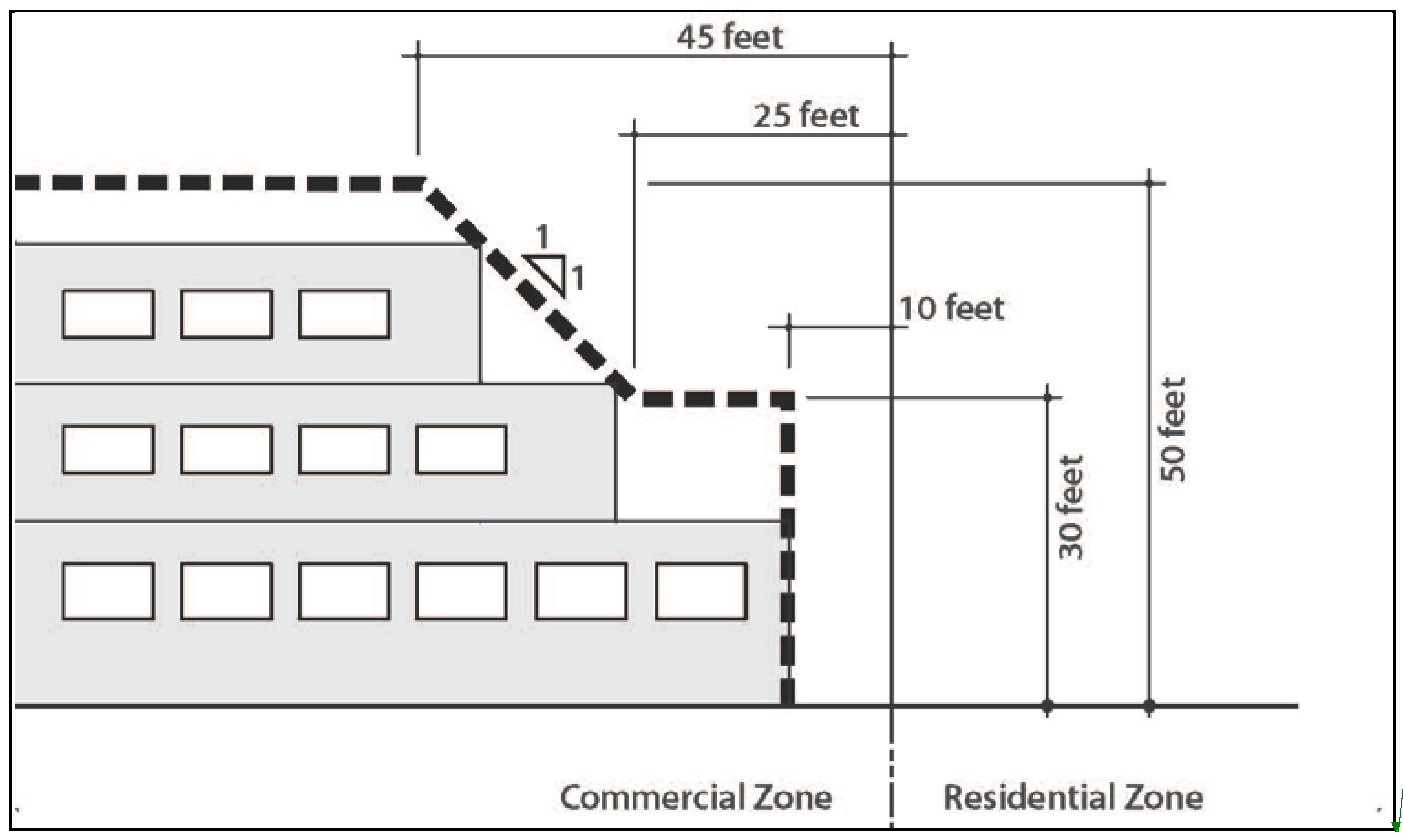
Figure 1 Building Height
(Ord. O-99-6 § 1 (part), 1999: Ord. 96-4 § 1 (part), 1996; Ord. No. O-2015-01, § 1(Exh. A), 3-18-2015)
16.104.050 - Design requirements.
16.104.060 - Additional requirements.
A.
Except as provided in subsection B of this section, all business and display of merchandise shall be conducted wholly within an enclosed building.
B.
Subject to an administrative review and approval by the city manager, outdoor storage and display may be permitted when all of the following conditions are satisfied:
1.
The amount of outdoor storage and display does not exceed five percent of the gross floor area of the business;
2.
Pedestrian, bicycle, wheel chair and motor vehicle access to and within the property is not impeded in any way;
3.
The outdoor storage and display is in conformity with any conditions of development permit or building permit approval; and
4.
The outdoor storage and display satisfies all relevant provisions of this title and other applicable requirements of this code.
C.
Master plan - King City Plaza.
1.
The applicant shall complete a master plan for King City Plaza as part of a site plan review in Chapter 16.152 when:
a.
Demolition and reconstruction of greater than fifty percent of the total building floor area on the subject property is proposed;
b.
Construction of new building floor area, which represents a total building floor area increase of greater than twenty-five percent on the subject property, is proposed; or
c.
Requested by the property owner.
2.
The following standards may be adjusted through the master plan process;
a.
Dimensional requirements in Section 16.104.040
b.
Additional requirements in Section 16.104.050, except subsection C. Hours of Operation, which will continue to apply;
c.
Parking and loading requirements in Chapter 16.132;
d.
Approval standards in Section 16.152.110;
e.
Landscaping standards in Chapter 16.124; and
f.
Sign standards in Chapter 16.148.
3.
The approval authority may approve an adjustment of the standards in Section 16.104.060 C.2 by determining:
a.
The adjusted standards perform as well or better than the normal standards;
b.
The adjusted standards will support the King City Town Center Plan and Implementation Strategy by enabling development that is consistent with Urban Design Action UD3 including, but not limited to:
i.
Frontage and site landscaping;
ii.
Generous, direct, ADA-compliant, and clearly marked walkways to connect shopping center destination with parking, surrounding neighborhoods, and 99W;
iii.
Maintaining or improving the efficiency and pedestrian accessibility of the parking lot without reducing parking;
iv.
Redesigning the portion of SW 116 th Avenue, which is within the subject property to look and function more like a village main street, similar to the public street segments of this street;
v.
Providing a more walkable and interesting pedestrian environment along the sidewalks; and
vi.
Improving access to transit.
D.
Hours of Operation. In keeping with the residential retirement character of the city, business hours shall be between the hours of eight a.m. to ten p.m. No business shall be conducted before or after these times unless approved as a conditional use as provided in this title.
(Ord. O-99-6 § 1 (part), 1999: Ord. 96-4 § 1 (part), 1996)
(Ord. No. O-2015-01, § 1(Exh. A), 3-18-2015)
Editor's note— Ord. No. O-2015-01, § 1(Exh. A), adopted March 18, 2015, renumbered § 16.104.050 as § 16.104.060.
16.108.010 - Purpose.
The purpose of the CF zone is to provide land for community facilities designed to be used for noncommercial, social and recreational purposes by the residents of the city. The zone implements the comprehensive plan policies and regulations that are intended to create, maintain and promote these activities.
(Ord. O-99-6 § 1 (part), 1999: Ord. 96-4 § 1 (part), 1996)
16.108.020 - Permitted uses.
A permitted use is a use, which is allowed outright, but is subject to all applicable provisions of this title. If a use is not listed as a permitted use, it may be held to be a similar unlisted use under the provisions of Chapter 16.82. Permitted uses in the CF zone are:
A.
Community services.
(Ord. O-99-6 § 1 (part), 1999: Ord. 96-4 § 1 (part), 1996)
16.108.030 - Conditional uses.
A conditional use is a use which is subject to a discretionary decision by the planning commission. The approval criteria are set forth in Chapter 16.156. If a use is not listed as a conditional use, it may be held to be a similar unlisted use under the provisions of Chapter 16.82. Conditional uses in the CF district are:
A.
Utilities;
B.
Public safety facilities; and
C.
Parks and open space.
(Ord. O-99-6 § 1 (part), 1999: Ord. 96-4 § 1 (part), 1996)
16.108.040 - Dimensional requirements.
A.
The dimensional requirements in the CF district are as follows:
1.
The minimum lot area shall be five thousand square feet;
2.
The minimum lot width shall be forty feet;
3.
The minimum lot depth shall be eighty feet;
4.
The minimum setback requirements shall be as follows:
a.
No front yard setback shall be required in this zone;
b.
No side yard setback shall be required, except when abutting a residential zone, a side yard of ten feet shall be required;
c.
No rear yard setback shall be required, except when abutting a residential zone, a rear yard setback of twenty-five feet shall be required;
5.
No building in this zone shall exceed a height of thirty feet; and
6.
The maximum height and size and minimum setbacks for accessory structures shall comply with the provisions of Chapter 16.176; and
7.
The maximum coverage of buildings and impervious surfaces shall not exceed seventy-five percent of the total lot area.
(Ord. O-99-6 § 1 (part), 1999: Ord. 96-4 § 1 (part), 1996)
16.112.010 - Purpose.
The purpose of the ROS zone is to accommodate park, open space and recreation facilities, including the existing golf course and appurtenant headquarters, pro shop, and maintenance structures, which are operated by the King City Civic Association. In addition, this zone may also be applied to protect and enhance natural resource areas, including but not limited to riparian areas, wetlands and the Tualatin River flood plain. The zone implements the comprehensive plan policies and regulations that are intended to create, maintain, and promote these activities.
(Ord. O-02-4 § 2 (part), 2002: Ord. O-99-6 § 1 (part), 1999: Ord. 96-4 § 1 (part), 1996)
16.112.020 - Permitted uses.
A permitted use is a use, which is allowed outright, but is subject to all applicable provisions of this title. If a use is not listed as a permitted use, it may be held to be a similar unlisted use under the provisions of Chapter 16.82. Permitted uses in the ROS zone are:
A.
Community services that are only located within the urban growth boundary (UGB); and
B.
Parks and open space (habitable buildings shall only be permitted within the UGB).
(Ord. O-02-4 § 2 (part), 2002: Ord. O-99-6 § 1 (part), 1999: Ord. 96-4 § 1 (part), 1996)
16.112.030 - Conditional uses.
A conditional use is a use, which is subject to a discretionary decision by the planning commission. The approval criteria are set forth in Chapter 16.156. If a use is not listed as a conditional use, it may be held to be a similar unlisted use under the provisions of Chapter 16.82. Conditional uses in the ROS district are:
A.
Utilities (located within the UGB); and
B.
Public safety facilities (located within the UGB); and
C.
Utility facilities necessary for public service (located outside the UGB). Sanitary sewer facilities may be established or extended only as permitted by OAR 660-011-0060.
(Ord. O-02-4 § 2 (part), 2002: Ord. O-99-6 § 1 (part), 1999: Ord. 96-4 § 1 (part), 1996)
16.112.040 - Dimensional requirements.
A.
The dimensional requirements in the ROS district areas that are within the UGB are as follows:
1.
The minimum lot area shall be five thousand square feet;
2.
The minimum lot width shall be forty feet;
3.
The minimum lot depth shall be eighty feet;
4.
The minimum setback requirements shall be as follows:
a.
No front yard setback shall be required in this zone;
b.
No side yard setback shall be required, except when abutting a residential zone, a rear yard setback of twenty-five feet shall be required;
5.
No building in this zone shall exceed a height of thirty feet;
6.
The maximum height and size and minimum setbacks for accessory structures shall comply with the provisions of Chapter 16.176; and
7.
The maximum coverage of buildings and impervious surfaces shall not exceed seventy-five percent of the total lot area.
(Ord. O-02-4 § 2 (part), 2002: Ord. O-99-6 § 1 (part), 1999: Ord. 96-4 § 1 (part), 1996)
16.114.010 - Purpose and Intent.
A.
The Kingston Terrace District development and design standards reflect the City's goals, policies, and implementation measures in the Kingston Terrace Master Plan; specifically:
1.
Support development of a vibrant and dynamic residential community that includes opportunities for retail, neighborhood servicing commercial, and municipal uses;
2.
Provide a wide range of housing types that are attainable to a diversity of households;
3.
Facilitate connectivity for all modes of travel throughout the community;
4.
Integrate and connect open spaces and natural areas with built spaces;
5.
Support environmental sustainability and climate resiliency approaches;
6.
Provide for orderly and efficient extension of public services, facilities, and utilities; and
7.
Provide a clear and objective permitting path for development to occur.
(Ord. No. 2023-04, § 1(Exh. A), 10-18-2023)
16.114.020 - Applicability.
A.
The standards of this section apply only to properties within the Kingston Terrace Plan District boundary as shown on Figure 16.114-1.
Figure 16.114-1 Kingston Terrace Plan District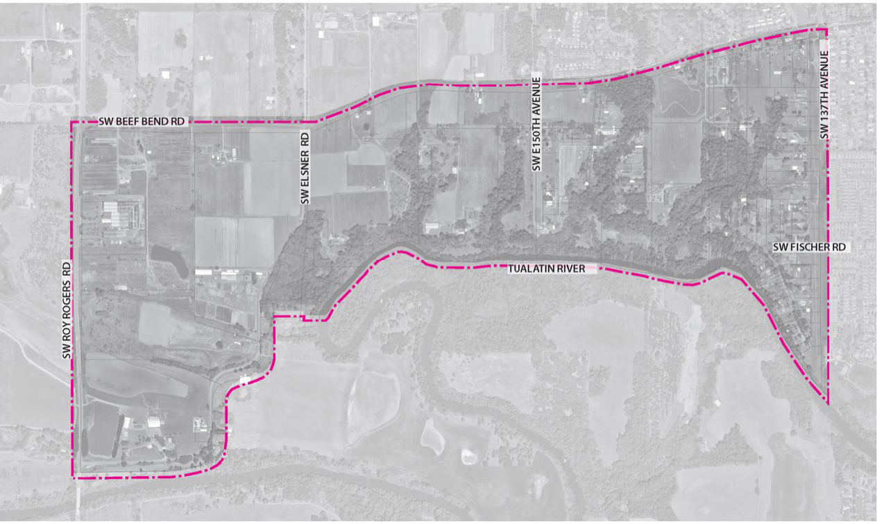
B.
The design standards of this chapter do not apply to existing uses and buildings within the Kingston Terrace Plan District.
C.
All other standards and requirements in this title apply to development within the Kingston Terrace District except as modified or exempted as noted in Table 16.114-1:
Table 16.114-1 Applicable Title 16—Community Development & Zoning Code
(Ord. No. 2023-04, § 1(Exh. A), 10-18-2023)
16.114.030 - Neighborhood Zones.
A.
Figure 16.114-2 illustrates the general boundaries of the Kingston Terrace Town Center (KTTC), Beef Bend Neighborhood (KTBB), Central Neighborhood (KTC), Rural Character Neighborhood (KTRC), and Natural Resource Area Overlay district boundaries.
Figure 16.114-2 Neighborhood Zones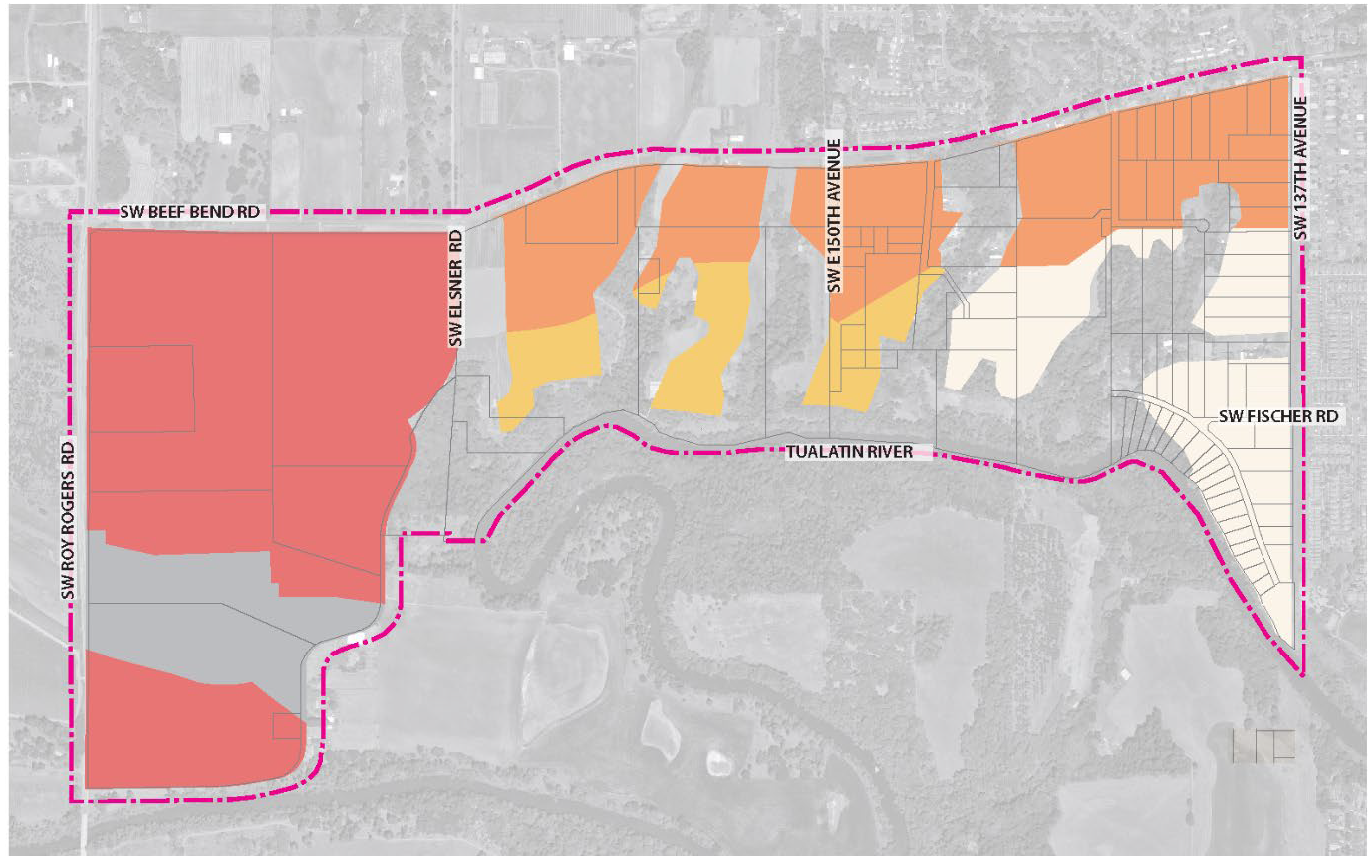
(Ord. No. 2023-04, § 1(Exh. A), 10-18-2023)
16.114.040 - Uses.
A.
Uses Allowed Outright (Y). Allowed uses in the Kingston Terrace District are shown in Table 16.114-2. A permitted use is a use which is allowed outright but is subject to all applicable provisions of this title. If a use is not listed as a permitted use, as shown in Table 16.114-2, it may be held to a similar unlisted use under the provisions of Chapter 16.82.
B.
Conditional Uses (CU). Conditional uses in the Kingston Terrace District are shown in Table 16.114-2. Conditional uses are uses which are subject to a discretionary decision by the Planning Commission. The approval criteria are set forth in Chapter 16.156. If a use is not listed as a conditional use, it may be held to be a similar unlisted use under the provisions of Chapter 16.82.
C.
Prohibited Uses (N). Prohibited uses in the Kingston Terrace District are shown in Table 16.114-2. Legally established uses and development which existed at the time these requirements were adopted and would otherwise be prohibited, are subject to additional regulations in Chapter 16.160, Nonconforming Situations.
Table 16.114-2 Uses in Kingston Terrace District
1 As defined by 16.24.030.C
2 Cottage clusters are subject to the development and design standards in 16.84.060, Cottage clusters.
3 Retail sales and service uses are subject to Additional Requirements of Section 16.114.040.D and liquor license review according to Chapter 5.05 of this Title.
4 Subject to approval standards of Section 16.156.060.E.
5 Subject to approval standards of Section 16.156.060.I.
6 Subject to Chapter 16.172 approval criteria and standards.
7 Subject to approval standards of Section 16.156.060.J.
8 Subject to approval standards of Section 16.156.060.L.
9 Subject to approval standards of Section 16.156.060.A.
10 Subject to approval standards of Section 16.156.060.H.
11 Subject to approval standards of Section 16.156.060.C.
12 Subject to approval standards of Section 16.156.060.N.
13 Subject to approval standards of Section 16.114.110.
D.
Outdoor activities, storage, and display associated with an approved retail and service use may be permitted when the retail and service uses comply with:
1.
Pedestrian, bicycle, wheelchair, and motor vehicle access to and within the site is not impeded in any way;
2.
The outdoor storage and display is in conformity with any conditions of development permit or building permit approval;
3.
The outdoor storage and display satisfied all relevant provisions of this title and other applicable requirements of this code; and
4.
Outdoor speakers (i.e., audio speakers, amplified sound, etc.) may be used provided sound levels comply with Section 8.04.130 of the King City Municipal Code.
(Ord. No. 2023-04, § 1(Exh. A), 10-18-2023)
16.114.050 - Density and Dimensional Standards.
A.
The minimum net density for development in the Kingston Terrace District is noted in Table 16.114-3.
B.
Net Density is defined as gross area less streets (public and private), parks and open space, storm facilities, natural resources, and uses that are not residential (i.e., Clean Water Services (CWS) pump station and area designated for municipal uses). It is represented as numbers of dwelling units per net acre.
Table 16.114-3 Density Requirements Per Neighborhood
C.
The dimensional standards for residential use type development in the Kingston Terrace District is noted in Table 16.114-4.
Table 16.114-4 Dimensional Standards14
14 In addition to the setback standards of Table 16.114-4, building setbacks for each type of structure must comply with the current Oregon Building Code.
15 Minimum lot size for residential land use types.
16 The minimum lot size for "Dwelling, single-family attached, Duplex, Triplex, and Fourplex" land use types may be reduced to 1,000 square feet.
17 The minimum lot width for "Dwelling, single-family attached, Duplex, Triplex, and Fourplex" land use types may be reduced to 15 feet.
18 There is no minimum setback for zero foot setback buildings. In all cases, zero foot setback buildings shall either: (1) be attached at the property line; or (2) have a total minimum separation of 6 feet between buildings.
19 Side yard of 5 feet for a single-story structure, and 10 feet for two-story structures.
20 Zero feet for a detached accessory dwelling unit or building less than or equal to 18 feet in height.
21 Zero to 6 feet or greater than 18 feet to a garage entrance to an alley.
22 Applicable to Dwelling, multi in Central Neighborhood. Mixed-use and commercial not permitted in Central Neighborhood.
23 Minimum 20 foot setback when abuts residential use.
24 Maximum coverage dimensional standards do not apply to Cottage Clusters.
(Ord. No. 2023-04, § 1(Exh. A), 10-18-2023)
16.114.060 - Design Purpose, Applicability, and Standards.
A.
Design purpose. Site design standards are intended to facilitate the development of attractive buildings that encourage multimodal transportation. They encourage good site design, which contributes to livability, safety, and sustainability; helps create a stronger community; and fosters a quality environment for residents and neighbors. Site design shall meet the following objectives:
1.
Livability. Development should contribute to a livable neighborhood by incorporating visually pleasing design, minimizing the impact of vehicles, emphasizing pedestrian and bicycle connections, and providing public and private open spaces for outdoor use.
2.
Compatibility. Development should have a scale that is appropriate for the surrounding neighborhood and maintains the overall character of the neighborhood.
3.
Safety and Functionality. Development should be safe and functional, by providing visibility into and within a mixed-use or residential development and by creating a circulation system that prioritizes bicycle and pedestrian safety.
4.
Sustainability. Development should incorporate sustainable design and building practices, such as energy conservation, preservation of trees and open space, quality building materials, and alternative transportation modes.
B.
Development in the Kingston Terrace District requires a minimum level of design. These design standards are intended to promote attention to detail, human-scale design, street visibility, and privacy of adjacent properties, while affording flexibility to use a variety of architectural styles. Development in Kingston Terrace District should integrate the following design objectives:
1.
Articulation. Buildings shall incorporate horizontal and/ or vertical design elements that break up façades into smaller planes.
2.
Eyes on the street/transparency. A certain percentage of the area of each facade shall be windows or entrance doors to promote pedestrian safety and use.
3.
Main entrance. Buildings shall include a primary entrance that complies with the standards for location, orientation, and visibility.
4.
Detailed design. Buildings shall include design features that enhance the visual character of the community and take into account the surrounding neighborhoods, provide permanence, and create a sense of place.
5.
Transitional Space. Ground floor residential dwellings shall include an area of transition between the public realm of the right-of-way (or tract or easement) and the front door or porch.
6.
Private and common open space. Developments shall ensure opportunities for relaxation or active recreation.
C.
Applicability.
1.
The following set of "fundamental" design standards are applicable to development within the Kingston Terrace District:
a.
Articulation,
b.
Eyes on the street or transparency,
c.
Main entrance,
d.
Detailed design,
e.
Transitional space,
f.
Private open space, and
g.
Common open space.
2.
Applicability concept. The design standards apply to building types as noted in Table 16.114-5. Buildings that meet the applicability provisions in Table 16.114-5 shall incorporate the following design standards. The graphics provided are intended to illustrate how development could comply with these standards and should not be interpreted as requiring a specific architectural style. An architectural feature may be used to comply with more than one standard.
3.
Table 16.114-5 identifies where building design standards apply to development in the Kingston Terrace District. These design standards shall be applied in addition to the dimensional requirements in Section 16.114.050.
[1]
Applicable to the entire site.
[2]
Applicable to building elevations facing public rights-of-way. Development with multiple street frontages must comply with the design standard requirements along the higher street classification; except for, the main entrance design standards may apply to the elevation fronting a lower street classification if on-street parking is not available on the higher classification street. In this case, one additional detailed design element will be provided on the building elevation fronting the higher street classification.
i.
Dwelling, multi, mixed-use, and commercial developments shall comply with the on-site bicycle and pedestrian neighborhood circulation standards of Section 16.114.120.H.
[3]
Applicable to building elevations containing a primary entrance.
[4]
Applicable to building elevations facing public parks and open spaces.
[5]
Applicable to dwellings in a cluster or grouping, either facing a shared open space (e.g., a common courtyard) or a pedestrian path.
[6]
Applicable to ground floor dwellings with a primary entrance with access from the street or shared open space (e.g., a common courtyard), when the primary entrance is located:
i.
Within ten feet of the street-facing property line, or
ii.
Within the front yard setback, or
iii.
Within ten feet of a shared open space common tractor easement.
Table 16.114-5 Applicable Building Design Standards
D.
Design Standards:
1.
Articulation. Buildings shall incorporate design elements that break up façades into smaller planes. See Figure 16.114-3 for illustration of articulation elements:
Figure 16.114-3 Building Articulation Elements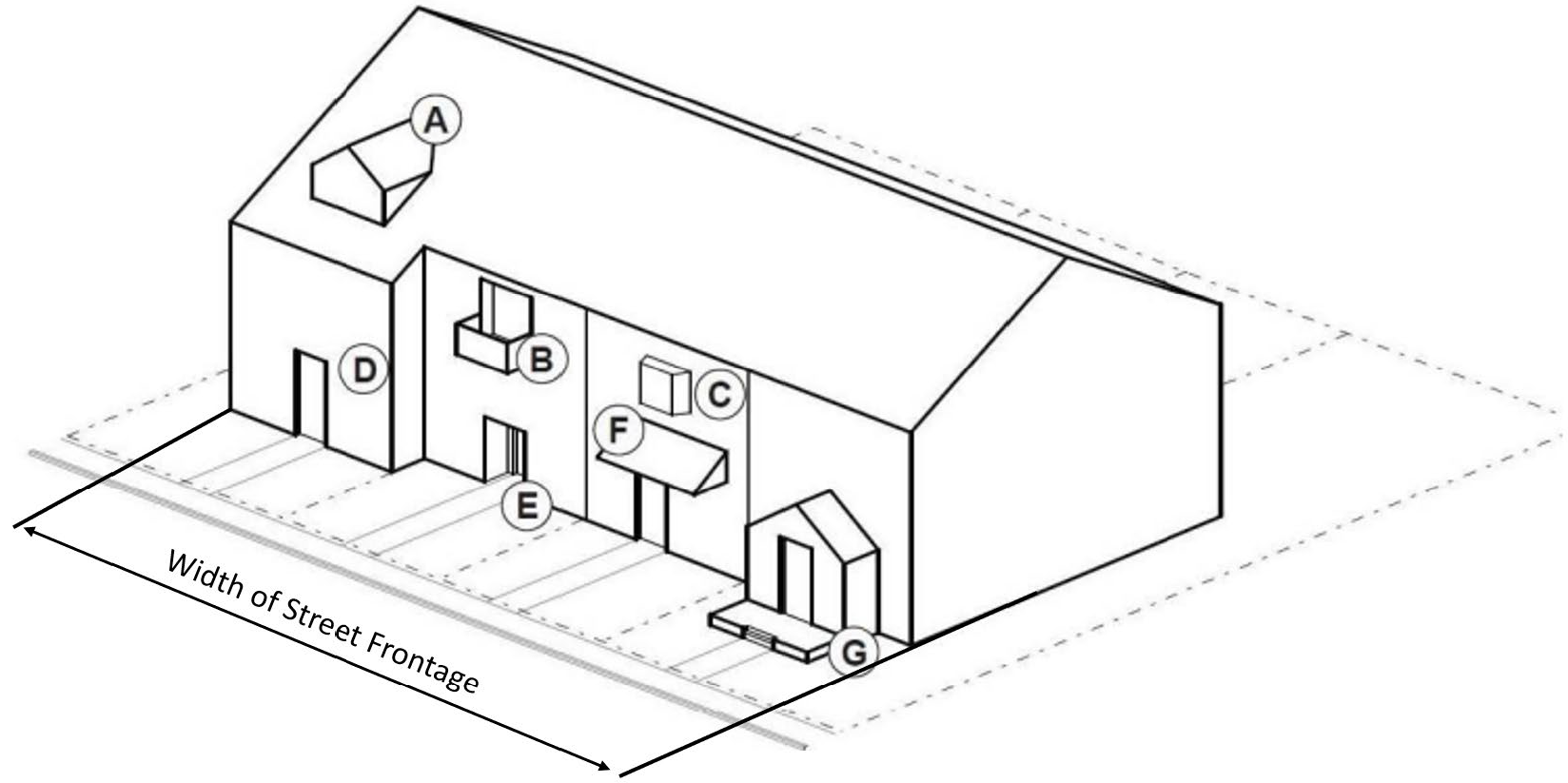
(A) A gabled dormer.
(B) Balcony that is at least two feet deep and accessible from an interior room.
(C) Bay window that extends at least two feet from façade.
(D) A façade offset that is recessed by at least two feet deep and six feet long.
(E) Recessed entryway that is a minimum of four feet deep.
(F) A covered entryway that is a minimum of four feet deep.
(G) A porch that is at least five ft deep.
a.
For buildings with sixty feet of street frontage or less, a minimum of one design element shall be provided along the street-facing façades.
b.
For buildings with over sixty feet of street frontage, at least one design element shall be provided for every thirty feet of street frontage.
c.
Design elements shall be distributed along the length of the façade so that there are no more than thirty feet between two elements.
d.
For buildings with less than thirty feet of street frontage, the building articulation standard is not applicable.
2.
Eyes on the street. At least twenty square feet of facades fronting a public street, or public park or open space shall include windows or entrance doors on Dwelling, single-family detached and attached, Duplex, Triplex, Fourplex, and Dwelling, multi. See Figure 16.114-4 for illustration of eyes on the street.
Figure 16.114-4 Eyes on the Street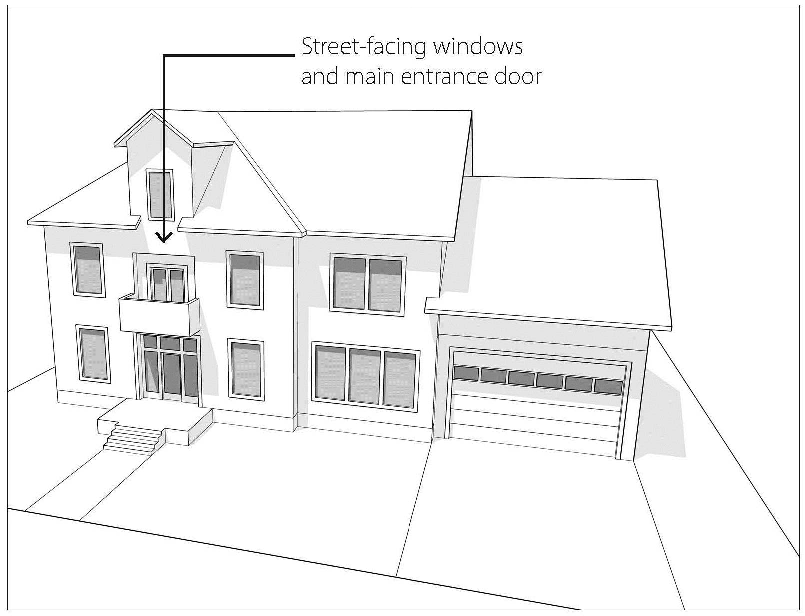
a.
Windows used to meet this standard shall have a maximum windowsill height of four feet above finished floor elevation.
b.
Windows used to meet this standard shall be transparent and allow views from the building to the street or open space. Glass blocks and privacy windows in bathrooms do not meet this standard.
c.
Window area is considered the entire area within the outer window frame, including any interior window grid.
d.
Doors used to meet this standard shall face the street or be at an angle of no greater than forty-five degrees from the street.
e.
Door area is considered the portion of the door that moves. Door frames do not count toward this standard.
3.
Transparency.
a.
On mixed-use, commercial, and municipal buildings with ground floor commercial, at least thirty-five percent of the ground floor elevation must be permanently treated with windows, display areas, or glass doorway openings. See Figure 16.114-5 for illustration of transparency.
Figure 16.114-5 Transparency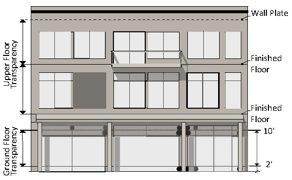
i.
For the purpose of this standard, window(s) necessary to meet this standard shall be measured from the minimum sill height above finished first floor elevation which is two feet for non-residential uses and four feet for residential uses.
b.
Design of Dwelling, multi, mixed-use, and commercial buildings shall comply with the building frontage, ground floor height, and weather protection standards of Table 16.114-6 to support a pedestrian-friendly environment.
Table 16.114-6 Dwelling-multi, Mixed-use, and Commercial Building Design Standards
25
Minimum ground floor height standard shall be limited to commercial uses on the ground floor.
i.
Lot frontages that contain dwelling-multi, mixed-use, and commercial development shall locate the buildings so that at least sixty percent is occupied by the building as illustrated in Figure 16.114-6.
ii.
Weather protection shall be provided with a recessed entryway, an awning or other projected element, or a combination of those methods.
Figure 16.114-6 Building Frontage Minimum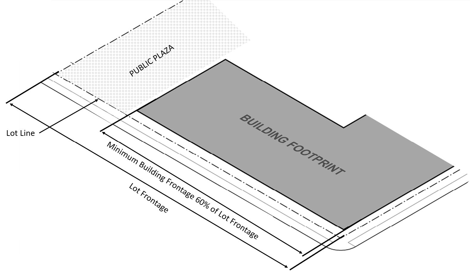
4.
Main entrance.
a.
Elevation(s) of dwelling-multi, mixed-use, or commercial buildings that contain a primary building entrance or multiple tenant entrance shall be designed to comply with the standards of Table 16.114-6.
b.
Residential dwellings shall have at least one primary entrance that meets both of the following standards. See Figure 16.114-7 for illustration of main entrances.
Figure 16.114-7 Main Entrances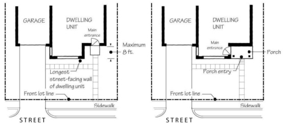
c.
Be no further than eight feet behind the longest street-facing wall of the building.
d.
Face the street, be at an angle of up to forty-five degrees from the street, or open onto a porch. If the entrance opens onto a porch, the porch shall meet all of the following additional standards:
i.
Be at least twenty-five square feet in area with a minimum four-foot depth,
ii.
Have at least one porch entry facing the street,
iii.
Have a roof that is no more than twelve feet above the floor of the porch, and
iv.
Have a roof that covers at least thirty percent of the porch area.
5.
Detailed design. Buildings shall include at least five of the following features. See Figure 16.114-8 for illustration of detailed design elements.
Figure 16.114-8 Detailed Design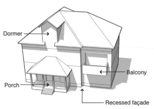
a.
Covered porch with an area of at least twenty-five square feet with a minimum dimension of four feet.
b.
Recessed entry area at least two feet deep, as measured horizontally from the face of the main building façade, and at least five feet wide.
c.
Offset on the building face of at least sixteen inches from one exterior wall surface to the other.
d.
Dormer that is at least four feet wide and integrated into the roof form.
e.
Roof eaves with a minimum projection of twelve inches from the intersection of the roof and the exterior walls.
f.
Gable roof, hip roof, or gambrel roof design.
g.
One roof pitch of at least five hundred square feet in area that is sloped to face the southern sky and has its eave line oriented within thirty degrees of the true north/south axis.
h.
Roof line offsets of at least two feet from the top surface of one roof to the top surface of the other.
i.
Tile or wood shingle roofs.
j.
Horizontal lap siding between three to seven inches wide (the visible portion once installed). The siding material may be wood, fiber-cement, or vinyl.
k.
Brick, cedar shingles, stucco, or other similar decorative materials covering at least forty percent of the street-facing façade.
l.
Window trim around all windows at least three inches wide and five-eigths inches deep.
m.
Window recesses, in all windows, of at least three inches as measured horizontally from the face of the building façade.
n.
Balcony that is at least three feet deep, five feet wide, and accessible from an interior room.
o.
Bay window at least two feet deep and five feet wide.
p.
Attached garage width, as measured between the inside of the garage door frame, of thirty-five percent or less of the length of the street-facing façade.
6.
Transitional space. Ground floor dwellings shall include an area of transition between the public realm of the right-of-way (or tract or easement) and the front door or porch. The transitional space design standard may be met either vertically, in accordance with Section 16.114.060.C.6.a, or horizontally, in accordance with Section 16.114.060.C.6.b.
a.
A vertical transition shall be an uncovered flight of stairs that leads to the front door or front porch of the dwelling. The stairs shall rise at least three feet, and not more than eight feet, from grade. The flight of stairs may encroach into the required front yard, and the bottom step shall be at least four feet from the front lot line.
b.
A horizontal transition shall be a covered porch with a depth of at least six feet. The porch may encroach into the required front yard, but it shall be at least four feet from the front lot line.
7.
Private open space. All dwelling, multi and mixed-use buildings shall provide private open space for each residential dwelling, such as a balcony or patio, that meets the following standards:
a.
Each space shall be attached to and directly accessible from an individual residential unit; and
b.
Each private open space must be a minimum of forty-eight square feet in area and a minimum of five feet in width and depth; and
c.
Additional common open space above the required minimum may substitute for some or all of the required private open space at a 1:1 ratio.
8.
Common open space. All dwelling, multi and mixed-use buildings shall provide common open space area as follows:
a.
Buildings shall provide at least two hundred square feet of common open space per residential dwelling unit.
b.
Common open space shall be no smaller than six hundred forty square feet in area, shall not be divided into areas smaller than six hundred forty square feet, and shall have minimum length and width dimensions of twenty feet.
c.
The area is open and available to the public or for the common use of residents and/or building tenants.
d.
The area contains seating and/or recreation facilities.
e.
Landscaping is provided consistent with the character and function of the space.
f.
For the purposes of this Section, vehicular circulation areas and parking areas, unless provided as part of a shared courtyard, shall not be considered common open space.
g.
Units located within one-quarter-mile from a public park or linear green open space provided as part of the development are exempt from this requirement.
h.
Common open space standards do not apply to dwelling, single-family attached or detached, duplex, triplex, fourplex, or cottage clusters.
(Ord. No. 2023-04, § 1(Exh. A), 10-18-2023)
16.114.070 - The Regulating Plan.
A.
Purpose and description.
1.
The Regulating Plan ensures consistency with goals and requirements of the Kingston Terrace Master Plan and King City's Transportation System Plan.
2.
The Regulating Plan, Figure 16.114-9, directs development in Kingston Terrace providing an illustrative bridge between King City's Transportation System Plan, the Kingston Terrace Master Plan, and applicable regulations of the Community Development and Zoning Code (CDC). The Regulating Plan identifies:
a.
Location of Natural Resource Area Overlay (Habitat Conservation Area);
b.
The location of Neighborhood Zones; and
c.
Location of all Backbone Streets, identification of street classifications, and type of intersections.
Figure 16.114-9 Kingston Terrace Regulating Plan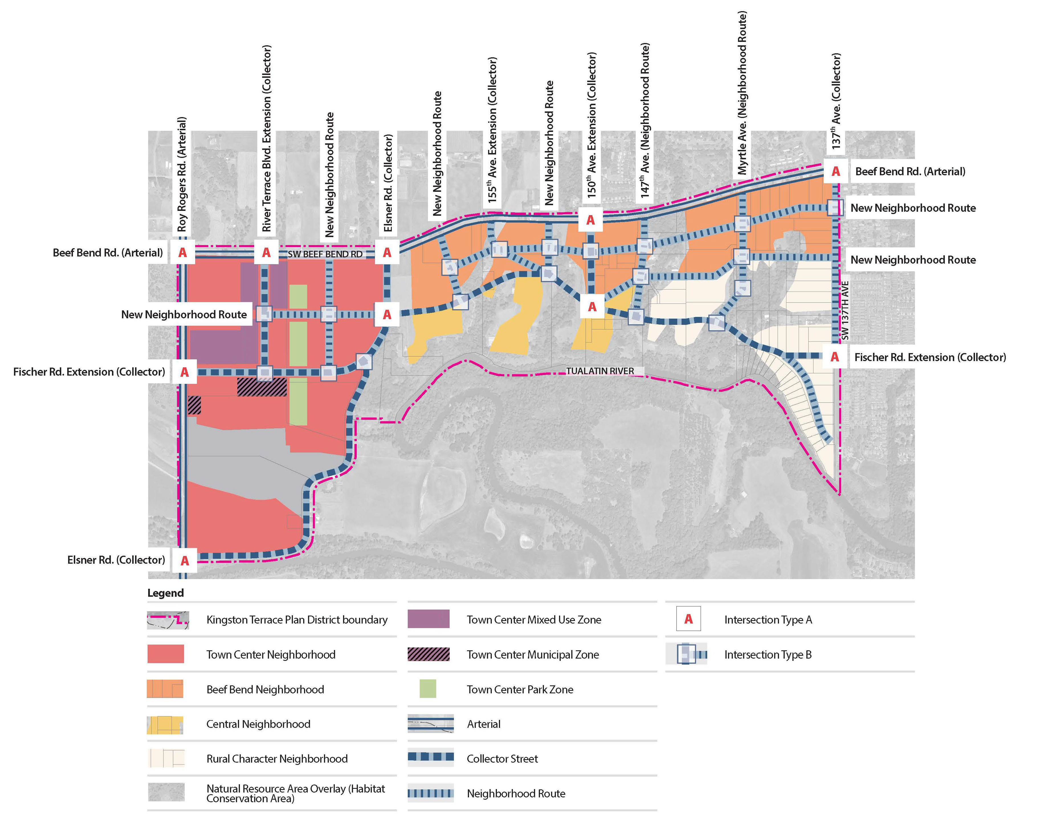
B.
Table 16.114-7 identifies the applicable sections of this title that implement each of the four planning frameworks identified through the Kingston Terrace master planning process.
Table 16.114-7 Implementation of Kingston Terrace Master Plan Frameworks
(Ord. No. 2023-04, § 1(Exh. A), 10-18-2023)
16.114.080 - Kingston Terrace District Goal 5 Safe Harbor Review.
Figure 16.114-10 Kingston Terrace District Locally Significant Wetland Resource Map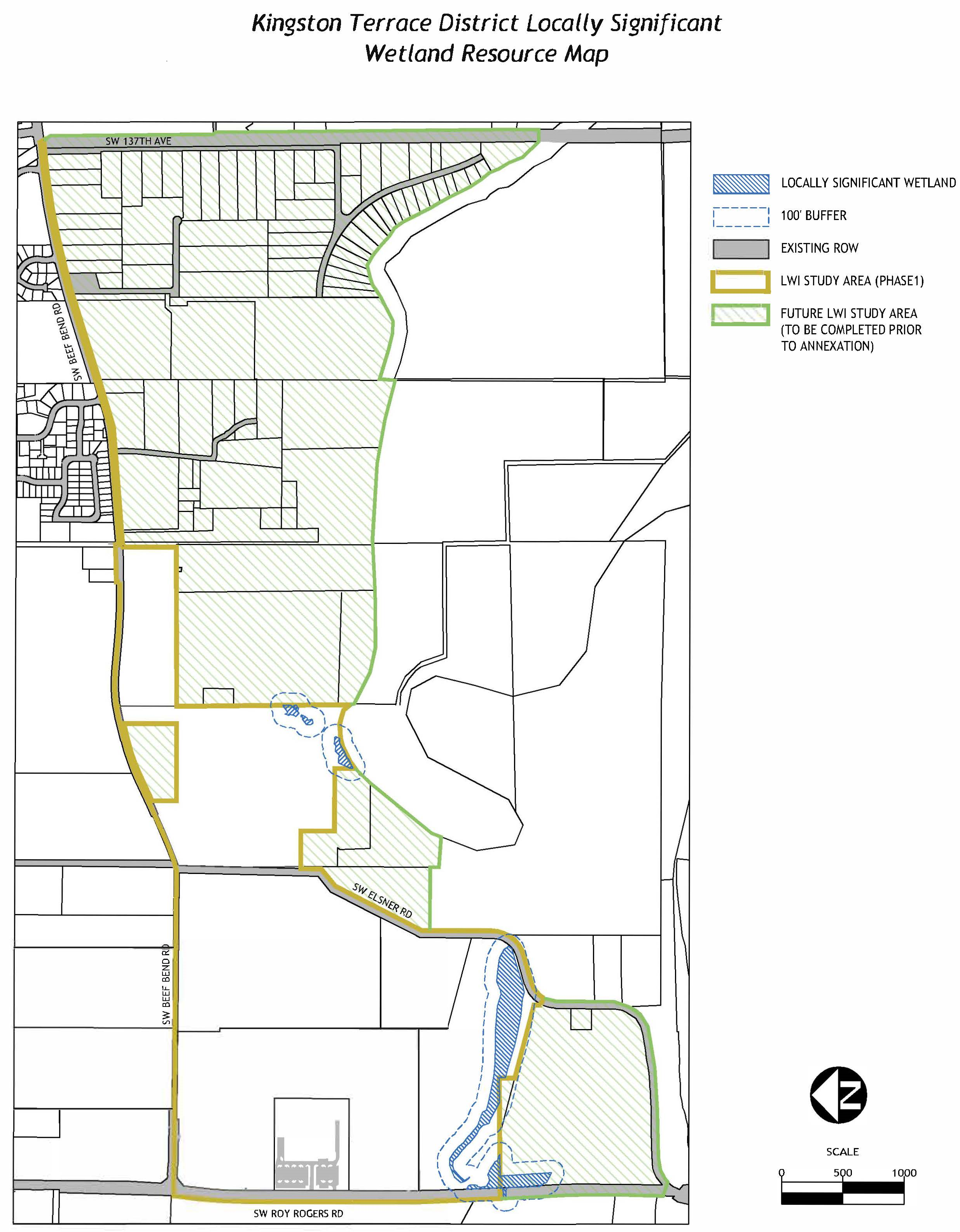
[Note: placeholder only; to be replaced by the LWI for the Kingston Terrace District upon LWI adoption by the city. Only a property indicated on Figure 16.114-10 as a "Property Included in LWI" shall be reviewed for development.]
A.
Purpose. The purpose of Section 16.114.080 is to establish wetland protections for properties within the Kingston Terrace District consistent with OAR 660-023-0100 and for the implementation a safe harbor ordinance to protect significant wetlands identified in the City's adopted Local Wetlands Inventory (LWI).
The regulations of this section are intended to implement the goals and policies of the comprehensive plan and the Statewide Planning Goal 5 Safe Harbor protection standards (Oregon Administrative Rules, Division 23) for wetlands on properties included within the Kingston Terrace District; to protect King City's wetland areas, thereby protecting the hydrologic and ecologic functions these areas provide for the community; to protect fish and wildlife habitat; to protect water quality and natural hydrology; to control erosion and sedimentation, and to reduce the adverse effects of flooding; to protect the amenity values and educational opportunities of King City's wetlands as community assets; and to improve and promote coordination among local, state, and federal agencies regarding development activities near wetlands. These regulations supplement other requirements enforced by Clean Water Services (CWS) and Oregon Department of State Lands (DSL).
Please note that compliance with state and federal wetland regulations for all wetlands, mapped or unmapped, remains the legal responsibility of the landowner.
B.
Applicability. The regulations of this chapter shall be applicable to all properties included within the Kingston Terrace District and identified on Figure 16.114-1 as a Property Included in LWI. This area contains approximately five hundred twenty-eight-acres, located south of Beef Bend Road, east of Roy Rogers Road, and north of the Tualatin River between 137 th Avenue and Roy Rogers Road. This area is shown on the comprehensive plan and zoning maps.
Any development proposed to be located on a property identified on Figure 16.114-10 as a Property Included in LWI and that contains all or part of a locally significant wetland, or is within one hundred feet of such a wetland, must comply with these regulations. Where the provisions of this section conflict with any other provisions of this title, local standards, or state and federal requirements, the more restrictive requirements shall apply. A property within the Kingston Terrace District that is not identified on Figure 16.114-10 as a Property Included in LWI may not apply for review under this section until such time as the City has adopted the LWI for the property.
C.
Locally Significant Wetlands. The areas identified on Figure 16.114-10 have been designated as "locally significant wetlands" pursuant to OAR 141-086-0350 and are subject to the Kingston Terrace Wetland Safe Harbor provisions in Section 16.114.080.D.
The provisions of this section shall be used to determine whether applications for development permits may be approved, approved with conditions, or denied. The map entitled Kingston Terrace Locally Significant Wetland Inventory (Figure 16.114-10) shall be consulted to determine site locations of locally significant wetlands. When development is proposed in close proximity to a wetland, including wetlands that are not identified as locally significant, a delineation is required in accordance with Section 16.114.080.F.1.e.
D.
Administration.
1.
Goal 5 Safe Harbor review shall be conducted concurrently with any other related land use application required by the city for the proposed development.
2.
Unless otherwise stated, King City shall apply the provisions of Section 16.114.080 in conjunction and concurrently with the requirements of any other development permit being sought by an applicant. If no other permit is being sought, the city manager shall serve as the approving authority.
3.
Variance applications described in Chapter 16.164 shall be administered and reviewed as a planning commission decision in accordance with Article II of this title using the applicable approval criteria in Section 16.164.050.
E.
Determination of Locally Significant Wetlands. King City has identified locally significant wetlands in accordance with rules adopted by Oregon Department of State Lands (OAR 141-086-0210). Locally significant wetlands are identified on the map entitled Kingston Terrace Locally Significant Wetland Inventory, Figure 16.114-10.
F.
Submittal requirements. As part of the development permit for any use or activity that is located on a property identified as a Property Included in LWI, and that includes or is within one hundred feet of a locally significant wetland identified in Figure 16.114-10, an application for a Goal 5 safe harbor review must be prepared and submitted in compliance with this section. An application for a Goal 5 Safe Harbor review shall be submitted on forms prepared by the City.
In addition to the form and information required in Section 16.44.030, an applicant shall submit the following:
1.
Copies of the site plan, number to be determined at the pre-application conference, and necessary data or narrative, which explains how the development conforms to the applicable criteria, and:
a.
The scale for the site plan shall be an engineering scale;
b.
All drawings of structures elevations, prepared by a registered civil engineer or architect, shall be a standard architectural scale;
c.
A scale drawing that clearly depicts the wetland boundary, the surface water source, existing trees and vegetation, property boundaries, and proposed site alterations including proposed excavation, fill, structures, and paved areas.
d.
Existing and proposed topography within the property boundaries using the following contour intervals:
i.
For slopes of five percent or less, contour intervals not more than one foot;
ii.
For slopes greater than five percent and up to and including ten percent, contour intervals not more two feet; and
iii.
For slopes greater than ten percent, contour intervals not more than five feet.
e.
A delineation of the wetland boundary completed in accordance with Oregon Department of State Lands rules. If the proposed project is designed to avoid wetlands, or if the subject property is within one hundred feet of a wetland that is located exclusively on an adjacent property, a wetland determination report may be provided in place of the delineation. No delineation is required if the proposed development is located twenty-five feet or more from a wetland identified on the LWI map or a determination. [Note: This is not a buffer or setback, it is an allowance for LWI map inaccuracy when the expense of a precise delineation may not be warranted.]
f.
Current photos of site conditions shall be provided to supplement the above information.
g.
Verification that the application packet has been submitted to the Oregon Department of Fish and Wildlife for review and comment if mitigation is being proposed with development.
2.
This information may be submitted with or made part of a site plan or grading plan for the proposed development; and
3.
The required fee.
G.
Permitted uses and activities. The following uses and activities are permitted within the locally significant wetland protection areas identified in Figure 16.114-10:
1.
Any use, sign, or structure, and the maintenance thereof, that was lawfully existing on the date of adoption of this ordinance [October 18, 2023], is allowed to continue within a wetland protection area. Such use, sign, or structure may continue at a similar level and manner as existed on the date of adoption of this chapter. The maintenance and alteration of pre-existing ornamental landscaping is permitted within a wetland protection area so long as no additional native vegetation is disturbed. The provisions of this section shall not be affected by any change in ownership of properties containing a wetland protection area.
2.
The following activities and maintenance thereof are allowed within a wetland protection area, provided that any applicable local, state, or federal permits are secured:
a.
Wetland restoration and rehabilitation activities;
b.
Restoration and enhancement of native vegetation;
c.
Cutting and removal of trees which pose a hazard to life or property due to threat of falling;
d.
Removal of non-native vegetation, if replaced with native plant species at similar coverage or density, so that native species are dominant; and
e.
Normal farm practices such as grazing, plowing, planting, cultivating, and harvesting, that meet the following criteria and limitations:
i.
The farm practices were in existence or occurring on the property on the date of adoption of the provisions herein.
ii.
The farm practices are of no greater scope or intensity than the operations that were in existence on the date of adoption of the provisions herein.
iii.
Normal farm practices do not include new or expanded structures, roads, or other facilities involving placement of fill material, excavation, or new drainage measures.
f.
Maintenance of existing drainage ways, ditches, or other structures, to maintain flow at original design capacity and mitigate upstream flooding, provided that management practices avoid sedimentation and impact to native vegetation, and any spoils are placed in uplands.
g.
Replacement of a permanent, legal, nonconforming structure in existence on the date of adoption of this chapter with a structure on the same building footprint, if it does not disturb additional area, and in accordance with the provisions of Chapter 16.160, Nonconforming Situations.
h.
Expansion of a permanent, legal, nonconforming structure in existence on the date of adoption of this chapter, if the expansion area is not within and does not disturb the wetland protection area, and in accordance with the provisions of Chapter 16.160, Nonconforming Situations.
i.
Emergency stream bank stabilization to remedy immediate threats to life or property.
j.
Maintenance and repair of existing roads and streets, including repaving and repair of existing bridges, and culverts, provided that such practices avoid sedimentation and other discharges into the wetland or waterway.
k.
New fencing in compliance with Clean Water Services Design and Construction Standards.
H.
Except as allowed in Section 16.114.080.G, the following activities are prohibited within a wetland protection area:
1.
Placement of new structures or impervious surfaces;
2.
Excavation, drainage, grading, fill or removal of vegetation;
3.
Expansion of area of landscaping with non-native species, such as a lawn or garden, into the wetland protection area;
4.
Disposal or temporary storage of refuse, yard debris, or other material;
5.
Discharge or direct runoff of untreated stormwater;
6.
Uses not allowed in the list of permitted uses of the underlying zone; and
7.
Any use not specifically allowed in Section 16.114.080.G;
8.
Streets, roads and paths; and
9.
Drainage facilities, utilities and irrigation pumps.
10.
Other wetlands within the Kingston Terrace District determined to not be locally significant may still be regulated by local, state, or federal agencies which require local, state, or federal permits before such alterations occur.
I.
Approval criteria. The approving authority shall base its decision on the following criteria in addition to the required criteria for any other permit or approval that is being sought. Approvals shall be based on compliance with all of the following criteria:
1.
The proposed project complies with the provisions of this section.
2.
Except as otherwise allowed in this section, the proposed project will not result in excavation or filling of a wetland or reduction of wetland area on a parcel that has been identified as containing a wetland.
3.
Except as otherwise allowed in this section, the proposed project will not result in development or filling of land within twenty-five feet of the boundary of wetland that has been identified only on the Kingston Terrace District Locally Significant Wetland Resource Map or by a determination, but not an approved delineation; and
4.
The applicable provisions of Chapter 16.140, Floodplain and Drainage Hazard Areas are satisfied.
J.
Conservation and maintenance of wetland protection areas. When approving applications for Land Divisions, Conditional Use Permits, or for Development Plan Review for properties containing a wetland protection area or portion thereof, the approving authority shall assure long term conservation and maintenance of the wetland protection be provided to comply with Clean Water Services Design and Construction Standards.
K.
Notification and coordination with state agencies.
1.
King City shall notify the Oregon Department of State Lands (DSL) of all applications to King City for development activities, including development applications, building permits, and other development proposals, that may affect wetlands or waters identified in the Kingston Terrace District Locally Significant Wetland Resource Map. This applies for both significant and non-significant wetlands. DSL provides a Wetland Land Use Notification form for this purpose. [See OAR 660-23-100(7); ORS 227.350 for cities.]
2.
King City shall notify the Oregon Department of Fish and Wildlife regarding OAR 635-415 "Fish and Wildlife Habitat Mitigation Policy." [Note: Recommendations from ODFW are advisory only.]
L.
Variances. The Planning Commission shall be the approving authority for variance applications to the Wetland Protection Area provisions. The procedures of Chapter 16.164 shall be followed for approval of a variance except that the variance criteria of this section shall apply.
1.
Hardship Variances. If through application of this chapter, the property has been rendered not buildable, the applicant may request Hardship Variance. A Hardship Variance may be granted only when the applicant has shown that all of the following conditions exist:
a.
The applicant has exhausted all other options available under this chapter to relieve the hardship;
b.
The variance is the minimum necessary to afford relief;
c.
No significant adverse impacts on water quality, erosion, or slope stability will result from approval of this hardship variance, or these impacts have been mitigated to the greatest extent possible; and
d.
Loss of vegetative cover shall be minimized.
2.
Mapping Error Variances and Corrections. The city manager, may correct the location of the wetland protection overlay zone when the applicant has shown that a mapping error has occurred, and the error has been verified by the Department of State Land (DSL). Delineations approved by DSL shall be used to automatically update the wetland protection overlay zone. No formal variance application or plan amendment is needed for map corrections where approved delineations are provided.
(Ord. No. 2023-04, § 1(Exh. A), 10-18-2023; Ord. No. 2023-07, §§ 2(Exh. B), 3(Exh. C), 1-17-2024)
16.114.090 - Upland Wildlife Habitat Conservation Areas.
A.
Purpose. The purpose of this section is to establish procedures and criteria for protection of Habitat Conservation Areas (HCA) in a manner that complies with Section 4 of Title 13 of Metro's Urban Growth Management Functional Plan on properties located within the Kingston Terrace District. The HCAs regulated by this chapter are limited to Class A and B Upland Wildlife Habitat Conservation Areas (Upland HCAs). These regulations are intended to supplement, but not duplicate, other requirements enforced by Clean Water Services (CWS), Oregon Division of State Lands, and federal agencies that may have jurisdiction over natural resources within these HCAs.
B.
Metro upland resource areas. The provisions of this section shall be used to determine whether applications for development permits may be approved, approved with conditions, or denied. The Metro Upland HCAs within the Kingston Terrace District are shown in Figure 16.114-11. A more detailed map entitled Kingston Terrace Class A and B Upland HCAs, which is available at City Hall, shall be consulted to determine site locations of these upland wildlife habitat resources and buffers, which lie outside the purview of CWS, state, and/or federal agencies.
1.
Class A Upland HCA. These areas are adjacent to Class I Riparian Corridors as shown in Figure 16.114-11.
2.
Class B Upland HCA. These areas are generally adjacent to Class II Riparian Corridors as shown in Figure 16.114-11.
Figure 16.114-11 Class A and B Upland HCAs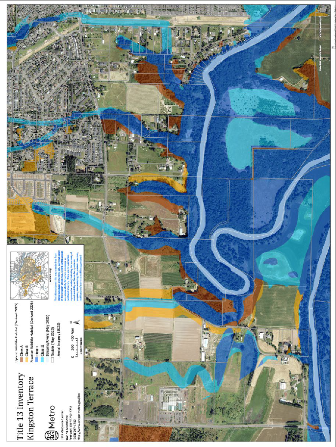
C.
Applicability of provisions. All development that exceeds the extent and scope of activities and improvements identified in Section 16.114.090.C.1. shall be regulated by this section (Section 16.114.090).
1.
Development on properties that contain a mapped Upland HCA identified in the Metro Title 13 Inventory as described in Section 16.114.090.B., must comply with these regulations, except they shall not apply to:
a.
HCA Class I and II Riparian Corridors that are subject to CWS regulatory authority.
b.
Metro HCA Class III Riparian Corridors and Metro Class C Upland Wildlife Habitat areas, which are not regulated by this title. In addition, if an on-site assessment results in riparian corridors (i.e., CWS Vegetated Corridor) being mapped within Metro Title 13 Upland HCA, these areas will be regulated per CWS authority.
c.
Development that is proposed to be greater than one hundred feet from an Upland HCA boundary.
d.
Change of ownership.
e.
Where a property has received previous approval according to this title, which has not expired, and the development proposed was part of, or contemplated by, the original development application approval, such as a phased development project or subdivision.
f.
Limited types of development, redevelopment, operations, improvements, and maintenance that are otherwise permitted by this title including the following:
i.
The alteration, expansion, or replacement of existing structures or related impervious surfaces including, but not limited to, accessory buildings, eave overhangs, exterior building improvement for access and exiting requirements, parking, and outdoor storage provided they will not intrude by more than one thousand square feet into the Upland HCA in addition to the existing building and impervious surface footprint.
ii.
Removal of up to ten percent, but no more than twenty thousand square feet of native vegetative cover on a lot or parcel within the mapped Upland HCA, not including trees measuring six-inch diameter at breast height (DBH) or larger. Removed vegetation shall be replaced as required by Section 16.114.090.1.
iii.
Maintenance of existing gardens, pastures, lawns, and landscape perimeters, including installation of new irrigation systems within them. Removed vegetation shall be replaced as required by Section 16.114.090.1.
iv.
Removal of nuisance or prohibited plants as identified on the Metro Native Plant List (Metro Resolution No. 98-2708) and the planting or propagation of plants identified as native plants on the Metro Native Plant List. After such removal, all open soil areas greater than one thousand square feet must be replanted with native plants on the Metro Native Plan List.
v.
Maintenance, alteration, repair, and replacement of roads and utilities provided that additional permanent and impervious improvements within an Upland HCA, such as pavement or structures, do not exceed one thousand square feet in area.
vi.
Operation, maintenance, and repair of existing manmade water control facilities such as irrigation and drainage ditches, constructed ponds or lakes, wastewater facilities, and stormwater pretreatment facilities.
vii.
Projects with the sole purpose of restoring or enhancing wetlands, streams, or fish and wildlife habitat areas, provided that the project is part of an approved local, state, or federal restoration or enhancement plan.
viii.
Removal of dead or diseased trees or trees that pose an imminent hazard to persons or property, provided that a consulting arborist report, or other credible evidence, is provided by the property owner to verify the need for removal.
ix.
Low-impact outdoor recreation facilities for public use including, but not limited to, multi-use paths, access ways, trails, picnic areas, or interpretive and educational displays and overlooks that include benches and outdoor furniture, provided that the facility meets the following requirements:
(a)
It contains less than one thousand square feet of new impervious surface; and
(b)
Its trails shall be designed to avoid damage to tree roots and constructed using non-hazardous, pervious materials, with a maximum width of six feet.
x.
Emergency procedures or activities undertaken, which are necessary to remove or abate hazards and nuisances or for the protection of public health, safety, and welfare; provided that such remedial or preventative action must take place within a timeframe too short to allow for compliance with the requirements of this chapter. After the emergency, the person or agency undertaking the action shall fully restore any impacts to the Upland HCA resulting from the emergency action consistent with the mitigation requirements in Section 16.114.090.I. Hazards that may be removed or abated include those required to maintain aircraft safety.
g.
Street trees that are approved by the city manager.
2.
Where the provisions of this chapter conflict with any other provisions of this title, CWS standards, or state and federal requirements, the more restrictive requirements shall apply.
3.
Development within an Upland HCA in accordance with the provisions of this title shall not result in removal of such developed areas from the Upland HCA and shall not change the applicable Upland HCA category.
D.
Prohibitions.
1.
The planting of any nuisance or prohibited vegetation identified in the Metro Native Plant List is prohibited within an Upland HCA. New plantings shall either be from the Metro Native Plant List or selected by a qualified professional, including, but not limited to, an arborist, landscape architect, or biologist.
2.
Outside storage of materials exceeding one thousand square feet is prohibited within an Upland HCA, unless such storage began before the effective date of this ordinance; or, unless such storage is approved during development review in accordance with this title.
E.
Administration.
1.
Development applications within an Upland HCA that exceed the thresholds in Section 16.114.090.C.1.f shall be administered and reviewed as a Type II City Manager decision in accordance with Article II of this title.
2.
Development applications proposed to occur outside of an Upland HCA but within one hundred feet of one shall be administered and reviewed as a Type I Administrative decision in accordance with Article II of this title.
3.
Upland HCA applications that require related development applications according to this title shall be reviewed in combination. This combined review shall follow either the Type II process per Section 16.114.090.E.1, or the Type III process when the associated application is subject to Planning Commission review as provided in Article II of this title.
4.
Adjustments described in Section 16.114.090.J. shall be administered and reviewed in combination with the related development application according to the review procedure required for that application.
F.
Submittal requirements. As part of the development permit for any use or activity, which is located on a lot that includes or is within one hundred feet of an Upland HCA in Section 16.114.090.B., an application for an Upland HCA review must be prepared and submitted on forms provided by the city. When a companion development plan review is required, the requirements of Section 16.114.150 shall be satisfied.
1.
In addition to the form and information required in Section 16.44.030, an applicant shall submit the following:
a.
Copies of the site plan or subdivision or partition plat, number to be determined by the city manager, and necessary data or narrative, which explains how the development conforms to the applicable criteria;
b.
Site plans, preliminary plat, grading plan, and required drawings, prepared by a registered civil engineer;
c.
Site plans shall identify the following:
i.
Location and type of existing development, including, but not limited to, building footprints, roads, driveways, parking areas, utilities, onsite sewage disposal systems, wells, landscaping, and filling or grading in an amount greater than ten cubic yards;
ii.
Location and width of existing adjacent roads and road rights-of-way;
iii.
The location of the Upland HCA boundary, the area of the subject property within one hundred feet of an Upland HCA boundary, and the location of any other protected natural or resource areas including, but not limited to, one hundred-year floodplain, riparian areas, wetlands, and slopes that are twenty-five percent or greater;
iv.
The location, species, height, and size of all trees that are six inches dbh or greater or tree groves on the property that are within an Upland HCA, Class I or II riparian area, or their respective one hundred-foot buffer areas;
v.
Density of grove of trees, as measured by overlapping canopy cover or canopy closure;
vi.
The location and description of all other vegetation that is either within the Upland HCA or within one hundred feet of its boundary;
vii.
Location of agricultural areas (e.g., pastures, orchards);
viii.
Location of naturalized areas (e.g., meadows, woods);
ix.
Location of rivers, streams, wetlands, and flood areas;
x.
Distance between naturalized areas, water bodies, and trees.
d.
Landscape plan and mitigation plan for disturbance in the Class A or B Upland HCA as shown in Figure 16.114-9;
e.
The scale for the site plan or preliminary plat shall be an engineering scale of not less than one-inch equals fifty feet;
f.
All drawings of structures elevations, prepared by a registered civil engineer or architect, shall be a standard architectural scale;
g.
In addition to the requirements of Article VI of this title, partitions and subdivisions shall identify proposed building envelopes, streets, and driveways necessary to serve the development that will follow the land division;
h.
Topographic map illustrating the existing and proposed topography of the subject property, drawn to scale. On properties that are two acres or larger, such a contour map is required only for the portion of the property to be developed. The topographic map shall be prepared using the following contour intervals:
i.
For slopes of five percent or less, contour intervals not more than one foot;
ii.
For slopes greater than five percent and up to and including ten percent, contour intervals not more than two feet; and
iii.
For slopes greater than ten percent, contour intervals not more than five feet.
i.
Current photos of site conditions;
j.
Construction management plan per Section 16.114.090.G; and
k.
Verification of any other permits required by other local, state, or federal agencies and the status of those permit applications.
2.
The information in Section 16.114.090.F.1 shall be submitted with or made part of a related development application, including, but not limited to, a building permit, development plan, or land division;
3.
Data and narrative for any related development applications as provided in this title;
4.
A list of names and addresses of all persons who are property owners of record within two hundred fifty feet of the subject property;
5.
The required fee;
6.
The city manager may require information in addition to that required by this chapter when it is found that certain information is necessary to properly evaluate the application; and
7.
The city manager may waive a specific requirement for information when it is found that such information is not necessary to properly evaluate the application.
G.
Construction management plans. A construction management plan shall be provided for non-exempt development within an Upland HCA or within one hundred feet of an Upland HCA including the following information:
1.
Demarcation of work areas to reduce potential damage to existing native vegetation within the Upland HCA;
2.
A tree protection plan prepared by a professional arborist shall demonstrate how existing trees six-inch dbh or greater will be appropriately protected with fencing and other techniques when construction is proposed to be within fifty feet of the tree drip line;
3.
A plan for conserving native soils disturbed during development;
4.
Location of site access and egress that construction equipment will use;
5.
Equipment and material staging and stockpile areas;
6.
Erosion and sediment control measures;
7.
Measures to protect trees and other vegetation located within the Upland HCA and within one hundred feet of an Upland HCA boundary, but outside of the disturbance area of a development approved under the provisions of this title; and
8.
Methods to ensure compliance with a development permit approved under this title.
H.
Approval standards.
1.
As part of the development permit for any use or activity, which is located on a lot that includes an Upland HCA, or area within one hundred feet of one, an application for an HCA review must be prepared and submitted in compliance with Section 16.114.090.F. The applicant shall demonstrate how the proposed development will satisfy the applicable criteria in Subsections 16.114.090.H.2. through H.4.
2.
For development on a lot that is proposed to only occur within one hundred feet of a Class A or B Upland HCA, the following requirements apply:
a.
The proposed development shall avoid any intrusion into the Upland HCA where native trees, as identified in the Metro Native Plant List are present. For land divisions, this will include a building footprint area for each developable lot in addition to grading, streets, and utilities.
b.
Appropriate protection for the Upland HCA shall be provided during construction to avoid any encroachment into the Upland HCA where native trees, as identified in the Metro Native Plant List are present, by providing protective fencing along the Upland HCA boundary and other methods approved by the city manager.
3.
For development on a lot that is proposed to occur within a Class A or B Upland HCA, the following requirements apply:
a.
Development shall avoid slopes of twenty-five percent or greater.
b.
Unless precluded by physical constraints, including, but not limited to, location of existing or planned vehicular access, existing improvements and intervening natural barriers, development shall first utilize any portions of the lot where native trees as identified in the Metro Native Plan List, are not present.
c.
Native trees, which are six inches dbh or greater and have a drip line that is contiguous to the drip line of a tree canopy on the lot or an adjoining Upland HCA or Class I or II Riparian Corridor, shall be retained unless the applicant can provide evidence from a qualified arborist that the tree is diseased or poses a safety risk.
d.
Singular, isolated native or non-native trees of any size and without contiguous drip lines may be removed subject to compliance with the mitigation requirements in Section 16.114.090.J.
e.
All nuisance or prohibited plants identified in the Metro Native Plan List shall be removed in any areas being developed or disturbed.
f.
To the extent practicable, when development within an Upland HCA is permitted, the proposed development shall be located, designed, and constructed to employ the techniques described in Part (c) of Table 16.114-8 to further minimize the impact of development in the Upland HCA.
g.
Notwithstanding the requirements in Section 16.114.090.1.3.a. through f., a minimum development disturbance area shall be permitted within a Class A or B Upland Habitat Conservation Area on a lot according to Table 16.114-9.
4.
For linear development where the project is within a public easement or right-of-way, the following requirements apply:
a.
The linear improvements, including, but not limited to, streets, sidewalks, pathways, and utilities, shall be designed to minimize grading, removal of native vegetation, removal of trees with a six-inch dbh or greater, and disturbance or removal of native soils by using the approaches described in Table 16.114-8;
b.
All nuisance or prohibited vegetation identified in the Metro Native Plant List within the easement or right-of-way shall be removed;
c.
Portions of the easement or right-of-way that is not permanently developed with impervious surfaces shall be restored using the approaches described in Table 16.114-8; and
d.
Removed trees shall be mitigated with new plantings as provided in Table 16.114-10 except for the allowance of street trees approved by the city manager.
5.
The following dimensional standards in Table 16.114-4 may be modified to reduce the land area converted to impervious surfaces:
a.
Minimum lot size may be reduced up to one thousand square feet.
b.
Except for the garage, required yard building setbacks may be reduced by up to fifty percent.
i.
Building height may be increased by ten feet in exchange for reducing building footprints by at least five hundred square feet.
Table 16.114-8
Table 16.114-9 Minimum Development or Disturbance Area in Upland HCA
26 For land divisions, the total development or disturbance area calculation shall include footprints for future building construction and related improvements such as driveways and patios. Minimums do not apply to linear development per Section 16.114.090.H.4.
6.
A construction management plan as specified in Section 16.114.090.G.
7.
Development permits shall comply with the applicable requirements of this title in addition to Section 16.114.150.
8.
Partition and subdivision applications shall demonstrate how the land division improvements and the subsequent development on the proposed lots will comply with the provisions of this title. Provided that development following the recording of the final plat is consistent with what was approved as part of the land division, a subsequent Upland HCA review will not be required.
I.
Mitigation requirement for disturbance in Upland HCAs.
1.
When intrusion into an Upland HCA satisfies the approval criteria in Section 16.114.090.H., mitigation shall be provided. Mitigation plans shall satisfy the following:
a.
Mitigation shall occur on the site of the disturbance, to the extent practicable. Off-site mitigation shall be approved if the applicant has demonstrated that it is not practicable to complete the mitigation on-site and has provided documented the ability to ensure the success of off-site mitigation. Mitigation shall occur within the Kingston Terrace District. When an alternative location and/or watershed is proposed, the applicant shall demonstrate why mitigation in the same watershed is not practicable.
b.
Nuisance or prohibited vegetation itemized in the Metro Native Plant List shall be removed within the mitigation area.
c.
Selection of all revegetation plantings shall be from the Metro Native Plant List.
2.
An applicant must meet Mitigation Option 1 or 2, whichever results in more tree plantings; except that where the disturbance area is one acre or more, the applicant shall comply with Mitigation Option 2:
a.
Mitigation Option 1. In this option, the mitigation requirement is calculated based on the number and size of trees that are removed from the site. Trees that are removed from the site must be replaced as shown in Table 16-114.10. Conifers must be replaced with conifers. Bare ground must be planted or seeded with native grasses or herbs. Non-native sterile wheat grass may also be planted or seeded, in equal or lesser proportion to the native grasses or herbs.
Table 16.114-10 Mitigation Option 1 - Tree
Replacement
b.
Mitigation Option 2. In this option, the mitigation requirement is based on the size of the disturbance area within a HCA. Native trees and shrubs are required to be planted at a rate of five trees and twenty-five shrubs for every five hundred square feet of disturbance area (calculated by dividing the number of square feet of disturbance area by five hundred, then multiplying that result times five trees and twenty-five shrubs and rounding all fractions to the nearest whole number of trees and shrubs). Bare ground must be planted or seeded with native grasses or herbs. Non-native sterile wheat grass may also be planted or seeded, in equal or lesser proportion to the native grasses or herbs.
3.
Plant size. The minimum size for replacement trees shall be one-half-inch caliper measured six inches above ground level, and the minimum size for replacement shrubs shall be one gallon.
4.
Plant spacing. Accepted landscaping practices, such as plant spacing, mulching, watering, and weed control shall be employed for planting and maintenance.
5.
Plant diversity. When more than ten trees or shrubs are planted, at least two different species shall be used.
6.
Maintenance. A mitigation maintenance plan shall be provided to demonstrate how a successful outcome will be achieved. A minimum of eighty percent of the plantings must survive, and removed nuisance or prohibited vegetation removed shall not reappear, for five years. The responsibility of monitoring, maintenance, and replacement shall rest with the property owner.
J.
Adjustments. The purpose of this section is to ensure that compliance with Section 16.114.090 does not cause unreasonable hardship. To avoid such instances, the requirements of Section 16.114.090 may be adjusted. Adjustments shall be considered in conjunction with a development application within an Upland HCA, and they shall be reviewed as a Type II City Manager decision in accordance with this title.
1.
To receive an adjustment to the Upland HCA requirements in this section, the applicant must demonstrate the following:
a.
The proposed adjustment does not represent a deviation from the applicable standard by more than 20 percent.
b.
The mitigation requirements in Section 16.114.090.1. will be satisfied. If the adjustment is related to these requirements, the applicant shall provide evidence from a qualified professional, including, but not limited to, an arborist, landscape architect, or biologist to demonstrate that the proposed alternative mitigation techniques will provide environmental and ecological benefits, which are equally effective mitigation for intrusions into the Upland HCA.
2.
Conditions may be imposed by the approval authority to limit and adverse impacts that may result from granting an adjustment.
(Ord. No. 2023-04, § 1(Exh. A), 10-18-2023)
16.114.100 - Neighborhood Locations and Primary Land Uses.
A.
The Regulating Plan locates each of the four neighborhoods within the Kingston Terrace Master Plan area. The neighborhood zones are generally located, and their boundaries shall be definitively established by the Backbone Streets, as follows:
1.
The Kingston Terrace Town Center is bounded by Beef Bend Road in the north, Roy Rogers Road on the west, and Elsner Road to the east and south.
2.
The Beef Bend Neighborhood is bounded by Beef Bend Road to the north, Elsner Road to the west, the new extension of Fischer Road on the south, and 137th Avenue on the east.
3.
The Central Neighborhood is bounded by the new extension of Fischer Road on the north (to 150th Avenue) and new east/west Neighborhood Route (identified in King City's Transportation System Plan Table 13 as Project ID 16), Elsner Road to the west, the Tualatin River on the south, and to the east, the extension of 147th Avenue, and the Natural Resource Area Overlay boundary.
4.
The Rural Character Neighborhood is bounded by a new east/west neighborhood route ((identified in King City's Transportation System Plan Table 13 as Project ID 16) on the north, the Natural Resource Area Overlay boundary to the west, 137th Avenue to the east, and the Tualatin River to the south.
5.
The Natural Resource Area Overlay boundary will generally define the extent of development, but the neighborhood zone boundaries shall generally coincide with street locations.
B.
Town Center Uses. The primary uses allowed outright within the Town Center neighborhood are listed in Table 16.114-2.
1.
Residential development in the Town Center shall comply with density requirements of Table 16.114-3, dimensional standards of Table 16.114-4, and design standards of Table 16.114-5.
2.
The Regulating Plan, Figure 16.114-9, identifies the location of a Municipal Zone at the intersection of River Terrace Boulevard and Fischer Road extension. In accordance with the Kingston Terrace Master Plan, future municipal buildings on this site may house a City Hall, library, and other public facilities. The site of Clean Water Services' pump station, located south of the intersection of Roy Rogers Road and Fischer Road extension, is also identified as Municipal Zone.
3.
The Regulating Plan, Figure 16.114-9, identifies the location of the Mixed-Use Zone within the Town Center located along River Terrace Boulevard and north of the Fischer Road extension. Mixed-use buildings shall contain both residential and commercial uses, stacked vertically side-by-side or standalone. The commercial business may include retail, offices, and restaurants.
4.
The Regulating Plan, Figure 16.114-9, illustrates the location of public parks and open space within the Town Center neighborhood in relation to the Mixed-Use and Municipal Use Zones. Development and design of public parks and open space in the Town Center shall comply with the standards of Section 16.114.110.
C.
Residential Neighborhood Uses. The primary uses allowed outright within the Beef Bend, Central, and Rural Character residential neighborhoods are listed in Table 16.114-2.
1.
Residential development in the Town Center shall comply with density requirements of Table 16.114-3, dimensional standards of Table 16.114-4, and design standards of Table 16.114-5.
2.
The Beef Bend Neighborhood may include neighborhood-scale commercial uses in conjunction with residential uses. Neighborhood-scale commercial may include multi-family dwelling units including live-work units with small-scale commercial development or residential over small-scale commercial.
3.
Development and design of public parks and open space in the Town Center shall comply with the standards of Section 16.114.110.
(Ord. No. 2023-04, § 1(Exh. A), 10-18-2023)
16.114.110 - Parks, Open Space and Trails.
A.
Developers shall pay Park System Development Charges (SDCs) in accordance with King City's Park SDC schedule or provide improvements per the Kingston Terrace Master Plan as agreed upon through the Annexation and Development Agreement process detailed in Sections 16.114.140.C and D.
B.
Developments in the Kingston Terrace District shall provide parks, open space areas, and trails in substantial compliance with the overall development vision as described in the Kingston Terrace Master Plan.
1.
A development shall provide parks, trails, or open space:
a.
As identified in the Kingston Terrace Master Plan Figure 3.4 Parks and Open Space System Diagram;
b.
Conform to the Kingston Terrace Master Plan Table 3.1 Parks and Open Spaces: Types, Guideline, Location with respect to both size; and
c.
Will be dedicated to the public if the proposal is for a public park or open space.
2.
Parks and open spaces shall be designed to enhance the public pedestrian environment and be consistent to the applicable "General Characteristics" of the Land Use: Parks and Open Space section of the Master Plan.
3.
Parks and open spaces shall be designed to include amenities and improvements as detailed in the "Key Features" in the Land Use: Parks and Open Space section of the Master Plan.
4.
Improvements may include, but are not limited to, the following:
a.
Landscaped or hardscaped courtyards and plazas;
b.
Play structures;
c.
Weather canopies or sunshades;
d.
Seating areas;
e.
Free-standing planters and/or raised planting beds;
f.
Drinking fountains;
g.
Public art or sculpture;
h.
Water features;
i.
Sports courts, fields, or tracts; or
j.
Other pedestrian space or design feature as approved by the reviewing authority.
5.
Passive recreation open spaces areas may be provided within identified natural resource or hazard areas including, but not limited to, 100-year floodplain, delineated wetlands and wetlands buffers, Class I and II Riparian Corridors, and Class A and B Upland Wildlife Habitat Conservation Areas if present on-site. Improvements to such areas may include the following provided all necessary development approvals and permits are obtained:
a.
Public accessways and trails;
b.
Wildlife viewing areas; and
c.
Improvements must comply with applicable requirements and approval criteria of Chapter 16.140, Floodplain and Drainage Hazard Areas and Sections 16.114.080, Kingston terrace District Goal 5 Safe Harbor Review and 16.114.090, Upland Wildlife Habitat Conservation Areas.
6.
Trails and paths shall be located and designed to:
a.
Augment the public sidewalk system and facilitate access to parks, schools, trails, open spaces, commercial areas, and similar destinations.
b.
Trails and paths must meet all applicable federal and state accessibility standards where feasible. Soft surface trails and paths in or adjacent to natural areas are allowable.
c.
Be dedicated to the public or placed in a public access easement.
C.
The Town Center will include the following public parks and opens spaces:
1.
Park Blocks: An area of four to seven acres located in the Town Center neighborhood shall provide both active and passive recreation and may include: sport fields, dog park, fitness stations, shelters, and open lawn seating.
2.
Urban Park: An area of one to five acres located to the south of the park blocks near the civic center. The urban park shall include space and be designed to accommodate community gatherings and events.
3.
Urban plazas: Areas of approximately one thousand square feet to five thousand square feet shall be located at the intersections of River Terrace Boulevard at the new east-west Neighborhood Route, and at River Terrace Boulevard at the Fischer Road extension. Urban plazas will be hardscaped with seating and ornamental landscaping.
4.
Neighborhood Park: An area of approximately three-fourths-acres, shall be located in the southern portion of the Town Center neighborhood. The park will provide an open lawn area, shaded seating, and a play area.
5.
Linear Greens: Linear greens, located adjacent to the new east-west neighborhood route extending west from Elsner Road to Roy Rogers Road, shall provide a hard surface path and street furnishings such as benches, trash receptacles, and lighting.
6.
Natural Open Space: A natural open space area, spanning from Roy Rogers Road to Elsner Road, shall be located in the southern portion of the Town Center neighborhood. The ten- to twenty-acre area shall provide connections to the natural resources with pedestrian trails, overlooks, nature play areas, and seating.
D.
The Beef Bend, Central, and Rural Character residential neighborhoods will include the following public parks and open spaces:
1.
Community Park: Two community parks about fifteen to thirty acres in size shall be located within the residential neighborhoods. One community park shall be located in the Central Neighborhood and the second park is proposed to be located in the Rural Character Neighborhood. Community parks are proposed to be located near a collector or neighborhood route and adjacent to or near the Tualatin River. The exact location of the community parks may vary by up to a one-quarter-mile radial distance as shown on in Figure 3.4 Parks and Open Space System Diagram of the Kingston Terrace Master Plan.
2.
Neighborhood Park: Three neighborhood parks, about three acres in size, are proposed within the Beef Bend, Central, and Rural Character residential neighborhoods. Each park shall serve a one-quarter to one-half mile radius of residential areas and be designed to include amenities such as lawn area, small playground, seating area, etc. The exact location of the neighborhood park may vary by up to a one-quarter-mile radial distance as shown in Figure 3.4 Parks and Open Space System Diagram of the Kingston Terrace Master Plan.
3.
Linear Park: A multi-use path shall be integrated into the electric transmission tower corridor on the eastern edge of the residential neighborhoods as shown in Figure 3.4 Parks and Open Space System Diagram of the Kingston Terrace Master Plan.
4.
Open Space/Natural Area: Open space and natural areas shall be provided generally along the north/south stream corridors, steep terrain, wetlands, and adjacent to the Tualatin River. The open space shall offer recreational amenities with minimal impact on the natural resources. The open space/natural areas shall be located as shown in Figure 3.4 Parks and Open Space System Diagram of the Kingston Terrace Master Plan; however, locations shall be field verified to determine the exact location of natural resources within the Beef Bend, Central, and Rural Character residential neighborhoods.
E.
Land use approvals for developments containing parks, open space, and trails shall assign maintenance responsibility if the area is not proposed and accepted as a public park.
F.
Development along Habitat Conservation Areas (HCA) and Class I and II Riparian Corridors.
1.
Adjacent to HCA and Class I and II Riparian Corridors, fencing along a lot line perimeter cannot exceed sixty percent, shall not exceed three feet in height, and chain-link fences are prohibited. This standard may apply to the perimeter of lots measured collectively or measured individually, provided that it applies to sixty percent of the total lineal dimension.
2.
For lots adjacent to HCA and Class I and II Riparian Corridors, which have their front lot line facing the resource, the resource-facing façades of buildings must meet the design requirements in Section 16.114.060, human-scale design: articulation, eyes on the street/transparency, main entrance, and detailed design.
(Ord. No. 2023-04, § 1(Exh. A), 10-18-2023)
16.114.120 - Neighborhood Circulation.
A.
The neighborhood circulation requirements and approval standards of Chapter 16.212 apply to development in the Kingston Terrace District, except for the street, sidewalk, accessway, and trail circulation standards as modified in this Section.
B.
Backbone Street Network. The Regulating Plan, Figure 16.114-9, illustrates the location of existing and future Backbone Street Network consistent with King City's Transportation System Plan and the Kingston Terrace Master Plan. Following is a list of the existing and future streets, the functional classification, and corresponding Project Identification (ID) number identified in Table 13 in Chapter 5 of the Transportation System Plan (TSP):
1.
North-south streets (listed west to the east):
a.
Roy Rogers Road - Arterial - TSP Project ID 1.
b.
River Terrace Boulevard Extension - Collector - TSP Project ID 3.
c.
New Neighborhood Route west of Elsner Road between Beef Bend Road and Fischer Road - TSP Project ID 4.
d.
Elsner Road - Collector - TSP Project ID 5 and 6.
e.
New Neighborhood Route east of Elsner Road and west of 155 th Avenue extension between Beef Bend Road and Ficher Road - TSP Project ID 10.
f.
155 th Avenue Extension - Collector - TSP Project ID 11.
g.
New Neighborhood Route east of 155 th Avenue extension and west of 150 th Avenue between Beef Bend Road and south of Fischer Road - TSP Project ID 12.
h.
150 th Avenue - Collector - TSP Project ID 13.
i.
147 th Avenue - Neighborhood Route - TSP Project ID 14.
j.
Myrtle Avenue - Neighborhood Route - TSP Project ID 15.
k.
137 th Avenue - Collector - TSP Project ID 18.
2.
East-west streets (north to south):
a.
Beef Bend Road - Arterial - TSP Project ID 8.
b.
New Neighborhood Route south of Beef Bend Road between 137 th Avenue and new neighborhood route - TSP Project ID 9.
c.
New Neighborhood Route north of Fischer Road extension between 137 th Avenue and 150 th Avenue - TSP Project ID 16.
d.
Fischer Road Extension - Collector - TSP Project ID 7.
3.
Local Streets. Within the areas bounded by Backbone Streets a finer-grained network of local streets will be built.
4.
Location of connecting street segment. To minimize impact to natural resources and accommodate topography, alignment of segments of Collector and Neighborhood Routes may vary up to one hundred feet from the locations identified on the Regulating Plan, Figure 16.114-9, provided they fully connect/intersect with each of the streets and intersections as shown on the Regulating Plan.
C.
Backbone Street intersections. The Regulating Plan, Figure 16.114-9, identifies the types of intersections of Backbone Streets and classifies them as follows:
1.
Type A Intersections. The following intersections already exist and/or will be extended into the Kingston Terrace District Plan. The location of these intersections may be adjusted by one hundred feet in any direction to accommodate topography, desired connection points, and construction feasibility. Type A intersections include:
a.
Beef Bend Road at Roy Rogers Road;
b.
Fischer Road Extension at Roy Rogers Road;
c.
Elsner Road at Roy Rogers Road;
d.
River Terrace Boulevard Extension at Beef Bend Road;
e.
Elsner Road at Beef Bend Road;
f.
150th Avenue at Beef Bend Road;
g.
137th Avenue at Beef Bend Road;
h.
Fischer Road at 137 th Avenue; and
i.
Fischer Road at 150 th Avenue.
2.
Type B Intersections. The remaining intersections identified on the Regulating Plan, Figure 16.114-9, are Type B. The location of these intersections may be adjusted by two hundred feet in any direction to accommodate topography, desired connection points, and construction feasibility.
3.
The Regulating Plan, Figure 16.114-9, includes unidentified intersections of Backbone Streets with Beef Bend Road. Location of the unidentified intersections is dependent upon Washington County's intersection spacing standards, the timing of development, property ownership, topography, and minimization of impact to natural resources.
D.
Street circulation standards. The following criteria apply to the street network within the Kingston Terrace District:
1.
Block length of collectors, neighborhood routes, and local streets shall not exceed five hundred thirty feet measured between intersections with public streets.
2.
Exceptions to the block size may be approved by the City Engineer where a street location is precluded by natural topography, wetlands, significant habitat areas, bodies of water, pre-existing development, or intersection spacing requirements for arterial or collector streets. An exception to the block length may also be approved to support the urban design goals of the neighborhood including, but not limited to, development of an urban neighborhood that includes plazas and active frontages, and creation of public parks and open spaces such as park blocks or linear greens that support multi-modal transportation.
3.
Mid-block pedestrian and bicycle accessways on public easements or rights-of-way must be provided at spacing of no more than three hundred thirty feet if full-street connections cannot be provided, unless the connection is impracticable due to topography, natural areas, inadequate sight distance, lack of supporting land use or other factors that may prevent safe connection, as determined by the City Engineer.
4.
The Regulating Plan, Figure 16.114-9, does not limit the ability of a developer to add additional streets or intersections.
E.
Design Standards: Table 16.114-11 details the street dimension and design characteristics for streets in the Kingston Terrace District.
Table 16.114-11 Street Dimensional and Design Standards
27 The combined required dimensions of each component (i.e., Plant Strip, Sidewalk) may be accommodated within the right-of-way, an easement or a combination of the two.
28 Per the City of King City Transportation System Plan, Figure 29: Sidewalk Zones, the Pedestrian Walkway Zone includes both the Pedestrian Throughway and Furnishing/Landscape Zone. The Pedestrian Throughway Zone is the accessible zone in which pedestrians travel. The Furnishings/Landscape Zone is located between the pedestrian throughway and the curb and includes street furnishings and/or landscaping (e.g., benches, lighting, bicycle parking, tree wells, and/or other plantings).
29 Left turn lane is optional in median streets; median may be a combination of planted, paved, and/or parked; median may be 20 to 40 feet wide.
30 Parallel or diagonal parking area may be partially planted, and/or used for permanent or temporary outdoor seating or other public uses instead of parking.
31 Parking is accommodated within the Pedestrian Walkway zone.
32 On a collector street the bicycle facility may be accommodated on a multi-use path.
33 Lots with front lot lines adjacent to or within ¼-mile distance from a Habitat Conservation Area (HCA) may be served by a narrow street or alley to minimize impact to the resource.
34 Narrow Street design alternatives A, B, and C must meet the applicable criteria of Section 16.114.120.F.1.
35 The parking zone may shift from side to side of the vehicular travel lane as long as the minimum width of the vehicular is maintained. The curbside parking area may be partially planted, and/or used for permanent or temporary outdoor seating or other public uses instead of parking.
36 Development sites that have public street frontage on an arterial street, collector, neighborhood route or local street, upon which they cannot take direct vehicle access may choose to provide vehicle access through an alley.
F.
Typical street sections:
Figure 16.114.12 Median Street A (Planted Median)
Figure 16.114.13 Median Street B (Center Plaza)
Figure 16.114.14 Main Street A (Parallel Parking)
Figure 16.114.15 Main Street B (Diagonal Parking)
Figure 16.114.16 Neighborhood Street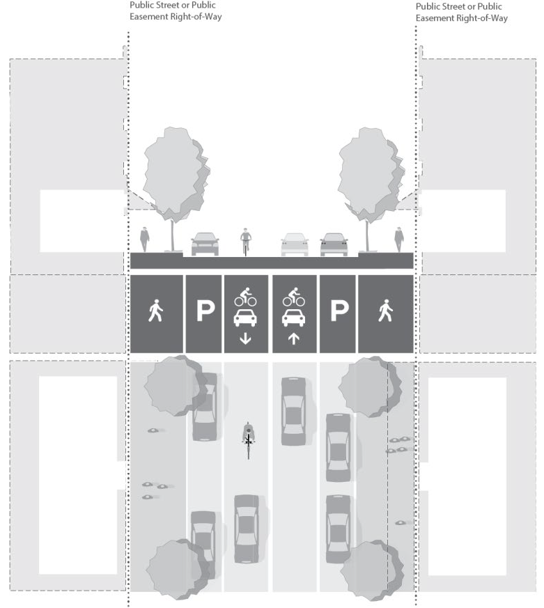
Figure 16.114.17 Biking Street A (Parking-Buffered Bike Lane)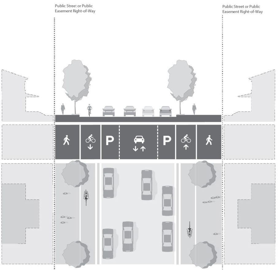
Figure 16.114.18 Biking Street B (Buffered Bike Lane)37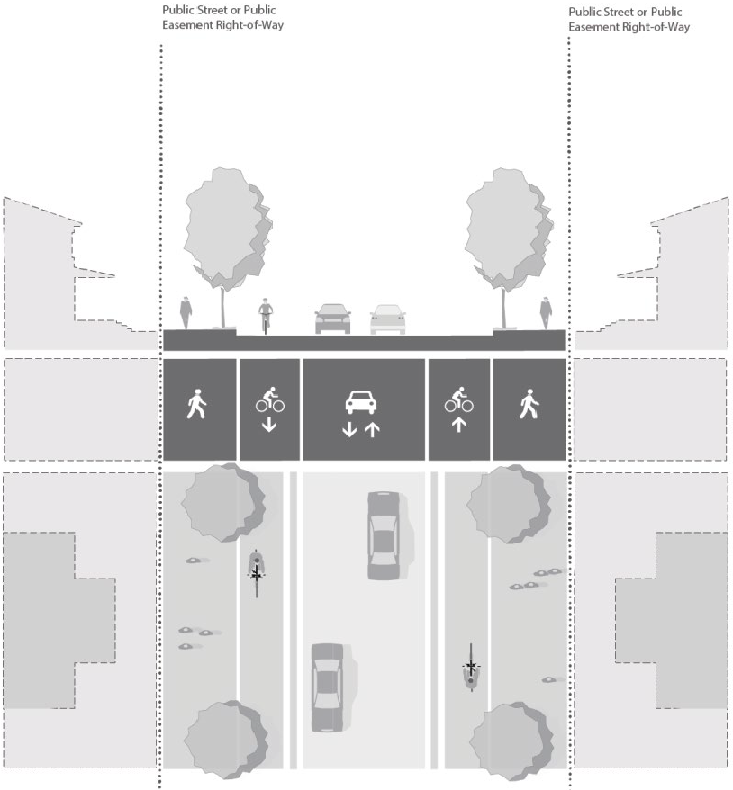
37 Optional Biking Street B (Buffered Bike Lane) design may include parking lane as noted in Table 16.114-11, Street Dimensional and Design Standards.
Figure 16.114.19 Biking Street C (Separated Bike Lane)38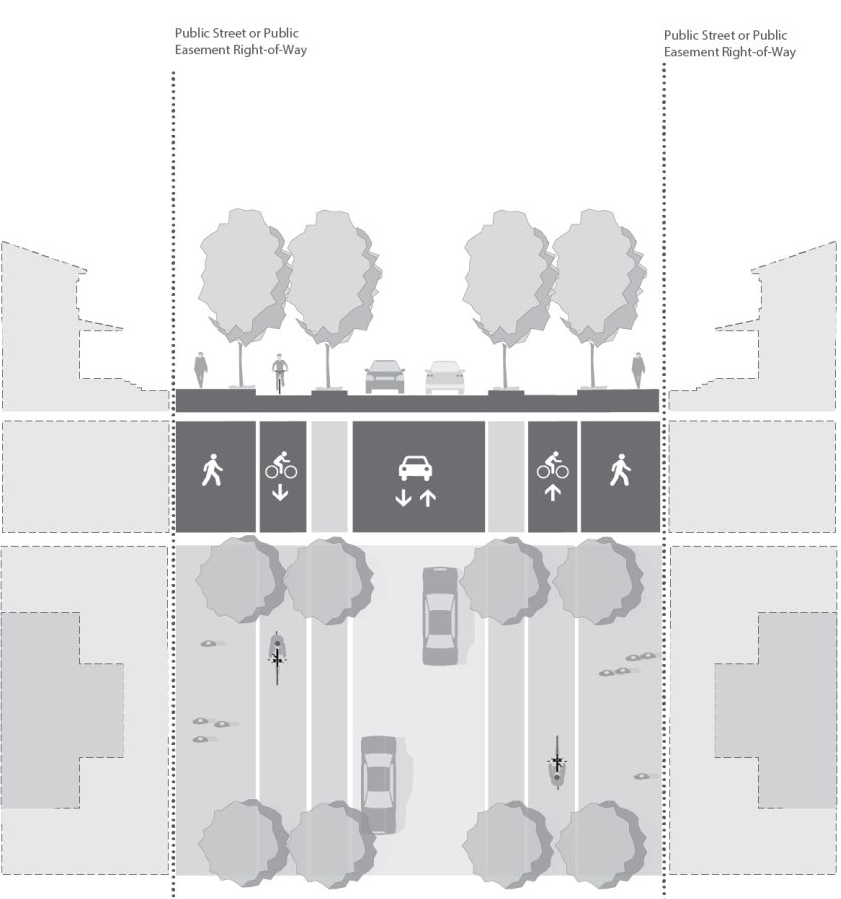
38 Optional Biking Street C (Separated Bike Lane) design may include parking lane as noted in Table 16.114-11 - Street Dimensional and Design Standards.
Figure 16.114.20 Rural Character Neighborhood Street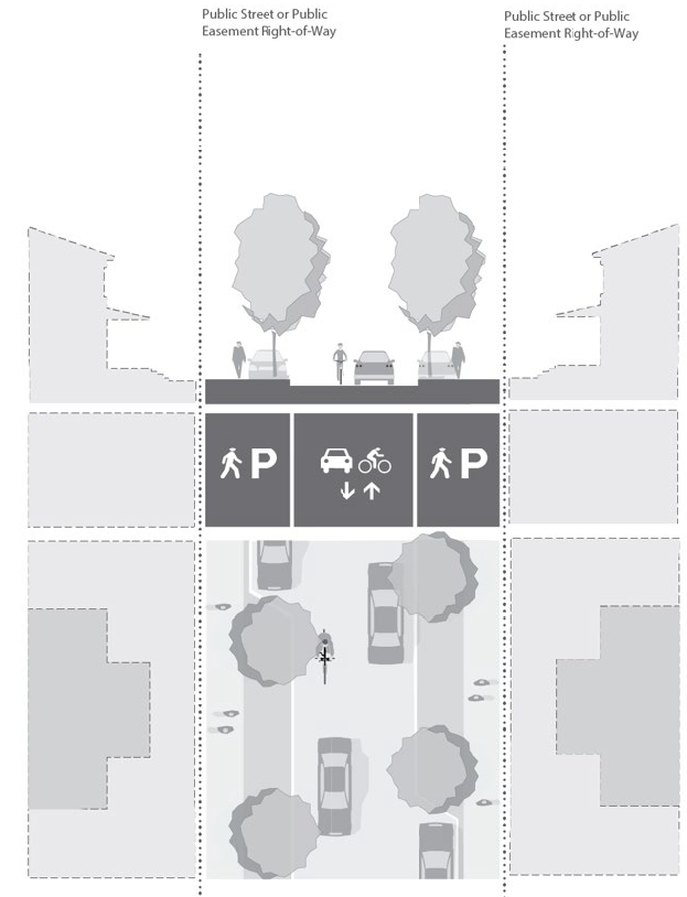
1.
Narrow Streets. Three alternative cross-sections for local residential narrow streets are illustrated in the following Figures 16.114-21, 16.114-22, and 16.114-23. Each Narrow Street alternative is tied to a specific set of criteria that must be met when adopting the alternative.
a.
Criteria for Narrow Street A:
i.
Traffic Flow Plan must be submitted and approved before adopting the alternative.
ii.
Not appropriate for streets serving more than five hundred vehicle trips per day.
iii.
On-street parking is permitted on one side only.
iv.
No on-street parking is permitted within thirty feet of an intersection.
b.
Criteria for Narrow Street B:
i.
Traffic Flow Plan must be submitted and approved before adopting the alternative.
ii.
Not appropriate for streets serving more than one thousand vehicle trips per day.
iii.
On-street parking is permitted on both sides.
iv.
No on-street parking is permitted within 30 feet of an intersection.
c.
Criteria for Narrow Street C:
i.
Traffic Flow Plan must be submitted and approved before adopting the alternative.
ii.
Not appropriate for streets serving more than two hundred vehicle trips per day.
iii.
No on-street parking is permitted on either side.
Figure 16.114.21 Narrow Street A (Parking One-Side)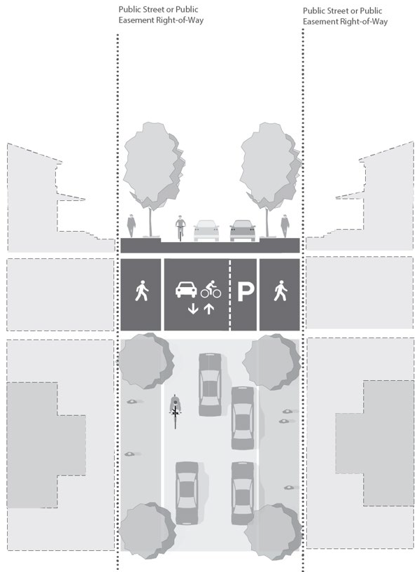
Figure 16.114.22 Narrow Street B (Parking Both Sides)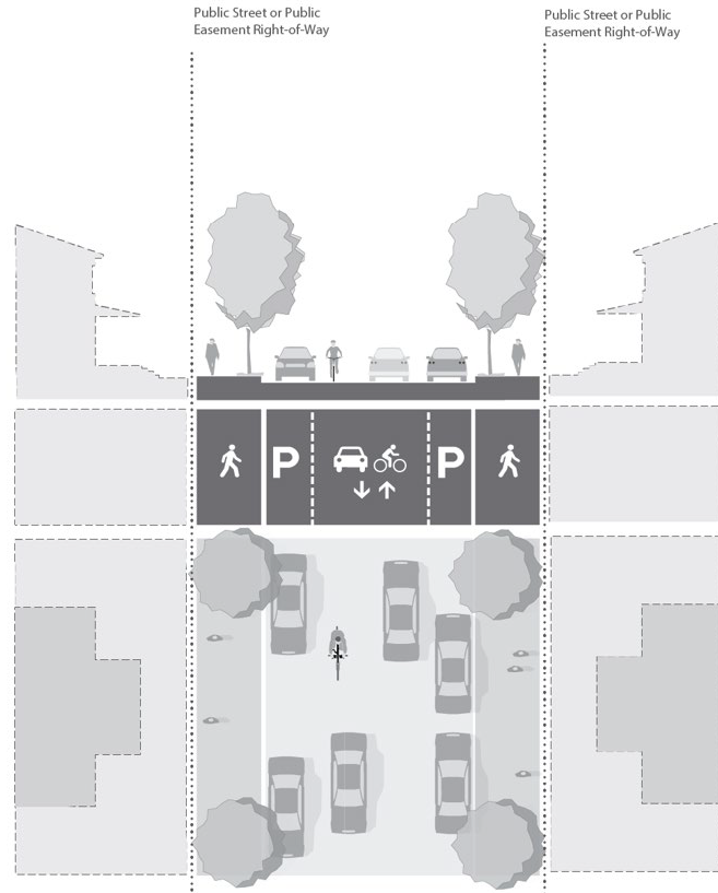
Figure 16.114.23 Narrow Street C (No Parking)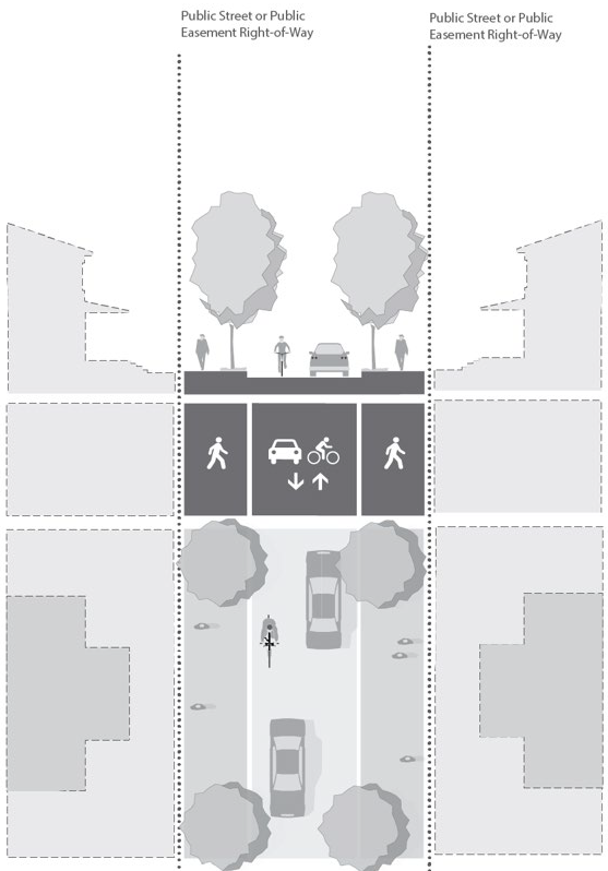
Figure 16.114.24 Alley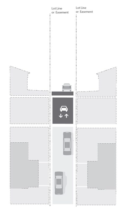
G.
Adjustments to the street dimension and design characteristics. Adjustments to the street dimension and design characteristics of Section 16.114.120.E may be approved by the City Engineer through a Development Plan Review with consideration made to the following:
1.
The functional street classification.
2.
Anticipated traffic volume.
3.
Sidewalk and bikeway requirements.
4.
On-street parking needs.
5.
Requirements for placement of utilities.
6.
Street lighting.
7.
Drainage and slope impacts.
8.
Protection of inventoried Goal 5 natural resources including Class A and B Upland Wildlife Habitat Conservations Areas and Class I and II Riparian Habitat Conservation Areas.
9.
Street location.
10.
Planting and landscape areas.
11.
Safety and comfort for motorists, bicyclists, and pedestrians.
12.
Access needs for emergency and service vehicles and transit.
13.
Guidance provided in Table 5: Minimum Bicycle Facilities, Table 7: Process for Determining Street Cross-Sections in Constrained Conditions, and Table 8: Constrained Acceptable Sidewalk Configuration of the City's Transportation System Plan.
H.
On-Site bicycle and pedestrian circulation. Development within Kingston Terrace shall provide an on-site bicycle and pedestrian circulation system which includes the following:
1.
Private development shall provide continuous connections between the primary buildings, ground level entrances, common buildings, common open space, and vehicle and bicycle parking areas.
2.
Pedestrian walkways shall be separated from vehicle parking and maneuvering areas by physical barriers such as planter strips, raised curbs, or bollards.
3.
Walkways shall be constructed with a hard surface material and shall be no less than five feet wide. If adjacent to a parking area where vehicles will overhang the walkway, it shall have a minimum width of seven feet. The walkways shall be separated from parking areas and internal driveways using curbing, bollards, landscaping, or distinctive paving materials.
4.
Dwelling, multi, mixed-use, and commercial developments shall provide on-site bicycle and pedestrian connections every three hundred thirty feet of block length where block lengths exceed five hundred thirty feet, except where precluded by natural topography, wetlands, significant habitat areas, bodies of water, or pre-existing development.
I.
Public bicycle and pedestrian circulation and facilities. The bicycle and pedestrian circulation system in the Kingston Terrace District shall include the following:
1.
Location of pedestrian and bicycle routes shall substantially conform to Figure 26: Pedestrian Route Designations and Figure 27: Bicycle Route Designations of the King City Transportation System Plan, except as altered by traffic or engineer analysis.
2.
Size and location of pedestrian and bicycle facilities along public streets shall conform to the Street Dimensional and Design Standards of Table 16.114-11.
3.
Where bicycle routes are parallel and adjacent to an auto travel lane, the connection must be clearly marked and safely separated from the auto travel lane.
J.
Future transit. Developers shall coordinate with transit providers on design and location of transit infrastructure for development along transit routes identified in King City's Transportation System Plan Figure 28: Transit Route Designations.
K.
Circulation and Access. Development in the Kingston Terrace District shall comply with the minimum driveway, access width, and pavement width standards of Table 16.114-12.
Table 16.114-12 Minimum Vehicle Access Standards
1.
Private residential access drives shall be provided and maintained in accordance with the applicable provisions of the Uniform Fire Code.
2.
Access drives from the street to off-street parking or loading areas shall be designed and constructed to facilitate the flow of traffic and provide maximum safety for pedestrian and vehicular traffic on the site.
3.
Parking spaces on access driveways shall be designed to reduce or eliminate backing movements and other conflicts with the driveway traffic and pedestrian routes and crosswalks.
4.
To slow traffic speeds on access drives, speed bumps, speed limit signs, and similar techniques may be required by the approval authority to enhance safety for pedestrians, bicyclists, and motorists on the site.
5.
To improve traffic flow, the city engineer may require directional signs on the site to guide pedestrians, bicyclists, or motorists.
6.
Where a proposed parking facility is served by one-way traffic flow on the site, it shall be accommodated by a driveway system approved by the city, and the entrance drive shall be situated closest to oncoming traffic and the exit drive shall be situated farthest from oncoming traffic.
7.
The direction of traffic flow shall be clearly marked for motorists on the property and the adjoining public street.
8.
Excluding dwelling, single-family attached or detached, groups of more than two parking spaces and all loading areas shall be served by a service drive so that no backing movements or other maneuvering within a street or other public right-of-way is required.
9.
All driveways shall be paved and designed in a manner approved by the City Engineer.
10.
Where pedestrian or bicycle routes cross driveways, parking area or loading areas, the connection must be clearly identifiable through the use of striping, elevation changes, speed bumps, a different paving material, or other similar method.
(Ord. No. 2023-04, § 1(Exh. A), 10-18-2023)
16.114.130 - Parking and Loading.
A.
Purpose. The purpose of this chapter is to provide basic and flexible standards for the development of vehicle parking, loading and bicycle parking. The design of parking and loading areas is critically important to the viability of commercial areas, pedestrian and driver safety, the efficient and safe operation of adjoining streets, and community image and livability. Because vehicle-parking facilities can occupy large amounts of land, they must be planned and designed carefully to use the land efficiently while maintaining the visual character of the community.
B.
Applicability. The Parking and Loading standards of Chapter 16.132 do not apply to new development in the Kingston Terrace District. They are superseded by the standards of Section 16.114.130.
C.
Vehicle parking standards.
1.
Minimum number of vehicle parking spaces. There are no minimum vehicle parking requirements in the Kingston Terrace District.
2.
Maximum number of vehicle parking spaces.
a.
The number of parking spaces provided by any particular use in ground surface parking lots must not exceed the number of parking spaces provided in Table 16.114-13, Maximum Off-Street Vehicle Parking Spaces. Spaces provided on-street, or within the building footprint of structures, such as in rooftop parking, tuck-under parking or under-structure parking, or in multi-level parking above or below surface lots, do not apply toward the maximum number of allowable spaces. Where a fractional number of spaces results, the maximum number of spaces is rounded down to the nearest whole number. This section does not apply to single-family residential dwellings.
Table 16.114-13 Maximum Vehicle Parking Spaces
3.
Availability. Parking spaces may not be used for the parking of equipment or storage of goods or inoperable vehicles. Parking spaces may not be assigned in any way to a use on another site, except for shared parking situations.
4.
Location.
a.
Vehicle parking is allowed only on approved streets, within garages, carports, and other structures, or on driveways or parking lots that have been developed in conformance with this code. Vehicle parking must not be located in a vehicle travel lane (including emergency or fire access lanes).
b.
Surface parking areas shall be located on the site to serve the intended users of the development safely and conveniently, without precluding future site intensification.
c.
Surface parking areas shall occur to the side or rear of buildings.
d.
Off-street surface vehicle parking areas, detached garages, and attached or detached carports associated with mixed-use, multi-family dwelling, or commercial buildings may not be located closer to a street property line than the building closest to that street property line.
e.
Parking spaces shall be so located and served by an access that their use will require no backing movements or other maneuvering within a street or right-of-way.
5.
ADA accessible parking spaces.
a.
When parking is provided on-site, accessible parking must be provided for disabled persons, in conformance with the Federal Americans with Disabilities Act (ADA). On-site accessible parking facilities must comply with the design requirements of the current building code as adopted by the State of Oregon.
6.
Shared Parking. Shared parking between two or more uses is permitted when all the following criteria are satisfied:
a.
Satisfactory legal evidence is presented to the city manager in the form of deeds, leases or contracts to establish the shared use; and
b.
The other applicable standards of this title can be met.
7.
Electrical service capacity. Electrical service capacity, as defined by ORS 455.417, must be provided to new off-street parking spaces in compliance with the standards of this subsection. Adjustments to the standards of this subsection are prohibited.
a.
Non-residential development and residential or mixed-use developments with less than five dwelling units must provide electrical service capacity to a minimum of twenty percent of all off-street vehicle parking spaces on the site.
b.
Residential or mixed-use developments with five or more dwelling units must provide electrical service capacity to a minimum of forty percent of all off-street vehicle parking spaces on the site.
c.
Dwelling units in townhouses are not included for the purposes of determining the applicability of this regulation.
8.
Maintenance.
a.
When provided, parking spaces shall be designed and maintained by the owner of the property.
b.
All off-street vehicle parking spaces and maneuvering areas must have a durable and paved surface and shall be maintained for all-weather use. The use of pervious concrete, pervious paving, driveway strips, or an in-ground grid or lattice surface is encouraged to reduce stormwater runoff.
9.
Parking stall standard dimensions and compact car parking.
a.
All off-street parking stalls must be improved to conform to City standards for surfacing, stormwater management and striping, and provide dimensions in accordance with Table 16.114-14 Parking Stall Dimensions and Figure 16.114-25 Parking Area Dimensions.
b.
No more than fifty percent of the parking stalls provided on-site can be compact spaces.
c.
The stopping edge of any curb or wheel stop must be placed no less than two feet from the end of the parking stall.
d.
Where a curb or wheel stop is provided, the overhang of a vehicle past the curb or wheel stop may be counted as part of the required parking stall depth, up to a maximum of two feet.
e.
Parking spaces along the boundaries of a parking lot or adjacent to interior landscaped areas or sidewalks shall be provided with a wheel stop that is at least four inches high located three feet back from the front of the parking space. The front three feet of the parking stall may be concrete, asphalt or low-lying landscape material that does not exceed the height of the wheel stop. This area cannot be calculated to meet landscaping or sidewalk requirement.
Table 16.114-14 Minimum Parking Dimensions
Figure 16.114-25 Parking Area Dimensions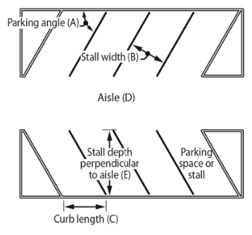
D.
Loading area requirements. All off-street vehicle loading areas for passengers or goods must:
1.
Include sufficient area for turning and maneuvering of vehicles on-site.
2.
Be designed such that vehicle stacking does not impact any public right-of-way, vehicle travel lane, or emergency or fire access lanes.
E.
Bicycle parking requirements: Bicycle parking shall be provided in conjunction with all new mixed-use, dwelling, multi, commercial, and municipal developments in Kingston Terrace District. This section does not apply to single-family, residential dwellings.
1.
Number of bicycle parking spaces. Table 16.114-15 lists applicable standards.
Table 16.114-15 Minimum Bicycle Parking Requirements
2.
Bicycle parking shall be located no more than fifty feet from a primary entrance in the closest available area to the primary entrance as determined by the decision-making authority.
3.
Bicycle parking facility design.
a.
Bicycle parking facilities shall either be lockable enclosures in which the bicycle is stored, or secure stationary rack which supports the frame so the bicycle cannot easily be pushed or fall to one side. Racks that require a user-supplied lock shall accommodate locking the frame and both wheels using either a cable or U-shaped lock.
b.
Bicycle parking spaces shall be at least six feet long and two and one-half feet wide, and overhead clearance in covered spaces shall be a minimum of seven feet.
c.
A five-foot aisle for bicycle maneuvering shall be provided and maintained beside or between each row of bicycle parking.
d.
Bicycle racks or lockers shall be securely anchored.
e.
Required bicycle parking shall be located in a well-lit secure location within fifty feet of an entrance to the building, but not farther from the entrance of the building than the closest standard or compact vehicle parking space.
f.
Bicycle parking shall not obstruct walkways. A minimum five-foot-wide aisle shall remain clear.
g.
If ten or more bicycle spaces are required for commercial or institutional developments, then at least fifty percent of the bicycle spaces must be sheltered under an eave, overhang, independent structure, or similar cover. A lockable enclosure shall be considered as a covered parking space.
h.
All of the required bicycle parking for residential uses shall be covered. This may include space provided in a carport or garage.
(Ord. No. 2023-04, § 1(Exh. A), 10-18-2023; Ord. No. O-2024-01, § 1(Exh. A), 12-18-2024)
16.114.140 - Provision of Adequate Public Facilities.
A.
Purpose. The purpose of this section is to address the provision of the infrastructure systems necessary to benefit and serve all property in the Kingston Terrace District as provided for in the Kingston Terrace Master Plan and King City's Transportation System Plan.
B.
Public improvements. Public infrastructure, mobility, development, and natural system improvements include, but are not limited to the following:
1.
Sanitary sewer infrastructure,
2.
Water infrastructure,
3.
Stormwater management infrastructure,
4.
Arterial street improvements,
5.
Collector streets,
6.
Neighborhood routes,
7.
Bicycle and pedestrian facilities,
8.
Public parks and open spaces, and
9.
Community recreation facility.
C.
Annexation agreement.
1.
Purpose. The annexation agreement is intended to ensure awareness of the annexation process as well as reasonable certainty to the property owner, the City, and the public that the scope and timing of subsequent development of the property will occur in a manner that facilitates the timely and equitable construction of necessary infrastructure improvements. The agreement is intended to describe the proposed use of the property following annexation, the process for development, the parties' commitments regarding the subsequent development, and the infrastructure anticipated to be necessary to support development.
2.
Applicability. Unless waived by the City, an annexation agreement consistent with this section shall be executed concurrently with any owner-initiated annexation application.
3.
Contents. Unless otherwise agreed by the City, an annexation agreement must include the following information and, at a minimum, address the following elements to the City's satisfaction:
a.
A legal description of the property;
b.
The current zoning;
c.
The proposed zoning consistent with Section 16.114.030;
d.
The owner's intended urban use of the property, including type, size, and density, in sufficient detail to allow the City to determine impacts to existing natural resources, land use, transportation network, and public infrastructure to identify improvements and permitting necessary to support the intended use and demonstrate conformance with the Kingston Terrace Master Plan, King City's Transportation System Plan, Comprehensive Plan, and applicable state and Metro requirements.
4.
General provisions.
a.
An annexation agreement expires two years from the last date it is signed by the parties unless the City has received a development plan review application for the property and deemed the application complete prior to the two-year expiration date.
b.
The provisions of an annexation agreement may be included in and made part of a subsequent land use decision, in which case the provisions of the land use decision supersede any conflicting provisions in the annexation agreement.
c.
An annexation agreement is not effective and binding on the parties until the annexation application is approved by the City Council in accordance with Chapter 16.192, Annexation.
D.
Development agreement.
1.
Purpose. A development agreement is intended to provide reasonable certainty to the property owner, the City, and the public that the scope and timing of development of the property will occur in a manner that facilitates the timely and equitable construction of necessary infrastructure, mobility, development, and natural system public improvements. The development agreement shall describe in greater detail the owner's intended use of the property, the parties' commitments regarding subsequent development of the property, in public improvements determined to be necessary to support development, and the parties' obligations with respect to financing and constructing the improvements.
2.
Applicability. A development agreement consistent with this Section may be required as a condition of approval of a development plan review application.
3.
Contents. Unless otherwise agreed by the City, the development agreement must include the following information and, at a minimum, address the following elements to the City's satisfaction:
a.
A description of the anticipated type and scope of residential or commercial development, including the number of housing units, consistent with the Kingston Terrace Master Plan;
b.
The proposed timing and any phasing of the development as it relates to available or planned infrastructure capacity;
c.
The financing and development obligations for any required or necessary infrastructure;
d.
The owner's commitment to design and construct amenities that further the goals and objectives of the Kingston Terrace Master Plan;
e.
A detailed plan for financing and constructing complete and connected arterial and/or collector or neighborhood route planned streets where the full right-of-way is under the control of the owner or developer, such that a new collector or arterial street is not terminated without connecting to another improved street. A "complete street includes both adjacent and opposite side full street improvements, including public and private utilities, where required;
f.
A detailed plan for financing and construction of public parks, trails, and open spaces on properties where a public park, trail, or open space is identified on the property according to Figure 3.4 Parks and Open Space System Diagram of the Kingston Terrace Master Plan; and
g.
A detailed plan for financing and construction of water, sanitary sewer, and stormwater management public facilities identified to serve the property as identified in the Kingston Terrace Master plan.
4.
General provisions. The provisions of a development agreement may be included in and made part of a subsequent land use decision, in which case the provisions of the land use decision supersede any conflicting provisions in the development agreement.
5.
Unless expressly authorized in a development approval, the imposition of private fees or any charge whatsoever that prohibits, restricts, or impairs adjacent or surrounding properties from accessing a public easement, facility, or service is prohibited.
E.
Exceptions permitted.
1.
An exception to one or more of the requirements of this Section may be obtained through a development plan review administered and reviewed in accordance to Section 16.114.140.
2.
An exception will be granted only if the applicant:
a.
Demonstrates that the exception will not materially impact implementation of the Kingston Terrace Master Plan and King City's Transportation System Plan;
b.
Has proposed alternatives that ensure the applicant will provide its proportional share of the funding and construction of the facilities in a timely manner as identified in the Kingston Terrace Master Plan and King City Transportation System Plan.
(Ord. No. 2023-04, § 1(Exh. A), 10-18-2023)
16.114.150 - Development Plan Review Process.
A.
Purpose. The purpose of development plan review is to establish a process and standards for development within the Kingston Terrace District that is consistent with the Kingston Terrace Master Plan, the comprehensive plan, and this title to ensure that transportation, public infrastructure, and other facilities are provided to support the anticipated development.
B.
Applicability. Development plan review shall be applicable to all new development and major modifications of approved development plans in the Kingston Terrace District, except it shall not apply to:
1.
New construction or additions to existing single-family detached or attached dwellings, duplexes, quadplexes, triplexes, cottage clusters, or accessory dwelling units on existing lots.
2.
Middle housing development on an existing lot is allowed outright subject to design and dimensional standards and HCA standards but exempt from development plan review.
3.
A change in the type and location of accessways and parking areas where off-site circulation would not be potentially affected.
4.
Minor modifications as provided in Section 16.114.150.Q.
C.
Administration.
1.
Development plan applications and major modifications to approved development plans shall be administered and reviewed as a Type III planning commission review in accordance with Article II of this title.
2.
Minor modifications to a development plan as described in Section 16.114.150.Q, shall be administered as a Type II city manager decision in accordance with Article II of this title.
3.
Permits for residential construction as identified in Section 16.114.150.B.2. shall be administered and reviewed as a Type I administrative decision in accordance with Article II of this title.
D.
Submittal requirements.
1.
In addition to the application form and information required in Section 16.44.030, the applicant shall submit each of the following:
a.
A site plan, with the number of copies to be determined at the preapplication conference, and necessary data or narrative which explains how the development conforms to the standards, and:
i.
The scale for site plan shall be an engineering scale; and
ii.
All drawings of structure elevations or floor plans shall be a standard architectural scale, being one-fourth inch or one-eighth inch.
b.
The site plan, data, narrative, and reports shall include the following:
i.
An existing site conditions analysis as described in Section 16.114.150.E;
ii.
A site plan, as detailed in Section 16.114.150.F;
iii.
A grading plan as detailed in Section 16.114.150.G;
iv.
Architectural elevations of all structures as detailed in Section 16.114.150.I;
v.
A landscape plan as detailed in Section 16.114.150.J;
vi.
A preliminary subdivision, partition, or lot line adjustment as detailed in Section 16.114.150.K, if applicable;
vii.
A traffic impact analysis based on the type and intensity of the proposed land use change or development and its estimated level of impact to the existing and future local and regional transportation systems;
viii.
Service provider letters from Clean Water Services and Tigard Water Department documenting capacity available to serve proposed land use change or development;
ix.
A phasing plan that depicts phased construction of development area including public transportation and utility improvements as needed; and
x.
A copy of all existing and proposed restrictions or covenants.
2.
The manager may require information in addition to that required by this chapter when it is found that certain information is necessary to properly evaluate the application.
3.
The manager may waive a specific requirement for information when it is found that such information is not necessary to properly evaluate the application.
E.
Site analysis drawings shall include:
1.
A vicinity map showing streets and access points, pedestrian and bicycle pathways, transit stops and utility locations.
2.
The site size and its dimensions.
3.
Contour lines at two-foot contour intervals for grades zero to ten percent and five-foot intervals for grades over ten percent.
4.
The location of drainage patterns and drainage courses.
5.
The location of natural hazard areas including:
a.
The one hundred-year floodplain;
b.
Slopes in excess of twenty-five percent;
c.
Unstable ground (areas subject to slumping, earth slides or movement);
d.
Areas having a severe soil erosion potential; and
e.
Areas having severe weak foundation soils.
6.
The location of resource areas including those identified in the Natural Systems section of the Kingston Terrace Master Plan:
a.
Class A and B Upland Wildlife Habitat Conservation Areas;
b.
Class I and II riparian areas;
c.
Wetlands;
d.
Trees with six inches diameter or greater measured four feet from ground level; and
e.
Streams and drainageways.
7.
The location of existing structures on the site and proposed use of those structures.
8.
The locations and types of noise sources on the site or on adjoining property such as traffic ways, mechanical equipment or noise producing land uses if requested by the city manager. See Section 8.04.130 for noise provisions.
F.
The proposed site plan shall be at the same scale as the site analysis and shall include the following information:
1.
The proposed site and surrounding properties.
2.
Contour line intervals as required by Section 16.114.150.E.
3.
The location, dimensions, and names of all:
a.
Existing and platted streets and other public ways and easements on the site and on adjoining properties, and
b.
Proposed streets or other public ways and easements on the site.
4.
The location and dimensions of:
a.
Entrances and exits on the site;
b.
Parking and circulation areas;
c.
Loading and service areas;
d.
Pedestrian and bicycle circulation;
e.
Outdoor common areas; and
f.
Above ground utilities.
5.
The location, dimensions and setback distances of all:
a.
Existing structures, improvements and utilities on the site or which are located on adjacent property within twenty-five feet of the site and are permanent in nature; and
b.
Proposed structures, improvements and utilities on the site.
6.
The location of all areas to be landscaped.
7.
The location and type of outdoor lighting, considering crime prevention techniques.
8.
The location of proposed utility lines.
9.
The location of all structures and their orientation.
10.
The size and location of mixed solid waste and recyclables storage areas.
G.
The site plan shall include a grading plan at the same scale as the site analysis drawings and shall contain the following information:
1.
Requirements in Sections 16.114.150.E. and 16.114.150.F.
2.
The location and extent to which grading will take place indicating general contour lines, slope ratios and slope stabilization proposals.
3.
A statement from a registered engineer supported by factual data substantiating:
a.
That any increase in intensity of the runoff caused by development must be facilitated on the site and the intensity of runoff leaving the site in its developed state shall not exceed that in its undeveloped state. The statement shall include as a minimum a storm frequency of occurrence of ten years or greater, depending upon evaluation of potential for damage when a storm of higher frequency occurs.
b.
When on-site detention of an increased volume of water caused by development is not feasible or acceptable, a plan which identifies and mitigates any off-site adverse effects resulting from increased runoff shall be prepared by a registered civil engineer.
c.
Compliance with Clean Water Services requirements for erosion control during construction.
H.
Geotechnical report prepared by a certified geotechnical engineer that addresses:
1.
Existing soil conditions,
2.
Recommended erosion control and slope stabilization measures, and
3.
Recommended plan for soil treatment, such as stockpiling of topsoil.
I.
The application shall include architectural drawings providing:
1.
Floor plans indicating the square footage of all structures proposed for use on-site.
2.
Typical elevation and section drawings of each structure, including exterior finish materials.
3.
Exterior mechanical equipment.
J.
The landscape plan shall be drawn at the same scale as the site analysis plan, or a larger scale if necessary, and shall indicate:
1.
Location of underground irrigation system sprinkler heads where applicable.
2.
Location and height of fences, buffers and screening.
3.
Location of terraces, decks, shelters, play areas and common open spaces.
4.
Location, type, size and species of existing and proposed plant materials.
K.
Any proposed land divisions or lot line adjustments shall provide the applicable submittal requirements in Chapters 16.196 Subdivision, or 16.200 Major and Minor Land Partitions and Lot Line Adjustments.
L.
Drawings for any proposed signs including:
1.
Location of any freestanding, wall or building signs.
2.
Scaled sign plans showing the dimensions, height, color, material, and means of illumination.
M.
Approval standards. The decision-making authority shall approve a Development Plan Review application when the following standards are demonstrated to be met in the Plan:
1.
The Development Plan complies with the applicable standards of this title;
2.
The location and alignment of streets, paths and trails, parks and open spaces and uses in proposed in the Development Plan are consistent with the Regulating Plan;
3.
Public infrastructure improvements will be designed and located to adequately serve the proposed development and not unduly or unnecessarily restrict the ability of any other property to develop; and
4.
If the Development Plan is phased, the phasing sequence is reasonable.
N.
Adjustments. The decision making-authority may approve a Development Plan Review application that proposes an adjustment provided that:
1.
The adjustment does not result in more than a twenty percent change in applicable dimensional or design standards;
2.
The Development Plan Review proposal complies with all other applicable requirements of this chapter; and
3.
The proposed adjustment does not materially alter compliance with the Regulating Plan.
O.
Minor Modification. Modification to an approved development plan may be approved provided it satisfies the following standards:
1.
Does not change the originally approved development plan boundary.
2.
Does not result in a density decrease of greater than ten percent from what was specified in the approved development plan.
3.
Does not change the amount of land area devoted to residential, mixed-use, or municipal land uses by greater than ten percent from what was specified in the approved development plan.
4.
Modifications to the location or alignment of streets or pedestrian paths, plazas, or parks as approved in the development plan, provided their functionality and performance is consistent with the approved development plan.
(Ord. No. 2023-04, § 1(Exh. A), 10-18-2023)