
King City City Zoning Code
ARTICLE IV
- Development Standards
Chapter 16.140 - FLOODPLAIN AND DRAINAGE HAZARD AREAS[3]
Editor's note— Ord. No. O-2016-03, § 1(Exh. A), adopted September 21, 2016, repealed ch. 16.140, §§ 16.140.010—16.140.150 and enacted a new ch. 16.140 as set out herein. Former ch. 16.140 pertained to similar subject matter and derived from Ord. 96-4, Ord. O-02-4, and Ord. O-05-01, § 1(part), adopted 2005.
16.116.010 - Applicability.
This title applies to an application for a building permit for all structures in the SF, and R-9 zones and all single-family detached structures in any zone, except to the extent the approval authority finds the applicant has shown that one or more of the conditions listed in Sections 16.116.030 or 16.116.040 exists, and exemptions or adjustments provided for there are warranted. In addition, non-exempt vegetation planted on lots subject to the provisions of Section 16.204.030 of the solar access standards for new development shall comply with the shade point height standards as provided in Sections 16.116.030 and 16.116.040 of this chapter.
(Ord. 96-4 § 1 (part), 1996)
16.116.020 - Solar site plan required.
An applicant for a building permit for a structure subject to the ordinance codified in this chapter shall submit a site plan that shows:
A.
The maximum shade point height allowed under Section 16.116.030;
B.
If the maximum shade point height is adjusted pursuant to Section 16.116.030, the average elevation of the rear property line;
C.
The location of the shade point, its height relative to the average elevation of the front lot line or the elevation at the midpoint of the front lot line, and its orientation relative to true south; and, if applicable;
D.
The solar balance point for the structure as provided in Section 16.116.070.
(Ord. 96-4 § 1 (part), 1996)
16.116.030 - Maximum shade point height standard.
The height of the shade point shall comply with either subsection A or B of this section.
A.
Basic Requirement.
1.
The height of the shade point shall be less than or equal to the height specified in Table A or computed using the following formula. The height of the shade point shall be measured from the shade point to either the average elevation at the front lot line or the elevation at the midpoint of the front lot line. If necessary interpolate between the five-foot dimensions listed in Table A.
2.
Provided, the maximum allowed height of the shade point may be increased one foot above the amount calculated using the formula or Table A for each foot that the average grade at the rear property line exceeds the average grade at the front property line.
B.
Performance Option. The proposed structure, or applicable non-exempt vegetation, will shade not more than twenty percent of the south-facing glazing of existing habitable structure(s), or, where applicable, the proposed structure or non-exempt vegetation comply with Sections 16.204.030.B and C of the solar access standards for new development. If Section 16.204.030.B, is used, non-exempt trees and the shade point of structures shall be set back from the protected solar building line two and one-half feet for every one foot of height of the structure or of the mature height of non-exempt vegetation over two feet.
(Ord. 96-4 § 1 (part), 1996)
16.116.040 - Exemption from the maximum shade point height standard.
The manager shall exempt a proposed structure or non-exempt vegetation from Sections 16.116.030 and 16.116.050 of this chapter if the applicant shows that one or more of the conditions in this section exist, based on plot plans or plats, corner elevations or other topographical data, shadow patterns, suncharts or photographs, or other substantial evidence submitted by the applicant.
A.
Pre-existing Shade. The structure or applicable non-exempt vegetation will shade an area that is shaded by one or more of the following:
1.
An existing or approved building or structure;
2.
A topographic feature; or
3.
A non-exempt tree that will remain after development of the site. It is assumed a tree must remain after development if it: is situated in a building setback required by local law; is part of a developed area or landscaping required by local law, a public park or landscape strip, or legally reserved open space; is in or separated from the developable remainder of a parcel by an undevelopable area or feature; or is on the applicant's property and not affected by the development. A duly executed covenant also can be used to preserve trees causing such shade.
B.
Slope. The site has an average slope that exceeds twenty percent in a direction greater than forty-five degrees east or west of true south based on a topographic survey by a licensed professional land surveyor or USGS or other officially recognized topographic information.
C.
Insignificant Benefit. The proposed structure or non-exempt vegetation shades one or more of the following:
1.
An undevelopable area;
2.
The wall of an unheated space, such as a typical garage;
3.
Less than twenty square feet of south-facing glazing; or
4.
An undeveloped lot, other than a lot that was subject to the solar access standards for new development, where:
a.
There are at least four single-family detached or attached homes within two hundred fifty feet of the lot within the same subdivision or a phase of the subdivision; and
b.
A majority of the homes identified in subsection C.4.a. of this section have an average of less than twenty square feet of south-facing glazing.
D.
Public Improvement. The proposed structure is a publicly owned improvement.
E.
Small Lot Size. The lot is less than or equal to four thousand square feet for a single-family dwelling or eight thousand square feet for a duplex.
(Ord. O-02-4 § 2 (part), 2002; Ord. 96-4 § 1 (part), 1996)
16.116.050 - Adjustments to the maximum shade point height standard.
The manager shall increase the maximum permitted height of the shade point determined using Section 16.116.030 to the extent it finds the applicant has shown one or more of the following conditions exist, based on plot plans or plats, corner elevations or other topographical data, shadow patterns, suncharts or photographs, or other substantial evidence submitted by the applicant.
A.
Physical Conditions. Physical conditions preclude development of the site in a manner that complies with Section 16.116.030, due to such things as a lot size less than three thousand square feet, unstable or wet soils, or a drainage way, public or private easement, or right-of-way.
B.
Conflict between the Maximum Shade Point Height and Allowed Shade on the Solar Feature Standards. A proposed structure may be sited to meet the solar balance point standard described in Section 16.116.050 or be sited as near to the solar balance point as allowed by Section 16.116.050, if:
1.
When the proposed structure is sited to meet the maximum shade point height standard determined using Section 16.116.030, its solar feature must potentially be shaded as determined using Section 16.116.050; and
2.
The application includes a form provided for that purpose by the city that:
a.
Releases the applicant from complying with Section 16.116.030 and agrees that the proposed structure may shade an area otherwise protected by Section 16.116.030.
b.
Releases the city from liability for damages resulting from the adjustment; and
c.
Is signed by the owner(s) of the properties that would be shaded by the proposed structure more than allowed by the provisions of Section 16.116.030.
3.
Before the city issues a permit for a proposed structure for which an adjustment has been granted pursuant to Section 16.116.030.B, the applicant shall file the form provided for in subsection B.2 of this section in the office of the county recorder with the deeds to the affected properties.
(Ord. 96-4 § 1 (part), 1996)
16.116.060 - Analysis of allowed shade on solar feature.
A.
An applicant may, but is not required to, perform the calculations in or comply with the standards of Section 16.116.060.
B.
Applicants are encouraged to design and site a proposed habitable structure so that the lowest height of any solar feature(s) must not be shaded by buildings or non-exempt trees on lot(s) to the south. The applicant should complete the following calculation procedure to determine if solar feature(s) of the proposed structure must be shaded. To start, the applicant should choose which of the following sources of shade originating from adjacent lot(s) to the south to use to calculate the maximum shade height at the north property line:
1.
Existing structure(s) or non-exempt trees; or
2.
The maximum shade that can be cast from future buildings or non-exempt trees, based on Table C. If the lot(s) to the south can be further divided, then the north-south dimension is assumed to be the minimum lot width required for a new lot in that zone.
C.
The height of the lowest point of any solar feature of the proposed structure is calculated with respect to either the average elevation or the elevation at the midpoint of the front lot line of the lot to the south.
D.
The applicant can determine the height of the shadow that may be cast upon the applicant's solar feature by the source of shade selected in subsection B by using the following formula or Table B.
SFSH = SH - (SGL/2.5)
Table C may be used to determine (SH) in the above formula.
E.
If the allowed shade height on the solar feature calculated in subsection D of this section is higher than the lowest height of the solar feature calculated in subsection C of this section, the applicant shall be encouraged to consider changes to the house design or location which would make it practical to locate the solar feature so that it must not be shaded in the future.
(Ord. 96-4 § 1 (part), 1996)
16.116.070 - Solar balance point.
If a structure does not comply with the maximum shade point height standard in Section 16.116.030 and the allowed shade on a solar feature standard in Section 16.116.060, then the solar balance point of the lot shall be calculated (see Figure 8). The solar balance point is the location on the lot where a structure would be an equal distance between the locations required by the maximum shade point height standard and the allowed shade on a solar feature standard.
(Ord. 96-4 § 1 (part), 1996)
16.116.080 - Review process.
Compliance with Chapter 16.116 shall be determined by the manager in conjunction with an application for a building permit.
(Ord. 96-4 § 1 (part), 1996)
16.116.090 - Yard setback adjustment.
The city shall grant an adjustment to the side, front and/or rear yard setback requirement(s) as indicated below if necessary to build a proposed structure so it complies with either the shade point height standard in Section 16.116.030, the allowed shade on a solar feature standard in Section 16.116.060, or the solar balance point standard in Section 16.116.070 as provided herein (see Figure 8). This adjustment is not intended to encourage reductions in available solar access or unnecessary modification of setback requirements, and shall apply only if necessary for a structure to comply with the applicable provisions of this chapter.
A.
SF Zone.
1.
A front yard setback may be reduced to not less than eight feet.
2.
A rear yard setback may be reduced to not less than three feet.
3.
A side yard setback may be reduced to not less than three feet.
B.
R-9 Zone.
1.
A front yard setback may be reduced to not less than twelve feet.
2.
A fifteen-foot setback to the garage vehicle entrance shall be maintained.
3.
A rear yard setback may be reduced to not less than fifteen feet.
4.
A side yard setback may be reduced to not less than three feet.
5.
A street side yard setback may be reduced to not less than eight feet.
(Ord. 96-4 § 1 (part), 1996)
16.120.010 - Purpose.
The purpose of this chapter is to establish criteria for the placement of manufactured/mobile homes in mobile home subdivisions, mobile home park developments and manufactured homes on individual building lots within the city.
(Ord. 96-4 § 1 (part), 1996)
16.120.020 - General provisions.
A.
Each mobile home placed in a mobile home park or subdivision shall meet the following standards and shall be inspected by the Building Official; and
1.
A state insignia indicating compliance with Oregon state mobile home construction standards in effect at the time of manufacture and including compliance for reconstruction of equipment installation made after manufacture shall be displayed on each mobile home;
2.
Each mobile home shall contain a water closet, lavatory, shower or tub, and a sink in a kitchen or other food preparation space; and
3.
Each mobile home shall be installed under the provisions of the administrative rules adopted by the director of commerce and administered by the state building code division.
B.
Each manufactured/mobile home in a mobile home park or subdivision shall have a continuous perimeter skirting installed pursuant to state regulations, which shall be of the same material and finish as the exterior of the mobile home;
C.
The wheels, tongue and traveling lights of each manufactured/mobile home in a mobile home park or subdivision shall be removed upon installation of unit;
D.
The maximum number of manufactured/mobile homes in the park or subdivision shall not exceed the number of dwelling units which would be allowed on a property given the zoning designation; and
E.
Each manufactured mobile home shall be maintained in good repair.
(Ord. 96-4 § 1 (part), 1996)
16.120.030 - Manufactured/mobile homes subdivision standards.
In addition to the standards of the zoning district in which the project is located and other standards of this title, a manufactured/mobile home subdivision shall:
A.
Comply with all applicable state standards and other city standards for the subdivision (See 16.196);
B.
Satisfy all the standards of the applicable zoning district; and
C.
Be limited to manufactured/mobile home housing types. All other types of residential units shall not be permitted without further review and permit process.
(Ord. 96-4 § 1 (part), 1996)
16.120.040 - Manufactured/mobile home park standards.
A.
The proposed manufactured/mobile home park shall be submitted to the city manager for review in accordance with Chapter 16.152, site plan review;
B.
The design for the manufactured/mobile home park shall conform to all applicable state standards established by the state of Oregon, Department of Commerce mobile home park standards and other city standards for site plan review (Chapter 16 .152).
C.
The proposed manufactured/mobile home park shall satisfy all the standards of the applicable zoning district.
(Ord. 96-4 § 1 (part), 1996)
16.120.050 - Manufactured homes on individual building lots.
A.
The establishment, location, and use of manufactured homes on individual lots shall be permitted in the absence of covenants, conditions and restrictions in any zone permitting installation of a single-family dwelling unit. Manufactured homes shall be subject to requirements and limitations which apply generally to such residential uses in the district and shall meet the following requirements and limitations:
1.
The manufactured home shall be multisectional and enclose a space of not less than one thousand square feet;
2.
The manufactured home shall be placed on an excavated and backfilled foundation and enclosed at the perimeter such that the finished first floor of the manufactured home is located not more than twelve inches above exterior grade.
3.
The manufactured home shall be securely anchored to the foundation system in accordance with the requirements of the state building codes agency for manufactured structures.
4.
The manufactured home shall have a pitched roof with a slope minimum of three feet in height for each twelve feet in width.
5.
The manufactured home shall have exterior siding and roofing which in material and appearance is similar to the exterior siding and roofing material commonly used on residential dwellings within the city as determined by the building official. This requirement shall not be interpreted to mean that the city is responsible for enforcing codes, covenants and restrictions of any homeowner's or other association.
6.
The manufactured home shall have an exterior thermal envelope in substantial compliance with performance standards equivalent to the performance standards required of single-family dwellings constructed under the state building code as defined in ORS 455.010, as determined by the building official.
(Ord. 96-4 § 1 (part), 1996)
(Ord. No. 2023-04, § 1(Exh. A), 10-18-2023)
16.120.060 - Nonconforming mobile homes.
A.
Mobile home parks existing at the adoption of the ordinance codified in this title not meeting the standards set forth in this title shall be considered nonconforming and are subject to the standards set forth in this title.
B.
When nonconforming mobile homes in such parks are moved or destroyed they shall be replaced with mobile or manufactured homes that meet the standards of this title.
(Ord. 96-4 § 1 (part), 1996)
16.124.010 - Purpose.
The purpose of this chapter is to establish standards for landscaping, buffering and screening of land uses within the city in order to enhance the aesthetic and environmental quality of the city:
A.
By protecting existing vegetation and street trees;
B.
By promoting compatibility between land uses by reducing the visual, noise and lighting impacts;
C.
By using planting materials to define spaces and articulate the uses of specific areas; and
D.
By establishing and enhancing a pleasant visual character which recognizes safety issues.
(Ord. 96-4 § 1 (part), 1996)
16.124.020 - Administration.
A.
When a land use application is subject to one or more of the chapters in Article V of this title, the standards in this chapter shall be applied as required by the applicable development review chapter(s) in Article V of this title.
B.
When the provisions of Article V of this title do not apply, the city manager shall review revisions to landscaping as an administrative decision in accordance with Article II of this title.
(Ord. 96-4 § 1 (part), 1996)
16.124.030 - Submittal requirements.
A.
In addition to the application form and information required in Section 16.44.030, the applicant shall submit a site plan which includes:
1.
Location of underground irrigation system sprinkler heads where applicable;
2.
Location and height of fences, buffers and screenings;
3.
Location of terraces, decks, shelters, recreational areas and common open spaces;
4.
A parking lot tree canopy plan including all elements listed as required in the section 4 of the King City Urban Foresty Guide (UFG);
5.
Location, type, size and species of existing and proposed plant materials with delineation of which trees and plant materials will be retained; and
6.
A narrative which addresses:
a.
Soil conditions;
b.
Erosion control measures that will be used;
c.
Methods to be employed by the owner or the owner's agents to provide above and below ground protection for existing trees and plant materials identified to remain; and
d.
The approval standards contained in this chapter.
B.
The manager may require information in addition to that required by this chapter when it is found that certain information is necessary to properly evaluate the application.
C.
The manager may waive a specific requirement for information when it is found that such information is not necessary to properly evaluate the application.
(Ord. 96-4 § 1 (part), 1996)
(Ord. No. O-2024-01, § 1(Exh. A), 12-18-2024)
16.124.040 - General provisions for land development.
A.
The standards set forth in the code are minimum standards for landscaping.
B.
Unless otherwise provided by a lease agreement, the owner, tenant and their agent, if any, shall be jointly responsible for the maintenance of all landscaping. Landscaping materials shall be maintained in good condition so as to present a healthy, neat and orderly appearance and shall be kept free from refuse and debris.
C.
All plant growth in landscaped areas of developments shall be controlled by pruning, trimming or otherwise so that:
1.
It must not interfere with the maintenance or repair of any public utility;
2.
It must not restrict pedestrian or vehicular access; and
3.
It must not constitute a traffic hazard because of reduced visibility.
D.
The installation of all landscaping shall be as follows:
1.
All landscaping shall be installed according to accepted planting procedures in accordance with the provisions of this title and generally following the provisions of Sunset New Western Garden Book, latest edition, Lane Publishing Company, Menlo Park, California.
2.
The plant materials shall be of high grade and be healthy, disease free, well branched stock characteristic of the species; and
3.
Any required landscaped area shall be designed, constructed, installed and maintained so that within three years the ground shall be covered by living grass or other plant materials.
E.
Certificates of occupancy shall not be issued unless the landscaping requirements have been met or other arrangements have been made and approved by the city such as the posting of a bond.
F.
Existing plant materials on a site shall be protected as much as possible:
1.
The tree and plant materials to be saved shall be noted on the landscape plans;
2.
The developer shall provide methods for the protection of existing trees and plant materials identified for preservation including use of chain link or other sturdy fence placed around the tree at the drip line; and
3.
Neither topsoil storage nor construction material storage shall be located within the drip line of trees designated to be preserved.
G.
After completion of site grading, topsoil is to be restored to exposed cut and fill areas to provide a suitable base for seeding and planting. All planted areas shall be graded to provide positive grading.
H.
Appropriate methods for the care and maintenance of yard trees and landscaping materials shall be provided by the owner of the property abutting the rights-of-way unless otherwise required for emergency conditions and the safety of the general public.
I.
The review procedures and standards for required landscaping and screening shall be specified in the conditions of approval during development review and in no instance shall be less than that required for conventional development.
J.
No trees, shrubs, or plantings more than eighteen inches in height shall be planted in the public right-of-way abutting roadways having no established curb and gutter.
K.
Trees and plant materials to be used within the community shall conform with the following specifications:
1.
Deciduous shade and ornamental trees shall be a minimum (one and one-half inches caliper measured six inches above ground, balled and burlapped. Bare root trees will be acceptable to plant during their dormant season. Trees shall conform to a characteristically shaped specimen.
2.
Coniferous trees shall be a minimum five feet in height above ground, balled and burlapped. Trees shall be well branched and represent a characteristically shaped specimen.
3.
Evergreen and deciduous shrubs shall be at least one to five gallon size. Shrubs shall be characteristically branched. The side of the shrub with the best foliage shall be oriented to public view.
4.
Groundcover shall be fully rooted and shall be well branched or leafed. English Ivy (Hedera Helix) is considered a high maintenance material which is detrimental to other landscape materials and buildings and is therefore prohibited.
5.
Lawns shall consist of grasses, including sod, or seeds of acceptable mix within the local landscaped industry. Lawns shall be one hundred percent coverage and weed free.
L.
Landscaped areas shall be provided with automatic irrigation systems or a readily available water supply with at least one outlet located within one hundred fifty feet of all plant materials to be maintained.
(Ord. 96-4 § 1 (part), 1996)
16.124.050 - Street trees.
A.
All development projects fronting on a public or private street approved after the adoption of this title shall be required to plant street trees in accordance with the standards in this chapter and the UFG.
B.
Certain trees can severely damage utilities, streets and sidewalks or can cause personal injury. Approval of any planting list must adhere to the list provided in the UFG and shall be subject to review by the city manager.
C.
Root barriers must be installed according to the manufacturer's specifications when a street tree is planted within five feet of any hard surface paving or utility box, or as otherwise required by the City Engineer.
(Ord. 96-4 § 1 (part), 1996)
(Ord. No. O-2015-01, § 1(Exh. A), 3-18-2015; Ord. No. O-2024-01, § 1(Exh. A), 12-18-2024)
16.124.060 - Location of street trees.
A.
Landscaping in the front and exterior side yard shall include trees with a minimum caliper of two inches as specified in the requirements stated in Section 16.124.080(B).
B.
The specific spacing of street trees by size of tree shall be as follows:
1.
Small or narrow stature trees (under twenty-five feet tall and less than sixteen feet wide branching) shall have an average spacing of no greater than twenty feet apart;
2.
Medium sized trees (twenty-five feet to forty feet tall, sixteen feet to thirty-five feet wide branching) shall have an average spacing of no greater than thirty feet apart;
3.
Large trees (over forty feet tall and more than thirty-five feet wide branching) shall have an average spacing of no greater than forty feet apart;
4.
Trees shall not be planted closer than twenty feet from a street intersection, nor closer than two feet from private driveways (measured at the back edge of the sidewalk), fire hydrants or utility poles in order to maintain visual clearance;
5.
No new utility pole location shall be established closer than five feet to any existing street tree;
6.
Tree pits shall be located so as not to include services (water and gas meters, etc.), in the tree well;
7.
On-premises services (water and gas meters, etc.), shall not be installed within existing tree well areas;
8.
Street trees shall not be planted closer than twenty feet to a public light standard;
9.
New light public standards shall not be positioned closer than twenty feet to existing street trees except when public safety dictates, the approval authority may reduce this distance requirement;
10.
Trees shall be planted at least two feet from the face of the curb;
11.
Where there are overhead power lines, the street tree species selected shall be of a type which, at full maturity, will not interfere with the lines; and
12.
Trees shall not be planted within two feet of any permanent hard surface, paving or walkway and the:
a.
Space between the tree and the hard surface may be covered by a nonpermanent hard surface such as grates, bricks on sand, paver blocks and cobblestones; and
b.
Sidewalk cuts in concrete for tree planting shall be at least four by four feet to allow for air and water into the root area.
C.
Trees, as they grow, shall be pruned to provide at least eight feet of clearance above sidewalks and thirteen feet above local street, fifteen feet above collector street, and eighteen feet above arterial street roadway surfaces.
(Ord. 96-4 § 1 (part), 1996)
(Ord. No. O-2015-01, § 1(Exh. A), 3-18-2015)
16.124.070 - Cut and fill around existing trees.
A.
Existing trees may be used as street trees if no cutting or filling takes place within the drip line of the tree unless an exception is approved by the city manager.
B.
An exception must be approved if:
1.
The ground within the drip line is altered merely for drainage purposes; and
2.
A plan is submitted by a qualified arborist showing that the cut or fill will not damage the roots and will not cause the tree to die.
(Ord. 96-4 § 1 (part), 1996)
(Ord. No. O-2015-01, § 1(Exh. A), 3-18-2015)
16.124.080 - Replacement of street trees.
A.
Existing street trees removed by development projects or other construction shall be replaced by the developer with those types of trees prescribed in the UFG and approved by the city manager.
B.
The replacement trees shall be of a size and species similar to the trees that are being removed unless lesser sized alternatives are approved by the city manager.
(Ord. 96-4 § 1 (part), 1996)
(Ord. No. 0-2015-01, § 1(Exh. A), 3-18-2015; Ord. No. O-2024-01, § 1(Exh. A), 12-18-2024)
16.124.090 - Exemptions.
A.
Exemptions from the street tree requirements may be granted by the approval authority on a case-by-case basis.
B.
Exemptions shall be granted:
1.
If the location of a proposed tree would cause potential problems with existing utility lines;
2.
If the tree would cause visual clearance problems;
3.
If the applicant proposes alternative placement of trees in a manner consistent with the purpose of this chapter; or
4.
If there is not adequate space in which to plant street trees. (Ord. 96-4 § 1 (part), 1996)
(Ord. 96-4 § 1 (part), 1996)
(Ord. No. O-2015-01, § 1(Exh. A), 3-18-2015)
16.124.100 - Buffering and screening—General provisions.
A.
It is the intent that these requirements shall provide for privacy and protection and reduce or eliminate the adverse impacts of visual or noise pollution at a development site, without unduly interfering with the view from neighboring properties or jeopardizing the safety of pedestrians and vehicles.
B.
Buffering and screening is required to reduce the impact of commercial development on adjacent residential uses and multi-family development on adjacent single-family use. The owner of each proposed development is responsible for the installation and effective maintenance of buffering and screening.
(Ord. 96-4 § 1 (part), 1996)
16.124.110 - Buffering/screening requirements.
A.
A buffer consists of an area within a required interior setback adjacent to a property line containing a length equal to the length of the property line of the abutting use or uses.
B.
A buffer area may only be occupied by utilities, screening, sidewalks and bikeways, and landscaping. No building, accessways or parking areas shall be allowed in a buffer area accept where an accessway has been approved by the city.
C.
A buffer/screening area shall be provided between different types of land use zones (for example, between single-family and multi-family residential, and between residential and commercial) on all portions of the lot abutting a lesser zone as follows:
1.
A ten-foot wide buffer area shall be landscaped on a commercial property abutting a residential zone; and
2.
A five-foot wide buffer area shall be landscaped on a multi-family property abutting a single-family zone; and
3.
A ten-foot wide buffer area shall be landscaped on a multi-family property abutting a commercial zone.
D.
The minimum improvements within a buffer area shall consist of the following:
1.
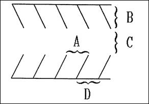
At least one row of trees shall be planted. They shall be not less than ten feet high for deciduous trees and five feet high for evergreen trees at the time of planting. Spacing for trees shall be as follows:
a.
Small or narrow stature trees, under twenty-five feet tall or less than sixteen feet wide at maturity shall be spaced no further than fifteen feet apart;
b.
Medium size trees between twenty-five feet to forty feet tall and with sixteen feet to thirty-five feet wide branching at maturity shall be spaced no greater than thirty feet apart.
c.
Large trees, over forty feet tall and with more than thirty-five feet wide branching at maturity, shall be spaced no greater than thirty feet apart.
2.
In addition, at least ten five gallon shrubs or twenty-one gallon shrubs shall be planted for each one thousand square feet of required buffer area.
3.
The remaining area shall be planted in living grass or other plant materials. A maximum of twenty-five percent of the landscaped area may be covered with mulch such as bark chips, rock, stone walkways or other similar permeable materials acceptable to the approval authority, but non-permeable materials such as "visqueen" may not be used. Areas covered by bark chips, rock or other similar materials shall not be underlain with nonpermeable materials such as plastic sheeting.
E.
Where screening is required the following standards shall apply in addition to those required for buffering (Figure 1):
1.
A hedge of narrow or broadleaf evergreen shrubs shall be planted which will form a four foot tall continuous screen within two years of planning, or;
2.
An earthen berm planted with evergreen plant materials shall be provided which must form a continuous screen six feet in height within two years. The unplanted portion of the berm shall be planted in living grass or other plant materials, or;
3.
A five foot or taller fence or wall shall be constructed to provide a continuous sight obscuring screen.
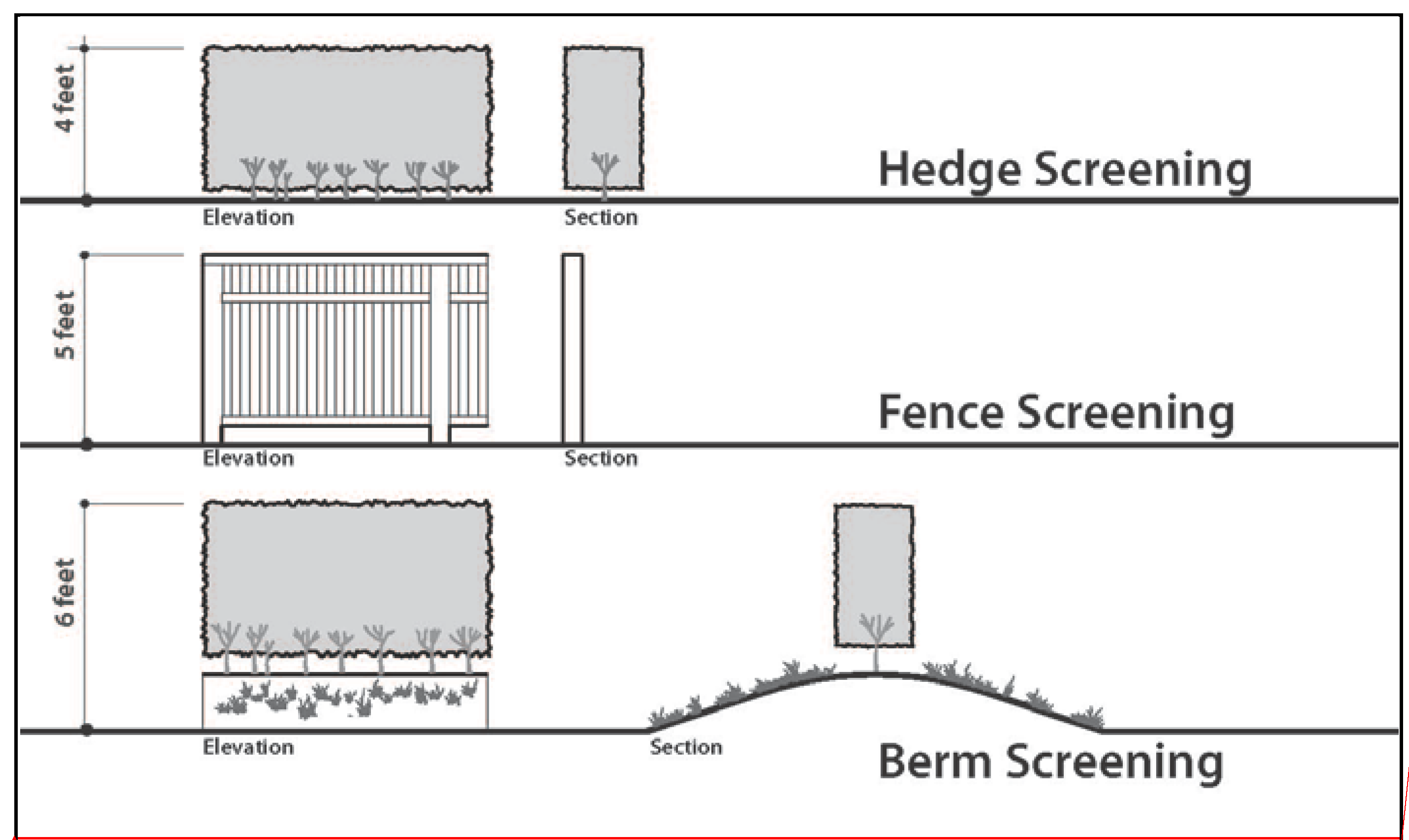
Figure 1 Landscape Screening Diagram
F.
Within the Kingston Terrace District Zone, buffering/screening areas shall be provided as follows:
1.
A ten-foot wide landscape buffer shall provide screening and horizontal separation between surface parking, loading, and service areas that serve dwelling, multi, mixed-use, commercial, and institutional development when located directly adjacent to dwelling, single-family attached and detached, duplexes, triplexes, fourplexes, and cottage clusters as shown in Table 16.124.F-1.
Table 16.124. F-1. Minimum Landscape Screening Requirement in Kingston Terrace District Zone
2.
Improvements in the landscape buffer shall comply with the standards of Sections 16.124.110.
3.
Where screening is required, it should complement the overall visual character of the development.
G.
Buffering and screening provisions shall be superseded by the vision clearance requirements as set forth in Section 16.144.030.C.
H.
When the use to be screened is downhill from the adjoining zone or use, the prescribed heights of required fences, walls, or landscape screening shall be measured from the actual grade of the adjoining property.
I.
Fences and Walls.
1.
Fences and walls shall be constructed of any materials commonly used in the construction of fences and walls such as wood or brick, or otherwise acceptable by the approval authority;
2.
When potential visual or noise impacts from normal activities on the site is anticipated, such as buildings, parking lots and loading areas, the approval authority may require fences and walls to be constructed of materials and in a manner and height that will attenuate noise impacts on adjoining properties;
3.
Such fence or wall construction shall be in compliance with Section 16.144.030 of this code; and
4.
Chain link fences with slats shall not qualify for screening along a property perimeter.
J.
Hedges.
1.
Except for development in the LC Zone, an evergreen hedge or other dense evergreen landscaping may satisfy a requirement for a sight obscuring fence where required subject to the height requirement in Section 16.124.130.
2.
Such hedge or other dense landscaping shall be properly maintained and shall be replaced with another hedge, other dense evergreen landscaping, or a fence or wall when it ceases to serve the purpose of obscuring view; and
3.
No hedge shall be grown or maintained at a height greater than that permitted by these regulations for a fence or wall in a vision clearance area as set forth in Section 16.144.030.C.
(Ord. 96-4 § 1 (part), 1996)
(Ord. No. O-2015-01, § 1(Exh. A), 3-18-2015; Ord. No. 2023-04, § 1(Exh. A), 10-18-2023)
16.124.120 - Setbacks for fences or walls.
A.
No fence or wall shall be constructed which exceeds the standards in Section 16.124.120.B except when the approval authority, as a condition of approval, allows that a fence or wall be constructed to a height greater than otherwise permitted in order to mitigate against potential adverse effects.
B.
Fences or Walls:
1.
May not exceed two feet in height in a required front yard or side yard forward of the front yard setback line;
2.
Are permitted outright in side yards behind the front yard setback or rear yards to a height of six feet; and
3.
Located on corner lots must preserve a visual clearance area in conformance with Section 16.144.030 of this code.
(Ord. 96-4 § 1 (part), 1996)
16.124.130 - Height restrictions.
A.
The prescribed heights of required fences, walls or landscaping shall be measured from the actual adjoining level of finished grade, not above a retaining wall.
B.
An earthen berm and fence or wall combination shall not exceed the six-foot height limitation for screening, except when the approval authority allows construction to a greater height in order to mitigate against adverse impacts such as incompatible land uses, noise, glaring light, and traffic; however, development shall comply with applicable neighborhood circulation standards.
(Ord. 96-4 § 1 (part), 1996)
(Ord. No. 2023-04, § 1(Exh. A), 10-18-2023)
16.124.140 - Parking and loading areas.
A.
Screening of parking and loading areas in the limited commercial zone. The specifications for this screening are as follows:
Landscaped parking areas shall include special design features to visually screen parking lot areas. These design features may include the use of landscaped berms, decorative walls and raised planters;
Landscape planters may be used to define or screen the appearance of off-street parking areas from the public right-of-way;
Materials to be installed should achieve a balance between low lying and vertical shrubbery and trees;
Trees shall be planted in landscaped islands in all parking areas at a ratio of one tree for every ten contiguous parking spaces and at the end of each parking row in order to provide a canopy effect;
Landscape islands shall have a minimum area of seventy square feet, shall be curbed, and have a minimum width of six feet, measured from the interior curb face;
Landscape islands shall be planted with a tree having a minimum mature height of twenty feet. If a pole-mounted light is proposed to be installed within a landscaped planter island, and the applicant demonstrates that there is a physical conflict for siting the tree and the pole-mounted light together, the decision-making authority may approve elimination of the pole-mounted light to accommodate placement of the tree; and
Curbs separating landscaped areas from parking areas may allow stormwater runoff to pass through them.
B.
Tree Canopy.
1.
Tree canopy must be provided over parking areas in compliance with the standards of this subsection. Tree canopy values are credited at seventy-five percent of their listed canopy area in the King City Urban Forestry Manual (UFM) tree list or at seventy-five (75) percent of the area calculated using the method described in Section 4 of the UFG.
2.
Parking lot trees must be planted from the list provided in the UFG unless otherwise approved by the manager or designee.
3.
Surface parking area to determine the one-half acre threshold shall be measured around the perimeter of all parking spaces, vehicle maneuvering areas, and interior parking lot landscaping. The parking area calculation shall be a cumulative calculation for all parking areas on the lot or parcel.
4.
Developments with off-street parking areas less than twenty thousand square feet in size, as measured using the method provided in Section 16.124.140.B.3 must provide a minimum effective tree canopy coverage of thirty (30) percent over all parking areas.
5.
Developments with off-street parking areas of twenty thousand square feet or more as measured using the method provided in Section 16.124.140.B.3 must meet one of the following:
a.
The development provides a minimum effective tree canopy coverage of forty (40) percent over all parking areas.
b.
The development provides a minimum effective tree canopy coverage of thirty (30) percent over all parking areas in addition to solar panels with a generation capacity of at least one-half kilowatt per parking space on the same site.
c.
The development provides solar panels with a generation capacity of at least one-half kilowatt per parking space above the parking area. In this case, no minimum tree canopy requirement applies.
d.
Development of a tree canopy plan under this section shall be done in coordination with the local electric utility, including pre-design, design, building, and maintenance phases.
(Ord. 96-4 § 1 (part), 1996)
(Ord. No. O-2015-01, § 1(Exh. A), 3-18-2015; Ord. No. 2023-04, § l(Exh. A), 10-18-2023; Ord. No. O-2024-01, § 1(Exh. A), 12-18-2024)
16.124.150 - Revegetation.
A.
Where natural vegetation has been removed through grading in areas not affected by the landscaping requirements and that are not be occupied by structures, such areas are to be replanted as set forth in this section to prevent erosion after construction activities are completed.
B.
Topsoil removed from the surface in preparation for grading and construction is to be stored on or near the site and protected from erosion while grading operations are underway.
1.
Such storage may not be located where it would cause suffocation of root systems of trees intended to be preserved; and
2.
After completion of such grading, the topsoil is to be restored to exposed cut and fill embankments or building pads to provide a suitable base for seeding and planting.
C.
Methods of Revegetation.
1.
Acceptable methods of revegetation include hydromulching or the planting of rye grass, barley or other seed with equivalent germination rates, and:
a.
Where lawn or turf grass is to be established, lawn grass seed or other appropriate landscape cover is to be sown at not less than four pounds to each one thousand square feet of land area;
b.
Other revegetation methods offering equivalent protection may be approved by the approval authority;
c.
Plant materials are to be watered at intervals sufficient to ensure survival and growth; and
d.
The use of native plant materials is encouraged to reduce irrigation and maintenance demands.
(Ord. 96-4 § 1 (part), 1996)
16.128.010 - Purpose.
The purpose of this chapter is to prohibit the unnecessary removal of trees in the city. At the time of development, it is recognized that the removal of some trees may be necessary to accommodate land uses and associated improvements as allowed by this title.
(Ord. 96-4 § 1 (part), 1996)
16.128.020 - Applicability of provisions.
A.
The provisions of this chapter shall apply to the cutting of trees with a caliper of six inches or greater, except for the circumstances noted in Section 16.128.020(B).
B.
The following activities do not require a tree removal permit under the provisions of this chapter.
1.
The action of any city officer or employee or of any public utility necessary to remove or alleviate an immediate danger to life or property, to restore or protect utility service, or to reopen a public thoroughfare to traffic.
2.
The cutting or removal of trees that are nuisances under Section 8.04.070 of this code.
3.
Cutting or removing of trees that are interfering with sewer service.
4.
Cutting or removing of trees that obstruct the view at an intersection contrary to requirements contained in Section 16.144.030 of this code.
5.
The cutting of not more than two trees on a single parcel of land or contiguous parcels of property under the same ownership within a single calendar year, unless the tree(s) is necessary to comply with a provision of development approval or compliance with provisions of Chapter 16.124.
6.
Commercial timber land subject to the Forest Practices Act.
(Ord. 96-4 § 1 (part), 1996)
16.128.030 - Administration.
A.
When a land use application is subject to one or more of the chapters in Article V of this title, the standards in this chapter shall be applied as required by the applicable development review chapter(s) in Article V of this title.
B.
When the provisions of Article V of this title do not apply, the city manager shall review tree removal applications as an administrative decision in accordance with Article II, of this title.
(Ord. 96-4 § 1 (part), 1996)
16.128.040 - Submittal requirements.
A.
In addition to the application form and information required in Section 16.44.030, the applicant shall prepare a map of the parcel indicating the number, size and species or other description of the trees proposed for removal and their location. The map shall be accompanied by a narrative which explains:
1.
The reason or reasons why the owner or owner's agent wishes to cut or remove the trees;
2.
The method of cutting or removal to be employed; and
3.
A description of any proposed landscaping or planting of new trees to replace the trees to be cut. The map shall include sufficient information to adequately review the proposed tree removal including an indication of the tree removal relative to property lines, structures, other trees on the site, and other features of the property and adjoining properties.
B.
The manager may require information in addition to that required by this chapter when it is found that certain information is necessary to properly evaluate the application.
C.
The manager may waive a specific requirement for information when it is found that such information is not necessary to properly evaluate the application.
(Ord. 96-4 § 1 (part), 1996)
16.128.050 - Approval criteria.
A.
A permit may be issued as requested in the application, it may be issued in part and denied in part, or may be issued subject to compliance by the applicant with reasonable conditions to be imposed in order to promote the purposes of this chapter. A permit shall state the period of time for which it is valid. A permit issued for the reason that an improvement is to be constructed upon the premises shall contain a provision that the permit is not valid until a building permit has been issued for the construction of the improvement. The burden is on the applicant to show that granting of a permit would be consistent with the stated purposes of this chapter.
B.
The following criteria shall be considered:
1.
The condition of the trees with respect to disease, danger of falling, proximity to existing or proposed structures and interference with utility services or pedestrian or vehicular traffic safety.
2.
The necessity to remove trees in order to construct proposed improvements, or to otherwise utilize the applicant's property in a reasonable manner.
3.
The topography of the land and the effect of tree removal on erosion, soil retention, stability of earth, flow of surface waters, protection of nearby trees and wind breaks.
4.
The number and density of trees existing in the neighborhood, the character and property uses in the neighborhood, and the effect of tree removal upon neighborhood characteristics, beauty and property values.
5.
The tree(s) is necessary to comply with conditions of development approval or compliance with provisions of Chapter 16.124.
6.
The adequacy of the applicant's proposals, if any, to plant new trees or vegetation as a substitute for the trees to be cut.
(Ord. 96-4 § 1 (part), 1996)
16.128.060 - Illegal tree removal.
The city retains the authority to require the applicant to replace any illegally removed trees pursuant to a plan, and meet any conditions as set forth by the city manager. No future permits or approvals for any use of the subject property shall be granted without compliance with the plan. Appeal of the replacement plan and its conditions shall be directed to the planning commission.
(Ord. 96-4 § 1 (part), 1996)
16.128.070 - Revocation of permit.
The city manager may revoke a tree removal permit if the conditions are not satisfied as required by the original permit.
(Ord. 96-4 § 1 (part), 1996)
16.128.080 - Notice of decision.
A notice of decision shall be provided to the applicant. The manager's decision may be appealed by the applicant as provided in Article II.
(Ord. 96-4 § 1 (part), 1996)
16.128.090 - Penalties.
Violation of any provision or requirement of this chapter shall be enforced as provided in Chapter 16.76.
(Ord. 96-4 § 1 (part), 1996)
16.132.010 - Purpose.
The purpose of these regulations is to establish parking areas having adequate capacity and which are appropriately located and designed to accommodate the majority of traffic generated by the range of uses which may locate on a site over time. The required parking numbers correspond to broad use categories, not specific uses, in response to this long term emphasis.
(Ord. 96-4 § 1 (part), 1996)
16.132.020 - General provisions.
A.
Applicability. The provisions of this chapter shall apply to all development regulated by this title and to any change of use or expansion which increases the on-site parking or loading requirements.
B.
Landscaping. All required parking areas must be completed and landscaped prior to occupancy of any structure except as provided in Chapter 16.124.
C.
Availability. Required parking spaces must be available for the use of residents, customers or employees of the use. Required parking spaces may not be assigned in any way to a use on another site, except for shared parking situations. Required parking spaces may not be used for the parking of equipment or storage of goods or inoperable vehicles.
D.
Location. Required parking spaces for residential uses must be located on the site of the use. Required parking spaces for nonresidential uses and residential uses in the LC Zone must be located on the site of the use or in parking areas whose closest point is within three hundred feet of the site.
E.
Shared Parking. Shared parking between two or more uses is permitted when all the following criteria are satisfied:
1.
The hours of operation of the uses do not overlap;
2.
Satisfactory legal evidence is presented to the city manager in the form of deeds, leases or contracts to establish the shared use;
3.
The other standards of this title can be met; and
4.
If a joint use arrangement is subsequently terminated, the requirements of this title shall then apply separately to each use.
F.
Change in Use.
1.
When an existing structure is changed in use from one use to another use as listed in Section 16.132.030, and the parking requirements for each use are the same, no additional parking shall be required.
2.
Where a change in use results in an intensification of use in terms of the number of parking spaces required, additional parking spaces shall be provided in an amount equal to the difference between the number of spaces required for the existing use and the number of spaces required for the new, more intensive use.
G.
D.E.Q. Permit. All parking areas which are designed to contain two hundred fifty or more parking spaces or to contain two or more levels, shall obtain a Department of Environmental Quality (D.E.Q.) indirect source construction permit and shall install oil and grease separators.
H.
Calculation of Required Parking.
1.
Where building square footage is specified, the area measured shall be the gross floor area within the exterior walls of the structure, excluding interior space devoted to off-street parking or loading.
2.
Where several uses occupy a single structure or parcel of land or a combination of uses are included in one business, the total off-street parking spaces and loading area shall be the sum of the separately computed requirements for each use, unless shared parking is approved as provided in Section 16.132.020.E.
I.
Parking Space Markings.
1.
Except for single-family, two-family, three-family, four-family, or cottage cluster residences, any parking spaces that are intended to be used to meet the off-street parking requirements contained in this chapter shall have all parking spaces clearly marked using a permanent paint; and
2.
All interior drives and access aisles shall be clearly marked and signed to show direction of flow and maintain vehicular and pedestrian safety.
J.
Employee Parking. Employee parking shall be designated for commercial developments. The employee spaces should be located in a manner that provides preferential treatment to business patrons.
K.
Short Term Parking Spaces. When deemed appropriate by the approval authority, short-term parking spaces shall be provided that enhance convenience and accessibility of the business for patrons. Said spaces shall be identified with signs and time limits.
(Ord. 96-4 § 1 (part), 1996; Ord. No. O-2015-01, § 1(Exh. A), 3-18-2015; Ord. No. O-2021-01, § 2(Exh. B), 8-18-2021; Ord. No. O-2024-01, § 1(Exh. A), 12-18-2024)
16.132.030 - Vehicle Parking and Loading Standards.
A.
Quantity.
1.
The ratios for the maximum number of off-street vehicle parking spaces allowed are provided in Table 16.132.040, subject to the following:
a.
If application of the maximum parking standard results in less than six parking spaces for a development with less than one thousand square feet of floor area, the development is allowed up to six parking spaces.
b.
If application of the maximum parking standard results in less than ten vehicle parking spaces for a development greater than one thousand feet, the development is allowed up to ten vehicle parking spaces.
c.
If a development is approved with no specified use, the development must apply the maximum parking standard for the use category that would allow the fewest number of parking spaces, chosen from all the uses that could be contained within the building type(s).
d.
The following types of parking areas are not included when calculating the maximum number of vehicle parking spaces allowed:
(i)
Parking spaces contained in a parking structure;
(ii)
Market-rate paid parking spaces;
(iii)
Designated carpool orvanpool spaces;
(iv)
Designated accessible parking spaces;
(v)
Fleet vehicle storage;
(vi)
Vehicle storage spaces for sale, lease, or rent; and
(vii)
Designated electric vehicle charging stations.
B.
Vehicular access. Vehicular access to off-street vehicle parking or loading areas must meet the requirements of Chapter 16.136, Circulation and Access and Chapter 16.144, Vision Clearance Areas.
C.
Pedestrian access. Walkways that cross access driveways or that provide access to vehicle or bicycle parking areas must comply with the following:
1.
Walkways must be physically separated from vehicle parking and maneuvering areas by either a minimum six-inch vertical separation (curbed) or a minimum three-foot horizontal separation, except that pedestrian crossings of traffic aisles are allowed if appropriate landscaping, pavement markings, or contrasting pavement materials are used;
2.
Walkways must be a minimum of four feet in width, exclusive of vehicle overhangs and obstructions such as mailboxes, benches, bicycle racks, and signposts; and
3.
Walkways must be in compliance with applicable federal and state accessibility standards.
D.
Electrical service capacity. Electrical service capacity, as defined by ORS 455.417, must be provided to new off-street parking spaces in compliance with the standards of this subsection. Adjustments to the standards of this subsection are prohibited.
1.
Non-residential development and residential or mixed-use developments with less than five dwelling units must provide electrical service capacity to a minimum of twenty percent of all off-street vehicle parking spaces on the site.
2.
Residential or mixed-use developments with five or more dwelling units must provide electrical service capacity to a minimum of forty percent of all off-street vehicle parking spaces on the site.
3.
Dwelling units in townhouses are not included for purposes of determining the applicability of this regulation.
(Ord. No. O-2024-01, § 1(Exh. A), 12-18-2024)
Editor's note— Ord. No. O-2024-01, § 1(Exh. A), deleted the former § 16.132.030, and enacted a new § 16.132.030 as set out herein. The former § 16.132.030 was entitled "Minimum off-street parking requirements," and derived from: Ord. O-03-2 § 1 (part), 2003; Ord. 96-4 § 1 (part), 1996; Ord. No. O-2015-01, § 1(Exh. A), adopted March 18, 2015; Ord. No. O-2020-01, § 1(Exh. A), adopted Aug. 19, 2020; and Ord. No. O-2021-01, § 2(Exh. B), adopted Aug. 18, 2021.
16.132.040 - Maximum off-street parking standards.
16.132.050 - Parking dimensional standards.
A.
Table of Standards.
1.
Minimum standards for a standard parking stall's length and width, aisle width, and maneuvering space shall be determined from the following table. Dimensions for designated compact spaces are noted in parenthesis:
2.
Sample Illustration.
3.
The width of each parking space includes a four-inch wide stripe which separates each space.
B.
Aisle Width.
1.
Aisles accommodating two direction traffic, or allowing access from both ends shall be twenty-four feet in width.
C.
Angle Parking.
1.
Angle parking is permitted; provided, that each space contains a rectangle of not less than nine feet in width and eighteen feet in length or eight and one-half feet in width and fifteen feet in length for compact spaces, and an appropriate aisle width as determined by interpolation of the table in Section 18.106.050.B.
D.
Compact Parking. The compact parking spaces described in this title shall not be used to satisfy no more than fifty percent of the total required number of parking spaces.
(Ord. 96-4 § 1 (part), 1996)
(Ord. No. O-2024-01, § 1(Exh. A), 12-18-2024)
16.132.060 - Parking design standards.
A.
Parking for Persons with Disabilities. All parking lots in conjunction with government and public buildings, as defined by Chapter 31 of the uniform building code, are to include parking for the handicapped as set forth below. These spaces may be included to satisfy the total number of parking spaces required.
1.
The number of accessible spaces per lot must conform to the requirements outlined in ORS 447.233.
2.
Parking lots and parking spaces shall conform to the requirements of Oregon Structural Specialty Code Chapter 11.
3.
Spaces shall be located nearest to the main pedestrian access point from the parking area to building or use serviced by the parking and are to be designed so persons using wheelchairs or assisted walking are not compelled to pass behind parked vehicles.
4.
Parking for the handicapped shall be identified in accordance with the international symbol of accessibility for the handicapped.
B.
Lighting. Any lights provided to illuminate public or private parking areas or vehicle sales areas shall be arranged to reflect the light away from any neighboring residential district.
1.
All pedestrian paths in parking areas and providing access to parking areas must be illuminated to a minimum level of 0.5 footcandles at all points, measured horizontally at the ground level.
2.
Lighting luminaires must have a cutoff angle of ninety degrees or greater to ensure that lighting is directed toward the parking surface.
3.
Lighting may not cause a light trespass of more than 0.5 footcandles measured vertically at the boundaries of the site.
C.
Pavement. All parking spaces and access drives shall be paved to specifications approved by the city manager.
D.
Drainage.
1.
Off-street parking and loading areas shall be drained in accordance with specifications approved by the city manager to ensure that ponding of storm water does not occur.
2.
Except for single-family and two-family residences, off-street parking and loading facilities shall be drained to avoid flow of water across public sidewalks and streets.
E.
Wheel Stops.
1.
Parking spaces along the boundaries of a parking lot or adjacent to interior landscaped areas or sidewalks shall be provided with a wheel stop that is at least four inches high located three feet back from the front of the parking space.
2.
The front three feet of the parking stall may be concrete, asphalt or low lying landscape material that does not exceed the height of the wheel stop. This area cannot be calculated to meet landscaping or sidewalk requirements.
F.
Maintenance of Parking Areas. All parking lots shall be kept clean and in good repair at all times. Breaks in paved surfaces shall be repaired promptly and broken or splintered wheel stops shall be replaced so that their function will not be impaired.
G.
Carpool and Vanpool Parking.
1.
Employee parking areas shall designate at least ten percent, but not fewer than one, of the long-term (four hours or more) employee or student parking spaces for carpool/vanpool parking. These designated spaces shall be located closer to the building entrances than other employee or student parking with the exception of ADA accessible and short-term (less than four hours) visitor parking. These spaces shall be clearly marked "Reserved - Carpool/Vanpool Only" and include hours of use, per the Manual of Uniform Traffic Control Devices.
H.
Landscaping.
1.
Landscaping for all off-street parking areas within new developments must comply with requirements set forth in Section 16.124.140.
(Ord. 96-4 § 1 (part), 1996)
(Ord. No. O-2024-01, § 1(Exh. A), 12-18-2024)
16.132.070 - Minimum bicycle parking requirements.
* All spaces shall be covered and fifty percent of the spaces shall be lockable enclosures.
(Ord. 96-4 § 1 (part), 1996; Ord. No. O-2015-01, § 1(Exh. A), 3-18-2015; Ord. No. O-2020-01, § 1(Exh. A), 8-19-2020; Ord. No. O-2024-01, § 1(Exh. A), 12-18-2024)
16.132.080 - Bicycle parking design standards.
A.
Parking Facility Design.
1.
Bicycle parking facilities shall either be lockable enclosures in which the bicycle is stored, or secure stationary rack which support the frame so the bicycle cannot easily be pushed or fall to one side. Racks that require a user-supplied lock shall accommodate locking the frame and both wheels using either a cable or U-shaped lock.
2.
Bicycle parking spaces shall be at least six feet long and two and one-half feet wide, and overhead clearance in covered spaces shall be a minimum of seven feet.
3.
A five foot aisle for bicycle maneuvering shall be provided and maintained beside or between each row of bicycle parking.
4.
Bicycle racks or lockers shall be securely anchored.
5.
Required bicycle parking shall be located in a well lighted, secure location within fifty feet of an entrance to the building, but not farther from the entrance of the building than the closest standard or compact vehicle parking space.
6.
Bicycle parking shall not obstruct walkways. A minimum five foot wide aisle shall remain clear.
7.
If ten or more bicycle spaces are required for commercial development, then at least fifty percent of the bicycle spaces must be covered. A lockable enclosure shall be considered as a covered parking space.
8.
All of the required bicycle parking for residential uses shall be covered. This may include space provided in a carport or garage.
B.
Locational Standards for Bicycle Parking.
1.
All required bicycle parking shall be located on the site within fifty feet of main building entrances and not farther from the entrance than the closest standard or compact motor vehicle parking space. Bicycle parking shall have direct access to both the public right-of-way and to the main entrance of the principal use.
2.
For buildings or development with multiple entrances, required short term bicycle parking shall be distributed proportionally at the various public entrances. Required long-term public parking shall also be distributed at the various public entrances, while employee parking shall be located at the employee entrance, if appropriate.
3.
Bicycle parking may be located in the public right-of-way with the approval of the city manager.
4.
Bicycle parking may be provided within a building, but the location must be easily accessible for bicyclists.
(Ord. 96-4 § 1 (part), 1996)
(Ord. No. O-2024-01, § 1(Exh. A), 12-18-2024)
16.132.090 - Parking structure standards.
A.
First-story windows and wall openings.
1.
All street-facing facades of parking structures must include windows, doors, or display areas on a minimum of twenty percent of the first-story facade area excluding those portions of the facade devoted to vehicular access, stairwells, elevators, and centralized payment booths. Required windows must have a sill no more than four feet above grade. Where the interior floor level prohibits such placement, the sill may be raised to allow it to be no more than two feet above finished floor wall up to a maximum sill height of six feet above grade.
B.
Exit warning bell.
1.
All exits from parking structures within fifteen feet of public sidewalks or pedestrian paths must include an audible and visible signal that alerts non-motorized traffic when vehicles are exiting.
C.
Parking layout and internal circulation.
1.
The required space and aisle dimensions within a parking structure are provided in the Figure (2) and Table (1) in 16.132.050.
D.
Electrical service capacity.
1.
The electrical service capacity requirements of Section 16.132.030.D apply to new parking structures.
(Ord. No. O-2024-01, § 1(Exh. A), 12-18-2024)
Editor's note— With the inclusion of new provisions designated as § 16.132.090 by Ord. No. O-2024-01, the existing § 16.132.080 has been renumbered as § 16.132.100 as herein set out.
16.132.100 - Loading area standards.
A.
Off-Street Loading Dimensions.
1.
The design, entrances, exits, and location of each loading berth or area shall be approved by the approval authority.
2.
Each loading space shall have sufficient area for turning and maneuvering of vehicles on the site, and at a minimum, the maneuvering length shall not be less than twice the overall length of the longest vehicle using the loading space.
3.
Landscaping for off-street loading facilities is required and shall comply with Chapter 16.124.
B.
Loading/Unloading Driveways Required On-Site. A driveway designed for continuous forward flow of passenger vehicles for the purpose of loading and unloading passengers shall be located on the site of any school, community center or other meeting place which is designed to accommodate more than twenty-five people at one time.
C.
Off-Street Loading Spaces. Buildings or structures to be built or altered which receive and distribute material or merchandise by truck shall provide and maintain off-street loading and maneuvering space as follows:
1.
Every commercial use having floor area of ten thousand square feet or more, shall have at least one off-street loading space on the site;
2.
One additional off-street loading space shall be provided for each additional twenty thousand square feet or fraction thereof; and
3.
Loading spaces and areas shall be located in a manner that does not conflict with customer and pedestrian traffic on the site.
(Ord. 96-4 § 1 (part), 1996)
(Ord. No. O-2015-01, § 1(Exh. A), 3-18-2015; Ord. No. O-2024-01, § 1(Exh. A), 12-18-2024)
16.136.010 - Purpose.
The purpose of this chapter is to establish standards for safe and efficient vehicle, bicycle and pedestrian access and circulation on a site and between developments.
(Ord. 96-4 § 1 (part), 1996)
16.136.020 - General provisions.
A.
Applicability. The provisions of this chapter shall apply to all development regulated by this title and to any change of use or expansion which modifies the circulation and access requirements of this chapter.
B.
Availability of Improvements. All required circulation and access improvements must be available for use prior to occupancy of any structure.
C.
Joint Access. Owners of two or more uses, structures, or parcels of land may agree to utilize a common driveway access when the combined uses comply with the following requirements:
1.
Satisfactory legal evidence is presented to the city manager in the form of deeds, easements, leases or contracts to establish the joint use;
2.
Copies of the deeds, easements, leases or contracts are placed on permanent record with the city; and
3.
The common driveway and related combination of uses comply with the standards in this chapter.
D.
Each parking or loading space shall be accessible from a street and the access shall be of a width and location as described in this title.
(Ord. 96-4 § 1 (part), 1996)
16.136.030 - Access standards—Residential.
A.
Vehicular access and egress for duplex, detached or attached single-family dwelling units on individual lots shall not be less than the following:
* Excludes accessory dwelling units.
B.
Vehicular access and egress for multiple-family residential uses shall not be less than the following:
* Excludes accessory dwelling units.
C.
A public street right-of-way and improvement shall be required when more than six separate lots are served by a street or access drive.
D.
Private residential access drives shall be provided and maintained in accordance with the applicable provisions of the uniform fire code.
E.
Access drives in excess of one hundred fifty feet in length shall be provided with approved provisions for the turning around of fire apparatus by one of the following:
1.
A level, circular, paved surface having a minimum turn radius measured from center point to outside edge of forty-five feet.
2.
A level, hammerhead-configured, paved surface with each leg of the hammerhead having a minimum depth of forty feet and a minimum width of twenty feet.
(Ord. 96-4 § 1 (part), 1996; Ord. No. O-2015-01, § 1(Exh. A), 3-18-2015; Ord. No. O-2020-01, § 1(Exh. A), 8-19-2020; Ord. No. O-2021-01, § 2(Exh. B), 8-18-2021)
16.136.040 - Access standards—Non-residential.
A.
Vehicle access, egress and circulation for nonresidential use shall not be less than the following:
(Ord. 96-4 § 1 (part), 1996; Ord. No. O-2015-01, § 1(Exh. A), 3-18-2015)
16.136.050 - Design standards.
A.
Access Drives.
1.
Access drives from the street to off-street parking or loading areas shall be designed and constructed to facilitate the flow of traffic and provide maximum safety for pedestrian and vehicular traffic on the site.
2.
Parking spaces on major access driveways shall be designed to reduce or eliminate backing movements and other conflicts with the driveway traffic and pedestrian routes and crosswalks.
3.
In order to slow traffic speeds on access drives, speed bumps, speed limit signs and similar techniques may be required by the approval authority to enhance safety for pedestrians, bicyclists and motorists on the site.
4.
In order to improve traffic flow, the approval authority may require directional signs on the site to guide pedestrians, bicyclists or motorists.
B.
One-Way Vehicular Access.
1.
Where a proposed parking facility is served by one-way traffic flow on the site, it shall be accommodated by a driveway system approved by the city, and the entrance drive shall be situated closest to oncoming traffic and the exit drive shall be situated farthest from oncoming traffic.
2.
The direction of traffic flow shall be clearly marked for motorists on the property and the adjoining public street.
C.
On-Site Bicycle and Pedestrian Circulation.
1.
Walkways and driveways shall provide a direct connection to existing and planned walkways and driveways on adjacent developments.
2.
Sidewalks and walkways must connect the pedestrian circulation system to other areas of the site such as buildings, vehicle and bicycle parking, children's play areas, required outdoor areas and any pedestrian amenities, such as open space, plazas resting areas and viewpoints. The pedestrian system must connect the site to adjacent streets and nearby transit stops.
3.
Walkways shall be located so that pedestrians have a short distance to walk between a transit stop or public sidewalk and building entrances.
4.
Pedestrian and bicycle connections shall be direct and circuitous routes shall be avoided.
5.
Where pedestrian or bicycle routes cross driveways, parking area or loading areas, the connection must be clearly identifiable through the use of striping, elevation changes, speed bumps, a different paving material or other similar method.
6.
Where pedestrian or bicycle routes are parallel and adjacent to an auto travel lane, the connection must be safely separated from the auto travel lane through the use of raised path, a raised curb, bollards, landscaping or other physical barrier.
(Ord. 96-4 § 1 (part), 1996; Ord. No. O-2015-01, § 1(Exh. A), 3-18-2015)
16.136.060 - Reservoir areas required for drive-in use.
A.
All uses providing drive-in services as defined by this title shall provide on the same site a reservoir for inbound vehicles as follows:
B.
A parking reservoir space shall be eighteen feet in length and eight feet in width.
(Ord. 96-4 § 1 (part), 1996)
16.136.070 - Access restrictions.
A.
Excluding single-family and duplex residences, groups of more than two parking spaces and all loading areas shall be served by a service drive so that no backing movements or other maneuvering within a street or other public right-of-way is required.
B.
In order to provide for increased traffic movement on congested streets and eliminate turning movement problems, the city may restrict the location of driveways on the street and require the location of driveways to be placed on adjacent streets when all of the following criteria apply:
1.
The driveway would cause or increase existing hazardous traffic conditions;
2.
The driveway would not provide adequate access for emergency vehicles;
3.
The alternative driveway location would provide a safer method of access and egress to the site; and
4.
The alternative driveway location would not create an adverse traffic impact for properties in the immediate vicinity of the site.
(Ord. 96-4 § 1 (part), 1996)
16.136.080 - Surfacing requirements.
All driveways shall be paved and designed in a manner approved by the city manager.
(Ord. 96-4 § 1 (part), 1996)
16.140.010 - Purpose.
The regulations of this chapter are intended to achieve the following:
A.
Implement the comprehensive plan;
B.
Implement the Federal Emergency Management Agency's (FEMA) flood insurance program and to minimize flood damage to property;
C.
Implement the Metro Urban Growth Management Functional Plan Title 3 Water Quality and Flood Management;
D.
Implement Statewide Planning Goal 7 Areas Subject to Natural Hazards;
E.
The flood hazard areas of the city of King City are subject to periodic inundation which results in loss of life and property, health, and safety hazards, disruption of commerce and governmental services, extraordinary public expenditures for flood protection and relief, and impairment of the tax base, all of which adversely affect the public health, safety, and general welfare. These flood losses are caused by the cumulative effect of obstructions in areas of special flood hazards which increase flood heights and velocities, and when inadequately anchored, damage uses in other areas. Uses that are inadequately flood-proofed, elevated, or otherwise protected from flood damage also contribute to the flood loss.
F.
It is the purpose of this chapter to promote the public health, safety, and general welfare, and to minimize public and private losses due to flood conditions in specific areas by provisions designed to:
1.
Protect human life and health;
2.
Minimize expenditure of public money and costly flood control projects;
3.
Minimize the need for rescue and relief efforts associated with flooding and generally under-taken at the expense of the general public;
4.
Minimize prolonged business interruptions;
5.
Minimize damage to public facilities and utilities such as water and gas mains, electric, telephone and sewer lines, streets, and bridges located in areas of special flood hazard;
6.
Help maintain a stable tax base by providing for the sound use and development of areas of special flood hazard so as to minimize future flood blight areas:
7.
Ensure that potential buyers are notified that property is in an area of special flood hazard; and
8.
Ensure that those who occupy the areas of special flood hazard assume responsibility for their actions.
(Ord. No. O-2016-03, § 1(Exh. A), 9-21-2016; Ord. No. O-2018-05, § 1(Exh. A), 10-17-2018)
16.140.020 - Applicability of provisions.
Floodplain and drainage hazard area review shall be applicable to all new development and modifications of existing development as provided in this chapter.
A.
Unless specifically prohibited by this title, or the Clean Water Services (CWS) "Design and Construction Standards for Sanitary Sewer and Surface Water Management" or its successor, the following are not required to obtain a development permit for a floodplain or drainage hazard area alteration:
1.
Uses and Activities Allowed in All Floodplain and Drainageway Locations.
a.
Farming or raising of livestock not utilizing a structure;
b.
Propagation or harvesting of timber for personal consumption, provided that the use of a caterpillar tractor, yarder, backhoe, grader or similar heavy mechanized equipment is prohibited;
c.
A wire boundary fence designed to impede as little as practicable the movement of water or water borne materials;
d.
Accessory residential or institutional uses such as lawns, gardens and play areas, provided that no structure is permitted;
e.
Recreational and accessory recreational uses such as parks or game fields, provided that no grading or structures are permitted;
f.
An emergency measure necessary for immediate safety of persons or protection of property, such as riprap for erosion control, provided however, that an application for a development permit shall be promptly filed if the measure otherwise would require such a permit but for the emergency;
g.
Line borings for installation of utilities when certified by a registered civil engineer: that the line is located at least thirty-six inches below ground surface in floodways, floodplains and drainage hazard areas; that the land disturbance will not alter flood storage capacity or water velocities; that all surface construction will take place outside the delineated floodplain or drainage hazard area; and that all spoils will be removed from the flood area and placed in an appropriate disposal site.
2.
Uses and Activities Allowed Only Within the Urban Growth Boundary.
a.
A recreational vehicle, which is allowed by the provisions of this title;
b.
A nonconforming recreational vehicle may be replaced, provided there is compliance with the standards of this title.
B.
Uses and Activities Permitted Through a City Manager Review.
Unless specifically prohibited in this title or the Clean Water Services "Design and Construction Standards for Sanitary Sewer and Surface Water Management" or its successor, a development permit may be approved in a flood or drainage hazard area according to a city manager review procedure for the following:
1.
Uses and Activities Allowed in All Floodplain and Drainageway Locations.
a.
Recreation or nature trails and removal of vegetation down to duff or bare soil provided the applicant obtains a permit for erosion control;
b.
Lot line adjustments;
c.
Major and minor land partitions;
d.
Wildlife viewing areas, including interpretive signs and off-street parking, which require no grading, and viewing platforms or structures, provided that all viewing platforms or structures:
i.
Are elevated by pilings,
ii.
Have the lowest floor at least one foot above the base flood elevation, and
iii.
A building permit is obtained for the proposed platform or structure;
e.
Maintenance, preservation and repair of local public streets and private streets including paving and grading of existing road surfaces, and grading and shaping of roadside ditches;
f.
Above ground electrical, communication, and signal transmission and distribution lines on a single-pole system. For the purposes of this section, a single-pole system is defined as above ground electrical, communication or signal lines and their supporting concrete, and wood or metal poles, excluding self-supporting steel lattice-type structures;
g.
Restoration and stabilization of the bank of a river or other watercourse or body of water for erosion control provided:
i.
The application includes a registered civil engineer's certification that:
(A)
The project is in response to a demonstrated bank failure that resulted from a specific flood event or which has occurred within the last two years,
(B)
The project only restores and stabilizes the bank to its original location before the demonstrated bank failure,
(C)
The length of the bank involved does not exceed two hundred fifty feet, and
(D)
If riprap is used, it will be keyed in to the bed and bank of the body of water as specified in OAR 141-089-0005.
ii.
Whether or not riprap is used, the length of bank within the project boundary, from the ordinary high water level to the top of the bank, shall be planted with vegetation that grows roots to stabilize the bank. Plant species used shall be those in the 1987 or most current list entitled "Shrubs, Trees and Aquatic Plants for Wildlife Plantings" prepared by the Oregon Department of Fish and Wildlife. The plantings shall meet the following requirements, unless different requirements are established for the project by the Oregon Division of State Lands through its permitting process:
(A)
At least five plants shall be placed per one hundred square feet of bank area, and
(B)
At least twenty percent of the plants placed shall be trees.
iii.
Upon completion of the project, a registered civil engineer or landscape architect shall submit a statement certifying that the project was completed in compliance with the provisions of this section;
h.
Maintenance, preservation or repair of drainage facilities located outside of public rights-of-way;
i.
Maintenance of an existing vehicular access to a single-family residence or for farm or forest uses; including culverts for driveway crossings provided the application includes a registered civil engineer's certification that the project complies with Sections 16.140.060(A) through (I) of this chapter.
2.
Uses and Activities Allowed Only Within the Urban Growth Boundary.
a.
Construction or major improvement of local public streets and private streets except as provided for by subsection (A)(1)(f) of this section, including paving and grading, shaping of roadside ditches, and catch basins;
b.
Construction of a vehicular access to a single-family residence or for farm or forest uses; including culverts for driveway crossings provided the application includes a registered civil engineer's certification that the project complies with Sections 16.140.060(A) through (I) of this chapter.
C.
Uses and Activities Allowed Through a Planning Commission Review.
Unless specifically prohibited by this title, or the Clean Water Services "Design and Construction Standards for Sanitary Sewer and Surface Water Management" or its successor, a development permit may be approved in a flood or drainage hazard area through a planning commission review procedure for the following:
1.
Uses and Activities Allowed in All Floodplain and Drainageway Locations.
a.
Water quality or quantity improvement facilities, or a wetland mitigation project when:
i.
Mandated or approved by a local, state or federal regulatory agency, or
ii.
Designed to be consistent with CWS standards;
b.
Dams, weirs, ponds and similar water impoundment devices, and mitigation and enhancement improvements for wetland and habitat areas;
c.
Construction or major improvement or alteration of underground pipes and conduits, including sewer, water and gas lines, transmission and distribution lines for gas and oil, underground electrical, telephone and television transmission and distribution lines, including necessary accessory structures and drainage systems;
d.
Above ground electrical, communication and signal transmission lines, except for those activities described in subsection (B)(1)(e) of this section;
e.
Parks, golf courses and other recreational uses that do not include structures;
f.
Recreation or nature trails and associated grading, piping, culverts or bridges that meet the provisions of this title and applicable local, state and federal agency requirements;
g.
Creation or restoration of wetlands;
h.
Culverts and piping to implement an approved development, other than public transportation facilities, when the pipe or culvert connects to an existing pipe, culvert or drainageway. Culverts and piping in a flood or drainage hazard area shall continue to be subject to applicable local, state and federal agency requirements;
i.
Bank maintenance, restoration or stabilization, including riprap for erosion control, of a river or other watercourse or body of water inside an urban growth boundary or not otherwise permitted by subsection (B)(1)(f) of this section;
j.
Subdivisions, provided that none of the proposed parcels located outside of the UGB shall accommodate residential structures;
k.
Driveways and off-street parking that comply with the provisions of this title and applicable local, state and federal agency requirements.
2.
Uses and Activities Allowed Only Within the Urban Growth Boundary.
a.
One detached dwelling (including a manufactured dwelling) together with no more than two accessory structures and off-street parking on a lawfully created lot, when the lot or parcel contains insufficient area outside of the flood area upon which to locate the dwelling and/or accessory structures;
b.
Substantial improvements to structures where "substantial improvement" is defined as follows: Any repair, reconstruction or improvement of a structure, the cost of which equals or exceeds fifty percent of the market value of the structure either:
i.
Before the improvement or repair is started, or
ii.
If the structure has been damaged and is being restored, before the damage occurred. For the purposes of this section, "substantial improvement" is considered to occur when the first alteration of any wall, ceiling, floor or other structural part of the building commences, whether or not that alteration affects the external dimensions of the structure except as follows:
(A)
Any project for improvement of a structure to correct existing violations of state or local health, sanitary, or safety code specifications which have been identified by the local code enforcement official and which are the minimum necessary to assure safe living conditions,
(B)
Any alteration of a structure listed on the national register of historic places or a state or local inventory of historic places, or
(C)
Applications for substantial improvements to structures shall comply with the requirements of this chapter;
c.
Improvements to a lawfully established structure when the cost of the improvement is less than fifty percent of the market value of the structure and there is compliance with Section 16.140.060 of this chapter. For the purpose of this subsection, improvement means any repair, reconstruction, addition or improvement of a structure except as follows:
i.
Any project for improvement of a structure to comply with existing state or local health, sanitary or safety code specifications, which is solely necessary to assure safe living conditions, or
ii.
Any alteration of a structure listed on the national register of historic places or a state or local inventory of historic places;
d.
Accessory structure customarily provided in conjunction with the use set forth in the applicable zoning district;
e.
Subdivisions and partitions that comply with the provisions of this title;
f.
Vehicular access to permitted uses, including driveway crossings, except as permitted by subsection (B)(1)(h) of this section;
g.
Parks, golf courses and other recreational uses that include structures;
h.
Construction or major improvement or alteration of public local streets and private streets within the UGB, or approved as part of a land division, including culverts and piping, accessory drainage systems such as catch basins, and necessary accessory structures;
i.
Parking area for an adjacent multi-family, institutional or commercial development.
(Ord. No. O-2016-03, § 1(Exh. A), 9-21-2016; Ord. No. O-2018-05, § 1(Exh. A), 10-17-2018)
16.140.030 - Administration.
A.
A floodplain and drainage hazard review shall be conducted concurrently with any other related land use application required by the city for the proposed development.
B.
Floodplain and drainage hazard review applications described in Section 16.140.020(B) shall be administered and reviewed as a city manager decision in accordance with Article II of this title and applicable approval criteria in Sections 16.140.060 through 16.140.120 of this chapter.
C.
All other floodplain and drainage hazard review applications described in Section 16.140.020 shall be administered and reviewed as a planning commission decision in accordance with Article II of this title and applicable approval criteria in Sections 16.140.060 through 16.140.120 of this chapter.
D.
Review all development permits to determine that the permit requirements of this chapter have been satisfied.
1.
Review all development permits to determine that all necessary permits have been obtained from those federal, state, or local governmental agencies from which prior approval is required.
2.
Review all development permits to determine if the proposed development is located in the floodway. If located in the floodway, assure that the encroachment provisions of Section 16.140.060 are met.
3.
Provide to building officials the base flood elevation and freeboard applicable to any building requiring a building permit.
4.
Review all development permit applications to determine if the proposed development qualifies as a substantial improvement, as set forth in Section 16.140.200.
E.
In addition to the notice requirements in Article II of this title, the city manager shall notify communities adjacent to the affected area and the Oregon Department of Land Conservation and Development prior to any alteration or relocation of a watercourse, and submit evidence of such notification to the Federal Insurance Administration. The city manager shall require that maintenance is provided within the altered and relocated portion of such watercourse so that the flood carrying capacity is not diminished.
F.
Development Permit Required. A development permit shall be obtained before construction or development begins within any special flood hazard area established in Section 16.140.040(B) of this chapter. The permit shall be for all structures including manufactured homes, as set forth in the definitions (Section 16.140.180 of this chapter) and for all development including fill and other activities, also as set forth in the definitions.
G.
Application for Development Permit. Application for a development permit shall be made on forms furnished by the city manager and may include but not be limited to plans in duplicate drawn to scale showing the nature, location, dimensions, and elevations of the area in question; existing or proposed structures, fill, storage of materials, drainage facilities, and the location of the foregoing. Specifically, the following information is required:
1.
Elevation in relation to mean sea level, of the lowest floor (including basement) of all structures;
2.
Elevation in relation to mean sea level to which any structure has been floodproofed;
3.
Certification by a registered professional engineer or architect that the floodproofing methods for any nonresidential structure meet the floodproofing criteria in Section 16.140.090 of this chapter; and
4.
Description of the extent to which a watercourse will be altered or relocated as a result of proposed development.
H.
In the interpretation and application of this chapter, all provisions shall be:
1.
Considered as minimum requirements;
2.
Liberally construed in favor of the governing body; and,
3.
Deemed neither to limit or repeal any other powers granted under State statutes.
(Ord. No. O-2016-03, § 1(Exh. A), 9-21-2016; Ord. No. O-2018-05, § 1(Exh. A), 10-17-2018)
16.140.040 - Basis for identifying lands subject to floodplain and drainage hazard area standards.
A.
Lands to Which This Chapter Applies.
This chapter shall apply to all areas of special flood hazard areas within the jurisdiction of city of King City, Oregon.
B.
Basis for Establishing the Areas of Special Flood Hazard.
The areas of special flood hazard identified by the Federal Insurance Administration in a scientific and engineering report entitled "The Flood Insurance Study for the City of King City, Oregon," dated October 19, 2018, with accompanying Flood Insurance Rate Maps (FIRM), are adopted by reference and declared to be a part of this chapter. The Flood Insurance Study is on file at 15300 SW 116th Ave., King City, OR 97224. The best available information for flood hazard area identification as outlined in subsection (B)(1) of this section, shall be the basis for regulation until a new FIRM is issued which incorporates the data utilized under subsection (B)(1) of this section.
1.
When base flood elevation data has not been provided in accordance with subsection B of this section, the city manager shall obtain, review, and reasonably utilize any base flood elevation and floodway data available from a federal, state or other source in order to administer new construction, substantial improvements, or other development in Zone A on the FIRM.
2.
Recognizing that the scale may be such that the true and accurate floodplain or drainage hazard area cannot be determined from the maps referenced in subsection B of this section alone, all persons seeking a development permit for lands within such areas and within two hundred fifty feet of the map boundary of a floodplain or drainage hazard area identified in subsection B of this section shall submit with the development permit application:
a.
A delineation of the floodplain and the floodway boundaries, established by a registered engineer or surveyor from the surface elevations available from the city for the floodplain based upon maps referenced in subsection B of this section, and upon any other available authoritative flood data approved by the city manager, including, but not limited to, high water marks, photographs of past flooding, or historical flood data; and
b.
A delineation of the drainage hazard area and drainageway by a registered surveyor or engineer from surface elevations prepared by a registered engineer. Such delineation shall be based on mean sea level datum and be field located using recognized landmarks.
C.
Acceptance of Risk. Persons seeking to develop within a floodplain or drainage hazard area must do so with the understanding that they and their successors assume the risks and that the risks cannot be eliminated, even with strict compliance with the standards adopted herein. This chapter does not imply that lands outside of floodplain or drainage hazard areas, or development permitted within, will be free from flooding or flood damage.
(Ord. No. O-2016-03, § 1(Exh. A), 9-21-2016; Ord. No. O-2018-05, § 1(Exh. A), 10-17-2018)
16.140.050 - Submittal requirements.
A.
In addition to the form and information required in Section 16.44.030 of this title, an applicant shall submit the following:
1.
Copies of the site plan, number to be determined at the preapplication conference, and necessary data or narrative, which explains how the development conforms to the applicable criteria, and:
a.
The site plans and required drawings, prepared by a registered civil engineer, shall be drawn on sheets preferably not exceeding twenty-four inches by thirty-six inches,
b.
The scale for the site plan shall be an engineering scale of not less than one inch equals fifty feet,
c.
All drawings of structures elevations, prepared by a registered civil engineer or architect, shall be a standard architectural scale, being one-fourth inch or one-eighth inch equals one foot, and
d.
Existing and proposed topography within the boundaries of the flood area using the following contour intervals:
i.
For slopes of five percent or less, contour intervals not more than one foot,
ii.
For slopes greater than five percent and up to and including ten percent, contour intervals not more than two feet, and
iii.
For slopes greater than ten percent, contour intervals not more than five feet;
2.
This information may be submitted with or be made part of a site plan or grading plan for the proposed development;
3.
A list of names and addresses of all persons who are property owners of record within two hundred fifty feet of the subject property;
4.
The required fee, and
5.
The site plan, data and narrative shall be submitted for any related development applications as provided in this title.
B.
Upon demonstration that no other alternative exists as determined by the City Engineer:
1.
Applicants shall obtain a Conditional Letter of Map Revision (CLOMR) from FEMA before an encroachment, including fill, new construction, substantial improvement, fences or other development, in the regulatory floodway is permitted that will cause any increase in the Base Flood Elevation. The CLOMR shall be submitted prior to the application being deemed complete.
2.
Within six months of project completion, an applicant who obtains a CLOMR from FEMA, or whose development alters a watercourse, modifies floodplain boundaries, or modifies Base Flood Elevations within the regulatory floodway shall submit obtain evidence to the city that a Letter of Map Revision (LOMR) from FEMA has been requested that reflects the as-built changes to the Flood Insurance Study (FIS) and/or Flood Insurance Rate Map (FIRM).
(Ord. No. O-2016-03, § 1(Exh. A), 9-21-2016; Ord. No. O-2018-05, § 1(Exh. A), 10-17-2018)
16.140.060 - Development standards for floodplain and drainage hazard area applications.
The applicant for a proposed floodplain or drainage hazard area development shall demonstrate compliance with the following applicable standards of this chapter.
A.
Subdivision Proposals.
1.
All subdivision proposals shall be consistent with the need to minimize flood damage;
2.
All subdivision proposals shall have public utilities and facilities such as sewer, gas, electrical, and water systems located and constructed to minimize or eliminate flood damage;
3.
All subdivision proposals shall have adequate drainage provided to reduce exposure to flood damage; and
4.
Where base flood elevation data has not been provided or is not available from another authoritative source, it shall be generated for subdivision proposals and other proposed developments which contain at least fifty lots or five acres (whichever is less).
B.
Development proposed to encroach into a regulatory floodway adopted and designated pursuant to FEMA regulations shall demonstrate through hydrologic and hydraulic analysis, performed in accordance with standard engineering practice by a registered civil engineer, that the cumulative effect of the proposal, when combined with all other existing and anticipated development within the basin based upon full development of the basin as envisioned in the relevant comprehensive plans for the city and Washington County, will not result in any increase in flood levels during the occurrence of the base (regional) flood discharge. Notwithstanding this provision, development that would result in such an increase may be approved if the city, at the sole expense of the applicant, first obtains FEMA approval in accordance with 44 CFR Ch. 1, Part 65 (October 1, 1990 edition, or its successor). No increase to the floodplain elevation shall be permitted unless the area in which the rise will occur contains no structures and the owner of such property signs a written acceptance of any increase in the floodplain elevation. These properties are not required to be part of the application for the proposed development.
C.
Until a regulatory floodway is designated, no new construction, substantial improvements or other development (including fill) shall be permitted within Zones A1-30 and AE on the FIRM, unless it is demonstrated that the cumulative effect of the proposed development when combined with all other existing and anticipated development, will not increase the water surface elevation of the base flood more than one foot at any point.
D.
Development proposed on a drainage hazard area site shall demonstrate through hydrologic and hydraulic analysis, performed in accordance with standard engineering practice by a registered civil engineer, that the cumulative effect of the proposal, when combined with all other existing and anticipated development within the basin based upon full development of the basin as envisioned in the relevant comprehensive plans for the city and Washington County, will not result in any increase to the drainage hazard area elevation at any point in the vicinity. Notwithstanding this provision, an increase may be approved if the area in which the rise will occur contains no structures and the owner of such property signs a written acceptance of any increase in the drainage hazard area elevation.
E.
Encroachments into a floodway shall be designed so as to minimize the risk that the encroachment will catch substantial debris or otherwise significantly impede floodwater flows. Designs may include, but are not limited to, adequate sizing of openings, secured breakaway bridges, diverters or spacing of supports.
F.
The proposal will not increase the existing velocity of flood flows so as to exceed the erosive velocity limits of soils in the flood area. Energy dissipation devices or other measures to control the mean velocity so as not to cause erosion of the flood area may be used to meet this standard. "Open Channel Hydraulics" by V.T. Chow, McGraw-Hill Book Company, Inc., 1988, is presumed to be the best available reference for maximum permissible velocity. "Hydraulic Engineering Circular No. 14," Hydraulic Design of Energy Dissipaters for Culverts and Channels, published by the Federal Highway Administration, September 1983, is presumed to be the best available reference for the design of energy dissipators.
G.
All cut and fill shall be structurally sound and designed to minimize erosion. All fill below the flood surface elevation shall be accompanied by an equal amount of cut or storage within the boundary of the development site unless:
1.
The proposed cut and fill is found to be in compliance with the King City storm drainage master plan and/or Clean Water Services requirements; or
2.
Off-site excavation will be utilized to balance a fill, provided:
a.
The off-site excavation area will be part of the application for the development proposing to place the fill,
b.
The off-site excavation area will be located in the same drainage basin as the proposed fill area,
c.
The off-site excavation area will be located within points of constriction on the drainage system, if any, and as close to the fill site as practicable. The applicant's registered civil engineer shall conduct a storage routing analysis to determine the location of the fill,
d.
The off-site excavation area will be constructed as part of the development placing the fill,
e.
Any use or future development of the excavated area shall comply with the standards of this chapter and Clean Water Services requirements,
f.
Ownership of the excavated area shall be by one of the following mechanisms:
i.
Dedication of the area to an appropriate public agency when a public agency is willing to accept the dedication,
ii.
Ownership of the area by the applicant of the proposed development,
iii.
Dedication of the development rights of the area to an appropriate public agency with ownership remaining with the property owner. Maintenance of the area shall be the responsibility of the applicant or property owner, and
iv.
Deed or easement-restricted private ownership which prevents any use or future development of the area as specified by subsection (F)(2)(e) of this section. Maintenance of the area as conditioned by the city shall be the responsibility of the applicant or property owner.
H.
There is adequate storm drainage behind a dike such as a lift pump or flap gate to drain the floodplain or drainage hazard area behind the dike.
I.
That the environmental impact of the disturbance or alteration of riparian wildlife and vegetation has been minimized to the extent practicable as required by Clean Water Services. Enhancement of riparian habitats through planting or other such improvements may be required to mitigate adverse effects. Significant features such as natural ponds, large trees, and endangered vegetation within the flood or drainage hazard area shall be protected when practicable.
J.
Drainage systems shall be designed and constructed according to the standards of Clean Water Services (CWS).
K.
Proposed partitions and subdivisions shall minimize flooding by complying with the applicable standards of the Clean Water Services construction standards.
L.
Public utilities and facilities in proposed partitions and subdivisions shall be located and constructed in a manner that will minimize flood damage.
(Ord. No. O-2016-03, § 1(Exh. A), 9-21-2016; Ord. No. O-2018-05, § 1(Exh. A), 10-17-2018)
16.140.070 - Supplemental criteria for dwellings.
A.
No new dwelling shall be constructed in a flood area if:
1.
The lot or parcel contains sufficient, suitable, existing buildable land area that is located outside the flood area so as to permit construction at least one foot above the flood area;
2.
The buildable land area shall be deemed suitable if it includes a minimum ten-foot perimeter setback around the proposed dwelling that is outside the flood area; and
3.
The property is outside of the urban growth boundary (UGB).
B.
Construction standards for new dwellings and substantial improvements to existing dwellings in flood areas:
1.
All new dwellings and substantial improvements to existing dwellings shall have the lowest floor, including any basement, elevated to at least one foot above the flood surface elevation and shall be anchored so as to prevent flotation, collapse or lateral movement;
2.
New dwellings and substantial improvements to existing dwellings may be placed on pressure treated pilings when:
a.
Certified by a registered engineer as sufficient to prevent collapse or movement during a one hundred-year flood,
b.
Pilings are placed on stable compacted fill on no greater than ten-foot centers, and
c.
Pilings greater than six feet high are reinforced;
3.
New dwellings and substantial improvements to existing dwellings may be placed on approved fill providing the building site, which includes the ground under the structure plus a ten-foot setback around all sides of the structure, is above the flood surface elevation;
4.
All new construction and improvements to existing structures shall be done with approved materials and utility equipment resistant to flood damage, using approved construction methods and practices that minimize such damage. All new construction and improvements to existing structures shall be anchored to prevent flotation, collapse or lateral movement;
5.
Fully enclosed areas below the lowest floor that are subject to flooding are permitted only if designed to automatically equalize hydrostatic flood forces on exterior walls by allowing for the entry and exit of floodwaters. Designs for meeting this requirement must either be certified by a registered professional engineer or must meet or exceed the following minimum criteria:
a.
A minimum of two openings having a total net area of not less than one square inch for every square foot of enclosed area subject to flooding shall be provided,
b.
The bottom of all openings shall be no higher than one foot above grade, and
c.
Openings may be equipped with screens, louvers, or other coverings or devices provided that they permit the automatic entry and exit of floodwaters without manual intervention;
d.
Show how the structure is anchored to prevent flotation, collapse or lateral movement; and
e.
Have structural components capable of resisting hydrostatic and hydrodynamic loads and effects of buoyancy.
(Ord. No. O-2016-03, § 1(Exh. A), 9-21-2016; Ord. No. O-2018-05, § 1(Exh. A), 10-17-2018)
16.140.080 - Supplemental criteria for manufactured dwellings, manufactured dwelling parks and subdivisions.
In addition to the requirements of Chapter 16.120 of this title, new or substantially improved manufactured dwellings, manufactured dwelling parks and subdivisions located in a flood area shall comply with the following standards:
A.
Manufactured dwellings shall not be located within the floodway except in a lawfully established manufactured dwelling park or subdivision.
B.
New manufactured dwellings shall not be located outside of the UGB.
C.
Manufactured dwellings shall:
1.
Be anchored to prevent flotation, collapse or lateral movement of the structure;
2.
Be anchored to prevent flotation, collapse, or lateral movement during the base flood, and shall be installed using methods and practices that minimize flood damage. Anchoring methods may include, but are not limited to, use of over-the-top or frame ties to ground anchors (reference FEMA's "Manufactured Home Installation in Flood Hazard Areas: guidebook for additional techniques);
3.
Have solid flood openings that comply with C.2 of this section for solid foundation walls supporting the manufactured dwelling;
4.
Have the bottom of the longitudinal chassis frame beam in A zones at or above the base flood elevation;
5.
Have electrical crossover connections that are a minimum of one foot above the base flood elevation.
D.
In new manufactured dwelling parks and subdivisions, or in expansions to existing manufactured dwelling parks and subdivisions, or where the repair, reconstruction or improvement of the streets, utilities and pads equals or exceeds fifty percent of value of the streets, utilities and pads before the repair, reconstruction or improvement has commenced; and for manufactured dwelling park or subdivision, the following shall be required:
1.
Stands or lots shall be elevated on compacted fill or on pilings so that the bottom of the longitudinal chassis frame beam of the manufactured dwelling shall be at or above the base flood surface elevation;
2.
Adequate surface drainage and access for a hauler are provided; and
3.
In the instance of elevation on pilings, that:
a.
Lots are large enough to permit steps,
b.
Piling foundations are placed in stable soil not more than ten feet apart, and
c.
Reinforcement is provided for pilings more than six feet above the ground level.
E.
Placement of, or substantial improvements to, manufactured dwellings on-sites outside of a manufactured dwelling park or subdivision, or in a new or existing manufactured dwelling park or subdivision, or in an expansion to an existing manufactured dwelling park or subdivision, shall be elevated on compacted fill or on pilings so that the bottom of the longitudinal chassis frame beam of the manufactured dwelling will be at or above the base flood surface elevation; elevation on pilings shall meet the requirements of subsection (D)(3) of this section.
(Ord. No. O-2016-03, § 1(Exh. A), 9-21-2016; Ord. No. O-2018-05, § 1(Exh. A), 10-17-2018)
16.140.085 - Supplemental criteria for recreational vehicles.
A.
Recreational vehicles placed on sites within a floodplain or drainage hazard area shall either:
1.
Be on the site for fewer than one hundred eighty consecutive days;
2.
Be fully licensed and ready for highway use; or
3.
Meet all permitting requirements applicable to manufactured homes including all anchoring and elevation requirements in Section 16.140.080 of this chapter.
B.
For purposes of this section, a recreational vehicle is ready for highway use if it is on its wheels or jacking system, is attached to the site only by quick disconnect type utilities and security devices, and has no permanently attached additions.
C.
This section shall not be construed to permit location of a recreational vehicle which is otherwise prohibited by any other section of this code.
(Ord. No. O-2016-03, § 1(Exh. A), 9-21-2016; Ord. No. O-2018-05, § 1(Exh. A), 10-17-2018)
16.140.090 - Supplemental criteria for nondwelling structures.
New construction and substantial improvement of any commercial, industrial or other nonresidential structure shall either have the lowest floor, including basement, elevated at or above the base flood elevation; or, together with attendant utility and sanitary facilities, shall:
A.
Be floodproofed so that below the base flood level the structure is watertight with walls substantially impermeable to the passage of water;
B.
Have structural components capable of resisting hydrostatic and hydrodynamic loads and effects of buoyancy;
C.
Be certified by a registered professional engineer or architect that the design and methods of construction are in accordance with accepted standards of practice for meeting provisions of this subsection based on their development and/or review of the structural design, specifications and plans. Such certifications shall be provided to the official as set forth in Section 16.140.030(G) of this chapter. (Application for Development Permit);
D.
Nonresidential structures that are elevated, not floodproofed, must meet the same standards for space below the lowest floor as described in Section 16.140.070(B)(5) of this chapter.
E.
In accordance with FEMA regulations, applicants floodproofing nonresidential buildings shall be notified that flood insurance premiums will be based on rates that are one foot below the floodproofed level (e.g., a building floodproofed to the base flood level will be rated as one foot below) or as otherwise amended by FEMA.
(Ord. No. O-2016-03, § 1(Exh. A), 9-21-2016; Ord. No. O-2018-05, § 1(Exh. A), 10-17-2018)
16.140.100 - Supplemental criteria for utilities and tanks.
A.
New and replacement water supply systems shall be designed to minimize or eliminate infiltration of flood waters into the system. The applicant shall obtain all applicable local, state or federal permits.
B.
New and replacement sanitary sewage systems shall be designed to minimize or eliminate infiltration of flood waters into, or discharge from, the system. On-site waste disposal systems shall be located to avoid impairment to them or contamination from them during flooding. The applicant shall obtain all applicable local, state or federal permits.
C.
Above ground electrical, communication and signal transmission or distribution lines and related accessory structures other than poles or towers, shall be constructed at or above the flood surface elevation. Poles and towers shall be constructed and placed to minimize risk of damage.
D.
Electrical, heating, ventilation, plumbing and air-conditioning equipment, and other service facilities shall be designed and/or otherwise elevated or located so as to prevent water from entering or accumulating within the components during flood conditions.
E.
Construction of utilities shall be done in a way, which minimizes the impact on the flood area. The site shall be restored, as far as practicable, to its original state according to CWS standards.
F.
New and replacement tanks in flood hazard areas shall either be elevated above the base flood elevation on a supporting structure designed to prevent flotation, collapse or lateral movement during conditions of the base flood, or be anchored to prevent flotation, collapse or lateral movement resulting from hydrostatic loads, including the effects of buoyancy assuming the tank is empty, during conditions of the base flood.
G.
New and replacement tank inlets, fill openings, outlets and vents shall be placed a minimum of two feet above base flood elevation or fitted with covers designed to prevent the inflow of flood water or outflow of the contents of the tank during conditions of the base flood.
(Ord. No. O-2016-03, § 1(Exh. A), 9-21-2016; Ord. No. O-2018-05, § 1(Exh. A), 10-17-2018)
16.140.110 - Supplemental criteria for piping, culverts and man-made creek beds.
16.140.120 - Criteria for multi-family, institutional and commercial development parking.
Land within the flood area and the UGB may be used for parking by multi-family, institutional or commercial developments, regardless of whether located on the same lot or parcel, if an approval for parking is obtained through the planning commission review procedure. The parking shall be approved only upon findings that:
A.
The parcel or lot could not develop at the planned density, including any density transfers or bonuses, due to lack of land area to provide ground level parking areas on the same lot or parcel outside the floodplain or drainage hazard area;
B.
Adequate drainage can be provided to minimize the off-site impact of changes in water flow, direction or velocity caused by creation of the parking area;
C.
The applicant will minimize any adverse impacts on the natural integrity of the flood area, including wildlife and riparian vegetation to the extent practicable. Significant features such as natural ponds, large trees and significant vegetation shall be preserved according to CWS standards;
D.
The parking area shall be posted to warn users that the area is within the flood area and shall not be used during periods of flood warning; and
E.
Vehicular access will be provided on a roadway no portion of which is below the flood surface elevation. The parking area shall be located and oriented to minimize to the extent practicable the need to fill to provide such access. All fill shall be structurally sound and designed to avoid erosion.
(Ord. No. O-2016-03, § 1(Exh. A), 9-21-2016; Ord. No. O-2018-05, § 1(Exh. A), 10-17-2018)
16.140.130 - Small accessory structures.
Relief from elevation or floodproofing as required in this chapter may be granted for small accessory structures that are:
A.
Less than two hundred square feet and do not exceed one story;
B.
Not temperature controlled;
C.
Not used for human habitation and are used solely for parking of vehicles or storage of items having low damage potential when submerged;
D.
Not used to store toxic material, oil or gasoline, or any priority persistent pollutant identified by the Oregon Department of Environmental Quality shall unless confined in a tank installed in compliance with this chapter or stored at least one foot above Base Flood Elevation;
E.
Located and constructed to have low damage potential;
F.
Constructed with materials resistant to flood damage;
G.
Anchored to prevent flotation, collapse, or lateral movement of the structure resulting from hydrodynamic and hydrostatic loads, including the effects of buoyancy, during conditions of the base flood;
H.
Constructed to equalize hydrostatic flood forces on exterior walls by allowing for the automatic entry and exit of floodwater. Designs for complying with this requirement must be certified by a licensed professional engineer or architect or
1.
Provide a minimum of two openings with a total net area of not less -than one square inch for every square foot of enclosed area subject to flooding;
2.
The bottom of all openings shall be no higher than one foot above the higher of the exterior or interior grade or floor immediately below the opening;
3.
Openings may be equipped with screens, louvers, valves or other coverings or devices provided they permit the automatic flow of floodwater in both directions without manual intervention;
J.
Constructed with electrical, and other service facilities located and installed so as to prevent water from entering or accumulating within the components during conditions of the base flood.
(Ord. No. O-2016-03, § 1(Exh. A), 9-21-2016; Ord. No. O-2018-05, § 1(Exh. A), 10-17-2018)
16.140.140 - Below-grade crawl spaces.
Below-grade crawlspaces are allowed subject to the following standards as found in FEMA Technical Bulletin 11-01, Crawlspace Construction for Buildings Located in Special Flood Hazard Areas:
A.
The building must be designed and adequately anchored to resist flotation, collapse, and lateral movement of the structure resulting from hydrodynamic and hydrostatic loads, including the effects of buoyancy. Hydrostatic loads and the effects of buoyancy can usually be addressed through the required openings stated in Section B below. Because of hydrodynamic loads, crawlspace construction is not allowed in areas with flood velocities greater than five feet per second unless the design is reviewed by a qualified design professional, such as a registered architect or professional engineer. Other types of foundations are recommended for these areas.
B.
The crawlspace is an enclosed area below the base flood elevation and, as such, must have openings that equalize hydrostatic pressures by allowing the automatic entry and exit of floodwaters. The bottom of each flood vent opening can be no more than one foot above the lowest adjacent exterior grade.
C.
Portions of the building below the base flood elevation must be constructed with materials resistant to flood damage. This includes not only the foundation walls of the crawlspace used to elevate the building, but also any joists, insulation, or other materials that extend below the base flood elevation. The recommended construction practice is to elevate the bottom of joists and all insulation above the base flood elevation.
D.
Any building utility systems within the crawlspace must be elevated above base flood elevation or designed so that floodwaters cannot enter or accumulate within the system components during flood conditions. Ductwork, in particular, must either be placed above the base flood elevation or sealed from floodwaters.
E.
The interior grade of a crawlspace below the base flood elevation must not be more than two feet below the lowest adjacent exterior grade.
F.
The height of the below-grade crawlspace, measured from the interior grade of the crawlspace to the top of the crawlspace foundation wall must not exceed four feet at any point. The height limitation is the maximum allowable unsupported wall height according to the engineering analyses and building code requirements for flood hazard areas.
G.
There must be an adequate drainage system that removes floodwaters from the interior area of the crawlspace. The enclosed area should be drained within a reasonable time after a flood event. The type of drainage system will vary because of the site gradient and other drainage characteristics, such as soil types. Possible options include natural drainage through porous, well-drained soils and drainage systems such as perforated pipes, drainage tiles or gravel or crushed stone drainage by gravity or mechanical means.
H.
The velocity of floodwaters at the site should not exceed five feet per second for any crawlspace. For velocities in excess of five feet per second, other foundation types should be used.
(Ord. No. O-2016-03, § 1(Exh. A), 9-21-2016; Ord. No. O-2018-05, § 1(Exh. A), 10-17-2018)
16.140.150 - Critical facilities.
Construction of new critical facilities shall be, to the extent possible, located outside the limits of the Special Flood Hazard Area (100-year floodplain). Construction of new critical facilities shall be permissible within the 100-year floodplain if no feasible alternative site is available. Critical facilities constructed within the 100-year floodplain shall have the lowest floor elevated three feet above the base flood or to the height of the 500-year flood, whichever is higher. Access to and from the critical facility should also be protected to the height utilized above. Floodproofing and sealing measures must be taken to ensure that toxic substances will not be displaced by or released into floodwaters. Access routes elevated to or above the level of the base flood elevation shall be provided to all critical facilities to the extent possible.
(Ord. No. O-2016-03, § 1(Exh. A), 9-21-2016; Ord. No. O-2018-05, § 1(Exh. A), 10-17-2018)
16.140.160 - General requirements and prohibitions.
A.
Property owners shall maintain the flood area in such a manner as to prevent reduction of the natural carrying capacity. Maintenance outside of the public right-of-way shall be done by means of hand implements unless a development permit for an alteration is first obtained (lawn mowers are considered hand implements).
B.
Storage of petroleum products, explosives, herbicides, pesticides, insecticides, poisons, defoliants, fungicides, desiccants, nematocides and rodenticide is prohibited.
C.
Dumping of solid waste in the flood area is prohibited.
D.
The provisions of the chapter are in addition to any and all federal, state or special district laws and regulations in force at the time of approval of the development permit. Any permits required from a local, state or federal agency shall be obtained prior to any development within the flood area.
E.
The standards and criteria of this chapter are cumulative and in addition to any other requirements of this title.
F.
The approval authority may condition any development permit to the extent necessary to avoid any specifically identified deleterious impacts on the natural integrity of the flood area or to wildlife and vegetation within the flood area.
G.
In the case of the partitioning or subdivision of land for the location of structures for human occupancy, such site shall provide a building site, which includes the ground under the structure plus a ten foot setback around all sides of the structure, with a ground elevation at least one foot above the flood surface elevation. No partition or subdivision shall create a lot whose dimensions do not meet this standard.
H.
There shall be no dumping of fill in a flood area without a floodplain or drainage hazard area alteration permit.
(Ord. No. O-2016-03, § 1(Exh. A), 9-21-2016; Ord. No. O-2018-05, § 1(Exh. A), 10-17-2018)
16.140.170 - Duties of the city.
A.
The city shall obtain and record the actual elevation (in relation to mean sea level) of the lowest floor (including basement) of all new or substantially improved structures located within the flood area and whether or not such structures contain a basement and, shall obtain and maintain for any floodproofed structure, the elevation to which the structure was floodproofed. Such information shall be public record.
B.
The city manager shall notify adjacent communities and the relevant state agency of any approval prior to alteration of a watercourse. The city manager shall submit evidence of such notification to the Federal Insurance Administration. Maintenance is to be provided within the altered or relocated portion of said watercourse so that the flood carrying capacity is not diminished.
(Ord. No. O-2016-03, § 1(Exh. A), 9-21-2016; Ord. No. O-2018-05, § 1(Exh. A), 10-17-2018)
16.140.180 - Abrogation.
This chapter is not intended to repeal, abrogate, or impair any existing easements, covenants, or deed restrictions. However, where this chapter and another ordinance, easement, covenant, or deed restriction conflict or overlap, whichever imposes the more stringent restrictions shall prevail.
If any section clause, sentence, or phrase of the Ordinance is held to be invalid or unconstitutional by any court of competent jurisdiction, then said holding shall in no way effect the validity of the remaining portions of this chapter.
(Ord. No. O-2016-03, § 1(Exh. A), 9-21-2016; Ord. No. O-2018-05, § 1(Exh. A), 10-17-2018)
16.140.190 - Variances.
A.
A variance application may be requested relating to any provision of this chapter.
B.
Variance applications shall be subject to the provisions in Chapter 16.164 Variance.
C.
In addition to the variance approval criteria in Section 16.164.050, the following factors shall be considered:
1.
All technical evaluations and information;
2.
The standards in this chapter;
3.
The danger that materials may be swept onto other lands to the injury of others;
4.
The danger to life and property due to flooding or erosion damage;
5.
The susceptibility of the proposed facility and its contents to flood damage and the effect of such damage on the individual owner;
6.
The importance of the services provided by the proposed facility to the community;
7.
The necessity to the facility to have a waterfront location, where applicable;
8.
The availability of alternative locations for the proposed use which are not subject to flooding or erosion damage;
9.
The compatibility of the proposed use with the floodplain management program;
10.
The safety of access to the property in times of flood for ordinary and emergency vehicles;
11.
The expected heights, velocity, duration, rate of rise, and sediment transport of the flood waters and the effects of wave action, if applicable, expected at the site; and
12.
The costs of providing governmental services during and after flood conditions, including maintenance and repair of public utilities and facilities such as sewer, gas, electrical and water systems, streets, and bridges.
D.
Upon consideration of the factors of Section 16.140.190 (C), the approval authority may attach such conditions to variance approval as it deems necessary to further the purposes of this chapter.
(Ord. No. O-2016-03, § 1(Exh. A), 9-21-2016; Ord. No. O-2018-05, § 1(Exh. A), 10-17-2018)
16.140.200 - Penalties for noncompliance.
No structure or land shall hereafter be constructed, located, extended, converted, or altered without full compliance with the terms of this chapter and other applicable regulations. Violations of the provisions of this chapter by failure to comply with any of its requirements (including violations of conditions and safeguards established in connection with conditions) shall constitute a misdemeanor. Any person who violates this chapter or fails to comply with any of its requirements shall be subject to the provisions in 16.76 Enforcement. Nothing herein contained shall prevent the city of King City from taking such other lawful action as is necessary to prevent or remedy any violation.
(Ord. No. O-2018-05, § 1(Exh. A), 10-17-2018)
Editor's note— Ord. No. O-2018-05, § 1(Exh. A),, adopted October 17, 2018, repealed § 16.140.200. Former § 16.140.200 pertained to floodplain definitions and derived from Ord. No. O-2016-03, § 1(Exh. A), adopted September 21, 2016.
16.142.010 - Purpose and intent.
The regulations of this chapter are intended to implement the comprehensive plan and the Statewide Planning Goal 5 safe harbor protection standards (Oregon Administrative Rules, Division 23) for riparian areas and wetlands on properties included within the West King City planning area. These regulations supplement other requirements enforced by clean water services (CWS) and the division of state lands (DSL).
(Ord. O-02-4 § 2 (part), 2004)
16.142.020 - Applicability of provisions.
A.
The regulations of this chapter shall be applicable to all properties included within the West King City planning area. This area contains approximately one hundred eight acres, located south of Beef Bend Road and the Mountain View Mobile Home park, and north of the Tualatin River between 131st Avenue and a Bonneville Power Administration right-of-way that is located along the east side of 137th Avenue. This area is shown on the comprehensive plan and zoning maps.
B.
Any development proposed to be located on properties that contain all or part of a Goal 5 resource listed in Section 16.142.040 of this chapter, must comply with these regulations. Where the provisions of this chapter conflict with any other provisions of this title, CWS standards, or state and federal requirements, the more restrictive requirements shall apply.
(Ord. O-02-4 § 2 (part), 2004)
16.142.030 - Administration.
A.
Goal 5 safe harbor review shall be conducted concurrently with any other related land use application required by the city for the proposed development.
B.
Goal 5 safe harbor review applications for compliance with Sections 16.142.040 through 16.142.060 shall be administered and reviewed as a city manager decision in accordance with Article II of this title.
C.
Variance applications described in Section 16.142.070 shall be administered and reviewed as a planning commission decision in accordance with Article II of this title using the applicable approval criteria in Section 16.142.070.
(Ord. O-02-4 § 2 (part), 2004)
16.142.040 - Goal 5 resource areas.
The provisions of this chapter shall be used to determine whether applications for development permits may be approved, approved with conditions or denied. The map entitled West King City planning area Goal 5 inventory (Figure 1) shall be consulted to determine site locations of Goal 5 resources and buffers. The Goal 5 resources within the West King City planning area include the following three areas, which are shown in Figure 1:
A.
Tualatin River Riparian Corridor. The Tualatin River has documented use by fish and an average annual flow of greater than one thousand cubic feet per second. Therefore, the Tualatin River has a Goal 5 safe harbor riparian corridor boundary of seventy-five feet from top of bank.
B.
Agricultural (Ag.) Wetland. The agricultural wetland contains approximately 0.82 acres of significant wetland. The Goal 5 safe harbor boundary is the delineated boundary of the wetland.
C.
Deer Creek Wetland. The Deer Creek wetland contains approximately 1.04 acres of significant wetland. The Goal 5 safe harbor boundary is the delineated boundary of the wetland.
(Ord. O-02-4 § 2 (part), 2004)
16.142.050 - Submittal requirements.
As part of the development permit for any use or activity that is located on a lot that includes a Goal 5 resource listed in Section 16.142.040, an application for a Goal 5 safe harbor review must be prepared and submitted in compliance with this section. An application for a Goal 5 safe harbor review shall be submitted on forms prepared by the city.
A.
In addition to the form and information required in Section 16.44.030, an applicant shall submit the following:
1.
Copies of the site plan, number to be determined at the pre-application conference, and necessary data or narrative, which explains how the development conforms to the applicable criteria, and:
a.
The site plans and required drawings, prepared by a registered civil engineer, shall be drawn on sheets preferably not exceeding twenty-four inches by thirty-six inches;
b.
The scale for the site plan shall be an engineering scale of not less than one inch equals fifty feet;
c.
All drawings of structures elevations, prepared by a registered civil engineer or architect, shall be a standard architectural scale, being one-fourth inch or one-eight inch equals one foot;
d.
Existing and proposed topography within the property boundaries using the following contour intervals:
i.
For slopes of five percent or less, contour intervals not more than one foot,
ii.
For slopes greater than five percent and up to and including ten percent, contour intervals not more than two feet, and
iii.
For slopes greater than ten percent, contour intervals not more than five feet;
e.
The delineated location of wetlands, the location of the top of bank for the Tualatin River; and the location safe harbor boundaries listed in Section 16.142.040 of this chapter, and
f.
Current photos of site conditions shall be provided to supplement the above information.
2.
This information may be submitted with or made part of a site plan or grading plan for the proposed development;
3.
A list of names and addresses of all persons who are property owners of record within two hundred fifty feet of the subject property; and
4.
The required fee.
B.
The site plan, data and narrative for any related development applications as provided in this title.
(Ord. O-02-4 § 2 (part), 2004)
16.142.060 - Regulated uses and activities.
No permanent alteration within riparian or wetland boundaries shall be permitted by grading, excavation, placement of fill, or by the placement of structures or impervious surfaces except as provided by this chapter.
A.
The following uses and activities are permitted within the riparian corridor and wetland boundaries identified in Section 16.142.040:
1.
Maintenance and repair of buildings, structures, yards, gardens or other activities or uses that were in existence prior to the effective date of these regulations;
2.
Replacement of existing structures with structures in the same location that do not disturb additional riparian surface area;
3.
Alterations of buildings or accessory structures, which do not increase building coverage;
4.
Enhancement and mitigation of a riparian corridor or wetland as approved by the city and other appropriate regulatory authorities;
5.
Streets, roads and paths;
6.
Drainage facilities, utilities and irrigation pumps;
7.
Grading for the purpose of enhancing the resource site; and
8.
Water-related and water-dependent uses.
B.
General Approval Criteria.
1.
Riparian and wetland vegetation shall not be removed, except for the following circumstances:
a.
Removal of non-native vegetation and replacement with native plant species; and
b.
Removal of vegetation necessary for uses and activities listed in subsection A of this section;
2.
Each tree removed shall be replaced with a native tree species;
3.
The applicable provisions of Chapter 16.140 are satisfied; and
4.
The division of state lands has been notified of the application, as provided by ORS 227.350, and all necessary permits shall be obtained from those local, state and/or federal governmental agencies from which approval is also required.
C.
Supplemental Approval Criteria.
For activities or development listed in subsections (A)(5) through (A)(8) of this section, the following criteria shall apply in addition to subsection B of this section:
1.
A wetland scientist or other professional competent in biology, prepares a report which:
a.
Identifies and maps the ecological and habitat resource values of the wetland and/or riparian areas on the site and the immediate area (based on field observations); and
b.
Demonstrates that equal or better protection for the identified resource values will be ensured through restoration of wetlands, riparian areas, enhanced buffer treatment or similar measures.
2.
Alterations in Tualatin River riparian area shall not occupy more than fifty percent of the width of the riparian area measured between the opposite upland edges of the corridor.
D.
An applicant may propose to inventory and protect wetlands under the procedures and requirements for wetland conservation plans administered through by DSL. A wetland conservation plan approved by the director of DSL shall be deemed to comply with relevant provisions of this chapter.
(Ord. O-02-4 § 2 (part), 2004)
16.142.070 - Variances.
The following matters shall be reviewed according to the variance process described in Chapter 16.164, except that the following criteria shall be used instead of the variance criteria in Section 16.164.050:
A.
Unbuildable Lot.
1.
The standards of the chapter shall be reduced or eliminated to assure that an existing lot, which is rendered unbuildable due to the provisions of this chapter, is allowed to develop as otherwise provided by this title. However, such development shall not exceed five thousand square feet of impervious improvements, while still providing for the maximum protection of the significant resources, consistent with the provisions of this title.
2.
To receive a variance under this section, the applicant must demonstrate that:
a.
The lot was created prior to the effective date of this chapter;
b.
The existing lot is rendered unbuildable by the provisions of this chapter; and
c.
The development proposal is designed to protect the resource(s) identified in Section 16.142.040 to the greatest extent practical.
B.
Claim of Map Error.
1.
Where the applicant alleges a claim of map error, the city shall consider information relating to a claim of map error, and if appropriate, adjust the map accordingly. The application for consideration of a map error shall include:
a.
A report conducted and prepared by a natural resource professional knowledgeable and qualified to complete such a report. The qualifications of the person or persons preparing each element of the report shall be included with the application;
b.
The report shall include information relating to soil types, geology, hydrology of the site, location of any wetlands or water bodies on the site, the location of the stream centerline, and the top-of-bank. The report shall also include an inventory that lists and describes the native and ornamental dominant and sub-dominant groundcover, shrub and tree species occurring on the site;
c.
The application shall include an analysis that describes the specific map error supported by evidence listed within the report required by this section;
d.
Current photos of the site conditions shall be provided to supplement the above information.
2.
When the reviewing authority finds substantial evidence that a Goal 5 resource boundary listed in Section 16.142.040 is in error, the resource boundary map (Figure 1) shall be amended to reflect the more accurate delineation of the boundary.
C.
Other Variances. A variance may be taken to any of the provisions of this chapter. Such variance applications shall be subject to the procedures and approval criteria in Chapter 16.164.
(Ord. O-02-4 § 2 (part), 2004)
16.144.010 - Purpose.
The purpose of this chapter is to provide adequate site clearance at intersections of streets and driveways to allow for safe operation of vehicles and to ensure the safety of pedestrians.
(Ord. 96-4 § 1 (part), 1996)
16.144.020 - Applicability of provisions.
The provisions of this chapter shall apply to vegetation and all development including the construction of new structures, remodeling of existing structures, and the construction or alteration of fences and signs.
(Ord. 96-4 § 1 (part), 1996)
16.144.030 - Standards.
All structures and landscaping shall satisfy the applicable standards of this section.
A.
A visual clearance area shall be maintained on the corners of all property adjacent to the intersection of two streets or a driveway providing access to a public or private street. The visual clearance area shall be that triangular area formed using the curb line or pavement edge at an intersection and the prescribed dimensions in subsections A.1, 2, and 3 of this section.
1.
With the exception of driveways serving no more than two residences, all intersections on Pacific Highway, Beef Bend Road, Roy Rogers Road, Elsner Road, 131st Avenue (north of Fischer Road), and Fischer Road shall have a visual clearance area of not less than thirty-five feet on each side of the intersection, unless an alternate standard is required by ODOT for Pacific Highway or Washington County for Beef Bend Road, Roy Rogers Road, Elsner Road, and Fischer Road (east of 131 st ).
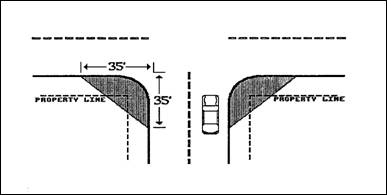
2.
With the exception of driveways serving no more than two residences, all intersections within the Kingston Terrace District shall have a visual clearance area of not less than twenty feet on each side of the intersection.
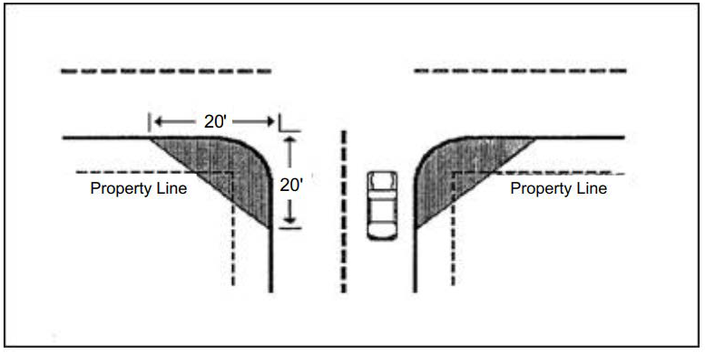
3.
The visual clearance for all other intersections which do not involve the streets described in subsections A.1 or A.2 of this section, shall not be less than fifteen feet on each side of the intersection. A driveway serving no more than two residences shall also be subject to this standard.
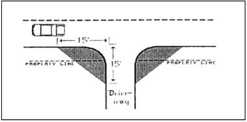
B.
A clear area shall contain no vehicle, hedge, planting, fence, wall, sign or any similar permanent obstruction which is between three feet and eight feet in height, measured from the top of the curb, or where no curb exists, from the street center line grade. Trees may be located in this area, provided all branches below eight feet are remove.
C.
Where horizontal or vertical curve conditions contribute to the obstruction of clear vision areas at an intersection or high traffic speeds are anticipated, hedges, plantings, fences, walls, buildings and other temporary or permanent obstructions shall be further reduced in height or eliminated to comply with the intent of the required clear vision area.
(Ord. 96-4 § 1 (part), 1996)
(Ord. No. 2023-04, § 1(Exh. A), 10-18-2023)
16.146.010 - Purpose.
The purpose of this chapter is to describe how density shall be calculated for residential development proposals.
(Ord. O-02-4 § 2 (part), 2004)
16.146.020 - Applicability of provisions.
The density calculations in this chapter shall apply to any development that has residential units as part of the proposed development with the exception of residential facilities and residential homes where the units for residents do not include individual kitchen and/or bathroom facilities and accessory dwelling units.
(Ord. O-02-4 § 2 (part), 2004; Ord. No. O-2020-01, § 1(Exh. A), 8-19-2020)
16.146.030 - Density calculation.
A.
To determine the maximum or minimum number of units, which may be constructed on a site for residential uses, the site size (in acres) shall be multiplied by the maximum or minimum number of units per acre allowed on the site, as designated by the applicable zone district, except as specified otherwise in this chapter. Density maximums may not apply to duplexes, quadplexes, triplexes, or cottage clusters.
EXAMPLE
Acres × units per acre = number of units allowed
1.6 × 5 = 8.0 or 8 units
B.
Site size shall include the area of the subject lot(s) or parcel(s), in acres or portions thereof, except for:
1.
All areas dedicated for public right-of-way that exist at the time the development application is submitted for review;
2.
Proposed lots with a maximum size of twenty thousand square feet to include existing residences on the subject lot(s) or parcel(s) to be developed; and
3.
Proposed remnant parcels, which are of sufficient size to be developed or divided in the future.
C.
No portion of the allowable density shall be transferred from one land use designation to another land use designation, except as permitted in accordance with the planned development provisions of Chapter 16.150.
D.
Land outside of the urban growth boundary (UGB) shall be ineligible for density transfer and shall not be considered in any density calculations.
E.
The number of units, which may be constructed on the subject lot(s) or parcel(s) shall be subject to the limitations of the applicable provisions of this title.
F.
When the maximum or minimum number of units allowed on a site results in a fraction of one-half or more, the number of units allowed shall be the next highest whole number, provided all minimum zone district requirements other than density can be met.
G.
Land that is dedicated to a park and recreation provider as public park land may be used to calculate the minimum or maximum density, provided the land is developed for recreational uses, and is not comprised of flood plain, drainage hazard, wetland or slopes over twenty percent.
H.
Land used for a private park, that is available to the general public outside of the residential development the park is located in, may be excluded from the acreage used to calculate the minimum density, provided the park is developed for recreational uses and does not include floodplain, drainage hazard, wetland, or slopes over twenty percent.
I.
For categories of land listed in Section 16.146.040, the applicant may either include it or exclude it from the acreage used to calculate the minimum or maximum density.
(Ord. O-02-4 § 2 (part), 2004; Ord. No. O-2021-01, § 2(Exh. B), 8-18-2021)
16.146.040 - Density transfers for unbuildable lands.
A.
Transfer of density from one area of land to another shall be permitted for any unbuildable portion of a lot or parcel when a portion of the subject lot or parcel is within the UGB and within one of the following areas:
1.
Floodplain;
2.
Drainage hazard;
3.
Jurisdictional wetland;
4.
Slopes over twenty percent;
5.
Power line easement or right-of-way;
6.
Future right-of-way for transitway, designated arterials, collectors and neighborhood collectors;
7.
Water quality sensitive areas designated for permanent protection; or
8.
Vegetated corridors designated for permanent protection.
B.
Density may be transferred within the UGB only as follows:
1.
Within a single lot or parcel within the same land use designation; or
2.
To an adjoining lot or parcel that is a subject of the development application provided it is also within the same land use designation as the other lot or parcel.
C.
Density Transfer Calculations. The number of units, which may be transferred, shall be calculated as follows:
1.
Determine the total density for the subject lot(s) or parcel(s);
2.
Determine the total number of units in the buildable portion and the unbuildable portion of the total site;
3.
Transfer the density of the unbuildable portion of the site to the buildable portion of the site, provided that the transferred density does not more than double the density allowed on the buildable portion of the site.
D.
For the purpose of this chapter, buildable shall mean all portions of the subject lot(s) or parcel(s) not included within a category listed in subsection A of this section, and unbuildable shall mean all portions of the lot(s) or parcel(s) included in one of these categories.
(Ord. O-02-4 § 2 (part), 2004)
16.148.010 - Title and purpose.
This chapter shall be referred to as the sign ordinance of the city and may be referred to in this chapter as this chapter. The purpose of this chapter is to protect the health, safety, property and welfare of the public through the establishment of standards to regulate the erection, location, maintenance and use of signs. The goals of this chapter are:
A.
To maintain an uncluttered and attractive appearance in the community and to improve the effectiveness of signs in identifying and advertising businesses;
B.
To provide equity and effectiveness in displaying identification signs by establishing regulations on size and location of such signs;
C.
To promote public safety by ensuring that traffic regulating devices be easily visible and free from nearby visual obstructions, from signs resembling official signs and from excessive numbers of signs;
D.
To ensure that signs are compatible with their surroundings;
E.
To guide and regulate the design, materials, construction, location, illumination and maintenance of all signs and sign structures to be located within the city, and adjacent boundaries.
(Ord. 96-4 § 1 (part), 1996)
16.148.020 - General provisions.
No person shall erect, construct, alter, relocate, maintain or use any sign unless a sign permit has been issued or the sign has been exempted by provisions of this chapter.
(Ord. 96-4 § 1 (part), 1996)
16.148.030 - Commercial, office and business signs.
Commercial, office and business district signs shall comply with all provisions and regulations of this chapter:
A.
Freestanding Signs. Freestanding signs for commercial, office and other business uses are permitted subject to the following requirements:
1.
Number. One double faced freestanding sign, identifying only the name of the development and no more than two of the principal uses of the premises, shall be permitted for a development.
2.
Height and Area. The sign height shall not exceed twenty-five feet. The maximum sign area shall not exceed one hundred square feet per sign face.
3.
Location. No freestanding sign or any part thereof shall be located on or over any portion of a public right-of-way or property line.
B.
Freestanding Directory Signs. In addition to freestanding signs, freestanding directory signs are permitted only for office but not for commercial uses, and are subject to the following restrictions. Such signs shall be limited to identifying the buildings and the names of tenants or occupants.
1.
Number. One double-faced freestanding directory sign shall be permitted for each development containing one multiple tenant building or group of architecturally related buildings. For developments with vehicle entrances on more than one street frontage, an additional directory sign may be permitted at such additional entrance.
2.
Height and Area. The sign height shall not exceed seven feet with the face area not exceeding forty-two square feet.
3.
Location. No sign or any part thereof shall be located on or over any portion of a public right-of-way or property line. The sign shall be located for viewing from the development by potential users of the development who have already entered onto the site. A freestanding directory sign shall not be attached to any other freestanding sign.
C.
Wall Signs. In addition to any other permitted sign, wall signs are permitted for commercial use, subject to the following requirements:
1.
Number.
a.
Walls Used. No more than two exterior walls shall be used for wall signs. Single tenant buildings shall use only two walls. Multiple tenant buildings shall use only the exterior walls which correspond with the portion of the building the tenant occupies.
b.
Signs. The permitted sign area per wall which has been designated to be used for wall signs may be divided among a maximum of three signs.
2.
Area.
a.
Single Tenant Building. Except as otherwise provided, the sign area of a wall sign, or combination of wall signs, shall not exceed ten percent (up to a maximum of two hundred fifty square feet) of the area of the wall to which it is attached. For the purpose of this regulation, the area of the wall is determined by multiplying the height of the wall from the ground level to eaves or top of the fascia by length of the wall. If the building contains two stories or more, the height of the wall is measured from the ground level to the top of the second story.
b.
Multiple Tenant Building. Except as otherwise provided, the sign area of a wall sign or a combination of wall signs, shall not exceed ten percent (up to a maximum of two hundred fifty square feet) of the area of the wall to which it is attached. For the purpose of this regulation, the area level to eaves or top of fascia by the length of the wall corresponding with the portion of the building the tenant occupies. If a tenant occupies two or more floors of a multiple story building, the height of the wall is measured from ground level to the top of the second story.
c.
Location. No sign shall extend above the line of the buildings eaves, the bottom of the fascia or above the second story of a multiple story building.
D.
Window Signs. In addition to other permitted signage, window signs are permitted for commercial, office or business uses subject to the following requirements:
1.
Number. No more than one window sign shall be permitted per building of a single tenant building, or for each tenant in a multiple tenant building.
2.
Area. The sign area shall not exceed twenty percent of the total area of the window or group of windows in which it is placed. Window signs may be substituted for permitted wall signage, as long as there is corresponding reduction of permitted wall sign area.
E.
Shingle Signs. In addition to other permitted signage, shingle signs are permitted for commercial or office uses, subject to the following requirements:
1.
Number. No more than one shingle sign shall be permitted for each tenant in any building.
2.
Area. The sign area shall not exceed six square feet per sign (two feet by three feet) with its depth not exceeding four inches. Shingle signs may be substituted for permitted wall signage, as long as there is a corresponding reduction of permitted wall sign area.
3.
Height. All shingle signs shall have a clearance of not less than eight and one-half feet between the lowest portion of the sign and ground level. No shingle sign, or part thereof, shall be located above the second story of a building, or above the line of the eaves or the top of the fascia wall.
4.
Location. A shingle sign may project out from a building, but shall be perpendicular to the building and horizontal to the ground level. No shingle sign shall project out diagonally from the corner of the building. No more than six inches shall separate the sign from the wall to which it is attached. The sign shall not extend over a public right-of-way, except a sidewalk.
5.
Illumination. A shingle sign shall not be internally illuminated.
F.
Entrance or Exit Signs. In addition to any other permitted signage, no more than one sign designating an entrance or exit shall be permitted at each driveway serving a development. Such signs shall be limited to "in," "out," "entrance" or "exit." Such signs shall not exceed eight square feet in sign area and four feet in height.
G.
Readerboard Signs. Readerboard signs are prohibited except for theater marquees advertising only current presentations, and automobile service stations advertising only fuel prices. No more than one readerboard sign shall be permitted for each theater and automobile service station. Only permanently attached readerboard signs are allowed after permit is obtained.
H.
Automobile Service Station Signs. In addition to other sections of this chapter, automobile service stations shall comply with the following requirements:
1.
All price signs shall be permanently affixed to the building or a freestanding sign;
2.
Price signs may be double-faced, but shall not exceed six square feet in area per face or as required by state or federal law;
3.
The maximum permitted freestanding and wall sign area shall be reduced by the sign area devoted to price signs;
4.
Signs not to exceed five square feet in area shall be permitted on each pump face.
I.
Bulletin Boards. Retail business, banks and organizations shall be allowed a bulletin board in addition to other permitted signs. The bulletin board shall not exceed twelve square feet in sign area and six feet in height. A permit is required.
J.
Roof Signs. Signs erected and maintained upon or against a sloped roof of a building, including a sign attached to any structure containing mechanical equipment.
1.
Roof signs will not be permitted except for tenants who have a total square footage of five thousand square feet.
2.
Permit applications for a roof sign will be given based on the total square footage of a single tenant in a multi-tenant building whose square footage is five thousand square feet or greater. The sign location on a lower slope not to exceed existing signs areas on present building and using the same design, color and material as other signs.
K.
Fascia Signs. In addition to other permitted signs, fascia signs are permitted for commercial/office and business uses as follows:
1.
Length. A space of no less than twelve inches on each end from the neighboring tenant;
2.
Height. The total height shall conform to the overall height of the fascia. It shall not extend above or below the edge of the fascia;
3.
Depth, not to exceed twenty inches;
4.
Area. Window or wall signs may be substituted for permitted fascia signs as long as there is a corresponding reduction of total permitted signage;
5.
Lettering may be internally illuminated by fluorescent lighting or other approved methods.
(Ord. 96-4 § 1 (part), 1996)
16.148.040 - Public and semi-public signs.
Public and semi-public uses include, but are not limited to, government and special district facilities, community centers, golf courses, libraries, museums and shall be subject to the following requirements:
A.
Freestanding Signs. Only one freestanding monument sign shall be permitted not to exceed eighteen square feet in sign area and five feet in height;
B.
Entrance or Exit Signs. No more than one sign designating an entrance or exit shall be permitted at each driveway serving the development. Such signs shall be limited to "in," "out," "enter," "entrance," "exit," or similar wording, and the name of the development. Such signs shall not exceed eight feet in sign area and four feet in height.
C.
Wall Signs. In addition to other permitted signs, wall signs are permitted subject to the following requirements:
1.
Number.
a.
Not more than two exterior walls for each building shall be used for wall signs;
b.
The total permitted sign area for each wall used for wall signs may be divided among a maximum of three signs;
c.
Area. The sign area of a wall sign, or combination of signs, shall not exceed ten percent (up to a maximum of one hundred fifty square feet) of the area of the wall to which the sign is attached. For the purposes of this regulation, the area of the wall is determined by multiplying the height of the wall from the ground level to eaves or top of a fascia by the length of the wall. If the building contains two or more stories, the height of the wall is measured from ground level to the top of the second story.
d.
Location.
i.
A wall sign shall be attached to the wall from which the permitted sign area is calculated.
ii.
No sign shall extend above the line of the building's eaves, or the top of the fascia or above the second story of a multiple story building.
D.
Bulletin Board. Retail businesses, banks and organizations shall be allowed a bulletin board in addition to other permitted signs. The bulletin board shall not exceed twelve square feet in sign area and six feet in height. A permit is required.
E.
Government Facilities. All on-premises signs associated with government facilities shall meet all provisions of this chapter.
(Ord. 96-4 § 1 (part), 1996)
16.148.050 - Residential use signs.
Residential uses shall be permitted the following signs: identification or monument sign. Subdivision, condominium developments, multi-family developments shall be allowed one, indirectly illuminated, freestanding monument sign or wall sign. Each sign shall have a maximum height of six feet and area of thirty-two square feet for a single-faced sign or sixty-four square feet for a double-faced sign. For developments with more than one vehicle entrance, an additional sign may be permitted at such additional entrance. Phased subdivisions shall be considered a single subdivision for determining permitted signs under this section.
(Ord. O-03-2 § 1 (part), 2003; Ord. 96-4 § 1 (part), 1996)
(Ord. No. 2023-04, § 1(Exh. A), 10-18-2023)
16.148.060 - Signs not requiring permits.
The following signs do not require a permit but are subject to the provisions of this chapter:
A.
Incidental signs shall not exceed two square feet in area per business.
B.
Name plates and postal address signs shall not exceed two square feet in area and shall be part of the building or attached as a wall sign.
C.
No trespassing, keep out, danger and warning signs shall not exceed two square feet in area.
D.
Real Estate Signs—Residential Real Estate Signs—Single-Family, Duplex, and Multi-family Units. The owner or authorized representative of a single-family, duplex or multi-family unit may erect the following real estate signs:
1.
Lawn sign in accordance with 16.148.080.D.
2.
Reserved.
3.
Residential Subdivisions and Undeveloped Land. Signs advertising more than three contiguous lots or undeveloped land in a residential planning district shall be limited to one double-faced sign not to exceed sixteen square feet per face or two sixteen square foot single-faced signs. Such signs shall be located on the premises being marketed, not less than five hundred feet apart and shall not exceed eight feet in height. Signs shall be removed within thirty days of sale of undeveloped land, or upon transfer of possession, whichever occurs first.
4.
Commercial and Undeveloped Lands. Signs advertising in a commercial district and undeveloped land shall be limited to one single-faced or double-faced sign for each street for two years or when ninety percent of the number of lots are sold, whichever occurs first.
E.
Temporary Window Signs. Such signs shall not obscure more than forty percent of the total transparent area of a window or group of windows.
F.
Auction Signs. One freestanding or wall sign may be permitted, subject to the following requirements. It shall be displayed no sooner than one week prior to the date of the auction. The sign shall not exceed twenty-one square feet in area per face and eight feet in height. Such signs shall be removed no later than the day following the auction.
(Ord. O-08-02 § 1 (part), 2008; Ord. O-03-2 § 1 (part), 2003; Ord. 96-4 § 1 (part), 1996)
(Ord. No. 2023-04, § 1(Exh. A), 10-18-2023)
16.148.070 - Temporary signs.
A.
Temporary Sign Permit Application. An application shall be submitted on forms prescribed by the city manager. The application shall include the size of the sign, a description of the proposed location of the sign, and the length of time the sign will be displayed. The application shall also contain the name and address of the applicant and the applicant's signature.
B.
Fees and Approval. Only the temporary signs cited in subsection C of this section shall be subject to the fees set forth in this chapter, except as otherwise provided. Each temporary sign permit application shall be accompanied by a fee as required by the city's schedule of fees and penalties as approved through resolution of the city council. Application and fees shall be submitted at least five working days prior to the planning commission's monthly meeting. Approval may be given by the city manager, planning commission chairman or planning commission.
C.
Grand Opening, Special Event, Special Sale Signs or Banners. The city manager shall have the authority to approve requests for advertising devices, signs or banners for a grand opening, special event or special sale. A permit can be granted for use up to fifteen days. At least sixty days must separate each approved time period.
(Ord. 96-4 § 1 (part), 1996)
16.148.080 - Exempt signs.
The following signs are exempt from the provisions of this chapter:
A.
Signs which are authorized and installed by public utility, telephone or cable television companies which serve as an aid to public safety, or which show the location of underground facilities;
B.
Public signs;
C.
Signs not visible or not intended to be read from the public right-of-way or from common areas open to the public;
D.
Lawn signs that meet the standards of this subsection are allowed in all zones and are not counted in the total square footage of permanent signage allowed on the site.
1.
Dimensions. Lawn signs may be up to four square feet in area with a maximum height of four feet.
2.
Placement. Lawn signs must be entirely outside of the right-of-way.
3.
Sign features. Illumination, electric signs, and changing image sign features are prohibited.
4.
Duration. Lawn signs shall be placed on a site for a maximum period of sixty days.
(Ord. 96-4 § 1 (part), 1996)
(Ord. No. 2023-04, § 1(Exh. A), 10-18-2023)
16.148.090 - Nonconforming signs and uses.
Nonconforming signs shall not be altered in any way. Any alteration, relocation or replacement of a nonconforming sign or any part thereof shall require immediate compliance with all provisions of this chapter. If a nonconforming sign is altered, then, the amortization provisions of subsection B of this section shall not apply.
A.
All nonconforming signs shall be removed or brought into conformance with the requirements of this chapter no later than two years from the effective date of the ordinance codified in this chapter, unless the original cost or most recent renovation of the signs preceding adoption of the ordinance codified in this chapter exceeds one hundred dollars, in which case, the following schedule applies.
1.
If either the original cost of the nonconforming sign or the most recent renovation to the sign preceding adoption of the ordinance codified in this chapter exceeds one hundred dollars, then the sign may be maintained and used only for a limited period of time based on the following schedule:
2.
The original cost of a nonconforming sign shall be determined by sign value information submitted at the time a sign permit was issued. If such information was not submitted, the property owner shall submit documentation verifying the original cost of the sign. The property owner shall also be responsible for submitting documentation verifying the cost of the most recent renovation to the sign. If such information is not available, the original cost of the sign shall be used in establishing the date of removal or bringing the sign into conformance.
3.
After the applicable permitted number of years has elapsed, the status of the sign reverts from nonconforming to illegal and becomes subject to enforcement proceedings.
B.
The city manager shall notify owners of property on which nonconforming signs are located of the amortization process and schedule for bringing the signs into conformance or removal, however, failure of the city manager to so notify shall not act to extend the applicable time frame for compliance with the provisions of this chapter. A nonconforming sign which, after the expiration of the applicable maximum permitted years, if not removed, shall be illegal.
1.
All signs which comply with the provisions of this chapter and are associated with nonconforming land uses will be allowed to be continued, as long as the nonconforming use retains its status.
2.
Signs for which variances were granted prior to the effective date of the ordinance codified in this chapter shall be subject to all portions of this section with the exception of subsection A of this section.
3.
A sign legally erected and maintained on property prior to annexation into the city and which fail to conform to the provisions of this chapter, shall be brought into conformance within two years of the effective date of the ordinance codified in this chapter. The amortization schedule in subsection A.1 of this section shall not apply to such signs.
(Ord. 96-4 § 1 (part), 1996)
16.148.100 - Nuisance signs.
A.
A sign constitutes a public nuisance under this chapter if:
1.
It is in violation of this chapter;
2.
It is deposited, left, displayed or located in the public right-of-way without authorization from the city, except a public sign; or
3.
It is a sign which, due to location or conditions, poses a threat to the public health, safety or welfare.
B.
The city manager is authorized to cause the removal and disposal of any signs which constitute a public nuisance in the following manner:
1.
Five days after written notice of the violation is mailed or twenty-four hours after notice is delivered in person to the person owning or controlling the nuisance sign the city manager/planning commission may have the sign removed and stored. The sign shall be stored for thirty days, and if unclaimed within thirty days of removal, it shall be presumed to be abandoned, and may be immediately sold, destroyed or otherwise disposed of.
2.
If the nuisance sign is determined by the planning commission to create a hazard to the public, for example, signs on the paved portion of the street or signs placed upon official traffic control signs, the five days advance notice need not be given and the sign may be immediately removed. Notice shall be given within one working day after removal.
3.
If the person responsible for the sign is not readily identifiable by the sign itself or by contacting adjacent property owners, the sign may be removed immediately without notice. If within the thirty days storage period, the person responsible for the sign becomes identified, then, notice should be made.
4.
If a previous notice has been given that a nuisance sign or substantially similar nuisance sign is again erected or placed (a change of copy or location does not constitute a different sign), any sign may be removed without further notice and stored for thirty days before further disposal. In such event, notice shall be given subsequent to removal and the owner shall be given an opportunity for a hearing before the planning commission to contest the violation and removal. The request for a hearing shall be made within three work days after removal and the hearing shall be held within ten work days after removal. The scope of the hearing shall be limited to whether there was a subsequent violation and whether the sign was a nuisance. Upon request, a written decision shall be made concerning the violation and removal procedure. The decision of the planning commission may be appealed to the city council as provided by ordinance.
5.
A responsible party desiring to claim a sign which has been removed and stored may do so, provided the claim is presented within thirty days of removal and that the cost of removal and storage is an amount not less than ten dollars for each sign and is paid to the city in advance.
(Ord. 96-4 § 1 (part), 1996)
16.148.110 - Prohibited signs and advertising devices.
The following signs or advertising devices are illegal and expressly prohibited by this chapter. No such sign or device shall be placed anywhere within the city limits.
1.
Abandoned signs;
2.
Advertising bench-type signs;
3.
Pennants, streamers, festoon lighting, banners, inflatable signs including blimps and/or hot or cold air balloons except as provided by this chapter. Nothing contained in this section shall be construed to prohibit the display of the flag of the United States, the State of Oregon or other political subdivision;
4.
Flashing sign;
5.
Illuminated signs which direct light into a residence;
6.
Obscene sign;
7.
Obstruction sign;
8.
Reserved;
9.
Portable sign, except for real estate signs;
10.
Rotating or moving signs;
11.
Search lights or beacons;
12.
Signs attached to trees or public utility poles, except public signs;
13.
Signs mounted on public property or within the public right-of-way, except public signs;
14.
Signs on Vehicles. Signs attached to or located on a stationary vehicle or trailer which is visible from a public right-of-way, and infrequently moved or moved primarily for display of the sign;
15.
Signs resembling official traffic signs or signals. Signs stating "stop," "go slow," "caution," "danger," and "warning," except as officially authorized or installed by the city, state Department of Transportation or the county;
16.
Signs using bare-bulb illumination or signs with a visible immediate source of illumination, except when permitted by this chapter;
17.
Strobe lights;
18.
Structurally unsafe sign;
19.
Any sign which is erected, placed, maintained or used which fails to comply with a specific provision of this chapter;
20.
Except for permitted, nonconforming signs, any sign for which a permit is required, but for which no permit has been issued;
21.
Signs which have lost their status as nonconforming signs either due to alteration, relocation, replacement, or due to the expiration of the applicable amortization period will receive thirty days notice to comply with this chapter after which a fine will be levied;
22.
Signs associated with illegal uses according to provisions of the planning commission review;
23.
Signs which constitute a public nuisance;
24.
Readerboard signs, and computer electronically controlled signs except for temperature and time; exception, automobile service stations as expressly provided.
(Ord. O-08-02 § 1 (part), 2008; Ord. 96-4 § 1 (part), 1996)
16.148.120 - Sign maintenance.
All signs shall be maintained in good order and repair at all times. Signs which have become faded, worn or which pose a danger to members of the public shall be repaired or removed.
(Ord. 96-4 § 1 (part), 1996)
16.148.130 - Criteria for sign permits—All signs.
All sign changes, alterations, relocations, construction and new developments shall follow the same processes and guidelines. The process for review will require the following items:
A.
Permit application obtained from city hall and accompanied by an appropriate fee;
B.
Details of proposed signs accompanied with a diagram or sketches of proposed signs;
C.
Location of building and location of placement/renovation, change, alteration, construction of development where signs will be placed;
D.
Total size/area of sign height, color and type of sign;
E.
Method of illumination;
F.
Method of support;
G.
Approximate sign area for all existing signs pertaining to business or development and distance between signs;
H.
In new development or construction, additional plans and pertinent information, when deemed necessary and appropriate, shall be required to ensure compliance with this chapter and other applicable ordinances.
(Ord. 96-4 § 1 (part), 1996)
16.148.140 - Administration.
A.
Sign applications shall be administered and reviewed as an administrative decision in accordance with Article II of this title.
B.
Sign applications requiring a variance shall be administered and reviewed as a Planning Commission decision in accordance with Article II of this title.
(Ord. 96-4 § 1 (part), 1996)
(Ord. No. O-2020-01, § 1(Exh. A), 8-19-2020)
Editor's note— Formerly entitled "Plan commission review" which was amended by Ord. No. O-2020-01.
16.148.150 - Permits—Approval and fees.
A.
Sign Permit Application. Application for a sign permit shall be submitted on forms prescribed by the city manager. The application shall address all criterion listed in Section 16.148.110. In addition, the application shall contain the names and addresses of the sign contractors, if any, the applicant, the owner of the property on which the sign will be erected and the property owner's consent. A separate application shall be submitted for each sign.
B.
Sign Permit. The city manager shall issue a sign permit when all applicable provisions of this chapter have been met. Except as otherwise provided, a separate sign permit shall be obtained for each sign.
C.
Sign Permit Fee. Each sign permit application shall be accompanied by a sign permit fee as required by the city's schedule of fees and penalties as approved through resolution of the city council.
D.
Double Fees. When a sign is erected or placed prior to approval of a required sign permit, the sign permit application fee specified in the city's schedule of fees and penalties as approved through resolution of the city council shall be doubled. Payment of the double fee shall not relieve an applicant from fully complying with the requirements of this chapter or from penalties prescribed in this chapter.
(Ord. 96-4 § 1 (part), 1996)
16.148.160 - Variances.
A.
Authorization to Grant or Deny Variances. The planning commission may authorize a variance from the requirements of this chapter when it is shown that, owing to special and unusual circumstances related to a specific piece of property, the literal interpretation of this chapter would cause an undue hardship. In granting a variance, the planning commission may attach conditions that it finds necessary to protect the best interests of the surrounding property, and to meet the purposes of this chapter.
B.
Conditions for Granting a Variance. No variance shall be granted by the planning commission unless the commission finds that all of the following criteria exists. The burden is upon the applicant to demonstrate that each of the following criteria exist.
1.
Exceptional or extraordinary conditions apply to the property or building that do not apply generally to other properties or buildings in the same planning district or vicinity, which conditions are a result of lot or building size or shape, topography or other physical circumstances applying to the property over which the applicant has no control.
2.
The hardship does not result from actions of the applicant, the tenant or previous tenant, or from personal circumstances such as age or financial situation of the applicant, or from regional economic conditions.
3.
The variance is necessary for the preservation of the property right of the applicant.
4.
The authorization of the variance shall neither be materially detrimental to the purposes and goals contained in this chapter, nor be injurious to property in the planning district or vicinity in which the property is located.
5.
The variance requested is the minimum variance from the provisions and standards of this chapter that will alleviate the hardship.
6.
The variance shall not be for the convenience of the applicant or for the convenience of a regional or national business which may prefer to use a standard sign or sign feature.
(Ord. O-03-2 § 1 (part), 2003; Ord. 96-4 § 1 (part), 1996)
16.148.170 - Inspection.
All signs for which a sign permit is required shall be subject to inspection by a member of the planning commission, or the city manager. Inspection may include, but shall not be limited to the following:
A.
Site inspection to assure compliance with the decisions of the planning commission, the sign permit criteria, if any, and provisions of this chapter;
B.
Structural inspection;
C.
Inspection of braces, anchors, supports and wall connections.
(Ord. 96-4 § 1 (part), 1996)
16.148.180 - Appeals process.
A decision of the planning commission's review on a sign application may be appealed to the city council.
(Ord. 96-4 § 1 (part), 1996)
16.148.190 - Enforcement.
The city manager is authorized to enforce the provisions of this chapter and to direct the removal of any illegal signs. When the planning commission/city manager has determined that a violation of this chapter exists, a written notice shall be served to the owner of the sign or the owner of the premises on which the sign is located. Additional notice is not required if a written notice was previously served to the responsible person regarding a substantially similar sign on the same premises. Notice shall be delivered to the person allegedly responsible for the sign by certified mail with return receipt requested. Multiple sign violations may be incorporated into a single notice. The notice shall contain at least the following information.
A.
A description of the sign condition to identify the violation;
B.
A statement describing how the recipient of the notice is responsible for the condition;
C.
A statement that the condition or the sign has been found to violate this chapter with a brief and concise description of the nature of the violation;
D.
A statement of the action required to remedy the violation and a date by which the remedy must be completed. Unless otherwise provided, permanent signs shall be remedied in not more than fourteen days and temporary signs shall be remedied in not more than forty-eight hours;
E.
If the sign is determined to be a nuisance, then a statement to that effect shall be included.
(Ord. 96-4 § 1 (part), 1996)
16.148.200 - Responsibility for violations.
It is intended that sign violations result in a penalty even though the responsible party does not knowingly or intentionally violate the provisions of this chapter. The mere fact that a violation exists and that a person is responsible or owns or controls the property on which the sign violation occurs, is sufficient to initiate enforcement proceedings and impose penalties. A person may be found liable, responsible or guilty of an alleged sign violation by reason of ownership, control or possession of the sign or the property on which the sign exists or has existed by reason of such person being the proximate cause of such sign's condition.
(Ord. 96-4 § 1 (part), 1996)
16.148.210 - Penalties.
It is a violation not to comply with any of the provisions of this chapter. It is also a violation to erect, maintain or use a sign contrary to this chapter. Conviction of a violation of any provision of this chapter will result in a penalty. Each day that a violation exists shall constitute a separate offense with a fine as required by the city's schedule of fees and penalties as approved through resolution of the city council.
(Ord. 96-4 § 1 (part), 1996)
16.148.220 - Cumulative remedies.
The rights, remedies and penalties provided in this chapter are cumulative and not mutually exclusive, and are in addition to any other rights, remedies and penalties available to the city under any other provisions of law. All officials, departments and employees of the city vested with authority to issue permits or grant approvals shall adhere to and require conformance with this chapter, and shall issue no permit or grant approval for any sign which violates or fails to comply with the conditions or standards imposed by this chapter. Any permit or approval issued or granted in conflict with the provisions of this chapter, whether intentional or otherwise, shall be void.
(Ord. 96-4 § 1 (part), 1996)
16.150.010 - Purpose.
The purposes of the planned development review process are to:
A.
Provide a means for creating planned environments by applying flexible standards, which allow the use of innovative design techniques which will result in a superior living arrangement;
B.
Facilitate the efficient use of land while preserving the existing landscape features and amenities to a greater extent than the normal standards of this title would allow;
C.
Encourage transferring density and development to the most suitable portions of the site;
D.
Encourage design features, which provide a variety of housing opportunities, public recreation and other community amenities; and
E.
Promote protection or avoidance of important natural and hazardous areas by using flexible standards and incentives.
(Ord. O-02-4 § 2 (part), 2004)
16.150.020 - Applicability of provisions.
A.
Planned development review may apply to site plan review (Chapter 16.152), conditional use (Chapter 16.156) and subdivision (Chapter 16.196) proposals at the request of the applicant.
B.
Planned development review shall not apply in the limited commercial (LC) district.
(Ord. O-02-4 § 2 (part), 2004)
16.150.030 - Administration.
Planned developments shall be administered and reviewed as a planning commission decision in conjunction with the related site plan review, conditional use and/or subdivision application in accordance with Article II of this title.
(Ord. O-02-4 § 2 (part), 2004)
16.150.040 - Submittal requirements.
A.
The application and support information required by this title for a related site plan review, conditional use and/or subdivision application shall be submitted.
B.
The applicant shall also provide supporting narrative, illustrations, plans, related information to clearly identify all requirements in this title that area proposed for modification as part of the planned development, and a demonstration of compliance with the provisions of this chapter.
(Ord. O-02-4 § 2 (part), 2004)
16.150.050 - Allowed uses.
A planned development may contain a mixture of uses subject to the density provisions of the base zone. Subject to Section 16.150.080, the following uses may be allowed within the UGB as part of a planned development approval in addition to the permitted and conditional uses allowed by the base zone:
A.
Accessory services directly serving the planned development only and which are customary or associated with, but clearly incidental to, the residential uses permitted in the base zone;
B.
Community building;
C.
Indoor and/or outdoor recreation facilities including fitness center, racquetball court, swimming pool, tennis court or similar use; and
D.
Recreational vehicle storage area, which only serves residents in the planned development.
(Ord. O-02-4 § 2 (part), 2004)
16.150.060 - Applicability of development standards.
A.
Except as provided in Section 16.150.060(B), the development standards of the base zone and this title shall continue to pertain to a planned development.
B.
The following standards of this title are optional within a planned development:
1.
Minimum lot size for lots that do not abut another property in the same or a more restrictive zoning district;
2.
Minimum average lot width for lots that do not abut another property in the same or a more restrictive zoning district;
3.
Minimum average lot depth for lots that do not abut another property in the same or a more restrictive zoning district;
4.
Side and rear yard setbacks for buildings that are more than fifty feet away from the perimeter of the planned development;
5.
Building height may be increased to fifty feet for buildings that are more than fifty feet away from the perimeter of the planned development; and
6.
When more than one zoning district applies to the site, the zone designations may be moved within the boundaries of the planned development, provided the total area of each zoning district remains the same.
(Ord. O-02-4 § 2 (part), 2004)
16.150.070 - Common open space.
A.
The planned development shall provide a minimum amount of usable common open space and recreational facilities such as playgrounds, bike and pedestrian trails, swimming pools, tennis courts and similar facilities according to the following:
1.
Twenty percent on-sites between zero and ten acres;
2.
Fifteen percent on-sites between ten and fifty acres; and
3.
Ten percent on-sites greater than fifty acres.
The open space necessary to meet this requirement shall not include riparian and wetland areas, including required buffer areas, or steep slopes. They shall also be improved and landscaped to reflect the intended character of the development, as approved by the planning commission. All common open space areas shall be minimum of one thousand square feet with minimum dimensions in any direction of ten feet.
B.
To the extent feasible, the planned development shall retain the natural topographic features, such as drainage swales, slopes, ridgelines, rock outcroppings, vistas, natural areas and trees.
C.
Designated common open space shall comply with the following:
1.
The open space area shall be shown on the final plan or plat and recorded in a manner required by the city manager; and
2.
The open space shall be conveyed in accordance with one of the following methods:
a.
By dedication to the city as publicly-owned and maintained as open space. Open space proposed for dedication to the city must be acceptable with regard to the size, shape, location, improvement, and budgetary and maintenance limitations;
b.
By leasing or conveying title (including beneficial ownership) to a corporation, home association or other legal entity, with the city retaining the development rights to the property. The terms of such lease or other instrument of conveyance must include provisions suitable to the city manager for guaranteeing the following:
i.
The continued use of such land for the intended purposes,
ii.
Continuity of property maintenance,
iii.
When appropriate, the availability of funds required for such maintenance,
iv.
Adequate insurance protection, and
v.
Recovery for loss sustained by casualty and condemnation or otherwise.
3.
By any alternative method which, achieves the objectives set forth in subsection (c)(2) of this section.
(Ord. O-02-4 § 2 (part), 2004)
16.150.080 - Approval criteria.
The approval authority shall approve, approve with conditions, or deny a planned development based upon the following approval criteria:
A.
All proposed uses under Section 16.150.050 shall be consistent with the residential character of the proposed development and compatible with existing or planned development on surrounding properties.
B.
The alternative design and/or development standards under Section 16.150.060 shall provide a character for the development that is the same or better than the character which would result by using the normal requirements of this title.
C.
The common open space requirement of Section 16.150.070 shall be satisfied.
D.
The applicable requirements of this title for the related site plan review, conditional use or subdivision application shall be satisfied.
(Ord. O-02-4 § 2 (part), 2004)