
La Grande City Zoning Code
CHAPTER 105
PUBLIC FACILITIES STANDARDS
Sec. 105-1. - Purpose.
The purpose of this chapter is to establish standards for the design and development of sites in order to protect the public health, safety and welfare.
(Ord. No. 3266 (Series 2023), § 6.1.001, 8-2-2023)
Sec. 105-2. - Applicability.
(a)
The standards established in this chapter shall apply to all development within the city urban growth boundary area.
(b)
Except where otherwise specifically regulated by this chapter or other city ordinances, the following transportation improvements are permitted outright:
(1)
Normal operation, maintenance, repair, and preservation activities of existing transportation facilities.
(2)
Installation of culverts, medians, guardrails, street lighting, sidewalks, pathways and similar types of improvements within the existing right-of-way.
(3)
Projects specifically identified in the La Grande/Island City Transportation System Plan as not requiring further land use regulation.
(4)
Emergency measures necessary for the safety and protection of property.
(5)
Acquisition of right-of-way for public roads, highways, and other transportation improvements designated in the La Grande/Island City Transportation System Plan except for those that are located in exclusive farm use or forest zones.
(c)
Construction, reconstruction, or widening of highways, roads, bridges or other transportation projects that are not improvements designated in the La Grande/Island City Transportation System Plan or not designed and constructed as part of a subdivision or planned unit development subject to site plan and/or conditional use permit review, shall require an amendment to the La Grande/Island City Transportation System Plan and applicable standards. Amendments to the La Grande/Island City Transportation System Plan shall be reviewed according to the comprehensive plan document amendment provisions in chapter 101, article III, division 9 and in coordination with Island City, Union County, and the state department of transportation.
(Ord. No. 3266 (Series 2023), § 6.1.002, 8-2-2023)
Sec. 105-3. - Improvement procedures.
The improvements required by this chapter shall conform to the requirements of this subpart and other improvement standards adopted by the city, and shall be in accordance with the following procedures:
(1)
Work shall not commence until the plans and specifications have been reviewed for adequacy and approved by the city engineer or designated city official and appropriate state agencies. To the extent necessary for evaluation of the partition or subdivision proposal, the plans and specifications shall be required before approval of the final map or plat.
(2)
Work shall not commence until the city engineer or designated city official has been notified.
(3)
Required improvements shall be constructed in accordance with specifications as set forth by the city engineer or designated city official and inspected for conformance. The city may require changes in typical sections and details if unusual conditions arise during construction which warrant such changes initiated by the developer, must be reviewed with and approved by the city engineer or designated city official.
(4)
Engineering standards of all design work shall be submitted to and approved by the city engineer or designated city official before construction begins. Changes in plans must be reviewed with the design engineer and approved by the city engineer or designated city official, and final inspection and approval of the completed improvements shall be made by the city engineer or the engineer's authorized representative before the improvements are accepted and performance assurance released. Prior to the final inspection, the developer shall furnish a certificate of completion prepared by a professional civil engineer. No building permits shall be issued until the provisions of this section are satisfied.
(5)
In addition to the requirements set forth in this subpart, the city will utilize the American Public Works Association (APWA) standard specifications and ASTM standards as a guideline to establish minimum standards.
(Ord. No. 3266 (Series 2023), § 6.1.003, 8-2-2023)
Sec. 105-25. - Purpose.
The purpose of these standards is to ensure safe ingress or egress to and from properties; to minimize street congestion and traffic hazards; to provide safe and convenient access to business, public services, and places of public assembly; and to make the appearance of vehicular circulation more compatible with surrounding land uses.
(Ord. No. 3266 (Series 2023), § 6.2.001, 8-2-2023)
Sec. 105-26. - Access standards for proposed subdivisions and planned unit development.
(a)
City engineer or authorized city official approval. Access to property fronting upon a city or public road shall be subject to the approval of the city engineer or designee.
(b)
Vehicular access. Vehicular access shall be provided to all lots from a dedicated street. Developments fronting an arterial may be required to provide a frontage or service road.
(c)
State highway division approval. Access to property fronting upon a state highway shall be subject to the approval of the state highway division.
(Ord. No. 3266 (Series 2023), § 6.2.002, 8-2-2023)
Sec. 105-27. - General street design criteria and standards.
The location, width, and grade of streets shall be considered in relation to existing and planned streets, to topographical conditions, to public convenience and safety, and to the proposed use of the land to be served by the streets. All street improvements shall be designed and constructed in accordance with the city standard drawings and specifications.
(Ord. No. 3266 (Series 2023), § 6.2.003, 8-2-2023)
Sec. 105-28. - Minimum street right-of-way widths.
Unless otherwise indicated on an official circulation plan, the minimum width of rights-of-way and street improvements shall be in compliance with the following table:
(1)
Cul-de-sac streets. A right-of-way width of not less than 130 feet, with improvements in accordance with the standards of this subpart.
(2)
Alleys. A right-of-way width of not less than 20 feet, with improvements in accordance with standards and specifications of this subpart.
(3)
When necessary for street construction on a side hill situation, the right-of-way needs shall be expanded as necessary.
(4)
When street design widths have been reduced by the elimination of parking on one or both sides, and when adequate off-street parking is provided, the right-of-way width may be reduced by a similar amount rounded to the nearest five feet.
Table 1. Street Standards
1 A portion of the required planting strip width may be used instead as additional sidewalk width or reduced right-of-way, as appropriate.
2 The minimum of the paved width was calculated with the following assumptions:
Arterials: two travel lanes, four-foot median divider, no center turn lane, no bike lanes.
Major collectors: two travel lanes, two bike lanes, no center turn lane, parking on one side.
Minor collectors: two travel lanes, parking on one side of street, no bike lanes.
Local streets: two travel lanes, parking on one side of street.
The maximum paved width for each street was calculated assuming the inclusion of all required and optional facilities. Minimum paved widths for each street are as required in section 105-29.
3 These right-of-way width ranges are for new streets.
4 Bike lanes should be provided on arterials unless more desirable parallel facilities are designated and designed to accommodate bicycles.
5 Bike lanes should be provided on minor collectors where traffic volumes or other factors warrant. Otherwise, minor collectors should be designed and designated as shared roadway facilities with wide outside travel lanes of 14 feet on important bike routes.
(Ord. No. 3266 (Series 2023), § 6.2.004, 8-2-2023)
Sec. 105-29. - Minimum street improvements.
The following public street improvements shall be required for development and shall be provided at the expense of the developer:
(1)
Arterial streets. Arterial streets shall be improved with street trees, curbs, gutters, stormwater collection system, sidewalk, and pavement. The typical street section shall be constructed in accordance with Table 1 in section 105-28, and in accordance with Public Works Engineering Standard Drawings and Specifications for Construction Manual, adopted by resolution of the city council. Sidewalks shall be installed on both sides.
(2)
Collector streets. Collector streets shall be improved with street trees, curbs, gutters, stormwater collection system, sidewalk, and pavement. The typical street section shall be constructed in accordance with Table 1 in section 105-28, and in accordance with Public Works Engineering Standard Drawings and Specifications for Construction Manual, adopted by resolution of the city council. Sidewalks shall be installed on both sides.
(3)
Local streets. Local streets shall be improved with street trees, curbs, gutters, stormwater collection system, sidewalk, and pavement. The typical street section shall be constructed in accordance with Table 1 in section 105-28, and in accordance with Public Works Engineering Standard Drawings and Specifications for Construction Manual, adopted by resolution of the city council. Sidewalks shall be installed on both sides.
(4)
Semi-private local streets. Semi-private local streets shall be located within a dedicated public street right-of-way and shall be improved to a minimum standard that includes a stormwater collection system, gravel shoulders and a paved surface in accordance with Public Works Engineering Standard Drawings and Specifications for Construction Manual, adopted by resolution of the city council. A semi-private local street shall only be allowed when it is determined by the planning commission at the recommendation of the city public works director, that a city standard arterial, collector or local street, as referenced above, cannot adequately be constructed to serve the development. The typical street section shall be approved by the public works department director or designee.
(5)
Elimination of parking, reduction of improved street width.
a.
Existing platted streets. When the right-of-way for any previously platted street is less than that specified above, the improved street width may be reduced through the elimination of parking on one or both sides, or by other means approved by the planning commission. This provision would apply when existing improvements prohibit the acquisition of necessary additional right-of-way, and adequate off-street parking is provided.
b.
New developments.
1.
In special instances, strict application of the requirements of this section may not be necessary, when provisions are made during development for adequate off-street parking. In such cases, on-street parking may be eliminated to allow for reduced pavement width. Privately maintained streets may allow for a reduction in street width required in the above sections. Typical examples of development where this section might apply are industrial parks, planned unit development, or a high density housing project.
2.
For residential properties that have topographic or other physical site constraints that makes strict adherence to this standard difficult, the planning commission may allow a reduced street width by eliminating on-street parking on one or both sides, along some street sections, in exchange for providing an equal or greater number of on-street parking spaces through an alternative street design within the development that reasonably services the impacted properties.
(6)
Minimum width for newly constructed streets. In no case will the widths of newly constructed streets be less than:
a.
Parking on one side.
1.
Arterial: 36 feet curb to curb.
2.
Collector: 30 feet curb to curb.
3.
Local: 28 feet curb to curb.
4.
Semi-private local street: 28 feet curb to curb.
b.
No parking either side.
1.
Arterial: 30 feet curb to curb.
2.
Collector: 28 feet curb to curb.
3.
Local: 24 feet curb to curb.
4.
Semi-private local street: 22 feet curb to curb.
(Ord. No. 3266 (Series 2023), § 6.2.005, 8-2-2023)
Sec. 105-30. - Street alignment.
All streets, as far as practical, shall be in alignment with existing streets by prolongation of the centerline or by connection with suitable curves. The offsetting alignments resulting in T intersections shall, where practical, provide minimum distance of 200 feet between points of intersections, when having approximately the same direction and otherwise shall not be less than 100 feet in separation.
(Ord. No. 3266 (Series 2023), § 6.2.006, 8-2-2023)
Sec. 105-31. - Street intersection angles.
Streets shall be laid out so as to intersect at any angle as near to a right angle as practical, except where topography requires a lesser angle, but in no case less than 60 degrees unless there is special intersection design. Streets shall have at least 50 feet of tangent adjacent to the intersection. Streets which intersect at an angle of 70 degrees or less, shall have a minimum corner radius of 20 feet along the right-of-way lines of the acute angle. Right-of-way lines at intersections with collector or arterial streets shall have a corner radius of not less than 20 feet.
(Ord. No. 3266 (Series 2023), § 6.2.007, 8-2-2023)
Sec. 105-32. - Street grades and curves.
Grades shall not exceed six percent on major or arterial street, ten percent on collector streets, and 12 percent on all other streets. The planning commission may allow steeper grades, through a variance permit procedure, after consideration of on-site fire protection systems as specified in section 1001.9 of the state fire code. No exceptions will be made for grades in excess of 15 percent. Centerline radii of curves shall be not less than 300 feet on major or arterial streets, 200 feet on collector streets, and 100 feet on all other streets.
(Ord. No. 3266 (Series 2023), § 6.2.008, 8-2-2023)
Sec. 105-33. - Cul-de-sacs.
(a)
A cul-de-sac shall be not more than 500 feet long. All cul-de-sacs shall terminate with a circular turnaround having a minimum curb-to-curb diameter of not less than 100 feet. The length of the cul-de-sac shall be measured from the center of the right-of-way of the closest intersecting through street to the center of the cul-de-sac bulb.
(b)
Cul-de-sacs shall only be permitted when one or more of the circumstances listed in this subsection exist. When cul-de-sacs are justified, pedestrianways shall be provided to connect with another street, greenway, school or similar destination unless one or more of the circumstances listed in this subsection exist.
(1)
Physical or topographic conditions make a street or walkway connection impracticable. These conditions include, but are not limited to, controlled access streets, railroads, steep slopes, wetlands, or water bodies where a connection could not reasonably be provided.
(2)
Buildings or other existing development on adjacent lands physically preclude a connection now or in the future considering the potential for redevelopment.
(3)
Where streets or accessways would violate provisions of leases, easements or similar restrictions.
(4)
Where the streets or accessways abut the urban growth boundary and rural resource land in farm or forest use, except where the adjoining land is designated as an urban reserve area.
(5)
Where through streets cannot be achieved by an alternative development design.
(Ord. No. 3266 (Series 2023), § 6.2.009, 8-2-2023)
Sec. 105-34. - Existing streets.
Whenever existing streets, whether adjacent to or within a development, are of inadequate width, the additional necessary right-of-way within the development boundary shall be provided at the time of the land division.
(Ord. No. 3266 (Series 2023), § 6.2.010, 8-2-2023)
Sec. 105-35. - Reserve strips.
Reserve strips or street plugs dedicated to the city and controlling the access to a street may be required, when necessary to:
(1)
Prevent access to the street on the side where additional width is required to meet the minimum right-of-way standards;
(2)
Prevent access to abutting property at the end of a street in order to ensure the proper extension of the street pattern, and the orderly development of land lying beyond the street; or
(3)
Prevent the uncontrolled development of land.
(Ord. No. 3266 (Series 2023), § 6.2.011, 8-2-2023)
Sec. 105-36. - Future extensions of streets.
When necessary to give access to, or permit a satisfactory future development of adjoining land, streets shall extend to the boundary of the development and a temporary turnaround may be required at the resulting dead end street. Reserve strips and street plugs may be required to ensure the objectives of street extensions.
(Ord. No. 3266 (Series 2023), § 6.2.012, 8-2-2023)
Sec. 105-37. - Half streets.
Half streets, while generally not acceptable may be approved where essential for reasonable development when in conformity with the requirements of this subpart, and when possible to require the dedication of the other half when the adjoining property is developed. The pavement width of a half street shall be one-half of the width required by Table 1 of section 105-28, plus seven feet. Whenever an existing half street is adjacent to land to be developed, the remaining half of the street shall be dedicated within such development. Reserve strips and street plugs may be required to ensure the objectives of obtaining fully width streets.
(Ord. No. 3266 (Series 2023), § 6.2.013, 8-2-2023)
Sec. 105-38. - Streets adjacent to railroad right-of-way.
Wherever a proposed development contains, or is adjacent to, a railroad right-of-way, provision shall be made for a street approximately parallel to, and on each side of, such right-of-way at a distance suitable for the appropriate use of the land between the streets and the railroad. The distance shall be determined with due consideration at cross streets of the minimum distance required for approach grades to a future grade separation, and to provide sufficient depth to allow screen planting along the railroad right-of-way.
(Ord. No. 3266 (Series 2023), § 6.2.014, 8-2-2023)
Sec. 105-39. - Marginal access streets.
Where a development abuts or contains an existing or proposed arterial street, marginal access streets, reverse frontage lots with suitable depth, screen planting contained in a non-access reserved area along the rear of side property line, or other treatment necessary for adequate protection of residential properties and for separation of through and local traffic may be required.
(Ord. No. 3266 (Series 2023), § 6.2.015, 8-2-2023)
Sec. 105-40. - Blocks.
(a)
Generally. The length, width, and shape of blocks shall be designed with due regard to providing adequate building sites for the use contemplated, consideration of needs for convenient access, circulation, control and safety of street traffic, and recognition of topographic conditions.
(b)
Sizes. Blocks shall not exceed 500 feet in length, except blocks within commercial and industrial subdivisions and blocks adjacent to arterial streets, or unless the previous adjacent layout or topographical conditions justify a variation.
(Ord. No. 3266 (Series 2023), § 6.2.016, 8-2-2023)
Sec. 105-41. - Driveway or access permits.
Prior to the construction of any driveway or road which connects with a city street or state highway, a right-of-way permit shall be obtained from the public works department/engineering division or state highway department. Such permit shall be issued subject to the conditions specified therein.
(Ord. No. 3266 (Series 2023), § 6.2.017, 8-2-2023)
Sec. 105-42. - Utilities in street rights-of-way.
Underground utilities, sanitary sewers, and storm drains installed in streets by the subdivider or partitioner shall be constructed prior to the surfacing of the streets in a predetermined location approved by the city engineer or designated city official. Stubs for service connections for underground utilities and sanitary sewers shall be placed to a length that will obviate the necessity of street cuts when service connections are made.
(Ord. No. 3266 (Series 2023), § 6.2.018, 8-2-2023)
Sec. 105-43. - Alley access.
Within the central business zone, alleys may be used as a primary access to a business.
(Ord. No. 3266 (Series 2023), § 6.2.019, 8-2-2023)
Sec. 105-44. - Access management guidelines.
(a)
Generally.
(1)
The intent of this section is to:
a.
Implement the access management policies of the city as set forth in the La Grande/Island City Transportation System Plan;
b.
Manage access to land development to preserve the transportation system in terms of safety, capacity, and function; and
c.
Reduce substandard access improvements over time by applying the provisions of this section when new development or major redevelopment occurs which will increase traffic generated from the site; when a safety or capacity deficiency requires specific mitigation; or when a street is reconstructed.
(2)
Unless otherwise noted, the provisions of this section shall apply to all arterials and collectors within the city and to all properties that abut these roadways.
(3)
The guidelines in this section shall be satisfied unless a waiver is justified as provided in subsection (e) of this section.
(b)
General access management guidelines. The access management guidelines contained in the table below shall be satisfied for new or reconstructed collector and local streets and driveways. Access management standards for state highways are included in appendix C of the 1999 Oregon Highway Plan and successor standards adopted by the state transportation commission. This appendix is adopted by reference as a part hereof as if fully set forth herein. Within the city limits and urban growth boundary, U.S. Highway 30/Oregon Highway 203 and Oregon Highway 82 (Island Avenue west of Interstate 84) are classified as district highways. Oregon Highway 82 (Island Avenue east of Interstate 84) is classified as a statewide highway.
Table 2. General Access Management Guidelines
1 Refer to 1999 Oregon Highway Plan appendix C: Access Management Standards.
(c)
Access design guidelines.
(1)
Corner clearance.
a.
Corner clearance for access connections shall meet or exceed the minimum spacing requirements for that roadway (Table 2).
b.
Where no other alternatives exist, the city may allow construction of an access connection along the property line farthest from the intersection. In such cases, directional connections (e.g., right in/out, right in only, or right out only) may be required.
(2)
Joint and cross access.
a.
Adjacent commercial or office properties classified as major traffic generators (i.e., shopping plazas, office parks), shall provide a cross access drive and bicycle/pedestrian access to allow circulation between sites.
b.
A system of joint use driveways and cross access easements shall be established wherever feasible and shall incorporate the following:
1.
A continuous service drive or cross access corridor extending the entire length of each block served to provide for driveway separation consistent with the access management classification system and standards;
2.
A design speed of ten miles per hour and a maximum width of 20 feet to accommodate two-way travel aisles designated to accommodate automobiles, service vehicles, and loading vehicles;
3.
Stub-outs and other design features to make it visually obvious that the abutting properties may be tied in to provide cross-access via a service drive; and
4.
A unified access and circulation system plan for coordinated or shared parking areas is encouraged.
c.
Shared parking areas shall be permitted and a reduction in required parking spaces if peak demands do not occur at the same time periods.
d.
Pursuant to this section, property owners shall:
1.
Record an easement with the deed allowing cross access to and from other properties served by the joint use driveways and cross access or service drive;
2.
Record an agreement with the deed that remaining access rights along the roadway will be dedicated to the city and pre-existing driveways will be closed and eliminated after construction of the joint-use driveway; and
3.
Record a joint maintenance agreement with the deed defining maintenance responsibilities of property owners.
e.
The city may reduce required separation distance of access points where they prove impractical, provided all of the following requirements are met:
1.
Joint access driveways and cross access easements are provided in accordance with this section.
2.
The site plan incorporates a unified access and circulation system in accordance with this section.
3.
The property owner enters into a written agreement with the city, recorded with the deed, that pre-existing connections on the site will be closed and eliminated after construction of each side of the joint use driveway.
(3)
Access connection and driveway design.
a.
Driveways shall meet the following standards:
1.
If the driveway is a one way in or one way out drive, then the driveway shall be a minimum width of ten feet and shall have appropriate signage designating the driveway as a one-way connection.
2.
For two-way access, each lane shall have a minimum width of ten feet.
b.
Driveway approaches must be designed and located to provide an existing vehicle with an unobstructed view. Construction of driveways along acceleration or deceleration lanes and tapers shall be avoided due to the potential for vehicular weaving conflicts.
c.
The length of driveways shall be designed in accordance with the anticipated storage length for entering and exiting vehicles to prevent vehicles from backing into the flow of traffic on the public street or causing unsafe conflicts with on-site circulation.
(4)
Nonconforming access features. Legal access connections in place as of September 18, 1999, that do not conform with the standards herein are considered nonconforming features and shall be brought into compliance with applicable standards under the following conditions:
a.
When new access connection permits are requested; or
b.
Change in use or enlargements or improvements that will increase trip generation.
(5)
Reverse frontage.
a.
Lots that front on more than one street shall be required to locate motor vehicle accesses on the street with the lower functional classification.
b.
When a residential subdivision is proposed that would abut an arterial, it shall be designed to provide through lots along the arterial with access from a frontage road or interior local road. Access rights of these lots to the arterial shall be dedicated to the city and recorded with the deed. A berm or buffer yard may be required at the rear of through lots to buffer residences from traffic on the arterial. The berm or buffer yard shall not be located with the public right-of-way.
(6)
Shared access. Subdivisions with frontage on an arterial shall be designed into shared access points to and from the street. Normally, a maximum of two accesses shall be allowed regardless of the number of lots or businesses served. If access off of a secondary street is possible, access should not be allowed onto the arterial. If access off of a secondary street becomes available, then conversion to that access is encouraged, along with closing the arterial street access.
(7)
Connectivity.
a.
The street system of proposed subdivisions shall be designed to connect with existing, proposed, and planned streets outside of the subdivision as provided in this section. To ensure continuation of the existing street grid and a pedestrian-friendly scale of the city blocks, block lengths shall be a maximum of 500 feet and block perimeters shall be a maximum of 2,000 feet.
b.
Wherever a proposed development abuts unplatted land or a future development phase of the same development, street stubs shall be provided to allow access to abutting properties or to logically extend the street system into the surrounding area. All street stubs shall be provided with a temporary turnaround unless specifically exempted by the planning commission upon recommendation from the public works director and fire chief, and the restoration and extension of the street shall be the responsibility of any future developer of the abutting land.
c.
Minor collector and local residential access streets shall connect with surrounding streets to permit the convenient movement of traffic between residential neighborhoods or facilitate emergency access and evacuation. Connections shall be designed to avoid or minimize through traffic on local streets. Appropriate design and traffic control such as four-way stops and traffic-calming measures are the preferred means of discouraging through traffic. For streets that serve less than ten dwelling units, the planning commission may grant an exception to this requirement upon recommendation from the public works director and fire chief.
(d)
Traffic study. For proposed development which is anticipated to generate more than 400 average daily motor vehicle trips (ADTs), the city shall require the applicant to provide a traffic impact study to demonstrate the level of impact to the surrounding street system. A traffic impact study may also be required at the discretion of the city where known traffic issues exist or where the existing transportation system may be at or near capacity. The applicant shall be required to mitigate all negative impacts attributable to the development as identified in the traffic impact study.
(e)
Waivers to access management guidelines. The planning commission may modify or waive the requirements of this section when this subsection is satisfied.
(1)
Applicant has provided proof of unique or special conditions that make strict application of the provisions impractical. Applicants shall include proof that one or more of the following circumstances exist:
a.
Indirect or restricted access cannot be obtained;
b.
No engineering or construction solutions can be applied to mitigate the condition;
c.
The characteristics or layout of abutting properties would make a development of a unified or shared access and circulation system impractical; and
d.
No alternative access is available from a street with a lower functional classification than the primary roadway.
(2)
The access hardship leading to the waiver request is not self-created.
(3)
The granting of the waiver shall meet the purpose and intent of these regulations and shall not be considered until every feasible option for meeting access standards is explored.
(Ord. No. 3266 (Series 2023), § 6.2.020, 8-2-2023)
Sec. 105-62. - Pedestrianways.
When necessary for public convenience and safety, pedestrianways ten feet in width to permit access to cul-de-sacs, to pass through oddly shaped or unusually long blocks, or to provide access to schools, parks, recreation, or other public or private areas, may be required. Pedestrianways shall be of such design and location as reasonably required to facilitate pedestrian travel, and shall be dedicated to the public.
(Ord. No. 3266 (Series 2023), § 6.3.001, 8-2-2023)
Sec. 105-63. - Street trees, curbs, gutters, and sidewalks.
Development shall include installations of street trees, curb, gutters, streetlights, and sidewalks as set forth in this article.
(Ord. No. 3266 (Series 2023), § 6.3.002, 8-2-2023)
Sec. 105-64. - Requirements for sidewalks and street trees.
(a)
Residential development. Curbs and sidewalks shall be required for all new development on both sides of the street. Street trees shall be required for all new development according to spacing and locations as approved by the community development director/planner. Curbs and sidewalks and street trees shall be required for additions or series of additions to any residential structure valued in excess of 30 percent of the most recent assessed value of the structure. Sidewalks and street trees shall be required for reconstruction of a residential casualty loss in excess of 130 percent of the most recent assessed value of the structure. If curbs and/or sidewalks do not exist adjacent to the subject property, an irrevocable consent to participate in a future local improvement district may be substituted for immediate improvements.
(b)
Commercial and civic development. Curbs and sidewalks are required for all new commercial and civic development on both sides of the street. The sidewalks shall be constructed to conform to the width of other sidewalks in the general area. Street trees are required for all new commercial development according to spacing and locations as approved by the community development director/planner. Curbs and sidewalks and street trees shall be required for additions or series of additions to any commercial or civic structure valued in excess of 30 percent of the most recent assessed value of the structure. Sidewalks and street trees shall also be required for reconstruction of a commercial or civic casualty loss in excess of 115 percent of the most recent assessed value of the structure. If curbs and/or sidewalks do not exist adjacent to the subject property, an irrevocable consent to participate in a future local improvement district may be substituted for immediate improvements.
(c)
Industrial development. Curbs and sidewalks are required for all new industrial development on both sides of the street. Sidewalks shall be not less than five feet wide. Street trees are required for all new industrial development according to spacing and locations as approved by the community development director/planner. Curbs and sidewalks and street trees shall be required for additions or series of additions to any industrial structure valued in excess of 30 percent of the most recent assessed value of the structure. Street trees and sidewalks shall also be required for reconstruction of an industrial casualty loss in excess of 115 percent of the most recent assessed value of the structure. If curbs and/or sidewalks do not exist adjacent to the subject property, an irrevocable consent to participate in a future local improvement district may be substituted for immediate improvements.
(Ord. No. 3266 (Series 2023), § 6.3.003, 8-2-2023)
Sec. 105-65. - Design and construction standards.
Curb, gutter, and sidewalk improvements are to be designed and constructed in accordance with standards established by the city. All necessary engineering, grading and construction is to occur at the expense of the developer, with the appropriate permits obtained through the public works department/engineering division. When a developer installs new curbing within a public street, the developer shall be responsible for extending the existing street pavement to the new curbline.
(Ord. No. 3266 (Series 2023), § 6.3.004, 8-2-2023)
Sec. 105-89. - Street names and numbers.
The purpose of this section is to provide a uniform addressing system that will allow for systematic expansion as well as providing the necessary information to public safety agencies to locate buildings by site address along the road network in the city. Except for extensions of existing streets, street names shall conform to the following standards:
(1)
Street names and numbers shall conform to the established pattern in the city and shall be subject to the approval of the community development department/planning division;
(2)
Name shall be limited to a maximum of 12 characters and two words, excluding the suffix directional indicator (i.e., street, avenue, court, lane or loop);
(3)
No street names shall be used which will duplicate or resemble the names of existing streets in the city and/or the county;
(4)
The designation of roads shall generally conform to the following:
a.
Roads running generally north-south shall be known as "streets."
b.
Roads running generally east-west shall be known as "avenues" or "lanes."
c.
Roads whose beginning and ending points intersect on a common road shall be known as "loops."
d.
Road dead-ending 1,000 feet or less from their beginning points shall be known as "courts."
e.
Roads located in the north quadrant as illustrated in Figure 1 below, shall include a "north" street prefix, such as North Second Street.
f.
Roads located in the east quadrant as illustrated in Figure 1 below, shall include an "east" street prefix, such as East Penn Avenue.
g.
Roads located in the south quadrant as illustrated in Figure 1 below, shall include a "south" street prefix, such as South Twelfth Street.
h.
Roads located in the central quadrant shall not include a street prefix.
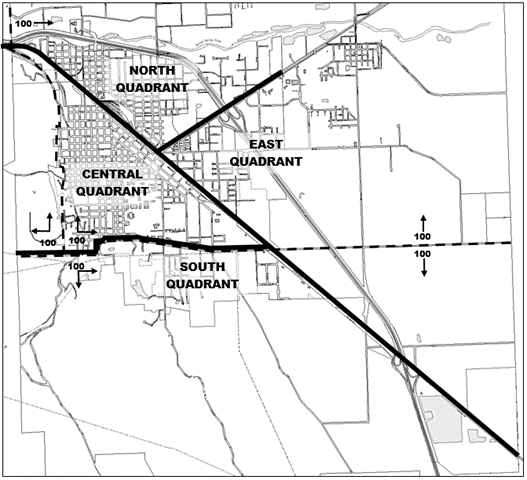
Figure 1
(Ord. No. 3266 (Series 2023), § 6.4.001, 8-2-2023)
Sec. 105-90. - Addressing.
The community development director/planner will assign addresses for each legal parcel as they are created or developed. For suite numbers/units within a multifamily, commercial or industrial structure, the property owner is responsible for assigning their own numbers/units, however for safety or 911 purposes sequential order is required.
(1)
Address numbers are typically assigned in increments of two approximately every 50 feet with up to 100 per block. Address numbers may be assigned in other increments to allow gaps where additional addresses may be assigned in the future to accommodate new development. Address numbers generally start at 100 at the base line locations as illustrated in Figure 1 in section 105-89.
(2)
For streets generally oriented in a north-south direction, even-numbered addresses shall be on the west side of the street and odd-numbered addresses shall be on the east side of the street.
(3)
For streets generally oriented in an east-west direction, even-numbered addresses shall be on the south side of the street and odd-numbered addresses shall be on the north side of the street.
(Ord. No. 3266 (Series 2023), § 6.4.002, 8-2-2023)
Sec. 105-91. - Clustered mailboxes.
For all new subdivisions and when required by the United State Postal Service (USPS), it shall be the developer's responsibility to install clustered mailboxes in accordance with the standards and specification contained in the Oregon Structural Specialty Code and as approved by the USPS.
(Ord. No. 3266 (Series 2023), § 6.4.003, 8-2-2023)
Sec. 105-92. - Street signs.
The developer shall deposit funds with the city, as determined by the public works director, to be sufficient to cover both the cost of street signs and installation. The street signs shall then be installed to city standards.
(Ord. No. 3266 (Series 2023), § 6.4.004, 8-2-2023)
Sec. 105-113. - Purpose.
Standards for site drainage and grading provide for the design of projects so as to minimize the harmful effects of stormwater runoff, and resultant inundation and erosion on proposed projects, and to protect neighboring and downstream properties from drainage problems resulting from new development.
(Ord. No. 3266 (Series 2023), § 6.5.001, 8-2-2023)
Sec. 105-114. - Drainage and grading plan requirements.
Drainage and grading plans shall be required for any new development which:
(1)
Involves a land disturbance through grading on lands consisting of average slopes in excess of 25 percent;
(2)
Involves a land disturbance through either grading or paving amounting to more than 10,000 square feet;
(3)
Will result in an impervious surface of more than 5,000 square feet;
(4)
Is subject to local ponding due to soil conditions and lack of identified drainage channels; or
(5)
Is located in an area identified by the city engineer or designated city official, as having a history of flooding, which may be further aggravated by the project or is within a flood hazard area.
(Ord. No. 3266 (Series 2023), § 6.5.002, 8-2-2023)
Sec. 105-115. - Drainage and grading plan preparation.
Drainage and grading plans are to be neatly and accurately drawn, at an appropriate scale which will enable ready identification and recognition of submitted information. The city engineer or designated city official may require drainage and grading plans to be prepared by a registered civil engineer.
(1)
Basic drainage and grading plan contents. A drainage and grading plan is to include the following information about the site:
a.
Flow lines of surface waters onto and off the site.
b.
Existing and proposed contours at two-foot intervals.
c.
Building corner and street elevations, existing and proposed.
d.
Existing and proposed retaining walls.
e.
Existing and proposed drainage channels, including drainage swales, ditches, and berms.
f.
Location and design of any proposed facilities for storage, or for conveyance of runoff into indicated drainage channels, including sumps, basins, channels, culverts, ponds, detention storm drains, and drop inlets.
g.
Estimates of existing and increased runoff resulting from the proposed improvements.
h.
Estimated cuts and fills for all material to be moved or imported, for amounts over 500 cubic yards must be submitted with the site plan or building permit where site plan review is not required.
i.
In geological hazard areas, as defined in chapter 109, article IV, a geotechnical engineer's evaluation of the grading and drainage plan and recommendations contained therein may be required by the community development director/planner.
j.
Grading and drainage plans must show the location of all improvements proposed in the citywide surface water master plan and provide for reservations of land for all proposed stormwater improvements. No construction shall be allowed within these reservation areas.
k.
Where improvements shown on the citywide surface water master plan have not been installed to serve a drainage area, all grading and drainage plans must indicate how these improvements will be installed or show on-site stormwater retention and disposal that will ensure that downstream flows will not increase after development of the property.
(2)
Engineered drainage and grading plan content. Engineered drainage and grading plans, when required, are to include an evaluation of the effects of projected runoff on adjacent properties and existing drainage facilities and systems in additions to the information required by subsection (1) of this section.
(Ord. No. 3266 (Series 2023), § 6.5.003, 8-2-2023)
Sec. 105-116. - Drainage and grading plan review and approval.
During site plan review, the city engineer or designated city official will review each drainage and grading plan for adequacy. Drainage and grading plans shall be approved by the city engineer or designated city official, where required, to ensure that the project will not result in inundation and erosion on the site, nor create any drainage or grading problems for neighboring or downstream properties.
(Ord. No. 3266 (Series 2023), § 6.5.004, 8-2-2023)
Sec. 105-117. - Inspection and completion.
Where required by the city engineer or designated city official, an inspection agreement is to be entered into, and the drainage facilities inspected and approved prior to approval on the final inspection of a building permit.
(Ord. No. 3266 (Series 2023), § 6.5.005, 8-2-2023)
Sec. 105-118. - Drainage system standards.
Drainage systems and facilities subject to drainage and grading plan review and approval are to be designed and constructed based on a Type 2A storm distribution for a 24-hour duration. Storm drainage plans shall be designed for a 25-year storm event and approved by the city engineer or designated city official.
(Ord. No. 3266 (Series 2023), § 6.5.006, 8-2-2023)
Sec. 105-150. - Purpose.
Upon the request of the city council, a variety of street design standards have been reviewed and are now incorporated in the land development code.
(Ord. No. 3266 (Series 2023), § 6.6.001, 8-2-2023)
Sec. 105-151. - Class I improvement standards.
This classification will cover those streets that are designed to meet the standards for an expected life of 20 years or more. The drawings set forth in the Public Works Engineering Standard Drawings and Specifications for Construction Manual, adopted by resolution of the city council, shall be the minimum standard for those streets in this classification. All streets designated as federal aid urban streets (FAU) shall be constructed under these design standards. Streets in this designation shall be constructed with sidewalks when at all possible in an effort to increase pedestrian safety. Collector streets are designed to withstand normal trucks of an HS 20 loading. Larger trucks are to utilize arterial streets where at all possible. This level of development shall be the ultimate goal for all streets within the city.
(1)
Advantages.
a.
The construction life is extended to a period above other city standards.
b.
The visible aesthetics in relationship to having curbs and a blacktop surface with landscaping or concrete driveways and a sidewalk is generally appealing to the public.
c.
Easy maintenance for the public works department for cleaning and minor repair.
d.
Storm sewer drainage is confined within the bounds of the curbs during minor flooding periods.
e.
Parking is restricted to a solid barrier, that being the curb; this restricts parking in the area on the back side of the curb and confines travel to the street surface.
f.
Defined areas for possible cross walks, signs, power poles, and other utilities that are restricted to the outside areas behind the curbs.
g.
It allows for a wide range of financing methods and is to city standards for a ten-year Bancroft bonding.
h.
Provides a dust-free surface.
(2)
Disadvantages. The extreme high level of cost that is incurred with this type of development.
(Ord. No. 3266 (Series 2023), § 6.6.002, 8-2-2023)
Sec. 105-152. - Class II improvement level.
(a)
Street construction. Streets constructed in this classification shall be constructed to the same standards as Class I streets with the exception of the form of drainage system. These streets shall meet the standards as set forth in the Public Works Engineering Standard Drawings and Specifications for Construction Manual, adopted by resolution of the city council. This level of construction shall be only utilized in substitution for Class I streets when it is determined by the city council at the recommendation of the city engineer or engineering superintendent, that an adequate drainage system cannot be installed for a Class I street.
(b)
Factors to be considered. Factors for consideration of the class of construction will be, but will not be limited to, cost, maintenance, hydrology, adverse weather conditions, or geographic location and soil types.
(c)
Parking restriction; maintenance. Parking in this class shall be restricted to the asphalt surface and discouraged from any vehicular use of the street shoulder. This method shall be used with extreme scrutiny. Streets under this classification are expected to have a 20-year life with minimal maintenance.
(1)
Advantages.
a.
The surface level of the street is constructed to maintain a 20-year life.
b.
It allows for on-site drainage within the right-of-way.
c.
Two travel and parking lanes are provided under the 36-foot wide or wider design.
d.
It can be utilized with or without sidewalks without adverse effects on the drainage system.
e.
It allows for a wide range of financing methods and is to city standards for a ten-year Bancroft bonding.
f.
Provides a dust-free surface.
(2)
Disadvantages.
a.
Cars have a tendency to utilize the French drain system for parking which plugs the drainage system.
b.
There is not a defined area for street cleaning or snow plowing.
c.
The initial cost for the project is fairly high but is reduced from the Class I improvement level.
d.
Surface water flow is not restricted to the street surface during low level flooding periods.
e.
This improvement level cannot be constructed within certain soil classifications due to poor subsurface drainage.
(Ord. No. 3266 (Series 2023), § 6.6.003, 8-2-2023)
Sec. 105-153. - Class III improvement level.
(a)
Street construction. Streets developed to this classification shall be constructed at a service level to expect a five year life with minimal maintenance. They shall be constructed to the standard as indicated set forth in the Public Works Engineering Standard Drawings and Specifications for Construction Manual, adopted by resolution of the city council. This construction class does not require storm sewer development. Only existing oil-mat streets will receive this treatment. A minimum of base material will be utilized to develop a street crown.
(b)
Factors to be considered. This class of street should only be done when a large enough project has been developed to fully use a full load of liquid asphaltic concrete oil. These projects should be constructed during the months of June, July, and August.
(c)
Repairs or maintenance. With a street development of this class, property owners would be required to monetarily support any repairs or maintenance after the five-year life expectancy.
(1)
Advantages.
a.
A reduced cost.
b.
Provides a dust-free surface.
c.
A fairly wide range of financing methods.
d.
An easy construction method with a minimal base.
(2)
Disadvantages.
a.
The surface level of the street is constructed to maintain a maximum five-year life expectancy.
b.
Does not apply for FAU funding.
c.
There is no drainage system allowed for in the design of this level.
d.
Street maintenance is increased.
e.
Does not have a defined area for street cleaning or snow plowing.
f.
No defined low level floodwater runoff is allowed for.
(Ord. No. 3266 (Series 2023), § 6.6.004, 8-2-2023)
Sec. 105-154. - Class IV improvement level.
(a)
General purpose and maintenance. This level is intended to be used only for the purpose of dust control. Because of the quality of the different products that can be used for this purpose, the effective life expectancy can range from two months to 12 months. Because of this, no warranties are being implied or offered. Only existing gravel streets will receive this treatment. Prior to the actual application, the public works department will review the street to determine the necessary level of repair. Actual work will be done generally within a one week period after review.
(b)
Determination of project length. When needed, base rock and/or blading will be done to facilitate the project as determined by the public works department. A minimum of one block or its equivalent, 300 feet, will be the acceptable project length. This level of service will be divided into divisions due in the most part to the wide range of application methods.
(1)
Level I, heavy oils and asphalt emulsions. These are sold under a variety of product names including DO-4, DO-5, DO-6, DO-8, and CSS-1. The DO products are heavy virgin oil products similar to bunker fuel; while CSS-1 is an asphaltic emulsion.
(2)
Level II, sodium lignin sulfate. This forestry by-product contains lignin and sugar that act as glue to hold dust particles together and to fill small spaces between particles. Care must be taken to grade the road so that water does not stand on the road surface causing the lignin and sugar to leach away.
(3)
Level III, oil water emulsion. This emulsion is mixed with water on a 4:1 to 10:1 basis depending on surface qualities. Under average conditions, a 4:1 dilution applied at 1½ gallons per square yard will suffice. The first application should be good for approximately three months depending on the amount of traffic use.
(4)
Level IV, magnesium chloride. This is a salt product that allows the surface of the road to maintain moisture and to bind particles together. It should not be used on previously oiled surfaces, and it may cause slight damage to vegetation within a few feet of treated roads.
a.
Advantages.
1.
The cost per property line foot is low.
2.
Ease of application.
3.
Utilized for dust abatement only.
b.
Disadvantages. Minimal life expectancy of two months.
(Ord. No. 3266 (Series 2023), § 6.6.005, 8-2-2023)
Sec. 105-155. - Class V improvement level.
(a)
This level is intended to be used only for the purpose of semi-private local street access when it is determined by the planning commission at the recommendation of the city public works director, that a full Class I or Class II street cannot adequately be constructed to serve the development. Streets constructed in this classification shall be constructed to the same standards as Class I Streets with the exception of the form of drainage system, curbs, parkway strip and sidewalk. These streets shall meet the standards as set forth in the Public Works Engineering Standard Drawings and Specifications for Construction Manual, adopted by resolution of the city council.
(b)
Factors for consideration of the class of construction will be, but not limited to: topography, land use density, emergency services cost, maintenance, hydrology, adverse weather conditions, or geographic location and soil types.
(c)
Parking in this class shall be restricted to the asphalt surface and discouraged from any vehicular use of the street shoulder. This method shall be used with extreme scrutiny. Streets under this classification are expected to have a 20-year life with minimal maintenance.
(Ord. No. 3266 (Series 2023), § 6.6.006, 8-2-2023)
Sec. 105-179. - Water system improvements.
(a)
The following water system improvements shall be required for development, and shall be provided at the expense of the developer:
(1)
Water mains.
(2)
Water service lines and meters.
(3)
Hydrants.
(4)
All water system appurtenances; accessory to provide complete system.
(5)
Domestic wells shall not be permitted, except when pre-existing as a legal nonconforming use permitted under chapter 109, article XVI.
(b)
All water system appurtenances: accessory to provide complete system.
(Ord. No. 3266 (Series 2023), § 6.7.001, 8-2-2023)
Sec. 105-180. - System standards.
The materials and installation shall conform to city standards, drawings, and specifications and any other standards adopted by the city.
(Ord. No. 3266 (Series 2023), § 6.7.002, 8-2-2023)
Sec. 105-181. - Approvals.
The developer, at the developer's expense, shall obtain all necessary state approvals prior to the city approving plans and specifications.
(Ord. No. 3266 (Series 2023), § 6.7.003, 8-2-2023)
Sec. 105-182. - As-built drawings.
Upon completion of any expansion of the water system, the developer shall furnish the city a set of as-built drawings prepared by a licensed civil engineer, acceptable by the city public works department/engineering division.
(Ord. No. 3266 (Series 2023), § 6.7.004, 8-2-2023)
Sec. 105-203. - Wastewater collection system improvements—Generally.
The following wastewater collection system improvements shall be required for development, and shall be provided at the expense of the developer:
(1)
Sewer mains.
(2)
Sewer laterals.
(3)
Manholes and clean-outs.
(4)
All wastewater collection system appurtenances; accessory to provide complete system.
(5)
Septic systems shall not be permitted, except when pre-existing as a legal nonconforming use permitted under chapter 109, article XVI.
(Ord. No. 3266 (Series 2023), § 6.8.001, 8-2-2023)
Sec. 105-204. - Wastewater collection system improvements—System standards.
The materials and installation shall conform to City of La Grande or the State of Oregon Standards, Drawings, and Specifications, and any other standards adopted by the city.
(Ord. No. 3266 (Series 2023), § 6.8.002, 8-2-2023)
Sec. 105-205. - Wastewater collection system improvements—Approvals.
The developer, at the developer's expense, shall obtain all necessary state approvals prior to the city approving plans and specifications.
(Ord. No. 3266 (Series 2023), § 6.8.003, 8-2-2023)
Sec. 105-206. - Wastewater collection system improvements—As-built drawings.
Upon completion of any expansion of the wastewater collection system, the developer shall furnish to the city a set of as-built drawings prepared by a licensed civil engineer, acceptable by the city public works department/engineering division.
(Ord. No. 3266 (Series 2023), § 6.8.004, 8-2-2023)
Sec. 105-207. - Stormwater collection system improvements—Generally.
The following stormwater collection system improvements shall be required for development, and shall be provided at the expense of the developer:
(1)
Sewer mains.
(2)
Sewer laterals.
(3)
Manholes, catch basins, and clean-outs.
(4)
All stormwater appurtenances; accessory to provide complete system.
(Ord. No. 3266 (Series 2023), § 6.8.005, 8-2-2023)
Sec. 105-208. - Stormwater collection system improvements—System standards.
The materials and installation shall conform to City of La Grande Standards, Drawings, and Specifications and any other standards adopted by the city.
(Ord. No. 3266 (Series 2023), § 6.8.006, 8-2-2023)
Sec. 105-209. - Stormwater collection system improvements—Approvals.
The developer, at the developer's expense, shall obtain all necessary state approvals prior to the city approving plans and specifications.
(Ord. No. 3266 (Series 2023), § 6.8.007, 8-2-2023)
Sec. 105-210. - Stormwater collection system improvements—As-built drawings.
Upon completion of any expansion of the stormwater collection system, the developer shall furnish to the city a set of as-built drawings prepared by a licensed civil engineer, acceptable by the city public works department/engineering division.
(Ord. No. 3266 (Series 2023), § 6.8.008, 8-2-2023)
Sec. 105-229. - Utilities in urban areas.
All development shall have all on-site public utility service connections installed underground. This standard applies to electrical service connections between the power company distribution lines, and all proposed buildings on a site, and on-site connections between buildings, but does not apply to the public utility distribution service to the edge of the lot, except in an underground utility district. This section is not intended to apply to the construction of accessory residential structures on previously developed residential dwelling sites.
(Ord. No. 3266 (Series 2023), § 6.9.001, 8-2-2023)
Sec. 105-230. - Utility easements.
Easements for sewers, storm drainage, water mains, electric lines, or other public utilities shall be dedicated wherever necessary. Easements shall be a minimum of 16 feet in width, or as required by the public works department, and centered on rear or side lot lines.
(Ord. No. 3266 (Series 2023), § 6.9.002, 8-2-2023)
Sec. 105-254. - Solid waste collection and disposal.
For uses which create a need for solid waste pickup and disposal, an enclosed area for the temporary collection of solid waste prior to disposal truck pickup is to be provided, as required by this article.
(Ord. No. 3266 (Series 2023), § 6.10.001, 8-2-2023)
Sec. 105-255. - Collection area standards.
(a)
Location of collection facilities. When an enclosure is required, the solid waste collection area is to be located within 100 feet of the dwellings or buildings served and in a location that can easily be accessed and served by the solid waste pickup service. The disposal unit shall be located on-site and shall not be located within a clear vision are or sight triangle as defined by this subpart.
(b)
Enclosure required. Solid waste collection areas which utilize dumpsters or other containers with a total capacity greater than two 65-gallon containers are to be screened from the view of public streets and adjoining properties by a solid fence or wall as high as the collection container, but not less than three feet or more than six feet in height.
(c)
Enclosure construction standards.
(1)
The floor or bottom surface of a solid waste collection area is to be of concrete or other impervious material.
(2)
The collection area is to have unobstructed vertical clearance for a minimum height of 25 feet.
(3)
Dumpster enclosures shall be designed of adequate size to fit all containers or disposal units (dumpster, cardboard recycle, grease barrels, other). The enclosure shall have a ten-foot unobstructed opening for accessing each container. For enclosures that will include multiple containers or disposal units, or if service vehicles need to enter the property, a 20-foot drive lane shall be provided, along with adequate space for the service vehicle to turnaround and exit. The disposal company shall be contacted to coordinate and obtain approval of the size and design specification.
(d)
Storage standards.
(1)
Solid waste shall be stored in a metal or non-breakable plastic container (e.g., roll-out containers, commercial dumpsters, etc.) designed for such storage. Solid waste shall not be stored in vehicles, trailers, in a manner accessible to animals or where it may be scattered by the elements.
(2)
Containers shall be leak proof with tight fitting lids.
(3)
Containers shall be emptied regularly to minimize odors and to avoid a health hazard.
(Ord. No. 3266 (Series 2023), § 6.10.002, 8-2-2023)