
La Pine City Zoning Code
ARTICLE 4
OVERLAY ZONES
Sec. 15.30.010. - Purpose.
Overlay zones address concerns unique to an area when other zoning mechanisms cannot achieve the desired results. An area may be unique based on natural, economic or historic attributes. Overlay zones provide a means to modify zoning regulations of the underlying base zones.
Sec. 15.30.020. - Scope of overlay zones.
Overlay zone regulations are applied in conjunction with a base zone. The overlay zone provisions may modify any portion of the regulations of the base zone or other regulations of this Title. The provisions may apply additional requirements or allow exceptions to general regulations. The specific regulations of the base zone or other regulations of this Title apply unless the overlay zone provides other regulations for the same specific topic. However, when there is a conflict between the overlay zone regulations and the base zone or other regulations of this Title, the overlay zone regulations control.
Sec. 15.32.010. - Purpose.
The neighborhood planning area provides standards and review procedures for development in the neighborhood planning area of the City of La Pine and is the "receiving area" for transferable development credits (TDCs). The neighborhood planning area includes six zoning districts, each with its own set of allowed uses.
Sec. 15.32.020. - General standards.
A.
Water and wastewater facilities.
1.
All uses in the neighborhood planning area requiring water shall be connected to the La Pine City water system.
2.
All uses in the neighborhood planning area that discharge wastewater shall be connected to the La Pine City sewage treatment facility or a department of environmental quality approved community waste water treatment facility serving the La Pine Neighborhood Planning Area.
B.
Transportation.
1.
Two perimeter collector and three neighborhood collector roads will provide access from Huntington Road into the neighborhoods.
2.
Crescent Creek Drive and a perimeter collector will provide access from Burgess Road. The three perimeter collectors dividing the neighborhoods will be adjacent to open space corridors that provide buffers between the four neighborhoods in the neighborhood planning area.
3.
Driveway access will not be allowed onto Crescent Creek Drive and the neighborhood collectors.
4.
Rather than a continuous paved parking shoulder, parking in designated pullout areas can be provided along the collectors for access to open space, parks and residential lots.
5.
Direct access from residential lots onto the local streets and perimeter collectors is permitted.
6.
Shallow vegetated swales alongside roads will provide for drainage.
7.
A network of multi-use paths will be developed parallel to many of the collector roads, in open space buffer areas within the development, along Huntington Road, and along the eastern perimeter collector parallel to Highway 97 or within the Highway 97 right-of-way, if sufficient right-of-way exists and ODOT authorizes the construction of a multi-use path in its right-of-way.
8.
The precise layout of these roads and multi-use paths will occur during the quadrant plan approval process as each neighborhood and quadrant is planned.
9.
Modifications to the layout and/or alignment of a path or trail outside of the neighborhood/quadrant process may be approved at the city engineer's discretion through an administrative review process.
10.
Use of the term "collector" in this chapter 15.32 means a street meeting the "collector" standard as defined in the City of La Pine Transportation System Plan. Crescent Creek Drive, Findlay Drive, Half Moon Drive, Campfire Drive, and Caldwell Drive are "collectors." Notwithstanding anything herein to the contrary, the city engineer may authorize a different street design standard through the quadrant planning process.
(Ord. No. 2020-02, § 2(exh. B), 1-22-2020)
Sec. 15.32.100. - Districts.
A.
Residential general district.
1.
Purpose. The residential general district is the largest area of neighborhood planning area. The district is primarily for single-family residential uses with a variety of lot sizes and housing styles. Some higher density housing is allowed in specified locations.
2.
Uses permitted outright.
a.
Single-family dwelling, including a "Class A" manufactured home.
b.
Duplex.
c.
Accessory dwelling.
d.
Multi-use path(s) and modifications of paths and/or trail alignments consistent with the intent of the plan as determined by the city through an administrative process.
e.
Open space.
f.
Residential facility or residential home.
g.
Home occupation that:
(1)
Is carried on within a dwelling only by members of the family who reside in the dwelling;
(2)
Does not serve clients or customers on-site;
(3)
Does not produce odor, dust, glare, flashing lights or noise;
(4)
Does not occupy more than 25 percent of the floor area of the dwelling;
(5)
Does not include the on-premises display or sale of stock in trade; [and]
(6)
Does not have any outdoor storage of materials used in the home occupation.
h.
Road or street project subject to approval as part of a land partition, subdivision or subject to the standards and criteria established by the city's transportation system plan and public works improvement standards.
3.
Uses permitted subject to site plan review. The following uses and their accessory uses are permitted subject to site plan review approval and the applicable provisions of this Development Code:
a.
Multi-family dwelling, located along the central collector road in the neighborhood planning area or adjacent to Huntington or Burgess Roads.
b.
Bed and breakfast inn, located along the central collector road in the neighborhood planning area or Huntington or Burgess Roads.
c.
Child care facility located adjacent to the central or a neighborhood collector road in the neighborhood planning area or Huntington or Burgess Roads.
d.
Park or playground.
4.
Conditional uses permitted. The following uses and their accessory uses are permitted subject to conditional use approval and the applicable provisions of this Development Code:
a.
Home occupation, subject to [section] 15.104.110 [15.104.90].
b.
Outdoor recreational equipment storage area as defined in DCC 18.04 until the city develops its own standards.
5.
Dimensional standards. The lot size, lot coverage block length, block perimeter and building height standards shown in Table 15.32-2 shall apply to the residential general district.
6.
Yard and setback requirements. The front, side and rear yard requirements in Table 15.32-2 shall apply to uses in the residential general district.
7.
Residential density. The residential density requirements in Tables 15.32-1 and 15.32-2 shall apply to the residential general district.
B.
Residential center district.
1.
Purpose. The residential center district is a location for social activities and small mixed-use residential/commercial businesses. It is located near the geographical center of each neighborhood. This district is the location for more compact housing types such as townhomes and apartment buildings that activate the center and allow a greater number of people the option to walk for their daily needs.
2.
Uses permitted outright.
a.
Single-family dwelling.
b.
Single-family dwelling - zero lot line.
c.
Townhome, duplex or triplex.
d.
Accessory dwelling.
e.
Live/work unit.
f.
Multi-use path(s) and modifications of paths and/or trail alignments consistent with the intent of the plan as determined by the city through an administrative process.
g.
Open space.
h.
Home occupation that:
(1)
Is carried on within a dwelling only by members of the family who reside in the dwelling;
(2)
Does not serve clients or customers on-site;
(3)
Does not produce odor, dust, glare, flashing lights or noise;
(4)
Does not occupy more than 25 percent of the floor area of the dwelling; and
(5)
Does not include the on-premises display or sale of stock in trade; and
(6)
Does not have any outdoor storage of materials used in the home occupation.
i.
Road or street project subject to approval as part of a land partition, subdivision or subject to the standards and criteria established by the city's transportation system plan and public works improvement standards.
2. [3.]
Uses permitted subject to site plan review. The following uses and their accessory uses are permitted subject to site plan review approval and the applicable provisions of this Development Code:
a.
Community center up to 4,000 square feet in floor area.
b.
Neighborhood commercial building as defined in DCC 18.04 until the city develops its own standards.
c.
Multi-family dwelling.
d.
Bed and breakfast inn.
e.
Church.
f.
Park or playground.
3. [4.]
Conditional uses permitted. The following uses and their accessory uses are permitted subject to conditional use and site plan review approval and the applicable provisions of this Development Code:
a.
Residential facility or residential home.
b.
Home occupation subject to 15.104.90.
4. [5.]
Dimensional standards. The lot size, lot coverage block length, block perimeter and building height standards shown in Table 15.32-2 shall apply to the residential center district.
5. [6.]
Yard and setback requirements. The front, side and rear yard requirements in Table 15.32-2 shall apply to uses in the residential center district.
C.
Residential density. The residential density requirements in Tables 15.32-1 and 15.32-2 shall apply to the residential center district.
D.
Community facility district; purpose. The purpose of this district is to provide a location for public and private uses and facilities that serve the civic, social and recreational needs of the community. The community facility district also includes higher density housing.
1.
Uses permitted outright.
a.
Duplex, triplex or townhome.
b.
Multi-use path(s) and modifications of paths and/or trail alignments consistent with the intent of the plan as determined by the city through an administrative process.
c.
Open space.
d.
Road or street project subject to approval as part of a land partition, subdivision or subject to the standards and criteria established by the city's transportation system plan and public works improvement standards.
2.
Uses permitted subject to site plan review. The following uses and their accessory uses are permitted subject to site plan review approval and the applicable provisions of this Development Code:
a.
Multi-family dwelling.
b.
Continuing care retirement center.
c.
Hospital.
d.
Medical facility.
e.
Assisted living, congregate care facility.
f.
Nursing home.
g.
Mixed use building (residential with other permitted use in the district).
h.
Child care center.
i.
Public use.
j.
Community center.
k.
Church.
l.
Senior center.
m.
Library.
n.
Museum.
o.
Performing arts building.
p.
Theater.
q.
School.
r.
Park or playground.
3.
Conditional uses permitted. The following uses and their accessory uses are permitted subject to conditional use and site plan review approval and the applicable provisions of this Development Code:
a.
Single-family dwelling.
b.
Retail or professional office use that supports a permitted use in the district.
4.
Dimensional standards. The lot size, lot coverage block length, block perimeter and building height standards shown in Table 15.32-2 shall apply to the community facility district.
5.
Yard and setback requirements. The front, side and rear yard requirements in Table 15.32-2 shall apply to uses in the community facility district.
E.
Community facility limited district; purpose. The purpose of this district is to provide locations for a school, recreation and transportation facilities.
1.
Uses permitted outright.
a.
Multi-use path(s) and modifications of paths and/or trail alignments consistent with the intent of the plan as determined by the city through an administrative process.
b.
Open space.
c.
Road or street project subject to approval as part of a land partition, subdivision or subject to the standards and criteria established by the city's transportation system plan and public works improvement standards.
2.
Uses permitted subject to site plan review. The following uses and their accessory uses are permitted subject to site plan review approval and the applicable provisions of this Development Code:
a.
Park and ride facility.
b.
School.
c.
Park or playground.
3.
Uses permitted subject to conditional use. The following uses and their accessory uses are permitted subject to conditional use and site plan review approval and the applicable provisions of this Development Code:
a.
Equestrian facility.
F.
Neighborhood commercial district; purpose. The purpose of this district is to provide a location for small-scale convenience commercial uses designed to serve the neighborhood planning area.
1.
Uses permitted outright.
a.
Multi-use path(s) and modifications of paths and/or trail alignments consistent with the intent of the plan as determined by the city through an administrative process.
b.
Open space.
c.
Road or street project subject to approval as part of a land partition, subdivision or subject to the standards and criteria established by the city's transportation system plan and public works improvement standards.
2.
Uses permitted subject to site plan review. The following uses and their accessory uses are permitted in a building or buildings each not exceeding 4,000 square feet of floor space, subject to site plan review approval and the applicable provisions of this Development Code:
a.
Convenience market.
b.
Video store.
c.
Retail store.
3.
Conditional uses permitted. The following uses and their accessory uses are permitted in a building or buildings each not exceeding 4,000 square feet of floor space, subject to conditional use and site plan review approval and the applicable provisions of this Development Code. Such as, but not limited to:
a.
Restaurant.
b.
Laundromat.
c.
Dry cleaning.
d.
Art studio in conjunction with retail use.
e.
Professional office.
4.
Dimensional standards. The lot size, lot coverage block length, block perimeter and building height standards shown in Table 15.32-2 shall apply to the commercial district.
5.
Yard and setback requirements. The front, side and rear yard requirements in Table 15.32-2 shall apply to uses in the commercial district.
G.
Park district. The purpose of this district is to provide neighborhood parks in each of the four neighborhoods within the neighborhood planning area. This district may also apply to an optional regional park that may be located in Neighborhood 2 or 3 during quadrant plan approval process.
1.
Uses permitted outright.
a.
Multi-use path(s) and modifications of paths and/or trail alignments consistent with the intent of the plan as determined by the city through an administrative process.
b.
Open space.
c.
Road or street project subject to approval as part of a land partition, subdivision or subject to the standards and criteria established by the city's transportation system plan and public works improvement standards.
2.
Uses subject to provisions of 15.32.100.G.4.
a.
Neighborhood park.
3.
Conditional uses. The following uses and their accessory uses are permitted subject to conditional use and site plan review approval, the development standards in 15.32.100.G.5 and the applicable provisions of this Development Code:
a.
Regional park.
4.
Neighborhood park development standards.
a.
Size standard. Each neighborhood park must be a minimum of two acres and no more than five acres in size. Neighborhood park areas do not need to be contiguous, so long as a multi-use path or sidewalks allow for pedestrian connection between the neighborhood park areas. If neighborhood parks are provided in a non-contiguous fashion, and notwithstanding anything herein to the contrary, each individual neighborhood park must be a minimum of one acre and the total neighborhood park area within an individual neighborhood must be a minimum of three acres.
b.
Location. Neighborhood parks must be located at approximately the center of each neighborhood or quadrant, must front a public street on at least one side, and must have multi-use path connections to a public street other than a frontage street.
c.
Boundary determination. The exact boundaries of the parks will be established at the time of approval of a quadrant plan.
d.
Platting. Neighborhood parks will be platted as part of the first phase for each quadrant in an approved quadrant plan.
e.
Development. The timing of neighborhood park development will be established through the quadrant plan approval process.
5.
Regional park development standards.
a.
The La Pine Neighborhood Planning Area may include one regional park. The regional park may be developed in Neighborhood 3 or 4.
b.
Size standard. The regional park shall be between ten and 25 acres in size.
c.
The location of a regional park shall be determined during the quadrant planning of Neighborhoods 3 and/or 4.
d.
If the regional park is located at the intersection of the central collector and a neighborhood collector at the center of a neighborhood, it may replace the required neighborhood park.
e.
Siting standards.
•
The regional park shall have direct access to either a collector street and an arterial street or the central collector and a neighborhood collector street.
•
The regional park shall have direct access to a paved multi-use path.
H.
Open space district. The purpose of this district is to provide two types of open space in the neighborhood planning area. Perimeter open space is located adjacent to Huntington and Burgess Roads, Highway 97, and between existing residential lots west of Neighborhood 4. Perimeter open space will provide visual and noise screening and locations for multi-use paths. If Highway 97 provides sufficient width for a perimeter buffer, is or will be improved with an ODOT approved multi-use path that includes a ten-foot buffer between the path and property line, the planning commission may allow for the Highway 97 right-of-way to serve as the eastern perimeter open space as part of the quadrant plan approval process. Corridor open space divides the four neighborhoods, helps to maintain a rural feeling, and contains multi-use paths. The quadrant plan for each neighborhood must designate the following minimum areas as open space district, as applicable to each quadrant:
(1)
In addition to the required dedication of right-of-way, a minimum 20-foot-wide corridor open space buffer must be provided on either side of the right-of-way separating adjacent neighborhoods.
(2)
Minimum 200-foot-wide perimeter open space adjacent to the Highway 97 right-of-way, unless through the quadrant plan approval process, the planning commission determines that the Highway 97 right-of-way is sufficient to accommodate a multi-use path while providing adequate buffering between the path and adjacent properties lines. The applicant must have prior approval from ODOT to construct the multi-use path in the Highway 97 right-of-way in order to utilize this exception.
(3)
Minimum 75-foot-wide perimeter open space adjacent to Huntington and Burgess Roads.
(4)
Minimum 50-foot-wide perimeter open space on the west edge of quadrants 4a and 4c.
(5)
A 500-foot wildlife corridor must be established in either Neighborhoods 3 or 4. The wildlife corridor must be unimproved and align with an existing or planned wildlife Highway 97 undercrossing to the extent practical.
1.
Perimeter open space uses permitted outright.
a.
Open space.
b.
Multi-use path(s) and modifications of paths and/or trail alignments consistent with the intent of the plan as determined by the city through an administrative process
2.
Corridor open space uses permitted outright.
a.
Open space.
b.
Multi-use path(s) and modifications of paths and/or trail alignments consistent with the intent of the plan as determined by the city through an administrative process.
c.
Picnic area.
d.
Benches along multi-use path.
e.
Park or playground managed by the La Pine Park District or a neighborhood planning area homeowners association.
3.
Uses permitted subject to an open space management plan under the provision of 15.32.100.H.(5).4.
a.
Vegetation management for wildfire hazard reduction.
b.
Vegetation management for wildlife habitat enhancement.
c.
Landscaped earthen berm.
d.
Road or street project subject to approval as part of a land partition, subdivision or subject to the standards and criteria established by the city's transportation system plan and public works improvement standards.
4.
Open space management plan.
a.
An open space management plan shall be prepared for each quadrant as a component of a quadrant plan. The plan shall be implemented as a condition of approval for the final plat of the first phase of any development in a quadrant. The open space management plan shall identify the funding source and management responsibility for zoned open space.
I.
Quadrant plan.
Plan approval required. Prior to issuance of a building permit, approval of a tentative plan or initiation of development (including, without limitation, streets or placement of utilities) within a neighborhood or quadrant, a quadrant plan must be approved according to the Type III Procedures of the La Pine Development Code section 15.204.030 and the quadrant plan approval criteria in 15.32.100.I.3.
1.
Eligibility to submit an application. The City of La Pine will accept a quadrant plan application from an owner or developer who has an agreement with Deschutes County of intent to purchase land in the quadrant. The county may also prepare a quadrant plan.
2.
Application requirements. All applications shall include the following elements:
a.
Zoning plan, drawn to scale, showing the boundaries of the proposed zones and the acres in each zone.
b.
Transportation plan, drawn to scale, including locations of street rights-of-way for central collector, neighborhood collector, perimeter collector and local streets, block configurations and connections with adjacent quadrants.
c.
Non-motorized circulation plan showing locations of any sidewalks or multi-use paths and where they will connect to adjacent quadrants.
d.
Open space and park plan, drawn to scale, defining boundaries for the open space district and neighborhood or regional parks where applicable.
e.
Open space management plan.
f.
Utility plan, drawn to scale, identifying location and specifications for sewer and water facilities. The utility plan shall include a schedule of improvement initiation and completion and a written narrative that explains or describes:
•
How the proposed water and sewer systems will be adequate to serve the type and size of development planned.
•
How the proposed location and sizing of facilities will be consistent with existing and planned facilities.
•
How adequate water flow volumes will be provided to meet fire flow and domestic demands.
g.
Proposed design guidelines and process for reviewing and approving buildings for conformance with the guidelines. Notwithstanding DCC 23.40.020(F)(1)(g), and this requirement, no design guidelines shall be required for quadrant 1c until the city develops its own standards.
h.
A plan showing the zone boundaries for neighborhood general and neighborhood center districts.
i.
A plan showing the proposed locations and dimensions of road rights-of-way.
j.
A written burden of proof statement with findings demonstrating conformance with the goals and policies of The Deschutes County Comprehensive Plan, DCC 23.40.020, the applicable sections of DCC 18.61, and any other applicable provisions of DCC title 18 until the city develops its own standards.
k.
A proposal for deed restrictions, covenants, conditions and restrictions (CCRs), and a homeowner's association. Notwithstanding DCC 23.40.020(F)(1)(g) and (h), no proposal for deed restrictions, CCRs, and a homeowner's association shall be required with an application for a quadrant plan for quadrant 1c until the city develops its own standards.
3.
Quadrant plan approval. Approval of a quadrant plan is a land use action reviewed under the Type III Procedures of Development Code section 15.204.030. Quadrant plans are subject to a public hearing before the City of La Pine Planning Commission. The planning commission makes the decision to approve or deny an application for a quadrant plan. The city council will act as the hearings body on an appeal of such a decision. An appeal of a quadrant plan will be conducted in accordance La Pine Development Code chapter 15.212. A quadrant plan may be approved subject to conditions with findings that the following criteria are met:
a.
The quadrant plan application contains all of the elements required in 15.32.100.I.2.
b.
The quadrant plan conforms to the relevant policies in the City of La Pine Comprehensive Plan.
c.
There is adequate sewer and water capacity to serve the development planned for the quadrant and agreements to provide service have been signed with appropriate water and sewer districts or providers.
d.
The streets proposed in the quadrant transportation plan conform to the general location and connection requirements of the La Pine Neighborhood Street Plan, Figure 15 in the Deschutes County Comprehensive Plan, DCC 23.36.052. The city engineer must approve of the street design. Final locations of road rights-of-way approved under a quadrant plan will be determined through the process for approval of a tentative plat under Development Code article 9.
e.
Except as approved by the city through a quadrant plan, the multi-use paths must be located within or adjacent to the perimeter or corridor open space as generally shown in the non-motorized plan, Figure 16 in the Deschutes County Comprehensive Plan, DCC 23.36.052 until the city develops its own standards. Path(s) and modifications of paths and/or trail alignments must be consistent with the intent of the quadrant plan as determined by the city through an administrative process. Any modifications of these locations must be in compliance with Development Code 15.32.020.B.7.
f.
Except as approved by the city through a quadrant plan, the open space in the open space and park plan must conform to the standards in Deschutes County Comprehensive Plan, DCC 23.36.020(D) and general location shown in the La Pine Neighborhood Parks and Open Space Plan, Figure 17 in the Deschutes County Comprehensive Plan, DCC 23.36.052, until the city develops its own standards. Any modifications of these locations must be in compliance with Development Code 15.32.100.I.3.G and Development Code 15.32.100.I.3.H.
g.
The zoning plan conforms to the following performance standards:
(1)
Neighborhood commercial district. A minimum of two and a maximum of four acres of neighborhood commercial district must be established in quadrant 3a or 3c. Alternatively, if quadrant plans for quadrant 3a and 3c are approved at the same time, the maximum area of neighborhood commercial district may be divided between the two quadrants. The neighborhood commercial zone must be located at the intersection of Huntington Road and the neighborhood collector that bisects Neighborhood 3.
(2)
Community facility district. Quadrant 1c will be zoned as community facility district.
(3)
Community facility limited district. The portion of quadrant 3a that is located west of Huntington Road will be zoned community facility limited. A maximum of 15 acres in the northwest section of quadrant 4a may be zoned community facility limited.
(4)
Residential center district. Each quadrant except quadrants 1a, 1b, 1c and 1d must have a residential center district with a minimum of three acres and a maximum of six acres. The area of the residential center district is gross acres including public rights-of-way. The residential center district must be a contiguous area located so that it is adjacent to both Crescent Creek Drive and the collector street that bisects the neighborhood.
(5)
Residential general district. The area zoned residential general will be the area in each quadrant that remains after the mandatory minimum residential center, neighborhood parks and open space zoning is defined.
h.
The proposed residential densities and lot sizes conform with the requirements of the residential general and residential center zones as further described as follows in Tables 15.32-1 and 15.32-2:
Note: Density is calculated using gross acres, excluding collector street right-of-way.
Notes:
(1) Gross acres, excluding collector street right-of-way.
(2) Must meet clear vision requirements of in article 5.
(3) The block requirements not applicable to review and approval of quadrant plans.
(Ord. No. 2019-01, exh. B-1, 4-10-2019; Ord. No. 2020-02, § 2(exh. B), 1-22-2020)
Sec. 15.34.010. - Purpose and intent.
The two transition areas within the city are located along the Burgess Road, Huntington Road and Highway 97 corridors (in the northern part of the city) and on some undeveloped properties in the southern part of the city where single family residential land abuts industrial land. The transition areas, which total 212 acres, were so designated because these areas were primarily undeveloped larger lots and are located in areas where adjoining land uses and transportation facilities could cause conflicts between uses. Additionally, these properties are located in areas where increased residential density and/or a mix of residential and commercial uses may be appropriate due to their proximity to major transportation corridors and existing facilities and services.
A.
North transition area. As the development and improvements to the transportation facilities occurs in the future, a development pattern that includes a mixture of service commercial uses and medium density residential development is desired. Such development should occur in a master planned fashion and should treat all sides of the development in a similar fashion, the development must not be linear in nature and should tie together all sides of the surrounding development.
B.
South transition area. As development of the industrial and single family residential areas occurs over time, the development of the transition area as a graduated multi-family residential buffer between the uses is desired. It is anticipated that the average density within the transition area will be medium density, but portions along the edges will vary in their densities in a manner that corresponds with the desired development pattern in the adjoining district. Such development should occur in a master planned fashion and should treat all sides of the development in a similar fashion, the development should be done in a manner where it is integrated into the surrounding development pattern and be respective of all sides of the surrounding uses.
Sec. 15.34.020. - Uses.
The use regulations within the transitional areas overlay zone are summarized in Table 15.34-1.
Sec. 15.34.030. - Master plan required.
A.
Development within transition areas shall be master planned to show an inter-relationship between the proposed development, and infrastructure and adjoining land uses.
B.
The purpose of a master plan is to provide opportunities to create a desirable environment through the application of flexible design and development standards to tracts of land under common ownership or control. It is intended to provide a transition area between zones and to blend uses without creating conflict between different zones. The master plan shall encourage a creative approach in the development of land in an efficient and aesthetic manner and to provide a desirable use of open areas, while encouraging a higher dwelling unit density and area coverage permitted in the abutting zones. It is intended to achieve economy in development and maintenance while providing privacy, usable open space, safe pedestrian and vehicular circulation and compatible relationships between different land uses.
Sec. 15.34.040. - General standards.
The following standards and requirements shall apply to all special master plans in the TA zones:
A.
The maximum number of developable units or the dwelling unit density allowed is determined by dividing the minimum lot area allowed in the abutting zone into the net land area of the project. Development occurring next to a single-family residential district may exceed by 20 percent the average dwelling unit density permitted by the underlying zone. Development occurring in multi-family districts may exceed by 30 percent the average dwelling unit density permitted by the underlying zone;
B.
The perimeter of the project shall be aesthetically compatible with the land use of adjoining properties. Perimeter lots adjoining or abutting property outside the project shall comply with the requirements of the underlying zone, or shall be screened in an aesthetic manner from adjoining properties so as to protect such adjacent lots from visual and audible impacts from the project which are inconsistent with the underlying zoning;
C.
Improvements on the site shall contain adequate landscaping so as to provide a compatible effect as seen from the adjoining properties;
D.
One or more major egress circulation points must be functionally connected to a public arterial or collector street or streets;
E.
Open space shall be arranged so as to be an integrated part of the project, not isolated and apart therefrom;
F.
A minimum of 20 percent of the land area of every master plan shall be comprised of open space;
G.
Water and sewer systems shall be publicly owned and designed to city standards;
H.
Streets may be private or public.
Sec. 15.34.050. - Application.
A.
The process to be followed in the application for a master plan shall consist of four procedures:
1.
Conceptual review by the city staff.
2.
Review of the preliminary development plan by the city planning commission and recommendation to the city council.
3.
Approval of the preliminary development plan by the city council.
4.
Approval of the utility and street plans by the city staff and approval of the final development plan by the city council.
Sec. 15.34.060. - Preliminary development plan application procedure.
The applicant shall submit to the city three copies of the preliminary plan material, including the following:
A.
Legal description of the project and site location map of the property;
B.
A proposed site plan and/or drawing showing the principal topographic contours and designated placement, location and principal dimensions of buildings, streets, parking areas, recreational areas, other open space and landscaping areas;
C.
Preliminary elevation and perspective drawings of project structures and improvements;
D.
Description of the special features of the development;
E.
A text describing conditions or features which cannot be adequately displayed on maps or drawings;
F.
A description of plans for covenants, restrictions, uses and continuous maintenance provisions for the project;
G.
The following plans and diagrams:
1.
A survey of the property, showing existing features, including contours, buildings, structures, streets, utility easements, rights-of-way, and existing land use;
2.
An off-street parking plan;
3.
A circulation diagram indicating the proposed movement of vehicles and pedestrians within the planned unit development and to and from existing and planned thoroughfares. Any special engineering features and traffic regulation devices needed to facilitate or ensure the safety of this circulation pattern must be shown;
4.
Preliminary landscape plans;
5.
A topographic map or model of the site and surrounding vicinity;
6.
Preliminary drainage plan;
7.
Proposed source of water supply, electric supply, cable, gas, fiber, and sewage disposal;
8.
Preliminary layout of water and sewer system;
9.
Lighting plan;
10.
Site plan showing minimum lot area, lot dimensions, lot coverage and yard requirements and the building heights.
[Sec. 15.36.000. - Intent.]
The Flood Plain zone includes all areas designated as "Special Flood Hazard Areas" in a study prepared locally using local rainfall and geologic information. Flood hazard areas are shown on maps prepared by the federal government in 1988 as a result of the county's participation in the National Flood Insurance Program. Deschutes County is one of many organizations and agencies responsible for development in the flood plain. For example, lending institutions require property owners to obtain flood insurance before any loan is given for development in a flood plain. If you are considering buying a lot or building in the FP zone, you should first consult with a planner so that you are aware of special requirements involved.
Sec. 15.36.010. - Purpose.
The purposes of the flood plain overlay zone are to implement the comprehensive plan; to protect the public from the hazards associated with flood plains; to conserve important riparian areas along river/sloughs and streams for the maintenance of the fish and wildlife resources; and to preserve significant scenic and natural resources while balancing the public interests with those of individual property owners in the designated areas.
Sec. 15.36.020. - Designated areas.
The areas of special flood hazard identified by the Federal Insurance Administration in a scientific and engineering report entitled "Flood Insurance Study for Deschutes County, Oregon and Incorporated Areas" revised September 28, 2007, with accompanying flood insurance rate maps is hereby adopted by reference and incorporated herein by this reference. The flood insurance study is on file at the Deschutes County Community Development Department. The flood plain zone shall include all areas designated as "Special Flood Hazard Areas" by the flood insurance study for Deschutes County. When base flood elevation data has not been provided in the flood insurance study, the city will obtain, review and reasonably utilize any base flood elevation or floodway data available from federal, state or other sources, in determining the location of a flood plain or floodway.
Sec. 15.36.030. - Use regulations.
A.
Prohibited uses.
1.
Marinas, boat slips and boat houses on private property.
B.
Uses permitted outright.
In addition to the underlying zones and their permitted/conditional uses, the following uses and their accessory uses are permitted outright:
1.
Agricultural use conducted without establishing or utilizing a structure. A structure does not include a boundary fence as long as such fence is designed to impede as little as possible the movement of floodwaters and flood-carried material.
2.
Management, propagation and harvesting of a forest product.
3.
Open space.
4.
Portions of a residential use that do not contain structures, such as lawn, garden or play areas.
5.
Road or street projects subject to approval as part of a land partition, subdivision or subject to the standards and criteria established by the city that do not involve flood plain development.
6.
Excavation, grading and fill for the routine maintenance and repair of existing roads and roadway drainage within the road right-of-way that will have not have an adverse effect on flood waters.
7.
Operation, maintenance, and piping of existing irrigation systems operated by an irrigation district.
8.
Recreational vehicles provided they meet the standards and criteria established by this chapter.
C.
Conditional uses permitted.
The following uses and their accessory uses may be allowed subject to applicable sections of this chapter:
1.
A roadway, bridge or utility structure, except a landfill, that will not impede the waters of a base flood.
2.
Incidental storage of material or equipment that is either not subject to damage by flood, or is mobile and readily removable from the area within time available after flood warning. If such material is not readily removable, it shall be anchored to prevent flotation and shall not obstruct water flow. Material or equipment stored shall include only items which will not create a hazard to the health or safety of persons, property, animals or plant life should the storage area be inundated.
3.
Single-family dwelling, or a manufactured home on an individual lot. In addition to the other requirements of this Development Code, single-family dwellings proposed to be sited in areas of the flood plain overlay zone designated agriculture on the comprehensive plan map may be approved. Single-family dwellings proposed to be sited in areas of the flood plain zone designated forest on the comprehensive plan map may be approved and are subject to the applicable provisions of this chapter.
4.
Agricultural accessory buildings.
5.
Hydroelectric facilities.
6.
Excavation, grading and fill and removal within the bed and banks of a stream or river/slough or in a wetland, subject to this chapter.
7.
Recreational uses requiring only structures having an insignificant effect on flood waters outside the floodway, such as golf courses, tennis courts, driving ranges, archery ranges, picnic grounds, boat launching ramps, swimming areas, wildlife or nature preserves, game farms, fish hatcheries, shooting preserves and hunting or fishing areas.
8.
Subdividing or partitioning of land, any portion of which is located in a flood plain, subject to the provisions of this chapter.
9.
All new construction, expansion or substantial improvement of an existing dwelling, an agricultural related structure, a commercial, industrial or other nonresidential structure, or an accessory building having an insignificant effect on flood waters.
10.
A boat dock or pier, either individual or community, on private property which lies on the Deschutes River between river miles 226.4 and 224.5. This area is identified in the scenic waterway management plan as the Wickiup River community area.
11.
Surface mining of mineral and aggregate resources in conjunction with the operation and maintenance of irrigation systems operated by an irrigation district, including the excavation and mining for facilities, ponds, reservoirs, and the off-site use, storage, and sale of excavated material.
D.
Limitations on conditional uses.
The following limitations shall apply to all uses allowed by this chapter:
1.
No new construction of a dwelling (including manufactured housing), accessory structure or farm use structure shall be allowed in the floodway of any river/slough or stream except for replacement in conformance with the applicable provisions of a dwelling lawfully in existence as of the effective date of [this] chapter.
2.
No new construction of a dwelling (including manufactured housing), accessory structure or farm use structure shall be located in the flood plain unless it can be demonstrated by the applicant that no alternative exists on the subject property which would allow the structure to be placed outside of the flood plain.
3.
No subdivision or partition shall be allowed which creates the potential for additional residential dwellings in the flood plain.
4.
All necessary federal, state, and local government agency permits shall be obtained.
Sec. 15.36.040. - Application for conditional use.
A.
Contents of an application.
All records of any application for a conditional use permit and all certification of elevations shall be maintained in the records of the city for public inspection. An application for a conditional use permit in the flood plain overlay zone shall, at a minimum, contain the following information:
1.
A detailed explanation of why it is necessary to conduct the proposed use in the flood plain overlay zone. Where base flood elevation data is not available from the flood insurance study or from another authoritative source, it shall be generated and submitted with the application for subdivision proposals and other proposed developments which contain at least 50 lots or five acres (whichever is less).
2.
A site plan, drawn to scale and accompanied by drawings, sketches and descriptions which describe and illustrate the proposed use. This site plan shall include, at a minimum, existing and proposed site contours in relation to the base flood elevation, existing and proposed structures, drainage facilities, and an explanation of how erosion will be dealt with during and after construction of the use.
3.
The location of the property relative to the channel of the river/slough or stream.
4.
The location of existing and proposed diking or abutments, if any.
5.
The elevation of the lowest habitable floor and of any basement floor for any dwelling unit or structure.
6.
The elevation to which the structure is to be floodproofed, if applicable.
7.
Elevations on the site plan shall be established by a licensed surveyor or engineer, and shall be in relation to mean sea level.
8.
Certification by a registered professional engineer or architect that the floodproofing methods for any structure meet the floodproofing criteria established by the Federal Emergency Management Agency and the applicable standards of this chapter.
9.
All other elements or information which will assist in the evaluation of the proposed development and conformance with the applicable criteria.
B.
Criteria to evaluate conditional uses.
1.
A conditional use permit in a flood plain overlay zone shall not be approved unless all standards established by the Federal Emergency Management Agency and this chapter are addressed and findings are made by the city that each of the standards and criteria are satisfied.
2.
Approval to alter or relocate a water course shall require notification to adjacent communities, the department of land conservation and development and department of state lands, prior to any such alteration or relocation and submit evidence to the Federal Insurance Administration. Maintenance shall be provided within the altered and relocated portion of said water course so that the flood carrying capacity is not diminished.
3.
A conditional use permit shall be based upon findings which relate to the property and existing and proposed structure(s). They shall not pertain to the property owner, inhabitants, economic or financial circumstances.
4.
All structures in the flood plain shall meet the following standards:
a.
Anchoring.
(1)
All new construction and substantial improvements shall be anchored to prevent flotation, collapse or lateral movement of the structure.
(2)
All manufactured homes must be anchored to prevent flotation, collapse or lateral movement, and shall be installed using methods and practices that minimize flood damage. Anchoring methods may include, but are not limited to, use of over-the-top or frame ties to ground anchors.
b.
Construction materials and methods.
(1)
All new construction and substantial improvements shall be constructed with materials and utility equipment resistant to flood damage.
(2)
All new construction and substantial improvements shall be constructed using methods and practices that minimize flood damage.
(3)
Electrical, heating, ventilation, plumbing and air-conditioning equipment and other service facilities shall be designed and/or otherwise elevated or located so as to prevent water from entering or accumulating within the components during conditions of flooding.
c.
Utilities.
(1)
All new and replacement water supply systems shall be designed to minimize or eliminate infiltration of flood waters into the system.
(2)
New and replacement sanitary systems shall be designed to minimize or eliminate infiltration of floodwaters into the system and discharge from the system into flood waters.
(3)
On-site waste disposal systems shall be located to avoid impairment to them or contamination from them during flooding.
d.
Below-grade crawlspace is allowed, subject to the standards in FEMA Technical Bulletin 11-01.
5.
Subdivision and partition proposals.
a.
All subdivision and partition proposals shall be consistent with the need to minimize flood damage.
b.
All subdivision and partition proposals shall have public utilities and facilities such as sewer, gas, electrical and water systems located and constructed to minimize flood damage.
c.
All subdivision and partition proposals shall have adequate drainage provided to reduce exposure to flood damage.
6.
Review of building permits. Where elevation data is not available either through the flood insurance study or from another authoritative source, applications for building permits shall be reviewed to ensure that proposed construction will be reasonably safe from flooding. The test of reasonableness is a local judgment and includes use of historical data, high water marks, photographs of past flooding, etc., where available. (Failure to elevate at least two feet above grade in these zones may result in higher insurance rates.)
7.
Specific standards. In the flood plain overlay zone, the following requirements must be met:
a.
Residential construction.
(1)
New construction, including replacement, and substantial improvement of any residential structure shall have the lowest floor of the entire structure, including basement, elevated at least one foot above base flood elevation.
(2)
Fully enclosed areas below the lower floor that are subject to flooding are prohibited unless they are designed to automatically equalize hydrostatic flood forces on exterior walls by allowing for the entry and exit of floodwaters. Designs for meeting this requirement must satisfy the standards in FEMA Technical Bulletin 11-01 and must either be certified by a registered professional engineer or architect and must meet or exceed the following criteria:
•
A minimum of two openings having a total net area of not less than one square inch for every square foot of enclosed area subject to flooding shall be provided.
•
The bottom of all openings shall be no higher than one foot above grade.
•
Openings may be equipped with screens, louvers or other coverings or devices, provided that they permit the automatic entry and exit of floodwaters.
b.
Nonresidential construction. New construction and substantial improvement of any commercial, industrial or other nonresidential structure shall either have the lowest floor, including basement, elevated at least one foot above the level of the base flood elevation, or, together with attendant utility and sanitary facilities, shall:
(1)
Be flood proofed so that below the base flood level the structure is watertight with walls substantially impermeable to the passage of water.
(2)
Have structural components capable of resisting hydrostatic and hydrodynamic loads and effects of buoyancy.
(3)
Be certified by a registered professional engineer or architect that the design and methods of construction are subject to accepted standards of practice for meeting provisions of this chapter, based on their development and/or review of the structural design, specifications and plans. Such certifications shall be provided to the city as set forth in this chapter.
(4)
Nonresidential structures that are elevated, but not flood proofed, must meet the same standards for space below the lowest floor.
(5)
Applicants for floodproofing nonresidential buildings shall be notified that flood insurance premiums will be based on rates that are one foot below the floodproofed level (e.g. a building constructed to the flood level will be rated as one foot below that level).
c.
Manufactured homes. All manufactured homes to be placed or substantially improved shall be elevated on a permanent foundation such that the lowest floor of the manufactured home is at least one foot above the base flood elevation. Such manufactured homes shall be securely anchored to an adequately anchored foundation system.
d.
Parking facilities. No parking facility shall be located within 20 feet (measured at right angles) of the ordinary high water mark (OHM).
8.
Floodways. In floodways the following provisions shall apply:
a.
Encroachments, including fill and removal, replacement of a dwelling lawfully in existence on the effective date of this chapter and other development are prohibited unless certification by a registered professional engineer is provided demonstrating that the proposed encroachments will not result in any increase in flood levels during a base flood discharge.
b.
The applicant must demonstrate that all necessary federal, state and local government agency permits have been or can be obtained and that all other applicable sections of this Development Code have been satisfied.
c.
Replacement of a dwelling shall not increase the square footage or footprint of the structure by more than 20 percent of the square footage or footprint of such dwelling as of the effective date of this chapter.
d.
No replacement of a dwelling shall be allowed if the use of the preexisting dwelling has been abandoned or otherwise terminated for a period of over one year.
Sec. 15.36.050. - Elevation certification.
Elevation of all new construction, including replacement and substantial improvements, relative to mean sea level of the lowest floor shall be documented before the framing inspection with a survey certified by a State of Oregon registered professional engineer or land surveyor.
Sec. 15.36.060. - Yard and setback requirements.
In an FP zone, the following yard and setback requirements shall be maintained:
A.
The front setback shall be a minimum of 20 feet from a property line fronting on a local street, 30 feet from a property line fronting on a collector and 50 feet from an arterial.
B.
There shall be a minimum side yard of ten feet for all uses.
C.
The minimum rear yard shall be 20 feet.
D.
The minimum yard setback for a nonfarm use from the property line adjacent to a farm use not owned by the applicant shall be 100 feet.
E.
In addition to the setbacks set forth herein, any greater setbacks required by applicable building or structural codes adopted by the State of Oregon and/or the city shall be met.
Sec. 15.36.080. - Little Deschutes River/slough and stream setback.
To permit better light, air, vision, stream and pollution control, to protect fish and wildlife areas and to preserve the natural scenic amenities along streams and lakes, the following setbacks shall apply:
A.
All sewage disposal installations such as septic tanks or septic drain fields shall be setback from the ordinary high water mark along all river/sloughs and streams a minimum of 100 feet, measured at right angles to the ordinary high water mark. In those cases where practical difficulties preclude the location of the facilities at a distance of 100 feet, and the county sanitarian finds that a closer location will not endanger public health or safety, a setback exception may be permitted to locate these facilities closer to the stream or lake, but in no case closer than 25 feet.
B.
All structures, buildings or similar permanent fixtures shall be set back from the ordinary high water mark along all streams or lakes a minimum of 100 feet measured at right angles from the ordinary high water mark.
Sec. 15.36.100. - Dimensional standards.
In an FP zone, the following dimensional standards shall apply:
A.
Lot coverage. The main building and accessory buildings located on any building site or lot shall not cover in excess of 30 percent of the total lot area.
B.
Building height. No building or structure shall be erected or enlarged to exceed 30 feet in height, except as allowed through an exception.
C.
Minimum lot size. Minimum lot size shall be ten acres for all areas which have received an exception to the statewide planning goals for resource uses. Areas which have not received an exception to the statewide planning goals shall have a minimum lot size of 80 acres.
Sec. 15.36.120. - Warning and disclaimer of liability.
The degree of flood protection required by the city is considered reasonable for regulatory purposes and is based upon scientific and engineering considerations. Larger floods can and will occur on rare occasions. Flood heights may be increased by man-made or natural causes. This chapter shall not create liability on the part of the city, Deschutes County, any officer, agent or employee thereof, or the Federal Insurance Administration, for any flood damages that result from reliance on this chapter or any decision lawfully made hereunder.
Sec. 15.36.140. - Interpretation of firm boundaries.
The city shall make interpretations where needed, as to exact location of the boundaries of the areas of special flood hazards (for example, where there appears to be a conflict between a mapped boundary and actual field conditions).
Sec. 15.38.010. - Purpose.
The purpose of this chapter is to protect La Pine's water bodies and associated riparian areas, thereby protecting the hydrologic, ecological and land conservation functions these areas provide. This chapter is intended to protect habitat for fish, other aquatic life, and wildlife; safeguard water quality for human uses and for aquatic life; control erosion and limit sedimentation; and reduce the effects of flooding. This chapter attempts to meet these goals by excluding structures from areas adjacent to fish-bearing lakes and streams and their associated wetlands, and by prohibiting vegetation removal or other alterations in those areas.
Sec. 15.38.020. - Definitions.
The following words and phrases are defined for use in chapter 15.38. If a term is defined in both chapter 15.38 and chapter 15.12, the definition in chapter 15.38 shall be used if the application of the term is within the parameters of the Little Deschutes River Riparian Overlay Zone.
Fish use means inhabited at any time of the year by anadromous or game fish species or fish that are listed as threatened or endangered species under the Federal or State Endangered Species Acts. Fish use is determined from Oregon Department of Forestry Stream Classification maps.
Impervious surface means any material which reduces or prevents absorption of stormwater into previously undeveloped land.
Lawn means grass or similar materials maintained as a ground cover of less than six inches in height, and generally managed to restrict the growth of shrubs and trees that inhibit the growth of grasses and forbs. For purposes of this chapter, lawn is not considered native vegetation regardless of the species used.
Mitigation A means of compensating for impacts to a significant riparian resource including: restoration, creation, or enhancement. Some examples of riparian impact mitigation actions are replanting trees, removal of nuisance plants, and restoring streamside vegetation where it is disturbed or were it has been degraded due to past practices.
Net loss means a permanent loss of riparian functions provided by riparian structure and vegetation that results from a development action despite mitigation measures having been taken.
Off-site mitigation means mitigation undertaken on a lot or parcel adjacent to or distant from the lot or parcel affected by a development action.
On-site mitigation means mitigation undertaken within the lot or parcel affected by a development action.
Ordinary high water level shall be regarded as the two-year recurrent flood elevation.
Riparian area means the area adjacent to a river, lake, or stream, consisting of the area of transition from an aquatic ecosystem to a terrestrial ecosystem.
Riparian corridor means a goal 5 resource that includes the water areas, fish habitat, riparian areas, and adjacent wetland and upland areas that serve to protect water quality and the habitat functions of the water body.
Stream means a channel, such as a river or creek, that carries flowing surface water, including perennial streams and intermittent streams with defined channels, and excluding man-made irrigation and drainage channels.
Structure means a building or other major improvement that is built, constructed or installed, not including minor improvements, such as fences, utility poles, flagpoles, or irrigation system components that are not customarily regulated through this chapter.
Substantial improvement means any repair, reconstruction, or improvement of a structure, the cost of which equals or exceeds 50 percent of the market value of the structure either:
1.
Before the improvement or repair is started, or if the structure has been damaged and is being restored, before the damage occurred.
2.
For the purposes of this definition "substantial improvement" is considered to occur when the first alteration of any wall, ceiling, floor, or other structural part of the building commences, whether or not that alteration affects the external dimensions of the structure. The term "substantial improvement" does not, however, include either:
a.
Any project for improvement of a structure to comply with existing state or local health, sanitary, or safety code specifications which are solely necessary to ensure safe living conditions; or
b.
Any alteration of a structure listed on the National Register of Historic Places or a state inventory of historic places.
Top of bank means a distinct break in slope between the stream bottom and the surrounding terrain which corresponds with the bankfull stage (the two-year recurrence interval flood elevation) of the stream.
Sec. 15.38.030. - Riparian corridors in La Pine.
The inventory of riparian corridors established by Deschutes County as goal 5 resources serves as the city's inventory. This inventory identifies the Little Deschutes River as the only fish-bearing stream within the City of La Pine. Based on the classification contained in this inventory, it shall be protected as a significant riparian resource as follows:
A.
Along the Little Deschutes River, the significant riparian resource shall extend 75 feet upland from the top of each bank except as identified in subsection B.
B.
Where the riparian corridor includes all or portions of a significant wetland as identified in the goal 5 element of the Deschutes County Comprehensive Plan, the distance to the significant riparian corridor boundary shall be measured from, and include, the upland edge of the wetland.
C.
Except as provided for in subsection B, the measurement of distance to the significant riparian corridor boundary shall be from the top of bank. In areas where the top of the bank cannot be clearly determined, the significant riparian corridor boundary shall be measured from the ordinary high water level.
Sec. 15.38.040. - Allowed activities within the Little Deschutes River Riparian Corridor Overlay Zone.
The activities allowed in the LDRRA Overlay zone are summarized in Table 15.38-1.
A.
The permanent alteration of the significant riparian corridor by grading or by the placement of structures or impervious surfaces is prohibited, except for the following uses, provided they are designed to minimize intrusion into the significant riparian corridor, and no other options or locations are feasible:
1.
Streets, roads, and paths.
2.
Drainage facilities, utilities, and irrigation pumps.
3.
Water-related and water-dependent uses.
4.
Replacement of existing structures with structures in the same location that do not disturb additional surface area.
5.
Non-conforming uses existing fully or partially within the significant riparian corridor may be expanded, provided the expansion does not occur within the significant riparian corridor. Substantial improvement of a non-conforming structure in the significant riparian corridor shall comply with the standards of this chapter.
6.
Shoreline stabilization and flood control structures that legally existed on the effective date of this Development Code may be maintained. Any expansion of existing structures or development of new structures shall be evaluated by the director and appropriate state natural resource agency staff. Such alteration of the significant riparian corridor shall be approved only if less-invasive or non-structural methods will not adequately meet the stabilization or flood control needs.
B.
Removal of vegetation is prohibited, except for:
1.
Removal of non-native vegetation and replacement with native plant species. The replacement vegetation shall cover, at a minimum, the area from which vegetation was removed, and shall maintain or exceed the density of the removed vegetation.
2.
Removal of vegetation necessary for the development of approved water-related or water-dependent uses. Vegetation removal shall be kept to the minimum necessary to allow the water-dependent or water-related use.
3.
Trees in danger of falling, as determined by a certified arborist, and thereby posing a hazard to life or property may be felled, following consultation and approval from the director. The director may require these trees, once felled, to be left in place in the riparian corridor.
4.
Existing lawn within the significant riparian corridor may be maintained, but not expanded to further intrude into the resource.
C.
Exceptions. The following activities are not required to meet the standards of this section:
1.
Commercial forest practices regulated by the Oregon Forest Practices Act.
2.
Normal and accepted farming practices other than the construction of buildings, structures, or paved roads.
Sec. 15.38.050. - Alteration requiring mitigation.
A.
Permanent alteration of the significant riparian corridor by placement of a structure or impervious surface not provided for under section 15.38.040 may be allowed adjacent to a significant riparian corridor as established under 15.38.030 of this chapter under the following conditions:
1.
Placement of fill, impervious services (including structures), and removal of vegetation shall be limited to the minimum amount necessary to accommodate the use. Any vegetation removed in excess of this standard shall be non-native species, and the proposal shall specify replacement of that vegetation with native species.
2.
The applicant shall provide sufficient information regarding the proposed development, the impacts to resources in the riparian corridor, and mitigation measures to allow the director, in consultation with the Oregon Department of Fish and Wildlife, to determine if the proposal will provide equal or better protection of riparian resources within the designated corridor through, provision of additional buffer along other portions of the reach, or enhancement and restoration of degraded riparian resources within the designated corridor. This information shall include at least a plot plan showing the top of bank, the extent of development within the significant riparian corridor, uses that are proposed to occur in association with the development, the extent of vegetation removal proposed, characteristics of the existing vegetation (types, density), proposed riparian enhancement or restoration measures, proposed alterations of topography or drainage patterns, and existing uses on the property.
3.
Proposals for development activities within the significant riparian corridor permitted under this section shall be subject to review by the Oregon Department of Fish and Wildlife, according to OAR 635-415, the Fish and Wildlife Habitat Mitigation Policy. Proposed alterations of the riparian corridor shall result in at least no net loss of riparian values or functions.
4.
In no case shall a structure or impervious surface intrude more than 37.5 feet into the significant riparian corridor as measured from the significant riparian area boundary established under section 15.38.030.
5.
Findings shall be provided that demonstrate that any necessary state or federal permits will be obtained.
Sec. 15.38.060. - Variance.
In cases where the limitations on activities within the significant riparian corridor unduly restricts the development of a lot or parcel legally created before the effective date of this Development Code, a property owner may request a riparian variance in accordance with the application provisions in article 8.
Sec. 15.40.010. - Purpose.
The purpose of the downtown overlay zone is to create a pedestrian-oriented downtown area that will serve as the center of commercial and civic activity in the community and as a destination for residents and visitors. Pedestrian-oriented places provide visual interest at eye-level, feel safe and comfortable for people walking, contain a variety of activities and services, are easy to navigate on foot, and provide open areas and amenities for gathering and resting. This overlay zone modifies the regulations of the underlying base zones to ensure pedestrian-oriented land uses and design. Within the overlay, streets have been designated as either "Storefront Streets" or "Pedestrian-Friendly Streets."
A.
Storefront streets. Storefront streets prioritize the pedestrian experience. These streets provide places to walk that are not only safe and comfortable, but that also provide visually interesting and engaging experiences. This is achieved through placing buildings closer to the street, designing buildings with architectural detail, and encouraging storefront shopping.
B.
Pedestrian-friendly streets. Pedestrian-friendly streets balance the pedestrian experience with the need to accommodate a range of development types. These streets are safe and comfortable for pedestrians. Buildings are encouraged to be placed close to the street, but not required. Other standards are relaxed slightly to provide flexibility in design while maintaining a pedestrian-friendly environment.
Sec. 15.40.020. - Applicability.
A.
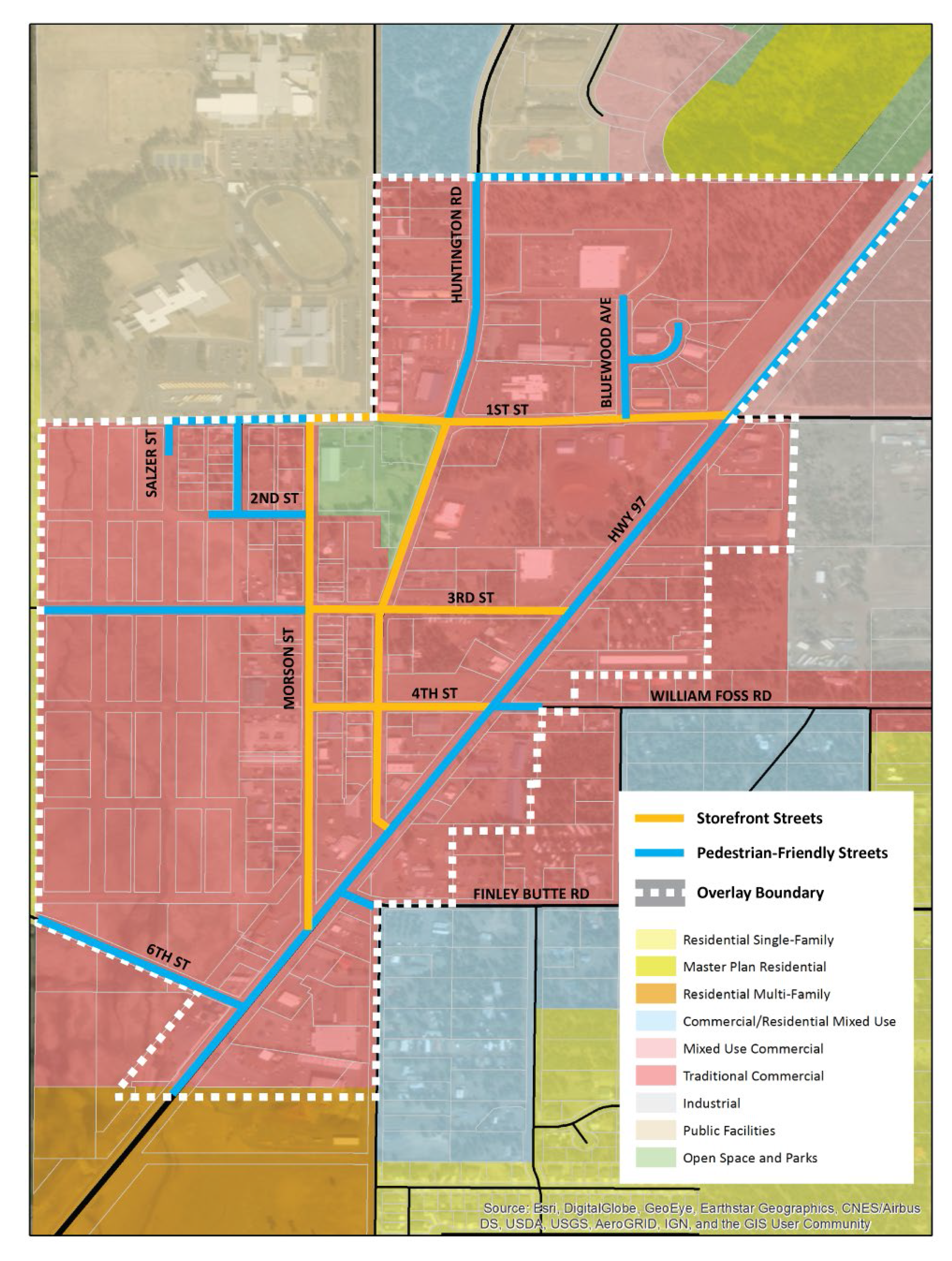
Zone boundary and street designations. The boundaries of the downtown overlay zone are depicted in Figure 15.40-1. The standards of this chapter apply to development and redevelopment on properties within this boundary. Specific standards within this chapter apply to properties abutting streets designated as storefront streets and pedestrian friendly streets, as shown on Figure 15.40-1.
Downtown Overlay Zone Map
B.
New buildings. The standards of this chapter apply to all buildings subject to site plan review that include over 200 square feet in floor area.
C.
Expansions and alterations to existing nonresidential buildings. The standards of this chapter apply to expansions and alterations to nonresidential buildings that are subject to site plan review, in accordance with chapter 15.312. The standards are applicable as follows:
1.
Expansions or additions to nonresidential buildings of over 500 square feet that are visible from a public street or public space are required to be in conformance with the standards of this chapter. The standards only apply to the expansion or addition.
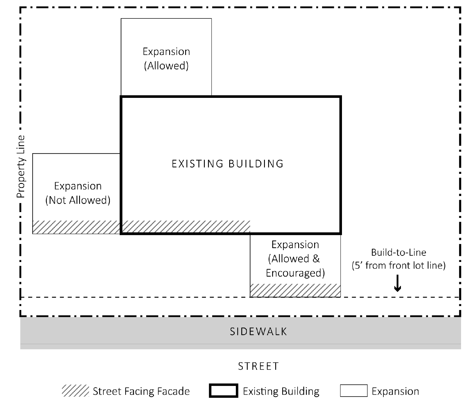
2.
Expansions or additions to nonresidential buildings that front a storefront street must not increase the length of street-facing facade that does not conform to the build-to-line standard and must, to the extent feasible, reduce the area dedicated to parking and vehicular circulation between the building and the right-of-way (See Figure 15.40-2).
3.
Expansions or additions to nonresidential buildings that front a pedestrian-friendly street must, to the extent feasible, reduce the area dedicated to parking and vehicular circulation between the building and the right-of-way.
4.
Exterior alterations or remodels of existing nonresidential buildings that do not conform to the standards for ground floor windows, weather protection, and architectural design must improve compliance with these standards where possible, and at a minimum must not increase nonconformance.
D.
Expansions and alterations to parking and vehicle circulation areas. Expansions or alterations to existing parking and vehicle circulation areas must not increase non-conformity with the standard for location of parking areas (15.40.060.B).
Sec. 15.40.025. - Downtown design exception.
A.
The planning commission may allow exceptions to the design standards in 15.40.060 through 15.40.090 without the need to obtain a variance pursuant to chapter 15.320. For each standard for which a design exception is sought, the applicant must demonstrate that at least one of the following circumstances is met:
1.
The physical characteristics of the site or existing structure (e.g., steep slopes, wetlands, other bodies of water, trees or other significant natural features of the site, buildings or other existing development, utility lines and easements, etc.) make compliance with the standard impractical; or
2.
The alternative design better complies with the following:
a.
The purpose of the Downtown La Pine Overlay as described in section 15.40.010; and
b.
The intent of the standard for which the exception is being sought.
B.
Requests for a downtown design exception are subject to Type III review in accordance with the procedures in article 7. The request may be considered as part of the development application.
Applicability of Build-to-Line Standard for Expansions or Additions on Storefront Streets
Sec. 15.40.030. - Uses.
Uses permitted in the underlying base zone are permitted in the downtown overlay zone, except that the following uses and activities are prohibited on sites abutting a storefront street:
A.
New drive-up and drive-through uses.
B.
New auto sales and service, including fuel stations.
C.
Ground floor residential dwelling units, except for horizontal mixed use where the residential dwelling units are located behind other uses.
Sec. 15.40.040. - Options for required parking.
A.
Credit for on-street parking. The off-street parking standards of chapter 15.86 may be reduced by one parking space for every one on-street parking spaces located adjacent to the subject site, provided the parking spaces meet the dimensional standards of section 15.86.030.
B.
Off-site parking. To allow flexibility in the location of required parking and to encourage efficient utilization of land, required parking may be located up to 800 feet from the development. Such parking shall be designated and signed as assigned to the remote development. Confirmation of the parking assignment shall be required prior to occupancy of the development.
C.
Shared parking. Required parking facilities for two or more uses, structures, or parcels of land may be satisfied by the same parking facilities used jointly, to the extent that the owners or operators show that the need for parking facilities does not materially overlap (e.g., uses primarily of a daytime versus nighttime nature; weekday uses versus weekend uses) or that one of the sites has an excess supply of parking. The right of joint use must be evidenced by a recorded deed, lease, contract, or similar written instrument establishing the joint use. Shared parking requests shall be subject to review and approval through a Type II application.
Sec. 15.40.050. - Summary of design standards.
Table 15.40-1 provides an overview of the design standards that apply within the downtown overlay zone. See the referenced section of this chapter for specific regulations.
Sec. 15.40.060. - Setbacks.
A.
Intent. The intent of the setback standards is to help ensure that buildings are placed close to the sidewalk to create both visual interest and a sense of enclosure or "an outdoor room." Buildings set back from the street with parking next to the sidewalk are less interesting and less comfortable for pedestrians. These standards apply to the primary building(s) on a site (e.g., not to accessory structures).
B.
Front setbacks. No minimum front setback standards apply to developments in the downtown overlay zone.
C.
Location of parking areas. No vehicle parking or circulation areas are permitted between the front of the building and a storefront street or a pedestrian-friendly street (see Figure 15.40-3). If the development site has a frontage on both types of streets, then this standard only applies to the frontage on the storefront street. If the development site has frontage on more than one storefront street, then this standard shall only apply to one storefront street.
D.
Build-to-line standard. Development sites abutting a storefront street must conform to a build-to-line standard (see Figure 15.40-4). The purpose of this standard is to promote a continuous building frontage that creates visual interest and a sense of enclosure on the street. The standard is met when at least 75 percent of the width of the building is located within five feet of the front lot line that faces a storefront street. If the development site has frontage on more than one storefront street, then this standard shall only apply to one storefront street. The city planning official may waive this requirement where it finds that one of the following conditions is met:
1.
The applicant proposes extending an adjacent sidewalk or plaza for public use, or some other pedestrian amenity is proposed to be placed between the building and public right-of-way.
2.
A significant tree or other environmental feature precludes strict adherence to the standard and will be retained and incorporated in the design of the project.
3.
A public utility easement or similar restricting legal condition that is outside the applicant's control makes conformance with the build-to line impossible. In this case, the building shall instead be placed as close to the street as possible given the legal constraint, and pedestrian amenities (e.g., plaza, courtyard, landscaping, outdoor seating area, etc.) shall be provided within the street setback.
No Parking between the Primary Building and a Pedestrian-Friendly or Storefront Streets
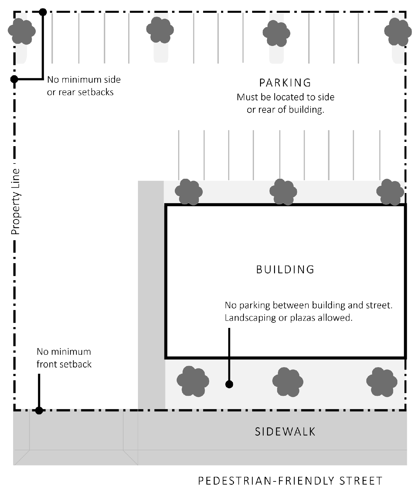
Building Setback Standards on Storefront Streets
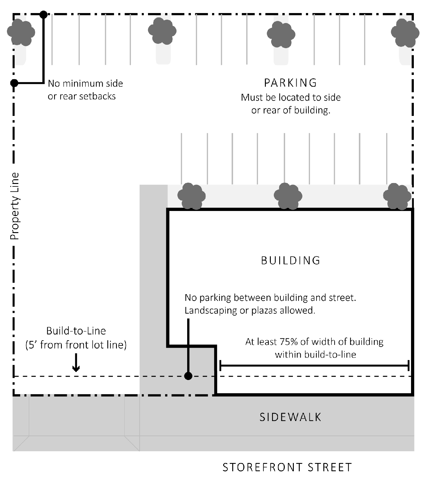
Sec. 15.40.070. - Building entries.
B. [A.]
Intent. These provisions ensure that all entrances to a primary building are visible and connected to the sidewalk by a pedestrian walkway. These features are important when the building is accessed by a pedestrian from the street (rather than from the parking lot). These standards apply to the primary building(s) on a site (e.g., not to accessory structures).
B.
Required walkway. All primary entrances to a building (e.g., tenant entrance, lobby entrance, breezeway entrance, or courtyard entrance) must be connected to the sidewalk by a direct and continuous walkway.
C.
Entry design. The primary building entrances must be architecturally emphasized through the use of one or more of the following features: recessed doorway(s); overhangs or canopies; transom windows; ornamental light fixtures; larger, transparent or more prominent doors; or pilasters or columns that frame the principal doorway.
D.
Entry orientation. All buildings must have at least one primary entrance facing that street (i.e., within 45 degrees of the street property line). For multi-tenanted nonresidential buildings, buildings with multiple entrances, or buildings with multiple frontages, only one primary entrance must comply with this standard. For multi-tenanted residential buildings on storefront streets, all residential units on the ground floor must have a private exterior entrance.
Sec. 15.40.080. - Window and weather protection requirements.
C. [A.]
Intent. Window area or "glazing" requirements ensure that building facades will be composed of windows that provide views of activity, people, and merchandise, creating an interesting pedestrian experience. The weather protection standards are intended to create a more comfortable experience for pedestrians on the sidewalk by providing protection from sun and rain. This standard is limited to storefront streets, where buildings are required to directly front the sidewalk and pedestrian comfort is a high priority. These standards apply to the primary building(s) on a site (e.g., not to accessory structures).
B.
Window requirements.
1.
Minimum window area required for nonresidential buildings.
a.
Building facades facing a pedestrian-friendly street must have windows, display areas, or glass doorways for at least 40 percent of the area of the ground level wall area (see Figure 15.40-5).
b.
Building facades facing a storefront street must have windows, display areas, or glass doorways for at least 60 percent of the area of the ground level wall area (see Figure 15.40-5).
c.
The ground level wall area is the wall area above 30 inches and below 108 inches, as measured from finished grade.
2.
Minimum window area required for residential buildings. Building facades that face a public street must have windows or glass doorways for at least 15 percent of the area of the entire facade.
3.
Transparency. All ground floor windows shall have a visible transmittance of 60 percent or higher.
C.
Weather protection. On building facades facing a storefront street, weather protection for pedestrians must be provided along at least 75 percent of the facade. Weather protection may be an awning, canopy, arcade, colonnade, recessed entry, or some combination of these elements. Where provided, weather protection shall meet the following standards:
a.
Be constructed of glass, metal, or a combination of these materials;
b.
Project at least five feet from the building facade;
c.
Have at least ten feet clearance above the sidewalk;
d.
Match the width of the storefront or the window opening(s); and
e.
Not obscure any existing or proposed transom windows.
Graphic Illustration of Window Area Standards
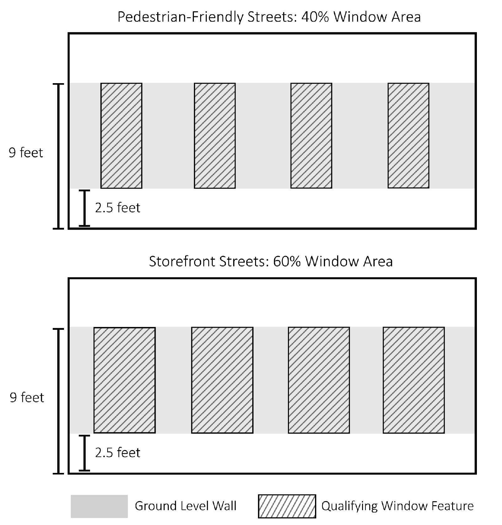
Sec. 15.40.090. - Architectural design standards.
A.
Intent. The facade articulation standards in [subsection] B work together to help ensure that building facades that have variation and depth in the plane of the building in order to create a more interesting and welcoming environment to pedestrians. The screening standard in [subsection] C ensures that mechanical equipment is screened or otherwise minimized so that it does not detract for the pedestrian environment. The materials and Cascadian Style standards in [subsections] D and E are intended to create a distinct brand or identity for Downtown La Pine.
B.
Articulation. All building exterior walls greater than 100 feet in length that orient to a street or public space must have breaks in the wall plane (articulation) of not less than one break for every 40 feet of building length or width, as applicable, as follows:
1.
A "break" is a feature or variation in the wall plane that projects or recedes at least six inches for a length of at least two feet. Breaks may include, but are not limited to, an offset, recess, window reveal, pilaster, frieze, pediment, cornice, parapet, gable, dormer, eave, coursing, canopy, awning, column, building base, balcony, permanent awning or canopy, marquee, or similar architectural feature.
2.
Changes in paint color and features that are not designed as permanent architectural elements, such as display cabinets, window boxes, retractable and similar mounted awnings or canopies, and other similar features, do not meet the break-in-wall-plane standard.
C.
Screening of mechanical equipment.
1.
Building walls. Where mechanical equipment, such as utility vaults, air compressors, generators, antennae, satellite dishes, or similar equipment, is permitted on a building wall that abuts a public right-of-way or civic space, it shall be screened from view from the right-of-way or civic space. Standpipes, meters, vaults, and similar equipment need not be screened but shall not be placed on a front elevation when other feasible alternatives exist; such equipment shall be placed on a side or rear elevation where feasible.
2.
Rooftops. Except as provided below, rooftop mechanical units shall be setback or screened behind a parapet wall so that they are not visible from any public right-of-way or civic space. Where such placement and screening is not feasible, the decision authority may approve painting of mechanical units in lieu of screening; such painting may consist of muted, earth-tone colors that make the equipment visually subordinate to the building and adjacent buildings, if any.
3.
Ground-mounted mechanical equipment. Ground-mounted equipment, such as generators, air compressors, trash compactors, and similar equipment, shall be limited to side or rear yards and screened with fences or walls constructed of materials similar to those on adjacent buildings. Hedges, trellises, and similar plantings may also be used as screens where there is adequate air circulation and sunlight, and irrigation is provided. The city may require additional setbacks and noise dampening equipment for compatibility with adjacent uses.
D.
Materials. Building materials must be consistent with the Cascadian Style.
1.
Primary materials. A primary material is the predominant building material that covers a minimum of 60 percent of the building's exterior walls. Acceptable primary materials are identified in Table 15.40-2.
2.
Secondary materials. A secondary material is not the predominant building material. Any one secondary material shall not cover more than 40 percent of the building's exterior walls. Acceptable secondary materials are identified in Table 15.40-2.
3.
Base materials. The building base shall be defined as the lower portion of a wall just above where it meets ground, to 24 inches above grade. Base materials are identified in Table 15.40-2. Use of these materials shall be limited to the building base unless the material is also identified as an acceptable primary or secondary material. If the base material is identical to material used on the portion of the wall directly above the base, then a change in material color, texture, or a horizontal band must be used to differentiate the base.
E.
Cascadian architectural elements. Building exterior walls facing a public street shall incorporate at least three of the following features. Using these features may also help meet other Development Code requirements, such as those related to building articulation or weather protection:
1.
Exposed, heavy timbers;
2.
Exposed natural wood color beams, posts, brackets and/or trim (e.g., eaves or trim around windows);
3.
Natural wood color shingles used as siding or to accent gable ends (or similar usage);
4.
Metal canopies;
5.
Heavy metal brackets (e.g., cast iron or similar appearance), which may be structural brackets or applied as cosmetic detailing;
6.
Pitched roof over more than 50 percent of the building (roof pitch must have a rise/span ratio of at least 4/12) which is constructed of either metal painted a muted earthtone or other fire resistant material (e.g., no wood shingle roofs are permitted); and
7.
Other similar features.