
La Pine City Zoning Code
ARTICLE 5
DEVELOPMENT STANDARDS
CHAPTER 15.92. - ADDITIONAL STANDARDS FOR LAND DIVISIONS[1]
State Law reference— Subdivisions and other land divisions, ORS 92.010 et seq.
Sec. 15.80.010. - Purpose.
Article 5 contains development and design standards for the built environment. The standards are intended to protect the public health, safety, and welfare through the provision of landscaping and buffering, parking and loading facilities, multimodal accessibility and interconnectivity, and adequate public facilities.
In interpreting and applying this article, the provisions herein shall be held to be the minimum requirements adopted for the promotion of the public health, safety, comfort, convenience, and general welfare.
Sec. 15.80.020. - Applicability.
Any land division or development, and the improvements required therefore, shall be in compliance with the development, design and improvement standards and requirements set forth in this article. Other provisions of this Development Code, other city ordinances, or state statutes or administrative rules may also apply.
Sec. 15.80.030. - Exemption - lot size requirements.
A.
The following exemptions to minimum lot size requirements shall apply:
1.
Non-conforming lots or aggregate of contiguous lots or parcels held in a single ownership has an area or dimensions which do not meet the lot size or dimensional requirements of the applicable zone, the lot or aggregate holdings may be occupied by a use permitted in the zone subject to the other requirements of the zone; providing, however, residential use shall be limited to single-family dwelling unit or to the number of dwelling units consistent with the equivalent densities of the zone.
2.
Any parcel of land or portion thereof, which is to be dedicated to a public, semi-public or public utility for a park, school, road, canal, railroad, utility or other public use shall be exempt from the minimum lot size requirements of this chapter and the applicable zone.
B.
For all other lot size requirements in all other zones, applicants may propose approval of exceptions or variances in accordance with the application requirements in article 8.
Sec. 15.80.040. - Exemption - yard or setback requirements.
The following exemptions to yard or setback requirements are authorized for a lot or use in any zone:
A.
If there is a lot where there are buildings on abutting lots, and the buildings are within 100 feet of the intervening lot, and the buildings have front yards less than the required front yard for the applicable zone, the depth of the front yard for the subject lot need not exceed the average depth of the front yards of the abutting lots.
B.
If there is a building on only one abutting lot within 100 feet with a front yard less than the required front yard for the zone, the front yard of the subject lot need not exceed a depth one-half way between the depth of the yard on the abutting lot and the required front yard of the applicable zone.
C.
Architectural features such as cornices, eaves, sunshades, canopies, gutters, chimneys and flues may project into a required yard two feet, provided that the projection is not closer than three feet to a property line, and, drainage or snowdrift does not flow onto abutting properties or right-of-way, and, fumes from woodstoves are not directed to other properties. Steps, terraces, platforms, patios, decks and porches having no roof covering, and fences not interfering with vision clearance requirements or drainage requirements may be permitted in required yards, except as otherwise limited or provided for by this chapter, or as otherwise approved by the city.
Sec. 15.80.050. - Supplementary height regulations.
The maximum height limitations shall not apply to:
A.
The following principal structures: Church, college, farm structure (other than a farm dwelling), hospital, radio or television tower, exhaust stack, emergency services structure, or public utility structure which is a permitted use and is located in any zone, provided it shall conform to the setback and yard requirements of the zone where it is located plus one additional foot horizontally for each foot over 45 feet in height.
B.
The following appurtenances attached to or part of a principal or accessory structure: Church spire, belfry, cupola, dome, monument, smoke-stack, derrick, conveyor, flag pole, mast, antenna, aerial, roof tank; ventilating air conditioning and similar building service equipment; roof structure, chimney and/or parapet wall, provided it shall be set back in conformance with the setback and yard requirements plus one foot horizontally for each foot in which it exceeds 45 feet in height above ground level. The principal or accessory structure to which it is attached may conform to setback and yard requirements with no additional setback provided the principal or accessory structure conforms to the height limitations of the zone.
Sec. 15.80.060. - Restrictions on the use of metal shipping containers.
Except as specified below, metal shipping containers shall not be placed on-site:
A.
In residential zones, no metal shipping containers shall be utilized as a dwelling at any time, or as storage structures for greater than 30 days.
B.
In commercial zones, metal shipping containers shall not be placed on-site, with the exception of short-term use for construction or relocations (30 days or less), or in the case of construction; 30 days after a certificate of occupancy has been issued.
C.
In industrial zones, metal shipping containers are permitted for storage uses.
Sec. 15.82.010. - Landscaping and buffering requirements.
The following minimum landscape requirements are established for all developments subject to site plan approval, unless approved otherwise by the reviewing authority:
A.
Exemption. The provisions of this section may be exempted for uses existing on or before the effective date of this Development Code that are a permitted use in a specific zone in an existing building or buildings on a lot or parcel of land of the scale that there is no remaining room for landscaping; this exemption shall also apply to the exterior remodeling and/or expansion of not more than 25 percent of the total square footage of all enclosed structures on a lot or parcel existing under a unit ownership on or before the effective date of this Development Code.
B.
Area required. Except as approved otherwise by the city, the following minimum percent of a parcel area shall be landscaped for the following uses:
1.
Duplexes and triplexes: 25 percent.
2.
Multi-family developments containing four or more units and commercial residential mixed uses (CRMX): 20 percent.
3.
Commercial uses including mixed use commercial (CMX): 15 percent.
4.
Industrial uses. A minimum five-foot landscaped buffer along any adjoining public right-of-way of a collector or arterial street or highway, which may be computed toward an overall requirement of ten percent.
5.
Minimum area requirements may include landscaping around buildings, in parking and loading areas, outdoor recreational use areas, screening and buffering areas, and surface water drainage areas.
C.
Landscaping defined. Required landscaping may include, but is not limited to, a combination of any of the following materials: living plant material such as trees, shrubs, groundcover, flowers and lawn (including native vegetation); and nonliving materials such as benches, walkways and courtyards, consisting of brick, decorative rock or other decorative materials. The total amount of nonliving materials (including bark dust, chips, aggregate, or other non-plant ground covers) shall not exceed more than 50 percent of the required landscape area.
D.
Existing vegetation. Existing site vegetation shall be utilized to the maximum extent possible consistent with building placement and the applicable proposed landscape plan.
E.
Parking lots. Parking lots with space for ten or more vehicles must be landscaped in accordance with the following minimum requirements:
1.
In commercial and residential developments, parking areas shall be divided into bays, and between or at the end of each parking bay a curbed planter containing at least 16 square feet may be required.
2.
If required, each planter shall contain at least one tree or shrub and ground cover.
3.
The areas shall be designed to be protected from being damaged by vehicles using the parking area.
4.
Unless sidewalks are provided adjacent to a structure, customer or resident parking areas should be separated from the exterior wall of a commercial or residential structure by a minimum five-foot strip of landscaping.
5.
Where a parking, loading or driveway area serving a multi-family, commercial, industrial or government use abuts a public right-of-way of a collector or arterial street or a local street across from a residential zone, or abuts a residential zone, a screen planting or other approved landscaped planter strip may be required between the parking area and the right-of-way without encroaching into a clear vision area or sidewalk.
F.
Buffering and screening.
1.
Purpose. The purpose of buffering and screening requirements are to reduce the impacts of a proposed use on adjacent uses and zones which provide for different types of uses. The city may waive or reduce the requirements where existing topography or vegetation is appropriate or otherwise negates the effectiveness or intended purpose or benefits of the buffering and screening.
2.
Where any permitted principal and/or accessory use in a commercial or industrial zone abuts any land zoned RSF, RMF, RMP or TA the following buffer and screening shall be required. These requirements shall apply in instances where such use is being newly developed on vacant land, expanded in floor area by 50 percent or greater, or removed and a new use developed.
3.
Within commercial zones. A buffer strip at least ten feet wide shall be provided and maintained along the entire length of a side or rear yard where it abuts an RSF, RMF, RMP, or TA zone. Buffer strips shall not be used for parking, storage of vehicles, equipment, or materials, nor for any other use incompatible with their purpose as a visual, noise, dust, and pollution barrier. The buffer strip shall contain suitable screening, defined as either of the following:
a.
A solid fence or wall, architecturally compatible with existing structures in the area, no less than five feet nor more than eight feet in height; or
b.
A sight-obscuring planting of evergreens, not less than four feet in height at the time of planting and of a variety that will maintain full, dense growth from the ground up to a height of not less than six feet upon maturity, planted at a spacing of the lesser of eight feet or the diameter of a mature specimen of the species being planted.
c.
Areas of the buffer strip not covered with a fence, wall, or screening plantings, shall be planted with appropriate ground cover vegetation, including native species. Xeriscape methods are highly encouraged.
d.
Installation and maintenance of the buffer and screening shall be the responsibility of the owner of the property on which the "C" type zone permitted use is located. Installation must be completed prior to issuance of a certificate of use and occupancy by the city. Fences or walls must be maintained in safe and structurally sound condition. Dead or diseased plants shall be removed and replaced in a timely manner. Grass shall be kept neatly mowed.
4.
Within industrial zones. A buffer strip at least 30 feet wide shall be provided and maintained along the entire length of a side or rear yard where it abuts any RSF, RMF, RMP, or TA zoned land. Buffer strips shall not be used for parking, storage of vehicles, equipment, or materials, nor for any other use incompatible with their purpose as a visual, noise, dust, and pollution barrier. The buffer shall meet the following standards:
a.
The buffer shall be planted with evergreens capable of obtaining and maintaining a dense growth to a full height and a full canopy diameter of no less than 12 feet. The minimum height at the time of planting shall be six feet. Plants shall be situated in two rows within the buffer strip, each row being located at least ten feet from the edge of the buffer strip. Plants in each row shall be spaced no more than 20 feet center-to-center and the two rows shall be situated in an alternating pattern so that the trees in one row are located centrally between the trees in the other row. Plants shall be allowed to obtain a minimum height of 12 feet and shall not be trimmed below that height thereafter.
b.
Installation and maintenance of the buffer and screening shall be the responsibility of the owner of the property on which the industrial use is located. Installation must be completed prior to issuance of a certificate of use and occupancy by the city. Dead or diseased plants shall be removed and replaced in a timely manner. Xeriscape methods and use of native species is highly encouraged.
c.
A property owner may not sell, lease, or otherwise transfer property if such action results in a reduction of a separation distance for a commercial or light manufacturing use below the minimum required in this section. Likewise, a property owner may not remove or alter natural vegetation or landforms serving upon a waiver from the city as buffer and screening for a commercial or light manufacturing use if such action results in the natural buffer and screening being less effective than as required in this and other sections of this Development Code.
5.
A buffer or screening area may only be occupied by screening utilities and landscaping materials, but the same may be located within the required yard or setback requirements provided vision clearance requirements are complied with.
6.
In lieu of the foregoing requirements, an applicant may provide for landscaping and screening, including plantings, fences, walls, walks and other features designed to afford the same degree of buffering as the standards above. A plan and specifications for an alternative shall be reviewed and approved by the review authority.
G.
Plant material installation standards. Except as otherwise approved by the city, the following standards shall apply to plant materials and the installation thereof as provided in accordance with the provisions of this section:
1.
Landscape plant materials shall be properly guyed and staked, and shall not interfere with vehicular or pedestrian traffic or parking and loading.
2.
Trees shall be a minimum size of six feet in height and be fully branched at the time of planting.
3.
Shrubs shall be supplied in one-gallon containers or six-inch burlap balls with a minimum spread of 12 inches.
4.
Rows of plants should be staggered to provide for more effective coverage.
H.
Maintenance and plant survival. All landscaping approved or required as a part of a development plan shall be continuously maintained, including necessary watering, weeding, pruning and replacement of plant materials. Except where the applicant proposes landscaping consisting of drought-resistant plantings and materials that can be maintained and can survive without irrigation, landscaped areas shall be irrigated. If plantings fail to survive, it is the responsibility of the property owner to replace them.
I.
Retention of trees. As part of a landscaping plan, the developer shall also provide a tree plan identifying the location and diameter breast height (DBH) of all trees on the property. Existing mature trees with at least a 10-inch DBH shall be retained to the furthest extent possible. Development shall conform to the natural environment to incorporate existing mature trees. Where trees must be removed for proposed development, they shall be replaced at a 1:1 ratio on the subject lot or parcel with trees of similar species that are native to the region, and with a DBH of at least five inches or larger. Replacement trees shall meet the maintenance and plant survival criteria of this code section. Any trees planted must maintain a 20-foot radius for spacing. The 20-foot radius spacing shall be the determining factor in how many trees are replaced on the subject property. If more trees must be planted than what the 20-foot radius spacing would allow, then the number of trees replaced shall be reduced to meet the spacing standard.
(Ord. No. 2024-02, § 7(exh. F), 12-11-2024)
Sec. 15.82.020. - Fences and walls.
The yard and setback requirements of this Development Code shall not be deemed to restrict any otherwise lawful fence, wall, or sign, provided that no fence, wall, or sign shall be located on any right-of-way of a public road.
A.
Materials. Fences and walls shall not be constructed of nor contain any material that could cause bodily harm, such as barbed wire, broken glass, spikes, or any other hazardous or dangerous materials, except as provided below.
1.
Barbed wire fences intended to contain or restrict cattle, sheep, horses or other livestock, are permitted in any zone where the keeping of livestock is permitted.
2.
Electric fences are permitted in any zone where the keeping of livestock is permitted, provided the following standards are met:
a.
The fence product shall be listed by a State of Oregon approved testing laboratory.
b.
The fence shall be installed and used in accordance with the testing laboratory listing.
c.
Electrical permits and inspections shall be required for the installation.
d.
Warning signs which notify individuals of a dangerous fence shall be posted on the fence, at intervals not to exceed 50 feet. The statement, DANGER - Electrified Fence, or an equivalent statement, shall be on the warning signs.
e.
The fence must be located outside any front yard setback and required landscaping, buffering or screening areas.
B.
Standards.
1.
Every fence shall be maintained in a condition of reasonable repair and shall not be allowed to become and remain in a condition of disrepair including noticeable leaning, missing sections, broken supports, non-uniform height, and uncontrolled growth of vegetation.
2.
All required swimming pool and hot tub fencing shall be a minimum of four feet in height and be equipped with a self-locking gate that closes automatically.
3.
Fences within a front or street side yard shall also conform to the clear vision requirements at intersections, which further restrict the use or height of sight-obscuring fences.
4.
In no instance shall a fence extend beyond the property line including into a public right-of-way. It is the responsibility of the property owner to determine the property line.
5.
Within residential and commercial zones, fences within the required front yard setback may not exceed four feet in height except that one incidental garden structure (e.g., arbor or gate) not exceeding eight feet in height and six feet in width is allowed within the required front yard provided it does not encroach into a required clear vision area. All other fences in all zones shall not exceed seven feet in height.
6.
Other provisions of this Development Code, or the requirements of the roadway authority, may limit allowable height of a fence or wall below the height limits of this section.
Sec. 15.86.010. - Applicability.
Off-street loading and vehicle and bicycle parking spaces shall be provided in accordance with the specifications of this chapter in all zones whenever any new use is established, an existing use is enlarged, or an existing use of land or structure is changed to a new use. Such new, enlarged, or changed use shall fully comply with the specifications of this chapter prior to being given a certificate of use and occupancy.
Sec. 15.86.020. - Off-street loading.
A.
Every commercial and industrial use which requires the receipt or distribution of material or merchandise by trucks with a 40-foot or longer wheelbase at a frequency of one or more vehicles per week shall provide off-street loading spaces in sufficient number to adequately serve the number and frequency of vehicle shipping and receiving projected for the use. The applicant shall provide supporting evidence of the projected shipping and receiving and how the number of spaces to be provided will be adequate.
B.
Where an off-street loading space is required, it shall be large enough to accommodate the largest vehicle that is expected to serve the use without obstructing vehicles or pedestrian traffic on adjacent streets and driveways. Each off-street loading space shall not be less than 12 feet wide by 55 feet long unless otherwise approved by the city through site design review.
C.
Off-street loading space(s) shall also have adequate adjacent area for vehicle maneuvering so that vehicles using the space(s) are not required to back-up onto or back-up from a public street or alley to use the space. Where parking areas are prohibited between a building and the street, loading areas are also prohibited.
D.
Exceptions and adjustments. The city, through site design review, may approve a loading area adjacent to or within a street right-of-way where it finds that loading and unloading operations are short in duration (i.e., less than one hour), infrequent, do not obstruct traffic during peak traffic hours, do not interfere with emergency response services, and are acceptable to the applicable roadway authority.
Sec. 15.86.030. - Off-street parking - required.
A.
Location of off-street loading and parking spaces. Except as otherwise permitted by this Development Code, required off-street loading and parking spaces shall be located on the same lot with the principal use they are intended to serve. In no case shall a required loading space be part of the area used to satisfy the parking requirements and vice versa. Also, in no case shall the required loading or parking space(s) of one use be used to satisfy the loading or parking space requirements of another use.
B.
Encroachment or reduction. A required loading or parking space shall not be encroached upon by a structure, storage, or other use, nor shall the number of spaces be reduced without replacement of a commensurate number of spaces in accordance with this section unless a special exception or variance has been approved.
C.
Calculations of amounts of required and allowed parking.
1.
When computing parking spaces based on floor area, parking structures and non-leasable floor spaces, such as storage closets, mechanical equipment rooms, and similar spaces, are not counted.
2.
The number of parking spaces is computed based on the primary uses on the site except as stated in subsection 3, below. When there are two or more separate primary uses on a site, the minimum and maximum parking for the site is the sum of the required or allowed parking for the individual primary uses. For shared parking, see subsection I below.
3.
When more than 20 percent of the floor area on a site is in an accessory use, the required or allowed parking is calculated separately for the accessory use. An example would be a 10,000 square foot building with a 7,000 square foot warehouse and a 3,000 square foot accessory retail area. The minimum and maximum parking would be computed separately for the retail and warehouse uses.
D.
Use of required parking spaces. Except as otherwise provided by this section, required parking spaces must be available for residents, customers, or employees of the use. Fees may be charged for the use of required parking spaces. Required parking spaces may not be assigned in any way to a use on another site, except for shared parking pursuant to subsection I.
E.
Improvement of parking areas. Motorized vehicle parking is allowed only on streets with an improved shoulder of sufficient width; within garages, carports, and other approved structures; and on driveways or parking lots that have been developed in conformance with this Development Code.
F.
Minimum number of off-street automobile parking spaces. Except as required for Americans with Disabilities Act compliance under subsection L, off-street parking shall be provided pursuant to one of the following three standards:
1.
The standards in Table 15.86-1;
2.
A standard from Table 15.86-1 for a use that the planning official determines is similar to the proposed use. For uses not specified in the table, the city shall determine parking based on submission of technical data from applicant or city sources; or
3.
Subsection (H), parking exceptions, which includes a parking demand analysis option.
G.
Maximum number of off-street automobile parking spaces. The following standards for maximum number of automobile parking spaces promote efficient use of land and compact development patterns.
1.
Applicability. Developments subject to site plan review must conform to the maximum parking standards.
2.
Standards. Unless otherwise approved by the city through site plan review, the maximum number of off-street automobile parking spaces allowed for a commercial development equals the minimum number of required spaces, pursuant to Table 15.86-1 times a factor of 2.0. Parking spaces that are located in snow storage areas do not count toward the maximum parking space requirements.
H.
Exceptions and reductions to off-street parking. An applicant may propose a parking standard that is different than the standards under subsections F or G, for review and action by the planning official through a Type II procedure. The applicant's proposal shall consist of a written request and a parking analysis prepared by a qualified professional. The parking analysis, at a minimum, shall assess the average parking demand and available supply for existing and proposed uses on the subject site; opportunities for shared parking with other uses in the vicinity; existing public parking in the vicinity; transportation options existing or planned near the site, such as frequent bus service, carpools, or private shuttles; and other relevant factors. The number of required off-street parking spaces may also be reduced through the provision of shared parking, pursuant to subsection I.
I.
Shared parking. Required parking facilities for two or more uses, structures, or parcels of land may be satisfied by the same parking facilities used jointly, to the extent that the owners or operators show that the need for parking facilities does not materially overlap (e.g., uses primarily of a daytime versus nighttime nature; weekday uses versus weekend uses), and, provided that the right of joint use is evidenced by a recorded deed, lease, contract, or similar written instrument establishing the joint use. Shared parking requests shall be subject to review and approval through site plan review.
J.
Parking stall design and minimum dimensions. Where a new off-street parking area is proposed, or an existing off-street parking area is proposed for expansion, the entire parking area shall be improved in conformance with this Development Code. At a minimum the parking spaces and drive aisles shall be paved with asphalt, concrete, or other city-approved materials, provided the Americans with Disabilities Act requirements are met, and shall conform to the minimum dimensions in Table 15-86-2 and the figures below. All off-street parking areas shall contain wheel stops, perimeter curbing, bollards, or other edging as required to prevent vehicles from damaging buildings or encroaching into walkways, landscapes, or the public right-of-way. Parking areas shall also provide for surface water management.
K.
Adjustments to parking area dimensions. The dimensions in subsection (J) are minimum standards. The city planning official, through a Type II procedure, may adjust the dimensions based on evidence that a particular use will require more or less maneuvering area.
L.
Americans with Disabilities Act (ADA). Parking shall be provided consistent with ADA requirements, including, but not limited to, the minimum number of spaces for automobiles, van-accessible spaces, location of spaces relative to building entrances, accessible routes between parking areas and building entrances, identification signs, lighting, and other design and construction requirements.
Sec. 15.86.040. - Drive-up and drive-through uses and facilities.
A.
Purpose. Where drive-up or drive-through uses and facilities are allowed, they shall conform to all of the following standards, which are intended to calm traffic, provide for adequate vehicle queuing space, prevent automobile turning movement conflicts, and provide for pedestrian comfort and safety.
B.
Standards. Drive-up and drive-through facilities (i.e., driveway queuing areas, customer service windows, teller machines, kiosks, drop-boxes, or similar facilities) shall meet all of the following standards:
1.
The drive-up or drive-through facility shall orient to and receive access from a driveway that is internal to the development and not a street, as generally illustrated.
2.
The drive-up or drive-through facility shall not be oriented to street corner.
3.
The drive-up or drive-through facility shall not be located within 20 feet of a street right-of-way.
4.
Drive-up and drive-through queuing areas shall be designed so that vehicles will not obstruct any street, fire lane, walkway, bike lane, or sidewalk.
5.
All drive up and drive thru facilities must be permanently affixed to the ground and be connected to the city water and sewer in accordance with the standards of chapter 15.90.
(Ord. No. 2024-02, § 8(exh. G), 12-11-2024)
Sec. 15.86.050. - Bicycle parking.
A.
Exemptions. This section does not apply to single-family and duplex housing, home occupations, and agricultural uses. The planning official may exempt other uses upon finding that, due to the nature of the use or its location, it is unlikely to have any patrons or employees arriving by bicycle.
B.
Standards. Bicycle parking spaces shall be provided with new development and, where a change of use occurs, at a minimum, shall follow the standards in Table 15.86-3. Where an application is subject to conditional use permit approval or the applicant has requested a reduction to an automobile-parking standard, the city may require bicycle parking spaces in addition to those in Table 15.86-3.
C.
Design. Bicycle parking shall consist of staple-design steel racks or other city-approved racks, lockers, or storage lids providing a safe and secure means of storing a bicycle. At a minimum, bicycle parking facilities shall be consistent with the following design guidelines:
1.
All bicycle parking shall be within 100 feet from a building entrance and located within a well-lit and clearly visible area;
2.
Bicycle parking shall be convenient and easy to find. Where necessary, a sign shall be used to direct users to the parking facility;
3.
Each bicycle parking space shall be at least two feet by six feet with a vertical clearance of six feet;
4.
An access aisle of at least five feet shall be provided in each bicycle parking facility;
5.
Bicycle parking facilities shall offer security in the form of either a lockable enclosure in which the bicycle can be stored or a stationary object, i.e., a "rack," upon which the bicycle can be locked. Structures that require a user-supplied lock shall accommodate both cables and U-shaped locks and shall permit the frame and both wheels to be secured (removing the front wheel may be necessary). Note: businesses may provide long-term, employee parking by allowing access to a secure room within a building.
D.
Hazards. Bicycle parking shall not impede or create a hazard to pedestrians or vehicles, and shall be located so as to not conflict with the vision clearance standards of section 15.88.040.
Sec. 15.86.060. - Snow storage areas.
A.
Purpose. The purpose of these standards is to ensure that adequate space is be provided within a development for storage of snow in winter months in order to accommodate space needed for access, circulation, and off-street parking.
B.
Applicability. Snow storage standards apply to all subdivisions and to developments subject to site plan review.
C.
Standards.
1.
Minimum area. Snow storage areas must be designated on a site plan. The areas must total a minimum of 15 percent of the area to be cleared, including all access drives, parking areas, and walkways.
2.
Location. Snow storage is not permitted on landscaped areas, except where these areas are limited to grass or rock cover. Snow storage may be permitted in parking areas, provided that the site can still accommodate enough parking spaces to meet minimum off-street parking requirements in winter months. Parking spaces that are located in snow storage areas do not count toward the maximum parking space requirements. It is encouraged that snow storage areas be located away from public view and that additional impervious surface areas are not created for the sole purpose of snow storage.
3.
Exceptions and adjustments. The city may reduce or eliminate the required snow storage areas if a snow removal plan is presented which provides a continuous guarantee of removal.
Sec. 15.88.010. - Purpose.
Chapter 15.88 contains standards for vehicular and pedestrian access, circulation, and connectivity. The standards promote safe, reasonably direct, and convenient options for walking and bicycling, while accommodating vehicle access to individual properties, as needed.
Sec. 15.88.020. - Applicability.
Chapter 15.88 applies to new development and changes in land use necessitating a new or modified street or highway connection. Except where the standards of a roadway authority other than the city supersede city standards, chapter 15.88 applies to all connections to a street or highway, and to driveways and walkways.
Sec. 15.88.030. - Vehicular access and circulation.
A.
Purpose and intent.Section 15.88.030 implements the street access guidelines of the City of La Pine Transportation System Plan. It is intended to promote safe vehicle access and egress to properties, while maintaining traffic operations in conformance with adopted standards. "Safety," for the purposes of this chapter, extends to all modes of transportation.
B.
Permit required. Vehicular access to a public street (e.g., a new or modified driveway connection to a street or highway) requires an approach permit approved by the applicable roadway authority.
C.
Traffic study requirements. The city, in reviewing a development proposal or other action requiring an approach permit, may require a traffic impact analysis, pursuant to section 15.90.080, to determine compliance with this Development Code.
D.
Approach and driveway development standards. Access management restrictions and limitations consist of provisions managing the number of access points and/or providing traffic and facility improvements that are designed to maximize the intended function of a particular street, road or highway. The intent is to achieve a balanced, comprehensive program which provides reasonable access as new development occurs while maintaining the safety and efficiency of traffic movement. Intersections, approaches and driveways shall conform to access spacing guidelines in the City of La Pine Transportation System Plan and the roadway authority's engineering standards. In the review of all new development, the reviewing authority shall consider the following techniques or considerations in providing for or restricting access to certain transportation facilities.
1.
Access points to arterials and collectors may be restricted through the use of the following techniques:
a.
Restricting spacing between access points based on the type of development and the speed along the serving collector or arterial.
b.
Sharing of access points between adjacent properties and developments.
c.
Providing access via a local order of street; for example, using a collector for access to an arterial, and using a local street for access to a collector.
d.
Constructing frontage or marginal access roads to separate local traffic from through traffic.
e.
Providing service drives to prevent overflow of vehicle queues onto adjoining roadways.
2.
Consideration of the following traffic and facility improvements for access management:
a.
Providing of acceleration, deceleration and right-turn-only lanes.
b.
Offsetting driveways to produce T-intersections to minimize the number of conflict points between traffic using the driveways and through traffic.
c.
Installation of median barriers to control conflicts associated with left turn movements.
d.
Installing side barriers to the property along the serving arterial or collector to restrict access width to a minimum.
E.
ODOT approval. Where a new approach onto a state highway or a change of use adjacent to a state highway requires ODOT approval, the applicant is responsible for obtaining ODOT approval. The city may approve a development conditionally, requiring the applicant first obtain required ODOT permit(s) before commencing development, in which case the city will work cooperatively with the applicant and ODOT to avoid unnecessary delays.
F.
Other agency approval. Where an approach or driveway crosses a drainage ditch, canal, railroad, or other feature that is under the jurisdiction of another agency, the applicant is responsible for obtaining all required approvals and permits from that agency prior to commencing development.
G.
Exceptions and adjustments. The city may approve adjustments to the spacing standards of subsections above, where an existing connection to a city street does not meet the standards of the roadway authority and the proposed development moves in the direction of code compliance.
H.
Joint use access easement and maintenance agreement. Where the city approves a joint use driveway, the property owners shall record an easement with the deed allowing joint use of and cross access between adjacent properties. The owners of the properties agreeing to joint use of the driveway shall record a joint maintenance agreement with the deed, defining maintenance responsibilities of property owners. The applicant shall provide a fully executed copy of the agreement to the city for its records, but the city is not responsible for maintaining the driveway or resolving any dispute between property owners.
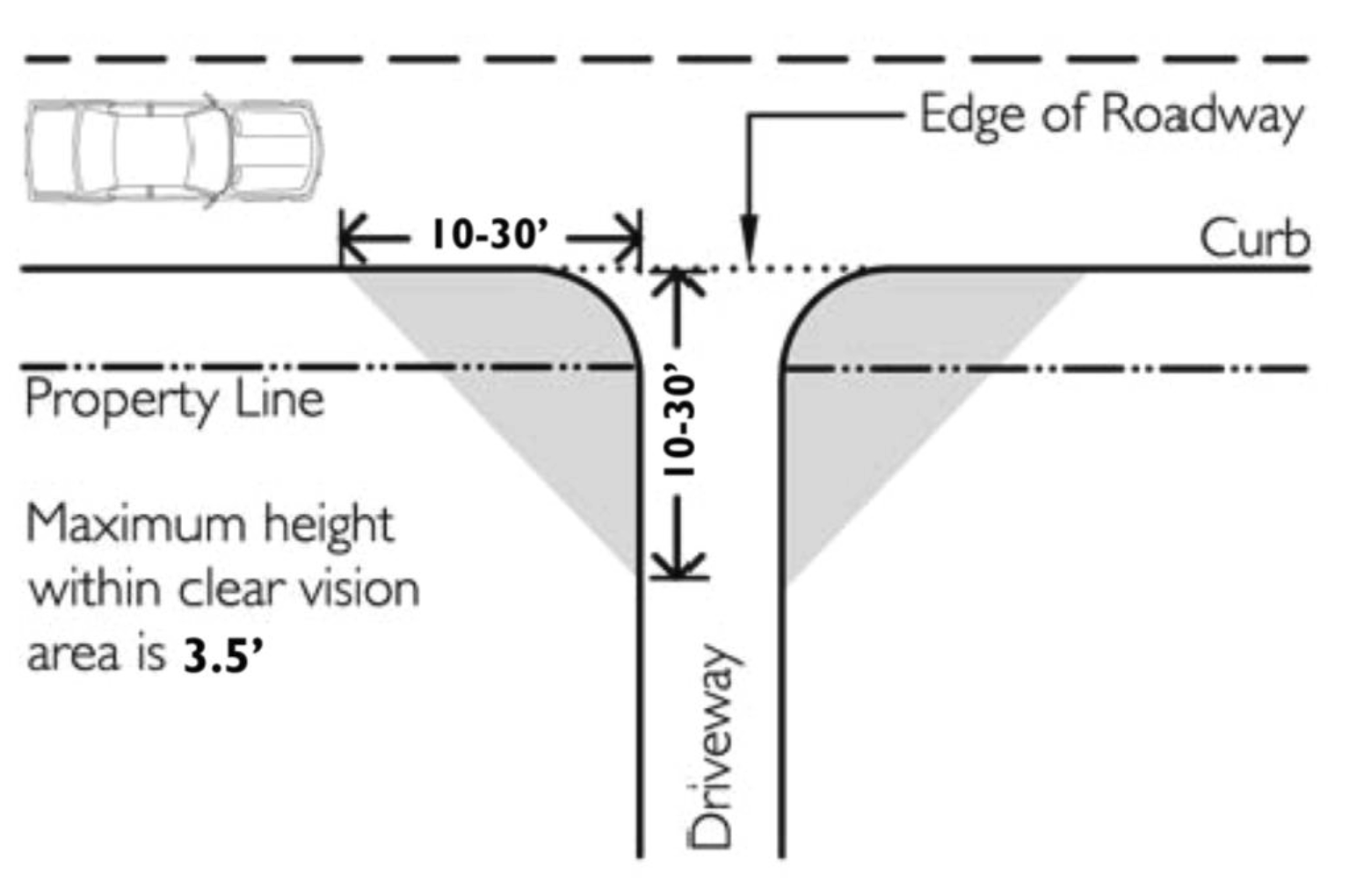
Sec. 15.88.040. - Clear vision areas (visibility at intersections).
A.
In all zones, a clear vision area shall be maintained on the corners of all property at the intersection of two streets or a street and a railroad. A clear vision area shall contain no planting, wall, structure, private signage, or temporary or permanent obstruction exceeding 3½ feet in height, measured from the top of the curb or, where no curb exists, from the established street centerline grade, except that trees exceeding this height may be located in this area provided all branches and foliage are removed to a height of eight feet above the grade.
B.
A clear vision area shall consist of a triangular area on the corner of a lot at the intersection of two streets or a street and a railroad (see Figure 18.88-1). Where lot lines have rounded corners, the specified distance is measured from a point determined by the extension of the lot lines to a point of intersection. The third side of the triangle is the line connecting the ends of the measured sections of the street lot lines. The following measurements shall establish clear vision areas within the city:
1.
In an agricultural, forestry or industrial zone, the minimum distance shall be 30 feet; or at intersections including an alley, ten feet.
2.
In all other zones, the minimum distance shall be in relationship to street and road right-of-way widths as follows:
Clear Vision Areas
Sec. 15.88.050. - Pedestrian access and circulation.
A.
Purpose and intent. This section implements the pedestrian access and connectivity policies of City of La Pine Transportation System Plan and the requirements of the Transportation Planning Rule (OAR 660-012). It is intended to provide for safe, reasonably direct, and convenient pedestrian access and circulation.
B.
Standards. New subdivisions, multi-family developments, planned developments, commercial developments and institutional developments shall conform to all of the following standards for pedestrian access and circulation:
1.
Continuous walkway system. A pedestrian walkway system shall extend throughout the development site and connect to adjacent sidewalks, if any, and to all future phases of the development, as applicable.
2.
Safe, direct, and convenient. Walkways within developments shall provide safe, reasonably direct, and convenient connections between primary building entrances and all adjacent parking areas, recreational areas, playgrounds, and public rights-of-way conforming to the following standards:
a.
The walkway is reasonably direct. A walkway is reasonably direct when it follows a route that does not deviate unnecessarily from a straight line or it does not involve a significant amount of out-of-direction travel.
b.
The walkway is designed primarily for pedestrian safety and convenience, meaning it is reasonably free from hazards and provides a reasonably smooth and consistent surface and direct route of travel between destinations. The city may require landscape buffering between walkways and adjacent parking lots or driveways to mitigate safety concerns.
c.
Vehicle/walkway separation. Except as required for crosswalks, per subsection d., below, where a walkway abuts a driveway or street it shall be raised six inches and curbed along the edge of the driveway or street. Alternatively, the city may approve a walkway abutting a driveway at the same grade as the driveway if the walkway is physically separated from all vehicle-maneuvering areas. An example of such separation is a row of bollards (designed for use in parking areas) with adequate minimum spacing between them to prevent vehicles from entering the walkway.
d.
Crosswalks. Where a walkway crosses a parking area or driveway ("crosswalk"), it shall be clearly marked with contrasting paving materials (e.g., pavers, light-color concrete inlay between asphalt, or similar contrasting material). The crosswalk may be part of a speed table to improve driver-visibility of pedestrians.
e.
Walkway construction. Walkway surfaces may be concrete, or other city-approved durable surface meeting ADA requirements. Walkways shall be not less than six feet in width, except that the city may require wider; sidewalks in developments where pedestrian traffic warrants walkways wider than six feet.
f.
Multi-use pathways. Multi-use pathways, where approved, shall be ten feet wide and constructed of asphalt, concrete or other city-approved durable surface meeting ADA requirements consistent with the applicable city engineering standards.
(Ord. No. 2024-02, § 9(exh. H), 12-11-2024)
Sec. 15.90.010. - Public facilities improvement.
Minor betterment, improvements, replacement or reconstruction of existing public facilities such as sewer and water lines, stormwater drainage facilities, sidewalks and other pedestrian ways or facilities, bikeways and similar public facilities within rights-of-ways and easements for the purposes existing on or before the effective date of this chapter, or on contiguous publicly-owned property designated, intended or utilized to support the facilities, or the facilities that are set forth within an adopted public facilities plan or other capital improvement plan duly adopted on or before the effective date of this ordinance, are exempt from permit requirements, unless specifically set forth otherwise.
Sec. 15.90.020. - Developer responsibility for streets and other public facilities.
A.
Duties of developer. It shall be the responsibility of the developer to construct all streets, curbs, sidewalks, sanitary sewers, storm sewers, water mains, electric, telephone and cable television lines necessary to serve the use or development in accordance with the specifications of the city and/or the serving entity.
B.
Over-sizing. The city may require as a condition of development approval that sewer, water, or storm drainage systems serving new development be sized to accommodate future development within the area as projected by the applicable facility master plan, and the city may authorize other cost-recovery or cost-sharing methods as provided under state law.
C.
Inadequate existing streets. Whenever existing streets, adjacent to, within a tract or providing access to and/or from a tract, are of inadequate width and/or improvement standards, additional right-of-way and/or improvements to the existing streets may be required.
D.
Half streets. Half streets, while generally not acceptable, may be approved where essential to the reasonable development of a proposed land development, and when the city finds it will be practical to require dedication and improvement of the other half of the street when the adjoining property is developed. Whenever a half street exists adjacent to a tract of land proposed for development, the other half of the street shall be dedicated and improved.
Sec. 15.90.030. - Sewer and water.
A.
Sewer and water plan approval. Development permits for sewer and water improvements shall not be issued until the public works director has approved all sanitary sewer and water plans in conformance with city standards.
B.
Inadequate facilities. Development permits may be restricted or rationed by the city where a deficiency exists in the existing water or sewer system that cannot be rectified by the development and which, if not rectified, will result in a threat to public health or safety, surcharging of existing mains, or violations of state or federal standards pertaining to operation of domestic water and sewerage treatment systems. The city may require water booster pumps, sanitary sewer lift stations, and other critical facilities be installed with backup power.
Sec. 15.90.040. - Stormwater.
A.
Accommodation of upstream drainage. Culverts and other drainage facilities shall be large enough to accommodate existing and potential future runoff from the entire upstream drainage area, whether inside or outside the development. Such facilities shall be subject to review and approval by the city engineer.
B.
Effect on downstream drainage. Where it is anticipated by the city engineer that the additional runoff resulting from the development will overload an existing drainage facility, the city shall withhold approval of the development until provisions have been made for improvement of the potential condition or until provisions have been made for storage of additional runoff caused by the development in accordance with city standards.
Sec. 15.90.050. - Utilities.
A.
General provision. The developer of a property is responsible for coordinating the development plan with the applicable utility providers and paying for the extension and installation of utilities not otherwise available to the subject property.
B.
Underground utilities. All new electrical, telephone or other utility lines shall be underground unless otherwise approved by the city.
C.
Subdivisions. In order to facilitate underground placement of utilities, the following additional standards apply to all new subdivisions:
1.
The developer shall make all necessary arrangements with the serving utility to provide the underground services. Care shall be taken to ensure that no above ground equipment obstructs vision clearance areas for vehicular traffic.
2.
The city reserves the right to approve the location of all surface-mounted facilities.
3.
All underground utilities installed in streets must be constructed and approved by the applicable utility provider prior to the surfacing of the streets.
4.
Stubs for service connections shall be long enough to avoid disturbing the street improvements when service connections are made.
D.
Exception to undergrounding requirement. The city may grant exceptions to the undergrounding standard where existing physical constraints, such as geologic conditions, streams, or existing development conditions make underground placement impractical.
Sec. 15.90.060. - Public street/highway improvement.
The following public streets and highway improvement activities are permitted outright in all zones and are exempt from the permit requirements of this Development Code.
A.
Installation of additional and/or passing lanes, including pedestrian ways and/or bikeways, within a public street or highway right-of-way existing as of the effective date of this chapter, unless such adversely impacts on-street parking capacities and patterns.
B.
Reconstruction or modification of public roads and highways, not including the addition of travel lanes, where no removal or displacement of buildings would occur, and/or no new land parcels result.
C.
Temporary public road and highway detours that will be abandoned and restored to original condition or use at such time when no longer needed.
D.
Minor betterment of existing public roads and highway related facilities such as maintenance yards, weigh stations, waysides, and, rest areas within a right-of-way existing as of the effective date of this Development Code. In addition, also exempt are contiguous public-owned property utilized to support the operation and maintenance of public roads and highways provided such is not located within a duly designated residential zone, or adjacent to or across the street from a lot or parcel within such a zone.
E.
The construction, reconstruction, or modification of a public street or highway that is identified as a priority project in a transportation system plan (TSP) or the state transportation improvement plan (STIP) that was duly adopted on or before the effective date of this chapter.
F.
The design, construction, operation, and maintenance of a tourist-oriented or public wayside.
Sec. 15.90.070. - Design of streets and other public facilities.
A.
Traffic circulation system. The overall street system shall ensure an adequate traffic circulation system with intersection angles, grades, tangents and curves appropriate for the traffic to be carried considering the terrain of the development and the area. An analysis of the proposed traffic circulation system within the land division, and as such system and traffic generated therefrom affects the overall City of La Pine transportation, will be required to be submitted with the initial land division review application. The location, width and grade of streets shall be considered in their relationship to existing and planned streets, to topographical conditions, to public convenience and safety and to the proposed use or development to be served thereby.
B.
Street location and pattern. The proposed street location and pattern shall be shown on the development plan, and the arrangement of streets shall:
1.
Provide for the continuation or appropriate projection of existing principal streets in surrounding areas; or
2.
Conform to a plan for the general area of the development approved by the city to meet a particular situation where topographical or other conditions make continuance or conformance to existing streets impractical; and
3.
Conform to the adopted La Pine Transportation System Plan as may be amended.
C.
Access ways. The city, in approving a land use application with conditions, may require a developer to provide an access way where the creation of a cul-de-sac or dead-end street is unavoidable and the access way connects the end of the street to another street, a park, or a public access way. Where an access way is required, it shall be not less than ten feet wide and shall contain a minimum six-foot-wide paved surface or other all-weather surface approved by the city. Access ways shall be contained within a public right-of-way or public access easement, as required by the city.
D.
Future street extensions. Where necessary to give access to or permit future subdivision or development of adjoining land, streets shall be extended to the boundary of the proposed development or subdivision. Where a subdivision is proposed adjacent to other developable land, a future street plan shall be filed by the applicant in conjunction with an application for a subdivision in order to facilitate orderly development of the street system. The plan shall show the pattern of existing and proposed future streets from the boundaries of the proposed land division and shall include other divisible parcels within 600 feet surrounding and adjacent to the proposed subdivision. The street plan is not binding, but is intended to show potential future street extensions with future development. The plan must demonstrate, pursuant to city standards, that the proposed development does not preclude future street connections to adjacent development land. Wherever appropriate, street stubs shall be provided to allow access to future abutting subdivisions and to logically extend the street system into the surrounding area. Street ends shall contain turnarounds constructed to Uniform Fire Code standards, as the city deems applicable, and shall be designed to facilitate future extension in terms of grading, width, and temporary barricades.
E.
Minimum right-of-way and roadway widths. Unless otherwise approved in the tentative development plan, street, sidewalk and bike rights-of-way and surfacing widths shall not be less than the minimum widths in feet set forth in the La Pine Transportation System Plan, and shall be constructed in conformance with applicable standards and specifications set forth by the city.
F.
Sidewalks. Unless otherwise required in this chapter or other city ordinances or other regulations, or as otherwise approved by the commission, sidewalks shall be required as specified in the La Pine Transportation System Plan. In lieu of these requirements, however, the city may approve a development without sidewalks if alternative pedestrian routes and facilities are provided.
G.
Bike lanes. Unless otherwise required in this chapter or other city ordinances or other regulations, bike lanes shall be required as specified in the La Pine Transportation System Plan, except that the planning commission may approve a development without bike lanes if it is found that the requirement is not appropriate to or necessary for the extension of bicycle routes, existing or planned, and may also approve a development without bike lanes in the streets if alternative bicycle routes and facilities are provided.
H.
Culs-de-sac. A cul-de-sac street shall only be used where the city determines that environmental or topographical constraints, existing development patterns, or compliance with other applicable city requirements preclude a street extension. Where the city determines that a cul-de-sac is allowed, all of the following standards shall be met:
1.
The cul-de-sac shall not exceed a length of 400 feet, except where the city through a Type II procedure determines that topographic or other physical constraints of the site require a longer cul-de-sac. The length of the cul-de-sac shall be measured along the centerline of the roadway from the near side of the intersecting street to the farthest point of the cul-de-sac.
2.
A cul-de-sac shall terminate with a circular turn around with a minimum radius of 45 feet of paved driving surface and a 50 foot right-of-way and meeting the Uniform Fire Code.
3.
The cul-de-sac shall provide, or not preclude the opportunity to later install, a pedestrian and bicycle access way between it and adjacent developable lands.
I.
Marginal access streets. Where a land development abuts or contains an existing or proposed arterial street, the city may require marginal access streets, reverse frontage lots with suitable depth, screen-plantings contained in a non-access reservation strip along the rear or side property line or other treatments deemed necessary for adequate protection of residential properties and the intended functions of the bordering street, and to afford separation of through and local traffic.
J.
Streets adjacent to railroad right-of-way. Whenever a proposed land development contains or is adjacent to a railroad right-of-way, provisions may be required for a street approximately parallel to the ROW at a distance suitable for the appropriate use of land between the street and the ROW. The distance shall be determined with consideration at cross streets of the minimum distance required for approach grades to a future grade separation and to provide sufficient depth to allow screen planting or other separation requirements along the ROW.
K.
Reserve strips. Reserve strips or street plugs controlling access to streets will not be approved unless deemed necessary for the protection of public safety and welfare and may be used in the case of a dead-end street planned for future extension, and in the case of a half street planned for future development as a standard, full street.
L.
Alignment. All streets, as far as practicable, shall be in alignment with existing streets by continuations of the center lines thereof. Necessary staggered street alignment resulting in intersections shall, wherever possible, leave a minimum distance of 200 feet between the center lines of streets of approximately the same direction, and in no case shall the off-set be less than 100 feet.
M.
Intersection angles. Streets shall be laid out to intersect at angles as near to right angles as practicable, and in no case shall an acute angle be less than 80 degrees unless there is a special intersection design approved by the city engineer or other duly designated city representative as applicable. Other streets, except alleys, shall have at least 50 feet of tangent adjacent to the intersection, and the intersection of more than two streets at any one point will not be approved.
N.
Curves. Centerline radii of curves should not be less than 500 feet on major arterials, 300 feet on minor arterials, 200 feet on collectors or 100 feet on other streets and shall be on an even ten feet. Where existing conditions, particularly topography, make it otherwise impractical to provide building sites, the city may accept steeper grades and sharper curves than provided for herein in this subsection.
O.
Street grades. Street grades shall not exceed eight percent on arterials, ten percent on collectors and 12 percent on all other streets including private driveways entering upon a public street or highway; however, for streets at intersections, and for driveways entering upon a public street or highway, there should be a distance of three or more car lengths (approximately 50 feet) where the grade should not exceed six percent to provide for proper stopping distance during inclement weather conditions.
P.
Street names. Except for the extension of existing streets, no street names shall be used which will duplicate or be confused with the name of an existing street in the city or within a radius of six miles of the city or within the boundaries of a special service district such as fire or ambulance. Such street names shall be approved by the Deschutes County street name coordinator.
Q.
Street name signs. Street name signs shall be installed at all street intersections by the developer in accordance with applicable city, county or state requirements. One street sign shall be provided at the intersection of each street, and two street signs shall be provided at four-way intersections.
R.
Traffic control signs. Traffic control signs shall be provided for and installed by the developer as required and approved by the appropriate city, county and/or state agency or department.
S.
Alleys. Alleys are not necessary in residential developments, but may be required in commercial and industrial developments unless other permanent provisions for access to off-street parking and loading facilities are approved by the city.
T.
Curbs. Curbs shall be required on all streets in all developments, and shall be installed by the developer in accordance with standards set forth by the city unless otherwise approved by the city. Approval of streets without curbs shall be at the discretion of the city engineer, and shall be so determined during the tentative plan land division review process on the basis of special circumstances to the development.
U.
Street lights. Street lights may be required and, if so required, shall be installed by the developer in accordance with standards set forth by the city and the serving utility company. Streets lights, if required, shall include one fixture and be located at the intersection of streets.
V.
Utilities. The developer shall make necessary arrangements with the serving utility companies for the installation of all proposed or required utilities, which may include electrical power, natural gas, telephone, cable television and the like.
W.
Drainage facilities. Drainage facilities shall be provided as required by the city in accordance with all applicable city and Oregon Department of Environmental Quality standards.
X.
Gates. Except where approved as part of a master planned development, private streets and gated drives serving more than two dwellings (i.e., where a gate limits access to a development from a public street), are prohibited.
Sec. 15.90.080. - Traffic impact analysis.
A.
Purpose. The purpose of this subsection is [to] coordinate the review of land use applications with roadway authorities and to implement section 660-012-0045(2)(e) of the state Transportation Planning Rule, which requires the city to adopt a process to apply conditions to development proposals in order to minimize impacts and protect transportation facilities. The following provisions also establish when a proposal must be reviewed for potential traffic impacts; when a traffic impact analysis must be submitted with a development application in order to determine whether conditions are needed to minimize impacts to and protect transportation facilities; the required contents of a traffic impact analysis; and who is qualified to prepare the analysis.
B.
When a traffic impact analysis is required. The city or other road authority with jurisdiction may require a traffic impact analysis (TIA) as part of an application for development, a change in use, or a change in access. A TIA shall be required where a change of use or a development would involve one or more of the following:
1.
A change in zoning or a plan amendment designation;
2.
Operational or safety concerns documented in writing by a road authority;
3.
An increase in site traffic volume generation by [300] average daily trips (ADT) or more;
4.
An increase in peak hour volume of a particular movement to and from a street or highway by [20] percent or more;
5.
An increase in the use of adjacent streets by vehicles exceeding the 20,000 pound gross vehicle weights by ten vehicles or more per day;
6.
Existing or proposed approaches or access connections that do not meet minimum spacing or sight distance requirements or are located where vehicles entering or leaving the property are restricted, or such vehicles are likely to queue or hesitate at an approach or access connection, creating a safety hazard;
7.
A change in internal traffic patterns that may cause safety concerns; or
8.
A TIA required by ODOT pursuant to OAR 734-051.
C.
Traffic impact analysis preparation. A professional engineer registered by the State of Oregon, in accordance with the requirements of the road authority, shall prepare the traffic impact analysis.
D.
Waiver or deferral. The city may waive or allow deferral of standard street improvements, including sidewalk, roadway, bicycle lane, undergrounding of utilities, and landscaping, as applicable, where one or more of the following conditions in [subsections] 1 through 4 is met. Where the city agrees to defer a street improvement, it shall do so only where the property owner agrees not to remonstrate against the formation of a local improvement district in the future:
1.
The standard improvement conflicts with an adopted capital improvement plan.
2.
The standard improvement would create a safety hazard.
3.
It is unlikely due to the developed condition of adjacent property that the subject improvement would be extended in the foreseeable future, and the improvement under consideration does not by itself significantly improve transportation operations or safety.
4.
The improvement under consideration is part of an approved partition in the [RL or RM] and the proposed partition does not create any new street.
Sec. 15.92.010. - Lots and blocks.
A.
Blocks. The resulting or proposed length, width and shape of blocks shall take into account the requirements for adequate building lot sizes, street widths, access needs and topographical limitations.
1.
No block shall be more than 660 feet in length between street corner lines with a maximum 1,400-foot perimeter unless it is adjacent to an arterial street, or unless topography or the location of adjoining streets justifies an exception, and is so approved by the reviewing authority.
2.
The recommended minimum length of a block along an arterial street is 1,260 feet.
3.
A block shall have sufficient width to provide for two tiers of building sites unless topography or the location of adjoining streets justifies an exception; a standard exception is a block in which the building lots have rear yards fronting on an arterial or collector street.
B.
Lots. The resulting or proposed size, width shape and orientation of building lots shall be appropriate for the type of development, and consistent with the applicable zoning and topographical conditions, specifically as lot sizes are so designated for each zoning district in the City of La Pine Development Code.
C.
Access. Each resulting or proposed lot or parcel shall abut upon a public street, other than an alley, for a width of at least 50 feet except as otherwise provided for in this Development Code (e.g., for townhomes). For lots fronting on a curvilinear street or cul-de-sac, the city may approve a reduced width, but in no case shall a width of less than 35 feet be approved.
D.
Side lot lines. The side lines of lots and parcels, as far as practicable, shall run at right angles to the street upon which they front; except that on curved streets they shall be radial to the curve.
E.
Division by boundary, ROW and drainage ways. No lot or parcel shall be divided by the boundary line of the city, county or other taxing or service district, or by the right-of-way of a street, utility line or drainage way, or by an easement for utilities or other services, except as approved otherwise.
F.
Grading, cutting and filling of building lots or sites. Grading, cutting and filling of building lots or sites shall conform to the following standards unless physical conditions warrant other standards as demonstrated by a licensed engineer or geologist, and that the documentation justifying such other standards shall be set forth in writing thereby:
1.
Lot elevations may not be altered to more than an average of three feet from the natural pre-existing grade or contour unless approved otherwise by the city.
2.
Cut slopes shall not exceed one foot vertically to 1½ feet horizontally.
3.
Fill slopes shall not exceed one foot vertically to two feet horizontally.
4.
Where grading, cutting or filling is proposed or necessary in excess of the foregoing standards, a site investigation by a registered geologist or engineer shall be prepared and submitted to the city as a part of the tentative plan application.
a.
The report shall demonstrate construction feasibility, and the geologist or engineer shall attest to such feasibility and shall certify an opinion that construction on the cut or fill will not be hazardous to the development of the property or to surrounding properties.
b.
The planning commission shall hold a public hearing on the matter in conformance with the requirements for a conditional use permit, however, such may be included within the initial hearing process on the proposed development.
c.
The planning commission's decision on the proposal shall be based on the following considerations:
(1)
That based on the geologist's or engineer's report, that construction on the cut or fill will not be hazardous or detrimental to development of the property or to surrounding properties.
(2)
That construction on such a cut or fill will not adversely affect the views of adjacent property(ies) over and above the subject site without land alteration, or that modifications to the design and/or placement of the proposed structure will minimize the adverse impact.
(3)
That the proposed grading and/or filling will not have an adverse impact on the drainage on adjacent properties, or other properties down slope.
(4)
That the characteristics of soil to be used for fill, and the characteristics of lots made usable by fill shall be suitable for the use intended.
G.
Through or double-frontage lots and parcels. Through or double-frontage lots and parcels are to be avoided whenever possible, except where they are essential to provide separation of residential development and to avoid direct vehicular access from major traffic arterials or collectors, and from adjacent nonresidential activities, or to overcome specific disadvantages of topography and orientation. When through or double-frontage lots or parcels are desirable or deemed necessary, a planting screen easement of at least four to six feet in width, and across which there shall be no right of vehicular access, may be required along the line of building sites abutting such a traffic way or other incompatible uses.
H.
Special building setback lines. If special building setback lines, in addition to those required by the applicable zoning, are to be established in a development, they shall be shown on the final plat of the development and included in the deed restrictions.
I.
Large building lots; redivision. In the case where lots or parcels are of a size and shape that future redivision is likely or possible, the city may require that the blocks be of a size and shape so that they may be redivided into building sites as intended by the underlying zone. The development approval and site restrictions may require provisions for the extension and opening of streets at intervals which will permit a subsequent redivision of any tract of land into lots or parcels of smaller sizes than originally platted.
Sec. 15.92.020. - Easements.
A.
Utility lines. Easements for sewer lines, water mains, electric lines or other public utilities shall be as required by the serving entity, but in no case be less than ten feet wide and centered on a rear and/or side lot line unless approved otherwise by the city. Utility pole tie-back easements may be reduced to five feet in width.
B.
Water courses. If a tract is traversed by a water course, such as a drainage way, channel or stream, there shall be provided a stormwater easement or drainage right-of-way conforming substantially with the lines of the water course, and such further widths as deemed necessary.
C.
Pedestrian and bicycle ways. When desirable for public convenience, a pedestrian and/or bicycle way of not less than ten feet in width may be required to connect to a cul-de-sac or to pass through an unusually long or oddly shaped block, or to otherwise provide appropriate circulation and to facilitate pedestrian and bicycle traffic as an alternative mode of transportation. Improvement of the easement with a minimum five-foot wide paved or other suitable surface will be required.
D.
Sewer and water lines. Easements may also be required for sewer and water lines, and if so required, shall be provided for as stipulated to by the city public works department and/or water and sewer district.
Sec. 15.92.030. - Land for public purposes.
A.
If the city has an interest in acquiring a portion of a proposed development for a public purpose, it shall notify the property owner as soon as the city council authorizes the transaction to proceed.
B.
Within a development, or adjacent to a development in contiguous property owned by the developer, a parcel of land of not more than five percent of the gross area of the development may be required to be set aside and dedicated to the public for parks and recreation purposes by the developer. The parcel of land, if required, shall be determined to be suitable for the park and/or recreation purpose(s) intended, and the city may require the development of the land for the park or recreation use intended or identified as a need within the community.
C.
In the event no such area is available that is found to be suitable for parks and/or recreation uses, the developer may be required, in lieu of setting aside land to pay to the appropriate parks and recreation agency a sum of money equal to the market value of the area required for dedication, plus the additional funds necessary for the development thereof if so required; if such is required, the money may only be utilized for capital improvements by the appropriate parks and recreation agency.
D.
If there is a systems development charge in effect for parks, the foregoing land and development or money dedication (if required) may be provided for in lieu of an equal value of systems development charge assessment if so approved by the collecting agency in accordance with the applicable provisions of the system development charge ordinance. If the collecting agency will not permit the land or money dedication in lieu of an applicable systems development charge, then the land and development or money dedication shall not be required.
E.
If the nature and design, or approval, of a development is such that over 30 percent of the tract of land to be developed is dedicated to public uses such as streets, water or sewer system facilities and the like, then the requirements of this subsection shall be reduced so that the total obligation of the developer to the public does not exceed 30 percent.
Sec. 15.94.010. - Improvement procedures.
Improvements to be installed by the developer, either as a requirement of this chapter, conditions of approval or at the developer's option as proposed as a part of the subject development proposal, shall conform to the following requirements:
A.
Plan review and approval. Improvement work shall not be commenced until plans therefor have been reviewed and approved by the city or a designated representative thereof. The review and approval shall be at the expense of the developer.
B.
Modification. Improvement work shall not commence until after the city has been notified and approval therefore has been granted, and if work is discontinued for any reason, it shall not be resumed until after the city is notified and approval thereof granted.
C.
Improvements as platted. Improvements shall be designed, installed and constructed as platted and approved, and plans therefore shall be filed with the final plat at the time of recordation or as otherwise required by the city.
D.
Inspection. Improvement work shall be constructed under the inspection and approval of an inspector designated by the city, and the expenses incurred therefore shall be borne by the developer. Fees established by the city council for such review and inspection may be established in lieu of actual expenses. The city, through the inspector, may require changes in typical sections and details of improvements if unusual or special conditions arise during construction to warrant such changes in the public interest.
E.
Utilities. Underground utilities, including, but not limited to, electric power, telephone, water mains, water service crossings, sanitary sewers and storm drains, to be installed in streets, shall be constructed by the developer prior to the surfacing of the streets.
F.
As built plans. As built plans for all public improvements shall be prepared and completed by a licensed engineer and filed with the city upon the completion of all such improvements. A copy of the as built plans shall be filed with the final plat of a subdivision or other development by and at the cost of the developer. The plans shall be completed and duly filed within 30 days of the completion of the improvements.
Sec. 15.94.020. - Completion or assurance of improvements.
A.
Agreement for improvements. Prior to final plat approval for a subdivision, partition, PUD or other land development, or the final approval of a land use or development pursuant to applicable zoning provisions, where public improvements are required, the owner and/or developer shall either install required improvements and repair existing streets and other public facilities damaged in the development of the property, or shall execute and file with the city an agreement between him/herself and the city specifying the period in which improvements and repairs shall be completed and, providing that if the work is not completed within the period specified, that the city may complete the work and recover the full costs thereof, together with court costs and attorney costs necessary to collect the amounts from the developer. The agreement shall also provide for payment to the city for the cost of inspection and other engineer services directly attributed to the project.
B.
Bond or other performance assurance. The developer shall file with the agreement, to ensure his/her full and faithful performance thereof, one of the following, pursuant to approval of the city attorney and city manager, and approval and acceptance by the city council:
1.
A surety bond executed by a surety company authorized to transact business in the State of Oregon in a form approved by the city attorney.
2.
A personal bond co-signed by at least one additional person together with evidence of financial responsibility and resources of those signing the bond sufficient to provide reasonable assurance of the ability to proceed in accordance with the agreement.
3.
Cash deposit.
4.
Such other security as may be approved and deemed necessary by the city council to adequately ensure completion of the required improvements.
C.
Amount of security required. The assurance of full and faithful performance shall be for a sum approved by the city as sufficient to cover the cost of the improvements and repairs, including related engineering, inspection and other incidental expenses, plus an additional 20 percent for contingencies.
D.
Default status. If a developer fails to carry out provisions of the agreement, and the city has unreimbursed costs or expenses resulting from the failure, the city shall call on the bond or other assurance for reimbursement of the costs or expenses. If the amount of the bond or other assurance deposit exceeds costs and expenses incurred by the city, it shall release the remainder. If the amount of the bond or other assurance is less than the costs or expenses incurred by the city, the developer shall be liable to the city for the difference plus any attorney fees and costs incurred.
Sec. 15.94.030. - Building and occupancy permits.
A.
Building permits. No building permits shall be issued upon lots to receive and be served by sanitary, sewer and water service and streets as improvements required pursuant to this chapter unless the improvements are in place, serviceable and approved by the city, with the service connections fees paid, and accepted by the city.
B.
Sale or occupancy. All improvements required pursuant to this chapter and other applicable regulations or approval conditions shall be completed, in service and approved by the city, and accepted by the city council, prior to sale or occupancy of any lot, parcel or building unit erected upon a lot within the subdivision, partitioning, PUD or other development.
Sec. 15.94.040. - Maintenance surety bond.
Prior to sale and occupancy of any lot, parcel or building unit erected upon a lot within a subdivision, partitioning, PUD or other development, and as a condition of acceptance of improvements, the city will require a one-year maintenance surety bond in an amount not to exceed 20 percent of the value of all improvements, to guarantee maintenance and performance for a period of not less than one year from the date of acceptance.
Sec. 15.94.050. - Engineering/special services for review.
With regard to any development proposal for which the city deems it necessary to contract for engineering and/or other special technical services for the review thereof or for the design of facility expansions to serve the development, the developer may be required to pay all or part of the special services. In such cases, the choice of the contract service provider shall be at the discretion of the city, and the service provider shall perform the necessary services at the direction of the city. The costs for the services shall be determined reasonable, and an estimate of the costs shall be provided to the developer prior to contracting therefore [therefor].