
La Plata City Zoning Code
ARTICLE IV
- ZONING REGULATIONS
Sec. 191-26. - Interpretation of regulations.
A.
Permitted uses and structures are set forth in section 191-8 table of permitted uses and shall be permitted by right, subject to conditions as specified in this chapter.
B.
All uses and structures indicated as special exceptions or permitted with conditions shall be subject to such provisions as listed in Article VI. Special exception uses and structures listed for any zone are permissible only upon approval by the Board of Appeals, subject to the conditions as specified and any other conditions as may be imposed by the Board of Appeals relative to the purposes and intent of this chapter.
C.
All uses and structures shall be subject to the provisions set forth in Article V.
D.
Permitted signs shall be regulated as set forth in Article VIII of this chapter.
(Ord. No. 20-09, § 2, 9-28-2020, eff. 10-13-2020)
Sec. 191-27. - Planned Development Zone (PD).
A.
Any planned development that is existing on the effective date of adoption or amendment of this chapter which was classified as a Planned Unit Development (PUD), Mixed Use Development (M-U) Zone or received Traditional Neighborhood Development (TND) designation under prior zoning regulations shall be deemed to have been granted approval by the Planning Commission; subject to maintaining the character and extent of such use or structure existing on the effective date of this chapter and the provisions of this section.
B.
In order to more clearly identify such planned developments, these developments are each being placed in their own planned development zone, and the planned development governing documents will be considered as the applicable development standards in the respective planned development zones.
1.
Zones established.
a.
Principally single-unit residential developments include the following:
(1)
PD HR — Hickory Ridge;
(2)
PD AG — Agricopia.
b.
Principally mixed-use residential and commercial development include the following:
(1)
PD-ST — Steeplechase.
2.
Development standards.
a.
The development standards set forth in the planned development governing documents apply to the following:
(1)
Completed planned development projects;
(2)
Undeveloped or partially completed individual sites within a planned development;
(3)
Replacement in kind of any completed portion of a planned development project. Such replacement does not have to duplicate the footprint of the replaced portion of the project.
b.
Any substantial change to the existing PUD, M-U or TND designated development shall require the development to apply for a re-zoning in accordance with this chapter, including one (1) or more of the following:
(1)
An increase in the intensity of the development (dwelling units, gross square footage, etc.) greater than ten percent (10%) of what is authorized in the planned development governing documents;
(2)
Substantial change in the uses of the property.
(3)
A material reduction in the cumulative amount of public or private open space; and
(4)
A major relocation of public streets; or
(5)
Any other proposed change that the Planning Commission determines would be a substantial change from the planned development governing documents.
c.
Any minor changes that are limited in scope and are not determined to be a substantial change to the existing PUD, M-U or TND designated development shall require the development to apply for a waiver that may be granted by the Planning Commission. The Planning Commission must provide notice to adjacent property owners and hold a public meeting before granting a waiver. Written comments will be accepted by the Planning Commission at their discretion. A minor change includes the following:
(1)
Any increase in building height, setback, or other dimensional standard beyond what is authorized in the planned development governing documents that affects one (1) or more lots, but does not affect the majority of the property;
(2)
Addition of new uses not approved in the planned development governing documents;
(3)
Such other proposed changes in the project that the Planning Commission determines to not be a substantial change from the planned development governing documents.
(Ord. No. 20-09, § 2, 9-28-2020, eff. 10-13-2020)
Sec. 191-28. - Residential zoning regulations.
A.
The residential zones in this chapter are created for the following general purposes:
1.
To provide appropriately located areas for residential development that are consistent with the comprehensive plan and public health, safety and welfare;
2.
To provide for residential lands with varying densities and types of housing to provide town residents with a variety of housing options;
3.
To ensure adequate light, privacy and open space for each dwelling and to protect residents from the harmful effects of excessive noise, traffic congestion and other significant environmental factors; and
4.
To ensure the provision of public services and facilities needed to accommodate planned population densities.
B.
R21 Residential Zone.
1.
The R21 Residential Zone is established primarily to accommodate detached dwelling units and provide for Low Density Residential Development. Standards promote substantial accommodation for the preservation of open space or forest retention.
C.
R10 Residential Zone.
1.
The R10 Residential Zone is established primarily to accommodate detached dwelling units and provide for low density residential development to protect community character.
D.
R8 Residential Zone.
1.
The R8 Residential Zone is established primarily to accommodate detached dwelling units and provide for low to medium density development.
E.
R5 Residential Zone.
1.
The R5 Residential Zone is established primarily to accommodate detached dwelling units, attached dwelling units and two-family residential dwellings with minimum lot sizes that can accommodate higher density development. Standards promote clustered development while providing additional open space for common use by the community.
F.
R3 Residential Zone.
1.
The R3 Residential Zone is established primarily to accommodate attached dwelling units, two-family dwellings and multiple-family dwelling units on minimum sized lots that can accommodate higher density. Standards promote clustered development while providing additional open space for common use by the community.
G.
Development standards for the residential zones are set forth in table 3 below. Additionally, open space requirements for all residential zones shall be in accordance with Chapter 173 of this Code.
Table 3
NOTES: 1 Maximum density in the R3 Zone for multi-family dwelling units is twenty (20) dwelling units per acre.
(Ord. No. 20-09, § 2, 9-28-2020, eff. 10-13-2020; Ord. No. 22-15, § 1, 8-23-2022, eff. 9-7-2022)
Sec. 191-29. - Cluster development.
A.
Cluster development procedures are intended to allow residential development with better designs than could be provided under regulations applicable to conventional subdivisions. Cluster development approvals allow variations in the base zone regulations but are not intended as and do not constitute a rezoning.
B.
Purpose.
1.
It is the intent of this section to permit residential cluster development in order to:
a.
Encourage creative and flexible site design that is sensitive to the land's natural features and adapts to the natural topography;
b.
Protect environmentally sensitive areas of a development site and preserve on a permanent basis open space, and natural features;
c.
Decrease or minimize nonpoint-source pollution impacts by reducing the amount of impervious surfaces in site development;
d.
Promote cost savings in infrastructure installation and maintenance by such techniques as reducing the distance over which utilities, such as water and sewer lines, need to be extended or by reducing the width or length of streets; and
e.
Provide opportunities for social interaction and walking and hiking in open space areas.
C.
General provisions.
1.
A residential cluster subdivision shall be permitted as of right in the following zones: R21, R-10, R8, R5 AND R3.
a.
All principal and accessory uses authorized in the applicable residential zones shall be allowed in the cluster development.
b.
Maximum lot coverage, floor area ratios, building height, and parking requirements for the applicable zone shall apply to the cluster subdivision and shall be applied to the entire site rather than to any individual lot.
2.
The following provisions shall apply to any residential cluster subdivision regardless of the general requirements of the applicable residential zone:
a.
The minimum area of the cluster development shall be two (2) acres.
b.
No minimum width or depth of a lot shall apply.
c.
A minimum separation of ten (10) feet shall be provided between all principal buildings and structures.
d.
A minimum yard or common open space of at least twenty-five (25) feet in depth shall be provided, as measured from all public streets and from the side and rear lot lines of the entire cluster development.
e.
Each lot shall have a minimum access of twelve (12) feet to a public or private street. Such access may be shared with other lots.
f.
More than one (1) principal building or structure may be placed on a lot.
g.
Not less than twenty-five percent (25%) of the site shall be conveyed as common open space in the manner provided for in subsection I., below.
h.
Where the site contains floodplains or coastal or freshwater wetlands, not less than fifty (50%) percent of such floodplains or wetlands shall be included in calculating the common open space.
D.
Contents of a site plan.
1.
The site plan for a residential cluster development shall include the applicable information for a major site plan in section 191-11 of this chapter.
E.
Calculation of permitted number of dwelling units; density bonuses.
1.
Except as provided in paragraph (3) below, the maximum number of dwelling units proposed for a residential cluster development shall not exceed the number of dwelling units otherwise permitted for the zone in which the parcel is located.
2.
Except as provided in paragraph (3) below, the number of permitted dwelling units on a site shall be calculated in the following manner.
a.
Measure the gross area of the proposed cluster development site in acres and tenths of an acre.
b.
Subtract from the gross area determined in subparagraph a. the area of public and private streets and other publicly dedicated improvements, measured in acres and tenths of an acre, excluding common open space (whether or not it is conveyed pursuant to subsection J., below). The remainder shall be the net buildable area.
c.
Convert the net buildable area from acres to square feet (SF), using the equivalency of forty-three thousand five hundred sixty (43,560) SF = one (1) acre.
d.
Divide the net buildable area by the smallest minimum lot size (in square feet) per unit for a dwelling unit permitted in the zone. This figure shall be rounded to the nearest lower number to establish the maximum number of dwelling units permitted in the cluster development.
3.
The Planning Commission may approve an increase of up to twenty-five percent (25%) of the maximum number of dwelling units in the cluster development, as calculated in paragraph 2. above, if:
a.
The percent of density bonus is no greater than the percent of dwelling units in the cluster development that are affordable units; or
b.
The percent of density bonus is no greater than the percent of the gross area of the cluster development that is both:
(1)
Set aside as and conveyed as common open space pursuant to subsection J., below; and
(2)
Accessible to the public.
F.
Procedures for review.
1.
The Planning Commission shall review and approve a residential cluster development and any amendments thereto as a land development project together with any ordinances and regulations of this chapter.
G.
Review criteria.
1.
In reviewing a residential cluster development, the Planning Commission shall determine whether:
a.
The site plan satisfies the requirements of subsections C., D., and E., above;
b.
Buildings and structures are adequately grouped so at least twenty-five percent (25%) of the total area of the site is set aside as common open space. To the greatest degree practicable, common open space shall be designated as a single block and not divided into unconnected small parcels located in various parts of the development;
c.
Pedestrians can easily access common open space;
d.
The site plan establishes, where applicable, an upland buffer of vegetation of at least fifty (50) feet in depth adjacent to wetlands and surface waters, including creeks, streams, springs, lakes, and ponds;
e.
Individual lots, buildings, structures, streets, and parking areas are situated to minimize the alteration of natural features, natural vegetation, and topography;
f.
Existing scenic views or vistas will remain unobstructed, especially from public streets;
g.
The site plan accommodates and preserves any features of historic, cultural, or archaeological value;
h.
Floodplains, wetlands, and areas with slopes in excess of twenty-five percent (25%) are protected from development;
i.
The cluster development advances the purposes of this section as stated in subsection A., above; and
j.
Any other requirements as determined by the Chief Executive Officer.
2.
The Planning Commission may apply such special conditions or stipulations to its approval of a residential cluster development as may be required to maintain harmony with neighboring uses and to promote the objectives and purposes of the comprehensive plan, this chapter and Chapter 173.
3.
If the Planning Commission finds that the requirements of paragraph 1, above, are satisfied, it shall approve the residential cluster development, subject to any special conditions or stipulations pursuant to paragraph 2. above, any density bonus pursuant to subsection D., above, and any reductions pursuant to subsection G., below.
H.
Reduction of certain physical design requirements.
1.
In approving a residential cluster development, the Planning Commission may reduce to twenty-two (22) feet the pavement width of any public or private streets that would otherwise be required by Chapter 170's design specifications for roads.
2.
An applicant who wants the reduction of pavement width of public or private streets as provided for in paragraph 1., above, shall submit a statement of justification for the reduction along with the final site plan.
I.
Controls on resale and rental of affordable housing units used as basis for density bonus.
1.
Affordable dwelling units used as the basis for approving a density bonus in subsection D., above, shall be subject to a deed restriction and a mortgage lien to ensure that newly constructed low- and moderate-income sales and rental units remain affordable to low- and moderate-income households for a period of not less than thirty (30) years, which period may be renewed.
2.
The deed restriction and mortgage lien shall be approved by the Chief Executive Officer and shall be enforceable by the town through legal and equitable remedies.
J.
Open space.
1.
Open space requirements for a residential cluster development shall be in accordance with the provisions of Chapter 173.
(Ord. No. 20-09, § 2, 9-28-2020, eff. 10-13-2020)
Sec. 191-30. - Commercial zoning regulations.
A.
The commercial zones in this chapter are created to implement the comprehensive plan and the vision plan for downtown La Plata by accommodating a full range of office, retail, commercial, service and mixed uses (residential/non-residential) for residents, businesses and visitors, for the purpose to:
1.
Strengthen the town's economic base and provide shopping, entertainment and employment opportunities close to where people live and work;
2.
Encourage site and architectural designs that create a sense of place and an interesting pedestrian friendly environment;
3.
Allow flexibility to encourage redevelopment and positive improvements to existing businesses and residences; and
4.
Minimize potential negative impacts of nonresidential development on adjacent residential areas.
B.
Central Business Zone (CB).
1.
The CB Zone is established and intended to encourage development of La Plata's downtown as a focal point with a mix of office, retail, service, restaurant, entertainment, cultural, government, civic and mixed uses, supporting the comprehensive plan, vision plan for downtown. It is more specifically intended to:
a.
Provide services and a range of uses in the downtown;
b.
Be pedestrian friendly;
c.
Encourage infill and redevelopment;
d.
Provide consistency with existing development;
e.
Add to the hours of use and more activities after business hours; and
f.
Promote economic and investment potential.
C.
Central Business Transition Zone (CBT).
1.
It is the general intent of the CBT Zone to:
a.
Support the implementation of the comprehensive plan and the vision plan for downtown La Plata;
b.
Accommodate growth by encouraging and facilitating new development and redevelopment of vacant, transitional or underutilized property in areas surrounding the Central Business Zone (the "downtown");
c.
Encourage efficient use of land and public infrastructure by directing growth to areas where adequate public facilities already exist;
d.
Stimulate economic investment in established neighborhoods that are within walking distance of the "downtown";
e.
Promote development of a compact and balanced mix of residential, commercial, recreational and institutional uses and building types in proximity to the "downtown";
f.
Provide developers and property owners with opportunities and standards to implement innovative infill projects that emphasize walkability and public transit versus automobile use;
g.
Provide standards which will result in development of a compact and walkable built environment that is friendly to the presence of people living or spending time in the area such as:
(1)
Land use mix;
(2)
Sidewalk and street design;
(3)
Residential density;
(4)
Building design and orientation; and
(5)
Site amenities.
D.
Commercial Highway Zone (CH).
1.
The CH Commercial Highway Zone is established to provide a variety of retail and related commercial services for use by the traveling public and by residents of the town and adjacent communities on locations adjacent to U.S. Route 301, a state highway and classified as a major arterial. It is intended to maintain the appearance of U.S. Route 301 and its access points and establish high standards of development. Commercial development in this zone shall be in the form of well-planned and buffered commercial concentrations with standards for buffering and landscaping, access control, efficient internal auto and pedestrian orientation, screening of loading/unloading and service areas and other site design amenities which enhance aesthetic appeal.
2.
The urban highway corridor of the CH Zone includes those properties on the eastern side of U.S. Route 301 (Crain Highway), beginning at the southeast corner of the intersection of Charles Street and Crain Highway South to and including 6900 Crain Highway, whose adjacency to properties in the Central Business Zone qualifies them for a setback-urban highway characteristics of fifteen (15) feet.
F.
Development standards for the commercial zones are set forth in table 4 below. Additionally, open space requirements for all residential development in these zones shall be in accordance with Chapter 173 of this Code.
Table 4
(Ord. No. 20-09, § 2, 9-28-2020, eff. 10-13-2020)
Sec. 191-31. - Industrial zoning regulations.
A.
The industrial zones in this chapter are created to strengthen the economic environment of the town by recognizing existing industrial uses and promoting industrial development, for the purpose of:
1.
Creating new jobs.
2.
Providing and protecting areas for industrial and office development consistent with the comprehensive plan.
3.
Accommodating new and existing technology-based industries in a campus setting with adequate infrastructure and facilities and providing nearby services for employees.
4.
Allowing for the provision of services and facilities needed to accommodate planned employment densities.
B.
Industrial-Light Zoning Regulations (IL).
1.
The Industrial-Light Zone is intended for industrial uses of moderate scale and intensity which will not cause the emission of excessive noise, vibration, residue, discharge or odor which is offensive to the surrounding community.
C.
Industrial-Heavy Zone (IH).
1.
The Industrial-Heavy Zone is appropriate for larger scale or intensive processing which may generate substantially more impact on surrounding properties than other uses, and which will not cause the emission of excessive noise, vibration, residue, discharge or odor which is offensive to the surrounding community.
2.
Special regulations.
a.
Any uses that will be detrimental to the health, safety or welfare of the public are prohibited in the IH Zone including, but not limited to, the following:
(1)
Any use that produces hazardous waste; toxic air pollutants, explosives, flammable gases, flammable liquids, infectious substances, radioactive materials, corrosive materials or has the potential for significant pollution to the environment.
D.
The development standards for the industrial zones shall be as shown in table 5 below.
Table 5
(Ord. No. 20-09, § 2, 9-28-2020, eff. 10-13-2020)
Sec. 191-32. - Planned Business Park and Enterprise Zone (PBPE).
A.
It is the intent of the PBPE Zone to provide standards and a process for the development of a mixture of complimentary land uses, to create sources of economic development and employment.
B.
The purpose of these regulations is to allow a more flexible approach to the design, review and approval process for business and employment parks, to achieve greater efficiency and functionality while minimizing negative impacts to sensitive natural areas or surrounding residential development zones. A parcel or tract of land that requests to be classified as a planned business park and enterprise zone must go through the rezoning process. The suitability and appropriateness of the proposed development plan shall be determined by the Town Council in a public hearing process described in subsection H. of this section.
C.
Development standards for the PBPE Zone are set forth in table 6 below. Additionally, open space requirements for all residential development in the PBPE Zone shall be in accordance with Chapter 173 of this Code.
Table 6
D.
Approval of any rezoning application, and of any development plan for a parcel or tract of land in a Planned Business Park and Enterprise Zone, is contingent on express written findings that an application and a development plan generally demonstrate each of the following:
1.
The application proposes a mix of uses in a campus or business park environment, satisfies the intent of the Planned Business Park and Enterprise Zone, and is compatible with proposed uses of adjacent development.
2.
Preservation and/or creative use of existing natural features, which minimizes environmental degradation and impact to wildlife habitat.
3.
Innovative use of existing infrastructure and material resources.
4.
Compatibility with the character and nature of existing adjacent development or neighborhoods.
5.
Provision of a transportation plan that incorporates multi-modal, public and private travel options, and promotes connectivity with adjacent projects and communities where appropriate.
6.
Use of unique, non-prototypical architectural designs, and exceptional site amenities, furnishings, and landscaping.
7.
Provision of opportunities for job creation and economic growth.
8.
Provision of opportunities for social, recreational, or cultural activities or events.
9.
Incorporation of green site and building design to the maximum extent practicable.
10.
Conformity with the La Plata Comprehensive Plan.
E.
A request for zoning designation of land as a planned business park and enterprise zone, received in conjunction with either a comprehensive rezoning application or an annexation petition, shall be submitted with a Master Site Development Plan (MSDP), which includes the information, maps, plans, and report described in section 191-11.
(Ord. No. 20-09, § 2, 9-28-2020, eff. 10-13-2020)
Sec. 191-33. - Traditional Development Mixed Use Zone (TDX).
A.
Purpose and intent.
1.
The purpose of these regulations is to allow the optional development and redevelopment of land consistent with the design principles of traditional neighborhood design. Further, the town council recognizes that due to the location, size and timing of any particular development there are inherent design and market characteristics that require alternative regulatory standards. The TDX Zone will be implemented in a manner that recognizes this alternative and accommodating approach to land design and development, in an effort to provide a range of residential and non-residential opportunities for the town. A Traditional Development Mixed Use Zone:
a.
Is compact;
b.
Is designed for the human scale;
c.
Provides a mix of uses, including residential, commercial, civic, and open space uses in close proximity to one another within the neighborhood;
d.
Provides a mix of housing styles, types, and sizes to accommodate households of all ages, sizes, and incomes;
e.
Retains existing buildings with historical features or architectural features that enhance the visual character of the community;
f.
Incorporates significant environmental features into the design;
g.
Encourages enhanced development techniques including; superior open space, parkland, land planning and architecture.
h.
Provides a more flexible approach to the development of land in terms of land use, density and design on large tracts of land.
i.
Develops commercial and mixed-use areas that are safe, comfortable and attractive to pedestrians;
j.
Provides flexibility in the siting and design of new developments and redevelopment to anticipate changes in the marketplace;
k.
Provide both roadway and pedestrian connections;
l.
Provide transitions between high traffic streets and neighborhoods;
m.
Encourage efficient land use by facilitating compact, high-density development and minimizing the amount of land that is needed for surface parking;
n.
Facilitate development (land use mix, density and design) that supports public transit, where applicable; and
o.
Is consistent with the town's comprehensive plan, and TDX Design Guidelines.
B.
Applicability.
1.
The traditional development mixed use zone may be applied to new development of twenty-five (25) acres or more of land.
C.
Procedural requirements.
1.
A Master Site Development Plan (MSDP) shall be submitted to the town in accordance with section 191-11 of this chapter. The Planning Commission shall review the Master Site Development Plan to determine if the plan satisfies the requirements of this section and to determine whether the land use within any particular parcel would have a material adverse impact upon any other parcel or any other zone in the town.
2.
A Master Site Development Plan and approving resolution will supersede any requirements found in this chapter and will act as the guiding document for all development on the tract of land.
D.
Development requirements.
1.
Minimum and maximum height, lot cover, setbacks and other development requirements not specified below are to be proposed by the applicant and approved by the Town Council in the final resolution.
2.
Any requirement not found elsewhere in this chapter and not in the approving resolution, shall be deemed not to govern development within that Master Site Development Plan.
3.
The development under an approved Master Site Development Plan for land lying within a TDX Zone shall provide a mix of uses in accordance with section 191-10 table of permitted uses and with the criteria set forth in table 7 below. The applicant may propose modification to the required mix of land uses. In modifying the mixture of land uses in the TDX Zone, the Planning Commission may consider the relationship (the amount, proximity, and accessibility) between the proposed land uses and the surrounding existing or other proposed land uses. These modifications shall be reviewed by the Planning Commission and a recommendation shall be sent to the Town Council for approval as part of a Master Site Development Plan review process.
Table 7
4.
Suitability of a tract of land for classification as a TDX shall be determined by reference to the Town's Comprehensive Plan and such other information as the town deems relevant. Each tract of land considered for a TDX shall be suitable for the type of development proposed and shall recognize and preserve to the maximum extent possible, outstanding natural features on the site.
5.
The parcel must have at least five hundred (500) feet of frontage on a major arterial street. A minor arterial may be developed as part of the development as long as it connects to two (2) major arterials streets.
6.
The development must provide a maximum residential density of fifteen (15) units per net acre and maintain a minimum density of six and five tenths (6.5) dwelling units per net acre for the overall development;
7.
Multifamily dwellings shall be allowed above commercial uses or as a separate use category;
8.
Non-residential density or floor area ratio (FAR) shall be proposed in conjunction with the master site development plan. A maximum non-residential density of far shall be established on the gross tract area within the TDX Zone as part of the MSDP approval.
9.
Of the twenty-five percent (25%) minimum open space requirement, a minimum of five percent (5%) shall be public use space. Usable open space shall include on-site landscaped areas, community open space, and/or land dedicated for town parkland, and shall allow for human activities of relaxation, recreation and social activity. The distribution of major open space areas, major stream corridors, proposed parks and other key features shall be shown on the master site development plan graphic and typical designs.
10.
Off street parking shall be located to the side or the rear of commercial buildings, multi-family dwellings, attached dwellings and two-family dwellings and shall comply with Article V unless otherwise approved by the Town Council. In instances where the applicant receives approval to modify this requirement, the Town Council may impose additional landscaping requirements.
E.
Design criteria and guidelines.
1.
This subsection articulates the town's design goals and objectives for new development and redevelopment. The following guidelines and standards are intended to implement the purposes of this zone.
2.
A project must demonstrate superior land planning and design to achieve the goals of the TDX Zone.
3.
The Town Council shall find as part of the council's resolution approving the Master Site Development Plan that the applicant meets all of the following goals (A-E) below, which are meant to be flexible, recognizing the wide range of commercial and residential needs in the community and the creativity of the market. The applicant may also propose other design criteria that provide superior land design, which the Town Council, in its discretion, may approve, deny or modify.
a.
Site design.
(1)
Publicly accessible open spaces and plazas are key focal points and organizing features within the site.
(2)
Active retail and commercial uses improve the pedestrian experience along the street level of all buildings, including parking structures.
(3)
Sustainable site design achieves a balance between development priorities and environmental best practices, enhancing the desirability of the site.
(4)
All commercial parking shall be located in the rear or along the side of a building. If parking is proposed along the front of a commercial property, the applicant shall propose additional landscaping, which the Town Council, in its discretion, may approve, deny or modify.
(5)
Pedestrian access shall be provided from the street and along all street frontages.
b.
Architectural design.
(1)
All visible sides of a building are given equal design consideration. All building sides are designed purposefully.
(2)
Along high visibility areas, buildings are pushed close to the street and incorporate a variety of ground story activation elements (e.g., windows, awnings, outdoor patios), to create a pedestrian-friendly environment.
(3)
Buildings should express the uses inside to the viewer outside to be more integrated into the streetscape.
(4)
Buildings should fit within their context in terms of mass and scale to enhance the character of a block or street.
(5)
Buildings should be designed for low energy and water use, human comfort and sustainable best practices.
(6)
Buildings should be constructed with durable, sustainable and low-maintenance materials to withstand the test of time.
(7)
Building design should reflect creativity and unique expression.
(8)
Buildings may utilize flexibility in meeting "build to" standards through allowed alternatives, such as garden or service screening walls, provided the alternative achieves the same pedestrian-friendly intent and employs the same quality materials required of the primary building.
(9)
Buildings should include human-scaled architectural elements through changes in plane, material, texture and detail, and through the interplay of light and shadow.
c.
Streetscape.
(1)
Streets should be landscaped with an aligned planting of deciduous trees to create a tree canopy at maturity and a cohesive, unified character for the site.
(2)
A monoculture of all the same tree species should be avoided.
(3)
Street furniture, such as benches, should be placed in public open spaces and plazas that have heavy pedestrian use.
(4)
Site furniture using high quality materials should be used throughout the site in all public areas.
(5)
Adequate quantities of street furniture should be used in all public areas, including benches, bicycle racks, and trash receptacles.
d.
Pedestrian access, safety and comfort.
(1)
The site should be designed to create a pedestrian-friendly street environment and encourage visitors to walk between multiple destinations within the site.
(2)
Uninterrupted sidewalks should be installed along active building edges to enhance the pedestrian experience.
(3)
Sidewalks should be a minimum of six (6) feet wide.
e.
Crime prevention and security.
(1)
All buildings should provide adequate lighting at a pedestrian or human scale;
(2)
Clear lines of sight should be retained into and out of entries and open spaces;
(3)
Landscaping should not inhibit line of sight for pedestrians or vehicles;
F.
Supplemental regulations.
1.
Alleys that do not meet approved town street standards shall be maintained by the homeowners associations.
(Ord. No. 20-09, § 2, 9-28-2020, eff. 10-13-2020)
Sec. 191-34. - Neighborhood Commercial Mixed Use Zone (NCX).
A.
Purpose and intent.
1.
The NCX Zone is intended for areas that are either currently developed or proposed for development and will only be applied upon application of the land owner. The NCX Zone may be used only for land that is in a targeted municipal growth area under the growth element of the comprehensive plan and is underutilized, transitional or vacant. The zone is intended for land that is convenient to both commercial zones and residential zones to provide essential services to existing neighborhoods and allow for a range of densities and a mix of compatible uses. Development in an NCX Zone should include commercial and residential uses or provide a transition to residential areas.
2.
The purposes of the NCX Zone are as follows:
a.
To foster high quality developments that promote connectivity and are well-suited to the character and historic context of the town;
b.
To encourage a balanced mix of compatible land uses, both vertically and horizontally;
c.
To be consistent with the environmental guidelines through the incorporation of landscaping, buffer yards, public use space and green space that will enhance the built environment;
d.
To encourage compact development to maximize the use of public transportation, bicycle access, and pedestrian access within the town;
e.
To provide flexible design standards and guidelines for the development of land, in order to promote innovative and superior design;
f.
To provide for a variety of commercial building types and residential uses with diverse styles of housing which are compatible with the intent of the NCX Zone;
g.
To provide for more efficient land use, particularly a flexible development pattern that can adjust to market conditions and local growth fluctuations; and
h.
To stimulate economic investment and development where such development improves or compliments neighborhood character.
B.
Applicability.
1.
In order to achieve these purposes, the NCX Zone permits a variety of uses within the allowable building envelopes, which can include residential, public and semi-public, commercial, and light industrial uses;
2.
All land uses and improvements within the NCX Zone shall be located, designed and developed in accordance with the applicable provisions of this section and through the approval of a site plan. A master site development plan is only required if an applicant requests to deviate from the standard provisions provided above in subsections C., D., or E. of this section. The applicant shall apply for and receive approval through the Master Site Development Plan (MSDP) process as stated in Article II, plan review and submittal requirements.
3.
Waiver by Master Site Development Plan.
a.
Subject to paragraph B.2., land uses and improvements within the NCX Zone may deviate from the standard provisions of subsections C.,D., and E. at the discretion of the Town Council and with a recommendation from the Planning Commission, provided that the applicant applies for and receives approval through the Master Site Development Plan (MSDP) process and meets all the design standards and requirements provided in Article II, before seeking and receiving subdivision or site plan approval from the Planning Commission.
C.
Development standards for the NCX Zone are set forth in table 8 below. Additionally, open space requirements for all residential development in the NCX Zone shall be in accordance with Chapter 173 of this Code.
Table 8
1.
Layback slope.
In addition to the height limits set forth in the foregoing table, building height cannot penetrate a forty-five degree (45º) layback slope line, beginning from the closest ground point of the lot line of any residential property where single unit detached, duplexes or attached homes, or townhouse development exists or such development is recommended in the comprehensive plan, without regard to intervening roads or other transportation facilities, as depicted in figure 15 below.
Figure 15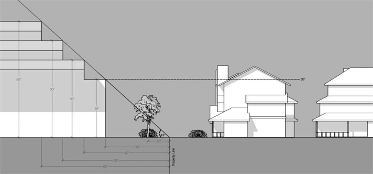
2.
Commercial requirements.
a.
A commercial component of a mixed use building shall be primarily on the street level of the building and oriented towards a public street.
b.
The gross floor area at the street level of any commercial establishment shall not exceed fifteen thousand (15,000) square feet;
c.
The street level of any building fronting on an arterial or collector street or that has neighboring commercial buildings shall:
(1)
Have a minimum floor-to-ceiling height of eleven (11) feet and be designed to allow for the future retrofitting of the space to commercial use even if not approved for commercial use.
(2)
Provide a minimum façade transparency of sixty percent (60%) of the width of the street frontage, which must be comprised of clear glass or other transparent material between two (2) feet and eight (8) feet in height, that allows view of indoor space or product display areas.
d.
All commercial floor space provided on the street level of a building for each commercial use must contain the following minimum floor area.
(1)
Street frontage of less than fifty (50) feet: At least eight hundred (800) square feet of the first floor of the building; or
(2)
Street frontage of more than fifty (50) feet: At least twenty percent (20%) of the first floor of the building.
e.
Access.
(1)
Connections shall be made to provide direct pedestrian and bicycle travel from within the development to adjacent uses, transit stops, perimeter sidewalks, and to major pedestrian destinations located within an adjacent neighborhood.
(2)
Sidewalks.
(a)
Six (6) foot wide, ADA compliant, sidewalks are required along all street frontages, to all building entrances from the street and/or the parking lot, and extending within the public right-of-way up to three hundred (300) feet beyond each side property line;
(b)
In order to provide efficient pedestrian connections to adjacent destinations, the town may require additional sidewalks, walkways, or bike paths not associated with a street, or the extension of a sidewalk from the end of a cul-de-sac to another street or walkway; and
(c)
Where a NCX Zone is located adjacent to a signalized street intersection, a pedestrian walkway shall connect the on-site pedestrian system with the intersection and shall be connected at a distance of no more than two hundred (200) feet from the intersection.
(d)
The Planning Commission or the chief executive may grant an exception to paragraphs 2.A, 2.B, and 2.C for the following reasons:
[1]
Where there are no existing or planned perimeter sidewalks.
[2]
Where sidewalks are not allowed by the authority having jurisdiction over the right-of-way.
D.
General design criteria.
1.
Sense of place.
a.
Site design shall recognize context and physical character of the surrounding area while setting a standard for future design endeavors. individual creativity and identity are encouraged, but care must be taken to maintain design integrity and compatibility of the property in order to establish a clear, unified image throughout the community;
b.
Housing in a range of sizes, and types is encouraged.
2.
Building location and orientation.
a.
Buildings articulation shall be used in areas open to public view to ensure that compatible uses are in close proximity to enhance the visual interest of buildings;
b.
Buildings should be located close to transit, parking facilities, public amenities, and open spaces; and
c.
Commercial uses should be located on collector or arterial streets or in areas that already have commercial uses.
3.
Parking lot orientation.
a.
Parking areas shall be designed and located to minimize the separation of buildings from the roadway, as well as from each other (building-to-building); and
b.
Placement of parking in the rear and at the sides of commercial buildings, with provisions for convenient and well-defined access from parking areas to the buildings being served, is encouraged.
4.
Vehicular access and parking.
a.
Vehicle and driveway access should be done in such a way that limits the number of curb cuts; and
b.
An interconnected transportation system shall be provided that disperses traffic and provides streets that accommodate multiple transportation modes including motor vehicles, transit, bicycles and pedestrians.
5.
Open space and central features.
a.
Attractive and inviting pedestrian scale features, spaces and amenities shall be provided as part of the design of buildings and developments;
b.
Public open spaces shall be incorporated into the site design in open spaces, drainage corridors, parkways, streets and alleys, as development edges, transitions and interconnections; and
c.
Pedestrian enhancements or special features such as furniture, sitting walls, decorative lighting and artwork shall be incorporated.
6.
Pedestrian flow.
a.
Spatial definition shall be created and a safe and attractive system of internal pedestrian circulation that connects to building entries, public sidewalks, and transit facilities and around the perimeter of the property shall be provided.
b.
Pedestrian walkways shall be distinguished from driving surfaces through the use of durable, low maintenance surface materials such as pavers, bricks, and scoured concrete.
7.
Landscaping.
a.
Entries with special planting shall be emphasized in conjunction with decorative paving or lighting;
b.
Strong landscaping elements, including mature trees, planters, and terracing shall be incorporated to enhance the site design; and
c.
Private property landscaping shall be coordinated with trees and other planting located in the public right-of-way.
8.
Stormwater management.
a.
Required water quality and stormwater management features shall be incorporated into the overall site design in accordance with Chapter 167 of this Code;
b.
The use of stormwater facilities as landscaped features should be encouraged in new developments;
c.
Storm water retention areas shall be designed to create high quality focal points or entrance features;
d.
The use of dry ponds and chain link fences is discouraged; and
e.
All stormwater facilities shall be maintained free of trash and debris.
E.
Building design criteria.
1.
Surrounding context.
a.
An architectural concept shall be developed and major building elements composed to reflect surrounding developments or buildings to ensure that the new development is compatible.
2.
Transition between uses.
a.
Architectural treatments such as windows, prominent doorways, and canopies shall be used on any side of a building visible from the ground level of an adjacent residentially zoned property; and
b.
Multi-story commercial buildings shall incorporate lower roof heights for portions that are adjacent to residentially zoned properties that have lower roof heights.
3.
Massing.
a.
Wherever possible, the construction of buildings that are two (2) or more stories in height is encouraged;
b.
The apparent bulk of buildings shall be reduced by providing a clearly defined "base", "middle" and "top";
c.
A variety of interest in the design of the building façade shall be provided through the use of rhythm, pattern and proportion; and
d.
A variety of roof heights and forms shall be provided to articulate different areas and uses.
4.
Entrances.
a.
Buildings must have a primary entrance door facing a public sidewalk. entrances at building corners may be used to satisfy this requirement;
b.
Two (2) building entrances may include doors to individual shops or businesses, lobby entrances, entrances to pedestrian-oriented plazas, or courtyard entrances to a cluster of shops or businesses;
c.
Entries and associated open spaces shall be designed to avoid the creation of isolated areas and to maintain lines of sight into and out of the building and adjacent spaces; and
d.
The principal entrance into a building shall be made prominent through the use of design elements including, but not limited to, ornamentation, recessed entrance, protruding entrance, canopies or awnings.
5.
Façade.
a.
Buildings shall be created that provide human scale and interest through use of varied forms, materials, details, and colors;
b.
Architecturally finished and detailed elevations shall be provided for all exposures of the building with the primary façade, typically the street-facing elevation, having architectural expression;
c.
The sidewalk level façade shall be articulated to provide an engaging pedestrian experience through open arcades and shop fronts, multiple building entries, merchandising display windows, and windows that encourage pedestrians to peer into the building interior;
d.
Windows with clear glass shall be used allowing views into the interior on all ground floor façades that are visible from and fronting on an abutting street or major parking area;
e.
On commercial building façades that are visible from a major arterial or pedestrian street, windows on the ground floor that allow views into the interior shall be provided; and
f.
Buildings shall be designed for flexibility to accommodate changes in use over time and minimize future renovation costs.
6.
Blank walls.
a.
Walls, or portions of walls, which have few entries or windows should receive special design treatment to increase pedestrian safety, comfort and visual interest including the following:
(1)
Lengths of blank walls shall be limited;
(2)
Courses shall be accented with different colors or textures;
(3)
Landscaped areas or raised planting beds shall be used to create visual distractions from blank walls;
(4)
Rhythm shall be created through the use of small setbacks, indentations, or projections;
(5)
The following shall be used to break up the wall surface:
[1]
Different textures, colors or materials;
[2]
Canopies, awnings, trellises;
[3]
Artwork, either freestanding or as murals; and
[4]
Seating ledges or perches and lighting features.
7.
Building materials.
a.
Durable materials shall be used that are of superior quality and are compatible with the environment and the surrounding areas.
b.
Materials such as exterior installation finishing system (EIFS), fabric or plastic should not be used.
c.
Materials should use the natural colors of brick, stone, and stained or painted woods, and should reserve bright colors for trim or accents.
(Ord. No. 20-09, § 2, 9-28-2020, eff. 10-13-2020)
Sec. 191-35. - Planned Redevelopment and Infill Overlay Zone (PRID).
A.
Purpose and intent. The Planned Redevelopment and Infill Zone ("PRID") Overlay Zone is intended to supplement, but not eliminate, the existing zoning classification of properties located in designated areas of town, for the purpose of applying special regulations in those areas to accomplish specific goals. PRID Overlay Zone standards are intended to allow the development of underutilized, transitional, or vacant land in ways that may depart from the strict application of the requirements of the existing zoning classification, in order to achieve more efficient land use and improved site design. The PRID Overlay Zone is also intended to:
1.
Allow the adaptive reuse of a site or existing buildings to accommodate a mix of residential dwelling types or commercial uses where such development is found to be compatible with the existing neighborhood.
2.
Stimulate economic investment and development in and around older established neighborhoods, where such development improves neighborhood character.
3.
Encourage compact development that is pedestrian scaled and/or transit-oriented and makes more efficient use of existing streets and utilities.
4.
Provide flexibility and permit a creative approach to the development of land that may not fall within the minimum land area, dimensional requirements or allowable uses of the underlying zone.
5.
Emphasize the internal relationships of the development plan elements; including circulation patterns, building locations, architectural character, and open space design.
6.
Enhance, preserve, and/or protect any valuable existing natural features or structures unique to the site.
B.
Applicability. Subject to the remaining provisions of this subsection B., all land uses and improvements within the PRID Overlay Zone shall be located, designed and developed in accordance with the applicable provisions of the underlying zoning classification, except as may be modified through approval of a Master Site Development Plan ("MSDP").
1.
The owner of land in a PRID Overlay Zone must apply for and receive approval of a MSDP before seeking and receiving subdivision or site plan approval from the Town Planning Commission except as follows:
a.
The Planning Commission, upon written application of a property owner, may exempt proposed development of the owner's land from complying with any or all of the MSDP requirements if the commission makes a written finding that site specific review under this section is not likely to achieve, to any significantly greater extent than development under the regulations of the underlying zoning zone, all of the following objectives:
(1)
More compact development which preserves a larger portion of the property in green, open space;
(2)
More compatible development with the adjacent and nearby properties;
(3)
More pedestrian connections and improvements related to non-vehicular modes of travel;
(4)
More potential for jobs creation and economic investment in La Plata;
(5)
More enhancement, preservation, and/or protection of existing natural features, structures or habitats unique to the site; and
(6)
More efficient use of public infrastructure or services (roads, utilities, schools, parks).
2.
Owners of adjoining properties within the PRID Overlay Zone may apply jointly for approval of an MSDP for development of their land under a unified development plan.
3.
In order to obtain the flexibility afforded by development under a MSDP, the owner of land in a PRID Overlay Zone may apply for and receive approval of a MSDP where use or development of the land in accordance with the regulations of the underlying zoning classification would not require subdivision or site plan approval from the Planning Commission.
C.
Land uses and development standards determined by approved MSDP. Specific land uses and development standards (including, but not limited to, uses, height, bulk, setbacks and parking) for each PRID project shall be determined on a site-by-site basis through review and approval of a MSDP. Land uses permitted under a MSDP may include land uses that would not be allowed under the regulations of the underlying zoning classification.
D.
Submittal requirements.
1.
A property owner shall initiate a request for approval of a MSDP by filing an application on such forms as may be required by the town, in addition to such other information and documentation as reasonably may be required by the town as part of the application.
E.
The MSDP shall be reviewed and approved in accordance with section 191-13 of this chapter.
F.
Development standards. In general, flexible development standards to allow a mix of uses, to reduce lot areas, widths, and required yards and to increase building heights may be permitted for a MSDP at the discretion of the Town Council, provided that such development standards comply with this subsection F.
1.
Residential density to be developed under a MSDP shall be as follows:
a.
The total number of dwelling units will be established at the time of MSDP approval and, if approved as part of a MSDP, may exceed the density allowed in the underlying zoning classification.
b.
Lot size (area) will be established at the time of MSDP approval, and shall be determined based on proposed residential density, setbacks, building heights and community compatibility.
2.
The height and lot coverage for structures to be developed under a MSDP is restricted to the maximum allowed within the underlying zoning classification unless:
a.
The average height and/or lot coverage of the adjacent structures is greater than the maximum height and/or lot coverage allowed in the underlying zoning classification, in which case the height and lot coverage for structures to be developed under a MSDP may not exceed the height and/or lot coverage of the adjacent structures; or
b.
The applicant establishes to the satisfaction of the town council that the proposed buildings or structures are designed in such a way as to appear consistent with building bulk and scale of the surrounding properties, creating an overall mass that incorporates the architectural rhythm, materials, and proportions of the surrounding neighborhood.
3.
The setback requirements of the underlying zoning classification may be reduced by the town council to facilitate interesting and innovative design solutions, provided that the encroachment into the setback required by the underlying zoning classification does not adversely affect storm drainage, privacy, sunlight, or views of the adjacent property, and does not unreasonably restrain the potential of the adjacent property for future development.
4.
The location of buildings and other permanent structures on a site shall be consistent with applicable community design guidelines and shall optimize the efficient use of land and utility services, reduce impervious areas, preserve important views, augment pedestrian access, and maintain the integrity of the existing streetscape, to the greatest applicable extent.
5.
Except as provided in subsection 5.A., open space and landscaping provided under a MSDP must meet the requirements of the underlying zoning classification. Where the underlying zoning classification is CH, CB or CBT, open space and landscaping also must be consistent with applicable community design guidelines.
a.
At the discretion of the Town Council, open space and landscaping requirements may be expanded or reduced as the council deems necessary to satisfy the intent of this section.
b.
All proposed landscaping and open space amenities must be shown on and approved as part of the MSDP.
6.
In general, parking spaces shall be provided as required by the underlying zoning classification. However, the required number of spaces may be reduced if adequate safety, convenience, and circulation within and external to the site are provided. All parking spaces proposed to serve the development on-site and off-site must be shown on the MSDP.
a.
Bike and pedestrian accommodation, shared parking and joint access drives are encouraged. When possible, off-street parking spaces shall be located behind buildings or otherwise screened from view from the street.
b.
The parking plan may use a combination of on-site and off-site parking spaces, and may employ "joint use" or "shared" parking strategies to meet the needs of the proposed development. However, in each case, the burden is upon the applicant to demonstrate that the proposed plan ensures adequate parking for the uses intended.
c.
The parking requirements of this chapter may be waived or modified as part of a MSDP.
7.
All proposed public streets, alleys, sidewalks, walkways, and utilities must be shown on the MSDP.
a.
The street and walkway system for the project must be safe, efficient, convenient, and attractive, and shall include intra-neighborhood and inter-neighborhood connections for cars and pedestrians wherever feasible and appropriate.
b.
Public street design standards applicable to the project will be determined at the time of approval of the MSDP, including requirements for road widths, street lighting, street furniture, and sidewalks.
G.
Amendment of an approved MSDP shall be in accordance with section 191-10, development standards.
(Ord. No. 20-09, § 2, 9-28-2020, eff. 10-13-2020)
Sec. 191-35.1. - Hospital Campus Zone (HC).
A.
Purpose and intent.
1.
The purpose and intent of the Hospital Campus Zone is to address the particular needs of a large-scale, multi-functional hospital and associated medical facilities, to include a multi-building complex located on a hospital campus, including the hospital and all related and support services and uses, such as office and other commercial uses. The HC Zone shall be a floating zone. The HC Zone shall be applicable as a floating overlay zone to all contiguous lots or parcels owned by the hospital organization as of the date of this chapter and located within the central business core of the town. Notwithstanding anything to the contrary set forth in this chapter, the HC Zone shall not be expanded as a floating zone to any residentially zoned properties to the west of Oak Avenue on the Western side of the hospital campus, or to the Southern or Eastern sides of Wicomico Street on the South end East sides of the hospital campus. The HC Zone shall act as a floating zone and may be applied upon application of the hospital organization to the Planning Commission, following any acquisition of a lot or parcel by the hospital organization contiguous to the hospital campus only as to the following: (1) Any lot or parcel which has a base zone of CB, CBT or other commercial base zone; (2) The lot identified as parcel 247 on Charles County Tax Map 113 (zoned R8), currently owned by Karl M. Lehman, et.al., with a street address of 606 Wicomico Street; and (3) the five (5) lots zoned R8, being parcels 261 through 265, on Charles County Tax Map 113, located on the West side of Somerset Court.
B.
Applicability.
1.
A hospital campus shall have a minimum area of a single or combined lot(s) or parcel(s) of five (5) acres. Subject to the geographical applicability of the HC Zone in this chapter, there shall be no maximum lot area or hospital campus area.
C.
Design criteria and guidelines.
1.
Building design criteria shall be as set forth in the design guidelines for the HC Zone, subject at all times to the requirements and functionality elements imposed by the joint commission for hospital standards, the Maryland Healthcare Commission, and other state and federal regulatory bodies, as applicable. Design and appearance criteria shall be applicable to the hospital campus with the intent that new and/or renovated buildings shall be consistent and compatible with the architectural style, design, and exterior appearance of existing buildings on the hospital campus as of the date of this chapter. Consistency and compatibility shall be determined by the Town Planning Director and shall not require design review board review or approval. If the Planning Director denies any proposed project as to consistency and compatibility, the hospital organization may appeal the decision of the Planning Director to the Design Review Board, and, if still aggrieved at the Design Review Board, may appeal the decision to the Town Board of Appeals.
D.
Development requirements.
1.
Buffers and landscape shall requirements be as set forth in this section and in the buffer yard plan and design guidelines for the HC Zone.
2.
Multiple buildings and/or structures shall be permitted on any single lot, in accordance with the approved site plan or site plans for the hospital campus from time to time.
3.
There shall be no open space or public lands requirements as to the Hospital Campus Zone.
4.
Buildings or improvements existing as of the effective date of this chapter shall be considered conforming, regardless of heights and yards and regardless of conformity to design elements.
5.
Perimeter or exterior setbacks shall be ten (10) feet where adjoining a commercial use or commercial zone, ten (10) feet where adjoining a public or private street, and twenty (20) feet where adjoining a residential use or residential zone. Parking requirements for other uses on the hospital campus shall be based upon the particular use that the particular parking is intended to serve.
6.
Fencing, barriers and/or structures necessary for the safety and security of the hospital campus, and its patients, patrons, staff, employees, and invitees, shall be liberally permitted on and around the perimeter of the hospital campus. Existing fencing as of the date of this chapter shall be considered permitted. Design Review Board approval shall be required for new fencing along the exterior perimeter of the hospital campus or along any public road.
7.
Lack of conformity as to any improvements on the hospital campus existing on the date of this chapter shall be considered grandfather and conforming. These regulations shall be liberally interpreted and applied, so as to facilitate the efficient expansion and/or change in uses of the hospital campus buildings and facilities and to recognize the changing nature of healthcare institutions.
8.
The provisions of this chapter related to the HC Zone shall control over any inconsistent provisions elsewhere in the zoning ordinance.
9.
Development standards for the Hospital Campus Zone are set forth in Table 4.1 below.
TABLE 4.1
(Ord. No. 21-34, § 2, 11-23-2021, eff. 12-8-2021)