
La Porte City Zoning Code
ARTICLE 02
ZONING DISTRICTS AND MAP
Section 02.01 - Zoning Districts
The county of La Porte, including the City of La Porte and the City of Michigan City, is divided into the following Districts. Certain districts are only applicable to the county or cities.
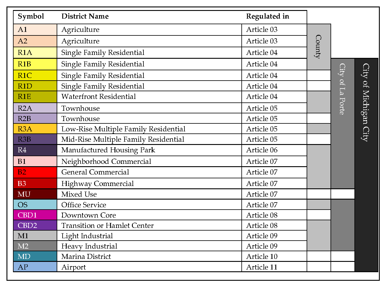
(Ord. No. 4500, § 5.2., 2-5-2019)
Section 02.02 - Official Zoning Map
(a)
An official Zoning Map is adopted as a part of this Ordinance, is hereby incorporated in this article by reference. The Zoning Map shows the boundaries of the zoning districts and the applicable zoning district that regulates each parcel of land. Pursuant to IC 36-7-4-610(c) the official zone map is on file and available for inspection and copying during regular business hours at:
(1)
La Porte County. The office of the building commissioner of the county.
(2)
City of La Porte. The office of the City of La Porte clerk-treasurer and the office of the city plan commission in the office of the engineering department of the City of La Porte.
(3)
City of Michigan City. The office of the Michigan City clerk.
(b)
The County Board of Commissioners may amend the Zoning Map for land located outside of the boundary of cities following the procedures outlined in Article 30. The city council may amend the Zoning Map for land located within the boundaries of cities following the procedures outlined in Article 30.
Section 02.03 - District Boundaries Interpreted
Where uncertainty exists with respect to the boundaries of the various districts as shown on the Zoning Map, the following rules shall apply:
(a)
When the exact boundaries of a district are uncertain, they shall be determined by use of the scale on the Zoning Maps.
(b)
Boundaries indicated as approximately following the centerlines of streets, highways, or alleys, shall be construed to follow the centerlines.
(c)
Boundaries indicated as approximately following platted lot lines shall be construed as following the lot lines.
(d)
Boundaries indicated as following railroad lines shall be construed to be the midway between the main tracks.
(e)
Boundaries indicated as following shorelines shall be construed to follow the shoreline, and in the event of change in the shoreline shall be construed as moving with the actual shoreline; boundaries indicated as approximately following the centerline of streams, rivers, canals, lakes or other bodies of water shall be construed to follow the centerline. Any use or structures extending into or over a lake or other water body shall be subject to the same zoning restrictions as the adjoining land.
(f)
When a right-of-way is vacated, the districts adjoining each side are respectively extended to the center of the area so vacated.
Section 02.04 - Zoning of Vacated Lands
Zoning of vacated areas means whenever any road, alley or other public way shall be vacated, the road, alley or other public way or portion thereof shall automatically be classified in the same zone district as the property to which it attaches.
Section 02.05 - Annexed Land
Where land within the county is annexed to one of the cities it shall retain its existing zoning until such time as the city takes action to rezone the land to another district.
Section 02.06 - District Use Regulations
Each zoning district article includes a schedule of permitted uses indicating uses that are permitted by right, and allowed by special exception. A use that is not listed as permitted or special exception in a district shall not be permitted in that district. Appendix A provides a combined schedule of permitted uses for all districts. A use that is not listed in any zoning district may be permitted upon determination by the enforcement official that the use is clearly similar in nature and compatible with a use that is listed in a particular district. In making this determination, the enforcement official shall consider the following:
(a)
The enforcement official shall consider specific characteristics of the proposed use and compare them to the characteristics of the uses that are listed in the zoning ordinance. Characteristics considered shall include, but are not limited to, traffic generation, types of services offered, types of goods produced, methods of operation, noise, hours of operation and building characteristics.
(b)
If the enforcement official determines that the proposed use is consistent and compatible with a permitted use, the use shall be permitted under that use category. If the enforcement official determines that the proposed use is consistent and compatible with a special exception use, the use shall be allowed with special exception approval. The use shall be subject to all requirements of the similar use.
(c)
A proposed use shall not be permitted in a district where the use is specifically listed in any other district, as shown in Appendix A, or where the enforcement official determines that the use is more similar in nature and compatible with uses listed in another district.
(d)
The use determination of the enforcement official may be appealed to the board of zoning appeals for an interpretation of the use provisions of the zoning ordinance.