
La Porte City Zoning Code
ARTICLE 03
AGRICULTURAL DISTRICTS
Section 03.01 - Intent
(a)
A1 Restricted Agricultural District. The A1 Restricted Agricultural District is established to provide areas of the county for major agricultural operations. The intent of this district is to protect prime agricultural areas from encroachment of residential and commercial sprawl and limit the conflict that can occur between agriculture and residential and commercial development. In order to meet this intent, the district excludes subdivisions and residential developments, other than farmsteads. This district applies to areas of the county designated for traditional agricultural in the County Land Development Plan.
(b)
A2 Agricultural District. The A2 Agricultural District is established primarily for agricultural uses, but also allows for limited non-farm rural residential development. The intent of this district is to protect agricultural areas from encroachment of residential and commercial sprawl by limiting the amount of residential development. This district applies to areas of the county designated for rural estate in the County Land Development Plan. This may also apply to planned growth or urban expansion areas where the current use of the land is agricultural and there is not a short term need for residential development.
Section 03.02 - Uses
Use and development of land and buildings shall only be for the following specified uses, unless otherwise provided for in this Ordinance. Uses are grouped into major categories and only those uses listed under each category are permitted. Land and/or buildings in the districts indicated at the top of the Table may be used for the purposes denoted by the following abbreviations:
P:
Permitted Use. Land and/or buildings in this District may be used for the purposes listed by right.
S:
Special Exception Use. Land and/or buildings in this District may be used for this purpose by obtaining Special Exception approval when all applicable standards cited in Article 24 Special Exception Review Requirements and Procedures.
-:
Not Permitted. The use is not permitted in the district. Uses not listed in the table are also not permitted. Uses that are not listed in any district of the zoning ordinance, as shown in Appendix A, may be allowed based upon a similar use determination in accordance with Section 02.06.
Table 03.02
Schedule of Permitted Uses
Residential uses in the A1 District shall be limited to agricultural farmsteads. Development of residential uses that are not under ownership by the owner, operator or employee of an agricultural use shall not be permitted.
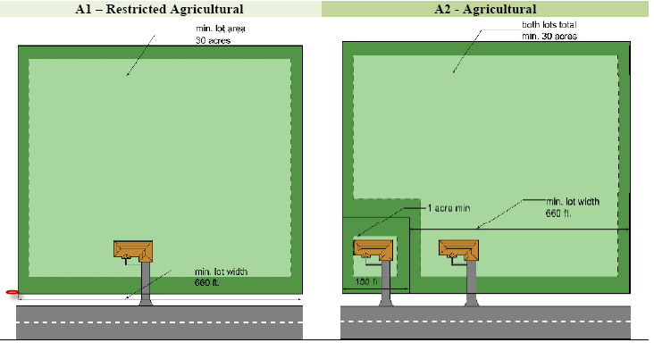
Section 03.03 - Lot Area and Width Requirements
All lots shall meet the following minimum area and width requirements. No new lots shall be created or altered in a manner that does not comply with the following requirements.
Table 03.03
Lot Area And Width Requirements
(a)
Subdivision of Land. All divisions to land shall be subject to the requirements set forth in the Subdivision Regulations of La Porte County, City of La Porte or City of Michigan City, as applicable.
(b)
Lot Area Calculation. Lot area is calculated based upon the net area of the lot, measured in the horizontal plane, exclusive of any area that is part of a public road right-of-way, private road easement or submerged land beneath the ordinary high water mark of a lake, river or stream.
(c)
Lot Width and Frontage. Lot width shall be measured as a straight line between the side lot lines at the minimum front yard setback of the district. All lots shall have frontage along a public road. The width along the road shall be sufficient to meet the lot width requirement at the minimum front yard setback.
(d)
Dominant Parcel. The dominant tract or parcel from which any newly created lot has been divided from must also maintain the required lot width.
(e)
Depth to Width Ratio. All newly created lots shall have a lot depth of no more than four times the width (i.e. maximum 4:1 depth to width ratio).
(f)
A2 Residential Lots. In the A2 District, lots less than 30 acres may be created as follows:
(1)
One lot may be subdivided from a dominant parcel for each whole 30 acres of the dominant parcel, as illustrated in the following schedule:
(2)
The new lot that is subdivided shall be at least one acre in area and have at least 200 feet of road frontage.
(3)
The dominant parcel may be less than 30 acres, provided the combined area of the dominant parcel and the new lot totals at least 30 acres.
(4)
The remaining dominant parcel must have at least 660 feet of road frontage.
(5)
Dividing of parcels where all resulting parcels are at least 30 acres shall not count towards the above number of allow new lots.
(g)
Nonconforming Lots. Lots of record that were in existence prior to the effective date of this ordinance may be used subject to the provisions of the nonconforming lot regulations of Section 29.03.
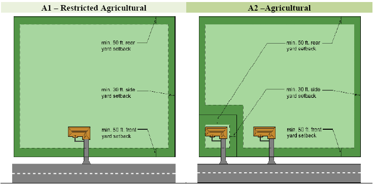
Section 03.04 - Building Dimensional Requirements
All structures shall be subject to the dimensional regulations of the following table.
Table 03.04
Building Dimensional Requirements (a)
(a)
Accessory Structures. Residential accessory structures shall be regulated under the requirements of Article 16. Buildings used for agricultural purposes shall not be considered accessory structures regulated by Article 13.
(b)
Height Exceptions. No structure shall exceed the maximum height of the district except for the allowable exceptions to height limits contained in Section 15.02.
(c)
Projections into Yards. All required yard spaces shall remain as landscaped open space, except for pavement, accessory structures and architectural features that are allowed to extend or project into required setbacks under Section 15.01.
(d)
Setback from Road. The front yard setback shall be measured from the road right-of-way or private road easement.
(e)
Corner Lots. Corner lots shall provide the minimum front yard setback from both road frontages.
(f)
Double Frontage Lots. In all districts, where a double frontage lot backs-up to a roadway, the minimum required front or roadside setback shall be required from both road rights-of-way.
(g)
Wetlands. A minimum setback of 50 feet shall be maintained from all wetlands. The setback may be adjusted according to requirements of natural resource preservation guidelines contained [in] Article 22.
(h)
Waterway Setback. The waterway setback shall be measured from the shoreline of the lake, river or stream. In no instance shall any structures other than docks, seawalls, retaining walls, sidewalks, boardwalks, and patios be permitted within the minimum waterway setback. The setback may be adjusted according to requirements of Natural Resource Preservation Guidelines.