
La Porte City Zoning Code
ARTICLE 12
- OVERLAY DISTRICTS
Section 12.01 - US-6, US-20, US-30, US-35, US-421, SR-2 and SR-39 Corridor Overlay District
(a)
Intent. The US-6, US-20, US-30, US-35, US-421, SR-2 and SR-39 corridors have all been identified as important transportation corridors in the County Comprehensive Plan. The intent of the Corridor Overlay Zoning District is to provide specific standards for the corridor to preserve roadway capacity and safety; ensure that development does not limit the future ability to improve the roadway; protect property values along the corridor; promote economic development; and establish a high-quality image for the entrance to the communities. Among the specific purposes of the Corridor Overlay Zoning District are:
(1)
Maximize the capacity of the road by controlling the number, and location of driveways; requiring alternate means of access through shared driveways, service drives, and access from side streets and requiring traffic impact studies for developments that will generate large volumes of traffic.
(2)
Preserve future right-of-way and minimize disruption of existing businesses and homes through preservation of additional right-of-way that may be necessary to widen the road. To achieve this, the overlay district provides for specific setbacks along the corridors.
(3)
Enhance the visual quality of this corridor by limiting signage and requiring landscape greenbelts to maintain the rural character of the county, and establish a desired entry image for the communities to create an attractive setting for new investment.
(b)
Scope of Application. A corridor overlay zoning district is hereby established over all lots having frontage along US-6, US-20, US-30, US-35, US-421, SR-2 and SR-39. The development or redevelopment of lots having frontage along US-6, US-20, US-30, US-35, US-421, SR-2 and SR-39 shall comply with the provisions of this overlay zoning district in addition to the applicable regulations of the underlying zoning district. Where a conflict exists between the requirements of this overlay zoning district and the underlying zoning district the more restrictive requirement shall apply.
(c)
Uses Permitted. The uses permitted shall be regulated by the underlying zoning district. The review and approval process applicable in the underlying zoning district shall be followed.
(d)
Dimensional Requirements.
(1)
The development or redevelopment of lots and parcels within the Corridor Overlay Zoning District shall comply with the lot dimensional and bulk requirements of the underlying zoning district.
(2)
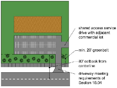
In the unincorporated areas of the county outside of the cities, a minimum setback of 80 feet from the centerline of the road shall be required for all buildings and parking areas. Where the road right-of-way is greater than 60 feet from the centerline of the road, then all buildings and parking areas shall be setback a minimum of 20 feet from the right-of-way.
(3)
Within the cities of La Porte and Michigan City, the front yard setbacks shall be based upon the underlying zoning.
(e)
Landscaping.
(1)
All lots in the unincorporated areas of the county outside of the cities shall be required to provide a landscape greenbelt along the designated corridors within the setback noted in subsection (d)(2) above. The greenbelts shall be landscaped with a minimum of two deciduous trees and six shrubs for every 40 linear feet of frontage.
(2)
All other site landscaping shall be in accordance with the requirements of Section 17.02.
(f)
Signs. All signs shall be in accordance with the requirements of Article 19, except that pole signs and other freestanding signs shall be limited to a height of 20 feet.
(g)
Transportation Related Requirements.
(1)
Driveway Access. All driveways shall comply with the spacing requirements of Section 18.04 for major thoroughfares.
(2)
Shared Driveways, Frontage Roads and Service Drives. All uses, except residential and agricultural, shall be required to install service roads to allow connection to adjacent lots that are zoned or planned for non-residential use. Service roads shall generally be parallel or perpendicular to the front lot line. Service roads that are parallel to the roadway corridors may be in the rear or front yard, depending on the location of parking, building setback and appropriate locations for connections to adjacent lots. All service drives shall be designed in accordance with the requirements of Section 18.04.
(3)
Traffic Impact Study. A traffic impact study shall be required as part of the site plan submission for any development within the overlay zoning district meeting the warrants for a traffic impact study, as provided in the "Applicant's Guide to Traffic Impact Studies," published by the Indiana Department of Transportation. The preparation and review of the traffic impact study shall also follow this guide.
Section 12.02 - Economic Opportunity Overlay District
(a)
Intent. The intent of the Economic Opportunity Overlay Zoning District is to provide a mechanism to allow for development of major transportation-related facilities in limited exurban and rural areas of the county where specific conditions exist that are conducive to large-scale distribution and logistics centers. Because of the land area requirements, need for access to rail and other transportation facilities and the potential impacts upon surrounding land use, it is preferable to locate large-scale warehousing, transportation and logistics industries away from the population concentrations of the cities. While it is desirable to permit this type of development due to the economic benefits of employment and tax revenues, there is a need to control the location and intensity of this land use to prevent undesirable sprawl of industry into rural areas, impact to residential areas and loss of valuable farmland. Among the specific purposes of the Economic Opportunity Overlay Zoning District are:
(1)
Ensure that transportation logistics industries are located in areas with sufficient existing or potential roadway and rail transportation infrastructure to support freight traffic and to meet the demands of traffic generated by the use.
(2)
Ensure that adequate utilities are available or can be readily provided to serve a new transportation logistics industry.
(3)
Ensure that transportation logistics industries are located in areas that will have minimal impact upon the county's population.
(4)
Limit the loss of valuable farmland.
(5)
Minimize the impact to natural features, including open space, woodlands, wetlands, groundwater and waterways.
(6)
Minimize the impact of transportation logistics industries on the rural character of the county by requiring adequate landscape screening, buffering and setbacks.
(b)
Scope of Application. The Economic Opportunity Overlay Zoning District may only be applied as an overlay zone in unincorporated locations in La Porte County where the underlying zoning is A1 Restricted Agricultural District, A2 Agricultural District, M1 Light Industrial District or M2 Heavy Industrial District.
(c)
Application. The Economic Opportunity Overlay Zoning District may be applied for following the rezoning procedures of Article 30 and this section.
(1)
In addition to the requirements of Article 30, all applications shall include a site plan complying with the requirements of Article 23 and this section.
(2)
A traffic impact study shall be required as part of the rezoning application for the overlay zoning district. The standards used in preparing and approving the traffic impact study shall comply with the "Applicant's Guide to Traffic Impact Studies," published by the Indiana Department of Transportation.
(d)
Uses Permitted. The uses permitted in the Economic Opportunity Overlay Zoning District shall be limited to the following uses, regardless of the provisions of the underlying zoning district:
(1)
Cartage, express and parcel delivery establishments.
(2)
Containerized freight yards.
(3)
Distribution centers.
(4)
Intermodal freight terminals.
(5)
Grain elevators.
(6)
Hotels.
(7)
Outdoor operations of all warehouse and freight movement land uses.
(8)
Railroad transfer or storage yards.
(9)
Trucking terminals, transfer buildings, truck garages and areas for parking of operable trucks.
(10)
Value-added agricultural uses such as canning, processing and packaging of agricultural products.
(11)
Warehouses.
(12)
Restaurants that are accessory to an above permitted use.
(13)
Vehicle fueling and maintenance that is accessory to an above permitted use.
(e)
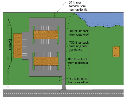
Dimensional Requirements. The minimum project size for the Economic Opportunity Overlay Zoning District shall be 500 contiguous acres. All buildings, parking, loading and storage areas shall be setback in compliance with the following dimensional requirements. The setbacks shall apply around the perimeter of the site. The required setback areas shall be maintained as green space and landscaped, in accordance with the requirements of subsection (f) below.
(f)
Landscaping. The following landscaping shall be required:
(1)
The road frontage greenbelt shall apply to all public road frontages, including limited access highways. The frontage greenbelt requirement shall not apply to private roads that are internal to the site or public roads internal to the overlay district that are developed to provide access to uses within the overlay district and not act as a through roadway.
(2)
In addition to the above landscape greenbelts, there shall be a minimum of one tree on the site for each 1,000 square feet of land area that is covered by buildings and pavement.
(3)
All other site landscaping shall be in accordance with the requirements of Section 17.02.
(g)
Transportation Related Requirements.
(1)
Driveway Access. All driveways shall have direct access to a paved state or federal highway that is suitable for the anticipated truck traffic, as determined by the Indiana Department of Transportation and the county highway engineer. All driveways shall comply with the requirements of Section 18.04.
(2)
Truck Access. All applications for rezoning to the Economic Opportunity Overlay Zoning District must indicate the type and volume of truck traffic anticipated at the site, including dimensions of all truck access and circulation lanes, and dimensions of all truck loading/unloading areas. Driveways and roads of commercial and industrial facilities anticipated to receive truck traffic must be designed to adequately accommodate the anticipated truck traffic.
(3)
Truck Circulation Plan. The site plan accompanying the application for rezoning to the Economic Opportunity Overlay Zoning District shall include a diagram with the dimensions of trucks anticipated at the site and shall show all existing and proposed truck circulation patterns including the direction and flow of truck traffic on the site and dimensions of all truck service drives, berths, and dock approaches. Truck maneuvering shall not be permitted within any public or private road off the property.
(4)
Turning Radius. Design features for trucking facilities shall include larger turning radii and added maneuvering space and pavement design to accommodate trucks. At a minimum these standards shall be those recommended by the American Association of State Highway and Transportation Officials or another standard specified by the county highway engineer.
(5)
Curbing. All parking, loading and truck storage areas shall be curbed with concrete curbing meeting the county engineering standards. Driveways shall be curbed for their full length.
(6)
Traffic Impact Study. A traffic impact study shall be required as part of the site plan submission for any development within the overlay zoning district meeting the warrants for a traffic impact study, as provided in the "Applicant's Guide to Traffic Impact Studies," published by the Indiana Department of Transportation. The preparation and review of the traffic impact study shall also follow this guide.
(h)
Non-transportation Infrastructure Related Requirements.
(1)
Wastewater Treatment. A fiscally viable plan for wastewater treatment shall be presented with the application to rezone to the Economic Opportunity Overlay District. This may be a signed agreement with an existing wastewater treatment facility that has adequate capacity. Phased developments shall provide for wastewater treatment for each phase.
(2)
Stormwater Management. Stormwater management shall meet the requirements of Chapter 46, Article IX and all other provisions of the Michigan City, Indiana Code of Ordinances related to stormwater management. Phased developments shall provide for adequate stormwater management for each phase of development.
(3)
Fire Protection. A fire protection plan shall be submitted with the application for rezoning to the Economic Opportunity Overlay District. The plan shall include the name and location of the fire department (and any stations) that will serve the site, the equipment and response time to the site for the identified department and/or station, plans for pumping from ponds or hydrants or use of tanker trucks, and interlocal agreements with other departments.
(i)
Phasing.
(1)
Site Plan Approval Required. Site plans shall be submitted and approved or denied by the plan commission. Site plans shall include all items in Article 23 and the following:
a.
Transportation plan;
b.
Stormwater management plan as approved by the Sanitary District under Chapter 46, Article IX of the Michigan City, Indiana Code of Ordinances;
c.
Fire protection plan; and
d.
Phasing plan, including public improvements.
(2)
Final Phase Plans Subject to Technical Review Only. Following approval of a site plan, each phase, consistent with the phasing plan and in substantial compliance with the approved site plan, shall be subject only to technical review by the staff and checkpoint agencies. Substantial departures from the approved site plan shall be subject to site plan approval by the plan commission.
(Ord. No. 4770, § 2(Exh. B, A.4, 5), 8-4-2025)
Section 12.03 - Waterfront View Protection Overlay Zoning District
This section has been deleted in its entirety.
(Ord. No. 4433, § 4, 5-16-2017; Ord. No. 4500, § 5.12., 2-5-2019)
Section 12.04 - Intentionally Omitted
Editor's note— Ord. No. 4770, § 2(Exh. B, A.6), adopted Aug. 4, 2025, repealed § 12.04, which pertained to Newporte Landing, South Overlay Zoning District (City of La Porte) and carried no amendatory history.
Section 12.05 - Intentionally Omitted
Editor's note— Ord. No. 4770, § 2(Exh. B, A.6), adopted Aug. 4, 2025, repealed § 12.05, which pertained to Economic Development Corridor Overlay Zoning District (City of La Porte) and carried no amendatory history.
Section 12.06 - US-12 Corridor Overlay District
(a)
Intent. The US-12 corridor has been identified as important transportation corridor through Michigan City. The intent of the US-12 Corridor Overlay District is to provide specific standards for the corridor to achieve the following:
(1)
Preserve the scenic character of the outlying areas of the city and promote development around the central core of the city that creates a strong sense of place.
(2)
Promote US-12 as a cultural heritage corridor to encourage economic development and tourism for Michigan City.
(3)
Encourage multi-modal transportation through pedestrian-oriented and transit-oriented development.
(4)
Maximize the capacity of the road by controlling the number and location of driveways; requiring alternate means of access through shared driveways, service drives and access from side streets, and requiring traffic impact studies for developments that will generate large volumes of traffic.
(5)
Enhance the visual quality of this corridor by limiting signage and preserving natural and scenic landscape features.
(b)
Scope of Application. A US-12 corridor overlay zoning district is hereby established over all lots having frontage along US-12. The development or redevelopment of lots having frontage along US-12 shall comply with the provisions of this overlay zoning district in addition to the applicable regulations of the underlying zoning district. This overlay district shall also apply to lots adjoining the railroad right-of-way that runs parallel to US-12, including the opposite side of the railroad furthest from US-12. Where a conflict exists between the requirements of this overlay zoning district and the underlying zoning district the more restrictive requirement shall apply.
(c)
Uses Permitted. The uses permitted shall be regulated by the underlying zoning district. The review and approval process applicable in the underlying zoning district shall be followed.
(d)
Dimensional Requirements. The development or redevelopment of lots and parcels within the US-12 Corridor Overlay Zoning District shall comply with the lot dimensional and bulk requirements of the underlying zoning district.
(e)
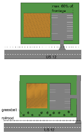
Parking Lots along Frontage. New off-street parking lots within 20 feet of the US-12 right-of-way may occupy no more than 60 percent of the lot's street frontage. The remaining frontage shall be occupied by building or landscaped area with no off-street parking located within 20 feet of the front lot line. Parking lots shall be landscaped in accordance with the requirements of Section 17.02.
(f)
Landscaping. All site landscaping shall be in accordance with the requirements of Section 17.02. Existing trees that are in good condition within 20 feet of the US-12 right-of-way shall be preserved. Existing trees that are located within 20 feet of the railroad right-of-way that runs parallel to US-12 shall be preserved, both between the US-12 right-of-way and the railroad right-of-way and on the opposite side of the railroad right-of-way furthest from US-12. Any site adjoining the railroad right-of-way that runs parallel to US-12 shall be required to provide the frontage greenbelt required by Section 17.02 along the railroad right-of-way.
(g)
Signs. All signs shall be in accordance with the requirements of Article 19, except that pole signs and other freestanding signs shall be limited to a height of 20 feet.
(h)
Transportation Related Requirements.
(1)
Nonmotorized Facilities. All sites shall have ten-foot wide nonmotorized pathways along US-12 and five-foot wide sidewalks along all intersecting side streets that meet the requirements of Section 18.05.
(2)
Driveway Access. All driveways shall comply with the spacing requirements of Section 18.04 for major thoroughfares.
(3)
Shared Driveways, Frontage Roads and Service Drives. All nonresidential uses with off-street parking lots shall be required to have vehicular connections to adjacent nonresidential sites that allows for circulation between parking lots. This may be achieved through shared driveways, shared parking lots or rear service roads connecting sites. Where service roads are used for vehicular connections to adjacent sites, they shall be provided in the rear yard. All service drives shall be designed in accordance with the requirements of Section 18.04.
(4)
Traffic Impact Study. A traffic impact study shall be required as part of the site plan submission for any development within the overlay zoning district meeting the warrants for a traffic impact study, as provided in the "Applicant's Guide to Traffic Impact Studies," published by the Indiana Department of Transportation. The preparation and review of the traffic impact study shall also follow this guide.
Section 12.07 - Mixed-Use (MU) District
(a)
Intent. The intent of the MU district is to enable a mixture of medium and high density residential, commercial retail, professional office, technology, office, light industrial, and public or institutional uses and spaces in a compact, highly walkable district or in the case of a business park, provided it is abutting or immediately adjacent to other existing industrially used or zoned land, a multi-use campus setting. This district is intended to establish an urban form along internal streets through specific design and building form standards, as well as to integrate enhanced pedestrian and bicycle connections within the development and where appropriate, to adjacent streets, neighborhoods, and districts. A development may include vertically-integrated or horizontal mixed use in combination with a business park depending on the development plan. The district is applicable for undeveloped sites and adaptive reuse or redevelopment of developed sites.
(b)
Scope of Application. The legislative body may establish the MU district in locations consistent and compatible with the Future Land Use Plan, or as warranted as a map amendment for areas of redevelopment. Development, redevelopment, or substantial improvements within a MU District shall be processed in accordance with Article 23, Improvement and Location Permits, Site Plans, Master Development Plans, Building Permits, and Certificated of Occupancy.
(c)
Uses Permitted. Use and development of land and buildings shall only be for the uses specified in Table 12.07(a), Schedule of Permitted Uses. Uses are grouped into major categories and only those uses listed under each category are permitted. Land and/or buildings indicated in Table 12.07(a) may be used for the following purposes.
(1)
Permitted Use. Land and/or buildings may be used for the purposes listed by-right. As set forth in the Use Requirements column, use standards may apply.
(2)
Special Exception Use. Land and/or buildings may be used for this purpose by obtaining special exception approval when all applicable standards cited in Article 24, Special Exception Review Requirements and Procedures, are met. As set forth in the Use Requirements column, use standards may apply.
(3)
Not Permitted. Uses not listed in the table are not permitted by right or by special exception. Uses that are not listed in any district of the zoning ordinance, as shown in Appendix A, may be allowed based upon a similar use determination in accordance with Section 02.06.
Table 12.07(a)
Schedule of Permitted Uses
(d)
Lot Area, Lot Width, and Building Dimensional Requirements.
(1)
Development Standards. No new structures shall be erected and no lots shall be created or altered in a manner that does not comply with the requirements of Table 12.07(b), Residential Standards, and Table 12.07(c), Commercial/Retail, Office/Industrial and Mixed-Use Standards.
Table 12.07(b)
Residential Standards
Table 12.07(c)
Commercial/Retail, Office/Industrial and Mixed Use Standards
(e)
Mixed-Use Requirements.
(1)
Gross Floor Area Percentage. Depending on whether a development includes horizontal or vertical mixed-use, the residential and nonresidential building areas vary.
a.
In a horizontal mixed-use development, the maximum percentage of gross floor area allowed for residential uses is 60 percent and the minimum percentage of gross floor area allowed for commercial/retail/light industrial or mixed uses is 40 percent.
b.
In vertical mixed-use development, the maximum percentage of gross floor area allowed for residential uses is 75 percent and the minimum percentage of gross floor area allowed for commercial/retail/light industrial or mixed uses is 25 percent.
c.
Within a business park, the gross floor area of light industrial development may be 100 percent provided the business park is abutting or immediately adjacent to other existing industrially used or zoned land.
(2)
Variations. Variations in the above residential and nonresidential gross floor areas within horizontal or vertical mixed-use developments may be considered by the Plan Commission provided the following:
a.
A warrant for a variation is clearly demonstrated, in writing, by way of a market study or project feasibility report;
b.
The requested variation is on an interim or short-term basis and will be fulfilled upon project build out; or
c.
The project proposal and its use mix will contribute substantially to the local tax base and generate higher revenues than would otherwise be captured by complying with the mixed-use requirements.
(3)
Building Types.
a.
Up to 100 percent of the ground floor of vertically mixed-use buildings may be devoted to permitted uses within the following categories, as set out in Table 12.07(a), Schedule of Permitted Uses:
1.
Retail Sales;
2.
Services;
3.
Accommodation and food services; or
4.
Entertainment and recreation.
b.
A maximum of 50 percent of the ground floor of vertically mixed-use buildings may be devoted to permitted uses within the following use categories:
1.
Civic, religious, social assistance organizations, and educational services;
2.
Finance, insurance, real estate, professional, scientific, and technical;
3.
Health care and social assistance; or
4.
Public administration.
c.
Any combination of permitted uses may take place on the upper floors of a vertically mixed-use building.
(f)
Design Standards.
(1)
Purposes. These standards are intended to provide residential and nonresidential mixed-use sites with the following:
a.
Ensure building placement and frontage along the street reflects an urban character.
b.
Maintain a consistent street frontage or "street wall" throughout the mixed-use area.
c.
Utilize building architecture to announce gateways, key intersections and public spaces.
d.
Create architectural variation along a block face through diversity of massing, articulation and architectural detailing.
e.
Create a built environment that emphasizes pedestrian scale and variety by activating ground floor frontages, using ample fenestration, awnings and frequent building entries.
f.
Ensure that streets and spaces with high volumes of pedestrian traffic are comfortable, protected from the sun, and visually and physically engaging at the ground level.
g.
Design parking structures so they do not dominate the built environment.
h.
Encourage a variety of building and development types throughout the site.
(2)
Grading.
a.
Site improvements shall minimize cut-and-fill to preserve natural terrain to the extent practicable and shall be designed to avoid or mitigate onsite and off-site or downstream drainage impacts.
b.
Grade changes within the drip-line of existing trees to be preserved shall be avoided.
c.
Topsoil shall be stockpiled and protected during construction, with disturbed soils and slopes replanted with a grass mixture or ground cover.
(3)
Block Types.
a.
Use Group Intent Statements.
1.
Residential. The Residential Block provides for a mix of single family attached and multi-family buildings. Buildings are primarily 1-4 stories and can include duplexes, row and townhomes, condominiums and traditional apartment buildings. The buildings utilize traditional architecture characteristics and materials. Residential Block buildings are oriented towards local streets, and vehicular access is by way of rear alleys. Parking is accommodated in garages (single family attached), in shared surface lots (multi-family buildings), and on-street parking.
2.
Mixed Use. The Mixed-Use Block provides a diverse mix of high activity uses. Mixed-Use Blocks provide opportunities for locally oriented retail, service commercial, professional office as well as multi-family housing options. Mixed-Use Blocks have an urban character with minimal to no building setbacks from the property line. Buildings have 360-degree architecture with active ground floor uses and storefronts. Buildings are primarily three to four stories with traditional architecture characteristics and materials.
Mixed-Use Blocks are composed of a combination of service roads, residential and commercial streets; all feature a pedestrian-friendly environment with continuous sidewalks, and other amenities such as street lights, benches, waste receptacles, or bollards. Mixed-Use Blocks utilize primarily parking structures and on-street parking to accommodate vehicular access. Mixed-Use Blocks also incorporate a central concentration of buildings that open onto a common open space.
3.
Commercial/Retail. The Commercial/Retail Block provides for a concentration of retail, service commercial, and professional office uses. Commercial/Retail Blocks are traditionally located adjacent to primary roadway corridors with a high level of vehicular access and visibility with buildings prominently located directly adjacent to rights-of-way. Commercial/Retail Blocks can be used to transition between existing development and more intense development blocks. Parking within the Commercial/Retail Block is predominately well-landscaped surface lots. When possible, surface parking lots are located to the side and rear of the building, and larger surface parking lots are placed within the interior and arranged to maximize sharing between multiple uses. Buildings are predominately one to two stories with traditional, modern architecture characteristics and materials. Buildings incorporate a high level of transparency and incorporate a 360-degree architecture façade treatment.
4.
Office/Industrial. Office/Industrial Blocks serve as activity and employment centers accommodating larger footprint buildings, arranged in a campus-style setting. These blocks have a high level of vehicular access and visibility. Office/Industrial Blocks provide large surface parking lots to the side and rear of the building. Parking lots are well-landscaped and contain pedestrian walkways.
Buildings are typically 20 to 60 feet in height and use high-quality building materials on the front and side facades. Architecture uses queues from traditional regional architecture character, but incorporates modern shapes, forms and materials. Buildings are set back from the street and include moderate levels of transparency on the ground floor.
b.
Block Standards.
1.
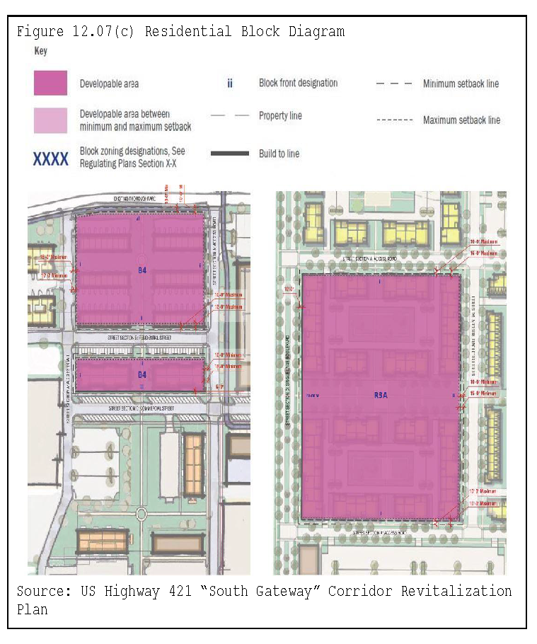
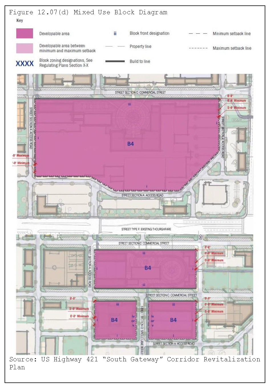
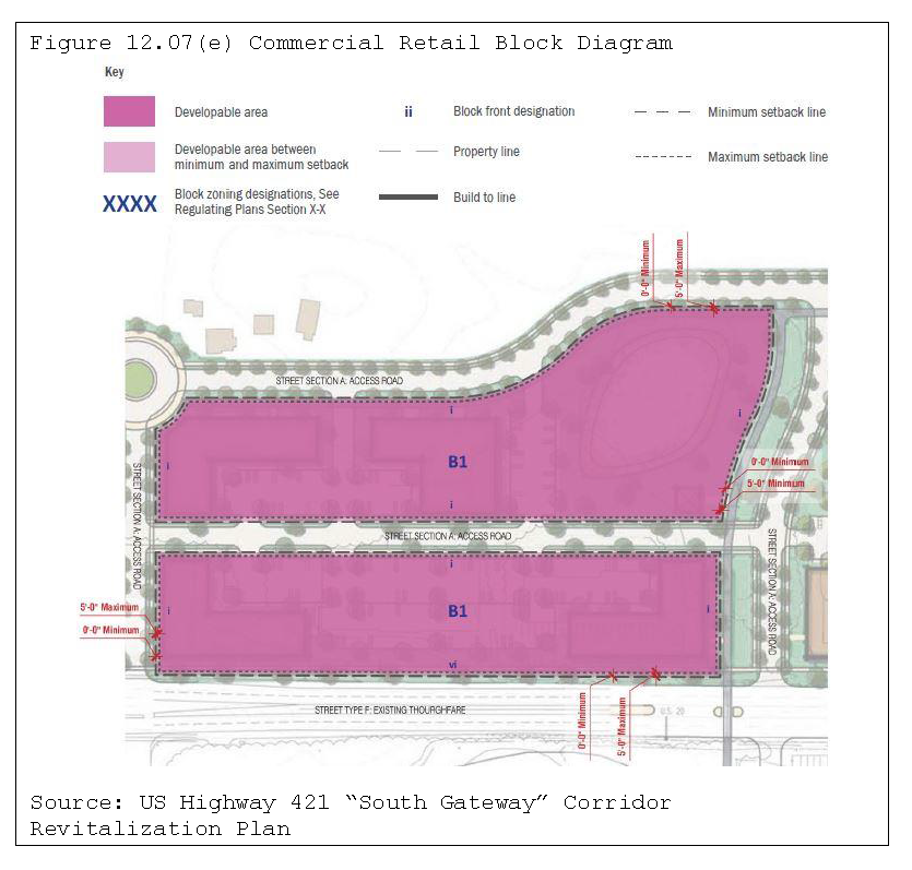
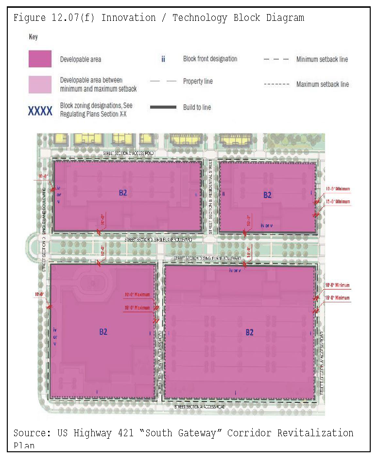
Building Placement and Frontages. Building placement standards describe where on the lot or property buildings must be located, which include build-to lines, setbacks, minimum frontage occupancy, and service and access points. The building placement standards are displayed in Table 12.07(d), Building Placement and Frontage Standards by Street Type, which specify the standards by the adjacent street type. Buildings must conform to the build-to and setback lines depicted in the table and illustrated in Figure 12.07(b), Residential Block Development Diagrams.
2.
Permitted Frontage Types. Building frontage refers to the type of relationship between the building and the street. The permitted frontages by street type are displayed in Table 12.07(e), Permitted Frontage Types by Street Type. Development must comply with the permitted frontage types of the selected building type (see Table 12.07(f) for the building types).
3.
Permitted Building Types and Heights. The building types vary by use group, which include Attached Residential, Courtyard, Mid-Rise, Linear Building with Garage, Multi-Family Residential, and Urban Block. The building types must conform to those listed in Table 12.07(f), Maximum Building Heights per Building Type. The table also specifies the building height limits.
4.
Open Space Types. The open space table outlines which spaces are intended to ensure that a variety of functional, well-designed open spaces are distributed throughout the development. More than one open space type may be used in combination to meet the open space requirement. Where three or more individual open spaces are available to meet the requirements, at least two types must be provided. Public open space must conform to the types listed in Table 12.07(g), Open Space Types.
Table 12.07(d)
Building Placement and Frontage Standards by Street Type
Table 12.07(e)
Permitted Frontage Types by Street Type
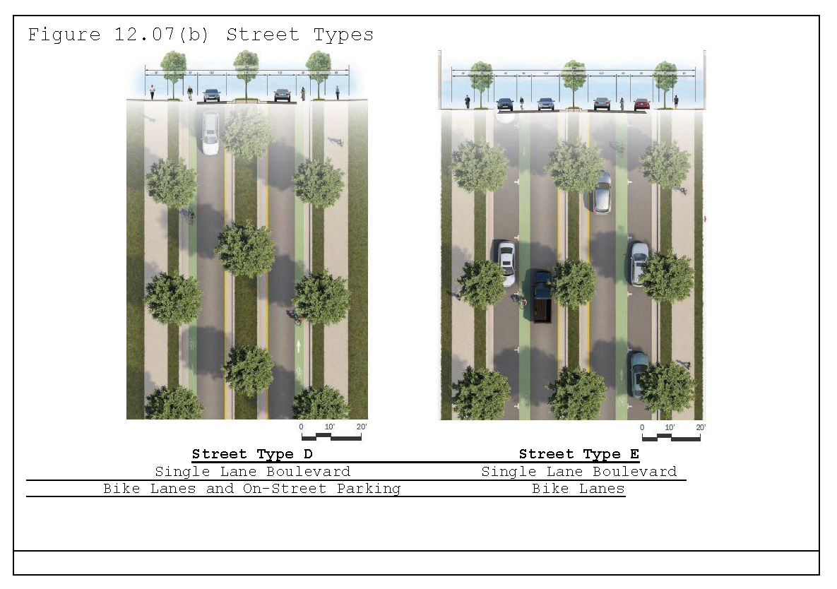
Table 12.07(f)
Maximum Building Heights per Building Type
Table 12.07(g)
Open Space Types
(4)
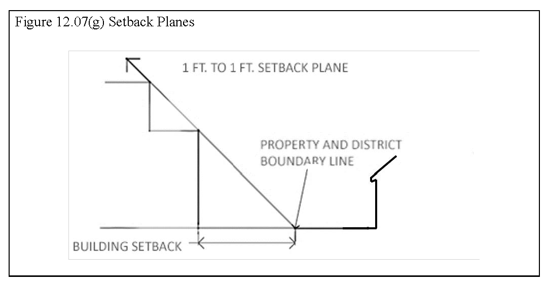
Setback Planes. Where a commercial/retail, mixed-use, or office/industrial building adjoins or is adjacent to a property zoned for single-family residential purposes, then the building shall be set back one foot from the property line for each one foot in building height over 35 feet. (See Figure 12.07(g), Setback Planes)
(5)
Site Layout.
a.
Commercial/Retail and Mixed-Use Buildings.
1.
Buildings shall be:
a.
Located near the center of the development, adjacent to major street corridors, or close to a central open space;
b.
Grouped together along streets to create short walking distances between buildings; and
c.
Located and oriented to minimize the walking distances to residential areas and public open spaces.
2.
Views. Buildings shall be situated and massed to avoid blocking views to significant natural features (e.g., sand dunes, topographic relief, creeks and streams, etc.).
3.
Streets. All streets and drives must be interconnected in a grid pattern. Cul-de-sacs are prohibited.
4.
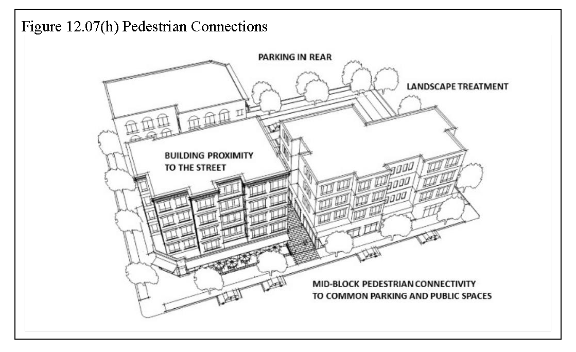
Blocks. Blocks shall be not less than 300 feet or more than 600 feet in length, with public access easements to provide mid-block pedestrian connections to common parking and public spaces, as displayed in Figure 12.07(h), Pedestrian Connections.
5.
Service and utility areas shall be oriented on a side of the building(s) that does not front public street right-of-way or shall be screened by an opaque wall or another approved visual treatment.
b.
Office/Industrial.
1.
Flex-space buildings shall be:
a.
Located on individual lots per the standards depicted in the tables in this Section;
b.
Oriented to face the street of the highest functional class; and
c.
Arranged such that the office space is placed adjacent to all abutting streets.
2.
Streets. All streets must be interconnected and shall be of a width and with turning radii to accommodate truck traffic. Cul-de-sacs are permitted provided the diameter of the bulb is sufficient to accommodate the turning radii of semi-tractor trailers.
3.
Blocks. Blocks may range in size based on the use types but shall not exceed 1,200 feet in length.
4.
Service and utility areas, facilities, and operations shall be oriented on a side of the building(s) that does not front public street right-of-way or that are internal to a multi-tenant building.
(6)
Building Form.
a.
Single-Use Multi-Family Buildings.
1.
A primary entrance for the building shall be located on the front façade.
2.
Front porches, stoops, bay windows, or dormers are required on portions of buildings that are within 10 feet of the building line.
3.
Uncovered stairs may extend to the front property line.
4.
The front yard may contain ornamental metal fencing and retaining walls not more than three feet in height above the sidewalk.
b.
Commercial/Retail and Mixed-Use Buildings.
1.
Buildings shall provide and enhance the pedestrian scale and orientation of the MU district, as follows:
a.
Buildings shall be constructed at the build-to line of the maximum setback to enclose a pedestrian-oriented streetscape in accordance with Table 12.07(e), Building Placement and Frontage Standards by Street Type.
b.
Buildings required to be constructed at a build-to line may be set back 10 feet to:
1.
Provide a walkway on private property along the frontage of the building; or
2.
Provide a public gathering area or plaza that offers seating or dining, landscape or hardscape enhancements, public information and displays, or other pedestrian amenities.
c.
Buildings shall utilize elements such as massing, materials, windows, canopies, and articulated roof forms to create a visually distinct building base, middle, and cap.
d.
One fully functional and visibly identifiable public entrance shall be provided along the frontage of each building, which incorporates changes in mass, surface, or finish to give emphasis.
e.
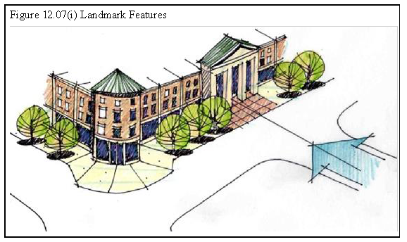
Corner and public buildings must include the design of special building or landmark features, such as towers, cupolas, and pediments, as displayed in Figure 12.07(i), Landmark Features.
c.
Office/Industrial Buildings.
1.
Buildings shall be designed to avoid a box-like appearance, including adherence to the articulation standards set out below.
2.
For every 60 feet of horizontal wall plane of building elevation(s) fronting public street right-of-way, there shall be a variation in the wall plane of at least two feet in depth and six feet in width.
3.
No less than 20 percent of the street-facing façade shall be constructed of windows.
4.
One fully functional and visibly identifiable public entrance shall be provided along the frontage of each building, which incorporates changes in mass, surface, or finish to give emphasis.
5.
Truck loading bays and overhead doors may not be located on the building elevation facing the street of the highest classification. Where required by way of lot shape, a minimum 20-foot buffer/setback shall be provided between the building and street and landscaped in accordance with Section 17.02(c).
(7)
Massing and Scale of Unified Street Frontages. Building facades must be architecturally differentiated in an obvious manner and must include at least three (for commercial/retail and mixed-use) or two (for office/industrial) of the following:
a.
Different colors;
b.
Cladding materials;
c.
Varying heights, provided that the change is at least 10 percent of the building height of the tallest module;
d.
Varying roof forms;
e.
Window arrangement; or
f.
Other facade articulation details (e.g., arcade, balcony, gallery, bay windows, pavilion, pergola, porches, porticos, terrace, tower, or vestibules, etc.).
(8)
Commercial/Retail and Mixed-Use Building Design. The standards in Section 17.01, Building Design Requirements, including Subsection 17.01(g), CBD1 Design Standards, apply in the MU district, along with the following additional or enhanced requirements.
a.
Street Visibility. Upper and lower-story windows must overlook streets and open spaces to make these spaces more comfortable and safe.
b.
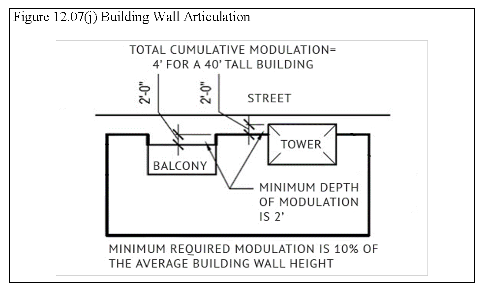
Articulation. Building facades along public or private streets, pedestrian areas, or common open spaces shall be articulated with projections or recesses that cumulatively equal 10 percent of the average building wall height, with a minimum depth of two feet. Such variations will contribute to the building architecture, which may be expressed in any manner provided the cumulative relief is achieved, as shown in Figure 12.07(j), Building Wall Articulation. Individual storefront designs and materials, as applicable, may be unique while maintaining the character of the building facade of which they are a part. The base of buildings must be articulated through use of plinths, pilasters, or other elements.
c.
Transparency:
1.
A minimum of 60 percent of the street-facing building facade between two feet and eight feet in height must be comprised of clear windows that allow views of indoor space or product display areas.
2.
Opaque, dark-tinted, or reflective glass is prohibited.
d.
Building Materials.
1.
Primary. The primary building materials used for building exterior finishes shall be proven high-quality, durable materials. These materials include:
a.
Brick, including thin brick;
b.
Glass and glass block; and
c.
Natural stone, including granite, limestone, marble, terra cotta or cast stone that simulates natural stone.
2.
Standard.
a.
Portland cement stucco;
b.
Architectural (textured) concrete masonry units, including split face, weathered face, sandblasted face, and ground face blocks up to a maximum of 50 percent of facades fronting on or most directly facing street right-of-way or a private access easement;
c.
Concrete finishes or precast concrete panels (tilt wall) incorporating exposed aggregate, hammered, or sandblasted surfaces or covered with a decorative cement-based acrylic coating;
d.
Pre-finished architectural aluminum composite metal wall panels (e.g., Alucobond or equal) up to a maximum of 50 percent of a wall facade
e.
Embossed or pre-finished architectural metal panel (26+ gauge), which has an appearance of masonry or stucco.
3.
Limited. Materials that may be used for exterior wall, siding, or cladding with the approval of the Plan Commission include:
a.
Prefabricated metal wall panels;
b.
Corrugated or ribbed metal panel;
c.
Exterior Insulation and Finish System (EIFS), provided:
1.
Use of a wall drainage system (barrier wall systems are prohibited); and
2.
Use of a 20 oz. high-impact mesh below eight feet above ground level.
d.
Smooth-faced, unfinished concrete block; and
e.
Metal siding.
4.
Prohibited. The use of the following for exterior walls, siding, or cladding is prohibited:
a.
Plastic.
b.
Plywood;
c.
Wood fiber;
d.
Under-fired or unfired clay, sand, or shale rock; and
e.
Painted brick, manufactured stone, concrete masonry units, and cementitious stucco.
5.
Others. Other building materials may be used by approval of the Enforcement Officer if it is demonstrated that they have comparable durability, impact resistance, and aesthetic quality as the materials permitted.
e.
Material Standards. Following are the minimum building material requirements:
Table 12.07(h)
Material Requirements by Use Group
f.
Colors. Exterior colors must be used in the context of the surrounding buildings and environment.
g.
Design of Parking Structures. Parking must be enclosed within, below, or behind buildings in a manner that conceals it from predominant public view and that does not interrupt the continuity of the pedestrian environment. All parking structures must be designed consistent with and complimentary to the architectural style of the principal building(s) to which they are attached. Freestanding parking structures are permitted provided they are not situated along arterial or collector streets or they incorporate active ground-level, street-facing uses within the structure, spanning a minimum of 50 percent of the cumulative street frontage. Parking structures must be positioned within the development to accommodate maximum shared use.
(9)
Commercial/Retail and Mixed-Use Amenities.
a.
Street Furniture. Public seating, trash receptacles, and directional kiosks must be of uniform design and provided throughout district. Sidewalk widths, street trees, landscaping, weather protection, public art, street furniture, and other pedestrian amenities in public rights-of-way and public plazas shall result in a total sidewalk width of no less than eight feet.
b.
Exterior Lighting. The standards in Section 17.04, Lighting Regulations, shall apply in the MU district. In addition, exterior lighting shall be an integral part of the architecture and landscape design, which shall be well-marked and well-lit. Street lighting shall relate in scale to the pedestrian character of the area; therefore, pedestrian lighting shall be limited to a height of three to 12 feet.
(g)
Pedestrian Improvements. The standards in Section 18.05, Non-motorized Pathways, apply in the MU district, along with the following requirements.
(1)
Sidewalks shall connect to existing sidewalks on adjoining lots or tracts.
(2)
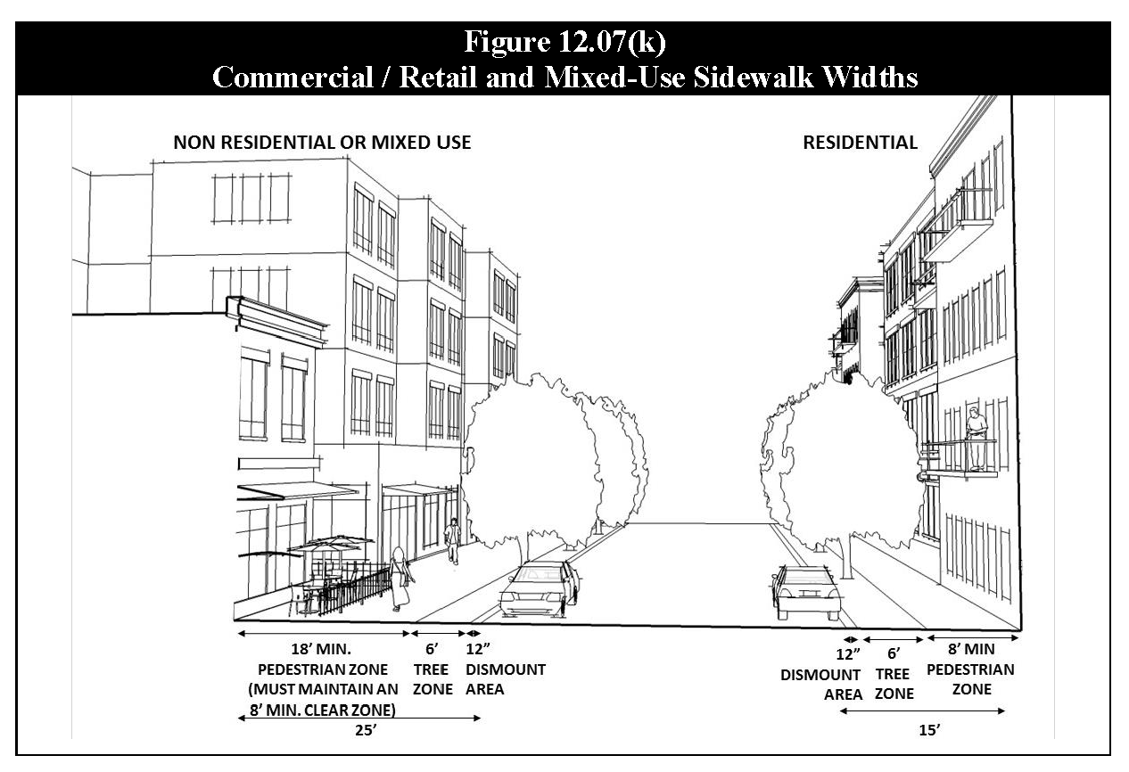
Sidewalk widths adjacent to public streets (see Figure 12.07(k), Commercial/Retail and Mixed-Use Sidewalk Widths) shall comply with the following standards.
a.
Sidewalks abutting residential buildings shall include a minimum 12-inch dismount area from back of curb, a minimum eight-foot pedestrian zone, and a minimum six-foot tree zone.
b.
Sidewalks abutting Commercial/Retail or Mixed-Use buildings shall include a minimum 12-inch dismount area from back of curb, a minimum 18-foot pedestrian zone with a minimum eight-foot clear zone and a minimum six-foot tree zone. The tree zone shall include minimum three-inch caliper shade tree every 30 linear feet of frontage.
c.
Sidewalks within Office/Industrial areas shall be a minimum width of four feet and shall be located on each side of all perimeter streets and one side of each interior street.
(3)
Nonmotorized Pathways. Extensions to existing public trails shall be provided as part of the sidewalk system or within common open space.
(h)
Open Space. As set out in Table 12.07(g), Open Space Types, open space shall be integrated into the overall design of development. Both public and private open space shall be distributed throughout development and should provide not only aesthetic quality but serve recreational and civic functions as well. A variety of open spaces must be conveniently accessible to all residents, employees, and patrons and provide pedestrian linkages throughout the development. Open space must be either include:
(1)
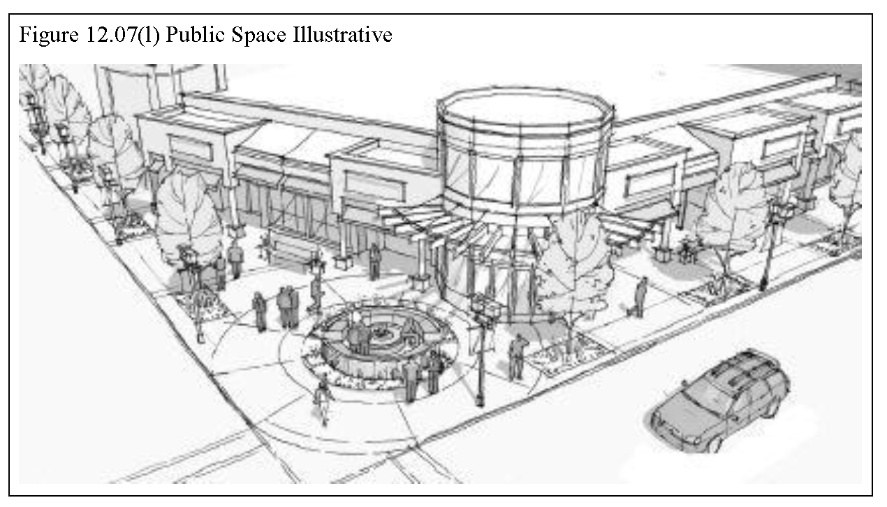
Public Space: Public spaces include open air or unenclosed to semi-unenclosed areas intended for public access and use. These areas range in size and development and serve to complement and connect surrounding land uses. Public space may be publicly- or privately-owned and maintained. (see Figure 12.07(l), Public Space Illustrative)
(2)
Private Common Space: Common spaces include privately-owned and maintained outdoor, unenclosed, or semi-unenclosed areas located on the ground or on a terrace, deck, porch, or roof. This space is designed and accessible for outdoor gathering, recreation, and landscaping, and is intended for use by the residents, employees, and/or visitors to the development.
(3)
Distribution:
a.
Location. The required open space may be provided on-site within a Commercial/Retail or Mixed-Use development as set out in this Section, or alternatively and as approved by the Plan Commission, up to 80 percent of the minimum required open space may be off-site provided such open space is abutting or immediately adjacent to the development.
b.
Bonus Floor Area/Density. An off-site location of the required common open space provides a substantial increase in the maximum allowable floor area or the number of residential dwelling units.
(4)
Amount Required.
a.
Commercial/Retail or Mixed-Use Development.
1.
Total Required Open Space. All development must provide four square feet of public space for every 100 square feet of nonresidential space, excluding service areas and parking.
2.
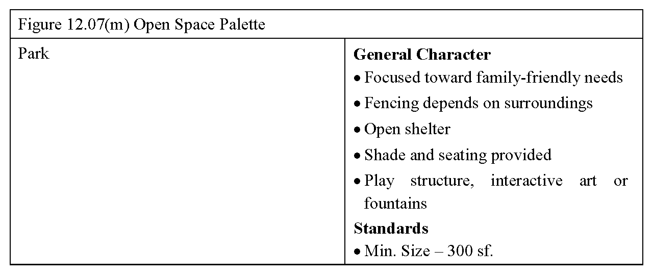
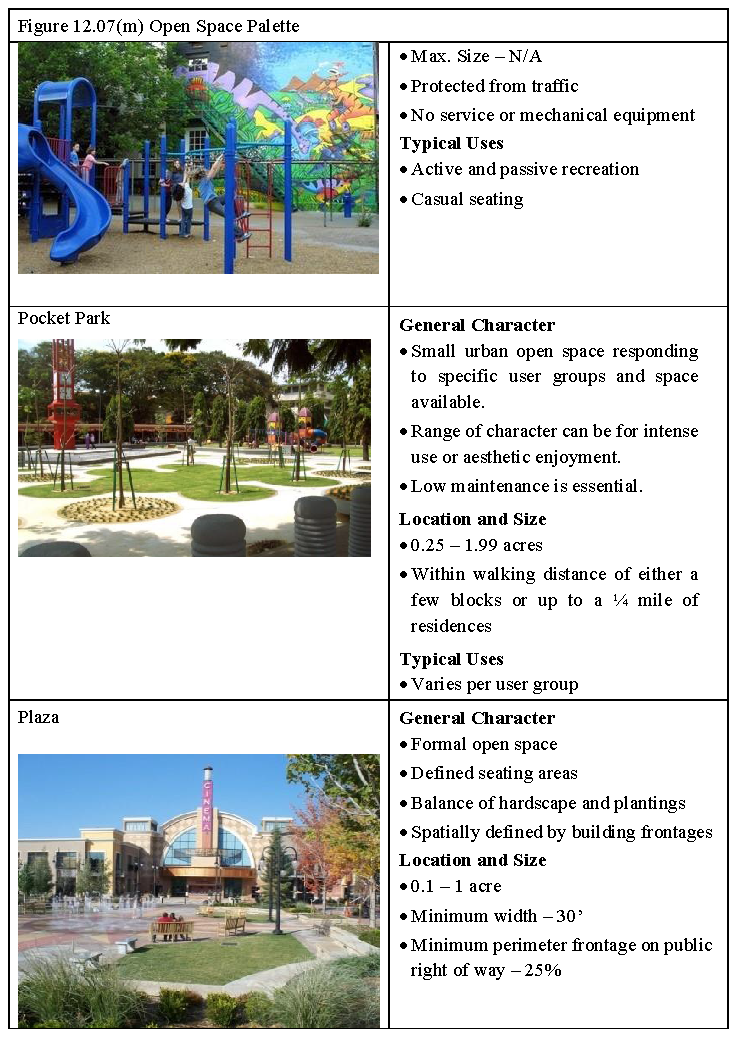
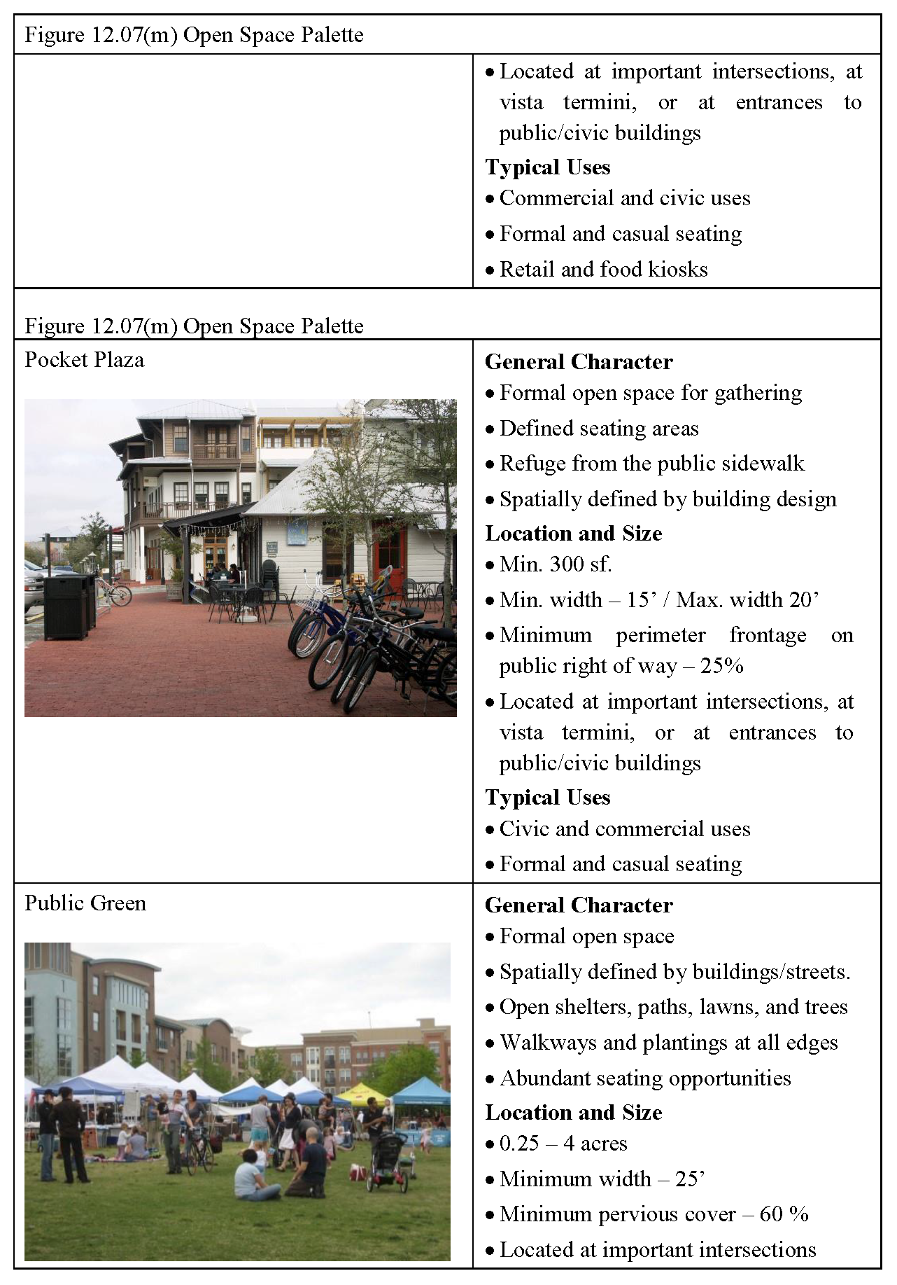
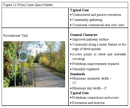
Types of Space. The allowable types of public spaces are displayed in Figure 12.07(m), Open Space Palette.
3.
Central Open Space. At least 50 percent of the required public space shall be within a common, centralized space.
a.
On- or off-site detention basins and other storm water impounding areas, except for permanent wet ponds, may not be counted toward the central open space area requirement.
b.
The space must be improved with a focal point such as a gazebo, public art or sculpture, pavilion, or paved patio area with a fountain or other iconic feature to help identify the park as a primary gathering place for the development. The area of this focal point shall be a minimum of 300 square feet, as shown in Figure 12.07(l), Public Space Illustrative.
c.
The central open space shall be accessible by pedestrians, bicycles, and vehicles. Sidewalks shall be provided adjacent to all roadways and shall be a minimum of six feet wide and not be adjacent to a street curb.
b.
Office/Industrial Development.
1.
Total Required Open Space. A minimum of 15 percent of the land area within a development shall be set aside as common open space, which may be in a central open space or distributed throughout the development.
2.
Types of Space. The allowable types of public spaces are displayed in Figure 12.07(g), Open Space Types, and illustrated in Figure 12.07(m), Open Space Palette.
c.
Residential Development.
1.
Required Open Spaces.
a.
Eight units or less - no requirement.
b.
Nine to 20 units - at least one private common space of any type.
c.
Twenty-one to 40 units - at least two private common spaces of any type.
d.
Forty-one units and greater - at least three private common spaces of any type.
2.
Types of residential open spaces include any permitted public space or balconies on no less than two-thirds of all multi-family units, forecourts, courtyards, roof terrace, or a pool or other amenity.
(i)
Parking.
1.
On-street. In a mixed-use development, street cross-sections shall be designed to include parallel or angled parking on both sides of all streets that are internal to the development.
2.
Off-Street Surface.
a.
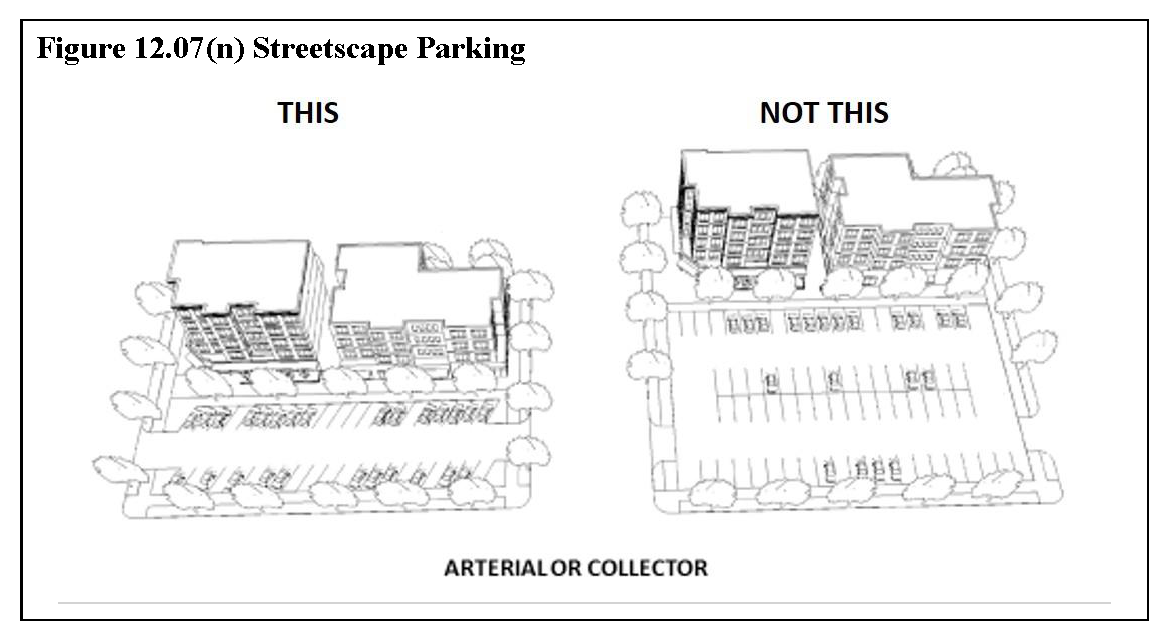
Commercial/Retail. The Enforcement Official may approve a maximum of two rows of parking between buildings and the adjacent street, as displayed in Figure 12.07(n), Streetscape Parking. Otherwise, off-street surface parking shall be located to the side or rear of main buildings. All off-street surface parking lots shall be landscaped to conform to the standards of Section 13.06, Site Design Requirements. Landscape screening shall be planted along 100 percent of all street frontages and other public places. Off-street surface parking shall only be angled or parallel spaces. Each off-street surface parking lot shall not exceed a total of 100 parking spaces, unless otherwise approved by the Board of Zoning Appeals.
b.
Office/Industrial. The Enforcement Official may approve a maximum of two rows of parking between buildings and the adjacent street, as displayed in Figure 12.07(n), Streetscape Parking. Otherwise, off-street surface parking for employees shall be located to the side of main buildings. All off-street surface parking lots shall be landscaped to conform to the standards of Section 13.06, Site Design Requirements.
3.
Parking Transitions. In mixed-use developments, off-street parking areas shall be designed for their transition to structured parking as the development matures toward build out. The site plan shall demonstrate viable traffic operations for ingress and egress for both surface parking and for a parking structure.
4.
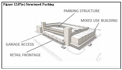
Structured. Parking structures shall be provided to achieve the intended urban form, scale and intensity, density, and mixture of uses of a mixed-use development. To fulfill these requirements, upon initial construction or within an agreed upon time period, structured parking is required for a minimum of 65 percent of the total required parking for a vertical mixed-use building or 50 percent of a horizontal mixed-use development. Parking shall be encapsulated within or below buildings in a manner that conceals it from predominant public view and that does not interrupt the continuity of the pedestrian environment, as displayed by Figure 12.07(o), Structured Parking. All parking structures shall be designed to be consistent with and complimentary to the architectural style of the main building(s). Freestanding parking structures are permitted provided they are either not situated along public streets or they incorporate active ground-level, street-facing uses within the structure. Parking structures shall be positioned within the development to accommodate maximum shared use.
4.
Shared. The Enforcement Official may allow a reduction in the required number of spaces for shared parking in accordance with Section 18.01.05(d), Enforcement Official Reduction of Parking Requirements.
(j)
Phasing. For horizontal mixed-use developments, a certificate of completion for a minimum of one nonresidential building must be issued prior to issuance of any certificates of occupancy for residential buildings.
(Ord. No. 4500, § 5.13., 2-5-2019)