
La Porte City Zoning Code
ARTICLE 04
SINGLE FAMILY RESIDENTIAL DISTRICTS
Section 04.01 - Intent
(a)
R1A Residence District. The R1A Single Family Residential District is established to include areas of low density single-family residences and limited agricultural uses. Certain other institutional, social and recreational uses are also included in this district, such as schools, child care and recreational uses. The intent is to create a transitional residential area in the planned urban expansion areas of the county designated in the County Land Development Plan.
(b)
R1B Residence District. The R1B Single Family Residential District is established to include areas of moderate density single-family residences. Certain other institutional, social and recreational uses are also included in this district, such as schools, child care and recreational uses. This district may apply to outlying areas of incorporated cities with larger lot development. This district may also apply to unincorporated areas of the county that are identified in the County Land Development Plan for planned urban expansion adjacent to established cities where sufficient public services are available to support the density. This district is intended for areas where community sewer is available or scheduled in the near future.
(c)
R1C Residence District. The R1C Single Family Residential District is established to include urban neighborhoods with moderate sized lots and larger single family dwellings. Certain other institutional, social and recreational uses are also included in this district, such as schools, child care and recreational uses. The intent is to maintain and enhance traditional, walkable, pedestrian-oriented neighborhoods and to provide for infill development that is consistent with the established character of the neighborhood. The R1C is only intended for incorporated areas of cities where all necessary utilities and community services are available to serve a higher density population.
(d)
R1D Residence District. The R1D Single Family Residential District is established to include urban neighborhoods with small lots. This district will include single family and two family dwellings. Certain other institutional, social and recreational uses are also included in this district, such as schools, child care and recreational uses. The intent is to maintain and enhance traditional, walkable, pedestrian-oriented neighborhoods and to provide for urban infill development that is of a form and character consistent with established historic neighborhoods. The R1D is only intended for incorporated areas of cities where all necessary utilities and community services are available to serve a higher density population.
(e)
R1E Waterfront Residence District. The R1E Waterfront Residential District is established to apply to existing, small-lot residential areas and to protect lake views and the sensitive natural environs of the waterfront. The principal use of this district is single-family detached dwellings and ancillary uses, along with commercial use of dwellings by special exception. Certain other community and recreational uses are also included in this district. The intent of this district is to conserve the character and value of these well-established waterfront neighborhoods, by preventing overbuilding of small lots and protecting against construction of new residences that are out of scale with the surrounding homes. Furthermore, the intent is to preserve the highly-valued amenity of the lakefront by maintaining views of Lake Michigan, preserving forest cover, and protecting the sensitive environment and ecology of the sand dunes, coastal wetlands, and streams and drainageways. The R1E district is intended only for the existing, historic waterfront neighborhoods and appropriately scaled infill development. Given the existing built environment and its character, this district is not intended for new, larger-scale development.
(Ord. No. 4500, § 5.3., 2-5-2019)
Section 04.02 - Uses
Use and development of land and buildings shall only be for the following specified uses, unless otherwise provided for in this Ordinance. Uses are grouped into major categories and only those uses listed under each category are permitted. Land and/or buildings in the districts indicated at the top of the Table may be used for the purposes denoted by the following abbreviations:
P:
Permitted Use. Land and/or buildings in this District may be used for the purposes listed by right.
S:
Special Exception Use. Land and/or buildings in this District may be used for this purpose by obtaining Special Exception approval when all applicable standards cited in Article 24 Special Exception Review Requirements and Procedures.
-:
Not Permitted. The use is not permitted in the district. Uses not listed in the table are also not permitted. Uses that are not listed in any district of the zoning ordinance, as shown in Appendix A, may be allowed based upon a similar use determination in accordance with Section 02.06.
Table 04.02
Schedule of Permitted Uses
(Ord. No. 4500, § 5.4., 2-5-2019)
Section 04.03 - Lot Area and Width Requirements
All lots shall meet the following minimum area and width requirements. No new lots shall be created or altered in a manner that does not comply with the following requirements.
Table 04.03
Lot Area And Width Requirements
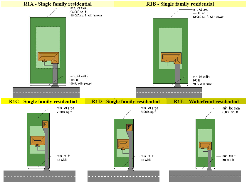
(a)
Subdivision of Land. All divisions to land shall be subject to the requirements set forth in the Subdivision Regulations of La Porte County, City of La Porte or City of Michigan City, as applicable.
(b)
Community Sewer. Community sewer refers to a community or municipal wastewater system. All lots not served by community sewer shall be subject to State and County Health Department regulations regarding accommodation of septic or other onsite wastewater treatment systems, which may require larger lot sizes than those indicated in Table 04.03. Any new lots created in the R1C, R1D or R1E must be served by community sewer. Community sewer may include onsite cluster systems.
(c)
Lot Area Calculation. Lot area is calculated based upon the net area of the lot, measured in the horizontal plane, exclusive of any area that is part of a public road right-of-way, private road easement or submerged land beneath the ordinary high water mark of a lake, river or stream.
(d)
Lots not Part of a Major Subdivision. In the unincorporated areas of the county, lots that are created through the recording of a minor subdivision plat shall be required to meet the following requirements:
(1)
The minimum lot area shall be one acre.
(2)
The minimum lot width shall be 200 feet.
(e)
Lot Width and Frontage. Lot width shall be measured as a straight line between the side lot lines at the minimum front yard setback of the district. All lots shall have frontage along a public road or street. The width along the road shall be sufficient to meet the lot width requirement at the minimum front yard setback.
(f)
Dominant Parcel. The dominant tract or parcel from which any newly created lot has been divided from must also maintain the required lot width.
(g)
Depth to Width Ratio. All newly created lots shall have a lot depth of no more than four times the width (i.e. maximum 4:1 depth to width ratio).
(h)
Nonconforming Lots. Lots of record that were in existence prior to the effective date of this ordinance may be used subject to the provisions of the nonconforming lot regulations of Section 29.03.
(i)
Recreation Area. All residential subdivisions containing more than 40 lots shall provide an active recreational area as required by the Subdivision Regulations.
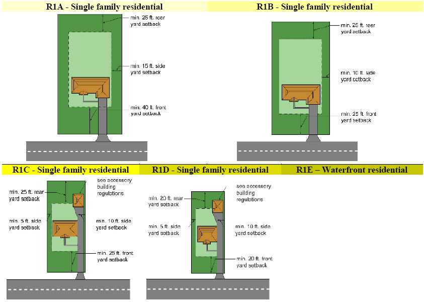
Section 04.04 - Building Dimensional Requirements
All structures shall be subject to the dimensional regulations of the following table.
Table 04.04
Building Dimensional Requirements (a)
(a)
Accessory Structures. Accessory structures shall be regulated under the requirements of Article 16.
(b)
Height Exceptions. No structure shall exceed the maximum height of the district except for the allowable exceptions to the height limits contained in Section 15.02.
(c)
Projections into Yards. All required yard spaces shall remain as landscaped open space, except for pavement, accessory structures and architectural features that are allowed to extend or project into required setbacks under Section 15.01. Driveways and other paved or gravel areas for vehicles shall not cover more than 40 percent of the front yard area. At least 60 percent of the front yard shall remain as landscaped green space.
(d)
Setback from Road. The front yard setback shall be measured from the road right-of-way or private road easement.
(e)
Corner Lots. Corner lots shall provide the minimum side street yard shown in Table 04.04, Building Dimensional Requirements. The longer road frontage shall be considered the side-street. The enforcement official may adjust the front lot line designation based upon the orientation of the building on the lot and adjacent lots.
(f)
Double Frontage Lots. In all districts, where a double frontage lot backs-up to a roadway, the minimum required front or roadside setback shall be required from both road rights-of-way.
(g)
Driveway Access. Corner and double frontage residential lots shall only have driveway access from one road, which shall be the lesser traveled road as determined by the enforcement official.
(h)
Wetlands. A minimum setback of 50 feet shall be maintained from all wetlands. The setback may be adjusted according to requirements of natural resource preservation guidelines contained [in] Article 22.
(i)
Waterway Setback. The waterway setback shall be measured from the shoreline of the lake, river or stream. In no instance shall any structures other than docks, seawalls, retaining walls, sidewalks, boardwalks, and patios be permitted within the minimum waterway setback. The setback may be adjusted according to requirements of Natural Resource Preservation Guidelines.
(j)
Maximum Lot Coverage. The percentage of the net lot area covered by buildings and impermeable surfaces shall be shown on all building permit plans, including those of accessory building(s) that individually or cumulatively exceed 144 square feet. The maximum lot coverage for buildings and impermeable surface shall be measured as follows:
(1)
The building coverage shall be calculated as the ratio of the footprint of all buildings, including the principal building, garages and detached accessory buildings, to the net area of the lot.
(2)
The total impermeable surface coverage shall be calculated as the ratio of the ground area covered by all principal and accessory buildings and structures, decks, pools, pavement, parking, loading, storage areas and normal pool of wet detention basins to the net lot area.
(k)
Waterfront View Protection.
(1)
Scope of Application. The Waterfront View Protection standards shall apply:
(a)
To all properties located from the highest point of the dune immediately south of the Lake Shore Drive, extended, northward to Lake Michigan, from the eastern limits of Washington Park on the west to the end of the City limits on the east.
(b)
To all new buildings or any additions to existing buildings that would increase the width of the building measured parallel to the shoreline or nearest park lot line.
(2)
Building Side Yards. The total of both side yards shall be at least 30 percent of the lot width where the structure is located.
(3)
Building Height Limits. The maximum height of any principal building shall be 35 feet.
(a)
The height of a building shall be measured from the highest point of the roof to the highest level of the existing grade of the lot where it adjoins the building wall or structure. For this purpose, existing grade shall mean the natural, undisturbed grade, before it is altered by land clearing, berming, or preparation and before construction begins.
(b)
The only exception to building height shall be chimneys, which shall be no more than five feet taller than the highest point of the roof.
(c)
All roofs shall have a minimum roof pitch of 4:12. The longest ridge line of the roof shall be roughly perpendicular to the shoreline; or for buildings at an angle, the ridge line most perpendicular to the shoreline (within 45 degrees of perpendicular).
(4)
Waterfront Setback. The waterfront setback shall be measured from the shoreline at established normal water level.
(5)
Uses Permitted. The uses permitted shall be regulated by the underlying zoning district. The review and approval process applicable in the underlying zoning district shall be followed.
(l)
Standards Applicable to the R1E District.
(1)
Subdivision of Land. Any subdivision or re-subdivision of land shall require a concept plan followed by a development plan followed by a primary plat for review and approval by the Plan Commission at a public hearing in compliance with the requirements of the 1400 Series of Indiana Code 36-7-4 prior to submission of an application for Primary Plat review.
(a)
Concept Plan. All information required for a concept plan as per Subdivision Ordinance Article 05, Section 01 shall be submitted;
(b)
Development Plan. The information required to be submitted includes:
1.
A map detailing the proposed vehicle and pedestrian systems including:
a.
Street layout and cross-sections;
b.
Points of ingress and egress and traffic control devices;
c.
Sidewalk and crosswalk improvements;
d.
Common parking areas, as applicable;
e.
Location, arrangement, and number of lots;
f.
Minimum area, width, and depth of lots;
g.
Areas of common open space or recreation within the proposed development;
h.
Topography, with one-foot contours indicated and areas where slopes exceed 12 percent clearly delineated; and
i.
All protected trees as set out in Section 17.02, Landscaping Requirements, including Latin name (Genus and species).
2.
An indication of each proposed phase within the development and land to remain undeveloped;
3.
Proposed building architecture (bulk, scale, and form) and materials for all applicable uses, including at least two building elevations; roof plan indicating orientation of roof pitches and direction of gables; and site design standards;
4.
A proposed drainage plan, including the location and capacity of proposed storm sewer and other stormwater management facilities and proposed alternative methods for handling storm water (e.g. structural and nonstructural best management practices (BMPs)) all in compliance with stormwater performance standards and the provisions of Chapter 46, Article IX of the Michigan City, Indiana Code of Ordinances; and
5.
A dune protection plan to protect both foredunes and backdunes from breach, blowout, and general erosion due to development.
(2)
Traffic Management. Any subdivision of land into 10 or more lots (including lots in all phases of larger subdivisions) shall require a traffic impact analysis conducted by a traffic engineer licensed by the State of Indiana. At a minimum, the analysis shall include:
(a)
A statement of how the development plan is designed to provide for safe vehicular access to/from and circulation within the development without reducing level of service;
(b)
Evidence that the design and location of proposed street and highway access points minimize safety hazards and congestion;
(c)
Evidence that the points of access to collector and local streets, and internal traffic circulation is compatible with the existing and any planned streets in adjacent developments; and
(d)
Proof that the traffic carrying capacities of adjacent streets and highways is sufficient to safely and efficiently accept traffic generated by the new development as evidenced by:
1.
Trip generation data and model outputs based on the travel characteristics and land uses, densities, or floor areas, as applicable, of the parcel proposed for development; and
2.
Capacity analysis for the adjacent streets from which the land proposed for development takes access, including existing and proposed Levels of Service (LOS), traffic counts for existing peak hour and average daily traffic (ADT) methods taking seasonal impacts of the proposed development into consideration for both pre- and post-development conditions.
(e)
Evidence that entrances, streets, and internal traffic circulation facilities in the development plan are compatible with existing and planned streets and adjacent developments.
(3)
Neighborhood Conservation.
(a)
Purpose. The City includes areas that have been developed for many years. Therefore, applying regulations to existing development has created situations in which existing lot dimensions and building footprints do not strictly comply with the requirements, even though they complied at the time they were permitted and constructed. The fact that these nonconformities were at one time conforming means that they are now deemed "legally nonconforming" and therefore, are permitted to continue without substantive changes until site, building or structure, or land use changes are proposed.
The purpose of this Subsection is to enable reinvestment on developed, nonconforming lots and new investment on vacant lots provided property improvements preserve and are compatible with the character and bulk and scale of development. A demonstration of conformance may warrant compliance with the standards of this Section or may allow adaptation to alternate development standards by the enforcement official without requiring hardship or a variance process. Further, lawfully constructed buildings, structures, and platted lots may be deemed conforming rather than nonconforming.
A number of properties are nonconforming by reason of the lot area, width, or width-to-depth ratio, building setbacks, and due to the percent of building or impermeable surface coverage. These nonconformities effect both developed and vacant lots, as applicable. A nonconforming designation imposes limitations on the ability to alter, expand, improve, or replace buildings as provided in Section 29.02, Nonconforming Structures and Buildings, and Section 29.03, Nonconforming Lots. Furthermore, such designation may also affect loan approval or require variances prior to property improvement. These limitations deter investment and reinvestment and the ability to sustain a quality character and economic integrity of the neighborhood over time.
(b)
Applicability. The standards of this Section are applicable to the R1E District.
(c)
Declaration of Conformity. Subject to the exceptions set out in Subsection (4)(c)(4) below:
1.
Lots that lawfully existed as of January 1, 2019 are deemed "conforming" with respect to lot area, lot width, and the width-to-depth ratio provided the lot is subject to an approved and recorded subdivision plat for which no metes-and-bounds adjustments have been made to the lot boundaries;
2.
Principal and accessory buildings or structures that lawfully existed as of January 1, 2019, or that were the subject of an active building permit, are conforming with respect to the current building footprint and its lot coverage;
3.
Any addition to or alteration of a principal or accessory building or structure and the cumulative lot coverage, including building and impervious surface coverage, after January 1, 2019, must comply with the following:
a.
Developed Lots:
1.
The standards of Table 04.04, Building Dimensional Requirements;
2.
Minor modifications approved by the Enforcement Official, or a designee, that do not exceed five percent of any required dimensional standard of this Ordinance, including those of existing building foundations or footprints, and which may be demonstrated not to impose material impacts on public rights-of-way, easements, or adjacent properties;
3.
If a proposed building or structure modification or expansion does not and may not comply with the standards of Table 04.04, Building Dimensional Requirements, then the application shall be evaluated according to the alternate standards outlined below; and then
4.
As allowed by a variance authorized by the Board of Zoning Appeals.
b.
Undeveloped Lots:
1.
The standards of Table 04.04, Building Dimensional Requirements, or if the subject lot is nonconforming as of January 1, 2019:
2.
The alternate standards outlined below.
(d)
Exceptions. A declaration of conformity however, does not make the following conforming:
1.
A primary plat that was approved by the City but for which secondary plat approval was not granted within 120 days;
2.
Construction of a principal structure on more than one lot of record without approval of a replat;
3.
Principal or accessory buildings or structures that were constructed or modified without or in violation of required permits;
4.
Principal or accessory buildings or structures that encroach into public rights-of-way or easements (including The Esplanade);
5.
Buildings that were permitted and constructed as a single-family detached dwelling and later converted to a two-family unit or multiplex (three to five units) without required permits, or were not in conformance with the applicable zoning designation; and
6.
Accessory buildings or structures that were located within a setback without approval of a variance.
(e)
Alternative Standards.
1.
Generally. Alternative setbacks may be applied only if demonstrated that the standards of this Subsection are met, and:
a.
The proposed construction does not interfere with a planned expansion of right-of-way, and if right-of-way expansion is planned, the encroachment is evaluated as if the right-of-way has been expanded;
b.
The proposed construction does not result in interference with any easement;
c.
Drainage onto abutting properties or rights-of-way does not significantly alter or substantially change the conditions before the proposed development;
d.
The proposed construction does not result in a nonconformity with respect to the building code on either the lot proposed for development or abutting lots;
e.
If the parcel that abuts the improvement is used for residential purposes, the proposed construction is built to building code standards that would allow construction of the abutting lot to be built to the same standard along the same setback line; and
f.
The proposed construction does not reduce the area provided for parking to fewer spaces than required.
2.
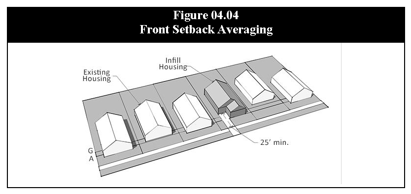
Front Setback Averaging. Front setbacks may be reduced to the average front setback along the same side of the same street segment in the same zoning district, provided that:
a.
The lot proposed for development and any lot that encroaches a public right-of-way or easement is not counted in the calculation; and
b.
If the lot takes vehicular access from the front, the driveway must be at least:
1.
25 feet long, measured from the property line to a building wall or garage door; and
2.
The width of the garage door(s) is/are not less than nine feet or more than 18 feet in width.
3.
Interior Side and Rear Yard Setbacks. The interior side and rear yard setbacks shall be the lesser of the standards of Table 04.04, Building Dimensional Requirements, or the average prevailing setbacks on the lots on either side or if on a corner lot, within two lots of the same street frontage, provided no interior side setback may be less than five feet and no rear setback may be less than 15 feet.
4.
Side Street Yard Setback. In the instance of a corner lot, the side street setback shall be the greater of that set out in Table 04.04, Building Dimensional Requirements, or the front yard setback of the adjacent lot.
5.
Building Coverage Ratio. The Enforcement Official may approve additional building coverage up to five percent greater than that required Table 04.04, Building Dimensional Requirements, if it is demonstrated that:
a.
The increased building coverage does not increase the extent of any other nonconformity present on the property;
b.
The impact will be no greater than it was before the construction of the additional building coverage; and
c.
The bulk (volume) of the building is not greater than that of a building that could be constructed at the maximum building coverage as set out in Table 04.04, Building Dimensional Requirements.
(Ord. No. 4500, §§ 5.5.—5.8., 2-5-2019; Ord. No. 4770, § 2(Exh. B, A.3), 8-4-2025)