
Laguna Woods City Zoning Code
CHAPTER 13
04.- ESTABLISHMENT OF ZONING DISTRICTS
Sec. 13.04.010.- Scope of the Zoning Code and adoption of Zoning District Map.
This chapter includes Zoning Maps, general provisions, special regulations and a set of general district regulations limiting and controlling the uses of land, the density of population, the uses and locations of structures, the height and bulk of structure, the areas and dimensions of sites; the size, height and location of signs; the installation and maintenance of screening and landscaping; and the control of vehicular access and the requirement of off-street parking and loading facilities. In addition, this chapter includes specific plan maps and texts adopted by ordinance.
(Ord. No. 03-03, § 5(18.10.205), 4-16-2003; Ord. No. 11-01, § 4(Exh. 1), 1-19-2011; Ord. No. 15-02, § 3(Exh. A), 8-19-2015)
Sec. 13.04.020. - Establishment of districts.
(a)
The incorporated territory of the City of Laguna Woods is hereby divided into zones or districts, as set forth in this title, as determined and defined by officially adopted zoning map. The zoning district map showing the classifications and boundaries of the districts shall, upon adoption in the manner required by the Planning and Zoning Law, be a part of this chapter. The following districts are established:
(b)
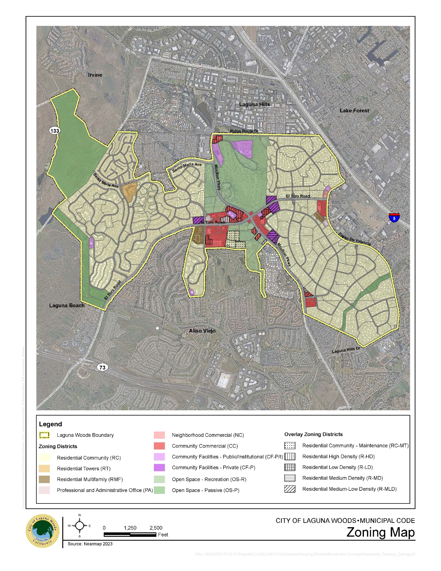
Map exhibit. The following map exhibit designates areas to which each of the zoning districts and overlay zoning districts established by this section are applied:
(Ord. No. 03-03, § 5(18.10.210), 4-16-2003; Ord. No. 11-01, § 4(Exh. 1), 1-19-2011; Ord. No. 23-02, § 3(Exh. A), 8-16-2023; Ord. No. 24-06, § 3, 9-18-2024)
State Law reference— Zones authorized, Government Code § 65851.
Sec. 13.04.030. - Interpretation of boundaries.
Where uncertainty exists as to the boundaries of districts shown on an official Zoning District Map, the following rules shall apply:
(1)
Boundaries indicated as approximately following the centerlines of streets, highways or alleys shall be construed to follow such centerlines;
(2)
Boundaries indicated as approximately following the right-of-way lines of streets, highways, or alleys, shall be construed to follow such right-of-way lines, and in event of change in the right-of-way line shall be construed as moving with the right-of-way line;
(3)
Boundaries indicated as approximately following the centerlines of streams, rivers, canals, lakes or other bodies of water, of flood control channels shall be construed to follow such centerlines;
(4)
Boundaries indicated as approximately following plotted lot lines shall be construed to follow such lot lines;
(5)
Boundaries indicated as parallel to or extensions of features indicated in the above subsections shall be so construed. Distances not specifically indicated on the official Zoning District Map shall be determined by the scale of the map;
(6)
Where a street or alley is vacated or abandoned the regulations applicable to the property to which it is reverted shall apply to such vacated or abandoned street or alley;
(7)
In case any further uncertainty exists, the Planning Commission shall determine the location of boundaries.
(Ord. No. 03-03, § 5(18.10.215), 4-16-2003; Ord. No. 11-01, § 4(Exh. 1), 1-19-2011)