
Laguna Woods City Zoning Code
CHAPTER 13
08.- RESIDENTIAL DISTRICTS
Sec. 13.08.010.- Intent and permitted uses.
(a)
Residential multifamily (RMF). To provide for the development and preservation of high-density multifamily residential neighborhoods with a moderate amount of open spaces. Only those uses are permitted that are complementary to and are compatible with such a residential neighborhood.
(b)
Residential community (RC). To provide for the development and preservation of planned unit developments with a mixture of single-family attached and detached homes, multiple-family homes. Said neighborhoods will be characterized by controlled physical access and specialized recreation facilities. Setbacks and other development standards are to be tailored specifically to each project by means of a precise development plan that is approved with the project.
(c)
Residential towers (RT). To provide for the development and preservation of a special type of multiple-family structure, high-rise, designed to house and provide other special needs for residents only.
_____
PERMITTED RESIDENTIAL USES LEGEND:
(Ord. No. 03-03, § 5, 4-16-2003; Ord. No. 11-01, § 4(Exh. 3), 1-19-2011; Ord. No. 11-02, § 4, 1-19-2011; Ord. No. 14-01, § 3, 4-16-2014; Ord. No. 17-03, § 3(Exh. A), 4-19-2017; Ord. No. 17-05, § 5(Exh. A), 5-17-2017; Ord. No. 17-06, § 5(Exh. A), 7-19-2017; Ord. No. 17-10, § 3(Exh. A), 11-15-2017; Ord. No. 18-05, § 3(Exh. A), 3-21-2018; Ord. No. 19-02, § 3(Exh. A), 4-17-2019; Ord. No. 2020-01, § 3, 8-19-2020; Ord. No. 23-01, § 3(Exh. A), 8-16-2023; Ord. No. 23-02, § 3(Exh. A), 8-16-2023; Ord. No. 23-03, § 3(Exh. A), 11-15-2023)
Sec. 13.08.020. - Development standards.
The Residential Development Standards Table, which follows, specifies standards for the development of property within residential districts.
Residential Development Standards
Notes:
1 Minimum per dwelling unit is based upon net land area.
2 In computing the depth of a rear setback from any building where such setback opens on an alley, private street, or public park, one-half of the width of such alley, street, or park may be deemed to be a portion of the rear setback, except that under this provision, no rear setback shall be less than 15 feet.
3 There shall be no minimum lot size. The total number of residential units permitted within the planning unit shall not be exceeded as was shown on the statistical analysis for the original planned community, as amended. The dwelling densities as categorized in the City's General Plan as low-density, medium-density and high-density shall not be exceeded. The limitations contained within the General Plan shall take precedence over any discrepancies that may exist as compared to the statistical analysis for the planning units.
4 Required yards and distances between building structures are waived.
5 The building site coverage shall not exceed 50 percent of the land area contained within each recorded tract, exclusive of dedicated right-of-way. Swimming pool coverage shall not be considered as building site coverage.
(Ord. No. 03-03, § 5, 4-16-2003; Ord. No. 11-01, § 4(Exh. 3), 1-19-2011)
_____
Sec. 13.08.030. - Supplemental residential district regulations.
(a)
Type of development for RC District. Standard development shall be predominantly of multiunit, multistoried structures and single family, one-story structures in an arrangement of attached or detached dwellings and their accessory structures. Such structures will be on contiguous or related building sites where the yards and open spaces may be combined into desirable arrangements of common open space.
(b)
Frontage for RC District. Building sites may not necessarily have street frontage, either public or private, provided:
(1)
Adequate and permanent access from a street to each family dwelling unit is provided for pedestrians and emergency vehicles;
(2)
Adequate and permanent provisions for one accessible, roofed automobile storage place is provided for each dwelling unit;
(3)
At least one parking space for every four dwelling units within each recorded tract is provided for visitors and guests. Such parking spaces may be uncovered and shall be so located as to be accessible to such visitors and guests.
(c)
Open space and landscaping for RC District. All open space shall be landscaped and may include noncommercial recreational facilities incidental to the residential development such as outdoor recreation areas, walkways, covered and uncovered patios, fences and necessary firefighting equipment and installations. Further, the required open space shall be arranged and provided in such a manner that it is accessible and usable for the purpose intended herein. Said open space shall not be devoted to commercial pursuits or any other activity in conflict with the purpose intended herein.
(d)
Lighting. All lights shall be designed and located so that direct light rays shall be confined to the premises.
(e)
Recreational facilities for RC and RT Districts. The replacement, redevelopment and/or relocation of any existing recreational facilities shall not result in a net loss of land area as originally developed and maintained for any type of recreational use, including clubhouse structures. Such change to existing recreational facilities requires the submittal of an analysis showing existing recreational facilities, service areas of such facilities, land area of such facilities and any other information as may be required by the Director to demonstrate that no such loss of land area will result, subject to the City Council's review and approval.
(Ord. No. 03-03, § 5(18.20.120), 4-16-2003; Ord. No. 11-01, § 4(Exh. 3), 1-19-2011)
Sec. 13.08.040. - Residential community-maintenance overlay.
(a)
Purpose, generally. The purpose of overlay zoning districts is to allow the City to establish special land use regulations, standards, or procedures in areas with unique land use, site planning, building design, or environmental resource issues. Overlay zoning districts are also an appropriate mechanism to implement long-term goals and land use requirements of the City for a specific property or location, or to coordinate land use and design requirements unique to a large tract of land. Overlay zoning districts are intended to be applied only where special circumstances justify the modification of base zoning district regulations to achieve specific land use and design objectives. Overlay zoning districts are established through rezoning and only in conjunction with base zoning districts.
(b)
Purpose, specifically. The purpose of the Residential Community-Maintenance Overlay Zoning District (RC-MT) is to provide for the continued development and preservation of specialized maintenance and operational support facilities that provide services to the base Residential Community (RC) zoning district, and to prohibit incompatible uses. Specialized maintenance and operational support facilities were developed with the initial development of the planned unit development located within the RC zoning district (formerly Rossmoor Leisure World Planned Community, now Laguna Woods Village), and have continued to be maintained and developed since then. Such facilities, and the direct services that they allow for, further the RC zoning district's purpose and intent of providing for the "development and preservation of planned unit developments."
(c)
Establishment and designation, generally. Except as modified by an overlay zoning district, the provisions of the applicable base zoning district shall apply to all development within the boundary of a designated area. If regulations conflict, the applicable overlay zoning district regulations shall prevail. Whenever an overlay zoning district is established, any subsequent application to change the base zoning district shall not be construed to be an application to eliminate the overlay zoning district for the property covered by the application. An intent to eliminate the overlay zoning district on a given property shall be expressly stated to be part of the application.
(d)
Establishment and designation, specifically. The designated area to which the RC-MT overlay zoning district is applied shall be all parcels located within the RC zoning district that are located south of El Toro Road, west of Moulton Parkway, and east of Calle Sonora.
(e)
Principally permitted land uses. Land uses permitted as a principal use within the RC-MT overlay zoning district, subject to all applicable laws and regulations, and only when operated to primarily provide services to the base RC zoning district, include the following:
Administrative/Professional Offices
Automobile Parking Structures, Multi-Level
Automobile/Truck Maintenance and Repair
Garages and Carports
Gate Houses
Maintenance Equipment/Supply Storage
Maintenance Office/Building
Public/Private Utility Buildings/Structures
(f)
Accessory land uses. Land uses that are permitted only as an accessory to a principal use within the RC-MT overlay zoning district include the following:
Accessory Building/Use
Exercise Facilities for Employee Use Only (indoor only; no fields/courts)
Churches, Temples, and Places of Worship
Fences and Walls
(g)
Conditionally permitted land uses. Land uses permitted subject to approval of a use permit within the RC-MT overlay zoning district, subject to all applicable laws and regulations, and only when operated to primarily provide services to the base RC zoning district, include the following:
Automobile Service Stations
Bus and Taxi Terminal Buildings
Impound/Storage Yards
Ministorage Facilities
Police and Fire Stations
Recreational Vehicle/Vessel Storage
Recycling Collection Sites
Vehicle Washing Facilities
(h)
Prohibited land uses. Land uses that are prohibited within the RC-MT overlay zoning district include the following:
Agricultural and Produce Stands
Alcoholic Beverage Sales
Athletic Fields/Courts
Automobile Wrecking, Junk/Salvage Yards
Bottling Plants
Commercial Medical Marijuana Cultivation
Commercial Uses
Congregate Care Facilities
Day Care Nurseries
Educational Institutions
Emergency and Transitional Housing Shelters
Helistops
Hospitals
Hotels and Motels
Housing
Kennels
Medical Uses
Recreation Centers
Restaurants
Retail/Service Businesses
Riding and Hiking Trails
Swimming Pools
Theatres
Tobacco and Cigarette Sales
Transfer/Materials Recovery Facilities
(i)
Wireless facilities. Wireless facilities within the RC-MT overlay zoning district are subject to the provisions of Section 13.26.210 of this Code.
(j)
Development standards. Development standards for the RC-MT overlay zoning district shall include Section 13.08.020 as it relates to the RC zoning district, but not Section 13.08.030, of this Code.
(k)
Supplemental development standards.
(1)
Lighting. All lighting, exterior and interior, shall be designed and located so as to confine direct rays to the premises.
(2)
Trash enclosures. All trash container storage areas shall, at a minimum, be covered by a solid roof equipped with downspouts to direct water away, paved with an impervious surface, and graded to prevent ponding.
(3)
Fueling areas. All fuel dispensing areas shall, at a minimum, be covered by a solid roof equipped with downspouts to direct water away, paved with an impervious surface, and graded to prevent ponding.
(4)
Screening. Landscaping shall be installed and maintained in a manner that substantially screens the RC-MT overlay zoning district, including any fences and walls, from the portion of El Toro Road extending west of the intersection of El Toro Road and Moulton Parkway to the first signalized intersection.
(Ord. No. 17-07, § 3(Exh. A), 9-20-2017)
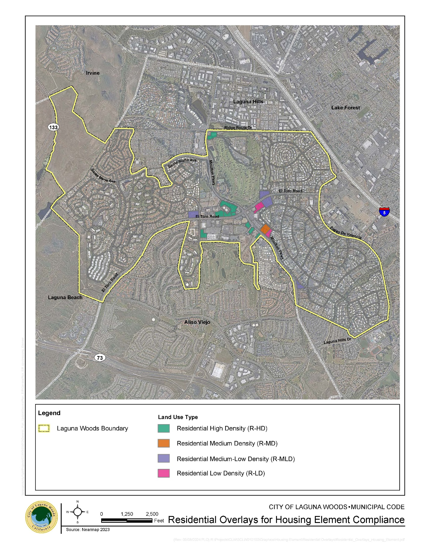
Sec. 13.08.050. - Residential overlays for housing element compliance.
(a)
Purpose, generally. The purpose of overlay zoning districts is to allow the City to establish special land use regulations, standards, or procedures in areas with unique land use, site planning, building design, or environmental resource issues. Overlay zoning districts are also an appropriate mechanism to implement long-term goals and land use requirements of the City for a specific property or location, or to coordinate land use and design requirements unique to a large tract of land. Overlay zoning districts are intended to be applied only where special circumstances justify the modification of base zoning district regulations to achieve specific land use and design objectives. Overlay zoning districts are established through rezoning and only in conjunction with base zoning districts.
(b)
Establishment and designation, generally. Except as modified by an overlay zoning district, the provisions of the applicable base zoning district shall apply to all development within the boundary of a designated area. If regulations conflict, the applicable overlay zoning district regulations shall prevail to the extent such overlay zoning district authorizes the principally permitted land use or land uses contemplated. Whenever an overlay zoning district is established, any subsequent application to change the base zoning district of a property or properties shall not be construed to be an application to eliminate the overlay zoning district for those properties. An intent to eliminate the overlay zoning district on a property or properties shall be expressly stated in the application.
(c)
Residential High Density Overlay Zoning District.
(1)
Purpose, specifically. The purpose of the Residential High Density (R-HD) overlay zoning district is to provide for the development of housing units of a type and number necessary to support compliance with the General Plan Housing Element. Accordingly, certain housing-related land uses are principally permitted as part of the R-HD overlay zoning district, in addition to the land uses principally permitted in the applicable base zoning district.
(2)
Establishment and designation, specifically. The designated area to which the R-HD overlay zoning district is applied shall be the properties located within the R-HD overlay zoning district boundary shown on the map exhibit in subsection (h) of this section.
(3)
Principally permitted land uses. Land uses permitted as a principal use within the R-HD overlay zoning district, subject to all applicable laws and regulations, include the land uses identified in the applicable base zoning district and the following, which shall be permitted as a "use by right" as that term is defined in California Government Code Section 65583.2(i) as amended from time to time or replaced with a successor statute, and subject to the City's design review:
a.
Housing with a density of 30 to 50 dwelling units per acre (du/ac), subject to the following:
1.
Housing shall be constructed as 100 percent residential projects or as mixed-use projects with other land uses identified in the applicable base zoning district provided that, for mixed-use projects, residential use shall occupy at least 50 percent of the total floor area of the project; and
2.
Housing shall be owner-occupied and/or rental multifamily in nature; and
3.
Twenty percent or more of the dwelling units constructed in each project shall be affordable for lower income households, with the determination of affordability based on applicable state law.
(d)
Residential Medium Density Overlay Zoning District.
(1)
Purpose, specifically. The purpose of the Residential Medium Density (R-MD) overlay zoning district is to provide for the development of housing units of a type and number necessary to support compliance with the General Plan Housing Element. Accordingly, certain housing-related land uses are principally permitted as part of the R-MD overlay zoning district, in addition to the land uses principally permitted in the applicable base zoning district.
(2)
Establishment and designation, specifically. The designated area to which the R-MD overlay zoning district is applied shall be the properties located within the R-MD overlay zoning district boundary shown on the map exhibit in subsection (h) of this section.
(3)
Principally permitted land uses. Land uses permitted as a principal use within the R-MD overlay zoning district, subject to all applicable laws and regulations, include the land uses identified in the applicable base zoning district and the following, which shall be permitted as a "use by right" as that term is defined in California Government Code Section 65583.2(i), as amended from time to time or replaced with a successor statute, and subject to the City's design review:
a.
Housing with a density of 20 to 30 dwelling units per acre (du/ac), subject to the following:
1.
Housing shall be constructed as 100 percent residential projects or as mixed-use projects with other land uses identified in the applicable base zoning district.
(e)
Residential Medium-Low Density Overlay Zoning District.
(1)
Purpose, specifically. The purpose of the Residential Medium-Low Density (R-MLD) overlay zoning district is to provide for the development of housing units of a type and number necessary to support compliance with the General Plan Housing Element. Accordingly, certain housing-related land uses are principally permitted as part of the R-MLD overlay zoning district, in addition to the land uses principally permitted in the applicable base zoning district.
(2)
Establishment and designation, specifically. The designated area to which the R-MLD overlay zoning district is applied shall be the properties located within the R-MLD overlay zoning district boundary shown on the map exhibit in subsection (h) of this section.
(3)
Principally permitted land uses. Land uses permitted as a principal use within the R-MLD overlay zoning district, subject to all applicable laws and regulations, include the land uses identified in the applicable base zoning district and the following, which shall be permitted as a "use by right" as that term is defined in California Government Code Section 65583.2(i), as amended from time to time or replaced with a successor statute, and subject to the City's design review:
a.
Housing with a density of 15 to 20 dwelling units per acre (du/ac), subject to the following:
1.
Housing shall be constructed as 100 percent residential projects or as mixed-use projects with other land uses identified in the applicable base zoning district.
(f)
Residential Low Density Overlay Zoning District.
(1)
Purpose, specifically. The purpose of the Residential Low Density (R-LD) overlay zoning district is to provide for the development of housing units of a type and number necessary to support compliance with the General Plan Housing Element. Accordingly, certain housing-related land uses are principally permitted as part of the R-LD overlay zoning district, in addition to the land uses principally permitted in the applicable base zoning district.
(2)
Establishment and designation, specifically. The designated area to which the R-LD overlay zoning district is applied shall be the properties located within the R-LD overlay zoning district boundary shown on the map exhibit in subsection (h) of this section.
(3)
Principally permitted land uses. Land uses permitted as a principal use within the R-LD overlay zoning district, subject to all applicable laws and regulations, include the land uses identified in the applicable base zoning district and the following, which shall be permitted as a "use by right" as that term is defined in California Government Code Section 65583.2(i), as amended from time to time or replaced with a successor statute, and subject to the City's design review:
a.
Housing with a density of eight to 10 dwelling units per acre (du/ac), subject to the following:
1.
Housing shall be constructed as 100 percent residential projects or as mixed-use projects with other land uses identified in the applicable base zoning district.
(g)
Housing optional. Nothing in this section shall be construed as requiring property owners to construct housing or discontinue any existing non-housing use. If a property owner does not wish to construct housing, zoning that allows such construction only presents an option for the future.
(h)
Map exhibit. The following map exhibit designates areas to which each of the overlay zoning districts established by this section are applied:
(Ord. No. 24-06, § 3, 9-18-2024)