


Lake Elmo City Zoning Code
TITLE 105
ZONING
08-226
08-253
2022-07
2026-01
2023-07
2024-05
2021-001
2022-06
08-247
08-250
2024-03
2023-14
2026-02
08-241
2022-05
2024-12
08-245
2024-13
2025-16
2023-04
2023-06
08-242
08-243
2023-20
08-246
08-248
2022-02
2022-08
2022-10
2024-14
2024-21
08-244
2023-15
2022-09
2022-12
2024-08
2024-17
2023-02
2023-08
105.04.010 Prohibited Without Screening-Repealed
105.04.020 All Districts
- In all districts, all refuse, rubbish, or garbage (as defined in LEC 1.08) shall be kept in an enclosed building or properly contained in a closed container designed for the purposes.
- The owner of vacant land shall be responsible for keeping the land free of refuse, rubbish, or garbage.
105.04.030 Unlicensed Passenger Vehicles And Trucks
Unlicensed passenger vehicles and trucks shall not be parked in residential districts for a period exceeding seven days.
105.04.040 Required Screening
- Screening. Screening shall be required in residential districts for any off-street parking area which contains more than four parking spaces and is within 30 feet of an adjoining residential lot.
- Business, industrial screening. Where any business or industrial use (structure, parking, or storage) is adjacent to property zoned or developed for residential use, that business or industry shall be screened along the boundary of the residential property. Screening shall also be provided where a business, parking lot, or industry is across the street from a residential zone, but not on the side of a business or industry considered to be the front.
- Exterior storage. All exterior storage shall be screened as required by LEC 105.04-I.
- Mechanical apparatus on roofs. All mechanical apparatus on roofs shall be screened.
- Loading docks. Loading docks shall be screened from all streets and adjacent property unless they are at the rear of the building which abuts another commercial use. The property owner may provide a 30-foot landscaped area between the dock and the property line where screening is not possible.
105.04.050 Purpose
The purpose of LEC 105.04.050 et seq., is to promote the public health, safety, and general welfare of the community while protecting motor vehicle operators, pedestrians, and adjacent land uses from glare to ensure a dark sky area for proliferation of wildlife, fireflies, etc.
105.04.060 Exterior Lighting Plan
- Except for single- and two-family dwellings, an exterior lighting plan shall be submitted to the city in order to determine whether the purpose and requirements of LEC 105.04.050 et seq. have been met prior to installation or modification of exterior lighting.
- This plan will be prepared by a certified architect, landscape architect, or lighting designer.
- The applicant must provide a plan that identifies the location, size, and type of luminaire, and show how the applicant intends to comply with LEC 105.04.050 et seq.
- A photometric plan of the site and fixture data sheet must be submitted with a site plan for office, commercial, or any type of industrial project in order to determine the effect of the luminaire on surrounding properties.
105.04.070 Prohibited Lighting
- Public roadway or street. No lights shall be placed in view of any public roadway or street so that its beams or rays are directed at any portion of the roadway when the light is of such brilliance and so positioned as to impair the vision of the driver of any motor vehicle.
- Lighting in all zoning districts. No direct or sky-reflected glare, whether from floodlights or from high temperature processes such as combustion or welding, shall be directed into any adjoining property.
- Bare light bulbs. Bare light bulbs shall not be permitted in view of adjacent property or public right-of-way.
- Light cast. No light or combination of lights, which cast light on a public street, shall exceed one footcandle meter reading as measured from the centerline of the street, nor shall any light or combination of lights, which cast light on an adjacent property, exceed four-tenths footcandles as measured from said property line.
- Maximum height. The maximum permitted height for any light pole, as measured from at grade from the base of the pole to the top of the luminaire, shall be 15 feet in all residential districts and 30 feet in all nonresidential districts.
- Exceptions. The requirements of LEC 105.04.050 et seq. do not apply to the following types of exterior lighting:
- Ornamental lighting. Ornamental landscape lighting fixtures, and solar operated light fixtures having self-contained rechargeable batteries, or any other ornamental, landscape or decorative lighting where any single light fixture does not exceed 200 initial light output lumens;
- Right-of-way lighting. Public lighting located within and intended for the right-of-way;
- Temporary lighting. Temporary lighting for public events (including, but not limited to, public sporting events, theatrical, television or performance areas) with an approved special event permit or held by the city;
- Required lighting. Lighting required by the Federal Aviation Administration or other state or federal agency;
- Public safety lighting. Temporary lighting for police, fire or public safety construction and repair personnel;
- Shoreline lighting. Certain shoreline lighting may be exempt from the requirements of these sections in order to provide sufficient illumination to a berthing structure, pier, or dock in the interest of public safety. Such fixture may be located anywhere on the property, including the principal structure, provided it meets the requirements of this subsection. Said fixtures shall be configured in a way to prevent illumination more than 50 feet beyond the berthing structure, pier or dock. Illumination shall only be activated during those times when the berthing structure, pier, dock or watercraft is in use.
105.04.080 Landscaping Requirements
The landscaping required on a lot shall consist of a finish grade and a soil retention cover such as sod, seed, mulch, and plantings, or as may be reasonably necessary to protect the soil and aesthetic values on the lot and adjacent property.
105.04.090 Boundary Landscape Requirements
- In all districts, all developed land shall have landscaping from the curb and gutter to the road right-of-way lines.
- This landscaped yard shall be kept clear of all structures, exterior storage, and off-street parking.
105.04.100 Front And Side Yards
Landscaping shall be provided and maintained on all required front and side yards in all developed districts except where pavement or crushed stone is used for walkways, driveways, or parking areas.
105.04.110 Open And Unimproved Areas
All open areas or any site, lot, tract, or parcel not otherwise improved shall be graded to provide adequate drainage and shall be landscaped.
105.04.120 Owner Responsibility
It shall be the responsibility of the owner to see that the landscaping is maintained in an attractive and well-kept condition.
105.04.130 Keeping Natural Or Existing Character
All lots, tracts, or parcels shall be properly maintained in accordance with their natural or existing character.
105.04.140 Turf Established
Turf must be established by the use of grass seed or sod on all lots, within 60 days of the issuance of a certificate of occupancy, excluding the time between October 1 and May 1. Turf must be established on all new developed lots by July 1, 2013. Alternate plans, other than turf, shall be approved by city staff prior to installation.
105.04.150 Commercial And Industrial Property Maintenance
All commercial/industrial properties shall maintain trees, shrubs, landscaping, parking lots, and exterior signage. Dead trees and shrubs are to be replaced within four months of notice.
105.04.160 Conservation Of Vegetation
No person shall make any unauthorized use of any public site or open space which is detrimental to the turf and/or soil conditions.
105.04.170 Intent
- Wind generators offer an alternative method of providing electrical power.
- It is the intent of the city to regulate the facilities in order to protect the safety and welfare of residents of the city and in order to prevent wind generators from becoming a nuisance.
105.04.180 Location
Wind generators are permitted in the Rural Residential (RR) and Agricultural (AG) Zoning Districts upon issuance of a wind generator permit.
105.04.190 Application
- Applicants for a wind generator permit shall complete application forms as provided by the city administrator.
- The application shall include the following:
- A report from a professional engineer describing the proposed wind generator and certifying the safety of the device;
- A site plan of the applicant's property drawn to a scale of one inch equals 100 feet and illustrating the location of the wind generator and all other buildings or structures located within 300 feet of the base of the wind generator; and
- A statement indicating that the proposed wind generator is in compliance with all applicable regulations of the Federal Aviation Agency where appropriate.
105.04.200 Application Review
- The completed application shall be forwarded to the building inspector for review and recommendation. Within 30 days of the receipt of the completed application, the city administrator shall schedule a public hearing before the city council to review the application. The public hearing shall be preceded by ten days' mailed notice to all residents within 500 feet of the perimeter of the applicant's property.
- Wind generator permits shall be issued subject to the following conditions:
- The minimum lot size requirement shall be 40 acres. The site must also be large enough to contain within its boundaries any debris resulting from tower failure and/or falling ice.
- The wind generator structure shall not exceed 125 feet in height.
- The wind generator and guy wires shall have a minimum setback of 150 feet from any property line.
- Fencing may be required if the structure poses a safety hazard to residents.
- Accessory buildings and guy wires must meet the setback requirements for the underlying zoning district.
- No lighting is allowed on the wind generator.
- Wind generators are prohibited in the Lake Elmo Airport Safety Zones.
- There shall be at least 1,000 feet between wind generators.
- If the applicant's property is subdivided into parcels of less than 40 acres, the wind generator shall be removed as a condition of the subdivision approval.
- Wind generator permits are not transferable. Upon sale of the property, the purchaser must apply for a new wind generator permit or remove the wind generator from the property.
105.04.210 Duration And Review
- Wind generator permits shall expire upon sale or subdivision of the property as provided above, but shall be reviewed annually.
- Wind generator permits may be revoked by an affirmative vote of three councilmembers for noncompliance with the conditions of the permit.
105.04.220 Solar Energy Systems
Solar energy systems are permitted accessory uses in all districts, provided the system or equipment is in compliance with standards set forth below:
- Permits. A building permit shall be obtained before the installation of solar arrays or panels on any property. All solar energy systems shall be installed and components labeled in accordance with the state electrical code section 690.
- Rooftop or building integrated solar energy systems.
- These systems are permitted accessory uses in all districts in which buildings are permitted.
- Visibility, commercial installations. Commercial rooftop systems shall be placed on the roof to limit visibility from the public right-of-way or to blend into the roof design, provided that minimizing visibility still allows the property owner to reasonably capture solar energy.
- Ground-mount solar energy systems.
- Ground-mount energy systems are permitted accessory uses in all districts where buildings are permitted.
- Ground-mount energy systems must comply with all accessory setback, height and lot coverage restrictions unless otherwise stated herein or a variance is granted and shall not encroach on any city easement unless an easement encroachment agreement approved by the planning director or his designee after review and approval from the city engineer or his designee has been executed. A certificate of zoning compliance is required for all solar energy systems unless a conditional use permit is required as stated herein.
- The collector surface of a ground-mount system and any foundation, compacted soil, or other component of the solar installation that rests on the ground is considered impervious surface. Vegetated ground under the collector surface can be used to mitigate stormwater runoff.
- Exemptions. Solar energy systems of a size of six square feet or less may be exempt from zoning district setback requirements.
- Interconnection agreement. All electric solar energy systems that are connected to the electric distribution or transmission system through the existing service of the primary use on the site shall obtain an interconnection agreement with the electric utility in whose service territory the system is located. Solar energy systems connected directly to the distribution or transmission system must obtain an interconnection agreement with the interconnecting electric utility. Systems that are not directly connected to the grid or not connected to the electric system of a building that is connected to the grid are exempt from this requirement.
- Glare.
- Glare produced from any solar energy system shall be minimized from affecting adjacent or nearby properties. Measures to minimize glare include selective placement of the system, screening of the solar array, modifying the orientation of the system, reducing use of the reflector system, or other remedies that limit glare.
- Mirror reflecting designed solar energy systems. Mirror reflecting designed solar energy systems are permitted only on properties with ten acres or larger. A conditional use permit is required and more restrictive setback standards may be required upon review of the conditional use permit.
- Code requirements. Electric solar energy system components that are connected to a building electric system must have an Underwriters Laboratory (UL) listing. All solar installations must comply with the state electrical code and National Electrical Code. All rooftop or building integrated solar energy systems require a building permit and shall comply with the state building code. Solar thermal hot water systems shall comply with applicable state plumbing code requirements.
- Decommissioning. A decommissioning plan shall be required to ensure that facilities are properly removed after their useful life. Decommissioning of solar panels must occur in the event they are not in use for 12 consecutive months. The plan shall include provisions for removal of all structures and foundations, restoration of soil and vegetation and a plan ensuring financial resources will be available to fully decommission the site. The city may require the posting of a bond, letter of credit or the establishment of an escrow to ensure proper decommissioning.
- Easements allowed. Solar easements may be filed, consistent with M.S.A. § 500.30. Any building owner can purchase an easement across neighboring properties to protect access to sunlight. The easement is purchased or granted by owners of neighboring properties and can apply to buildings, trees, or other structures that would diminish solar access.
105.04.230 Purpose And Intent
The purpose of this subchapter is to allow for and regulate the design, location, placement, construction, maintenance, and removal of wireless communications towers and antennas and to:
- Reasonably accommodate the provision of wireless telecommunication services to the general public;
- Provide safety/emergency service through the use of wireless communications facilities;
- Minimize adverse visual effects of wireless telecommunication towers, antennas, or accessory equipment through careful design and siting standards;
- Strictly control the location and design of wireless communications facilities so that allowed facilities will not be obtrusive or visually unpleasant and, in particular, to protect residential property and neighborhoods from visually intrusive tower installations where reasonably possible;
- Provide clear standards governing all aspects of such facilities;
- Avoid potential damage to adjacent properties from tower failures through structural standards and setback requirements;
- Maximize the use of existing and approved towers, structures, and/or buildings for the location of new wireless telecommunication towers in order to reduce the number of the structures needed to accommodate wireless telecommunication services; and
- Allow new facilities only when a documented proof of need satisfactory to the city can be shown.
105.04.240 Permit Requirements
- All new wireless communications facilities shall require a conditional use permit in accordance with the zoning district requirements specified in LEC 105.04.280 with the exception of those facilities that are exempt from review under this chapter or that may be approved administratively with a wireless communications permit.
- A public hearing for a new wireless communications facility that requires a conditional use permit shall be preceded by ten days' mailed notice to record owners of property located within 1,000 feet of the parcel on which the tower will be located.
- Exemptions. The following are exempt from review under this chapter:
- Television antennas, satellite dishes one meter (39 inches) in diameter or less;
- Satellite dishes used commercially and three meters in diameter or less;
- Receive-only antennas;
- Amateur radio facilities, subject to other city Code requirements;
- Mobile services providing public information coverage of news events or of a temporary or emergency nature.
- Administrative review. The following shall be allowed as a permitted use subject to the issuance of a wireless communications permit in accordance with LEC 105.04.280:
- Satellite dishes more than one meter (39 inches) in diameter;
- Ground-mounted antennas not exceeding the maximum height allowed for structures in the underlying zoning district;
- Building-mounted antennas not exceeding 25 feet above the highest part of the building to which they are attached;
- Utility pole-mounted antennas not exceeding 25 feet above the highest part of the utility pole to which they are attached;
- Antennas co-located on an existing wireless communications facility structure.
105.04.250 Proof Of Need
- As part of an application for a conditional use permit or wireless communications permit, an applicant shall demonstrate proof of need by providing a coverage/interference analysis and capacity analysis, which indicates that the location and height of the tower or antennas as proposed is necessary to meet the frequency plus other spacing needs of the cellular communication system and/or to provide adequate portable radio coverage and capacity to areas which cannot be adequately served by locating the tower or antenna at another site. The proof of need for the tower or antennas must be demonstrated to the satisfaction of the city by providing the city an analysis from a qualified professional RF engineer with experience in radio frequency analysis work, which is subject to acceptance by the city prior to commencing the work.
- The cost of the city's review, including an analysis of the proof of need, is the applicant's responsibility. An escrow shall be established in an amount required by council resolution for this purpose.
- The analysis and the material provided by the engineer shall include at least the following:
- Structural capacity analysis. Provide an analysis of the impact of the proposed facility on the tower's carrying capacity of at least three antenna arrays required (using a typical maximum facility) under the co-location provision of this subchapter.
- Coverage/interference. Provide an analysis for:
- City property and other public property with signal strength values (expressed in decibels) for on street level, in vehicle, and in building level with said interference analysis indicating the protection afforded for all the frequencies in use or which could be in use by the city or other public safety agencies.
- Private property with signal strength values (expressed in decibels) for on street level and in building level with said analysis indicating the protection afforded property within one-half mile of the proposed facility and site.
- System capacity analysis. If the system coverage analysis does not show a coverage need, provide a system capacity analysis.
- Radio frequency radiation hazard analysis. The analysis must address compliance with the most current FCC Bulletin OET 65 radiation standard.
- Map of existing and proposed facilities. A map showing the location of all existing and any proposed towers within two miles of the site being considered. Communications equipment and towers within this area shall be identified by type, function, ownership/users and height. The capacity of existing towers located within two miles (the study area) to carry additional facilities must be provided.
- Map of existing buildings and structures. A map showing the location of all existing buildings, water towers and structures 75 feet or more in height above the ground and within two miles of the site being considered. The potential and efforts undertaken to use these buildings and structures as a supporting base for an antenna or communications facility purpose must be described and analyzed.
- Other information. Any other information deemed necessary by the city in order to demonstrate the need for a new wireless communications facility.
- Exception. If the request is limited to adding an antenna array on an existing tower without increasing the height of the tower support structure or otherwise permitted after an administration review under LEC 105.04.240, the city may waive some or all of the proof of need requirements listed above.
105.04.260 Location Requirements And Site Ranking Analysis
- Location requirements for new facilities. If a new wireless communications facility is needed, based on the materials and studies submitted and reviewed by the city, the following preferences, listed in ranked order, shall be followed and each preference shall be analyzed to determine the most appropriate location:
- Use of existing towers. An existing tower may be used to support the proposed facility. If no existing tower has additional capacity, a determination must be made to show if and how towers in the study area can be modified to accommodate the proposed facility. The co-location requirements specified in LEC 105.04.270 shall be used to help determine whether or not an existing tower can be used to support a proposed facility.
- Use of existing structures. An existing structure over 35 feet high may be used. Preference shall be given to existing light poles, high voltage utility towers and water towers.
- Use of existing building four or more stories in height. Public and commercial buildings or structures four or more stories high which can more likely accommodate facilities without obstructing views or being obtrusive to scenic views shall be given preference over shorter buildings.
- Within an existing easement that contains utility poles over 75 feet in height or within 100 feet of said right-of-way.
- Public land and facilities. In situations in which one of the four options listed above is not feasible, land owned by the city or other public property shall have preference to private property.
- Private property within the city subject to the location and zoning requirements of this chapter and the following criteria:
- Less restrictive zoning districts shall be given preference over more restrictive zoning districts. For example, proposed sites in commercial or industrial districts will be given preference over sites in residential, rural residential or agricultural zoning districts.
- Sites with the least visual impact on residential areas and which are the most consistent with the community's rural character shall be given preference.
- Lower ranked alternatives. In cases where a lower ranked alternative is proposed, the applicant shall file a written analysis demonstrating that, despite diligent efforts to adhere to the established hierarchy within the potential service area, as determined by a qualified radio frequency engineer, higher ranked options are not technologically feasible. An application for a lower-ranked site shall be considered incomplete without this written documentation.
105.04.270 Co-Location Requirements
- In accordance with the location requirements and site preferential ranking found in this chapter, wireless communication services shall be located on existing towers or structures which exceed 35 feet in height and which are located within the potential service area for the site being proposed by the applicant. In the event that co-location is not possible, the applicant must demonstrate that a good faith effort to co-locate on existing towers and structures was made but an agreement could not be reached.
- Exceptions to co-location requirements. The city council shall waive any or all of the co-location requirements if it is determined that:
- The antennas and/or tower accessory equipment would cause the structural capacity of an existing or approved tower or building to be exceeded, as documented by a qualified and licensed professional engineer, and the existing or approved tower or building cannot be reinforced, modified, or replaced to accommodate the antennas or tower accessory equipment at a reasonable cost;
- The antennas and/or tower accessory equipment would cause interference materially impacting the usability of existing antennas or tower accessory equipment as documented by a qualified radio frequency engineer and the interference cannot be prevented at a reasonable cost, or would otherwise prevent the use of existing antennas or related accessory equipment and structures;
- Existing or approved towers and buildings within the applicant's search radius cannot or will not accommodate the antennas and/or tower accessory equipment at a height necessary to function reasonably as documented by a qualified radio frequency engineer; and/or
- Other unforeseen reasons make it infeasible to locate the antennas and/or tower accessory equipment upon an existing or approved tower or building.
105.04.280 Prohibited Areas
Wireless telecommunication towers shall not be allowed in the following areas:
- Residentially zoned parcels (R-1, R-2, R-3, R-4, and RE zoning districts) of less than 2.5 acres or rural residential parcels of less than five acres unless the wireless telecommunication tower and ground facilities accessory thereto are located within an existing public utility power line right-of-way or other public right-of-way that contains utility poles over 75 feet in height or within 100 feet of said right-of-way;
- Open space easements or conservation easements;
- Airport impact zones without consent of the FAA; and/or
- Open space preservation zoning districts.
105.04.290 Zoning Requirements
- Wireless communications facilities that require a conditional use permit, including the installation of a new tower, shall be permitted in the following districts and subject to the following height restrictions provided they meet all other requirements of this subchapter.
Zoning District Maximum Height (in feet) Minimum Parcel Area A-Agriculture 125 10 RR-Rural Residential Zoning 125 5 R-1, R-2, R-3 and R-4 Residential 125 2.5 OP-Open Space 125 2.5 RE-Residential Estates 125 2.5 GB, LB, CB, HB-Business 125 5 BP-Business Park 125 5 PF-Public Facility 125 None - The city council may increase the maximum height of a wireless communications facility by 25 feet in all residential and open space districts and 50 feet in agriculture, business and public facility districts, provided that an applicant is able to demonstrate a need for a higher facility and/or that the additional height will serve a public interest in allowing fewer towers to serve a given area.
- Regardless of zoning district, new facilities may be allowed within an existing public utility power line right-of-way or other public right-of-way that contains utility poles over 75 feet in height or within 100 feet of said right-of-way.
- Public land exemption. A wireless communication facility may be located on any parcel that is owned by the city or another public entity regardless of the zoning district or size of the property.
105.04.300 Application And Review Procedures
- Wireless communications permit (administrative approval). An applicant seeking approval of a facility that can be approved administratively with a wireless communications permit shall follow all of the application requirements listed below for a conditional use permit but shall be exempt from those requirements found in the zoning code including the public hearing requirements. An application found to comply with the provisions of this chapter may be approved by the planning director. Approval shall be in writing, identifying the specific facility approved, the location, mounting height, and other pertinent information and any conditions of approval. If the requested facility is to be located on public property, the agreement allowing the facility shall be approved by the city council and executed prior to issuing the permit.
- Conditional use permit. Wireless communications facilities that require a conditional use permit are subject to the requirements specified in the zoning code in addition to all requirements of LEC 105.04.240. Applications shall be submitted on forms provided by the city and shall include the following information:
- Plan drawing. A site plan drawn to scale acceptable to the planning director which illustrates:
- The parcel on which the tower and accessory ground facilities will be located;
- The existing and proposed buildings and structures on the tower parcel;
- The buildings located within 200 feet of the perimeter of the tower parcel; and
- Access easements as necessary to the tower parcel.
- Exterior plan drawing. A scaled drawing of the exterior of the proposed wireless communications facility, clearly showing the method of fencing, coloration, materials, and camouflage techniques being used.
- Post construction renderings. Photo-simulated post construction renderings of the proposed wireless communications facilities, equipment enclosures, and ancillary structures as they would look after construction from locations at the periphery of the proposed site, which shall, at a minimum, include renderings from the vantage point of any adjacent roadways and residential neighborhoods. The renderings shall also include photo-simulations of the antenna supporting structure after it has been fully developed with antenna structures (the applicant may assume for the purpose of the simulation that other antenna structures on the facility will resemble their proposed structure size and design). A minimum of two such renderings shall be provided; additional renderings may be required if the city determines that additional views should be considered.
- Exterior colors. Exterior paint or finish samples of the colors to be used in the construction of the wireless communication facility.
- Engineer's report. A report from a qualified and licensed professional engineer which:
- Describes the wireless communication tower height and design including a cross-section and elevation;
- Certifies the wireless communication tower's compliance with structural and electrical standards;
- Documents the height above grade for the mounting positions, which can be used for co-location and the minimum separation distances between the co-location positions; and
- Describes the wireless communication tower's capacity to support antennas, including an example of the number and type of antennas that can be accommodated on the wireless communication tower.
- Five-year plan. In conjunction with the information required to demonstrate the proof of need for a new facility under this subchapter, the applicant shall submit a five-year plan for wireless telecommunication facilities to be located within the city. The city acknowledges that the plans are fluid and in all likelihood will change depending upon market demands for the service. The city will maintain an inventory of all existing and reasonably anticipated cell site installations. The applicant shall provide the following written information in each five-year plan and the plan must be updated with each submittal for a new wireless communication tower permit as necessary:
- A description of the radio frequencies to be used for each technology;
- A list of all existing sites to be upgraded or replaced, and proposed cell sites within the city for these services by the applicant; and
- A presentation size map of the city, which shows the five-year plan for cell sites, or if individual properties are not known, the geographic service areas of the cell sites.
- Plan drawing. A site plan drawn to scale acceptable to the planning director which illustrates:
- Application fee. An application fee in an amount prescribed from time to time by city council resolution as necessary to reimburse the city for costs incurred to process the wireless communication tower permit application along with an escrow payment as prescribed by the city council to cover the costs associated with the city's review of the permit.
- FCC licensing. Confirmation that the applicant is properly licensed by the FCC, or is the authorized representative of a wireless communication provider properly licensed by the FCC.
- Owner authorization. Written authorization from the property owner describing the area which will be subject to the tower lease.
- Prevention of destructive interference. Documentation of the steps to be taken by applicant to avoid causing destructive interference to co-located previously established public safety communications facilities; and
- Landscape and screening plan. A detailed landscape plan, which indicates how tower accessory equipment will be screened.
105.04.310 Expert Review
- Where, due to the complexity of the methodology or analysis required to review an application for a wireless communications facility, the planning director may require a technical review by a third-party expert. The costs of this review shall be borne by the applicant, and shall be in addition to applicable conditional use or wireless communications permit, and building permit fees. The applicant shall submit an escrow deposit that may be applied towards the cost of such technical review upon notification from the director that a technical review is required, and shall remit any outstanding balance to the city for such review prior to issuance of a building permit. The maximum fee for such review and the required escrow deposit shall be in accordance with the fee schedule adopted by the city council.
- The expert review may address any or all of the following:
- The accuracy and completeness of submissions;
- The applicability of analysis techniques and methodologies;
- The validity of conclusions reached;
- Whether the proposed wireless communications facility complies with the applicable approval criteria set forth in these regulations;
- Other matters deemed by the city to be relevant to determining whether a proposed wireless communications facility complies with the provisions of these regulations.
- Based on the results of the expert review, the city may require changes to the applicant's application and submittals.
- The applicant shall reimburse the city within 15 working days of the date of receipt of an invoice for expenses associated with the third-party expert's review of the application. Failure by the applicant to make reimbursement pursuant to this section shall abate the pending application until paid in full.
105.04.320 Construction Permits
All wireless communication towers erected, constructed, or located within the city, and all wiring therefor, shall comply with the requirements set forth in the city’s most recent building and zoning regulations.
105.04.330 Tower Standards
- Compliance with standards. Wireless communication towers shall comply with the following standards unless the city council grants a variance as necessary to reasonably accommodate the wireless communication tower. Variance procedures shall be processed according to the zoning code.
- Design.
- To blend into the surrounding environment through the use of color; and architectural treatment and techniques that softens the visual impact of the wireless communication tower on the surrounding environment;
- To be of a monopole design unless the city council determines that an alternative design would better blend into the surrounding environment;
- All proposed wireless communication towers shall be designed, structurally, electrically, and in all respects, to accommodate both the applicant's antennas and comparable antennas for at least two additional users if the tower is over 100 feet in height or for at least one additional user if the tower is less than 100 feet in height, provided that this standard may be waived or otherwise modified by the city council as necessary to allow the applicant to construct a wireless communication tower that better blends into the surrounding environment;
- Where possible, all proposed wireless communication towers must be designed to allow for future rearrangement of antennas upon the tower and to accept antennas mounted at various heights;
- All facilities shall be designed to minimize the visual impact to the greatest extent feasible by means of placement, screening, landscaping with native species, whenever feasible, and camouflage, and be compatible with existing architectural element, building materials, and other site characteristics. The applicant shall use the least visible antennas possible to accomplish the coverage objectives.
- Adverse effects on properties.
- New wireless communications facilities shall be configured and located in a manner that shall minimize adverse effects, including visual impacts on adjacent properties. The applicant shall demonstrate that alternative locations, configurations, and facility types have been examined and shall address in narrative and graphic form the feasibility of any alternatives that may have fewer adverse effects on adjacent properties than the facility, configuration and location proposed.
- The following attributes shall be considered from vantage points at adjacent properties, roadways and occupied structures: height and location, mass and scale, materials and color, existing and proposed vegetation and intervening structures.
- An applicant shall demonstrate through the photo-simulation requirements under LEC 105.04.300(b)(3) that the project design employs each of these attributes in a manner that minimizes adverse effects to the greatest extent possible.
- All facilities that have the potential for high visibility shall be sited in such a manner as to cause the least detriment to the view shed of adjoining properties.
- Setbacks.
- No communications tower shall be located in the required front, side or rear yard setback of any parcel.
- No freestanding communications tower shall be located closer than 125 percent of the tower height from any lot lines with the following exceptions:
- Towers in a side or rear yard that are adjacent to parcels zoned commercial, industrial or public facility.
- Setbacks from buildings:
- In residential zoning districts, wireless communications towers shall be set back a minimum of 100 percent of the tower height from a residential dwelling except for dwellings on the subject property.
- In all other zoning districts, the minimum setback between structures as required by the building code shall be observed.
- Use of existing light poles, high voltage poles or towers and other existing structures are exempt from the setback requirements, provided that such pole, tower or structure is not increased in height.
- Wireless communications towers located within an existing public utility power line right-of-way or other public right-of-way that contains utility poles over 75 feet in height or within 100 feet of said right-of-way shall be exempt from the setbacks as herein required.
- A required setback may be reduced or its location in relation to a public street varied upon providing the city with a licensed professional engineer's certification that the wireless communication tower is designed to collapse or fail within a distance or zone shorter than the required setback distance.
- Height. The maximum height of a wireless communications tower shall be determined based on the underlying zoning district and will be the amount specified in LEC 105.04.290.
- Lighting. At night, wireless communication towers shall not be illuminated by artificial means, unless otherwise required by the Federal Aviation Administration (FAA).
- White strobe lighting is prohibited.
- The applicant shall document the need for lighting as part of a new wireless communications facility application.
- A site that requires lighting shall only be accepted when no other suitable alternative exists. A new tower may be rejected on the grounds that lighting will be a visual nuisance to surrounding properties.
- Landscaping and screening.
- All wireless communications towers and related building facilities shall be landscaped and screened with natural vegetation to lessen the visual impact. The natural vegetation on the site shall be documented on the site plans. Suitable existing vegetation shall be retained to the maximum extent possible based on an analysis of the site. New landscaping shall be selected that includes coniferous and deciduous plants and trees that are hardy for conditions on the site without the use of augmented water.
- Landscaping shall include ground cover, lower story, mid-story and upper story plants. Plant density shall be sufficient to provide 80 percent opacity year-round from the ground up to a distance of five feet high for 60 percent or more of the site with the planting to be located based on an analysis of the site in relation to the surrounding area. Greater or lesser amounts and percentages may be required or allowed based on the city's review.
- Signs and advertising. The use of any portion of a wireless communications tower for signs other than warning or equipment information is prohibited.
- Interference with public safety communication. No wireless communication facility shall interfere with public safety communications. All wireless communication towers/antennas shall comply with FCC regulations and licensing requirements.
- Accessory utility buildings. All utility buildings and structures accessory to a tower shall be architecturally designed to blend in with the surrounding environment and compatible with adjacent buildings, and shall be permitted in addition to the number of accessory buildings otherwise allowed in each zoning district.
- Ground-mounted equipment shall not be visible from beyond the boundaries of the site and shall be screened by a solid wall or fence and dense landscaping materials described in subsection (g) of this section.
- Accessory utility buildings shall observe the minimum setback requirements for accessory buildings in the underlying zoning district as well as all other applicable zoning and building requirements for accessory buildings.
- Maintenance. All buildings and structures on the premises of the wireless communications facility shall observe the city's property maintenance standards of the city Code.
105.04.340 Wireless Communications Tower Agreement
- If the application is approved by the city, a wireless communications tower permit and a building permit shall be issued upon the execution of a wireless communication tower agreement.
- The agreement shall be signed by the applicant and property owner and the terms of the agreement shall include the following:
- A list of the conditions of approval to the wireless communication tower permit;
- A statement indicating that failure to comply with the conditions of approval shall result in the removal of the wireless communication tower, antennas, or tower accessory equipment;
- A statement indicating that the expenses incurred by the city to enforce the provisions of the wireless communication tower agreement shall be reimbursed by the applicant;
- A statement, which requires the applicant to utilize the procedures established by the FCC to resolve any complaints received relating to interference allegedly caused by the wireless communication tower; and
- A statement indicating that a wireless communication tower which has not been used for six consecutive months shall be deemed abandoned and may be required to be removed in accordance with LEC 105.04.350. To ensure compliance with this provision, the applicant must submit a performance bond or letter of credit in an amount sufficient to cover the removal or reduction costs.
105.04.350 Abandonment And Removal
- Towers and antennas shall be removed within six months of cessation of use.
- An owner wishing to extend the time for removal or reactivation shall submit an application stating the reason for such extension. The planning director may extend the time for removal or reactivation up to 60 days upon showing of a good cause. If the tower or antenna is not removed in a timely fashion, the city may give notice that it will contract for removal within 30 days following written notice to the owner. Thereafter, the city may cause removal and be reimbursed for all costs associated with said removal by drawing on the funds provided with the financial guarantee.
- Upon removal of the wireless communication facility, the site shall be returned to its natural state and topography and vegetated consistent with natural surroundings.
105.04.360 Minimum Conditions
General conditions on a wireless communications permit may include, but not be limited to, the following:
- An agreement providing for co-location and six-month removal of unused and/or obsolete towers shall be attached and become part of the permit.
- The tower shall be set back a distance equal to the tower height from all property lines. All accessory structures shall be set back a minimum of 20 feet from all side yard and rear yard property lines.
- Zoning permits shall be applied for and issued before any construction is started.
- Prior to application for a conditional use permit, an applicant must obtain FAA approval and/or provide documentation that FAA approval is not needed.
- Applicant must obtain FCC licensure and approval as required for various communications applications.
- Applicant must submit proof of liability and worker's compensation insurance.
- Proof that towers and their antennas have been designed by, and, following completion of construction, were inspected by a qualified and licensed professional engineer (at the applicant's expense) to conform to applicable state structural building standards and all other applicable reviewing agencies and to conform with accepted electrical engineering methods and practices as specified in applicable provisions of the National Electrical Code.
- Metal towers shall be constructed of, or treated with, corrosive resistant material.
- The addition of antennas and associated equipment of an additional provider to an existing permitted tower shall be considered co-location and shall require a zoning permit and site plan approval. An amendment to a conditional use permit shall typically not be required.
- All towers shall be reasonably protected against unauthorized climbing. The area around the base of the tower and guy wire anchors shall be enclosed by a fence with a minimum height of six feet with a locked gate.
- All towers and their antennas shall utilize building materials, colors, textures, screening and landscaping that effectively blend the tower facilities within the surrounding natural setting and built environmentally to the greatest extent possible.
- No part of any antenna or tower, nor any lines, cable, equipment, wires or braces shall at any time extend across or over any part of the right-of-way, public street, highway or sidewalk without approval by the city through the zoning permit approval process.
- All obsolete or unused towers and accompanying facilities shall be removed within six months of the cessation of operations at the site unless a time extension is approved by the city. After the facilities are removed, the site shall be restored to its original or an improved state which includes removal of all concrete to six feet below normal grade and surrounding area returned to normal grading. Electronic equipment shall not be removed in advance of removal of obsolete or unused towers. To ensure compliance, the applicant must submit a performance bond or letter of credit in an amount sufficient to cover all removal costs as determined by the city prior to the issuance of a building permit for the facility. Failure to remove the structure shall be cause for the city to remove the tower and associated equipment and assess the cost against the required bonding or letter of credit instrument.
- The city shall conduct a final inspection of the site to ensure that all requirements of the city Code and all conditions of approval attached as part of the wireless communications permit are met prior to the start of operation of the facility.
- For installations of a facility in an area that could potentially be accessed by the public (including rooftop installations or other locations that would be considered public versus occupational) a radio frequency hazard analysis and a yearly report must be submitted before December 31 of each year showing the results of on-site measurements at the site. A registered professional engineer hired by the provider must sign these measurements and report. At a minimum, the report must document any changes to the site over the course of the previous year.
- All towers must be approved by the FAA and registered with the FCC prior to the issuance of a building permit for a new facility.
105.04.370 Purpose And Intent
- The purpose of this subchapter is to encourage security, fire, or medical alarm users and alarm businesses (including, but not limited to, sales, installation, and/or monitoring) to maintain the operation reliability and the proper use of alarm systems so as to limit unnecessary police, fire, and emergency medical responses to false alarms and alarm malfunctions.
- This subchapter governs burglary, robbery, intrusion, fire, and medical emergency false alarms, provides for service fees for excessive false alarms, and provides for issuance of citations or assessment of service fees.
105.04.380 Alarm Systems
- False alarm warning notice. Each time the county sheriff’s office and/or the city fire department responds to a false alarm due to system malfunction or when no reason can be determined for the false alarm, the county sheriff’s office shall issue a false alarm warning notice.
- Service fee. A service fee for excessive false alarms shall be charged as follows:
- No service fee shall be charged for the first three false alarms that occur within a 12-month period calculated from the date of the first alarm.
- More than three false alarms and up to and including six false alarms within a 12-month period shall result in a service fee. The fee shall be set from time to time by ordinance of the city council.
- More than six false alarms within a 12-month period shall result in a service fee. The fee shall be set from time to time by resolution of the city council.
- The city, based on false alarm response records provided by the county sheriff's office, will bill the service fee.
- Service fee exceptions. No service fee shall be assessed if the false alarm is:
- Caused by an electrical storm, tornado, or other act of God where there is clear evidence of physical damage to the alarm system;
- Caused by intermittent disruption of telephone circuits beyond the control of the alarm site owner;
- Caused by electrical power disruption or failure more than two hours beyond the control of the alarm owner; and/or
- At a location where the county sheriff’s department has installed the VARDA or other similar alarms.
- Requirement of payment of service fee. All false alarm service fees are due and payable within 30 days from date of invoice. In the event that false alarm service fees are not paid, as required by LEC 105.04.380 et seq., all delinquent accounts may be certified to the city administrator who shall prepare an assessment roll each year providing for assessment of the delinquent accounts against the respective property served. The assessment roll shall be delivered to the council for adoption on or before October 1 of each year. Upon approval of the assessment roll, the city administrator shall certify to the county auditor the amount due. The county auditor shall then enter the amount as part of the tax levy on the premises to be collected during the coming year. The action may be optional or subsequent to taking legal action to collect delinquent accounts.
- Violations. A person commits an offense in violation of LEC 105.04.380 et seq. if the person suffers or permits three or more false alarms within a 12-month period.
105.04.390 Purpose And Intent
The city's amateur radio tower antenna regulations are adopted in order to:
- Facilitate the provision of amateur radio tower antenna services to the residents and businesses of the city;
- Minimize adverse visual effects of amateur radio tower antennas through careful design and siting standards;
- Avoid potential damage to adjacent properties from amateur radio tower antenna failures through structural standards and setback requirements.
105.04.400 Permit Required
No person shall install an amateur radio tower antenna higher that what is permitted in the zone in which it is located without first receiving the appropriate permit.
105.04.410 Amateur Radio Tower Antenna Permit
- Applications for an amateur radio tower antenna permit shall be submitted to the city planner, and shall include the following:
- A survey drawn to scale, which illustrates the parcel on which the antenna will be located, buildings located on the parcel, buildings located within 100 feet of the parcel, and the location of the proposed amateur radio tower antenna;
- A drawing to scale, which illustrates the antenna's relative size and visibility from adjoining property. Amateur radio tower antenna structures shall not exceed 120 feet in height. The amateur radio tower antenna must be set back from all adjoining property lines a distance no less than the height of the amateur radio tower antenna plus 15 feet;
- Documentation from the amateur radio tower antenna manufacturer showing construction details and construction materials;
- Mailing addresses for all property owners of record located within 500 feet of the subject property; and
- A copy of the applicant's FCC amateur radio license.
105.04.420 Planning Commission Review
- Upon receipt of a completed application, the city planner shall schedule a hearing before the planning commission, which shall be preceded by ten days' mailed notice to the record owners of property located within 500 feet of the parcel on which the amateur radio tower antenna will be located.
- The planning commission shall make recommendations to the city council regarding the issuance of an amateur radio tower antenna permit and, in particular, concerning the following:
- The reasonable necessity for the amateur radio tower antenna;
- The appropriateness of the amateur radio tower antenna design;
- The appropriateness of the amateur radio tower antenna's construction materials and assembly;
- Maintenance requirements; and/or
- The distance of the amateur radio tower antenna from adjoining property lines.
105.04.430 City Council Review
- Upon receipt of planning commission recommendations, the city council shall review the application. The city council may approve the application subject to conditions, table its review until a date certain, or deny the application for an amateur radio tower antenna permit. If the application is approved by the city council, an amateur radio tower antenna and a building permit shall be issued upon the execution of an amateur radio tower antenna agreement.
- The terms of the amateur radio tower antenna agreement shall include the following:
- A list of the conditions of approval to the amateur radio tower antenna permit;
- A statement indicating that failure to comply with the conditions of approval shall result in the removal of the amateur radio tower antenna structure;
- A statement indicating that the expenses incurred by the city to enforce the provisions of the amateur radio tower antenna agreement shall be reimbursed by the applicant;
- A statement, which requires the applicant to use the procedures established by the FCC to resolve any complaints received relating to interference allegedly caused by the amateur radio tower antenna; and
- A statement indicating that the amateur radio tower antenna permit shall be valid during the term of the amateur radio tower antenna agreement and only while the applicant resides on the property.
105.04.440 Review And Revocation
The city planner shall inspect the property at least annually for compliance with the provisions of the amateur radio tower antenna agreement. If the permittee does not comply with the terms of the agreement, a hearing shall be scheduled before the city council for determining whether to terminate the agreement. The hearing shall be preceded by ten days' mailed notice to occupants of property within 500 feet of the lot on which the amateur radio tower antenna is located.
105.04.450 Legislative Findings And Purposes
- Findings. The city finds that certain areas within the municipality are characterized by certain soil types, slopes, and water levels which, without proper corrective action, are unsuitable for development of any type; inappropriate development in these areas increases soil erosion and sedimentation, the introduction of toxic materials into groundwater, encourages pollution, destroys ecological and natural resources, and requires expenditures of public funds to correct deficiencies, contributing to the detriment of the health, safety, and welfare of the citizens of the city.
- Purpose. The purpose of this subchapter is to provide for the regulation of development on restrictive soils in a way as to minimize the risk of environmental damage and to protect private homeowner's and governmental units from incurring high maintenance and capital costs resulting from the necessity to correct deficiencies encountered as a result of development on poorly suited soils.
105.04.460 District Boundaries
LEC 105.04.450 et seq. shall apply to areas within the city which are delineated on the official soils maps of the city and have soil types set forth in Table A in LEC 105.04.470(d)(2). For the purposes of determining the application of LEC 105.04.450 et seq. to any particular parcel of land, the above-referenced map shall be on file in the office of the zoning administrator and shall be available for inspection and copying.
105.04.470 Restrictive Soils And Development Permit Provisions
- Permit. Except as provided in LEC 105.04.450 et seq., no person shall erect any structure within the restrictive soils overlay district without having first obtained a written permit from the zoning administrator authorizing erection of the structure.
- Exceptions. The permit requirements established by LEC 105.04.450 et seq. shall not apply to:
- Any public agency or its contractor or any person performing work within a right-of-way of any public agency pursuant to a permit issued by the public agency;
- Emergency work necessary to preserve life or property. When emergency work is performed under LEC 105.04.450 et seq., the person performing it shall report the pertinent facts relating to the work to the zoning administrator prior to the commencement of the work. The zoning administrator shall review the facts and determine whether an emergency exists and shall, by written memorandum, authorize the commencement of the emergency exception. The person commencing emergency work shall, within ten days following the commencement of that activity, apply for the issuance of a restrictive soils development permit and on the issuance of the permit may be required to perform the work as is determined to be reasonably necessary to fulfill the purposes of LEC 105.04.450 et seq.; and/or
- Development consisting of the corrective alteration, repair, or maintenance of any lost full use of land existing on the date of adoption of LEC 105.04.450 et seq.
- Application for and processing of permit.
- A separate application for a permit shall be made to the zoning administrator for each development for which a permit is required except that only one application need be made for two or more acts which are to be done on the same parcel.
- The application shall include a map of the site and a delineation of the soils found in the site along with a plan and cost estimate of the proposed development and the other engineering data, surveys, and other information and material as may be required in order to determine the effects of the development on the affected land and the suitability of the soils for the development. See LEC 105.04.740 to determine if a stormwater management plan or an erosion and sediment control plan is required.
- When proposed work includes construction or alterations of structures, the work shall be submitted with the application, along with detailed drawings of any special foundation structures and/or special provisions for on-site sewage disposal.
- Issuance of permit. The following standards shall govern the issuance of permits for development within the restrictive soils overlay district.
- Development on restrictive soils shall not be permitted until an investigation and subsequent report has been completed and presented to the zoning administrator by a professional engineer or soil scientist experienced and knowledgeable in the practice of soils and soils mechanics, and until the recommendations of the investigation have been incorporated into the design plan and specification. No permit shall be issued for development on soils deemed by LEC 105.04.450 et seq. to be unsuitable.
- Table A, below, is a grouping of restrictive soils which are incorporated and made a part of LEC 105.04.450 et seq. The following soils groupings set forth in Table A are highly restrictive for residential, commercial, industrial, or other development due to high water table (three feet or less), steep slope conditions, high shrink swell potential, or high frost action potential. No development permit shall be issued unless it has first been demonstrated by the developer that buildings shall be constructed in accordance with the standards found in the state building code for appropriate soil conditions, and that a soil absorption disposal system can satisfactorily function in accordance with municipal regulations. The standards are incorporated by reference into LEC 105.04.450 et seq.
Table ASoil Group/Slope Soil Group/Slope Soil Group/Slope 2 D, E, F 298 859 D, E, F 7 D, E, F 301 860 8 D, E, F 302 D, E, F 861 12 D, E, F 340 896 49 D, E, F 342 D, E, F 1013 100 367 1027 D, E, F 132 D, E, F 453 D, E, F 1029 D, E, F 151 D, E, F 454 D, E, F 1039 D, E, F 153 D, E, F 460 1040 155 D, E, F 472 1813 158 D, E, F 488 1819 D, E, F 169 D, E, F 504 D, E, F 1820 174 529 1827 D, E, F 177 D, E, F 857 1848 D, E, F 259 858 Notes to table: Letter references (A, B, C, D, E, or F) indicate a slope range. Symbol Slope Description Simple Complex A Nearly Level Nearly Level B Gently Sloping Undulating C Sloping Rolling D Moderately Sloping Hilly E Steep Steep F Very Steep Very Steep Notes to table: If no slope symbol is specified, the entire soil type is restricted, regardless of slope.
- Conditions. A special permit may be approved subject to compliance with conditions reasonable and necessary to ensure compliance with the requirements contained in the ordinance which are specifically set forth in the permits. The conditions may, among other matters, limit the size, kind, or character of the proposed development, require the construction of other structures, including special foundations and soil stabilization structures, establish required monitoring procedures, require the alterations of the site as may be necessary, and/or require the conveyance to the city or other public entity of certain lands or interests in the land.
- Time of permit; extensions; renewals.
- A permittee shall begin the work authorized by the permit within 60 days from the date of issuance of the permit unless a different date for the commencement of work is set forth in the permit. The permittee shall complete the work authorized by the permit which in no event shall exceed more than 12 months from the date of issuance. The permittee shall notify the zoning administrator at least 24 hours prior to the commencement of work. If the work is not commenced as specified in LEC 105.04.450 et seq., then the permit shall become void. If, prior to the date established for commencement of work, the permittee makes written request to the zoning administrator for an extension of time to commence the work, setting forth the reasons for the required extension, the zoning administrator may grant the extension. A permit which has become void may be renewed at the discretion of the zoning administrator upon payment of renewal fee. If the zoning administrator does not grant the renewal, a permit for the work may be granted only upon compliance with the procedures established for any original application.
- The permittee shall notify the zoning administrator in writing of the termination of the work authorized and no work shall be deemed to have been completed until approved in writing by the zoning administrator following the written notification.
- The zoning administrator may cause inspections of the work to be made periodically during the course of the work by the zoning administrator or a member of the city staff and shall cause a final inspection to be made following the completion of the work.
- Variances and appeals. Variances and appeals are administered pursuant to the zoning code.
105.04.480 Responsibility; Effect
- Responsibility. Neither the issuance of a permit nor compliance with the conditions of the permit, nor with the provisions of LEC 105.04.450 et seq. shall relieve any person from any responsibility otherwise imposed by law for damage to persons or property; nor shall the issuance of any permit under this section serve to impose any liability of the city or its officers or employees for injury or damage to persons or property. A permit issued pursuant to LEC 105.04.450 et seq. does not relieve the permittee of the responsibility for securing and complying with any other permit which may be required by any other law, ordinance, or regulation.
- Conflicts. Whenever LEC 105.04.450 et seq. is in conflict with another section, statute, or regulation, the more restrictive requirement shall govern.
105.04.490 Legislative Findings And Purposes
- Findings. The city finds that there are many wetlands within the municipality which, as part of the ecosystem, are critical to the health, safety, and welfare of the land, animals, and people within the city and the metropolitan area; that existing and potential development within the city creates increasing ecological problems and demands upon these resources; and that these problems and demands have the effect of polluting, eliminating, or altering both the wetlands and their functions (and the processes associated with wetlands and their functions) which if preserved and maintained constitute important physical, aesthetic, recreational, and economic assets of existing and future residents of the city.
- Purpose. The purpose of this subchapter is to provide for the protection, preservation, proper maintenance, and use of the city's wetlands, to minimize the disturbance to them and to prevent damage from excessive sedimentation, eutrophication, or pollution, to prevent loss of fish or other beneficial aquatic organisms, and/or loss of wildlife and vegetation or the habitants of the same; to provide for the protection of the city's probable fresh water supplies from the dangers of drought, overdraft, pollution, or mismanagement; to secure safety from floods; to reduce the financial burdens imposed upon the communities through rescue and relief efforts occasioned by the occupancy or use of areas subject to periodic flooding to prevent loss of life, property damage, and the losses and risks associated with flood conditions; to preserve the location, character, and extent of natural drainage courses.
105.04.500 District Boundaries
LEC 105.04.500 et seq. shall apply to wetland areas within the city which are delineated on the official wetland maps of the city and have soil types as set forth in Table A of LEC 105.04.520(d)(1). For the purposes of determining the application of LEC 105.04.500 et seq. to any particular parcel of land or water, the above-referenced map shall be on file in the office of the zoning administrator and shall be available for inspection and copying.
105.04.510 Definitions
Unless specifically defined in LEC 105.04.500 et seq., common definitions, words, and phrases used in LEC 105.04.500 et seq. shall be interpreted so as to give them the same meaning as they have in common usage throughout this Code and are found in LEC 1.08.
105.04.520 Wetland Permit Provisions
- Permit. Except as provided in LEC 105.04.500 et seq., no person shall perform any of the following actions or otherwise alter the ecological characteristics of a wetland without first having obtained a written permit from the zoning administrator authorizing the alteration: deposit or remove any material within a wetland; excavate within a wetland; construct, alter, or remove any structure within, upon, or across a wetland; plant or remove any vegetation within a wetland; alter any embankment within a wetland, or change the flow of water through the wetland. The above actions shall be collectively referred to as "work."
- Exceptions. The permit requirements established by LEC 105.04.500 et seq. shall not apply to:
- Any public agency or its contractor or any person performing work within a right-of-way of any public agency pursuant to a permit issued by the public agency;
- Emergency work necessary to preserve life or property. When emergency work is performed under LEC 105.04.500 et seq., the person performing it shall report the pertinent facts relating to the work to the zoning administrator prior to the commencement of the work. The zoning administrator shall review the facts and determine whether an emergency exists and shall, by written memorandum, authorize the commencement of the emergency exception. A person commencing emergency work shall, within ten days following the commencement of that activity, apply for the issuance of a wetlands permit and on the issuance of the permit may be required to perform the work as is determined to be reasonably necessary to correct any impairment to the wetland occasioned by the work; and/or
- Work consisting of the alteration, repair, or maintenance of any conforming use of land existing on the date of adoption of the ordinance codified in LEC 105.04.500 et seq.
- Application for and processing of permit.
- A separate application for a permit shall be made to the zoning administrator for each work activity for which a permit is required except that only one application need be made for two or more acts which are to be done on the same parcel. The application shall include a map of the site and a plan and a cost estimate of the proposed development and the other engineering data, surveys, and other information and material as may be required in order to determine the effects of the development on the affected land and water uses, such as extent of wetland, a description of the amount and location of work to be performed, a survey of the ecological characteristics of the wetland, maps and data on soils, water table and the flood capacity of the wetland, and copies of permits or reports from state department of natural resources, Washington Soil and Water Conservation District. When proposed work includes construction or alteration of structures, three sets of plans and specifications for the work shall be submitted with the application.
- The wetlands permit application shall be processed in accordance with the procedures specified for the processing of conditional use permits, and the wetlands permit may be processed at the same time and in connection with the processing of an application for a building permit or any other permit required to be granted by ordinance of the city.
- See LEC 105.04.740 to determine if a stormwater management plan or an erosion and sediment control plan is required.
- Issuance of permit.
- Restricted development. Table A, below, shows a grouping of wetland and wetland-prone soils on which development is restricted.
Table A75 265 540 113 266 541 120 325 543 123 329 544 161 408 552 162 449 862 166 452 863 170 456 1033 189 468 1055 225 481 1821 264 507 1847 - No special permits. No special permits shall be issued unless the zoning administrator, engineer, and soil scientist find and determine that the proposed work complies with the following general and specific, if applicable, requirements.
- Filling into wetlands. It is the policy of the city to limit the placement of any fill material into wetlands in order to preserve the natural character of the wetlands, and maintain suitable aquatic habitat for fish and wildlife, and provide for sound surface water management and flood control.
- Placement in conformance with these rules shall be permitted in the following cases, subject to wetland permit, where applicable:
- Development of beach areas;
- Protection of shoreline from continued erosion by placement of rip-rap materials;
- Recovery of shoreland lost by erosion or other natural forces which has occurred within the last five years;
- Limited filling to allow raising of previous development constructed at too low an elevation; and/or
- Provide navigational access from riparian properties, where access cannot be gained by alternative means.
- Placement shall not be permitted in the following cases:
- To achieve vegetation control;
- To create upland areas for development or subdivision;
- To stabilize lake and stream beds which cannot support fill materials (e.g., excessive depths of muck, steep bank, or bed slope, and the like); and/or
- To stabilize areas of flowing water, active springs, or subject to substantial wave action, draft, sedimentation, or other disruptive forces.
- Except as otherwise provided in LEC 105.04.500 et seq., those wetlands which serve the following functions shall not be altered:
- Those that have a continuing scientific or educational value due to their location, size, flora, fauna, and other characteristics of the wetland;
- Those that clearly contribute to stormwater flood control or to the maintenance of domestic water supplies, minimum desirable stream flows, or lake water levels;
- Those that significantly contribute to the improvement of water quality;
- Those that currently or potentially serve a useful recreation function for a significant number of users;
- Those that make a significant contribution to scenic views;
- Those that provide significant resting, nesting, or spawning or breeding areas for water fowl, other birds, fish, or mammals; and
- Those that contain unique/endangered plant species of areas of historical significance.
- A permit shall be required for all other filling and shall be granted provided:
- The project is not unduly detrimental to the public purposes listed in M.S.A. § 103E.011, as it may be amended from time to time, including, but not limited to, fish and wildlife habitat, navigation, water supply and stormwater retention; filling of posted fish spawning areas is prohibited;
- The fill consists of clean inorganic material that is free of pollutants, nutrients, rubbish, refuse, and garbage as defined in LEC 1.08. The maximum particle size shall be eight inches;
- The existence of a stable, supporting foundation is established by appropriate means, including soil boring data where deemed necessary by the city engineer;
- Where erosion protection is deemed necessary by the city engineer, the site conditions and fill material are capable of being stabilized by an approved existing land uses on the affected public water; and
- The maximum extent of filling which may be permitted in a wetland shall be determined by flood storage and nutrient stripping capacity requirement for the wetland watershed.
- Placement in conformance with these rules shall be permitted in the following cases, subject to wetland permit, where applicable:
- Excavation of public waters.
- Policy and general restrictions. It is the policy of the city to discourage the excavation of materials from the beds of public waters in order to preserve the natural character of public waters and their shorelands and maintain suitable aquatic habitat for fish and wildlife. Excavation shall be permitted provided the conditions of Minn. R. § 6115.0200, Excavation of Public Waters, as it may be amended from time to time, are met, except:
- Where it is intended to gain access to navigable water depths when access can be reasonably attained by utilizing a temporary or permanent dock;
- Where inland excavation is intended solely to extend riparian rights to non-riparian lands, or to promote the subdivision and development of non-riparian lands; and/or
- Where the proposed excavation will be detrimental to significant fish and wildlife habitat or protected vegetation.
- Dredging.
- General standards. A permit shall be required for all dredging subject to the following general standards:
- The project must be adequate in relation to appropriate geologic and hydrologic factors, including, but not limited to, quantity and quality of local drainage at the site; type of sediment/soil strata and underground formations in the vicinity; life expectancy of the dredging with respect to bed load, long-shore drift and siltation patterns in the project vicinity; and protection of the water body from increased seepage, pollution, and other hydrologic impacts.
- Adequate and stable on-land spoil disposal sites located above the ordinary high water mark and outside of floodway districts must be available for containment of dredged spoils, and project plans must include provisions for sodding, seeding, or otherwise properly-protecting these spoils. Dredge spoils may be placed below the ordinary high water mark only when the city determines that one or more beneficial public purposes will be enhanced.
- The proposed project must represent the minimal impact solution to a specific need with respect to all other reasonable alternatives such as weed removal without dredging, beach sanding, excavation above the bed of public water, less extensive dredging in another area of the public water, or management of an alternative water body for the intended purposes.
- The dredging must be limited to the minimum dimensions necessary for achieving the desired purpose. Where excavation is proposed on a water body that is perched on an impervious stratum, soil borings must show that the proposed excavation will not rupture the impervious stratum.
- Additional specific standards. The following categories of dredging projects shall be permitted, subject to the following specific restrictions.
- Beach development. The existing site conditions will not provide a suitable beach using a sand blanket alone. The area to be dredged shall be consistent with the general dimensions authorized for beach sanding under Minnesota Rules. The depth of dredging needed to reach a suitable beach stratum shall not be excessive considering anticipated site maintenance and desired water depths.
- Wetland improvement. The dredging shall be limited to the removal of accumulated sediment or rock debris where the materials constitute an impairment to the use of a common navigational corridor, impede reasonable access, or where it is intended to create open areas in aquatic vegetation to improve fish or wildlife habitat.
- General standards. A permit shall be required for all dredging subject to the following general standards:
- Policy and general restrictions. It is the policy of the city to discourage the excavation of materials from the beds of public waters in order to preserve the natural character of public waters and their shorelands and maintain suitable aquatic habitat for fish and wildlife. Excavation shall be permitted provided the conditions of Minn. R. § 6115.0200, Excavation of Public Waters, as it may be amended from time to time, are met, except:
- Specific requirements.
- Work in the wetland will not be performed during the breeding season or water fowl or fish spawning season.
- No part of any septic tank system or of another sewage disposal system requiring on-land or in-the-ground disposal of waste shall be located closer than 75 feet from the edge of a wetland unless it can be shown that no effluent can reach the wetland because of existing physical characteristics on the site. On-site sewage disposal systems shall be permitted only if they meet state regulations and local regulations.
- Runoff from developed property and construction projects adjacent to a wetland may be directed to the wetland only when reasonably free of silt and debris and chemical pollutants, and at rates which will not disturb wetland vegetation or increase turbidity.
- No liquid waste shall be discharged in a wetland or disposed of in a manner that would cause the waste to enter the wetland.
- Wetlands may not be used for disposal of material which logically should be disposed of in a landfill, and no part of a wetland shall be used for a sanitary landfill.
- Floor elevation of buildings located within the district, if used for living quarters or work space, must be at least three feet above the seasonal high water level of the wetland.
- No development shall be allowed in the wetland protection district which will endanger the health, safety, and welfare of persons and which will result in unusual maintenance costs of road and parking areas or the breaking or leaking of utility lines.
- Removal of vegetation within the wetlands shall be permitted only when and where work within the wetland has been approved in accordance with the standards of LEC 105.04.500 et seq.
- Removal of vegetation within the district but outside the wetland shall be limited to that reasonably required for the placement of structures and the use of the property.
- Restricted development. Table A, below, shows a grouping of wetland and wetland-prone soils on which development is restricted.
- Conditions. A special permit may be approved subject to compliance with conditions reasonable and necessary to ensure compliance with the requirements contained in subsection (d) of this section, which are specifically set forth in the permits. The conditions may, among other matters, limit the size, kind, or character of the proposed work, require the construction of other structures, require replacement of vegetation, require monitoring procedures, stage the work over time, require the alteration of the site design to ensure buffering, or require the alteration of the site design to ensure buffering, or require the conveyance to the county or another public entity of certain lands or interests in the land.
- Time of permit; extensions; removals.
- A permittee shall begin the work authorized by the permit within 60 days from the date of issuance of the permit unless a different date for the commencement of work is set forth in the permit. The permittee shall complete the work authorized by the permit within the time limits specified in the permit which in no event shall exceed more than 12 months from the date of issuance. The permittee shall notify the zoning administrator at least 24 hours prior to commencing of the work. If the work is not commenced as specified in LEC 105.04.500 et seq., then the permit shall become void. If, prior to the date established for commencement of work the permittee makes written request to the zoning administrator for any extension of time to commence the work setting forth the reasons for the required extension, the zoning administrator may grant the extension.
- A permit which has become void may be renewed at the discretion of the zoning administrator upon payment of a renewal fee. If the zoning administrator does not grant such a renewal, a permit for the work may be granted only upon compliance with the procedures established for any original application.
- The permittee shall notify the zoning administrator in writing of the termination of the work authorized and no work shall be deemed to have been completed until approved in writing by the zoning administrator following the written notification.
- The zoning administrator may cause inspection of the work to be made periodically during the course of the work by the zoning administrator or a member of the city staff and shall cause a final inspection to be made following the completion of the work.
- Variances and appeals. Variances and appeals shall be handled as proscribed in the zoning code.
105.04.530 Responsibility; Effect
- Responsibility. Neither the issuance of a permit nor compliance with the conditions of the permit, nor with the provisions of LEC 105.04.500 et seq. shall relieve any person from any responsibility otherwise imposed by law for damage to persons or property; nor shall the issuance of any permit under LEC 105.04.500 et seq. serve to impose any liability on the city or its officers or employees for injury or damage to persons or property. A permit issued pursuant to LEC 105.04.500 et seq. does not relieve the permittee of the responsibility for securing and complying with any other permit which may be required by any other law, ordinance, or regulation.
- Severability. If any part of LEC 105.04.500 et seq. is held to be unconstitutional or otherwise illegal, the remainder of LEC 105.04.500 et seq. shall be deemed and held to be valid and remain in force and effect as if the portion had been included in LEC 105.04.500 et seq. If LEC 105.04.500 et seq. or any provision in LEC 105.04.500 et seq. is held to be inapplicable to any person, property or work, the holding shall not affect the applicability of LEC 105.04.500 et seq. to any other person's property or work.
- Special assessment. The land within a designated wetlands district area which is restricted by LEC 105.04.500 et seq. and for which a development or other restrictive easement is conveyed to the city shall not be subject to special assessments to defray the costs of other municipal improvements for which the assessments are authorized pursuant to M.S.A. ch. 429, as it may be amended from time to time.
- Conflicts. Whenever LEC 105.04.500 et seq. is in conflict with another section, statute, or regulation, the more restrictive requirement shall govern.
105.04.540 Purpose
The interstate corridor overlay district shall provide special requirements and performance standards that shall be imposed in conjunction with zoning districts adopted for land located in the interstate highway corridor. The purpose of this district is to manage changes in land use that may occur along the interstate corridor as a result of improved highway access and frontage road development. To accomplish this objective, this overlay district sets forth two sets of performance standards which must be met by all proposed users in the corridor.
105.04.550 Permitted Uses And Structures
All uses which are permitted in the underlying zoning district.
105.04.560 Accessory Uses And Structures
All necessary uses which are permitted in the underlying zoning district.
105.04.570 Conditional Uses
All conditional uses which are permitted in the underlying zoning district.
105.04.580 Minimum District Requirements; Interim Uses
- Uses not served by public sewer and water that are not intensive (urban) land uses, and demand negligible increases in public services, may be approved as interim uses.
- These uses shall be subject to the following minimum performance standards:
- Minimum lot size of ten acres;
- No sewer discharge exceeding eight SAC units per ten acres;
- No public utility service is required on the part of the city;
- All projected traffic generated by the use can be accommodated with existing streets, requiring no improvements at the cost of the city or the public;
- An adequate supply of off-street parking and off-street loading space shall be provided;
- The use will require no additional public safety services or needs;
- No noise abatement problems shall exist that could potentially require public corrective action;
- The proposed land use will be compatible both in terms of internal site plans, and with regard to adjacent land uses;
- Where potential land use compatibility problems exist, site plans shall be designed to eliminate the conflicts through redesign or through the incorporation of features that mitigate the impacts of the conflicts;
- Land use plans provide for future development or redevelopment at the time that public water and sewer services are provided;
- The site plan shall provide for adequate drainage systems which do not pose pollution problems, see LEC 105.04.740 to determine if a stormwater management plan or an erosion and sediment control plan is required;
- The use maintain standards of architectural design and building quality consistent with the uniform building code and all other applicable city codes;
- The proposed use is consistent with the city's comprehensive plan; and
- The proposed use will not create fiscal problems for the city, or adversely impact the health, safety, or welfare of the city.
105.04.590 Minimum District Requirements; Long-Term Uses
- Uses that are urban in nature and require public water and sewer service, as well as other major public services, shall be classified as "long-term users."
- These uses shall be subject to the following minimum performance standards:
- Public sewer and water extensions, provided at the user's expense;
- If projected traffic generated by the proposed use exceeds the capacity of existing streets, additional improvements shall be provided at the expense of the land developer;
- All necessary noise abatement improvements will be provided at no cost to the city;
- An adequate supply of off-street parking and off-street loading space shall be provided;
- The proposed land uses will be compatible both in terms of internal site plans, and with regard to adjacent land uses;
- Where potential land use compatibility problems exist, site plans shall be designed to eliminate the conflicts through redesign or through the incorporation of features that mitigate the impact of the conflicts;
- The site plan shall provide for adequate drainage systems which do not pose pollution problems, see LEC 105.04.740 to determine if a stormwater management plan or an erosion and sediment control plan is required;
- The use shall maintain standards of architectural design and building quality consistent with the uniform building code and all other applicable city codes;
- The proposed use is consistent with the city's comprehensive plan; and
- The proposed use will not create fiscal problems for the city or adversely impact the health, safety, or welfare of the city.
105.04.600 Minimum District Requirements; All Uses
- The following minimum requirements shall be observed in the overlay district, subject to additional requirements, exceptions and modifications set forth in this Code.
- Uses permitted in the underlying zoning district shall be subject to the lot area and setback requirements specified in the applicable district.
- Lot area, setback, building requirements may be increased under the overlay district to provide sound site planning and eliminate potential conflicts between land uses.
105.04.610 Building Type And Construction
No galvanized or unfinished steel, galvanized or unfinished aluminum buildings (walls or roofs), except those specifically intended to have a corrosive design finish, such as Corten steel, shall be permitted. Any exposed metal or fiberglass finish on all buildings shall be limited to 50 percent of any one wall. Exterior building finishes shall consist of materials comparable in grade and quality to the following: brick; natural stone; decorative concrete block; cast-in-place concrete or precast concrete panels; wood, provided the surfaces are finished for exterior use and wood of proven exterior durability is used such as cedar, redwood, and the like; curtain wall panels of steel, fiberglass, and aluminum (non-structural, non-load bearing), provided the panels are factory fabricated and finished with a durable non-fade surface with fasteners of a corrosive-resistant design; glass curtain wall panels; stucco.
105.04.620 SAC Unit Determination
- SAC unit calculations will be based upon the criteria established by the metropolitan waste control commission, which state that one SAC unit is equivalent to 274 gallons of flow per day.
- The SAC unit will be determined by the metropolitan waste control commission. A request for SAC unit determination must be made prior to the issuance of the building permits.
105.04.630 Purpose
- The shorelands within the city are designated as shoreland district. Regulations set forth in this subchapter shall govern land use and other activities within this district. The classification of the lakes shall govern the use, alteration, and development of land within the shoreland district.
- The uncontrolled use of shorelands adversely affects the public health, safety, and general welfare by contributing to pollution of public waters and by impairing the local tax base. In furtherance of the policies declared in M.S.A. chs. 103F, 103G, 115, 116, 394, and 462, as they may be amended from time to time, the commissioner provides the following minimum standards and criteria for the subdivision, use, and development of the shorelands of public waters. The standards and criteria are intended to preserve and enhance the quality of surface waters, conserve the economic and natural environmental values of shorelands, and provide for the wise use of water and related land resources of the state.
105.04.640 Intent
It is the intent of the city to:
- Regulate placement of sanitary and waste treatment facilities on shorelands of public waters to prevent pollution of public waters and public health hazards resulting from the facilities;
- Regulate alteration of shorelands of public waters to prevent excessive sediment pollution, increased water runoff, excessive nutrient runoff pollution;
- To preserve and enhance the unique aesthetic appearance and ecological value of the shoreland; and
- Regulate the construction of buildings and changes of land use in shorelands to minimize property damage during periods of high water.
105.04.650 Definitions
Unless specifically defined below, words or phrases used in LEC 105.04.630 et seq. shall be interpreted so as to give them the same meaning as they have in LEC 1.08 with common usage in this and all other sections of this Code. All distances, unless otherwise specified, shall be measured horizontally.
105.04.660 Administration
- The city will provide for the administration and enforcement of their shoreland management controls by establishing permanent procedures for building construction, installation of sewage treatment systems, and grading and filling.
- Permits required. A permit is required for the construction of buildings or building additions (including the related activities as construction of decks and signs), installation and/or alteration of sewage treatment systems, and those grading and filling activities not exempted by LEC 105.04.680(e). Application for a permit shall be made to the city on the forms provided. The application shall include the necessary information so that the city can determine the site's suitability for the intended use and that a compliant sewage treatment system will be provided.
- Variance.
- Variance requests will be considered pursuant to the procedures set forth in the zoning code.
- For existing developments, the application for variance must clearly demonstrate whether a conforming sewage treatment system is present for the intended use of the property. The variance, if issued, must require reconstruction of a nonconforming sewage treatment system.
- Notifications to the department of natural resources.
- Copies of all notices of any public hearings to consider variances, amendments, or conditional uses under local shoreland management controls must be sent to the commissioner or the commissioner's designated representative and postmarked at least ten days before the hearings. Notices of hearings to consider proposed subdivision or plats must include copies of the subdivision or plat.
- When a variance is approved after the department of natural resources has formally recommended denial in the hearing record, the notification of the approved variance required in subsection (b)(3)a of this section shall also include the board of adjustment's summary of the public record and testimony and the findings of facts and conclusions which supported the issuance of the variance.
- A copy of approved amendments and subdivisions or plats and final decisions granting variances or conditional uses under local shoreland management controls must be sent to the commissioner or the commissioner's designated representative and postmarked within ten days of final action.
105.04.670 Shoreland Classification
- The public waters of the city have been classified below, consistent with the criteria found in Minn. R. ch. 6120.3000, as it may be amended from time to time, and the Protected Waters Inventory Map for Washington County, Minnesota. The shoreland area for the water bodies listed below shall be defined in LEC 105.04.650 and as shown on the city's shoreland management area map.
- The classes of public waters for the city are natural environment lakes, recreational development lakes, and tributary streams.
- Natural environment lakes. Natural environment lakes are generally small, often shallow lakes with limited capacities for assimilating the impacts of development and recreational use. They often have adjacent lands with substantial constraints for development, such as high water tables, exposed bedrock and unsuitable soils. These lakes, particularly in rural areas, usually do not have much existing development or recreational use.
DNR I.D.# Lake Name Location OHW 100-Year Elevation 82007400 Horseshoe Sec. 25 876.8 82009900 Clear Sec. 2, 11 82010000 Unnamed Sec. 4 82010500 Berschen's Pond Sec. 10 82010700 Sunfish Sec. 14 896.4 899 82010800 Friedrich Pond Sec. 15, 22 913.0 82011000 Downs Sec. 24 889.1 893 82011100 H.J. Brown Pond Sec. 26 82011200 Rose (Sunfish) Sec. 25, 36 82011300 Goose Sec. 27, 34, 35 924.4 82011601 Armstrong (north of 10th Street) Sec. 28 1020.3 82011602 Armstrong (south of 10th Street) Sec. 33 1019.1 - Recreational development lakes. Recreational development lakes are generally medium-sized lakes of varying depths and shapes with a variety of land forms, soil, and groundwater situations on the lands around them. They often are characterized by moderate levels of recreational use and existing development. Development consists mainly of seasonal and year-round residences. Many of these lakes have capacities of accommodating additional development use.
DNR I.D.# Lake Name Location OHW 100-Year Elevation 82-101 DeMontreville Sec. 4, 5, 9 929.3 931.0 82-103 Olson Sec. 8, 9 929.3 931.0 82-104 Jane Sec. 9, 10 924 925.0 82-106 Elmo Sec. 13, 14, 23, 24, 26 885.6 889 - Tributary streams. Tributary stream segments consist of watercourses mapped in the protected waters inventory that have not been assigned one of the river classes. These segments have a wide variety of existing land and recreational use characteristics.
Location Stream Name Sec. 33 Unnamed to Wilmes Lake Sec. 16, 21, 22 Raleigh Creek North (to Eagle Point Lake) Sec. 22, 23, 27 Raleigh Creek South (Eagle Point Lake to Lake Elmo) Sec. 25 Unnamed Tributary
- Natural environment lakes. Natural environment lakes are generally small, often shallow lakes with limited capacities for assimilating the impacts of development and recreational use. They often have adjacent lands with substantial constraints for development, such as high water tables, exposed bedrock and unsuitable soils. These lakes, particularly in rural areas, usually do not have much existing development or recreational use.
- The permitted and conditional uses allowed in the underlying zoning district shall be those allowed in the natural environment lakes, recreational development lakes, and tributary streams shoreland districts.
Land Use Matrix Land Uses Zoning Districts AG R1 P HB GB R3 RR RE LB BP OP Auto service P Churches and schools P Commercial Ag P P P P Duplex multifamily CUP Farming P P P P P P P P Greenhouses CUP CUP Kennels CUP CUP CUP Manufactured homes; with sewer P Manufacturing CUP Office uses P P P P Restaurants P CUP CUP Retail uses P P P CUP Single-family residential P P P P P P Stables CUP CUP Notes to table: (1) P=Permitted use. (2) CUP=Conditional use permit. (3) The land use matrix outlines general allowed uses, subject to restrictions and provisions of the zoning code. Reference LEC 105.12 for specific allowable uses in each district.
105.04.680 Shoreland Standards
- General provisions. The following standards shall apply to all shorelands of the protected waters. Where the requirements of the underlying zoning district as shown on the official zoning map are more restrictive than those set forth in LEC 105.04.630 et seq., the more restrictive standards shall apply. Only land above the ordinary high water level of public waters can be used to meet lot area standards, and lot width standards must be met at both the ordinary high water level and at the building line.
- Lot area; no sewer.
Zoning District Natural Environment Lakes Recreation Development Lakes Riparian Non-Riparian Riparian Non-Riparian RE (no sewer) 2.5 acres 2.5 acres 2.5 acres 2.5 acres R1 (no sewer) 80,000 square feet 80,000 square feet 1.5 acres 1.5 acres RR (no sewer) 10 acres 10 acres 10 acres 10 acres AG (no sewer) 40 acres 40 acres 40 acres 40 acres OP (no sewer) 0.5 acres 0.5 acres R3 (no sewer) 40,000 square feet 20,000 square feet 20,000 square feet 15,000 square feet GB (no sewer) 3.5 acres 3.5 acres 3.5 acres 3.5 acres BP (no sewer) 3 acres 3 acres 3 acres 3 acres - Lot width.
Classification Riparian Lot (No Sewer) Riparian Lot (With Sewer) Non-Riparian Lot (Without Sewer) Non-Riparian Lot (With Sewer) Natural Environment 200 feet 200 feet 200 feet NA Recreational Development 150 feet 150 feet 150 feet NA Tributary Streams 100 feet 100 feet NA NA - Placement, design, and height of structures.
- Placement. When more than one setback applies to a site, structures and facilities must be located to meet all setbacks. Where structures exist on the adjoining lots on both sides of a proposed building site, structure setbacks may be altered without a variance to conform to the adjoining setbacks from the ordinary high water level, provided the proposed building site is not located in a shore impact zone or in a bluff impact zone. Structures shall be located as follows:
- Structure and on-site sewage system setbacks. Structure and on-site sewage system setbacks (in feet) from ordinary high water level.
Setbacks From OHW Classification Structures Sewage Treatment System Natural environment 150 feet 150 feet Recreational development 100 feet 75 feet Tributary 100 feet 75 feet - Additional structure setbacks. The following additional structure setbacks apply, regardless of the classification of the water body.
Setback From Setback (In Feet) Top of bluff 30 Unplatted cemetery 50 Right-of-way line of federal, state, or county highways Per underlying zoning district regulations and exceptions Right-of-way line of town road, public street, or other roads or streets not classified Per underlying zoning district regulations and exceptions - Bluff impact zone. Structures and accessory facilities, except stairways and landings, must not be placed within bluff impact zones.
- Significant historic sites. No structure may be placed on a significant historic site in a manner that affects the values of the site unless adequate information about the site has been removed and documented in a public repository.
- Steep slopes. The city shall evaluate possible soil erosion impacts and development visibility from public waters before issuing a permit for construction of sewage treatment systems, roads, driveways, structures, or other improvements on steep slopes. When determined necessary, conditions must be attached to issued permits to prevent erosion and to preserve existing vegetation screening of structures, vehicles, and other facilities as viewed from the surface of public water, assuming summer, leaf-on vegetation.
- Proximity to roads and highways. Per underlying zoning district regulations and exceptions.
- Use without water-oriented needs. Use without water-oriented needs must be located on lots or parcels without public waters frontage, or, if located on lots or parcels with public water frontage, must either be set back double the normal ordinary high water level setback or be substantially screened from view from the water by vegetation or topography, assuming summer, leaf-on conditions.
- Structure and on-site sewage system setbacks. Structure and on-site sewage system setbacks (in feet) from ordinary high water level.
- Design criteria for structures.
- High water elevations. Structures must be placed in accordance with any floodplain regulations applicable to the site. All principal structures shall have their lowest floor at a level at least three feet above the highest known water level or the ordinary high water level, whichever is higher.
- Water-oriented accessory structures. Each lot may have one water-oriented accessory structure not meeting the normal structure setback in subsection (d) of this section if this water-oriented accessory structure complies with the following provisions:
- The structure or facility must not exceed 13 feet in height, exclusive of safety rails, and cannot occupy an area greater than 250 square feet. Detached decks must not exceed eight feet above grade at any point.
- The setback of the structure or facility landward from the ordinary high water level must be at least ten feet on a recreational development lake and 50 feet on a natural environment lake.
- The structure or facility must be treated to reduce visibility as viewed from public waters and adjacent shorelands by vegetation, topography, increased setbacks, or color, assuming summer, leaf-on conditions.
- The roof may be used as a deck with safety rails, but must not be enclosed or used as a storage area.
- The structure or facility must not be designed or used for human habitation and must not contain water supply or sewage treatment facilities.
- As an alternative for general development and recreational development waterbodies, water-oriented accessory structures used solely for watercraft storage, and including storage of related boating and water-oriented sporting equipment, may occupy an area up to 400 square feet provided the maximum width of the structure is 20 feet as measured parallel to the configuration of the shoreline.
- Stairways, lifts, and landings. Stairways and lifts are the preferred alternative to major topographic alterations for achieving access up and down bluffs and steep slopes to shore areas. Stairways and lifts must meet the following design requirements:
- Stairways and lifts must not exceed four feet in width. Wider stairways may be used for public open space recreational properties.
- Landings for stairways and lifts must not exceed 32 square feet in area. Landings larger than 32 square feet may be used for public open space recreational properties.
- Canopies or roofs are not allowed on stairways, lifts, or landings.
- Stairways, lifts, and landings may be either constructed above the ground on posts or pilings, or placed into the ground, provided they are designed and built in a manner that ensures control of soil erosion.
- Stairways, lifts, and landings must be located in the most visually inconspicuous portions of lots, as viewed from the surface of the public water assuming summer, leaf-on conditions, whenever practical.
- Facilities such as ramps, lifts, or mobility paths for physically handicapped persons are also allowed for achieving access to shore areas, provided that the dimensional and performance standards of subsections (d)(2)c.1 to 5 of this section are satisfied.
- Height of structures. All structures in residential districts, except churches and nonresidential agricultural structures, must not exceed 35 feet in height.
- Placement. When more than one setback applies to a site, structures and facilities must be located to meet all setbacks. Where structures exist on the adjoining lots on both sides of a proposed building site, structure setbacks may be altered without a variance to conform to the adjoining setbacks from the ordinary high water level, provided the proposed building site is not located in a shore impact zone or in a bluff impact zone. Structures shall be located as follows:
- Shoreland alterations.
- Generally. Alterations of vegetation and topography will be regulated to prevent erosion into public waters, fix nutrients, preserve shoreland aesthetics, preserve historic values, prevent bank slumping, and protect fish and wildlife habitat. Best management practices are recommended to guide shoreland alteration activities.
- Vegetation alterations. Vegetation alteration necessary for the construction of structures and sewage treatment systems and the construction of roads and parking areas regulated by subsection (f) of this section are exempt from the vegetation alteration standards that follow. Removal or alteration of vegetation, except for agricultural uses as regulated in subsection (h) of this section is allowed, subject to the following standards.
- Intensive vegetation clearing within the shore and bluff impact zones and on steep slopes is not allowed.
- In shore and bluff impact zones and on steep slopes, limited clearing of trees and shrubs, and cutting, pruning, and trimming of trees is allowed to provide a view to the water from the principal dwelling site and to accommodate the placement of stairways and landings, picnic areas, access paths, livestock watering areas, beach and watercraft access areas and permitted water-oriented accessory structures or facilities, provided that:
- The screening of structures, vehicles or other facilities as viewed from the water, assuming summer, leaf-on conditions, is not substantially reduced;
- Along rivers, existing shading of water surfaces is preserved; and
- The above provisions are not applicable to the removal of trees, limbs, or branches that are dead, diseased, or pose safety hazards.
- Topographic alterations; grading and filling.
- Grading and filling and excavations necessary for the construction of structures, sewage treatment systems, and driveways under validly issued construction permits for these facilities do not require the issuance of a separate grading and filling permit. The grading and filling standards in LEC 105.04.630 et seq. must be incorporated into the issuance of permits for construction of structures, sewage treatment systems, and driveways.
- Public roads and parking areas are regulated by subsection (f) of this section.
- Notwithstanding subsections (e)(3)a and b of this section, a grading and filling permit will be required for:
- The movement of more than ten cubic yards of material on steep slopes or within shore or bluff impact zones; and
- The movement of more than 50 cubic yards of material outside of steep slopes and shore and bluff impact zones.
- The following considerations and conditions in addition to LEC 105.04.500 et seq. must be adhered to during the issuance of construction permits, grading and filling permits, conditional use permits, variances, and subdivision approvals.
- Grading and filling in any Type 2, 3, 4, 5, 6, 7, or 8 wetland must be evaluated to determine how extensively the proposed activity would affect the following functional qualities of the wetland. (This evaluation must also include a determination of whether the wetland alteration being proposed requires permits, reviews, or approvals by other local, state, or federal agencies such as a watershed district, the state department of natural resources, or the United States Army Corps of Engineers. The applicant will be so advised.)
- Sediment and pollutant trapping and retention;
- Storage of surface runoff to prevent or reduce flood damage;
- Fish and wildlife habitat;
- Recreational use;
- Shoreline or bank stabilization; and
- Noteworthiness, including special qualities such as historic significance, critical habitat for endangered plants and animals, or others.
- Alterations must be designed and conducted in a manner that ensures only the smallest amount of bare ground is exposed for the shortest time possible.
- Mulches or similar materials must be used, where necessary, for temporary bare soil coverage, and a permanent vegetation cover must be established as soon as grading is complete.
- Methods to minimize soil erosion and to trap sediments before they reach any surface water feature must be used.
- Altered areas must be stabilized to acceptable erosion control standards consistent with the field office technical guides of the local soil and water conservation districts and the United States Soil Conservation Service.
- Fill or excavated material must not be placed in a manner that creates an unstable slope.
- Plans to place fill or excavated material on steep slopes must be reviewed by qualified professionals for continued slope stability and must not create finished slopes of 30 percent or greater.
- Fill or excavated material must not be placed in bluff impact zones.
- Any alterations below the ordinary high water level of public waters must first be authorized by the commissioner under M.S.A. § 103G.245, as it may be amended from time to time.
- Alterations of topography must only be allowed if they are accessory to permitted or conditional uses and do not adversely affect adjacent or nearby properties.
- Placement of natural rock rip-rap, including associated grading of the shoreline and placement of a filter blanket, is permitted if the finished slope does not exceed three feet horizontal to one foot vertical, the landward extent of the rip-rap is within ten feet of the ordinary high water level, and the height of the rip-rap above the ordinary high water level does not exceed three feet.
- Grading and filling in any Type 2, 3, 4, 5, 6, 7, or 8 wetland must be evaluated to determine how extensively the proposed activity would affect the following functional qualities of the wetland. (This evaluation must also include a determination of whether the wetland alteration being proposed requires permits, reviews, or approvals by other local, state, or federal agencies such as a watershed district, the state department of natural resources, or the United States Army Corps of Engineers. The applicant will be so advised.)
- Excavations where the intended purpose is connection to a public water, such as boat slips, canals, lagoons, and harbors, must comply with all provisions of LEC 105.04.630 et seq. Permission for excavations may be given only after the commissioner has approved the proposed connection to public waters.
- Placement and design of roads, driveways, and parking areas.
- Public and private roads and parking areas must be designed to take advantage of natural vegetation and topography to achieve maximum screening from view of public waters. Documentation must be provided by a qualified individual that all roads and parking areas are designed and constructed to minimize and control erosion to public waters consistent with the field office technical guides of the local soil and water conservation district, or other applicable technical materials.
- Roads, driveways, and parking areas must meet structure setbacks and must not be placed within bluff and shore impact zones, when other reasonable and feasible placement alternatives exist. If the council, at its discretion, determines that no alternative exists, the structures may be placed within these areas and must be designed to minimize adverse impacts.
- Public and private (intended solely for the use of the property owner) watercraft access ramps, approach roads, and access-related parking areas may be placed within shore impact zones, provided the vegetative screening and erosion control conditions of LEC 105.04.630 et seq. are met. For private facilities, the grading and filling provisions of subsection (e) of this section must be met.
- Stormwater management. The following general and specific standards shall apply, in addition to all applicable requirements found in LEC 105.04.740.
- General standards.
- Existing natural drainageways, wetlands, and vegetated soil surfaces must be used to convey, store, filter, and retain stormwater runoff before discharge to public waters.
- Development must be planned and conducted in a manner that will minimize the extent of disturbed areas, runoff velocities, erosion potential, and reduce and delay runoff volumes. Disturbed areas must be stabilized and protected as soon as grading is complete and facilities or methods used to retain sediment on the site.
- When development density, topographic features, and soil and vegetation conditions are not sufficient to adequately handle stormwater runoff using natural features and vegetation, various types of constructed facilities such as diversions, settling basins, skimming devices, dikes, waterways, and ponds may be used. Preference must be given to designs using surface drainage, vegetation, and infiltration other than buried pipes and manmade materials and facilities.
- Use of fertilizers, pesticides, or animal wastes within shorelands must be done in a way as to minimize impact on the shore impact zone or public water by proper application.
- Specific standards.
- Impervious surface coverage of lots must not exceed 6,000 square feet or 15 percent of the lot area, whichever is larger.
- When constructed facilities are used for stormwater management, documentation must be provided by a licensed civil engineer that they are designed and installed consistent with the field office technical guide of the local soil and water conservation districts.
- New constructed stormwater outfalls to public waters must provide for filtering or settling of suspended solids and skimming of surface debris before discharge.
- General standards.
- Special provisions for public/semi-public, agricultural, and forestry uses.
- Standards for public and semi-public uses.
- Surface water-oriented public or semi-public uses with similar needs to have access to and use of public waters may be located on parcels or lots with frontage on public waters. Those uses with water-oriented needs must meet the following standards:
- In addition to meeting impervious coverage limits, setbacks, and other zoning standards in LEC 105.04.630 et seq., the uses must be designed to incorporate topographic and vegetative screening of parking areas and structures.
- Uses that require short-term watercraft mooring for patrons must centralize these facilities and design them to avoid obstructions of navigation and to be the minimum size necessary to meet the need.
- No advertising signs or supporting facilities for signs may be placed in or upon public waters. Signs conveying information or safety messages may be placed in or on public waters by a public authority or under a permit issued by the county sheriff.
- Other outside lighting may be located within the shore impact zone or over public waters if it is used primarily to illuminate potential safety hazards and is shielded or otherwise directed to prevent direct illumination out across public waters. This does not preclude use of navigational lights.
- Uses without water-oriented needs must be located on lots or parcels without public waters frontage, or, if located on lots or parcels with public waters frontage, must either be set back double the normal ordinary high water level setback or be substantially screened from view from the water by vegetation or topography, assuming summer, leaf-on conditions.
- Surface water-oriented public or semi-public uses with similar needs to have access to and use of public waters may be located on parcels or lots with frontage on public waters. Those uses with water-oriented needs must meet the following standards:
- Agriculture use standards.
- General cultivation farming, grazing, nurseries, horticulture, truck farming, sod farming, and wild crop harvesting are permitted uses if steep slopes and shore and bluff impact zones are maintained in permanent vegetation or operated under an approved conservation plan (resource management system) consistent with the field office technical guides of the local soil and water conservation districts or the United States Soil Conservation Service, a provided by a qualified individual or agency. Best management practices of the state DNR must be used. The shore impact zone for parcels with permitted agricultural land uses is equal to a line parallel to and 50 feet from the ordinary high water level.
- Animal feedlots, as defined by the Minn. R. § 7020.0300, as amended from time to time, for compliance with permits, must meet the following standards:
- New feedlots must not be located in the shoreland of watercourses or in bluff impact zones and must meet a minimum setback of 300 feet from the ordinary high water level of all public water basins.
- Modifications or expansions to existing feedlots that are located within 300 feet of the ordinary high water level or within a bluff impact zone are allowed if they do not further encroach into the existing ordinary high water level setback or encroach on bluff impact zones.
- Standards for public and semi-public uses.
- Water supply and sewage treatment.
- Water supply. Any public or private supply of water for domestic purposes must meet or exceed standards for water quality of the state department of health and the state pollution control agency. Private wells must be located, constructed, maintained, and sealed in accordance with or in a more thorough manner than the water well construction code of the state department of health.
- Sewage treatment. Any premises used for human occupancy must be provided with an adequate method of sewage treatment, as follows:
- Publicly-owned sewer systems must be used where available.
- All private sewage treatment systems must meet or exceed the standards contained in LEC title 5 or the standards for individual sewage treatment systems contained in Minn. R. ch. 7080, a copy of which is adopted by reference and declared to be a part of LEC 105.04.630 et seq. In all cases, the more restrictive regulation shall apply.
- On-site sewage treatment systems must be set back from the ordinary high water level in accordance with the setbacks contained in subsection (d)(1) of this section.
- All proposed sites for individual sewage treatment systems shall be evaluated in accordance with the criteria in this subsection (i)(2)d. If the determination of a site's suitability cannot be made with publicly available, existing information, it shall then be the responsibility of the applicant to provide sufficient soil borings and percolation tests from onsite field investigations. Evaluation criteria:
- Depth to the highest known or calculated groundwater table or bedrock;
- Soil conditions, properties, and permeability;
- Slope; and
- The existence of lowlands, local surface depressions, and rock outcrops.
- Nonconforming sewage treatment systems shall be regulated and upgraded in accordance with LEC 105.04.700(b)(3).
- The discharge of non-treated raw sewage effluent into a lake, wetland, or stream is strictly prohibited and the condition will be required to be ceased immediately; and within a reasonable period (not to exceed 30 days) of notice and order to comply by the zoning administrator, the property owner shall install a system which complies with Minn. R. ch. 7080, as it may be amended from time to time, and LEC title 5, whichever is more restrictive.
- Gray water, meaning liquid waste from a dwelling produced by bathing, laundry, culinary operations, and floor drains associated with these sources, and specifically excluding toilet waste, must be treated in accordance with Minn. R. ch. 7080, as it may be amended from time to time. Discharge of gray water directly into a lake, wetland, or stream is prohibited and the condition shall cease immediately.
- Any discharge of chemically-treated water into a lake, wetland, or stream, such as, by way of an example only, the drainage of a swimming pool, must not be done without first obtaining all required permits from the state pollution control agency.
- Conditional uses.
- Conditional uses allowable within shoreland areas shall be subject to the review and approval procedures, and criteria and conditions for review of conditional uses established in the zoning code.
- The following additional evaluation criteria and conditions apply within shoreland areas:
- Evaluation criteria. A thorough evaluation of the water body and topographic, vegetation, and soils conditions on the site must be made to ensure:
- The prevention of soil erosion or other possible pollution of public waters, both during and after construction;
- The visibility of structures and other facilities as viewed from public waters is limited;
- The site is adequate for water supply and on-site sewage treatment; and
- The types, uses, and numbers of watercraft that the project will generate are compatible in relation to the ability of public waters to safely accommodate these watercraft.
- Conditions attached to conditional use permits. The council, upon consideration of the criteria listed above and the purposes of LEC 105.04.630 et seq., shall attach the conditions to the issuance of the conditional use permits as it deems necessary to fulfill the purposes of LEC 105.04.630 et seq. The conditions may include, but are not limited to, the following:
- Increased setbacks from the ordinary high water level;
- Limitations on the natural vegetation to be removed or the requirement that additional vegetation be planted; and
- Special provisions for the location, design, and use of structures, sewage treatment systems, watercraft launching and docking areas, and vehicle parking areas.
- Evaluation criteria. A thorough evaluation of the water body and topographic, vegetation, and soils conditions on the site must be made to ensure:
105.04.690 Nonconformities
- All legally established nonconformities as of the date of the ordinance codified in LEC 105.04.630 et seq. may continue, but they will be managed according to applicable state statutes and other regulations of the city for the subject of alterations and additions, repair after damage, discontinuance of use, and intensification of use; except that the following standards will also apply to shoreland areas:
- Construction on nonconforming lots of record.
- Lots of record in the office of the county recorder on the date of enactment of the ordinance codified in LEC 105.04.630 et seq. that do not meet the requirements of LEC 105.04.680(b) may be allowed as building sites without variances from lot size requirements, provided the use is permitted in the zoning district, the lot has been in separate ownership from abutting lands at all times since it became substandard, was created compliant with official controls in effect at the time, and sewage treatment and setback requirements of LEC 105.04.630 et seq. are met.
- A variance from setback requirements must be obtained before any use, sewage treatment system, or building permit is issued for a lot. In evaluating the variance, the board of adjustment shall consider sewage treatment and water supply capabilities or constraints of the lot and shall deny the variance if adequate facilities cannot be provided.
- If, in a group of two or more contiguous lots under the same ownership, any individual lot does not meet the requirements of LEC 105.04.680(b), the lot must not be considered as a separate parcel of land for the purposes of sale or development. The lot must be combined with one or more contiguous lots so they equal one or more parcels of land, each meeting the requirements of LEC 105.04.680(b) as much as possible.
- Additions/expansions to nonconforming structures.
- Additions/expansions. All additions or expansions to the outside dimensions of an existing nonconforming structure must meet the setback, height, and other requirements of LEC 105.04.680. Any deviation from these requirements must be authorized by a variance pursuant to LEC 105.04.670(b)(2).
- Decks. Deck additions may be allowed without a variance to a structure not meeting the required setback from the ordinary high water level if all of the following criteria and standards are met:
- The structure existed on the date the structure setbacks were established.
- A thorough evaluation of the property and structure reveals no reasonable location for a deck meeting or exceeding the existing ordinary high water level setback of the structure.
- The deck encroachment toward the ordinary high water level does not exceed 15 percent of the existing setback of the structure from the ordinary high water level or does not encroach closer than 30 feet, whichever is more restrictive.
- The deck is constructed primarily of wood and is not roofed or screened.
- Nonconforming sewage treatment systems.
- A sewage treatment system not meeting the requirements of LEC 105.04.680(i) must be upgraded, at a minimum, at any time a permit or variance of any type is required for any improvement on, or use of, the property. For the purposes of this provision, a sewage treatment system shall not be considered nonconforming if the only deficiency is the sewage treatment system's improper setback from the ordinary high water level.
- The council of the city has notified the DNR commissioner of its plan to identify nonconforming sewage treatment systems in shoreland areas. The city will require upgrading or replacement of any nonconforming system identified by this program within a reasonable period of time, which will not exceed 180 days of notice and order to comply by the zoning administrator. Sewage systems installed according to all applicable local shoreland management standards adopted under M.S.A. § 103F.201, as it may be amended from time to time, in effect at the time of installation may be considered as conforming unless they are determined to be failing, except that systems including cesspools, leaching pits, seepage pits, or other deep disposal methods, or systems with less soil treatment area separation above groundwater than required by Minn. R. ch. 7080, as it may be amended from time to time, for design of off-site sewage treatment systems, shall be considered nonconforming.
- Construction on nonconforming lots of record.
105.04.700 Subdivision/Platting Provisions
- Land suitability. Each lot created through subdivision must be suitable in its natural state for the proposed use with minimal alteration. Suitability analysis by the local unit of government shall consider susceptibility to flooding, existence of wetlands, soil and rock formations with severe limitations for development, severe erosion potential, steep topography, inadequate water supply or sewage treatment capabilities, near-shore aquatic conditions unsuitable for water-based recreation, important fish and wildlife habitat, presence of significant historic sites, or any other feature of the natural land likely to be harmful to the health, safety, or welfare of future residents of the proposed subdivision or of the city.
- Platting. All subdivisions shall be in accordance with the city's platting regulations and requirements.
- Consistency with other controls. Subdivisions must conform to all regulations for the city. A subdivision will not be approved where a later variance from one or more standards in official controls would be needed to use the lots for their intended purpose. In areas not served by publicly-owned sewer and water systems, a subdivision will not be approved unless domestic water supply is available and a sewage treatment system consistent with LEC 105.04.680(d) and (i) can be provided for every lot. Each lot shall meet the minimum lot size and dimensional requirements of LEC 105.04.680(b), including at least a minimum contiguous vegetative area, that is free of limiting factors sufficient for the construction of two standard sewage treatment systems. Lots that would require use of holding tanks must not be approved.
- Information requirements. Sufficient information must be submitted by the applicant for the city to make a determination of land suitability. The information may include the following at the discretion of the city planner or city engineer:
- Topographic contours at two-foot intervals or less;
- The surface water features required in M.S.A. § 505.03, as it may be amended from time to time, to be shown on plats obtained from United States Geological Survey quadrangle topographic maps or more accurate sources;
- Adequate soils information to determine suitability for building and on-site sewage treatment capabilities for every lot from the most current existing sources or from field investigations such as soil borings, percolation tests, or other methods;
- Information regarding adequacy of domestic water supply; extent of anticipated vegetation and topographic alterations; near-shore aquatic conditions, including depths, types of bottom sediments and aquatic vegetation; and proposed methods for controlling stormwater runoff and erosion, both during and after construction activities;
- Location of 100-year floodplain areas and floodway districts from existing adopted maps or data; and
- A line or contour representing the ordinary high water level, the "toe" and "top" of bluffs, and the minimum building setback distances from the top of the bluff and the lake or stream.
- Dedications. When a land or easement dedication is a condition of subdivision approval, the approval must provide easements over natural drainage or ponding areas for management of stormwater and significant wetlands.
- Controlled access or recreational lots. Lots intended as controlled accesses to public waters or for recreational use areas for use by non-riparian lots within a subdivision must meet or exceed the sizing criteria in LEC 105.04.680(b) and (c).
105.04.710 Statutory Authorization
This subchapter is adopted pursuant to the authorization and policies contained in M.S.A. chs. 103B and 462 and M.S.A. §§ 103F.401 and 103F.441 and Minn. R. chs. 7050, 7090, and 8410. This subchapter is intended to meet the current construction site erosion and sediment control and post-construction stormwater management regulatory requirements for construction activity and small construction activity (NPDES permit) as defined in 40 CFR pt. 122.26(b)(14)(x) and (b)(15), respectively.
105.04.720 Findings
The city finds that uncontrolled stormwater runoff and construction site erosion from land development and land disturbing activity can have significant adverse impacts upon local and regional water resources diminishing the quality of public health, safety, public and private property, and natural resources of the city. Specifically, uncontrolled construction site erosion and stormwater runoff can:
- Threaten public health, safety, property, and general welfare by increasing runoff volume peak flood flows, and overburdening storm sewers, drainageways, and other storm drainage systems;
- Diminish the capacity of lakes and streams to support fish, aquatic life, recreational, and water supply uses by increasing pollutant loadings of total sediment, suspended solids, nutrients, heavy metals, bacteria, pathogens, and other urban pollutants;
- Degrade physical stream habitat by increasing stream bank erosion, increasing stream bed scour, diminishing groundwater recharge, diminishing stream base flows, and increasing stream temperatures;
- Undermine floodplain management efforts by increasing the incidence and levels of flooding;
- Alter wetland communities by changing wetland hydrology and increasing pollutant loading; and
- Generate airborne particulate concentrations that are health threatening or may cause other damage to property or the environment.
105.04.730 Purpose
- The general purpose of this subchapter is to set forth regulatory requirements for land development and land disturbing activities aimed at minimizing threats to public health, safety, public and private property and natural resources within the city from construction site erosion and post-construction stormwater runoff.
- Specific purposes are to establish performance standards that will:
- Protect life and property from dangers associated with flooding;
- Protect public and private property and the natural resources from damage resulting from runoff and construction site erosion;
- Protect functional values of all types of natural water bodies (e.g., rivers, streams, wetlands, lakes, seasonal ponds);
- Sustain or enhance biodiversity (native plant and animal habitat) and support riparian ecosystems;
- Protect water quality from nutrients, heavy metals, bacteria, pathogens, debris, thermal stress, and other urban pollutants;
- Promote infiltration and groundwater recharge;
- Regulate stormwater runoff volumes and peak rates for land development and land disturbing activities;
- Promote regional stormwater management by watershed; and
- Provide a single, consistent set of performance standards that apply to all land development and land disturbing activities.
105.04.740 Applicability
- Stormwater management.
- A stormwater management (SWM) plan shall be required for all proposed land development activity, unless otherwise exempted in this subchapter, which meets any or all of the following:
- Any land development activity that increases and/or replaces impervious surface with a surface area exceeding one acre, including smaller individual sites that are part of a common plan of development that may be constructed at different times; and/or
- A subdivision consisting of three or more lots; and/or
- Any land development activity, regardless of size, that the city determines would otherwise cause an adverse impact to an environmentally sensitive area.
- Exemptions. The following land development activities will be exempt from the stormwater management requirements of this subchapter:
- Mining activities regulated by LEC 9.04;
- Reconstruction of existing public trails and construction of new public trails that are not a part of a proposed land development activity as defined in subsection (a)(1) of this section;
- Reclamation and maintenance of existing public streets.
- A stormwater management (SWM) plan shall be required for all proposed land development activity, unless otherwise exempted in this subchapter, which meets any or all of the following:
- Erosion and sediment control.
- An erosion and sediment control (ESC) plan shall be required for all proposed land disturbing activity, unless otherwise exempted in this subchapter, which meets any or all of the following:
- Meets the permit requirements of an excavation and grading permit per LEC 105.08.060;
- New dwelling permits;
- A subdivision of any size;
- Involves the laying, repairing, replacing, or enlarging of an underground utility, pipe or other facility, or the disturbance of road ditch, grass swale or other open channel for a distance of 500 feet or more; and/or
- Is a land disturbing activity, regardless of size, that the city determines would otherwise cause an adverse impact to an environmentally sensitive area, or may violate any erosion and sediment control standard set forth in this subchapter.
- Exemptions. The following land disturbing activities will be exempt from the erosion and sediment control plan requirements of this subchapter:
- Cemetery graves;
- Mining activities regulated by LEC 9.04;
- Tilling, planting, or harvesting of agricultural, horticultural or silvicultural (forestry) crops;
- Emergency work necessary to protect life, limb, or property; and
- City, county, state, or federal agency project whose plans and specifications meet the requirements of this subchapter and are reviewed and approved by the city under a separate process.
- An erosion and sediment control (ESC) plan shall be required for all proposed land disturbing activity, unless otherwise exempted in this subchapter, which meets any or all of the following:
105.04.745 Definitions
For the purpose of this subchapter, all terms, phrases, words, and their derivatives shall have the meanings as stated in LEC 1.08
105.04.750 Incorporation By Reference
- The following are incorporated into this subchapter by reference:
- The local surface water management plan; and
- The city engineering design standards.
- All stormwater mitigation and management technologies shall be consistent with the most current versions of the City Engineering Design Standards.
105.04.760 Plan Review Procedure
- Plan approval required. The applicant shall not commence any construction activity subject to this subchapter until plan approval has been authorized by the city and all fees, escrows and securities have been paid and filed with the city.
- Plan submittal. The applicant must submit the required plans and documentation to fully address all provisions of this subchapter and demonstrating conformance to the current versions of the City Engineering Design Standards.
- Plan review and authorization. The city shall review the plan submittal for completeness and compliance with standards. If the city determines that the plan does not meet the requirements of this subchapter, the city shall notify the applicant that the submittal is incomplete and request changes or additional information. The plans must be revised to correct the deficiencies and resubmitted for approval before the land disturbance activity begins. If the city determines that the stormwater management plan and/or erosion and sediment control plan meet the requirements of this subchapter, the city shall issue a plan approval valid for a specified period of time that authorizes the land activity contingent on the implementation and completion of this plan. The city may approve the plans subject to compliance to conditions reasonable and necessary to ensure that the requirements in this subchapter are met.
- Construction initiation and first compliance inspection. No work shall begin on a site until a preconstruction meeting has been conducted (if required by the city as part of the plan approval). Once work is authorized to begin, the applicant or agent shall install all erosion and sediment control devices as required by the approved plan and shall inform the city that they are in place. The city will complete an initial site inspection to determine compliance with the plan and to authorize the land disturbance activity to begin.
- Adherence to the approved plans and plan modifications. Once approved by the city, the stormwater management plan and/or erosion and sediment control plan must be followed throughout the duration of the land disturbance or land development activity. The approved plans shall not be modified or altered without receiving written authorization from the city. Plan amendments will be required by the city whenever:
- A change in design, construction, operation, maintenance, weather, or seasonal conditions that has a significant effect on the discharge or pollutants to surface waters or underground waters;
- Inspections or investigations indicate the plans are not effective in eliminating or significantly minimizing the discharge or pollutants to surface waters or underground waters or that the discharges are causing water quality degradation;
- The plan is not achieving the general objectives of minimizing pollutants in stormwater discharges associated with construction activity; or
- The plan is found to not be consistent with the terms and conditions of this subchapter.
- Variance requests. The city may grant a variance on a case-by-case basis. The content of a variance is specified in the zoning code.
105.04.770 Performance And Design Standards
- Stormwater management plan.
- All stormwater management plans shall meet the minimum requirements of the NPDES construction stormwater permit (Permit No. MNR100001), the minimum requirements of the watershed(s) having jurisdiction over the site(s), the City Engineering Design Standards, and other regulatory agencies. A stormwater management plan must be submitted to the city for review and approval concurrently with the submittal to the watershed(s) having jurisdiction over the site(s).
- Stormwater criteria. Stormwater management plans will be assessed for stormwater rate control and stormwater quality management to reduce the impacts of the land activity.
- Rate control requirements. The stormwater management plan shall demonstrate that all rate control requirements of the NPDES construction stormwater permit (Permit No. MNR100001) and the watershed(s) having jurisdiction over the site(s) are met. Stormwater best management practices to meet this requirement shall be designed and constructed in accordance with the most current version of the city engineering design standards. The city engineer retains the authority to require the above conditions to apply to the rate of stormwater runoff discharging at any point leaving the site.
- Water quality control requirements. The stormwater management plan shall demonstrate that all water quality control requirements of the NPDES construction stormwater permit (Permit No. MNR100001) and the watershed(s) having jurisdiction over the site(s) are met. Stormwater best management practices to meet this requirement shall be designed and constructed in accordance with the most current version of the City Engineering Design Standards. The city engineer retains the authority to require the above conditions to apply to the rate of stormwater runoff discharging at any point leaving the site.
- Drainage-related easements. Drainage easements must be acquired on behalf of the city and legally recorded at the county for all permanent stormwater facilities to allow for proper access and maintenance activities. At a minimum, drainage easements shall meet the following criteria:
- Easements are required for all ponding areas to the basin's 100-year storm high water level elevation.
- Easements are required for all outlet swales and ditches, and for overland overflow routes located downstream of basins located on-site.
- Easements are required for all storm sewer pipes, throughout its entire length. For storm sewer pipes installed less than ten feet in depth within private property, the easement shall be a minimum of 20 feet wide. For storm sewer pipes installed greater than ten feet in depth within private property, the easement shall be a minimum of 30 feet wide, or as determined by the city engineer.
- Easements are required for maintenance vehicle access to all stormwater facilities where not directly available on a public road.
- If a stormwater management plan involves direction of some or all runoff off of the site, it shall be the responsibility of the applicant to obtain from adjacent property owners any necessary easements or other property interests concerning flowage of water.
- Erosion and sediment control plan.
- All erosion and sediment control plans shall meet or exceed the most stringent of the performance and design standards of this subchapter and shall be consistent with National Pollution Discharge Elimination Permit (NPDES) requirements, the city engineering design standards, and the filing or approval requirements of relevant watershed districts (Brown's Creek, South Washington, and/or Valley Branch), the county, state department of natural resources, state pollution control agency, and other regulatory agencies.
- Erosion and sediment control criteria.
- Erosion and sediment control plans will be assessed in the following ways:
- Pollution prevention by minimizing disturbance of natural soil cover and vegetation, and minimizing, in area and duration, exposed soil and unstable soil conditions;
- Using sediment barriers to protect soil stockpiles, receiving water bodies, wetlands, storm sewer inlets, and adjacent properties from sediment deposition;
- Minimize off-site sediment transport on trucks and equipment;
- Minimize work in and adjacent to water bodies and wetlands;
- Maintain stable slopes;
- Avoid steep slopes and the need for high cuts and fills;
- Minimize disturbance to the surrounding soils, root systems and trunks of trees adjacent to site activity that are intended to be left standing;
- Minimize the compaction of site soils;
- Using and maintaining temporary and permanent soil stabilization;
- Controlling site waste through the use of a designated concrete washout area; and
- Managing site waste of all unused building materials by properly disposed of wastes offsite and not allowing site wastes to be carried by runoff into a receiving channel or storm sewer system.
- All sites must be maintained to prevent unreasonable erosion and sedimentation.
- Erosion control measures must be in place before any land disturbance activity begins, and measures must remain in place and functional until the site is permanently stabilized. Adequate and timely temporary and permanent stabilization measures must be taken.
- Streets shall be cleaned and swept within 24 hours whenever tracking of sediment occurs and before sites are left idle for weekends and holidays.
- All temporary erosion and sediment control measures, such as silt fence and inlet protection devices, shall be removed within 30 days after permanent stabilization is attained. All storm sewer systems and drainageways must be flushed and cleaned of sediment accumulation and all accumulated sediments must be removed and properly disposed of.
- Erosion and sediment control plans will be assessed in the following ways:
105.04.780 Stormwater Facility Maintenance
- Maintenance of publicly-owned facilities.
- The city shall perform maintenance of publicly-owned stormwater facilities within the city as provided for in the local surface water management plan and the city stormwater pollution prevention plan.
- A final inspection shall be required before the city accepts ownership of the stormwater facilities. Before work under the plan is deemed complete, the applicant must submit as-built record drawings and a maintenance plan demonstrating at the time of final stabilization that the stormwater facilities conform to design specifications.
- Maintenance of privately-owned facilities. A maintenance agreement in a form acceptable to the city must be executed and recorded with the county for all permanent stormwater facilities to be located on private property. The agreement shall provide a maintenance plan defining the party responsible to conduct maintenance, the type of maintenance and the maintenance intervals.
105.04.790 Monitoring And Inspections
- Monitoring and inspection requirements for site construction. The applicant is responsible for inspections and record-keeping in accordance with the approved plan requirements and NPDES permit requirements. The applicant must maintain a copy of the approved stormwater management and erosion and sediment control plans at the site at all times including all daily records required by the plans. The applicant must monitor site conditions and make any and all necessary repairs and corrections to the erosion control measures to maintain site compliance. The applicant has a duty to report to the city any illegal off-site discharges. Failure to make a report within 24 hours of the discovery of the off-site discharge shall constitute a violation of this subchapter.
- City inspections.
- The city shall conduct inspections on a regular basis to ensure that both stormwater and erosion and sediment control measures are properly installed and maintained prior to construction, during construction, and at the completion of the project. The city shall not be responsible for the direct or indirect consequences to the applicant or to third parties for noncompliant conditions undetected by inspection.
- Right of entry. The issuance of an approved plan under this subchapter constitutes a right of entry for the city or its contractor to enter upon the construction site for the purpose of obtaining information, examination of records, conducting investigations, inspections or surveys, including the right to bring such equipment to perform such surveys and investigations. The city inspector may copy any books, papers, records, or memoranda pertaining to activities or records required to be kept under the terms and conditions of this site, and may inspect the stormwater pollution control and erosion control measures including any sampling and monitoring pertaining to the compliance requirements for the site.
- Construction shall not occur on the site at any time when the city has identified conditions of noncompliance or a stop work order has been issued.
- Construction activities undertaken by an applicant prior to resolution of all discrepancies specified by the city shall constitute a violation of this subchapter.
- Whenever there is insufficient evidence of compliance with any of the provisions of this subchapter or evidence that any material or construction does not conform to the requirements of the approved plans, the city may require tests as proof of compliance to be made at no expense to the city. Test methods shall be as specified by recognized test standards, or in the absence thereof, by the city.
105.04.800 Enforcement
- Enforcement. The city shall be responsible for enforcing this subchapter.
- Penalties. Any person, firm or corporation failing to comply with or violating any of the provisions of this subchapter, shall be deemed guilty of a misdemeanor, and each day during which any violation of any of the provisions of this subchapter is committed, continued or permitted, shall constitute a separate offense. All land use and building permits shall be suspended until the applicant has corrected any and all violations.
- Enforcement by stop work order.
- Whenever a city inspector finds any violation of this subchapter, the inspector will fill out an inspection form noting the observed violations and a stop work order will be issued.
- The stop work order shall be in writing and shall be given to the applicant or the applicant's agent.
- Upon issuance of the stop work order, the cited work shall immediately cease. The stop work order shall state the reason for the order.
- The applicant must immediately begin corrective actions to remedy the violations. Once the violations have been corrected the applicant must contact the city to schedule a re-inspection.
- The applicant may commence further activity at the site after a re-inspection is provided by the city and the city determines that the site is in compliance, and all fees associated with the violation are paid in full.
- If the applicant fails to correct the violations in a timely manner, the city may correct the cited violations and draw down the escrow to cover the costs.
- Enforcement actions to ensure compliance. The city can take the additional following actions in the event of a failure by applicant to meet the terms of this subchapter:
- Withhold inspections or issuance of certificates or approvals.
- Revoke any permit issued by the city to the applicant.
- Conduct remedial or corrective action on the development site or adjacent site affected by the failure.
- Recover from applicant all costs associated with correcting the failure or remediating damage from the failure, by drawing down any escrow funds. If the costs exceed the escrow funds, the city may invoice the applicant with payment due immediately. All payments by applicant must be made prior to resuming work on the site.
- Bring other actions against the applicant to recover costs of remediation or meeting the terms of this subchapter.
105.04.810 Financial Securities
- Financial securities. The applicant shall provide security for the performance of the work in the amount established in the city's fee schedule, and in a form acceptable to the city.
- Action against the financial security. The city may access the financial security to conduct work necessary to correct any violations in a timely manner and in accordance with the provisions of this subchapter. The city shall use the security to finance remedial work undertaken by the city, or a private contractor under contract to the city including a fee to the city for processing equal to ten percent of the any contractor invoice for materials and services, to reimburse the city for all costs incurred in the process of remedial work, including, but not limited to, staff time, engineering fees and attorney's fees.
- Maintenance of financial security. If at any time the financial security is drawn upon, the applicant will be required to submit additional security to restore the security to the full amount as originally established. Restoring the full security is a requirement prior to resuming work on the site.
105.04.820 Stormwater Utility
See LEC 5.16.
105.04.830 Lawn Fertilizer Regulations
No person shall apply fertilizer to or deposit grass clippings, leaves, or other vegetative materials on impervious surfaces, or within stormwater drainage systems, natural drainageways, or within wetland buffer areas.
105.04.840 Other Controls
- In the event of any conflict between the provisions of this subchapter and the provisions of any other city ordinance adopted by the city council, the more restrictive standard prevails.
- The city reserves the right to impose supplemental or additional conditions or requirements to prevent erosion or undesired runoff.
105.04.850 Purpose
The general purpose of this subchapter is to provide for the health, safety, and general welfare of the public through the regulation of non-stormwater discharges to the storm drainage system to the maximum extent practicable as required by federal and state law. This subchapter establishes methods for controlling the introduction of pollutants into the municipal separate storm sewer system (MS4) in order to comply with requirements of the MS4 permit issued to the city by the Minnesota Pollution control Agency (MPCA) under the National Pollutant Discharge Elimination System (NPDES) permit process. The objectives of this subchapter are:
- To regulate the contribution of pollutants to the MS4 by stormwater discharges by any user;
- To prohibit illicit connections and discharges to the MS4;
- To establish legal authority to carry out all inspection, surveillance, monitoring, and enforcement procedures necessary to ensure compliance with this subchapter.
105.04.860 Applicability
This subchapter shall apply to all water entering the storm drainage system generated on any developed and undeveloped lands unless explicitly exempted by LEC 105.04.910(a)(1) through (4).
105.04.870 Definitions
For the purposes of this subchapter, all terms, phrases, words, and their derivatives shall have the meanings as stated in LEC 1.08.
105.04.880 Responsibility For Administration
The city shall administer, implement, and enforce the provisions of this subchapter. Any powers granted or duties imposed upon the city may be delegated in writing by the city administrator to persons or entities acting in the beneficial interest of or in the employ of the city.
105.04.890 Compatibility With Other Regulations
This subchapter is not intended to modify or repeal any other ordinance, rule, regulation, or other provision of law. The requirements of this subchapter are in addition to the requirements of any other ordinance, rule, regulation, or other provision of law, and where any provision of this subchapter imposes restrictions different from those imposed by any other ordinance, rule, regulation, or other provision of law, whichever provision is more restrictive or imposes higher protective standards for human health or the environment shall control.
105.04.900 Ultimate Responsibility
The standards set forth herein and promulgated pursuant to this subchapter are minimum standards, therefore, this subchapter does not intend or imply that compliance by any person will ensure that there will be no contamination, pollution, or unauthorized discharge of pollutants.
105.04.910 Discharge Prohibitions
- Prohibition of illegal discharges. No person shall throw, drain, or otherwise discharge, cause, or allow others to throw, drain, or otherwise discharge into the MS4 any pollutants or waters containing any pollutants, other than stormwater. The commencement, conduct or continuance of any illegal discharge to the storm drain system is prohibited except as described as follows:
- The following discharges are exempt from discharge prohibitions established by this subchapter: water line flushing, landscape irrigation, diverted stream flows, rising groundwater, uncontaminated groundwater infiltration, uncontaminated pumped groundwater, discharges from potable water sources, foundation drains, air conditioning condensation, irrigation water, springs, water from crawl space pumps, footing drains, lawn watering, individual residential car washing, flows from riparian habitats and wetlands, street wash water, dechlorinated swimming pool water, and any other water source not containing a pollutant.
- For swimming pool discharges, water shall sit seven days without the addition of chlorine to allow for chlorine to evaporate before discharge.
- Discharge of swimming pools, crawl spaces, sump pumps, footing drains and other sources that may be determined to contain sediment or other forms or pollutants may not be discharged directly to a gutter or storm sewer. This discharge must be allowed to flow over a vegetated area to allow filtering of pollutants, evaporation of chemicals and infiltration of water consistent with the stormwater requirements of the city.
- Discharges or flow from firefighting, and other discharges specified in writing by the city as being necessary to protect public health and safety.
- Discharges associated with dye testing; however, this activity requires a written notification to the city prior to the time of the test.
- The prohibition shall not apply to any non-stormwater discharge permitted under an NPDES permit, waiver, or waste discharge order issued to the discharger and administered under the authority of the MPCA, provided that the discharger is in foil compliance with all requirements of the permit, waiver, or order and other applicable laws and regulations, and provided that written approval has been granted for any discharge to the storm drain system.
- The following discharges are exempt from discharge prohibitions established by this subchapter: water line flushing, landscape irrigation, diverted stream flows, rising groundwater, uncontaminated groundwater infiltration, uncontaminated pumped groundwater, discharges from potable water sources, foundation drains, air conditioning condensation, irrigation water, springs, water from crawl space pumps, footing drains, lawn watering, individual residential car washing, flows from riparian habitats and wetlands, street wash water, dechlorinated swimming pool water, and any other water source not containing a pollutant.
- Prohibition of illicit connections.
- The construction, use, maintenance or continued existence of illicit connections to the storm drain system is prohibited.
- This prohibition expressly includes, without limitation, illicit connections made in the past, regardless of whether the connection was permissible under law or practices applicable or prevailing at the time of connection.
- A person is considered to be in violation of this subchapter if the person connects a line conveying sewage to the MS4, or allows such a connection to continue.
- Improper connections in violation of this subchapter must be disconnected and redirected, if necessary, to an approved onsite wastewater management system or the sanitary sewer system upon approval of the city.
- Any drain or conveyance that has not been documented in plans, maps or equivalent, and which may be connected to the storm sewer system, shall be located by the owner or occupant of that property upon receipt of written notice of violation from the city requiring that such locating be completed. Such notice will specify a reasonable time period within which the location of the drain or conveyance is to be determined, that the drain or conveyance be identified as storm sewer, sanitary sewer or other, and that the outfall location or point of connection to the storm sewer system, sanitary sewer system or other discharge point be identified. Results of these investigations are to be documented and provided to the city.
- Additional discharge prohibitions. Any owner or occupant of property within the city shall comply with the following requirements:
- Subsurface sewage treatment systems shall be maintained to prevent failure.
- Recreational vehicle sewage shall be disposed of to a proper sanitary waste facility.
- Mobile washing companies (carpet cleaning, mobile vehicle washing, and the like) shall dispose of wastewater to the sanitary sewer.
- All motor vehicle parking lots and private streets shall be swept, at a minimum, once a year in the spring to remove debris. Such debris shall be collected and properly disposed of.
- Fuel, chemical residue, household hazardous waste or other types of potentially harmful material shall be disposed of properly.
- Objects, such as motor vehicle parts, containing grease, oil or other hazardous substances, and unsealed receptacles containing hazardous materials, shall not be stored in areas susceptible to runoff.
- Any machinery or equipment that is to be repaired or maintained in areas susceptible to runoff shall be placed in a confined area to contain leaks, spills or discharges.
105.04.920 Watercourse Protection
Every person owning property through which a watercourse passes, or such person's lessee, shall keep and maintain that part of the watercourse within the property free of trash, debris, yard waste, excessive vegetation, and other obstacles that would pollute, contaminate, or significantly retard the flow of water through the watercourse. In addition, the owner or lessee shall maintain existing privately-owned structures within or adjacent to a watercourse, so that such structures will not become a hazard to the use, function, or physical integrity of the watercourse.
105.04.930 Industrial Or Construction Activity Discharges
- Submission of notice of intent (NOI) to the city.
- Any person subject to an industrial or construction activity NPDES stormwater discharge permit shall comply with all provisions of such permit. Proof of compliance with said permit is required in a form acceptable to the city prior to the allowing of discharges to the MS4.
- Industrial activity includes activities subject to NPDES industrial stormwater permits as defined in 40 CFR 122.26(b)(14).
- Construction activity includes activities subject to NPDES construction permits. These include construction projects resulting in land disturbance of one acre or more. Such activities include, but are not limited to, clearing and grubbing, grading, excavating, and demolition.
- The operator of a facility, including construction sites, required to have an NPDES permit to discharge stormwater associated with industrial activity shall submit a copy of the NOI to the city at the same time the operator submits the original NOI to the EPA as applicable.
- The copy of the NOI must be delivered to the city either in person or by mailing it to:
Notice of Intent to Discharge Stormwater City of Lake Elmo 3800 Laverne Avenue S. Lake Elmo, MN 55042
- Any person subject to an industrial or construction activity NPDES stormwater discharge permit shall comply with all provisions of such permit. Proof of compliance with said permit is required in a form acceptable to the city prior to the allowing of discharges to the MS4.
- A person commits an offense if the person operates a facility that is discharging stormwater associated with industrial activity without having submitted a copy of the NOI to do so to the city.
105.04.940 Requirement To Prevent, Control, And Reduce Stormwater Pollutants By The Use Of Best Management Practices
The city will adopt requirements identifying best management practices for any activity, operation, or facility which may cause or contribute to pollution or contamination of stormwater, the storm drain system, or waters of the United States. The owner or operator of such activity, operation, or facility shall provide, at their own expense, reasonable protection from accidental discharge of prohibited materials or other wastes into the municipal storm drain system or watercourses through the use of these structural and non-structural BMPs. Further, any person responsible for a property or premises that is, or may be, the source of an illicit discharge, may be required to implement, at said person's expense, additional structural and non-structural BMPs to prevent the further discharge of pollutants to the MS4. Compliance with all terms and conditions of a valid NPDES permit authorizing the discharge of stormwater associated with industrial activity, to the extent practicable, shall be deemed compliance with the provisions of this subchapter. These BMPs shall be part of a stormwater management plan (SWMP) as necessary for compliance with requirements of the NPDES permit.
105.04.950 Notification Of Spills
Notwithstanding other requirements of law, as soon as any person responsible for a facility or operation, or responsible for emergency response for a facility or operation has information of any known or suspected release of materials which are resulting or may result in illegal discharges or pollutants discharging into stormwater, the storm drain system, or waters of the United States, said person shall take all necessary steps to ensure the discovery, containment, and cleanup of such release. In the event of such a release of hazardous materials said person shall immediately notify emergency response agencies of the occurrence via emergency dispatch services. In the event of a release of non-hazardous materials, said person shall notify the city in person or by phone no later than the next business day. If the discharge of prohibited materials emanates from a commercial or industrial establishment, the owner or operator of such establishment shall also retain an on-site written record of the discharge and the actions taken to prevent its recurrence. Failure to provide notification of a release, as provided above, is a violation of this subchapter.
105.04.960 Right Of Entry
The city shall be permitted to enter and inspect facilities subject to regulation under this subchapter as often as may be necessary to determine compliance with this subchapter, including the right to set up, or require the facilities owner to set up devices necessary to conduct monitoring and/or sampling of the facilities' stormwater discharge.
105.04.970 Enforcement
- Enforcement. The city shall be responsible for enforcing this subchapter.
- Penalties. Any person, firm or corporation failing to comply with or violating any of the provisions of this subchapter shall be deemed guilty of a misdemeanor, and each day during which any violation of any of the provisions of this subchapter is committed, continued or permitted, shall constitute a separate offense. All land use and building permits shall be suspended until the applicant has corrected any and all violations.
- Emergency cease and desist orders. When the city finds that any person has violated, or continues to violate, any provision of this subchapter, or any order issued hereunder, or that the person's past violations are likely to recur, and that the person's violation has caused or contributed to an actual or threatened discharge to the MS4 or waters of the state which reasonably appears to present an imminent or substantial endangerment to the health or welfare of persons or to the environment, the city may issue an order to the violator directing it immediately to cease and desist all such violations.
- Suspension due to the detection of illicit discharge. Any person discharging to the MS4 in violation of this subchapter may have their MS4 access terminated if such termination would abate or reduce an illicit discharge. Such suspension may also be imposed if it is necessary to stop an actual or threatened discharge which presents or may present imminent and substantial danger.
- Violations deemed a public nuisance. In addition to the enforcement processes and penalties provided, any condition caused or permitted to exist in violation of any of the provisions of this subchapter is a threat to public health, safety, and welfare, and is declared and deemed a nuisance, and may be summarily abated or restored at the violator's expense; and/or a civil action to abate, enjoin, or otherwise compel the cessation of such nuisance may be taken.
105.04.980 Authority
This subchapter shall become effective upon the passage and publication of the ordinance from which it is derived in accordance with the law.
105.04.990 Adoption By Reference
The city does hereby adopt, by reference, the year 2012 edition of the International Property Maintenance Code, as hereinafter amended pursuant to this subchapter, as the property maintenance code of the city.
105.04.1000 Amendments
- The year 2012 edition of the International Property Maintenance Code adopted by this subchapter is hereby modified by deleting the following sections: 103.2, 103.3.
- The year 2012 edition of the International Property Maintenance Code adopted by this subchapter is hereby amended by modifying the following denominated sections thereof to read as hereinafter set forth:
- Chapter 1.
101.1 For the purpose of this article, these regulations shall be known as the property maintenance code of the city, hereinafter referred to as this Code.
102.3 Application of other codes. Repairs, additions or alterations to a structure, or changes of occupancy, shall be done in accordance with the procedures and provisions of the state building code. Nothing in this Code shall be construed to cancel, modify or set aside any of the provisions of the city zoning code.
103.1 Enforcement. Responsibility for enforcement of this Code shall be vested in the city's building official's office. The city's building official is hereby appointed as the code official for the purposes of this Code and employees acting under his discretion and control shall be deemed to be deputy code officials.
103.5 Fees. The fees for activities and services performed by the department carrying out its responsibilities under this Code shall be determined by the city council.
- Chapter 1.
105.08.010 State Building Code Adopted
The state building code, as adopted by the commissioner of labor and industry pursuant to M.S.A. ch. 326B, including all of the amendments, rules and regulations established, adopted and published from time to time by the state commissioner of labor and industry, through its building codes and standards unit, is hereby adopted by reference with the exception of the optional chapters, unless specifically adopted in this section. The state building code is hereby incorporated in this section as if fully set out herein and shall be known as the "Lake Elmo Building Code."
105.08.020 Application, Administration, And Enforcement
- The application, administration, and enforcement of the building code shall be in accordance with the state building code. The building code shall be enforced within the extraterritorial limits permitted by M.S.A. § 326B.121, subd. 2(d).
- The code enforcement agency of the city is called the "Lake Elmo Building Department." The building code shall be enforced by the city building official, as the building official is designated by the city to administer the code in accordance with M.S.A. § 326B.133, subd. 1.
105.08.030 Permits, Inspections And Fees
- The issuance of permits, conducting of inspections and the collection of fees shall be as authorized in Minn. R. ch. 1300. Permit fees shall be assessed for work governed by this section in accordance with the city's fee schedule. In addition, a surcharge fee shall be collected on all permits issued for work governed by this section in accordance with M.S.A. § 326B.148, subd. 1.
- No permit, as required by the building code, shall be issued until the fees prescribed have been paid, nor shall an amendment to a permit be approved until the additional fees, if any, due to an increase in the estimated cost of the building or structure have been paid.
- Plan review fees shall be 65 percent of the building permit fee. Investigation fees for work started without a permit shall be equal to the permit fee.
- Plan review fees for similar plans shall be 25 percent of the normal building permit fee.
- The plan checking fee shall be paid by the applicant to the city.
- Permits shall he required for moving structures within, out, or through the city. Structure moving permit fees shall be as established by the city's fee schedule.
- An escrow administration fee in an amount established in the city's fee schedule shall be paid before a permit is issued for all permits requiring escrow in accordance with LEC 105.08.100.
105.08.040 Generally
- Permits required. No person, firm, or corporation shall erect, construct, enlarge, alter, repair, move, improve, remove, convert, or demolish any building or structure in the city or cause these actions to be done without first obtaining a separate building permit for each building or structure as required by the state building code as adopted by this chapter.
- Fees established.
- Fees shall be as provided by city council ordinance, as amended from time to time, and shall be attached as Appendix A of the zoning code.
- The building official shall utilize the chart of estimated construction costs as annually provided by the state department of labor and industry, building codes and standards unit, to compute building valuations for the purposes of establishing the permit fees of the city.
- Specific fees are set forth from time to time by resolution of the city council.
- Double fee. If any construction is undertaken in the absence of a permit required by this Code to be issued as a prerequisite to building construction, the permit fee shall be double the stated amount.
- Building demolition fees. All building or structures prepared for demolition within the city require a demolition permit.
105.08.050 Culverts In Developments With Rural Section
No building permit shall be issued for any parcel served by a roadway with a rural ditch section until the applicant installs or is served by a driveway culvert of a type and in a manner to avoid obstruction of water flow, as determined by the city engineer, or until the city engineer determines that no culvert is necessary.
105.08.060 Excavation And Grading Permits
- Permit required. No person shall undertake, authorize, or permit any of the following actions without first having obtained a grading and excavating permit from the city:
- Any excavating, grading, filling, or other changes in the earth's topography resulting in the movement of more than 50 cubic yards of material, except in any designated wetlands, floodplain, or shoreland district;
- Any excavating, grading, filling, or other changes in the earth's topography in any designated wetlands, floodplain, or shoreland district for construction projects, development, or subdivisions;
- Any excavation of gravel or other materials for the purpose of creating wetlands, berming, other natural features, and landscape amenities; or
- Any changing of a natural drainageway or drainage pattern that results in increasing or intensifying the flow of surface water upon adjacent property.
- Exceptions. Notwithstanding the above, no grading or excavation permit shall be required for the following activities except as required by state building code:
- Earthwork undertaken in accordance with grading plans approved in conjunction with a site and building plan review or plat approval;
- Earthwork which will result in moving less than 50 cubic yards of material, provided the work does not take place in any designated wetlands, floodplain, or shoreland district and does not affect local drainage patterns; or
- Public improvement projects.
- Plan approval required. No grading or excavation permit shall be issued for site grading or excavation without approved plans for site development and adequate provision for site protection from wind or water erosion. See LEC 105.04.750 for stormwater and erosion and sediment control requirements.
- Changes to earth's topography prohibited without permit. No person shall undertake, authorize, or permit any excavating, grading, filling, or other change in the earth's topography which violates or is not in compliance with a grading or excavating permit issued by the city, including the approved plans and all terms and conditions of the permit.
- Public hearing. All grading and excavating applications, for the purpose of creating wetlands, berming, landscape amenities, and other natural features that result in the moving of more than 400 cubic yards of material per acre of site area shall require a public hearing. To the extent possible, grading permit review will be combined with other planning permits reviews.
- Review of grading permits. Applications for a grading or excavation permit that require either an administrative review or approval by the city council following a public hearing, shall be made to the city planner on forms provided by the city. The application shall be accompanied by the fee set forth from time to time by resolution of the city council.
- Submission requirements. All grading and excavation permit applications shall be accompanied by the following information:
- The legal description of the property;
- The required fee, as set forth in the city's fee schedule, as it may be amended from time to time;
- Evidence of ownership or an interest in the property;
- Existing and proposed final grades utilizing two-foot contour intervals;
- A survey showing the location and elevation of all roads, utilities, and structures which may be impacted by the proposal;
- A tree survey showing all trees having a caliper of six inches or greater and a tree preservation plan;
- A landscaping and site restoration plan;
- A development concept plan indicating how the recontoured parcel may be developed in a manner consistent with this chapter and the comprehensive plan;
- A drainage plan which includes any engineering work for stormwater retention must comply with LEC 105.04.770;
- An erosion control plan indicating the type and location of erosion measures to be used, must comply with LEC 105.04.7870;
- A traffic analysis showing how the materials will be removed from or delivered to the site;
- Two copies of all available soil borings together with boring location maps and any other soil information pertinent to improvements;
- The other information as may be required by the city;
- A schedule of building construction phasing on permit site;
- The hours of operation; and
- The duration of activity.
- Administrative review of grading and excavating permits.
- Grading or excavating plans that result in the moving of more than 50, but less than 400, cubic yards of material per acre may be approved by the city administrator upon recommendation of the city planner and city engineer. The application shall be accompanied by the submission requirements set forth in subsection (g) of this section.
- Upon receipt of a completed application, the city planner shall review the application within ten working days and shall notify the applicant of the decision by mail. The city planner may impose the modifications and conditions as may be necessary to protect the public interest. Bonding may be required in any amount sufficient to ensure site restoration should the applicant default on his responsibilities.
- City council review of grading and excavating permits.
- Grading and excavating plans that result in the moving of 400 cubic yards of material per acre require a public hearing and approval of the city council. The application shall be accompanied by the submission requirements set forth in subsection (g) of this section.
- Upon receipt of a completed application, the city clerk shall call a public hearing within 30 days from the date of application. Notice shall be published in the city's legal newspaper, and property owners within 500 feet of the project site shall be notified of the public hearing no less than ten days prior to the hearing. The application shall be reviewed by the city planner and city engineer and their written comments submitted to the city council.
- Grading permit standards. Grading and excavating permits shall be issued only for grading plans which comply with the following:
- The plans shall maximize the preservation of trees on the property and utilize the trees to the maximum extent possible to screen the grading from adjacent property.
- The plan shall utilize landscaping to restore site aesthetics, minimize the visual impact of the work, screen the grading from adjacent property, and enhance the property's development potential. All areas altered because of grading activity shall, at a minimum, be restored with seed and disked mulch or sod within two weeks after the completion of the activity. The city may approve an extension of this deadline, if appropriate, but in no case shall site restoration be delayed beyond October 1.
- The plan shall not result in sites which are unsatisfactory for development of permitted uses. The development potential of a site may be adversely impacted by the matters as unsuitable finished grades, poor soil stability, unsatisfactory drainage, soil compaction detrimental to drainfield construction, or exposure to deleterious influences such as highway frontages for residential property.
- The plan shall provide for the removal of any significant amounts of organic material or construction debris from the site.
- In instances where an existing natural or created buffer will be impacted by grading or filling operations, site restoration shall be completed in a manner which resembles, to the extent possible, the original vegetative and topography state of the property, when deemed appropriate by the city.
- The plan shall protect wetlands, floodplains, shorelands, public waters, and other natural features to the maximum extent possible.
- The plan shall provide for adequate drainage, stormwater retention, and erosion control measures.
- The plan shall provide for traffic movements to and from the site which do not have significant adverse effects on roads, intersection, or development in the area. Streets surrounding the site shall be swept as needed to remove any debris which may accumulate due to these activities.
- The plan shall include a schedule of activities which limits the duration of off-site disruptions and impacts.
- The plan must also be approved, where required, by appropriate watershed districts, the United States Army Corps of Engineers, the state department of natural resources, and any other government agency which has jurisdiction.
- The plan shall be accompanied by a bond sufficient to ensure compliance with the approved permit and adequate site restoration.
- The amount of the bond shall be based upon the size of the site, sensitivity of its surroundings, extent of grading, amount of material moved, necessary site restoration and potential impacts upon public facilities, including damage to public roadways and property.
- The plan shall comply with the state building code and all other applicable statutes or ordinances.
105.08.070 Private Road Permits
A permit shall be required to construct an asphalt, concrete, or gravel private road or alley. Fees are set forth from time to time by ordinance of the council.
105.08.080 Moving Buildings Into City
- Application. Prior to moving a building or structure which will be located or relocated within the city, a moving permit must be obtained from the council. The application for a moving permit shall include the following information:
- A performance bond in an amount set forth by the council based on a written recommendation of the building official, city attorney, and/or city planner;
- A certificate of insurance which indicates that the applicant has obtained liability coverage and property damage coverage in an amount set forth by the council based on a written recommendation of the building official, city attorney, and/or city planner;
- Photos of all sides of the building or structure;
- A complete description of the building or structure including its age and physical condition;
- A site plan;
- A percolation test for the site in the city on which the building will be located or relocated;
- An application fee set forth from time to time by council resolution;
- A written approval from utility companies;
- Proof of ownership of site in city on which the building will be located or relocated;
- Proof of state license for house and building moving; and
- The required fee.
- Inspection. The building inspector shall inspect the building or structure for which the permit is requested before and after it is moved. Applicant shall reimburse the city for expenses incurred by the building official in order to inspect a building or structure located beyond the borders of the city. The expense reimbursement shall be made before issuance of the moving permit.
- Standards. All improvements required to render the building or structure safe and suitable for occupancy shall be completed prior to occupancy. Additional improvements necessary to ensure that the building or structure complies with the city's building code and with the site grading requirements or landscaping requirements for the zone, in which the structure will be located, shall be completed within 12 months of the date of issuance of the moving permit. The building or structure as improved shall not materially depreciate surrounding property values.
- Review procedure.
- The completed application shall be submitted to the planning commission along with recommendations of the building official. The planning commission shall conduct a hearing on the application preceded by at least ten-days' mailed notice to all property owners within 500 feet of the building location site. The planning commission shall make its recommendation to the city council within 40 days after the completed application has been referred to the planning commission. If the planning commission recommendation is not received within the required time, the council may take action without the planning commission's report.
- The council may grant or deny the application or table it in order to obtain additional data necessary to make a reasonable decision. The council may require that the applicant post a performance bond, letter of credit, or cash deposit in a reasonable amount in order to ensure that applicant completes those improvements which are required to be completed within 12 months of the date of the issuance of the moving permit.
105.08.090 Exterior Finish
The exterior of all structures must be finished within six months from the date of commencement of construction of the structure. The building official may extend the completion date for large scale projects or demonstrated hardship.
105.08.100 Security Escrow For Construction
- Security escrow. A security escrow in an amount established by the city's fee schedule shall be paid before a building permit is issued for the construction of all new single and two-family residential structures and site work for other agreement as required by sections 103.00.106 or 105.12.260 of the city code. The security shall be returned to the applicant upon the successful completion of the following:
- Compliance with the state building code;
- Compliance with the city Code; and
- Compliance with specified requirements as determined by the building official.
- Form. The city will accept a security escrow in the form of cash or a letter of credit in the form approved by the City Attorney.
- Purpose. The security may be used at any time for the remediation of construction or development site improvements - related damage or debris on and around the site and for other violations of the city Code, including, but not limited to, unpaid fees, unpaid fines, unpaid contracted service fees, erosion control, street maintenance, boulevard repair and restoration, and landscaping. If the security items, landscaping, or building exterior, are not completed within six months of start of construction, excluding the time between November 1 and April 1, or upon the builder filing bankruptcy, or if the job is abandoned for 30 days or more, the city may enter the lot, perform the work, and apply the security toward the cost, plus administrative fees.
- Action against the financial security. The city shall use the security to finance remedial work undertaken by the city, or a private contractor under contract to the city including a fee to the city for processing equal to ten percent of any contractor's invoice for materials and services, to reimburse the city for all costs incurred in the process of remedial work, including, but not limited to, staff time, engineering fees and attorney's fees.
- Maintenance of financial security. If at any time the financial security is drawn upon, the applicant may be required to submit additional security to restore the security to the full amount as originally established. Restoring the full security is a requirement prior to resuming work on the site. The city maintains the right to stop all site / building work until the financial security has been replenished.
- Release of financial security. The financial security shall be in place at the city's discretion until all work is completed, including the building final inspection and all site work and landscaping or other requirements including all punch list corrective items identified through city inspections.
105.08.110 Survey
The building inspector may require a certificate of survey showing the actual dimensions of the lot to be built on, the exact size and location on the lot of the building and accessory buildings to be erected, and other information as may be necessary to determine compliance with the city Code, before issuing a building permit for new construction on any lot.
105.08.120 Incompatible Structures
- Referral by building official and city administrator. Whenever an application is filed with the city for a building permit for any structure to be built, enlarged, or altered within, or moved in or into the city, and the building official finds that the application, plans, and specifications, and the plot plan submitted (the application papers) comply with the code of the city except that the application papers provide for a structure, the exterior design, appearance, and functional plan which the building official and city administrator, feel may be so at variance or so similar with the exterior design, appearance, and functional plan of structures in the neighborhood and same zoning district of the proposed structure as to cause a material depreciation generally to property in the neighborhood, then the building official shall, within ten days after the receipt of the application papers, file the papers and the opinion in writing, signed by the building official and city administrator, with the planning commission.
- Call of hearing. Within ten days after the receipt of the application papers and opinions, the city administrator shall give notice to each member of the planning commission and to the public by publication in the official paper and to any other persons the city administrator deems advisable, of a hearing to be held by the planning commission with respect to the application. The notice shall state the purpose of the hearing and the location of the structure. Notice to the applicant shall be by registered mail at least three days in advance of the hearing, provided appearance at the hearing shall constitute a waiver of any defect in the notice of the hearing. The hearing on the application shall be held not less than one week, nor more than two weeks, after receipt of the application by the city.
- Hearing and findings. Before or during the hearing, each member of the planning commission may view the premises upon which the structure is located or to be located, and at the hearing the commission shall examine the application papers and hear the applicant. It may also hear any citizens of the neighborhood and other individuals who request to be heard. Within 48 hours of the close of the hearing, the commission shall, pursuant to a majority vote of all the members of the commission, file written findings of the fact. It shall determine whether the exterior design, appearance, and functional plan of the structure is or is not at a variance or so similar with the exterior design, appearance, and functional plan of structures constructed or in the course of construction in the neighborhood of the proposed structures (in the same zoning district) as to cause material depreciation generally to property in the neighborhood. The commission shall further make a recommendation that the application be accordingly granted or denied. The finding, determination, and recommendation shall be in writing, signed on behalf of the planning commission by its chair. The city administrator shall file a certified copy of the finding, determination, and recommendation with the building official and shall mail a copy to the applicant. The application papers, the written opinions, and the findings, determinations, and recommendations of the planning commission shall immediately be presented by the city administrator to the council at its next regular meeting. Further action with respect to the application shall be held in abeyance pending order and direction of the council. In that case, no permit with respect to the application shall be issued except upon order and direction of the council.
105.08.130 Construction Site Erosion Control
- Site grading.
- Submission requirements. All applications for a building permit shall include a plot or site plan detailing the proposed finished grades of the site at all building corners and all lot corners. All grades proposed shall be consistent with the approved grading plan for the subdivision in which the building site is located.
- As built grades certification. Amounts collected by the city and held in escrow as security to ensure completion of construction projects for any activity which requires a permit shall be held until the builder or the property owner has provided the city with a certificate of a registered surveyor or civil engineer attesting to the as built grades of all building corners and site corners, and the certificate shows all the grades to be consistent with the plot or site plan attached to the building permit application.
- See LEC 105.04.790 and LEC 105.04.800 for additional requirements.
- The requirements for construction site stormwater management and erosion and sediment control are found in LEC 105.04.750.
105.08.140 Fire Prevention And Protection
- State fire code adopted. The Minnesota State Fire Code, as adopted by the Commissioner of Labor and Industry pursuant to M.S.A. ch. 299F.011, including all of the amendments, rules and regulations established, and appendix chapters as outlined below, adopted and published from time to time by the Minnesota Commissioner of Public Safety, through its fire marshal division is hereby adopted by reference and incorporated in this section as completely as if set out in full. A master copy of the most current and enforceable code book will be kept on hand and available for reference at the fire department. A person desiring a permit, as required by the Minnesota State Fire Code, shall submit an application to the Fire Code Official along with any fee required by the city fee schedule.
- Appendices. Appendices A, B, C, D, E, F, G, H, I, J, K, L, M, N, O, and P are hereby adopted by the City of Lake Elmo. Under the direction of the Fire Code official, only particular appendices will be enforced. A published document is updated on an annual basis which includes specific details pertaining to appendices.
- State statute adopted. Minnesota State Statute, as adopted by the Commissioner of Labor and Industry, pursuant to M.S. Ch. 1306.0020 Subp. 3 is hereby adopted by reference and incorporated in this section as completely as if set out in full.
- Use of the terms of the fire code. Wherever the term "jurisdiction" is used in the Minnesota State Fire Code, it shall mean the City of Lake Elmo. Where the term "fire code official" is used in the Minnesota State Fire Code, it shall mean the city's Fire Chief.
- Duties and responsibilities of the fire code official. The Fire Code Official or his or her authorized representative shall have the following duties and responsibilities:
- Enforcement of the Minnesota State Fire Code and applicable State Statutes.
- Enforcement of Fire Department Code Interpretation Policy Data sheets
- Keeping on file with the city all statutes and regulations applicable to this section.
- Fire inspections. In order to ensure the health, safety, and public welfare, the city will inspect new and existing facilities in accordance with an established fire department policy. A fire service fee will be charged in accordance with the city's fee schedule for new construction, additions and alterations where a building permit is required.
- Hazardous materials.
- A list of all hazardous materials and chemicals stored in structure(s) and on the property shall be submitted to the Fire Department in accordance to SARA Tier II Reporting, including 302 and 312 classifications.
- Fire department code interpretation policy data sheets. The Lake Elmo Fire Department regularly publishes and maintains a specific set of interpretation policy data sheets that outline how the fire department understands and enforces particular sections of the Minnesota State Fire Code. Such interpretations are considered ordinance. A copy of each particular interpretation policy data sheet will be provided in any case where it is requested or enforced.
105.08.150 Minimum Standards
- Regulations. All principal buildings shall meet or exceed the minimum standard of the state building code or the manufactured housing code, the state uniform fire code, the state department of health, the state pollution control agency, and the city's on-site sewage treatment ordinance.
- Existing neighborhoods. When the principal building is a dwelling unit in an existing neighborhood, it shall contain no less than 75 percent of the average square footage, in finished living area, of the homes in that block. This provision may not be construed to require more than 940 square feet in finished living area for a two-bedroom dwelling unit, in any neighborhood.
- Undeveloped areas. When the principal building is a dwelling unit in an undeveloped block, it shall be required to meet the requirements of subsection (a) of this section only.
105.08.160 Swimming Pools; Generally
- Permits required. No person, corporation, partnership, or firm shall construct, repair, enlarge, alter, change, remodel, or otherwise significantly improve a swimming pool in the city without first having obtained a permit from the building official or their designee.
- Definitions. Unless specifically defined in this section, common definitions, words, and phrases used in this section shall be interpreted so as to give them the same meaning as they have in common usage through this Code. Definitions are found in LEC 1.08.
- Land coverage. The water surface of a pool shall be deemed pervious surface. All other pool features, such as the pool apron and equipment pad, shall be deemed impervious surface.
- Application for permit. The building official may require plans, specifications, and pertinent explanatory data be submitted with an application for a permit.
- An application for a permit which includes a site plan showing:
- The type and size of pool, location of pool, location of house, garage, fencing, and other improvements on the lot;
- The location of structures on all adjacent lots;
- The location of filter unit, pump, and writing indicating the type of the units;
- The location of back-flush and drainage outlets, grading plan, finished elevations, and final treatment (decking, landscaping, and the like) around pool;
- The location of existing overhead or underground wiring, utility easements, trees, and similar features;
- The location of any water heating unit;
- The location of water supply systems, buried sewers, and sewage disposal systems, other utilities and proximate sources of possible contamination of the pool; and
- All dimensions, including the length, width, depth of the pool, the size of the pool deck, and the liquid capacity of the pool; plans shall be drawn to a scale of not smaller than one-fourth inch to one foot;
- The application shall be accompanied by the permit fee the council establishes by resolution.
- Pools shall not be located within 20 feet of any septic tank/drainfield nor within six feet of any principal structure or frost footing. Pools shall not be located within any required front or side yard setbacks.
- Pools shall not be located beneath overhead utility lines nor over underground utility lines of any type.
- Pools shall not be located within any private or public utility, walkway, drainageway, or other easements.
- In the case of underground pools, the necessary precautions shall be taken during the construction to:
- Avoid damage, hazards, or inconvenience to adjacent or nearby property; and
- Ensure that proper care shall be taken in stockpiling excavated material to avoid erosion, dust, or other infringements upon adjacent property.
- All access for construction shall be over the owner's land and due care shall be taken to avoid damage to public streets and adjacent private or public property.
- To the extent feasible, back-flush water or water from pool drainage shall be directed onto the owner's property or into approved public drainageways.
- Water shall not drain onto adjacent or nearby private land.
- The filter unit, pump, heating unit, and any other noise-making mechanical equipment shall be located at least 50 feet from any adjacent or nearby residential structure and not closer than ten feet to any lot line.
- An application for a permit which includes a site plan showing:
- Pool piping. Pool piping systems shall be constructed of materials prescribed in the city plumbing code. Installation of the piping, including the pool water supply line, shall be inspected by the building official prior to covering the piping.
- Main outlets. Pools shall be equipped with facilities for completely emptying the pool and effecting surface drainage (by gravity, if elevations permit). The drainage system shall be constructed in accordance with the provisions of the city plumbing code.
- Water supply. Water supplies serving all swimming pools shall be of a safe sanitary quality and be acceptable to the county health officer. The installation of the pool water supply piping and connection to the source of supply shall be in accordance with the city plumbing code.
- Electrical requirements. All electrical installations provided for, installed, and used in conjunction with residential swimming pools shall conform with the state electrical code and shall be inspected and approved by the state electrical inspector. No current-carrying electrical conductors shall cross residential swimming pools, either overhead or underground or within 15 feet of the pools, except as necessary for pool lighting or pool accessories.
- Heating requirements. Permits shall be required for all heating units used in conjunction with swimming pools. Installation shall be made in accordance with the city heating building code in effect at the time of installation.
- Pressure relief valves. Pools shall be designed and constructed with under-drain systems and pressure relief valves to prevent pool flotation, where the building official determines the same to be necessary.
- Shield lights. Lights used to illuminate any swimming pool shall be so arranged and shielded so as to reflect light away from adjoining properties.
- Location. All swimming pools or appurtenances to swimming pools shall be located in the rear yard and meet the setback requirements of the district in which it is located. Requests for a variance from the provisions of this section shall be referred first to the planning commission for its study and recommendation and then to the council.
- Fences. All swimming pools shall be completely enclosed by a non-climbable type fence. All fence openings or points of entry into the pool area shall be equipped with gates. The fence and gates shall be at least four feet in height and shall be constructed of a minimum number 11 gauge woven wire mesh corrosion-resistant material or other material approved by the building official. All gates shall be equipped with self-closing and self-latching devices placed at the top of the gate or otherwise be inaccessible to small children. All fence posts shall be decay- or corrosion-resistant and shall be set in concrete bases or other suitable protection. The openings between the bottom of the fence and the ground or other surface shall not be more than four inches.
- Above ground swimming pools. Ladders or stairs which are attached to or placed against the outside of above ground tank-type swimming pools having a depth of 24 inches or more shall be removed from the outside of the pool when it is not being used by the owner or owner's authorized guests. All other applicable provisions of this section shall apply to above ground pools.
- Public or semi-public swimming pools. Swimming pools, other than residential pools, shall be constructed and operated in conformance with standards for the installations established by the state board of health. In addition, the person, firm, corporation, or agency proposing the construction of a swimming pool other than residential shall file with the building official, prior to the beginning of any construction, a copy of the report prepared and issued by the state health department showing approval of the plans, and one set of pool plans upon which the approval is indicated by stamp, seal, or other official marking of that agency.
105.08.170 Tennis Courts; Generally
- Permits required. A permit shall be required for all private tennis courts on residential lots.
- Application. An application for a permit shall include name, address, lot and block number, and a site plan showing the size, shape, and pavement and sub-pavement materials, the location of the court, the location of the house, garage, fencing, septic systems, and any other structural improvements on the lot, the location of structures on all adjacent lots, a grading plan showing all revised drainage patterns and finished elevations at the four corners of the court, landscaping and turf protection around the court, location of existing and proposed wiring and lighting facilities.
- Administration. Permits shall be issued by the building official.
- Applicable standards.
- Tennis courts shall not be located closer than ten feet on any side or rear lot line. Tennis courts shall not be located within any required front yard.
- Tennis courts shall not be located over underground utility lines of any type, nor shall any court be located within any private or public utility, walkway, drainageway, or other easement.
- Solid tennis court practice walls shall not exceed ten feet in height. A building permit shall be required for the walls. The walls shall be set back a minimum of 30 feet from any lot line.
- Chain link fencing surrounding the tennis court may extend up to ten feet in height above the tennis court surface elevation.
- Fees. Fees shall be based on the value system established in the state building code, or as adopted by ordinance of the council.
105.08.230 Purpose
The purpose of LEC 105.08.230 et seq., is to promote health, safety, order, convenience, and general welfare by enforcing minimum standards for manufactured home parks, the location and use of the homes and the design, construction, alteration, and arrangement of homes on the lots, authorizing the inspection of manufactured home parks, and fixing penalties for violations.
105.08.240 Scope
- Lot with occupied dwelling. No person shall park or occupy a manufactured home on the premises of a lot with any occupied dwelling.
- Requirements. No person shall permit anyone to live or reside temporarily or permanently on land owned or rented by the person except in a structure meeting the requirements of the building and zoning ordinances of this city.
- Exemptions.
- The provisions of LEC 105.08.230 et seq., shall not prohibit temporary use of a manufactured home as a single-family residence, during a period not to exceed ten months, while the family occupying the manufactured home is constructing a residence on the lot on which the manufactured home is located. The owner of the lot shall first secure a building permit for the permanent residence on the lot and a permit for temporary use of a manufactured home as provided in LEC 105.08.230 et seq. The building official may issue a permit for temporary use of a manufactured home for a period not to exceed ten months from the date of issuing of the permit for the permanent residence, provided the owner shall enter into an agreement with the city, in a form satisfactory to the city attorney, agreeing to remove the manufactured home from the lot no later than ten months from the date of issuance of the permit for the permanent home. The agreement shall provide that, in the event the owner fails to remove the manufactured home in accordance with the provisions of the owner's permit, the city may cause the manufactured home to be removed and stored in a suitable place at the owner's expense. The owner's performance of the agreement shall be secured by a bond or a cash deposit filed with the administrator in the amount of $1,000.00.
- Nothing in LEC 105.08.230 et seq., shall prohibit the use of manufactured homes as provided in the zoning code in LEC 105.12.
105.08.250 Definitions
Unless specifically defined within LEC 105.08.230 et seq., common definitions, words, and phrases used in LEC 105.08.230 et seq. shall be interpreted so as to give them the same meaning throughout this Code, and are found in LEC 1.08.
105.08.260 Permits
No person shall attempt to establish, maintain, or operate a manufactured home park within the city without first obtaining a permit from the council.
105.08.270 Applications
- No permit for a park shall be issued by the council until and unless the person requesting the permit shall first apply to the city administrator on the form of application to be provided by the administrator, and shall submit with the application all information and data specified in LEC 105.08.230 et seq.
- The application shall be in writing, signed by the applicant, and shall include the following:
- Name and address of applicant;
- Location and legal description of the manufactured home park;
- Complete engineering plans and specifications of the proposed park, including, but not limited to, the following:
- The area and dimensions of the tract of land;
- Two-foot topography sketch of the land;
- The number, location, and size of all manufactured home lots;
- The location and width of roadways and walkways;
- The location of water and sewer lines and reset pipes;
- Plans and specifications of the water supply and refuse and sewage disposal facilities;
- Plans and specifications of all buildings constructed or to be constructed within the manufactured home park;
- The location and details of lighting and electrical systems; and
- A landscaping plan approved by the city, and that park ground area and recreation equipment be shown on the landscaping plan, as provided by state statute and LEC 105.08.300.
- A plan for the warning and sheltering or the safe evacuation to a safe place of shelter of the residents of the park in times of severe weather conditions, such as tornadoes, high winds, and floods. The shelter or evacuation plan shall be developed with the assistance and approval of the city and shall be posted at conspicuous locations throughout the park. Residents of the park must also be given the option of constructing a shelter under or near their home, approved by the city and park owners; and
- Further information as the council may request to enable the council to determine if the proposed park will comply with the legal requirements and will ensure the protection of the best interests of the city and its citizens as to health, welfare, and public safety. Twenty copies of the application, and all accompanying plans and specifications, shall be filed. The council shall make investigations of the applicant, the plans, the site, and any other related subjects as it may deem necessary and proper. For the purposes of this investigation, the council may use the services of regular city offices and employees or the council may employ the service of outside consultants and experts as it may choose. This application shall be required for all areas not yet occupied by manufactured homes prior to the effective date of the ordinance codified in this section.
105.08.280 Fees
Application fees shall be set from time to time by resolution of the city council.
105.08.290 Hearing
The council shall provide for a public hearing before granting a park permit. Notice of the hearing shall be made by publication in the official city newspaper. Publication shall be made at least ten days prior to the date of hearing. All property owners within 500 feet shall also be notified by mail.
105.08.300 Design Standards
A park shall conform to the following requirements:
- Location. The park shall be located on a well-drained site properly graded to ensure prompt drainage of surface waters and stormwaters and to ensure freedom from stagnant pools of water. Surface waters shall be disposed of according to a plan approved by the city. The park shall be serviced by a central sanitary sewer system and a central water system approved by the state department of health, and by the council.
- Lot size. Individual lots shall be provided consisting of a minimum of 6,000 square feet each, and shall be at least 60 feet wide, which size lot allows for a maximum length manufactured home of 55 feet. Larger homes will require longer lots to comply with subsection (c) of this section, and other requirements of LEC 105.08.230 et seq.
- Clearance between homes. Manufactured homes shall be placed upon lots so that there shall be at least a 20-foot clearance between homes and 20 feet between the front of the home and the front lot line and 25 feet between the rear of the home and the rear lot line.
- Location to public road. No manufactured home shall be located within 125 feet of the existing or planned-for edge of the traveled part of a public road. Under no conditions shall a home be located closer than 30 feet to a public road right-of-way line.
- Internal streets. Internal private streets within the park shall have a driving surface no less than 32 feet in width and shall have unobstructed access to a public street, road, or alley, shall meet city engineering design standards, and be posted with a 20 mph speed limit.
- Walkways. Walkways shall be no less than two feet in width.
- Driveways and sidewalks. All driveways and sidewalks shall be hard surfaced and shall be no closer than five feet from park boundary.
- Utility building. Each park shall have the utility buildings as are required by state law.
- Landscaping.
- Parks shall be landscaped as the council shall approve and direct in the specifications established in the permit.
- The landscaping may be ordered by the council as appears necessary and proper to cause the appearance of the park to harmonize with the general appearance of the surrounding neighborhood and to provide borderline screening if deemed advisable.
- Electric. Electrical service shall be provided for each manufactured home, with service to be at least 110 volt, 100 ampere capacity.
- Lot markings. The limits of each manufactured home lot shall be clearly marked on the ground by permanent flush stakes, markers, or other suitable means and the manufactured home lot limits shall be the same as shown on the accepted plans.
- Parking. Each lot shall have parking space for at least two automobiles.
- Open space. Public open space shall be provided as set forth in this title.
- Lights. A lighting system for the park grounds approved by the council shall be installed and lighting provided from sunset to sunrise.
- Hydrants. Fire hydrants shall be installed and connected as necessary.
- Foundations. All dwellings shall be placed on a permanent foundation or anchored to resist overturning, uplift, and sliding in compliance with the state building code.
105.08.310 Office
Each park shall have an office for the use of the operator distinctly marked "office" and the marking shall be illuminated during all hours of darkness.
105.08.320 Child-Free Area
Each park plan may provide for an area of lots within the park reserved for residents without minor children, not to exceed one-third of the individual lots.
105.08.330 Building Permits
A building permit shall be required for each manufactured home brought into a park and any alterations to a structure in a manufactured home park.
105.08.340 Operator
The operator or duly authorized agent shall be in attendance at the park at all times and shall keep the park in a clean, orderly, sanitary condition.
105.08.350 Violations
Failure to comply with any provision or requirement of LEC 105.08.230 et seq. or with any provision or requirement imposed upon the park or owner or operator by the terms of the permit or the terms of any contract agreement or stipulation entered into or imposed by the council as part of or in connection with the permit shall be cause for revocation of the park permit by the council after a ten-day mailed notice of violation and time and place of hearing to the owner and operator and a hearing by the council. Compliance with the terms of LEC 105.08.230 et seq. shall be a condition precedent to the issuance of a state license and shall run with the license so as to be an essential part of the license. Upon revocation of a permit by the council, no further occupancy of the manufactured homes in the park shall be allowed. However, the council may allow a reasonable time for termination of occupancy. This section shall apply in all respects to any violation of provisions previously in effect that continue to control existing occupied park areas.
105.08.360 Inspections
- Compliance with ordinance. The building inspector is authorized and directed to make inspections as are necessary to determine satisfactory compliance with LEC 105.08.230 et seq., including the power to enter at reasonable times upon any private or public property for inspections.
- Registration record. The building inspector, the county sheriff, or their duly authorized representatives, shall have the power to inspect the register containing a record of all residents of the manufactured home park.
- Access. It shall be the duty of the park management to give the building inspector free access to all lots at a reasonable time for the purpose of inspection.
- Repairs. It shall be the duty of every occupant of a manufactured home park to give the owner of the park or owner's agent or employee access to any part of the manufactured home park at reasonable times for the purpose of making repairs or alterations that are necessary to effect compliance with LEC 105.08.230 et seq.
105.08.370 Floodplain Management
- Requirements. New manufactured home parks and expansions to existing manufactured home parks shall be subject to the provisions placed on subdivisions by LEC 100.00.090.
- Existing parks in floodplain districts. Manufactured homes in existing manufactured home parks that are located in floodplain districts are nonconforming uses and may be replaced only if in compliance with the following conditions:
- The manufactured home lies in the flood fringe district;
- The manufactured home is anchored with tie-downs that comply with requirements of state statutes;
- The manufactured home owner or renter is notified that the manufactured home site lies in the floodplain and may be subject to flooding; and
- The manufactured home park owner develops a flood emergency plan consistent with the time available after a flood warning. The plan shall be filed with and approved by the council.
105.08.380 Storm Shelters
- Manufactured home park owners shall adopt regulations relating to the use and maintenance of storm shelters. A copy of the regulations or any amendments thereto shall be kept on file with the administrator, the civil defense director, the fire chief, and the county sheriffs department.
- The regulations shall address the following minimum concerns:
- Maintenance of shelters. The regulations shall include a routine maintenance schedule in order to control vandalism and maintain the shelters in a sanitary and safe manner. During the storm season, shelters shall be checked at least once during each business day by a representative of the manufactured home park owners. As used herein, the term "storm season" means the period between April 1 and September 15 of each year.
- Shelter access map. An access map illustrating the most convenient route from an individual manufactured home to a designated storm shelter shall be disseminated in the following manner:
- A copy shall be delivered to each manufactured home owner within the park.
- A copy shall be included with the park move-in information packets for each new tenant.
- Copies shall be posted on any manufactured home park community bulletin board.
- A copy shall be posted in the club house of the golf facility at the manufactured home park.
- A copy shall be available at the manufactured home park office.
- Storm shelter drills. Storm shelter drills shall be conducted at a reasonable time in the spring of each year prior to the storm season. The city civil defense director and the fire chief shall be given 72 hours advance notice of any proposed storm shelter drill. The park owner shall include within their regulations relating to storm shelter drills any recommendations of the civil defense director and/or fire chief.
- Periodic review. On an annual basis, park owners shall solicit comments from park residents and the administrator regarding the effectiveness of current storm shelter regulations or proposals for changes to the regulations.
105.08.390 Purpose And Intent
- Based upon the difficulty and expense of relocating manufactured homes and the availability of manufactured home parks within a reasonable distance of the city, the council finds that the public health, safety, and welfare of city residents will be promoted by adopting regulations relating to the payment of relocation costs and compensation in the event of the closing of all or a portion of a manufactured home park.
- The purpose of the regulation is to define the regulations which will apply to manufactured home park closings and is adopted pursuant to the authority granted by M.S.A. § 327C.095, as it may be amended from time to time.
105.08.400 Notice Of Closing
At least nine months prior to the anticipated date for the full or partial park closing, the park owner shall:
- Personally serve a copy of the closure statement on at least one adult resident of each manufactured home within the manufactured home park; and
- Personally serve the city administrator with a copy of the closure statement, a current resident list, and a plan for funding the relocation costs and compensation which will be required as a condition of closing.
105.08.410 Public Hearing
- The city administrator shall forward the closure statement to the planning commission for comment.
- Upon review by the planning commission, the city administrator shall schedule a public hearing before the council preceded by ten-days mailed notice to people whose names appear on the resident list.
- Failure to notify all park residents shall not invalidate the public hearing.
- At the public hearing, the council shall review the closure statement, receive comments, and evaluate the impact of the manufactured home park closing on the park residents, the city's resources, and its comprehensive plan.
105.08.420 Conditions Of Closing
As a condition of closing, the park owner shall pay relocation costs to eligible park residents or the park purchaser shall pay compensation to eligible park residents as provided subsequently in LEC 105.08.400 et seq. Development and/or building permits shall not be issued for subsequent uses of the manufactured home park property until the park owner has complied with the city's development regulations and until the park owner and/or park purchaser have made arrangements, acceptable to the city, for funding relocation costs and compensation required by LEC 105.08.400 et seq.
105.08.430 Park Resident Statement
Within 90 days of receipt of a closure notice, a park resident shall provide the park owner with a written statement of relocation costs or, in the alternative, a written statement that the park resident cannot relocate the park resident's manufactured home to another manufactured home park within a 25-mile radius and the reasons for the conclusion.
105.08.440 Election To Receive Relocation Costs
- Single section manufactured homes. If a single section manufactured home can be relocated to another manufactured home park within a 25-mile radius, the park owner shall pay eligible park residents' relocation costs as defined in LEC 105.08.400 et seq., or, an amount equal to $3,500.00, whichever is less.
- Double section manufactured homes. If a double section manufactured home can be relocated to another manufactured home park within a 25-mile radius, the park owner shall pay eligible park residents' relocation costs as defined in LEC 105.08.400 et seq., or an amount equal to $5,000.00, whichever is less.
- Relocation payments. The park owner shall make relocation payments directly to contractors providing the relocation service, but, upon proof of payment of the relocation costs by an eligible park resident, shall reimburse the eligible park resident directly for the relocation costs. The park owner shall be entitled to receive adequate documentation of relocation costs, including costs of proposals, invoices, estimates, and contracts for relocation services.
- Maximum relocation payment. The maximum relocation payment specified in subsections (a) and (b) of this section shall be adjusted on January 1 of each year commencing on January 1, 1992, based upon the change in the consumer price index, Minneapolis-St. Paul, for all urban consumers (CPI-U) as published in the Bureau of Labor Statistics of the United States Department of Labor. The amount of the adjustment shall be equal to the percentage of change in the CPI-U on the date of adjustment over the CPI-U in effect on January 1 of the preceding year.
105.08.450 Election To Receive Compensation
If a manufactured home cannot be relocated to another manufactured home park within a 25-mile radius, an eligible park resident shall elect one of the following options by giving written notice to the park owner who shall forward the notice to the park purchaser, and the compensation payment provided for in LEC 105.08.400 et seq. shall be paid within 30 days prior to the date of the closing on the sale of the manufactured home park.
- Retaining title. The eligible park resident may elect to receive compensation in an amount equal to the average relocation cost provided to eligible park residents for the relocation of similar housing, in which event the park purchaser shall pay the compensation and the eligible park resident shall retain title to the manufactured home and be responsible for its prompt removal from the manufactured home park; or
- Title transfer. The eligible park resident may elect to receive compensation in an amount equal to the estimated fair market value of the manufactured home as determined by an independent appraiser experienced in manufactured home appraisals. The appraisal shall be made no earlier than 60 days prior to the closing of the park or its conversion to another use in order to ensure that the current fair market value of the eligible park residents' manufactured home is appraised. The park purchaser and the eligible park resident shall each pay one-half of the cost of the appraisal. The park purchaser shall pay the compensation to the eligible park resident upon transfer of clear title to the manufactured home.
105.08.460 General Requirements
- Vacation of manufactured home from park. Displaced park residents cannot be required to vacate the manufactured home park until 60 days after conclusion of the public hearing before the council.
- Partial closure. If there is a partial closure of the manufactured home park and other lots remain available within the same manufactured home park, the park owner must allow displaced residents an opportunity to relocate within the manufactured home park unless the displaced resident's manufactured home, because of its size, is not compatible with the available lot.
105.08.470 Limitation Of Relocation Costs And Compensation
The total amount of relocation cost and compensation to be paid to eligible park residents shall not exceed 20 percent of the estimated market value of the manufactured home park, as stated in the property tax statement for the year in which the closure statement is served on the city administrator. If the total of the relocation cost and compensation payable to eligible park residents exceeds this limitation, the relocation costs and compensation payable to each eligible park resident shall be decreased proportionately so that the total of the relocation costs and compensation does not exceed the limitation stated in this section.
105.08.480 Exhibit A: Official Sign District Map
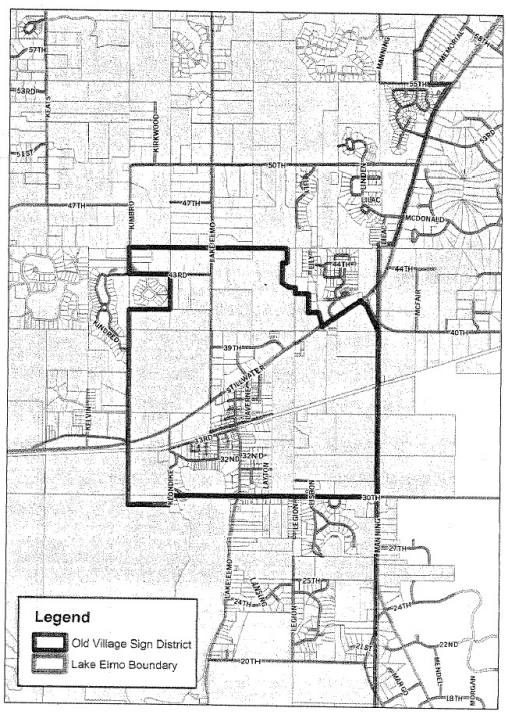
105.12.010 Purpose
This chapter is adopted for the purposes of:
- Protecting the public health, safety, comfort, convenience, and general welfare;
- Implementing the city comprehensive land use plan;
- Promoting orderly development of the residential, commercial, industrial, recreational and public areas;
- Conserving the natural and scenic beauty and attractiveness of the city;
- Conserving natural resources in the city;
- Minimizing environmental pollution; and
- Conserving energy through the siting of buildings and encouragement of solar and earth-sheltered structures where appropriate.
105.12.020 Statutory Authorization
This chapter is adopted pursuant to the authorization contained in M.S.A. ch. 462, or successor statutes.
105.12.030 Jurisdiction
This chapter shall be applicable to all lands and waters within the corporate limits of Lake Elmo, Minnesota.
105.12.040 Premature Development And Subdivision Prohibited
Any development, redevelopment, plat, or other subdivision of property may be denied by the city council if it is deemed by the city council to be premature for development pursuant to the criteria listed in LEC 103.00.025. The burden of proof shall be on the applicant, property owner, or subdivider to demonstrate to the city council that the proposed development, redevelopment, plat, or subdivision is not premature for development or redevelopment.
105.12.045 Compliance Required
Except as this chapter specifically provides, no structure shall be erected, converted, enlarged, reconstructed or altered, and no structure or land shall be used for any purpose in any manner which is not in conformity with this chapter.
105.12.050 Rules Of Construction And Interpretation
The following rules of construction and interpretation apply to this chapter:
- Minimum requirements. In their interpretation and application, the provisions of this chapter shall be held to the minimum requirements for the promotion of the public health, safety and welfare.
- Conflict. Where the conditions imposed by any provision of this chapter are either more restrictive or less restrictive than comparable conditions imposed by any other law, chapter, statute, resolutions or regulation of any kind, the regulations which are more restrictive or which impose higher standards or requirements shall prevail.
105.12.060 Severability And Validity
It is hereby declared to be the intention that the several provisions of this chapter are severable in accordance with the following:
Validity. If any court of competent jurisdiction shall adjudge invalid the application of any provision of this chapter to a particular property, building, or structure, such judgment shall not affect other property, buildings or structures.
105.12.070 Effective Date
This chapter shall be in full force and effect from and after the date of the passage and approval by the city council of the ordinance from which it is derived.
105.12.080 Introduction And Purpose
The purpose of this article is to define general terms used in this zoning ordinance, to establish a classification system for land uses and a consistent set of terms defining uses permitted within various zoning districts, and to establish the rules for interpretation of language in this chapter.
105.12.090 Interpretation Of Certain Terms
In the construction of the zoning ordinance codified in this chapter, the following rules shall be observed and applied, except where the context clearly indicates otherwise:
- The term "building" includes the term "structure."
- The terms "used for" shall include the phrases "arranged for," "designed for," "intended for," "maintained for," and "occupied for."
- The term "lot" shall mean zoning lot unless otherwise specified in this chapter.
- The terms "lot," "parcel," or "premises" may be used interchangeably.
- All stated and measured distances shall be taken to the nearest integral foot. If a fraction is one-half foot or less, the integral foot next below shall be taken.
105.12.100 General Definitions
Unless specifically defined in this chapter, common definitions, words and phrases used in this chapter shall be interpreted as to give them the same meaning as they have in common usage throughout this Code and are found in LEC 1.08.
105.12.110 Zoning Use Types And Classifications
- Rules of interpretation for zoning use types and classifications.
- Purpose of use types. The purpose of the use types is to establish a classification system for land uses and a consistent set of terms defining uses permitted within various zoning districts. The use types section also facilitates the process of determining the applicable use type of any activity not clearly within any defined use type.
- Interpretation. In the event of any question as to the appropriate use type of any existing or proposed use or activity, the planning director shall have the authority to determine the appropriate use type. In making such a determination, the planning director shall consider the operational and physical characteristics of the use in question and shall consider the classification contained in the most recent edition of the Standard Industrial Classification Manual published by the U.S. Office of Management and Budget. In addition, the planning director shall consider the specific requirements of the use in common with those included as examples of use types. Those examples, when included in use type descriptions, are intended to be illustrative, as opposed to exclusive lists. The planning director may also determine that a proposed use or activity is sufficiently different from any use type listed below and will require an amendment to the text of this chapter.
- Determinations in writing. The planning director shall make such determinations of appropriate use types in writing, which shall include an explanation of the reasons for the determination.
- Appeal. A determination of the planning director may be appealed to the board of adjustment pursuant to the procedures for administrative appeals outlined in LEC 3.08.100.
- Use types and classifications.
- Residential and related uses.
- Family living.
Live-work unit means a dwelling unit in combination with a shop, office, studio, or other work space within the same unit, where the resident occupant both lives and works.
Manufactured home park means a development on a site under a single ownership which consists of two or more spaces for the placement of manufactured homes for dwelling or sleeping purposes, regardless of whether or not a fee is charged for the utilization of such space.
Multifamily residential means a building containing three or more dwelling units served by one or more shared entrance. The term "multifamily residential" includes cooperative apartments and condominiums, but not condominium-hotels. (See condominium and condominium-hotel under LEC 1.08.)
Secondary dwelling means a residential dwelling unit, but not a manufactured home, located on the same lot as a single-family dwelling unit, either within the principal structure or above a detached garage.
Single-family, attached, or townhomes, means a building containing independent dwelling units adjacently attached to each other, each with separate exterior entrances at the ground floor. Single-family attached must contain more than two units, but not to exceed eight total units. The units may be on the same, or separate, lots.
Single-family, detached, means a building containing only one dwelling unit, surrounded by landscape area or yards on all sides.
Two-family or duplex means a building on a single lot or adjacent lots containing two dwelling units, either side-by-side or stacked vertically. - Group living.
Congregate housing means a dwelling providing shelter and services for the elderly, which may include meals, housekeeping, and personal care assistance and minor medical services, but not intermediate, long-term, or extended nursing care for residents.
Correctional facilities means a public or privately-operated use providing housing and care for individuals legally confined, designed to isolate those individuals from a surrounding community.
Group home means a residence shared by six or fewer handicapped persons in addition to resident staff, who live together as a single housekeeping unit and in a long-term, family-like environment in which staff persons provide care, education, and participation in community activities for the residents with the primary goal of enabling the residents to live as independently as possible in order to reach their maximum potential.
Group residential facility means a licensed public or private establishment, which, for gain or otherwise, regularly provides one or more dependents with 24-hour a day substitute for the care, food, lodging, training, education, supervision, rehabilitation, and treatment they need, but which for any reason cannot be furnished in the dependent's own home. The term "group residential facility" includes, but is not limited, to state institutions under the control of the commissioner of public welfare, foster homes, maternity shelters, group homes, as defined herein, with seven or more residents, schools for handicapped children, and homes for battered children or battered spouses.
Halfway house means an establishment providing accommodations, rehabilitation, counseling, and supervision to persons suffering from alcohol, drug addiction or other similar disorders, or to persons re-entering society after being released from a correctional facility or other institution.
Semi-transient accommodations means and includes boardinghouses, roominghouses, fraternity and sorority houses, or lodging rooms, as defined by this chapter. Semi-transient accommodations do not include condominium-hotels, as defined in LEC 1.08.
- Family living.
- Public and civic uses.
Cemetery means land used or intended to be used for the burial of the dead and dedicated for cemetery purposes, including columbarium's, crematories, mausoleums, and mortuaries when operated in conjunction with and within the boundaries of such cemetery.
Colleges and universities means institutions of higher learning which offer courses of general or specialized study leading to a degree or certificate. They are certified by the state board of higher education or by a recognized accrediting agency. Colleges tend to be in campus-like settings or on multiple blocks. Accessory uses include offices, housing for students, food service, laboratories, health and sports facilities, theaters, meeting areas, parking, maintenance facilities, and support commercial. Examples include universities, liberal arts colleges, community colleges, nursing and medical schools not accessory to a hospital, and seminaries.
Community services means establishments of a public, nonprofit, or charitable nature generally providing a local service to people of the community. Generally they provide the service on the site or have employees at the site on a regular basis. The service is ongoing, not just for special events. Community centers or facilities may incorporate membership provisions, and are open to the general public to join at any time (for instance, any senior citizen could join a senior center). The use may also provide special counseling, education, or training of a public, non-profit, or charitable nature. Accessory uses may include offices, meeting areas, food preparation areas, parking, health and therapy areas, day care uses, and athletic facilities. Examples include libraries, museums, senior centers, community centers, social service facilities, early childhood learning facilities, and other special educational services.
Day care center means any facility operated for the purpose of providing care, protection, and guidance to 14 or more individuals during only part of a 24-hour day. The term "day care center" includes nursery schools, preschools, day care centers for individuals, and other similar uses but excludes public and private educational facilities or any facility offering care to individuals for a full 24-hour period.
Public assembly means facilities owned and operated by a public or quasi-public agency accommodating public assembly for non-recreation purposes. Typical uses include auditoriums, convention facilities, exhibition facilities, convention halls, or armories.
Religious institutions means establishments that are intended to primarily provide meeting areas for religious activities. Accessory uses include Sunday school facilities, parking, caretaker's housing, and group living facilities such as convents. Examples include churches, temples, synagogues, and mosques.
Schools, public and private, means establishments at the primary, elementary, middle, junior high, or high school level that provide state-mandated basic education. Accessory uses include play areas, cafeterias, recreational and sport facilities, auditoriums, and before or after school day care. Examples include public and private day-time schools, boarding schools, and military academies.
Exemptions:- Preschools are classified as day care facilities; and
- Business and trade schools are classified as educational services.
- Services.
Business center means a building or group of buildings planned, constructed, and managed as a total entity, with common on-site parking for a group of commercial service establishments, with office uses also permitted. In the central business district, the requirement for common on-site parking need not be met in order to classify a development as a business center.
Business services means establishments primarily engaged in rendering services to business establishments on a fee or contract basis, such as advertising and mailing, building maintenance, office equipment rental and leasing, photo finishing, business supply services, and computer programming/data processing services.
Communication services means establishments primarily engaged in the provision of broadcasting and other information relay services accomplished through the use of electronic and telephone mechanisms. Excluded from this use type are facilities classified as essential services or broadcasting and communications towers. Typical uses include television studios, telecommunications service centers, telegraph service offices or film and sound recording facilities.
Educational services means establishments engaged in furnishing specialized academic or technical courses, normally on a fee basis, such as vocational or correspondence schools, barber college, data processing schools, or secretarial schools, along with non-degree granting schools such as post-secondary colleges and universities, martial arts, music, art, ceramic, and dramatic, schools, and dance instruction.
Financial institution means provision of financial and banking services to consumers or clients. Walk-in and drive-in services are generally provided on site. Typical uses include banks, savings and loan associations, savings banks, credit unions, lending establishments, and drive-up automatic teller machines (ATMs).
Funeral home means establishments engaged in undertaking services such as preparing the dead for burial, and arranging and managing funerals. Typical uses include funeral homes or mortuaries.
Lodging. See Transient accommodations.
Medical facilities means establishments engaged in providing diagnostic services, extensive medical treatment (including surgical services), and other hospital services, as well as continuous nursing service, including general medical and surgical hospitals, specialty hospitals, medical laboratories, bio-medical research and development, outpatient care facilities, medical schools and associated dormitories, medical appliance sales, and similar uses, but not including animal hospitals.
Membership organization means organizations operating on a membership basis for the promotion of the interests of the members included such uses as trade associations, business associations, professional membership organizations, labor unions, civic or fraternal organizations, but not including churches, hospitals, golf and country clubs, or credit unions.
Nursing and personal care means establishments primarily engaged in providing intermediate or long-term nursing and health related care to individuals, typically classified as nursing homes.
Offices means a building or portion of a building used for office purposes by a business, service, professional, or institutional establishment, including medical offices or clinics, studios for those involved in art, sculpture, music, and the like, and all other establishments similar in character.
Personal services means establishments primarily engaged in providing services involving the care of a person or his apparel, such as barber shops, clothing rental, salons and health clubs, photographic studios, cleaning and garment services (but not including power laundries or dry cleaning plants) or coin-operated laundries.
Repair and maintenance shop means establishments engaged in miscellaneous repair services, primarily of household-oriented products such as radios, televisions, washers and dryers, furniture (including re-upholstery), small engine repair, bicycles, or locksmiths.
Self-service storage facility means an establishment designed and utilized for the purpose of renting or leasing individual storage spaces to tenants who have sole private access to such space for storing personal property.
Trade shop means any lot, land, building, or structure that serves as the headquarters for contractors involved in specialized activities such as plumbing, painting, plastering, masonry, carpentry, roofing, well drilling, landscaping and the like, where tools, equipment and materials used in the business are stored. The category also includes establishments involved in specialized trades such as sheet metal, sign painting, drapers, and exterminators.
Transient accommodations, lodging, means establishments in which lodging is provided and offered to the public for compensation, and which is open primarily to transient guests, as distinguished from semi-transient boarding or rooming facilities. Typical uses include hotels, motels, and inns. Meeting and restaurant facilities may be included accessory to this use type. Condominium-hotels shall be considered as a type of transient accommodation.
Transportation services means establishments furnishing services related to the arrangement of persons and goods movements, such as freight forwarding, parking services or the rental/leasing of automobiles or two-axle trucks.
Veterinary service means establishments engaged in the practice of veterinary medicine, dentistry or surgery, along with those providing animal related services such as kennels, grooming, or breeding services. - Food service.
Drinking and entertainment means establishments primarily engaged in the selling of drinks for consumption on the premises, where entertainment may be provided and the incidental sale of prepared food for consumption on the premises is permitted. These establishments may often charge a fee or admission charge for the entertainment provided. Included in this category are bars, beer gardens, discotheques, nightclubs, taverns, and dance halls.
Drive-in restaurant means an establishment primarily engaged in the preparation of food and beverages, for either take-out, delivery, or table service, served in disposable containers at a counter and a drive-up or drive through service facility or which offers curb service.
Fast food restaurant means an establishment primarily engaged in the preparation of food and beverages, for either take-out, delivery, or table service, served in disposable containers at a counter. This use type does not employ a drive-up or drive-through service facility, and does not offer curb service.
Standard restaurant means an establishment whose principal business is the sale of food and/or beverage to customers in a ready to consume state, and whose principal method of operation includes one or both of the following:- Customers, normally provided with an individual menu, are served their food and beverage by restaurant employees at the same table or counter at which the food and/or beverage are consumed;
- A cafeteria-type operation where food and beverage generally are consumed within the restaurant building.
- Sales of merchandise.
Garden center (retail agriculture) means establishments or places of business primarily engaged in retail or wholesale (bulk) sale, from the premises, of trees, shrubs, seeds, fertilizers, pesticides, and plant materials primarily for agricultural, residential, and commercial consumers. Such establishments typically sell products purchased from others, but may sell some material which they grow themselves. Typical uses include nurseries, retail greenhouses, plant stores, and lawn and garden centers.
Neighborhood convenience store means establishments primarily engaged in the provision of frequently or recurrently needed goods for household consumption, such as prepackaged food and beverages, and limited household supplies and hardware. Convenience stores shall not include fuel pumps or the selling of fuel for motor vehicles. Typical uses include neighborhood markets and country stores.
Retail trade means establishments engaged in selling goods or merchandise to the general public for personal or household consumption and rendering services incidental to the sale of such goods. These establishments are characterized by the following:- They buy and receive as well as sell merchandise;
- They may process some products, but such processing is incidental or subordinate to the selling activities; and
- They predominantly sell to customers for their own personal or household use.
- General retail.
- Antiques and collectibles store.
- Art gallery.
- Bicycle sales and repair.
- Book store, music store.
- Clothing and accessories.
- Craft or needlework shop.
- Drugstore, pharmacy.
- Electronics and appliance sales and repair.
- Florists.
- Specialty food store, including bakery, butcher shop, delicatessen, and the like.
- Jewelry store.
- Hardware store.
- Newsstands, magazine sales.
- Pet store.
- Photographic equipment and supplies.
- Picture framing.
- Secondhand store, thrift or consignment store.
- Sporting goods store.
- Stationery store.
- Tobacco store.
- Video rental or sales.
- Building supplies sales.
- Furniture and appliance sales, rental, showrooms.
- Grocery, supermarket.
- Liquor store.
- Warehouse club sales.
Wholesaling means establishments engaged primarily in selling merchandise to retailers, or to industrial, commercial, institutional, or professional business customers, or to other wholesalers, or on a mail order basis to individuals or firms, or which serve as agents or brokers buying merchandise for, or selling merchandise to, individuals and companies. - Automotive/vehicular uses.
Automobile maintenance service means repair of automobiles, noncommercial trucks, motorcycles, motor homes, recreational vehicles, or boats, including the sale, installation, and servicing of equipment and parts. Typical uses include tire sales and installation, wheel and brake shops, oil and lubrication services and similar repair and service activities where minor repairs and routine maintenance are conducted.
Automobile parts/supply means retail sales of automobile parts and accessories. Typical uses include automobile parts and supply stores which offer new and factory rebuilt parts and accessories, and include establishments, which offer minor automobile repair services as an accessory use.
Car wash means washing and cleaning of vehicles. Typical uses include automatic conveyor machines and self-service car washes.
Commercial vehicle repair means repair of construction equipment, commercial trucks, agricultural implements and similar heavy equipment, including automobiles, where major engine and transmission repairs are conducted. Typical uses include automobile and truck repair garages, transmission shops, radiator shops, body and fender shops, equipment service centers, machine shops, and other similar uses where major repair activities are conducted.
Gasoline station means any place of business with fuel pumps and underground storage tanks that provide fuels and oil for motor vehicles. A neighborhood convenience store associated with automobile fuel sales shall be considered a gasoline station.
Parking facility means any structure associated with a nonresidential use whose purpose is to provide the required off-street parking spaces for a principal use, or any site utilized for parking which constitutes the principal use on a parcel of land. This category also includes community lots, which are established to meet the parking needs in a residential area, and park and ride lots.
Sales and storage lots means establishments engaged in the display for sale, lease, and/or rental of automobiles, trucks, machinery, recreational vehicles and manufactured homes, including auto dealerships or the farm commercial storage of privately-owned trailers, boats, campers, or similar vehicles. - Outdoor recreation.
Campgrounds and trailering means establishments engaged in providing overnight or short-term sites for the placement of recreational vehicles or temporary housing, with or without facilities such as water and electricity.
Golf course means a tract of land for playing golf, improved with tees, greens, fairways, hazards, and which may include clubhouses and shelters. Included would be executive or par three golf courses. Specifically excluded are independent driving ranges or miniature golf facilities, which are classified as outdoor recreation facilities.
Marina means a facility for storing, servicing, fueling, berthing, and securing and launching of private pleasure craft that may include the sale of fuel and incidental supplies for the boat owners, crews, and guests.
Outdoor entertainment means an outdoor facility developed for entertainment, amusement, or tourist purposes which typically involve large areas of land and concentrated traffic peaks oriented towards events at the facility, including drive-in theaters, amphitheaters, outdoor concert halls, or theme parks.
Outdoor recreation facility means a commercial recreation facility that is primarily an open-air facility, such as baseball fields, swimming pools, skating rinks, golf driving ranges, or miniature golf facilities.
Parks and open areas means uses of land focusing on natural areas, large areas consisting mostly of vegetative landscaping or outdoor recreation, community gardens, or public squares. Lands tend to have few structures. Accessory uses include, but are not limited to, clubhouses, maintenance facilities, concessions, caretaker's quarters, gazebos, pavilions, band shells, and parking. Examples include parks, public squares, plazas, recreational trails, botanical gardens, boat launching areas, nature preserves, and land used for grazing that is not part of a farm or ranch.
Restricted recreation means commercial recreation facilities that are of greater nuisance than conventional outdoor athletic facilities because of:- The noise and traffic volumes they may generate;
- The glare they produce; or
- The potential danger they may create from flying objects or the use of weapons. This category includes such uses as amusement parks, racetracks (auto, go-cart, motorcycle) or ranges (skeet, rifle, or archery).
- Indoor recreation/entertainment.
Adult establishment. See LEC 11.16.020.
Indoor athletic facility means a commercial recreation facility that provides completely enclosed or indoor recreation space, such as racquet clubs, indoor skating rinks, swimming pools, or gymnasiums.
Indoor recreation means establishments primarily engaged in activities intended to provide personal amusement, with the largest number of patrons typically during the evening hours or on weekends, and where food and refreshments may be provided as an incidental service, including such uses as bowling alleys, billiard, pool, or bingo parlors, amusement arcades, and indoor theaters (live or motion picture). - Agricultural and related uses.
Agricultural entertainment business means an agricultural sales business that combines the elements and characteristics of agriculture and tourism, which is not necessarily located in an existing building. Examples of agricultural entertainment include: corn mazes, hay rides, sleigh rides, petting farms, on-farm tours, agricultural related museums, demonstrations of farming practices, techniques and methods, fee-based fishing and hunting, horseback riding, nature trails, haunted barns and similar activities which are related to agriculture.
Agricultural production means establishments engaged in the production of crops, plants or vines, including agro forestry, or establishments which are engaged in the keeping, grazing, or feeding of livestock for sale, value increase, or livestock increase.
Agricultural sales business means the retail sale of fresh fruits, vegetables, flowers, herbs, trees, or other agricultural, floricultural, or horticultural products. The operation may be indoors or outdoors, include pick-your-own or cut-your-own opportunities, and may involve the ancillary sale of items considered accessory to the agricultural products being sold or accessory sales of unprocessed foodstuffs; home processed food products such as jams, jellies, pickles, sauces; or baked goods and homemade handicrafts. The floor area devoted to the sale of accessory items shall not exceed 25 percent of the total floor area. No commercially packaged handicrafts or commercially processed or packaged foodstuffs shall be sold as accessory items. No activities other than the sale of goods as outlined above shall be allowed as part of the agricultural sales business.
Agricultural services means establishments that perform services which support or assist the agricultural community, such as soil preparation services, crop services, farm management services, or breeding services on a fee or contract basis, along with experimental farms for research or educational purposes. This category is intended to apply where agricultural land is located, and may include buildings and other structures that provide office, warehouse, and storage areas for these establishments.
Agricultural support means establishments engaged in farm equipment sales and repair, farm produce sales and supply (feed grain, elevators) and small-scale farm product processing, such as cider mills, dairies, poultry or meat processing.
Forestry operations means the use of land for the raising and harvesting of timber, pulpwood or other forestry products for commercial purposes, including the temporary operation of a sawmill and/or chipper or grinder to process the timber cut from that parcel or contiguous parcels. Excluded from this definition shall be the cutting of timber associated with land development approved by the city which shall be considered accessory to the development of the property.
Greenhouse, non-retail, means a building or structure constructed chiefly of glass, glasslike or translucent material, cloth, or lath, which is devoted to the protection or cultivation of flowers or other tender plants.
Wayside stand means a temporary structure or vehicle used for the seasonal retail sale of agricultural goods, floriculture, and horticulture produced by the operator of the wayside stand, which is clearly a secondary use of the premises and does not change the character thereof. - Alternative energy.
Solar energy system means a device or structural design feature, a primary purpose of which is to provide for the collection, storage, and distribution of solar energy for space heating, cooling, water heating, or for power generation.
Solar farm means a commercial facility that converts sunlight into electricity, whether by photovoltaic (PV), concentrating solar thermal devices (CST), or other conversion technology, for the principal purpose of sales of generated electricity to off-site customers.
Wind generator means a machine which generates energy/power from the wind. - Industrial and extractive uses.
Closed landfill management means the use associated with the responsibility and obligation of the state pollution control agency (MPCA) to take necessary response actions on the property as provided in M.S.A. § 115B.412, subd. 4, and M.S.A. §§ 115B.39 to 115B.43.
Heavy industrial means establishments involved in the manufacture, fabrication, processing, compounding, or assembling of materials from raw material or previously processed material. These uses have severe potential for adversely affecting surrounding land uses due to potential environmental impacts related to noise, smoke/particulate emissions, vibration, noxious gases, odor, glare/heat, fire/explosion hazards and waste disposal. In addition, these uses may generate large amounts of truck or auto traffic, may involve the use of large unenclosed production areas, or may require large, tall structures that are unsightly. Heavy industrial uses typically involve primary production processes in the area of paper products (pulp mills), food processing (slaughterhouse, meat packing plant), chemicals (manufacture of inorganic chemicals, resins, plastics, paints, fertilizers, explosives, ink), petroleum products (refineries, bulk storage), primary metals (blasting, smelting, rolling), machinery and equipment manufacturer (auto assembly, engines, construction equipment), leather (storing, curing, tanning), gravel based products (manufacture of bricks, concrete, abrasives), and lumber products (saw mills).
Landfill means a disposal site employing an engineered method of disposing solid wastes in a manner that minimizes environmental hazards by spreading, compacting to the smallest volume, and applying cover material over all exposed waste at the end of each operating day.
Laundry plant means establishments primarily engaged in the provision of laundering, cleaning, or dyeing services other than those classified as personal services. Typical uses include bulk laundry and cleaning plants, diaper services, and linen supply services.
Light industrial means establishments involved in the processing, fabrication, assembly, or compounding of products where the process involved is relatively clean and nuisance free, usually completely enclosed, and with limited environmental effects. These uses can be made compatible with surrounding areas through landscape screening and through separation required by yard and height limitations. Typically, these uses result in the creation of finished products for sale on a wholesale basis to retailers or directly on a retail basis, and include uses in the following areas: lumber products (millwork, cabinet-making), electronics, textiles, printing and publishing services, bottling works, carpet and rug cleaning, furniture manufacture, paper (final processing of stationery, bags, etc., from purchased bulk stock), light metal finishing and light machining, rubber and plastics (compounding processed resins, molding plastics), gravel based products (pottery, cutting, finishing granite, firing and decorating clay products), and ice manufacturing.
Motor freight and warehousing means establishments engaged primarily in either the storage or shipment of goods and materials, including terminal facilities for handling freight, and maintenance facilities in which the trucks (including tractor trailer units) involved with the operation of the business are stored, parked and serviced. Materials within a warehouse or terminal facility may be combined, broken down, or aggregated for trans-shipment or storage purposes where the original material is not chemically or physically changed.
Non-production industrial means establishments that normally are considered industrial in character even though they are not involved in the manufacturing or processing of products. These uses generate negative impacts largely through their need for outside storage of equipment and materials, the large expanse of land needed for this storage, and the creation of dirt, dust and noise, along with intermittent truck traffic. These uses generally can be made compatible through landscape screening and the imposition of limited performance standards, and thus are not objectionable in most industrial or commercial districts. The types of uses categorized here include contractor's yards, lumberyards, utility yards, and public maintenance shops and yards.
Research and testing means establishments or other facilities for carrying on investigation in the natural or physical sciences, or engineering and development as an extension of investigation with the objective of creating end products, on a contract or fee basis, and including pilot plant operation.
Resource extraction means a use involving on-site extraction of surface or subsurface mineral products or natural resources. Typical uses are quarries, borrow pits, sand and gravel operations, mining, and soil mining. Specially excluded from this use type shall be grading and removal of dirt associated with an approved site plan or subdivision.
Salvage/recyclable center means land or buildings where waste, discarded, salvaged, or recyclable materials are bought, sold, stored, exchanged, sorted, cleaned, packed, disassembled or handled on a commercial basis, including, but not limited to, scrap metal, aluminum, rags, paper, rubber products, glass products, lumber products and products resulting from the wrecking of automobiles or other vehicles. Any site containing two or more unregistered, inoperable motor vehicles is classified as a salvage center. - Utilities, transportation and communications.
Air transportation means establishments engaged in domestic, emergency, or foreign transportation of passengers or goods by air, including airports, flying fields, rotorcraft terminals, as well as any associated terminal facilities.
Broadcasting or communication means any unstaffed facility for the transmission and/or reception of radio, television, radar, cellular telephone, personal paging device, specialized mobile radio (SMR), and similar services. A broadcasting or communication facility usually consists of an equipment shelter or cabinet, a support tower or other structure used to achieve the necessary elevation, and the transmission or reception devices or antenna. Broadcasting or communication facilities include wireless communications facilities and wireless communications towers as defined in LEC 1.08.
Essential services means overhead, above ground or underground electrical, gas, steam or water transmission or distribution systems and structures of collection, communication, supply or disposal systems and structures used by public utilities or governmental departments or commissions or as are required for the protection of the public health, safety or general welfare, including towers, poles, wires, mains, drains, sewer pipes, conduits, cables, fire alarm boxes, police call boxes and accessories in connection therewith but not including buildings.
Local transit means establishments primarily engaged in furnishing local and suburban passenger transportation, including taxicabs, passenger charter services, school buses, and terminals (including service facilities) for motor vehicle passenger transportation.
Railroad transportation means establishments engaged in domestic freight and passenger transportation by rail, and including railroad yards, freight stations and switching yards. - Accessory uses.
Bed and breakfast means a private, owner-occupied residence that contains no more than five guestrooms where lodging, with or without meals, is provided for compensation. Guest stays shall be limited to 30 days.
Commercial wedding ceremony venue means a use involving a location to conduct wedding ceremonies, not including receptions, and usually operated in exchange for remuneration by providing the venue to the public.
Domestic pets means the keeping of small domestic animals, such as dogs, cats, birds, rodents, fish, and the like, not primarily for produce or value increase, but rather for show, sport, or as pets.
Family day care means a residence licensed by the state department of human services in which no more than ten children at any one time receive care, maintenance and supervision by someone other than their relatives or legal guardians for less than 24 hours per day.
Group family day care means a residence licensed by the state department of human services in which at least 11, but not more than 14, children receive care, maintenance and supervision by someone other than their relatives or legal guardians for less than 24 hours per day.
Home occupations means any gainful occupation or profession engaged in by the occupants and up to one non-occupant employee of a dwelling when carried on within a dwelling unit or in an accessory building, provided that no signs other than those allowed by the city's sign regulations regarding home occupations are present.
Kennel, private, means the keeping, breeding, raising, showing or training of four or more dogs over six months of age for personal enjoyment of the owner or occupants of the property, and for which commercial gain is not the primary objective.
Merchandise parties means private parties held for the purpose of soliciting sales. Merchandise parties shall include but not be limited to Tupperware, Mary Kay, and Avon parties.
Stable, private, means the keeping, breeding, or raising of horse or ponies exclusively for the personal use and enjoyment of the owner or occupant of the property or the riding of horses or ponies by the owner or occupant of the property and their guests.
Swimming pools means any permanently located pool, used for swimming and/or bathing which is over 24 inches in depth, or which has a surface area exceeding 150 square feet.
Temporary sales means any isolated or occasional display and sale of used personal property or home-crafted items conducted on residential premises by the occupant of the residential property. Temporary sales shall include rummage sales, basement sales, yard sales, porch sales, craft sales, garage sales, and seasonal boutiques.
- Residential and related uses.
105.12.120 Classifications
For the purpose of this chapter, all land in the city is divided into zoning districts. The zoning districts shall be identified by the following classifications, including those districts identified in LEC 105.12.590:
| R-2 | One- and Two-Family Residential |
| GB | General Business |
| OP | Open Space Preservation District |
| OZD | Overlay Zoning Use District |
105.12.130 Boundaries
See LEC 105.12.600.
105.12.140 Zoning District Map
See LEC 105.12.600.
105.12.150 R-2 One- And Two-Family Residential
- Permitted uses and structures.
- One-family detached dwellings; and
- Two-family dwellings, provided they do not exceed 50 percent of the units in a block.
- Accessory uses and structures.
- Uses and structures which are customarily accessory and clearly incidental and subordinate to permitted uses and structures;
- Private garages, carports, screenhouses, conservatories, playhouses, swimming pools, and storage buildings for use by occupants of the principal structure;
- Temporary real estate tract office for the purpose of selling lots on the tract upon which it is located; and
- Home occupations.
- Minimum district requirements.
R-2 Zoning District Lot Size: One-family 1 1/2 acre per unit without sanitary sewer; 7,500 feet per unit with sanitary sewer Two-family 1 1/2 acre per unit without sanitary sewer; 6,000 square feet per unit with sanitary sewer Lot Width: One-family 75 feet at front yard setback line with sanitary sewer; 125 feet without sanitary sewer Two-family 100 feet at front yard setback line with sanitary sewer; 200 feet without sanitary sewer Building setback from property lines (also see LEC 105.12.210): Front 30 feet Side (Interior) 10 feet Side (Corner) 25 feet Rear 40 feet Arterial Street 50 feet Primary building height (also see LEC 105.12.220) 35 feet Accessory buildings and structures: Accessory building and structures height (also see LEC 105.12.220) 14 feet Off-street parking 3 spaces per unit Septic drainfield regulations All lots must have at least one acre of land suitable for septic drainfields and area sufficient for two separate and distinct drainfield sites. Placement of the second required drainfield between the trenches of the first drainfield is prohibited. Maximum width of primary dwelling All dwelling units must be at least 20 feet wide through the main living area of the structure. Footings The primary structure must have continuous frost footings. Continuous frost footings are not required for porches, decks, and other appendages so long as proper post type footings per existing building codes are constructed. Maximum impervious surface coverage Maximum width of driveways See LEC 9.16.090 Signage See LEC 105.12.430
105.12.160 GB General Business
- Permitted uses and structures.
- The following service/office uses:
- General business--service/office;
- Accounting;
- Advertising (sign fabrication not permitted use);
- Alterations;
- Apparel cleaning pick-up stations;
- Apparel repair and alterations;
- Architectural;
- Art gallery;
- Auditing;
- Bakeries (with production of bakery goods limited to retail sales);
- Barber services;
- Beauty shops;
- Bookkeeping;
- Business and management consultant offices;
- Business associations;
- Cafes and restaurants--drive-up window (menu boards and intercom systems prohibited; adequate vehicle stacking must be provided);
- Cafes and restaurants (limited to full table service operations);
- Charitable;
- Chiropractic;
- Civic, social and fraternal association offices and halls;
- Collection and adjustment services;
- Credit reporting (consumer and mercantile);
- Dental;
- Detective and protective agencies;
- Duplication;
- Educational;
- Employment agencies;
- Engineering;
- Finance;
- Galleries;
- Governmental offices;
- Insurance;
- Investment;
- Labor unions;
- Legal;
- Libraries;
- Mailing;
- Medical;
- Medical services (the compounding, dispensing or retail sale of drugs, prescription items, patient or proprietary medicine, sick room supplies, prosthetic devices or items relating to any of the foregoing when conducted in the building occupied primarily by medical, dental, osteopathic, chiropractic or optometric offices);
- Optometric;
- Osteopathic;
- Photo gallery;
- Professional membership organizations;
- Real estate;
- Religious;
- Scientific research (excluding laboratory facilities);
- Shoe repair;
- Stenographic service;
- Therapeutic massage (see licensing requirements in LEC 11.20.010);
- Welfare offices.
- The following retail uses:
- General business--retail;
- Antiques and secondhand merchandise;
- Apparel and related accessories;
- Automobile repair and services;
- Automobiles and automobile accessories;
- Bicycles;
- Books;
- Building supplies;
- Cameras and photographic supplies;
- Cigars and cigarettes;
- Drugs and proprietary items;
- Electrical supplies;
- Flowers and floral accessories;
- Food and grocery products;
- Furniture;
- Gifts, novelties and souvenirs;
- Glass;
- Heating equipment;
- Home furnishings and related equipment;
- Jewelry;
- Liquors;
- Marine craft and accessories;
- Newspapers and magazines;
- Nursery and garden supplies;
- Optical goods;
- Paint;
- Pets;
- Plumbing equipment;
- Sporting goods;
- Stationery;
- Wallpaper.
- The following repair/service uses:
- General business--repair/service;
- Clock repair;
- Electrical repair and supplies;
- Equipment, rental and leasing;
- Food catering;
- Furniture repair;
- Heating;
- Household appliances;
- Jewelry repair;
- Landscaping;
- Plumbing;
- Radio;
- Reupholstery;
- Television;
- Watch repair.
- The following office uses (excluding equipment storage):
- General business--office;
- Air conditioning contractor;
- Building construction contractor;
- Carpentry contractor;
- Decorating contractor;
- Heating contractor;
- Masonry contractor;
- Painting contractor;
- Plastering contractor;
- Plumbing contractor;
- Roofing contractor;
- Sheet metal contractor;
- Stone work contractor;
- Tile setting contractor;
- Wallpaper contractor;
- Water well drilling contractor;
- Wood flooring contractor.
- Uses permitted by conditional use permit:
- General business--conditional use;
- Bed and breakfast facility: 15 beds maximum;
- Boarding care facility: 15 residents maximum;
- Day care centers: 40 children maximum;
- Family entertainment centers;
- Fitness studio: Maximum floor area not to exceed 5,000 square feet;
- Kennels;
- Nursing care facility: 15 residents maximum;
- Open sales lots;
- Manufacturing: Any industrial manufacturing operation in existence within the city at the effective date of the ordinance from which this chapter is derived, including manufacture of wood products and plastic products, may continue the use as a conforming use without a conditional use permit. Nothing in this provision shall otherwise be construed to require the city to authorize any manufacturing use in the general business zone after the effective date of the ordinance from which this chapter is derived;
- Veterinary clinics.
- General requirements:
- All storage, services, repair or processing shall be conducted wholly within an enclosed building or behind opaque fence or wall not less than six feet high, except the outdoor display of merchandise;
- Incineration of waste matter shall be conducted in approved equipment located within the building wherein the permitted use is conducted;
- Where a proposed GB development abuts on RR, R-1, R-2, R-3, R-4, or RE district other than at a public street line, buffer provision shall be established. There shall be provided a protective strip of not less than 35 feet in width. The protective strip shall not be used for parking, off-street loading or storage and shall be landscaped. The protective strip must be approved by the council as being in harmony with the residential neighborhood and providing sufficient screening of the commercial area;
- All lots must have at least one acre of land suitable for septic drainfields and area sufficient for two separate and distinct drainfield sites. Placement of the second required drainfield between the trenches of the first drainfield is prohibited; and
- The following service/office uses:
- Accessory uses. Uses which are clearly incidental and subordinate to the allowed uses shall be accessory.
- Minimum district requirements.
- Septic drainage regulation;
- All applicants for a use or building permit in any district not served by public sanitary sewer must demonstrate that an on-site sewage treatment system (primary and secondary location) as approved by the county can be installed in accordance with Washington County Subsurface Sewage Treatment System Regulations.
- Performance standards.
- Purpose and intent.
- It is the purpose and intent of the city, by the adoption of the performance standards of this article, to ensure commercial buildings constructed within the city are of a high quality of exterior appearance, consistent with the terms of Nonresidential Development Policy #5 of the 2000--2020 Lake Elmo Comprehensive Plan. It is the finding of the city that a limited selection of primary exterior surfacing materials meets this standard of quality.
- It is the further finding of the city that several specific exterior surfacing materials are appropriate, and of sufficient quality, to be utilized only as accent materials in varying percentages. The variations of percentage of specific accent materials relates to a finding by the city as to the relative quality and rural character of those respective accent materials.
- Architectural and site plan submittals. New building proposals shall include architectural and site plans prepared by registered architect and shall show the following as a minimum:
- Elevations of all sides of the buildings;
- Type and color of exterior building materials;
- Typical general floor plans;
- Dimensions of all structures; and
- Location of trash containers, heating, cooling and ventilation equipment and systems.
- Applicability, structure additions and renovation.
- Additions to existing structures resulting in an increase of gross floor area of the structure of less than 100 percent; and/or installation of replacement exterior surfacing of any portion of an existing structure shall be exempt from the standards of this article where it is found that the new or replacement exterior surfacing proposed is identical to that of the existing structure.
- Where additions to an existing structure result in an increase in the gross floor area of the existing structure of 100 percent or greater, the entire structure (existing structure and structure addition) shall be subject to the standards of this article.
- Performance standards, primary exterior surfacing.
- The primary exterior surfacing of structures shall be limited to natural brick, stone, or glass. Artificial or thin veneer brick or stone less than nominal four inches thick shall not qualify as complying with this performance standard.
- Primary exterior surface shall be defined as not less than 70 percent of the sum of the area of all exterior walls of a structure nominally perpendicular to the ground. All parapet or mansard surfaces extending above the ceiling height of the structure shall be considered exterior surface for the purposes of this article. Windows and glass doors shall be considered a primary surface, but the sum area of this glass shall be deducted from the wall area for the purposes of the 70 percent primary/30 percent accent formulas of this chapter. Doors of any type of material, except glass, shall not be considered a primary exterior surface.
- Each wall of the structure shall be calculated separately and, individually comply with the 70/30 formula.
- Performance standard, exterior surfacing accents. Not more than 30 percent of the exterior wall surfacing, as defined by subsection (d)(4) of this section, may be of the following listed accent materials, but no single accent material, except natural wood, may comprise more than 20 percent of the total of all accent materials; and, no combustible materials shall be used:
- Cedar, redwood, wood siding;
- Cement fiber board;
- Standing seam metal;
- Architectural metal;
- Stucco;
- Poured in place concrete (excluding "tilt-up" panels);
- Architectural metal panels; and
- Porcelain or ceramic tile.
- Performance standard, accessory structures. All accessory structures shall comply with the exterior surfacing requirements specified by this subsection (d) of this section.
- Performance standard, HVAC units and exterior appurtenances. All exterior equipment, HVAC and trash/recycling and dock areas shall be screened from view of the public with the primary exterior materials used on the principal structure.
- Performance standard, visible roofing materials. Any roofing materials that are visible from ground level shall be standing seam metal, fire-treated cedar shakes, ceramic tile, clay tile, concrete or slate.
- Applicability, new construction. The standards of this section shall be applicable to all structures and buildings constructed in the city, on and after the effective date of the ordinance from which this chapter is derived. The performance standards of this article shall not be in any manner minimized by subsequent planned unit development plans or agreement.
- Purpose and intent.
105.12.170 OP Open Space Preservation District
- Provisions regulating the OP Open Space Preservation District were repealed and replaced with the regulations now in LEC 105.12, art. XVII.
- Buffer setbacks in OP developments. Buffer setbacks shall be applied from the edge of the existing open space preservation developments as follows:
Buffer Setbacks in OP Developments (in feet) North Edge South Edge West Edge East Edge Exception Parcels St. Croix's Sanctuary 200 50 50 100 Discover Crossing 200 100 50 100 Whistling Valley I 25 200 N/A N/A Whistling Valley II 25 100 85 N/A Whistling Valley III 50 100 100 N/A Farms of Lake Elmo 100 50 100 25 Prairie Hamlet 200 50 50 100 Fields of St. Croix I 50 N/A 200 100 Fields of St. Croix II N/A 200 200 N/A N/A The Homestead 50 50 200 50 Tapestry at Charlotte's Grove 50 50 200 50 100 Tamarack Farm Estates 100 100 100 100 Sunfish Ponds 100 100 100 200 Hamlet on Sunfish Lake 50 100 50 50 Cardinal Ridge 100 200 50 50 Wildflower Shoves 100 200 100 200 Heritage Farms 50 N/A N/A 50 N/A Tana Ridge (Res. 2009-033) N/A N/A 50 50 Parkview Estates (Res. 2009-033) 50; except lot 9, block five use 20 ft N/A N/A 50
105.12.180 OZD Overlay Zoning Use District
The following overlay districts are designed to promote orderly development or to protect some specific sensitive natural resources. These district regulations are in addition to, rather than in lieu of, regulations imposed by the existing basic zoning use districts. These districts are defined and established as follows:
- Floodplain: See LEC 100.00.060;
- Restrictive Soils Overlay District: See LEC 105.04.450 through LEC 105.04.480;
- Wetland Protection and Preservation Overlay District: See LEC 105.04.500 through LEC 105.04.530;
- Shoreland District: See LEC 105.12.1230;
- Interstate Corridor Overlay District: See LEC 105.04.540 through LEC 105.04.620;
- Airport: (Reserved); and
- Open Space Development Overlay District: See LEC 105.12, art. XVII.
105.12.190 Additions And Exceptions To Minimum Area, Height, And Other Requirements
- Existing lot. An existing lot is a lot or parcel of land in a residential district which was of record as a separate lot or parcel in the office of the county recorder or registrar of titles, on or before the effective date of the ordinance from which this chapter is derived. Any such lot or parcel of land which is in a residential district may be used for single-family detached dwelling purposes, provided the area and width of the lot are within 60 percent of the minimum requirements of this chapter; provided, all setback requirements of this chapter must be maintained; and provided, it can be demonstrated safe and adequate sewage treatment systems can be installed to serve the permanent dwelling. Any one-acre lot which was of record before October 16, 1979 may be used for single-family detached dwelling purposes regardless of ownership of adjacent parcels, provided the lot meets all other requirements of this chapter.
- Reductions in lot size for municipal purposes. Any lot that has been reduced in size due to the acquisition of property for municipal purposes that would otherwise meet the requirements of an existing lot as described in subsection (a) of this section, may be used for a single-family detached dwelling, provided that the lot is not reduced in size by more than ten percent of the minimum district requirements due to the municipal land acquisition and further provided the lot conforms to all other zoning district and subdivision standards for the district in which it is located. This provision shall apply to the subdivision of lots in existence prior to the adoption of the ordinance codified in this article that would have otherwise met the zoning district standards for lot size and that meet all requirements of this section.
- Contiguous parcels. If, in a group of two or more contiguous lots or parcels of land owned or controlled by the same person, any individual lot or parcel does not meet the full width or area requirements of this chapter, the individual lot or parcel cannot be considered as a separate parcel of land for the purposes of sale or development, but must be combined with adjacent lots or parcels under the same ownership so that the combination will equal one or more parcels of land, each meeting the full lot width and area requirements of this chapter.
- Subdivision of lots. Any lot or parcel of land subdivided by any means after the effective date of the ordinance from which this chapter is derived for the purposes of erecting a structure, must be approved as required by the subdivision ordinance.
- Lake and stream frontage lots. All lots having frontage on a lake or stream shall be subject to the provisions of the shoreland management ordinance as well as the regulations provided by this chapter. All lots on unclassified bodies of water in the shoreland management ordinance shall meet the minimum setback requirements for a General Development Lake, except as provided in the shoreland management section.
- Lots in the floodplain. All lots in a designated floodplain shall be subject to the floodplain ordinance as well as the regulations provided by this chapter.
- Reduction of required yard or lot size prohibited. No yard or lot shall be reduced in area or dimension so as to make it less than the minimum required by this chapter, and if the existing yard or lot is less than the minimum required, it shall not be further reduced. No required yard or lot currently used for a building or dwelling group shall be used to satisfy minimum lot area requirements for any other building.
- Sloping on erodible building sites. On sites with slopes of greater than 25 percent or on easily erodible soils, as defined on the community soils maps and compiled by the county soils conservation agent, no structure shall be constructed.
- Minimum area requirements for lots without public sanitary sewer. In areas without public sanitary sewer, but where public sanitary sewer is proposed in the city's capital improvement program, single- and two-family homes shall demonstrate suitable soil conditions for adequate on-site sewage treatment area.
- In areas without public sanitary sewer where public sanitary sewer is not proposed in the city capital improvement program or comprehensive plan, single- and two-family homes shall demonstrate suitable soil conditions for a minimum on-site sewage treatment area of 1 acre per dwelling unit.
- A building permit shall not be issued for a lot which either does not meet the minimum acres of acceptable soils for on-site sewage treatment; or does not have enough acceptable soils within the lot or under legal contract to construct at least two complete septic/drainfield treatment systems.
- Lot width on a public street. All lots or parcels shall have direct adequate physical access for emergency vehicles along the frontage of the lot or parcel on a dedicated and approved public roadway to the width derived from applying the lot width requirement in each zoning district.
105.12.200 Permitted Encroachments On Required Yards
The following shall be permitted encroachments into setback and height requirements, except as restricted by other sections of this chapter:
- In any yards.
- Posts, off-street open parking, flutes, leaders, sills, pilasters, lintels, cornices, eaves (up to three feet), gutters, awnings, open terraces, steps, chimneys, flag poles, open fire escapes, egress window/wells, sidewalks, fences, essential services exposed ramps (wheelchair), patios, stoops, decks not requiring railings in accordance with state building codes, or similar features, provided they do not extend above the height of the ground floor level of the principal structure or to a distance less than five feet from any lot line nor less than one foot from any existing or proposed driveway; yard lights and nameplate signs; trees, shrubs, plants, floodlights or other sources of light illuminating authorized illuminated signs, or light standards for illuminating parking areas, loading areas, or yards for safety and security reasons; provided the direct source of light is not visible from the public right-of-way or adjacent residential property.
- Porches as defined in LEC 1.08 may encroach up to six feet into a required front yard setback or side corner yard, but in no case shall be setback less than ten feet from the front property line. A porch is not allowed in a side or rear yard setback.
- Side and rear yards. Fences; walls and hedges six feet in height or less; bays not to exceed a depth of three feet or containing an area of more than 30 square feet; egress/window wells not to exceed the minimum area needed to meet building/ fire code or fire escapes not to exceed a width of three feet.
- Corner lots. Nothing shall be placed or allowed to grow in such a manner as materially to impede vision between a height of 2 1/2 feet and ten feet above the centerline grades of the intersecting streets within 100 feet of the intersection.
- Off-street parking. In no event shall off-street parking spaces, structures of any type, buildings, or other improvements cover more than 75 percent of the lot area. In no event shall the landscaped portion of the lot be less than 25 percent of the entire lot as a result of permitted encroachments. In shoreland areas, no more than one-third of lot areas shall be covered with improvements.
105.12.210 Setbacks
- Front setbacks. Where adjacent residential structures on the same side of the street between intersections have front yard setbacks different from those required, the front yard minimum setback shall be the average of the immediately adjacent structures. If there is only one immediately adjacent structure, the front yard minimum setback shall be the average of the required setback and the setback of the adjacent structure. In no case shall the required front yard setback exceed the required minimum established within the districts of this chapter.
- Side and rear setbacks. Subject to regulations contained in the building code and other applicable regulations, side and rear setback requirements may be waived, provided party walls are used and the adjacent buildings are constructed as an integral unit and are part of an approved shopping center, townhouse development, or other similar development. The waiver shall only be by issuance of a variance.
- Setbacks from private roads. All setback requirements of this chapter shall also be applicable to private roads and easement access rights-of-way.
- Setbacks from roads. Where property lines extend across public roads, the setbacks shall be measured from the adjacent right of way.
105.12.220 Height
- Maximum height.
- Antennas shall not be located on structures in excess of 65 feet in height unless the structures are existing water towers and the antennas are only an accessory use on the water towers.
- No other structure shall exceed 35 feet in height including church spires, belfries, cupolas and domes, monuments, chimneys and smokestacks, flag poles, public facilities, except barns, silos, and other farm structures, utility transmission services, and transmission towers of commercial broadcasting stations.
- Parapet walls. Parapet walls shall not exceed more than four feet above the permitted height of the building.
105.12.230 Director Of Planning
The city council shall appoint a director of planning. The director of planning, or his designated agent, shall enforce this chapter and shall perform the following duties:
- Permits. Issue zoning permits pertaining to the zoning ordinance and make and maintain records thereof;
- Inspections. Conduct inspections of buildings and use of land to determine compliance with the terms of this chapter;
- Records. Coordinate with the city clerk to maintain permanent and current records of this chapter, including, but not limited to, all maps, amendments and conditional uses, variances, appeals and applications therefor;
- Applications. Receive, file and forward all applications for appeals, variances, conditional uses or other matters to the designated official bodies;
- Interpretation. Interpret the provisions of this chapter and related provisions of the city Code, including determinations of zoning use types and classifications as specified in LEC 105.12.110;
- Enforcement. Institute in the name of the city any appropriate actions or proceedings to enforce this chapter;
- Work program. Recommend a program of work pursuant to section LEC 3.12.180 to the planning commission prior to the beginning of each calendar year and at such other times as the planning commission may request;
- Reporting. Submit a yearly report to the planning commission in January of each year summarizing the activities of the planning department during the previous year, including information related to housing, public infrastructure, city facilities, industrial and commercial development, enforcement actions, and other such information as the director of planning deems relevant. This report should also include any recommended changes to the comprehensive plan or various land use ordinances;
- Planning commission. Serve as an ex officio, non-voting member of the planning commission.
105.12.240 Applications Review Process
- Application form and fee. The following general provisions apply to all applications required under this chapter:
- Application form.
- Application in writing. All applications for any site plan, conditional use permit, zoning verification, variance, or for any other city approval required by this chapter, or to amend this chapter, shall be made in writing on a form provided by the city, to the director of planning.
- Information required. Every application shall contain the legal description of the property and a statement of the specific permit or action being sought. In addition, every application shall include the submission requirements listed in subsection (b)(1) of this section. Nothing in this section shall be deemed to prevent the city from requesting additional information from the applicant upon which to base a decision.
- Fee. The application shall be accompanied by the required fee as established by resolution of the city council. If a dispute arises over a specific fee imposed by the city, the amount of the fee must be deposited and held in escrow, and the person aggrieved by the fee may appeal to the district court, as provided by M.S.A. § 462.361 (judicial review), as it may be amended from time to time. The application shall proceed as if the fee had been paid, pending a decision of the court.
- Application form.
- Application requirements.
- Submission materials. Submission materials for applications required under this chapter shall include the following specific information:
- Site plan drawn to scale showing parcel and building dimensions.
- Location of all buildings and their size, including square footage.
- Curb cuts, driveways, access roads, parking spaces, off-street loading areas, and sidewalks.
- Landscape plans meeting the requirements of LEC 105.12.480.
- If grading or stormwater management is proposed, grading and stormwater, erosion, and sediment control plans meeting the requirements of LEC 105.04.710 through LEC 105.04.840, LEC 105.08.060, and LEC 105.08.130.
- Type or types of business or activity and proposed number of employees.
- Proposed floor plan of any building with use indicated.
- Building elevation drawings of any new construction or building renovation proposed.
- Sanitary sewer and water plans with estimated flow rates.
- Soil type and soil limitations for intended use. If severe soil limitations for the intended use are noted, a plan or statement indicating the soil conservation practice or practices to be used to overcome the limitation shall be made part of the application.
- For applications that require a public hearing, a certified list of property owners located within 500 feet of the subject property obtained from and certified by a licensed abstractor.
- The director of planning may require that the applicant supply proof of ownership of the property for which a permit is requested.
- The director of planning may require traffic generation information to determine the adequacy of existing transportation infrastructure.
- Such other information as may be required by the director of planning, planning commission, or city council.
- Waiver of submission materials. The director of planning may waive certain submission requirements for projects that will have a minimal impact on surrounding properties or in instances when said submission requirements are impractical given the nature of the proposed development.
- Submission materials. Submission materials for applications required under this chapter shall include the following specific information:
- Amended applications. An amendment to any permit issued under this chapter shall be processed in the same manner as a new application.
- State established time limit for final action. The city shall comply with the time limits as established by M.S.A. § 15.99 (time deadline for agency action), as it may be amended from time to time, with regards to taking action on any applications subject to said statute.
105.12.250 Public Hearing Requirements
This section contains requirements for public hearings held by the planning commission, board of adjustment or city council under this chapter.
- Notification of the general public. The director of planning shall set the date for a public hearing and shall have notices of such hearing published in the legal newspaper at least once, and not less than ten days prior to the hearing.
- Notification of surrounding property owners. For any application for which a public hearing is required, the director of planning shall notify all property owners within the affected zone and within 500 feet of the outer boundaries of the property in question.
- Failure of any property owner to receive such notification shall not invalidate the proceedings.
- The city council may waive the mailed notice requirements for a city-wide amendment to the zoning ordinance initiated by the planning commission or city council.
- Hearing procedures.
- Public hearings conducted by the planning commission, city council, and board of adjustment.
- The director of planning or his representative shall summarize the application and any associated information.
- The applicant shall be allowed to summarize the request and call any witnesses to support his request.
- The public shall be allowed to make statements concerning the request subject to reasonable limits that may be set by the body conducting the hearing.
- The planning commission, city council and board of adjustment may establish other procedures as needed to ensure due process for those parties involved with the hearing.
- Appeal hearings. The board of adjustment shall hold a hearing and make a decision on any appeal submitted in accordance with LEC 105.12.310. The board of adjustment shall establish rules for due process during appeal hearings and any part to the appeal may appear at the hearing in person or by agent or attorney. At a minimum, the following hearing procedure will be followed:
- Appellant shall present a case and may call any witnesses necessary in support thereof;
- Respondent may ask questions of appellant's witnesses;
- Respondent may call witnesses;
- Appellant may ask questions of respondent's witnesses;
- Respondent may summarize his position;
- Appellant may summarize his position;
- Generally, the Minnesota District Court Rules of Civil Procedure shall apply for the conduct of the hearing.
- Public hearings conducted by the planning commission, city council, and board of adjustment.
105.12.260 Permits, Certificates And Licenses
- Building permits.
- Compliance. A building permit is required for the construction or structural alteration of a building or any part thereof. Other construction activity may require a permit in accordance with the state building code. Demolition, wrecking or removal of any structure shall require a demolition or moving permit. No building permit shall be issued for any construction, enlargement, alteration or repair, demolition or moving of any building or structure on any lot or parcel until all requirements of the state building code as adopted by the city pursuant to LEC 105.08 have been fully met.
- Concurrent applications. If the proposed development requires a zoning amendment, variance or conditional use permit, or other permit required under this article, the applicant shall secure all required permits prior to the issuance of a building permit for said development.
- Administrative review of permits for existing platted lots. If the proposed development does not involve a zoning amendment, variance or conditional use permit, and proposes a use, structure or expansion of an existing structure on an existing platted lot, the director of community development may review the application and authorize the building official to approve or to deny the permit.
- Expiration. All building permits shall expire pursuant to Minnesota Rules Part 1300.0120, as it may be amended from time to time.
- Certificate of zoning compliance. A certificate of zoning compliance is a zoning permit that is intended as a means of administratively reviewing a new use, change in use, or structural change that does not require a building permit.
- When required. A certificate of zoning compliance or other city issued permit is required for the following activities:
- A new use classification within an existing building or structure;
- A change of use classification within an existing building or structure;
- Addition, removal or change in parking or other on-site improvements including patios;
- Small accessory structures that do not require a building permit;
- Swimming pools;
- Tennis courts, sport courts, or other similar improvement;
- Antennas, including amateur radio antennas and wireless communications facilities that meet the criteria for administrative review in LEC 105.04.240(c);
- Fences six feet and less in height;
- Driveways that are not authorized as part of an approved building permit;
- Stormwater management activities and structures not otherwise permitted as part of a development application;
- Other situations or improvements requiring additional review or interpretation, as specified elsewhere in this article.
- Expiration of a certificate of zoning compliance. Where a certificate of zoning compliance use has been established and is discontinued for any reason for a period of one year or longer, the certificate of zoning compliance shall become null and void.
- When required. A certificate of zoning compliance or other city issued permit is required for the following activities:
- Certificate of occupancy. No vacant land shall be occupied or used and no buildings hereafter erected, altered or moved shall be occupied until a certificate of occupancy has been issued by the building official. Such certificates shall show that the building or premises or part thereof and the use thereof are in conformity with the state building code and the provisions of this chapter. Such certificate shall be issued only when the building or premises and the use thereof conform to all the requirements of the city Code. A temporary certificate of occupancy shall not be issued in the growing season, from April 1 to November 1, unless otherwise approved by the building official.
- Sign permit. A sign permit shall be authorized for a sign that conforms to the sign regulations in LEC 105.12.430. An application, on a form provided by the director of planning, shall be submitted with the required fee by the owner of the proposed sign. The director of planning shall issue a sign permit if all of the regulations in LEC 105.12.430 are met.
- Special event permit. A special event permit may be issued for certain events for activities or events not otherwise permitted under the zoning ordinance in accordance with LEC 11.04.070.
- Grading permit.
- Required. A permit shall be required for all non-agricultural projects or activities that will result in the movement of more than 50 cubic yards of earth or the disturbance of more than one-half acre of land, and for construction of a building or structure on steep slopes, as specified in LEC 105.12.1230(c)(7)e. The community development director may issue a grading permit only if the grading plan meets the requirements of the city stormwater management and erosion and sediment control ordinance.
- Public hearing. All grading and excavating applications, for the purpose of creating wetlands, berming, landscape amenities, and other natural features that result in the moving of more than 400 cubic yards of material per acre of site area shall require a public hearing.
- Grading Agreement. A grading agreement, in the city's standard form of agreement, and approved by the City Attorney, shall be executed for all non-single family or two-family projects requiring a grading permit.
- Grading agreements shall require financial securities, in an amount determined by the city on a case by case basis, and to ensure the proper completion and implementation of site restoration, tree preservation, and erosion controls.
- Grading agreements shall require escrowed funds for engineering review, administration, and inspections.
- Grading agreement provisions may be included within a development agreement associated with a plat or subdivision or included within a sire improvement agreement, in which case, a separate grading agreement is not required.
- Site Improvement Agreement. A site improvement agreement, in the city's standard form of agreement, and approved by the City Attorney, is required for any project that contains construction work that includes public improvements, including, but not limited to, public utilities, street, trails, sidewalks and boulevards, and to ensure private site work, including erosion control, stormwater management and landscaping, whether public or private, are completed as required by the city.
- The site improvement agreement must be executed prior to issuance of a building permit.
- Site improvement agreements shall require financial securities in the estimated amount of the required site improvements to ensure the proper completion and implementation of site restoration, tree preservation, public improvements, erosion controls, and other site work.
- Site improvement agreements shall require escrowed funds for engineering review, administration, and inspections.
- Site improvement agreement provisions may be included within a development agreement associated with a plat or subdivision, in which case, a separate site improvement agreement is not required.
105.12.270 Planning Commission
The planning commission shall provide assistance to the city council in the administration of this chapter. The recommendations of the planning commission shall be advisory in nature. Specifically, the planning commission shall review, hold public hearings, and make recommendations to the city council on all applications for zoning amendments, variances, and conditional use permits using the criteria of this article. The planning commission shall be formed and operate in conformance with LEC 3.12 and specifically with LEC 3.12.110 through LEC 3.12.280.
105.12.280 Zoning Amendments
- Criteria for granting zoning amendments. The city council may adopt amendments to the zoning ordinance and zoning map in relation to land uses within a particular district or to the location of a district line. Such amendments shall be used as a means to reflect changes in the goals and policies of the city as reflected in the comprehensive plan.
- Types of amendments.
- Rezoning. A change in the boundary of a zoning district or a change from one district to another on the official zoning map, referred to as a rezoning.
- Text amendment. A change in the text for specific zoning district regulations or any other provision of this chapter.
- Initiation of proceedings. Proceedings for a text amendment or a rezoning may be initiated by one of the following three methods:
- By petition of an owner or owners of property that is proposed to be rezoned or for which a text amendment for a change in a district regulation is proposed;
- By recommendation of the planning commission;
- By action of the city council.
- Application requirements for zoning amendments initiated by petition. A petition for a zoning amendment shall be submitted to the director of planning on such form as required by LEC 105.12.240 and accompanied by the following information:
- Conceptual site plan drawn to scale showing all affected parcels and a general concept for any proposed development of said parcels.
- General location of all buildings and their approximate dimensions and square footage.
- Approximate location of all curb cuts, driveways, access roads, parking areas, off-street loading areas, and sidewalks.
- Conceptual landscape plan indicating general planting areas for trees, shrubs, and lawns.
- Conceptual grading, erosion control, and stormwater management plan.
- Conceptual sewer and water utility plan for the development.
- Narrative indicating the types of uses or businesses that are contemplated for the development, number of employees, parking and traffic impacts, and other pertinent information about the proposed development.
- The director of planning may require the applicant to supply proof of ownership of the property for which the amendment is requested that illustrates legal or equitable interest in the property.
- Hearing requirements. The planning commission shall hold a public hearing on each complete application for a zoning amendment as provided in LEC 105.12.250. After the close of such hearing, the planning commission shall consider findings and shall submit the same together with its recommendation to the city council.
- Effect of denial of application. No application of a property owner for an amendment to the text of this chapter or the zoning map shall be considered by the planning commission within the one-year period following a denial of such request, except the planning commission may permit a new application, if in the opinion of the planning commission, new evidence or a change of circumstances warrant it.
- Relationship to comprehensive plan. Any rezoning shall be consistent with the current city comprehensive land use plan. If the rezoning is not consistent with the current comprehensive plan, an amendment to the comprehensive plan must be requested and approved prior to or concurrent with the rezoning request.
- Coordination with adjoining communities. Any zoning district change on land adjacent to or across a public right-of-way from an adjoining community shall be referred to the planning commission and the adjacent community or county for review and comment prior to action by the city council granting or denying the zoning district classification change. A period of at least ten days shall be provided for receipt of comments. Such comments shall be considered as advisory only.
105.12.290 Conditional Use Permits
- Required findings. Conditional use means a land use or development, as defined by ordinance, that would not be appropriate generally but may be allowed with appropriate restrictions as provided by official controls only upon a finding that all of the following provisions are met:
- The proposed use will not be detrimental to or endanger the public health, safety, comfort, convenience or general welfare of the neighborhood or the city.
- The use or development conforms to the city comprehensive plan.
- The use or development is compatible with the existing neighborhood.
- The proposed use meets all specific development standards for such use listed in LEC 105.12, art. IX.
- If the proposed use is in a floodplain management or shoreland area, the proposed use meets all the specific standards for such use listed in LEC 105.04, LEC 105.12.1230 and LEC title 100.
- The proposed use will be designed, constructed, operated and maintained so as to be compatible in appearance with the existing or intended character of the general vicinity and will not change the essential character of that area.
- The proposed use will not be hazardous or create a nuisance, as defined under this chapter, to existing or future neighboring structures.
- The proposed use will be served adequately by essential public facilities and services, including streets, police and fire protection, drainage structures, refuse disposal, water and sewer systems and schools or will be served adequately by such facilities and services provided by the persons or agencies responsible for the establishment of the proposed use.
- The proposed use will not create excessive additional requirements at public cost for public facilities and services and will not be detrimental to the economic welfare of the community.
- The proposed use will not involve uses, activities, processes, materials, equipment and conditions of operation that will be detrimental to any persons, property or the general welfare because of excessive production of traffic, noise, smoke, fumes, glare or odors.
- Vehicular approaches to the property, where present, will not create traffic congestion or interfere with traffic on surrounding public thoroughfares.
- The proposed use will not result in the destruction, loss or damage of a natural or scenic feature of major importance.
- Application requirements. Conditional use permit applications shall be submitted to the director of planning on such form and accompanied by such information as required by LEC 105.12.240(a) and with the submission materials listed in LEC 105.12.240(b).
- Public hearing required. The planning commission shall hold a public hearing on each complete application for a conditional use permit as provided in LEC 105.12.250. After the close of the hearing on a proposed conditional use permit, the city planning commission shall consider findings and shall submit the same together with its recommendation to the city council.
- Final decision by city council. The city council shall make the final decision on a conditional use permit after a public hearing by the planning commission. The city council may approve, approve with conditions, or deny the application.
- Conditions. In reviewing applications for conditional use permits, the planning commission and council may attach whatever reasonable conditions they deem necessary to mitigate anticipated adverse impacts associated with these uses, to protect the value of property within the district and to achieve the goals and objectives of the comprehensive plan. In determining such conditions, special consideration shall be given to protecting immediately adjacent properties from objectionable views, noise, traffic and other negative characteristics associated with such uses.
- The conditions shall include all specific development standards for such use listed in LEC 105.12, art. IX.
- If the proposed use is in a floodplain management or shoreland area, the conditions shall include specific standards for such use listed in LEC title 100 and LEC 105.04.630 through LEC 105.04.700.
- In addition, conditions may include, but are not limited to, the following:
- Controlling the number, area, bulk, height and location of such uses;
- Regulating ingress and egress to the property and the proposed structures thereon with particular references to vehicle and pedestrian safety and convenience, traffic flow, and control and access in case of fire or other catastrophe;
- Regulating off-street parking and loading areas where required;
- Controlling the location, availability and compatibility of utilities;
- Requiring berming, fencing, screening, landscaping or other means to protect nearby property; and
- Requiring other conditions to create compatibility of appearance with surrounding uses.
- Findings for denial. If the planning commission recommends denial of a conditional use permit or the council orders such denial, it shall include in its recommendation or determination findings as to the specific ways in which the proposed use does not comply with one or more specific findings required by this chapter.
- Permittee. A conditional use permit shall be issued for a particular use and not for a particular person, except in the case of a permit granted for the uses of land reclamation, mining or soil or mineral processing. In such cases, a permit shall be issued to the particular person making application for such permit and such permit shall not be transferred or assigned for use by another without the written consent of the city. However, such consent by the city shall not be unreasonably withheld.
- Periodic review. A periodic review of the use may be attached as a condition of approval of a conditional use permit.
- Term of permit. Unless otherwise stipulated, the term shall be the life of the use.
- Revocation. Failure to comply with any condition set forth in a conditional use permit, or any other violation of this chapter, shall be a misdemeanor and shall also constitute sufficient cause for the termination of the conditional use permit by the city council following a public hearing conducted in accordance with LEC 105.12.250.
- Expiration. If substantial construction has not taken place within 12 months of the date on which the conditional use permit was granted, the permit is void except that, on application, the council, after receiving recommendation from the planning commission, may extend the permit for such additional period as it deems appropriate. If the conditional use is discontinued for six months, the conditional use permit shall become void. This provision shall apply to conditional use permits issued prior to the effective date of the ordinance from which this chapter is derived, but the six-month period shall not be deemed to commence until the effective date of the ordinance from which this chapter is derived.
105.12.300 Interim Use Permits
- Purpose and intent. The purpose and intent of allowing interim uses are:
- To allow a use for a limited period of time that reasonably utilizes the property where such use is not consistent with the future land map in the comprehensive plan; and
- To allow a use that is presently acceptable, but that with anticipated development or redevelopment or other significant change, will not be acceptable in the future or will be replaced by a permitted or conditional use allowed within the respective district.
- Required findings. An interim use permit may be granted only if the city council finds as follows:
- The use is allowed as an interim use in the respective zoning district and conforms to standard zoning regulations.
- The use will not adversely impact nearby properties through nuisance, noise, traffic, dust, or unsightliness and will not otherwise adversely impact the health, safety, and welfare of the community.
- The use will not adversely impact implementation of the comprehensive plan.
- The user agrees to all conditions that the city council deems appropriate to establish the interim use. This may include the requirement of appropriate financial surety such as a letter of credit or other security acceptable to the city to cover the cost of removing the interim use and any interim structures not currently existing on the site, upon the expiration of the interim use permit.
- There are no delinquent property taxes, special assessments, interest, or city utility fees due upon the subject parcel.
- The date or event terminating the interim use shall be set by the city council at the time of approval.
- Application requirements. Interim use permit applications shall be submitted to the director of planning on such form and accompanied by such information as required by LEC 105.12.240(a) and with the submission materials listed in LEC 105.12.250(b).
- Additional application requirements. An application for an interim use permit shall include the following additional information:
- A letter from the applicant explaining the proposal and stating the date or event that will terminate the use;
- A signed consent agreement, subject to review and approval by the city council documenting:
- That the applicant, owner, operator, tenant and/or user has no entitlement to future approval or reapproval of the interim use permit;
- That the interim use will not impose additional costs on the public if it is necessary for the public to fully or partially take the property in the future; and
- That the applicant, owner, operator, tenant and/or user will abide by conditions of approval that the city council attaches to the interim use permit.
- Additional application requirements. An application for an interim use permit shall include the following additional information:
- Public hearing required. The planning commission shall hold a public hearing on each complete application for an Interim use permit as provided in LEC 105.12.250. After the close of the hearing on a proposed interim use permit, the city planning commission shall consider findings and shall submit the same together with its recommendation to the city council.
- Final decision by city council. The city council shall make the final decision on an interim use permit after a public hearing by the planning commission. The city council may approve, approve with conditions, or deny the application.
- Termination. An interim use shall terminate on the happening of any of the following events, whichever occurs first:
- The date or event stated in the permit;
- Upon violation of conditions under which the permit was issued;
- Upon a change in the city's zoning regulations which renders the use nonconforming; or
- The redevelopment of the use and property upon which it is located to a permitted or conditional use as allowed within the respective zoning district.
- Revocation. Failure to comply with any condition set forth in an interim use permit, or any other violation of this chapter, shall be a misdemeanor and shall also constitute sufficient cause for the termination of the conditional use permit by the city council following a public hearing conducted in accordance with LEC 105.12.250.
- Renewal. The following process may be used to renew an active interim use permit that is set to expire. Terminated or suspended interim use permits cannot be renewed unless the director of planning has received an application for and approved a one-time, 30-day extension to continue processing the renewal application.
- Application. Application requirements for renewal of an existing interim use permit shall be the same as for a new application.
- Review. Upon receiving a completed application for an interim use permit renewal, the director of planning shall send notice of the requested renewal to all property owners within 500 feet of the parcels containing the interim use. If any objections are raised within ten days of the mailed notice, the application shall be processed in the manner of a new application. If no objections are raised, the director of planning shall prepare a resolution of approval outlining the conditions and stipulations of the renewal for consideration by the city council. The city council, as its discretion, may approve or deny the request with findings. Denial of a renewal request does not constitute termination of the existing interim use permit.
105.12.310 Appeals And The Board Of Adjustment
The board of adjustment is hereby established pursuant to this chapter and state law. The board of adjustment (which is the city council in accordance with LEC 3.08.100) shall have those powers and authority as provided by state law and as hereinafter provided for. The board of adjustment shall be formed and operate in conformance with LEC 3.08 and specifically with LEC 3.08.100.
- Powers of the board of adjustment.
- Review of administrative decisions. The board of adjustment shall act upon all questions as they may arise in the administration of this chapter, including the interpretation of zoning maps, and it shall hear and decide appeals from and review any order, requirement, decision or determination made by such an administrative official charged with enforcing this chapter. Such appeal may be made by any person, firm or corporation aggrieved by an officer, department, board or bureau of the city.
- Variances. The board of adjustment shall also have the power to grant variances to the provisions of this chapter under certain conditions. The conditions for the issuance of a variance are as indicated in LEC 105.12.320. No use variances (uses different than those allowed in the district) shall be issued by the board of adjustment.
- Procedure for appeals.
- Filing of appeals. All appeals to the board of adjustment shall be in writing and filed with the office of the city clerk within 14 calendar days of the date of mailing of the notice of the order, requirement, decision or determination from which the appeal is made.
- Hearings. The board of adjustment shall conduct a hearing regarding all appeals in accordance with LEC 105.12.250(c)(2).
- Notice. Written notice of the hearing shall be provided to the parties to the hearing and mailed not less than 14 days prior to the hearing.
- Orders. The board shall, within a reasonable time, make its order deciding the matter and shall serve a copy of such order upon the appellant or petitioner by mail. The board of adjustment may reverse or affirm, wholly or partly, or may modify the order, requirement, decision or determination as in its opinion ought to be made. The reasons for the decision of the board of adjustment shall be stated in the order. A majority vote of the board of adjustment shall be necessary to reverse any decisions of an administrative office of the city or to decide in favor of the applicant.
105.12.320 Variances
- In general. The board of adjustment shall have the power to grant variances to the provisions of this chapter under the following procedures and standards: A request for a variance from the literal provisions of this chapter may be granted in instances where their strict enforcement would cause practical difficulties because of circumstances unique to the individual property under consideration and then only when it is demonstrated that such actions will be in keeping with the spirit and intent of this chapter. All requests for variances shall be reviewed in accordance with the required findings listed in subsection (f) of this section.
- Use variances prohibited. A variance shall not be granted for any use that is not a listed permitted or conditional use under this chapter for property in the zone where the property is located.
- Application requirements. Variance applications shall be submitted to the director of planning on such form and accompanied by such information as required by LEC 105.12.240(a) and with the submission materials listed in LEC 105.12.240(b).
- Hearing requirements. The planning commission shall hold a public hearing on each complete application for a variance as provided in LEC 105.12.250. After the close of the hearing on a proposed variance, the city planning commission shall consider findings and shall submit the same together with its recommendation to the board of adjustment.
- Board of adjustment action. The board of adjustment shall receive the recommendation of the planning commission and shall take final action on the variance request. All findings and decisions of the board of adjustment concerning variances shall be final.
- Required findings. Any action taken by the board of adjustment to approve or deny a variance request shall include the following findings:
- Practical difficulties.
- A variance to the provision of this chapter may be granted by the board of adjustment upon the application by the owner of the affected property where the strict enforcement of this chapter would cause practical difficulties because of circumstances unique to the individual property under consideration and then only when it is demonstrated that such actions will be in keeping with the spirit and intent of this chapter.
- Definition of practical difficulties. The term "practical difficulties," as used in connection with the granting of a variance, means that the property owner proposes to use the property in a reasonable manner not permitted by an official control.
- Unique circumstances. The problem for the landowner/applicant which the proposed variance is intended to correct must be due to circumstances that are unique to the property in question and that were not created by the land owner/applicant.
- Character of locality.
- The proposed variance will not alter the essential character of the locality in which the property in question is located.
- Definition of locality. For the purposes of this subsection, the term "locality" shall be defined as all that property within 500 feet of the property proposed for the variance; however, in all events, it shall include all parcels abutting the affected parcel, including those immediately across a public street, alley of other public property.
- Adjacent properties and traffic. The proposed variance will not impair an adequate supply of light and air to property adjacent to the property in question or substantially increase the congestion of the public streets or substantially diminish or impair property values within the neighborhood.
- Practical difficulties.
- Conditions. The planning commission may recommend and the board of adjustment may impose such restrictions and conditions upon the property that is the subject of the variance as may be necessary to comply with the standards established by this chapter or to reduce or minimize the effect of such variance upon other properties in the neighborhood and to better carry out the intent of the variance.
- Effect of denial. No application by a property owner for a variance shall be submitted to the board of adjustment within a six months period following a denial of such a request unless, in the opinion of the board, new evidence of change in circumstances warrant it.
- Expiration. A variance shall be deemed to authorize only one particular use and shall expire if work does not commence within 12 months of the date of granting such variance, except when:
- Initial requests for an extension of one year or less.
- A written request for an extension of one year or less is received by the city at least 30 days prior to the expiration of the initial variance. In order to make the request, the applicant shall submit an application on a form provided by the city and pay an application fee in the amount set forth in the city's fee schedule. The request for the extension must include facts demonstrating that a good faith attempt has been made by the applicant to complete or utilize the variance that was granted.
- The planning director shall review the request and either approve or deny the extension. The planning director's decision may be appealed to the board of adjustment pursuant to LEC 105.12.310.
- Subsequent requests for extensions and extensions for more than one year.
- Subsequent requests for extensions and requests for an extension of more than one year must be made to the city at least 30 days prior to the expiration of the variance. In order to make the request, the applicant shall submit an application on a form provided by the city and pay an application fee in the amount set forth in the city's fee schedule. The request for the extension must include facts demonstrating that a good faith attempt has been made by the applicant to complete or utilize the variance that was granted.
- The planning commission shall review the request and shall make a recommendation to the city council as to whether the city council should approve or deny the request.
- Initial requests for an extension of one year or less.
- Revocation. The board of adjustment may revoke a variance if any conditions established by the board as part of granting the variance request are violated.
105.12.330 Violations And Enforcement
- Enforcing officer. It shall be the duty of the planning director to cause the provisions of this chapter to be properly enforced.
- Violations. Any person who shall violate or refuse to comply with any of the provisions of this chapter shall be subject to the enforcement and penalty provisions of LEC 1.04.230.
- Investigation and administrative enforcement.
- Investigation of violation. The director of planning shall investigate alleged violations of this chapter. Investigation of a violation may require accessing the property where the violation is alleged to have occurred. The director of planning shall notify the landowner of the need for investigation and make a reasonable attempt to gain permission from the landowner for access to the property and structures for investigative purposes. If the landowner is unresponsive or access to the property is specifically denied by the landowner, the director of planning shall obtain a judicial order prior to entering upon the property. Entering a structure for investigative purposes shall occur only upon permission of the landowner or issuance of a judicial order.
- Administrative enforcement.
- Notice of violation. Whenever in the judgment of the director of planning a determination is made upon investigation that a particular permit holder has not complied with this chapter, the director of planning shall issue a written notice of violation to the owner of the record and require him to complete the work.
- Cease and desist order. Upon investigation, if the director of planning has probable cause to believe a violation of this chapter has occurred and that immediate stoppage of work is necessary to minimize harm caused by such violation, the director of planning may issue a cease and desist order to halt the progress of any property modification. When any work has been stopped by a cease and desist order, it shall not be resumed until the reason for the work stoppage has been completely satisfied and the cease and desist order lifted.
- Administrative fee for enforcement. The director of planning shall charge an administrative fee, as set by resolution of the city council, to compensate for time spent involving the investigation and prosecution of violations, and including any expenses incurred during the investigation.
- After the fact applications and fees. Any person making application for a permit after the commencement of work requiring a permit, shall be charged an additional administrative fee. In the event the application for a permit is denied or the action permitted does not include all or part of the work commenced prior to approval of said permit, the director of planning shall require correction and/or restoration of the concerned property to its original state, including removal of structures or improvements.
105.12.340 Application
- Application, generally. Except as provided in this chapter, no building or structure shall be erected, moved, altered, or extended and no land, building, or structure or part of the building, shall be occupied or used unless in conformity with regulations specified in this chapter for the district in which it is located.
- Application to existing structures. This chapter shall not apply to existing buildings and structures, nor to the existing use of any structure, or land to the extent of the use on the effective date of the ordinance from which this chapter is derived. This chapter shall apply to any change in use, to any intensification of the nonconforming use, to any movement of a building or structure, or to any expansion of a structure which may result in the generation of additional sewage for on-site disposal.
- Use defined. For the purpose of this chapter, the term "use" shall mean:
- Any purpose for which a building or other structure or a tract of land may be designed, arranged, intended, maintained, or occupied; or
- Any activity, occupation, business, or operation carried on, or intended to be carried on, in a building or other structure, or on a tract of land.
105.12.350 Nonconforming Uses, Buildings And Structures
- Definitions. The following words, terms and phrases, when used in this subchapter, shall have the meanings ascribed to them in this subsection, except where the context clearly indicates a different meaning:
Nonconforming building or nonconforming structure means any building or structure lawfully existing on the effective date of the ordinance from which this chapter is derived or any amendment to this chapter, which building or structure does not conform with the regulations, including dimensional standards, for the district in which it is located after the effective date of the ordinance from which this chapter is derived or the amendment.
Nonconforming use means any lawful use of land or any lawful use of a building or structure existing on the effective date of the ordinance from which this chapter is derived, or any amendment to this chapter which use does not conform with the regulations for the district in which it is located after the effective date of the ordinance from which this chapter is derived or the amendment. - Preservation of nonconforming uses. Except as provided in this chapter, the lawful use of land or the lawful use of a building or structure existing on the effective date of the ordinance from which this chapter is derived or on the effective date of any amendment to this chapter may be continued through repair, replacement, restoration, maintenance, or improvement, although the use does not conform to the provisions of this chapter, except as otherwise provided in this section. The continuation of the nonconforming use does not include expansion, except as otherwise permitted by this section.
- Preservation of dimensionally substandard buildings or structures. Except as provided in this chapter, buildings structures lawfully existing on the effective date of the ordinance from which this chapter is derived or on the effective date of any amendment to this chapter may be maintained although the building or structure does not conform to the dimensional standards of this chapter. However, any such building or structure shall not be altered or improved beyond normal maintenance, except that any lawful dimensional substandard residential building, accessory building, or structure may be altered or improved if the existing substandard dimension relates only to setback requirements and does not exceed the ten percent of the minimum setback requirements. Additionally, the alteration or improvement shall conform to all of the provisions of this chapter and shall not increase the existing substandard dimensions.
- Unlawful uses, buildings, and structures. No unlawful use of property existing on the effective date of the ordinance from which this chapter is derived or any amendment to this chapter, nor any building or structure which is unlawfully existing on the effective date shall be deemed a nonconforming use or a nonconforming building or structure.
- Permit holders and permit applicants. Any nonconforming structure that is ready for or under construction on the effective date of the ordinance from which this chapter is derived or any amendment to this chapter may be completed and occupied in accordance with the requirements of any valid building permit issued for the construction prior to the effective date.
- Change from one nonconforming use to another. A nonconforming use may be changed only to a use permitted in the district in which it is located; except that if no structural alterations are made, a nonconforming use of a building may be changed to another nonconforming use of the same or a more restrictive classification, and provided the change is approved by the board of adjustment and appeals as provided in this chapter. Once changed to a conforming use, no building or land shall be permitted to revert to a nonconforming use.
- Change of use with approval of the board of adjustment. A nonconforming use all or partially conducted in a building or buildings, may be changed to another nonconforming use only upon determination by the board of adjustment, after a public hearing, that the proposed new use will be no more detrimental to its neighborhood and surroundings than is the use it is to replace. In determining relative detriment, the board of adjustment shall take into consideration, among other things: traffic generated; nuisance characteristics, such as emission of noise, dust, and smoke; fire hazards; and hours and manner of operation.
- Restoration of nonconforming building or structure. A nonconforming use, building or structure which is destroyed by fire or other peril to the extent of greater than 50 percent of its estimated market value, as indicated in the records of the county assessor at the time of damage, and no building permit has been applied for within 180 days of when the property is damaged, may be restored and the occupancy or use of the building, structure, or part of the structures which existed at the time of the partial destruction, may be continued or resumed. In this case, the city may impose reasonable conditions upon a building permit in order to mitigate any newly created impact on adjacent property or water body. When a nonconforming structure in the shoreland district with less than 50 percent of the required setback from the water is destroyed by fire or other peril to greater than 50 percent of its market value, as indicated in the records of the county assessor at the time of damage, the structure setback may be increased if practicable and reasonable conditions are placed upon a building permit to mitigate created impacts on the adjacent property or water body.
- Abandonment of use. When any nonconforming use of land or of a building or structure is discontinued for a period in excess of one year, the land, building, or structure shall not be allowed to continue as a nonconforming use and any subsequent use or occupancy of the land, building or structure shall be a conforming use or occupancy.
105.12.360 Purpose
The purpose of this article is to establish regulations for activities that may occur in many zoning districts or in association with a variety of land uses, including parking, signage, and activities within yards, to promote the orderly development or use of land and minimize conflicts among land uses.
105.12.370 Applicability
The provisions of this article shall be applied to all zoning districts and shall be in addition to the requirements in any specific zoning district. A permit shall not be issued unless all applicable general regulations are met.
105.12.380 Permits Required
Permits are required for all changes in use and all development activities, with the exception of signs, which shall be governed by the specific requirements of LEC 105.12.430 as may be applicable.
105.12.390 Essential Services
Essential services, as defined by this article, are permitted in any district, provided that a site plan for any new or expanded service facility is filed with the planning department. The city council may require site plan review of large facilities, upon the recommendation of the planning director.
105.12.400 Fencing Regulations
- Purpose. The purpose of this article is to provide for the regulation of fences in the city and to prevent fences from being erected that would be a hazard to the public, an unreasonable interference with the uses and enjoyment of neighboring property or are incompatible with existing uses and other zoning restrictions.
- Definitions. The following words, terms and phrases, when used in this section, shall have the meaning ascribed to them in this subsection, except where the context clearly indicates a different meaning:
Permanent fence means fences that are installed in a fixed or enduring manner that are not intended for a seasonal or temporary purpose.
Temporary fence means fences that are installed and removed on a seasonal basis, such as snow fences, garden fences and seasonal recreational fences, such as hockey boards. Temporary fences do not include construction or silt fencing approved by the city. - Permit required.
- Permanent fence. No permanent fence shall be erected without first obtaining a fence permit. Application shall be made to the planning director or their designee. The fee shall be established by the city's fee schedule. The planning director or their designee is authorized to issue a fence permit if the application indicates that the fence will be in compliance with this section. The board of adjustment and appeals shall hear and decide appeals when it is alleged that the planning director was in error. The appeals shall follow the procedure outlined in LEC 3.08.010.
- Temporary fence. Temporary fencing that complies with subsection (f) of this section and all other applicable provisions of this article shall be exempt from permit requirements.
- General requirements. All fences erected in the city are subject to the following requirements:
- Maintenance. All fences shall be properly maintained with respect to appearance and safety. Fences that remain in a state of disrepair for an extended period of time shall constitute a nuisance per LEC 9.28.030.
- Face of fence. The finished side of any fence or wall must face abutting property or street rights-of-way.
- Fence materials. Permitted fence materials shall be limited to brick, stone, wood, wrought iron, vinyl, composite material, steel, aluminum, chain link, and in cases of temporary fencing only, materials that are consistent with temporary fencing as regulated under subsection (f) of this section.
- Traffic obstruction. No fence or wall shall obstruct a motorist's or a pedestrian's safe view from the driveway or street.
- Location.
- Fences may be installed on any portion of a lot subject to the height restrictions of subsection (e) of this section and may be installed up to the property line. Any portion of the fence and all footing material shall by fully on the respective property and not encroach or cross over onto the neighboring property. It is also the responsibility of the property owner to have the property lines identified.
- All pertinent property pins shall be visible upon inspection for fences installed within one foot (12 inches) of a property boundary.
- In the case of a dispute, the city may require a survey to establish the boundary line of a property.
- Easement encroachment. An easement encroachment agreement must be approved by the planning director or his designee after review and approval from the city engineer or his designee, along with a fence permit, for any fence that will be installed within a city easement.
- Swimming pools. All swimming pools shall be enclosed with required fencing per LEC 105.08.160.
- Pipeline and storm drain. Where any city owned infrastructure such as storm drain, sanitary, water, or storm sewer pipe is located the following standards apply:
- No fences are permitted to parallel a pipeline within 10 feet on either side.
- Fences that intersect a pipeline must have a gate or removable panels equal to 10 feet.
- Fences must maintain a 10 foot setback from storm drains.
- No fences are permitted to parallel a pipeline within 10 feet on either side.
- Fence height and design.
- Fences within front and side (corner) yards. Any fence within a front or side (corner) yard setback or any required setback form a public right-of-way may not exceed forty-eight (48) inches (4 feet) in height and must be 50 percent open to air and light. The fence must also be setback twenty (20) feet extending from the front corner lot pin or ROW.
- Residential and mixed-use districts. No fence shall exceed six feet in height, and shall be subject to the design requirements of subsection (e)(3) of this section.
- Commercial and industrial districts. No fence or wall shall exceed eight feet in height. Fences that exceed eight feet in height require a conditional use permit.
- Temporary fences.
- Height and performance. Temporary fences shall comply with the fence height standards of subsection (e) of this section. Temporary fences shall be at least 40 percent open to air and light. If unable to be at least 40 percent open to air and light, temporary fences shall not exceed forty-eight (48) inches (4 feet) in height. The fence must also be setback twenty (20) feet extending from the front lot pin or ROW.
- Duration and limitation.
- No snow fence or posts shall be installed prior to October 1, and must be removed prior to April 15.
- Seasonal recreational fencing intended for winter sports, such as hockey or broomball shall not be installed prior to October 1, and must be removed prior to April 15.
- Location. Snow fences shall be set back at least 50 feet from any south or east property line, or such additional distance as may be required to prevent the accumulation of snow on public streets or adjoining property, as determined by the public works director.
- Prohibited fencing. Barbed wire and electric fencing are prohibited in platted areas.
- Agricultural exemption. Fences constructed on parcels in excess of five acres for the keeping of horses; and fences constructed on parcels in excess of ten acres are specifically exempted from the provisions of this section. Any such agricultural fencing shall be at least 75 percent open to air and light.
105.12.410 Off-Street Parking
- Purpose. The intent of this section is to prevent or alleviate congestion and promote the public safety and welfare by establishing minimum requirements for off-street parking, and requiring that parking areas are located and constructed in a manner that provides for optimum visibility to vehicles entering and exiting said parking area, accessibility, and safety. It is the responsibility of property owners to provide adequate parking to meet their specific needs.
- Applicability. Off-street parking in accordance with this section shall be provided for all new uses and all expansions of existing uses in all districts. Parking requirements may be waived in the Village Mixed-Use District (VMX), recognizing the availability of on-street and shared parking facilities.
- Location. All required off-street parking facilities shall be located outside of any street right-of-way, and as follows:
- Spaces accessory to one- and two-family dwellings shall be located on the same lot as the principal use served. Spaces within garages are counted toward the required number of spaces.
- Spaces accessory to multiple-family dwellings and nonresidential uses shall be located on the same lot as the principal use served or within 400 feet of the main entrance to the principal building served.
- Off-street parking located elsewhere than on the lot where the principal use being served is located shall be under the same ownership and control, either by deed or long-term lease, as the principal use. The owner of the principal use must file a recordable document with the city requiring permanent provision of off-street parking during the existence of the principal use.
- Off-street surface parking areas containing more than four parking spaces shall be located a minimum of 20 feet from the boundary of any adjacent lot zoned or used for residential purposes, with the exception of lots zoned Village Mixed-Use (VMX).
- Other parking in residential areas. Parking in residential areas (off-street and on-street) shall be limited to the use of the residents of those homes and their guests.
- Off-street parking in commercial areas. Off-street surface parking areas in commercial districts shall be located in a manner consistent with the setback requirements in LEC 105.12.930.
- Required off-street parking spaces shall not be utilized for open storage of goods or for the storage of vehicles which are inoperable or for sale or rent.
- Parking area design and maintenance.
- Access to parking spaces. Each required off-street parking space shall open directly to an aisle or driveway of such width and design as to provide safe and efficient means of vehicular access to the parking space, as shown in Table 5-1, Minimum Parking Space and Aisle Dimensions, except where accessory to residential uses of up to four units.
- Maneuvering area. All parking areas except those serving one- and two-family dwellings on local streets shall be designed so that cars shall not be required to back into the street. If deemed necessary for traffic safety, turn-around areas may be required.
- Surfacing and drainage. All off-street parking areas shall be surfaced as follows:
- Single-family and two-family dwellings shall provide a durable surface with suitable drainage.
- In all residential, commercial and mixed-use districts, all areas intended to be utilized for parking space for five or more vehicles and associated driveways shall be paved with a durable surface, including, but not limited to, hot asphalt, bituminous or concrete.
- In industrial districts, all areas intended to be utilized for parking space and driveways shall be surfaced with materials suitable to control dust and drainage. Plans for surfacing and drainage for nonresidential uses shall be submitted for review and the final plan shall be subject to written approval.
- Storage areas for heavy construction equipment that would damage the pavement may be exempt from the paving and surfacing requirement with an acceptable surface approved by the city engineer.
- Farm dwellings and farm operations are exempt from the paving requirement.
- City parks shall be exempt from the parking requirement if approved by the city council.
- Marking of parking spaces. All parking areas containing five or more spaces or containing angled parking shall be marked with painted lines at least four inches wide. Such markings shall be maintained in a clearly legible condition.
- Curbing. All open off-street parking areas designed to have head-in parking along the property line shall provide a bumper curb not less than five feet from the side property line or a barrier of normal bumper height not less than three feet from the side property line.
- Landscaping and screening. Parking areas shall be screened and landscaped as provided in LEC 105.12.480.
- General maintenance. Parking areas and driveways shall be kept free of dirt, dust, debris and waste. In winter months, required parking areas shall be cleared of snow and ice within a reasonable time.
- Accessible parking. Accessible parking spaces for the disabled shall be provided as required by the International Building Code.
- Dimensions. The minimum dimensions for required parking spaces are shown in Table 5-1, Minimum Parking Space and Aisle Dimensions and Figure 5-1, Minimum Parking Dimensions Diagram.
Table 5-1: Minimum Parking Space and Aisle Dimensions
Angle (A) Width (B)a Curb Length (C) Stall Depth (D)b 1 Way Aisle Width (E) 2-Way Aisle Width (E) 0 (Parallel) 9' 22' 8'6" 14' 22' 44° 9' 12' 18'9" 14' 22' 60° 9' 9'10" 19'10" 18' 22' 90° 9' 8'6" 18' 20' 22' a. For parking areas containing more than ten parking spaces, compact spaces may account for up to 20 percent of the total parking area required. They may be reduced in size to a width of eight feet and a stall depth of 12 percent less than (D) above, and must be grouped and signed appropriately b. Parking spaces that use an appropriately sized curb overhang over a landscaped island or buffer may be reduced in depth by 1 1/2 feet (1' 6"). A concrete curb or other means shall be provided to prevent parked vehicles from damaging plant materials.
Minimum Parking Dimensions Diagram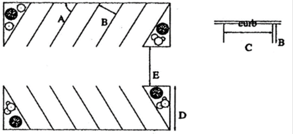
- Parking requirements. Accessory, off-street parking shall be provided as specified in Table 5-2, Specific Minimum Off-Street Parking Requirements, except as otherwise specified in this section.
- In addition to the requirements in Table 5-2, one parking space shall be provided for each commercial vehicle or vehicle necessary for the operation of the use that is maintained on the premises.
- Parking spaces for uses with multiple components, such as hotels with dining and conference facilities, shall be based on the sum of the parking requirements of the separate components. Shared parking standards may be used where applicable.
- Proof of parking. The planning commission may allow parking requirements for a particular use to be relaxed or lessened in response to an expected demand that is lower than the required standard in this section, provided that one of the following conditions exists:
- Sufficient open area is set aside on the parcel to meet the required standard, if determined to be necessary at a later date.
- If parking will be needed less than 25 percent of the time during typical hours of use, on-street parking accessible by sidewalk within two blocks of the site may be used in lieu of required off-street parking.
- Where a parking study is required, a qualified transportation engineer or transportation planner shall perform the study. The study shall contain information on the anticipated number of employees, customers, visitors, clients, shifts, events, or deliveries to the use, and may refer to other studies or similar situations elsewhere.
- Shared parking. Joint use of required parking spaces is encouraged where two or more uses on the same or adjacent sites are able to share the same parking spaces because their parking demands occur at different times. The applicants must submit analysis showing that peak parking times of the uses will occur at different times and the parking area will be adequate for both uses. A legal instrument such as an easement or deed restriction that guarantees access to the parking for both uses shall be submitted.
- Truck parking in residential areas. No commercially licensed trailer shall be parked or stored in a residential district except when loading, unloading, or rendering a service. Recreation vehicles and pickups are not restricted by the terms of this provision.
Table 5-2: Specific Minimum Off-Street Parking RequirementsUse Minimum Parking Requirement Notes Residential Uses Household Living Single-family detached dwelling 2 spaces per dwelling unit Two-family dwelling 1 space per 1-bedroom unit two spaces per 2-bedroom or larger unit. Single-family attached dwellings shall provide an additional ten percent of parking spaces for visitor parking. Multifamily dwellings shall also provide one visitor space per four units Single-family attached dwelling Multifamily dwelling No fee shall be charged for required spaces Senior (elderly) housing 1 space per dwelling unit If senior housing may be converted to general housing in the future, proof of additional parking shall be required Secondary dwelling 1 space per secondary dwelling unit Live-work unit 2 spaces per dwelling unit At least one of the required spaces shall be accessible for client parking Mobile home park 2 spaces per dwelling unit Group Living Group home, group residential facility, halfway house, congregate housing 1 space per employee on the largest shift plus one visitor space for every four residents based on capacity Semi-transient accommodations 1 space per bedroom, plus one space for each full-time staff equivalent Parking study required Public and Civic Uses Cemetery As determined by the planning director College or university, other adult learning center To be determined by the planning director based on parking study Parking study required Community services Parking equal to 30 percent of the capacity of persons or as determined by the planning director based on parking study Day care center (see under accessory uses for family day care) 1 space per employee on largest shift plus one space per seven students based on capacity; or one space per ten students if an off-street drop-off and pick-up space is provided School, public or private 1 space per staff member plus one space per five students of legal driving age based on design capacity Existing schools not meeting this standard may be required to develop a parking management plan, but shall not be required to add the minimum number of spaces Public assembly 1 space per each four seats based on design capacity Religious institution, place of worship 1 space per each six seats or ten feet of pews in the main assembly hall Existing institutions not meeting this standard may be required to develop a parking management plan, but shall not be required to add the minimum number of spaces Services Business center Total of parking requirements for individual uses, excepting any that meet the shared parking requirements in LEC 105.12.410(g) Commercial kennel, commercial stable 1 space per employee on the largest shift plus one space per six animals Communication services 1 space per 400 square feet of gross floor area, plus one space per company vehicle stored on the site Educational services 1 space per staff member plus one space per five students of legal driving age based on design capacity Financial institution 1 space per 200 square feet of gross floor area Funeral home 1 space per 100 square feet of floor area in the main assembly room plus one space per staff member Transient accommodations, lodging 1 space per guest room, plus additional space for meeting or restaurant facilities Meeting and restaurant facilities may require additional parking, based on square footage of each use as defined in this table Medical facilities 5 spaces per medical professional, or one space per 200 square feet of gross floor area Membership organization (clubs, lodges, etc.) 1 space per 300 square feet of gross floor area Nursing and personal care 1 space for each four beds, plus one space per employee on the largest work shift Offices 3 spaces per 1,000 square feet of gross floor area Personal services 1 space per 300 square feet of gross floor area Repair and maintenance shop 1 space per 400 square feet of gross floor area Self-service storage facility 1 space per 300 square feet of office or sales area The apron in front of the storage units shall be wide enough for two cars to pass Trade shop 1 space per 300 square feet of office or sales area, plus one space per 3,000 square feet of storage area Transportation services 1 space per 300 square feet of office or sales area, plus one space per vehicle kept on premises Veterinary service 3 spaces per veterinarian, or one space per 200 square feet of gross floor area Food Services Drinking and entertainment 1 space per three customer seats or each 100 square feet of interior space (the greater), plus one space per 200 square feet exterior seating area. Drive-in restaurant, fast food restaurant, standard restaurant 1 space per three customer seats or each 100 square feet of interior space (the greater), plus one space per 200 square feet exterior seating area. Drive-throughs shall provide queuing space for at least three vehicles in advance of the menu board and three vehicles between the menu board and pick-up window Sales of Merchandise Garden center, building supplies sales 1 space per 250 square feet of gross floor area plus one space per 2,000 square feet of outside sales or display area Furniture and appliance sales 1 space per 800 square feet of gross floor area General retail 1 space per 250 square feet of gross floor area Includes any retail uses not specifically listed in this table Shopping center 1 space per 250 square feet of gross floor area Shared parking provisions (LEC 105.12.410(g)) are encouraged to be used where applicable Wayside stand 1 space per 400 square feet sales area Spaces need not be paved, but shall be adequately separated and screened from the street and adjacent properties, as determined by the planning director Wholesaling 1 space per 250 square feet of indoor sales area plus one space per 2,000 square feet of storage area Automobile/Vehicular Uses Automobile maintenance services, commercial vehicle repair, gas station 1 space per 250 square feet of gross floor area used for sales or customer service plus two spaces per service bay Service bay shall not be counted as a parking space Automobile parts/supply 1 space per 250 square feet of indoor sales area plus one space per 2,000 square feet of storage area Automobile rental 1 space per 250 square feet of gross floor area plus adequate storage space for rental vehicles maintained on site Car wash 1.5 spaces per bay, plus four stacking spaces per bay, plus one space per employee on the largest shift Vehicle sales and storage lots 1 space per 250 square feet of indoor sales area plus one space per 2,000 square feet of outside sales or display area and one space per 2,000 square feet of storage area Outdoor Recreation Uses Campgrounds and trailering 1 space per site, plus spaces required for other uses Golf course 5 spaces per hole plus additional space for meeting or restaurant facilities Marina As determined by the planning director Parking study may be required for large or multiple-use facilities Outdoor entertainment As determined by the planning director Outdoor recreation facility 1 space per three persons based on maximum occupancy load, plus one space per employee on the largest shift or as determined by parking study Parking study may be required for large or multiple-use facilities Parks and open areas No requirement Restricted recreation As determined by the planning director Parking study may be required Swimming pool 1 space per 150 square feet of pool area Indoor Recreation/Entertainment Adult establishment 1 space per 250 square feet of gross floor area Indoor athletic facility 1 space per 250 square feet floor area plus two spaces per tennis or racquet games court and one space per 150 square feet of pool area Indoor recreation Bowling alleys: five spaces per lane. Other facilities: one space per three persons based on maximum capacity Agricultural and Related Uses Agricultural production and services No requirement Agricultural support 1 space per 300 square feet of indoor sales or office area plus one space per 1,000 square feet of outside sales or display area and one space per 2,000 square feet of storage area Forestry operations As determined by the planning director Production, Processing and Storage Non-production industrial, light industrial, heavy industrial 1 space per 1,000 square feet gross floor area up to 20,000 square feet plus one space per 2,000 square feet in excess of 20,000 square feet, or per five regular employees, whichever is greater Additional parking may also be required for office or retail space, as specified in this table. Includes other industrial uses largely carried on in enclosed buildings and not individually listed Motor freight and warehousing 1 space per 300 square feet of office or sales area, plus one space per 3,000 square feet of storage area Landfill, resource extraction, salvage/recyclable center 2 spaces per three employees on the largest shift, based on maximum planned employment Includes other industrial uses largely carried on outdoors Utilities, Transportation and Communications Air transportation As determined by the planning director Broadcasting or communication tower No requirement Essential services As determined by the planning director Local transit, railroad transportation 2 spaces per three employees on the largest shift, based on maximum planned employment Accessory uses Animals, domestic No requirement Home occupation No requirement unless specified in conditional use permit Bed and breakfast 1 space per guest room in addition to dwelling unit requirements Family day care, group family day care 1 space per employee not residing on the premises plus one drop-off space Kennel, private; stable, private No requirement Interim Uses Interim use As determined by the planning director
105.12.420 Off-Street Loading Areas
Off-street loading space shall be provided in all districts for any nonresidential use which will involve the receipt or distribution of materials or merchandise by trucks or similar vehicles and has a gross floor area of 5,000 square feet or more, in accordance with the following standards. Off-street loading area requirements may be waived in the Village Mixed-Use District (VMX).
- Number. For facilities with less than 20,000 square feet gross floor area, a designated loading zone may be provided on-site, rather than constructing a loading berth. For facilities with 20,000 square feet gross floor area or greater, one off-street loading berth shall be provided every 30,000 square feet gross floor area or fraction thereof.
- Location. All required loading berths shall be off-street. A loading berth shall be located at least 25 feet from the intersection of two street rights-of-way and at least 50 feet from a residential district unless within a building. Loading berths shall not occupy the required front yard setback.
- Size. Unless otherwise specified in this chapter, a required loading berth shall be not less than 12 feet in width, 50 feet in length and 14 feet in height, exclusive of aisle maneuvering space.
- Access. Each required loading berth shall be located with appropriate means of vehicle access to a street or public alley in a manner which will least interfere with traffic. Driveway design is specified in LEC 105.12.400.
- Surfacing. All loading berths and access ways shall be improved with a durable material to control the dust and drainage.
- Accessory use. Any space allocated as a loading berth or maneuvering area in accordance with this section shall not be used for the storage of goods, inoperable vehicles or required off-street parking.
105.12.430 Sign Regulations
- Purpose and intent. The purpose of this section is to provide standards to safeguard life, health, and property and to promote the public welfare by regulating the design, area, number, construction, location, and installation of all signs referred to hereunder. The city council and planning commission of the city find that the visual environment has an effect on the welfare of the citizens of the city and that careful control of signage can protect and enhance the community. To carry out this general purpose, the regulations set forth herein are intended to:
- Protect the public from hazards that result from signs which are structurally unsafe, obscure the vision of motorists and/or compete or conflict with necessary traffic signals and warning signs.
- Preserve the land value of private property by ensuring the compatibility of signs with nearby land uses.
- Foster high quality commercial and industrial development and to enhance economic development of existing businesses and industries by promoting reasonable, orderly, attractive and effective signs that meet the need for business identification, advertising and communication.
- Encourage creative and well-designed signs that contribute in a positive way to the community's visual environment, express local character and help develop a distinctive image in the city.
- Recognize that signs are a necessary form of communication and provide flexibility within the sign review and approval process to allow for unique circumstances.
- Provide applicants with clear and consistent rules and regulations and to guarantee equal treatment under the law through accurate record keeping and consistent enforcement.
It is not, however, the purpose or intent of this section to regulate the message displayed on any sign.
- Definitions. The following words, terms and phrases, when used in this section, shall have the meanings ascribed to them in this subsection, except where the context clearly indicates a different meaning:
Abandoned sign means any sign remaining in place which for a period of 90 consecutive days or more that no longer advertises or identifies a bona fide business, product, service, idea, or activity or has not been properly maintained in accordance with the requirements of this section.
Ancillary sign means a wall sign separate from and subordinate in area to the principal sign.
Attention-attracting object means any streamer, pinwheel, pennant, flag, propeller, inflatable sign, statuary, tethered balloon, bunting, beacon, or other artificial device, figure, shape, color, sound, light or exhibit, whether live, animated, or still, that is intended to attract attention to the use or business being conducted on the site. Attention-attracting object does not include the flag of any governmental country.
Awning means a roof-like cover consisting of fabric, plastic or structural protective cover that projects from the wall of a building which generally serves the purpose of shielding a doorway, entrance, window, or outdoor service area from the elements or to provide decorative distinction.
Banner means a suspended sign made of a flexible material such as canvas, sailcloth, plastic, paper, or fabric of any kind, and intended to be displayed on a temporary basis. A decorative banner is a banner containing no message or logo that is displayed for the purpose of adding color or interest to the surroundings or to the building to which it is attached. A flag or canopy shall not be considered a banner.
Beacon means a stationary or revolving light that flashes or projects illumination, single color or multicolored, in any manner that is intended to attract or divert attention.
Billboard means an off-premises sign on which lettered, figured, or pictorial matter is displayed that has a display surface of 250 square feet or more.
Canopy means a detachable, roof-like cover, supported from the ground or deck, floor or walls of a structure, for protection from the sun or weather.
Changeable copy sign means a sign or portion thereof with characters, letters, or illustrations that can be changed or rearranged manually without altering the face or the surface of the sign and on which the message changes less than eight times a day and less than once per hour. A sign on which the only copy that changes is an electronic or mechanical indication of price, time or temperature shall not be considered a changeable copy sign.
Comprehensive sign plan means a complete signage plan for a building or lot that has been approved by the city.
Copy means words, letters, numbers, figures, designs, or other symbolic representations incorporated into a sign.
Directional sign, on-premises, means a sign erected for the purpose of indicating the required or preferred direction of vehicular, bicycle, or pedestrian traffic on private property.
Directional sign, off-premises, means any sign that is displayed for the purpose of informing people of or guiding people to a particular place for a specified event.
Directory sign means a sign which serves as a common or collective identification for a group of persons or businesses operating on the same lot.
Election sign means signs authorized by Minnesota Statutes Section 211B.045.
Electronic variable message sign means a changeable copy sign or portion thereof which can be electronically changed or rearranged without altering the face or the surface of the sign, not including signage or portions thereof displaying price, time and temperature.
Facade means any separate face or surface of a building, including parapet walls, and roof surfaces or any part of a building which encloses or covers unusable space. Where separate facades are oriented in the same direction, or where the inside angle at the intersection of two surfaces is greater than 135 degrees, they are to be considered as part of a single facade.
Flag means a device generally made of flexible material, such as cloth, paper, or plastic, and displayed from a pole, cable or rope. It may or may not include copy.
Frontage means the boundary of a lot that abuts a public street.
Government sign means any sign erected by the city or any other governmental entity in the exercise of official government business and authority.
Ground sign means any freestanding sign that is supported by structures or supports in or upon the ground and independent of support from any building. A single sign structure having two identical or nearly identical faces back to back shall constitute a single sign. For the purposes of this definition, a ground sign is intended to refer to a primary, permanent, ground-mounted sign, not a temporary sign or sign that is ancillary to the primary sign, such as a directional sign or portable sign.
Hanging sign means a sign that is suspended from the underside of a surface and is supported by such surface.
Inflatable sign means a freestanding or moored sign expanded or inflated with air or another gas, like a balloon, and which may rise and float above the ground.
Legal nonconforming sign means any sign which was lawfully erected and displayed but which does not conform to the requirements and limitations herein, or any sign which was lawfully erected and displayed on the effective date of any amendment to this section, but which does not conform to such amendment. Said legal nonconforming sign may be continued through repair, replacement, restoration, maintenance, or improvement, but not including expansion. "Expansion" shall be defined as any structural alteration, change, or addition that is made outside of the original sign structure or sign area, including the addition of a dynamic display.
Monument sign means a ground sign having a monolithic base or support structure of any material measuring no less than one-third (one-third) of the greatest width of the sign at any point.
Pennant means a tapered or dove-tailed banner or flag.
Pole sign means a ground sign mounted upon a pole or pylon, or multiple poles or pylons, not meeting the definition of a monument sign.
Portable sign means a type of temporary sign that is not permanently attached to the ground or a building or not designed to be permanently attached to the ground or a building, including, but not limited to, trailers or other vehicles that are used principally as a sign, posters, sandwich boards or other freestanding signboards, regardless of whether such signs are attached to the ground or to a building or structure.
Projecting sign means a sign that is attached to the wall of a building and projects more than 15 inches beyond such wall.
Sign means any letter, word, or symbol, poster, picture, statuary, reading matter or representation in the nature of an advertisement, announcement, message, or visual communication, whether painted, posted, printed, affixed, or constructed including all associated brackets, braces, supports, wires and structures, which is displayed for information or communicative purposes. A sign does not include wall or building art.
Street frontage means the distance for which a lot boundary adjoins a single public street.
Temporary sign means a sign that is not constructed or intended for long term use.
Village Area means all properties within the Village Area Metropolitan Urban Service Area (MUSA) boundary.
Wall sign means a sign that is attached to a wall of a building and is affixed parallel to the wall at a distance of not more than 15 inches from the surface of the wall with no copy on the sides or edges. This definition includes painted, individual letter, cabinet signs, and signs on a mansard.
Window sign means any sign located completely within an enclosed building and visible from a public way or placed upon a window. Merchandise within the premises and visible from the exterior shall not be considered a window sign under this definition; however, any signs that are placed on the backs of shelving units or similar structures, or interior walls where the sign is located less than seven feet from the window's surface shall be considered a window sign. - Applicability. The sign ordinance codified in this section shall apply to any sign placed, erected, altered, maintained, or relocated within the city that is plainly visible, although not necessarily legible, from any vehicular or pedestrian public right-of-way. This section shall not regulate government signs; the copy or message displayed on signs; signs not intended to be viewed from a public right-of-way; interior window display; product dispensers; non-dynamic displays on scoreboards on athletic fields, flags, gravestones, barber poles; religious symbols; commemorative plaques; the display of street numbers; or any display not defined herein as a sign. The purpose of this provision is to prevent any inadvertent favoring of commercial speech over non-commercial speech, or favoring of any particular non-commercial message over any other non-commercial message. This provision prevails over any more specific provision to the contrary.
- Sign permits and fees.
- Permit required. Except as provided in this section, it shall be unlawful for any person to place, erect, alter or relocate within the city, any sign without first obtaining a permit from the community development department and making payment of all permit fees as required by the city's fee schedule. This subsection shall not be interpreted to require a permit for a change of copy on a changeable copy sign, changing occupant sign panels on a directory sign, repainting, cleaning, or other normal maintenance and repair of any existing sign or its structure as long as the sign copy does not change.
- Application for sign permit. All applications for sign permits shall be filed on a form supplied by the city. Such application shall be submitted with all required information provided and shall contain or have attached thereto the following information:
- Date of application.
- Name, address, telephone number, and email address, of the applicant as well as of the person, firm, corporation, or association erecting the sign.
- The written consent of the owner or lessee of the premises upon which the sign is to be erected, or the sworn statement of the applicant that the applicant is authorized by the owner, lessee or other authorized occupant of the premises to erect the proposed sign.
- A scale drawing showing the existing and proposed location and dimensions of all buildings, structures, and signs on the subject property. For a ground sign, the drawing shall also indicate the following: distance of the sign from either the face of curb or sidewalk as well as its location relative to other ground signs, driveways, fire hydrants, and any other features of a site that could be obscured by the sign.
- A landscaping plan around the base of all ground signs.
- The configuration of the proposed sign listing the height, width, total square footage, proposed copy, method of construction and attachment, method of illumination and description of all electrical equipment, sign materials and colors, and at least one image showing the location of the proposed sign and its relationship to either the building to which it is to be mounted or the surrounding lot if it is a ground sign.
- The total area and number of all signs by type on the subject property both before and after the installation of the proposed sign.
- For temporary signs, applications must be accompanied by a signed, written statement acknowledging the ordinance requirements governing the duration of time during which the sign may be displayed.
- Such other information as the city may require to ensure compliance with this section and any other applicable laws.
- Application process and review procedure. It shall be the duty of the community development department, upon the filing of an application for a sign permit, to examine the application for compliance with the requirements of this section and, if deemed necessary by the community development director, to inspect the premises upon which the proposed sign is to be erected. If the application is complete and the proposed sign is in compliance with all the requirements of this section, and any other applicable laws, the following actions shall be taken:
- If the application is for a permanent sign that conforms to an approved comprehensive sign plan that applies to the property upon which it is to be located, or for a permanent or temporary sign that adheres to the requirements of this Code, the community development director may issue a permit.
- If an application for approval of a comprehensive sign plan pursuant to subsection (i) Comprehensive sign plans is submitted with a development application subject to planning commission review and city council approval, the community development director shall review the application and make a recommendation to the planning commission prior to issuing a permit.
- Except for applications for approval of a comprehensive sign plan, any decision of the community development director may be appealed to the board of adjustment and appeals.
- In the event that a permit is issued but the sign authorized by the permit is not placed, erected, altered or relocated within six months after the issuance of the permit, the permit shall expire and be null and void.
- Fees. A fee shall be charged for the permit in the amount set forth in the city's fee schedule.
- Design review criteria. Signs shall meet the following criteria:
- Any signage affixed to a building shall be dimensioned and located in such a manner that it fits the buildings architectural features and proportions.
- All signs shall be designed to fit the zoning and character of the surrounding area. Special consideration should be made where proposed signage is located on or adjacent to locally identified historic structures or publicly-owned recreation and conservancy areas. Signage in planned unit developments, or in developments seeking comprehensive sign plans, shall conform to the planned or existing dominant architectural theme of the area. Signage in or abutting residential properties should be designed and located so as not to create a nuisance. When applicable, signage shall conform to the Lake Elmo Design Guidelines and Standards Manual.
- Signs illuminated by lights shall be positioned in such a manner that none of the light spills over onto an adjourning property or glares or shines into the eyes of motorists or pedestrians. All signs must conform to the sign illumination standards in subsection (f)(7) of this section and LEC 105.04.050.
- The base of all permanent ground signs must be landscaped. Landscape plantings or other landscape materials will not be considered as part of the allowable signage.
- General sign regulations. This section pertains to all signs erected in the city. Additional regulations may apply based on sign type and zoning district in which the sign is to be displayed. Whenever regulations conflict anywhere within this section or with any other applicable rule or regulation, unless expressly stated otherwise, the more restrictive provision shall control.
- Surface area calculation. The sign surface area shall be calculated based on the area within the smallest single continuous rectilinear perimeter of not more than eight straight lines encompassing all elements of the actual sign face including any writing, representation, emblems or any figure or similar character together with any material forming an integral part of the display or forming the backing surface or background on which the message or symbols are displayed, but excluding any support structure. For a sign painted on or applied to a building, the area shall be considered to include all lettering, wording and accompanying design or symbols, together with any background of a different color than the natural color, or finish material of the building. Area of signs displaying copy on two parallel, back-to-back faces not separated by more than 12 inches shall be calculated with reference to a single face only.
- Sign location, placement and setback requirements. Except as provided elsewhere in this section, all signs shall be subject to the following requirements:
- Limitations based on building setbacks.
- Except as provided in paragraph (b) below, no part of any permanent or temporary sign shall extend over a property line.
- Where buildings are lawfully permitted to exist on the property line, a permanent sign attached to a building may project not more than six feet over the abutting public sidewalk or right-of-way, provided that the bottom of the sign components are located no less than eight feet above the ground immediately beneath such sign. No sign may project over adjacent private property. Any ground sign shall be located on the premises unless it is an authorized temporary sign for which a valid permit is in effect.
- Signs on public property. No sign shall be located within or across any public right-of-way, or on any public property, easement, or utility pole, except for:
- A sign erected by, or required by, a government agency or temporarily erected to protect the health and safety of the general public;
- A sign erected in conformity with paragraph (a)(2) of this section;
- Subdivision identification signs, provided an encroachment agreement is obtained from the appropriate jurisdiction if the sign is located within the public right-of-way;
- Directional signs to institutions, schools, parks and public buildings within the city not to exceed four square feet subject to the approval of the road authority. Not more than three directional signs are allowed for each building location.
- Safety of motorists and non-motorists.
- No sign shall be erected or maintained at any location where by reason of its position, wording, illumination, size, shape, or color it may obstruct, impair, obscure the vision of road users, or otherwise obstruct, interfere with the view of, or be confused with, any authorized traffic control sign, signal or device.
- No ground sign, with the exception of government signs, may be placed within ten feet of a fire hydrant, within 15 feet of a crosswalk, or within 15 feet of the intersection of any circulation lane, roundabout, driveway or alley.
- No sign exceeding a height of 30 inches may be placed within the vision triangle as defined in LEC 1.08.
- No sign or structural components shall obstruct passage on a sidewalk or walkway.
- Additional regulations pertaining to placement of all signs. Except for a sign erected by, or required by, a government agency or temporarily erected to protect the health and safety of the general public:
- No sign shall be attached to a fence, tree, shrubbery, utility pole or like items on either public or private property, and no sign shall obstruct or obscure primary signs on adjacent premises.
- No sign shall extend beyond the perimeter of a permanent structure or obstruct any window, door, fire escape, ventilation shaft or other area that is required to remain unobstructed by an applicable building code.
- No sign shall be mounted upon any roof of any building or structure.
- Americans with Disabilities Act compliance. Sign placement shall meet all Americans with Disabilities Act (ADA) requirements.
- Limitations based on building setbacks.
- Construction and structural requirements. Every sign shall be constructed of such material and with such workmanship as to be safe. Every sign shall be designed and constructed in conformity with the applicable provisions of the state building code and shall be free of any exposed extra bracing, angle iron, guy wire or cables. The base or support of all permanent ground signs shall be securely anchored to an appropriately designed concrete base or footing per the state building code.
- Load requirements. All signs and other advertising structures shall be designed and constructed to meet all load requirements according to all applicable regulations in the state building code.
- Installation. All signs shall be properly secured, supported and braced. No sign or any part thereof, or anchor, brace, or guy wire shall be attached, fastened or anchored to any fire escape, fire ladder or standpipe, and no sign or any part thereof, or anchor, brace or guy wire shall be erected or maintained which may cover or obstruct any door, doorway, or window of any building or which may hinder or prevent ingress or egress through such door, doorway or window, or which may hinder or prevent the raising or placing of ladders against such building in the event of fire. All signs or attention-attracting objects shall be free of projections that could cause injury to a pedestrian and shall be installed in such a manner to avoid obstruction of a public sidewalk or street or portion thereof.
- Maintenance. All signs, including nonconforming signs, and sign structures shall be maintained to preserve the appearance and structural integrity substantially identical to the new condition of the sign.
- Sign illumination. All illuminated signs shall comply with LEC 105.04.050 (Lighting, Glare Control and Exterior Lighting Standards) and the following requirements:
- Electrical permit. All signs in which electrical wiring and connections to be used shall comply with all applicable provisions of the state electrical code.
- Voltage displayed. The voltage of any electrical apparatus used in conjunction with a sign shall be conspicuously noted on that apparatus. In addition, all electrical signs shall bear the label of approval of a recognized testing laboratory and be equipped with a watertight safety switch that is located where the electrical supply enters the sign.
- External illumination. All external lighting fixtures shall be steady, stationary, fully-shielded and directed solely onto the sign, and shall use lighting designed to minimize light spill and glare. Lighting sources shall not be directly visible or cause glare to adjacent public rights-of-way or adjacent private property.
- Internal illumination. Internally illuminated signs shall permit light to shine fully through only the lettering and graphic elements of the sign. The background for such lettering and graphics shall be opaque or translucent and shall transmit light at a level substantially less than that transmitted through the lettering and graphics. If the contrast between the lettering or graphic elements and background does not permit adequate legibility, a translucent white boarder of up to one inch in width may be placed around said lettering or graphic elements.
- Brightness limitation. Except for day-time displays on electronic variable message signs, in no instance shall the lighting intensity of any illuminated sign exceed:
- Three footcandles at the front lot line and one footcandle at all other lot lines, measured three feet above the surface of the ground.
- 50 footcandles measured perpendicular to the face of the sign from a distance equal to the narrowest dimension of the sign.
- Glare. All artificial illumination shall be so designed, located, shielded and directed so as to prevent the casting of glare or direct light up adjacent public right-of-way or surrounding property.
- Reflectors and lights. Gooseneck and similar reflectors and lights shall be permitted on ground and wall signs; provided, however, the reflectors and lights shall concentrate the illumination upon the area of the sign so as to prevent glare upon the street or adjacent property. It shall be unlawful to maintain any sign which is wholly or partially illuminated by floodlights or spotlights, unless such lights are completely concealed from view from the public right-of-way.
- Motion as a component of a sign. No sign shall have any flashing, scintillating, moving or blinking lights or rotating beacons, whether operated by electronic or mechanical means or wind driven, nor shall any floodlight, spotlight, or beacon utilize such actions to illuminate a sign. In addition, no beam of light shall be projected through a mechanism which periodically changes the color of the light reaching the sign.
- Attention-attracting objects. The use of any attention-attracting object, as defined in this Code, shall be allowed only as a temporary sign in conjunction with a special event permit, not to exceed ten days per issuance. No permit shall be granted for any premises more than four times in any calendar year; or more than once in any three-month period.
- Resemblance to traffic signs. No sign shall contain or resemble any sign resembling in size, shape, message, or color any traffic control devices compliant with the Minnesota State Manual on Uniform Traffic Control Devices.
- Limitations according to the type of land use and zoning district. Unless exempt under paragraph (k) of this section or as expressly provided elsewhere, no permanent or temporary signs shall be displayed except in conformity with the following regulations as they correspond to the type of land use and districts in which the sign is to be displayed.
- Residential uses in residential districts.
- In connection with legal home occupations, a single sign which does not exceed two square feet in area. Signs under this subsection shall be wall signs only.
- A residential condominium or multifamily apartment complex may display identification signs if the total acreage of the lot is one acre or more and the condominium or apartment includes eight or more units. One wall identification sign and one ground identification sign per street frontage may be displayed, with a maximum of two wall identification signs and two ground identification signs per lot. No identification sign shall exceed 32 square feet in area, and the maximum height is six feet above curb level for ground signs or one story or 12 feet above curb level for wall signs, whichever is lower. For the purposes of this subsection, the term "lot," when used in reference to a condominium, means all property within the common interest community complex and not each unit.
- Subdivision identification signs.
- Number. Each residential subdivision is allowed up to one subdivision identification sign per entrance to the subdivision. For the purposes of this section, residential subdivision shall include all phases of approved staged developments.
- Location. Subdivision identification signs shall be located near entrances to the subdivision, except that one sign may be located along an abutting arterial or major collector roadway.
- Size. The maximum size for a subdivision identification sign is 32 square feet at a subdivision's main entrance and 24 square feet for all other locations. The maximum height for a ground identification sign is six feet above curb level.
- Setback. Subdivision identification signs and support structure shall maintain a setback of at least ten feet from any street right-of-way. Signs as well as support structures within a center island shall maintain a setback of at least five feet from the curb and are subject to regulations set forth by paragraph (f)(2).
- Changeable copy signs, including electronic variable message signs, are not a permitted sign type for subdivision identification signage.
- Institutional uses in or abutting residential districts. Nonresidential institutional uses located in or abutting residential districts, located in residential districts may erect signs as follows:
- Wall and ground signs.
- Area and number. One wall sign and one ground sign per street frontage may be displayed, identifying the entity, with a maximum of two wall signs and two ground signs per lot. Additional wall or ground signs for wayfinding purposes may be permitted when the size of the lot, number of vehicular or pedestrian entrances, and layout of the buildings require additional signs in order to promote traffic and pedestrian safety. Signs under this subsection, whether displayed on a wall or on the ground, shall not exceed 12 square feet in area, except such signs may be increased in area by one square foot for each additional foot that the sign is set back more than 12 feet from a lot line. No sign under this section shall exceed 32 square feet in area.
- Height. No identification wall sign shall project higher than one story, or 12 feet above curb level, whichever is lower. No ground sign shall project higher than six feet.
- Temporary signs.
- Wall and ground signs.
- Agricultural sales businesses. Signage related to agricultural sales business may be erected as follows:
- On-premises signs, agricultural sales businesses. One or more on-premises signs may be erected on a property in conjunction with an operating agricultural sales business subject to the following requirements and restrictions:
- Agricultural sales businesses utilize less than ten acres of land specifically for the growing of agricultural crops for the businesses are allowed one on-premises sign not to exceed 32 gross square feet of advertising surface.
- Agricultural sales businesses utilizes more than ten acres of land but less than 40 acres of land specifically for the growing of agricultural crops for the businesses are allowed up to two on-premises signs not to exceed 48 gross square feet of total advertising surface, with no individual sign surface exceeding 32 square feet in size.
- Agricultural sales businesses utilizing more than 40 acres of land specifically for the growing of agricultural crops for the business are allowed up to three on-premises signs not to exceed 64 gross square feet of total advertising surface, with no individual sign surface exceeding 32 square feet in size.
- Any illuminated sign shall be consistent with paragraph (f)(7) of this section and illuminated only during those hours when business is open to the public for conducting business.
- Agricultural sales businesses utilize less than ten acres of land specifically for the growing of agricultural crops for the businesses are allowed one on-premises sign not to exceed 32 gross square feet of advertising surface.
- Temporary off-premises signs, agricultural sales businesses. Independent of the total allowable sign area for an individual property anywhere within the city, a temporary off-premises sign may be erected on a property in conjunction with an operating agricultural sales business subject to the following requirements and restrictions:
- Maximum number. Every agricultural sales business shall have no more than three off-premises signs at any given time to direct the public to the location of the business.
- Timeframe of use. Temporary off-premises signs may be erected for 45-day time periods no more than four times in any given calendar year. The required temporary sign permit shall stipulate the range of dates for each of the four allowable time periods in any given calendar year.
- Size and height. An off-premises agricultural sales advertising sign shall not exceed 50 square feet in area and shall not be taller than ten feet in height.
- Setbacks. Off-premises signs shall be a minimum of 25 feet from all side property lines, and a minimum of 50 feet from other off-premises advertising signs.
- Permission required. Applicants for off-premises signs shall acquire permission from the property owner upon whose land the sign is to be erected.
- Maximum number. Every agricultural sales business shall have no more than three off-premises signs at any given time to direct the public to the location of the business.
- On-premises signs, agricultural sales businesses. One or more on-premises signs may be erected on a property in conjunction with an operating agricultural sales business subject to the following requirements and restrictions:
- Commercial, mixed-use and business park districts.
- Wall signs.
- Number. No building occupant shall display more than one wall sign per street frontage except as provided below:
- One additional wall sign may be displayed on a building with no front setback, provided that such sign is a flat sign that is either painted upon the building or does not extend outward more than six inches or,
- One additional wall sign may be displayed on single occupant buildings with a minimum lot width of 100 feet or,
- Up to three ancillary wall signs may be displayed on buildings measuring at least 100 feet in length along the front lot line. Any ancillary sign displayed under this paragraph shall not exceed 50 percent of the net area or of the largest permitted wall sign displayed on that facade.
- Lots having multiple street frontages. Commercial buildings occupying corner lots, or multiple frontages adjacent to more than one public right-of-way, may display up to one additional building-mounted sign for each additional frontage, provided that such additional sign may not exceed 50 percent of the area allowed by the primary frontage and is oriented toward the additional frontage. For the purposes of this Section, the primary frontage shall be presumed to be the frontage upon which the main entrance to the building is located. The applicant, however, may identify a different frontage as the primary frontage in order to maximize the effectiveness of the signage.
- Business not fronting onto a street. Buildings without street frontage may have only one wall sign per business.
- One additional wall sign may be displayed on a building with no front setback, provided that such sign is a flat sign that is either painted upon the building or does not extend outward more than six inches or,
- Surface area. The total permitted sign surface area of all wall signs on a facade shall not exceed 1.5 square feet of signage for each lineal foot of building frontage that is coterminous with the occupancy to which the sign refers, unless a different amount allocated to the building occupant is identified in an approved comprehensive sign plan pursuant to subsection (i) of this section. In addition, no individual wall sign shall exceed 100 square feet in area.
- Number. No building occupant shall display more than one wall sign per street frontage except as provided below:
- Ground Signs/Directory.
- Number. There shall be no more than one ground sign for each street on which the lot has frontage, except one additional ground sign per lot frontage may be allowed for any lot frontage over 1,000 linear feet. On lots where the number of businesses exceed the number of allowed ground signs, a directory sign shall be used in lieu of multiple ground signs. No single business or building occupant shall be allowed signage on both an individual ground sign and a ground directory sign on the same street frontage. On premises having no principal building, there shall be no more than one ground sign for the premises.
- Surface area. No ground sign shall exceed ten feet in height and 64 square feet in area. No directory sign shall exceed 12 feet in height and 80 square feet in area except as follows:
- Village area. No ground sign shall exceed six feet in height and 32 square feet in area. No directory sign shall exceed 12 feet in height and 80 square feet in area.
- Parcel abutting Hudson Boulevard. No ground or directory sign shall exceed 30 feet in height and 250 square feet in area. Signs shall be within 100 feet of the property line abutting Hudson Boulevard.
- Village area. No ground sign shall exceed six feet in height and 32 square feet in area. No directory sign shall exceed 12 feet in height and 80 square feet in area.
- Number. There shall be no more than one ground sign for each street on which the lot has frontage, except one additional ground sign per lot frontage may be allowed for any lot frontage over 1,000 linear feet. On lots where the number of businesses exceed the number of allowed ground signs, a directory sign shall be used in lieu of multiple ground signs. No single business or building occupant shall be allowed signage on both an individual ground sign and a ground directory sign on the same street frontage. On premises having no principal building, there shall be no more than one ground sign for the premises.
- Wall signs.
- Planned unit development districts. No permanent sign shall be displayed except a sign authorized by the city and included in the comprehensive sign plan pertaining to the development site. Temporary signs are permitted for commercial, institutional or industrial uses unless prohibited by the comprehensive sign plan.
- Conservancies and parks. No sign shall be permitted in a city park or open space except those installed with permission of the city's public works director.
- Residential uses in residential districts.
- Sign installation standards pertaining to specific sign type. Except as expressly provided elsewhere, signs shall meet the following regulations according to sign type:
- Wall signs.
- Location. Wall signs shall be mounted parallel to building walls and only on a portion of an exterior wall that is coterminous with the occupancy to which the sign refers, unless a different location is identified in an approved comprehensive sign plan pursuant to subsection (i) of this section. No wall sign shall extend above or beyond the wall to which it is attached.
- Installation requirements. No wall sign shall cover or interrupt significant architectural elements such as columns, column caps, friezes, door or window heads, embellishments, adornments, fenestration, or ornamental detailing on any building. All mounting brackets and other hardware used to affix a sign to a wall as well as all electrical service hardware and equipment shall be concealed by architectural elements of the building or the sign itself.
- Ground signs.
- Type of sign. Any permanent ground sign shall be erected as a monument sign. Pole signs are prohibited unless the pole portion of the sign is enclosed in a shroud that causes the sign to appear to have a monolithic base or support structure of any material measuring no less than one-third of the greatest width of the sign at any point or unless the height is no greater than three feet. This provision does not apply to signs erected on properties in a commercial, mixed-use, or business park district abutting Hudson Boulevard. The base of the monument sign shall not exceed the width of the widest portion of the sign face by more than 25 percent.
- Location. Ground signs shall be placed with consideration for visibility, access, maintenance, and safety, consistent with the provisions of paragraph (f)(2) of this section. Ground signs shall be located beyond required setbacks a distance equal to or greater than the height of the sign. If this is not possible, ground signs shall be located as far from required setback lines as possible. In no case shall a ground sign, as defined in this section, extend beyond a lot line of a property. A ground sign larger than six square feet shall be located no closer than 100 feet of another ground sign or the furthest distance possible from another ground sign, whichever distance is shorter.
- Height.
- The height of a ground sign shall be measured from the approved grade at the base of the sign or the elevation of the street upon which the sign faces, whichever is lower, to the top of the highest attached component of the sign.
- A ground sign shall be mounted on a base not to exceed four feet in height.
- Landscaping. Perennial plantings, grass or other landscaping features shall be incorporated around the base of all ground signs.
- Exempt or special purpose ground signs. The location of and maximum height and surface area of any other exempt or special-purpose ground sign expressly authorized by another section of this section, shall be as set forth in such other section.
- Window signs.
- Location. All window signs must be located inside an exterior window unless the sign is weatherproof and does not pose a danger from falling or being blown by the wind. Lettering or graphic elements that are directly mounted on a window shall not encroach upon the frame, mullions, or other supporting features of the glass.
- Permanent signs. When a sign is painted on or otherwise attached or applied to the window area in a permanent manner, then such a sign shall be included in the total allowable wall sign area for the building and shall not exceed 20 percent of the total ground-floor window area of the building, excluding the door windows. All permanent window signs which have their lettering or graphic elements directly on the glazing shall be painted, metal leafed, vinyl transferred, or in some other manner permanently applied to the interior side of the glass of an exterior building window or door. No application using a temporary adhesive shall be permitted unless the community development director determines the application to be reasonably safe.
- Temporary signs. Temporary window signs shall not exceed 30 percent of the total ground-floor window area of any building, excluding the door windows. Such signs must be displayed in conformance with the temporary sign regulations listed in paragraph (j) of this section.
- Limitation. Under no circumstances shall any combination of permanent or temporary window signage cover more than 50 percent of the total ground floor window area of any building.
- Changeable copy signs.
- Not an additional permitted sign type. Changeable copy signs are not an additional permitted sign type, but any permitted sign type may be a changeable copy sign, provided that the total surface area of the entire sign does not exceed the maximum allowed for the type and location of sign upon which the changeable copy is displayed.
- Electronic variable message signs. Any sign type may be an electronic variable message sign subject to the following regulations:
- Surface area. The areas of electronic variable message signs capable of displaying copy shall not exceed 40 square feet and shall be included within the maximum aggregate sign surface area allowed for the type and location of sign upon which the changeable copy is displayed.
- Location. Electronic variable message signs are not permitted in the Village Area.
- Length of cycle. The electronic changeable copy or images shall not alternate, change, fade in, fade out, or otherwise change more frequently than once every ten seconds. Electronic variable message sign signs may not display scrolling, racing, pixelating or moving characters or images, or similar actions that convey motion.
- Brightness adjustment. An electronic variable message sign shall be equipped with photosensitive equipment which automatically adjusts the brightness and contrast of the sign in direct relation to the ambient outdoor illumination such that the light level does not exceed three footcandles at the front lot line and one footcandle at all other lot lines, measured three feet above the surface of the ground.
- Maintenance. Any electronic variable message sign shall be maintained so as to be able to display messages in a complete and legible manner.
- Canopy and awning signs. Canopy and awning signs are subject to the following provisions:
- Surface area. The sign surface area of a canopy or awning sign shall not exceed 15 percent of the area of the vertical section of the canopies and awnings. The area of the vertical section of the canopies and awnings is calculated as the difference between the highest and lowest point on the canopy or awning multiplied by the length of the canopy or awning. The difference between the highest and lowest point shall be measured parallel to the facade upon which it is attached.
- Location.
- Canopies and awnings shall be constructed and erected so that the lowest portion of the projecting frame thereof shall be not less than nine feet, and the lowest portion of the descending skirt shall be not less than eight feet above the level of the sidewalk or public thoroughfare.
- No portion of the canopy or awning sign shall extend above or beyond the canopy or awning upon which it is attached. However, a sign may be hung beneath a canopy parallel to the building frontage so long as it and its structural components are no less than eight feet above the ground immediately beneath the sign.
- Awnings shall not project more than 72 inches out from the building upon which they are attached, nor extend out from the building beyond the extension of the awnings on adjoining buildings.
- Installation requirements. To preserve the architectural integrity of a building, no canopy or awning, and no canopy or awning sign, shall cover or interrupt significant architectural elements such as columns, column caps, friezes, door or window heads, embellishments, adornments, fenestrations or ornamental detailing.
- Illumination. Signs on awnings and canopies may be illuminated where the following conditions are maintained:
- Both interior type strip lighting and exterior type gooseneck lighting is permitted, not exceeding a maximum light level of 18 footcandles measured three feet from the perpendicular to the light source.
- The bottom of any illuminated awning or canopy shall be enclosed.
- The provisions of paragraph (f)(7) of this section are satisfied.
- Materials. Canopy and awning signs shall be made of either the material with which the canopy or awning is covered or other waterproof materials affixed flush to the face of the canopy or awning, or be painted directly on the awning or canopy material with weather-resistant paint.
- Snow load. It is found that snow and ice that accumulates on awnings can pose a danger to pedestrians. To ensure the safety of pedestrians, snow and ice shall be removed from awnings within a reasonable time period after an event of snow and ice accumulation.
- Hanging signs. One sign up to six square feet in area may be suspended above a walkway near a primary building entrance so long as it and its structural components are no less than eight feet above the ground immediately beneath the sign. When a hanging sign is displayed in lieu of a ground or projecting sign, the square footage shall not count towards the maximum allowable area for a wall sign.
- Projecting signs. A projecting sign may be displayed subject to the following restrictions:
- Maximum projection. The maximum distance a projecting sign may project is not more than 24 inches into the right-of-way. Subject to zoning setback limitations, a projecting sign may project no more than six feet from the building face.
- Location. A building may have one projecting sign facing a street or on a corner of the building.
- Surface area. The permitted area of a projecting sign shall not exceed the square footage for the amount that would otherwise be allowed for a wall sign on the building. When a projecting sign, not exceeding six square feet, is displayed in lieu of a ground sign, the square footage shall not count towards the maximum allowable area for a wall sign.
- Height. A projecting sign must vertically clear any pedestrian area by at least eight feet and vehicular ways by at least 14 feet. A projecting sign may extend to the juncture of the roof with the building wall or to the top of any parapet, but no projecting sign may extend above a second story.
- Directional signs. On-premises directional signs may be placed on private property near driveway entrances, at building entrances, and in parking lots and loading areas where reasonably necessary. Each such sign shall be located on premises and shall adhere to the regulations pertaining to vision triangles and other setbacks as defined in subsection (f)(2) of this section. Such signage shall be considered exempt from the total signage calculation for the premises as long as all the following standards are met:
- Such signage does not serve an additional advertising purpose.
- There are no more than four directional signs per lot, not including a maximum of one directional sign allowed per driveway entrance/exit.
- Surface area per sign does not exceed four square feet.
- Logos do not exceed two square feet in area per sign.
- Sign height does not exceed five feet above ground elevation at base of sign.
- Flags and decorative banners. The following regulations apply to all flags and decorative banners:
- A minimum clearance of eight feet over pedestrian ways and 14 feet over vehicular areas.
- Maximum number of flagpoles for any lot is three.
- Maximum height of any flagpole is 50 feet.
- Maximum number of flags per lot is four.
- Maximum area of any flag shall be 40 square feet.
- Flags representing a private entity, including corporate or business flags, shall be included within the maximum sign area total for the site, as applied to the allowance for a ground sign, and shall require a sign permit.
- Wall signs.
- Comprehensive sign plans.
- Purpose. Multi-tenant developments such as shopping malls, due to the varying occupant's need for signage and the potential for unique architecture and placement of different occupancies as they relate to street frontages, can create challenges to the applicability of sign regulations and the fair distribution of permitted square footage for occupants. This section is intended to define how signage permitted under this Section will be distributed among the different occupancies available in the development. The comprehensive sign plan shall create visual harmony between the signs, buildings, and building site through unique and exceptional use of materials, design, color, and lighting, and other design elements; and shall result in signs of appropriate scale and character to the uses and buildings on the lot as well as adjacent buildings, structures and uses.
- Applicability. A comprehensive sign plan shall be required of an applicant for all planned unit developments and commercial or industrial multi-tenant developments where different occupancies will compete for permitted square footage on a single lot.
- Submission requirements. An application for comprehensive sign plan approval shall be submitted to the community development director and shall include:
- A site plan, dimensioned, showing the location of the buildings, structures, parking areas, driveways, and landscaped areas on the lot upon which the proposed sign is to be attached or erected.
- A table or tables containing:
- Computation of the maximum total sign area.
- Maximum area for individual signs.
- Height and number of ground signs.
- Statement of the maximum total sign area and maximum number of signs permitted on the site by this section.
- An accurate indication on the site plan of the location and orientation of each sign for which a permit is currently being requested, the anticipated location of future signs requiring a permit, and the location of all reasonably anticipated temporary signs.
- A description and illustration of the following may be required:
- Colors and materials to be used in sign construction.
- Style of lettering for all signs.
- Appearance/location of logos or icons.
- Location of each sign on the buildings, with building elevations if necessary.
- All sign proportions.
- Types of illumination.
- Amendment. A comprehensive sign plan may be amended by filing a new comprehensive sign plan, in conformance with the requirements of the sign ordinance in effect at the time, and obtaining approval of the community development director.
- Binding effect.
- After approval of a comprehensive sign plan, no permanent sign shall be erected, placed, painted, or maintained by the property owner or any buyer, tenant, occupant, subtenant, assignee, employee, agent or other party in use of the subject property except in conformance with such plan without obtaining a sign permit and in conformance with the comprehensive sign plan.
- If the city council has approved a comprehensive sign plan with flexible criteria, the community development director is authorized to approve, through the standard sign permit approval process, sign applications in conformance with the comprehensive sign plan, but only to the extent that the application is in conformance with the comprehensive sign plan.
- The terms and conditions of an approved comprehensive sign plan shall have the same force and effect and be enforced in the same manner as any other provision of this section.
- Temporary signs.
- General requirements. Temporary signs shall conform to the following standards:
- Permit required. No temporary sign may be displayed without a valid temporary sign permit or portable sign permit.
- Sign type. Temporary signs may include any sign type permitted by this section.
- Number. No more than two temporary signs may be displayed on a lot at any time.
- Surface area. The maximum area of all temporary signs displayed shall be a combined total of eight square feet if displayed for ten days or longer.
- Location. No temporary sign may be placed off-premises except as otherwise provided elsewhere in this section.
- Duration. No temporary sign permit shall be issued to erect or maintain any temporary signage for a period exceeding 21 days. A permit for temporary sign or signs shall be granted no more than four times in any calendar year and only once every three months.
- Installation requirements. All temporary signs shall be constructed, anchored and supported in a manner which reasonably prevents the possibility of such signs becoming hazards to the public health and safety as determined by the community development director.
- Portable signs. In addition to the general requirements pertaining to temporary signs, the following standards pertain to portable signs:
- Permit required. A sign permit shall be issued on an annual basis before a portable sign may be erected. Such permit shall only be valid during the calendar year during which it is issued.
- Construction. A sign shall be manufactured to a professional standard of construction, finish and graphics. A portable sign shall be freestanding, self-supported and constructed of substantial materials such as wood, metal or plastic such that the sign will reasonably withstand the elements.
- Size and design regulations.
- A portable sign shall not exceed six square feet in surface area per side, with a maximum of two signable sides or faces.
- The sign shall not exceed three feet measured at the widest point of the sign face.
- Any portion of the sign's face used for a chalk or dry-erase board shall not exceed 50 percent of the total sign face surface area.
- Number. One portable sign may be displayed per business or occupant in any commercial or industrial area or planned unit development.
- Location. A portable sign is restricted to the lot of the business establishment to which a permit has been issued, except such a sign may be located in the public right-of-way in front of the premises only where no front setback is required.
- Placement. A portable sign shall:
- Be placed only along sidewalks where a minimum five-foot-wide clear sidewalk is maintained. In no event shall a portable sign be placed on any bicycle path. The placement, of a portable sign shall not obstruct access to any crosswalk, mailbox, curb cut, fire hydrant, fire escape, fire door, building entrance, public parking space or any other public property, nor shall a sign obstruct the ability of persons to exit/enter vehicles parked along the curb;
- Not be attached, chained or in any manner affixed to public property including street trees, utility poles or sign posts;
- Not obstruct the clear view of any traffic signal, regulatory sign or street sign;
- Not be located closer than ten feet to any other portable sign;
- Not be located directly adjacent to a bus or transit vehicle stop or station, shall not obstruct sight lines of road users, nor be placed less than 25 feet from a street intersection or 15 feet from a crosswalk;
- Not be placed in such a way as to interfere with snowplowing of the streets;
- Be maintained free of snow, be placed on solid ground at all times and shall not be placed on top of snow banks.
- Illumination. A portable sign shall not be illuminated.
- Time limitations and removal. A portable sign may be displayed only during business hours. Such sign must be removed and safely stored out of view during times when the business is not open to the public. Trailers or other vehicles that are not used principally as a sign may be parked on the lot when the business is not open to the public.
- Enforcement. Portable signs located within the public right-of-way are a privilege and not a right. The city in permitting placement of such signs in the public right-of-way reserves the right to require their removal at any time because of anticipated or unanticipated problems or conflicts. To the extent possible, the permittee shall be given prior notice of any time period during which, or location at which, the placement of portable signs within the public right-of-way is prohibited. Furthermore, the sign permit may be revoked by the community development director following notice to the permittee. The permit may be revoked if one or more conditions outlined in this section have been violated, or if the sign is determined to constitute a public nuisance not specifically outlined in this section. Following the revocation of the sign permit, no application for the same site shall be filed within 180 days from the date of revocation. The permittee has a right to appeal the decision of the community development director within 30 days of issuance of a revocation notice pursuant to paragraph (n)(2) of this section.
- Indemnification. Where a temporary or a, portable sign is permitted in the public right-of-way, the owner, lessee or lessor of the business to which a permit has been issued and the property owner shall agree in writing to fully indemnify, defend, and hold the city harmless for any personal injury or property damage resulting from the existence or operation of said sign, and shall furnish evidence of general liability insurance in the amount of $1,500,000 with the city as additional named insured or provide other security to the satisfaction of the city administrator.
- Permit renewal. The permit for a portable sign must be renewed annually prior to January 1 of each year.
- General requirements. Temporary signs shall conform to the following standards:
- Signs exempt from permit. Consistent with the purpose and scope of this section, the city recognizes that certain temporary, necessary, or limited-purpose signs should be lawfully displayed without the need to obtain a permit and should not count as part of the specific sign area allowed to be displayed on a particular property. All signs exempt from permit requirements must, nonetheless, adhere to all other applicable sections of this section and all other applicable state and federal regulations. The city finds that the following signs may be displayed without a permit because they serve an immediate or temporary traffic safety or way finding function:
- Address and nameplates. Address and name plates not exceeding three square feet in area.
- Athletic field signage. Signs, banners, and scoreboards designed solely for view from spectator areas and displayed on interior walls, fences, or other structures located inside an enclosed athletic field at a school, park, or other public or private athletic complex. Approval of the park commission shall be required to display a sign, banner, or scoreboard under this subsection at a city park.
- Awning signage. Signs displayed on awnings located on commercial or industrial buildings, provided that the signs are displayed on the lowest 12 inches of the principal face or side panels of awnings and, provided that they do not exceed six inches in height.
- Signs on construction sites. Such signs may only be placed on the property where construction work is in progress, shall not be erected prior to the beginning of work for which a valid building permit has been issued, and shall be removed within ten days of completion of work or the expiration of the building permit, whichever is sooner. Signs on parcels under construction in residential zones or in parks shall not exceed 32 square feet per street frontage. Sign on parcels under construction in commercial, industrial, multifamily, or planned unit development on parcels less than 100,000 square feet shall not exceed 64 square feet per street frontage; and on parcels greater than 100,000 square feet shall not exceed 96 square feet per street frontage. Square footage must be divided.
- Flags. Flags that comply with the provisions of subsection (h)(9) of this section.
- Temporary signs during a garage or estate sale. Signs on properties having a garage or an estate sale shall not exceed four square feet in area, shall not be displayed for a period of time more than 72 consecutive hours and may be displayed no more than twice in any one calendar year. Up to three signs may be displayed per event, two of which may be displayed off-premises, but not in the public right-of-way. Any such sign placed on private property must have the consent of the property owner on whose property such sign is displayed.
- Government signs, including traffic or official public hearing notice signs. Such signs are placed, authorized, or required by the city or other authorized governmental agency. The requirements for maximum area, height, setback, or other size, materials or physical specifications shall be as required by law or the authorizing agency.
- Holiday and temporary decorations. Holiday or temporary decorations when located on private property, or with the approval of the city if on public property. In addition, any sign in the nature of a decoration, identification or direction, incidentally and customarily associated with any national or religious holiday or any civic festival, fair or similar gathering, held during a period of ten days or less in any year, provided such sign shall not differ substantially from the requirements set forth in this section.
- Signs on properties with a home occupation. One sign on a property with a home occupation is permitted. The sign shall be non-illuminated, flush-mounted to a wall of the residence, and shall not exceed two square feet in area.
- Memorial signs. Any cornerstone, commemorative, or historical tablet or landmark designation plaque.
- Menu signs. Menu signs up to 55 square feet in area and six feet in height, provided they are located within 15 feet of the commercial building with which they are associated or advertise and in a manner such that the copy is not readily viewable from the public right-of-way or a residential occupancy on an adjacent lot.
- Noncommercial messages. One sign per parcel per street frontage carrying any lawful noncommercial message not exceeding 12 square feet in area. Any other permitted commercial sign may be substituted for a noncommercial message but will count toward the total signage type and area for the parcel upon which it is located. Hand-held signs carrying noncommercial messages are not subject to any size limitation so long as they are held by and under the physical control of a person during all times they are on display.
- Parking lot regulation signs. Signs in parking lots not exceeding nine square feet and having a minimum setback of ten feet.
- Parking lot directional signs. Parking lot signs must comply with the provisions of subsection (h)(8) of this section.
- Signs authorized by Minnesota Statutes Section 211B.045.
- Signs on residential properties that are for sale or rent. Signs located on these premises may not be placed above the top of the lowest level of the building.
- For lots for sale or rental containing less than four dwelling units within one residential structure, one non-illuminated real estate sign up to six square feet per unit may be displayed.
- For lots for sale or rental where at least four but less than 16 dwelling units are contained within one residential structure, one non-illuminated sign up to 12 square feet may be displayed.
- For lots for sale or rental where 16 or more dwelling units are contained within one residential structure, one non-illuminated sign up to 32 square feet may be displayed.
- Up to two directional signs, each sign no more than six square feet in area, may be installed off property after obtaining the consent of the property owner on whose property such sign is to be displayed. These signs may not be located in the public right-of-way. These off-premises directional signs must be a self-supporting type sign.
- Signs on single occupant commercial property that is for sale or rental. For lots that are for sale or rent that are less than five acres, one non-illuminated sign up to 12 square feet in area may be displayed. For larger lots that are for sale or rent, one non-illuminated sign up to 32 square feet in area may be displayed.
- Signs on nonresidentail grouped development or multi-tenant buildings. For each property containing a group development or multi-tenant building containing nonresidential land uses, a maximum of two signs, one per each nonresidential street frontage, may be displayed up to a maximum of 32 square feet in area.
- Subdivision signs. For each subdivision that has been approved in accordance with the city subdivision regulations, a maximum of two temporary signs may be located on a portion of the subject subdivision. Each such sign shall be not more than 32 square feet in area. One additional similar sign shall be permitted for each 100 lots in the subdivision in excess of 100 lots. These signs may be displayed until a time at which building permits have been issued for 80 percent of the lots in the subdivision.
- Temporary notices. Leaflet-type notices flat-mounted to kiosks or public information boards.
- Utility company signs. Signs that serve as an aid to public safety or that show the location of facilities such as public telephones and underground cables only to the extent necessary to accomplish those goals.
- Window signs, temporary. Signs and displays that are of a temporary nature such as for advertising sales and specials and that do not cover more than 30 percent of the total ground-floor window area of any building, excluding the door windows. Merchandise and pictures or models of products or services incorporated in a window display are not considered signs. Any sign placed on the outside of a window requires a sign permit unless the sign is weatherproof and does not pose a danger from falling or being blown by the wind.
- Window or wall signs not readable off-premises. Window or wall signs not exceeding two square feet in area with lettering not exceeding three inches high designed to provide information to persons on the premises such as hours of operation, or sample restaurant menu. Where no front yard setback exists, such signs as would generally be unreadable off premises where minimum setback regulations apply shall qualify for this exemption notwithstanding that such signs are readable from the public right-of-way. Such signs shall not be counted toward total permitted signage.
- Signs on vehicles. Signs of any size on vehicles traveling to or lawfully parked on an operating and insured vehicles, construction trailers or equipment which are temporarily parked on a permitted construction site, or primary business location
- Prohibited signs. The following signs are expressly prohibited in the city:
- Abandoned signs or signs on vacated or abandoned buildings.
- Off-premises signs, except as expressly allowed under this section.
- Inflatable signs.
- Rationale. Inflatable signs shall be prohibited because they are generally more distracting and hazardous to pedestrian traffic safety, tend to have an anchoring device that is less reliable under wind pressure, and out of scale and less compatible with surrounding structures and signs.
- The following inflatable devices shall not be considered a sign:
- Registered hot air balloons in use and momentarily moored but not being used primarily as a sign.
- Novelty type balloons less than two feet in diameter and less than three feet in any dimension tethered or moored no more than ten feet above the ground.
- Inflatable holiday or other decorations displayed temporarily on private property, that do not contain any commercial message, and that does not exceed 15 feet in height.
- Signs attached to any public utility pole or structure, street tree, fence, fire hydrant, bridge, curb, sidewalk, park bench, or other location on public property except as otherwise expressly permitted under this section.
- Signs that interfere with the safe operation of official traffic control devices.
- Signs that emit sound.
- Signs anchored by gut wires, chains, cables, or similar devices that project down to the ground or in any way which create an unsafe condition for pedestrians or motorists.
- Signs placed on vehicles or trailers which are parked or located for the primary purpose of displaying said signs (this does not apply to permitted portable signs or letting on buses, taxis, or vehicles operating during the normal course of business).
- Signs imitating or resembling official traffic or public safety signs or signals in shape, size, or color.
- Billboards.
- Roof signs.
- Beacons, unless authorized for use by the city or any other governmental entity in the exercise of official government business and authority.
- Legal nonconforming signs. Any legal nonconforming sign may continue to be displayed or replaced consistent with LEC 105.12.340 through LEC 105.12.350.
- Variances and appeals.
- Variances. It is recognized that circumstances may exist from time to time where strict application of the size, location and type of sign standards hereinafter specified for the various zoning districts may be unreasonable or where literal enforcement of the regulations may work an unnecessary hardship on the applicant. Variations from the standards are, therefore, permitted by issuance of a variance by the city council upon recommendation of the planning commission that such extenuating circumstances exist. Variances shall be considered according to the provisions of LEC 105.12.320.
- Appeals. An applicant may appeal any decision of the community development director to the board of adjustment and appeals according to the provisions of LEC 3.08.100.
- Violations.
- It shall be unlawful and a violation of this section for any person to maintain any prohibited sign, to perform or order the performance of any act prohibited by this section, or to fail to perform any act which is required by the provisions of this section. In the case of any such violation, each 24-hour period in which such violation exists shall constitute a separate violation.
- Any and all signs, erected, altered, or maintained in violation of this section, or any of the clauses and provisions of the same, or in violation of any of the laws or ordinances of the city and/or the state, are, and each of them is declared to be, a public nuisance and subject to enforcement. Any such signs are erected, altered or maintained contrary to law shall be abated as a nuisance by the community development director.
- Penalty. Any person who shall fail to comply with any of the provisions of this section shall be subject to a penalty as prescribed by LEC 1.04.230.
- Enforcement.
- If the community development director or building official finds that any sign has been erected, altered, or is being maintained in violation of this section, or is in an unsafe condition as to be a menace to the safety, health, or welfare of the public, they shall give written notice to the owner thereof of the person entitled to possession of the sign and the owner of the real estate upon which the sign is located. No notice shall be required for permitted temporary signs displayed in violation of time limitations prior to taking enforcement action.
- Said letter shall notify the owner, or person entitled to possession of the sign, of the specific violation or violations and direct that alterations, repairs or removal, whichever may be applicable, be made to bring said violations in conformance with the terms and conditions of this section.
- In the event the person so notified fails or neglects to comply with or conform to the requirements of such notice, the community development director or building official may file an appropriate citation or complaint in an appropriate court of law or take whatever other legal action may be necessary to cause such sign to be altered or removed. If a sign is considered abandoned, the city, after notice, may remove such sign at the cost of the owner of the property upon which the sign sits. An invoice for such costs shall be sent to the property owner and, if not paid, shall be certified to the county for collection with the property taxes.
- Severability. If any section, subsection, sentence, clause, or phrase of this Section is for any reason held to be invalid, such decision shall not affect the validity of the remaining portions of this Section. The City Council hereby declares that it would have adopted this Section in each section, subsection, sentence, or phrase thereof, irrespective of the fact that any one or more sections, subsections, sentences, clauses, or phrases be declared invalid.
105.12.440 Accessory Buildings And Structures, Generally
- Purpose. Within the city, the following provisions shall apply to accessory building and structures in all zoning districts.
- Definitions. The following words, terms and phrases, when used in this section, and all sections pertaining to accessory buildings or structures, shall have the meanings ascribed to them in this subsection, except where the context clearly indicates a different meaning:
Agricultural building means an accessory building means a structure that is on agricultural land as determined by the governing assessor of the city under M.S.A. § 273.13(23) and meets all other requirements of M.S.A. § 362B.103. A state pollution control agency permit may be required.
Detached domesticated farm animal building means a one-story accessory building used or intended for the shelter of domestic farm animals and/or related feed or other farm animal supportive materials. The building may require a state pollution control agency feedlot permit in addition to site and building plan approval.
Detached residential accessory building means a one-story accessory building primarily used or intended for the storage of automobiles and other miscellaneous equipment. No door or other access opening shall exceed 14 feet in height.
Fish house means a water-oriented structure meant to provide periodic shelter during the winter months while atop a frozen lake for use in fishing. A structure will be considered a fish house only if it is constructed with sleds, wheels or similar means to allow transport on to a frozen lake; is not used on land for human habitation; and is not used for boat storage.
Storage or tool shed means a one-story accessory building of less than 200 square feet gross area with a maximum roof height of 12 feet. - Permit required. All accessory building and structures require either a certificate of zoning compliance or a building permit as determined by the state building code.
- Principal structure necessary. No accessory buildings of structures shall be constructed nor accessory use located on a lot until a building permit has been issued for the principal structure to which it is accessory. Exemption: Fish houses, as defined in this Code and located in the RS Rural Single-Family District, are exempt from this requirement, provided the following are met: must be located on a lot one-half acre in size or more with direct access to a water body; is 120 square feet or less; and complies with shoreland regulations and RS Rural Single-Family setback requirements. One fish house per lot may exist without a principal structure. The structure must maintain a current fish house license with the state department of natural resources regardless if it is left on a water body overnight. If a current state department of natural resources fish house license is not obtained for the structure, the structure must be removed from the property within 60 days.
- Proximity to principal structure. Accessory buildings shall maintain a six-foot setback from the principal structure. An accessory building or structure will be considered as an integral part of the principal building if it is located six feet or less from the principal structure.
- Exempt structures. The following residential improvements shall be exempt from the maximum allowed structure size and number requirements in residential districts:
- Unenclosed playhouses.
- Gazebos up to a total of 120 square feet in size and a maximum of 12 feet in overall height.
- Detached decks over 30 inches in height up to a total of 120 square feet in size.
- Outdoor swimming pools.
- Patios.
- Tennis and sport courts.
- Structures, sheds or coops up to a total of 200 square feet in size used to house permitted animals, such as chickens, horses, or other livestock. These structures must not exceed 12 feet in height and must meet all required setbacks per MPCA guidelines and the city's animal ordinances.
- Water-oriented accessory structures as permitted in accordance with the city's shoreland ordinance.
- Storage or tool sheds as defined in this section.
- Ground-mount solar energy systems.
105.12.450 Pole Construction Buildings
- Pole construction buildings, A and RR Districts.
- Pole construction buildings are permitted in the A and RR zoning districts subject to the setbacks and other performance standards required under the Zoning Code, LEC 105.12.
- Pole construction buildings are prohibited on properties zoned A and RR where a conditional use permit has been issued for an Open Space Preservation (OP) Development.
- Pole construction buildings, RS District. Pole construction buildings are permitted in the RS zoning district only on parcels that are abutted by land zoned Rural Residential (RR) or Agricultural (A) zoned along 75 percent or more of the perimeter of the subject parcel.
105.12.460 Purpose
The purpose of this section is to provide regulations of general applicability for property throughout the city that are intended to protect or enhance natural resources and processes, and minimize conflicts among land uses.
105.12.470 Tree Preservation
- Purpose. Within the City of Lake Elmo, trees and woodlands are considered a valuable asset to the community. The City places a priority on protecting this asset and finds that it is in the best interest to regulate the development and alteration of wooded areas within the community. All applicants shall comply with all the provisions in the Zoning Code which address the preservation of existing significant trees, including this section. All applicants shall demonstrate a good faith effort to maximize tree preservation during the development review phase and shall avoid a mass-grading approach to site development where possible. Applicants are encouraged to preserve all healthy trees of significant value even if the trees do not meet the size requirements to be considered significant trees.
- Definitions. The following words, terms and phrases, when used in this section, shall have the meanings ascribed to them in this subsection, except where the context clearly indicates a different meaning:
Applicant means any person or entity submitting an application to the City for approval of a land use permit including preliminary plat, final plat, conditional use permit, interim use permit, planned unit development, variance or grading permit.
Common tree means and includes Ash, Aspen, Basswood, Catalpa, Elm, Hackberry, Locust, Poplar, Silver Maple, Willow and any other tree not defined as a hardwood deciduous tree or a coniferous/evergreen tree.
Coniferous/evergreen tree means a wood plant, which, at maturity, having foliage on the outermost portion of the branches year-round. Tamaracks are included as a coniferous tree species.
Construction area means any area in which construction activity has or is occurring.
Construction activity means any disturbance to the land that results in the movement of earth, the alteration in the topography or existing soil cover (both vegetative and non-vegetative) that may result in accelerated stormwater runoff, leading to soil erosion and movement of sediment into surface water or drainage systems. Examples of construction activity may include clearing, grading, filling, excavating, building construction and landscaping.
Construction damage means any action such as filling, scraping, trenching, or compacting the soil around trees or wounding trees in such a manner that it may result in the eventual death of the tree.
Critical root zone (CRZ) means an imaginary circle surrounding the tree trunk with a radius distance of one (1) foot per one (1) inch of tree diameter. E.g., a 20-inch diameter has a critical root zone with a radius of twenty (20) feet.
Deciduous hardwood tree means a tree that loses its foliage or leaves annually such as Birch, Cherry, Hickory, Ironwood, Hard Maples, Oak and Walnut.
Development means any activity or proposal that requires City approval of a preliminary plat, final plat, building permit, demolition permit, conditional use permit, interim use permit, planned unit development, variance or grading permit.
Diameter breast height (DBH) means the diameter of trees at breast height, measured 4 1/2 feet (54 inches) above the ground.
Drip line means the farthest distance away from the trunk of a tree that rain or dew will fall directly to the ground from the leaves or the branches of the tree.
Healthy tree means a healthy tree has:- A live top (live crown) that is greater than one-third (1/3) the total tree height;
- Dead branches that make up less than fifteen percent (15 %) of the total crown;
- Less than fifteen percent (15%) of the tree crown with missing branches;
- Consistent growth of foliage throughout the live portion of the crown; and
- A tree trunk with no open wounds that are greater than one-third (1/3) the diameter of the tree, with no wounds in contact with the ground and no wounds that have soft, punky wood or other indication of decay.
Nuisance tree means:- Any living or standing tree or part thereof infected to any degree with a shade tree disease (see Tree disease below) or shade tree pest;
- Any logs, stumps, branches, firewood or other part of dead or dying tree(s) infected with a shade tree disease or shade tree pest unless properly treated; and
- Any standing dead trees or limbs which may threaten human health or property.
Ornamental tree means a small tree, usually less than thirty (30) feet in height at maturity, often planted for ornamental characteristics such as flowers or attractive bark.
Redevelopment means a site with construction activity that creates new or replaces existing impervious surface, buildings or structures on a parcel that is fully or partially occupied by buildings, structures, or other impervious surfaces.
Tree disease or diseased means Dutch elm disease (Ophiostoma ulmi or Ophiostoma novo-ulmi), oak wilt (Ceratocystis fagacearum) or any other tree disease of epidemic nature.
Tree pest means Emerald Ash Borer (Agrilus plannipenis), European elm bark beetle (Scolytus multistriatus), Native elm bark beetle (Hylurgopinus rufipes) or any other tree pest with potential to cause widespread damage.
Significant tree means a healthy tree measuring a minimum of six (6) inches in diameter for hardwood deciduous trees, nineteen (19) feet in height or eight (8) inches in diameter for coniferous/evergreen trees, or twelve (12) inches in diameter for common trees, as defined herein.
Site means a parcel or area of land within which construction activity, development, or redevelopment occurs or is to occur.
Specimen tree means a healthy, deciduous hardwood tree measuring equal to or greater than thirty (30) inches in diameter breast height or a healthy coniferous/evergreen tree measuring equal to or greater than twenty-five (25) feet in height.
Tree Preservation Plan means a plan prepared by a landscape architect licensed by the State of Minnesota or forester identifying all of the significant and specimen trees in the proposed development or parcel. A Tree Preservation Plan must include a proposed site plan, a proposed grading plan including all custom graded lots, a tree inventory that includes the size, species, and location of all significant trees proposed to be saved and removed on the area of development, and the measures proposed to protect the significant and specimen trees that are to be saved. The applicant shall have the Tree Preservation Plan superimposed on the proposed development grading plan.
Woodland evaluation report means a report prepared by a forester, landscape architect licensed by the State of Minnesota, or land surveyor indicating the general location, condition, and species of significant trees on a parcel planned for future development or grading activity. The report must demonstrate that there will be no impact to existing significant trees as part of the development or grading activity. Finally, the report must include the measures proposed to protect significant trees on the site. - Tree preservation standards for developing properties.Protective measures. The Tree Preservation Plan shall identify and require the following measures to be utilized to protect significant trees planned for preservation:
- Before any grading or construction activity, the applicant shall install snow fencing or polyethylene laminate safety netting at the drip line or at the perimeter of the critical root zone, whichever is greater, of significant trees, specimen trees and significant woodlands to be preserved. No grade change, construction activity, parking, or storage of materials shall occur within this fenced in area.
- Measures to be taken so that oak trees are not wounded, trimmed, pruned, or damaged in any way (root, bark, branches, etc.) between the dates of March 15 and October 31. Measures to be taken to ensure that any oak trees pruned or trimmed have any cut areas sealed with an appropriate nontoxic tree wound sealant.
- Prevention of change in soil chemistry due to concrete washout and leakage or spillage of toxic materials, such as fuels or paints.
- Removal of any nuisance or dead trees located in areas to be preserved.
- Installation of erosion control methods.
- Applicability.
- A Tree Preservation Plan, or suitable alternatives as determined by the City, shall be submitted and approved by the City for the following activities:
- New development or redevelopment in any Zoning District. A Tree Preservation Plan shall be required as part of any new development, redevelopment, or subdivision application.
- Any grading or excavation project that results in the movement of greater than 400 cubic yards of material per acre of site per Lake Elmo Code Section 105.08.060.
- If the applicant is able to demonstrate that the proposed development, redevelopment, construction activity or grading activity includes no impact to the significant trees on the site, then the applicant may be exempt from the requirement to submit a Tree Preservation Plan. It is the responsibility of the applicant to demonstrate that there are no impacts to significant trees through a Woodland Evaluation Report or some other form of tree survey or study.
- The issuance of a development approval for the construction of a single-family residence on an existing platted lot of record.
- The harvesting of trees. For the purposes of this section, "harvesting" means cutting or clearing trees for purposes relating to forestry operations, as defined in Lake Elmo Code Section 105.12.110. "Harvesting" does not include the clearing of land for purposes of development, even where the trees are sold for purposes of creating lumber for related purposes.
- Additions to single-family homes, general homes improvements and the construction of accessory buildings (i.e., garages, sheds) on residential properties.
- Home gardens or an individual's home landscaping, installation, repairs, or maintenance work.
- Tree removal related to public improvement projects and maintenance or repairs to existing streets, roadways, sewers, parks, storm water facilities and utility infrastructure.
- Emergency removal of trees to protect the public health and safety or to alleviate immediate dangers to life, limb, property, or natural resources.
- Tree removal related to public improvement projects to restore or enhance woodlands, savannas, or prairies.
- Removal of dead or dying trees, unless those trees were planted as part of tree replacement in which case the property owner shall replace such trees based on the City-approved Tree Preservation Plan for the property.
- Removal of nonnative trees that the City deems as nuisance or as an invasive species.
- A Tree Preservation Plan, or suitable alternatives as determined by the City, shall be submitted and approved by the City for the following activities:
- Tree Preservation Plan. All applicants shall submit a Tree Preservation Plan prepared by a forester or landscape architect licensed by the State of Minnesota in accordance with the provisions of this section. The Tree Preservation Plan shall reflect the applicant's best effort to determine the most feasible and practical layout of lots, buildings, parking lots, driveways, streets, storage, storm water management facilities and other physical features, so that the maximum amount of significant and specimen trees are preserved and protected from development and construction During the review of an application for a building permit, grading permit, site plan approval, planned unit development, conditional use permit, interim use permit, or preliminary plat, the City will review the project and the Tree Preservation Plans according to the best available layout in order to preserve significant trees and to ensure that the applicant used the best possible design to mitigate and minimize construction damage to significant trees.
- During the review of an application for a building permit, grading permit, site plan approval, planned unit development, conditional use permit, interim use permit, or preliminary plat, the City will review the project and the Tree Preservation Plan in order to ensure that the Tree Preservation Plan has the best available layout in order to preserve significant trees and to ensure that the applicant used the best possible design to mitigate and minimize construction damage to significant trees.
- Tree Preservation Plan requirements. The Tree Preservation Plan shall be a separate plan sheet(s) that includes the following information:
- The name(s), certification(s), telephone number(s) and address(es) of the person(s) responsible for tree preservation during the course of the development project.
- Tree inventory. The Tree Preservation Plan must include a Tree Inventory through one of the following methods:
- Individual tree inventory. An individual tree inventory including an identification system linked to metal field tags located four and one-half (4 1/2) feet from grade on all significant trees must be identified on a plan sheet in both graphic and tabular form.
- Tree inventory sampling. In cases of sites with large tracts of significant trees, the City may approve the use of a sampling inventory for all or portions of a site as an alternative to an individual tree inventory. The sampling inventory must include the methodology for sampling, identification ribbon around the perimeter of the sampling areas, and metal field tags located four and one-half (4 1/2) feet from grade on all significant trees in the sampling area. Within the sampling area, the quantity, size, species, health and location of all significant trees must be identified on a plan sheet in both graphic and tabular form. Based on sampling, total estimates and locations of healthy significant trees shall be provided.
- Combination tree inventory. With the approval of the city, sites that include both large tracts of significant trees and areas of individual significant trees may utilize a combination of the individual and sampling inventory methods.
- Trees that were planted as part of a commercial business such as a tree farm or nursery do not need to be inventoried on an individual tree basis. A general description of the trees and an outer boundary of the planted area must be provided. The burden of proof shall be on the applicant to provide evidence to support the finding that the trees were planted as part of a commercial business.
- A listing of healthy significant trees inventoried in subsection (c)(3)b of this section. Dead, diseased, nuisance or dying trees do not need to be included in the totals.
- A listing of the healthy significant trees removed, identified by the metal field tag or some other form of identification used in the tree inventory in subsection (c)(3)b of this section.
- A listing of the healthy significant trees to remain, identified by the metal field tag or some other form of identification used in the tree inventory in subsection (c)(3)b of this section.
- Outer boundary of all contiguous wooded areas, with a general description of trees not meeting the significant tree size threshold.
- Locations of the proposed buildings, structures, or impervious surfaces.
- Delineation of all areas to be graded and limits of land alteration and disturbance.
- Identification of all significant trees proposed to be removed within the construction area. These significant trees should be identified in both graphic and tabular form.
- Measures to protect significant and specimen trees and City standard tree protection detail.
- Size, species, number and location of all replacement trees proposed to be planted on the property in accordance with the Mitigation Plan, if necessary.
- Signature of the person(s) preparing the plan.
- Implementation. All new construction areas, development sites, and redevelopment sites shall be staked, as depicted in the approved Tree Preservation Plan, and the required tree protection fencing shall be installed and approved by the City's Landscape Architect around the critical root zone before land disturbance is to commence. The City has the right to inspect the site at any time for compliance with the plan. No encroachment, land disturbance, trenching, filling, compaction, or change in soil chemistry shall occur within the fenced areas protecting the critical root zone of the trees to be saved.
- Allowable tree removal. Up to thirty (30) percent of the diameter inches of significant trees on any parcel of land being developed, redeveloped, graded, or proposed for construction activity may be removed without having to adhere to the tree replacement requirements. Replacement according to the tree replacement schedule is required when removal exceeds more than thirty (30) percent of the total significant tree diameter inches. The following types of trees do not need to be included as part of the tally of tree removals:
- Dead, diseased, nuisance, or dying trees;
- Trees that are transplanted from the site to another appropriate area within the City;
- Trees that were planted as part of a commercial business, such as a tree farm or nursery (subject to verification by the City); or
- Trees that were planted by the current property owner. In making such a determination, the City shall consider consistency of the age of the trees, any patterns in the location of trees, historical aerial photography and evidence of intentional planting such as invoices, formal planting plans or cost sharing agreements.
- Mitigation plan.
- In any new development, redevelopment, new construction area, or grading project where the allowable tree removal is exceeded, the applicant shall mitigate the tree loss by planting replacement trees in appropriate areas within the development in accordance with the Tree Replacement Schedule.
- The form of mitigation to be provided by the applicant shall be determined by the City.
- The planting of trees for mitigation on residential projects shall be in addition to any other landscape requirements of the City.
- All trees, with the exception of ornamental trees, planted as landscaping on commercial or mixed-use projects may be counted towards tree replacement requirements.
- Tree replacement calculations. Thirty (30) percent of the total diameter inches of significant trees on the site of new construction, new development, or redevelopment may be removed without replacement. The applicant shall plant all required replacement trees on the site of the proposed new construction, new development, or redevelopment. The following calculation procedure must be used to determine tree replacement requirements:
- Tally the total number of diameter inches of all significant trees on the site.
- A calculation must be provided which breaks out the number of inches removed for hardwood, evergreen/deciduous, and common trees. The thirty (30) percent removal figure applies to each category individually and trees are replaced according to the Tree Replacement Schedule in subsection (c)(8) of this section.
- Tree replacement schedule. Tree removals over the allowable tree removal limit on the parcel or site of new construction, new development, or redevelopment shall be replaced according to the following schedule:
- Common tree species shall be replaced with new trees at a rate of one-fourth (1/4) the diameter inches removed.
- Coniferous/evergreen tree species shall be replaced with new coniferous or evergreen trees at a rate of one-half (1/2) the diameter inches removed. Since coniferous species are often sold by height rather than diameter inch, the following conversion formula can be used: Height of Replacement Coniferous Tree/2 equals Diameter Inches of Credit.
- Hardwood deciduous tree species shall be replaced with new hardwood deciduous trees at a rate of one-half (1/2) the diameter inches removed.
- Replacement tree size. Replacement trees must meet the minimum sizes listed in LEC 105.12.480.
- Species requirement. The City must approve all species used for tree replacement. Ornamental trees are not acceptable for use as replacement trees. Where ten (10) or more replacement trees are required, not more than thirty (30) percent of the replacement trees shall be of the same species of tree. The planting of native species is encouraged, and hardiness and salt tolerance of the plants should be considered where applicable.
- Protective measures. The Tree Preservation Plan requires the following measures to be utilized to protect significant trees planned for preservation:
- Before any grading or construction activity, the applicant shall install snow fencing or polyethylene laminate safety netting at the drip line or at the perimeter of the critical root zone, whichever is greater, of significant trees, specimen trees and significant woodlands to be preserved. No grade change, construction activity, parking, or storage of materials shall occur within this fenced area.
- See Minnesota Department of Transportation Standard Plan 5-297.301 and Minnesota Department of Transportation Specification Section 2572 for specific requirements related to tree protection and restoration.
- See Minnesota Department of Transportation Standard Plan 5-297.301 and Minnesota Department of Transportation Specification Section 2572 for specific requirements related to tree protection and restoration.
- Measures to be taken so that oak trees are not wounded, trimmed, pruned, or damaged in any way (root, bark, branches, etc.) between the dates of March 15 and October 31. Measures to be taken to ensure that any oak trees pruned or trimmed have any cut areas sealed with an appropriate nontoxic tree wound sealant.
- Prevention of change in soil chemistry due to concrete washout and leakage or spillage of toxic materials, such as fuels or paints.
- Removal of any nuisance or dead tress located in areas to be preserved.
- Installation of erosion control methods.
- Before any grading or construction activity, the applicant shall install snow fencing or polyethylene laminate safety netting at the drip line or at the perimeter of the critical root zone, whichever is greater, of significant trees, specimen trees and significant woodlands to be preserved. No grade change, construction activity, parking, or storage of materials shall occur within this fenced area.
- Additional protective measures. The City encourages applicants to use the following tree protection measures to protect the root zones and to prevent damage to significant and specimen trees that the applicant intends to preserve;
- Installation of retaining walls or tree wells to preserve trees.
- Placement of utilities in common trenches outside of the drip line of significant and specimen trees or use of tunneled utility installation.
- Use of tree root aeration, fertilization, or irrigation systems.
- Installation of retaining walls or tree wells to preserve trees.
- Compliance with the tree preservation plan. The applicant shall implement the Tree Preservation Plan and receive confirmation of acceptance from the City's Landscape Architect prior to the start of and during any grading or construction activities. The tree protection measures shall remain in place until all grading, and construction activity is terminated or until a request to remove the tree protection measures is made to, and approved by, the City.
- No significant trees shall be removed until the Tree Preservation Plan is approved by the City and except in accordance with the approved Tree Preservation Plan.
- If an applicant damages or removes a significant tree that is intended to be preserved to the point that City staff believes the tree will not survive, the applicant must remit to the City a cash mitigation, calculated per diameter inch of the removed or damaged tree in the amount set forth in the City fee schedule.
- The City shall have the right to inspect the site in order to determine compliance with the approved Tree Preservation Plan. The city shall determine whether the Tree Preservation Plan has been met prior to the release of any financial security obtained for tree preservation.
- Instances where a significant tree is removed due to new development, redevelopment, new construction activity or were disturbed, and the removal was not noted on the landscaping or tree removal plan will result in a one-to-one replacement penalty regardless of if the removal is over the thirty percent (30%) allowance.
- Before any grading or construction activity, the applicant shall install snow fencing or polyethylene laminate safety netting at the drip line or at the perimeter of the critical root zone, whichever is greater, of significant trees, specimen trees and significant woodlands to be preserved. No grade change, construction activity, parking, or storage of materials shall occur within this fenced in area.
- Tree protection standards for non-developing properties.
- Existing developed commercial, industrial, and mixed-use properties.
- Trees that are removed in an existing commercial, industrial, or mixed-use development must be replaced in accordance with the original landscaping plan, unless the property owner has obtained City approval for an alternative landscaping plan. If the original landscaping plan is not able to be found, trees identified by the most recent aerial photo of the property will be assumed to be part of the original landscape plan.
- Trees that are removed that were part of a designated tree preservation area must be replaced in accordance with the tree replacement requirements outlined in LEC 105.12.470. The thirty percent (30%) allowable tree removal limit does not apply in these situations.
- Trees that are removed in an existing commercial, industrial, or mixed-use development must be replaced in accordance with the original landscaping plan, unless the property owner has obtained City approval for an alternative landscaping plan. If the original landscaping plan is not able to be found, trees identified by the most recent aerial photo of the property will be assumed to be part of the original landscape plan.
- Existing developed commercial, industrial, and mixed-use properties.
- Warranty requirement. Any tree installed as a required replacement tree shall have the same two year warranty requirements as trees required by Lake Elmo Code Section 105.12.480.
- Financial security. In cases where mitigation or tree replacement is required, the City may require that a financial security, in a form acceptable to the City, be provided as part of a development agreement, site improvement agreement or applicable permit to ensure compliance and performance of the Mitigation Plan. The financial security will be released to the applicant upon verification by the City that the Mitigation Plan was followed, and that all replacement trees have been installed in accordance with the approved landscaping plan, match or exceed approved plan quantities, and meet City acceptance requirements to begin the two year landscape warranty. The financial security may be used to replace any replacement trees that do not satisfy the warranty criteria.
- Exceptions.
- Exception standards. Notwithstanding the City's desire to accomplish tree preservation and protection goals, there may be instances where these goals are in conflict with other City objectives. These conflicts will most likely occur on small, heavily-wooded parcels. The City recognizes there may be instances where it is not practical or reasonable to have an applicant plant the total required replacement trees on the site. The City encourages applicants to have the required number of replacement trees planted entirely on the site to the extent this is possible. The City will only approve the use of fee-in-lieu of tree replacement or other mitigation methods when all the required tree replacement cannot practically or reasonably occur on the site in the judgement of the City.
Applicants may ask the City to approve exceptions to the City's tree preservation and replacement standards. The City Council may grant exceptions if all of the following conditions exist:- It is not feasible to combine the subject parcel with adjacent parcels that could use the parcel as required green space;
- Strict adherence to the City's tree preservation and replacement standards would prevent reasonable development that is consistent with the Comprehensive Plan and desirable to the City on the parcel; and
- The exception requested is the minimum needed to accomplish the desired development or redevelopment.
- Reduced mitigation for exceptions. If the City Council approves an exception to the tree preservation standards, relief from the requirements of the standards may take the form of reduced mitigation requirements, greater allowable tree removal, higher thresholds for determining significant trees, or any combination of the above. The City Council will determine which form of relief best balances the objectives of the City and tree preservation.
The City Council may require payment to the City of a fee-in-lieu of tree replacement, payment of additional park dedication fees; the implementation of woodland management practices by the applicant; or the planting of replacement trees on City property by the applicant under direction of the City Public Works Director; or a combination of these methods as a condition of the City approving relief or an exception from the City tree preservation and replacement standards. The amount of the fee-in-lieu of tree replacement is set forth in the City's fee schedule.
- Exception standards. Notwithstanding the City's desire to accomplish tree preservation and protection goals, there may be instances where these goals are in conflict with other City objectives. These conflicts will most likely occur on small, heavily-wooded parcels. The City recognizes there may be instances where it is not practical or reasonable to have an applicant plant the total required replacement trees on the site. The City encourages applicants to have the required number of replacement trees planted entirely on the site to the extent this is possible. The City will only approve the use of fee-in-lieu of tree replacement or other mitigation methods when all the required tree replacement cannot practically or reasonably occur on the site in the judgement of the City.
- Tree Fund
- Purpose. The purpose is to provide a dedicated fund for tree replacement throughout the city.
- Funding Sources. The primary funding sources will be from fee-in-lieu of tree replacement, funds allocated by the City Council, and individual and business donations.
- Eligible Expenses. Funds shall be spent on programs approved by the City Council, which include but are not limited to a boulevard tree program.
- Purpose. The purpose is to provide a dedicated fund for tree replacement throughout the city.
105.12.480 Landscape Requirements
All development sites shall be landscaped, as provided in this section, in order to control erosion and runoff, promote conservation of water, moderate extremes of temperature and provide shade, aid in energy conservation, preserve habitat, provide visual softening of, especially, urban development, and generally enhance the quality of the physical environment within the city.
- Landscape plan required. A landscaping plan is required for all new commercial, industrial, institutional, and multifamily development, all planned unit developments, and all subdivisions, with the exception of minor subdivisions, as defined in this chapter. The landscape plan shall be prepared by a certified landscape architect, shall be drawn to a scale identified on the plan, and include the following:
- The location, size, quantity, and species of all existing and proposed plant materials.
- Methods for protecting existing trees and other landscape material, consistent with LEC 105.12.470.
- The plant schedule shall depict the height and spread of each plant type at the time of planting and at the time of maturity.
- All existing and proposed features such as buildings, structures, parking areas, pervious and impervious pavement, signs, fences, walls, enclosures, natural features, grading, property lines, easements, utilities, and driveways shall shall be clearly shown on the plans.
- Seeding, sodding, and ground cover materials.
- Provisions for irrigation and other water supplies.
- Elevation view, details, and cross-sections of all required screening.
- City standard plan notes and planting details, as well as any additional planting instructions and notes.
- Topsoil preservation plan that includes: stockpile location, calculations that a sufficient amount of topsoil will be set aside to restore the site with a depth of four (4) inches, erosion control requirements, and a soil report prepared by an independent party verifying topsoil borrow meets or has been altered to meet the composition requirements of MN DOT Spec 3877 as modified to contain no less than than 6% organic matter.
- Design considerations. The following design concepts and requirements shall be considered when developing a landscape plan.
- To the maximum extent possible, the landscape plan shall incorporate, preserve and protect, existing significant trees and other healthy, non-invasive vegetation on the site.
- Landscaped areas should be of adequate size to allow for healthy plant growth, to a typical mature size without impeding on roads, walks, trails, buildings or other areas needed for service access or public safety. Planting areas should provide adequate areas for plant maintenance.
- A variety of trees and shrubs should be used to provide visual interest year-round. No more than 25 percent of the required number of trees and shrubs may consist of any one taxonomic genius. A minimum of 25 percent of the required number of trees shall be deciduous shade trees, and a minimum of 25 percent shall be coniferous trees. Ornamental trees may be used when applied towards landscaping requirements. However, the number of trees shall not exceed 15 percent of the required amount.
- Final slopes greater than 3:1 will not be permitted without special treatment such as terracing, retaining walls, erosion control blankets, or special ground covers.
- All plant materials, except trees planted per the tree replacement schedule, shall meet the following minimum size standards in Table 6-1. Trees planted per the tree replacement schedule shall meet the minimum requirements outlined in LEC 105.12.470(c)(8)d.
Table 6-1: Minimum Size Standards for Landscape Materials
Plant Type Minimum Size at Planting ** Trees: Evergreen 6 feet in height Deciduous--shade 2.5 inches caliper, measured six inches from base Deciduous--ornamental 2 inches caliper, measured six inches from base Shrubs: Evergreen # five container* Deciduous # five container* Shrubs used for screening (evergreen or deciduous) # five container* * Approximately five gallons. ** See American Standards for Nursery Stock, ANSI 260.1-2004 for exact specifications. * This table and its requirements do not apply to the tree replacement schedule. - As an alternative to the minimum standards for landscape materials, a landscape plan prepared by a qualified professional certifying that said plan will meet the intent of this section may be submitted.
- As a general rule, trees should be planted ten feet away from all utilities including water and sewer stubs unless approved by the city's landscape architect. No plantings may be placed in a drainage and utility easement, unless approved by the Public Works Director.
- Landscaping of setback areas. All required setbacks not occupied by buildings, parking, paths or plazas shall be landscaped with turf grass, native grass, trees, shrubs, vines, perennial flowering plants, and surrounding pervious ground cover.
- A minimum of one tree per lot or one tree for every 50 feet of street footage, lake shore or stream frontage, or fraction thereof shall be planted at the time of development. The total tree requirement will be whichever quantity is greater.
- Trees adjacent to streets shall be planted within the front yard and may be arranged in a cluster or placed at regular intervals to best complement existing landscape design patterns in the area.
- Salt tolerance, species soil compatibility, and root structure should be considered when selecting tree species adjacent to streets, sidewalks and parking areas.
- Where property abuts a lake or stream, trees shall be planted at intervals of no more than 50 feet along the shoreline, except where natural vegetation is sufficient to meet this requirement.
- In addition to the requirements of subsection (c)(1) of this section, a minimum of five trees shall be planted for every one acre of land that is disturbed by development activity. Such trees may be used for parking lot landscaping or screening as specified in subsections (d) and (e) of this section.
- A minimum of one tree per lot or one tree for every 50 feet of street footage, lake shore or stream frontage, or fraction thereof shall be planted at the time of development. The total tree requirement will be whichever quantity is greater.
- Interior parking lot landscaping. The purpose of interior parking lot landscaping is to minimize the expansive appearance of parking lots and provide shaded parking areas. Landscaping shall consist of planting islands, medians and borders, comprising the required planting area specified under subsection (d)(1) of this section.
- At least five percent of the interior area of parking lots with more than 30 spaces shall be devoted to landscape planting areas. Areas may consist of islands or corner planting beds.
- Shade trees shall be provided within the interior of parking lots (in islands or corner planting beds) in accordance with the following table:
Table 6-2: Minimum Required Tree Planting for Parking LotsNumber of Parking Spaces Minimum Required Tree Planting 0--30 None required 31--100 1 tree per ten spaces or fraction thereof 101+ 1 tree per 15 spaces or fraction thereof
- Perimeter parking lot landscaping. Parking areas, and especially vehicle headlights, shall be screened from public streets and sidewalks, public open space, and adjacent residential properties. Where applicable an applicant may demonstrate that distance and/or finished grades would achieve this objective, whereupon this requirement may be waived by the Community Development Director. The perimeter of parking areas shall be screened as follows:
- With the exception of VMX area, a landscaped frontage strip at least eight feet wide shall be provided between parking areas and road right-of-way. If a parking area contains over 100 spaces, the frontage strip shall be increased to twelve feet in width.
- Within the frontage strip, screening shall consist of either a masonry wall, fence, berm, or hedge or combination that forms a screen a minimum of 3 1/2 and a maximum of four feet in height, and not less than 50 percent opaque on a year-round basis.
- Trees shall be planted at a minimum of one deciduous tree per 50 linear feet within the frontage strip.
- Along side and rear property lines abutting residential properties or districts, screening shall be provided, consisting of either a masonry wall, fence or berm in combination with landscape material that forms a screen a minimum of four feet in height, a maximum of six feet in height, and not less than 90 percent opaque on a year-round basis. Landscape material shall include trees, planted at a minimum of one deciduous or coniferous tree per 40 linear feet along the property line.
- Figure A: Example cross-section view of perimeter parking lot landscape screening.
- Figure B: Example elevation view of perimeter parking lot landscape screening.
- With the exception of VMX area, a landscaped frontage strip at least eight feet wide shall be provided between parking areas and road right-of-way. If a parking area contains over 100 spaces, the frontage strip shall be increased to twelve feet in width.
- Screening. Screening shall be used to provide visual and noise separation of more intensive uses from less intensive uses. Where screening is required in the City Code between uses or districts, it shall consist of either a wall or fence, or berm in combination with landscape material that forms a screen at least six feet in height, and not less than 90 percent opaque on a year-round basis. Top of wall or fence shall be a minimum of six feet above the elevation along the property line(s) from which screening of the less intensive use is required. The city may require screening at least eight feet in height were the difference in intensity of uses is greater, such as between lots planned for development with single-family attached and detached residential development and certain service uses such as self-service storage and trade shops, automotive/vehicular uses, or industrial and extractive uses. Landscape material shall include trees, planted at a minimum of one deciduous or coniferous tree per 25 linear feet along the property line. Screening trees shall be adequately sized and offset from the property line so as not to overhang adjacent properties upon reaching mature size. Additional landscape material, such as shade trees or trellises, may be required to partially screen views from above.
- Figure C: Example cross-section of screening between land uses.
- Figure D: Example elevation view of screening between land uses.
- Maintenance and installation of materials. Installation and maintenance of all landscape materials shall comply with the following standards:
- All landscape materials shall be installed to current industry standards. Special attention must be paid to initial soil preparation, drainage, and proper initial planting of plant root mass.
- Irrigation or other water supply adequate to support the specified plant materials shall be provided at the time of, or immediately after, plant installation.
- All required landscaping and screening features shall be kept free of refuse and debris.
- All landscape mulch depth, plantings, seeded, and sodded areas shall be maintained to manage weeds and ensure establishment of intended plant materials.
- All landscape materials shall be guaranteed for two years. Any landscape material that dies, has a dead or broken central leader, exhibits 30% or more crown death, is damaged by construction, or becomes diseased before the end of the second year after acceptance shall be replaced by the developer.
- For nonresidential projects, continuing maintenance and replacement of landscape materials shall be the responsibility of the property owner, including after two years of initial installation. Improvements identified on the landscape plan, including non-plant materials, such as fencing, shall be maintained for the life of the project for which the plan was required.
- Topsoil Borrow Requirements. Earthwork and topsoil shall comply with the following standards:
- The topsoil stock pile location and erosion controls shall be called out in the plan set when building permit for new residential or commercial construction is submitted to the city. All areas disturbed, outside of paved areas, shall be excavated to a depth of four (4) inches and tilled to a depth of six (6) inches ro remove compaction. The depth of the topsoil borrow shall be no less than four (4) inches, not including sod depth.
- Only topsoil borrow meeting MN DOT Spec 3877 as modified to contain no less than 6% organic matter, is to be placed as the final soil layer on a site to provide the required depth of topsoil borrow cover an to bring the entire site to grade.
- Confirmation of topsoil depth and quality shall be submitted as written confirmation from a licensed party before a full Certificate of Occupancy is issued.
- The topsoil stock pile location and erosion controls shall be called out in the plan set when building permit for new residential or commercial construction is submitted to the city. All areas disturbed, outside of paved areas, shall be excavated to a depth of four (4) inches and tilled to a depth of six (6) inches ro remove compaction. The depth of the topsoil borrow shall be no less than four (4) inches, not including sod depth.
- Financial security. The city will require that a financial security, in a form acceptable to the city, be provided as part of a development agreement or applicable permit to ensure compliance and performance of the landscape plan. The financial security will be released to the applicant upon verification by the city that the landscape plan was followed, and that all landscape materials are planted and in a reasonable state of health. The financial security may be used to replace any landscape materials that have become damaged or diseased after planting. Adequate security must be retained to ensure performance for at least two years after the installations have been completed.
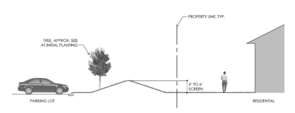
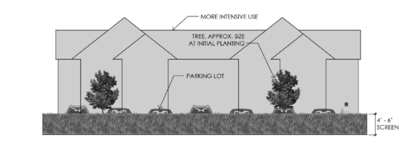
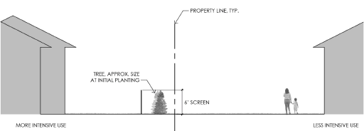
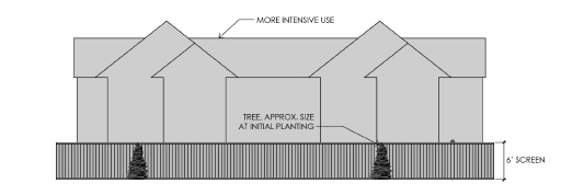
105.12.490 Purpose And Applicability
Specific development standards are established as supplemental regulations that address the unique characteristics of certain land uses. The standards and conditions listed below apply to both permitted and conditional uses, in addition to all other applicable regulations of this article. Standards shall apply in all zoning districts where the use in question is allowed. Standards for uses that apply only within specific districts are listed within the articles pertaining to those districts.
105.12.500 Standards For Residential And Related Uses
- Group home. A group home is a specific use type located within a single-family dwelling, and therefore shall meet all zoning standards applicable to single-family dwellings, including setbacks, lot area, lot coverage, and off-street parking. License capacity shall not exceed six persons per facility, plus support staff.
- Group residential facility, halfway house.
- In residential districts, the facility shall occupy a residential building type permitted within the district where it is located, and shall meet all zoning standards applicable to that building type.
- On-site services shall be for residents of the facility only.
- Congregate housing (assisted living).
- To the extent practical, all new construction or additions to existing buildings shall be compatible with the scale and character of existing building and surrounding neighborhood.
- The site shall contain a minimum of 50 square feet of green space per resident, consisting of outdoor seating areas, gardens and/or recreational facilities. In cases of unique circumstances, the city may consider public parks or plazas within 300 feet of the site to meet this requirement. It is the responsibility of the applicant to demonstrate why the green space cannot be located on site.
- An appropriate transition area between the use and adjacent property may be required, to include landscaping, screening and other site improvements consistent with the character of the neighborhood.
- Semi-transient accommodations (boardinghouses, roominghouses, etc.).
- The operator shall submit a management plan for the facility and a floor plan showing sleeping areas, emergency exits and bathrooms.
- All new construction or additions to existing buildings shall be compatible with the scale and character of the existing building and surrounding neighborhood.
- An appropriate transition area between the use and adjacent property may be required, to include landscaping, screening and other site improvements consistent with the character of the neighborhood.
- Temporary health care dwellings. Pursuant to authority granted by M.S.A. § 462.3593, subd. 9, the city opts-out of the requirements of M.S.A. § 462.3593, which defines and regulates temporary family health care dwellings. By exercising this authority, the city is prohibiting the use of temporary family health care dwellings within the city.
105.12.510 Standards For Services
- Educational services. Except in the industrial districts, all typical activities shall be conducted within an enclosed building.
- Farm Schools. Public and Private.
- The minimum lot area required for a farm school shall be nine (9) acres.
- An affiliate of the school must live on site as a permanent resident.
- The site must have primary access to a roadway that is not classified as a neighborhood street or a “B Minor” in the Comprehensive Plan.
- All parking must be contained on site. Parking must adhere to the standards set forth in LEC 105.12.410 of this Chapter.
- Student drop off and pick up must occur on site.
- The buildings on the site that are intended for use by the school must meet all applicable building and fire code requirements for the proposed use.
- The buildings on site that are intended for use by the school will be subject to an inspection and review by the City Building Official and the Fire Chief to ensure that they meet all applicable building and fire code requirements. The applicant must have a pre-application meeting on site with the Building Official before final submission of the conditional use permit application and any other land use applications needed.
- The school must comply with the applicable requirements of the U.S. Department of Education and the Minnesota Department of Education.
- The septic system on the site must be inspected and approved by the county. It must be verified with the county that the site can functionally support the allotted number of students and staff at the school.
- The septic system approval/review documentation from the county must be provided by the applicant to the city with the application materials.
- Any structural additions and modifications, if desired, must be structurally similar by design and be similar in color to the existing structure. Any new structures must be structurally similar in design and be similar in color to the existing structures on the site. All structures must have a residential appearance.
- There shall be no overnight school activities on the site.
- There shall be no more than twenty-five students on the site at one time.
- All school assemblies and activities (such as plays, concerts, parent-teacher conferences, etc.) that are held on the site must be conducted Monday through Friday. All school assemblies and activities desired outside of this time frame must be conducted off site.
- A half mile separation shall be required between all farm schools.
- Medical facilities. The facility shall have access to an arterial or collector street of sufficient capacity to accommodate the traffic that the use will generate. A minimum of two access points shall be provided.
- Any new hospital or expansion of an existing hospital shall submit a master plan that shall describe proposed physical development for at least a ten-year period, and shall include a description of proposed development phases and plans, estimated dates of construction and anticipated interim uses of property.
- Landing pads for helicopters involved in emergency rescue operations, and helicopter flight paths shall meet all applicable federal and state requirements.
- Nursing and personal care.
- To the extent practical, all new construction or additions to existing buildings shall be compatible with the scale and character of the existing building and surrounding neighborhood.
- The site shall maintain a minimum of 50 square feet of green space per resident, consisting of outdoor seating areas, gardens and/or recreational facilities. In cases of unique circumstances, the city may consider public parks or plazas within 300 feet of the site to meet this requirement. It is the responsibility of the applicant to demonstrate why the green space cannot be located on site.
- An appropriate transition area between the use and adjacent property may be required, to include landscaping, screening and other site improvements consistent with the character of the neighborhood.
- Self-service storage facility.
- No commercial transactions shall be permitted other than the rental or sale of storage units.
- No more than one unit shall be accessed directly from the public street.
- Site design shall accommodate a logical and safe vehicle and pedestrian circulation pattern.
105.12.520 Standards For Food Services
- Restaurant with drive-through.
- Drive-through elements shall not be located between the front facade of the principal building and the street. No service shall be rendered, deliveries made or sales conducted within the required front yard, although tables may be provided for customer use.
- Site design shall accommodate a logical and safe vehicle and pedestrian circulation pattern. Adequate queuing lane space shall be provided, without interfering with on-site parking/circulation.
- Drive-through canopies and other structures, where present, shall be constructed from the same materials as the primary building, and with a similar level of architectural quality and detailing.
- Sound from any speakers used on the premises shall not be audible above a level of normal conversation at the boundary of any surrounding residential district or on any residential property.
- Each food or beverage drive-through business shall place refuse receptacles at all exits.
- Drinking and entertainment. Music or amplified sounds shall not be audible above a level of normal conversation at the boundary of any surrounding residential district or on any residential property.
105.12.530 Standards For Automotive/Vehicular Uses
- Car wash.
- The car wash shall be capable of being enclosed when not in operation.
- Any access drive shall be located at least 30 feet from any public street intersection, measured from the interior curb line commencing at the intersection of the street.
- Any car wash line exit shall be at least 30 feet distant from any street line.
- Sound from any speakers used on the premises shall not be audible above a level of normal conversation at the boundary of any surrounding residential district or on any residential property.
- Water from the car wash shall not drain across any sidewalk or into a public right-of-way.
- Gasoline station.
- Lot size and access. A gasoline station site shall be a minimum of 20,000 square feet in size and shall have access to a collector or higher classification street.
- Performance standards. A drainage system subject to the approval of the city engineer shall be installed. The entire site, with the exception of the area taken up by the structure, landscaping and pump islands, should be surfaced with asphalt, concrete or other material approved by the city.
- Repairs in an enclosable building. All vehicle repairs shall be conducted in a building capable of being enclosed when not in use.
- Vehicles. No vehicles other than those utilized by employees or awaiting service shall be parked on the premises overnight. No vehicle shall be parked or awaiting service longer than 15 days.
- Canopies. Canopies shall be located no closer than 20 feet from any property line. Any lighting on the underneath side of the canopy shall be recessed mounted with flush lenses and downward directed. Signage on canopies shall comply with LEC 105.12.430. Canopy columns and fascia should reflect the design and/or materials of the principal building.
- Screening of storage areas. The storage or display of inoperable or unlicensed vehicles not awaiting service as in subsection (b)(4) of this section or other equipment, and all trash storage or disposal facilities, shall meet all setback requirements of a structure, and shall be screened from view from adjacent public streets and adjacent residential properties. Screening shall meet the requirements of LEC 105.12.480.
- Outdoor display. Exterior display of items offered for sale shall meet all building setback requirements and shall be located in containers, racks or other structures designed to display merchandise.
- Accessory uses. The following accessory uses shall require a separate conditional use permit:
- Automatic car and truck wash.
- Rental of vehicles, equipment or trailers.
- General retail exceeding 2,500 square feet in floor area.
- Sales and storage lots.
- Size and location. The site shall be a minimum of 20,000 square feet in size and shall have access to a collector or higher classification street. Vehicular access to the outdoor sales area shall be at least 60 feet from the intersection of any two streets.
- All vehicle repairs shall be conducted in a completely enclosed building.
- A site plan shall be submitted showing the layout of vehicles for sale or rent, employee parking and customer parking.
- Sound from any speakers used on the premises shall not be audible above a level of normal conversation at the boundary of any surrounding residential district or on any residential property.
105.12.540 Standards For Outdoor Recreation Uses
- Golf course.
- Location. The facility shall have access to a collector or higher classification street. A minimum of two entry points to such facilities shall be provided.
- Site plans. Site plans for such facilities shall indicate all proposed recreation areas, building uses and locations, sanitary facilities, storage areas, parking, circulation and other information needed to assess the impacts of the proposed operation on surrounding properties and the road network.
- Accessory uses. The following accessory uses are permitted in conjunction with a golf course: A driving range, putting greens, pro shop, club house and locker facilities, maintenance buildings, course shelters, and cart storage facilities. Other accessory uses may require a separate conditional use permit.
- Resource protection. Golf courses shall be designed with consideration of environmental resources, including:
- Water recycling and conservation through on-site storage and use facilities;
- Use of landscaped buffers and other best management practices (BMPs) to minimize fertilizer runoff and other chemicals from entering surface water bodies; and
- Use of landscaping and site layout to preserve and enhance wildlife habitat.
- Buffering. A planted buffer may be required to screen adjacent residential and other uses.
- Other conditions. Other conditions may be imposed to mitigate the potential impacts of the use.
- Outdoor entertainment, restricted recreation.
- Location. The facility shall have access to a collector or higher classification street. A minimum of two entry points to such facilities shall be provided.
- Site plans. Site plans for such facilities shall indicate all proposed recreation and entertainment areas, sanitary facilities, storage areas, parking, circulation, estimated noise levels, and other information needed to assess the impacts of the proposed operation on surrounding properties and the road network. Conditions may be imposed to mitigate the potential impacts of the use.
- Outdoor recreation facility. Facilities that would generate substantial traffic, such as playing fields or aquatic centers, shall be located with access to a street of sufficient capacity to accommodate the traffic that the use will generate. A minimum of two entry points to such facilities shall be provided.
105.12.550 Standards For Indoor Recreation/Amusement
Indoor athletic facility, indoor recreation. Facilities that would generate substantial traffic shall be located with access to a street of sufficient capacity to accommodate the traffic that the use will generate. A minimum of two entry points to such facilities shall be provided.
105.12.560 Standards For Alternative Energy
- Solar farms.
- Conditional or interim use permit. A conditional or interim use permit subject to the zoning district in which the proposed solar farm is to be located.
- Minimum lot size, setbacks, and screening requirements. Solar farms are limited to properties at least ten acres in size. Solar farms must maintain a setback of at least 50 feet from adjacent properties and be screened and fenced as determined by the city from adjacent residential properties.
- Stormwater and NPDES. Solar farms are subject to the city's and watershed district's stormwater management and erosion and sediment control provisions and NPDES permit requirements.
- Foundations. A qualified engineer shall certify that the foundation and design of the solar panels, racking and support is within accepted professional standards, given local soil and climate conditions.
- Wind generator systems. Wind generator systems are allowed as an accessory or principal use with a conditional use permit in the rural and commercial districts. The system must comply with all standards described herein. Applicants should check for compliance with local utility, state, and federal laws before construction.
- Application. An application for a wind generator shall follow the application and review procedures for a conditional use permit as specified in LEC 105.12.290. In addition to the submission requirements of LEC 105.12.290, an application for a wind generator shall include the following:
- A report from a professional engineer describing the proposed wind generator and certifying the safety of the device.
- Appropriate certifications as required by a nationally recognized testing laboratory. Self-certification is not allowed.
- A statement indicating that the proposed wind generator is in compliance with all applicable regulations of the Federal Aviation Administration where appropriate.
- All necessary information relating to site (site plan) and system design.
- Specific standards for ground-mounted systems.
- Maximum height. 125 feet, including the system as a whole, from the base to the highest point.
- Setbacks. At least 1.25 times the height of the wind generator from any lot line, shoreland overlay district boundary, and any utility lines and public or private road way. A setback of at least 200 feet is required from any principal structure on adjacent properties within the Rural Districts.
- Rotors. Rotors or moving parts are required to be at least 30 feet above the ground and 30 feet above any obstruction equal to its height from the base. Rotor diameter shall not exceed 52 feet or a blade length of 26 feet.
- Minimum lot size. There is no minimum lot size on which a wind generator may be constructed unless there is more than one wind generator per parcel, provided required setbacks are met.
- Number. For parcels on which there are more than one wind generator, the number of wind generators allowed is limited to one system per five acres, and all systems must meet minimum setback requirements.
- Specific standards for roof/structure mounted systems.
- Height. Subject to the maximum building height specified for the district in which it is constructed.
- Setbacks. Must be set back a distance equal to its height away from utility lines, and the location must support the structure.
- Rotors. Moving parts may not be located below the roof line on which the system is mounted.
- Number. The number of roof/structure mounted systems allowed is limited to one system per building within rural districts and is limited to the manufacturer's setback recommendations within commercial districts.
- General standards.
- Design. All turbines shall be commercially available and not prototype turbines. Each wind generator shall be equipped with both a manual and automatic braking device capable of stopping the operation in high winds. No components unnecessary to the operation of the wind generator shall be allowed.
- Maintenance. Wind generators shall be inspected and maintained under agreement or contract by the manufacturer or other qualified entity. The owner of the wind generator must have the tower inspected by a licensed qualified professional and submit to the city a report on the status and condition of the wind generator. The times of inspection shall be specified by the manufacturer or at a minimum of every two years. Routine maintenance, including, but not limited to, painting, part replacement, etc., shall be done as necessary but does not require a report to be submitted.
- Climbing. To prevent unauthorized climbing, such apparatus shall not be located within 12 feet of the ground, and a locked anti-climb device shall be installed on the tower.
- Signage. Properties with wind generators shall have at least one sign posted at the entrance of the property or structure on which the wind generator is mounted, containing the following information: voltage information, manufacturer's name, emergency telephone number, and emergency shutdown procedures. There shall also be signs located on transformers and substations which are directly connected to the system. Systems shall not be used for displaying any advertising, nor for other uses, including, but not limited to, cell phone antennas, flags, ham radio antennas, etc.
- Lightning. All wind generators shall be protected against lightning strikes.
- Aviation. No wind generator shall be located in a way that will create an obstruction to navigable airspace of public and private airports in the state. Wind generators are prohibited in the city airport safety zone.
- Feeder lines. The electrical collection system (wind generator) shall be placed underground within the interior of each parcel. They may run through public water ways subject to DNR, FWS, and or USACOE permits.
- For all guyed towers. Visible and reflective objects, such as plastic sleeves, reflectors or tape shall be placed on the guy wire anchor points and along the outer and innermost guy wires up to a height of eight feet above the ground.
- Screening. Wind generator are exempt from the screening requirements.
- Aesthetics. The appearance of the wind generator, tower and any other related components shall be maintained throughout the life of the wind generator per the manufactures/industry standards. Ground-mounted wind generators shall be installed on tubular and monopole design towers.
- Color. Wind generators shall be uniform in color, white or off-white, grey, or another non-obtrusive color. Finishes shall be matte or non-reflective.
- Vibration. No wind generator shall produce vibrations through the ground that are perceptible beyond the property on which it is located.
- Noise. Wind generator shall comply with language outlined in LEC 13.04.070.
- Lighting. Systems shall not be illuminated unless required by the Federal Aviation Administration (FAA), state, or federal regulations.
- Electrical certification. Batteries or other energy storage device shall be designed consistent with the state electrical code and state fire code. Wind generators must also meet the standards established by the International Electrotechnical Commission (IEC).
- Intent to install. Prior to installation of a wind generator, the applicant must show proof that the utility provider has given consent to connect to the grid. Off-grid systems are exempt from this requirement.
- Decommissioning.
- Generally. A wind energy systems shall be maintained at all times according to the manufacture's specifications. If a wind generator has become unstable, leans significantly out-of-plumb, or poses a danger of collapse, it shall be removed or brought into repair within 60 days following notice by the building official to the owner of the lot upon which the system is located. The building official may order immediate repairs if, in the opinion of the building official, the generator will imminently collapse or if a safety risk is being posed. If the owner of a wind generator plans to abandon or discontinue, or is required to discontinue, the operation of the system, the owner shall notify the building official by certified U.S. mail of the proposed date of abandonment or discontinuation. Such notice shall be given no less than 30 days prior to abandonment or discontinuation. In the event that an owner fails to give such notice, the wind energy system shall be considered abandoned if the wind energy system is not operated for a continuous period of 12 months. At such point, the owner has the option to either fully abandon and remove the system or submit a new application for operation of the system.
- Removal. Upon abandonment or discontinuation of use, the property owner shall physically remove the wind energy system as soon as practical, considering the weather conditions within six months from the date of abandonment or discontinuation of use. The term "physically remove" includes, without limitation, the actual, complete removal of the tower, turbine, and all other components of the wind energy system from the site of the original installation.
- Site restoration. The owner shall, upon decommissioning/abandonment, as soon as practical, considering the weather, restore the area affected by any wind generator to the condition that existed immediately before construction began, to the extent possible. The time period may be no longer than six months after decommissioning of the turbine, unless otherwise negotiated with the building official. Restoration shall be compatible with the safe operation, maintenance, and inspection of the city. All costs associated with the restoration of the site will be the responsibility of the property owner.
- Transfer of ownership. Permits are not transferrable. If the portion of property containing the wind generator is sold, the new owner must apply for a new wind generator permit or remove the system per the decommissioning plan.
- Application. An application for a wind generator shall follow the application and review procedures for a conditional use permit as specified in LEC 105.12.290. In addition to the submission requirements of LEC 105.12.290, an application for a wind generator shall include the following:
105.12.570 Standards For Accessory Uses
- Bed and breakfast.
- The use of a bed and breakfast is not permitted unless the city issues a permit for that specific property. The permit will be valid for two years. A permit for a bed and breakfast will only be issued if:
- The facility is located in a single-family detached dwelling.
- The number of lodging rooms in any building does not exceed five. If the proposed number of lodging rooms in any building exceeds five, a conditional use permit shall be required.
- The facility meets parking requirements as set forth by Table 5-2 of LEC 105.12.410.
- The applicant shall meet all applicable government regulations.
- The operator shall carry liability insurance, and shall provide proof of such insurance to the city upon request.
- Permits are non-transferable and do not run with the land.
- A permit constitutes a limited license granted to the property owner by the city and in no way creates a vested zoning right.
- By signing the permit, the applicant of the bed and breakfast permit acknowledges that he shall defend and indemnify the city against any and all claims arising out of operating a bed and breakfast.
- Bed and breakfast permit fees shall be as established by the city council.
- The use of a bed and breakfast is not permitted unless the city issues a permit for that specific property. The permit will be valid for two years. A permit for a bed and breakfast will only be issued if:
- Drive-through facility.
- Drive-through elements shall not be located between the front facade of the principal building and the street.
- Plans for on-site circulation and driveway locations shall be reviewed as part of the conditional use review process. Site design shall accommodate a logical and safe vehicle and pedestrian circulation pattern. Adequate queuing lane space shall be provided, without interfering with on-site parking/circulation.
- Alley access to drive-through lanes is prohibited on any block containing a residential district, except for commercial deliveries when approved by the city engineer.
- Drive-through canopies and other structures, where present, shall be constructed from the same materials as the primary building, and with a similar level of architectural quality and detailing.
- Sound from any speakers used on the premises shall not be audible above a level of normal conversation at the boundary of any surrounding residential district or on any residential property.
- An emergency exit lane shall be provided for uses queuing through the drive-through lanes, without interfering with on-site parking/circulation.
- Commercial wedding ceremony venue. A commercial wedding venue is allowed as an accessory use with an interim use permit in the A Agriculture, RT Rural Transitional, and RR Rural Residential Zoning Districts on parcels greater than ten acres in size. The establishment of a commercial wedding venue on RR parcels is limited to those sites meeting the following criteria:
- The site has historically been used as a farmstead for the surrounding agricultural land; and
- The use will incorporate a barn or other historical agricultural building over 75 years of age for the wedding ceremonies.
The suitability of a parcel for a wedding venue shall be determined by the characteristics of the site and by the unique capacity of the parcel to accommodate the use while preserving the essential rural character of the neighborhood and the site on which the use is located, by the ability of the parcel to accommodate the use without negative impact on the general health, safety, and welfare of the community, and by other factors the city may deem appropriate for consideration. The use must adhere to the following standards:- Ownership. The property will be the primary residence of the venue operators. The operator must be on the premises for the duration of each event.
- Maximum number of guests. The maximum number of guests is limited to 200 for each event.
- Food and beverages. The serving of food and beverages is permitted only as part of the ceremony.
- Seasonal operation. Ceremonies are limited to no more than twice per week and are permitted only during the months of May through October.
- Hours of operation. Events shall only be allowed between the hours of 10:00 a.m. and 10:00 p.m. All guests and staff must vacate the premises by 10:00 p.m. All lights associated with the event must be turned off by 10:00 p.m. Any one ceremony is limited to a maximum duration of three hours.
- Overnight accommodations. No overnight accommodations are allowed.
- Off-street parking. Off-street parking shall be required in the ratio of one parking space for each three attendees based on the maximum number of attendees planned for the site. The off-street parking area and the number of parking spaces shall be documented on the required site plan. Off street parking shall be exempted from the paving and curbing requirements in LEC 105.12.410.
- Setbacks. The minimum setbacks from neighboring houses and property lines for the various activities associated with the wedding venue shall be as follows:
- Parking: 100 feet from residential property lines; 200 feet from neighboring houses.
- Outdoor activity spaces: 300 feet from residential property lines; 400 feet from neighboring houses.
- Indoor activity spaces: 300 feet from residential property lines; 400 feet from neighboring houses.
- Landscaping/screening. Landscaping may be required to buffer the use from adjacent land uses and to provide screening when such screening does not presently exist on the site. A landscape plan shall be submitted at the time of application for an interim use permit.
- Grading. Any proposed grading shall observe all requirements of LEC 105.08.060. If a grading plan is required, it shall be submitted in conjunction with an application for an interim use permit.
- Traffic. A transportation management plan shall be submitted as part of an application for an interim use permit. The plan shall address traffic control, including traffic movement to the public street system and impact on the surrounding roadways.
- Structures. All existing or proposed structures to be used for the wedding ceremony venue shall be inspected by the city building official and must meet applicable building code requirements.
- Temporary structures. Temporary structures, including tents and canopies, may be allowed. Tents and canopies may be erected no more than one day prior to an event and must be removed no more than 72 hours following the event.
- Application. An application for a commercial wedding venue shall follow the application and review procedures for an interim use permit as specified in LEC 105.12.300. In addition to the submission requirements of LEC 105.12.300, an application for a commercial wedding venue shall include the following information:
- The expected number of attendees per ceremony;
- The number of ceremonies per year;
- The number of employees;
- The hours of operation;
- Sanitary facilities;
- Lighting;
- Sound amplification to be used and a plan to minimize any amplified sounds;
- Temporary structures or tents to be used in association with the planned events;
- Signage;
- Security to be provided;
- Location of all trash receptacles;
- Traffic management plan;
- Other documentation as specified herein.
- Sanitary facilities. Sanitary facilities adequate for the number of attendees shall be provided. Portable toilets may be approved for temporary use, and must be screened from view from roads and neighboring properties by landscaping or a wooden enclosure. No portable toilets shall be located closer than 400 feet from a neighboring residential structure.
- Lighting. Lighting associated with the wedding venue shall be limited to downcast and shielded fixtures so that the source of the light is not visible from adjacent roads or neighboring properties. Lighting shall comply with LEC 105.04.050.
- Noise. All wedding venues shall comply with city's noise standards found in LEC 13.04.070 through LEC 13.04.100.
- Sound amplification. Amplification of music and participants and is allowed only in conjunction with a wedding ceremony. There shall be no other amplification of music or sound outside of the ceremony.
- Waste. All solid waste must be stored in a manner that prevents the propagation, harborage, or attraction of flies, rodents, or other nuisance conditions and must be removed at least once every seven days by a licensed solid waste hauler.
- Liability. The applicant shall secure adequate liability coverage, which shall be in place at least one week prior to any event.
- Other activities. Other than the commercial wedding ceremonies authorized under this section, no other commercial ceremonial activities may be conducted on the site.
- Home occupations. Home occupations shall be considered a permitted accessory use. The purpose of home occupation standards are to ensure that the activities are clearly secondary to the intended use of the dwelling and to ensure that the business is compatible with surrounding residential uses. All home occupations must comply with the criteria set forth below.
- Permitted home occupations.
- A home occupation may include, but is not limited to:
- Home office.
- Hair salons not serving more than two customers at a time.
- Teaching, though limited to no more than three students at any time.
- Uses which do not alter the character of the locality, do not create a nuisance as outlined in LEC 9.28, and are legally allowed by local, state, and federal law.
- Home occupations shall not be interpreted to include:
- Tourist homes.
- Restaurants.
- Disorderly house as defined by M.S.A. § 609.33, subd. 1, as it may be amended from time to time, or similar uses.
- Sale or use of hazardous materials.
- Adult establishments as defined in LEC 11.16.
- Any overnight activities shall not be permitted.
- A home occupation may include, but is not limited to:
- Operation requirements.
- The home occupation shall be clearly incidental and subordinate to the residential use of the premises, and shall result in no incompatibility or disturbance to the surrounding area.
- Activities associated with the permitted home occupation may only be conducted between the hours of 7:00 a.m. and 10:00 p.m.
- No over the counter retail sales may be made unless ancillary to the permitted business.
- There shall not be more than one employee who does not customarily reside on the property affiliated with the home occupation.
- The use shall not create a nuisance as defined by LEC 9.28.
- Site requirements.
- Exterior alterations or modifications that change the residential character or appearance of the dwelling unit or accessory structure to that of a commercial nature shall be prohibited.
- Interior alterations or modifications shall not eliminate all of the bathrooms, sleeping areas, or kitchens.
- Signage. Home occupations are allowed signage in accordance with LEC 105.12.430(g)(1)a and (k)(10).
- The operation shall not create a demand for more than three parking spaces at any given time, and no parking for the business shall be on-street. Off-street parking shall be on a durable parking surface such as asphalt, concrete, etc. The off-street parking area required for the principal residential use shall be retained exclusively for the principal use.
- Exterior storage. No outside storage or display of products or merchandise is permitted.
- No stock in trade over 1,000 cubic feet shall be stored on the premises.
- Permitted home occupations.
105.12.580 Division Into Districts
- All areas zoned. The incorporated areas of the city are hereby divided into the following zoning districts:
Table 8-1: Zoning DistrictsZoning District Reference R-2 One- and Two-Family Residential LEC 105.12.150 GB General Business LEC 105.12.160 A Agriculture Article XI RR Rural Residential Article XI RT Rural Development Transitional Article XI RS Rural Single-Family Article XI RE Residential Estate Article XI GCC Golf Course Community Article XII LDR Urban Low Density Residential Article XII MDR Urban Medium Density Residential Article XII HDR Urban High Density Residential Article XII V-LDR Village Low Density Residential Article XIII VMX Village Center Mixed-Use Article XIII C Commercial Article XIV CC Convenience Commercial Article XIV LC Neighborhood Office/Limited Commercial Article XV BP Business Park/Light Manufacturing Article XV PF Public Facilities Article XVII - Annexed areas. Any land that is annexed into the city shall be included in the A Agriculture District until such time as the city council amends the comprehensive plan to include the new area, and rezones it to another district.
105.12.590 Zoning Map
- The location and boundaries of the districts established by this chapter are set forth on the official zoning map, which is hereby incorporated as part of this chapter, and which is on display in the planning department.
- District boundary lines recorded on the zoning map are intended to follow lot lines, the centerline of streets or alleys, the centerlines of streets or alleys projected, railroad rights-of-way lines, the center of watercourses or the corporate limit lines as they exist at the time of the enactment of this chapter.
- Whenever any street, alley or other public way is vacated, the zoning district adjoining that of such vacated street, alley or public way shall be automatically extended to the center of such vacated area and all area included therein shall be then and henceforth subject to all regulations of the extended district.
- It shall be the responsibility of the planning director to maintain and amend the zoning map. The director of planning shall make any corrections or amendments to the map after all of the procedures outlined in LEC 100.00.020 for the making of such revisions or amendments shall have followed by the planning commission and the city council.
- Amendments to the official zoning map shall be recorded on the map within 30 days after adoption by the council. The copy of the official zoning map shall be displayed in the office of the planning department and shall be open to public inspection at all times during which the office is customarily open.
105.12.600 Consistency With Comprehensive Plan
The zoning districts in this chapter and the delineation of zoning district boundaries on the zoning map are consistent with the goals and policies of the city comprehensive plan.
105.12.610 Purpose
The rural districts are established to provide guidance for existing rural development that is served primarily by on-site wastewater treatment facilities in the city. The objectives of these districts are to preserve and enhance the quality of living in the existing rural areas, as well as regulate structures and uses which may affect the character or desirability of these areas. The rural districts and their purposes are as follows:
- RT Rural Development Transitional District. The RT Rural Development Transitional District is an interim holding zone that will regulate land uses within those portions of the city planned and staged for development that will connect to regional sewer service in accordance with the comprehensive plan. The future zoning classification for areas zoned RT and the timing for any zoning map amendments to rezone property in this district will be determined by the city council upon the extension of public sanitary sewer and water services into these areas. In the meantime, agricultural and existing residential uses will be allowed to continue in addition to other uses that are consistent with the A and RR zoning districts.
- A Agricultural District. The A Agricultural District will apply to agricultural or undeveloped areas in the city, including any newly annexed areas. The purpose of the district is to allow for agricultural and other activities typically associated with agriculture, including non-farm dwellings at a density of one unit per 40 acres. Future residential development may occur at the aforementioned density or through the open-space preservation development process. These parcels are expected to be served by on-site wastewater treatment facilities. In addition, some limited agriculture-related businesses, such as wayside stands and outdoor recreation, are appropriate short-term or interim uses for this district.
- RR Rural Residential District. The RR Rural Residential District is established for lands that have existing small-scale agricultural activity, as well as single-family residential dwellings. Future residential development may occur at a density of one dwelling unit per ten acres, or through the open-space preservation development process. These sites are expected to be served by on-site wastewater treatment facilities. Some limited agriculture-related businesses, such as wayside stands, are appropriate as interim uses for this district.
- RS Rural Single-Family District. The RS Rural Single-Family District is established for lands that have already been platted as conventional residential subdivisions prior to the 2005 adoption of the comprehensive land use plan. Only lots which were part of a subdivision prior to and up to 2005 are eligible for rezoning to RS.
- RE Residential Estate District. The purpose of the RE Residential Estate District is to allow for single-family detached dwellings on large lots. The large lots and setbacks provide for an open-space environment that is consistent with the rural character of the city. Planned residential subdivisions are allowed on a minimum of 20 acres (nominal) with an average subdivision density of 3.33 acres per residential unit. Lot sizes should be adequate to provide for on-site wastewater treatment.
105.12.620 Permitted, Conditional, And Interim Uses
Table 9-1 lists all permitted, conditional, and interim uses allowed in the rural districts. "P" indicates a permitted use, "C" a conditional use, and "I" an interim use. Uses not so indicated shall be considered prohibited. Cross-references listed in the table under "Standard" indicate the location within this section of specific development standards that apply to the listed use.
Combinations of uses. Principal and accessory uses may be combined on a single parcel.
Table 9-1: Permitted, Conditional, and Interim Uses, Rural Districts
| RT | A | RR | RS | RE | Standard | |
| Residential Uses | ||||||
| Household living | ||||||
| Single-family detached dwelling | P | P | P | P | P | LEC 105.12.650(a) |
| Secondary dwelling | - | P | - | - | - | LEC 105.12.650(d) |
| Services | ||||||
| Self service storage facility | Ia | Ia | - | - | - | LEC 105.12.650(g) |
| Outdoor Recreation | ||||||
| Outdoor recreation facility | - | C | - | - | - | LEC 105.12.540(c) |
| Parks and open areas | P | P | P | P | P | LEC 105.12.110(b)(7) |
| Restricted recreation | - | C | - | - | - | LEC 105.12.540(b) |
| Agricultural and Related Uses | ||||||
| Agricultural entertainment business | I | I | I | - | - | LEC 105.12.1420 |
| Agricultural production | P | P | P | - | - | LEC 105.12.110(b)(9) |
| Agricultural sales business | I | I | I | - | - | LEC 105.12.1410 |
| Agricultural services | C | C | - | - | - | LEC 105.12.650(j) |
| Forestry operations | - | P | - | - | - | LEC 105.12.110(b)(9) |
| Greenhouses, non-retail | C | C | C | - | - | LEC 105.12.110(b)(9) |
| Solar farm | I | C | C | - | - | LEC 105.12.1470 |
| Wayside stand | P | P | P | - | - | LEC 105.12.110(b)(9) |
| Industrial and Extractive Uses | ||||||
| Motor freight and warehousing | Ia | - | - | - | - | LEC 105.12.650(g) |
| Environmental Uses | ||||||
| Wind Generator - Ground Mounted | C | C | C | C | C | LEC 105.12.560(b) |
| Wind Generator - Roof/Structure Mounted | C | C | C | C | C | LEC 105.12.560(b) |
| Accessory Uses | ||||||
| Bed and breakfast | P | P | P | P | P | LEC 105.12.570 |
| Domestic pets | P | P | P | P | P | LEC 105.12.110(b)(13) |
| Family day care | P | P | P | P | P | LEC 105.12.110(b)(13) |
| Home occupation | P | P | P | P | P | LEC 105.12.110(b)(13) |
| Kennel, private | C | C | C | - | - | LEC 105.12.110(b)(13) |
| Solar energy systems | P | P | P | P | P | LEC 105.04.220(c) |
| Stable, private | C | C | C | - | - | LEC 105.12.110(b)(13) |
| Swimming pools, hot tubs, etc. | P | P | P | P | P | LEC 105.08.160 |
| Temporary sales | P | P | P | P | P | LEC 105.12.110(b)(13) |
| Water-oriented accessory structures | P | P | P | P | P | LEC 105.12.1230 |
| Wind Generator - Ground Mounted | C | C | C | C | C | LEC 105.12.560(b) |
| Wind Generator - Roof/Structure Mounted | C | C | C | C | C | LEC 105.12.560(b) |
| Other structures typically incidental and clearly subordinate to permitted uses | P | P | P | P | P | |
| Commercial wedding ceremony venue | I | I | I | - | - | LEC 105.04.220(d) |
| Farm Schools, Public and Private | I | C | C | C | C | 105.12.510 |
| Open space preservation development | ||||||
| OP development | - | C | C | - | - | Ch. 105.12, Art. XVII |
| Notes to rural districts Table 9-1: | ||||||
| a. One dwelling unit per 40 acres applies to all non-farm dwellings. In additional to non-farm dwellings (one per 40 acres), each farm is allowed one farm dwelling per farm. | ||||||
| b. Nominal 40 acres: A 40-acre parcel not reduced by more than ten percent due to road rights-of-way and survey variations. | ||||||
| c. Nominal ten acres: A ten-acre parcel not reduced by more than ten percent and/or a ten-acre parcel located on a corner or abutting a street on two sides not reduced by more than 15 percent due to road rights-of-way and survey variations. | ||||||
| d. The minimum lot size for lots served by public sanitary sewer shall be 24,000 square feet per residential unit. | ||||||
| e. A minimum of 1.25 acres of land above the floodplain or free of any drainage easements is required. | ||||||
| f. Lots must be configured to contain a circle with a diameter of 250 feet minimum; the ratio of lot length to width shall be a maximum of 3:1. Flag lots are prohibited. | ||||||
| g. Corner properties: The side facade of a corner building adjoining a public street shall maintain the front setback of the adjacent property fronting upon the same public street, or the required front yard setback, whichever is less. If no structure exists on the adjacent property, the setback shall be as shown in the table. | ||||||
| h. Setback standards do not apply to solar farms. LEC 105.12.1440 should be referenced for these specific standards. | ||||||
105.12.630 Lot Dimensions And Building Bulk Requirements
Lot area and setback requirements shall be as specified in Table 9-2, Lot Dimension and Setback Requirements.
Table 9-2: Lot Dimension and Setback Requirements, Rural Districts
| RT | A | RR | RS | RE | |
| Minimum Lot Area (acres) | |||||
| Single-family detached dwelling | 20 | 40a,b | 10c | 1.5d | 2.5e,f |
| Minimum Lot Width (feet) | |||||
| Single-family detached dwelling | 300 | 300 | 300 | 125 | NAf |
| Maximum principal structure height (feet)i | 35 | 35 | 35 | 35 | 35 |
| Maximum impervious coverage | - | - | - | 25 percent | 15 percent |
| Minimum Principal Building Setbacks (feet) h,i | |||||
| Front yard | 30 | 100 | 30 | 30 | 100 |
| Interior side yard | 10 | 100 | 10 | 10 | 50 |
| Corner side yard g | 25 | 100 | 25 | 25 | 80 |
| Rear yard | 40 | 100 | 40 | 40 | 100 |
| Minimum Accessory Building Setbacks (feet)h,i,j | |||||
| Front yard | 30 | 100 | 30 | 30 | 100 |
| Interior side yard | 10 | 100 | 10 | 10 | 15 |
| Corner side yard | 25 | 100 | 25 | 25 | 30 |
| Rear yard | 40 | 100 | 40 | 10 | 15 |
| Minimum Agricultural Related Setbacks (Animal buildings, feedlots or manure storage sites) | |||||
| Any property line | 200 | 200 | 200 | - | - |
| Any existing well or residential structure | 50 | 50 | 50 | - | - |
| Any body of seasonal or year-round surface water | 200 | 200 | 200 | - | - |
| Notes to rural districts Table 9-2: | |||||
| a. One dwelling unit per 40 acres applies to all non-farm dwellings. In additional to non-farm dwellings (one per 40 acres), each farm is allowed one farm dwelling per farm. | |||||
| b. Nominal 40 acres: a 40-acre parcel not reduced by more than ten percent due to road rights-of-way and survey variations. | |||||
| c. Nominal ten acres: a ten-acre parcel not reduced by more than ten percent and/or a ten-acre parcel located on a corner or abutting a street on two sides not reduced by more than 15 percent due to road rights-of-way and survey variations. | |||||
| d. The minimum lot size for lots served by public sanitary sewer shall be 24,000 square feet per residential unit. | |||||
| e. A minimum of 1.25 acres of land above the floodplain or free of any drainage easements is required. | |||||
| f. Lots must be configured to contain a circle with a diameter of 250 feet minimum; the ratio of lot length to width shall be a maximum of 3:1. Flag lots are prohibited. | |||||
| g. Corner properties: The side facade of a corner building adjoining a public street shall maintain the front setback of the adjacent property fronting upon the same public street, or the required front yard setback, whichever is less. If no structure exists on the adjacent property, the setback shall be as shown in the table. | |||||
| h. Setback standards do not apply to solar farms. LEC 105.12.1440 should be referenced for these specific standards. | |||||
| i. Ground-mounted wind generators may exceed the allowable height restriction designated in all rural districts and are subject to different setback requirements as identified in LEC 105.12.560. | |||||
| j. On properties that are identified as a Riparian Lot, accessory structures may be placed between the principle structure and the public right-of-way. See LOC 105.12.670 | |||||
105.12.640 Dimensional Requirements And Preservation Of Open Space
Lot configuration, RR district. All lots must be rectangular in shape and any two adjacent sites must have an aspect ratio not exceeding 4:1.
105.12.650 Site Design And Development Standards
Development of land within the rural districts shall follow established standards for traffic circulation, landscape design, parking, signs and other considerations as specified in LEC 105.12, arts. VII, VIII and IX. The following standards apply to specific uses, and are organized by district:
- Single-family detached dwelling, all rural districts. All single-family dwellings shall be at least 24 feet in width, at least 960 square feet in area, and be placed on a permanent foundation.
- Septic drainfield regulation, A, RR, and RS districts. All applicants for a use or building permit in any district not served by public sanitary sewer must demonstrate that an on-site sewage treatment system (primary and secondary location) as approved by the county can be installed in accordance with Washington County Subsurface Sewage Treatment System Regulations.
- Septic drainfield regulation, RE district. All applicants for a use or building permit in any district not served by public sanitary sewer must demonstrate that an on-site sewage treatment system (primary and secondary location) as approved by the county can be installed in accordance with Washington County Subsurface Sewage Treatment System Regulations.
- Secondary dwelling, A district. One non-farm dwelling per each 40 acres, or part of a dwelling on a prorated basis, not already containing a farm or non-farm dwelling, is permitted provided:
- The dwelling unit is located on a separate parcel of record in the office of the county recorder and/or county auditor, which shall be at least 1 1/2 acres in size;
- The parcel on which the dwelling unit is located must have at least 125 feet of frontage along a public street, be rectangular in shape and no dimension to be greater than three times the other; and
- The dwelling is separated by at least 300 feet from the nearest farm building.
- Parking standards, A, RR and RS districts. Three spaces of off-street parking required per dwelling unit.
- Parking standards, RE district.
- Two enclosed spaces minimum (200 square feet minimum per space).
- Two exterior spaces within minimum setback of 50 feet from any property line.
- Non-agricultural low impact use, A, RT districts. The city recognizes that allowing non-agricultural low impact uses, strictly controlled and regulated by interim use permit, might allow a farmer or large property owner an economical use of his property that is zoned agricultural. The following standards may apply to these types of uses:
- All of the property owner's real estate that is contiguous to the non-agricultural low impact use must be zoned agricultural and remain so zoned while the conditional use permit is in effect.
- The area where the non-agricultural low impact use is located shall be legally defined and approved by the city and is hereafter known as the "non-ag area." The non-ag area shall not exceed four percent of the property owner's contiguous agricultural zone gross lot area. The building footprints and asphalt and concrete surfaces within the non-ag area shall not exceed 1.5 percent of the property owner's contiguous agricultural zone gross lot area. Landscaping, berms, ponds, gravel driveways, and other improvements that would otherwise be permitted in the agricultural zone may be located outside of the non-ag area.
- Non-agricultural low impact uses shall only be allowed on a parcel of a nominal 40 acres or larger.
- Non-agricultural low impact uses shall not generate more than three trips per day per acre of contiguous agriculturally zoned area, with the exception of land with sole access to Hudson Boulevard that shall not generate more than six trips per day per acre.
- Any uses under this section involving the outside storage of vehicles, equipment, or goods shall be located a minimum of 200 feet from any public roadway or adjacent landowner's boundary, except that the setback from the I-94 frontage road shall be not less than 50 feet. In addition, any such outside storage shall be screened from view from adjacent property and the public roadway by berms and landscaping. A plan for such screening shall be submitted with the application for the interim use permit which shall clearly demonstrate by view cross-sections that said screening will be effective immediately, and in all seasons. Degradation of such screening by loss of landscape materials, outdoor storage of items that exceed the screened height or for any other reason shall be grounds for rescinding the outdoor storage portion of the interim use permit.
- Non-agricultural low impact uses may not generate more than 3.0 SAC units per 3.5 acres or 235 gallons per day per net acre of land based upon design capacity of facilities, whichever is more restrictive.
- The property owner shall maintain the remaining land or farm outside of the IUP area in accordance with the permitted uses of the agricultural zoning district and the required practices of the soil and water conservation district.
- Rate and volume of stormwater runoff must meet the requirements of the city's stormwater ordinance.
- In the event that the property owner, or future property owner, initiates a comprehensive plan amendment and rezoning of any or all of the contiguous real estate from agriculture to a more intensive use, the interim use permit shall terminate and all nonconforming structures shall be removed from the site within one year from the date of the city council's adoption of the comprehensive plan amendment and rezoning, unless the city agrees otherwise. This section shall not apply if the city initiates rezoning or if property owner is forced to transfer title to any part of the contiguous real estate due to eminent domain.
- All conditional use permits granted to a non-agricultural low impact shall be reviewed on an annual basis, and may be rescinded, after a two-week notice and a public hearing, if the council finds that the public health, safety, or welfare is jeopardized.
- The standards for buildings or structures, as listed in the minimum district requirements of the agricultural zone, shall not apply to structures built prior to the effective date of the ordinance from which this chapter is derived.
- Unserviced lots, RT, A, RR districts. All lots that are subdivided without city sewer and public water service shall meet the following standards:
- Lots, houses and other structures, driveways and any new streets shall be located in compliance with the comprehensive plan and any more detailed area plans for future roads, public water services, and drainage.
- The planning commission may require a sketch plan showing how the entire tract could be divided when city services become available. Lots and buildings shall be sited and streets shall be laid out to facilitate future subdivision.
- Commercial kennel, commercial stable, or accessory kennel or stable, RT, A, RR districts. The facility shall occupy a site at least ten acres in size. Outdoor exercise areas shall be located at least 100 feet from adjacent properties; landscaping or other screening may be required.
- Agricultural services and support, RT, A districts.
- A facility established after the effective date of the ordinance from which this article is derived shall have direct access to a collector or higher classification street.
- An appropriate transition area between the use and adjacent property may be required, to include landscaping, screening and other site improvements consistent with the character of the neighborhood.
- All processing of animal or dairy products shall take place within an enclosed building.
105.12.660 Accessory Uses And Structures
Accessory uses are listed in the rural district use table as permitted or conditional accessory uses. Accessory uses and structures in the rural districts shall comply with the following standards and all other applicable regulations of this article:
- Phasing. No accessory use or structure shall be constructed or established on any lot prior to the time of construction of the principal use to which it is accessory.
- Incidental to principal use. The accessory use or structure shall be incidental to and customarily associated with the principal use or structure served.
- Subordinate to principal use. The accessory use or structure shall be subordinate in area, extent, and purpose to the principal use or structure served.
- Function. The accessory use or structure shall contribute to the comfort, convenience, or necessity of the occupants of the principal use or structure served.
- Location. The accessory use or structure shall be located on the same zoning lot as the principal use or structure.
- Exemption. Fish houses, as defined in this Code and located in the RS Rural Single-Family District, are exempt from this requirement, provided the following criteria are met: must be located on a lot one-half acre in size or more with direct access to a water body; is 120 square feet or less; and complies with shoreland regulations and RS Rural Single-Family District setback requirements. One fish house per lot may exist without a principal structure. The structure must maintain a current fish house license with the state department of natural resources regardless if it is left on a water body overnight. If a current state department of natural resources fish house license is not obtained for the structure, the structure must be removed from the property within 60 days.
105.12.670 Accessory Structures, Rural Districts
- Size and number. The maximum number and size of accessory buildings permitted in rural zoning districts are outlined in Table 9-3:
Table 9-3: Accessory Buildings, Rural Zoning DistrictsLot Size Maximum Structure Sizea,c (square feet) No. of Permitted Buildings Under 1 acre 1,200 1 1--1.99 acres 1,500 1 2--4.99 acres 1,750 1 5--9.99 acres 2,000 2 10--14.99 acres 2,500 2b 15--19.99 acres 3,000 2b 20--39.99 acres 4,000 2b 40+ acres Unregulatedc Unregulatedc Notes to Table 9-3: a. Maximum structure size accounts for the total maximum area allowed for all permitted accessory structures combined. b. One agricultural building, as defined in LEC 105.12.440, is allowed in addition to the permitted number and size of accessory structures. c. Agricultural buildings, as defined in LEC 105.12.440, are allowed on properties forty acres or more in addition to two permitted accessory structures which total 4,000 square feet and are not classified as agricultural.. - Structure height, rural districts. No accessory building shall exceed the height of the principal structure, with the exception of agricultural buildings, as defined in LEC 105.12.440. Building projections or features on accessory structures that are not agricultural buildings as defined in LEC 105.12.440, such as chimneys, cupolas, and similar decorations are permitted in rural districts.
Riparian Lots, when accessory buildings are allowed between the principal structure and the public right-of-way the accessory building shall not exceed one story in height or the height of the principle structure, whichever is less. - Structure location, rural districts. Except for Riparian Lots, no detached garages or other accessory buildings shall be located nearer the front lot line than the principal building on that lot.
- Exterior design and color. The exterior building materials, design and color of all accessory buildings or structures shall be similar to or compatible with the principal building, with the exception of the following accessory buildings or structures:
- Detached domesticated farm animal buildings.
- Agricultural buildings.
- Pole buildings, as defined and regulated in LEC 105.12.440.
- Gazebos.
- Swimming pools.
- Other structures in which the required design is integral to the intended use, such as a greenhouse.
- Attached garages, size. Attached garages must not exceed the footprint size of the principal building.
105.12.680 Accessory Uses
- Exterior storage in residential districts. All materials and equipment shall be stored within a building or be fully screened so as not to be visible from adjoining properties, except for the following:
- Laundry drying.
- Construction and landscaping materials and equipment currently being used on the premises. Materials kept on the premises for a period exceeding six months shall be screened or stored out of view of the primary street on which the house fronts.
- Agricultural equipment and materials, if they are used or intended for use on the property.
- Off-street parking and storage of trailers 25 feet in length or less as regulated in LEC 105.12.410, are licensed (when applicable) and kept in operable condition.
- Trailers shall be licensed to a resident of the property.
- Residential properties are allowed to store one trailer (boat trailer, utility trailer, recreational vehicle, etc.) within the front yard. All other trailers must be stored either in the side or rear yard, and must be at least 5 feet from all property lines.
- Trailers must not be used as temporary or permanent storage of items as described in LEC section 9.28.
- Firewood storage. For personal use only.
- Firewood must be stacked in a stable manner, cannot exceed 5 feet in height, and stored only in the side or rear yards. In the case of properties with multiple street frontages, fire wood shall not be stored on a side that abuts a public street.
- Firewood must be stacked in a stable manner, cannot exceed 5 feet in height, and stored only in the side or rear yards. In the case of properties with multiple street frontages, fire wood shall not be stored on a side that abuts a public street.
- Temporary sales. Temporary sales, also known as yard or garage sales, are permitted in all residential districts, limited to two per calendar year per residence, not to exceed four days in length.
105.12.690 Accessory Uses And Structures Not Listed
Standards for accessory uses and structures that are permitted in all districts, or in all residential buildings in any district, are listed in LEC 105.12, art. IX. These include uses such as family and group family day care, bed and breakfast facilities, and home occupations, and structures such as swimming pools and solar equipment.
105.12.700 Purpose And District Descriptions
The urban residential districts are established to provide areas for residential development that are served by public sewer and water services in accordance with the city's comprehensive plan. The objectives of these districts are to preserve and enhance the quality of living in residential neighborhoods, to regulate structures and uses which may affect the character or desirability of residential areas, to encourage a variety of dwelling types and locations and a range of population densities consistent with the city's comprehensive plan, and to ensure adequate light, air, privacy and open space. The residential districts and their purposes are as follows:
- GCC Golf Course Community District. The GCC district is intended to permit urban residential developments in conjunction with a golf course and its accessory uses. Development in this district will be enhanced by coordinated site planning; open space and environmental resources; and provision of a safe and efficient system for pedestrian and vehicle traffic. The GCC district is intended to provide areas for densities lower than other Urban Residential Districts, ranging from 1.4 to 1.65 units per acre, with adequate open space buffers to provide a transition between denser, sewered development and rural areas. Residential development within the GCC district will consist of an environment of predominantly single-family dwellings with lots slightly larger on average than those in most urban residential districts.
- LDR Urban Low Density Residential District. The LDR district provides an environment of predominantly single-family dwellings on moderately sized lots, and is designed to be the most restrictive of the urban residential districts. The LDR district is intended to provide areas for lower density residential development within the city's planned sewered development areas, and may be used to provide a transition between rural development areas and the city's urban development and districts. Densities shall range from two to four units per acre; however, the overall density for a specific development area must be consistent with the net densities specified in the comprehensive plan. The lot size and other district standards allow for the creation of smaller lots with the expectation that common open space will be provided within developments that exceed the base densities (at low end of the land use density range) within the comprehensive plan.
- MDR Urban Medium Density Residential District. The MDR district is established to provide for a diversity of housing types in those areas where such development is consistent with the medium density residential designation of the comprehensive plan and compatible with the development pattern of the surrounding area. Clustering of buildings to permit more orderly development and to preserve open space within new developments is encouraged. Development within the district shall occur at densities in the range of four to eight dwelling units per acre, with two-family dwellings and townhouses permitted. The city will determine the allowed density for a piece of property at the time of the development application, and this determination will be based upon the site-specific characteristics of the property and the requested development. Factors to be considered in increasing or decreasing the allowed density include the existing environmental conditions such as wetlands, floodplains, steep slopes, significant trees; the specific site plan; the amount of open space preserved, and the type of housing units proposed, including whether greater density is desirable because the development contains housing that is consistent with the city's housing goals. The burden of establishing the appropriateness of the high end of the density range will be on the applicant.
- HDR Urban High Density Residential District. The HDR district is established to provide for an environment of moderate to high-density attached and multifamily housing, designed to present an attractive appearance to neighboring streets and adjacent uses, to include sufficient private and semi-private outdoor space, and to be well integrated into their surroundings. Small office and service businesses of limited size and extent may be allowed as conditional uses. The HDR district is appropriate as a transition between commercial or industrial districts and surrounding neighborhoods, and in already developed higher-density areas. Development within the district may occur at densities in excess of seven dwelling units per acre, provided the overall densities for within a development area are consistent with the net densities specified in the comprehensive plan and that a density analysis is used consistent with the purpose statement for the MDR district.
105.12.710 Permitted And Conditional Uses
Table 10-1 lists all permitted and conditional uses allowed in the urban residential districts. "P" indicates a permitted use, "C" a conditional use. Uses not so indicated shall be considered prohibited. Cross-references listed in the table under "Standards" indicate the location within this chapter of specific development standards that apply to the listed use.
Combinations of uses. Principal and accessory uses may be combined on a single parcel. A principal and secondary dwelling unit may be combined according to the standards of LEC 105.12.750(c). Single-family attached or multifamily complexes designed for rental or condominium occupancy, typically include multiple units and buildings on a single parcel.
| Table 10-1: Permitted and Conditional Uses, Residential Districts | |||||
| Residential Uses | GCC | LDR | MDR | HDR | Standard |
| Household Living | |||||
| Single-family detached dwelling | P* | P | P | P | LEC 105.12.740 (B), (E), *(O) |
| Two-family dwelling | - | - | P | P | LEC 105.12.740 (F) |
| Single-family attached dwelling | - | - | P* | P** | LEC 105.12.740 *(G),**(J) |
| Multifamily dwelling (rental or condominium) | - | - | C* | P** | LEC 105.12.740 *(h),**(k) |
| Secondary dwelling | C | C | C | C | LEC 105.12.740(c) |
| Live-work unit | - | - | - | C | LEC 105.12.740(l) |
| Manufactured home park | - | - | C | - | LEC 105.12.170--LEC 105.12.340 |
| Group Living | |||||
| Group home | - | P | P | P | LEC 105.12.500(c) |
| Group residential facility | - | - | C | C | LEC 105.12.500(b) |
| Halfway house | - | - | - | C | LEC 105.12.500(b) |
| Congregate housing | - | - | C | C | LEC 105.12.500(c) |
| Semi-transient accommodations | - | - | C | C | LEC 105.12.500(d) |
| Public and Civic Uses | |||||
| Community services | - | - | - | C | |
| Day care center | - | - | C | C | LEC 105.12.110(b)(4) |
| Schools, public and private | - | C | C | C | LEC 105.12.510(a) |
| Services | |||||
| Offices | - | - | C | LEC 105.12.740(m) | |
| Funeral home | - | - | C | LEC 105.12.740(i) | |
| Personal services | - | - | C | LEC 105.12.740(i) | |
| Nursing and personal care | - | - | C | LEC 105.12.510(c) | |
| Sales of Merchandise | |||||
| Neighborhood convenience store | - | - | C | LEC 105.12.740(k) | |
| Wayside stand | C | P | P | P | LEC 105.12.740(d) |
| Outdoor Recreation | |||||
| Golf course | P | C | - | - | LEC 105.12.550(a) |
| Outdoor recreation facility | C | - | - | - | LEC 105.12.550(c) |
| Indoor recreation facility | C | - | - | - | LEC 105.12.550, LEC LEC 105.12.740(n) |
| Parks and open areas | P | P | P | P | |
| Transportation and Communications | |||||
| Broadcasting or communication facility | - | C | C | C | |
| Accessory Uses | |||||
| Home occupation | P | P | P | P | LEC 105.12.570(d) |
| Bed and breakfast | P | P | P | P | LEC 105.12.570(a) |
| Domestic pets | P | P | P | P | |
| Family day care | P | P | P | P | LEC 105.12.110(m)(2) |
| Group family day care | - | C | C | C | LEC 105.12.110(m)(2) |
| Temporary sales | P | P | P | P | LEC 105.12.760(h) |
| Parking facility | - | - | - | C | |
| Solar equipment | P | P | P | P | LEC 105.12.760(h) |
| Swimming pools, hot tubs, and the like | P | P | P | P | LEC 105.08.160(c) |
| Water-oriented accessory structures | P | P | P | P | LEC 105.12.1230 |
| Restaurant | C | - | - | - | LEC 105.12.740(p) |
| Drinking and entertaining | C | - | - | - | LEC 105.12.740(p) |
| Semi-transient accommodations | C | - | - | - | LEC 105.12.740(r) |
| Other structures typically incidental and clearly subordinate to permitted uses | P | P | P | P | |
105.12.720 Lot Dimensions And Building Bulk Requirements
Lot area and setback requirements shall be as specified in Table 10-2, Lot Dimension and Setback Requirements.
Table 10-2: Lot Dimension and Setback Requirements, Residential Districts
| GCC | LDR | MDR | HDR | |
| Minimum Lot Area (square feet) | ||||
| Single-family detached dwelling | 9,000 | 8,000 | 7,000 | 5,000 |
| Two-family dwelling (per unit) a | - | 5,000 | 4,000 | 3,000 |
| Single-family attached (per unit) b | - | - | 1,750 | 1,750 |
| Multifamily dwelling (per unit) | - | - | 3,000 | 1,800 |
| Secondary dwelling | See LEC 105.12.740(c) | See LEC 105.12.740(c) | See LEC 105.12.740(c) | See LEC 105.12.740(c) |
| Live-work unit | - | - | - | 3,600 |
| Congregate housing | - | - | See LEC 105.12.500(c) | See LEC 105.12.500(c) |
| Manufactured home park | - | - | See LEC 105.12.170--LEC 105.12.340 | See LEC 105.12.170--LEC 105.12.340 |
| Minimum Lot Width (feet) | ||||
| Single-family detached dwelling | 70 | 60 | 50 | 50 |
| Two-family dwelling (per unit) a | - | 35 | 30 | 20 |
| Single-family attached (per unit) b | - | - | 25 | 20 |
| Multifamily dwelling (per building) | - | - | 75 | 60 |
| Live-work unit | - | - | - | 25 |
| Maximum Height (feet) | 35 | 35 | 35 | 50 |
| Maximum Impervious Coverage | 30 percent | 40 percent | 50 percent | 75 percent |
| Minimum Building Setbacks (feet) | ||||
| Front yard | 25 | 25 c | 25 c | 20 c |
| Interior side yard e | ||||
| Principal Buildings f, g | 10 | 10 | 10 | 10d |
| Minimum Building Setbacks (feet) | ||||
| Interior side yard | ||||
| Attached garage or accessory structures f, g | 5 | 5 | 5 | 10d |
| Corner side yard g, h | 15 | 15 | 15 | 15 |
| Rear yard | 20 | 20 | 20 | 20 |
| Notes to Urban Residential Districts Table: | ||||
| a. Common open space areas may be used in the determining whether or not the minimum lot areas within a development are met, when provided as part of an overall development plan. | ||||
| b. Two-family units may be side-by-side with a party wall between them (twin) or located on separate floors in a building on a single lot (duplex). The per-unit measurements in this table apply to twin units, whether on a single lot or separate lots. The standards for single-family detached dwelling shall apply to a duplex containing two vertically-separated units on a single lot. | ||||
| c. In the case of single-family attached dwellings that are not situated on individual lots, minimum lot size shall be applied to each unit as a measure of density; i.e., one unit per 2,500 square feet. This standard is also used for multifamily dwellings. | ||||
| d. Single-family dwellings (both attached and detached) and two-family dwellings may use the side yard setbacks within MDR zoning districts. | ||||
| e. In a block where the majority of the block face has been developed with the same or similar setbacks, the front setback for the remaining lots on that block face shall fall within the range established by the existing setbacks. | ||||
| f. In situations where a garage or accessory building is set back less than seven feet from a side property line, the maximum permitted encroachment for anything attached to said building (including eaves, overhangs, steps, chimneys, and other appurtenances as described in LEC 105.12.200) will be two feet. | ||||
| g. Side yards setbacks shall apply to the ends of attached or two-family dwellings. | ||||
| h. Corner properties: The side facade of a corner building adjoining a public street shall maintain the front setback of the adjacent property fronting upon the same public street, or the required front yard setback, whichever is less. If no structure exists on the adjacent property, the setback shall be as shown in the table. | ||||
| i. For all residential uses, the minimum structure setback from a public street shall be 40 feet. | ||||
105.12.730 Dimensional Requirements And Preservation Of Open Space
- Averaging of lot area. When lots are clustered within a development to provide common open space, the open space may be used to calculate an average density per lot to determine compliance with the individual lot area requirements.
- Lot dimension reductions. Other reductions in dimensional standards may be considered as part of a planned unit development if these reductions provide for common open space within a development.
- Lots adjacent to public greenway corridors. On any lot that abuts a public greenway, as depicted in the comprehensive plan, the minimum setback for all structures, including accessory buildings, shall be the required rear yard setback for the district in which said structure is located.
105.12.740 Site Design And Development Standards
Development of land within the urban residential districts shall follow established standards for traffic circulation, landscape design, parking, signs and other considerations as specified in LEC 105.12, arts. VII, VIII, and IX. The following standards apply to specific uses, and are organized by district:
- Planned unit developments, all urban residential districts.
- A planned unit development may be submitted for consideration within any residential district, subject to the requirements and standards established in LEC 105.12.1120.
- A residential development that exceeds 15 units per acre in an HDR Zoning District may be allowed as a planned unit development in accordance with the density bonus provisions of LEC 105.12.1130.
- Single-family detached dwellings, all urban residential districts. All single-family dwellings shall be at least 24 feet in width, at least 960 square feet in area, and be placed on a permanent foundation.
- Secondary dwelling, all urban residential districts. The purpose of a secondary dwelling is to provide life-cycle housing opportunities for family members or small households of one or two people, while providing more efficient use of large single-family dwellings or large lots.
- A secondary dwelling unit may be located within a principal structure used as a single-family detached dwelling, above a detached garage, or within a separate detached structure.
- There shall be no more than one secondary dwelling unit on the zoning lot.
- At least one dwelling unit on the zoning lot shall be owner-occupied.
- The minimum lot area shall be 2,500 square feet greater than the minimum lot area required for a single-family detached dwelling in the zoning district.
- If the secondary unit is included in the principal building, the appearance of the building shall remain that of a single-family dwelling. Any new or additional entrances must face the side or rear of the building.
- Whether the secondary unit is an addition to an existing structure or a new detached structure, roof pitch, windows, eaves and other architectural features must be the same or visually compatible with those of the principal building. Exterior finish materials and trim must be the same or closely match in type, size and location the materials and trim of the original building.
- A secondary unit within the principal structure shall not contain more than 30 percent of the principal building's total floor area or 800 square feet, whichever is less. A detached secondary unit shall not exceed 1,000 square feet in gross floor area.
- Impervious limits for the lot within the zoning district in question shall not be exceeded.
- Wayside stand, all urban residential districts.
- No more than one stand per lot shall be permitted.
- Adequate off-street parking shall be provided.
- Single-family detached dwelling, all urban residential districts.
- No parking shall be located in the front yard or between the front facade and the street except on a permitted driveway.
- The primary entrance shall be located on the facade fronting a public street.
- Two-family dwelling, MDR and HDR districts.
- No parking shall be located in the front yard or between the front facade and the street except on a permitted driveway.
- Access to the second dwelling unit shall be either through a common hallway with one front entrance, or by means of a separate entrance.
- New housing types should be introduced in limited quantities to increase diversity and housing choice, not to replace whole blocks of existing housing. Therefore, no more than one-fourth of the lineal frontage of a developed block may be redeveloped as two-family units, and no further two-family or higher density development is permitted once this threshold is reached. Lineal frontage shall be measured around the entire perimeter of the block.
- Two-family dwellings shall be designed to reflect the general scale and character of surrounding buildings on surrounding blocks, including front yard depth, building width height and roof pitch, primary materials, facade detailing and size and placement of window and door openings.
- Single-family attached dwelling (townhouse), MDR district.
- A maximum of eight units shall be permitted within a single building. Buildings with more than eight units may be allowed as a conditional use.
- Townhouses shall be located on lots in such a way that each individual unit has a minimum of 15 feet of street frontage. No parking shall be located in the front yard or between the front facade and the street.
- Townhouses that do not meet the minimum requirements for frontage along a street or that have frontage along a private street may be allowed as a conditional use.
- The primary entrance shall be located on the facade fronting a public street unless the townhouses are approved as a conditional use under subsection (g)(2)a of this section; an additional entrance may be provided on the rear or side facade.
- New housing types should be introduced in limited quantities to increase diversity and housing choice, not to replace whole blocks of existing housing. Therefore, no more than one-fourth of the lineal frontage of a developed block (measured around the entire block perimeter) may be converted to townhouse units, and no further townhouse, two-family or higher-density development is permitted once this threshold is reached.
- Townhouse units shall be designed to reflect the general scale and character of existing buildings on surrounding blocks, including front yard depth, height and roof pitch, primary materials, facade detailing and size and placement of window and door openings.
- Common open space for use by all residents or private open space adjacent to each unit shall be provided. Such open space shall comprise a minimum of 500 square feet per unit.
- Multifamily building, MDR district.
- A maximum of eight units shall be permitted within a single building. Buildings with more than eight units may be allowed as a conditional use.
- The multifamily building shall be designed to reflect the general scale and character of buildings on surrounding blocks, including front yard depth, roof pitch, primary materials, facade detailing and size and placement of window and door openings.
- No parking shall be located in the front yard or between the front facade and the street.
- New housing types should be introduced in limited quantities to increase diversity and housing choice, not to replace whole blocks of existing housing. Therefore, no more than one-fourth of the linear frontage of a block (measured around the entire block perimeter) may be developed as multifamily units, and no further multifamily, two-family or townhouse development is permitted on the block once this threshold is reached.
- Common open space for use by all residents or private open space adjacent to each unit (as a courtyard or balcony) shall be provided. Such open space shall comprise a minimum of 300 square feet per unit.
- Funeral home, HDR district.
- A facility developed after the effective date of the ordinance from which this chapter is derived shall have access to an arterial or collector street of sufficient capacity to accommodate the traffic that the use will generate. A minimum of two access points shall be provided.
- Additions or new construction shall be designed to reflect the general scale and character of the existing building and surrounding neighborhood, including front yard depth, roof pitch, primary materials, facade detailing and size and placement of window and door openings.
- Single-family attached dwelling, HDR district.
- A maximum of ten units shall be permitted within a single building. Buildings with more than ten units may be allowed as a conditional use.
- Townhouse dwellings shall be located on lots in such a way that each individual unit has a minimum of 15 feet of street frontage. No parking shall be located in the front yard or between the front facade and the street.
- Townhouses that do not meet the minimum requirements for frontage along a street or that have frontage along a private street may be allowed as a conditional use.
- The primary entrance shall be located on the facade fronting a public street unless the townhouses are approved as a conditional use under subsection (j)(2)b of this section; an additional entrance may be provided on the rear or side facade.
- Common open space for use by all residents or private open space adjacent to each unit shall be provided. Such open space shall comprise a minimum of 300 square feet per unit.
- Multifamily building, HDR district.
- No parking shall be located in the front yard or between the front facade and the street.
- Common open space for use by all residents or private open space adjacent to each unit (as a courtyard or balcony) shall be provided. Such open space shall comprise a minimum of 200 square feet per unit.
- Live-work unit, HDR district. The purpose of a live-work unit is to provide a transitional use type between a home occupation and a larger commercial enterprise, and to provide neighborhood-oriented commercial services, while maintaining a generally residential character in which the work space is subordinate to the residential use.
- The work space component shall be located on the first floor or basement of the building.
- The dwelling unit component shall maintain a separate entrance located on the front or side facade and accessible from the primary abutting public street.
- The work space component of the unit shall not exceed 30 percent of the total gross floor area of the unit.
- A total of two off-street parking spaces shall be provided for a live-work unit, located to the rear of the unit or underground/enclosed.
- The size and nature of the work space shall be limited so that the building type may be governed by residential building codes. An increase in size or intensity beyond the specified limit on floor area would require the building to be classified as a mixed-use building.
- The business component of the building may include offices, small service establishments, home crafts which are typically considered accessory to a dwelling unit, or limited retailing (by appointment only) associated with fine arts, crafts, or personal services. It may not include a wholesale business, a manufacturing business, a commercial food service requiring a license, a limousine business or auto service or repair for any vehicles other than those registered to residents of the property.
- The business of the live-work unit must be conducted by a person who resides on the same lot. The business shall not employ more than two workers on-site at any one time who live outside of the live-work unit.
- Offices or personal services, HDR district. The establishment shall not exceed 3,000 square feet in size, and may be located within a multifamily building or a freestanding building.
- Additions or new construction shall be designed to reflect the general scale and character of surrounding buildings, including front yard depth, roof pitch, primary materials, facade detailing and size and placement of window and door openings.
- No parking shall be located in the front yard or between the front facade and the street.
- No building shall be constructed and no residential building shall be wholly or partially converted to such a use within a distance of 300 feet from any other retail or service business on the same street within the HDR district.
- Neighborhood convenience store, HDR district.
- The establishment shall not exceed 3,000 square feet in size, and may be located within a multifamily building or a freestanding building.
- Additions or new construction shall be designed to reflect the general scale and character of existing buildings on surrounding blocks, including front yard depth, roof pitch, primary materials, facade detailing and size and placement of window and door openings.
- No parking shall be located in the front yard or between the front facade and the street.
- The use shall occupy a corner property. Any freestanding building developed on such a property shall have a minimum setback of ten feet from each right-of-way line.
- No building shall be constructed and no residential building shall be wholly or partially converted to such a use within a distance of 500 feet from any other retail or service business on the same street within the HDR district.
- Development, GCC district.
- Open space required. A minimum of 50 percent of the gross acreage being developed as golf course community must be designated as either a golf course or as open space.
- Buffers required. All residential lots must be a minimum of 100 feet from external residential lots within the city on the periphery of the proposed golf course community. The resulting buffer area shall be part of the required 50 percent open space. Buffer widths may be reduced as determined by council in areas where existing mature vegetation and/or changes in topography occurring on the site proposed for development exist or are introduced to provide an effective year-round buffer.
- Connectivity. Trails, walkways, or paths must be provided within the development and make planned connections to planned external trails, walkways or paths within the community. There must also be internal trail connectivity between proposed housing and the golf course or main area of open space being established within the golf course community.
- Restaurant and drinking and entertaining, GCC district. Restaurants and drinking and entertaining establishments within the golf course community must adhere to the following standards: Must meet applicable standards set forth by Lake Elmo Design Guidelines and Standards for commercial development.
- Indoor athletic facility, GCC district. Must be owned and operated by the same entity that owns and operates the golf course or homeowner's association and must not be a freestanding commercial operation.
- Semi-transient accommodations, GCC district.
- Must be accessory to a golf course.
- Must be owned and operated by either the owners of the golf course or homeowner's association and must not be a freestanding commercial operation.
105.12.750 Residential District Design Standards
Review of design. For certain development activity as specified in the Lake Elmo Design Guidelines and Standards Manual, design review is required as part of the approval process for a permit or certificate under this section. All projects subject to design review shall be reviewed for conformance with the Lake Elmo Design Guidelines and Standards Manual and shall follow the review procedures specified in LEC 105.12.830(a).
105.12.760 Accessory Uses And Structures
Accessory uses are listed in the urban residential district use table as permitted or conditional accessory uses. Accessory uses and structures in the urban residential districts shall comply with the following standards and all other applicable regulations of this subchapter.
- Phasing. No accessory use or structure shall be constructed or established on any lot prior to the time of construction of the principal use to which it is accessory.
- Incidental to principal use. The accessory use or structure shall be incidental to and customarily associated with the principal use or structure served.
- Subordinate to principal use. The accessory use or structure shall be subordinate in area, extent, and purpose to the principal use or structure served.
- Function. The accessory use or structure shall contribute to the comfort, convenience, or necessity of the occupants of the principal use or structure served.
- Location. The accessory use or structure shall be located on the same zoning lot as the principal use or structure.
- Attached structures, urban residential districts. An accessory structure shall be considered attached and an integral part of the principal structure when it is connected by an enclosed passageway. All attached accessory structures shall be subject to the following requirements:
- In all residential districts, the design and construction of any garage, carport, or storage building shall be similar to or compatible with the design and construction of the main building. The exterior building materials, roof style, and colors shall be similar to or compatible with the main building or shall be commonly associated with residential construction.
- The structure shall meet the required yard setbacks for a principal structure, as established for the zoning district in which it is located;
- The structure shall not exceed the height of the principal building to which it is attached;
- Attached garages, urban residential districts.
- Attached garages are encouraged to be side or rear loaded.
- For single-family detached dwellings, the width of the visible garage door area when closed shall not exceed 60 percent of the principal building facade (including garage) fronting the primary street.
- Attached garages shall not exceed 1,000 square feet in area at the ground floor level except by conditional use permit.
- Garage doors or openings shall not exceed 14 feet in height.
- Detached structures, urban residential districts. Detached accessory structures shall be permitted in residential districts in accordance with the following requirements:
- Detached accessory structures shall be located to the side or rear of the principal building, and are not permitted within the required front yard or within a side yard abutting a street.
- Detached garages shall not exceed 1,000 square feet at ground floor level and shall not exceed a height of 22 feet or the height of the principal structure, whichever is higher. The maximum size and height may be increased upon approval of a conditional use permit, provided that lot coverage requirements are satisfied.
- Pole barns, as defined herein, exceeding 120 square feet shall be prohibited.
- No more than 30 percent of the rear yard area may be covered by accessory structures.
- Garage doors or openings shall not exceed 14 feet in height.
- Accessory uses.
- Exterior storage in residential districts. All materials and equipment shall be stored within a building or be fully screened so as not to be visible from adjoining properties, except for the following:
- Laundry drying;
- Construction and landscaping materials and equipment currently being used on the premises. Materials kept on the premises for a period exceeding six months shall be screened or stored out of view of the primary street on which the house fronts;
- Agricultural equipment and materials, if these are used or intended for use on the premises;
- Off-street parking and storage of vehicles and accessory equipment, as regulated in LEC 105.12.410;
- Storage of firewood shall be kept at least ten feet from any habitable structure and screened from view from adjacent properties; and
- Outdoor parking.
- Temporary sales. Temporary sales, also known as yard or garage sales, are permitted in all residential districts, limited to two per calendar year per residence, not to exceed four days in length.
- Accessory uses and structures not listed. Standards for accessory uses and structures that are permitted in all districts, or in all residential buildings in any district, are listed in LEC 105.12, art. IX. These include uses such as family and group family day care, bed and breakfast facilities, and home occupations, and structures such as swimming pools and solar equipment.
- Exterior storage in residential districts. All materials and equipment shall be stored within a building or be fully screened so as not to be visible from adjoining properties, except for the following:
105.12.770 Purpose And District Description
The village districts encompass the Lake Elmo Village Planning Area. The village districts provide for an area of compact development including a mix of uses made mutually compatible through a combination of careful planning and urban design and coordinated public and private investment. The mixture of uses and level of density and intensity is intended to support the level of public infrastructure planned for the area.
- V-LDR Village Low Density Residential. The purpose of the V-LDR zoning district is to provide opportunity for lower density residential development within the Village Planning Area and to create a transition and connectivity between the heart of the Old Village and surrounding rural areas. Appropriate housing types in this area may include single-family detached housing. Residential development within areas zoned V-LDR will occur at a density of 1.5 to 3.00 units per acre.
- V-MDR Village Medium Density Residential. The purpose of the V-MDR is to provide an area for greater variety in housing stock and bring more people closer to living within easy access of Old Village destinations and amenities. The district shall consist primarily of higher density, single-family detached housing. Single-family attached, duplexes, and townhomes/villa housing types shall not exceed 25% of the development. Residential development within areas zoned V-MDR will occur at a density of 3.01 to 8 units per acre.
- V-HDR Village High Density Residential. The purpose of the V-HDR is to provide an area for a variety of higher density housing types in the Village Planning Area and to bring a higher concentration of people closer to Old Village destinations and amenities. This area is intended to provide for opportunities for more housing at a wider range of price points and to provide lifecycle housing in Lake Elmo. Appropriate housing types in this area may include multi-family dwellings. First floor non-residential uses may be appropriate. Residential development within areas zoned V-HDR will occur at a density of 8.01 to 12 units per acre.
- VMX Village Mixed-Use District. This district is intended to continue the traditional mixed-use development that has occurred in the Old Village by allowing retail, service, office, civic and public uses as well as residential units. The mixture of land uses within the district is essential to establishing the level of vitality and intensity needed to support retail and service uses. Development within areas zoned VMX will occur at a density of 5 - 10 units per acre. Senior congregate care facilities may exceed this density maximum with a range not to exceed a total of 16 units per acre, provided the facility can satisfy all zoning and applicable conditional use permit review criteria. The placement of building edges and treatment of building, parking, landscaping, and pedestrian spaces is essential to creating the pedestrian friendly environment envisioned for the VMX district.
105.12.780 Permitted And Conditional Uses
Table 11-1 lists all permitted and conditional uses allowed in the village districts. "P" indicates a permitted use, "C" a conditional use. Uses not so indicated shall be considered prohibited. Cross-references listed in the table under "Standards" indicate the location within this section of specific development standards that apply to the listed use.
- Combinations of uses. The following use types may be combined on a single parcel:
- Principal and accessory uses may be combined on a single parcel.
- Permitted or conditional uses allowed within the district may be combined on a single parcel, provided that a unified and integrated site plan is approved. If one or both of the uses is/are conditional, the entire development must be approved as a conditional use.
- Combination of uses, VMX district.
- A mixed-use building that combines permitted or conditionally permitted uses may be developed meeting the form standards of this subchapter.
- Non-Residential Uses.
- On property zoned V-HDR, allowed non-residential uses shall be located on the street level (first floor) only. Such use shall have its primary entrance from the front or side of the building.
- On property zoned V-HDR, allowed non-residential uses shall be located on the street level (first floor) only. Such use shall have its primary entrance from the front or side of the building.
Table 11-1: Permitted and Conditional Uses, Village Districts
| V-LDR | V-MDR | V-HDR | VMX | Standard | |
| Residential Uses | |||||
| Household Living: | |||||
| Single-family detached dwelling | P | P | P | P | LEC 105.12.820 |
| Two-family dwelling | - | - | P | P | |
| Single-family attached dwelling | - | - | C | C | LEC 105.12.820 |
| Multifamily dwelling | - | - | C | C | LEC 105.12.820 |
| Secondary dwelling | P | P | P | P | LEC 105.12.820 |
| Live-work unit | - | - | C | P | LEC 105.12.820 |
| Group Living: | |||||
| Group home | P | C | - | P | LEC 105.12.500 |
| Group residential facility | - | C | - | C | LEC 105.12.500 |
| Congregate housing | - | C | - | C | LEC 105.12.500 |
| Semi-transient accommodations | - | - | - | C | LEC 105.12.500 |
| Public and Civic Uses: | |||||
| Community services | - | - | - | P | LEC 105.12.110 |
| Day care center | - | - | - | P | LEC 105.12.110 |
| Public assembly | - | - | - | C | LEC 105.12.110 |
| Religious institutions | - | - | - | C | LEC 105.12.110 |
| Schools, public and private | - | - | - | C | LEC 105.12.110 |
| Services: | |||||
| Business services | - | - | C | P | LEC 105.12.110 |
| Business center | - | - | - | - | LEC 105.12.110 |
| Offices | - | - | C | P | LEC 105.12.110 |
| Communications services | - | - | - | P | LEC 105.12.110 |
| Education services | - | - | C | P | LEC 105.12.110 |
| Financial institution | - | - | C | P | LEC 105.12.110, V-HDR first floor only and drive-thru prohibited. VMX drive-thru by Conditional Use Permit. |
| Funeral home | - | - | - | - | LEC 105.12.110 |
| Lodging | - | - | C | C | |
| Medical facility | - | - | - | C | LEC 105.12.510 |
| Membership organization | - | - | - | C | |
| Nursing and personal care | - | - | - | C | LEC 105.12.510 |
| Personal services | - | - | C | P | LEC 105.12.110 |
| Repair and maintenance shop | - | - | - | C2 | LEC 105.12.820 |
| Trade shop | - | - | - | C | LEC 105.12.110 |
| Veterinary services | - | - | - | C | LEC 105.12.110 |
| Food Services: | |||||
| Standard restaurant | - | - | - | P | LEC 105.12.110 |
| Restaurant with drive-through | - | - | - | C | In VMX drive-thru shall be located in rear yard. LEC 105.12.520 |
| Drinking and entertainment | - | - | - | P | LEC 105.12.520 |
| Sales of Merchandise: | |||||
| Retail trade 1 | - | - | - | P | LEC 105.12.110 |
| Farmer's market | - | - | - | P | |
| Garden center | - | - | - | C | LEC 105.12.950 |
| Neighborhood convenience store | - | - | C | P | LEC 105.12.110 |
| Shopping center | - | - | - | C | LEC 105.12.110 |
| Wayside stand | P | - | - | P | LEC 105.12.740(d) |
| Automotive/Vehicular Uses: | |||||
| Automobile maintenance service | - | - | - | C2 | LEC 105.12.820 |
| Gasoline station | - | - | - | C2 | LEC 105.12.530(b) |
| Parking facility | - | - | C | C | LEC 105.12.820 |
| Outdoor Recreation: | |||||
| Outdoor recreation facility | - | - | - | C | LEC 105.12.540 |
| Parks and open areas | P | P | P | P | On public property or as an accessory use to serve residents of a primary use |
| Indoor Recreation/Entertainment: | |||||
| Indoor athletic facility | - | - | C | C | LEC 105.12.550 |
| Indoor recreation | - | - | - | C | LEC 105.12.550 |
| Transportation and Communications: | |||||
| Broadcasting or communications facility | - | - | - | C | LEC 105.12.110 |
| Accessory Uses: | |||||
| Home occupation | P | P | P | P | LEC 105.12.110 |
| Bed and breakfast | P | - | - | P | LEC 105.12.110 |
| Family day care | P | P | - | P | LEC 105.12.110 |
| Group family day care | - | - | - | C | LEC 105.12.110 |
| Temporary sales | P | P | - | P | LEC 105.12.830(h) |
| Parking facility | - | - | - | P | LEC 105.12.110 |
| Solar equipment | P | P | P | P | Roof mounted only |
| Lower Potency Hemp Edible Sales | N | N | N | P | LEC 105.12.1490 |
1 Retail Trade in the VMX District includes all uses and activities defined as Retail Trade in LEC 105.12.110(b) (5) with the exception of building supplies sales and warehouse club sales.
2 Uses shall only be located on lots fronting Stillwater Boulevard North/CSAH 14 or Manning Avenue/CSAH 15.
3 In the V-MDR district, single-family attached, duplexes, and townhomes/villa housing types may be permitted, as part of a PUD, but shall not exceed 25% of the development.
105.12.790 Lot Dimensions And Building Bulk Requirements
Lot area and setback requirements shall be as specified in Table 11-2, Lot Dimension and Setback Requirements.
Table 11-2: Lot Dimension and Setback Requirements, Villages Districts
| V-LDR | V-MDR | V-HDR | VMX | |
| Minimum Lot Area (square feet): a | ||||
| Nonresidential use | - | - | - | None |
| Single-family detached dwelling (front/rear loaded driveway) b | 9,000/7,000 | 6,000/4,000 | 6,000/4,000 | 6,000/4,000 |
| Two-family dwelling (per unit) c | - | 2,500 | 2,500 | 2,500 |
| Single-family attached (per unit) d | - | 2,500 | 2,500 | 2,500 |
| Multifamily dwelling (per unit) | - | - | 1,800 | 2,800 |
| Secondary dwelling | See LEC 105.12.740 (c) | See LEC 105.12.740 (c) | See LEC 105.12.740 (c) | See LEC 105.12.740(c) |
| Congregate housing | - | See LEC 105.12.500 (c) | - | LEC 105.12.500(c) |
| Minimum Lot Width (feet): | ||||
| Single-family detached dwelling (front/rear loaded driveway) b | 70/50 | 60/40 | 60/40 | 60/40 |
| Two-family dwelling (twin/vertical) (per unit) c | - | 30/25 | 30/25 | 30/25 |
| Single-family attached (per unit) d | - | 25 | 25 | 25 |
| Multifamily dwelling (per building) | - | - | 60 | 75 |
| Live-work unit | - | - | 25 | 25 |
| Maximum height (feet/stories) | 35 | 35/3 | 45/3 | 35/3 e |
| Maximum Impervious Coverage: | ||||
| Residential lots | 35 percent | 50 percent | 75 percent | 75 percent |
| Other | - | - | - | No Limit |
| Minimum Building Setbacks (feet): | ||||
| Front yard | 25 | 25 | 25 | Single-Family Detached and Attached: - 25 |
| Interior Side Yard: | ||||
| Principal building | 10 | 10 | 10 | 10 f |
| Principal building - Single-Family Detached | 10 | 5 | 5 | 5 |
| Attached garage or accessory structure | 5 | 5 | 5 | 5 |
| Corner side yard | 15 | 10 | 10 | 0 g |
| Rear yard i | 20 | 20 | 20 | 10 h |
| Notes to Village Districts Table: | ||||
| a. No development may exceed the residential density range as specified in the comprehensive plan for the corresponding land use category. | ||||
| b. In all districts except V-LDR: For single-family detached dwellings, driveway access is encouraged to be rear loaded to meet density requirements and Traditional Neighborhood Development design principles. Front loaded access is allowed for flexibility within the development but shall not exceed 25% of the development. See 105.12.820-830 for parking requirements related to attached and detached garages. | ||||
| c. Two-family units may be side-by-side with a party wall between them (twin) or located on separate floors vertical in a building on a single lot (duplex). If a driveway through the front yard, along the side of building is proposed, the lot width shall increase by 10 feet or the width of the proposed driveway, whichever is greater. See 105.12.820 (b). | ||||
| d. In the case of single-family attached dwellings that are not situated on individual lots, minimum lot size shall be applied to each unit as a measure of density; i.e., one unit per 2,500 square feet. This standard is also used for multifamily dwellings. If a driveway through the front yard, along the side of the building is proposed, the lot width shall increase by 10 feet or the width of the proposed driveway, whichever is greater . See 105.12.820-830. Since dwellings are attached, interior side yards are not required. Buildings shall have a minimum separation of 20 feet. | ||||
| e. Buildings up to 45 feet in height may be permitted as part of a PUD in the VMX district. | ||||
| f. Side yard setbacks in the VMX district apply only along lot lines abutting residentially zoned parcels or those parcels with residential uses as the sole use. | ||||
| g. Corner properties. The side yard facade of a corner building adjoining a public street shall maintain the front setback of the adjacent property fronting upon the same public street, or the required front yard setback, whichever is less. If no structure exists on the adjacent property, and provided required setbacks are not otherwise stated herein, the setback shall be shown in the table. | ||||
| h. Properties zoned V-LDR abutting Stillwater Boulevard North (CSAH 14), Lake Elmo Avenue North (CSAH 17) north of Stillwater Blvd (CSAH 14), and Manning Avenue North (CSAH 15) shall have a minimum structure setback of 50 feet. | ||||
| i. Rear loaded detached garages, that open onto an alley, are not required to have a setback from the rear property line. | ||||
| j. Below grade/basement dwelling units shall be considered the first floor. | ||||
105.12.800 Dimensional Requirements And Preservation Of Open Space
- Averaging of lot area. When lots are clustered within a development to provide common open space, the open space may be used to calculate an average density per lot to determine compliance with the individual lot area requirements.
- Lot dimension reductions. Other reductions in dimensional standards may be considered as part of a planned unit development if these reductions provide for common open space within a development.
105.12.810 General Site Design Considerations; Village Districts
Development of land within the village districts shall follow established standards for traffic circulation, landscape design, and other considerations as specified in the Lake Elmo City Code (LEC). Traditional Neighborhood Development principles shall be followed.
- The Lake Elmo Design Guidelines and Standards shall govern site design and building design.
- Circulation.
- New access points to County State Aid Highway 14 may be refused or restricted to right-in, right-out movement if alternatives exist. Internal connections shall be provided between parking areas on adjacent properties wherever feasible.
- The number and width of curb cuts shall be minimized. To promote pedestrian circulation, existing continuous curb cuts shall be reduced to widths necessary for vehicular traffic, and unnecessary or abandoned curb cuts shall be removed as parcels are developed.
- Screening of existing residential structures. When a new more intensive residential or non-residential development is proposed adjacent to an existing single-family residential structure, screening shall be provided in accordance with LEC 105.12.480 (f). The city may require buffering or screening above and beyond this section in cases where the required screening will not provide an adequate separation between the uses.
- Sidewalks and/or trails. Where cul-de-sacs are permitted by the city, sidewalks or trails are required to connect the bulb of the cul-de-sac with the nearest through-road or trail.
- Lake Elmo Theming Study. Elements of the Lake Elmo Theming Study not herein described must be incorporated in to development within village districts where applicable.
- Alley design. Alleys shall be privately owned and maintained by the homeowners' association but shall be accessible to the public. Snow removal and grass cutting may be assigned to the abutting homeowner.
- Alley dimensions. The easement width shall be a minimum of 32 feet. The roadway width shall be a minimum of 16 feet. The area between the property line and the edge of road shall be a minimum of 8 feet or half of the road width, whichever is greater and shall be provided on both sides of the road. Alley design shall be approved by the engineering department to ensure that adequate area is provided.
105.12.820 Development Standards For Specific Uses
Development of land within the village districts shall follow established standards for traffic circulation, landscape design, and other considerations as specified by the Lake Elmo City Code (LEC). The following standards apply to specific uses.
- Residential units
- Single-family detached dwellings.
- No parking shall be located in the front yard or between the front facade and the street except on a permitted driveway.
- Primary entrances are required to be along the front facade.
- Dwelling units shall be at least 24 feet in width, at least 960 square feet in area, and be placed on a permanent foundation.
- In districts outside of V-LDR: Parking for single-family detached units is encouraged to be accessible from a rear yard alley.
- If a driveway through the front yard, along the side of the building is proposed, required parking shall be located in the rear yard or in an attached garage located behind the habitable area.
- Front loaded garages are not permitted.
- If a driveway through the front yard, along the side of the building is proposed, required parking shall be located in the rear yard or in an attached garage located behind the habitable area.
- Unless otherwise specified in this article, single-family detached dwellings in the VMX and V-HDR shall adhere to the V-MDR district setbacks.
- Secondary dwellings. Restricted to lots occupied by single-family detached dwellings and must meet the standards for secondary dwellings in residential districts, LEC 105.12.740(c) and, in the VMX, must be located within the primary structure. LEC 105.12.740(c)(4) shall not apply. In all districts except V-LDR, the minimum lot area shall meet the standard for two-family dwellings.
- Single-family attached and two-family dwellings.
- The primary entrance to each unit shall be located on the facade fronting a public street.
- Common open space for use by all residents or private open space adjacent to each unit shall be provided. Such open space shall comprise of a minimum of 300 square feet in the V-HDR and VMX, and 500 square feet per unit in the V-MDR.
- Unless otherwise specified in this article, single-family attached dwellings in the VMX and V-HDR shall adhere to the MDR district setbacks.
- No parking shall be located in the front yard or between the front facade and the street.
- Parking for single-family attached and two-family units is encouraged to be accessible from a rear yard alley.
- If a driveway through the front yard, along the side of the building is proposed, only one driveway per building shall be approved. Required parking shall be located in the rear yard.
- If a driveway through the front yard, along the side of the building is proposed, only one driveway per building shall be approved. Required parking shall be located in the rear yard.
- Front loaded garages are not permitted.
- Multifamily dwelling units.
- Dwelling units within a mixed-use building are restricted to the upper floors or rear or side ground floors.
- Setback standards for multifamily dwellings not within a mixed-use development shall be determined through the conditional use process.
- Common open space for use by all residents or private open space adjacent to each unit shall be provided. Such open space shall comprise of a minimum of 300 square feet per unit in the V-MDR and 200 square feet per unit in the V-HDR.
- No parking shall be located in the front yard or between the front facade and the street. Parking for multi-family dwelling units is encouraged to be accessible from a rear yard alley. Parking shall be located below grade or in the rear or interior side yard.
- All other residential uses, VMX district. Setbacks for all other residential uses within the village districts not specifically outlined in this section shall be determined by either LEC 105.12.830 or through the conditional use process.
- Single-family detached dwellings.
- Nonresidential uses.
- Setbacks, generally. The front yard setback of a new nonresidential building within the VMX district shall maintain the prevailing front yard setback of that block, or a maximum setback of 20 feet, whichever is less.
- Repair and maintenance shop. No outdoor storage is permitted unless fully screened from public view.
- Trade shop. Exterior materials storage must be totally screened from view from adjacent public streets and adjacent residential properties by a wall of the principal structure or a screen wall constructed of the same materials as the principal structure.
- Veterinary services.
- All activities must be conducted within an enclosed building.
- Specific veterinary practices shall be limited to veterinary medicine, surgery, dentistry, and related service for small domestic household pets.
- Garden center.
- The storage or display of any materials or products shall meet all setback requirements of a structure and shall be maintained in an orderly manner. Screening along the boundaries of adjacent residential properties may be required, meeting the standards of LEC 105.12.470(f).
- The storage of any soil, fertilizer or other loose, unpackaged materials shall be contained so as to prevent any effects on adjacent uses.
- Automobile maintenance service and automobile parts/supply.
- All vehicle repairs shall be conducted in a completely enclosed building.
- The storage or display of inoperable or unlicensed vehicles or other equipment shall meet all setback requirements of a structure and shall be totally screened from view from adjacent public streets and adjacent residential properties.
- Live-work unit. The purpose of a live-work unit is to provide a transitional use type between a home occupation and a larger commercial enterprise while maintaining a generally residential character in which the work space is subordinate to the residential use and the effects of the work space are compatible with a residential use.
- The work space component shall be located on the first floor or basement of the building.
- The dwelling unit component shall maintain a separate entrance.
- The work space component of the unit shall not exceed 50 percent of the total gross floor area of the unit.
- A total of two off-street parking spaces shall be provided for a live-work unit, located to the rear of the unit, or underground/enclosed.
- The size and nature of the work space shall be limited so that the building type may be governed by residential building codes.
- The business component of the building may include offices, small service establishments, crafts considered accessory to a dwelling unit, limited retailing (by appointment only), or personal services. It may not include a large scale wholesale business, a commercial food service requiring a license, a limousine business or auto service or repair for any vehicles other than those registered to residents of the property.
- The business of the live-work unit must be conducted by a person who resides on the same lot. The business shall not employ more than two workers on-site at any one time who live outside of the live-work unit.
- Parking facility. Structured parking is permitted as a ground floor use within a mixed-use building, provided that the entrance is located on side or rear facades, not facing the primary abutting street. The primary street-facing facade shall be designed for retail, office or residential use.
- Outdoor dining accessory to food services. Outdoor dining is allowed as an accessory use provided that tables do not block the required sidewalk.
105.12.830 Accessory Uses And Structures
Accessory uses are listed in Table 11-1 as permitted or conditional accessory uses. Accessory uses and structures in the village districts shall comply with the following standards and all other applicable regulations of this article:
- Phasing. No accessory use or structure shall be constructed or established on any lot prior to the time of construction of the principal use to which it is accessory.
- Incidental to principal use. The accessory use or structure shall be incidental to and customarily associated with the principal use or structure served.
- Subordinate to principal use. The accessory use or structure shall be subordinate in the area, extent, and purpose to the principal use or structure served.
- Function. The accessory use or structure shall contribute to the comfort, convenience, or necessity of the occupants of the principal use or structure served.
- Location. The accessory use or structure shall be located on the same zoning lot as the principal use or structure.
- Residential accessory structures.
- Design compatibility. On parcels used for residential structures within the village districts, the design and construction of any garage, carport, or storage building shall be similar to or compatible with the design and construction of the main building. The exterior building materials, roof style, and colors shall be similar to or compatible with the main building or shall be commonly associated with residential construction.
- Attached structures. An accessory structure shall be considered attached, and an integral part of, the principal structure when it is connected by an enclosed passageway. All attached accessory structures shall be subject to the following requirements:
- The structure shall meet the required yard setbacks for a principal structure, as established for the zoning district in which it is located.
- The structure shall not exceed the height of the principal building to which it is attached.
- Attached garages.
- In the V-LDR district, attached garages on single-family detached structures are encouraged to be side or rear loaded. In all other districts, attached garages on single-family detached structures are required to be rear loaded. Attached garages on single-family attached, two-family, and multifamily structures shall be rear loaded. If facing the primary street, garages shall be designed using the following techniques, unless specific physical conditions on the lot in question require a different approach:
- The front facade of the garage shall be offset from the principal structure by a minimum of two feet from the plane of the public right-of-way.
- The width of the attached garage shall not exceed 40 percent of the width of the entire principal building facade (including garage) fronting the primary street.
- Attached garages shall not exceed 1,000 square feet in area at the ground floor level except by conditional use permit.
- Garage doors or openings shall not exceed eight feet in height.
- In the V-LDR district, attached garages on single-family detached structures are encouraged to be side or rear loaded. In all other districts, attached garages on single-family detached structures are required to be rear loaded. Attached garages on single-family attached, two-family, and multifamily structures shall be rear loaded. If facing the primary street, garages shall be designed using the following techniques, unless specific physical conditions on the lot in question require a different approach:
- Detached structures. Detached accessory structures for permitted residential structures in the village districts must be in accordance with the following requirements:
- Detached accessory structures shall be located to the side or rear of the principal building, and are not permitted within the required front yard or within a side yard abutting a street.
- Detached garages shall not exceed 1,000 square feet at ground floor level and shall not exceed a height of 22 feet or the height of the principal structure, whichever is higher. The maximum size and height may be increased upon approval of a conditional use permit, provided that lot coverage requirements are satisfied.
- Detached garages shall be located in rear yard and are encouraged to be rear loaded.
- Pole barns shall be prohibited.
- No more than 30 percent of the rear yard area may be covered by accessory structures.
- Garage doors or openings shall not exceed eight feet in height for residential uses.
- Exterior storage on residential parcels. All materials and equipment shall be stored within a building or be fully screened so as not to be visible from adjoining properties, except for the following:
- Laundry drying.
- Construction and landscaping materials and equipment currently being used on the premises. Materials kept on the premises for a period exceeding six months shall be screened or stored out of view of the primary street on which the house fronts.
- Agricultural equipment and materials, if these are used or intended for use on the premises.
- Off-street parking and storage of vehicles and accessory equipment, as regulated in LEC 105.12.410.
- Storage of firewood shall be kept at least ten feet from any habitable structure and screened from view of adjacent properties.
- Outdoor parking.
- Temporary sales. Temporary sales, also known as yard or garage sales, are permitted in all residential districts, limited to two per calendar year per residence, not to exceed four days in length for each event.
105.12.840 Village Districts Design Review
- Review of design. For certain development activity, as specified in the Lake Elmo Design Standards Manual, design review is required as part of the approval process. All projects subject to design review shall be reviewed for conformance with the Lake Elmo Design Standards Manual. The Lake Elmo Design Standards Manual shall apply to all properties in the Village Area.
- Review authority and process. Design review shall be facilitated and reviewed by the community development department. The community development department shall approve or deny the application. The applicant may appeal the department's decision to the City Council within 30 days of the date of the letter. The appeal shall be in writing and filed with the community development director. Design review shall be incorporated in the established review of the development activity. For those applications under this section that require review by the planning commission (i.e., conditional use permits), the planning commission shall consider the standards in the Lake Elmo Design Standards Manual in its recommendation to the city council.
- Review by professional. The City Council or applicant may request review by a design professional of the proposed design or demolition. The City shall designate a design professional to conduct the review and the applicant shall be responsible for the costs incurred.
- Development activity defined.
- Development activity consists of new construction and redevelopment activities, including remodeling that expands the footprint of a structure, altering, or repairing a structure in a manner that will change the exterior appearance of said structure. Development activity also includes the construction of a new parking lot and installation of signage.
- Exempt activities. The following activities shall be exempt from review under this section:
- Ordinary repairs and maintenance that will not change the exterior appearance of a structure;
- Removal of existing signage without replacement unless said signs are an integral part of the building;
- Emergency repairs ordered by the City in order to protect public health and safety;
- Exterior alteration, addition, or repair of a structure used as a single-family residence, duplex, or two-family residence;
- Temporary signage, installed in accordance with the sign regulations of the city code, or during which time an application for permanent signage is pending under this section;
- Maintenance of existing signage advertising an on-site business;
- Alterations only to the interior of a structure.
105.12.850 Purpose And District Descriptions
- MU-C Mixed-Use Commercial.
- The purpose of the mixed-use commercial district is to provide areas in the city for and promote mixed-use development that supports a sustainable mix of retail, commercial and residential uses that will benefit from proximity and adjacency to one another. It is the intent of the district to require a minimum mix of uses with each plat and PUD. The mixed-use commercial district will serve as a transitional district between more intense highway-oriented development and less intense rural or medium density residential uses. The intent of the mixed-use commercial district is to permit flexibility in the use of the land, while providing a set of minimum development standards in site design, spatial relationships, building architecture and landscape design that will allow property owners to design and construct development projects that respond both to market needs and to city goals and policies. The placement and treatment of buildings, parking, signage, landscaping and pedestrian spaces are essential elements in creating a livable environment in a mixed-use area. The transitional aspect of development in this district requires projects that are designed with a special focus on mitigating any negative impacts on existing and future development in the area. The city will evaluate new development proposals for their consistency with these goals and the city may require developers to amend or change development proposals. The city may deny proposals when the city finds them to be inconsistent with the goals and policies of the city.
- The district promotes attractive, inviting, high-quality retail shopping and service areas that are conveniently and safely accessible by multiple travel modes. Development shall incorporate creative design and buffering techniques to ensure smooth transitions between different types of development or different intensities of uses. At least 50 percent but no more than 80 percent of the net developable area of a proposed mixed-use commercial development is to be residential, and residential development within these areas shall occur at a density range of 10 to 15 units per acre. If a proposed development does not include at least 50 percent but no more than 80 percent of the net developable land area in residential development, the city will require the applicant to provide a ghost plat (build-out plans) during sketch plan review that proposes how this residential requirement would be met. This method of subdivision (by showing future land use and subdivision) and development review is a front-loading process that preserves land for future residential use. The city will use the ghost plat or sketch plan as an official document to establish land use consistent with the comprehensive plan.
- MU-BP Mixed-Use Business Park.
- The purpose of the mixed-use business park district is to provide areas in the city that will have a mix of general business, business park and residential uses. Having a mixture of land uses within the district allows for better integration of uses and more flexibility to respond to market demands. It is the intent of the district to require a minimum mix of uses with each plat and PUD. The district promotes high standards of site design, spatial relationships, building architecture and landscape design that will foster compact developments with pedestrian convenience and human scale and will preserve and strengthen existing businesses and land uses. The placement and treatment of buildings, parking, signage, landscaping and pedestrian spaces are essential elements in creating a livable environment in a mixed-use area. The city will evaluate new development proposals for their consistency with these goals and the city may require developers to amend or change development proposals. The city may deny proposals when the city finds them to be inconsistent with the goals and policies of the city.
- The city allows light industrial and limited manufacturing in this district with the city approval of a conditional use permit. All business activities and storage in this district are to be conducted inside buildings that are of high quality and attractive. The city will require developers and builders in the district to provide open space, quality landscaping and berming as part of their projects. Development in this district shall incorporate creative design and buffering techniques to ensure smooth transitions between different types of development or different intensities of uses. At least 50 percent but no more than 80 percent of the net developable area of a proposed mixed-use business park development is to be residential, and residential development within these areas shall occur at a density range of six to ten units per acre. If a proposed development does not include at least 50 percent but no more than 80 percent of the net developable land area in residential development, the city will require the applicant to provide a ghost plat (build-out plans) during sketch plan review that proposes how this residential requirement will be met. This method of subdivision (by showing future land use and subdivision) and development review is a front-loading process that preserves land for future residential use. The city will use the ghost plat or sketch plan as an official document to establish land use consistent with the comprehensive plan.
105.12.860 Mixed-Use Commercial And Mixed-Use Business Park Review Procedure
All development within the mixed-use commercial and mixed-use business park zoning districts shall follow the review and approval process outlined in this section. No development in the MU-C or MU-BP will be permitted prior to the completion of all stages of review, nor with the submission of all required documents, including any additional documents that may be required by the city in the review of the proposed MU-C or MU-BP development.
- Submittal requirements. In general, the submittal requirements outlined in the city's subdivision regulations shall apply in addition to the application requirements outlined below. If the development is proposed to be a planned unit development, the application requirements outlined in the city's planned unit development process also shall apply. These submittal requirements shall be submitted to the city for the sketch plan and preliminary stages of any development. If the property has already been platted, the development shall still be subject to the following submittal requirements, and the development shall be subject to mixed-use development review. The application requirements for a mixed-use development review shall be the same as those required in LEC 105.12.240 regardless if the proposed uses are permitted. The following outlines the minimum application requirements applicable for a proposed development within the MU-C and MU-BP districts:
- A narrative description of the mixed-use project, including how the project fulfills the purposes of the MU-C or MU-BP district.
- Identification of minimum required land area to be devoted for residential uses and the land area proposed for commercial, industrial or other land uses based on zoning ordinance and comprehensive plan documents governing land use on the subject property or properties.
- Clear demonstration and documentation that the project or development can achieve the required residential densities.
- For all business and/or commercial areas, a sketch plan illustrating the proposed layout of commercial buildings and related improvements; alternatively, where business or commercial areas are not proposed to be developed immediately, the applicant may submit an estimate of the commercial development capacity of the property in square feet of commercial building space.
- A statement identifying the minimum and maximum development capacity, by land use category, for future phases of the project.
- If a proposed development does not include at least 50 percent of the developable land area in residential development, the applicant will be required to provide a ghost plat (build-out plans) during sketch plan review that proposes how the parcel or area adjacent to the proposed development will be used in order to meet the 50 percent residential/50 percent commercial requirement. If an adjacent parcel is included in this ghost plat, the adjacent property owner must sign off on the application or the city will determine that the request does not meet the minimum residential requirements of this Code and will deny the development application or proposal.
- Mixed-use commercial and mixed-use business park review and approval procedures. The review procedures outlined in the city's subdivision regulations shall apply as applicable, in addition to the review procedures outlined below. If the development is proposed to be a planned unit development, the review procedures outlined in the city's planned unit development process shall also apply. If the property has already been platted, the development shall be subject to mixed-use development review. The city review and approval process for a mixed-use development review of a previously platted property shall be the same as outlined in LEC 105.12.290 regardless if the proposed uses are permitted. Expansion of existing permitted uses on the same parcel on which they exist will not require a mixed-use development review.
- Ghost plat as an official document. If a ghost plat submitted with the mixed-use development review because the proposed development could not meet the required mix of having at least 50 percent of the site in residential land uses, the city will use the ghost as an official document to establish a land use mix consistent with the comprehensive plan. The ghost plat or build-out plan shall show a realistic future urban-style lot and block layout and street system, taking into consideration existing streets and access points, utilities, topography, natural features (water bodies, wetlands, etc.) and shall show how the proposed development will not isolate the adjacent land or property making them undevelopable.
- Rules and regulations. The city shall review and process mixed-use development requests consistent with all city and state requirements. No requirement outlined in the mixed-use development review process shall restrict the city council from taking action on an application if necessary to meet state mandated time deadlines.
- Preconstruction. No building permit shall be granted for any structure within the MU-C or MU-BP districts without approval from the city of the mixed-use development review unless the proposed building is part of an existing development.
- Effect on conveyed property. In the event that any real property in an approved mixed-use development review is conveyed in total, or in part, the new owners thereof shall be bound by the provisions of the mixed-use development review and approvals.
- Tracking of required 50 percent residential/50 percent commercial requirement. The city shall create a database to track the residential units, the associated residential density (in units per acre) and the acreages of residential and other land uses associated with each development approved by the city with and by the mixed-use development review process.
- Changes or modifications. Requests for changes or modifications of an approved mixed-use development shall be made in writing to the city and shall be submitted to the planning director. The determination of whether a proposed modification is minor or major shall be made at the discretion of the planning director.
105.12.870 Permitted, Conditional And Interim Uses
Table 14-1 lists all permitted and conditional uses allowed in the commercial areas of the MU-C and MU-BP zoning districts. "P" indicates a permitted use, "C" a conditional use and "I" an interim use. Uses not so indicated are prohibited. Cross-references listed in the table under "Standards" indicate the location within this chapter of specific development standards that apply to the listed use.
Combinations of uses. The following use types may be combined on a single parcel.
- Principal and accessory uses.
- Single-family attached or multifamily complexes designed for rental or condominium occupancy, since these typically include multiple units and buildings on a single parcel.
- Other permitted or conditional uses allowed within the district may be combined on a single parcel, provided the city approves a unified and integrated site plan. The city must approve the entire development as a conditional use.
- A mixed-use building that combines permitted or conditionally permitted residential, service, retail and civic uses may be developed meeting the form standards of this section. Office or studio uses on upper stories of such buildings are encouraged.
- Compatible uses. In the event of any question as to the appropriate use type or compatibility of any proposed land use or activity in a mixed-use development, the planning director shall have the authority to determine if the city should consider the use or activity as permitted, conditional or prohibited from a location in a mixed-use zoning district. In making such a determination, the planning director shall consider the operational and physical characteristics of the proposed use or activity in question. In addition, the planning director shall consider the specific requirements of the use in common with those included as permitted or conditional uses in the zoning district. Where a question or conflict arises as to the appropriateness or compatibility of a proposed use or activity, the planning director shall refer the matter to the planning commission. The planning commission shall make a recommendation about the matter to the city council, who shall make the final determination as to whether the city will allow (or not allow) a proposed use; is compatible as a permitted use or as a conditional use; is compatible as an accessory use; or is a use that may be added to a specific mixed-use development within the zoning district.
Table 14-1: Permitted, Conditional and Interim Uses, Mixed-Use Commercial and Mixed-Use Business Park Districts
| MU-C | MU-BP | Standard | |
| Residential Uses | |||
| Household Living: | |||
| Single-family detached dwelling | P | P | LEC 105.12.900(a) |
| Single-family attached dwelling | P | P | LEC 105.12.900(b) |
| Multifamily residential dwelling | P | P | LEC 105.12.900(c) |
| Secondary dwelling | C | C | LEC 105.12.900(d) |
| Live-work unit | C | C | LEC 105.12.900(e) |
| Group Living: | |||
| Group home | P | P | LEC 105.12.500(a) |
| Group residential facility | C | C | LEC 105.12.500(b) |
| Congregate housing | C | C | LEC 105.12.500(c) |
| Semi-transient accommodations | C | C | LEC 105.12.500(d) |
| Public and Civic Uses: | |||
| Community services | C | C | LEC 105.12.900(f) |
| Day care center | C | C | LEC 105.12.110(b) |
| Public assembly | C | C | LEC 105.12.900(f) |
| Services: | |||
| Business center | P | P | LEC 105.12.110(b) |
| Business services | P | P | LEC 105.12.110(b) |
| Offices | P | P | LEC 105.12.110(b) |
| Communication services | P | P | LEC 105.12.110(b) |
| Educational services | P | P | LEC 105.12.510(a); LEC 105.12.900(g) |
| Financial institution | P | P | LEC 105.12.110(b) |
| Funeral home | C | - | LEC 105.12.900(h) |
| Lodging (transient accommodations) | C | C | 154.302(d) |
| Medical facility | C | C | LEC 105.12.510(b); LEC 105.12.900(i) |
| Nursing and personal care | C | C | LEC 105.12.510(c) |
| Personal services | P | P | LEC 105.12.110(b) |
| Repair and maintenance shop | P | P | LEC 105.12.900(j) |
| Transportation services | C | C | LEC 105.12.110(b) |
| Veterinary services | C | C | LEC 105.12.900(l) |
| Food Services: | |||
| Standard restaurant | P | P | |
| Restaurant with drive-through | C | C* | LEC 105.12.520(a); LEC 105.12.900(m); *LEC 105.12.900(n) |
| Drinking and entertainment | C | C | LEC 105.12.520(b) |
| Sales of Merchandise: | |||
| Cannabis cultivation | N | N | 105.12.1490 |
| Cannabis event, temporary | P | N | 105.12.1490 |
| Cannabis mezzobusiness | N | N | 105.12.1490 |
| Cannabis microbusiness | N | N | 105.12.1490 |
| Cannabis sales | C | N | 105.12.1490 |
| Cannabis wholesaling | N | N | 105.12.1490 |
| Lower-potency hemp edible manufacturing | N | N | 105.12.1490 |
| Lower-potency hemp edible sales | C | N | 105.12.1490 |
| Garden center | P | - | LEC 105.12.900(p) |
| Neighborhood convenience store | P | - | LEC 105.12.110(b)(5) |
| Retail trade | C | C* | *LEC 105.12.110(b)(5) |
| Shopping center | C | - | LEC 105.12.110(b)(5) |
| Wholesaling | C | C | |
| Automotive/Vehicular Uses: | |||
| Motor vehicle (automobile) parts/supply | C | - | LEC 105.12.830(b)(5) |
| Vehicle (car) wash: | C | - | |
| Motor fuel (gasoline) station | C | - | LEC 105.12.830(b) |
| Parking facility | C | C | LEC 105.12.830(b)(7) |
| Outdoor Recreation: | |||
| Outdoor recreation facility | C | - | LEC 105.12.550(c) |
| Parks and open areas | P | P | LEC 105.12.110 |
| Indoor Recreation/Entertainment: | |||
| Indoor athletic facility | C | C | LEC 105.12.560 |
| Indoor recreation | C | C | LEC 105.12.560 |
| Industrial and Manufacturing Uses: | |||
| Light industrial/limited manufacturing | C | LEC 105.12.110 | |
| Non-production industrial | C | (See Note X on page 17) | |
| Research and testing | C | C | LEC 105.12.110 |
| Transportation and Communications: | |||
| Broadcasting or communications facility | C | C | |
| Accessory Uses: | |||
| Home occupation | P | P | LEC 105.12.110(b)(13) and LEC 105.04.220(e) |
| Bed and breakfast | P | P | LEC 105.04.220(a) |
| Cannabis Delivery | C | N | LEC 105.12.1490 |
| Family day care | P | P | LEC 105.12.110(l)(4) |
| Group family day care | P | P | |
| Temporary sales | P | P | LEC 105.12.860(g) |
| Parking facility | P | P | |
| Outdoor storage | C | - | |
| Outdoor display | C | - | |
| Solar energy system | P | P | LEC 105.04.220(c) |
| Wind generator - ground mounted | C | C | LEC 105.12.570(b) |
| Wind generator - roof/structure mounted | C | C | LEC 105.12.570(b) |
| Swimming pools, hot tubs, etc. | P | P | LEC 105.08.160(c) |
| Other structure typically incidental and clearly subordinate to permitted uses | P | P | |
105.12.880 Lot Dimensions And Building Bulk Requirements
Lot area and setback requirements shall be as specified in Table 14-2: Lot Dimension and Setback Requirements, Mixed-Use-Commercial and Mixed-Use-Business Park Districts.
Table 14-2: Lot Dimension and Setback Requirements, Mixed-Use-Commercial and Mixed-Use-Business Park Districts
| MU-C | MU-BP | |
| Minimum Lot Area (square feet):a, c | ||
| Single-family detached dwelling | 4,000 | 5,000 |
| Two-family dwelling (per unit) | 3,000 | 4,000 |
| Single-family attached dwelling (per unit)b | 3,000 | 4,000 |
| Multifamily dwelling (per unit) | 1,500 | 2,200 |
| Secondary dwelling | See section LEC 105.12.740(c) | |
| Live-work unit | 3,000 | 3,000 |
| Nonresidential uses | 20,000 | 85,000 |
| Minimum Lot Width (feet): | ||
| Single-family detached dwelling | 50 | 50 |
| Two-family dwelling (per unit) | 20 | 20 |
| Single-family attached dwelling (per unit)b | 20 | 20 |
| Multifamily dwelling (per building) | 60 | 60 |
| Live-work unit | 25 | 25 |
| Nonresidential uses | 100 | 200 |
| Maximum Height (feet) i | 50 | 50 |
| Maximum impervious coverage (non-shoreland areas) | 75 percent | 75 percent |
| Building Setback Requirements (feet): | ||
| Residential uses: | ||
| Front yard d | 20 | 20 |
| Interior Side Yard: f | ||
| Principal buildings | 7 | 7 |
| Attached garage or accessory structures e,f | 5 | 5 |
| Corner side yard g | 10 | 10 |
| Rear yard | 20 | 20 |
| Nonresidential Uses: | ||
| Front yard d | 30 | 50 |
| Interior side yard j | 10 | 30 |
| Corner side yard g | 25 | 30 |
| Rear yard | 30 | 30 |
| From residential zones | 50 | 150 |
| Parking Setback Requirements (feet): | ||
| Front yard | 15 | 30 |
| Interior side yard | 10 | 15 |
| Corner side yard | 15 | 30 |
| Rear yard | 10 | 15 |
| From residential zones | 35 | 50 |
| Notes to Mixed-use Commercial and Mixed-use Business Park Districts Table: | ||
| a. Common open space areas may be used in determining whether or not the minimum lot areas within a development are met, when provided as part of an overall development plan. | ||
| b. Two-family units may be side-by-side with a party wall between them (twin) or located on separate floors in a building on a single lot (duplex). The per-unit measurements in this table apply to twin units, whether on a single lot or separate lots. The standards for single-family detached dwelling shall apply to a duplex containing two vertically-separated units on a single lot. | ||
| c. In the case of single-family attached dwellings that are not situated on individual lots, minimum lot size shall be applied to each unit as a measure of density; i.e., one unit per 2,500 square feet. This standard also is used for multifamily dwellings. | ||
| d. In a block where the majority of the block face has been developed with the same or similar setbacks, the front setback for the remaining lots on that block face shall fall within the range established by the existing setbacks. | ||
| e. In situations where a garage or accessory building is set back less than seven feet from a side property line, the maximum permitted encroachment for anything attached to said building (including eaves, overhangs, steps, chimneys, and other appurtenances as described in LEC 105.12.200) will be two feet. | ||
| f. Side yard setbacks shall apply to the ends of attached or two-family dwellings. | ||
| g. Corner properties. The side facade of a corner building adjoining a public street shall maintain the front setback of the adjacent property fronting upon the same public street, or the required front yard setback, whichever is less. If no structure exists on the adjacent property, the setback shall be as shown in the table. | ||
| h. Attached garages and accessory structures on parcels on which single-family homes are located may have a side yard setback of five feet. | ||
| i. Buildings higher than 50 feet may be allowed through a conditional use permit and would be subject to a separate technical and planning evaluation. | ||
| j. All accessory buildings for nonresidential uses must be set back at least ten feet from property lines. | ||
| k. Ground-mounted wind generators may exceed the allowable height restriction designated in all commercial districts and are subject to different setback requirements as identified in section LEC 105.12.560(b). | ||
| l. For all residential uses, the minimum structure setback shall be 40 feet. | ||
105.12.890 General Site Design Considerations, Mixed-Use Commercial And Mixed-Use Business Park
Development of land within the mixed-use commercial and mixed-use business park shall meet the following general standards, in addition to those standards set forth in the city's Design Guidelines and Standards Manual and the Development Standards for Specific Uses (listed below):
- Design and layout. The design and layout of a mixed-use development shall take into account the relationship of the site to the surrounding area. The perimeter of a mixed-use site shall be designed and constructed to minimize undesirable impacts of the mixed-use site on adjacent or nearby properties.
- Location of residential and commercial development, generally. Residential development within the mixed-use development shall be located adjacent to existing residential development in order to provide a transition to commercial development unless sufficient buffering and screening, as determined by the city, is provided.
- Commercial and business park development, generally. Developers and applicants shall design additions and all new construction to reflect the general scale and character of existing buildings on surrounding blocks, including front yard depth, roof pitch, primary materials, facade detailing and size and placement of window and door openings. All commercial/business/industrial buildings and sites are expected to meet or exceed the Lake Elmo Design Guidelines and Standards.
- Mitigation. Where the industrial or commercial nature of adjacent uses would be incompatible with residential development due to noise, vibration, odor, light, glare or other disturbance, reasonable effort shall be taken to minimize such impacts. Mitigation may include, but is not limited to, increased setbacks, the planting of substantial landscaping for buffering and/or the construction of a wall, fence or earth berm between properties.
- Circulation. New access points to a County State Aid Highway may be refused or restricted to right-in, right-out movement if alternatives exist. Internal connections shall be provided between parking areas on adjacent properties wherever feasible. In addition, the number and width of curb cuts shall be minimized. To promote pedestrian circulation, existing continuous curb cuts shall be reduced to widths necessary for vehicular traffic, and unnecessary or abandoned curb cuts shall be removed as parcels are developed.
- Fencing and screening. Fencing and screening walls visible from the public right-of-way shall be constructed of materials compatible with the principle structures.
- Lighting design. Lighting shall be integrated into the exterior design of new or renovated structures to create a greater sense of activity, security and interest to pedestrians, and shall comply with LEC 105.04.050 et seq.
- Exterior storage. Exterior materials storage must be screened from view from adjacent public streets and adjacent residential properties, by a wing of the principal structure or by a screen wall constructed of the same materials as the principal structure. The city may approve other materials for the required screening if the city determines the proposed design and materials of the screening would be of a similar design and character of the principle structure. The height of the structure or screen wall must be sufficient to completely conceal the exterior stored materials from view at eye level (measured at six feet above ground level) on the adjacent street.
- Screening of existing residential structures. When a new development is proposed adjacent to existing single-family residential homes, the developer shall provide screening in accordance with LEC 105.12.480(f). The city may require buffering or screening above and beyond this section in cases where the city determines the required screening will not provide an adequate separation between incompatible uses.
105.12.900 Development Standards For Specific Uses
- Single-family detached dwellings.
- All single-family dwellings shall be at least 24 feet in width, at least 960 square feet in area, and be placed on a permanent foundation.
- No parking shall be located in the front yard or between the front facade and the street except on a permitted driveway.
- The primary entrance shall be located on the facade that fronts a public street.
- Single-family attached dwellings.
- A maximum of ten units shall be allowed within a single building. Buildings with more than ten units may be allowed as a conditional use.
- Townhouse dwellings shall be located on lots in such a way that each individual unit has a minimum of 15 feet of street frontage. No parking shall be located in the front yard or between the front facade and the street except on a permitted driveway. Townhouses that do not meet the minimum requirements for frontage along the street or that have frontage along a private street may be allowed as a conditional use.
- Multifamily dwellings.
- No vehicle parking shall be located in the front yard or between the front facade and the street.
- Common open space for use by all residents or private open space adjacent to each unit (such as a courtyard or balcony or a combination of these) shall be provided. Such open space shall comprise a minimum of 300 square feet per unit.
- Secondary dwellings.
- A secondary dwelling unit may be located within a principal structure used as a single-family detached dwelling, above a detached garage, or within a separate detached structure.
- There shall be no more than one secondary dwelling unit on any one lot or parcel.
- At least one dwelling unit on each lot or parcel shall be owner-occupied.
- The minimum lot area shall be 2,500 square feet greater than the minimum lot area required for a single-family detached dwelling in the zoning district.
- If the secondary unit is included in the principal building, the appearance of the building shall remain that of a single-family dwelling. Any new or additional entrances must face the side or rear of the building.
- Whether the secondary unit is an addition to an existing structure or a new detached structure, roof pitch, windows, eaves and other architectural features must be the same or visually compatible with those of the principal building. Exterior finish materials and trim must be the same or closely match in type, size and location the materials and trim of the principal building.
- A secondary unit within the principal structure shall not contain more than 30 percent of the principal building's total floor area or 800 square feet, whichever is less. A detached secondary unit shall not exceed 1,000 square feet in gross floor area.
- Live-work unit.
- The work space component of the unit shall be located on the first floor or basement of the building.
- The dwelling unit component shall maintain a separate entrance located on the front or side facade and accessible from the primary abutting public street.
- The work space component of the unit shall not exceed 30 percent of the total gross floor area of the unit.
- A total of two off-street parking spaces shall be provided for a live-work unit, located to the rear of the unit or underground or in an enclosed space.
- The size and nature of the work space shall be limited so that the building type may be governed by residential building codes. An increase in size or intensity beyond the specified limit on floor area would require the building to be classified as a mixed-use building.
- The business component of the building may include offices, small service establishments, home crafts, etc., that are typically considered accessory to a dwelling unit, or limited retailing (by appointment only) associated with fine arts, crafts, or personal services. It may not include a wholesale business, a manufacturing business, a commercial food service requiring a license, a limousine business, small engine or power equipment repair or service or a motor vehicle service or repair facility for any motor vehicles other than those registered to residents of the property.
- The business of the live-work unit must be conducted by a person who resides on the same lot. The business shall not employ more than two workers on-site at any one time who live outside of the live-work unit.
- Public assembly and community services.
- No exterior bells or loudspeakers are allowed.
- The structure containing the use shall be no less than 100 feet from residential properties.
- Outdoor recreation areas shall be setback a minimum of 100 feet from residential properties with adequate screening.
- The building's meeting space seating capacity shall not exceed 500 persons.
- Educational services.
- The structure containing the use shall be no less than 100 feet from residential properties.
- Outdoor recreation areas shall be setback a minimum of 100 feet from residential properties with adequate screening.
- The number of persons on-site at any given time shall not exceed 700, with the exception of larger events occurring no more than four times per year.
- Funeral home. The site shall have access to an arterial or collector street of sufficient capacity to accommodate the traffic that the use will generate. The site shall have a minimum of two driveways or vehicle access points. Crematoriums are not allowed.
- Medical facilities. Medical facility structures, primary vehicular access points, and landing pads for helicopters involved in emergency transport or rescue operations shall not be located within 1,500 feet of a residential property.
- Repair and maintenance shop. No outdoor storage is permitted. All business activities (including repairs and maintenance) shall be conducted completely indoors.
- Veterinary services. All activities and services must be conducted within an enclosed building. Crematoriums are not allowed.
- Restaurant with drive-through. All parts of the drive-through lanes shall be no less than 200 feet from residential properties.
- Standard restaurant and restaurant with drive-through, MU-BP district. Must be incorporated as part of a larger business center or lodging use.
- Retail trade, MU-BP district. Limited to uses clearly incidental and accessory to a permitted or conditionally permitted principal use of the land. The compounding, dispensing or sale of drugs, prescription items, patient or proprietary medicine, sick room supplies, prosthetic devices or items relating to any of the permitted or conditionally permitted uses is only allowed when conducted in the building occupied primarily by medical facilities or offices.
- Garden center.
- The storage or display of any materials or products shall meet all primary building setback requirements of a structure, and shall be maintained in an orderly manner. Screening along the boundaries of adjacent residential properties may be required, meeting the standards of LEC 105.12.950(g).
- All loading and vehicle parking associated with the business shall be provided off-street.
- The storage of any soil, fertilizer, landscape rock, mulch or other loose, unpackaged materials shall be contained so as to prevent any negative effects on adjacent uses.
- Motor vehicle parts/supply.
- The structure containing the parts supply shall be no less than 200 feet from residential properties or land uses.
- The storage or display of inoperable or unlicensed vehicles or other equipment shall meet all setback requirements of a primary structure, and shall be totally screened from view from adjacent public streets and adjacent residential properties.
- No test driving of vehicles shall be permitted on local residential streets.
- The city does not allow the sales, exterior storage, or display of motor vehicles in the mixed-use zoning districts.
- Motor vehicle washes.
- The structure containing the vehicle wash shall be no less than 200 feet from residential properties.
- The city may require additional screening to limit sight and noise impacts of service or wash bays.
- The owner or operator shall submit equipment specifications to the city. The city may require the owner or operator of the vehicle wash to implement noise reduction measures to minimize potential negative impacts to nearby residential properties.
- The developer and owner shall make adequate provisions for vehicle circulation and stacking on-site. Stacking requirements shall be based on the specifications of the vehicle wash and the amount of time required to wash each vehicle.
- Motor vehicle fuel stations.
- Fuel pumps, canopies and structures shall be no less than 200 feet from residential uses.
- The city may require additional screening to limit the impact of headlights and noise on adjacent property.
- Parking facility.
- Within a mixed-use building.
- Structured parking is allowed only as a ground floor use within a mixed-use building, provided that it is located on side or rear facades, not facing the primary abutting street.
- The primary street-facing facade shall be designed for retail, office or residential use.
- In general, as an accessory use.
- The parking structure shall not exceed the height of the principal structure on the parcel.
- The parking structure shall meet the exterior building material requirements of the district and shall be consistent with the architectural design of the principal structure.
- Within a mixed-use building.
- Sales and storage lots.
- All inventory shall be stored and displayed inside of a building or within an approved outdoor storage area that shall meet the standards required herein.
- The outdoor storage of vehicles is prohibited.
- Outdoor recreation facility.
- The city may require performance standards or conditions to minimize the impact of noise and lighting and to minimize the likelihood of the recreational activity spilling over onto adjacent property or rights-of-way. The conditions may include, but are not limited to, limiting hours of use, restricting the location of outdoor courts or rinks, and requiring the installation of fencing and/or screening.
- Sport courts or ice rinks shall not be located in the front yard or in a side yard adjacent to a right-of-way of a residential property, and shall abide by structure setback requirements.
- Indoor recreation and indoor athletic facility.
- Entrances for public access as well as other outdoor areas where patrons may congregate shall be no less than 200 feet from residential districts.
- Provisions for noise reduction shall be identified and implemented based on the type of use.
- Non-production and light industrial, MU-BP district. Non-production industrial use shall be allowed as a principal use, and may include wholesale and off-premises sales, provided that:
- The structure containing the use shall be no less than 200 feet from residential land uses;
- The use shall be served by a street of sufficient capacity to handle the traffic the use will generate;
- The use shall include a retail or office component equal to at least 25 percent of the floor area of the use;
- An appropriate transition area between the use and adjacent property may be required, to include landscaping, screening and other site improvements consistent with the character of the area;
- The owner or operator shall submit equipment specifications to the city. The city may require the owner or operator to implement vibration and noise reduction measures as part of their business.
- Outdoor dining accessory to food services.
- Tables shall not block a public sidewalk or other walkway needed for pedestrian circulation. A minimum of five feet of sidewalk or walkway must remain open.
- All outdoor dining space shall be at least 200 feet from any residential property.
- The outdoor dining area shall be directly adjacent to the principal structure and shall be clearly delineated by fencing and decorative landscaping.
- Outdoor loudspeakers and lighting shall be designed to limit impacts on adjacent property or rights-of-way.
- Medical facilities. Medical facility structures, primary vehicular access points, and landing pads for helicopters involved in emergency transport and rescue operations shall be located at least 1,500 feet from a residential property.
- Outdoor storage yard/facility.
- Outdoor storage of display of goods used in conjunction with and on the same site as the permitted or conditional use:
- The display area shall be directly adjacent to a structure or under a permanent canopy.
- The display area shall not exceed two percent of the area of the footprint of the principal building or 400 square feet, whichever is less.
- Goods in the display area shall be neatly organized and stored.
- The display area shall not occupy parking/loading or landscaping areas, and shall not interfere with fire and safety access to the building.
- Outdoor storage of materials and inventory:
- Outdoor storage shall not be permitted on parcels less than three acres in size.
- The area of storage shall not exceed an area equal to ten percent of the gross area of the lot or 20 percent of the footprint area of the principal structure, whichever is less.
- The area of storage shall not be located within the front yard or a side yard adjacent to a right-of-way.
- The outdoor storage of damaged or inoperable motor vehicles or equipment is prohibited.
- Outdoor storage of display of goods used in conjunction with and on the same site as the permitted or conditional use:
105.12.910 Purpose And District Descriptions
The commercial districts are established to provide a range of goods and services for city residents within the city's existing commercial corridors and districts, to promote employment opportunities and the adaptive reuse of existing commercial buildings, and to maintain and improve compatibility with surrounding areas. In all the commercial districts, consideration should be given to building and site design to provide for efficient and well-integrated use of land, ensure compatibility with adjacent residential districts, to control traffic and improve the pedestrian environment. The commercial districts are as follows:
- LC Neighborhood Office/Limited Commercial District. The purpose of the LC district is to provide for the establishment of limited scale neighborhood commercial centers that offer basic convenience type goods and services to the immediately surrounding residential neighborhoods in areas that are not planned for public sanitary sewer services. Office uses and other business uses are allowable on a limited scale. It is the intent of this district to promote a high quality of business design and development that produces a positive visual image and minimizes adverse effects from traffic congestion, noise, odor, glare, and similar impacts.
- CC Convenience Commercial District. The CC district is established to provide for smaller scale commercial development and attractive neighborhood shopping centers that are compatible with surrounding residential and business park development, ideally located at the intersection of two or more collector streets or at the intersection of an arterial and collector street. Convenience goods and services are those which are purchased frequently, i.e., at least weekly; for which comparison buying is not required; and which can be sustained in a limited trade area. Such uses include convenience markets, personal services and repair shops. A limited number of other uses, including, but not limited to, restaurants, gas stations, medical centers, transit-related park-and-ride lots, and facilities with drive-up windows, are also allowed.
- C Commercial District. The purpose of the C district is to provide for the establishment of commercial and service activities which draw from and serve customers from the entire community or region and are located in areas that are well served by collector or arterial street facilities outside the village area. It is intended to allow the widest range of commercial uses, especially those that are oriented towards the traveling public or that need large sites with highway access and visibility. Residential uses may be appropriate as part of a mixed-use commercial development, with unit densities being determined by either the identified range within the comprehensive plan or to a level deemed appropriate as part of a planned unit development.
- BP Business Park/Light Manufacturing District. The purpose of the BP district is to provide areas for attractive, high quality business park development primarily for office, high quality manufacturing and assembly, and non-retail uses in developments which provide a harmonious transition to residential development and neighborhoods by:
- Conducting all business activities and essentially all storage inside buildings;
- Consisting of high quality and attractive buildings which blend in with the environment;
- Providing open space, quality landscaping and berming;
- Including berming and buffering of parking, loading docks and other similar functions;
- Protecting and enhancing the natural environment; and
- Providing users with an attractive working environment that is unique in the eastern metropolitan area with immediate access to I-94.
105.12.920 Permitted, Conditional And Interim Uses
Table 12-1 lists all permitted and conditional uses allowed in the commercial districts. "P" indicates a permitted use, "C" a conditional use and "I" an interim use. Uses not so indicated shall be considered prohibited. Cross-references, listed in the table under "Standards," indicate the location within this chapter of specific development standards that apply to the listed use.
Combinations of uses. The following use types may be combined on a single parcel:
- Principal and accessory uses.
- Other permitted or conditional uses allowed within the district may be combined on a single parcel, provided that a unified and integrated site plan is approved. The entire development must be approved as a conditional use.
- A mixed-use building that combines permitted or conditionally permitted residential, service, retail and civic uses may be developed meeting the form standards of this subchapter. Office or studio uses on upper stories are encouraged.
Table 12-1: Permitted, Conditional and Interim Uses, Commercial Districts1 General Retail Sales shall include all of the subcategories identified in the LEC 105.12.110(b)(5) under Retail Trade with the exception of those subcategories listed separately in Table 12-1 above.LC CC C BP Standard Residential Uses: Household Living: Single-family attached dwelling - - - - LEC 105.12.950(a) Multifamily dwelling - - - - LEC 105.12.950(b) Live-work unit C C - - LEC 105.12.110(b)(1) Group Living: Semi-transient accommodations - - - - LEC 105.12.500(d) Congregate housing - - - - LEC 105.12.500(c) Public and Civic Uses: Colleges and universities - - C C LEC 105.12.110(b)(2),
LEC 105.12.510(a)Community service - C C C LEC 105.12.110(b)(2) Day care center C C C C LEC 105.12.110(b)(2) Schools, public and private - - C C LEC 105.12.110(b)(2),
LEC 105.12.510(a)Local transit - - - C LEC 105.12.950(o) Public assembly - - C C LEC 105.12.110(b)(2) Religious institutions - - C - LEC 105.12.110(b)(2) Services: Business services P P P P LEC 105.12.110(b)(3) Business center P P P P LEC 105.12.110(b)(3) Offices P P P P LEC 105.12.110(b)(3) Commercial kennel C - C - Communication services C C P P LEC 105.12.110(b)(3) Educational services P P P P LEC 105.12.110(b)(3),
LEC 105.12.510(a)Financial institution P P P P LEC 105.12.110(b)(3) Funeral home - C P - LEC 105.12.110(b)(3) Lodging - - P C* LEC 105.12.110(b)(3), 154.302(d),
*LEC 105.12.950(c)Medical facility - - C C LEC 105.12.110(b)(3),
LEC 105.12.510(b)Membership organization P P P - LEC 105.12.110(b)(3) Nursing and personal care C C C - LEC 105.12.110(b)(3),
LEC 105.12.510(c)Personal services P P P - LEC 105.12.110(b)(3) Services: Repair and maintenance shop - - P - LEC 105.12.950(d) Self-service storage - - - - Trade shop - - P - LEC 105.12.950(e) Transportation services - - - C LEC 105.12.110(b)(3) Veterinary services P P P C LEC 105.12.950(f) Food Services: Standard restaurant - P P C* LEC 105.12.110(b)(4),
LEC 105.12.950(l)Drive-in restaurant - C C - LEC 105.12.520(a) Drinking and entertainment - C P - LEC 105.12.520(b) Fast food restaurant - P P C* *LEC 105.12.950(m) Sales of Merchandise: General retail sales1 C P P C* LEC 105.12.950(n) Building supplies sales - - C - Warehouse club sales - - C - Furniture and appliance sales - - P - Grocery, supermarket - - P - Liquor store - P P - Garden center - - P - LEC 105.12.950(g) Neighborhood convenience store - P P - Shopping center - P P - Cannabis cultivation N N N C LEC 105.12.1490 Cannabis event, temporary N N P P LEC 105.12.1490 Cannabis mezzobusiness N N N C LEC 105.12.1490 Cannabis microbusiness N N N C LEC 105.12.1490 Cannabis sales N N N C LEC 105.12.1490 Cannabis wholesaling N N N C LEC 105.12.1490 Lower-potency hemp edible manufacturing N N N C LEC 105.12.1490 Lower-potency hemp edible sales N N C C LEC 105.12.1490 Sales of Merchandise: Wholesaling - - P - Automotive/Vehicular Uses: Automobile maintenance service - - C - LEC 105.12.950(h) Automobile parts/supply - - P - LEC 105.12.950(h) Car wash - - C - LEC 105.12.110(b)(6) Commercial vehicle repair - - - - LEC 105.12.950(h) Gasoline station - C C - LEC 105.12.530(b) Parking facility - - C* C *LEC 105.12.950(i) Sales and storage lots - - C - LEC 105.12.530(c) Outdoor Recreation: Campgrounds and trailering - - - - Golf course - - - - Marina - - - - Outdoor entertainment - - - - Outdoor recreation facility - - C - LEC 105.12.550(c) Parks and open areas P P P P LEC 105.12.110(b)(7) Restricted recreation - - - - Indoor Recreation/Entertainment: Adult establishment - - - C LEC 11.16 Indoor athletic facility - C P C LEC 105.12.560(a) Indoor Recreation/Entertainment: Indoor recreation - - C - LEC 105.12.560(a) Agricultural and Related Uses: Agricultural sales business - I P - LEC 105.12.110(b)(9) Agricultural services - - C - LEC 105.12.110(b)(9) Agricultural support - - C - LEC 105.12.110(b)(9) Greenhouses, non-retail - - - - LEC 105.12.110(b)(9) Wayside stand P P P P LEC 105.12.110(b)(9) Industrial and Extractive Uses: Heavy industrial - - - - Landfill - - - - Light industrial - - - C LEC 105.12.110(b)(10) Non-production industrial - - - C LEC 105.12.950(j) Motor freight and warehousing - - - C LEC 105.12.110(b)(10) Research and testing - - - C LEC 105.12.110(b)(10) Resource extraction - - - - LEC 105.12.110(b)(10) Salvage/recyclable center - - - - LEC 105.12.110(b)(10) Transportation and Communications: Broadcasting and communications C C C C LEC 105.12.110(b)(11),
LEC 105.12.220Environmental Uses: Wind Generator - Ground Mounted C C C C LEC 105.12.560 Wind Generator - Roof/Structure Mounted C C C C LEC 105.12.560 Accessory Uses: Bed and breakfast - - P - LEC 105.04.220(a) Cannabis delivery N N C C LEC 105.12.1490 Drive-through facility - C C - LEC 105.12.520(a) Family day care - - - - LEC 105.12.110(b)(12) Group family day care - - - - LEC 105.12.110(b)(12) Home occupation - - - - LEC 105.12.110(b)(12) Parking facility C C P* P *LEC 105.12.950(i) Outdoor storage - - C - Outdoor display - - C - Solar equipment P P P P LEC 105.04.220(c) Wind Generator - Ground Mounted C C C C LEC 105.12.560 Wind Generator - Roof/Structure Mounted C C C C LEC 105.12.560 Other structures typically incidental and clearly subordinate to permitted use P P P P
105.12.930 Lot Dimensions And Building Bulk Requirements
Lot area and setback requirements shall be as specified in Table 12-2 Lot Dimension and Setback Requirements, Commercial Districts.
Table 12-2: Lot Dimension and Setback Requirements, Commercial Districts
| LC | CC | C | BP | |
| Minimum lot area (square feet) | 3.5 acres | 12,000 | 20,000 | 2 acres |
| Minimum lot width (feet) | 300 | 75 | 100 | 200 |
| Minimum lot depth (feet) | 400 | - | - | - |
| Maximum height (feet/stories) d | 35 | 35 | 45 | 50a |
| Maximum impervious coverage | 40 percent | 60 percent | 75 percent | 75 percent |
| Building Setback Requirements (feet): d | ||||
| Front yard | 100 | 30 | 30 | 50 |
| Interior side yard | 50 | 20 | 10 | 30 |
| Corner side yard | 100 | 25c | 25c | 30 |
| Rear yard | 50 | 30b | 30b | 30 |
| Residential zones | 150 | 50 | 50 | 150 |
| Parking Setback Requirements (feet): | ||||
| Front yard | 50 | 15 | 15 | 30 |
| Interior side yard | 50 | 10 | 10 | 15 |
| Corner side yard | 50 | 15 | 15 | 30 |
| Rear yard | 50 | 10 | 10 | 15 |
| Residential zones | 100 | 35 | 35 | 100 |
| Minimum building floor size (square feet) | 4,000 | - | - | 5,000 |
| Notes to Table 12-2: | ||||
| a. Buildings higher than 50 feet may be allowed through a conditional use permit and would be subject to a separate technical and planning evaluation. | ||||
| b. Accessory buildings must be set back ten feet from property lines. | ||||
| c. Corner properties. The side facade of a corner building adjoining a public street shall maintain the front setback of the adjacent property fronting upon the same public street, or the required front yard setback, whichever is less. If no structure exists on the adjacent property, the setback shall be as shown in the table. | ||||
| d. Ground-mounted wind generators may exceed the allowable height restriction designated in all commercial districts and are subject to different setback requirements as identified in LEC 105.12.570. | ||||
| e. For all residential uses, the minimum structure setback from public street shall be 40 feet. | ||||
105.12.940 General Site Design Considerations, Commercial Districts
Development of land within the commercial districts shall follow established standards for traffic circulation, landscape design, and other considerations as specified in LEC 105.12, arts. VII, VIII, and IX.
- Circulation.
- Internal connections shall be provided between parking areas on adjacent properties wherever feasible.
- The number and width of curb cuts shall be minimized. To promote pedestrian circulation, existing continuous curb cuts shall be reduced to widths necessary for vehicular traffic, and unnecessary or abandoned curb cuts shall be removed as parcels are developed.
- Fencing and screening. Fencing and screening walls visible from the public right-of-way shall be constructed of materials compatible with the principal structure.
- Lighting design. Lighting shall be integrated into the exterior design of new or renovated structures to create a greater sense of activity, security, and interest to the pedestrian. All lighting shall be installed in conformance to LEC 105.04.050 et seq.
- Exterior storage. Exterior materials storage must be screened from view from adjacent public streets and adjacent residential properties, by a wing of the principal structure or a screen wall constructed of the same materials as the principal structure. Height of the structure or screen wall must be sufficient to completely conceal the stored materials from view at eye level (measured at six feet above ground level) on the adjacent street or property.
105.12.950 Development Standards For Specific Uses
The following standards apply to specific uses allowed within the commercial districts. Other specific use standards are located in LEC 105.12, art. IX:
- Single-family attached dwellings, C district. Limited to areas that are designated as mixed-use in the comprehensive land use plan.
- Multifamily dwelling units, C district. Dwelling units (both condominium and rental) are allowed as follows:
- Within those areas designated as mixed-use in the comprehensive plan; and
- On the upper floors or rear or side ground floors of a mixed-use building approved as part of a planned unit development.
- Lodging, BP district. Must incorporate a full-service restaurant and rooms accessible only through interior corridors and be subordinate to a main business complex.
- Repair and maintenance shop. No outdoor storage is permitted.
- Trade shop. Exterior materials storage must be totally screened from view from adjacent public streets and adjacent residential properties, by a wall of the principal structure or a screen wall constructed of the same materials as the principal structure.
- Veterinary services. All activities must be conducted within an enclosed building. Crematoriums are not allowed.
- Garden center.
- The storage or display of any materials or products shall meet all primary building setback requirements of a structure, and shall be maintained in an orderly manner. Screening along the boundaries of adjacent residential properties may be required, meeting the standards of LEC 105.12.950(g).
- All loading and parking shall be provided off-street.
- The storage of any soil, fertilizer or other loose, unpackaged materials shall be contained so as to prevent any effects on adjacent uses.
- Automobile maintenance service and automobile parts/supply.
- All vehicle repairs shall be conducted in a completely enclosed building.
- The storage or display of inoperable or unlicensed vehicles or other equipment shall meet all setback requirements of a primary structure, and shall be totally screened from view from adjacent public streets and adjacent residential properties.
- Parking facility, C district. Structured parking is permitted as a ground floor use within a mixed-use building, provided that it is located on side or rear facades, not facing the primary abutting street. The primary street-facing facade shall be designed for retail, office or residential use.
- Non-production industrial, BP district. Non-production industrial use shall be allowed as a principal use, and may include wholesale and off-premises sales, provided that:
- The use is served by a street of sufficient capacity to handle the traffic the use will generate;
- The use includes a retail or office component equal to at least 25 percent of the floor area of the use; and
- An appropriate transition area between the use and adjacent property may be required, to include landscaping, screening and other site improvements consistent with the character of the area.
- Outdoor dining accessory to food services. Outdoor dining is allowed as an accessory use in the commercial districts, provided that tables do not block a public sidewalk or other walkway needed for pedestrian circulation. A minimum of five feet of sidewalk or walkway must remain open.
- Standard restaurant, BP district. Must be incorporated as part of a larger business center or lodging use.
- Fast food restaurant, BP district. Must be incorporated as part of a larger business center or lodging use.
- Retail trade, BP district. Limited to uses clearly incidental and accessory to a permitted or conditionally permitted principal use of the land. The compounding, dispensing or sale of drugs, prescription items, patient or proprietary medicine, sick room supplies, prosthetic devices or items relating to any of the permitted or conditionally permitted uses is only allowed when conducted in the building occupied primarily by medical facilities or offices.
- Local transit, BP district. School bus terminals shall be allowed as a conditional principal use within the business park zoning district, provided that:
- The use shall be limited to a school district transportation center, owned by a public school district, serving as a bus terminal for buses which transport passengers to and from schools or between school programs and community residences.
- The property on which the use is located must be located within one-half mile of property owned by a public school district for an active school or school administration building.
- Must be on property of at least ten acres in size or more.
- Must be sufficiently screened, as determined by the city, from adjacent residential properties through techniques such as berming and landscaping.
- Accessory uses to bus terminals may include an office and routine maintenance of school buses, including, but not limited to, washing and fueling.
105.12.960 Commercial District Design Standards
Review of design. For certain development activity as specified in the Lake Elmo Design Guidelines and Standards Manual, design review is required as part of the approval process for a permit or certificate under this section. All projects subject to design review shall be reviewed for conformance with the Lake Elmo Design Guidelines and Standards Manual and shall follow the review procedures specified in LEC 105.12.840.
105.12.970 PF Public And Quasi-Public Open Space
- Purpose and intent. The purpose and intent of the PF zoning district is to allow uses and structures that are incidental and subordinate to the overall land uses permitted in the city. While allowing certain uses within the city, general performance standards have been established. This is intended to ensure maintenance and preservation of the established rural character of the city by preserving agricultural land, woodlands, corridors, and other significant natural features, and provide buffering between PF and residential or other uses.
- Permitted uses. The following public uses are permitted on City property in the PF zoning district:
- Parks and playgrounds.
- Indoor or outdoor athletic facility.
- Public open spaces or stormwater ponds.
- Parks and playgrounds.
- Conditional uses. In addition to the specific standards and criteria which may be cited below for respective uses, each application shall be evaluated based on the standards and criteria set forth in LEC 105.12.290. Uses allowed herein that are in existence within the city at the effective date of the ordinance from which this chapter is derived may continue the use as a permitted use. The following uses are conditionally permitted in the PF zoning district:
- Cemeteries, provided that:
- Direct access is provided to a public street classified by the comprehensive plan as major collector or arterial; and
- No mausoleum, crematorium, or other structure is permitted, except a one-story tool or storage shed of 160 square feet floor maximum floor area.
- Religious institutions, provided that:
- Direct access is provided to a public street classified by the comprehensive plan as major collector or arterial;
- Exterior athletic fields shall not include spectator seating, public address facilities or lighting; and
- No freestanding broadcast or telecast antennas are permitted. No broadcast dish or antenna shall extend more than six feet above or beyond the principal structure.
- Facilities for local, county and state government, provided that:
- Direct access is provided to a public street classified by the comprehensive plan as major collector or arterial; and
- The use and location is consistent with the community facilities element of the comprehensive plan.
- Libraries and museums (public and private), provided that:
- For private facilities, a plan is provided, together with a declaration and covenants to run with the title to the land, that prescribes perpetual maintenance, insurance and ownership responsibilities for all facilities and land area; and
- Direct access is provided to a public street classified by the comprehensive plan as a major collector or arterial.
- Public and private schools (except licensed day care), provided that:
- Direct access is provided to a public street classified by the comprehensive plan as a major collector or arterial.
- Historic sites and interpretive centers, provided that:
- Direct access is provided to a public street classified by the comprehensive plan as a major collector or arterial.
- Cemeteries, provided that:
- Uses allowed by interim use permit. The keeping of horses in conjunction with churches, provided that:
- The keeping of horses does not constitute a feedlot per Minn. Rules.
- The property is directly adjacent to only Agricultural (A) and Rural Residential (RR) zoned properties that are not developed as open space preservation subdivisions. Roadways shall be considered an adequate buffer.
- Evidence is provided to show adherence to all livestock and horse regulations in the city Code.
- Accessory uses and structures. Uses and structures, which are clearly incidental and subordinate to the principal permitted uses and structures. All exterior materials of accessory structures must be the same as those of the principal structure.
- Minimum district requirements.
- District requirements in PF Zoning District.
District Requirements in PF Zoning District With Structure Without Structure Maximum parcel area 20 N/A Lot width -- minimum: 100 feet N/A Lot depth -- minimum: 150 feet N/A Primary Structure Setback from Property Line: Front -- minimum: 50 feet N/A Side (interior) -- minimum: 50 feet N/A Side (corner) -- minimum: 50 feet N/A Rear -- minimum: 50 feet N/A Accessory Structure Setback from Property Line: Front -- minimum: 50 feet N/A Side (interior) -- minimum: 50 feet N/A Side (corner) -- minimum: 50 feet N/A Rear -- minimum: 50 feet N/A Principal structure height -- maximum 50 feet -- structure side walls not to exceed 3.5 feet N/A Accessory structure height -- maximum 35 feet -- structure side walls not to exceed 18 feet N/A Unoccupied structure above the highest point of the roof 25 feet - Septic drainfield regulations See LEC 5.08.020 et seq. See LEC 5.08.020 et seq. Signage See LEC 105.12.430 See LEC 105.12.430 - Essential services shall be exempt from the minimum district requirements of LEC 105.12.970(e)(1). Essential services with buildings shall maintain a minimum ten-foot setback from property lines.
- Essential services that do not meet the minimum district requirements of LEC 105.12.970(e)(1), shall have increased four season screening and fencing.
- Maximum lot area, buffer width and impervious coverage shall be in compliance with the following table:
Maximum Parcel Area Buffer Width (feet) Maximum Impervious Site Coverage 0--5 acres 50 39.5 percent 5.1--10 acres 100 38 percent 10.1--20 acres 150 35 percent 20.1 or more acres 150 32 percent - Essential services shall be exempt from the buffering requirements of the PF zoning district.
- District requirements in PF Zoning District.
- Performance standards.
- Generally.
- Architectural standards.
- It is the purpose and intent of the city, by the adoption of the performance standards of this subsection (f), to ensure commercial buildings constructed within the city are of a high quality of exterior appearance, consistent with section 3.B. of the City of Lake Elmo Design Guidelines and Standards Manual.
- It is the further finding of the city that several specific exterior surfacing materials are appropriate, and of sufficient quality, to be utilized only as primary or accent materials in varying percentages. The variations of percentage of specific accent materials relates to a finding by the city as to the relative quality and character of those respective accent materials.
- Architectural and site plan submittals. New building proposals shall include architectural and site plans prepared by registered architect and shall show the following as a minimum:
- Elevations of all sides of the buildings;
- Type and color of exterior building materials;
- Typical general floor plans;
- Dimensions of all structures; and
- Location of trash containers, heating, cooling and ventilation equipment and systems.
- Applicability structure additions and renovation.
- Additions to existing structures resulting in an increase of gross floor area of the structure of less than 100 percent; and/or installation of replacement exterior surfacing any portion of an existing structure shall be exempt from the standards of this subsection where it is found that the new or replacement exterior surfacing proposed is identical to that of the existing structure.
- Where additions to an existing structure result in an increase in the gross floor area of the existing structure of 100 percent or greater, the entire structure (existing structure and structure addition) shall be subject to the standard of this subsection.
- Performance standard--Primary exterior surfacing.
- The primary exterior surfacing of structures shall be limited to natural brick, stone, or glass. Artificial or thin veneer brick or stone less than nominal four inches thick shall not qualify as complying with this performance standard.
- Primary exterior surface shall be defined as not less than 70 percent of the sum of the area of all exterior walls of a structure nominally perpendicular to the ground. All parapet or mansard surfaces extending above the ceiling height of the structure shall be considered exterior surface for the purposes of this section. Windows and glass doors shall be considered a primary surface, but the sum area of this glass shall be deducted from the wall area for the purposes of the 70 percent primary/30 percent accent formulas of this section. Doors of any type of material, except glass, shall not be considered a primary exterior surface.
- Each wall of the structure shall be calculated separately and, individually comply with the 70/30 formula.
- Performance standard--Exterior surfacing accents. Not more than 30 percent of the exterior wall surfacing, as defined by subsection (f)(1)d of this section may be of the following listed accent materials, but no single accent material, except natural wood, may comprise more than 20 percent of the total of all accent materials; and no combustible materials shall be used:
- Cedar, redwood, wood siding;
- Cement fiber board;
- Standing seam metal;
- Architectural metal;
- Stucco;
- Poured in place concrete (excluding tilt-up panels);
- Architectural metal panels; and
- Porcelain or ceramic tile.
- Performance standard--Accessory structures. All accessory structures shall comply with the exterior surfacing requirements specified by this section.
- Performance standard--HVAC units and exterior appurtenances. All exterior equipment, HVAC and trash/recycling and dock areas shall be screened from view of the public with the primary exterior materials used on the principal structure.
- Performance standard--Visible roofing materials. Any roofing materials that are visible from ground level shall be standing seam metal, fire-treated cedar shakes, ceramic tile, clay tile, concrete, or slate.
- Applicability--New construction. The standards of this subsection (f)(1)d shall be applicable to all structures and buildings constructed in the city, on and after the effective date of the ordinance from which this section is derived. The performance standards of this subchapter shall not be in any manner minimized by subsequent planned unit development plans or agreement.
- Architectural standards.
- Parking. Each site shall be provided with off-street automobile parking as follows:
- Religious institutions: One space for each permanent and temporary four seats based on the design capacity of the main assembly hall. Facilities, as may be provided in conjunction with such buildings and uses, shall be subject to additional requirements that are imposed by the city Code.
- Facilities for local, county and state government: One space for each 250 square feet of office area. Facilities, as may be provided in conjunction with such buildings and uses, shall be subject to additional requirements that are imposed by the city Code.
- School, elementary and junior high (public or private): Three spaces for each classroom.
- School, high school (public or private): One space for each two students.
- Historic sites and interpretive centers, libraries, and museums (public or private): One space for each 300 square feet of floor area.
- Landscaping. All yard area shall either be landscaped green areas or open and left in a natural state. Yards to be landscaped shall be landscaped attractively with lawn, trees, and shrubs in accordance with a plan prepared by a landscape architect. Areas left in a natural state shall be kept free of litter, debris, and noxious weeds. Yards adjoining any residential zone shall contain a buffer area consisting of berming, landscaping, and/or fencing for the purpose of screening noise, sight, sound, and glare.
- Buffering. Where areas abut residential districts, a buffer area and setback in compliance with this subsection (f)(4) is required. The buffer requirement shall be applicable to any interior parcel property line, and not applied to property lines abutting improved public streets. No public/private streets or driveways, or off-street parking facilities may be located in the buffer area. The buffer area shall be completely defined and designed, and approved by the city prior to all final city approvals for construction on site. Prior to the issuance of a building permit or commencement of any improvements on site, the owner shall provide the city with a financial security for a minimum of 24 months unless a shorter term of security is specifically approved by the city council, approved by the city attorney, to ensure construction of the buffer area. All landscaping shall comply with LEC 105.12.480.
- Signage. All signs shall comply with LEC 105.12.430.
- Lighting. All lighting shall comply with LEC 105.04.050 through LEC 105.04.070.
- Traffic. All applications for a building permit responsive to the requirements of this section shall include a detailed report, certified by a registered engineer, demonstrating the extent of and quantitative impact on public roads from forecasted traffic of the use, based on ITE average daily and peak hour/event traffic. Forecasted traffic generation within the design capacity of an impacted public street, as determined by the city engineer, shall be the primary determinant for approval of the site plan.
- Noise. All uses in the PF zoning district shall comply with the city's noise standards found in LEC 13.04.070 through LEC 13.04.100.
- Generally.
105.12.980 Purpose
The purpose of open space planned unit developments is to provide greater development flexibility within rural portions of the community while maintaining the rural character by preserving agricultural land, woodlands, wildlife or natural corridors, pollinator and wildlife habitat, and other significant natural features consistent with the goals and objectives of the city's comprehensive plan. The city reserves the right to deny establishment of an open space PUD overlay district and direct a developer to re-apply under standard zoning provisions if it is determined that proposed benefits of the open space PUD do not justify the requested flexibilities.
105.12.990 Intent
It is the intent of the city that open space planned unit developments will offer needed development flexibility within the agricultural, rural residential, and rural estate zoning districts to provide for:
- A variety of lot configurations and housing styles that may not otherwise exist within the city's rural areas;
- An avenue to provide a development density equal to or greater than what could be achieved via underlying zoning;
- A reduction in the costs to construct and maintain public facilities and infrastructure in a rural setting;
- Protected open space to enhance and preserve the natural character of the community;
- The creation of distinct neighborhoods that are interconnected within rural areas;
- To preserve large contiguous open spaces.
105.12.1000 Definitions
Unless specifically defined in LEC 105.12, art. II, common definitions, words, and phrases used in this article shall be interpreted so as to give them the same meaning as they have in common usage throughout this Code and as may be found in LEC 1.08.
105.12.1010 Initiation Of Proceedings
The owner of property on which an open space PUD is proposed shall file the applicable application for a PUD by paying the fees set forth in LEC 1.12.010 and submitting a completed application form and supporting documents as set forth on the application form and within this section. Complete applications shall be reviewed by city commissions as deemed necessary by the community development director and be acted upon by the city council. If a proposed open space PUD is denied, any subsequent application for a substantially similar PUD within one year of the date of denial shall fully address all findings which supported the denial prior to being accepted as complete.
105.12.1020 Reflection On The Official Zoning Map
- PUD provisions provide an optional method of regulating land use which permits flexibility from standard regulating provisions. Establishment of a PUD shall require adoption of an ordinance creating an overlay zoning district atop the boundaries of the development area. For each PUD district, a specific ordinance shall be adopted establishing all rules which shall supersede underlying zoning. Issues not specifically addressed by the PUD overlay district shall be governed by the underlying zoning district regulations.
- All open space preservation developments approved prior to October 4, 2016 shall be allowed to continue per the original conditions of approval.
105.12.1030 Prerequisites For Open Space PUDs
- Only land zoned as agricultural, rural residential, or rural estate may be considered for establishment of an open space planned unit development.
- The minimum land area for establishment of an open space planned unit development is a nominal contiguous 20 acres.
- Establishment of an open space planned unit development will be considered only for areas of land in single ownership or control. Alternatively, multiple party ownership, in the sole discretion of the city, is acceptable when legally sufficient written consent from all persons and entities with ownership interest is provided at the time of application.
105.12.1040 Uses Within Open Space PUDs
- Primary uses.
- Permitted.
- Single-family, detached;
- Preserved open space;
- Conservation easements;
- Agriculture;
- Suburban farms;
- Private stables;
- Single-family, attached and Townhouses (no more than 25 percent in any development);
- Wayside stand; and
- Public parks and trails.
- Conditionally permitted. None.
- Interim permitted. None.
- Permitted.
- Accessory uses.
- Permitted. Uses deemed by the community development director to be typically accessory to an established permitted use on the property as listed in subsection (a)(1) of this section. Setbacks are established in LEC 105.12.1050 subsection (b)(6) and other standards shall conform with the requirements in LEC 105.12.660-690.
- Conditionally permitted. None.
- Interim permitted. None.
- Prohibited uses. All other uses not listed in subsection (a) or (b) of this section are hereby prohibited.
- Use restrictions and allowances. The final PUD overlay district ordinance for an open space PUD may include specific provisions governing uses which supersede underlying zoning and the general PUD regulations herein.
105.12.1050 Open Space PUD Design
Open space PUDs shall comply with all of the following minimum design standards unless modifications are authorized for consideration by the city council via a super-majority vote.
- Density. The maximum dwelling unit density within an open space planned unit development shall be 24 units per 40 acres of total land area (0.6 dwelling units/acre) on the undeveloped parcel. A development without at least one access onto a roadway classified as a collector or greater shall have a maximum density of 0.45 dwelling units per acre. The total number of dwelling units shall not exceed the density limitations contained in the comprehensive plan for open space preservation development. In addition, the applicant shall submit the proposed density based on buildable land area for comprehensive planning purposes.
- Lot design. Lot locations and configurations within open space planned unit developments shall be derived utilizing the following methodology. An applicant must be able to demonstrate how these steps resulted in the plan being proposed.
- Soils analysis conducted. A certified septic designer or soils scientist shall complete a review of the soils on the site, and categorize all areas as highly suitable for septic systems, moderately suitable for septic systems, or poorly suited for septic systems.
- Septic design identification. Based on the soils analysis, an applicant must identify whether the proposed development will be serviced by individual septic tanks and drain fields, or via a system of individual septic tanks which utilize one or more communal drain fields.
- If individual septic tanks and drain fields can be supported by the available soils and is the chosen methodology to serve the development, all proposed lots must be able to provide primary and secondary drain field sites on each lot (outside of drainage and utility easements), and must meet the minimum lot size standards outlined herein.
- If individual septic tanks which utilize a communal drain field (or fields) is the chosen methodology to serve the development, then the locations for communal drain fields shall be identified within the areas deemed the most suitable on the site for supporting septic utilities according to the soils analysis. All such areas shall be clearly denoted on provided plan sets.
- Low pressure sewer should only be allowed in special circumstances as deemed necessary by the city engineer. When low pressure sewer is deemed necessary by the city engineer, it must be installed outside of the street pavement such that street excavation is not required for repairs or replacement.
- Identification of required buffers. A no build zone (buffer) between the proposed buildable lots and the PUD boundary shall be derived as follows:
- A 100-foot buffer from all adjacent property lines; or
- A 200-foot buffer from all existing residential dwellings within an abutting residential development, whichever is greater.
- The buffer shall not be a part of a buildable lot.
- Identification of preferred building pad locations. Building pad locations, up to the maximum number of units permitted by LEC 105.12.1050(a), which preserve natural topography and drainageways, minimize tree loss, protect historic sites or structures, and limit the need for soil removal and/or grading shall then be identified. The orientation of individual building sites shall maintain maximum natural topography and ground cover.
- Building pads shall be located outside of required buffers and shall be sited so as to provide ample room for accessory structures on each proposed lot.
- If individual septic tanks and drain fields for each lot are to be utilized, locations for primary and secondary facilities for each proposed building pad shall also be identified. All such sites must be verified as being viable as a component of PUD preliminary plan review.
- If individual septic tanks utilizing communal drain fields is intended, the plan must clearly identify which communal drain field will service each of the proposed building pads.
- Placement of streets.
- Streets shall then be designed and located in such a manner as to:
- Maintain and preserve natural topography, groundcover, significant landmarks, historic barns, and trees;
- Minimize cut and fill;
- Preserve and enhance both internal and external views and vistas;
- Promote road safety;
- Ensure adequate access for fire and rescue vehicles; and
- Ensure and promote adequate vehicular circulation both within the development and with adjacent neighborhoods.
- The design of streets and the dedication of right-of-way shall be in compliance with the city's current engineering design standards and specifications as may be amended. 28-foot-wide streets with parking on one side are permitted.
- Streets shall not encroach into a required buffer area unless it can be demonstrated that such an alignment is necessary to achieve the goals outlined above, and that no equivalent option exists outside of the buffer. Driving surfaces that cross the buffer area at a 90 degree angle to provide current or future access to an adjacent property or boundary road shall be the only exception.
- Streets shall then be designed and located in such a manner as to:
- Lot creation. Based on the street locations, building pad locations, and septic system locations; lines to delineate individual lots shall then be identified in accordance with the following:
- Lots.
- Single-family lots being served by individual septic tanks and drain fields shall be a minimum of one acre in size;
- Single-family lots being served by individual septic tanks utilizing communal drain fields shall be a minimum of 16,000 square feet in size with a 100' minimum lot width and 160' minimum lot depth. Lots designed with rear-loaded parking through a secondary access (alley), may reduce the required minimum front lot width to 80'.
- All land reserved for communal septic system use shall be located within a dedicated outlot to be owned by the homeowners' association (HOA) of the development; and
- Base lots for townhomes shall be large enough such that individual unit lots can meet all required structure setbacks contained herein.
- Lot specific buildable areas.
- The buildable area on each proposed lot which remains after consideration of each of the following shall be shown:
- Required buffers from adjacent lands (See LEC 105.12.170(b));
- Required setbacks from waterbodies and non-buildable land per shoreland district regulations (See LEC 105.12, art. XIX);
- Steep slopes;
- Easements; and
- Land within the following setbacks:
Housing Type Single-Family Homes Townhomes Accessory Structures Front yard 30 20 Not permitted Side yard 15 feet 10 Corner lot front yard 30 Not Permitted Corner lot street side yard 30 15 Rear yard 20 20
- Proposed buildable area on each lot shall be sufficient to accommodate primary and accessory structures that are normal and customary to the type of development being proposed.
- The buildable area on each proposed lot which remains after consideration of each of the following shall be shown:
- Lots.
- Open space and park land adjustments.
- Open space.
- The total preserved open space area within an open space planned unit development shall be no less than 50 percent of the total gross land area, as defined by LEC 1.08. If this threshold is not achieved after following the first six steps of lot design, the proposed lot areas will need to be adjusted or lots eliminated until this requirement is met.
- Land needed for stormwater facilities as required by other provisions of this Code may count towards required open space for the purposes of open space PUD design, but must ultimately be placed in outlots to be dedicated to the city. The development is required to construct a stormwater reuse pond for irrigation.
- Excluding land needed for compliant stormwater facilities, not less than 60 percent of the remaining preserved open space shall be in contiguous parcels which are five acres or more in size.
- Preserved open space parcels shall be contiguous with preserved open space or public park land on adjacent parcels.
- Park land.
- Parks and recreational facilities shall be provided in the open space PUD (or cash-in-lieu contributions must be made) in addition to preserved open space as specified in the city parks plan.
- Determination of whether a land dedication or cash-in-lieu contribution will be required to fulfill park land requirements will be at the discretion of the city council after it receives a recommendation from the city parks commission. If a required park land dedication causes overall open space to drop below the minimum threshold, the proposed lot areas will need to be adjusted or lots eliminated until the open space requirement is once again met.
- Any park dedication shall be consistent with the dedication and fee-in-lieu standards specified in LEC title 103.
- Open space.
105.12.1060 Open Space PUD Development Standards
Open space PUDs shall comply with all of the following development standards unless modifications are authorized for consideration by the city council via a super-majority vote.
- Preserved open space standards.
- With the exception of stormwater facilities which must be dedicated to the city, all preserved open space within an open space planned unit development shall be subject to a conservation easement and used for the purposes listed in LEC 105.12.980.
- Preserved open space land shall be controlled in one or more of following manners as determined at the sole discretion of the city council:
- Owned by an individual or legal entity who will use the land for a specific set of purposes which is subject to a permanent conservation easement (in accordance with M.S.A. ch. 84C.01-.05, as it may be amended from time to time), which is held by a holder as defined by M.S.A. ch. 84C.01(2) as approved by the city; and/or
- A conservation easement conveyed to the city;
- Owned as an outlot by the city (this option may only be used for land being dedicated to the city for stormwater maintenance and conveyance purposes).
- Preserved open space land shall be maintained for the purposes for which it was set aside. If preserved open space was set aside for agricultural purposes or for natural habitat, a plan shall be submitted which will indicate how the land will be maintained or returned to a natural state and who will be responsible for plan implementation. Developers shall provide copies of proposed homeowners’ association declarations and conservation easements to the city describing land management practices to be followed by the party or parties responsible for maintaining the preserved open space for the city’s review prior to recording of these documents.
- Where applicable, a homeowners’ association shall be established to permanently maintain all residual open space and recreational facilities. The homeowners’ association’s declaration must guaranty continuing maintenance and give assessment rights to the city if there is lack of the maintenance. The homeowners’ association declaration shall be submitted to the city as part of the documentation requirements of LEC 105.12.1080(c) for an open space PUD final plan.
- Septic system design standards.
- In general. The placement and design of all septic systems shall conform to the requirements of the county.
- Individual septic drain fields. Sites for individual septic drain fields, both primary and secondary, must be located entirely within each lot and cannot be located within any easement.
- Communal drain fields.
- Communal drain fields may be partially or completely located in an area designated as preserved open space, provided the ground cover is restored to its natural condition after installation, and recreational uses are prohibited above or within 50 feet of communal drain fields or as approved by the city engineer.
- Communal drain fields, if installed, shall be professionally maintained, and are acceptable once legally sufficient documentation has been provided by the developer to ensure such maintenance will continue in perpetuity.
- Building standards.
- Principal structures within open space PUDs shall not exceed 2 1/2 stories or 35 feet in height.
- It is desired that the structures within neighborhoods convey a particular architectural style with similar building components, materials, and roof pitches. The PUD overlay ordinance crafted for each individual open space PUD should establish minimum architectural standards for the neighborhood.
- All wells shall be located a minimum of 50 feet from septic tanks and septic drain fields.
- The width of an attached garage shall not exceed 40 percent of the width of the entire principal building facade (including garage) fronting the primary street.
- Landscaping standards.
- A landscape plan for the entire site is required and shall consist of at least ten trees per acre of building lot area; and trees shall not be not less than 1.5 inches in caliper measured at 54 inches above grade level.
- Boulevard landscaping is required along all streets to consist of at least one tree per every 30 feet or placed in clusters at the same ratio.
- Impervious surface standards. The maximum impervious surface allowable within an open space planned unit development shall not exceed 30 percent of the lot.
- Trail and sidewalk standards. A trail system with sidewalks shall be established within open space planned unit developments in accordance with the following:
- The linear footage of trails provided shall be at least equal in length to the sum of the centerline length of all public roads within the development.
- A sidewalk shall be constructed along the lot frontage on one (1) side of the road.
- A required trail shall be provided on the other side of the road or within the open space of the development. Additional asphalt trails shall be required to create connections to other developments and public places. Trails may be required to exceed the sum of the centerline length at the discretion of the community development director or city engineer.
- A sidewalk shall be constructed along the lot frontage on one (1) side of the road.
- All trails shall be constructed of asphalt or concrete in compliance with the standard city design for trails.
- Proposed trails shall provide connections between and access to the buildable land areas and preserved open space land being created by the development.
- Proposed trails shall connect to existing, planned, or anticipated trails or roads adjacent to the development site and on adjacent parcels.
- If applicable, trails shall be linked (or be designed to provide a future link) to the Old Village to emphasize the connection between existing and new development.
- The linear footage of trails provided shall be at least equal in length to the sum of the centerline length of all public roads within the development.
105.12.1070 Open Space PUD Review Criteria
The following findings shall be made by the city council prior to approval of a new or amended open space planned unit development:
- The proposed development is consistent with the goals, objectives, and policies of the comprehensive plan.
- All prerequisites for an open space PUD as outlined in LEC 105.12.1030 are met.
- All open space PUD design standards (as outlined in LEC 105.12.1050) and all open space development standards (as outlined in LEC 105.12.1060) are met; or if deviations are proposed, that all such deviations are supported because they achieve the following three goals:
- The deviations allow for higher quality building and site design that will enhance aesthetics of the site;
- The deviations help to create a more unified environment within the project boundaries by ensuring one or more of the following: architectural compatibility of all structures, efficient vehicular and pedestrian circulation, enhanced landscaping and site features, and/or efficient use of utilities; and
- The overall design provides appropriate solutions to eliminate adverse impacts that proposed deviations may impose on surrounding lands.
- If the proposed PUD involves construction over two or more phases, the applicant has demonstrated that each phase is capable of being a stand-alone development independent of other phases.
105.12.1080 Open Space PUD Review Procedure
All requests to establish an open space planned unit development shall be initiated by following the steps below:
- PUD preliminary plan.
- Pre-application conference. Before filing of an application for OP planned unit development with the city, the applicant of the proposed OP planned unit development shall arrange for and attend a conference with the community development director, city engineer and other city staff. The primary purpose of the conference shall be to provide the applicant with an opportunity to gather information and obtain guidance as to the general suitability of his proposal for the area for which it is proposed and its conformity to the provisions of this subchapter before incurring substantial expense in the preparation of plans, surveys and other data. No application for an open space PUD preliminary plan will be accepted by the city unless an applicant's proposal is distinctly similar to one reviewed by city staff in the required pre-application conference.
- PUD preliminary plan submittal requirements. Except as may be waived by the community development director, the following information shall constitute a complete application for an open space PUD preliminary plan.
- All required information for a preliminary plat per LEC 105.12.1200(c) and LEC 105.12.1210.
- A separate open space PUD preliminary plan which includes the following information:
- Administrative information including identification of the drawing as an open space PUD preliminary plan, the proposed name of the project, contact information for the developer and individual preparing the plan, signature of the surveyor and civil engineer certifying the document, date of plan preparation or revision, and a graphic scale and north arrow;
- Area calculations for gross land area, wetland areas, right-of-way dedications, and proposed public and private parks or open space and net land area for calculating project residential density;
- Existing zoning districts on the subject land and all adjacent parcels;
- Layout of proposed lots with future lot and block numbers. The perimeter boundary line of the subdivision should be distinguishable from the other property lines. Denote outlots planned for public dedication and/or open space schools, parks, etc.;
- The location of proposed septic disposal areas;
- Area calculations for each parcel;
- Proposed setbacks on each lot forming the building pad. and calculated buildable area;
- Proposed gross hardcover allowance per lot if applicable.;
- Existing contours at intervals of two feet. Contours must extend a minimum of 200 feet beyond the boundary of the parcels in question;
- Delineation of wetlands, wetland buffers, and/or watercourses over the property;
- Delineation of the ordinary high water levels of all water bodies;
- Location, width, and names of existing and proposed streets within and immediately adjacent to the subdivision parcel;
- Easements and rights-of-way within or adjacent to the subdivision parcels;
- The location and orientation of proposed buildings;
- Proposed sidewalks and trails;
- Vehicular circulation system showing location and dimension for all driveways, parking spaces, parking lot aisles, service roads, loading areas, fire lanes, emergency access, if necessary, public and private streets, alleys, sidewalks, bike paths, direction of traffic flow and traffic control devices;
- Lighting location, style and mounting and light distribution plan;
- Proposed parks, common areas, and conservation easements (indicate public vs. private if applicable); and
- Location, access and screening detail of large trash handling and recycling collection areas.
- Proposed architectural theming and performance standards for the development;
- A grading drainage and erosion control plan prepared by a registered professional engineer providing all information as required by the City Engineering Design Standards;
- A utility plan providing all information as required by the City Engineering Design Standards;
- Results of deep soil test pits and percolation tests, at the rate of no fewer than two successful test results for each proposed septic disposal area;
- The location and detail of signage providing all pertinent information necessary to determine compliance with LEC 105.12.430;
- A tree preservation plan as required by LEC 105.12.470;
- A landscape plan, including preliminary sketches of how the landscaping will look, prepared by a qualified professional providing all information outlined in LEC 105.12.480;
- A plan sheet or narrative clearly delineating all features being modified from standard open space PUD regulations;
- Homeowners’ association documents including declarations, covenants, articles of incorporation, and bylaws;
- Proposed conservation easement documents; and
- Any other information as directed by the community development director.
- PUD preliminary plan review.
- As part of the review process for an open space PUD preliminary plan, the community development director shall generate an analysis of the proposal against the expectations for PUDs, and make a recommendation regarding the proposed overlay district for planning commission and city council consideration.
- The community development director shall prepare a draft ordinance to establish the potential overlay district to be established as a component of the PUD final plan.
- The planning commission shall hold a public hearing and consider the application's consistency with the goals for PUDs, the PUD review criteria, and applicable comprehensive plan goals. The planning commission shall make recommendations to the city council on the merit, needed changes, and suggested conditions to impose on the PUD.
- In approving or denying the PUD preliminary plan, the city council shall make findings on the PUD review criteria outlined in LEC 105.12.1070.
- As a condition of PUD preliminary plan approval; finalization, adoption, and publication of an overlay district ordinance shall need to occur prior to the filing of any future final plat.
- Effect of a PUD preliminary plan review. Preliminary plan approval governs the preparation of the PUD final plan which must be submitted for final approval in accordance with the requirements of this section.
- Limitation of approval. The city council's review of an open space PUD preliminary plan shall remain valid for a period of one year. The city council, in its sole discretion, may extend the validity of its findings for an additional year.
- PUD final plan.
- Application deadline. Application for an open space PUD final plan shall be submitted for approval within 180 days of city council approval of the open space PUD preliminary plan unless a written request for a time extension is submitted by the applicant and approved by the city council.
- PUD final plan submittal requirements. Except as may be waived by the community development director, the following information shall constitute a complete application for an open space PUD final plan.
- All required information for a final plat per LEC 103.00.080.
- All required PUD preliminary plan documents, other than the preliminary plat, shall be updated to incorporate and address all conditions of PUD preliminary plan approval.
- Any deed restrictions, covenants, agreements, and articles of incorporation and bylaws of any proposed homeowners’ association or other documents or contracts which control the use or maintenance of property covered by the PUD.
- A final staging plan, if staging is proposed, indicating the geographical sequence and timing of development, including the estimated start and completion date for each stage.
- Up-to-date title evidence for the subject property in a form acceptable to the community development director and the city attorney.
- Warranty deeds for property being deeded to the city for all parks, stormwater ponds, open space, etc., free from all mortgages, liens and encumbrances.
- All easement documents for easements not being dedicated on the final plat including those for trails, ingress/egress, etc., together with all necessary consents to the easements by existing encumbrancers of the property.
- Any other information deemed necessary by the community development director to fully present the intention and character of the open space PUD.
- If certain land areas or structures within the open space PUD are designated for recreational use, public plazas, open areas or service facilities, the owner of such land and buildings shall provide a plan to the city that ensures the continued operation and maintenance of such areas or facilities in a manner suitable to the city.
- PUD final plan review.
- The community development director shall generate an analysis of the final documents against the conditions of the open space PUD preliminary plan approval, and make a recommendation as to whether all conditions have been met or if additional changes are needed.
- Staff should once again identify any information submittals that were waived so the city council may determine if such is needed prior to making a final decision.
- The community development director shall finalize the ordinance to establish the proposed overlay district for consideration by the planning commission and the city council.
- The planning commission shall hold a public hearing on the proposed overlay district ordinance and open space final PUD plans, and shall submit a recommendation to the city council for consideration. Because an open space PUD preliminary plan was previously approved, the planning commission's recommendation shall only focus on whether the ordinance and open space PUD final plan are in substantial compliance with the open space PUD preliminary plan and the required conditions of approval.
- The city council shall then consider the recommendations of the community development director, the public, and the planning commission; and make a decision of approval or denial, in whole or in part, on the open space PUD final plan. A denial shall only be based on findings that an open space PUD final plan is not in substantial compliance with the approved open space PUD preliminary plan and/or the required conditions of approval.
- As a condition of PUD final plan approval, publication of the overlay district ordinance or a summary thereof shall be required prior to filing of the approved final plat.
- Planned unit development agreement.
- At its sole discretion, the city may as a condition of approval, require the owner and the developer of the proposed open space PUD to execute a development agreement which may include, but not be limited to, all requirements of the open space PUD final plan.
- The development agreement may require the developers to provide an irrevocable letter of credit in favor of the city. The letter of credit shall be provided by a financial institution licensed in the state and acceptable to the city. The city may require that certain provisions and conditions of the development agreement be stated in the letter of credit. The letter of credit shall be in an amount sufficient to ensure the provision or development of improvement called for by the development agreement.
- As directed by the city, documents related to the PUD shall be recorded against the property.
- Time limit.
- A planned unit development shall be validated by the applicant through the commencement of construction or establishment of the authorized uses, subject to the permit requirements of this Code, in support of the planned unit development within one year of the date of open space PUD final plan approval by the city council. Failure to meet this deadline shall render the open space PUD final plan approval void. The city council may approve extensions for validation of the PUD of up to one year if requested in writing by the applicant; extension requests shall be submitted to the community development director and shall identify the reasons why the extension is necessary along with an anticipated timeline for validation of the planned unit development.
- An application to reinstate an open space PUD that was voided for not meeting the required time limit shall be administered in the same manner as a new open space PUD beginning at open space PUD preliminary plan.
105.12.1090 Open Space PUD Amendments
Approved open space PUDs may be amended from time to time as a result of unforeseen circumstances, overlooked opportunities, or requests from a developer or neighborhood. At such a time, the applicant shall make an application to the city for an open space PUD amendment.
- Amendments to existing open space PUD overlay districts. Amendments to an approved open space PUD overlay district shall be processed as one of the following:
- Administrative amendment. The community development director may administratively approve minor changes to an approved open space PUD if such changes are required by engineering or other circumstances, provided the changes conform to the approved overlay district intent and are consistent with all requirements of the open space PUD ordinance. Under no circumstances shall an administrative amendment allow additional lots, or changes to designated uses established as part of the PUD. An administrative amendment shall be memorialized via letter signed by the community development director.
- Ordinance amendment. A PUD change requiring a text update to the adopted open space PUD overlay district language shall be administered in accordance with adopted regulations for zoning code changes in LEC 105.12.280. Ordinance amendments shall be limited to changes that are deemed by the community development director to be consistent with the intent of the original open space PUD approval, but are technically necessary due to construction of the adopted overlay district language.
- PUD amendment. Any change not qualifying for an administrative amendment or an ordinance amendment shall require an open space PUD amendment. An application to amend an open space PUD shall be administered in the same manner as that required for a new PUD beginning at open space PUD preliminary plan.
- Pre-existing OP developments.
- Pre-existing OP developments authorized prior to October 4, 2016 shall continue to be governed per the original conditions of approval until the OP development is cancelled by the city, or the OP development is converted to an open space PUD overlay district.
- An application to amend an existing OP development shall require the development to be converted into an open space PUD beginning at open space PUD preliminary plan.
- Replatting of lots will only be required if the community development director determines such is necessary to implement the requested change.
- The resulting overlay zoning district shall be applied to all properties within the OP development being amended.
105.12.1100 PUD Cancellation
An open space PUD shall only be cancelled and revoked upon the city council adopting an ordinance rescinding the overlay district establishing the PUD. Cancellation of a PUD shall include findings that demonstrate that the PUD is no longer necessary due to changes in local regulations over time; is inconsistent with the comprehensive plan or other application land use regulations; threatens public safety, health, or welfare; or other applicable findings in accordance with law.
105.12.1110 Administration
In general, the following rules shall apply to all open space PUDs:
- Rules and regulations. No requirement outlined in the open space PUD review process shall restrict the city council from taking action on an application if necessary to meet state mandated time deadlines.
- Preconstruction. The city shall not grant a building permit for any building on land for which an open space PUD plan is in the process of review, unless the proposed building is allowed under the existing zoning and will not impact, influence, or interfere with the proposed open space PUD plan.
- Effect on conveyed property. In the event that any real property in an approved open space PUD is conveyed in total, or in part, the new owners thereof shall be bound by the provisions of the approved overlay district.
105.12.1120 Intent
The intent of the Planned Unit Development (PUD) overlay zoning district is to provide greater flexibility in the use of land and the placement and size of buildings within the development of residential and nonresidential areas in order to achieve more creative development outcomes while remaining economically viable and marketable and to better utilize site features and obtain a higher quality of development. Approval of a planned unit development shall result in a zoning change to a specific PUD overlay district, with specific requirements and standards that are unique to that development. The City reserves the right to deny establishment of a PUD overlay district and direct a developer to re-apply for City approval under the standard applicable zoning district if the City determines the proposed benefits do not justify requested flexibilities. A Planned Unit Development (Article XVIII) shall be within the Metropolitan Urban Service Areas (MUSA). Planned Unit Developments, outside of the MUSA and within certain rural zoning districts, shall follow standards in Open Space Planned Unit Developments (Article XVII).
105.12.1130 Identified Objectives
When reviewing requests for approval of a planned unit development, the City shall consider whether one or more of the objectives listed below will be served or achieved. It is the responsibility of the applicant to provide a narrative of how the proposed planned development meets one or more of the City's identified objectives A through J. Planned unit developments should not be allowed simply for the purpose of increasing overall density or allowing development that otherwise could not be approved.
- Innovation in land development techniques that may be more suitable for a given parcel than conventional approaches.
- Promotion of integrated land uses, allowing for a mixture of residential, commercial, and public facilities.
- Establishment of appropriate transitions between differing land uses.
- Provision of more adequate, usable, and suitably located open space, recreational amenities, natural resource protection and other public facilities than would otherwise be provided under conventional land development techniques.
- Accommodation of housing of all types with convenient access to employment opportunities and/or commercial facilities; and especially to create additional opportunities for lifecyle housing to all income and age groups.
- Preservation and enhancement of important environmental features through careful and sensitive placement of buildings and facilities.
- Coordination of architectural styles and building forms to achieve greater compatibility within the development and surrounding land uses.
- Creation of more efficient provision of public utilities and services, lessened demand on transportation, and/or the promotion of energy resource conservation.
- Establishing measures to protect and preserve groundwater storage.
- Allowing the development to operate in concert with a redevelopment plan in certain areas of the City and to ensure the redevelopment goals and objectives will be achieved.
105.12.1140 Allowed Development
Uses within the PUD may include only those uses generally considered associated with the general land use category shown for the area on the official Comprehensive Land Use Plan. Specific allowed uses and performance standards for each PUD shall be delineated in an ordinance and development plan. The PUD development plan shall identify all the proposed land uses and those uses shall become permitted, conditional or interim uses with the acceptance of the development plan. Any change to the development plan will be considered an amendment to the PUD, and will follow the procedures specified in LEC 105.12.280 for zoning amendments. PUDs may allow for flexibility in the following:
- Uses. The PUD application shall identify all proposed land uses and those uses shall become permitted, conditional or interim uses upon the approval of the planned unit development. The extent of allowed land uses within a PUD shall be limited to those land uses that are allowed or deemed by the city to be substantially similar to those allowed in the underlying zoning district.
- Placement of structures. More than one principal building may be placed on a platted lot within a planned unit development. The appearance and compatibility of buildings in relation to one another, other site elements, and surrounding development shall be considered in the review process.
- Development intensity. The PUD may provide for an increase in the maximum impervious surface by up to 20 percent as measured over the entire project site of that allowed in the base zoning district, for the purpose of promoting project integration and additional site amenities. The impact of increased maximum impervious surface must be mitigated through stormwater management techniques approved by city staff and all other applicable agencies.
- Density. The PUD may provide for an increase in density of residential development by up to 20 percent of that allowed in the base zoning district, for the purpose of promoting diversity of housing types and additional site amenities. Increased residential densities of varying levels will be awarded based upon the provision of a combination of various site amenities outlined in LEC 105.12, art. VII. In addition, the City retains the right to evaluate all proposals for bonus density in accordance with the overall goals of the City's land use element of the comprehensive plan.
- Building setbacks. The PUD may provide for a reduction in or elimination of required setbacks in the base zoning district, provided that a landscaped setback area of the minimum width established for the base zoning district is maintained along the periphery of the adjacent zoning districts.
- Lot requirements. The City Council may authorize reductions in the area and width of individual lots within a PUD from that required for the base zoning district, provided that such reductions are compensated for by an equivalent amount of open space or other public amenities elsewhere in the planned unit development. Any open space shall not include areas designated as public or private streets. The plan may increase the maximum density beyond that permitted in the base zoning district for the purpose of promoting an integrated project with a variety of housing types and additional site amenities.
- Other exceptions. As part of PUD approval, the City Council is authorized to approve other exceptions to the zoning controls applicable to the base zoning district, such as the maximum height of structures or the minimum off-street parking requirements. Such exceptions shall only be granted when they are clearly warranted to achieve the objectives identified in LEC 105.12.1130.
- Trees/landscaping requirements. The City Council may authorize flexible landscaping approaches and/or tree preservation and replacement standards that better address on-site needs or may require specialized landscaping and/or screening plans that address adjacent property concerns.
105.12.1150 Minimum Requirements
- Development area. A PUD must include a minimum of five (5) acres. Tracts of less than five (5) acres may be developed as a PUD only if the City Council determines that the following applies:
- The proposed project is of superior design and can achieve one (1) or more of the identified objectives listed in LEC 105.12.1130; and
- That compliance with the City’s comprehensive plan goals and policies can be attained through the use of the PUD process.
- Open space. For all PUDs, at least 20 percent of the project area not within street rights-of-way shall be preserved as protected open space. Other site amenities may be approved as an alternative to this requirement. Any required open space must be available to the residents, tenants, or customers of the PUD for recreational purposes or similar benefit. Wetlands and other land reserved for stormwater detention facilities and other required site improvements may be applied to this requirement.
- Street layout. In existing developed areas, the PUD should maintain the existing street grid, where present, and restore the street grid where it has been disrupted. In newly developing areas, streets shall be designed to maximize connectivity in each cardinal direction, except where environmental or physical constraints make this infeasible. All streets shall terminate at other streets, at public land, or at a park or other community facility, except that local streets may terminate in stub streets when those will be connected to other streets in future phases of the development or adjacent developments.
105.12.1160 Density
The PUD may provide for an increase in density of residential development by up to 20 percent of that allowed in the base zoning district. Applicants seeking increased residential density through a Planned Unit Development are required to provide at least one (1) or a combination of site amenities that equal the required amount of amenity points to achieve the desired density bonus.
- Amenity points and equivalent density increases. Increases in density will be awarded through a 1:1 ratio with amenity points. For every increase in amenity points for a planned unit development, the applicant will be allowed an equivalent amount of density increase, up to a maximum increase of 20 percent. Table 16-1 outlines the required amount of amenity points to achieve various density increases.
Table 16-1: Amenity Points and Equivalent Density IncreasesAmenity Points Density Increase 5 5 percent 10 10 percent 15 15 percent 20 20 percent - Site amenities. Site amenities that are eligible for amenity points are listed in Table 16-2, along with their associated standards of implementation. Some of the amenities may be awarded a range of amenity point based upon the quality and magnitude of the amenity. The City is not requiring the installation or use of any of these amenities.
- Site amenities not listed. The City may also consider the allotment of amenity points for site amenities that are not otherwise specified within this article as part of the preliminary plan phase of the planned unit development.
Table 16-2: Site AmenitiesPoints Amenity Standards 5--10 Single Family Stormwater Reuse Irrigation Single family detached and single family attached residential developments. A minimum of 50 percent of the total area to be sodded and landscaped shall be irrigated by stormwater reuse systems. One amenity point shall be rewarded for every additional 10 percent of the total sodded and landscaped area that is irrigated by stormwater reuse. All stormwater reuse systems shall meet the requirements of the City of Lake Elmo Stormwater Reuse Irrigation Design Standards. 1--10 Renewable energy A minimum of 10 percent of the total electricity usage shall be derived from renewable energy sources through onsite generation. One amenity point shall be rewarded for every additional 10 percent of the total electricity usage generated by onsite renewable energy source. The renewable energy site amenity may be used in conjunction with the Leadership in energy and environmental design site amenity. 10 Public right-of-way dedication Dedication of land and construction of a public road, trail, pathway, or greenway that is part of an approved city plan, but outside the scope of the immediate project area. Right-of-way improvements should be designed per the specification of the city engineer. 5 Multifamily Stormwater Reuse Irrigation Multifamily residential developments. 100 percent of the total area to be sodded and landscaped shall be irrigated with stormwater reuse systems. All stormwater reuse systems shall meet the requirements of the City of Lake Elmo Stormwater Reuse Irrigation Design Standards. 5 Fire sprinkler systems The installation of fire sprinkler systems, per NFPA 13, 13D or 13R, in structures that are not currently required to install these systems under state code. Amenity points will only be awarded in situations where there are a significant proportion of structures in the development that are not required to be sprinkled under the state building code. In addition, the density bonus calculation shall only be applied to the number of structures that do not require fire sprinkler systems. 5 Leadership in energy and environmental design The proposed development shall meet the minimum standards for LEED Silver certification. The developer must submit the LEED checklist and documentation to the City, approved by a LEED Accredited Professional (LEED-AP), which shows that the project meets LEED Certification. 1-3 Theming Significant utilization of various elements of theming consistent with the 2013 Lake Elmo Theming Project, including, but are not limited to, signage, fencing, landscaping, lighting and site furnishings. One amenity point shall be rewarded for every integrated theming component. Each theming component must be incorporated along 100 percent of the proposed street to receive credit. A maximum of three credits shall be rewarded. 3 Natural features Site planning that preserves significant natural features or restores ecological functions of a previously damaged natural environment when such preservation or restoration is not otherwise required. The preservation and restoration must be above and beyond that required by city ordinance or engineering standards to receive credit.
105.12.1170 Coordination With Other Regulations
- Coordination with subdivision review. subdivision review under the subdivision regulations shall be carried out simultaneously with the review of the PUD. The plans required under this subchapter shall be submitted in a form that will satisfy the requirements of the subdivision ordinance for the preliminary plat and final plat.
- Coordination with other zoning requirements. All of the provisions of this article applicable to the original district within which the planned unit development district is established shall apply to the PUD district except as otherwise provided in approval of the final plan.
105.12.1180 Phasing And Guarantee Of Performance
- Development schedule. The city shall compare the actual development accomplished in the various PUD zones with the approved development schedule.
- Note. See LEC 105.12.1210(c)(4).
- Phasing of amenities. The construction and provision of all of the common open space, site amenities and public and recreational facilities which are shown on the final development plan must proceed at the same rate as the construction of dwelling units, if any. The Planning Director shall review all of the building permits issued for the PUD and examine the construction which has taken place on the site. If the Planning Director finds that the rate of construction of dwelling units is greater than the rate at which common open spaces, site amenities and public and recreational facilities have been constructed and provided, the Planning Director shall forward this information to the City Council for their consideration and possible action.
- Guarantees. A financial guarantee or letter of credit shall be required to guarantee performance by the developer. The amount of this financial guarantee or letter of credit, and the specific elements of the development program that it is intended to guarantee, will be stipulated in the development agreement.
- Note. See LEC 105.12.1220(a).
- Rezoning to original district. If substantial development has not occurred within a reasonable time after approval of the PUD zoning district, the City Council may instruct the planning commission to initiate rezoning to the original zoning district. It shall not be necessary for the City Council to find that the rezoning was in error.
105.12.1190 Control Of Planned Unit Development Following Completion
- Final development plan controls subsequent use. After the certificate of occupancy has been issued, the use of the land and the construction, modification or alteration of any buildings or structures within the planned unit development shall be governed by the final development plan.
- Allowed changes. After the certificate of occupancy has been issued, no changes shall be made in the approved final development plan except upon application as provided below:
- Any minor extensions, alterations or modifications of existing buildings or structures may be authorized by the Development Review Committee if they are consistent with the purposes and intent of the final plan. No change authorized by this section may increase the cubic volume of any building or structure by more than ten (10) percent; and
- Any building or structure that is totally or substantially destroyed may be reconstructed only in compliance with the final development plan unless an amendment to the final development plan is approved under this chapter.
- Amendment required for major changes. Any other changes in the final development plan, including any changes in the use of common open space, must be authorized by an amendment of the final development plan under the procedures for Zoning Amendments, LEC 105.12, art. III.
105.12.1200 Procedures For Processing A Planned Unit Development
There are three stages to the PUD process: application conference, preliminary plan and final plan, as described below.
- Application conference. Before filing of an application for PUD with the city, the applicant of the proposed PUD shall arrange for and attend a conference with the Planning Director, the City Engineer and other City staff. The primary purpose of the conference shall be to provide the applicant with an opportunity to gather information and obtain guidance as to the general suitability of his proposal for the area for which it is proposed and its conformity to the provisions of this subchapter before incurring substantial expense in the preparation of plans, surveys and other data.
- Preliminary plan. Following the pre-application conference, the applicant may submit a preliminary plan application and preliminary plat, in accordance with the requirements described in LEC 103.00.070. The application shall proceed and be acted upon in accordance with the procedures in this article for zoning changes.
- Final plan. Following approval of the preliminary plan, the applicant shall submit a final plan application and final plat, in accordance with the requirements described in LEC 103.00.080. The application shall proceed and be acted upon in accordance with the procedures in this article for zoning changes. If appropriate because of the limited scale of the proposal, the preliminary plan and final plan may proceed simultaneously.
- Schedule for plan approval.
- Developer has a pre-application conference with City staff for their review and comment of the proposed PUD.
- Following the pre-application conference with City staff, the application may proceed to the preliminary plan phase.
- The developer presents the preliminary plan to the Planning Commission for its review and comment.
- After verification by the Planning Director that the required plan and supporting data are adequate, the Planning Commission shall hold a public hearing about the proposed preliminary PUD plan, with public notice.
- The Planning Commission shall conduct the hearing and report its findings and make recommendations to the City Council.
- The City may request additional information from the applicant concerning operational factors or retain expert testimony at the expense of the applicant concerning operational factors.
- The City Council may hold a public hearing after the receipt of the report and recommendations from the Planning Commission. If the Planning Commission fails to make a report within 60 days after receipt of the application, then the City Council may proceed without the report. The City Council may approve the preliminary plan and attach such conditions as it deems reasonable.
- Following City Council approval of the preliminary plan, the application may proceed to the final plan phase.
- The developer must present the final plan to the Planning Director for his or her review and comment.
- After verification by the Planning Director that the required final plan and supporting data are adequate, the Planning Commission shall hold a public hearing, with public notice.
- The Planning Commission shall conduct the hearing and report its findings and make recommendations to the City Council.
- The City may request additional information from the applicant concerning operational factors or retain expert testimony at the expense of the applicant concerning operational factors.
- After the receipt of the report and recommendations from the Planning Commission, the City Council may approve the final plan and attach such conditions as it deems reasonable.
105.12.1210 Application Requirements For Pre-Application Conference, Preliminary Plan And Final Plan
Five copies of the following plans, exhibits and documents shall be submitted to the City before the pre-application conference, and as part of preliminary plan stage and the final plan stage applications:
- Pre-application conference.
- General information.
- The landowner's name and address and his interest in the subject property.
- The applicant's name and address if different from the landowner.
- The names and addresses of all professional consultants who have contributed to the development of the PUD plan being submitted, including, but not limited to, attorney, land planner, engineer and surveyor.
- Present status.
- The address and legal description of the property.
- The existing zoning classification and present use of the subject property and all lands within 500 feet of the subject property.
- A map depicting the existing development of the subject property and all land within 500 feet of the subject property and showing the location of existing streets, property lines, easements, water mains, and storm and sanitary sewers, with invert elevations on and within 100 feet of the subject property.
- Site conditions. Where deemed necessary by the City, graphic reproductions of the existing site conditions at a scale of one-inch equals 100 feet shall be submitted and contain the following:
- Contours; minimum five-foot intervals;
- Location, type and extent of tree cover;
- Slope analysis; and
- Location and extent of water bodies, wetlands, streams, and floodplains within 300 feet of the subject property.
- A written statement generally describing the proposed PUD and showing its relationship to the City Comprehensive Plan.
- Schematic drawing of the proposed development concept, including, but not limited to, the general location of major circulation elements, public and common open space, residential and other land uses.
- Proposed design features related to proposed streets, showing right-of-way widths, typical cross-sections, and areas other than streets, including, but not limited to, pedestrian ways, utility easements and stormwater facilities.
- Statement of the estimated total number of dwelling units proposed for the PUD and a tabulation of the proposed approximate allocations of land use expressed in acres and as a percent of the total project area, which shall include at least the following:
- Area devoted to residential use by building type;
- Area devoted to common open space;
- Area devoted to public open space and public amenities;
- Approximate area devoted to, and number of, off-street parking and loading spaces and related access;
- Approximate area, and floor area, devoted to commercial uses; and
- Approximate area, and floor area, devoted to industrial or office use.
- When the PUD is to be constructed in stages during a period of time extending beyond a single construction season, a preliminary schedule for the development of such stages or units shall be submitted stating the approximate beginning and completion date for each such stage and overall chronology of development to be followed from stage to stage.
- The City may excuse an applicant from submitting any specific item of information or document required in this stage which it finds to be unnecessary to the consideration of the specific proposal.
- The City may require the submission of any additional information or documentation which it may find necessary or appropriate to full consideration of the proposed PUD.
- General information.
- PUD preliminary plan stage.
- PUD preliminary plan submittal requirements. Requests for preliminary PUD plans shall be filed with the Planning Director on an official city application form. The applicant’s signatures shall be provided on the application form. If the applicant is not the fee owner of the property, the fee owner’s signature shall also be provided on the application form, or the applicant shall provide separate written and signed authorization for the application from the fee owner. Such application shall be accompanied by the following information. The applicant shall submit a minimum of four (4) large scale copies and ten (10) reduced scale (11-inch by 17-inch) copies of all graphics. The application shall be considered as being officially submitted and complete when the applicant has met all the specified requirements. The applicant will be responsible for all expenses incurred in obtaining the required information.
- Preliminary plat and preliminary major subdivision information required by LEC 103.00.090.
- General information:
- The landowner’s name and address and his interest in the subject property.
- The applicant’s name and address if different from the landowner and the applicant’s interest in the subject property.
- The names and addresses of all professional consultants who have contributed to the development of the PUD plan being submitted, including but not limited to attorney, land planner, landscape architect, engineer, and surveyor.
- Evidence that the applicant has sufficient control over the subject property to effectuate the proposed PUD, including a statement of all legal, beneficial, tenancy and contractual interests held in or affecting the subject property and including an up-to-date title commitment or certificate of title and such other evidence as the City Attorney may require to show the status of title or control of the subject property.
- Present status.
- The address, property identification number (PID) and legal description of the property.
- The existing zoning classification and present use of the subject property and all lands within 500 feet of the property.
- A map depicting the existing development of the property and all land within 500 feet thereof and indicating the location of existing streets, property lines, easements, water mains and storm and sanitary sewers, with invert elevations on and within 100 feet of the property.
- A written statement generally describing the proposed PUD and the market which it is intended to serve and its demand showing its relationship to the city's Comprehensive Plan and how the proposed PUD is to be designed, arranged and operated in order to permit the development and use of neighboring property in accordance with the applicable regulations of the City.
- A statement of the proposed financing of the PUD.
- Site conditions. Graphic reproductions of the existing site conditions at a scale of one-inch equals 100 feet. All of the graphics should be at the same scale as the final plan to allow easy cross-reference. The use of overlays is recommended for ease of analysis.
- Contours; minimum two-foot intervals.
- Location, type and extent of tree cover.
- Slope analysis.
- Location and extent of water bodies, wetlands and streams and floodplains within 300 feet of the property.
- Significant rock outcroppings.
- Existing drainage patterns
- Vistas and significant views.
- Soil conditions as they affect development.
- Schematic drawing of the proposed development concept, including, but not limited to, the general location of major circulation elements, public and common open space, residential and other land uses.
- A statement of the estimated total number of dwelling units proposed for the PUD and a tabulation of the proposed approximate allocations of land use expressed in acres and as a percent of the total project area, which shall include at least the following:
- Area devoted to residential use by building type;
- Area devoted to common open space;
- Area devoted to public open space and public amenities;
- Approximate area devoted to streets;
- Approximate area devoted to, and number of, off-street parking and loading spaces and related access;
- Approximate area, and floor area, devoted to commercial uses; and
- Approximate area, and floor area, devoted to industrial or office use.
- When the proposed PUD includes increases in density of residential development above the base zoning district, a statement describing the site amenities to be included within the PUD, and demonstrating that the proposed site amenities sufficiently achieve the desired density bonus. The applicant is required to demonstrate that all site amenity standards have been met in order to be awarded increased density for residential development.
- When the PUD is to be constructed in stages during a period of time extending beyond a single construction season, a schedule for the development of such stages or units shall be submitted stating the approximate beginning and completion date for each such stage or unit and the proportion of the total PUD public or common open space and dwelling units to be provided or constructed during each such state and overall chronology of development to be followed from stage to stage.
- When the proposed PUD includes provisions for public or common open space or service facilities, a statement describing the provision that is to be made for the care and maintenance of such open space or service facilities.
- Any restrictive covenants that are to be recorded with respect to property included in the proposed PUD.
- Schematic utilities plans indicating placement of water, sanitary and storm sewers infrastructure and systems.
- Applicable plans must meet or exceed the requirements of the City’s Engineering Design and Construction Manual.
- Any additional information deemed necessary and required by the Planning Director. The Planning Director may waive for good cause certain information requirements not pertinent to the particular request.
- The City may excuse an applicant from submitting any specific item of information or document required in this stage which it finds to be unnecessary to the consideration of the specific proposal.
- The City may require the submission of any additional information or documentation which it may find necessary or appropriate to full consideration of the proposed PUD.
- PUD preliminary plan review.
- As part of the review process for a PUD preliminary plan, the Planning Director shall review the PUD, and shall prepare a report and make a recommendation about the proposed preliminary PUD plan for Planning Commission and City Council consideration.
- The Planning Director shall prepare a draft ordinance to establish the potential PUD overlay zoning district to be established as a component of the PUD final plan.
- The Planning Commission shall hold a public hearing and report its findings and make recommendations to the City Council on the merit, needed changes and suggested conditions the City should impose on the PUD.
- The City Council shall review and finalize the ordinance. Adoption and publication of an overlay district ordinance shall occur upon approval of the preliminary PUD. The effective date of the ordinance shall be upon approval of the final PUD.
- Effect of a PUD preliminary plan review. The approved PUD preliminary plan and ordinance governs the preparation of the PUD final plan. The applicant or developer shall submit the proposed PUD final plan to the City for final approval in accordance with the requirements of this title.
- Limitation of approval. The City Council’s approval of a PUD preliminary plan shall remain valid for a period of 180 days, unless a request for time extension of up to one (1) year is submitted in writing to the City and approved by the City Council. (See subsection (c)(4) of this section about PUD time limits.)
- PUD preliminary plan submittal requirements. Requests for preliminary PUD plans shall be filed with the Planning Director on an official city application form. The applicant’s signatures shall be provided on the application form. If the applicant is not the fee owner of the property, the fee owner’s signature shall also be provided on the application form, or the applicant shall provide separate written and signed authorization for the application from the fee owner. Such application shall be accompanied by the following information. The applicant shall submit a minimum of four (4) large scale copies and ten (10) reduced scale (11-inch by 17-inch) copies of all graphics. The application shall be considered as being officially submitted and complete when the applicant has met all the specified requirements. The applicant will be responsible for all expenses incurred in obtaining the required information.
- PUD Final Plan Stage.
- Application deadline. The applicant or developer shall submit an application for a PUD final plan to the City for approval within 180 days of City Council approval of the PUD preliminary plan unless a written request for a time extension is submitted by the applicant and approved by the City Council.
- Development and PUD final plan stage submissions should depict and outline the proposed implementations of the preliminary plan stage for the PUD. Information from the pre-application conference and preliminary plan stages may be included for background and to provide a basis for the submitted plan. The development stage submissions shall include, but not be limited to:
- A final plat and information required by LEC 103.00.080;
- Final plans drawn to a scale of not less than one-inch equals 100 feet (or a scale requested by the Planning Director) containing at least the following information:
- Proposed name of the development (which shall not duplicate nor be similar in pronunciation to the name of any plat heretofore recorded in the county where the subject property is situated);
- Property boundary lines and dimensions of the property and any significant topographical or physical features of the property;
- An accurate legal description of the entire area within the PUD for which final development plan approval is sought;
- The location, size, use and arrangement, including height in stories and feet, and total square feet of ground area coverage, and floor area of proposed buildings, including manufactured homes, and existing buildings which will remain, if any;
- A detailed site plan, suitable for recording, showing the physical layout, design and purpose of all streets, easements, rights-of-way, utility lines and facilities, lots, block, public and common open space, trails, landscaping and screening, structures and uses;
- Applicable plans must meet or exceed the requirements of the City's Engineering Design and Construction Manual.
- A tabulation indicating the number of residential dwelling units and expected population;
- Density calculations, including proposed density bonuses above the base zoning district. To be granted increased density of residential development, the applicant must submit a schedule of site amenities with proposed designs and standards. The applicant must demonstrate that site amenity standards in Table 15-2 have been met to be rewarded additional density;
- A tabulation indicating the gross square footage, if any, of commercial and industrial floor space by type of activity (e.g., retail or office);
- Preliminary architectural typical plans indicating use, floor plan, elevations and exterior wall finishes of proposed building, including manufactured homes;
- Location, dimensions of all driveways, entrances, curb cuts, parking stalls, loading spaces and access aisles, and all other circulation elements including bike and pedestrian; and the total site coverage of all circulation elements;
- Location, designation and total area of all common open space;
- Location, designation and total area proposed to be conveyed or dedicated for public open space, including parks, playgrounds, school sites and recreational facilities;
- The location of applicable site amenities, if any;
- Proposed lots and blocks, if any and numbering system;
- The location, use and size of structures and other land uses on adjacent properties;
- Detailed plans and provisions of proposed landscaping and screening;
- Grading, drainage and site alteration plan illustrating changes to existing topography and natural site vegetation. The plan should clearly reflect the site treatment and its conformance with the approved preliminary PUD plan;
- A soil erosion control plan acceptable to watershed districts, the Department of Natural Resources, or any other agency with review authority, clearly illustrating erosion control measures to be used during construction and as permanent measures;
- Applicable plans must meet or exceed the requirements of the City’s Engineering Design and Construction Manual; and
- Any other information that may have been required by the Planning Commission or City Council in conjunction with the approval of the preliminary plan.
- PUD final plan review.
- The Planning Director shall prepare an analysis of the final documents against the conditions of the PUD preliminary plan approval and shall make a recommendation as to whether all conditions have been met or if the applicant needs to make additional changes to the project plans.
- The Planning Director shall identify any information submittals that were waived so the City Council may determine if such is needed before making a final decision.
- If the Planning Director finds the final PUD documents to be inconsistent with the preliminary PUD plan and ordinance, then the preliminary PUD plan and ordinance shall be amended.
- The City Council shall then consider the recommendations of the Planning Director, and make a decision of approval or denial, in whole or in part, on the PUD final plan. A City Council denial shall only be based on findings that a PUD final plan is not in substantial compliance with the approved PUD preliminary plan and/or the required conditions of approval of the approved PUD preliminary plan.
- For Preliminary PUD's approved prior to April 4, 2023, the final PUD may follow the previous final PUD process and have the City Council adopt the PUD ordinance with the final PUD approval.
- Planned unit development agreement.
- At its sole discretion, the City may, as a condition of approval, require the owner and developer of the proposed PUD to execute a development agreement that may include but not be limited to all requirements of the PUD final plan.
- The development agreement may require the developers to provide an irrevocable letter of credit in favor of the City. The letter of credit shall be provided by a financial institution licensed in the state and acceptable to the City. The City may require that certain provisions and conditions of the development agreement be stated in the letter of credit. The letter of credit shall be in an amount sufficient to ensure the installation or development of all improvements called for by the City and outlined in the development agreement.
- As directed by the City, the applicant or developers shall record with Washington County all documents related to the PUD against the property.
- Time limit.
- A planned unit development shall be validated by the applicant through the commencement of construction or establishment of the authorized uses, subject to the permit requirements of this Code, in support of the planned unit development within one (1) year of the date of PUD final plan approval by the City Council. Failure to meet this deadline shall render the PUD final plan approval void. Notwithstanding this time limitation, the City Council may approve time extensions for validation of an approved PUD of up to one (1) year if requested in writing by the applicant; extension requests shall be submitted to the Planning Director and shall identify the reasons why the extension is necessary along with an anticipated timeline for validation of the planned unit development.
- The City shall administer and process an application to reinstate a PUD that was voided for not meeting the required time limit for validation and implementation in the same manner as a new PUD beginning at PUD preliminary plan.
105.12.1220 PUD Amendments
PUDs approved by the City may be amended from time to time as a result of unforeseen circumstances, overlooked opportunities, or requests from a developer or neighborhood. At such a time, the applicant shall make an application to the City for a PUD amendment.
Amendments to existing planned unit development shall be processed as one of the following:
- Administrative amendment. The Planning Director may approve minor changes to an approved PUD such as location, placement and height of structures if such changes are required by engineering or other circumstances, provided the changes conform to the approved PUD overlay district intent and are consistent with all requirements of the PUD ordinance. Under no circumstances shall an administrative PUD amendment allow additional residential lots or additional residential units to an approved PUD. The Planning Director may allow changes to designated uses established as part of the PUD if the City determines the proposed use changes would be substantially similar to the permitted uses approved by the City for the PUD. An administrative amendment shall be memorialized via letter signed by the Planning Director and recorded at Washington County against the PUD property.
- Ordinance amendment. A PUD change requiring a text update to the adopted PUD overlay district language shall be administered in accordance with adopted regulations for zoning code changes in LEC 105.12.280. Ordinance amendments shall be limited to changes that are deemed by the City to be consistent with the intent of the original PUD approval, but are technically necessary due to construction of the adopted PUD district language.
- PUD amendment. Any change not qualifying for an administrative amendment or an ordinance amendment shall require a PUD amendment. The City shall administer and process an application to amend a PUD in the same manner as the City requires for a new PUD beginning at PUD preliminary plan. Such major changes requiring City approval of a PUD amendment are those that, as determined by the Planning Director, substantially change the basic design, density, open space, similar requirements or provisions of the approved PUD.
105.12.1230 PUD Cancellation
The City shall only cancel and revoke a PUD upon the City Council adopting an ordinance rescinding the PUD district. Cancellation of a PUD by the City Council shall include findings that demonstrate the PUD is no longer necessary due to changes in local regulations over time; is inconsistent with the comprehensive plan or other application land use regulations; threatens public safety, health, or welfare; has become void; or other applicable findings in accordance with law.
105.12.1240 Administration
In general, the following rules shall apply to all PUDs:
- Rules and regulations. No requirement outlined in the PUD review process shall restrict the City Council from taking action on an application if necessary to meet state mandated time deadlines.
- Preconstruction. The City will not grant or issue a building permit for any building on land for which a PUD plan is in the process of review, unless the proposed building is allowed under the existing zoning and will not impact, influence, or interfere with the proposed PUD plan.
- Effect on conveyed property. In the event that any real property in a City-approved PUD is conveyed in total, or in part, the new owners thereof shall be bound by the provisions of the PUD zoning district.
105.12.1250 City Costs
The applicant shall make a deposit of a fee escrow with the City for the purpose of reimbursing any costs directly related to a given development. Such costs include, but are not limited to, professional fees and expenses incurred by the City for consultants (including, but not limited to, planners, engineers, architects, landscape architects and attorneys) who the City determines in its sole judgment are necessary to assist in reviewing, implementing or enforcing the provisions of this article. The amount of the deposit, and any addition to it that the City may later require, shall be established by the Planning Director. The City and the applicant may agree to share the costs of consultants based upon a specific written agreement. Any funds not used by the City shall be returned to the applicant at the conclusion of the project.
105.12.1260 Shoreland Management Overlay District
- Purpose. This article is adopted pursuant to the authorization and policies contained in M.S.A. 103F, Minn. R. parts 6120.2500—6120.3900, and the planning and zoning enabling legislation in M.S.A. ch. 462. The purpose of the Shoreland Management Overlay District is to preserve and enhance the quality of surface waters and conserve the economic and natural environmental values of shorelands through the following activities:
- Regulate placement of sanitary and waste treatment facilities on shorelands of public waters to prevent pollution of public waters and public health hazards resulting from the facilities.
- Regulate alteration of shorelands of public waters to prevent excessive sediment pollution, increased water runoff and excessive nutrient runoff pollution.
- Preserve and enhance the unique aesthetic appearance and ecological value of the shoreland.
- Regulate the construction of buildings and changes of land use in shorelands to minimize property damage during periods of high water.
- Definitions. Words, terms and phrases, when used in this section, shall have the meanings ascribed to them in LEC 1.08, except where the context clearly indicates a different meaning.
- Shoreland Management Overlay District.
- Shoreland classifications. The public waters in Table 17-1 have been classified by the commissioner of natural resources, consistent with the classifications assigned by the commissioner under Minn. R. part 6120.3300, as: Natural Environment (NE), Recreational Development (RD) and Tributary (T) shorelands.
Table 17-1: Shoreland ClassificationsDNR ID # Name Location Ordinary High Water Level Class 82011601 Armstrong (north of CSAH 10) Sec. 28, T29, R21 1020.3 NE 82011602 Armstrong (south of CSAH 10) Sec. 28, T29, R21 1019.3 NE 82009900 Clear Sec. 2 and 11, T29, R21 - NE 82010100 DeMontreville Sec. 4, 5 and 9, T29, R21 929.3 RD 82010500 Berschen's Pond NE 82011000 Downs Sec. 24, T29, R21 889.1 NE 82010900 Eagle Point Sec. 22 and 27, T29, R21 896.5 NE 82010600 Elmo Sec. 13, 14, 23, 24 and 26, T29, R21 885.6 RD 82010800 Friedrich Pond Sec. 15 and 22, T29, R21 - NE 82011300 Goose Sec. 27, 34 and 35, T29, R21 924.4 NE 82011100 H.J. Brown Pond Sec. 26, T29, R21 - NE 82007400 Horseshoe Sec. 25, T29, R21 876.8 NE 82010400 Jane Sec. 9 and 10, T29, R21 924.0 RD 82011700 Kramer Sec. 35, T29, R21 - NE 82010300 Olson Sec. 8 and 9, T29, R21 929.3 RD N/A Raleigh Creek North (to Eagle Point Lake) Sec. 16, 21 and 22, T29, R21 - T N/A Raleigh Creek South (Eagle Point Lake to Lake Elmo) Sec. 22, 23 and 227, T29, R21 - T 82011200 Rose Sec. 25 and 36, T29, R21 - NE 82010700 Sunfish Sec. 14, T29, R21 896.4 NE 82010000 Unnamed Sec. 4, T29, R21 - NE 82031300 Unnamed Sec. 12, T29, R21 - NE N/A Unnamed to Wilmes Lake Sec. 33, T29, R21 - T N/A Unnamed Tributary Sec. 25, T29, R21 - T Classifications: RD = Recreational Development Lake Classification NE = Natural Environment Lake Classification T = Tributary River Classification Notes to Table 17-1: a. As measured from and perpendicular to the ordinary high water level (OHWL). - Land uses in shoreland districts. All uses of land shall be regulated by the applicable zoning district subject to applicable conditions. Notwithstanding the underlying zoning district, the following uses shall be regulated in shoreland districts as specified in Table 17-2:
Table 17-2: Permitted (P) and Conditional (C) Uses, Shoreland ClassificationsShoreland Classification Land Uses Recreational Development Natural Environment Tributary River Residential P P P Commercial P C C Public and civic uses P C C Outdoor recreational C C C Agricultural and related usesb, c P P P Industrial and extractive uses - - - Utilities, transportation and communications C C C Accessory uses P P P Planned developments (PUDs) C C C Forest land conversion C C C Notes to Table 17-2: a. City owned parks and open space and any uses or structures accessory to such uses are permitted within shoreland areas. b. Vegetative clearing within shore and bluff impact zones and on steep slopes is not permitted. c. New feedlots are not allowed in any Shoreland Management Overlay District. - Shoreland standards. The standards in Table 17-3 shall apply within shoreland areas to principal, conditional and accessory uses and structures:
Table 17-3: Shoreland StandardsShoreland Classification Standards Recreational Development Natural Environment Tributary River Minimum structure setback from county, state or federal road right-of-way 50 feet 50 feet 50 feet Minimum setback from right-of-way line of town road, public street, or other roads or streets not classified 20 feet 20 feet 20 feet Minimum structure setback from an unplatted cemetery or historical sitea 50 feet 50 feet 50 feet Minimum Structure Setback From The Ordinary High Water Level (OHWL):b, c, e Seweredd 75 feet 150 feet 50 feet Unseweredd 100 feet 150 feet 100 feet Minimum structure setback from top of bluff 30 feet 30 feet 30 feet Minimum septic system setback from OHWL 75 feet 150 feet 75 feet Minimum low floor elevation above the 100-year flood elevation 2 feet 2 feet 2 feet Maximum Impervious Lot Coverage: Sewerede 30 percent 30 percent 30 percent Unsewered 15 percent 15 percent 15 percent Minimum Lot Sizef, Riparian Lots: Sewered: Single-family detached 20,000 s.f. 40,000 s.f. Same as zoning district Two-family or duplex 35,000 s.f. 70,000 s.f. Same as zoning district Triplex 120,000 s.f. 160,000 s.f. Same as zoning district Quad 160,000 s.f. 200,000 s.f. Same as zoning district Unsewered: Single-family detached 40,000 s.f. 80,000 s.f. Same as zoning district Two-family or duplex 80,000 s.f. 120,000 s.f. Same as zoning district Minimum Lot Sizef, Non-Riparian Lots: Sewered: Single-family detached 15,000 s.f. 20,000 s.f. Same as zoning district Two-family or duplex 26,000 s.f. 35,000 s.f. Same as zoning district Triplex 38,000 s.f. 52,000 s.f. Same as zoning district Quad 49,000 s.f. 65,000 s.f. Same as zoning district Unsewered: Single-family detached 40,000 s.f. 80,000 s.f. Same as zoning district Two-family or duplex 80,000 s.f. 160,000 s.f. Same as zoning district Minimum Lot Width,f, g Riparian Lots: Sewered: Single-family detached 75 feet 125 feet 75 feet Two-family or duplexe 135 feet 225 feet 115 feet Triplexe 195 feet 325 feet 150 feet Quade 255 feet 425 feet 190 feet Unsewered: Single-family detached 150 feet 200 feet 100 feet Two-family or duplexe 225 feet 300 feet 150 feet Minimum Lot Width, Non-Riparian Lots: Sewered: Single-family detached 75 feet 125 feet 75 feet Two-family or duplexe 135 feet 220 feet 115 feet Triplexe 190 feet 315 feet 150 feet Quade 245 feet 410 feet 190 feet Unsewered: Single-family detached 150 feet 200 feet 100 feet Two-family or duplexe 265 feet 400 feet 150 feet Maximum Structure Height 35 feet 35 feet 35 feet Notes to Table 17-3: a. Reduction of the required setback from an historic site is permitted with the approval of the office of the Minnesota State Archeologist. b. Where structures exist on both sides of a proposed building site, structure setbacks may be altered without a variance to conform to the adjoining setbacks from the Ordinary High Water Level (OHWL), provided the proposed building is not located in a shore impact zone or bluff impact zone. c. Roads, driveways and parking areas shall meet the minimum structure setback. Where no alternative exists, such improvements may be placed within the required structure setbacks provided they are designed to adapt to the natural landscape, soil erosion is minimized and no construction shall occur in shore or bluff impact zones. Exceptions to setback requirements must comply with the rules and regulations of local watershed districts. d. Commercial, public and civic uses located on lots with public waters frontage shall be setback double the required setback or be substantially screened from the water by vegetation or topography, assuming summer, leaf-on conditions. e. Subdivisions of duplexes, triplexes, and quads within Natural Environment Shoreland districts must also meet standards set forth in subsection (c)(5)c of this section. f. Minimum lot size and width requirements apply to residential uses only. g. Lots intended as controlled accesses to public waters or as recreation areas for use by owners of non-riparian lots within subdivisions. Must meet or exceed the following standards: They must meet the width and size requirements for residential lots, and be suitable for the intended uses of controlled access lots. i. If docking, mooring, or over-water storage of more than six watercraft is to be allowed at a controlled access lot, then the width of the lot (keeping the same lot depth) must be increased by the percent of the requirements for riparian residential lots for each watercraft beyond six, consistent with the following table: They must be jointly-owned by all purchasers of lots in the subdivision or by all purchasers of non-riparian lots in the subdivision who are provided riparian access rights on the access lot; and covenants or other equally effective legal instruments must be developed that specify which lot owners have authority to use the access lot and what activities are allowed. The activities may include watercraft launching, loading, storage, beaching, mooring, or docking. They must also include other outdoor recreational activities that do not significantly conflict with general public use of the public water or the enjoyment of normal property rights by adjacent property owners. Examples of the non-significant conflict activities include swimming, sunbathing, or picnicking. The covenants must limit the total number of vehicles allowed to be parked and the total number of watercraft allowed to be continuously moored, docked, or stored over water, and must require centralization of all common facilities and activities in the most suitable locations on the lot to minimize topographic and vegetation alterations. They must also require all parking areas, storage buildings, and other facilities to be screened by vegetation or topography as much as practical from view from the public water, assuming summer, leaf-on conditions.Controlled Access Lot Frontage Requirements Ratio of Lake Size to Shore Length (acres/mile) Required Increase in Frontage (percent) Less than 100 25 percent 100--200 20 percent 201--300 15 percent 301--400 10 percent Greater than 400 5 percent - Design criteria for structures.
- Water-oriented accessory structures. Each lot may have one water-oriented accessory structure not meeting the normal structure setbacks if the structure complies with the following provisions:
- Structure height. The structure or facility must not exceed ten feet in height, exclusive of safety rails, from the average grade of the structure to the peak of the roof. Detached decks must not exceed eight feet above grade at any point.
- Structure size. Water-oriented accessory structures cannot occupy an area greater than 250 square feet.
- Structure setback. The setback of the structure or facility landward from the ordinary high water level (OHWL) must be at least ten feet on a recreational development lake and 50 feet on a natural environment lake.
- Visibility screening. The structure or facility must be treated to reduce visibility as viewed from public waters and adjacent shorelands by vegetation, topography, increased setbacks or color, assuming summer, leaf-on conditions.
- Roof decking. The roof of the structure may be used as a deck with safety rails, but must not be enclosed or used as a storage area.
- Habitation, water and sewage prohibited. The structure or facility must not be used for human habitation and must not contain water supply or sewage treatment facilities.
- Watercraft storage facilities. As an alternative for recreational development water bodies, water-oriented accessory structures used solely for watercraft storage, and including the storage of related boating and water-oriented sporting equipment, may occupy up to 400 square feet provided the maximum width of the structure is 20 feet as measured parallel to the configuration of the shoreline.
- Stairways, lifts and landings. Stairways and lifts are the preferred alternative to major topographic alterations for achieving access up and down bluffs and steep slopes to shore areas. Stairways and lifts must meet the following design requirements:
- Stairways and lifts must not exceed four feet in width. Wider stairways may be used for public open space or recreation properties.
- Landings for stairways and lifts must not exceed 32 square feet in area. Landings larger than 32 square feet may be used for public open space or recreation properties.
- Canopies or roofs are not allowed on stairways, lifts or landings.
- Stairways, lifts and landings may be either constructed above ground on posts or pilings or placed into the ground, provided that they are designed and built in a manner that ensures control of soil erosion.
- Stairways, lifts and landing must be located in the most visually inconspicuous portions of lots, as viewed from the surface of the public water assuming summer, leaf-on conditions, whenever practical.
- Facilities such as public and private watercraft access ramps, lifts, access-related parking areas, or mobility paths for physically handicapped persons are also allowed for achieving access to shore areas, provided that the dimensional and performance standards of subsections (c)(4)b.1 through 5 of this section are satisfied and provided the vegetative screening and erosion control requirements are met.
- Roads, driveways, and parking areas. Public and private roads, driveways, and parking areas must be designed to take advantage of natural vegetation and topography to achieve maximum screening from view from public waters. Documentation must be provided by a qualified individual that all roads and parking areas are designed and constructed to minimize and control erosion to public waters consistent with the field office technical guides of the local soil and water conservation district, or other applicable technical materials.
- Steep slopes. Local government officials must evaluate possible soil erosion impacts and development visibility from public waters before issuing a permit for construction of sewage treatment systems, roads, driveways, structures, or other improvements on steep slopes. When determined necessary, conditions must be attached to issued permits to prevent erosion and to preserve existing vegetation screening of structures, vehicles, and other facilities as viewed from the surface of public waters, assuming summer, leaf-on vegetation.
- Water-oriented accessory structures. Each lot may have one water-oriented accessory structure not meeting the normal structure setbacks if the structure complies with the following provisions:
- Subdivision standards. The following standards shall apply to subdivisions in shoreland areas:
- Each lot created through subdivision must be suitable in its natural state for the proposed use with minimal alteration. In determining suitability, the city will consider susceptibility to flooding, existence of wetlands, soil and rock formations with severe limitations for development, severe erosion potential, steep topography, inadequate water supply or sewage treatment capabilities, near-shore aquatic conditions unsuitable for water-based recreation, important fish and wildlife habitat, presence of significant historic sites, or any other feature of the natural land likely to be harmful to the health, safety, or welfare of future residents of the proposed subdivision, or of the community at-large.
- Subdivisions must conform to all other official controls adopted by the city. Subdivisions will not be approved that are designed so variances from one or more standards in official controls would be needed to use the lots for their intended purpose. Lots that would require use of holding tanks must not be approved.
- On natural environment lakes, subdivisions of duplexes, triplexes, and quads must also meet the following standards:
- Each building must be set back at least 200 feet from the ordinary high water level.
- Each building must have common sewage treatment and water systems that serve all dwelling units in the building.
- Watercraft docking facilities for each lot must be centralized in one location and serve all dwelling units in the building.
- No more than 25 percent of a lake's shoreline can be in a duplex, triplex, or quad environment.
- Agricultural activities. The following standards shall apply to agricultural activities in shoreland areas:
- The shore impact for parcels with permitted agricultural uses is equal to a line parallel to and 50 feet from the OHWL.
- General cultivation farming, grazing, nurseries, horticulture, truck farming, sod farming, and wild crop harvesting are permitted uses if steep slopes and shore impact zones are maintained in permanent vegetation or operated under an approved conservation plan (resource management systems) consistent with the field office technical guides of the local soil and water conservation district or the USDA Natural Resources Conservation Service.
- New animal feedlots are not allowed in shoreland. Modifications or expansions to existing feedlots or resumption of old feedlots are conditional uses and must meet the following standards:
- Feedlots must be designed consistent with Minn. R. ch. 7020;
- Feedlots must not further encroach into the existing ordinary high water level setback or the bluff impact zone and must not expand to a capacity of 1,000 animal units or more;
- Old feedlots not currently in operation may resume operation consistent with M.S.A. § 116.0711;
- The use of pesticides, fertilizers or animal wastes within shoreland areas shall be done in such a way as to minimize impacts on shore impact zones by proper application or use of earth or vegetation.
- Shoreland alterations. The purpose of this section is to prevent erosion into public waters, fix nutrients, preserve shoreland aesthetics, preserve historic values, prevent back slumping and protect fish and wildlife habitat. Shoreland alterations shall be allowed in accordance with the following standards:
- Bluff or shore impact zones. No principal or accessory structure or use shall be placed within bluff or shore impact zones other than agricultural activities as permitted by subsection (c)(6)b of this section.
- Shore impact zones. Shore impact zones shall be maintained in permanent vegetation or operated under an approved conservation plan consistent with the field office technical guides of the local soil and water conservation district.
- Intensive vegetative clearing. Intensive vegetation clearing within shore and bluff impact zones and/or steep slopes is not permitted. Intensive clearing within shoreland areas outside of bluff or shore impact zones and steep slope areas is subject to standards set forth in subsection (c)(8) of this section.
- Limited tree clearing. Limited clearing of trees and shrubs and the cutting, pruning and trimming of trees within bluff and shore impact zones or steep slopes to accommodate picnic areas, trails and water access and to provide a view to the water from a principal dwelling site shall be permitted provided the screening of structures, as viewed from the water, is not substantially reduced and that the shading of water surface is along rivers is preserved. These provisions do not apply to the removal of tree limbs or branches that are dead or pose a safety hazard.
- Grading in shoreland areas. All grading and filling activities must be in conformance with the Wetland Conservation Act. Any grading or filling on steep slopes or within shore or bluff impact zones involving the movement of ten or more cubic yards of material or involving more than 50 cubic yards of material elsewhere in a shoreland area shall require the submission of a grading permit. Approval shall be granted only if the following conditions are met:
- The smallest amount of bare ground is exposed for the shortest time possible;
- Ground cover such as mulch is used for temporary bare soil coverage and permanent ground cover, such as sod, is established;
- Methods to prevent erosion and trap sediment during construction are employed;
- Altered areas are stabilized to accepted erosion control standards;
- Fill is not placed so as to create unstable slopes;
- Plans to place fill or excavated material on steep slopes are certified by qualified professionals as to slope stability and must not create finished slopes of 30 percent or greater;
- Alterations below the OHWL of public waters must first be authorized by the commissioner of the state department of natural resources per M.S.A. §§ 103G.245 and 103G.405;
- Placement of natural rock riprap, including associated grading of the shoreline and placement of a filter blanket, is permitted if the finished slope does not exceed three feet horizontal to one-foot vertical, the landward extent of the riprap is within ten feet of the OHWL and the height of the riprap above the OHWL does not exceed three feet;
- Alterations of topography shall only be permitted if accessory to a permitted or conditional use;
- Fill or excavated material must not be placed in bluff impact zone.
- Forest management standards. The harvesting of timber and associated reforestation or conversion of forested use to a nonforested use must be conducted consistent with the following standards:
- Timber harvesting and associated reforestation must be conducted consistent with the Sustaining Minnesota Forest Resources: Voluntary Site-Level Forest Management Guidelines for Landowners, Loggers and Resource Managers.
- Forest land conversion to another use requires issuance of a conditional use permit and adherence to the following standards:
- Shore and bluff impact zones must not be intensively cleared of vegetation.
- An erosion and sediment control plan is developed and approved by the city and local soil and water conservation district and is consistent LEC 105.04.710 before issuance of a conditional use permit for the conversion.
- Stormwater management. Stormwater management shall be in accordance consistent LEC 105.04.710. In addition, the state pollution control agency's Minnesota Stormwater Manual shall be used as guidance. Within shoreland areas, the following standards also apply:
- Existing natural drainageways, wetlands and vegetated soil surfaces must be used to convey, store, filter and retain stormwater in a manner consistent with local watershed district rules and regulations before discharge to public waters.
- Development must be planned and conducted in a manner that will minimize the extent of disturbed areas, runoff velocities, and erosion potential and reduce and delay runoff volumes. Disturbed areas must be stabilized and protected as soon as grading is complete and facilities or methods used to retain sediment on the site are removed.
- Use of fertilizers, pesticides or animal wastes within shoreland areas must be done in a way to minimize impact on the shore impact zone or public water by proper application.
- New constructed stormwater outfalls to public waters must provide for filtering or settling of suspended solids and skimming of surface debris before discharge.
- Private utilities. The following provisions shall apply in shoreland areas:
- Private subsurface sewage treatment systems shall meet applicable city and county requirements and Minn. R. ch. 7080 standards. Publicly-owned sewer systems shall be used where available.
- Any private water supply to be used for domestic purposes shall meet quality standards established by the state department of health and the state pollution control agency.
- Private wells must be located, constructed, maintained, and sealed in accordance with or in a more thorough manner than the water well construction code of the state department of health.
- Planned unit developments (PUD).
- Purpose. To protect and enhance the natural and scenic qualities of shoreland areas during and after development and redevelopment of high density residential uses.
- Density. Deviation from the minimum lot size standards of Table 17-3 in this section is allowed if the standards in this section are met.
- Processing of PUDs. Planned unit developments are processed according to the procedures and standards of LEC 105.12, arts. XVI and XVII, whichever is more restrictive. Approval cannot occur until all applicable environmental reviews are complete.
- Application for a PUD. The applicant for a PUD must submit the following documents prior to final action on the application request:
- A property owners association agreement with mandatory membership, and consistent with subsection (c)(11)h.4.i of this section.
- Deed restrictions, covenants, permanent easements or other instruments that:
- Address future vegetative and topographic alterations, construction of additional buildings, beaching of watercraft, and construction of commercial buildings in residential PUDs; and
- Ensure preservation and maintenance of open space in perpetuity accordance with the criteria and analysis specified in subsection (c)(11)h of this section.
- Density determination. Proposed new or expansions to existing planned unit developments must be evaluated using the following procedures:
- Step 1. Identify density analysis tiers. Divide the project parcel into tiers by drawing one or more lines parallel to the ordinary high water level at the following intervals, proceeding landward:
Classification Tier Depth No Sewer (feet) Sewer (feet) Recreational development lakes 267 267 Natural environment lakes 400 320 Tributary rivers 300 300 - Step 2. Calculate suitable area for development. Calculate the suitable area within each tier by excluding all wetlands, bluffs, or land below the ordinary high water level of public waters.
- Step 3. Determine base density.
- Divide the suitable area within each tier by the minimum single residential lot area in Table 17-3 use required minimum riparian lot areas for the first tier unless no lots within the first tier are riparian. for lakes to determine the allowable number of dwelling units, or base density, for each tier. Allowable densities may be transferred from any tier to any other tier further from the waterbody, but must not be transferred to any tier closer to the waterbody.
- All PUDs must meet the design standards in subsection (c)(11)f of this section.
- Step 4. Determine if the site can accommodate increased density.
- The PUD may provide for an increase in density of up to 20 percent allowed in the base zoning district or in Table 17-3, whichever is more restrictive, if: Structure setbacks from the ordinary high water level;
- Are increased to at least 50 percent greater than the minimum setback; or
- The impact on the waterbody is reduced an equivalent amount through vegetative management, topography, or additional acceptable means and the setback is at least 25 percent greater than the minimum setback.
- Step 1. Identify density analysis tiers. Divide the project parcel into tiers by drawing one or more lines parallel to the ordinary high water level at the following intervals, proceeding landward:
- Design criteria. All PUDs must meet the following design criteria:
- General design standards.
- Dwelling units must be clustered into one or more groups and located on suitable areas of the development.
- Dwelling units must be designed and located to meet the dimensional standards, other than those for lot area and width, in Table 17-3;
- Shore recreation facilities:
- Must be centralized and located in areas suitable for them based on a suitability analysis (as explained in subsection (c)(5)a of this section).
- The number of spaces provided for continuous beaching, mooring, or docking of watercraft must not exceed one for each allowable dwelling unit in the first tier.
- Launching ramp facilities, including a small dock for loading and unloading equipment, may be provided for use by occupants of dwelling units located in other tiers.
- At least 50 percent of the total project area shall be preserved as open space and must meet standards outlined in subsection (c)(11)g of this section.
- PUDs shall be connected to public water supply and sewer systems. When sewer is not available, individual septic systems are not allowed; community sewage treatment systems are required.
- Approval from the DNR is required to ensure compliance with additional regulations.
- Structures, parking areas, and other facilities must be treated to reduce visibility as viewed from public waters and adjacent shorelands by vegetation, topography, increased setbacks, color, or other means acceptable to the local unit of government, assuming summer, leaf-on conditions. Vegetative and topographic screening must be preserved, if existing, or may be required to be provided.
- Accessory structures and facilities, except water-oriented accessory structures, must meet the required structure setback and must be centralized.
- General design standards.
- Open space requirements.
- Open space must constitute at least 50 percent of the total project area within the shoreland and must include:
- Areas with physical characteristics unsuitable for development in their natural state and areas containing significant historic sites or unplatted cemeteries;
- Portions of the shore impact zone preserved in its natural or existing state as follows:
- For existing residential PUDs, at least 50 percent of the shore impact zone
- For new residential PUDs, at least 70 percent of the shore impact zone.
- Open space may include:
- Outdoor recreational facilities for use by owners of lots in the subdivision and by the general public;
- Stormwater detention facilities, subsurface sewage treatment systems if the use of the space is restricted to avoid adverse impacts on the systems, and other required site improvements not prohibited herein may be applied to this requirement;
- Non-public water wetlands.
- Open space shall not include:
- Road rights-of-way, or land covered by roads, structures or parking surfaces;
- Lots, unless owned in common by an owners association;
- Commercial facilities or uses;
- Land below the OHWL of public waters.
- Open space must constitute at least 50 percent of the total project area within the shoreland and must include:
- Open space maintenance and administration requirements.
- Open space preservation. The appearance of open space areas, including topography, vegetation, and allowable uses, must be preserved.
- Before final approval of a PUD is granted, the developer/owner shall provide for the preservation and maintenance, in perpetuity, of open space and the continuation of the development as a community.
- The instruments must prohibit:
- Commercial uses;
- Vegetation and topographic alterations other than routine maintenance;
- Construction of additional buildings or storage of vehicles and other materials; and
- Uncontrolled beaching of watercraft.
- Development organization and functioning. All planned unit developments must use an owners association with the following features:
- Membership must be mandatory for each dwelling unit owner and any successive owner;
- Each member must pay a pro rata share of the association's expenses, and unpaid assessments can become liens on units or dwelling sites;
- Assessments must be adjustable to accommodate changing conditions; and
- The association must be responsible for insurance, taxes, and maintenance of all commonly-owned property and facilities.
- Nonconformities.
- All legally established nonconformities as of the date of the ordinance codified in this section may continue, but will be managed according to M.S.A. § 462.357(1e) and other regulations of this community for alterations and additions; repair after damage; discontinuance of use; and intensification of use.
- All additions or expansions to the outside dimensions of an existing nonconforming structure must meet the setback, height, and other requirements of this article. Any deviation from these requirements must be authorized by a variance.
- Setback averaging. Where structures exist on the adjoining lots on both sides of a proposed building site, structure setbacks may be altered without a variance to conform to the adjoining setbacks from the OHWL, provided the proposed structure is not located in a shore impact zone or in a bluff impact zone.
- Setbacks of decks. Deck additions may be allowed without a variance to a structure not meeting the required setback from the ordinary high water level if all of the following criteria and standards are met:
- The structure existed on the date the structure setbacks were established.
- A thorough evaluation of the property and structure reveals no reasonable location for a deck meeting or exceeding the existing ordinary high water level setback of the structure.
- The deck encroachment toward the ordinary high water level does not exceed 15 percent of the existing setback of the structure from the ordinary high water level or does not encroach closer than 30 feet, whichever is more restrictive.
- The deck is constructed primarily of wood, and is not roofed or screened.
- Surface water-oriented uses. Uses with needs to have access to and use of public waters may be located on parcels or lots with frontage on public waters must meet the following standards:
- In addition to meeting impervious coverage limits, setbacks, and other zoning standards, uses must be designed to incorporate topographic and vegetative screening of parking areas and structures.
- Uses that require short-term watercraft mooring for patrons must centralize these facilities and design them to avoid obstructions of navigation and to be the minimum size necessary to meet the need.
- No advertising signs or supporting facilities for signs may be placed in or upon public waters. Signs conveying information or safety messages may be placed in or on public waters by a public authority or under a permit issued by the county sheriff.
- Signs may be placed, when necessary, within the shore impact zone if they are designed and sized to be the minimum necessary to convey needed information.
- Other outside lighting may be located within the shore impact zone or over public waters if it is used primarily to illuminate potential safety hazards and is shielded or otherwise directed to prevent direct illumination out across public waters. This does not preclude use of navigational lights.
- Shoreland classifications. The public waters in Table 17-1 have been classified by the commissioner of natural resources, consistent with the classifications assigned by the commissioner under Minn. R. part 6120.3300, as: Natural Environment (NE), Recreational Development (RD) and Tributary (T) shorelands.
- Administration.
- Variances. Variances may only be granted in accordance with M.S.A. § 462.357 and are subject to the following:
- A variance may not circumvent the general purposes and intent of this section; and
- For properties with existing sewage treatment systems, a certificate of compliance, consistent with Minn. R. § 7082.0700, subpt. 3, is required for variance approval. A sewage treatment system shall be considered compliant if the only deficiency is the system's improper setback from the ordinary high water level.
- Conditional uses. All conditional uses in the shoreland area are subject to a thorough evaluation of the waterbody and the topographic, vegetation, and soil conditions to ensure:
- The prevention of soil erosion or other possible pollution of public waters, both during and after construction;
- The visibility of structures and other facilities as viewed form public waters is limited;
- There is adequate water supply and on-site sewage treatment; and
- The types, uses, and numbers of watercraft that the project will generate are compatible in relation to the suitability of public waters to safely accommodate these watercraft.
- Mitigation.
- In evaluating all variances, conditional uses, zoning and building permit applications, the zoning authority shall require the property owner to address, when related to and proportional to the impact, the following conditions to meet the purpose of this article, to protect adjacent properties, and the public interest:
- Advanced stormwater runoff management treatment;
- Reducing impervious surfaces;
- Increasing setbacks from the ordinary high water level;
- Restoration of wetlands;
- Limiting vegetation removal and/or riparian vegetation restoration;
- Provisions for the location, design, and use of structures, sewage treatment systems, water supply systems, watercraft launching and docking areas, and parking areas; and
- Other conservation-designed conditions the zoning authority deems necessary.
- In evaluating plans to construct sewage treatment systems, roads, driveways, structures, or other improvements on steep slopes, conditions to prevent erosion and to preserve existing vegetation screening of structures, vehicles, and other facilities as viewed from the surface of public waters assuming summer, leaf-on vegetation shall be attached to permits.
- In evaluating all variances, conditional uses, zoning and building permit applications, the zoning authority shall require the property owner to address, when related to and proportional to the impact, the following conditions to meet the purpose of this article, to protect adjacent properties, and the public interest:
- Notifications to the department of natural resources.
- All notices of public hearings to consider variances, ordinance amendments, or conditional uses under shoreland management controls must be sent to the commissioner or the commissioner's designated representative at least ten days before the hearings. Notices of hearings to consider proposed subdivisions/plats must include copies of the subdivision/plat.
- All approved ordinance amendments and subdivisions/plats, and final decisions approving variances or conditional uses under local shoreland management controls must be sent to the commissioner or the commissioner's designated representative and postmarked within ten days of final action. When a variance is approved after the department of natural resources has formally recommended denial in the hearing record, the notification of the approved variance shall also include the summary of the public record/testimony and the findings of facts and conclusions which supported the issuance of the variance.
- Any request to change the shoreland management classification of public waters must be sent to the commissioner or the commissioner's designated representative for approval, and must include a resolution and supporting data as required by Minn. R. 6120.3000, subpt.4.
- Any request to reduce the boundaries of shorelands of public waters must be sent to the commissioner or the commissioner's designated representative for approval. The boundaries of shorelands may be reduced when the shoreland of water bodies with different classifications overlap. In these cases, the topographic divide between the water bodies shall be used for adjusting the boundaries.
- Subsurface sewage treatment system certificate of compliance. A certificate of compliance, consistent with Minn. R. 7082.0700 subpt. 3, is required whenever a permit or variance of any type is required for any improvement on or use of the property. A sewage treatment system shall be considered compliant if the only deficient is the system's improper setback from the ordinary high water level.
- Variances. Variances may only be granted in accordance with M.S.A. § 462.357 and are subject to the following:
105.12.1270 Authorization
This article is adopted pursuant to the authorization and policies contained in M.S.A. § 115B.412, sub. 9. The purpose of the closed landfill restricted zoning district is to protect the integrity of the landfill's remediation and monitoring systems; protect human healthy and public safety at each landfill; and accommodate local government needs and desires for land use at the qualified facility with consideration for health and safety requirements.
105.12.1280 Permitted, Conditional, And Interim Uses
Table 18-1 lists all permitted, conditional, and interim uses allowed in the closed landfill restricted zoning district. "P" indicates a permitted use, "C" a conditional use, and "I" an interim use. Uses not so indicated shall be considered prohibited. Cross-references listed in the table under "Standards" indicate the location within this section of specific development standards that apply to the listed use.
Table 18-1: Permitted, Conditional, and Interim Uses
| CLR | Standard | |
| Closed Landfill Management | P | LEC 105.12.110 (b)(10) |
| Solar Farms | C | LEC 105.12.1250, LEC 105.12.1260, LEC 105.12.1440 |
105.12.1290 Lot Dimensions And Building Bulk Requirements
| Structure Setback Requirements (feet) | CLR |
| Front yard | 50 |
| Side yard | 50 |
| Rear yard | 25 |
105.12.1300 Site Design And Development Standards
Solar farms. Proposed locations and plans for solar farms must be approved by both the city and state pollution control agency (MPCA). Required buffer width may be waived through conditional use permit approval.
105.12.1310 Minimum Standards; Purposes
All uses, buildings, and structures permitted pursuant to this article shall conform to the performance and design standards set forth in this article; the standards are determined to be the minimum standards necessary to comply with the intent and purposes of this Code as set forth in this article.
105.12.1320 Principal Building
- There shall be no more than one principal building on any one parcel of land.
- No cellar, garage, recreational vehicle or trailer, basement with unfinished exterior structure above, or accessory building shall be used at any time as a dwelling unit.
- All principal buildings hereafter erected on unplatted land shall be so placed as to avoid obstruction of future street or utility extensions and shall be so placed as to permit reasonably anticipated future subdivisions and land use.
- All principal buildings shall meet or exceed the minimum standards of the state building code, the state uniform fire code, the state department of health, the state pollution control agency, and the city's on-site sewage treatment ordinance.
105.12.1330 Public Convenience Structures
No public use or convenience structure shall be located within the public right-of-way. The structure shall include, but shall not be limited to, trash containers, institutional direction signs, bicycle racks, benches, plating boxes, awnings, flag poles, bus shelters, light standards, stairs, stoops, light wells, newspaper storage containers, mail boxes for private mail delivery firms, loading wells, signs, and others. The structures do not include utility facilities.
105.12.1340 Traffic Control
- The traffic generated by any use shall be controlled so as to prevent:
- Congestion of the public streets;
- Traffic hazards; and
- Excessive traffic through residential areas, particularly truck traffic. Internal traffic shall be so regulated as to ensure its safe and orderly flow. Traffic into and out of business and industrial areas shall in all cases be forward-moving with no backing into street.
- On any corner lot, nothing shall be placed or allowed to grow in a manner that impedes vision between a height of 2 1/2 feet and ten feet above the centerline grades of the intersecting streets within 15 feet of the intersecting street right-of-way lines. This restriction shall also apply to the planting of crops and to yard grades that result in elevations that impede vision within 15 feet of any intersecting street right-of-way lines.
105.12.1350 Storage Of Hazardous Materials
No uses associated with the bulk storage of over 2,000 gallons of oil, gasoline, liquid fertilizer, chemicals, and similar liquids shall be permitted except as are specifically permitted by the council after finding that fire, explosion, or water or soil contamination hazards are not present that would be detrimental to the public health, safety, and general welfare. All existing above ground liquid storage tanks having a capacity in excess of 2,000 gallons shall secure such permission within 12 months following enactment of this article. The zoning administrator shall require the development of diking around the tanks, suitably sealed to hold a leakage capacity equal to 115 percent of the tank capacity. Any existing storage tank that, in the opinion of the planning commission or the council, constitutes a hazard to the public safety shall discontinue operations within five years following enactment of the ordinance codified in this article.
105.12.1360 Explosives
No activities involving the storage, use, manufacture of materials or products which could be detonated shall be permitted except those that are specifically permitted by the council. The materials shall include, but shall not be confined to, all primary explosives such as lead azide and mercury fulminate; all high explosives and boosters such as TNT, tetryl and nitrates; propellants and components thereof such as nitrocellulose, black powder, and nitroglycerin; blasting explosives such as dynamite; and nuclear fuel and reactor elements such as uranium 235 and plutonium.
105.12.1370 Fallout Shelters
Fallout shelters may be permitted in any district, subject to yard regulations of the district. The shelters may contain or be contained in other structures or be constructed separately, and in addition to shelter use, may be used for any use permitted in the district, subject to the district regulations on that use.
105.12.1380 Dwelling Units In Commercial And Industrial Districts
Dwelling units for watchman and family shall be considered as an accessory use and shall conform to all applicable regulations for the district in which located, except as modified in this section:
- A dwelling unit in the commercial district located in a commercial structure shall not occupy the front half of the ground floor or basement.
- A dwelling unit in a commercial or industrial building shall not contain more than one bedroom, unless the building is part of a planned unit development.
- No detached dwelling unit shall be permitted in the commercial or industrial districts, except as part of a planned unit development.
- A dwelling unit which is a part of the principal building shall be provided with two exits; one shall be a direct outside exit.
- All buildings shall conform to the building code and applicable fire codes.
105.12.1390 Radiation And Electrical Interference Prohibited
No activities shall be permitted that emit dangerous radioactivity beyond enclosed areas. There shall be no electrical disturbance (except from domestic household appliances) adversely affecting the operation of ordinary business or household equipment and appliances. Any such emissions are declared to be a nuisance.
105.12.1400 Temporary Farm Dwelling
- No person shall park or occupy a mobile home on the premises of a lot with any occupied dwelling or on any land which is situated outside an approved mobile park, except as provided in this section. The mobile home will be an accessory dwelling unit located on a farm of at least 75 acres in size.
- Occupants.
- The mobile home will be occupied by persons who are either:
- Members of the family of the persons occupying the principal dwelling house on the premises; or
- Members of the family engaged in the occupation of farming on the premises as partners or other business associates of the persons living in the principal dwelling house on the premises, and who earn 50 percent or more of their annual gross income for federal income tax purposes from farming on the premises.
- The mobile home use will expire and terminate at such time as the persons occupying the mobile home are no longer engaged in farming on the premises as required by LEC 105.12.260(b); and
- At the time of termination, the mobile home temporary farm dwelling shall be removed from the premises within 30 days when practicable.
- The mobile home will be occupied by persons who are either:
105.12.1410 Temporary Construction Office
A temporary mobile home may be permitted in any district if the zoning administrator finds the following conditions are satisfied:
- The mobile home will be utilized as a field headquarters for directing the ongoing construction of a project;
- Only one mobile home shall be permitted on each project;
- The mobile home shall have adequate sanitary facilities or the site shall have temporary sanitary facilities installed;
- The mobile home and parking spaces shall adhere to all setbacks for the zoning district and shall only utilize the permitted access driveway;
- The mobile home shall not be used as a dwelling unit; and
- The mobile home shall be removed within 30 days of the permit termination.
105.12.1420 Recreation Vehicles
- The term "recreational camping vehicle" includes the following:
- Any vehicular, portable structure built on a chassis, designed to be used as a temporary dwelling for travel, recreational, and vacation uses;
- Any structure designed to be mounted on a truck chassis for use as a temporary dwelling for travel, recreation, and vacation;
- Any portable, temporary dwelling to be used for travel, recreation, and vacation, constructed as an integral part of a self-propelled vehicle; and
- Any folding structure, mourned on wheels and designed for travel, recreation and vacation use.
- A recreational vehicle may not be parked on any land outside of an approved camping area or an approved sales lot, except that the parking of one unoccupied vehicle in an accessory private garage, building, or in the rear yard of a residential district is permitted, provided that no living quarters shall be maintained or any business practiced in the trailer while it is so parked or stored.
- A recreational vehicle of the type described in subsection (a) of this section and owned by a non-resident, guest or visitor may be parked or occupied by the guest or visitor on property on which a permanent dwelling unit is located for a period not to exceed 30 days while visiting the resident of the property. The recreation vehicle shall have self-contained sanitary facilities or standard on-site facilities as required by the community building official/sanitarian.
105.12.1430 Recreational Camping Area
Any area, whether privately or publicly owned, used on a daily, nightly, weekly, or longer basis for the accommodation of five or more tents, or recreational camping vehicles free of charge or for compensation. Recreational camping area excludes children's camps, industrial camps, migrant labor camps, as defined in state statutes and state commissioner of health rules, U.S. Forest Service Camps, state forest service camps, state wildlife management areas or state-owned public access area, which are restricted in use to picnicking and boat landing, also referred to as "area" in this section.
- Trailer park operation. No person, firm, or corporation shall develop or operate any recreational camping area without having first obtained a conditional use permit.
- Application. The application for an approval, in addition to the requirements, shall indicate the name and address of the developer and a general description of the construction schedule and construction costs. The application shall be accompanied by 20 copies of plans, which indicate the following:
- Location and size of camping area;
- Location and size of all vehicle or trailer lots, dead storage areas, recreation areas, laundry drying areas, roadways, parking spaces and sites, and all setback dimensions;
- Detailed landscaping plans and specifications;
- Detailed grading plan with two-foot contour intervals;
- Plans for sanitary sewage disposal, surface drainage, water systems, electrical service, and gas service;
- Plans for an overhead street lighting system shall be submitted for approval by the city engineer;
- The method of disposing of garbage and refuse;
- Location, size, and character of each lot;
- Location and size of all streets abutting the area;
- Road construction plans and specifications;
- Plans for any and all structures; and
- Such other information as may be required or requested by the city.
- Designation of uses. The area design shall designate specific areas for primitive tent camping, recreation vehicles, and trailers.
- Trailer park lots. On any area lot, the placement of recreational vehicles shall conform to all setbacks and other requirements of the zoning district in which the lot is located.
- Performance standards for trailer parks.
- All water supply and sanitary facilities must conform to the current recommendations of the state department of health and pollution control agency.
- All areas shall have at least 20 percent of the land area (exclusive of internal streets) developed for recreational use (i.e., tennis courts, children's play equipment, swimming pools, golf greens and the like) which shall be developed and maintained by the owner or operator at owner's/operator's expense. All areas must have an area or areas set aside for dead storage and over-load parking. Open air drying of laundry and clothes shall be allowed only in approved areas established and maintained exclusively for that purpose.
- All utilities, such as sewer, water, fuel, electric, telephone, and television antenna lead-ins, shall be buried to a depth specified by the city engineer, and there shall be no overhead wires or support poles except those essential for street or other lighting purposes. All utility connections shall be approved by the city prior to connection. Plans for the disposal of surface stormwater shall be approved by the city engineer.
- All land area shall be adequately drained and properly maintained free of dust, refuse, garbage, rubbish or debris. The proposed method of garbage, waste, and trash disposal must be approved by the council and must meet or exceed the current state department of health standards.
- All structures shall require a building permit. It is not the intent of this chapter to repeal or abrogate any part of the building code. The provisions of this chapter shall be enforced in addition to and in conjunction with the provisions of the building code.
- The source of fuel for cooking, eating, or other purposes for each lot shall be approved by the council. Periodic inspection of the entire park by the zoning administrator may be required.
- No vehicle shall be allowed in a vehicle park that does not conform to the requirements of the motor vehicle code of the state. Every structure in a vehicle park shall be developed and maintained in a safe, approved, and substantial manner.
- A properly landscaped area shall be adequately maintained around each area. No vehicular building shall be located within 20 feet of the exterior boundary of any park or within 40 feet of any exterior, existing public road right-of-way.
- Each area shall contain at least 30 fully developed vehicle lots. Access to parks shall be provided as required by the zoning administrator. The access streets shall be paved in accordance with minimum specifications required for the construction of any city street.
- Advertising shall be limited to one sign not to exceed 24 square feet, with lighting, height, and location as approved by the council.
- Each area must have one or more central community buildings with central heating which must be maintained in a safe, clean, and sanitary condition. The buildings shall be adequately lighted during all hours of darkness and shall contain laundry washers, dryers and drying areas, in addition to public toilets and lavatory. Each area shall have a building for the use of the operator distinctly marked office and the marking shall be illuminated during all hours of darkness. An illuminated map of the park shall be displayed at the office.
- An adult caretaker must be on duty at all times in the area. The operator of every area shall maintain a register in the office of the area indicating the name and address of the owner and occupants of each vehicle, license number of each recreational vehicle and automobile of each occupant, and the date of arrival and departure of each vehicle. The corners of each lot shall be clearly marked and each lot shall be numbered. The grounds of the park shall be adequately lighted from sunset to sunrise.
- No dogs or animals shall be permitted to run at-large within the area. No public address or loud speaker system will be permitted.
- No RV camping area shall be located so that drainage from the park or camp area will endanger any water supply. All areas shall be well drained. No portion of the area shall be located in an area subject to flooding. No waste water from the trailers or other recreational vehicles shall be deposited on the surface of the ground.
- Each lot shall abut or face a driveway or clear unoccupied space of not less than 16 feet in width, which shall have unobstructed access to the internal area road system.
- Lots shall be designed to allow an open space of at least 50 feet between each vehicle or tent and at last 30 feet between the vehicle or tent and the front lot line butting the interior camping area road system.
- Each lot shall have 200 square feet of off-street parking space, or as approved by the zoning administrator, for two automobiles. No parking spaces shall be closer than ten feet to any side yard lot line.
- Each lot, or pair of lots, shall contain adequate containers to store, collect, and dispose of refuse and garbage so as to create no health hazards, rodent damage, insect breeding, accident or hazardous fire areas, or air pollution. Each lot, or pair of lots, shall have insect-proof, water-tight, rodent-proof refuse container on the lots.
- Each lot shall be no further than 400 feet from the nearest, readily available drinking water supply.
- Each lot with an individual water system connection shall have a water supply capable of supplying 100 gallons of water per site per day.
- All recreational vehicle areas shall be equipped with at least one central toilet, bathing and laundry building, which meets or exceeds the requirements of the state department of health, except that in primitive tent camping areas, only toilet facilities shall be required as per the state department of health.
- Outdoor cooking or burning shall be confined to fireplaces, pits, grills, or stoves, which shall be permanently affixed to a designated location on each lot as per the site plan. Each permanent cooking or burning facility shall be placed on the lot so as to minimize the fire hazards and smoke nuisance.
- Incineration of refuse, garbage, or other wastes shall not be permitted within any recreational vehicle camping area.
- All centralized refuse collection and equipment, and area maintenance equipment shall be stored in a screened and fenced service yard within the camping area.
105.12.1440 Agricultural Sales Businesses
Agricultural sales businesses shall be allowed upon the issuance of an interim use permit in agricultural and rural areas that are guided for rural agricultural density or future sewered development in accordance with the comprehensive plan. Agricultural sales businesses shall be subject to the following performance standards:
- Activities shall be limited to those listed within the definition for agricultural sales business.
- The agricultural sales business shall be located on land owned or leased by the producer or the operator of the business, and not within or on any public rights-of-way or easements.
- The operator must be able to demonstrate at all times to the city that there is sufficient access, parking and maneuvering space, that the location and adequacy of approaches are sufficient, that there is suitable and safe access for pedestrians, and that customer parking is away from the travel way and in close proximity to the agricultural sales business.
- All waste materials shall be enclosed in containers provided on the site, and shall not generate any nuisance impacts on adjacent properties.
- All sidewalks, roadways, and parking areas shall be treated as necessary to eliminate dust nuisance impacts on adjacent properties.
- The maximum gross floor area that can be devoted to sales activities is limited to 20,000 square feet.
- Parking shall be provided in accordance with the parking requirements for other commercial uses, as per § 154.051(C). All parking must occur on-site, be on a primary surface such as Class 5 gravel or pavement and must be set back at least 30 feet from all property lines.
- The minimum lot size shall be 40 acres for any agricultural sales business.
- On-site wastewater handling system shall be planned and designed by a licensed professional and approved by the city or its designated responsible authority. Usable primary and alternate well and septic sites sized for the maximum anticipated usage of the property shall be identified on the property. Alternate sites shall be protected in the site plan design, and will only need to be used upon failure of a primary site.
- Any structures constructed for the agricultural sales business shall be consistent on design and appearance with other agricultural buildings in the area.
- Trip generation shall be limited to the yearly average daily trips calculated for the underlying zoning, with no daily trip generation to exceed twice the daily calculation rate for the underlying zoning. The base daily trip generation is established at 180 vehicle trips per day for even 40 acres.
- The maximum impervious coverage for the buildings, parking areas and other uses devoted to the agricultural sales business shall not exceed 40,000 square feet and the remainder shall be suitably landscaped.
- Any activities that are defined as an agricultural entertainment business shall require a separate interim use permit.
- Any exterior storage of equipment and materials other than the display of products being sold or agricultural equipment currently in use on the property shall be prohibited, unless otherwise exempted in accordance with LEC 105.04.010 through LEC 105.04.030.
- There shall be a minimum buffer of 100 feet between any sales areas or sales buildings and any adjacent residential property lines.
- Rooftop or outside building mechanical equipment must be screened from view from adjacent properties and rights-of-way with an opaque material architecturally compatible with the buildings.
- Trash containers must be located inside or screened in an acceptable manner.
- The operator shall adhere to the general review criteria applicable to all interim use permit applications.
- No activities or structures beyond those specified in the interim use permit shall be added before review by the city to determine compliance with this section.
105.12.1450 Agricultural Entertainment Businesses
Agricultural entertainment businesses shall be allowed upon the issuance of an interim use permit in agricultural and rural areas that are guided for rural agricultural density or future sewered development in accordance with the comprehensive plan. Agricultural entertainment businesses shall be subject to the following performance standards:
- An agricultural entertainment business shall adhere to all performance standards as outlined in LEC 105.12.1410 for an agricultural sales business;
- The property proposed to be used for agricultural entertainment must be located with direct access to a collector or arterial street as identified in the comprehensive plan;
- Discharge of firearms, including blanks, shall not be allowed on the property;
- The property owner must take reasonable steps to prevent trespassing on adjacent properties by employees, contractors or patrons.
105.12.1460 Enforcement
- Application to city personnel. The failure of any officer or employee of the city to perform any official duty imposed by this chapter shall not subject the officer or employee to a penalty imposed for violation unless a penalty is specifically provided for such failure.
- Equitable relief. In the event of a violation or the threatened violation of any provision of this chapter, or any provision or condition of a permit issued pursuant to this chapter, the city in addition to other remedies may institute appropriate actions or proceedings to prevent, restrain, correct, or abate the violation or threatened violation.
105.12.1470 Solar Farms
- Conditional or interim use permit. A conditional or interim use permit subject to the zoning district in which the proposed solar farm is to be located.
- Minimum lot size. Solar farms are limited to properties at least ten acres in size.
- Setbacks. Solar equipment shall be at least 150 feet away from all property lines and public road right-of-way measured from the exterior edges of the solar equipment.
- Screening Requirements. The following screening requirements apply in addition to landscaping requirements outlined in 105.12.480 to mitigate potential negative impacts of solar farms from adjacent land uses:
- A permeant vegetative screening buffer shall be designed to have a horizontal depth of at least twenty (20) feet and a minimum height of six (6) feet.
- Screening requirements of the solar farm from any adjacent public road right-of-way shall be met at the time of planting.
- Screening requirements of the solar farm from adjacent residential dwellings and public waterbodies as viewed from 6' above the Ordinary High Water Level shall be met within six (6) growing seasons.
- If screening requirements are not met, and landscaping is not established, within six (6) growing seasons, screening must be implemented through the planting of mature vegetation.
- A permeant vegetative screening buffer shall be designed to have a horizontal depth of at least twenty (20) feet and a minimum height of six (6) feet.
- Stormwater and NPDES. Solar farms are subject to the city's and watershed district's stormwater management and erosion and sediment control provisions and NPDES permit requirements.
- Foundations. A qualified engineer shall certify that the foundation and design of the solar panels, racking and support is within accepted professional standards, given local soil and climate conditions.
105.12.1480 Airport Overlay District
- Applicability. The airport overlay district applies to land near the Lake Elmo General Aviation Airport. The specific regulations in this district are in addition to, rather than in lieu of, regulations imposed by any other zoning classification for the same land.
- Regulations. Properties and uses within this overlay district are regulated in accordance with the City of Lake Elmo Zoning Ordinance and also must abide by the Lake Elmo Airport Zoning Ordinance. In the event of a conflict between the City of Lake Elmo Zoning Ordinance and the Lake Elmo Airport Zoning Ordinance, the more stringent limitation or requirement shall govern and prevail. A copy of the Lake Elmo Airport Zoning Ordinance is available at the Lake Elmo City Hall, as well as with the Metropolitan Airports Commission.
105.12.1490 Cannabis And Lower-Potency Hemp
(a) Applicability. The standards within this subsection shall apply to the following uses:
(1) Cannabis Cultivation (2) Cannabis Events, Temporary (3) Cannabis Manufacturing (4) Cannabis, Mezzobusiness (5) Cannabis, Microbusiness (6) Cannabis Sales (7) Cannabis Wholesaling (8) Lower-Potency Hemp Edible Manufacturing (9) Lower-Potency Hemp Edible Sales
(b) Buffers
(1) Any cannabis business must be setback 1,000 feet from schools as established by Minnesota Statute Section 342.13(c) (2) Any cannabis business must be setback 500 feet from a day care center as established by Minnesota Statute Section 342.13(c) (3) Any cannabis business must be setback 500 feet from a residential treatment facility as established by Minnesota Statute Section 342.13(c) (4) Any cannabis business must be setback 500 feet from an attraction within a public park that is regularly used by minors, including a playground or athletic field.
(c) Development Standards
(1) Must be licensed by the State of Minnesota and in compliance with the standards set by Minnesota Statutes, Minnesota Rules, and the Office of Cannabis Management. (2) The facility shall be secured as required by Minnesota Statutes, Minnesota Rules, and the Office of Cannabis Management. (3) All operations, including but not limited to cultivation, manufacturing, storage, and sales must occur within a fully enclosed building or facility meeting applicable requirements of the Lake Elmo Design Standards Manual. (4) Outdoor operations are prohibited. Cultivation within greenhouses is prohibited. All cannabis businesses must take place in a building. (5) Outdoor storage beyond the daily parking of vehicles is prohibited. (6) The facility shall not produce noxious or nuisance causing odors, subject to the following conditions:
a. The facility shall be ventilated so that all odors cannot be detected by a person with a normal sense of smell at the exterior of the facility or at any adjoining use or property. b. Growing cannabis must comply with all applicable laws and shall not produce noxious or dangerous gases or odors or otherwise create a danger to any person or entity in or near the facilities. c. An odor maintenance plan must be submitted to the City and approved by the City. d. At the City Council’s discretion, the applicant may be required to provide plans that show appropriate odor control systems so as not to produce any noxious or dangerous gases or odors or create any dangers to any person or entity in or near the facility.
(7) All mechanical, odor suppression equipment, and trash enclosures must be screened.
(8) Lighting
a. All site lighting must meet City Code requirements. All light fixtures must be downward directed with cut-offs and be architecturally designed to match the overall design of the building. b. The specifications of all light fixtures must be provided to the City with the application for a conditional use permit. c. A photometric plan must be submitted to the City with the application for a conditional use permit indicating light measure at the property line.
(9) Water and Wastewater
a. Management of wastewater shall be in accordance with the Minnesota Statutes, Minnesota Rules, standards set by the Office of Cannabis Management, standards set by the Minnesota Pollution Control Agency, and local ordinances. Where multiple standards exist, the more restrictive of the standards shall apply. b. Water use within the site shall be designed to maximize the amount of water reuse possible.
(10) Signs
a. Signs shall be in compliance with the Minnesota Statutes, Minnesota Rules, standards set by the Office of Cannabis Management and the City Code. Whenever a more restrictive standard exists, the more restrictive standard shall apply.
(11) Temporary Cannabis Events – In Business and Industrial Districts, a Temporary Cannabis Event may only be permitted as follows:
(1) License or Permit Required for Temporary Cannabis Events. A license or permit is required to be issued and approved by the City of Lake Elmo prior to holding a Temporary Cannabis Event. (2) Registration & Application Procedure. A registration fee, as established in the City of Lake Elmo’s fee schedule, shall be charged to applicants for Temporary Cannabis Events. (3) Application Submittal & Review. The City of Lake Elmo shall require an application for Temporary Cannabis Events. (4) An applicant for a Temporary Cannabis Event shall fill out an application form, as provided by the City of Lake Elmo. Said form shall include, but is not limited to:
a. Full name of the property owner and applicant; b. Address, email address, and telephone number of the applicant; c. A site plan including the location of the event, the set-up, location of parking, dates of the proposed event, hours of operation, lighting, signage, and any other information deemed necessary by the City.
(5) The applicant shall include with the form:
a. The application fee as established in the City of Lake Elmo’s fee schedule. b. A copy of the Office of Cannabis Management cannabis event license application, submitted pursuant to Minnesota Statutes 342.39 subd. 2.
(6) The application shall be submitted to the City for review. If the City determines that a submitted application is incomplete, they shall return the application to the applicant with the notice of deficiencies.
(7) Once an application is considered complete, the City shall inform the applicant as such, process the application fees, and forward the application to the City Council for approval or denial.
(8) The application fee shall be non-refundable once processed.
(9) The application for a license for a Temporary Cannabis Event shall meet the following standards:
a. Must be licensed by the State of Minnesota and in compliance with the standards set by the Office of Cannabis Management. b. Temporary Cannabis Events may only be held at approved Cannabis Cultivation, Cannabis Mezzobusiness, Cannabis Microbusiness, Cannabis Retail, and Low Potency Hemp Retail Locations. c. Temporary Cannabis Events must be held indoors. d. Temporary Cannabis Events must last no more than four consecutive calendar days. e. No more than four Temporary Cannabis Events may be conducted at a single location in a calendar year. f. Hours of operation for a Temporary Cannabis Event are limited to 10:00 AM to 5:00 PM.
(10) A request for a Temporary Cannabis Event that meets the requirements of this Section shall be approved.
(11) A request for a Temporary Cannabis Event that does not meet the requirements of this Section shall be denied. The City shall notify the applicant of the standards not met and basis for denial.
105.12.1500 Penalty
- Any person who violates any provision of this chapter for which no penalty is provided shall be subject to the terms of LEC 1.04.230.
- The violation of any provision of this chapter, except for §§ 154.120 through 154.128, or the violation of the conditions or provisions of any permit issued pursuant to this chapter shall be a misdemeanor and, upon conviction, shall be subject to the penalties set forth in LEC 1.04.230.