
Las Cruces City Zoning Code
ARTICLE I
- PURPOSE, AUTHORITY, AND SCOPE OF THE ZONING CODE
Sec. 38-1. - Title.
This chapter shall be entitled "The Las Cruces Zoning Code" and is referred to elsewhere as "this Code."
(Ord. No. 2354, § I, 1-22-07)
Sec. 38-2. - Purpose and intent.
The purpose of this Code is to implement the Las Cruces Comprehensive Plan and plan elements, especially the land use element, adopted by the city council. The land use core goal of the comprehensive plan, and the purpose of the land use element, is to "achieve an urban form which supports and enhances our unique environment." The intent of this Code is to encourage the most appropriate use of land and to promote the health, safety, and general welfare of the community for the purpose of improving each citizen's quality of life. The regulations within this Code are deemed necessary to:
A.
Ensure that all development is in accordance with this Code and the Las Cruces Comprehensive Plan and its elements, which are designed to
1.
Mitigate congestion in the streets and public ways,
2.
Secure safety from fire, flood waters, panic and other dangers,
3.
Promote health and the general welfare,
4.
Provide adequate light and air,
5.
Prevent overcrowding of land,
6.
Avoid undue concentration of population,
7.
Facilitate adequate provision for transportation, water, sewerage, schools, parks and other public requirements,
8.
Protect the continued use and expansion of city-owned or maintained activities and structures, and
9.
Control and abate the unsightly use of buildings or land;
B.
Encourage innovations in land development and redevelopment;
C.
Give reasonable consideration to the character of each zoning district and its peculiar suitability for particular uses;
D.
Encourage mixed-land uses to decrease the length of trips for work and/or shopping and encourage the consolidation of trips and alternative modes of travel;
E.
Regulate or restrict the erection, construction, alteration, repair or use of buildings, structures or land;
F.
Control and abate the unlawful use of structures, buildings, or land by:
1.
Preventing unlawful erection, construction, reconstruction, alteration, repair, conversion, maintenance or use,
2.
Restraining, correcting or abating the violation,
3.
Preventing the occupancy of such building, structure or land, or
4.
Preventing any illegal act, conduct, business or use in or about such premises;
G.
Avoid the inappropriate development of land, ensure that development proposals are sensitive to natural areas and features, provide adequate protection from and reduce the effects of natural hazards;
H.
Encourage the conservation of energy in the use of structures, buildings, and land;
I.
Minimize adverse environmental impacts of development;
J.
Improve the design, quality, and character of new development;
K.
Encourage development of vacant properties within established areas;
L.
Ensure that development proposals are sensitive to the character of existing neighborhoods;
M.
Foster a more rational relationship between different land uses for the mutual benefit of all;
N.
Conserve the value of buildings and land;
O.
Promote health, safety, and general welfare by regulating and restricting the:
1.
Height, number of stories and size of buildings and other structures,
2.
Percentage of a lot that may be occupied,
3.
Size of yards, courtyards and other open space,
4.
Density of population,
5.
Location and use of buildings, structures and land for trade, industry, residence or other purposes;
P.
Reduce noise, glare and odor; and
Q.
Mitigate conflicts among neighbors.
(Ord. No. 2354, § I, 1-22-07)
Sec. 38-3. - Statutory authority and jurisdiction.
This Code is created and adopted pursuant to the authority set forth in sections 3-19, 3-20 and 3-21 New Mexico State Statutes Annotated (NMSA), 1978 Compilation, as amended, and Section 3-21A NMSA 1987, as amended, and shall be applicable to all property within the corporate limits of the City of Las Cruces, New Mexico, referred to as "the city" elsewhere herein.
State property, Dona Ana County property, the Las Cruces Public School District School Board property, federal property and property owned or controlled by any other governmental entity being utilized for public purposes shall be exempt from these regulations only when specific exemption is provided elsewhere by state or federal statute or court order. Such exemption shall not apply to local, state or federal property that is not being used for public purposes. Governmental and private entities shall comply with the requirements of section 3-19-11 NMSA.
The city shall comply with section 3-19-11 NMSA and the requirements of this Code.
(Ord. No. 2354, § I, 1-22-07)
Sec. 38-4. - Interpretation and conflict.
A.
Minimum requirements. The provisions of this Code shall be considered the minimum requirements or standards to meet the purpose and intent expressed in section 38-2 of this Code.
B.
Local conflict. Where the provisions of any local ordinance or regulation impose greater restrictions than those of this Code, generally the provisions of such document shall prevail. When two or more provisions of this Code are in conflict, generally the most restrictive provision shall apply (however, see section 38-62, exceptions and modifications.) In either case, the Community Development Director or designee shall have the authority, on a case by case basis, to determine which conflicting provisions of this Code and/or other local requirements shall be imposed.
C.
Federal and state conflict. Any provisions of U.S. or New Mexico State Law which impose a greater duty, standard, or requirement than those contained herein shall supersede the provisions of this Code.
D.
Interpretation of meaning. The Community Development Director or designee shall interpret the meaning of the provisions of this Code. Executed interpretations shall be included in the appropriate section of this Code and remain an official part of this Code until overturned. Disagreement with a staff interpretation may be appealed to the Planning and Zoning Commission and the commission's decision may be appealed to the city council. The following are other interpretation/decision appeal issues that are heard by specific bodies as described below:
1.
City staff decisions regarding non-specified land uses may be appealed to the Planning and Zoning Commission (see sections 38-30 and 38-40).
2.
Design-related interpretation disagreements between the city staff and the University Avenue Corridor Citizen's Design Review Committee may be appealed to the Planning and Zoning Commission (see section 38-44).
3.
City staff decisions on matters associated with the Avenida de Mesilla Gateway Overlay Zone District may be appealed to the Planning and Zoning Commission (see section 38-45).
4.
West Mesa (Industrial Park) Strategic Planning Committee and city staff decisions regarding the West Mesa Industrial Park may be appealed to the city council (see section 38-46).
5.
City staff interpretations regarding infill parcels may be appealed to the Planning and Zoning Commission (see section 38-47).
E.
Severability. If any article, section, paragraph, sentence, phrase, or part hereof is declared unconstitutional or invalid by a court of competent jurisdiction, all remaining portions shall not be affected.
(Ord. No. 2354, § I, 1-22-07)
Sec. 38-5. - Establishment of official zoning district atlas, zoning districts, and boundaries.
A.
Zoning district atlas. For the purpose of this Code, the city shall be divided into zoning districts and these shall be shown on maps within the official zoning district atlas. If a dispute arises regarding the location of a zoning district boundary, the ordinance creating or changing a zoning district boundary shall be the governing document (see section 38-5C).
B.
Designation of official districts. The following shall be the official zoning districts:
GENERAL ZONING DISTRICTS
Single-Family Rural Residential Zoning Districts
EE Single-Family Equestrian Estate and Agriculture
RE Single-Family Residential Estate
REM Single-Family Residential Estate Mobile
Single-Family Urban Residential Zoning Districts
R-1c Single-Family Low Density
R-1a Single-Family Medium Density
R-1b Single-Family High Density
R-1cM Single-Family Low Density Mobile
R-1aM Single-Family Medium Density Mobile
R-1bM Single-Family High Density Mobile
Multi-Family Dwelling Zoning Districts
R-2 Multi-Dwelling Low Density
R-3 Multi-Dwelling Medium Density
R-4 Multi-Dwelling High Density (Density to be established by City) and Limited Retail and Office
Office Zoning Districts
O-1 Office, Neighborhood - Limited Retail Service
O-2 Office, Professional - Limited Retail Service
Commercial Zoning Districts
C-1 Commercial Low Intensity
C-2 Commercial Medium Intensity
C-3 Commercial High Intensity
M-T Industrial Technology
M1/M2 Industrial Standard
M-3 Industrial Heavy
SPECIAL ZONING DISTRICTS
FC Flood Control Zoning District
OS-R Open Space - Recreation Zoning District
OS-NC Open Space - Natural/Conservation Zoning District
H Holding Zone District
CBD Central Business District and Main Street Plaza Overlay Zone
UAC University Avenue Corridor Plan Overlay Zone District
AdM Avenida de Mesilla Gateway Overlay Zone District
WMIP West Mesa Industrial Park Overlay Zone District
LAO Lohman Avenue Overlay District
IDO Infill Development Overlay District
PUD Planned Unit Development
NMO North Mesquite Neighborhood Overlay Zone District
SMO South Mesquite Neighborhood Overlay Zone District
C.
Interpretation and extension of district boundaries.
1.
Where uncertainty exists concerning boundaries of any zoning district shown on maps within the official zoning district atlas, the ordinance creating or changing a zoning district boundary shall be the governing document. The following rules shall apply if there is still uncertainty after reviewing the creating ordinance:
a.
Boundaries shall be construed as the centerline of existing, future or vacated streets, highways, railroads, alleys, drainage or irrigation canals, other public rights-of-way or un-zoned rights-of-way. The boundary extension of any zoning district shall be a projection of the property line and/or zoning district boundary line to the centerline of any applicable right-of-way centerline regardless of the angle of intersection.
b.
Where property has been subdivided into blocks and lots, the boundaries shall be construed to be the lot line.
c.
Where property is not otherwise designated, divided, or subdivided, the boundary line shall be determined by the scaled distance shown on the maps within the official zoning district atlas.
2.
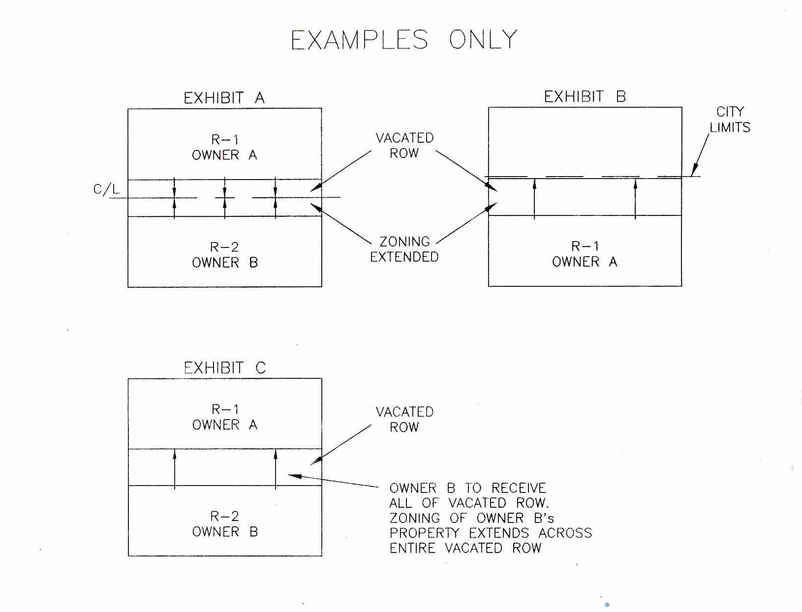
When a right-of-way is vacated, either through action by the city council or by a re-plat approved by the Planning and Zoning Commission, zoning district boundaries shall be approved by separate action of the city council. The following rules shall apply for such zoning district boundary extensions for vacated rights-of-way:
a.
In the event that there are two different properties that receive or purchased the vacated right-of-way, the zoning for the adjoining properties shall be extended to the centerline of what was the right-of-way. See the following exhibit A.
b.
In the event that there is property not within the city adjacent to the vacated right-of-way and the vacated right-of-way is entirely within the city limits, the zoning for the adjoining properties that are within the city limits shall be extended entirely across what was the right-of-way. See the following exhibit B.
c.
In the event that there are two different properties, but only one property is to receive all the vacated right-of-way, the zoning for the receiving properties shall be extended entirely across what was the right-of-way. See the following exhibit C.
d.
Any other situations concerning zoning district boundary extension and vacated rights-of-way not covered in items 2a through 2c above shall be determined by the city council.
(Ord. No. 2354, § I, 1-22-07)