
Las Cruces City Zoning Code
ARTICLE V
- SPECIAL ZONING DISTRICTS
Sec. 38-40. - Special zoning districts—Purpose and uses.
Special zoning districts are zones that have a set of unique provisions or unusual characteristics and have a special purpose other than a general residential, office, commercial or industrial zoning district. Nonspecified land uses which are similar to those land uses listed as allowed, as conditional, or as a special use, may be permitted by the Community Development Director or designee. any decision of the Community Development Director or designee with regard to nonspecified land uses may be appealed to the Planning and Zoning Commission.
The following is a list of the special zoning districts described in this article:
FC Flood control zoning district
OS-R Open space—Recreation zoning district
OS-NC Open space—Natural/conservation zoning district
H Holding zone district
CBD Central business district and Main Street Plaza overlay zone
UD University District Overlay
AdM Avenida de Mesilla Gateway overlay zone district
WMIP West Mesa Industrial Park overlay zone district
LAO Lohman Avenue overlay district
IDO Infill development overlay district
PUD Planned unit development
NMO North Mesquite Neighborhood overlay zone district
SMO South Mesquite Neighborhood overlay zone district
(Ord. No. 2354, § I, 1-22-07)
Sec. 38-41. - FC—Flood control zoning district.
A.
Purpose: The FC flood control zoning district is designed to protect persons and property from periodic flooding by designation of principal floodwater channels and areas contiguous which may become invaded by storm runoff. The FC zone may be used for some agricultural purposes, the commercial raising of some animals, and for recreational activities.
B.
Zoning district:
FC flood control
Engineering study required. Prior to application for any request for a zone change from an existing FC district, an engineering study is required. Such study shall show the location of all flood drainage channels within 500 feet of proposed land uses or structures, anticipated flows at key points, including the anticipated discharge velocity and depth flow, for the ten-year storm (ten percent chance in any given year) and the 100-year storm (one percent chance in any given year.) Such study shall be performed by an engineer, licensed and registered in the state, and shall clearly demonstrate that the proposed use will in no way impair or impede the flow of water, which would result in property damage or endangering human lives.
C.
Flood control district uses:
"C" - Conditional uses: These uses are permitted; however, unique conditions for each conditional land use are listed after the land use table or in section 38-53, conditional uses. There also may be requirements in the Municipal Code with which specific land uses must comply.
"S" - Special uses: The uses require a special use permit to be approved by the Planning and Zoning Commission. these uses could have potential harmful effects on the neighborhood in which they are located. The special use permit process will ensure that mitigation techniques to lessen or eliminate the negative impacts will be required. see section 38-54.
FLOOD CONTROL ZONING DISTRICT USES
Conditions: Conditions for land uses listed above as "C", without a number, are described in section 38-53, conditional uses. Conditions with a number, "C#", are described below:
The raising of animals shall be consistent with the Municipal Code and shall be kept 300 feet from adjacent residential property. Raising of crops and trees shall be kept at least 100 feet from adjacent residential property. There shall be no significant nuisance to neighboring property at the property line due to odor, dust, fertilizers, herbicides, and no prolonged use of noisy equipment.
(Ord. No. 2354, § I, 1-22-07)
Sec. 38-41.1. - Open space zoning districts.
A.
Purpose: The open space zoning districts are intended to:
Allow both public and private lands to serve as areas providing both active and passive recreational opportunities in either a developed (modified) or natural setting.
Protect, preserve and/or restore natural resources and open spaces such as areas of undisturbed native vegetation, arroyos and major land features when development within these areas would be detrimental to the health, safety and general welfare of city residents.
Establish buffer areas that are aimed at mitigating issues involving potentially incompatible land uses.
For purposes of these zoning districts, applicable public and private lands whether developed or in their natural state will be considered as open space. Application of the OS zone designations to private land requires the express written consent of the property owner(s). Designation of the OS zone on private land or portions thereof in no way exempts property that may be under development from complying with LCMC chapter 32, design standards, section 32-279 (public sites and open spaces). Developments that incorporate open space into the overall project design and/or provide applicable facilities or improvements to these open spaces may be subject to special development considerations and flexibility which may include density bonuses, variances and other similar development incentives. Consideration and review of open space designs shall be on a case by case basis and must be deemed beneficial to the city's overall open space network. The city may either approve or reject any proposal. Acceptance of an open space proposal does not guarantee acceptance of these areas for city maintenance.
B.
Zoning district:
Open space
OS-R Open space—Recreation
OS-NC Open space—Natural/conservation
C.
Development standards: Specific requirements for these zoning districts vary depending on the intended use of the proposed open space and any anticipated impact to surrounding properties. Other development requirements above and beyond what is included in this section may apply and as such, reference to applicable chapters within the Las Cruces Municipal Code is recommended.
Open space uses:
"A" - Allowed uses: These uses are allowed if they comply with the development standards deemed applicable by the city, other requirements of this article and all other articles of this zoning code if applicable. There also may be requirements in the Municipal Code with which specific land uses must comply.
"C" - Conditional uses: These uses are permitted; however, unique conditions for each conditional land use are listed after the land use table or in section 38-53, conditional uses enumerated. There also may be requirements in the Municipal Code with which specific land uses must comply.
"S" - Special uses: These uses are generally not permitted by right in a zoning district, but through review and approval to determine surrounding area impacts, may be allowed. Requirements for special uses are listed after the land use table or in section 38-54, special use permits. There also may be requirements in the Municipal Code with which specific land uses must comply.
Open Space Uses by District
Condition notes:
1.
Structures shall be directly related to the use, maintenance or enjoyment of the subject open space. Examples include equipment buildings, gazebos, monuments, restrooms, play equipment, amphitheatre, etc.
2.
Christmas tree stands, fireworks stands, flea markets, and yard, garage or rummage sales on public property are prohibited. see section 38-50 and 38-53 for specific temporary use restrictions.
3.
The raising of animals shall be consistent with chapter 7 of the Municipal Code and shall be kept 300 feet from adjacent residential property. Raising of crops and trees shall be kept at least 100 feet from adjacent residential property. There shall be no significant nuisance to neighboring property at the property line due to odor, dust, fertilizer, herbicides, and no prolonged use of noisy equipment.
4.
See section 38-53. A solid wall or fence shall surround the installation. Landscaping shall be provided to screen and/or buffer the installation as necessary to allow the use to blend with the surrounding properties and minimize noise and visual pollution. When wells are proposed or already situated on property, consideration and adherence to established well head protection policy shall be followed to the extent possible. Telecommunication structures shall be designed to blend into the surrounding landscape or if attached to a structure, the structure itself. Facial mounts are required as applicable and tower structures shall be designed with concealment in mind. Options include but are not limited to flag poles, outdoor lighting standards, towers that mimic trees, etc.
5.
Allowed if an integral part of a recreational open space design. Landscaping shall be provided to screen and/or buffer the use as necessary to allow the use to blend with the surrounding properties and minimize noise and visual pollution as applicable.
6.
These facilities are intended to facilitate access through and enjoyment of applicable areas. Accessory uses such as water fountains, benches, and shade structures may be incorporated into the overall design, but must directly benefit or serve the dominant use.
Special use notes:
1.
See section 38-54 and section 19-164 of the Municipal Code.
2.
Country club must be designed in concert with a golf course or similar type of large open land area.
(Ord. No. 2354, § I, 1-22-07)
Sec. 38-42. - H—Holding zone district.
A.
Purpose: The holding zoning district is intended for property that is not predominantly developed and the property owners do not have plans or are not ready to develop their property. Subdividing the property into lots of one acre or larger is allowed. One detached single-family dwelling may be constructed on any lot of record, i.e., any lot recorded at the county courthouse before the time of annexation. A one time remodeling of an existing structure is also allowed.
B.
Zoning district: H holding.
C.
Development standards: Development standards for the EE zoning district shall apply.
D.
Holding zone district uses:
"A" - Allowed uses: These uses are allowed if they comply with the development standards, other requirements of this article and all other articles of this zoning code. There also may be requirements in the Municipal Code with which specific land uses must comply.
"C" - Conditional uses: These uses are permitted; however, unique conditions for each conditional land use are listed after the land use table or in section 38-53, conditional uses enumerated. There also may be requirements in the Municipal Code with which specific land uses must comply.
Holding Zone District Uses
Conditions: Conditions for land uses listed above as "C," without a number, are described in section 38-53, conditional uses. Conditions with a number, "C#," are described below.
1.
A one-time remodeling of an existing structure is defined as the altering of the interior and/or the exterior, including additions.
(Ord. No. 2354, § I, 1-22-07)
Sec. 38-43. - Downtown Development Code.
A.
Purpose. The purpose of this section and the zoning districts defined herein is to accommodate government facilities, retail, office, residential, and other similar uses in the downtown area of the city with appropriate height, yard, and intensity standards to allow for a higher density and intensity of development. Further, the properties described within the Main Street (MS) zoning district are identified as a special area within the Downtown to encourage revitalization through incentives and clearly defined development standards. See Table 1. Downtown Regulating Plan for the district boundaries, See Sec. N. MS Architectural Standards for development standards that apply to the MS district only.
1.
The Downtown Development Code is designed to foster infill redevelopment in a mixed-use pattern as part of a vibrant, diverse, downtown.
2.
This Section is intended to promote traditional urban form and a lively mix of uses, allowing for shopfronts, sidewalk cafes, and other commercial uses at the street level, with wide sidewalks and shade trees, overlooked by upper story residences and offices. It also provides a setting for major activities that benefit the community such as markets, festivals, and entertainment.
3.
A range of open spaces should be distributed within adjacent neighborhoods and throughout downtown.
4.
Buildings and landscaping should contribute to the physical definition of thoroughfares as civic places.
5.
The transect designations in Sec. B. Zoning Districts shall describe the general character of downtown.
B.
Zoning Districts. Zoning districts are limited to the following transect designations:
1.
Downtown (DT): This district consists of higher intensity mixed-use buildings that accommodate retail, offices, institutional, and residences. The thoroughfares have wide sidewalks with street trees and buildings are set close to the sidewalks.
2.
Main Street (MS): This district is similar in use and character to DT, but the massing and proportions are in harmony with an urban core.
3.
General Urban (GU): This district includes a mix of uses, but is primarily in the form of medium-intensity mixed use structures. It may have a wide range of building types: residences, live-work units, commercial buildings, theaters, and mixed-use buildings. The thoroughfares have wide sidewalks and buildings are set close to the sidewalks.
C.
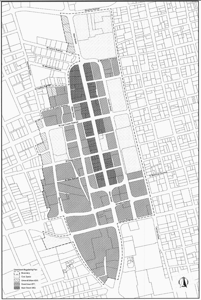
Downtown Regulating Plan.
1.
The regulating plan is the zoning map and principal tool for implementing the Downtown Master Plan, as amended. It identifies the transect district for the building site (See Table 1. Downtown Regulating Plan) which regulates standards for each lot.
2.
New development in Downtown shall provide sidewalk improvements, civic spaces as needed, and contribute to a shared parking and access strategy to create a complementary pattern for growth and development. The rules below will enhance a compact, economically sustainable, mixed-use downtown that complements the adjacent neighborhoods and provides flexible opportunities for residential, employment, government, institutional, and commercial uses.
3.
Where present, alleys shall provide access to the rear of all lots. Alley dedication and construction within the rear setback is required as part of a redevelopment project if they do not exist. Alleys shall be constructed pursuant to Table 16. Access and Sec. T. Streetscape.
D.
Instructions.
1.
Find the transect zone for your parcel in Table 1. Downtown Regulation Plan.
2.
Site and building plans submitted under this Section shall include the following, in compliance with the standards described in this Section:
a.
Site Plan/Building Placement
b.
Building Specifications including floor plans (See § H through § K.)
c.
MS Architectural Standards, if applicable (See § L.)
d.
Fencing (See § M.)
e.
Signs (See § N.)
f.
Use (See § O.)
g.
Parking (See § P.)
h.
Landscaping (See § Q.)
i.
Streetscape, if applicable (See § R.)
3.
Site and building plans submitted under this Section require review by respective City departments for appropriate compliance with other applicable City codes and ordinances and final approval by the Community Development Department.
TABLE 1. DOWNTOWN REGULATING PLAN
E.
Definitions. This Sub-section provides definitions for terms in this Section that are technical in nature or that otherwise may not reflect a common usage of the term. Additional definitions are in Article III of Chapter 38, Zoning Code and Sec. 36-3 of Chapter 36, Signs.
Alley: a vehicular way located to the rear of lots providing access to service areas, parking and accessory structures.
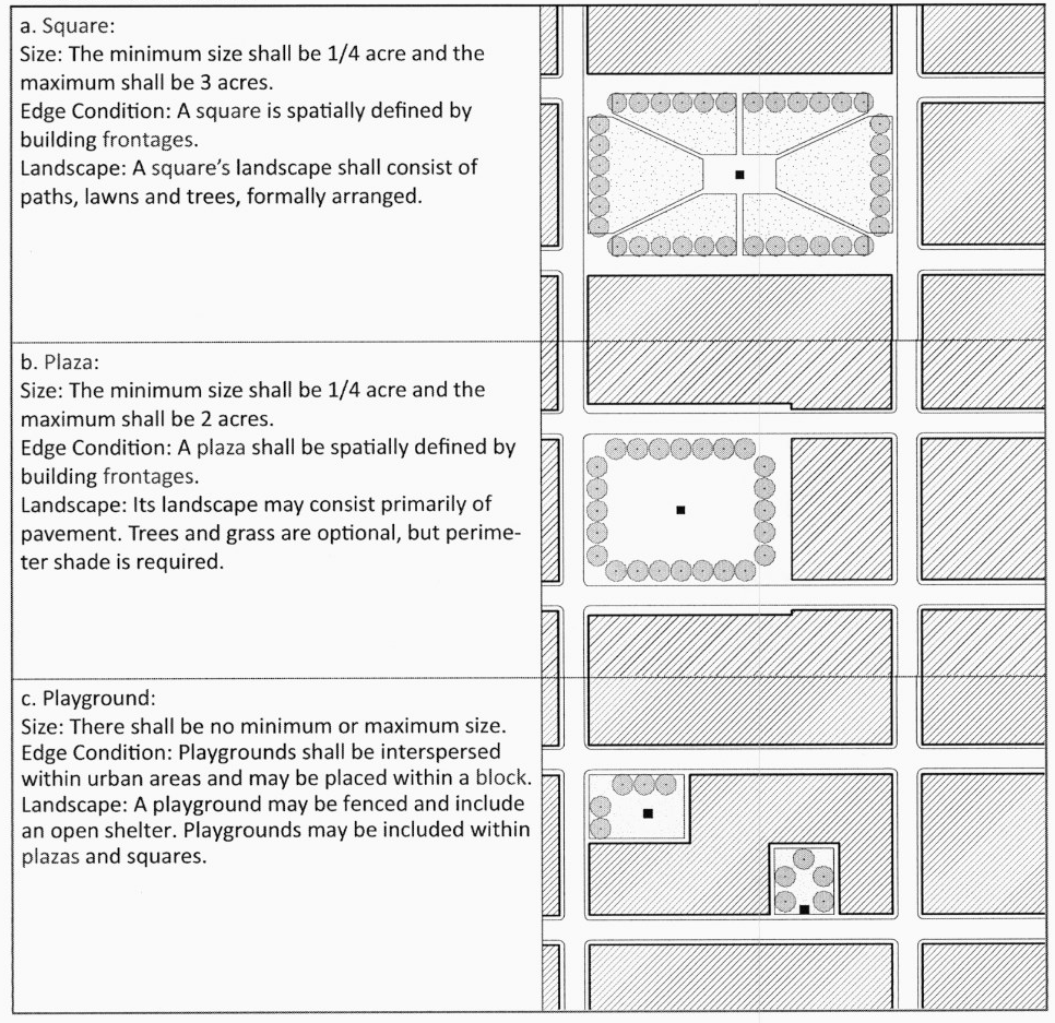
Civic Space: an outdoor informal or formal area permanently dedicated for public use. See Table 2. Civic Space.
TABLE 2. CIVIC SPACE
Director: City of Las Cruces Community Development Department Director.
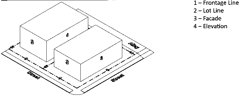
Elevation: an exterior wall of a building not along a frontage line. See: facade. See Table 3. Terminology Illustrated.
Encroach: to break the plane of a vertical or horizontal regulatory limit with a structural element extending into a setback, into the public frontage, or above a height limit.
Encroachment: any structural element that breaks the plane of a vertical or horizontal regulatory limit extending into the public frontage setback, or above a height limit.
Facade: the exterior wall or elevation of a building that is set along a frontage line. See Table 3. Terminology Illustrated.
Frontage: the area between a building facade and the vehicular lanes, inclusive of its built and planted components. Frontage is divided into private and public frontages. See Table 3. Terminology Illustrated.
Primary Frontage: on corner lots, the private frontage designated to bear the address and principal entrance to the building, and the measure of minimum lot width. Prescriptions for the parking locations pertain only to the principal frontage. Prescriptions for the front setback pertain to both frontages of a corner lot. See frontage.
Secondary Frontage: on corner lots, the private frontage not on the primary thoroughfare.
Private Frontage: the privately owned setback between the frontage line and principal building facade.
Common Entry: a private frontage configuration for office and residential use, wherein the facade is aligned close to the frontage line with the primary building entrance at sidewalk grade. The common entry may be buffered by a planter at the sidewalk.
Forecourt: a private frontage yard wherein a portion of the facade is close to the frontage and the central portion is set back.
Gallery: a private frontage configuration for retail use wherein the facade is aligned close to the frontage line with an attached cantilevered shed or lightweight colonnade overlapping the sidewalk.
No Yard: a private frontage yard type with zero setback at the frontage line.
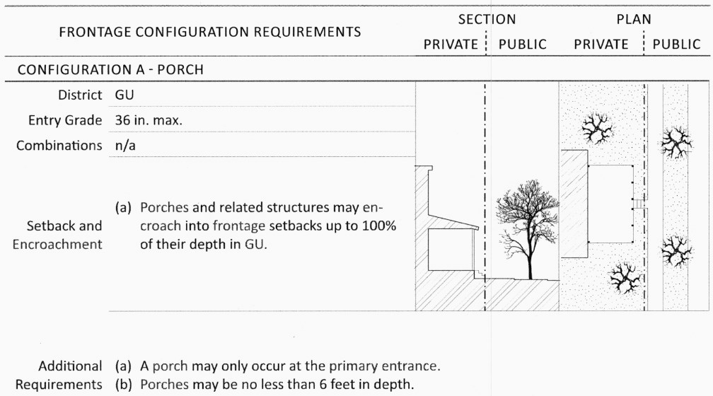
Porch: a private frontage configuration wherein the facade has a covered patio or elevated area at the primary entrance.
Shopfront: a private frontage configuration for retail use, with substantial glazing, wherein the facade is aligned close to the frontage line with the building entrance at sidewalk grade.
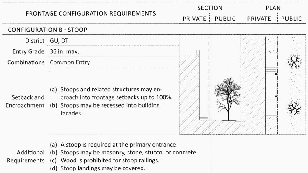
Stoop: a private frontage configuration wherein the facade is aligned close to the frontage line with the first story elevated from the sidewalk for privacy, with an exterior stair and landing at the entrance.
Terrace: a private frontage yard type with a shallow setback and front elevated patio, usually with a low wall at the frontage line. This type buffers residential uses from urban sidewalks. Terraces are also suitable for outdoor cafes.
Walled Yard: a private frontage yard type with a wall at the frontage line.
Frontage buildout: the percentage of the lot width that is occupied by the building facade at the front setback.
Frontage Line: a lot line bordering a public frontage. Facades facing frontage lines define the public realm and are therefore more regulated than the elevations facing other lot lines.
Landscaped Area: the area of a lot or parcel exclusive of building footprints, driveway and walkway pavements, and other impervious hardscape areas, and exclusive of ponds, pools and other water features.
Liner building: a building specifically designed to mask a parking lot or a parking structure from a public frontage.
Live-Work: a mixed-use unit consisting of a commercial and residential use. The commercial use may be anywhere in the unit.
Lot Coverage: the percentage of a lot that is covered by buildings and other roofed structures.
Mixed-Use: multiple uses within the same building or in multiple buildings.
Pedestrian Passage: a pedestrian access between or through buildings. The passage may connect midblock parking to the street.
Principal Entrance: the main point of access for pedestrians into a building.
Signs: Signs shall be defined pursuant to Chapter 36, Signs. Additional definitions are as follows:
Changeable Copy: A sign which allows characters, letters, or illustrations to be changed without altering the sign.
Display Case: A display case located on the facade of a building which displays menus, handbills or posters advertising a scheduled event, performance or film, and merchandise associated with the event, performance or film.
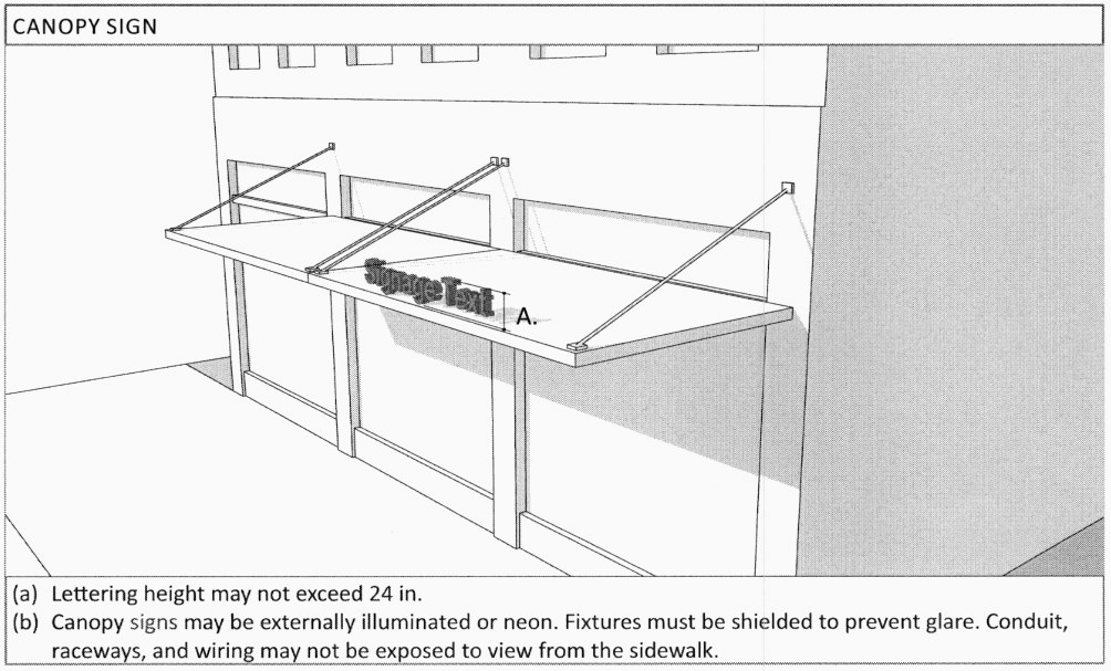
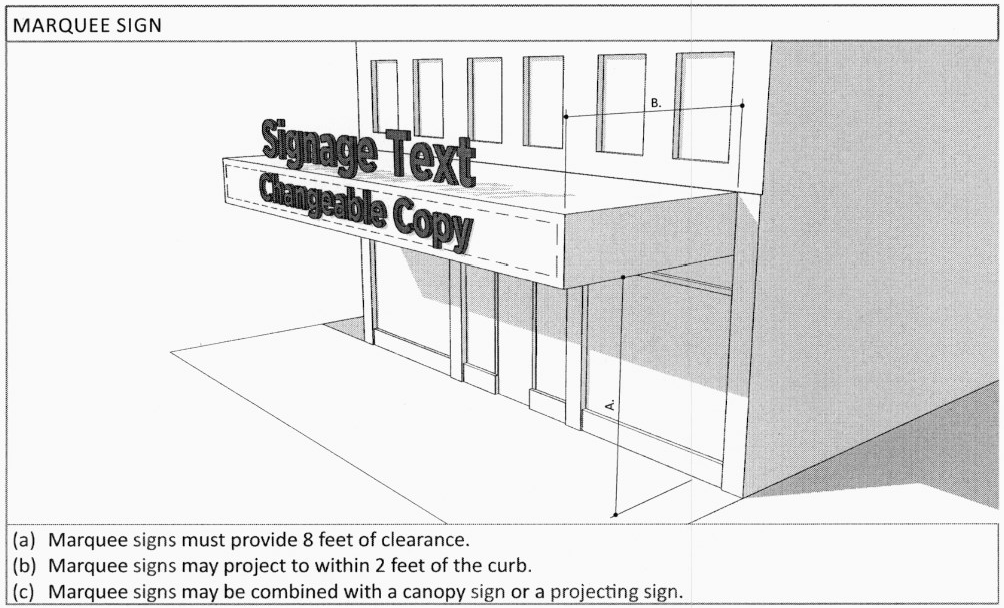
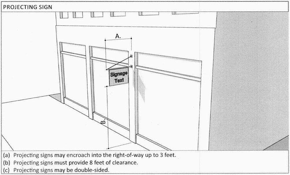
Projecting Sign: A small sign, which is suspended from an overhang, canopy, marquee, or awning, or is suspended from a mounting attached directly to the building wall, and hangs perpendicular to the building wall. An 8-foot clearance is required between a projecting sign and finished grade.
Story: a habitable level within a building, excluding an attic or raised basement.
Streetscreen: a freestanding wall built along the frontage line with the facade. It may mask a parking lot from the public frontage, provide privacy to a side yard, and/or strengthen the spatial definition of the public realm. (Syn: streetwall).
Transect: categorization system that organizes all elements of the built environment.
Use, Civic (See § O.): community uses open to the public including: meeting halls; libraries; schools; police and fire stations; post offices (retail operations only, no primary distribution facilities); places of worship; museums; cultural, visual and performing art centers; transit centers; and government functions open to the public.
Use, Commerce (See § O.): commerce uses shall be considered to encompass all of the following:
1.
Executive, Administrative, and Professional Offices
2.
Medical and Dental Offices, and Clinics
3.
Day Care Centers
4.
On-premise Alcohol Sales
5.
Sidewalk Cafes
6.
Outdoor Food and Beverage Service
7.
All of the Civic Use Categories
8.
All of the Retail Use Categories
9.
Parking Facilities and Structures
Use, Cottage Industry (See § O.): cottage industry uses shall refer to an industry whose labor force consists of individuals working at home with their own equipment.
Use, Lodging (See § O.): lodging uses are defined as premises available for daily and weekly renting of bedrooms and shall be considered to encompass all of the following:
1.
Bed and Breakfast
2.
Inn
3.
Motel
4.
Hotel
Use, Residential (See § O.): residential uses shall be considered to encompass all of the following:
1.
Dwelling Units
2.
Adult Foster Care Family Home
3.
Family Day Care Homes
4.
Foster Family Homes
5.
Homes for the Disabled
Use, Retail (See § O.): retail uses shall be considered to encompass all of the following:
1.
Retail service: establishments providing services, as opposed to products, to the general public, including restaurants, finance, real estate and insurance, travel agencies, health and educational services, galleries, and temporary storage, provided that the temporary storage is ancillary to the primary retail service.
2.
Retail specialty: Include, but are not limited to the sale of gifts, antiques, flowers, books, jewelry, wearing apparel or craft shops making articles exclusively for sale at retail on the premises.
3.
Retail trade: Establishments engaged in selling new goods or merchandise to the general public for personal or household consumption and rendering services incidental to the sale of such goods.
_____
TABLE 3. TERMINOLOGY ILLUSTRATED
F.
Existing Building and Property Alteration, Remodel, or Renovation.
1.
For the purpose of this section, alteration, remodel, or renovation shall be defined as: Any change or rearrangement in the supporting members of an existing building, such as bearing walls, columns, beams, girders, as well as any change in rooflines, or any enlargement to or diminution of a building or structure, whether horizontally or vertically.
2.
Minor modifications. For the purpose of this section, a minor modification shall be one that does not result in an alteration, remodel, or renovation as described in Section F.1. The minor modification of an existing building or property is permitted by-right if such changes result in greater conformance with the purposes and specifications of this Section. The minor modification must comply with the design standards and codes unless, through the determination of the Director or designee, said compliance would substantially create an undue burden to the property owner or create a condition whereby the expansion and compliance measure, partially applied, would be substantially out of character with the existing development.
3.
Existing buildings and properties that do not conform to the provision of this Section may continue in use as they are. However, they shall be brought into compliance with current codes and standards when:
i.
The property remains vacant for a period of one continuous year or greater; or
ii.
Alteration, remodel, or renovation causes one-time or cumulative amendments to 30 percent or greater of the gross square footage of building area; or
iii.
A change in use occurs on the property which results in the alteration of the use orientation (e.g. service to retail), or density (e.g. eight dwelling units to 15 dwelling units) or change in occupancy type from the building code perspective.
4.
Once permission to proceed has been granted by the Director or designee, the applicant may apply for the permit. Work shall not commence until permit approval is granted.
5.
The restoration or rehabilitation of an existing building shall not require the provision of parking in addition to that existing, nor on-site stormwater retention/detention in addition to that existing, unless otherwise required by County or State code.
6.
Normal maintenance activities as verified by the city's building official or designee are exempt from this provision.
7.
Should an applicant not agree with the interpretation by the Director or designee, the interpretation may be appealed to the Planning and Zoning Commission.
G.
Building Placement.
1.
Lot coverage by building shall not exceed that recorded in Table 4 - Table 6.
2.
Facades shall be built parallel to the principal frontage line, and along a minimum percentage of the frontage width at the setback, as specified as frontage buildout on Table 4 - Table 6.
3.
Setbacks for principal buildings and accessory buildings shall be as shown in Table 4 - Table 6. Setbacks may be adjusted by up to 10 percent by administrative waiver to accommodate specific site conditions. The Director or designee shall make the following written findings:
a.
The waiver is consistent with the provisions of Sec. B. Zoning Districts.
b.
The waiver is consistent with the Downtown Master Plan.
c.
The building placement will not materially endanger the public health or safety.
d.
The location and character of the building placement, if developed according to the plans and information approved, will be in harmony with proximate land uses, and consistent with the purposes of the district.
e.
The building placement will not adversely affect Downtown by altering its character.
TABLE 4. BUILDING FORM STANDARDS - GU
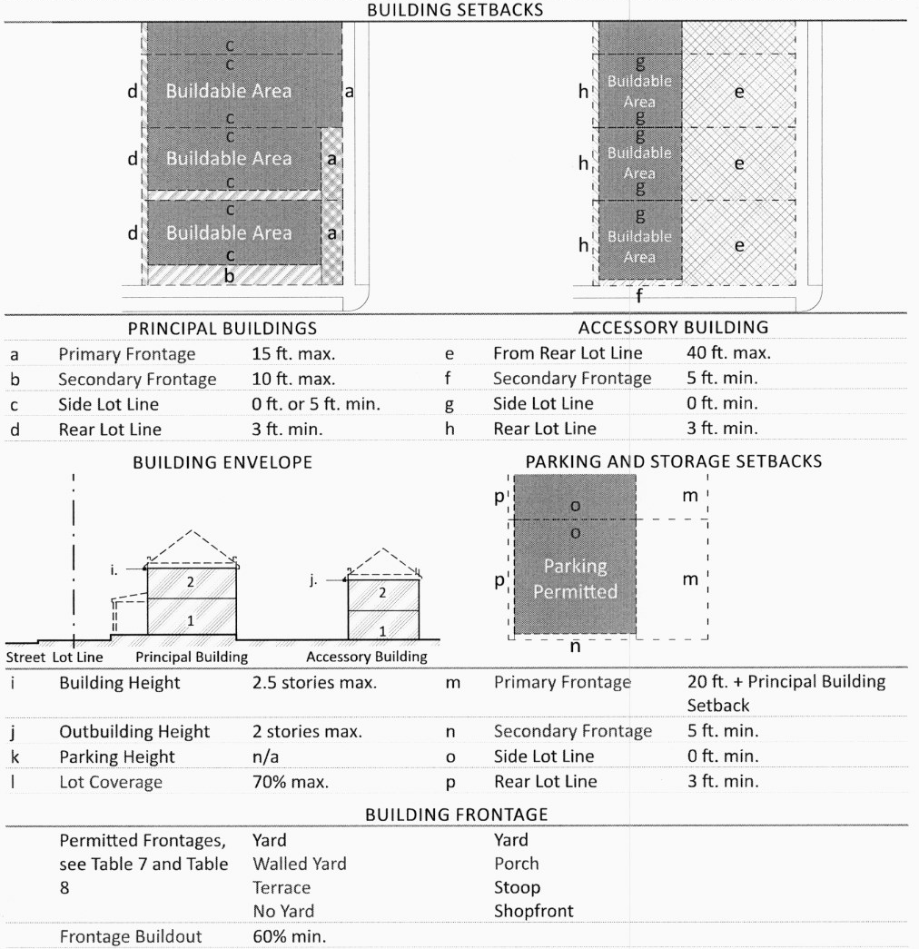
TABLE 5. BUILDING FORM STANDARDS - DT
TABLE 6. BUILDING FORM STANDARDS - MS
H.
Building Specifications: Height.
1.
Building height is regulated by Table 4—Table 6, measured as follows:
a.
Building height is measured in above ground stories.
b.
Stories are measured from finished floor to finished ceiling.
c.
Stories above the ground floor are limited to 14 feet after which height they are counted as two stories.
d.
For residential uses, a ground floor story of 16 feet or less is counted as one story. Ground floors exceeding 16 feet in height are counted as two stories.
e.
For non-residential and mixed-uses a ground floor story shall be no less than 10 feet in height. A ground floor story of 25 feet or less is counted as one story. Ground floors exceeding 25 feet in height are counted as two stories. Mezzanines extending beyond 33% of the floor area shall be counted as an additional floor.
f.
Height limits do not apply to unfinished attics, masts, belfries, clock towers, chimney flues, water tanks, or elevator bulkheads.
g.
Building stepbacks shall be required in MS pursuant to Table 6.i.
I.
Building Specifications: Frontage Requirements.
1.
Lot lines abutting a right-of-way are designated as a primary frontage or secondary frontage as follows:
a.
For lots abutting a right-of-way along a single lot line, the lot line abutting the right-of-way is designated the primary frontage.
b.
For lots abutting a right-of-way along multiple lot lines, the lot line relating to the address of the principal building is designated the primary frontage. All remaining lot lines are designed secondary frontages.
c.
Main Street is considered the primary frontage for all lots abutting the right-of-way.
2.
Regulations pertaining to primary frontages and secondary frontages, collectively frontage requirements, apply to the area of the lot within the front setback and secondary front setback including the following:
a.
Building facades;
b.
Structures that project from the facade such as porches, terraces, stoops, awnings, canopies, and galleries;
c.
Landscape elements and ground surfaces between the building facade and the lot line.
3.
Where building facades do not occupy the entire frontage length, a streetscreen is required as follows:
a.
Streetscreens must be between 4 and 8 feet in height.
b.
Openings in the streetscreen for vehicular access may be no wider than 26 feet.
c.
Streetscreens shall provide no less than 70 percent opacity.
4.
Frontages are regulated by frontage type according to Table 7, Table 8, and as follows:
a.
Landscaping, fencing, and general surface treatment are regulated according to frontage yard type pursuant to Table 7.
b.
Encroachments and configurations are regulated according to frontage configuration type pursuant to Table 8.
c.
Frontage types are a combination of frontage yard type and frontage configuration type.
d.
Where frontage yard types permit multiple frontage configuration types, one or more frontage configuration type may be selected for each facade.
5.
Frontage types must be designated at all building frontages and must comply with the standards for that type.
6.
A shopfront frontage is required for all ground floor retail uses.
7.
Building entries must be provided along frontages as follows:
a.
The principal entrance must be located at the primary frontage.
b.
All habitable spaces within a building must be accessible from frontages.
c.
Building entries must be provided at primary frontages at a minimum of one entry for every 50 feet of frontage.
d.
Building entries must be provided at secondary frontages at a minimum of one entry for every 150 feet of frontage.
8.
Loading docks and service areas up to a combined width of 30 feet may be incorporated into secondary frontages no more than 50 feet from the rear lot line.
TABLE 7. FRONTAGE TYPES - YARD
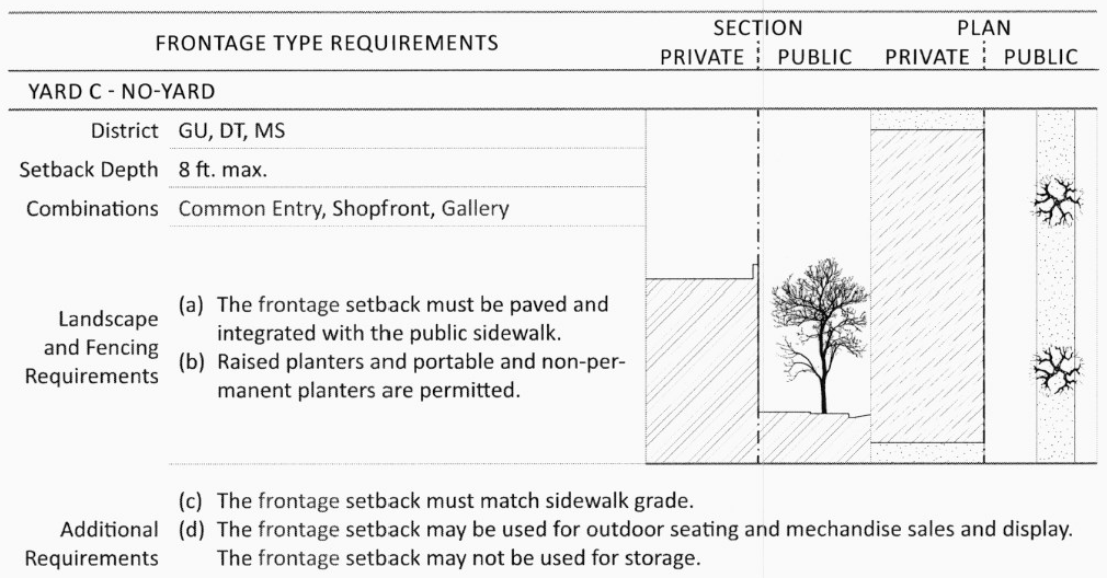
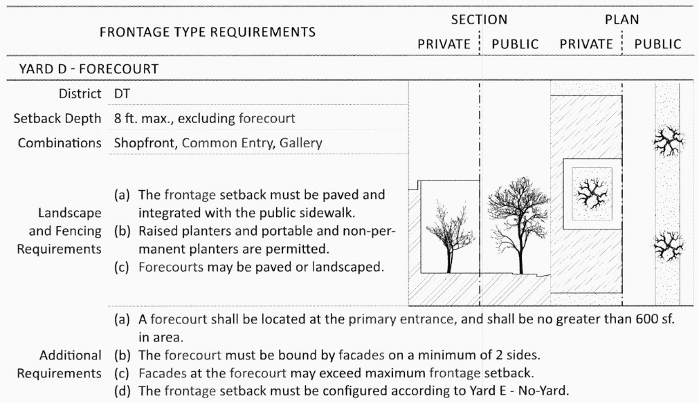
TABLE 8. FRONTAGE TYPES - CONFIGURATION
J.
Building Specifications: Encroachments.
1.
Encroachments into frontages are permitted as follows:
a.
Encroachments in frontage setback are prohibited except where specifically permitted in this Section, Table 7, and Table 8.
b.
Roof overhangs, cornices, window and door surrounds and other facade decorations may encroach into the front setback up to 2 feet but not beyond the lot line, and may not obscure views from windows to the street or from the street into windows.
c.
Shading devices may encroach into frontage setbacks as follows:
d.
In GU, shading devices attached to facades may encroach up to 6 feet, but not beyond the lot line.
e.
In DT and MS, shading devices may encroach into the front setback up to the lot line, and into the right-of-way up to 10 feet or within 2 feet of the curb.
f.
Balconies may encroach into the frontage setback a maximum of 3 feet, but not beyond the lot line.
g.
Bay and bow windows may encroach into the frontage setbacks up to 3 feet, but not beyond the lot line.
2.
Encroachments into pedestrian passages are permitted as follows:
a.
A minimum of 14 feet in height must be maintained along the entire length of pedestrian passage.
b.
Buildings and structures may encroach over pedestrian passages.
c.
An unobstructed pedestrian path must be maintained a minimum of 5 feet in width and 8 feet in height. The pedestrian path is required to be continuous however it is not required to follow a straight line.
d.
Signage, bay and bow windows, balconies, lighting fixtures, and display windows may encroach into pedestrian passages.
e.
Outdoor seating, outdoor dining, and other non-permanent fixtures may encroach into pedestrian passages.
K.
Building Specifications: Glazing.
1.
Facade glazing at building frontages must meet the minimum area requirements, calculated by glass area for each facade separately, as specified in Table 9. Minimum Facade Glazing.
TABLE 9. MINIMUM FACADE GLAZING
2.
Mirrored and reflective glass is prohibited.
3.
Shopfront frontages must meet the following glazing requirements:
a.
Shopfronts must provide clear glazed areas for visibility into tenant spaces for no less than 60 percent of the shopfront area.
i.
Facade area is calculated as the height from finished floor to finished ceiling times the width of the tenant space.
b.
Shopfront glazing requirements are calculated separately for each tenant space.
4.
Signs and posters shall cover no more than 30 percent of the total glazing area.
L.
MS Architectural Standards. This sub-section supersedes the zoning district standards for any subject addressed in the MS zoning district.
1.
Building Width:
a.
New buildings facing Main Street shall not exceed the average building width on their block except as follows:
i.
Buildings may be a maximum of 150 feet wide if the facade is designed to simulate the average width of buildings on the block.
2.
Facade Standards:
a.
Glazing at the second story shall not exceed 30% of the second story building facade wall area.
b.
Mechanical equipment shall be screened from the street view.
3.
Sidewalk Coverings:
a.
When awnings, canopies or galleries are used, they shall be designed and installed in compliance with building codes.
b.
Sidewalk coverings shall not obscure architectural details of designated historic building facades.
4.
Signs:
a.
Signs shall not obscure other building elements such as windows, cornices or architectural details.
b.
Individual business signs in a single storefront shall relate to each other in design, size and placement on the building and lettering style.
c.
Externally illuminated signs shall contain light within the sign frame and shall not spill light over to other portions of the building.
M.
Fencing.
1.
Hedges in frontage fences shall be evergreen.
2.
Wood frontage fences shall be painted or stained.
3.
Lot line fences shall be between 60 and 72 inches in height.
4.
Frontage fences shall not exceed 48 inches in height nor violate the clear sight triangle.
5.
Frontage fences may occur at the lot line, or up to 18 inches behind the lot line to permit landscaping.
6.
When erected on a lot line, all of the fence and any of its supporting structures shall be contained within the lot.
7.
The supporting members and posts shall be on the inside, and the smooth or flat faces on the outside. If two faces are used, each face shall be of the same type and finish. Board on board fences is considered equal treatment.
8.
Chain link, barbed wire, razor wire, and electrically charged fences are not permitted.
N.
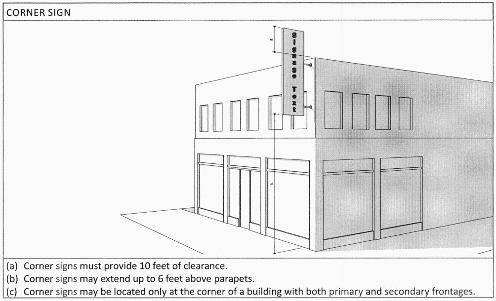
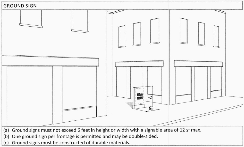
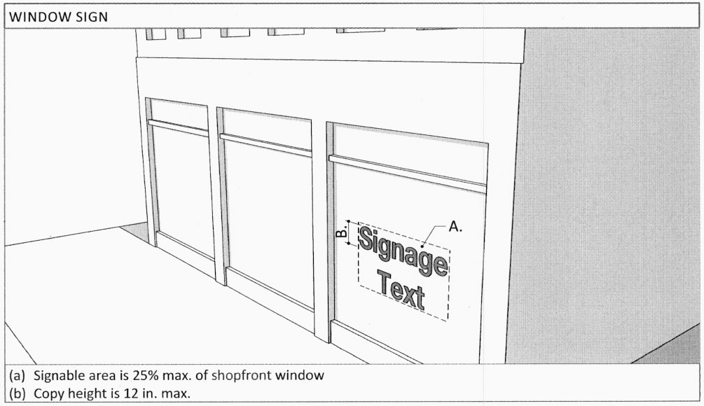
Signs. The general intent of regulating signs that are visible from the public frontage is to ensure proper dimensioning and placement with respect to existing or planned architectural features, to maintain or improve public safety, to maintain or improve the aesthetic character of the context in which they are located (See Table 10). Signage provides legible information for pedestrians as well as drivers.
Except with respect to the additional provisions in this section, Chapter 36, Signs shall be applicable and govern pursuant to the administration, processes and provisions for all signage within the City Limits of the City of Las Cruces. However, only the signage types permitted in this subsection and Table 10. General Sign Restrictions hereof shall be permitted in the Downtown. Unless specifically defined in Sec. E. Definitions, all definitions used in this Section shall be as defined in Sec. 36-3 of Chapter 36, Signs.
1.
Prohibited Signs.
a.
Moving, flashing, or animated signs including but not limited to searchlights, streamers and spinners;
b.
Inflatable signs, such as but not limited to balloons, gas inflated signs or similar inflated signs;
c.
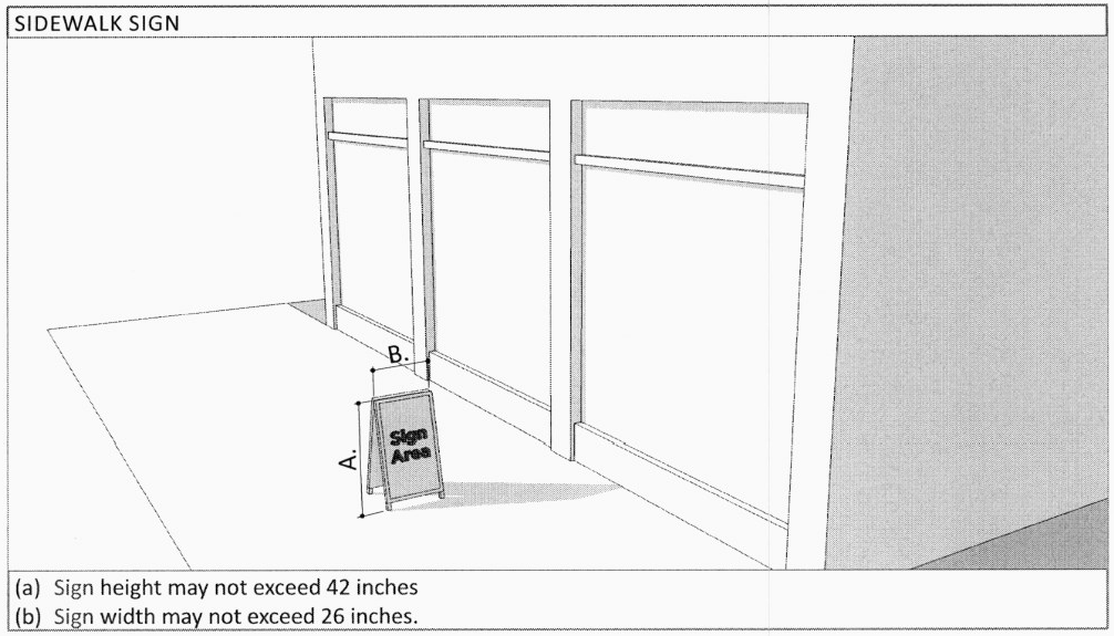
Portable signs, except for sidewalk signs as allowed in Table 10;
d.
Flags, other than those specifically allowed in Chapter 36, Signs;
e.
Outdoor image projections (signs projected from an external light source onto a building or structure) or any other similar devices.
2.
Permitted Signs and Sign Restrictions.
a.
Permitted sign types are limited by Transect district and the following restrictions according to Table 10. General Sign Restrictions:
i.
The number of signs per sign type;
ii.
The area of signs;
iii.
Height of sign copy.
b.
Additional sign restrictions apply per sign type according to Table 11. Specific Sign Regulations.
c.
A permit is required for the installation or modification of all signs as specified in Table 11 as Permit.
i.
Signs projecting into rights-of-way require a revocable permit.
ii.
Signs not requiring a permit must meet all of the requirements of this section.
iii.
Signs requiring building inspector approval must be designed by a structural engineer.
d.
Signs may be installed and maintained for the period of time specified according to Table 10 as Period.
i.
All signs must be removed within 14 days of the termination of the permitted period. Signs permitted for a permanent period are not regulated by this subsection.
ii.
Where the period of a sign is limited to during business hours, the sign must be removed during all hours the establishment is not in operation.
iii.
Any moveable signs must be removed from outdoor spaces during high winds or other weather conditions that might pose a hazard to public safety.
e.
All signs must provide the following clearance except where specified otherwise:
i.
8 feet at pedestrian ways;
ii.
13.5 feet at vehicular ways.
f.
Illuminated signs are permitted as follows:
i.
Signs may be illuminated by a light source external to the sign;
ii.
Internally illuminated signs are permitted at shopfront frontages.
g.
Changeable copy is permitted for display cases, suspended, kiosk, ground, and sidewalk signs, and at community and regional parks. Change of copy does not require a permit.
TABLE 10. GENERAL SIGN RESTRICTIONS
TABLE 11. SPECIFIC SIGN REGULATIONS
O.
Uses.
1.
Lot and building use is allowed according to Table 12. Allowed Uses by use category and subcategory.
2.
Multiple uses within a single lot or building are permitted in all districts.
3.
Accessory uses are permitted as follows:
a.
Accessory dwellings in GU are limited to housing related to the principal dwelling, rental housing and home office uses, not exceeding 600 square feet per story.
b.
Home occupations are permitted subject to obtaining a use permit in accordance with the provisions of Sec. 38-52.
4.
Manufacturing uses, other than cottage industries, are not permitted Downtown.
5.
Conditional Uses are permitted pursuant to Sec. 38-53.
TABLE 12. ALLOWED USES
(A) Approved by Right (C) Conditional (NP) Not Permitted
P.
Parking.
1.
Off-street Parking Location and Access.
a.
Off-street parking shall be provided in accordance with achieving the downtown master plan goals and policies and supporting the development proposal.
b.
Additional off-street parking is not required in the downtown transects. Unless otherwise specified, off-street parking design shall comply with Sec. 38-58 of Chapter 38, Zoning as well as any state and federal regulations.
c.
When provided, parking may not be located within 30 feet of the primary frontage line and 20 feet of secondary frontage lines.
d.
Parking areas shall have well-delineated pedestrian access routes to the most direct entrance of the building they serve.
e.
Parking may be fulfilled in the following locations:
i.
Parking spaces provided within the lot
ii.
Parking spaces provided along a parking lane (on-street) corresponding to lot frontages.
iii.
Parking spaces leased from a private or public parking facility within 500 feet of the lot.
iv.
Parking spaces managed by an established parking district.
2.
Parking lots and structures visible from frontages require one of the following screening methods or a combination of methods:
a.
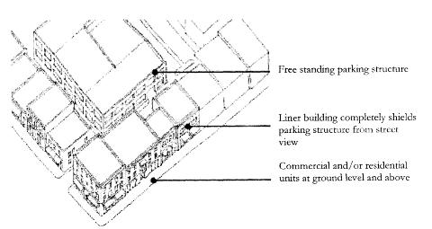
Liner buildings, optional at parking lots and required at parking structures. The ground floor frontages of parking structures shall be screened with liner buildings with the exception of ingress and egress points.
b.
A masonry wall no less than 4 feet in height.
c.
An evergreen hedge, or other landscape element to screen the view of parking, no less than 4 feet in height.
3.
Driveways providing access to off-street parking are limited to 24 feet (2-way) in width in DT or MS and 10 feet (1-way) in width in GU.
4.
Vehicular access to off-street parking is restricted as follows:
a.
Lots with rear alley access must provide vehicular access from a rear alley.
b.
One curb-cut is permitted for each secondary frontage. Curb cuts shall comply with Chapter 32, Design Standards.
c.
Where secondary frontages are not available, one curb-cut is permitted at the primary frontage for lots with a minimum width of 80 feet.
5.
Pedestrian access to off-street parking must be provided from frontages, according to the following:
a.
A minimum of one ADA-compliant walkway must be provided between each lot frontage and off-street parking areas.
b.
Pedestrian access walkways must be a minimum of 6 feet in width in DT.
6.
Shared Vehicular Parking Options.
a.
The number of spaces provided may be reduced according to Table 13, completed as follows:
i.
For each use, enter the minimum required spaces as specified in Table 13, into the first column.
ii.
For each time of day, multiply the required spaces per use by the occupancy rate, and enter the sum of the resulting column in the bottom row.
iii.
The resulting reduced minimum required parking spaces is the highest value entered in the bottom row.
TABLE 13. SHARED PARKING
Q.
Landscaping.
1.
The spacing and placement of plants shall be adequate and appropriate for the typical size, shape and habit of the plant species at maturity.
2.
Landscape quantities shall be determined by Article IV, Development Standards for Landscaping of Chapter 32, Design Standards.
3.
Proposed trees and understory trees shall be centered horizontally and minimally:
a.
Three (3) feet from walkways, curbing and other impervious pavements;
b.
Five (5) feet from street lights, underground utilities, utility meters and service lines, fences, walls and other ground level obstructions;
c.
Six (6) feet from porch eaves, and awnings and similar overhead obstructions associated with the ground level of buildings;
d.
Eight (8) feet from balconies, verandas, building eaves and cornices, and similar overhead obstructions associated with the upper stories of buildings.
4.
Ground vegetation with spines, thorns or needles that may present hazards to pedestrians, bicyclists or vehicles are prohibited within two (2) feet of the sidewalk or street.
5.
Bare and exposed ground shall be covered with live plant materials and/or mulch, including gravel mulch.
6.
Artificial plants or artificial turf are prohibited.
7.
Specific to DT and MS.
a.
Landscape islands in interior parking lots shall only occur at the end of drive aisles. Islands should be the minimum size for healthy growth for the specific species of tree.
b.
Porous paving materials and other green infrastructure methods may be used in order to increase storm water infiltration on site.
8.
Any tree species and cultivar applicable for planting in the Downtown Las Cruces microclimate may be considered for planting within Downtown public squares, plazas, and private parcels, with the exception of those identified in Table 14. Prohibited Plants.
TABLE 14. PROHIBITED PLANTS
R.
Streetscape. The primary use of thoroughfares is to provide access to private lots and public civic spaces. In accordance with the intent of this Section, streetscape improvements shall be designed to support several modes of transportation: public transportation, motor vehicles, and non-motorized vehicles such as bicycles and pedestrians.
1.
Alley easements include one (1) bi-directional vehicular lane, within a total width alley of not less than 20 feet. The entire right-of-way should be paved and remain with clear access.
2.
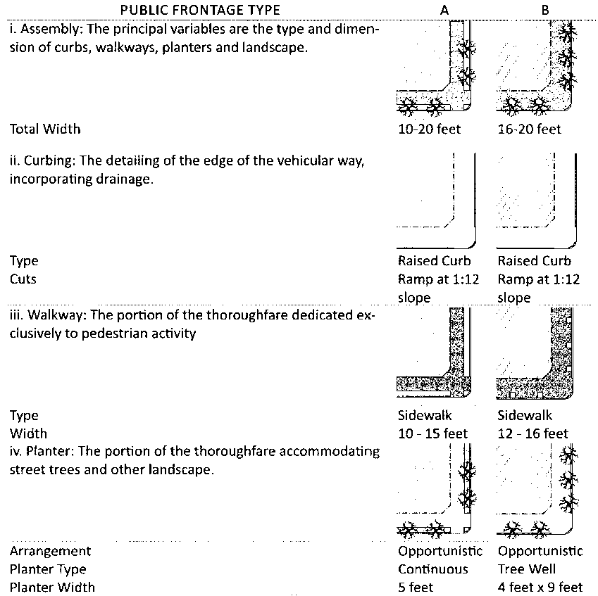
At the time of, and within, new or infill development trees shall be planted at an average spacing of no less than 40 feet on center within the front setback of the parcel being developed unless the front setback is less than 8 feet pursuant to Table 15. Public Frontage Type.
3.
Streetscape improvements may be made pursuant to Table 15.
a.
At commercial frontages the spacing of trees may be irregular to avoid visually obscuring shopfronts.
b.
At gallery frontages, public planting is not required and public lighting may be provided within the gallery.
c.
Tree spacing may be adjusted up to 20 percent by administrative waiver to accommodate specific site conditions.
TABLE 15. PUBLIC FRONTAGE TYPE
S.
Sidewalk displays on public property.
1.
Sidewalk display means the outdoor display of merchandise for sale to the public during regular business hours by any person, persons or organization when such merchandise is displayed on a portion of, or entirely on a public sidewalk or public place not designed for vehicular traffic.
a.
All agents, employees or representatives conducting a sidewalk display on Main Street between the roundabout and Bowman in downtown Las Cruces, shall comply with the following provisions:
(i)
All sidewalk displays shall only be conducted during regular business hours;
(ii)
All displays shall be installed and removed by the business or property owner daily;
(iii)
No booths, tables or display merchandise shall obstruct ADA access, vehicular traffic, business entrances, or designated fire access points;
(iv)
Sidewalk displays shall be limited to 100 square feet in total size;
(v)
Sidewalk displays shall only be conducted immediately in front of the permanent business located immediately adjacent to Main Street;
(vi)
No person shall leave merchandise, booths, tables or cases on the site of the display after the conclusion of regular business hours.
(vii)
No person shall display merchandise of a type that is not originally sold by the permanent business located immediately adjacent to Main Street
(viii)
Sidewalk displays shall not include vending machines, food or beverage, outdoor lighting, or provide entertainment.
(ix)
All debris and trash created by the sidewalk displays shall be immediately cleaned from the public property.
(x)
No sidewalk displays shall be allowed after the entity with which it is associated is not open to the public.
(xi)
No permanent structure may be affixed to the sidewalk or any building. The business or property owner shall be responsible for any damage caused to the sidewalk or public property by the display;
(xii)
The business or property owner assumes all risks with setting up a sidewalk display and shall not hold the city responsible for any accidents or loss in the installation, removal, or operation of the displays.
(Ord. No. 2783, § I(Exh. A), 6-6-16; Ord. No. 2815, § I(Exh. A), 6-19-17)
Editor's note— Ord. No. 2783, § I(Exh. A), adopted June 6, 2016, repealed and reenacted section 38-43 in its entirety to read as herein set out. Formerly, section 38-43 pertained to the CBD—Central business district and Main Street Plaza overlay zone, and derived from Ord. No. 2354, § I, adopted January 22, 2007; Ord. No. 2502, § I, adopted January 26, 2009; Ord. No. 2701, § I(Exh. A), adopted December 16, 2013, and Ord. No. 2702, § I(Exh. A), adopted December 16, 2013.
Sec. 38-44. - UD—University District Overlay.
A.
Intent and purpose. The University District Overlay intends to allow greater flexibility to developers and land owners while encouraging the development of a vibrant, mixed-use University District. The purpose of this document is to implement transportation, land use and urban design policies as established in the University District plan. Specifically, the purpose of this overlay is to stipulate provisions which will:
1.
Promote a pedestrian-oriented urban form in the University District. The focus on form promotes buildings that conform to tested urban design principles, and that adapt to changing conditions over time.
2.
Establish an area with a rich mix of uses: Commercial, cultural resources, residential and transportation choices.
3.
Maximize connectivity and access in a multimodal circulation network in which residents, workers, and visitors may conveniently walk, drive, bike, or ride public transportation to destinations within and outside of the district.
4.
Support existing University District businesses.
5.
Promote sustainable development that minimizes negative impacts on natural resources. A walkable, mixed-use, higher density University District supports sustainable development by providing an alternative to low-density development in peripheral areas. University District's buildings, transportation systems and public spaces should be designed to minimize negative impacts on air and water quality and promote innovation in environmental design.
6.
Create a seamless destination where the City of Las Cruces and New Mexico State University meet.
B.
Applicability.
1.
Introduction. This overlay applies to all properties that have been rezoned within the University District overlay zone. It shall be used to regulate the design of new streets, new buildings, and new public spaces.
2.
Terms. The provisions of this overlay are activated by "shall" when required; "should" when recommended; and "may" when optional. Technical terms used throughout this Code may be defined in Subsection F. Definitions. Those terms not defined in article 6 shall be accorded their commonly accepted meanings. In the event of conflicts between these definitions and the provisions herein stated, the Community Development Director shall have the authority pursuant to Subsection 38-4 B. to determine which will be imposed.
C.
Diagrams and illustrations. Diagrams and illustrations are an integral part of this overlay and are used to help explain standards and guidelines. The diagrams and illustrations are for illustrative purposes only. When in conflict, written text shall take precedence over diagrams and illustrations.
D.
Delineation of overlay district.
1.
The University District Overlay applies to all properties within the boundaries noted on the associated map. Please refer to Figure 1.
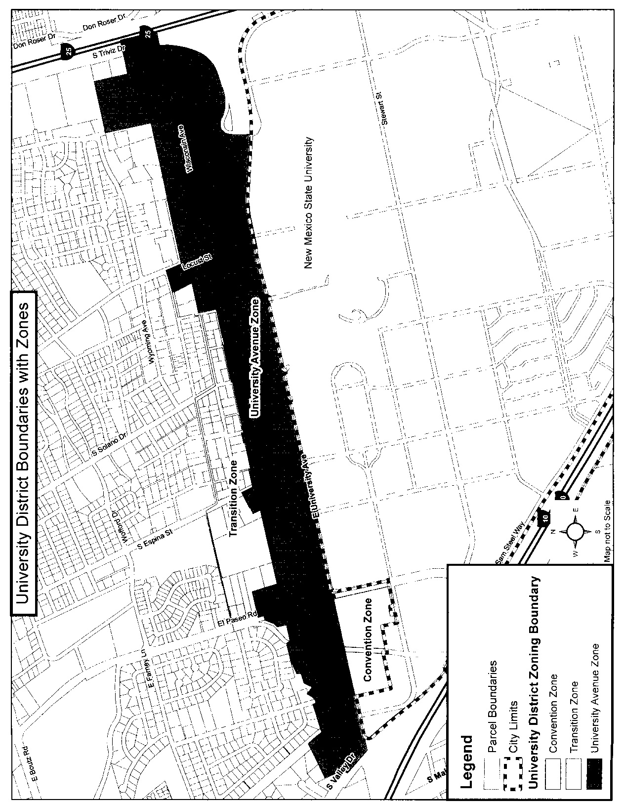
Figure 1: University District Overlay
2.
Within the boundary of this overlay, three distinct zones shall be established: University Avenue Zone (UD-UAZ), Transition Zone (UD-TZ), and Convention Zone (UD-CZ). The locations of these zones are on the associated map.
E.
The vision for the zones.
1.
University Avenue Zone (UD-UAZ): The UD-UAZ is assigned to land appropriate for an urban neighborhood center with a mix of building types and uses. These lands are generally occupied by attached residential houses, apartment buildings, and commercial or mixed-use buildings. Civic and religious use buildings may also be present. Lands may also be used for playgrounds, squares, and plazas. Two- to five-story buildings are encouraged. Block sizes are limited to create a walkable and well connected network of streets. Streets are designed to encourage pedestrian activity by generally including on-street parking, curbs and gutters, parkways with street trees, and wide sidewalks. University Avenue shall be the primary frontage for properties on University Avenue.
2.
Transition Zone (UD-TZ): The UD-TZ is assigned to land appropriate for neighborhoods with a mix of building types and uses. These lands are generally occupied by detached and attached residential houses, small apartment buildings, and small commercial or mixed-use buildings. Civic and religious use buildings may also be present. Lands may also be used for playgrounds, passive and active neighborhood parks and squares. The buildings may be one- to three-stories high with shallow front setbacks and small or no side and rear yards. Block sizes are limited to create a walkable and well connected network of streets. Streets are designed to encourage pedestrian activity by generally including on-street parking, curbs and gutters, parkways with street trees, and wide sidewalks.
3.
Convention Zone (UD-CZ): The UD-CZ is assigned to land suitable for development that, by its intrinsic size, function, or configuration, may not conform to the descriptions and standards for one of the other zones. The development types include convention and exhibition hall, hotel, and ancillary uses such as restaurant and specialty retail.
F.
Definitions. Definitions are in addition to those noted in chapter 38, section 38-20 of the 2001 Las Cruces Zoning Code, as amended unless otherwise noted here:
Brew-pub: A brew-pub is a microbrewery which serves food or is combined with a pub. A microbrewery, or craft brewery, is a brewery which produces a limited amount of beer. The maximum amount of beer a brewery may produce and still be classed as a microbrewery in New Mexico is less than or equal to 200,000 barrels a year, according to the New Mexico Alcohol and Gaming Division.
Callecita or lane: Combines the space for a car with the space for the pedestrian. See also, the Las Cruces Downtown Revitalization Final Schematic Design and Concept Report, adopted August 2005.
Dwelling, above ground floor: Dwelling unit(s) located above ground floor office or commercial uses.
Front facade: A term that is equivalent to "primary front" in the Las Cruces Municipal Code. It is the elevation with the main entrance to a building that faces a public street. In the UAZ, the primary or front facade faces University Avenue.
Green roof: As defined by the U.S. Environmental Protection Agency, green roofs, also known as rooftop gardens, are planted over existing roof structures, and consist of a waterproof, root-safe membrane that is covered by a drainage system, lightweight growing medium, and plants. Green roofs reduce rooftop and building temperatures, filter pollution, lessen pressure on sewer systems, and reduce the heat island effect.
Guest dwelling: A dwelling to be used for temporary occupancy only and is not to be rented or leased. A guest dwelling shall be no more than 50 percent of the main dwelling's heated/cooled square footage and shall not contain a kitchen. (See also chapter 38-53 of the 2001 Las Cruces Zoning Code, as amended.)
Live/work unit: A building that may be used flexibly for living and working in the same building. A variety of uses in the buildings is encouraged. Dwelling units may be located above the ground floor, attached to the rear of a shop front, or detached and located in the rear or side yard. Work is of a commercial nature subject to business registration requirements and not a home occupation.
Mixed-use: For the purposes of this overlay, the term refers to the practice of allowing more than one type of land use category (For example, residential, office or commercial, etc.) in a single building or set of buildings located on a single parcel.
Outdoor plaza or space: A generally open area that may be used for active or passive purposes by one or more businesses and the public visiting the location. An example may include an outdoor seating area for a cafe or restaurant serving as an extension of one or more business, a landscaped plaza serving as open space for patrons and visitors alike, etc.
Parking garage with and without liner building: A combination of structures for parking and a mix of uses (commercial, residential, office) where parking is designed to be concealed from view and levels of parking are at-grade, above grade, or partially below grade (but not fully underground). A liner building is a specialized building that may be built as part of the parking structure or separate; it is parallel to the street and designed to conceal a parking structure from the street with active ground floor uses such as retail shops or residential stoops. A parking garage may be designed without a liner building provided that it is designed in such a way so as to incorporate active ground floor uses, architectural features and articulated elements to mitigate blank walls and screen parking.
Pedestrian scale lighting: Lighting that shall be a maximum of 16 feet in height and shall contribute to the overall character of the surrounding community, site architecture or other site features.
Performing arts center: A multi-use performance space that is intended for use by various types of the performing arts, including dance, music and theatre.
Secondary residence: A dwelling unit that is subordinate in size and location to the main dwelling on a single property, and may be rented or leased as an independent dwelling unit. A secondary residence is different from a guest dwelling or accessory structure in that it is a distinct dwelling unit containing a kitchen. Examples include an apartment or cottage.
Single use: For the purposes of this overlay, the term refers to either one or multiple component parts of a single land use category such as residential, office or commercial. Multiple office related businesses on a single parcel or tract shall be considered a single use. For the purpose of this overlay there shall be a limit to a concentration of single land uses in favor of a mix of uses.
G.
Permitted uses.
1.
General provisions.
a)
Mixed-use development is permitted throughout the University District. Mixed-use is defined as the practice of allowing more than one type of use, including residential, in a building or set of buildings.
b)
The University District Overlay is not within the Infill Overlay District; however, specific provisions of the Infill Overlay that pertain to the University District Overlay shall include streamline review, subdivision processing and waiver of permit and application fees as applicable. Use of these provisions shall be allowed regardless of a parcel's status (vacant, underutilized, etc.)
c)
There shall be no development or alteration of the lands, uses, or structures within this overlay except as provided for by this section of the 2001 Las Cruces Zoning Code, as amended from the date of its enactment and other sections of the 2001 Las Cruces Zoning Code, as amended and other codes where applicable. For example, under no circumstances shall development violate the city's traffic standards for maintaining clear sight triangle (chapter 32, article VI, section 32-405).
d)
Commercial (retail and service) and office drive-thru windows/drive-up windows are discouraged in the University District. Drive-through uses do not support a pedestrian-oriented environment and are inconsistent with the goals for the University District. Although drive-through facilities are discouraged, the following standards shall apply to facilities approval by the UD-CDRC.
i.
Windows and stacking lanes. Drive-through windows and stacking lanes shall not be located within the front yard setback or along facades that face a street. Drive-through windows shall be located to the rear of buildings.
ii.
Circulation. The design and location of the facility shall not impede vehicular traffic flow and shall not impede pedestrian movement and safety. Shared driveways and/or driveways located off of non-arterial streets should be used, where possible.
iii.
Screening. Architectural elements, landscaping, and/or other screening elements shall be used to minimize the visual impacts of the drive-through facility.
e)
Developments having frontage on University Avenue greater than 400 linear feet shall be mixed-use.
f)
Land uses that do not appear on this list shall be reviewed by the Community Development Director or designee and a determination will be made as to whether said use is consistent and/or congruous with others listed or whether or not it requires a special use permit by its intended omission.
2.
University Avenue Zone (UD-UAZ), Transition Zone (UD-TZ) and Convention Zone (UD-CZ). Please refer to Table 1 for uses that are allowed (A), conditional (C) and not permitted (NP). Please refer to section 38-33 in the 2001 Las Cruces Zoning Code, as amended, for the number of auto parking stalls required per land use.
Table 1: Permitted Uses
H.
Property alteration, remodel or renovation.
1.
Purpose. Property alterations, remodels or renovation standards are established for this district to maintain consistent quality standards for all development and may be for the purpose of adaptive re-use of the structure. For the purposes of this section, exterior remodel, renovation, or alteration shall be defined as: Any change or rearrangement in the supporting members of an existing building, such as bearing walls, columns, beams, girders, as well as any change in rooflines, or any enlargement to or diminution of a building or structure, whether horizontally or vertically. Normal maintenance activities as verified by the city's building official or designee are exempt from this provision.
2.
Minor modifications. Changes to a property may be made without requiring compliance with the University District Overlay Urban Design Standards (architecture, landscaping, signage, and utilities). The expansion and/or modification must comply with the urban design standards of the University District Overlay unless through the determination of the Community Development Director or designee, said compliance would substantially create an undue burden to the property owner or create a condition whereby the expansion and compliance measure, partially applied, would be substantially out of character with the existing development. In no case shall a minor modification/expansion equal or exceed a cumulative total of 15 percent of the gross floor area, nor shall an expansion or modification equal or exceed a cumulative total of $25,000.00 in valuation. A proposal equal to or exceeding these values or one that impacts parking and landscaping shall not be considered as a minor addition and/or modification. It shall, therefore, be subject to normal review and consideration afforded development in the overlay and may be subject to nonconforming provisions that follow. The applicant must provide estimates for the cost of labor as a means of ensuring compliance with the valuation criteria.
a)
Once permission to proceed has been granted by the Community Development Director or designee, the applicant may apply for the permit. Work shall not commence until permit approval is granted.
b)
Should an applicant or aggrieved party not agree with the interpretation by the planning director or designee, the interpretation may be appealed to the University District Citizens Design Review Committee for their recommendation to the Planning and Zoning Commission. All other nonconforming use requirements are subject to article XII (Nonconforming Use Provisions) of the 2001 Las Cruces Zoning Code, as amended, and the city's design standards.
I.
Nonconforming uses. Nonconforming uses within the University District Overlay shall be subject to the following provisions.
1.
Permitted uses—Nonconforming.
a)
When nonconforming site/urban design features regarding access from the right-of-way or lighting are involved, these features shall be brought into compliance with current standards when:
i.
The property remains vacant for a period of one continuous year or greater; or
ii.
Any one-time or cumulative increase of 15 percent or greater to the gross square footage of building area occurs; or
iii.
Any interior/exterior remodel, renovation, or alteration occurs to the building in the amount of $25,000.00 or greater; or
iv.
A change in use occurs on the property which results in the alteration of the use intensity (for example, low volume retail to high volume retail), use orientation (for example, service to retail), or density (for example, eight dwelling units to 15 dwelling units) or change in occupancy type from the building code perspective.
b)
When nonconforming site/urban design features regarding signage, landscaping, walls or parking are involved, these features shall be brought into compliance with current standards when:
i.
The property remains vacant for a period of one continuous year or greater; or
ii.
Any one-time or cumulative increase of 50 percent or greater to the gross square footage of building area occurs; or
iii.
Any interior/exterior remodel, renovation, or alteration occurs to the building in the amount of $75,000.00 or greater; or
iv.
A change in use occurs on the property which results in the alteration of the use intensity (for example, low volume retail to high volume retail), use orientation (for example, service to retail), or density (for example, eight dwelling units to 15 dwelling units) or change in occupancy type from the building code perspective.
c)
When nonconforming site/urban design features regarding architecture/building elements associated with window fenestrations/glazing requirements are involved, these features shall be brought into compliance with current standards when:
i.
The property remains vacant for a period of one continuous year or greater; or
ii.
Any one-time or cumulative increase greater than 75 percent or greater to the gross square footage of building area occurs; or
iii.
Any interior/exterior remodel, renovation, or alteration occurs to the building in the amount of $200,000.00 or greater; or
iv.
A change in use occurs on the property which results in the alteration of the use intensity (for example, low volume retail to high volume retail), use orientation (for example, service to retail), or density (for example, eight dwelling units to 15 dwelling units) or change in occupancy type from the building code perspective.
2.
Prohibited uses—Nonconforming.
a)
Uses that existed within the overlay prior to plan/ordinance adoption (2010) that are deemed a prohibited use may be allowed to continue to exist and expand or enlarge (either one-time or cumulative increase) provided that:
i.
The property has not remained vacant for a period of one continuous year or greater; or
ii.
A change in use has not occurred on the property which results in the alteration of the use intensity (for example, low volume retail to high volume retail), or use orientation (for example, service to retail).
b)
If the above two criteria are confirmed not to have existed, the use may:
i.
Increase or expand in area (lot or building) not more than 50 percent in gross square footage of lot or building area; and
ii.
Any noncompliant site/urban design standards existing shall be brought into compliance with overlay standards to the extent possible. Determination of the extent of compliance shall rest with the Community Development Director or designee.
J.
Development and urban design standards.
1.
Building and site development standards for the UD-UAZ: University District, University Avenue Zone.
a)
UAZ: Block, lot and density standards.
b)
UAZ: Setbacks—Primary building.
c)
UAZ: Building design (primary building).
d)
UAZ: Frontage elements (primary building).
e)
UAZ: Placement of surface parking and accessory buildings.
f)
UAZ: Placement of parking structures.
g)
UAZ: Building design (accessory buildings).
h)
UAZ: Outdoor lighting.
i)
UAZ: Garbage, recycle, mechanical equipment, loading areas and compost storage.
2.
Building and site development standards for the UD-TZ: University District Transition Zone.
a)
TZ: Block, lot and density standards.
b)
TZ: Setbacks—Primary building.
c)
TZ: Building design (primary building).
d)
TZ: Frontage elements (primary building).
e)
TZ: Placement of surface parking and accessory buildings.
f)
TZ: Placement of parking structures.
g)
TZ: Building design (accessory buildings).
h)
TZ: Outdoor lighting.
i)
TZ: Garbage, recycle, mechanical equipment, loading areas and compost storage.
3.
Building and site design standards for the UD-CZ: University District Convention Zone.
a)
Civic standards.
i.
Introduction. Civic buildings are buildings operated by not-for-profit organizations (including governmental organizations) that are dedicated to arts, culture, education, recreation, government, transit, and or for use approved by the legislative body. The above uses with a religious foundation are not considered civic buildings.
b)
Standards. The following standards apply to civic buildings:
i.
Civic buildings should be architecturally distinctive, designed appropriately for their function, and designed with an outdoor gathering spaces.
ii.
Civic buildings may be located within civic spaces.
iii.
Civic buildings shall not be subject to the standards of this article (Building Standards). The particulars of their design shall be determined by the University District Citizens Design Review Committee (UD-CDRC) and as required by the director.
c)
Historic building standards.
i.
Introduction. Historic buildings are structures that are listed on the National and/or New Mexico Registers of Historic Places.
ii.
Standards. The following standards apply to historic buildings:
1)
Uses for historic buildings and properties shall comply with Table 1, Permitted Land Uses.
2)
Alterations and additions to historic buildings shall comply with the Secretary of the Interior's Standards for Rehabilitation.
4.
Landscaping—All zones. All landscape planting should serve to enhance the architectural value of the building, ground the building in the site, create a pleasant and attractive environment for pedestrians, and mitigate environmental conditions such as excess heat, strong winds and air pollution.
a)
Purpose. Landscaping standards are established for this district to create a more comfortable environment for pedestrians and transit users; to achieve the intended character of a walkable district that meets the desires of the community; and provide stormwater management by reducing runoff and improving water quality by filtering runoff before it enters the collection system. Where city uses of easement area or right-of-way requires displacement of landscaping or damage to drainage ponds, the city shall replace or repair those pond and landscaping elements to the extent possible as determined by the city.
b)
Applicability. The provisions of this section shall supersede other landscaping requirements within the Municipal Code, where conflict in regulation exists, as it applies to the landscaping of the University District only.
c)
Landscaping standards apply to all development in the University District with the exception of properties that are occupied by single-family residences. Landscape consists of native or drought-tolerant species of both overstory (shade and coniferous trees) and understory plantings of ornamental trees, shrubs, cacti and perennial grasses, groundcovers, and flowers, the standards for which apply to the entire site and parking lot area, excluding building area.
Landscaping for new development within the University District shall comply with principles of water conservation that address:
1.
Planning and design;
2.
Soil improvements;
3.
Efficient irrigation;
4.
Zoning of plants;
5.
Mulches;
6.
Turf alternatives; and
7.
Appropriate maintenance. (Please refer to: Curtis Smitb's article, Principles of Xeriscape.)
d)
Area to be Landscaped. The required area to be landscaped is equal to a minimum of 20 percent of the total parking area. For the purposes of this article, the parking area shall be defined as the surface area of the entire tract of land excluding the building pad.
i.
Parking bays in excess of ten spaces in length should be divided by intermittent landscape islands. Landscape islands shall be no less than six feet by six feet for each tree and accompanying groundcovers.
ii.
One tree shall be planted in the parking lot area for every five parking spaces. Each tree shall be planted in an area that is no less than six feet by six feet.
iii.
A landscape buffer no less than eight feet wide should be provided between all parking areas and the sidewlak or street, the purpose of which is to screen parked vehicles from view from the street. The buffer strip should contain a mix of shade trees, low shrubs or perennial flowers, boulders and may include a decorative fence that ensures visibility. (Please refer to fencing in section J. Development and urban design standards.) If a solid wall or dense hedge is used it should be no less than 18 inches and no more than four feet (48 inches) in height to allow views into and out of parking areas. If a berm is used, the slope should not exceed 20 percent (5:1).
iv.
In parking lots larger than one acre or 200 feet or more wide, walkways are required that link perimeter sidewalks to primary building entrances.
v.
Green roofs (please refer to section F. Definitions) may be used to meet minimum landscape requirements at a 1:1 ratio excluding the above listed requirements for landscaping parking lots.
e)
Installation. The irrigation system and landscaping shall be installed before the completion of building construction and prior to the issuance of a certificate of occupancy unless a temporary certificate of occupancy or other written agreement has been arranged with the city. Such agreements extending the time of installation will be for a maximum period of nine months. (Ord. No. 978, § 4.6, 6-20-88)
f)
The total required landscape area shall be evenly distributed throughout the site. Businesses offering outdoor seating within their front setbacks may reduce the required landscaping, subject to review by the city and the citizen's design review committee (to be discussed later in this Code).
g)
Plants at the time of installation shall be sized and quantities shall be defined according to the following: Two - 2¼-inch caliper tree, five - 15-gallon shrubs, and a choice of either five - one-gallon shrubs or 50 square feet of groundcover, for every 500 square feet of lot area excluding building area and parking lot area.
h)
Trees shall include shade producing trees which achieve a mature size of at least 25 feet high and 25 feet spread and ornamental trees which have particular features such as spring blooms, fall foliage color or bark characteristics. Evergreen trees such as pines, junipers, and cypress are also allowed. Shrubs shall include a mix of deciduous and evergreen plants including plants native to the Chihuahuan Desert and others adapted to our climate. Groundcovers shall serve to prevent soil erosion, provide color, and create an oasis feeling.
5.
Fencing, walls and retaining walls—General all zones.
a)
Existing noncompliant fences and walls within the district may remain in place so long as they conform to existing city ordinances regarding permitting, height and placement. Increases in structure height or length shall require full compliance with fencing/wall requirements.
b)
New fences/walls shall be of a generally "open" design to maintain visibility from the street. As an example, an open fence including gates has for each one-foot wide segment 60 percent of the surface area in open spaces which afford a direct view through the fence. Picket, post and rail, tubular steel and wrought iron are examples of acceptable open fencing. A base not greater than three feet in height may be used in combination with the "open" design. Chain link fencing is prohibited. All fences/walls in front yards must be "open" by design. A "closed" fence/wall is defined as a structure, including gates, which conceals from view from adjoining properties, streets, or alleys, activities conducted behind it. "Closed" fences/walls may only be constructed in side and rear yards. They are not allowed in front yards.
c)
Fences, walls and hedges within the primary front yard (where primary front yard setback is determined) shall be limited to a height of four feet. The design of manmade structures shall conform to the provisions found in section (2) above.
d)
Fences, walls and hedges that are within five feet of the secondary front property line (side where secondary front yard setback is determined) shall be limited to a height of four feet. If the fence, wall or hedge is setback at least eight feet from the property line, the maximum height shall be limited to height of eight feet. The design of man-made structures shall conform to the provisions found in section (2) above.
e)
Fences, walls and hedges that are within the rear and side yards shall be limited to a height of eight feet.
f)
Retaining walls used within the various districts shall be designed in a manner limiting their height to what is absolutely necessary for the retaining purpose intended.
6.
Signage—All zones.
a)
Purpose. The University District Overlay Sign Code shall be established for aesthetics, height, overall size, type, and lighting considerations for signage consistent with district urban design standards.
b)
Attached signage. Only window, wall, awning signs and multi-use development directory signs are allowed. Awnings and the attached signs are subject to the design standards of all applicable codes.
Wall signs: Flush-mount:
1.
Commercial/nonresidential development.
a)
No wall sign shall project beyond the ends of the wall or beyond the top of the building to which it is affixed.
b)
Walls signs shall be affixed flat against the building wall. Any necessary frame mounting shall not extend more than six inches from the wall.
c)
Wall signs shall be placed on the ground floor of the structure in which the use takes place.
d)
No more than three wall signs shall be allowed per building facade in buildings with more than one business or use.
e)
No more than one wall sign shall be allowed per business or use per building facade. When there are more than three business occupants per building refer to the multi-use development directory sign standards of this sevtion.
f)
One square foot of signage for each linear foot of exterior wall space, not to exceed 50 square feet per wall. The sign(s) shall be placed on the side of the building used to calculate the square footage of the sign. For buildings that are set back 100 or more feet from the sidewalk, signage may exceed the 50-foot maximum as determined by the Community Development Director or designee.
2.
Multitamily residential development.
a)
Up to two wall signs, not to exceed 32 square feet each, with the name, logo, and associated graphics on a building containing eight or more residential units.
b)
Only one sign is allowed per wall. These attached signs are subject to the design standards of all applicable codes.
Wall signs: Projecting:
1.
Projecting signs shall be considered double-faced signs with each sign face of equal size.
2.
Projecting signs shall not exceed 12 square feet in sign face area (six square feet per sign face).
3.
Only one projecting sign shall be allowed per business per street frontage.
4.
Only ground floor commercial businesses shall be permitted to utilize projecting signs.
5.
Projecting signs must maintain at least eight feet of clearance as measured from the bottom of the sign to grade and may project no more than four feet from the building or closer than two feet to the edge of the sidewalk, whichever is less.
6.
Projecting signs shall be installed at right angles to a building front.
Window signs:
1.
There shall be no more than one permanent window sign per window.
2.
Neon signs displayed indoors constitute permanent window signs. Only one neon sign shall be permitted per business facade.
3.
The total coverage of all permanent, neon and temporary window signs shall not exceed 25 percent of the total glass area of the window.
Awnings and canopies:
1.
Awnings and canopies shall be supported solely by the building to which they are attached and no columns or posts shall be permitted as supports.
2.
No portion of an awning or canopy shall be less than eight feet above grade. However, if the awning and canopy extends beyond four feet between the building and curb, it must be 12 feet above grade.
3.
The roofs of all awnings and canopies shall be used for no other purpose than to form and constitute a roof. The roofs of all awnings and canopies shall not drain directly or into the public right-of-way. The roofs of all awnings and canopies shall be constructed in accordance with the building code.
4.
Awnings and canopies shall be designed to withstand a wind speed of not less than 90 miles per hour.
5.
Awnings and canopies shall not interfere with street trees or traffic signs.
6.
No advertising shall be placed on the awning or canopy except the name or logo of the owner, business or industry conducted within the premises, address of the building, or the building name.
7.
Lettering or logos shall be painted or otherwise permanently affixed in letters not exceeding 20 inches in height on the front and side portions thereof.
8.
Translucent awnings and canopies are not permitted.
9.
Any awning or canopy that encroaches into the public right-of-way shall obtain an approved encroachment agreement from the city's land management department prior to placement and use of the awning or canopy and comply with chapter 32 of the International Building Code.
Multi-use development directory sign. Exterior directory signs, with the name and location of all businesses within a multi-use development, shall be wall-mounted as specified above. One square foot of signage is allowed for each linear foot of exterior wall space, not to exceed 50 square feet per wall. The sign(s) shall be placed on the side of the building used to calculate the square footage of the sign.
c)
Freestanding ground signage—All development.
i.
Ground signs shall be the only freestanding signage permitted within the district.
ii.
One ground sign is allowed per lot. The ground sign shall identify the primary tenant, the name of the business center or the name of the residential units.
iii.
Individual ground signs shall be limited to properties which own direct, unobstructed (on-site) access to a public street.
iv.
Ground signs shall not exceed 24 square feet in area, and shall not exceed three feet in height. Signs shall be placed at least five feet from the outside edge of the right-of-way, and at least five feet from adjacent property lines and not within the clear sight triangle as defined by the City of Las Cruces Design Standards. Please refer to section 32-405.
d)
Design standards.
i.
The silhouette, shape, and materials of signs in the University District Overlay shall be simple and compatible with the building or facade to which they relate.
ii.
Freestanding signs shall not be placed so they obscure important architectural features such as entrances, display windows, or decorative cornices when viewed from the right-of-way.
iii.
Attached signs shall not disrupt the architectural composition of the building facade. No part of any attached sign shall overlap or cover architectural features of the building such as cornices, eaves, window and door frames, columns, vigas and other decorative elements.
iv.
Signs within a business center shall be compatible with the architectural character of the center.
v.
The number of different lettering styles or fonts on a sign shall be kept to a minimum, and shall relate to the architectural character of the property. Lettering and copy shall not be crowded onto a sign and shall leave ample space around the copy to preserve legibility.
vi.
The visual appearance of signs shall reinforce the architectural character of the site.
vii.
Illumination:
a)
Signs that are illuminated shall have concealed lighting fixtures with the exception of LED and neon.
b)
No reflectors, arms, fixtures or wires shall be visible from the street.
c)
Internally illuminated signs shall not be permitted.
d)
No sign shall be illuminated to create a nuisance, traffic hazard or excessive glare to adjacent property and shall comply with the City of Las Cruces Street Lighting Ordinance to prevent illumination of the night sky so as to lessen light pollution. Please refer to section 32-409 (Street lighting) and chapter 39, Outdoor Lighting.
e)
Freestanding signs shall be landscaped at their base in a manner that is compatible with the character of the site. Landscaping shall form an attractive cluster at the base of the sign.
f)
The top of any sign shall not exceed 20 feet above grade.
e)
Temporary promotional banners and pole banners.
i.
Building-mounted banner displays: In addition to permitted permanent signage, businesses and organizations in the University District Overlay are allowed temporary, promotional displays in the form of a banner for promotional purposes that are subject to the following conditions:
a)
Each business and organization, with the exception of those within the convention zone, shall be permitted one banner three times during each calendar year for a maximum of ten consecutive days each or for a maximum of 30 consecutive days. Due to the nature of the convention zone and the number of special events, banners are expected to change more frequently than three times during each calendar year.
b)
Only one banner per business or organization may be displayed at a time.
c)
Banners shall be made of a durable material that may include 12 to 16-ounce weight materials, such as, nylon or vinyl reinforced canvas. Banners must have hemmed and reinforced edges. Grommets should be located on the banner's edge to allow it to be securely fastened to its supporting structure. If grommets are not used, some other mechanism such as rope shall be placed within the hem to allow for its attachment.
d)
Banners may not exceed 25 square feet in area.
e)
Banners shall be securely attached to a permanent building.
f)
The applicant shall provide to the sign administrator the name and address of the business/organization where the banner is to be placed, the first day the banner is to be displayed, the date it is to be removed, the size of the proposed banner, and its design.
g)
Banners may be erected only when a sign permit has been issued. All banners shall be removed not later than the permissible time limit stated above. Failure to do so may forfeit the ability to use these provisions in the future. A permit will be issued to the applicant and will remain in effect for the duration of that event.
ii.
Pole banners: Banners may be placed on city-owned utility and light poles promoting city-sponsored events and/or messages with approval by the city manager or his/her designee. (For the purposes of pole banners, a city-sponsored event shall be defined as an event for which the City of Las Cruces donates money and/or services/personnel.) Examples of these types of messages include: "Las Cruces Sparkles on the 4th of July" and "Happy Holidays". Other governmental entities, such as New Mexico State University, may also place banners on city-owned utility and light poles that display a community-wide message and are approved by the city manager or his/her designee. Examples of these types of messages include: "Go Aggies!" and "Welcome Back to School!" Approval with New Mexico State Highway Department will also be required when appropriate. To place banners on city-owned utility and light poles, arrangements shall be made through the traffic engineering section of the public works department. Fees may be imposed to offset expenses.
f)
Prohibited signs: The following signs are prohibited in the University District Overlay:
i.
Portable and pole signs, whether temporary or permanent.
ii.
Permanent banners.
iii.
Pennants, streamers, and other fluttering devices, whether temporary or permanent.
iv.
Real estate, construction, contractor and "coming soon" signs over 12 square feet in area or over five feet tall.
v.
Political signs over 12 square feet in area or over five feet tall.
vi.
Billboards and all other off-premises signs.
vii.
All other signs as prohibited in section H of the Las Cruces Sign Code.
g)
Applicability: Where there are areas concerning signage not addressed by the University District Sign Code, chapter 36 of the Municipal Code, Signs, shall apply.
K.
Transportation (streets and public spaces).
1.
Right-of-way improvements (traveled way, roadside and intersections) throughout the district shall be in accordance with the city's complete streets policy. (Please refer to city council Resolution No. 09-301, June 15, 2009.)
2.
Project initiation and preliminary engineering shall be initiated at the earliest opportunity for right-of-way improvements to the traveled way, roadside and intersections of University Avenue between Interstate 25 and Interstate 10.
3.
Future amendments to this section are anticipated and shall convey design parameters for University Avenue as a walkable thoroughfare.
4.
Callecitas shall be considered and alleys shall be preserved, whenever possible for improving pedestrian connectivity and providing vehicular access to properties. (Please refer to section F. Definitions.)
L.
Parking, general—All zones.
1.
Parking requirements.
Requirements:
1.
Parking ranges are set for land uses in each zone, as noted in article IV, section 38-33 of the 2001 Zoning Code, as amended. Requests to reduce parking requirements shall be evaluated on a case-by-case basis by the Community Development Director or designee. Requests to exceed maximum parking requirements shall be granted for parking structures that meet the development and urban design standards set forth in this Code.
2.
Shared parking and access agreements among neighboring properties are encouraged and will count toward off-street parking requirements. Section 38-58 (Off-street parking) dictates the requirements for this application.
3.
Off-street parking requirements can be met by entering into a shared parking agreement within one-fourth mile, as measured along the street network and pedestrian right-of-way, that shall be used to identify how parking demand will be met and which properties are involved.
4.
All standards for parking dimensional and ADA requirements for all development within the district shall be consistent with section 38-58, Off-street parking, of the City Zoning Code.
5.
All vehicles are to be parked along designated streets, in designated driveway or parking areas only. Parking on front lawns and/or landscaped areas shall be prohibited.
2.
Parking options: (Please refer to section G. Permitted uses for allowed parking locations.)
To reduce development costs, parking garages are not required. Parking may be provided within an attached garage, detached garage, parking structure with or without liner building, or surface parking lot. Parking for nonresidential uses may also be provided off-site in a public parking lot or structure if a parking management district is formed for the area. Dedicated surface parking areas shall meet the landscape requirements of section J. Development and urban design standards of this overlay.
3.
Parking access:
Alleys. Alleys are required for projects that create new blocks to provide access to parking areas and to minimize driveway curb cuts along streets. Alleys are encouraged (but not required) for projects on existing blocks to provide access to parking areas. Driveway access from the street is only allowed on lots where an alley cannot be provided.
Driveways. Driveway width shall comply with city design standards.
Pedestrian connectivity. In parking lots larger than one acre or equal to or greater than 200 feet wide, walkways shall link perimeter sidewalks to primary building entrances.
Parking prohibition. A parking management plan would improve mobility and access to shops and business centers as well as controlling the amount of land dedicated to surface parking lots and parking structures. Until a parking management plan is adopted, parking shall be prohibited from 8:00 a.m. to 5:00 p.m., Monday through Friday, on the following streets:
Chaparral St. between University Ave. and Plain St. (east side only);
Hagarty Ave. between University Ave. and Plain St. (west side only);
Mesa St. between Jordan St. and Espina St. (south side only).
M.
Demolition. To preserve any contributing structure listed on the historic register (state or national) in the University District Overlay; this section creates a 60-day demolition permit review process that allows time for interested parties to explore alternatives to the demolition of historic structures. Demolition for all other structures shall follow chapters 30-491 and 38-63 of the 2001 Las Cruces Zoning Code, as amended.
1.
Demolition permit. Demolition permit applications shall be submitted to the community development department prior to any demolition activity taking place. Community development department staff will review the application for compliance with the 2001 Las Cruces Zoning Code, as amended. A proposal for redevelopment of the property must accompany the permit application.
2.
Posting. At the beginning of the 60-day demolition permit review process, the community development department will issue a sign that is to be posted in a conspicuous place on the property. The applicant is responsible for posting the sign and ensuring that it is in place for the entire 60-day period.
3.
At the beginning of the 60-day demolition permit review process, the community development department will inform the neighborhood associations, the New Mexico Historic Preservation Division and the Dona Ana Historic Society that a demolition permit has been applied for.
4.
A demolition permit shall be issued upon the completion of the following items: 1) the completion of the 60-day period; and 2) the application meets all City Code requirements and has been approved by the community development department staff. (The applicant may use the 60-day time period to resolve any necessary code compliance comments.) The permit application may be withdrawn by the applicant at anytime without charge.
5.
Prior to the demolition of a historic structure, the applicant shall be responsible for fully documenting the structure, both interior and exterior, to provide a permanent record, in accordance with documentation procedures as follows. The demolition permit will not be approved without submittal and approval of this documentation by community development staff.
a)
Complete the Historic Cultural Property Inventory (HCPI) forms 1 and 2;
b)
Photograph the property:
i.
Photo processing, printing and labeling shall follow the protocol established by the National Parks Service; please refer to the National Register Photo Policy Fact Sheet.
ii.
Using a 35mm camera with black-and-white print film (or digital camera described in photo documentation policy), take several exterior photos of the primary structure (front, rear, sides, close-up views, details, setting, etc.) and exterior photos of each historic secondary structure, such as a garage, sheds, etc. (Accessory buildings that are not listed on the historic register should not be included.) For assistance in taking quality photographs, please refer to NPS Bulletin #23 at the link listed above.
iii.
Include several interior photos of the primary structure, with attention to any distinctive architectural or historic features (vigas, carvings, coping, special flooring, bullet holes, etc.)
iv.
Staff strongly suggests that wide-angle camera lenses not be used for exterior photographs since these lenses tend to distort vertical dimensions of buildings. A perspective-correction lens is highly recommended for best results.
v.
The submitted photo packet must include one set of black and white (B&W) photographs, the negative strips, and a photo CD-R or DVD-R from the developer. Photographs, whether 35mm or digital, must be printed in B&W. Printed size may be 3½ × 5; 4 × 6; or 5 × 7.
vi.
Include a continuation sheet that provides information common to all photographs, followed by a list providing information pertinent to each photograph.
vii.
Digital images: When using digital images, the file name for each electronic image on the CD-R or DVD-R must correspond with the photo log included on the continuation sheet and the information labeled on the back of each photograph, and it should reference the county and state in which the property is located.
viii.
All photographs and negatives must be put into archival photo or negative sleeves. Label the top of each protective negative sheet with: the property name, location, and the date the photographs were taken.
c)
If measured drawings done by the Historic American Building Survey exist, the owner should annotate the drawings, showing changes to the property, interior and exterior, that have occurred up to the current date.
d)
If known, a short history of the property should be included, in order to document how that property fits within the historic district or community.
e)
The demolition permit will not be approved without submittal and approval of this documentation by community development staff.
6.
Compliance with the procedure set out in this section is not required if it is determined by the City of Las Cruces that the immediate demolition of a historic structure is in the best interest of public health, safety, and welfare. The applicant shall be responsible for documenting the structure in accordance with the procedure above to fully demonstrate the need for demolition and to provide a record of the structure. In the event that entering the structure would pose a threat to the health, safety and welfare of the documenter, interior photos are not required. This documentation must accompany the memo of determination for demolition by the building official prior to the issuance of a demolition permit.
N.
Administration.
Submittal and review process.
1.
Purpose. Submittal and review procedures are established for all new development to protect persons and property in the University District Overlay as directed in the University District Plan.
2.
Subject to review by the citizens' design review committee (UD-CDRC).
a)
Subdivisions. For submittal and review of subdivisions within the district, refer to article V, of chapter 37 pertaining to infill subdivision procedure.
b)
Buildings.
i.
Pre-application conference: Prior to filing an application for development of new buildings in the district, the applicant is encouraged to meet with staff of the city community development department to review the proposed project. At this conference, staff shall review the development proposal and advise the applicant concerning the compatibility of the proposal with the intent and standards of the University District Plan and all other applicable city codes.
ii.
Application procedure: Upon completion of the pre-application conference, the applicant shall submit at minimum, one copy of all application materials for new development to the community development department for review. Upon submittal, staff shall review the submittal for completeness. If all the required items have been submitted, the community development department shall issue a receipt for submittal.
iii.
University District Citizens' Design Review Committee (UD-CDRC): Applicants shall meet with the UD-CDRC and city staff at a public hearing for a formal recommendation by the UD-CDRC regarding the proposed project.
iv.
Final approval: An application shall be effective for no more than one year from the date of approval. If development proposed by the application has not been initiated within the one year stipulated, the application must be resubmitted for approval as established in this section. The applicant may submit a request for extension of approval prior to the expiration date, if desired. The request will be reviewed by the community development department.
c)
Variances. Variances in the numerical requirements for development within the district will be considered in accordance to fulfilling the policies of the University District Plan and not contradictory to the policies therein. Variances may be granted by the Planning and Zoning Commission at a public hearing in accordance with section 38-10.
i.
An application for a numerical variance will be processed to applicable city departments and the citizen's design review committee.
ii.
Applicants must present their request to the citizen's design review committee for their recommendation to the Planning and Zoning Commission. Recommendations from the UD-CDRC shall be delivered to the Planning and Zoning Commission prior to the public hearing.
iii.
Decisions of the Planning and Zoning Commission may be appealed to city council, in accordance with provisions of section 38-13.
d)
Special use permit (SUP). The Community Development Director or designee determines SUP needed for uses not listed in this overlay.
e)
Zone change. Applicants must present requests for zone change to the citizen's design review committee for the committee's recommendation to the Planning and Zoning Commission. Recommendations from the design review committee shall be delivered to the Planning and Zoning Commission prior to the public hearing. Decisions of the Planning and Zoning Commission may be appealed to city council in accordance with section 38-13.
f)
Plan amendments, code amendments. Applicants must present requests for plan amendments and code amendments to the University District Citizen's Design Review Committee (UD-CDRC) for the committee's recommendation to the Planning and Zoning Commission. Such requests will be considered once a year at the January meeting of the UD-CDRC. An exception to the once-a-year rule and expedited review applies to cases deemed necessary by the city in order to ensure successful implementation of the goals and objectives of the plan and ordinance where there is direct conflict between the plan and overlay. The UD-CDRC will determine which amendments may be processed gratis; all others incur a fee established by Resolution No. 00-360, July 3, 2000. Recommendations from the UD-CDRC shall be delivered to the Planning and Zoning Commission prior to the public hearing. Recommendation of the Planning and Zoning Commission are made to city council which makes the final decision.
g)
Property alteration, remodel or renovation. Any related activities to existing buildings within the district shall require review by the community development department and the citizen's design review committee to insure that the building and the property of the site will be brought into conformance with all applicable urban design standards of the University District Plan and this section.
A portion of the submittal requirements may not be required in all renovation cases. Upon receipt of a written request justifying the deletion of required information, the community development department may waive any submittal requirement.
3.
Courtesy review of NMSU projects. Although NMSU is neither within the city limits, nor subject to its jurisdiction, the campus and city share a stake in development along University Avenue and in the region as a whole. As such, the UD-CDRC respectfully requests "courtesy design review" of the university's projects, particularly those planned for and close to University Avenue.
4.
Subject to administrative review by community development department staff.
a)
Request to vacate alley;
b)
Signs;
c)
Minor modifications. A modification or change to a property that is less than a cumulative total of 15 percent of gross floor area, nor exceeds a cumulative total of $25,000.00 in valuation.
5.
Application materials and fees. Applications for development in the University District Overlay shall be obtained from the community development department. All applicants with submittals requiring public notice, such as new development and/or property renovation, shall be required to submit a development statement with their application. Development statement forms may be obtained from the community development department. Application and permitting fees are waived for development in the University District. Requirements for applications for all types of development shall include the following:
a)
A letter of intent stating the following:
i.
A statement of the purpose and use of the property.
ii.
All property improvements to be made.
iii.
A statement of the sustainable building practices to be employed.
iv.
A development schedule indicating the approximate dates at which construction or phases of construction will begin and end.
b)
A boundary survey as prepared by the appropriate licensed professional that is accurate and complete shall be made of the land to be developed. Property lines shall be shown giving the bearings in degrees, minutes and seconds. Distances shall be shown in feet and hundredths. Curved boundaries or lines on the survey shall provide sufficient data to enable the re-establishment of curves on the property. The location and description of all monuments set or found shall be included when applicable.
c)
Site plan. The site plan shall be at a scale that adequately represents the information. Copies provided shall be legible and of a good quality, with no limit to the number of sheets used. The plans shall indicate the following:
i.
Title of site plan.
ii.
Total acreage of site.
iii.
Date of preparation, north arrow, written and graphic scale.
iv.
Identification of district planning area.
v.
Identification of site by lot, block, subdivision, if applicable.
vi.
A statement of ownership, signed by the property owner.
vii.
Name and address of property owner.
viii.
Name and address of applicant, if applicable.
ix.
Name and address of consulting firm or representative, if applicable.
x.
Location and type of all land uses.
xi.
All site improvements with all setbacks indicated.
xii.
Dimensions of all buildings.
xiii.
Existing and proposed vehicular circulation systems, including parking areas, storage areas, service areas, loading areas, and major points of access, including street pavement width and right-of-way.
xiv.
A landscaping plan, to include the location, size, common name, and biological name of all landscaping materials.
xv.
Where applicable, pedestrian and bicycle circulation system, and its relation to surrounding circulation.
xvi.
Where applicable, location and arrangement of all open space, common recreational space, and private open space.
xvii.
Architectural renderings or artistic drawings. Copies provided shall be legible and of a good quality, with no limit to the number of sheets used. The drawings shall illustrate the following:
a)
All new development illustrating all exterior building design, materials and colors.
b)
All new development illustrating relationships to neighboring uses, including site lighting.
c)
Sign location, materials, color, size, shape and lighting.
d)
Quality of materials: Application materials which are illegible and/or otherwise of a low quality will not be accepted.
e)
Three-dimensional model. For projects proposed in the convention zone (CZ), provide computer-generated or physical modeling to enhance public understanding and review of the buildings within the context of the district as a whole.
f)
Waivers. A portion of the submittal requirements may not be required in all development cases. Upon receipt of a written request justifying the deletion of required information, the community development department may waive any submittal requirement.
O.
Enforcement of overlay zone district. Provisions to enforce this section shall be consistent with the enforcement provisions of article II of the Municipal Code.
(Ord. No. 2571, § I)exh. A), 4-5-10; Ord. No. 2775, § I(Exh. A), 2-16-16; Ord. No. 2799, § III(Exh. B), 11-7-16)
Editor's note— Ord. No. 2571, § I(exh. A), adopted Apr. 5, 2010, repealed the former § 38-44, which was entitled "UAC—University Avenue Corridor plan overlay zone district" and enacted a new § 38-44 as set out herein. Former § 38-44 derived from: Ord. No. 2354, § I, adopted Jan. 22, 2007; Ord. No. 2432, § I, adopted Feb. 25, 2008; Ord. No. 2433, § I, adopted Feb. 25, 2008; and Ord. No. 2496, § I, adopted Jan. 26, 2009.
Sec. 38-45. - AdM—Avenida de Mesilla Gateway overlay zone district.
A.
Purpose. The purpose of the Avenida de Mesilla Gateway overlay zone district is to implement land use and urban design policies as established in the Avenida de Mesilla Gateway plan. Specifically, the purpose of this zone is to utilize special provisions to provide guidance in future decisions regarding zoning, land use, urban design, and transportation. The overall intent of the district is to create a gateway which promotes an aesthetically pleasing yet functional environment in which citizens from both the city and the Town of Mesilla can interact socially, where the business community can exist in a commercially viable environment, and where both endeavors can co-exist with little or no conflict with one another.
B.
Delineation of overlay zone district. The Avenida de Mesilla Gateway overlay zone district shall include all properties in their entirety, regardless of any future partitions thereof, having frontage directly on Avenida de Mesilla, from Valley Drive, west to the city limits. The applicable properties affected by this overlay zone district are indicated by the district map in this section. This map reflects all applicable parcels as of March 20, 2000.
C.
Permitted uses and development standards. There shall be no development or alteration of the lands, uses, or structures within this overlay zone district except as provided for by this section of this Code from the date of its enactment, and other sections of this Code and other codes where applicable.
1.
Permitted uses—No conditions. Unless expressly prohibited by this section or modified by conditions, all permitted uses and special uses will adhere to the underlying zoning of the property.
2.
Permitted uses—With conditions. The following uses are permitted in accordance with stated provisions. The following list is intended to supplement any permitted use, with or without conditions.
a.
Automobile parking lot/parking garage. Permitted only when all applicable urban design requirements are followed.
b.
Bus terminal. Permitted only when all applicable urban design requirements are followed. No storage of buses on-site and no repair facilities permitted.
c.
Commercial or trade school (totally enclosed). Permitted only when related activities occur within an enclosed building and when there are no materials, equipment, or machinery used in the conduct of said activity stored outside. The use shall not pose any adverse impacts to adjacent properties due to noise, odor, dust, or vibration.
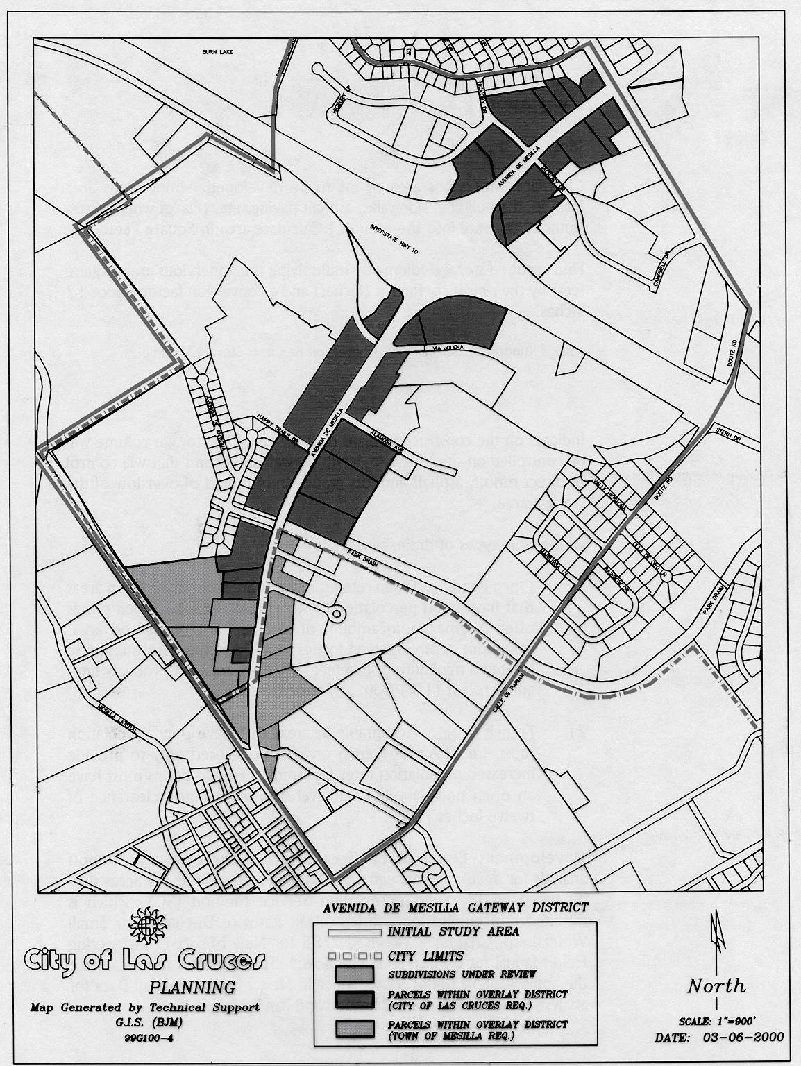
d.
Cottage industry. Such use shall meet the following requirements:
1)
Permitted only when such use occurs within a totally enclosed building on the premises where the primary use (retail/service) is conducted;
2)
The processing of goods shall be clearly accessory to the primary use (retail or service) where a maximum of 49 percent of the total business floor area, not to exceed 3,000 square feet, shall be used in the conduct of the cottage industry.
3)
The use shall not pose any adverse impacts to adjacent properties due to noise, odor, dust, or vibration.
4)
No more than three separate cottage industries may operate on any one parcel.
e.
Dance/music academy. Permitted only when used for instruction and/or the conduct of activities related to the performing arts.
f.
Dwellings as an accessory use for a proprietor, resident watchman, or caretaker. Permitted only when said dwelling meets all applicable urban design criteria and is constructed on-site.
g.
Engraving shop. All related activity shall be completely enclosed within the building used for the primary use and there shall be no outside storage of parts, inventory, or related materials whether temporary or permanent.
h.
Food/beverage production or packaging. Such use shall meet the following requirements:
1)
Permitted only when such use occurs within the same building as the primary use;
2)
The use must remain secondary to the primary use (retail or service).
3)
In no event shall the square footage for any production/assembly process associated with the commercial activity exceed 49 percent of the total business floor area (not to exceed 3,000 square feet).
4)
All ancillary activity (processing) uses shall conform to the following:
a)
Shall be conducted in a manner which serves to enhance the general retail and/or service atmosphere.
b)
Examples of establishments which may conduct this ancillary activity include cafes/restaurants, taverns, and other like uses involving food/beverage related products (human consumption) within applicable zoning districts.
c)
The ancillary activity shall not pose any adverse impacts to adjacent properties due to noise, odor, dust, or vibration.
i.
Gasoline station. Permitted only when vehicle repair activities are not associated with the use.
j.
Temporary uses. Temporary uses shall follow provisions as outlined in section 38-50; except as further stated. For purposes of the Avenida de Mesilla Gateway overlay district, temporary uses shall be limited to:
1)
Christmas tree stands. Sales of Christmas trees shall not occur before November 15 or after December 31. These uses shall be permitted only in C-2, C-3, M1/M2 and M-3 underlying zoning districts.
2)
Yard, garage or rummage sales. These types of uses shall be conducted for no more than four days, three times at one location in a calendar year. No permits are required for these uses and they must be conducted from an individual's dwelling. The conduct of these activities from a business or other property not used primarily for residential purposes is prohibited. This use is permitted in all applicable underlying zones.
3)
Community wide event. Temporary uses at the time of a community wide event are permitted to begin one week (seven calendar days) before the beginning of the community wide event and shall end three calendar days from the last day of the community wide event. For purposes of the Gateway, a community wide event is defined as a celebration or event that primarily promotes the community as a whole and not a single business or group of businesses per se. The activities may or may not involve retail special sales related to the specific celebration. Furthermore, the celebration/event must be sponsored by either local government(s) or not-for-profit organizations. These events may involve the use of tents and other temporary structures. Examples of community wide events include, but are not limited to The Mesilla Valley Hot Air Balloon Rally, custom car shows, public expositions, etc. These uses are permitted in R-4, O-2, C-2, C-3, M1/M2 and M-3 zones. (Also see Municipal Code Chapter 18, Article IV.)
3.
Prohibited uses. The following identifies those uses which are prohibited regardless of the underlying zoning district:
Acid manufacture
Adult amusement establishment
Adult bookstore/video store
Airport and heliport
Amusement park or enterprise (temporary or permanent)
Assembly of electronic or mechanical parts and equipment
Auto, truck, camper, and recreational vehicle sales and service
Automotive washing establishment
Boat sales, service, and repair
Body shop
Bus garage/storage/repair
Cement, lime, gypsum or plaster manufacturing or mixing
Cemetery
Cigarette and cigar stand (temporary or permanent)
Clothing manufacturer
Construction or contractor's yard (permanent)
Dance hall
Drive-in theater
Dyeing establishment
Electrical shop (contractor)
Explosive manufacture or storage
Fabrication shop
Fat rendering
Fertilizer manufacture/processing
Flea market
Firewood sales
Fraternity house
Freight house or truck terminal
Frozen food locker
Glue manufacture
Heavy equipment sales and service
Junk yards, salvage, or wrecking yards
Kennel (commercial)
Lumber yard (outside storage)
Manufacturing of consumer goods such as: appliances, batteries, garments, etc.
Metal work and machine shop
Microwave radio relay structure
Mini storage units
Mobile/manufactured homes
Mobile home park
Mobile home sales and service
Mobile home subdivision
Monopole
Motorcycle sales and service
Open or exterior storage and display of merchandise and/or materials (except when products offered and displayed on the premises are either:
1)
Grown on or off the premises; or
2)
Home-crafted, hand-crafted, or hand-assembled by crafts-persons on or off the premises.
Examples of acceptable products include, but may not be limited to, nursery stock, fruits and vegetables, leather crafts, paintings, woodwork, metalcraft, ceramics, sculpture, basketry, weaving and yarn work. Items shall typically be considered "non-durable commodities" which serve to foster the cultural and historical characteristics of the Mesilla Valley region. Examples of unacceptable products include, but may not be limited to, motorized vehicles, or equipment, bicycles, trailers, clothes washers, cloth dryers, fabricated storage sheds, playhouses, animal shelters, and goods commercially produced through mechanized means. Structures/walls/fences used to enclose and/or protect the display of goods shall be compatible to the architectural design of the primary building located on site. When no architectural style is defined within these regulations pre-exist on the property, one of the required styles shall be used for purposes herein stated.)
Packaging of cosmetics, pharmaceuticals, toiletries
Paint shop (spraying/mixing—nonretail sales)
Petroleum refining
Plumbing and heating shop (contractor)
Public utility installation, substation, and water well
Racetrack
Radio and TV broadcasting
Raw materials manufacturing, processing, and extraction
Recreational vehicle park
Recycling/purchase center
Sign construction and sales (exclusive of signs created pursuant to a cottage industry)
Smelting of ores
Sorority house
Stables (commercial)
Stadium: Baseball, football, soccer, track
Stock yards or slaughter of animals
Storage of wrecked or dismantled vehicles and parts (primary or accessory use)
Street vendors
Television and radio towers and all other free standing towers (public or private)
Temporary uses—Pursuant to temporary use permits (except those specifically identified elsewhere in this section.)
Tire sales and service
Warehouse/storage/distribution center
Welding shop (primary or accessory use)
Wrecker services
4.
Development standards. The following development standards shall apply to all fronting properties along the Gateway:
Minimum lot area/size/dimensions: Refer to underlying zone development standards.
Minimum setback provisions: Refer to underlying zone development standards.
Maximum building height: 40 feet. Not to contain no more than two stories. Pertains to all allowed uses within underlying zoning districts.
D.
Nonconforming uses. The following nonconforming use provisions shall apply to properties within the Gateway. Provisions pursuant to section 38-45.D.2.d below which allow increases in floor, building, or lot square footage shall not nullify minimum compliance requirements (i.e. parking and landscaping) established elsewhere in this Code or in other companion codes.
1.
Permitted uses with nonconforming urban design features.
a.
When nonconforming urban design features involving parking, landscaping, lighting, and fencing/walls are located on properties within the Avenida de Mesilla Gateway overlay zone district, these features shall be brought into compliance with Gateway standards when:
1)
The property remains vacant for a period of one continuous year or greater; or
2)
Any one-time or cumulative increase of ten percent to the gross square footage of building area occurs; or
3)
Any exterior remodel, renovation, or alteration occurs to the building. This provision shall not nullify allowances as identified in item 1.a.2); or
4)
A change in use occurs on the property which results in the alteration of the uses intensity (i.e. low volume to high volume business activity) or orientation (i.e. service to retail activity).
b.
When the architectural characteristics of the building are nonconforming, the architecture shall be brought into compliance with current standards when:
1)
The property remains vacant for a period of one continuous year or greater; or
2)
Any one-time or cumulative increase of 30 percent is made to the gross square footage of building area; or
3)
Any exterior remodel, renovation, or alteration occurs to the building. This provision shall not nullify allowances as identified in item 1.b.2).
c.
When a sign on the property is nonconforming, it shall be brought into conformance with current standards when:
1)
The property remains vacant for a period of one continuous year or greater; or
2)
A change in use occurs on the property which results in altering the uses intensity (i.e. low volume to high volume business activity) or orientation (i.e. service to retail activity).
2.
Prohibited uses with nonconforming urban design features.
a.
Commercial uses that existed within the Gateway prior to plan/ordinance adoption and which are specifically identified as a prohibited use, may be allowed to expand or enlarge (either one-time or cumulative increase) provided that:
b.
Said increase is no greater than 49 percent of the gross square footage of the lot, if said increase involves the incorporation of additional land area; or
c.
Said increase is no greater than 49 percent of the gross square footage of building area, if said increase is through the addition of building floor area; and
d.
All nonconforming urban design features are brought into compliance with Gateway standards when the lot area or building floor area has increased by 25 percent.
e.
In the event that a prohibited use is discontinued, removed, or otherwise ceases to exist on the subject parcel for any duration of time, said use shall lose its nonconforming status. Thereafter, any subsequent use and nonconforming urban design feature shall be made to conform with all applicable development requirements.
For purposes herein stated, a change in ownership of a nonconforming use shall not constitute a loss of nonconforming status. Additionally, maintenance of an official business registration in the absence of the corresponding bonafide use of the property, shall not be considered a continuation of a land use and may at the Community Development Directors or his/her designees discretion, trigger compliance requirements.
3.
For purposes of this section, exterior remodel, renovation, or alteration shall be defined as: any change or rearrangement in the supporting members of an existing building, such as bearing walls, columns, beams, girders, as well as any change in roof lines, or any enlargement to or diminution of a building or structure, whether horizontally or vertically. Normal maintenance activities as verified by the city's building official or his/her designee are exempt from this provision.
E.
Urban design standards. To insure quality property development and renovation, the following requirements regulating urban design are established in this overlay zone district.
1.
Architectural design.
a.
Purpose. Architectural design standards are established for this district in order to create uniformity of physical design consistent with the district's unique architectural characteristics.
See appendix I for a visual guide of the architectural design portion of this ordinance.
1)
Architectural design standards are established as follows: For properties along the Gateway, Pueblo, Spanish Colonial, Territorial, Mission, and other southwest vernacular architectural styles shall be required. The Pueblo, Spanish Colonial, Territorial, and Mission architectural styles represent those which are strongly encouraged within the Gateway. For information regarding other allowable styles, please refer to New Mexico Historic Building Inventory Manual, section VI, Introduction To New Mexico Architectural Styles, which is available in the city planning office.
a)
Pueblo.
(1)
Required facade features.
(a)
Walls shall be surfaced with a smooth stucco surfacing and shall incorporate soft rounded corners or buttressed corners in order to emphasize structural massing.
(b)
Parapet walls above the roof line shall be used in the design and shall have rounded edges and variations in height. Variations in height of parapet walls are recommended.
(c)
The use of bell coates (espadañas) or other design strategies which simply vary the heights of the facade shall be incorporated in large scale (business center or apartment complex) commercial or residential buildings.
(d)
Structures which are more than one story in height shall have the top story setback further from the front property line than the first story.
(2)
Roofs.
(a)
Required roof features. Roofs shall generally lie flat except that sloping of the surface will be allowed to facilitate the shedding of moisture.
(b)
Recommended roof features. Canales made of clay or treated wood shall be incorporated along appropriate areas of the roof and facade to aid in the removal of the surface moisture.
(3)
Required color features. Stuccoed walls and applied ornamentation shall be of a desert or earth tone.
(4)
Ornamentation.
(a)
Required ornamentation features.
(i)
Although the pueblo architectural style is generally limited in ornamentation, the use of exposed/treated wood lintels above windows and entryways and wood vigas shall be required.
(ii)
Vigas, applied as decoration, shall be placed along the exterior wall in a single orientation (i.e. north/south or east/west) in order to avoid the appearance of crossed or misplaced supports (buildings of more complicated design may be allowed multi-directional placement).
(iii)
Vertical supports for portales/loggias, if used in the design, shall consist of round wood columns with corbel bracketed capitals.
(b)
Recommended ornamentation features.
(i)
Application of exposed/treated wood lintels above windows and entryways and wood vigas may be used in their true structural form or may be applied simply as decoration.
(ii)
The use of portales/loggias are strongly encouraged but are not required elements.
(iii)
If chimneys are incorporated as a design feature, all components shall be appropriately constructed and detailed in a manner consistent with the rest of the structure.
b)
Spanish Colonial.
(1)
Facade.
(a)
Required facade features.
(i)
Walls shall be surfaced with a smooth stucco surfacing.
(ii)
Structures which are more than one story in height shall have the top story setback further from the front property line than the first story.
(b)
Recommended facade features. Walls are encouraged to include a belt mold which encircles the building along the top of the facade.
(2)
Roofs.
(a)
Required roof features.
(i)
Roofs shall be pitched using a 4 in 12 to 5 in 12 pitch.
(ii)
Roofs over balconies and other such features may have pitches of 2 in 12 or 3 in 12.
(iii)
Roofs shall be surfaced with clay barrel tiles or a material giving a similar appearance.
(b)
Recommended roof features.
(i)
Roofs are encouraged to have clipped eaves, generally flush with the wall.
(ii)
When overhangs are created, exposed and treated timbers should be used.
(3)
Color.
(a)
Required color features.
(i)
Stuccoed walls shall be white or contain otherwise light desert colors.
(ii)
If color accents are used, they shall not be of a stark contrast to the primary color of the wall.
(iii)
Roof color shall contain red tones.
(b)
Recommended color features. Color accents are a recommended feature of the Spanish Colonial style.
(4)
Ornamentation.
(a)
Required ornamentation features.
(i)
Windows shall be of a divided light variety and shall be recessed or otherwise defined and accentuated with molded surroundings.
(ii)
Walls for courtyard and patios, if used, shall be thick and/or otherwise appear massive.
(iii)
If shade structures are used, they shall have strong timber accents such as beams or joists.
(b)
Recommended ornamentation features.
(i)
Limited arches should be used in the overall design of the structure.
(ii)
Arches serving primary entryways are typical and are encouraged.
(iii)
All doors should be constructed of or give the appearance of heavy carved wood.
(iv)
Courtyards and patio designs incorporated into the building design are strongly encouraged.
(v)
Shade structures are also encouraged.
(vi)
If chimneys are incorporated as a design feature, all components shall be appropriately constructed and detailed in a manner consistent with the rest of the structure.
c)
Territorial.
(1)
Facade.
(a)
Required facade features.
(i)
Walls shall be surfaced with either a smooth stucco or brick. If brick is used, the brick must be antiqued or otherwise treated to give the appearance of a weathered and aged brick.
(ii)
Parapet walls above the roof line shall be used in the design and shall be capped with brickwork, masonry, or wood unless a folk territorial design is used, in which case, no parapet shall be used.
(iii)
Structures which are more than one story in height shall have the top story setback further from the front property line than the first story.
(b)
Recommended facade features.
(i)
Overall building form should be clean and simple in appearance.
(ii)
Structures should have facades of varying heights.
(2)
Roofs.
(a)
Required roof features.
(i)
Roofs shall generally lie flat except that sloping of the surface will be allowed to facilitate the shedding of moisture.
(ii)
Folk territorial designs shall have pitched gable roofs surfaced with tin or corrugated sheet metal which has been factory painted/treated in a manner which eliminates its reflective properties yet contributes to the design characteristics of the selected architecture.
(b)
Recommended roof features. Dormer windows are not required in folk territorial designs, but are strongly encouraged.
(3)
Color.
(a)
Required color features.
(i)
Stuccoed walls shall have earth tones such as tan, sand, and beige.
(ii)
Brick facades shall consist of muted colors such as red brick which has been "antiqued."
(b)
Recommended color features. Trim materials shall have light or neutral colors which contrast to primary surface colors.
(4)
Ornamentation.
(a)
Required ornamentation features.
(i)
In designs which incorporate parapets, the cornice shall be detailed with decorative brick or wood and contain dentil ornamentation.
(ii)
Window and door openings shall be set flush with the wall and shall have trim treatments of brick or wood surrounding the fenestration.
(iii)
The use of pediments (wood trim treatment) above doors and windows is required.
(iv)
Windows shall be of a divided light variety.
(v)
Ornamentation treatments for porches or porticos, if used, shall be similar to those incorporated on the primary structure (wood cornice and dentil treatments are typical) and shall be supported by wood columns.
(b)
Recommended ornamentation features.
(i)
Canales should be square or rectangular in shape and be constructed of a natural material such as wood, or have surface treatment which is consistent with the primary structure.
(ii)
If window shutters are used, they shall be paneled.
(iii)
Doors should be constructed of wood or treated to give the appearance of wood and should also be paneled.
(iv)
Designs incorporating porches or porticos along the facade are strongly encouraged.
(v)
Separate shade structures or treatments over balconies are not required but, if used, shall incorporate exposed timber in the design.
(vi)
If garden walls are used, they shall be surfaced with stucco and shall have a brick cap similar in treatment to that used for the primary building walls.
(vii)
Chimneys are not required but, if incorporated as a design feature, all components shall be appropriately constructed or otherwise detailed in a manner consistent with the rest of the structure.
d)
Mission.
(1)
Facade.
(a)
Required facade features.
(i)
Walls shall be surfaced with a smooth stucco finish and maintain clean edges or corners.
(ii)
Walls shall give the appearance of mass through their construction.
(iii)
Larger structures (i.e. business center, hotel etc.) which contain two stories shall:
(aa)
Create two distinct levels,
(bb)
Feature an arched portal feature along the first level,
(cc)
Incorporate a vertical element such as an espandana or bell coate in the design,
(dd)
The portal shall characteristically contain curvilinear openings or archways to emphasize the portal and assist in defining the two levels, and
(ee)
The second story shall be set back further from the front property line than the first story.
(ff)
All facades regardless of building size shall incorporate arched entryways in the design.
(gg)
Arched window openings or detailing is strongly encouraged for all such openings and shall be required for windows which figure prominently in the facade design.
(hh)
Facades shall also incorporate curvilinear parapets projecting above gabled rooftops.
(b)
Recommended facade features.
(i)
Smaller structures used for single uses or a small number of uses will comply with the following:
(aa)
May incorporate similar design features as what is required of the larger structures; and
(bb)
Greater design latitude shall be afforded to smaller structures in order to ensure that scale and mass do not overwhelm the overall appearance.
(2)
Roofs.
(a)
Required roof features.
(i)
Roofs shall be pitched in a gable fashion and shall be surfaced with a red colored tile.
(ii)
Emphasis to the roof detailing shall be provided through the use of curvilinear parapets.
(b)
Recommended roof features. Projecting eaves, if utilized, shall be accentuated with exposed rafters.
(3)
Required color features.
(a)
Stuccoed walls shall have light or neutral tones.
(b)
Roof tiles shall have a red tone.
(4)
Ornamentation.
(a)
Required ornamentation features. Curvilinear parapets shall be required.
(b)
Recommended ornamentation features.
(i)
Any projecting eaves shall be required to be accentuated by exposed rafters.
(ii)
Detailing which emphasizes rounded or curved openings such as windows or portal entry arches is encouraged.
b.
Wall surfacing.
1)
For all other architectural styles not outlined above, stucco or brick shall be the material used for all exterior wall surfacing (exclusive of trim details, etc.).
2)
Freestanding walls/fences if used as a design feature shall be constructed of adobe or cinder block layered with stucco, or wrought iron or any combination thereof except that all wall treatments shall be consistent with the architectural style used for the building(s).
3)
Slump block shall not be used as a finish surface for any facade or freestanding wall.
4)
No chain link fencing shall be permitted unless used for temporary purposes related to construction which occurs on site.
c.
Multiple story structures.
1)
Two story structures, regardless of architectural type, shall have their stories terraced or staggered so as to provide a transitioning of structural bulk and scale.
2)
Special design features such as espadañas (bell coates) are exempt from this provision.
3)
Portals incorporated in the design and placed along the facade may be considered an acceptable transition mechanism, as identified in c.1), above.
d.
Accessory structures.
1)
All accessory structures such as storage buildings, work shops, and structures used to enhance indoor/outdoor space (i.e. pergolas or other shade devices within courtyards etc.) shall be constructed and otherwise detailed in a manner consistent with the architecture of the primary building.
e.
Sensitive building design
1)
All building facades shall become an integral part of the overall design and reflect the architectural style chosen.
2)
When necessary, the use of landscaping shall be required to break up building facades which by their design may have long, continuous surfaces with limited fenestrations or other openings.
2.
Landscaping.
a.
Purpose. The landscaping standards for new development, and the encouragement of landscaping for existing property along the Gateway, are established to represent the agricultural theme prevalent within the Gateway area and the Mesilla Valley in general. Landscaping will also screen/buffer parking lots from the right-of-way and soften their overall impact.
1)
Definitions.
a)
Landscape shall be defined as the following per 1000 square feet of landscape area required:
(1)
Two two-inch caliper trees as measured six inches above soil level and which reach a minimum height of 25 feet at maturity as referenced in The New Western Garden Book (most recent edition), and
(2)
Fifteen five-gallon shrubs, and
(3)
A choice of either five one-gallon shrubs or 50 square feet of ground cover for every 500 square feet of lot area excluding building area and parking lot area in addition to five one-gallon shrubs.
2)
Landscaping for new development along the Gateway shall be provided to cover 15 percent of the lot area exclusive of building area.
3)
All landscaping shall be provided on site.
4)
Of the total area to be landscaped, fifty percent (50 percent) shall be located within the front setback of the property. Of this percentage, one-half (2) shall be located between the front property line and the parking lot.
Note: Front setback of the property shall be defined as: the area between the back of sidewalk and the property's principal structure.
5)
A minimum of 25 percent of the total required landscape area and 25 percent of required plant material shall be located along the rear and sides of any principal and/or ancillary building.
6)
The remaining 25 percent of the required landscaping shall be incorporated in areas adjacent to service areas (loading docks/bays, dumpsters, etc.), building/utility equipment, and within ponding areas as a means of providing a screen or buffer to these potentially harsh/contrasting development features.
7)
In addition to the 15 percent required landscaping percentage, all development exclusive of single-family and duplex properties shall be required to plant trees within the parking areas for shade and visual relief.
a)
Trees located within the parking area shall maintain a minimum height of six feet before the first lateral branch and shall reach a minimum canopy diameter, at maturity, of 20 feet.
b)
All parking areas shall have a minimum requirement of one 24-inch box tree per every ten parking spaces within the parking lot.
Trees shall be located in an island and/or planters which will protect tree trunks from cars.
(1)
Addition of a barrier such as a curb, wheel stop, or bollard shall be required to be used as protection.
(2)
Islands shall be a minimum of three feet wide.
(3)
Islands shall be located so as to relieve the large expanses of paving and to provide shade and contribute to orderly multi-modal circulation.
c)
Trees should be planted along the edge and/or between parking stalls in planter areas which have a minimum area of 49 square feet, dimensional requirements as provided in Appendix I at the end of this section, and a raised border of at least four inches in height.
d)
Where a landscape border or similar feature abuts parking stalls, trees within those areas may count toward the parking area tree requirement, provided:
(1)
The trees are planted within ten feet of the parking stall area perimeter; and
(2)
The number of parking area trees required pursuant to these regulations is not reduced by more than half as a result of this condition's implementation; and
(3)
A minimum of one tree is provided within the parking area.
8)
Ground cover material consisting of bark, pecan shell, decorative stone, or river rock shall be used on any ground surface which would otherwise be exposed. Excessively large expanses (greater than 500 square feet) of ground covered landscape areas shall be avoided unless vegetation and variety in ground cover textures are incorporated to help mitigate incompatible scale concerns.
9)
The property owner shall be responsible for maintenance of all plantings and for a sufficient irrigation system to water all plant material, but should also conserve water, as per the city design standards.
a)
In the event the required maintenance is not being provided 20 days after notice from the city, the property owner shall be subject to a fine as per the Municipal Code.
b)
Each day of such and infraction shall be deemed a separate offense.
3.
Site design elements.
a.
Buffering—Purpose. Visual screens/buffers are established to soften the harsh look of parking lots and other physical features from the right-of-way and to ease their overall impact. Through the use of required landscaping, landscaping elements, garden walls, berms, hedges, and/or other landscape features, this separation will exist. The following provisions shall be considered when creating this separation:
Buffer strip.
1)
A minimum ten-foot wide buffer strip shall be required between parking lots and the property line which is most parallel with Avenida de Mesilla.
2)
Buffers shall have a minimum vertical height of two feet and a maximum vertical height of three feet, as measured from top of buffer element to top of curb. All clear site triangle provisions shall apply as stated in article III, definitions.
3)
Berms.
a)
Berms shall have a maximum design slope of one foot of rise for every five feet of distance (grass) or one foot rise for every three feet of distance (ground cover).
b)
Walls, if used in conjunction with berms or as the sole buffering mechanism, shall be placed at the farthest location away from the property line, closest to the parking area. Head-in-parking adjacent to walls must use wheel stops or be offset at least 2.5 feet from the curb.
c)
Design considerations shall be implemented to control erosion where berms abut sidewalks.
4)
All landscaping used within the buffer strip may count toward fulfilling the landscaping requirements pursuant to applicable provisions.
5)
Aesthetically incompatible service areas and building mechanical/utility equipment.
a)
Dumpsters.
(1)
Dumpster locations shall be surrounded by a wall having a minimum height of at least one foot above the refuse container and which is compatible with the architectural character of the development in material and location.
(2)
Landscaping shall also be placed in close proximity to the dumpster so as to cause a more appropriate transition or blending of physical features.
b)
Freestanding building mechanical/utility equipment.
(1)
This equipment shall be screened from view using landscaping or walls in a manner that conceals the equipment and remains consistent with the landscape/ architectural character of the project to which it pertains.
(2)
Equipment that is on the rooftop or otherwise attached to the building shall be screened from view through the use of building design elements such as parapets or similar strategies.
(3)
When the chosen architectural style selected does not lend itself to using these techniques, equipment shall be placed toward the rear of the building rooftop or facade and shall be painted with a color that most accurately matches the building element to which it is attached.
4.
Sidewalks. Sidewalk installation requirements shall adhere to the city design standards and the city sidewalk ordinance requirements, except that:
a.
Future large scale (block lengths or greater) sidewalk reconstruction and new installation efforts shall require the matching of sidewalk surfacing consistent with that found along Avenida de Mesilla near the Avenida de Mesilla/Calle de El Paso intersection.
b.
Small scale (less than block length) installation of new lengths of sidewalk and small scale sidewalk reconstruction shall be examined on a case by case basis to see if surface matching is appropriate.
c.
Piecemeal surface matching should be avoided.
5.
Signs.
a.
Purpose. The Avenida de Mesilla Gateway overlay zone district sign code shall be established for aesthetics, height, overall size, type and lighting considerations for signage consistent with the district's urban design standards.
b.
In determining applicable sign standards, chapter 36 shall apply, except as provided below:
1)
Off-premise signs. No off-premise signs shall be allowed along the Gateway except for the following:
a)
Political signs that are no greater than 32 square feet in area and six feet in height. Signs shall be erected no sooner than 30 days before the election to which they pertain and shall be removed within seven days following same election.
b)
Off-premise sign displays regarding community events or holidays may be permitted, if approved by the city manager or designee.
2)
Temporary signs/displays. Temporary signs/displays shall be limited to banners, pennants, streamers, balloons and real estate signs.
a)
Banners, pennants, streamers, and balloons shall be subject to applicable provisions identified within the city sign code pursuant to commercial promotional display (section 36-118) and residential promotional display (section 36-119).
b)
Real estate signs shall be no greater than 15 square feet in sign area. Sign height shall be no greater than six feet. When signs are greater than eight square feet in sign area, they shall be constructed entirely of wood and shall incorporate corporate logos, illustrations, or other graphics along with the text to create a more aesthetically pleasing sign display. Signs in excess of eight square feet shall utilize a combination of differing geometric shapes in the design of the sign face's outline or silhouette.
3)
On-premise attached signs.
a)
Wall, window, and canopy signs shall be the only attached sign types allowed within the Gateway.
b)
The maximum total sign area shall be no greater than one square foot of signage per linear foot of street frontage along Avenida de Mesilla only. For a single business located on one or more lots, the total attached sign area shall not exceed 250 square feet. For a development involving business/shopping centers, the maximum total sign area shall be limited to that authorized by the sign area calculation using Avenida de Mesilla frontage.
c)
Except for canopy signs, there shall be no limit to the number of signs used provided that their cumulative square footage does not exceed the maximum allotment (see also, window sign design standards, on-premise point-of-sale and accessory use signs) allowed.
d)
No more than 20 percent of the window area shall be covered by a window sign.
e)
Canopy signs shall be placed on no more than two sides of the canopy. Sign(s) may either be attached to the canopy through the use of either channel letters (construction characteristics), or the sign(s) may be painted, imprinted, or stamped on the canopy face. Only one sign type may be used per canopy. Canopy signs shall not occupy more than 33 percent of the canopy side to which they are attached and shall be primarily used for corporate/business identification only and not advertising pre se. For purposes of these regulations, canopies shall be defined as provided in article III and shall not include portales, poticos, loggias, zagguans, miradors, and other similar architectural design features/elements customarily used in southwestern architectural vernacular.
4)
On-premise freestanding signs.
a)
Ground signs shall be the only freestanding sign allowed within the Gateway.
b)
If two signs are allowed, the second sign may be of a design, size, and height permitted pursuant to the city's sign ordinance and shall be located toward the property line which is furthest from and most parallel to Avenida de Mesilla, at a distance from that line which shall not exceed 15 feet. All other applicable sign setbacks and related provisions shall apply for the sign.
c)
Ground signs located along Avenida de Mesilla shall be no larger than six feet in height and no greater than 32 square feet in sign area.
d)
Each ground sign shall maintain a ten-foot setback from front and side property lines.
e)
Wood shall be the predominant material used in the construction of the ground sign's copy.
f)
The illumination of the ground sign must not be positioned so as to interfere or visually impair passing motorists, bicyclists, or pedestrians.
g)
If the lighting standard is visible, it shall be decorative in its construction and shall be consistent with the architectural style of the property.
h)
Properties developed as business centers shall conform to the following:
(1)
One ground sign identifying the name of the center.
(2)
One directory ground sign will be allowed.
(a)
The directory ground sign shall be no greater than six feet in height.
(b)
The sign shall provide no more than four square feet of sign area for the identification of each tenant.
(3)
Overall sign area is dependent on the number of businesses within the business center.
(4)
All other provisions set forth in article VIII and this section regarding setbacks, construction materials, and illumination shall apply.
(5)
On-premise point-of-sale and accessory use signs.
(a)
These sign types shall follow all applicable provisions identified within the sign code.
(b)
For purposes of the Gateway, the square footage of these sign types shall be part of the total square footage allowed under the provisions for attached signage.
c.
Sign design standards.
1)
Signs shall not be placed in a manner which interferes, covers, or otherwise disrupts the intended purpose of important architectural building features such as display windows, cornices, vigas, entrances, eaves, and other decorative/integral elements.
2)
Signs shall be designed (shape, color, and material) in a manner consistent with the building to which it relates.
a)
Signs of excessively complicated design, which disrupt the architectural character of the building, shall not be permitted.
b)
In order to facilitate this compatibility, the following shall apply:
(1)
Freestanding signs.
(a)
Design elements and/or finish treatments such as stucco or brick surfacing, freestanding wall designs/treatments, etc. shall be incorporated into a monument sign's overall design except that the copy portion of the sign shall be constructed of wood.
(b)
Color. The color of surface or finish materials used on the building shall be incorporated into the sign's supporting structure.
Contrasting colors may be used on the copy portion of the sign for purposes of increased legibility and clarity.
A maximum of two contrasting colors shall be used.
(c)
When multiple ground signs are allowed (i.e. business centers), the design of each sign shall maintain a similar design appearance, and colors and lettering styles shall remain consistent.
(d)
The base of all ground signs shall be landscaped with shrubs and ground cover.
(2)
Attached signs.
(a)
Signs may be constructed of channel letters, or wood; except, only one style may be used per building or development. If channel letters are used, a logo of the same construction type may also be incorporated into the sign(s) design.
(b)
Contrasting colors may be used in the sign's design for clarity and legibility; however, a maximum of two such colors, exclusive of background color, are allowed for signs used by each business. For purposes of this provision, the background color must not be used to highlight the sign message and must, therefore, be a color applied in a consistent manner to building or structure walls/surfaces within the development.
d.
Lighting.
1)
If a sign is externally lighted, the lighting fixture shall be decorative in its construction and be compatible to the architectural style of the building to which it relates.
2)
Other illumination options include both internal and back lighting.
3)
When a sign is lighted, there shall be no glare off the sign due to the lighting utilized with the sign.
e.
Neon signs.
1)
The use of neon is permitted provided it is used for back lighting purposes only. The neon tubing shall be completely shielded from view (as viewed from the front of the subject sign) by the sign's letters or sign structure it is intended to back light. Only one color of neon may be used to back light signs placed upon a building or within a development.
f.
Legibility and clarity.
1)
To facilitate legibility and sign clarity, the number of different lettering styles or fonts and font sizes on a sign shall be kept to a minimum.
2)
Lettering shall not be crowded onto a sign and ample space surrounding the copy shall be maintained.
6.
Transportation.
a.
Purpose. To improve access to and circulation within the Avenida de Mesilla Gateway overlay zone district, to minimize traffic conflicts along the Gateway, and to encourage the integration of all modes of transportation into the Gateway. The following transportation regulations shall be complied with:
1)
Appropriate striping, placement of barriers, surfacing treatments, and other applicable demarcation strategies shall be used to clearly identify circulation patterns. Developments are encouraged to provide bicycle access and parking.
2)
The following access/curb cut provisions shall be required along Avenida de Mesilla pursuant to New Mexico State Highway and Transportation Department final approval.
The provisions are based on the linear frontage of property along Avenida de Mesilla and are intended to promote shared access and increase overall ingress/egress efficiency and safety.
a)
Access designs which incorporate acceleration/deceleration lanes and other similar traffic flow strategies, which may impact access/curb cut needs, will require the review and approval of plans by the city's public works director or designee and New Mexico State Highway and Transportation Department.
b)
Non-shared curb cuts shall maintain a five-foot side yard setback.
c)
A 50-foot separation between curb cuts as measured along the property line shall be maintained regardless of type.
d)
The width for one-way curb cuts shall be 15 feet. The width for two-way and shared curb cuts shall be no less than 25 feet and no greater than 35 feet.
e)
Shared access shall be strongly encouraged.
f)
Shared access provisions shall be secured by a shared access agreement between affected property owners and shall be approved as to form and content by the city attorney's office. Final agreements shall be filed at the county clerk's office.
3)
Parking. In order to minimize the impacts often created by parking lots, parking requirements along the Gateway shall follow all applicable parking standards as provided in section 38-58, off-street parking, of this Code, except as follows:
a)
Businesses located along the Gateway are encouraged to seek shared parking agreements with businesses on adjoining properties.
(1)
These agreements shall be approved as to form and content by the city attorney's office and once completed, filed with the county clerk's office.
(2)
Agreements may be made with adjoining property owners regardless of each business' hours of operation.
(3)
In combining parking requirements, 100 percent of the required off-street parking for all subject businesses shall be met.
(4)
For businesses requiring a shared parking arrangement in order to meet parking provisions, the agreement shall pertain to no more than 40 percent of the number of parking stalls they are responsible to provide. The remaining 60 percent must be provided on that business' site.
b)
Lighting standards used to illuminate parking lots shall relate in design, material, and color to the architectural and/or historical character of the property.
c)
All lighting shall be fully shielded fixtures with full cut-off, 20 percent below horizontal.
F.
Administration of overlay plan district.
1.
Purpose. All new development, including subdivisions and signs, shall require city approval. Proposals involving any development within the Avenida de Mesilla Gateway area shall be processed through the city's staff to aid in enforcing area standards.
a.
Submittal and review process.
1)
Purpose. Submittal and review procedures are established for all new development to protect persons and property within the district as directed in the Avenida de Mesilla Gateway Plan.
2)
Subdivisions. For submittal and review of subdivisions within the district, refer to article VI, alternate summary procedures, City Subdivision Code.
3)
Buildings.
a)
Pre-application conference.
(1)
Prior to the filing of an application for developments in the district, it is strongly encouraged that the applicant meet with staff of the city community development department to review the proposed project.
(2)
At the conference, staff shall review the development proposal and advise the applicant concerning the compatibility of the proposal with the intent and standards of the Avenida de Mesilla Gateway plan and all other applicable city codes.
b)
Application procedure. Upon submittal of the required items, the application materials will be processed to the appropriate city departments. Written comments and recommendations from the reviewing agencies will be forwarded to the community development department within ten working days from the date of submittal.
c)
Application materials.
(1)
Applications for development within the Avenida de Mesilla Gateway overlay zone district shall be obtained from the community development department, building permit section.
(2)
Development submittal requirements, including the development statement shall, at a minimum, reflect the following information: (Number of copies to submit with the application is outlined in the Avenida de Mesilla Gateway overlay zone district application packet, available at the city community development department.)
(a)
A statement of objectives to be achieved by the development inclusive of a description of the character and anticipated use of the proposed development.
(b)
Scaled site plan.
(i)
Property boundaries.
(ii)
Location of all structures.
(iii)
Parking layout.
(iv)
Location of service and loading areas.
(v)
Pedestrian and bicycle circulation.
(vi)
Dumpster location.
(vii)
Areas proposed for landscaping.
(viii)
Ingress/egress access points.
(ix)
Identification of proposed uses within each structure.
(x)
Storm water ponding areas.
(xi)
Surfacing material for impervious surfaces.
(xii)
Setbacks.
(xiii)
Any other information which conveys how the proposal will meet development requirements.
(c)
Scaled floor plan. The scaled floor plan shall clearly identify the internal boundaries, size, and storage areas of each use.
(d)
Scaled landscaping plan.
(i)
This plan shall include the location, size, and common name of all landscaping.
(ii)
A complete irrigation plan shall be included, clearly identifying how the landscape will be sustained.
(e)
Scaled elevations.
(i)
The diagram shall include each directional view of all structures clearly identifying exterior building materials and treatments.
(ii)
Location and treatment of all fenestrations and other building openings shall also be indicated on plans.
(iii)
Building ornamentation shall be shown.
(iv)
Roof design and roof surfacing material shall be indicated on diagram.
(f)
Architectural/artistic renderings.
(i)
Renderings shall reflect the exterior building.
(ii)
Drawings shall demonstrate the use of building materials.
(iii)
Renderings shall indicate selected colors.
4)
Signs.
a)
Sign permits shall be required for all signs within the district. While sign permits are approved separately from all other required permits and applications, the department strongly encourages the display of signage included in the aforementioned submittal material F.1.a.3)c)(2)(b) through F.1.a.3)c)(2)(f).
b)
All application and submittal material can be obtained from the city planning office. Once the application has been deemed complete and approved, a sign permit will be issued by the city's sign administrator.
b.
Appeals.
1)
Any applications for developments must be approved by the city in order for a building permit to be issued.
2)
In the event that an application is denied by the city staff, based on interpretation of the Gateway plan and this Code, an agreement of interpretation cannot be reached, and all other procedures established by this section have been exhausted, the applicant may file for an appeal, in writing, to the Planning and Zoning Commission within 15 days of the city staff's denial decision.
3)
The appeal will be processed by the city to be considered at the next available public hearing in accordance with notice requirements of section 38-10 of this Code.
4)
Any aggrieved person that is affected by a decision of an administrative official, commission, committee, or board in the enforcement of the Avenida de Mesilla Gateway plan and this section may appeal such decision to the city council in accordance with section 38-13 of this Code.
5)
Any person aggrieved by a determination of the city council may appeal to the district court within 30 days after the determination made by city council, in accordance with section 38-14 of this Code.
c.
Variances.
1)
Variances in the numerical requirements for development within the district may be granted by the Planning and Zoning Commission at a public hearing in accordance with section 38-11 of this Code.
2)
An application for a numerical variance will be processed to applicable city departments.
3)
Written comments from the applicable city departments shall be forwarded to the city community development department within ten working days of the submittal.
4)
Comments from the community development department shall be delivered to the Planning and Zoning Commission prior to the public hearing.
5)
Decisions of the Planning and Zoning Commission may be appealed to city council, in accordance with the provisions of section 38-13 of this Code.
G.
Enforcement of overlay zone district. Provisions to enforce this section shall be consistent with the enforcement provisions of section 38-16 of this Code.

(Ord. No. 2354, § I, 1-22-07)
Sec. 38-46. - LCIIP—Las Cruces Innovation and Industrial Overlay Zone District.
A.
Purpose. The purpose of the Las Cruces Innovation and Industrial Park Overlay Zone District is to guide development within the Park and implement the policies found in the LCIIP Master Plan. It aims to promote the natural and existing environment within the Park, and encourage employment options for residents while enhancing the overall aesthetic features of the Park.
B.
Applicability of Industrial Park Overlay Zone District boundaries. The Las Cruces Innovation and Industrial Park Overlay Zone District shall apply to all properties within the Overlay Zone District as identified in "Figure 1. Las Cruces Innovation and Industrial Park Overlay Zone & Districts" below. Most of the Park is regulated by the Overlay Zone District requirements except a few parcels, as indicated in "Figure 2. Las Cruces Innovation and Industrial Park Zoning Designations." The Overlay Zone District includes permitted and prohibited uses along with development standards for site, architecture, landscape, and parking.
C.
Land Use Districts. As established in Elevate Las Cruces, "Business Park and Industrial areas are reserved for concentrations or warehousing, trade, transportation, research and development, manufacturing, and industrial uses" (Elevate Las Cruces, Volume I, pg. 35).
The goal of the Land Use Framework is to accommodate a range of uses, with the intent of creating synergy between businesses with similar or complementary activities. The Land Use Framework also establishes a commercial district adjacent to Interstate 10. Uses such as restaurants and retail are permissive here to provide and encourage services to the local workforce. The Land Use Framework establishes four districts with specific permissive land uses. Since the Las Cruces Innovation and Industrial Park Overlay Zone District allows a wide variety of uses and covers almost all the land area within the Park boundary, the Land Use Framework establishes land use districts to group similar or complementary uses to provide a more organized built environment. The Land Use Framework, as illustrated in "Figure 1. Las Cruces Innovation and Industrial Park Overlay Zone & Districts," breaks the Park down into four districts:
1.
Value added agriculture;
2.
Manufacturing/warehousing/distribution;
3.
Aerospace/aviation/defense; and
4.
Commercial.
The Value-Added Agriculture district is located south of Interstate 10 in the southeastern portion of the Park. It is intended to accommodate agriculture-related manufacturing and other processes that enhance the value of basic agricultural commodities. Most of the parcels are larger in size to provide sufficient land for these types of activities.
The Manufacturing/Warehousing/Distribution district is located south of Interstate 10 in the southwestern portion of the Park. It is intended to accommodate manufacturing, warehousing, and distribution types of uses. It offers a range of parcel sizes and has good access to the interstate.
The Aerospace/Aviation/Defense district is located north of Interstate 10 and is adjacent to the Las Cruces International Airport. It is intended to accommodate aviation- and defense-related uses and offers a range of parcel sizes with direct access to the airport.
The Commercial district is located adjacent to Crawford Boulevard, on both sides of the Interstate 10 interchange. It is intended to accommodate commercial uses that offer services to the local workforce and interstate-associated business opportunities. This district has smaller parcel sizes more suited for uses like restaurants, with good visibility and access from the interchange.
D.
Development Process. All development within the Overlay Zone District shall follow the applicable City of Las Cruces development processes.
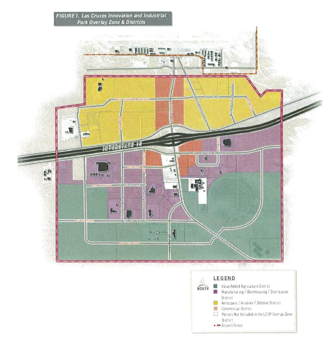

E.
Land uses. "Table 1. Use Table" allocates uses into four Land Use Districts. A dash ("-") indicates the use is not permitted while a "P" indicates that a use is permitted. An "A" indicates that a use is accessory. Associated Conditional Use Standards are indicated with an "X" and detailed in Section "Conditional Use Standards." This indicates that a use is permitted with conditions. Uses not specified in "Table 1. Use Table" will be determined by the City of Las Cruces Community Development Director in consultation with the City of Las Cruces Economic Development Director.
1.
Prohibited Uses. The following uses are prohibited:
a.
All uses prohibited under FAA regulations;
b.
All adult amusement establishments;
c.
All residential uses, except as established under the accessory use category.
2.
Conditional Use Standards.
a.
Aerospace/Aviation/Defense District.
1)
All uses in the Aerospace & Aviation District shall comply with all applicable FAA regulations.
b.
Commercial Uses.
1)
Agriculture and Animal Related.
a)
General Agriculture.
i.
Animals shall be confined to graze within the appropriate boundaries and cannot graze on surrounding properties and streets.
ii.
The keeping of large and small livestock animals shall comply with the City of Las Cruces Municipal Code.
b)
Small Animal Facilities.
i.
Kennels must be conducted within fully enclosed building. Outdoor pens shall be enclosed on all sides by a wall or fence at least six feet high.
ii.
This use must be screened as required by section "Walls, Fences and Screening."
2)
Food, Beverage, Hotel or Motel.
a)
Brewery and micro-brewery facilities, including tasting rooms.
i.
Alcohol sales for on-premises consumption is allowed, provided that the establishment complies with all New Mexico State law requirements.
3)
Motor Vehicle-Related.
a)
Vehicle Services.
i.
This use must be screened as required by section "Walls, Fences and Screening."
ii.
Vehicle repair, servicing, and maintenance shall be conducted within a fully enclosed building.
iii.
Recreational vehicle parking stalls/hook-ups are ancillary to the primary use and cannot be a standalone land use.
4)
Offices and Commercial Services.
a)
Construction Contractor Facility and Yard.
i.
This use must be screened as required by section "Walls, Fences and Screening."
5)
Outdoor Entertainment.
a)
Outdoor Entertainment.
i.
Drive-In Theater use shall be enclosed with a wall, fence, or vegetative screen of at least six feet in height. A screen located less than 500 feet from Interstate 10 shall be shielded so that the picture surface cannot be seen from Interstate 10.
ii.
All other outdoor entertainment uses shall include fencing or screening meeting the standards established in section "Walls, Fences, and Screening" designed to prevent any objects from passing beyond the property line and onto surrounding properties and streets. Uses shall be limited to one acre in size.
3.
Industrial Uses.
a.
Manufacturing, Fabrications & Assembly.
1)
Cannabis cultivation, Infused Products Manufacturing.
a)
This use shall comply with all New Mexico State law requirements.
2)
Light Manufacturing.
a)
All activities in this use shall be conducted within a fully enclosed building unless a Special Use Approval is obtained pursuant to the City of Las Cruces Special Use Permit Process.
b)
Incidental outdoor storage is permitted but must comply with section "Walls, Fences and Screening."
c)
This use may include a sales/display room for items manufactured on the property.
3)
Heavy Manufacturing.
a)
This use may be conducted outside of a building, provided the activities are screened from view according to section "Walls, Fences and Screening."
b)
Incidental outdoor storage is permitted but must comply with section "Walls, Fences and Screening."
4)
Special Manufacturing.
a)
This use must obtain all applicable State and federal permits or approvals for the activity and comply with the terms of those permits and approvals throughout the duration of the activity.
b)
This use may be conducted outside of a building, provided the activities are screened from view according to section "Walls, Fences and Screening."
b.
Telecommunications, Towers, and Utilities.
1)
Solar Energy Generation.
a)
This use must obtain all applicable State and federal permits or approvals for the activity and comply with the terms of those permits and approvals throughout the duration of the activity.
2)
Telecommunications, Towers, and Utilities.
a)
This use shall comply with the City of Las Cruces Municipal Code.
c.
Wholesaling and Storage.
1)
Outdoor Storage.
a)
This use must be screened as required by section "Walls, Fences and Screening."
4.
Accessory Uses.
a.
Accessory Commercial Uses.
1)
In all districts, all uses listed under the 'Food, Beverage, Entertainment & Lodging' use and 'Offices and Commercial Services' use category shall be permissive as an accessory use not to exceed a maximum of 40 percent of the gross floor area of the building for commercial purposes associated with that specific industrial or manufacturing use.
b.
Accessory Residential Use—Non-Primary.
1)
Residential use—non-primary is allowed for caretakers of the primary non-residential use and may be attached or detached.
F.
Administration and Enforcement.
1.
Applicability. The following development standards shall apply to all parcels located within the Overlay Zone District's boundary as identified on "Figure 1. Las Cruces Innovation and Industrial Park Overlay Zone & Districts." City of Las Cruces Municipal Code standards shall apply unless otherwise stated in the document.
2.
Non-Conforming.
a.
Uses and structures that are non-conforming with the standards of the Las Cruces Innovation and Industrial Park Overlay Zone District shall comply with this section.
1)
There are two instances of non-conformance:
a)
Instance 1: A non-conforming use/structure which was initiated/constructed prior to the adoption of the Overlay Zone District standards.
b)
Uses that are classified as instance 1 may continue in perpetuity unless the use ceases for a period of no less than 12 consecutive months. However, the use/structure cannot be expanded, enlarged, or extended.
c)
Instance 2: A non-conforming use/structure initiated/constructed after the adoption of the Overlay Zone District standards.
d)
Uses that are classified as instance 2 shall be brought into compliance immediately and shall not be permitted to expand.
G.
General Development Standards.
1.
Streets and Public Right-of-Way.
a.
All streets within Las Cruces Innovation and Industrial Park must adhere to City of Las Cruces Design And Roadway Construction Standards currently amended/adopted.
b.
Property owners shall provide dedicated right-of-way including easements for trail corridors and pedestrian facilities.
c.
The property owner is responsible to provide landscaping in accordance with standards outlined in this section in contiguous parkways and medians at the time of site development.
d.
All additions, rehabilitation, remodeling, or structural modifications to existing buildings with a value of $100,000.00 or more, including all new parking lots require installation of parkway and median landscaping.
e.
Landscape in parkways and medians shall be maintained by the property owner of the contiguous property.
2.
Dimensional Standards.
a.
All buildings and structures within Las Cruces Innovation and Industrial Park will be limited to the following development requirements:
3.
Site Layout.
a.
Orient building entries, office areas, showrooms and/or lobbies, and amenities to front the primary public street.
b.
On-site circulation shall have an adequate length of stacking for industrial facilities, e.g. loading docks, terminals, etc. that do not interfere with the movement of traffic (on- or off-site) and/or pedestrian areas.
c.
Outdoor lighting shall follow the regulations provided in the City of Las Cruces Outdoor Lighting Ordinance.
d.
Provide on-site pedestrian walkways at a minimum six-foot clear width that are separate from drive aisles to connect to primary building entrances.
e.
A public space such as an outdoor patio space, plaza, or courtyard shall be provided for any buildings greater than or equal to 75,000 square feet. For lots with more than one building, shared public spaces are permitted.
f.
Sidewalk installation is required with any development located on the north side of Interstate 10.
g.
Sidewalk installation is not required with any development located on the south side of Interstate 10.
4.
Parking.
a.
Parking requirements for automobiles and bicycles are set for land uses as noted in the adopted Land Use Table. Requests to reduce parking requirements shall be evaluated on a case-by-case basis by the Economic Development Director or designee.
b.
Accessible parking shall be provided according to Federal ADA parking standards.
c.
Landscaped islands and medians shall be incorporated into parking areas to provide shade, define parking areas and pedestrian access, and allow for passive water harvesting. See "Landscaping" for requirements.
d.
Surface runoff in parking lots shall be directed to landscaped passive water harvesting areas.
e.
A minimum of 20 percent of parking spaces provided shall use previous materials such as previous concrete, previous asphalt, permeable pavers, compacted gravel or gravel. If gravel is used, a minimum of four-inch base course that is compacted to ensure stabilization of gravel is required.
f.
Carports, including solar carport canopies, are allowed within surface parking lots, provided the materials are compatible with the building architecture.
g.
Fleet vehicle parking and loading docks shall not be located along the site main frontage. The placement of such facilities shall be located in the rear half of the site, secondary front, or behind the principal structure.
h.
Outdoor storage areas used for fleet vehicles shall be paved or use a similarly compacted material that is stable and does not produce dust.
i.
Bike parking shall be located at the primary entrance of the primary building.
5.
Architecture.
a.
Building Materials.
1)
Buildings shall be designed to incorporate contemporary architectural styles and materials to create the appearance of a state-of-the-art industrial park. Common elements such as architectural style, color, materials and ornamentation shall be used to create a cohesive park identity.
2)
Permitted materials include:
a)
Exterior plaster or stucco.
b)
Architectural metal; decorative panels, structural elements and decorative support or trim members.
c)
Precast concrete and tilt-up wall systems.
d)
Textured, patterned and/or integrally colored cast-in-place concrete.
e)
Integrally colored, precast CMU (concrete masonry units), provided that surfaces are molded, serrated or treated to give wall surfaces a three-dimensional texture.
f)
Brick.
g)
Natural stone.
h)
Glass curtain wall systems.
3)
Higher quality materials shall be utilized to draw attention to the office areas and entrances. Higher quality materials include architectural metal, decorative panels, structural elements and decorative support or trim members, brick and natural stone, among others.
4)
The use of reflective or shiny metallic roofs shall be prohibited.
b.
Massing.
1)
Building heights, massing and setbacks shall be varied, to define the different functions within a building such as offices and warehousing.
2)
Primary buildings shall have clearly defined entries. To emphasize entries, one or a combination of the following elements shall be applied; portals, overhangs, fenestration, canopies, material and color changes. The "large box" components of the industrial buildings that are visible from a public right-of-way shall feature both vertical and horizontal articulation and be compatible with the more articulated office area.
3)
Metal structures are acceptable; however, they must visually tie to other building elements, such as the office, storage areas, etc.
4)
Temporary or portable buildings shall be limited in use for construction purposes only.
c.
Screening.
1)
Exposed industrial systems and equipment shall be architecturally integrated or screened unless otherwise determined by the Community Development Director upon consultation with the Economic Development Director.
2)
All heavy industrial processing, assembling of materials shall be conducted within an enclosed structure or be screened according to "Walls, Fences and Screening."
6.
Landscaping.
a.
General Provisions.
1)
Landscaping Calculations and Definitions. For all developments within the Las Cruces Innovation and Industrial Park, the following formula shall be used to calculate the amount of landscape area is required:
Total lot area multiplied by the following percentages, not exclusive of building area:
2)
One-fourth of the total area required to be landscaped shall be located within the front setback area of the property.
3)
Where the site exceeds one acre, only the portion of the site that includes the operational area where the primary building is situated and is being developed/disturbed shall be calculated. If the area to be left undeveloped/undisturbed is disturbed during construction, replacement of vegetation is required.
4)
Passive water harvesting drainage swales shall be considered and installed when possible within landscape areas to capture runoff from impervious surfaces as illustrated in "Figure 4. Drainage Swales."
5)
Impervious areas shall be graded to drain into drainage swales. Drainage swales shall be designed as follows:
a)
Swale channel alignments and side slopes must be designed in close coordination with civil engineers to ensure that they convey stormwater while minimizing erosion damage.
b)
Swales shall capture at minimum the first flush of a storm event.
c)
Swale side slopes shall not exceed 4:1. Where adjacent to walkways or accessible hardscape areas they shall not exceed 6:1.
d)
Runoff that enters the swale in a sheet flow fashion requires that the edge of the swale be flush with grade. Where curbs are necessary, intermittently spaced curb cuts shall be installed to allow runoff to enter the swale. Curb cuts shall be at least 18 inches wide and spaced from three to 15 feet apart.
6)
For further guidance on design and installation of drainage swales in landscape areas, refer to the NMDOT National Pollutant Discharge Elimination System (NPDES) Manual.
b.
Plant/Landscape Materials.
1)
The Las Cruces Airport Landscape Plan shall be used as a guide for acceptable plant materials.
2)
Living plant material shall be provided according to the following:
a)
A minimum of one live tree shall be provided for every 1,000 square feet of required landscaped area.
b)
A minimum of 20 live shrubs shall be provided for every 1,000 square feet of required landscaped area.
c)
One hundred square feet of ground [c]over or ten one-gallon size plants shall be provided for every 1,000 square feet of required landscaped area.
3)
Plant substitution is permitted following the City of Las Cruces Design Standards.
4)
Minimum plant material sizes at the time of installation shall be:
a)
Deciduous Canopy Trees and Deciduous Accent Trees—Two-inch Caliper.
b)
Evergreen Trees—Ten-foot Minimum height.
c)
Shrubs and groundcover—One gallon minimum.
5)
Xeriscape or drought tolerant landscaping is required for all provided landscaping areas.
6)
Gravel, rock mulch or organic mulch, and similar mulch materials are acceptable within landscape areas. If gravel is used as ground cover, its use shall be limited to a maximum of 75 percent within landscape areas.
7)
Gravel, colored rock, and similar mulch materials shall not be permitted north of Interstate 10.
8)
All plant material shall be maintained by the owner in a living, attractive condition. All areas shall be free of weeds.
9)
If used, weed barriers shall be permeable to optimize stormwater infiltration and prevent runoff.
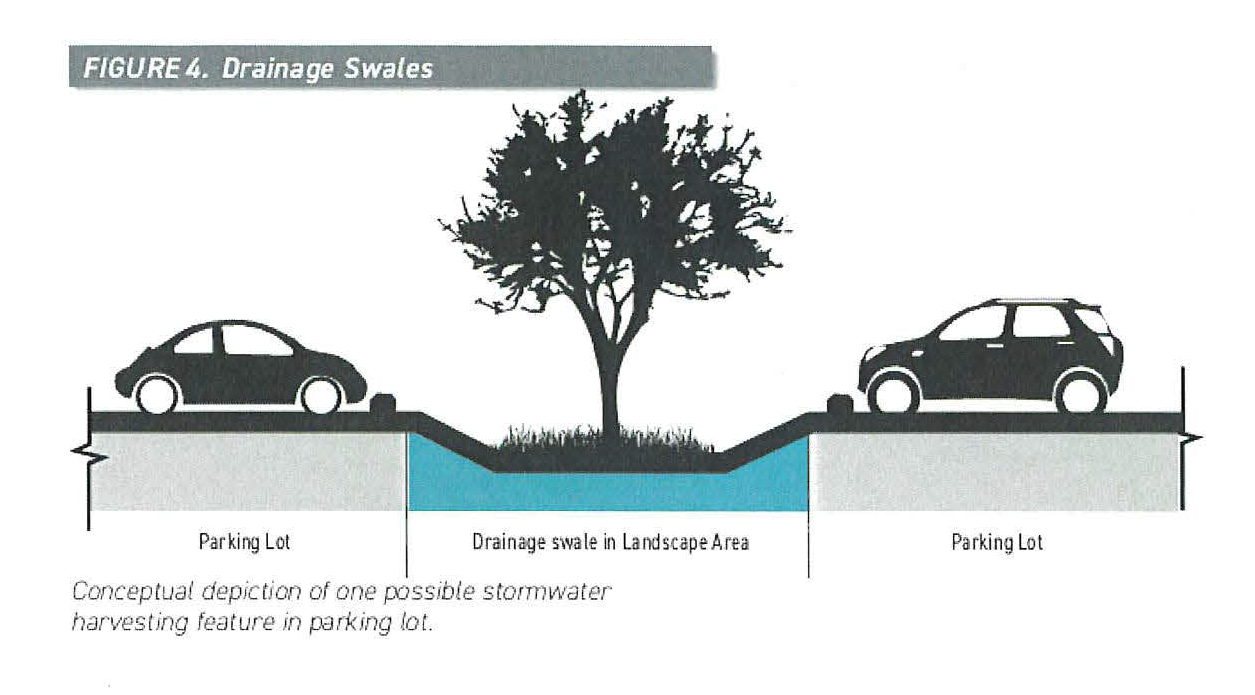
c.
Off-street parking lots.
1)
Off-street parking lots shall have one tree for every ten parking spaces. Where covered carports are utilized, this requirement may be reduced or eliminate the tree requirement within parking lots through a determination of the Community Development Director. The Community Development Director shall consider the overall landscaping plan and the scale of the development to determine if covered carports shall either reduce or eliminate the tree requirement within parking lots.
2)
The minimum size of tree planters within off-street parking lots shall be 60 square feet per tree.
3)
In parking lots of 100 spaces or more, the ends of parking aisles shall be defined as landscaped islands no narrower than eight feet in any dimension.
4)
Off-street parking lot landscaping standards do not apply to fleet vehicle parking areas.
5)
Any landscaping provided to meet the off-street parking lot standards will be credited towards the overall site ten percent landscape requirement.
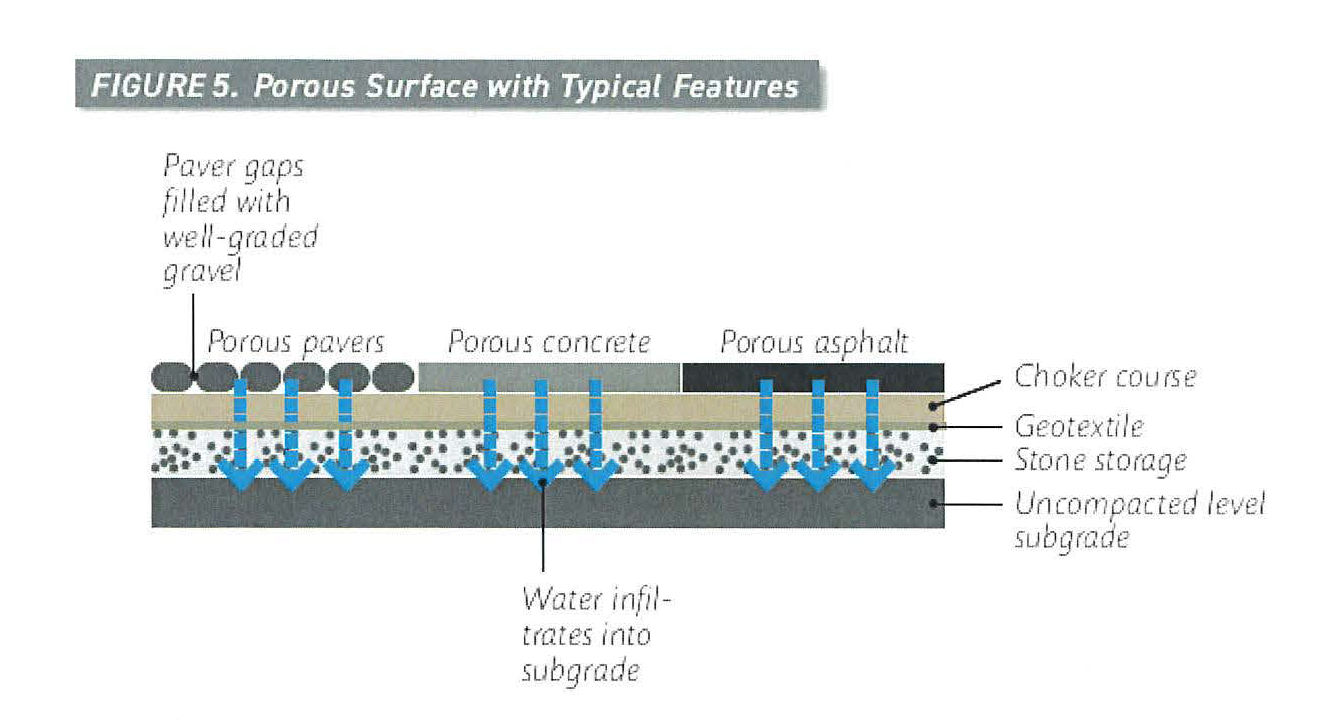
7.
Walls, Fences and Screening.
a.
The maximum allowed height for a fence depends on where the fence is located on a property. All fences and walls shall comply with the height limits established in "Table 3. Maximum Wall Height Standards" and illustrated in "Figure 6. Wall Height."
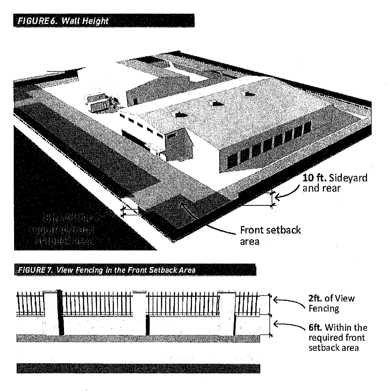
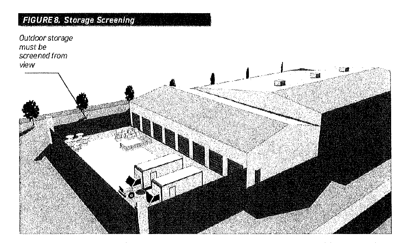
b.
Within the required front setback area, the maximum allowable fence height is eight feet if two feet consists of view fencing. If opaque fencing is applied, the maximum height is six feet.
c.
The finish of walls and fences shall be constructed of durable materials manufactured for exterior use and shall be weather and decay-resistant, which are compatible with the adjacent building(s) in regard to materials, detailing, and color. Acceptable materials include:
1)
Stucco over concrete masonry units (CMU).
2)
Split face block.
3)
Brick.
4)
Stone.
5)
Curved interlock blocks.
6)
Gabions.
7)
Tubular steel, wrought iron bars, or other grill work.
d.
Unfinished solid CMU or chain link are acceptable materials, except in areas visible from the public rights-of-way.
e.
The use of razor ribbon (concertina), barbed wire, or cyclone fencing is prohibited.
f.
Any required screening of mechanical equipment and support/services areas shall be accomplished by one of the following:
1)
An architectural building element, such as a wing wall, that screens the equipment or area being screened;
2)
A wall or fence of a height equal to or greater than the height of the equipment or area being screened. Walls or fences shall incorporate at least one of the primary materials and colors of the nearest wall of the primary building; or
3)
A vegetative screen planted along the full length of the equipment or area to be screened of a height equal to or greater than the height of the equipment or area to be screened at the time of planting.
8.
Signage.
a.
All signs shall comply with the City of Las Cruces sign code except as outlined below.
b.
All signs shall be designed in accordance with the Overlay Zone District's adopted signage plans and regulations.
c.
At key locations such as intersections, joint tenant/monument signs shall include language in Spanish, Braille and larger print for sight-impaired populations.
d.
Vehicular directional signage within public right-of-way or on City property shall be exempt from signage standards.
e.
Freestanding Monument Signs.
1)
Freestanding monument signs will be limited to a maximum of one per street frontage.
2)
The maximum signage size shall not exceed 450 square feet for lots adjacent to interstate frontage. The maximum signage size for all other lots shall not exceed 50 square feet.
3)
The maximum height shall not exceed 80 feet for lots adjacent to interstate frontage. The maximum height for all other lots shall not exceed 18 feet.
4)
Monument signs shall match the architectural style, color, materials and ornamentation of the primary building(s).
5)
For all lots with more than one monument sign, all signs shall be of uniform design and materials.
6)
Free standing monument signage is permissive at the primary park entrances.
7)
The maximum height for directional signage is six feet.
f.
Building Mounted Signs.
1)
Building mounted sign size shall not exceed ten percent of the building facade to which it is applied.
2)
Building mounted signs may not project more than 15 inches from the wall.
3)
Building mounted signs shall have contrasting colors from the background and text height and font that ensures readability, but must blend with the architectural style, color, materials and ornamentation of the main building(s).
4)
No building mounted sign shall intrude upon architectural features including windows, columns, or canopies or decorative features.
g.
Temporary Signage.
1)
Temporary construction signs shall be permitted in accordance with the City of Las Cruces sign code, with the following exceptions:
a)
For properties less than ten acres, one sign is permitted not to exceed 64 square feet in sign area and eight feet in height.
b)
For properties in excess of ten acres, one sign is permitted not to exceed 96 square feet in sign area and eight feet in height.
h.
Prohibited Signage.
1)
The following sign types are prohibited within the Las Cruces Innovation and Industrial Park:
a)
Banners.
b)
Billboards.
c)
Portable or temporary signs, except for those permitted above.
d)
Window Signs.
i.
Signage Illumination.
1)
Exterior and interior illumination will be allowed for both attached and freestanding signs, provided they comply with the following standards:
a)
Signs that are illuminated shall have concealed lighting fixtures. This provision applies also to neon tubing and fluorescent fixtures.
H.
Definitions.
Accessory, commercial/office uses. Any offices and commercial services and food, beverage uses listed in "Table 1. Use Table." These uses must be incidental to the primary use.
Accessory, residential use—non-primary. An accessory dwelling on a nonresidential premise, occupied by the person who oversees the nonresidential operation 24 hours a day.
Cannabis cultivation and cannabis-infused products manufacturing. A facility in which cannabis is grown, harvested, dried, cured, or trimmed. This use may also include the process in which a product is infused with cannabis that is intended for use or consumption other than by smoking including but not limited to, edible products, ointments, and tinctures.
Commercial services and general retail. An establishment providing for the retail sale of general merchandise or food directly to the consumer; this includes, but is not limited to, sale of general merchandise, clothing and other apparel, flowers and household plants that are not grown on-site, dry goods, convenience and specialty foods, hardware and similar consumer goods, or other retail sales.
Construction contractor facility and yard. A building and related outdoor area used to store and maintain construction equipment and materials including, but not limited to, plumbing, electrical, carpentry, roofing, and landscaping, and facilities customarily required in the building trade by a construction contractor. Any outside storage is required to be screened with an opaque fence.
Contemporary style architecture. The use of innovative and new construction technologies and materials with a focus on steel, reinforced concrete, and glass, clean lines and a form that follows function.
Drainage and major utility, other. A facility regulated as a public utility or common carrier by the state or other relevant jurisdiction or agency, including, but not limited to, major telephone facilities, natural gas facilities, water treatment plants, water pump stations, sewage treatment plants, stormwater drainage facilities, irrigation facilities, or similar public services. Major facilities are those sized or designed to serve the entire park, or a wide area of the park.
Film and media production. Outdoor or enclosed entertainment-related facilities including, without limitation, movie studios and production facilities, distribution facilities, editing facilities, catering facilities, printing facilities, postproduction facilities, set construction facilities, sound studios, special effects facilities and other entertainment-related production operations.
Fire and police station. A public facility operated by a governmental agency where fire engines and other equipment are housed, and from which calls for emergency fire responses are handled. This use may include administrative offices, storage of equipment, temporary detention facilities, and the open or enclosed parking of patrol vehicles excluding, however, correctional institutions.
Fleet vehicle. Any vehicle owned or operated by the person, company or business which is used for purposes of delivery, pick up or service to patrons of the primary use. A fleet vehicle may also be a commercial vehicle.
Fleet vehicle parking. Parking of fleet vehicles.
Freight house or truck terminal. Property or building used primarily for freight pick-up or distribution and the temporary parking of trucks of common or contract carriers during loading or unloading, including necessary warehouse space for storage of transitory freight. May also include intermodal distribution facilities for truck or shipping transport. Accessory uses may include, but are not limited to, a truck wash and loading and unloading from rail spurs.
General agriculture. Any use of land for the purpose of production of crops and horticulture specialties, the raising of livestock and poultry, and the processing, packaging, storage and sale of agricultural products which are raised on the premises, and including all the types of structures normally associated with these uses, such as storage bins, barns, sheds, tool houses, greenhouses, garages, and any other use or facility ancillary to farming or open land. This use may also include the growing of plants for wholesale or retail sales, which may take place outside or in greenhouses. Outdoor sales of plants are allowed.
Heavy manufacturing. Mechanical or chemical transformation of materials or substances into new products, including the assembling of component parts, the manufacturing of products, and the blending of materials, such as lubricating oils, plastics, resins, or liquors. This use ordinarily creates a greater than average impact on the environment or has significant impacts on the use and enjoyment of other properties in terms of noise, smoke, fumes, odors, glare, or health or safety hazards. However, this use does not include processes that input or create hazardous byproducts, as defined by federal regulation, in the course of manufacturing, assembly, fabrication, or materials treatment, or that uses manufacturing, assembly, fabrication, or treatment processes that create potentially hazardous impacts including, but not limited to, explosions or leakage of nuclear or electromagnetic radiation into the environment or surrounding areas. These processes are covered under the special manufacturing zone.
Higher education, vocational school. A private institution that provides full-time or part-time education beyond high school, including college, university and vocational schools that provides specialized training and education beyond the high school level.
Indoor entertainment/recreation venues. A commercial indoor entertainment venue where food, nonalcoholic beverages or other refreshments may be obtained for consumption on the premises and where floor shows, bands or other forms of entertainment may be provided for customers. This use also includes health club or gyms, and non-medical service establishment intended to maintain or improve the physical condition of persons.
Light manufacturing. Assembly, fabrication, or processing of goods and materials, primarily conducted within an enclosed building, which is designed, built and maintained so as to prevent smoke, noise, glare, dust, odors or other development impacts from being detected beyond the boundaries of the property. Assembly, fabrication, or processing may include compounding, processing, assembling, packaging or testing of goods. This use does not include any use that meets the definition of Heavy Manufacturing or Special Manufacturing.
Military and law enforcement agency. A public facility operated by the federal government where engines and other equipment are housed. This use may also include administrative offices, storage of equipment, and grounds for training and practice.
Natural resource extraction. On-site extraction of surface or subsurface mineral products or natural resources, including solids, such as coal and ores; liquids, such as crude petroleum; and gases, such as natural gases. Uses may include quarries, borrow pits, sand and gravel operation, mining, soil mining, rock crushing, screening, and the accessory storage of explosives
Nightclub and bar. An establishment that is devoted to the selling or serving of alcoholic beverages for consumption by patrons on the premises and in which the serving of food is only incidental to the consumption of those beverages, including taverns, nightclubs, cocktail lounges and cabarets.
Offices and research facility. A premise where professional, clerical, business management or public administration work is carried out and where the sale of merchandise on the premises is totally absent or a very limited activity in support of the work being carried on. This use may also include a medical or dental clinic for patients that are not lodged overnight and research and testing facilities for scientific research, investigation, testing, or experimentation, but not facilities for the manufacture or sale of products, except as incidental to the main purpose of the laboratory.
Outdoor entertainment. An outdoor commercial or entertainment activity that is open to the general public. This use may include outdoor markets, drive-in theater, stadium or other entertainment and recreation activities like batting cages, golf driving ranges, miniature golf courses, go-cart tracks, skating rinks, skateboard parks, swimming pools, tennis courts, or sports courts.
Outdoor storage. The keeping of any goods, material, or merchandise outside of a building in the same place.
Parking garage with/without liner building. A combination of structures for parking and a mix of uses (commercial, residential, office) where parking is designed to be concealed from view and levels of parking are at-grade, above grade, or partially below grade (but not fully underground). A liner building is a specialized building that may be built as part of the parking structure or separate; it is parallel to the street and designed to conceal a parking structure from the street with active ground floor uses such as retail shops or residential stoops. A parking garage may be designed without a liner building provided that it is designed in such a way so as to incorporate active ground floor uses, architectural features and articulated elements to mitigate blank walls and screen parking.
Recycling sort facilities and electronic recycling. A facility that sorts reusable materials in preparation for introduction into an industrial process by which the material is transformed into a new product in such a manner that the original identity as a product is lost. Material is limited to paper, plastic, and metal as well as electronics recycling.
Small animal facilities. A facility that serves small animals for their care and treatment. This use may include outdoor pens for temporary animal holding. This use does not include animal raising.
Solar energy generation. The use of land or buildings as locations for mounting of solar collectors or other devices that rely on sunshine as an energy source and are capable of collecting, distributing, or storing the sun's radiant energy.
Special manufacturing. Mechanical or chemical transformation of materials or substances into new products, including the assembling of component parts, the manufacturing of products, and the blending of materials, such as lubricating oils, plastics, resins. This use ordinarily creates a greater than average impact on the environment or has significant impacts on the use and enjoyment of other properties in terms of noise, smoke, fumes, odors, glare, or health or safety hazards. This use includes processes that input or create hazardous by-products, as defined by federal regulation, in the course of manufacturing, assembly, fabrication, or materials treatment, or that uses manufacturing, assembly, fabrication, or treatment processes that create potentially hazardous impacts including but not limited to explosions or leakage of nuclear or electromagnetic radiation into the environment or surrounding areas.
Telecommunications, towers, and utilities. Any facility used for wireless communications, usually consisting of a support structure for antennas, equipment shelters or cabinets, and/or other transmission and reception devices used for business or commercial purposes.
Temporary, construction staging area, trailer, or office. Temporary use of a structure, including a mobile office, as a construction site office by a building contractor while a specific project is under construction, or as a real estate office during the construction and initial marketing phase of a new development.
Temporary, seasonal outdoor sales, events. Temporary outdoor or indoor retail display and sales of new or used goods, produce, and/or handcrafts or services associated with the season or a cultural event such as sales of fireworks, pumpkins, Christmas trees, or other seasonal items; semi-annual sales of art or handcrafted items in conjunction with community festivals or art shows; sidewalk or parking lot sales. Incidental sales of food and beverages is allowed.
Vehicle services. Commercial services dealing with vehicles. This use may include car wash, vehicle and equipment sales, rental, fueling, recreational vehicle parking stalls and hook-ups, and repair.
Warehousing, logistics and distribution. Building or premise in which goods, merchandise or equipment are stored and frequent heavy trucking activity may occur. Open storage of material, or nuisances such as dust, noise, and odors may be part of this use.
(Ord. No. 2982, § (I)(Exh. A), 8-16-21; Ord. No. 3085, § (I)(Exh. A), 10-21-24)
Editor's note— Ord. No. 2982, § (I)(Exh. A), adopted Aug. 16, 2021, repealed the former § 38-46 and enacted a new § 38-46 as set out herein. The former § 38-46 pertained to WMIP—West Mesa Industrial Park Overlay Zone District, and derived from Ord. No. 2354, § I, adopted Jan. 22, 2007.
Sec. 38-46.1. - AOD—Las Cruces International Airport Operations Overlay Zone District.
A.
Purpose. The purpose of the Las Cruces International Airport Operations District is to protect the operations of the Las Cruces International Airport ("Airport") from encroachment of land uses that could inhibit or restrict present airport operations or negatively affect the future growth and operation of the airport. Since the boundaries associated with this district are dependent upon the physical boundaries of specific airport features, the boundaries shall change as necessary with respect to any changes in these features.
B.
Delineation of airport operations overlay zoning district boundary. The boundaries of this district are shown on Map 2 and shall be defined as follows:
1.
Precision instrument runway approach zone. The inner edge of this approach zone coincides with the width of the primary surface and is 1,000 feet wide at a point 200 feet from the end of the precision instrument approach runway of the airport. The primary surface is a surface longitudinally centered on an airport runway, ending at each end of the runway when it has no specially prepared hard surface and 200 feet beyond each end of the runway when it has a specially prepared hard surface.
The precision instrument runway approach zone expands outward uniformly to a width of 16,000 feet at a horizontal distance of 50,000 feet from the horizontal surface of the precision instrument runway. The zone's centerline is an outward continuation of the centerline of the runway.
The height limit for this zone is defined by a slope extending upward and outward one foot of vertical elevation for each 50 feet of horizontal distance for the first 10,000 feet beginning at the end of and at the same elevation as the primary surface. From 10,000 to 40,000 feet, this slope extends at a rate of one foot of vertical elevation for each 40 feet of horizontal distance.
2.
Horizontal zone. The horizontal zone is established by swinging arcs of 10,000 feet radii from the center of each end of the primary surface of each runway and connecting the adjacent arcs by drawing lines tangent to those arcs. The horizontal zone does not include the approach and transitional zones. The horizontal zone extends for 10,000 feet as described above to the boundary of the conical zone.
The height limit of structures in the horizontal zone is established at 150 feet above the airport elevation of 4,456 feet for a total height limit of 4,602 feet above mean sea level (MSL).
3.
Conical zone. The conical zone is the area that commences at the periphery of the horizontal zone and extends to a horizontal distance of 4,000 feet.
The height limit for this area is defined as a slope extending upward and outward one foot of vertical elevation for each 20 feet of horizontal distance beginning at the periphery of the horizontal zone and extending to a height of 350 feet above the airport elevation.
4.
Transitional zones. These are the areas that extend outward at 90 degree angles to each runway centerline and extended at a slope of one foot of vertical elevation for each seven feet of horizontal distance from the sides of the primary and approach surfaces to where they intersect the horizontal and conical surfaces.
The height limit for these areas is defined as the slope described above, extending to 150 feet above the airport elevation.
C.
Area of disclosure. This area is defined as all lands within the Las Cruces City Limits as noted by the area of disclosure boundary on Map 1. Within this area, the subject property's proximity to the airport shall be disclosed by any person or entity subdividing land. The area of disclosure boundary shall be noted in all development proposals.
D.
Restrictions. No residential uses shall be allowed within the area of disclosure (shown on Map 1) unless the following requirements are met. These requirements are necessary to mitigate the encroachment of land uses that could inhibit or restrict present airport operations or negatively affect the future growth of the airport.
1.
No use may be made of land, water, or electrical power within any zone (includes approach, horizontal, conical, and transitional zones) in such a manner as to create electrical interference with navigational signals or radio communication between airport and aircraft, make it difficult for pilots to distinguish between airport lights and others, result in glare in the eyes of pilots using the airport, impair visibility in the vicinity of the airport, create bird strike hazards or otherwise in any way endanger or interfere with the landing, takeoff or maneuvering of aircraft intending to use the airport.
2.
No structure shall be erected, altered or maintained, and no tree shall be allowed to grow in any zone to a height in excess of applicable height limits established by that zone (includes approach, horizontal, conical, and transitional zones).
3.
Effective on the date of this overlay approval, all land subdivisions within the area of disclosure shall require disclosure of the land's proximity to the airport by any person or entity subdividing land within this area. Disclosure of this information shall be required on the final subdivision plat to be recorded with the Office of the Dona Ana County Clerk.
4.
Development within the area of disclosure shall adhere to all applicable restrictions stated and outlined in F.A.R. Part 77 (Height Restrictions) and F.A.R. Part 150 (Noise and Land Use Compatibility) as amended.
E.
Submittal and review requirements. Submittal and review requirements are established for all new development to protect persons and property in the district.
1.
Subdivisions. Submittal, review, and approval of all subdivisions, including replats of previously platted lots will follow Chapter 37 of the City of Las Cruces Municipal Code.
2.
Buildings and signs. Building plans and sign permit applications will be submitted for approval to the community development department in accordance with their respective codes (Chapters 30 and 36 of the Municipal Code).
3.
Variances. The Planning and Zoning Commission is authorized to grant variances in accordance with the criteria established within subsection 38.10.I of this Code, as amended. Said requests shall be accompanied by a written determination by the airport manager as to the merits of the request.
F.
Appeals. Appeal procedures are established for any person that is affected by a decision of an administrative official, commission, committee, or board in the enforcement of this section in accordance with section 38-13 of this Code.
(Ord. No. 2460, § I, 6-23-08)
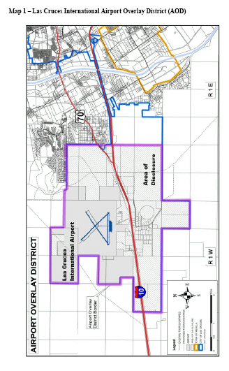
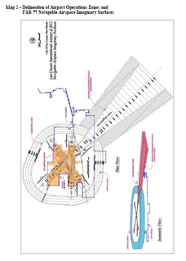
Sec. 38-47. - LAO—Lohman Avenue Overlay District.
A.
General.
1.
Purpose. The purpose of the Lohman Avenue Overlay District is to implement land use and urban design policies as established in the Lohman Avenue plan. Specifically the purpose of this overlay district is to specify architectural and urban design provisions to improve this important entrance into our community and promote an attractive image for the city as a whole.
2.
Delineation of district.
(a)
The Lohman Avenue Overlay District follows Lohman Avenue from the city limits (the eastern boundary) to Walnut Street (the western boundary). The overlay district includes those properties that are located within 350 feet from the edge of Lohman Avenue right-of-way to determine the overlay district's northern and southern boundaries.
(b)
The applicable properties affected by this overlay district are indicated by the overlay district map at the end of this section. This map is subject to change as the city's limits expand in an easterly direction.
(c)
If a property is bisected by this 350-foot boundary, any construction beyond the designated boundary are required to follow the urban design standards for consistency purposes.
(d)
Residential developments that are bisected by the designated boundaries are expected to create a development theme as a part of their master plan/preliminary plat requirement. The development theme must conform to the design principles of the overlay district. Adherence to the development's master plan and/or preliminary plat requirement will be a part of the condition approving the development's final plat or site plan.
3.
Issues not addressed here. Any issue not addressed in this division, such as subdivision, zone change, special use permit, variance requests, parking, and general fence/wall height, will revert to the appropriate sections of the Municipal Code, as amended.
B.
Permitted uses, development standards, urban design requirements, and nonconforming uses.
1.
Compliance. There shall be no development or alteration of the lands, uses, or structures within the overlay district except as provided for by this subdivision and other sections of this chapter and other codes where applicable.
2.
Permitted uses and development standards. All permitted uses, special uses, and development standards (e.g., setbacks, building height, and densities) in the Lohman Avenue overlay district will adhere to the underlying zoning of the property.
3.
Urban design requirements.
(a)
Purpose. Flexible architectural and urban design standards are established for the Lohman Avenue overlay district in order to create an aesthetically pleasing environment in this ever-busy and important gateway which will also assist in creating a positive image for our community as a whole.
(b)
Standards established. Architectural and urban design standards are established as follows:
(1)
General requirements.
a.
All new construction, additions, and exterior remodeling efforts shall comply with the spirit and intent of the Lohman Avenue plan.
b.
The planning director or designee shall have final approval on all design issues. Planning director or designee shall also have the authority to allow flexibility in design when dealing with unusual situations provided that a project meets the spirit and intent of the goals, objectives and policies found in both the 1999 comprehensive plan's urban design element and The Lohman Avenue plan.
(2)
Architecture.
a.
All new construction shall be required to utilize architectural styles that reinforce our New Mexico/Southern New Mexico architectural vernacular and heritage whether contemporary or traditional.
b.
All new construction shall be required to utilize stucco, adobe and/or brick dependent upon the architectural style chosen. Exposed metal exterior walls are expressly prohibited.
c.
If choosing a traditional New Mexico/Southern New Mexico architectural style, architectural features typically associated with said style of architecture must be incorporated into the design. Examples include vigas, parapets, and portals with pueblo styles (see appendix A for further examples).
d.
If choosing a contemporary style of New Mexico/Southern New Mexico architecture, interpretations of the architectural features associated with traditional architectural elements and features, such as vigas, parapets, portals with pueblo styles must be incorporated (see appendix A for further examples).
e.
Architectural styles must be similar in nature throughout a project. For example, if a traditional architectural style is utilized, then a traditional style must be used throughout the project. Conversely, if a contemporary architectural style is utilized, then a contemporary style must be used throughout the project.
f.
All structures must be in scale with one another throughout a project. For instance, gas stations canopies must be in scale with its associated service and/or retail area.
g.
Chain-link fencing shall be prohibited on property lines adjacent to collector and/or arterial streets.
h.
Rooflines must be designed to reduce the exterior mass of a building, add visual interest, and be appropriate to the architectural style.
i.
Reflective materials are prohibited unless its significance can be demonstrated with respect to the architectural style chosen, such as Folk Territorial style utilizing metal roofing materials (window glazing is exempted from this provision).
j.
Playgrounds associated with a business locating in the Lohman Avenue overlay district must be secondary to the primary business/use. All playgrounds must be located within a structure and must be compatible in scale and architectural design to the primary business/use.
k.
All sales, storage, and/or displays must be included within a structure that complies with the architectural requirements of this section (temporary, seasonal sales, such as Christmas tree and pumpkin stands, locating in zones which allow their use are not required to follow these architectural standards).
(3)
Landscaping.
a.
Unless otherwise stated in this section, all projects shall follow the landscaping requirements found in the city's design standards (matrix 1 requirements shall be observed).
b.
Of the total area to be landscaped, 50 percent shall be located within the front setback of the property. Of this percentage, one-half (½) shall be located between the front property line and the parking lot.
Note: Front setback of the property shall be defined as the area between the back of sidewalk and the property's principal structure. Required landscaping may be placed within city right-of-way as per the city's design standards.
c.
A variety of landscaping materials must be employed to create visual interest. Utilizing softscape (plants) and hardscape elements (gravel, walkways, walls) must be incorporated into the design. Plant materials must be those best suited to the Chihuahua Desert.
d.
In addition to the current landscaping requirement, one tree shall be placed within the parking lot for each ten parking stalls. Parking trees must be evenly distributed throughout the parking area and must be suitable for planting around non-impervious surfaces (tolerant of reflective heat, deep rooting vegetation, etc.). Parking trees must adhere to the following:
1.
Parking trees must maintain a minimum height of six feet before the first lateral branch and must reach a minimum canopy diameter, at maturity, of 20 feet;
2.
Parking trees must be planted along the edge and/or between parking stalls in planter areas which have a minimum area of four-foot by four-foot and a raised border of at least four inches in height. If a planter(s) is to be used as a wheel stop, the planter(s) must be a minimum four-foot by six-foot and a raised border of at least four inches in height (it may be possible to increase the size of planter and decrease the length of the parking stall. Interested parties must submit a design proposal to the planning director for waiver approval); or
3.
Where a landscape border or similar feature abuts parking stalls, trees within these areas may count towards the parking area tree requirement if the trees are planted within ten feet of the parking stall area perimeter, the number of parking trees are not reduced by more than half by this exception, and a minimum of one tree is provided within the parking area.
(4)
Site design.
a.
Architectural features must be included on all building walls that are immediately adjacent to city streets and/or residential areas. Architectural features can include, but are not limited to recesses, projections, wall insets, window display areas, awnings, balconies, window projections, landscaping structures, and other features that complement the building's design and are acceptable to the planning director (if a project is developing adjacent to vacant property, the vacant property's existing zoning will be used to determine wall detail requirements.)
b.
Parking areas shall adhere to one or more of the buffering methods listed here. Large commercial complexes, must utilize two or more of the listed methods must be used in order to buffer parking areas from Lohman Avenue:
1.
Locate parking areas away from adjacent streetfronts;
2.
Place a landscaped buffer with berm when in between the parking area and streetfront (one foot of rise for every five feet of distance when in grassed landscapes and one foot rise for every three feet of distance when in landscapes consisting of groundcover);
3.
Place a landscaped buffer with a low wall/or fence (minimum three feet in height) between the parking area and streetfront;
4.
Place a landscaped drainage pond between the parking area and streetfront; and/or
5.
Distribute parking areas throughout a development as a means of breaking-up large parking lots.
c.
All freestanding walls or fencing shall relate in design, material, and color to the building's architectural style. Walls that are constructed in individual projects that front along a particular street segment must provide continuity in design and compatibility in texture and color with adjacent projects along that particular street segment. Combining trees, shrubs, and/or climbing vines must be employed along the periphery of the fence or wall to avoid the monotony of a large, blank surface.
d.
If due to the property's topography constraints, a retaining wall is required for slope/soil stabilization and increased buildable area, terracing or a similar mechanism will be required to prevent walls that are out of scale with the development and to avoid visual monotony.
e.
Service areas must be screened and/or buffered from Lohman Avenue and any adjacent residential uses. Service areas include but are not limited to loading bays/zones and dumpsters.
f.
All utility/mechanical equipment shall be screened from view using the following techniques:
1.
Ground set utility and/or mechanical equipment must be screened with landscaping or walls in a manner that conceals the equipment. Screening must be consistent with the project's landscaping. Walls must be consistent with the building's architectural character (especially in terms of color, physical style and scale.)
2.
Mechanical and/or utility equipment located on a rooftop or is otherwise attached to a building must be screened from view from all angles through the use of building design elements, such as varied roof heights, parapets, etc.
If adjacent rights-of-way are significantly higher in elevation to adjacent properties, rooftop equipment should be screened to the best extent possible. The planning director or designee must approve of screening strategies in these instances.
3.
Exterior mechanical/utility equipment mounted on building facades shall be prohibited unless they are an integrated architectural design feature and painted such a color as to blend in with their background and/or building to which they are attached.
4.
If the chosen architectural style does not lend itself to using the techniques described above, such equipment must be shielded from view by an opaque screen that is treated in a manner that most accurately matches the building's look, design, and texture to which it is attached.
g.
All stacking lanes/drive-up aisles (associated with a drive-up service) must be de-emphasized. Techniques to de-emphasize stacking lanes/drive-up aisles include, but are not limited to utilizing landscaping as a screen or placing lanes/aisles where they are not readily seen from streets and sidewalks.
h.
Lighting used to illuminate parking lots and buildings should relate in design, material, and color to the architectural and/or historical character of the subject property. Lighting must utilize fixtures as mandated by local lighting requirements.
i.
Where possible, agreements to share driving aisles and parking areas to minimize traffic conflicts, lessen visual clutter, and promote greater traffic circulation efficiency are encouraged. Agreements may be made with adjoining property owners regardless of each business' hours of operation. Those seeking shared driving aisles and parking areas must observe the following:
1.
Agreements shall be approved as to form and content by the city attorney's office and once completed, filed with the county clerk's office.
2.
In combining parking requirements, 100 percent of the required off-street parking for all subject businesses shall be met.
3.
For a businesses that is sharing parking in order to meet parking provisions, the agreement shall pertain to no more than 40 percent of the number of parking stalls they are responsible to provide. The remaining 60 percent must be provided on that business' site.
j.
The final site plan for commercial, office, and/or residential complexes must be approved by the planning director or designee. Complexes designed in a traditional "strip" fashion are prohibited.
(5)
Signage.
a.
Freestanding signage will be limited to monument/ground signs for properties located east of Nacho Road. Monument/ground signs in this area shall have a maximum height of seven feet and a maximum of 40 square feet in area. Monument/ground signs are required to incorporate a landscaped base into its design. Monument/ground signs shall be placed no closer than five feet from the property line and must not violate clear-sight-triangles. The number of freestanding signage shall be determined according to chapter 36 of the Municipal Code, as amended. All other freestanding signs, i.e., those west of Nacho Road, shall comply with chapter 36 and item b. and c. of this section.
b.
Billboards shall not be permitted.
c.
Signs shall be designed (shape, color, and material) in a manner consistent with the building(s) to which it/they relate via the following:
1.
Design elements and/or finish treatments such as stucco or brick surfacing, freestanding wall designs/treatments, etc., shall be incorporated into a monument/ground signs overall design. The color of surface or finish materials used on the building shall be incorporated into the sign's supporting structure.
2.
When multiple monument/ground signs are allowed, the design of each sign shall maintain a similar design appearance, and colors and lettering styles shall remain consistent.
d.
Attached signage shall follow the requirements as established in chapter 36 of the Las Cruces Municipal Code, as amended.
C.
Nonconforming uses.
1.
Definitions. The following words, terms and phrases, when used in this Chapter, shall have the meanings ascribed to them in this section, except where the context clearly indicates a different meaning:
Exterior remodel, renovation, or alteration means any change or rearrangement in the supporting members of an existing building, such as bearing walls, columns, beams, girders, as well as any change in rooflines, or any enlargement to or diminution of a building or structure, whether horizontally or vertically. Normal maintenance activities as verified by the city's building official or designee are exempt from this definition.
2.
Applicability. The following nonconforming use provisions in this chapter shall apply to properties within the Lohman Avenue overlay district. Provisions pursuant to this subdivision which allow increases in floor, building, or lot square footage shall not abrogate minimum compliance requirements (e.g., parking, landscaping, and drainage) established elsewhere in this chapter or in other companion codes.
3.
Nonconforming urban design features.
(a)
When nonconforming urban design features involving parking, landscaping, lighting, and fencing/walls are located on properties within the Lohman Avenue overlay district, these features shall be brought into compliance with Gateway standards when:
(1)
The property remains vacant for a period of one continuous year or greater;
(2)
Any one-time or cumulative increase greater or equal to ten percent to the gross square footage of building area occurs;
(3)
Any exterior remodel, renovation, or alteration occurs to the building. This provision shall not nullify allowances as identified in subsection (a)(2) of this section; or
(4)
A change in use occurs on the property which results in the alteration of the use's intensity (i.e. low volume to high volume business activity) or orientation (i.e. service to retail activity).
(b)
When the architectural characteristics of the building are nonconforming, the architecture shall be brought into compliance with current standards when:
(1)
Any one-time or cumulative increase greater or equal to 30 percent is made to the gross square footage of building area; or
(2)
Any exterior remodel, renovation, or alteration occurs to the building. This provision shall not nullify allowances as identified in subsection (a)(2) of this section.
(c)
When a sign on the property is nonconforming, it shall be brought into conformance with current standards when:
(1)
The property remains vacant for a period of one continuous year or greater;
(2)
The entire sign structure is removed for any purpose.
D.
Administration.
1.
Purpose. In the Lohman Avenue overlay district, all new development, exterior remodeling/additions, signage, and those alterations dealing with urban design features discussed in this chapter shall require city approval. Proposals involving all new development, exterior remodeling/additions, signage, and those alterations dealing with urban design features discussed in this chapter shall be reviewed by city staff to aid in enforcing area standards.
2.
Submittal and review process.
(a)
Building permit. The submittal and review procedures for buildings and walls/fences are as follows:
(1)
Preapplication conference.
a.
Prior to filing an application for a development in the Lohman Avenue overlay district, it is strongly encouraged that applicants meet with community development department staff to review the proposed project.
b.
At the conference, staff shall review the development proposal and advise the applicant concerning the compatibility of the proposal with the intent and standards of the Lohman Avenue plan, Lohman Avenue overlay district ordinance, and 1999 comprehensive plan.
(2)
Application procedure. Upon submittal of the required items, the application materials will be processed to the appropriate city departments. Written comments and recommendations from the reviewing agencies will be forwarded to the community development department within ten working days from the date of submittal.
(3)
Application materials.
a.
Applications for development within the Lohman Avenue overlay district shall be obtained from the community development department, building permit section.
b.
The number of copies to submit with the application is outlined in the Lohman Avenue overlay district application packet, available at the city community development department. Development submittal requirements shall, at minimum reflect the following information:
1.
A statement of objectives to be achieved by the development, inclusive of a description of the character and anticipated use of the proposed development.
2.
Scaled site plan including the following:
i.
Property boundaries.
ii.
Location of all structures.
iii.
Setbacks.
iv.
Parking layout.
v.
Ingress/egress access points.
vi.
Pedestrian and bicycle circulation.
vii.
Areas proposed for landscaping.
viii.
Surfacing material for impervious surfaces.
ix.
Storm water ponding areas.
x.
Dumpster location(s).
xi.
Location of service and loading area(s).
xii.
Location of cart collection areas, when applicable.
xiii.
Freestanding sign location(s).
xiv.
Any other information which conveys how the proposal will meet development requirements.
3.
Scaled landscaping plan shall include:
i.
Location, size, and common name of all landscaping.
ii.
A complete irrigation plan shall be included, clearly identifying how the landscape will be sustained.
4.
Scaled elevations shall include:
i.
Directional view of all structures, including signs, clearly identifying exterior building materials and treatments.
ii.
Location and treatment of all fenestration and other building openings.
iii.
Building ornamentation.
iv.
Roof design and surfacing.
v.
All signage design and placement.
5.
Architectural/artistic renderings shall:
i.
Reflect all aspects/views of exterior buildings.
ii.
Demonstrate the use of building materials through the drawings.
iii.
Indicate/demonstrate selected colors to be used throughout the project.
(b)
Sign permits.
(1)
Sign permits shall be required for all signs within the district. Freestanding signage designs must be submitted at the time of building permit review. Once the building permit for the development has received a certificate of occupancy, a sign permit may then be issued by the city's sign administrator. Attached signage permits may be approved separately from the building permit.
(2)
All application and submittal material can be obtained from the city community development department. Once the application has been deemed complete and approved, a sign permit will be issued by the city's sign administrator. Signs may not be erected until a sign permit is granted.
3.
Appeals.
(a)
In the Lohman Avenue overlay district, any applications for development must be approved by the city in order for a building permit or sign permit to be issued.
(b)
If an application is denied by the city staff based on an interpretation of the Lohman Avenue plan and this division, and an agreement of interpretation cannot be reached and all other procedures established by this division have been exhausted, the applicant may file for an appeal, in writing, to the Planning and Zoning Commission within 15 days of the city staff's denial decision.
(c)
The appeal will be processed to the Planning and Zoning Commission to be considered at the next available public hearing in accordance with notice requirements of 38-10.
(d)
Any aggrieved person who is affected by a decision of an administrative official, commission, committee, or board in the enforcement of the Lohman Avenue overlay district and this division may appeal such decision to the city council in accordance with subsections 38-13.
(e)
Any person aggrieved by a determination of the city council may appeal to the district court within 30 days after the determination made by city council, in accordance with section 38-14.
4.
Enforcement. Provisions to enforce this division shall be consistent with the enforcement provisions of article III of this chapter.
Appendix A
Examples of features associated with traditional southwestern architectural styles are listed in this appendix. For information regarding a variety of acceptable southwestern styles not noted here, please refer to the New Mexico Historic Building Inventory Manual, Section VI, Introduction to New Mexico Architectural Styles.
Pueblo Style features include, but are not limited to:
Walls with smooth stucco surfacing
Walls with soft rounded corners or buttressed corners
An emphasis on structural massing
Parapet walls above roof lines which have rounded edges and vary in height
The use of bell coates (espadañas)
Flat roofing style
Canales
Wood lintels above windows and entryways
Wood vigas
Portales/loggias
Desert or earth tones
Spanish Colonial features include, but are not limited to:
Walls with smooth stucco surfacing
Balconies
Pitched, red-tiled roofs
Roofs with clipped eaves
White or light desert colors
Divided light windows
Windows accentuated with molded surroundings
Arches serving primary entryways
Heavy, carved wood doorways.
Courtyards or patios
Territorial style features include, but are not limited to:
Walls with smooth stucco surfacing or "antiqued" brick
Parapet walls above roof lines (except for Folk Territorial)
Parapets capped with brickwork, masonry, or wood
Clean and simple in appearance
Flat roofing style
Light earth tones such as sand, tan, and beige with lighter contrasting trim materials (such as white)
Pediments above doors and windows
Divided light windows
Porches or porticos along the primary facade
Folk Territorial styles may utilize pitched gable roofs surfaced with tin/corrugated sheet metal (treated in a manner which eliminates its reflective properties)
Mission style features include, but are not limited to:
Walls with smooth stucco surfacing, clean edges and/or corners
Walls giving the appearance of mass
The use of bell coates (espadañas)
Arched window openings
Curvalinear openings or archways above portals
Arched doorways
Curvalinear parapets
Pitched, red-tiled roofs
Light or neutral tones
Exposed rafters under projecting eaves
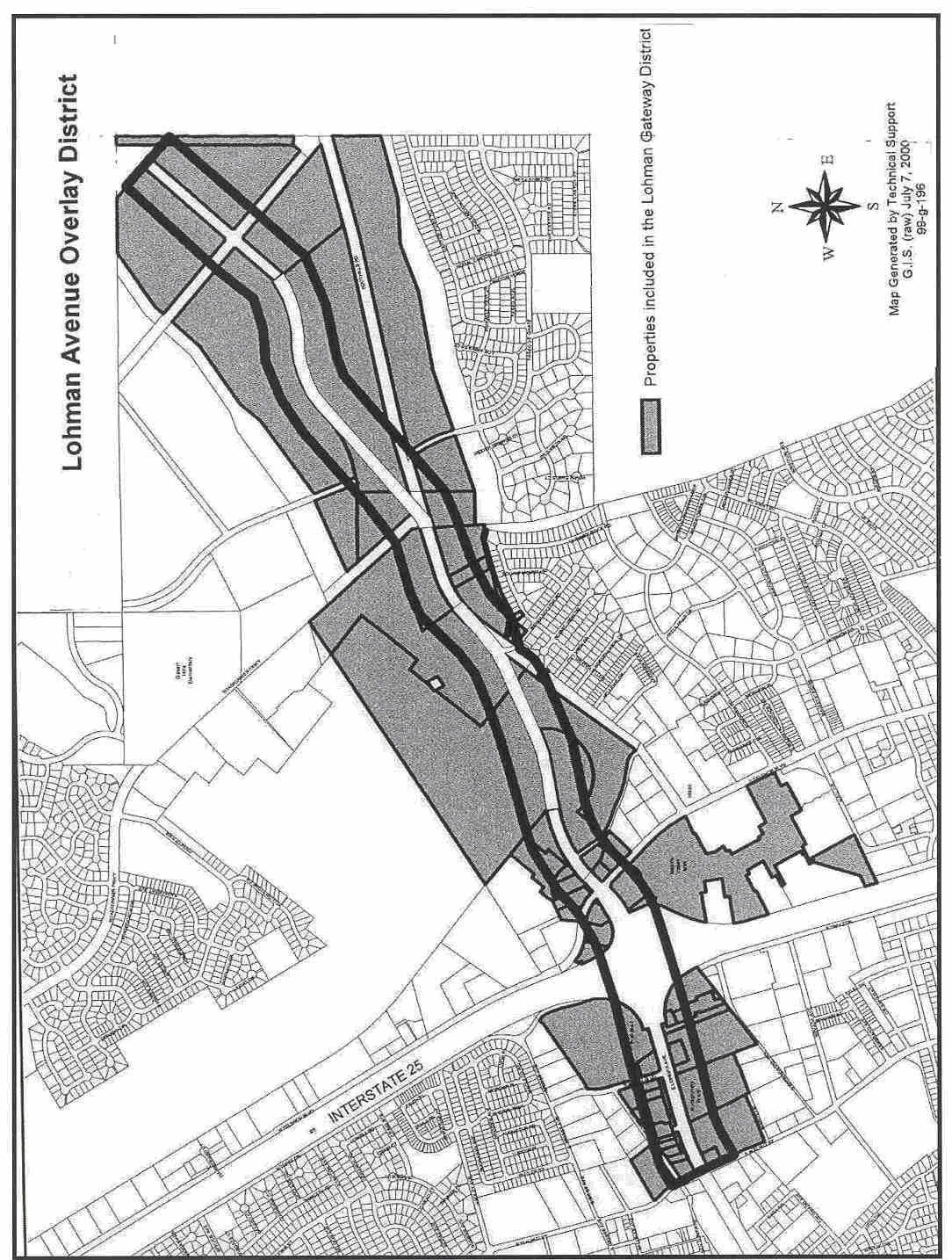
(Ord. No. 2354, § I, 1-22-07)
Sec. 38-48. - IDO—Infill development overlay district.
A.
Purpose. The purpose of the infill development overlay district is to implement land use and development policies as established in the infill policy plan. Specifically, the purpose of this overlay zone is to provide a streamlined review process for the development of vacant and underutilized parcels or those parcels ready for redevelopment within the urban core area of Las Cruces regardless of the property's zoning. The goal is to develop active uses that are compatible with surrounding land uses while promoting economic development in the central part of [the] city, in accordance with the comprehensive plan.
B.
Definitions.
An "infill parcel" is defined as any vacant or underutilized tract, lot, or parcel of real property, including those parcels currently used for agricultural purposes, that falls within the infill area (See Figure 1).
An "underutilized parcel" is any tract, lot, or parcel of real property on which additional development or redevelopment may occur without significantly altering neighborhood character. A parcel may be considered underutilized for a number of reasons, including but not limited to:
• Presence of a structure that has no active utility service;
• Presence of a multi-unit commercial or residential structure with sustained high vacancy rates;
• Undeveloped land area sufficient to construct an additional, non-accessory structure;
• Land use that is less dense/intense than current zoning allows.
A determination as to whether a parcel is underutilized, and therefore a qualified infill parcel, shall be made by community development staff. This judgment shall be confirmed or denied by the Planning and Zoning Commission unless the decision is an administrative one (see subsection F herein).
A "vacant parcel" is any tract, lot, or parcel of real property that currently has no building on premises, but may contain utility, transportation, agricultural or other non-building structures (including but not limited to utility poles, alleys, garden plots).
C.
Delineation of overlay district. The infill development overlay district is defined as all property contained within the following boundary: (See Figure 1)
1.
Interstate Highway 25,
2.
The northern boundary of the University Avenue Corridor Overlay Zone,
3.
Valley Drive (NM Highways 188 & 185),
4.
Hoagland Road,
5.
Alameda Boulevard,
6.
Three Crosses Avenue, and
7.
North Main Street (U.S. Highway 70).
D.
Infill development process. The infill development process (IDP) is a streamlined development process for qualifying infill parcels. The IDP can be used for the following types of requests:
1.
Variances, (including signs)
2.
Special use permits
3.
Planned unit developments (Including land uses not allowed in the parcel's existing zone)
4.
Subdivisions (See City of Las Cruces Subdivision Code, Article V)
5.
Building permits
6.
Sign permits
7.
Business registrations
E.
Application procedure. The application, including the development statement, indicating what type of action is being requested along with necessary support information (see application packet) shall be submitted to the community development department. An applicant may submit multiple requests at once (i.e. building permit, sign permit, variance and special use permit) so that all requests are reviewed simultaneously. This allows for all necessary permits for development and use of an infill parcel to be issued at once. There shall be no submittal fee required for an IDP proposal. However, an application will not be accepted if all required information is not included. If the application is complete, the application will then be processed for review by the appropriate staff.
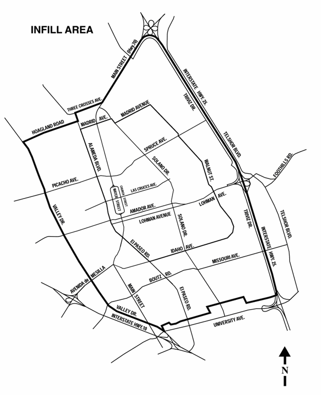
Figure 1
If required, the proposal will then be scheduled for review by the Planning and Zoning Commission at a public hearing on the first Tuesday following the public notice period.
Public notice will be sent in accordance with section 38-12, excluding subdivisions, which shall conform to the requirements of the Las Cruces Subdivision Code, chapter 37 of the Las Cruces Municipal Code, for public notification.
F.
Approval Procedure. An IDP proposal will either be processed administratively (IDPA) or brought before the Planning and Zoning Commission for final action (IDPPZ). As previously explained in subsection E, once an application is submitted, the staff will process said application via the appropriate process.
IDPA. For IDP proposals that only require administrative approval, i.e. business registrations, summary subdivisions, building permits, and sign permits, staff shall review the submittal in an expedited manner. The initial review period for commercial/industrial building permits shall be three business days. Any subsequent review beyond the first submittal shall be accomplished within two business days. Single-family residential building permits may be issued over-the-counter or go through a review period as provided for in articles IV and VI of Chapter 30 of the Municipal Code. Business registrations and sign permit applications shall be reviewed and either approved or denied within three business days. A business registration will be issued with the certificate of occupancy for the property. A sign permit can be issued at anytime following approval.
IDPPZ. The Planning and Zoning Commission is the final authority on all types of requests as indicated in subsection D that would require a public hearing. Any decision of the Planning and Zoning Commission may be appealed to the city council in accordance with section 38-13 of this Code and/or Article V of Section 37-13 of the City Subdivision Code depending on the type of request. IDP proposals requiring Planning and Zoning Commission approval will be heard by the Planning and Zoning Commission in a public hearing when the public notice requirements of section 38-12 of this Code or Article V of the Las Cruces Subdivision Code, Chapter 37 of the Las Cruces Municipal Code, as applicable, are met and in accordance with subsection E above.
The Planning and Zoning Commission shall consider an IDP proposal based on the criteria and authority granted it by section 38-10. In addition, the Goals, Objectives, Policies, and Design Matrices within the Elements of the city's comprehensive plan shall be used to guide decisions. IDP proposals may contain various applications, but shall be considered as a unified proposal, and as such, the Planning and Zoning Commission should evaluate whether the project as a whole advances the purpose as defined in subsection A herein. The Planning and Zoning Commission may approve, approve with conditions, or deny any IDP proposal brought before it. The Planning and Zoning Commission shall not postpone an IDP proposal unless agreed upon by the applicant. An action form shall be issued to the applicant detailing the action taken by the Planning and Zoning Commission and any conditions required by the commission.
(Ord. No. 2354, § I, 1-22-07; Ord. No. 2519, § I, 5-26-09)
Sec. 38-49. - PUD—Planned Unit Development.
A.
Purposes. The purposes of planned unit developments (PUD) are to:
(1)
Comply with Growth Management Policy as established in the Land Use Element, other applicable elements and all companion documents to the Comprehensive Plan.
(2)
Produce more flexibility in development than would result from a strict application of this Code.
(3)
Permit design flexibility that will encourage a more creative approach to the development of land and that will result in more efficient and aesthetically desirable alternatives to the housing and other development needs of the community.
(4)
Permit flexibility in land use, density, placement of buildings, arrangement of open space, circulation facilities, and off-street parking areas, and maximize the potential of individual sites under development.
(5)
Promote the infill of vacant land.
(6)
Create developments that balance the benefits to the community with the developer's interests.
B.
General Provisions.
(1)
The PUD process shall be required for those proposed developments that are to be subdivided and multi-phased and that request three or more deviations to planning-related minimum development standards, e.g., setbacks. An applicant whose proposed development is not required to follow the PUD process may request to use the PUD process.
(2)
The Infill Development Process (IDP) described in Section 38-48 authorizes the Planning and Zoning Commission to take final action on PUD's. However, proposed development in Infill Areas is not required to use the PUD process, but may use the Infill Development Process.
(3)
Proposed deviations to engineering standards, e.g., street construction standards, will be acted on by the Public Works Department Director or designee with appeal to the Engineering Review Committee. However, the PUD process shall not be used if only deviations to engineering standards are proposed.
(4)
A developer shall not be granted a deviation to planning-related minimum standards (private incentive) without providing a public benefit to the City/community. The Land Use Element of the City's Comprehensive Plan provides guidance in determining appropriate public benefits in relation to private incentives. One or more public benefits are to be provided for each private incentive. For example, the private incentive request to reduce the amount of open space below the standard shall result in an equivalent amount of recreation equipment being provided or a combination of benefits that relate to the private incentive requested.
(5)
A PUD may be used to correct any legal nonconforming situation. However, a PUD shall not be used to make an illegal situation legal.
(6)
All contiguous property owned or legally controlled by the developer shall be included within the PUD.
C.
Specific Provisions. A Planned Unit Development shall meet minimum development standards. The existing development standards, e.g., Zoning Code requirements, shall be met, or minimum development standards, as proposed by the applicant, and approved as part of the PUD, shall be met. The applicant shall clearly describe the PUD in terms of all of the following specific provisions. In addition, the Community Development Director or designee may recommend conditions and the Planning and Zoning Commission or the City Council may impose conditions and require compliance with such other standards as deemed necessary.
(1)
Land Use. A PUD may contain any land use or combination of land uses.
(2)
Location. A PUD may be located anywhere within the City except within the University Avenue Corridor Plan Overlay Zone District. However, the PUD process shall not be used to circumvent the requirements of any overlay zoning district.
(3)
Size. There is no acreage minimum or maximum.
(4)
Density. There is no minimum or maximum number of dwelling units per acre.
(5)
Intensity. There is no minimum or maximum square footage requirement for nonresidential uses.
(6)
Off-Site Roadway and Intersection Improvements. Contributions to or the provision of off-site roadway and intersection improvements shall be required based on the proportionate share of the PUD's impact on off-site roadway segments and intersections. Off-site roadway and intersection improvements necessary in whole or in part because of the PUD's impacts shall be provided according to the improvements schedule outlined in the required traffic impact analysis called for in the Transportation Element of the Comprehensive Plan (Policy 1.5 of Goal 7, Growth Management, of the Transportation Element of the Comprehensive Plan). Furthermore, improvements shall be consistent with Growth Management policy of the Land Use Element.
(7)
Architecture. PUD architecture shall be compatible with and enhance the existing architecture on adjacent property.
(8)
Design. The City may alter the design of the proposed PUD to insure the public health, safety and welfare.
(9)
Context. The City may alter the proposed PUD to insure compatibility with existing and potential land uses adjacent to the proposed PUD.
(10)
Antennas, Towers, Communication Structures, and Other Vertical Structures. See Section 38-59.
(11)
Height. See Subsection 38-3I.D and Section 38-32.D.
(12)
Landscaping. See Chapter 32 of the Municipal Code.
(13)
Mobile Home Parks/Recreational Vehicle Parks. See Section 38-57.
(14)
Open Space. See Chapter 32 of the Municipal Code.
(15)
Off-Street Parking. See Section 38-58.
(16)
Roadway Access. See Chapter 26, Article III, Access and Median Cuts. The proposed PUD shall be accessed by at least one paved roadway (meeting the City of Las Cruces Standard Specifications for Road Construction) within the minimum right-of-way for the roadway width having the capacity necessary to serve the first phase of the PUD. Additional access may be required before other phases of the PUD are allowed to proceed.
(17)
Setbacks/Buffervards/Screens. (See Matrix 1 at the end of this section.)
(18)
Signage. See Chapter 36 of the Municipal Code.
(19)
Walls and Fences. See Section 38-60.
(20)
Accessory Uses and Structures. See Section 38-51.
(21)
Private Incentives/Public Benefits. For each private incentive (deviation to existing Municipal Code planning-related minimum standards listed above) requested, one or more public benefits shall be provided. For example, a private incentive request to reduce the amount of open space below the standard shall result in an equivalent amount of recreation equipment being provided or a combination of benefits that relate to the private incentive requested.
D.
Review Procedures.
(a)
Authorization. A Planned Unit Development (PUD) is a zoning district change and is not permitted by right in any zoning district. The procedures and requirements in this Article shall govern the development of a PUD.
For each PUD, there shall be a Pre-Application Conference, Concept Plan, one or more Final Site Plans and, if required, one or more Final Plats. The following table summarizes actions to be taken on a PUD:
Recommendation (R), Final Action (FA), and Appeal (A).
* The Planning and Zoning Commission is authorized to take final action using the Infill Development Process within Infill Areas.
** The City Council shall take final action on final site plans when one or more is submitted along with the Concept Plan.
*** A Final Plat may not be required in every case.
(b)
Pre-Application Conference. Any proposed PUD shall first be reviewed at a pre-application meeting scheduled and held by the Community Development staff. The pre-application process shall be subject to the provisions provided for in Subsection 38-10.C. This meeting does not require a written application or fee. The results of this meeting shall not obligate the Planning and Zoning Commission or City Council.
(c)
Concept Plan Review.
(1)
Concept Plan Application. The Concept Plan is similar to, and replaces, a subdivision master plan in that it is intended to serve as a tool that can assist in identifying the appropriateness of a proposed development within the context of its surroundings. The Concept Plan forms the basis for approval of the PUD.
The Concept Plan and supplemental material shall be submitted to the Community Development Department no later than 60 calendar days prior to the date of the regular meeting of the Planning and Zoning Commission. The staff shall review the submittal for completeness. If all the required items have been submitted as per Subsection 38-49.E, the Community Development Department shall issue a receipt for submittal. A Concept Plan and supplemental material shall not be accepted for review if incomplete. All items required on a Concept Plan must be present for acceptance unless accompanied by a written request justifying the deletion of required information. The Community Development Director or designee may waive any submittal requirement. However, after reviewing the Concept Plan, the Community Development Director or designee, the Planning and Zoning Commission and/or the City Council may require additional items and resulting information in addition to the submittal requirements as per Subsection 38-49.E. Additional items and/or information requested by staff may include, but not be limited to, the need for early notification to a neighborhood group(s) and/or defined noticed area. Additional requests by staff shall be justified in writing.
A written staff report with recommendations shall be provided to the Planning and Zoning Commission along with the Concept Plan. The report shall recommend that the Concept Plan be approved, conditionally approved, disapproved, or postponed.
(2)
Concept Plan Public Hearing(s). Public hearing and notice requirements shall be in accord with provisions of Section 38-10. The applicant or applicant's representative shall be present at the public hearing for the proposal to be considered. If the applicant or representative is not at the public hearing, the Concept Plan shall be postponed until the next regular Planning and Zoning Commission meeting or City Council meeting.
The Planning and Zoning Commission shall review the Concept Plan, staff report, applicant presentation, and information submitted by interested citizens. Action by the Planning and Zoning Commission shall be a recommendation to the City Council for approval, conditional approval, or disapproval. The Planning and Zoning Commission is authorized to take final action on a PUD using the Infill Development Process within Infill Areas. An Official Notification of Decision that describes the decision of the Planning and Zoning Commission and/or City Council shall be furnished to the applicant in compliance with State law.
The Concept Plan may be approved only if it includes the following findings:
a.
The proposed construction and use of the PUD will not be detrimental to the health, safety or welfare of the community or adjacent neighborhood;
b.
There is or will be adequate sewage capacity, roadway capacity, energy supply, and potable water supply to serve the PUD at the time a certificate of occupancy or letter of acceptance, as applicable, is to be issued;
c.
The PUD conforms to the intent, goals, objectives, policies, and standards of all City plans and codes;
d.
The uses proposed, including their density and intensity, are appropriate to the character of the neighborhood and will have a positive aesthetic effect on the neighborhood in which the PUD will be located; and
e.
The proposed uses will not subject surrounding properties and pedestrians to significant hazardous traffic conditions.
Final approval may be granted subject to compliance with such conditions required by the Planning and Zoning Commission and/or the City Council. The conditions that the Planning and Zoning Commission and/or City Council find necessary shall be made part of the terms under which the PUD is granted. The Planning and Zoning Commission and/or the City Council may require such conditions to be included as covenants or deed restrictions in any subsequent conveyances of PUD property. Such covenants and deed restrictions shall be properly recorded with the Dona Ana County Clerk. Furthermore, the Planning and Zoning Commission and/or City Council may require that all or part of any utility corridor, roadway, walkway, bike facility, park, playground, or other public area shown on the Concept Plan be dedicated for public use as an easement, right-of-way, or other conveyance.
If the Concept Plan is approved or conditionally approved by the Planning and Zoning Commission and/or the City Council, the PUD shall be shown on the Official Zoning District Map as PUD replacing the existing zoning districts.
(3)
Concept Plan Effective Period. The approval of the Concept Plan shall be effective for a period of five years. If a Final Site Plan for all or part of the area has not been approved by the Planning and Zoning Commission and/or City Council by the expiration of the five-year period, the Concept Plan approval shall expire. The zoning of the property shall automatically revert to the underlying zoning districts that existed for the property at the time the Concept Plan was approved. Prior to the expiration date, the staff may approve a request for an extension of time of up to two years. After the first time extension, the Planning and Zoning Commission and/or City Council shall consider any other time extension request. When at least one Final Site Plan has been approved, the Concept Plan shall remain effective until amended.
(4)
Concept Plan Amendment. Any substantial change proposed that would affect the approved Concept Plan shall require re-submittal of the Concept Plan in its entirety. Minor changes are those changes that are not substantial and may be approved by the staff; however, staff may determine that any proposed change should be reviewed by the Planning and Zoning Commission and City Council. Substantial changes to the Concept Plan are subject to the same requirements as the original application. Substantial changes shall include but are not limited to:
a.
Any change that would increase the intensity of the land uses;
b.
Fifteen percent cumulative increase in vehicular traffic to any roadway segment or intersection;
c.
Fifteen percent cumulative increase in residential density;
d.
Fifteen percent cumulative increase in nonresidential square footage;
e.
Any change in private incentives and public benefits;
f.
Increase in size of property;
g.
Any reduction in screening, bufferyards and setbacks at the PUD property line;
h.
Fifteen percent cumulative increase in the buildable area for structures including signs; and
i.
Fifteen percent cumulative reduction in open space.
(d)
Final Site Plan Review.
(1)
Final Site Plan Application, Public Hearing and Effective Period. A Final Site Plan shall substitute for a subdivision preliminary plat when an applicant must otherwise comply with the subdivision requirements. Upon approval of the Concept Plan, the applicant may submit a Final Site Plan for part or all of the land area covered by a Concept Plan for Planning and Zoning Commission consideration. However, an applicant may submit a Final Site Plan along with the Concept Plan. One or more final site plans submitted with the Concept Plan shall be submitted along with the Concept Plan to the City Council for final consideration. Subsequent final site plans shall be submitted to the City Council for final consideration.
The Final Site Plan and supplemental material shall be submitted to the Community Development Department no later than 60 calendar days prior to the date of the regular meeting of the Planning and Zoning Commission. The staff shall review the submittal for completeness. If all the required items have been submitted as per Subsection 38-49.E., the Community Development Department shall issue a receipt for submittal. A Final Site Plan and supplemental material shall not be accepted for review if incomplete. All items required on a Final Site Plan must be present for acceptance unless accompanied by a written request justifying the deletion of required information. The staff may waive any submittal requirement. However, after reviewing the Final Site Plan, the Planning and Zoning Commission and/or the City Council may require additional items and resulting information in addition to the submittal requirements as per Subsection 38-49.E. Additional items and/or information requested by staff may include, but not be limited to, the need for early notification to a neighborhood group(s) and/or defined noticed area. Additional requests shall be justified in writing.
A written staff report with recommendations about the Final Site Plan shall be provided to the Planning and Zoning Commission along with the Final Site Plan. The report shall recommend that the Final Site Plan be approved, conditionally approved, disapproved, or postponed.
The review procedures for the Final Site Plan shall be the same as for the Concept Plan except that:
a.
The Planning and Zoning Commission shall take final action instead of the City Council unless a Final Site Plan has been submitted along with the Concept Plan. One or more final site plans submitted with the Concept Plan shall be submitted along with the Concept Plan to the City Council for final consideration. Subsequent final site plans shall be submitted to the City Council for final consideration.
b.
No findings are required except that the Final Site Plan conforms to the Concept Plan.
c.
A Final Site Plan shall be effective for two years from the date of approval. When at least one Final Plat or at least one Building Permit has been approved, the Final Site Plan shall be effective until amended.
Approval of a Final Site Plan shall not constitute approval of a Final Plat when a Final Plat is required. Such approval shall constitute the permission to prepare and submit a Final Plat for part or all of the land area covered by the Final Site Plan and construction drawings of all improvements for the Final Site Plan land area. Final platting shall not be considered until a Final Site Plan is approved. If a Final Plat is not required, an approved Final Site Plan shall allow for a building permit to be issued that is in compliance with Chapter 30, Buildings and Building Regulations. Notation on documents shall clearly indicate that the project receiving the building permit is part of a PUD and is subject to the approved Concept Plan and approved Final Site Plan.
In granting approval of a Final Site Plan, the Planning and Zoning Commission shall require adequate guarantees of compliance with all conditions of approval. Such guarantees may include, but are not limited to, performance bonds, lien agreements, or escrow deposits in an amount sufficient to ensure compliance. Moreover, the construction of a PUD following approval of a Final Site Plan shall be in accordance with the Concept Plan and Final Site Plan conditions. Failure to comply with such conditions and standards shall be deemed a violation of this Code.
(2)
Final Site Plan Amendment. Any substantial change proposed that would affect the approved Final Site Plan shall require resubmittal of the Final Site Plan in its entirety. Minor changes are those changes that are not substantial and may be approved by the staff; however, staff may determine that any proposed change should be reviewed by the Planning and Zoning Commission and City Council. Substantial changes are subject to the same requirements as the original application. Substantial changes shall include but are not limited to:
a.
Increased drainage impact;
b.
Change in location and size of utilities and easements;
c.
Change in required, specific landscape features such as buffers, screens and setbacks at the PUD property line;
d.
Change in proposed roadways above major local class;
e.
Change in structure location, including signs, by more than five feet; and
f.
Change in architectural style or character.
(e)
Final Plat Review and Contents. If required, the Final Plat(s) review procedures and contents shall comply with Article IV of Chapter 37, the City's Subdivision Code.
E.
Submittal Requirements.
(a)
Concept Plan Submittal Requirements. A request for review of a Concept Plan shall include the following information:
(1)
Official Application and Development Statement;
(2)
Submittal Fee;
(3)
Waiver request and justification to delete submittal information, if applicable;
(4)
Descriptions of deviations to planning-related development standards and the public benefits to be provided;
(5)
Association by-laws (may be submitted with each Final Site Plan.);
(6)
Concept Plan. The following information shall be provided on the Concept Plan and supporting maps and drawings:
a.
Name of Concept Plan.
b.
Name, address and telephone number(s) of property owner(s), developer(s) and consultant(s) preparing the Concept Plan.
c.
Detailed area map showing the surrounding area within a half mile and the PUD in relationship to adjacent parcels, existing roadways, and natural or manmade features that may impact or be impacted by the PUD.
d.
North arrow, date of preparation, and written and graphic scale.
e.
Legal description.
f.
Boundary lines of Concept Plan area with approximate length of lines and boundary lines of phases.
g.
For each lot, parcel, or tract, list proposed land uses and acreage and show building area boundaries within which each structure will be located:
1.
Maximum number of dwelling units and maximum density.
2.
Maximum square footage of nonresidential uses.
h.
Proposed screening and bufferyard/setback distances along the PUD property line.
i.
Existing land uses and zoning on adjacent lots, parcels, or tracts.
j.
Name of adjacent subdivisions (including the filing date, book and page numbers), property owners, and zoning. If not subdivided, name of property owner.
k.
Twenty-foot contour intervals minimum or as appropriate.
l.
Proposed alignment of roadways and how they relate to the Metropolitan Planning Organization (MPO) Transportation Plan and the Transportation Element of the Comprehensive Plan and the impacts created on the area road network, neighborhood, and other land uses. Impact data shall include the anticipated traffic volume generated by the proposed development, identification of the affected road network, and the additional traffic volumes associated for each road. If required, provide a Traffic Impact Study, including a roadway improvement schedule, consistent with the requirements of the Transportation Element of the Comprehensive Plan (Policy 1.5 of Goal 7, Growth Management, of the Transportation Element) and based on the latest recommendations from the Institute of Traffic Engineers. Thoroughfare System: Identification of adjacent roadways and other transportation lines by functional classification; proposed location, length, width of all roadways, bikeways, trails, walkways, and any other transportation lines. Identify existing and proposed classification of roadways as per City of Las Cruces Design Standards and based on the current Las Cruces MPO Transportation Plan and the Transportation Element of the Comprehensive Plan.
m.
Location and sizes of existing and proposed utilities.
n.
Significant natural features, such as arroyos and 100-year floodplains.
o.
All easements.
p.
Tabular Information:
1.
Land uses of each lot, parcel, or tract.
2.
Total acreage of the PUD, acreage for each land use, and acreage of each land use by phase.
3.
Maximum number of dwelling units and maximum density by phase.
4.
Total square footage of nonresidential uses by phase.
5.
Total acreage for open space, private and public facilities, and right-of-way.
6.
Maximum height of proposed structures for each lot, parcel or tract.
q.
Approval block signifying the final approved Concept Plan to be signed by the Zoning Administrator upon approval by the City Council and resolution of all outstanding staff comments.
(7)
Other Impact Studies, if required by the Planning and Zoning Commission, are to be submitted prior to City Council consideration:
a.
Impacts on any public facilities outside the PUD area. Impact data shall include expected population generated by the proposed development, identification of public facilities, e.g., utilities, parks, that are anticipated for use by said population and level of capacity of said utilized public facilities.
b.
Impacts on air quality, specifically solid particulates known as PM10. (Small airborne particulates, particulate matter less than or equal to ten microns in diameter, are an important health concern because they are far more likely than larger particles to be inhaled deep into the lungs. This particulate matter is a respiratory irritant, can aggravate asthma and other lung diseases, and act as a medium of transport that allows the body to absorb heavy metals through oxidation. These small, suspended particulates also play some role in obscuring light, thus degrading visibility.) Impact data shall include identification of proposed uses that generate air pollution substances into the environment and the projected impact.
c.
Impacts on views and noise to adjacent property. Impact data shall include identification of proposed uses that generate excessive noise, anticipated maximum height for proposed structures, identification of existing physical features that are viewed from the PUD and adjacent properties, and how these views will be altered by the PUD. Proposals to mitigate impacts shall be provided.
d.
Geological and Soils Hazards. Report on the Geologic and Soils Hazards in relation to slope conditions, drainage problems and suitability for septic system use, if applicable, as identified by the Soil Survey of Dona Ana County Area, New Mexico. This report shall also include either an aerial photograph or a map with existing contours at an appropriate interval to establish accurate ground contour of the PUD area.
(8)
Copy of early notification letter to neighborhood group(s) and/or defined noticed area and copy of minutes (summary or verbatim) from any required meeting pursuant to Subsection 38-10.C.1.(d)(v).
(b)
Final Site Plan Submittal Requirements. A request for review of a Final Site Plan (FSP) shall include the following information:
(1)
Official Application and Development Statement.
(2)
Submittal Fee.
(3)
Waiver request and justification to delete submittal information if applicable.
(4)
Master Drainage Study consistent with Section 37-81 of the Subdivision Code and Article III, Drainage, of the City Design Standards.
(5)
Master Utilities Report and Plan consistent with Section 37-81 of the Subdivision Code.
(6)
A Final Site Plan. A FSP shall be at a scale that adequately represents the required information. A FSP shall be prepared on 18" × 24" sheets of paper. Copies shall be legible with no limit to the number of sheets provided. A FSP and supporting maps and drawings shall show existing conditions and all proposals, including the following:
a.
Name of the FSP.
b.
Total acreage of the FSP area to the nearest 1/10 of an acre.
c.
Date of preparation, north arrow, written and graphic scale.
d.
Vicinity Map to locate the FSP within the Concept Plan area. The Vicinity Map shall show relationship to existing major roadways.
e.
Name and address of applicant.
f.
Name and address of the person, corporation, or organization preparing the FSP.
g.
Number to identify each lot. Letter of the alphabet to identify each tract or parcel.
h.
Proposed lot lines and right-of-way lines; rights-of-way and street widths; rights-of-way and easement widths for public services or utilities and any limitations thereof.
i.
Dimensions, acreage, and purposes of tracts or parcels.
j.
Sites and acreage for any multi-family dwellings or nonresidential uses.
k.
Dimension of all buildings, setbacks, bufferyards, parking, walkways, lighting, signs, landscaping, walls, fences, open space, and recreation areas.
l.
Architectural elevation drawings of all buildings, signs, and other structures.
m.
On separate sheets, if necessary, include existing conditions of the proposed FSP area. If applicable, include the following:
1.
FSP name.
2.
Location, width, and purpose of all easements on site.
3.
Public rights-of-way on and within 150 feet of the site: name, width, and classification.
4.
Utilities on and adjacent to the site: Location and size of water wells, water reservoirs, water lines, sanitary and storm drains, and drainage facilities; location of all irrigation channels and drains; location of gas lines, fire hydrants, electric and telephone poles, and street lights. If water mains and sewers are not on or adjacent to the tract, indicate the direction, distance, and size of nearest lines.
5.
Existing topography guidelines:
i.
For land with average slope of less than five percent, show contour lines at intervals of not more than two feet.
ii.
For land with average slope of more than five percent, show contour lines at intervals of not more than five feet.
6.
Conditions on adjacent land significantly affecting design of the FSP: direction and gradients of ground slope, character and location of development, access points from adjacent points, and building types.
n.
Approval block signifying the Final Site Plan approved to be signed by the Zoning Administrator upon approval by the Planning and Zoning Commission and resolution of all outstanding staff comments.
(7)
Copy of early notification letter to neighborhood group(s) and/or defined noticed area and copy of minutes (summary or verbatim) from any required meeting pursuant to Subsection 38-10.C.1.(d)(v).
F.
Existing Planned Unit Developments. A PUD existing on the effective date of this Code may continue to develop based on the approved PUD conceptual plan and final site plan. However, a proposed substantial change as defined in this Division shall require that an existing PUD comply with all the requirements of this Code.
Sec. 38-49. Buffer Matrix 1 (Separation and Landscaping Requirements between Land Use/Zones): Listed here are separation and landscaping requirements that all forms of development are required to follow when a proposed use is located next to differing adjacent land uses/zones. Other separations distances and landscaping screens may be followed other than what is listed here with the approval of the planning director or designee.
Key:
1)
The first letter denotes a total setback or buffer that is required for that particular
zone/land use
SB = Setback. (A setback is the distance between the property line and where a permanent structure may be constructed. Limited construction may take place, such as sheds and parking.)
BY = Bufferyard. (Only open space and drainage areas may be placed within the bufferyard.)
R = Regular setback required for that zoning district (Buffering and/or screening are not required.)
2)
The second letter denotes the type of screening required for the particular zone/land
use. (Refer to the Design standards for screen standards.)
A = Opaque screen
B = Semi-opaque screen
C = Broken Screen
3)
Types of land uses:
VLD Res. = Very Low Density Residential
LD Res. = Low Density Residential
MD Res. = Medium Density Residential
HD Res. = High Density Residential
Neigh. Office = Neighborhood Office
Pro. Office = Professional Office
Low Inten. Comm. = Low Intensity Commercial
Med. Inten. Comm. = Medium Intensity Commercial
High Inten. Comm. = High Intensity Commercial
Reg. Comm. = Regional Commercial
L. Indust. = Light Industrial
S. Industrial = Standard Industrial
H. Industrial = Heavy Industrial

(Ord. No. 2354, § I, 1-22-07; Ord. No. 2687, § I(Exh. A), 8-5-13)
Sec. 38-49.1. - NMO—North Mesquite Neighborhood Overlay Zone District.
A.
Purpose. The North Mesquite Neighborhood district is designed to deal with issues unique to one of the city's older neighborhoods. Specific provisions in this Code deal with issues such as setbacks and zoning designations that are better suited to this older part of the city. Via neighborhood participation, it was decided to closely follow the zoning designations and permitted land uses of the city's former 1981 Zoning Code, as amended, with some modifications.
B.
Delineation of North Mesquite overlay district boundaries. The North Mesquite overlay district shall include all properties noted on the associated map (figure 1).
C.
Development standards and permitted uses. There shall be no development or alteration of the lands, uses, or structures within this overlay zone district except as provided for by this section of this Code from the date of its enactment and other sections of this Code and other city codes and ordinances where applicable. Development requirements and permitted uses shall be established for all areas in this overlay zone district as follows:
1.
Development standards. The following development standards shall apply to all areas within the overlay zone district.
Minimum lot area/size: 3,500 square feet
Minimum lot width/frontage: 40 feet
Minimum lot depth: 70 feet
Minimum side setback: Five feet*, ***
Minimum rear setback: Five feet*, ***
Minimum front setback(s): The average of the two adjacent properties on either side of the subject property. If this situation does not exist, a minimum of ten feet**, ***. At the minimum, all setbacks shall meet clear site triangle**.
Maximum building height:
North Mesquite R-1: 35 feet
North Mesquite R-2: 35 feet
North Mesquite R-3: 45 feet
North Mesquite R-4: 60 feet
North Mesquite O-1: 45 feet
North Mesquite C-1: 45 feet
North Mesquite C-2: 60 feet
*Overhangs are not permitted within the required setbacks.
**Clear-Site-Triangle requirements must be met or applicable encroachment agreements must be entered into when applicable.
***All projects must meet the city's design standards, including drainage. The public works department will determine on-site drainage requirements. Permitted setbacks as noted here may need to be modified/increased if on-site drainage facilities are required.
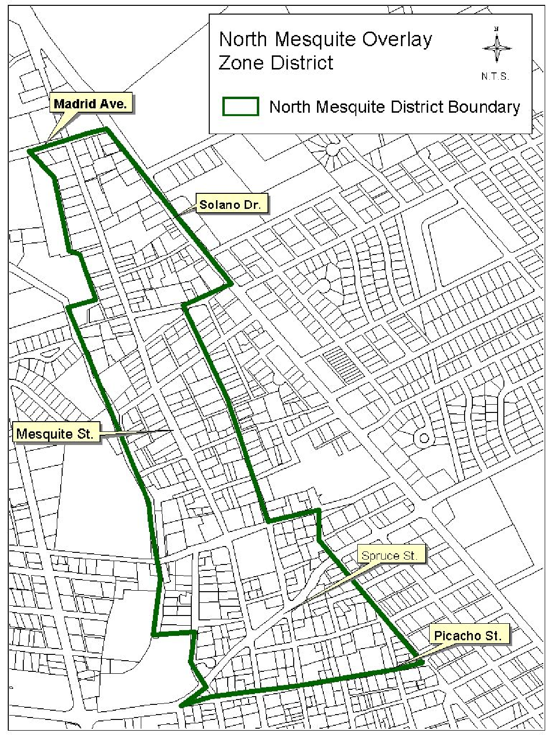
Figure 1
2.
Zoning. There shall be no development or alteration of the lands, uses, or structures within this overlay zone district except as provided for by this section of this Code from the date of its enactment, and other sections of this Code and other codes where applicable.
(a)
Permitted uses and development standards are established as described hereafter:
(1)
North Mesquite R-1 single-family low density residential district (maximum of eight dwelling units per acre).
Purpose. The North Mesquite R-1 district is intended to accommodate detached single-family dwelling units and to maintain and protect a low density residential character of development. Accessory uses which are incidental to and customarily found within the North Mesquite R-1 district are also permitted.
a.
R-1 permitted uses. The following uses are permitted with their noted conditions the North Mesquite R-1 districts.
Above ground storage tanks for liquid petroleum (LP) gas. Tanks shall be permitted only when meeting Uniform Fire Code requirements as adopted by the city and when receiving approval from the state LP gas bureau.
Accessory building. See "accessory building/structure.
Accessory dwelling unit. Shall follow requirements found in section 38-33.A.
Construction yard or building (temporary). Such yard or building shall be removed upon completion of construction or within three years from date of permit, whichever is sooner. Construction yards and buildings shall be maintained in a neat and orderly fashion, and open yards shall be enclosed by a fence five feet in height. However, there shall be no fence or wall more than three feet in total height above street-curb level located within 30 feet of a street intersection. Above ground storage tanks for flammable and combustible liquids within construction yards shall meet the Uniform Fire Code as adopted by the city and be approved by the city fire department.
Garage or yard sale or similar use for individual residences. Three sales are permitted in a one-year period at a single address. A sale shall not exceed three consecutive days.
Greenhouse (noncommercial), garden sheds, tool sheds. When detached from the main dwellings, such structures are subject to the provisions of accessory buildings, article 10.
Home for the disabled. See section 38-21.
Home occupation. Subject to the provisions of this section and section 38-52.
Kennel (private, residential).
Public park, playground, or ballfields. See section 38-33.E.
Real estate office (temporary). Permitted only when used in conjunction with a residential subdivision, provided such use shall be discontinued upon the completion of the development or within three years from date permit issued, whichever is sooner.
Religious institution (over ten persons)/columbarium. Religious institutions, with or without a columbarium, shall be located on a major local or higher designated roadway. Structures or parking located within 25 feet of a residential zoning district shall provide an opaque buffer consisting of landscape and walls or fences. Dumpsters or other garbage collection facilities shall not be located within 25 feet of property used for residential purposes.
Storage of recreational vehicles and motor vehicle appurtenances. Storage of personal recreational vehicles, boats, trailers, or similar uses shall be limited to a maximum of one per dwelling unit in the front or side yard, with no limit in the rear yard, separated at least five feet from any property line.
Swimming pool (private). Permitted only when a protective fence, four feet in height, is provided around the yard, lot or pool area. The pool shall be no closer than five feet from any property line, and approval from all utilities is required to insure overhead safety.
Utility installation: The site shall be developed and maintained in conformance with the general character and appearance of the district, and such development shall include landscaping and suitable opaque screening in the form of a solid wall, fence or compact shrubbery around the entire perimeter of the lot or tract, or around the installation itself in cases such as transformers. A wall or fence may be up to ten feet high. A solid wall or fence shall surround the installation. Landscaping shall be provided to screen and/or buffer the installation as necessary to allow the use to blend with the surrounding properties and minimize noise and visual pollution.
b.
North Mesquite R-1 Special Uses. The following uses require a public hearing and approval of the Planning and Zoning Commission. Specific conditions and provisions for each use may be referred to in part D of this section.
Cemetery/columbarium.
Community building.
Golf course and country club.
Group child care home.
Halfway house.
Nursing home.
School (private, public, and parochial).
(2)
North Mesquite R-2: Medium density residential district (maximum of 15 dwelling units per acre).
Purpose. The North Mesquite R-2 district is intended to accommodate an overall maximum density of 15 dwelling units per acre. This district is intended for single-family, duplex or apartment units in which a medium density residential character is protected and maintained.
a.
North Mesquite R-2 permitted uses with their noted conditions:
Above ground storage tanks for liquid petroleum (LP) gas. Tanks shall be permitted only when meeting Uniform Fire Code requirements as adopted by the city and when receiving approval from the state LP gas bureau.
Accessory building. See accessory building/structure.
Child care center, nursery, or similar use. Child care center, group child care home, family child care home, preschool, nursery school, day nursery, kindergarten, and similar uses shall be in accord with State licensing requirements. Care of 13 or more children at one time is prohibited in the residential zoning districts listed. Refer to section 38-52 of the Municipal Code, home occupation business registration, for babysitting service/child care when 12 or fewer children are cared for.
Condominiums. Maximum of four attached units.
Construction yard or building (temporary). Such yard or building shall be removed upon the completion of construction or within three years from date of permit, whichever is sooner. Construction yards and buildings shall be maintained in a neat and orderly fashion, and open yards shall be enclosed by a fence five feet in height. However, there shall be no fence or wall more than three feet in total height above street-curb level located within 30 feet of a street intersection. Above ground storage tanks for flammable and combustible liquids within construction yards shall meet the Uniform Fire Code as adopted by the city and be approved by the city fire department.
Dwellings. Maximum of four attached or detached dwelling units, not to exceed a maximum density of 15 dwelling units per acre.
Garage or yard sale or similar use for individual residences. Three sales are permitted in a one-year period at a single address. A sale shall not exceed three consecutive days.
Greenhouses (noncommercial), garden sheds, tool sheds. When detached from the main dwelling, such structures are subject to the provisions of accessory buildings, article 10.
Home for the disabled. See section 38-21.
Home occupation. Subject to the provisions of this section and section 38-52.
Public park, playground, or ballfield.
Kennel (private, residential).
Real estate office (temporary). Permitted only when used in conjunction with a residential subdivision, provided such use shall be discontinued upon the completion of the development or within three years from date permit issued, whichever is sooner.
Religious institution (over ten persons)/columbarium. Religious institutions, with or without a columbarium, shall be located on a major local or higher designated roadway. Structures or parking located within 25 feet of a residential zoning district shall provide an opaque buffer consisting of landscape and walls or fences. Dumpsters or other garbage collection facilities shall not be located within 25 feet of property used for residential purposes.
Storage of recreational vehicles and motor vehicle appurtenances. Storage of personal recreational vehicles, boats, trailers, or similar uses shall be limited to a maximum of one per dwelling unit in the front or side yard, with no limit in the rear yard, separated at least five feet from any property line.
Swimming pools: Private. Permitted only when a protective fence four feet in height is provided around the yard, lot or pool area. The pool shall be no closer than five feet from any property line, and approval from all utilities is required to insure overhead safety.
Townhouses. Maximum of four attached units.
b.
North Mesquite R-2 special uses. The following uses require a public hearing and approval of the Planning and Zoning Commission. Specific conditions and provisions for each use may be referred to in part D of this section.
Automobile parking lot.
Cemetery/columbarium.
Community building.
Golf course and country club.
Mobile home park.
Mobile home subdivision.
Nursing home/assisted living facility.
School (public, private, parochial).
Swimming pool (public or commercial).
(3)
North Mesquite R-3 high density residential district (maximum of 30 Dwelling units per acre).
Purpose. The North Mesquite R-3 district is intended to accommodate multiple family dwelling units and accessory structures and uses. The zone is intended to maintain and protect high density residential development that is characteristic of apartments, townhouses, condominiums, and other similar dwelling complexes. The North Mesquite R-3 zone is intended to be located in areas that have access to main thoroughfares.
a.
North Mesquite R-3 permitted uses with their noted conditions:
Above ground storage tanks for liquid petroleum (LP) gas. Tanks shall be permitted only when meeting Uniform Fire Code requirements as adopted by the city and when receiving approval from the state LP gas bureau.
Accessory building. See "accessory building/structure.
Boarding house.
Condominiums.
Child care center, nursery, or similar use. Child care center, group child care home, family child care home, preschool, nursery school, day nursery, kindergarten, and similar uses shall be in accord with State licensing requirements. Care of 13 or more children at one time is prohibited in the residential zoning districts listed. Refer to section 38-52 of the Municipal Code, home occupation business registration, for babysitting service/child care when 12 or fewer children are cared for.
Construction yard or building (temporary use). Such yard or building shall be removed upon the completion of construction or within three years from date of permit, whichever is sooner. Construction yards and buildings shall be maintained in a neat and orderly fashion and open yards shall be enclosed by a fence five feet in height. However, there shall be no fence or wall more than three feet in total height above street-curb located within 30 feet of a street intersection.
Above ground storage tanks for flammable and combustible liquids within construction yards shall meet the current fire code as adopted by the city and be approved by the city fire department.
Dwellings. Single or multi-family units, apartments, townhouses, and condominiums with a maximum density of 30 dwelling units per acre.
Fraternity house.
Garage or yard sale or similar use for individual residences. Three sales are permitted in a one-year period at a single address. A sale shall not exceed three consecutive days.
Greenhouses (noncommercial), garden sheds, and tool sheds. When detached from the main dwelling, such structures are subject to the provisions of accessory buildings, article 10.
Home for the disabled. See section 38-21.
Home occupation. Subject to the provisions of this section and section 38-52.
Nursing home/assisted living facility.
Kennel (private, residential).
Private club or lodge. Permitted when used in conjunction with nonprofit organizations such as Lions Club, Elks Lodge, and the like. Building(s) shall not be located within 100 feet of an R-1 or R-2 zone. Private clubhouses and game rooms are also permitted when used as a part of an apartment, condominium, or townhouse complex, provided such building(s) shall not be located within 50 feet of an R-1 or R-2 zone.
Public park, playground, and ballfield.
Real estate office: Temporary. Permitted only when used in conjunction with a residential subdivision provided such use shall be discontinued upon the completion of the development or within three years from date of permit, whichever is sooner.
Religious institution (over ten persons)/columbarium. Religious institutions, with or without a columbarium, shall be located on a major local or higher designated roadway. Structures or parking located within 25 feet of a residential zoning district shall provide an opaque buffer consisting of landscape and walls or fences. Dumpsters or other garbage collection facilities shall not be located within 25 feet of property used for residential purposes.
Sorority house.
Swimming pool: Private. Permitted only when a protective fence four feet in height is provided around the yard, lot, or pool area. The pool shall be no closer than five feet from any property line, and approval from all utilities is required to insure overhead safety.
Townhouses. Maximum of eight attached units.
b.
North Mesquite R-3 special uses. The following uses require a public hearing and approval of the Planning and Zoning Commission. Specific conditions and provisions for each use may be referred to in part D of this section.
Amusement park.
Automobile parking lot.
Cemetery/columbarium.
Community building.
Flea market.
Golf course and country club.
Halfway house and quasi-institutional house.
Mobile home park.
Mobile home subdivision.
School (public, private, parochial).
Swimming pool (public or commercial).
(4)
North Mesquite R-4 high density residential and limited office district (maximum of 40 dwelling units per acre).
Purpose. The North Mesquite R-4 district is intended to accommodate a mixture of high density multiple family dwelling units and limited offices in which no merchandise or goods are sold as the primary business. The North Mesquite R-4 zone is intended to be located in areas that have access to main thoroughfares and are large enough in area to accommodate large-scale apartment complexes or limited office developments.
a.
North Mesquite R-4 permitted uses with their noted conditions:
Above ground storage tanks for liquid petroleum (LP) gas. Tanks shall be permitted only when meeting Uniform Fire Code requirements as adopted by the city and when receiving approval from the state LP gas bureau.
Accessory building. See "accessory building/structure."
Boarding house.
Child care center, nursery, or similar use. Child care center, group child care home, family child care home, preschool, nursery school, day nursery, kindergarten, and similar uses shall be in accord with State licensing requirements. Care of 13 or more children at one time is prohibited in the residential zoning districts listed. Refer to section 38-52 of the Municipal Code, home occupation business registration, for babysitting service/child care when 12 or fewer children are cared for.
Condominiums.
Construction yard or building (temporary use). Such yard or building shall be removed upon the completion of construction or within three years from date of permit, whichever is sooner. Construction yards and buildings shall be maintained in a neat and orderly fashion and open yards shall be enclosed by a fence five feet in height. However, there shall be no fence or wall more than three feet in total height above street-curb level located within 30 feet of a street intersection.
Above ground storage tanks for flammable and combustible liquids within construction yards shall meet the Uniform Fire Code as adopted by the city and be approved by the city fire department.
Dwellings. Single or multi-family units, apartments, townhouses, and condominiums with a maximum density of 40 dwelling units per acre.
Fraternity house.
Garage or yard sale or similar use for individual residences. Three sales are permitted in a one-year period at a single address. A sale shall not exceed three consecutive days.
Greenhouses (noncommercial), garden sheds, and tool sheds. When detached from the main dwelling, such structures are subject to the provisions of accessory buildings, article 10.
Home for the disabled. See section 38-21.
Home occupation. Subject to the provisions of this section and section 38-52.
Nursing homes/assisted living facility.
Kennel (private, residential).
Offices (limited). Offices which provide health services as a convenience to the neighborhood such as medical, chiropractic or dental, and certain professional offices which have a very low traffic volume such as attorneys, accountants, and architects are permitted, provided such uses maintain the residential character of the neighborhood and zoning district in which they are located. There shall be no goods or merchandise prepared or sold on the premises. Uses such as barbershops, hairdressers, banks, and similar commercial and business offices which generate moderate or high volumes of traffic are prohibited in the North Mesquite R-4 district.
Private club or lodge. Permitted when used in conjunction with nonprofit organizations such as Lions Club, Elks Lodge, and the like. Building(s) shall not be located within 100 feet of an R-1 or R-2 zone. Private clubhouses and game rooms are also permitted when used as a part of an apartment, condominium, or townhouse complex, provided such buildings shall not be located within 50 feet of an R-1 or R-2 zone.
Public park, playground, and ballfield.
Religious institution (over ten persons)/columbarium. Religious institutions, with or without a columbarium, shall be located on a major local or higher designated roadway. Structures or parking located within 25 feet of a residential zoning district shall provide an opaque buffer consisting of landscape and walls or fences. Dumpsters or other garbage collection facilities shall not be located within 25 feet of property used for residential purposes.
Sorority house.
Swimming pool: Private. Permitted only when a protective fence four feet in height is provided around the yard, lot or pool area. The pool shall be no closer than five feet from any property line, and approval from all utilities is required to insure overhead safety.
Townhouses. Maximum of ten attached units.
b.
North Mesquite R-4 special uses. The following uses require a public hearing and approval of the Planning and Zoning Commission. Specific conditions and provisions for each use may be referred to in part D of this section.
Amusement park.
Automobile parking lot.
Cemetery/columbarium.
Community building.
Flea market.
Golf course or country club.
Halfway house and quasi-institutional house.
Hospital and overnight clinic.
Institution: Public, educational, religious, and philanthropic.
Mobile home park.
Mobile home subdivision.
School (public, private, parochial).
Swimming pool (public or private).
(5)
North Mesquite O-1 office district:
Purpose. The North Mesquite O-1 district is intended to accommodate office, service and institutional uses in which merchandise or goods are not prepared or sold as the primary business. This zone is designed to be a transition between commercial and residential uses and serve specified business, personal and professional services that can function efficiently without generating large volumes of vehicular traffic. The North Mesquite O-1 district should maintain a predominantly residential character. Residential uses are not permitted in the North Mesquite O-1 zone, except in cases where a proprietor uses a part of an office building as a dwelling. Limited landscaping is also required in the North Mesquite O-1 zone:
Landscaping requirements:
• A landscaping buffer, a minimum of five feet, excluding sidewalks, shall be provided and maintained along all street frontages. This landscaping shall be accomplished by the use of greenery, trees, lawn grass, shrubs, crushed stones, cactus, lava rock, or similar materials. In addition, all areas not devoted to buildings, structures, paved drives, walks and off-street parking facilities shall be covered with one of the above materials
• The entire lot width shall be landscaped with the exception of approved driveways.
• Landscaping shall not interfere with visibility for safe ingress and egress.
a.
North Mesquite O-1 permitted uses.
Art studio
Automobile parking lot
Barber shop
Beauty shop
Clinic (excluding animal clinic)
Community or public office building
Cosmetologist shop
Dentist office
Funeral home, mortuary, excluding crematoriums
Insurance office
Law office
Lessons (art, dance, music, and the like)
Office complex
Photographic studio
Physicians office
Private club or lodge
Professional and business offices
Real estate office
b.
Permitted uses—With conditions: The following uses are permitted in accord with stated conditions:
Above ground storage tanks for liquid petroleum (LP) gas. Tanks shall be permitted only when meeting Uniform Fire Code requirements as adopted by the city and when receiving approval from the state LP gas bureau.
Accessory building/structure. See "accessory building/structure."
Construction yard of building (temporary use). Permitted only during construction, provided such yard or building shall be removed upon the completion of construction or within three years from date of permit, whichever is sooner. Construction yards and buildings shall be maintained in a neat and orderly fashion, and open yards shall be enclosed by a fence of a minimum of five feet in height. However, there shall be no fence or wall more than three feet in total height above street-curb level located within 30 feet of a street intersection.
Above ground storage tanks for flammable and combustible liquids within construction yards shall meet the Uniform Fire Code as adopted by the city and be approved by the city fire department.
Dwelling use. Only when used as an incidental or accessory use to a business by a proprietor and when located in the same building as the primary business.
Electronic banks. Buildings shall not exceed 2,500 square feet of floor area. There shall be no interior commercial use and no drive-up window facilities.
Laboratory: Medical, dental, or similar uses. Permitted only when entirely contained within an office building and used strictly for the purpose of serving the occupants of the office complex. There shall be no direct entrance from the exterior of the building, and no advertising signs or other visible displays indicating the use from the exterior of the building.
Prescription sales shop. Permitted only for the purpose of serving the occupants of a medical, dental, or similar office facility and with no direct entrance from the exterior of the building. There shall be no advertising signs or other visible displays indicating the use from the exterior of the building.
Public utility installations, substations, and waterwells. The site shall be developed and maintained in conformance with the general character and appearance of the zoning district and shall include landscaping and suitable screening in the form of a solid wall, fence or compact shrubbery around the perimeter of the lot or tract.
Religious institution (over ten persons)/columbarium. Religious institutions, with or without a columbarium, shall be located on a major local or higher designated roadway. Structures or parking located within 25 feet of a residential zoning district shall provide an opaque buffer consisting of landscape and walls or fences. Dumpsters or other garbage collection facilities shall not be located within 25 feet of property used for residential purposes.
c.
North Mesquite O-1 special uses. The following uses require a public hearing and approval of the Planning and Zoning Commission. Specific conditions and provisions for each use may be referred to in part D of this section.
Drive-in bank.
Golf course or country club.
Halfway house or quasi-institutional house.
Home for disabled.
Institution: Public, educational, religious, and philanthropic.
Public building (other than offices).
Schools (public, private, parochial).
Swimming pools (public or commercial).
(6)
North Mesquite C-1 neighborhood commercial district.
Purpose. The North Mesquite C-1 district is intended to accommodate limited retail and service establishments as a convenience to nearby residential neighborhoods. This zone is designed to be compatible and consistent with the needs and character of a residential neighborhood. Uses such as the sale, service and repair of motor vehicles, engines, and mobile homes; gasoline service stations and body shops; dancing establishments; the wholesaling and warehousing of merchandise; pet shops; and similar uses are not permitted in the North Mesquite C-1 zone. Uses which exceed 3,000 square feet of gross floor area per business require a special use permit after public hearing of the Planning and Zoning Commission, in order to insure that the size of the business does not create undue traffic congestion, noise or other problems that would be detrimental to the residential character of the neighborhood.
Residences in North Mesquite C-1 shall comply with North Mesquite R-4 development standards.
a.
North Mesquite C-1 permitted uses. The following uses are permitted by right in the North Mesquite C-1 district provided the gross floor area of each business does not exceed 3,000 square feet. Uses exceeding 3,000 square feet may be considered for approval only as a special use permit after a public hearing before the Planning and Zoning Commission in accord with section 38-10.
Arts and crafts studio
Bakery
Barber shop
Beauty parlor
Bicycle sales and service
Bookstores and stationery shops
Cigarette and cigar shops
Clinic (excluding animal clinics)
Coffee shop and snack bar
Community building (publicly or privately owned)
Cosmetologist shop
Delicatessen (walk-in with 16 seats maximum)
Dressmaking shop
Dry-cleaning and steamcleaning (receiving shop)
Florist shop
Gift shop
Grocery store
Hobby shop and toy store
Household appliance and repair shop
Knit and yarn shops
Laundry (self service)
Lessons (art, dance, music, and the like)
Library
Meat and seafood markets
Messenger service
Newspaper distribution office
Offices: Professional and business
Photographic studio
Post office
Prescription shop
Private club or lodge
Public park, playground, recreational use
Real estate office
Residences
Restaurant (walk-in with 16 seats maximum)
Shoe repair shop
Tailor shop
Variety store
b.
Permitted uses—With conditions: The following uses are permitted in accord with stated conditions.
Above ground storage tanks for flammable and combustible liquids. Tanks shall be permitted only when meeting Uniform Fire Code requirements as adopted by the city and when receiving approval from the city fire department.
Above ground storage tanks for liquid petroleum (LP) gas. Tanks shall be permitted only when meeting Uniform Fire Code requirements as adopted by the city and when receiving approval from the state LP gas bureau.
Accessory building/structure. See "accessory building/structure."
Child care center, nursery, or similar use. Child care center, group child care home, family child care home, preschool, nursery school, day nursery, kindergarten, and similar uses shall be in accord with state licensing requirements. Care of 13 or more children at one time is prohibited in the residential zoning districts listed. Refer to section 38-52 of the Municipal Code, home occupation business registration, for babysitting service/child care when 12 or fewer children are cared for.
Construction yard or building (temporary use). Permitted only during construction, provided use or building shall be removed upon the completion of construction or within three years from date of permit, whichever is sooner. Construction yards and buildings shall be maintained in a neat and orderly fashion, and open yards shall be enclosed by a solid fence of a minimum of five feet in height. However, there shall be no fence or wall more than three feet in total height above street-curb level located within 30 feet of a street intersection.
Above ground storage tanks for flammable and combustible liquids within construction yards shall meet the Uniform Fire Code as adopted by the city and be approved by the city fire department.
Christmas tree sales. Temporary, not prior to November 15 and provided lots are removed by December 31.
Drive-in bank. Stacking lanes shall be provided and designed to insure that no bank or ATM traffic backs into the street giving access to the bank. Banks or ATMs shall have access to a major local or higher designated roadway. See the Municipal Code for stacking lane requirements.
Firewood sales. Maximum of ten cords per business stored on site.
Home for handicapped, disabled, retarded, or retired. See section 38-21.
Home occupation. Subject to the provisions of this section and section 38-52.
Retail sales: Specialized merchandise. Retail sales, except as otherwise stated, shall be limited to stores that specialize in a particular type of merchandise such as clothing, records, shoes, home appliances, or other similar convenience goods to serve nearby residential neighborhoods.
Shopping center (less than two acres). Provided a site plan for the entire development is approved.
Public utility installation, substation, and waterwell. The site shall be developed and maintained in conformance with the general character and appearance of the zoning district and shall include landscaping and suitable screening in the form of a solid wall, fence or compact shrubbery around the perimeter of the lot or tract.
Religious institution (over ten persons)/columbarium. Religious institutions, with or without a columbarium, shall be located on a major local or higher designated roadway. Structures or parking located within 25 feet of a residential zoning district shall provide an opaque buffer consisting of landscape and walls or fences. Dumpsters or other garbage collection facilities shall not be located within 25 feet of property used for residential purposes.
Storage: Incidental to primary use. Storage shall be permitted only for merchandise incidental to the primary use of the business. Such storage shall be totally enclosed within the building of primary use, and at least ten percent of the gross floor area shall be used for retail sales or service. Exterior or open storage is prohibited.
Swimming pools. Permitted only when a protective fence four feet in height is provided around the yard, lot or pool area. The pool shall be no closer than five feet from any property line, and approval from all utilities is required to insure overhead safety.
c.
C-1 special uses. The following uses require a public hearing and approval of the Planning and Zoning Commission. Specific conditions and provisions for each use may be referred to in part D of this section.
Gas pumps (accessory to a grocery store).
Gross floor area: Exceeding 3,000 square feet.
Golf course and country club.
Halfway house and quasi-institutional house.
Hospital and overnight clinic.
Institutions: Public, educational, religious, and philanthropic.
School (public, private, and parochial).
Shopping center (limited to a maximum of five acres).
Auto washing establishment.
(7)
North Mesquite C-2 general commercial district.
Purpose. The intent of the North Mesquite C-2 zoning district is to provide for certain commercial/retail uses which generate large volumes of automobile traffic. The district is intended for areas surrounding major arterial intersections where a wide range of automobile-related service facilities, convenience goods and personal services are desirable and appropriate as a land use.
*Total lot area must be equal to, or greater than, 3,500 square feet.
Residences in the North Mesquite C-2 zoning district shall comply with North Mesquite R-4 zoning district development standards.
a.
North Mesquite C-2 permitted uses. The following uses are permitted by right in the C-2 North Mesquite district:
Animal hospital and clinic
Arts and crafts studio
Automobile and camper sales and service
Automobile parking lot
Automobile washing establishment
Bakery
Banking and financial institution
Barber shop and beauty parlor
Bicycle sales and service
Boat sales and service
Bowling alley
Bus terminal
Business service establishment
Butcher shop/meat market
Catering
Cigarette and cigar stand
Clothing store and apparel shop
Coffee shop and cafe
Columbarium
Community and public building
Convention or exhibition hall
Country club
Dance hall or music academy
Department store
Dressmaking shop
Drugstore
Dry cleaning and steam cleaning
Electrical shop
Firewood sales
Florist
Food store
Fraternity
Frozen food locker
Funeral home, mortuary (including crematorium)
Gasoline station
Glass cutting and finishing
Golf course
Gymnasium
Hardware store
Hospital or overnight clinic
Hotel and motel
Household appliance sales, service and repair
Institutions, public and quasi-public
Laboratory (medical and dental)
Laundry
Lessons (art, music, dance, and the like)
Liquor store
Lumber store
Medical center
Microwave radio relay structure
Miniature golf course
Motion picture theater
Motorcycle sales and service
Newspaper establishment, including distribution office
Newsstand
Nursing or convalescent home
Office (business and professional)
Paint sales
Parking garage/lots
Plumbing/heating/cooling/sheet metal business (refer to contractor-type yard, e.g. associated with cooling, heating, plumbing, and sheet metal shops if a yard is associated with the business)
Pet shop
Photographic studio and supply store
Plant nursery
Pool and billiard room
Printing and engraving shop
Private club or lodge
Public park, playground, recreational use
Radio, television, music store
Residence
Restaurant
Retail sales
Shoe repair
Show and sales room for business products
Skating rink
Sorority
Sporting goods store
Steamcleaning establishment
Tailoring
Tavern
Taxicab stand
Telegraph and messenger service
Tire sales and service
Upholstery shop
Variety store
Other: Businesses in existence at the time of this Code's adoption and have a current business registration shall be heretofore known as permitted uses, as such, all will be allowed to continue their operations in the manner in which they currently operate at the time of this Code's adoption. (Please note that all permits, regulations, etc., which are mandated by state and/or federal law must be adhered to.)
b.
Permitted uses with conditions. Applies to new businesses and (refer to section 38-70.4 for further information). The following North Mesquite C-2 uses are permitted in accord with stated provisions.
Above ground storage tanks for flammable and combustible liquids. Tanks shall be permitted only when meeting Uniform Fire Code requirements as adopted by the city and when receiving approval from the city fire department.
Above ground storage tanks for liquid petroleum (LP) gas. Tanks shall be permitted only when meeting Uniform Fire Code requirements as adopted by the city and when receiving approval from the state LP gas bureau.
Amusement park or enterprise. Subject to the provisions and requirements of the Municipal Code. Temporary amusement enterprises are prohibited within 300 feet of any residential zoning district. Permanent amusement enterprises are prohibited within 500 feet of any residential zoning district.
Assembly of arts and crafts. Only when such assembly is for display and sale on the premises or when such assembly occupies less than 1,500 square feet of a building.
Bank drive-up windows. Stacking lanes shall be provided and designed to insure that no bank or ATM traffic backs into the street giving access to the bank. Banks or ATMs shall have access to a major local or higher designated roadway. See the Municipal Code for stacking lane requirements.
Body shop. Buildings shall be located a minimum of 300 feet from a residential district boundary and shall have fire department approval.
Child care center, nursery, or similar use. Child care center, group child care home, family child care home, preschool, nursery school, day nursery, kindergarten, and similar uses shall be in accord with State licensing requirements. Care of 13 or more children at one time is prohibited in the residential zoning districts listed. Refer to section 38-52 of the Municipal Code, home occupation business registration, for babysitting service/child care when 12 or fewer children are cared for.
Christmas tree sales. Temporary, not prior to November 15, provided lots are cleaned and removed by December 31.
Construction yard or building (temporary). Such yard or building shall be removed upon completion of construction or within three years from date of permit, whichever is sooner. Construction yards and buildings shall be maintained in a neat and orderly fashion, and open yards shall be enclosed by a fence five feet in height. However, there shall be no fence or wall more than three feet in total height above street-curb level located within 30 feet of a street intersection. Above ground storage tanks for flammable and combustible liquids within construction yards shall meet the Uniform Fire Code as adopted by the city and be approved by the city fire department.
Contractor-type yards (e.g. Associated with cooling, heating, plumbing, and sheet metal shops). Yards shall be maintained in a neat and orderly fashion and enclosed by a solid wall or fence a minimum of six feet in height (clear-site-triangle requirements must be met).
Cottage industry. A cottage industry is defined as any manufacturing, compounding, and/or assembly process, including food preparation, which is subordinate to a primary use of retail sales or service. This use is not to be confused with or treated as a home occupation. Cottage industry land use listings may be found in section 38-33.I. of the Las Cruces Municipal Code. Cottage industries are limited to 5,000 square feet of retail sales space or retail sales space limited to 49 percent of the total building square footage, whichever is less. Cottage industry may only occur within a totally enclosed building where the primary use (retail/service) is conducted. The processing of goods shall be clearly secondary to the primary use, shall be sold on site only, and shall not pose any significant adverse impact to adjacent properties due to noise, odor, dust, or vibration. A maximum of 49 percent of the total business floor area, not to exceed 3,000 square feet, may be used in the conduct of the cottage industry.
Firewood sales. No more than 20 cords stored on site.
Flea market. Subject to the requirements of Ordinance No. 625 in the Municipal Code.
Furniture assembly (accessory use). Permitted only as an incidental or accessory use to retail sales. Maximum floor area for assembly shall not exceed 3,000 square feet, not to exceed 30 percent of the total business floor area, and shall be within the same building.
Heavy equipment repair (accessory use). Permitted only as an incidental or accessory use to heavy equipment sales. Floor area for repair shall not exceed 3,000 square feet and not exceed 30 percent of the total gross floor area. Welding is permitted only in conjunction with repair and shall not be used for the purpose of heavy equipment assembly.
Home for handicapped, disabled, retarded, or retired. See section 38-21.
Home occupation. Subject to the provisions of this section and section 38-52.
Meat processing. Meat processing of wild game and custom orders is allowed provided that the meat that is processed is not for wholesale distribution.
Mini-storage units. Units shall not be used for commercial sales of products, merchandise, service, or repair.
Paint shop. Spraying or mixing is allowed provided such use shall be located at least 100 feet from any residential zoning district and provided there shall be fire department approval.
Public utility installation, substation, and waterwell. The site shall be developed and maintained in conformance with the general character and appearance of the zoning district and shall include landscaping and suitable screening in the form of a solid wall, fence or compact shrubbery around the perimeter of the lot or tract.
Schools. Elementary, middle or high schools shall be located on a collector or higher designated roadway. Commercial, trade or technical schools, college or university shall be located on a minor arterial or higher designated roadway. All sites shall have a minimum of one acre. Structures or parking located within 25 feet of a residential zoning district shall provide an opaque buffer consisting of landscape and walls or fences. Dumpsters or other garbage collection facilities shall not be located within 25 feet of property used for residential purposes.
Storage of wrecked or dismantled vehicles and parts (accessory use). The storage of wrecked and dismantled vehicles and parts thereof shall be permitted only as an incidental accessory use to a vehicle repair establishment or a body shop approved by a special use permit in the C-2 district. Such use shall meet the following requirements:
1.
Storage shall be within an enclosed building or within a site-obscuring fence at least six feet in height;
2.
Vehicles and parts stored at the exterior of the building shall be owned by customers of the business and such storage shall be only for the purpose of repair and return to customers;
3.
Exterior storage of vehicles shall not remain on the premises for a period exceeding three months;
4.
There shall be a maximum of five wrecked vehicles stored at the building exterior during any one time; and
5.
Exterior storage shall be a minimum of 100 feet from a residential zoning district.
Storage as an accessory use. Storage shall be permitted only when incidental or accessory to sales of merchandise. Such storage shall be within a totally enclosed area and at least five percent of the gross floor area shall be used for retail sales or service.
Temporary uses. Temporary uses, such as fireworks stands, shall be allowed in the North Mesquite C-2 district and shall follow the timelines and other such requirements established in section 38-50 of the Municipal Code.
Recycling purchase centers. This business is limited to the inspection, weighing, purchasing and temporary storage of aluminum and scrap metal, cloth, glass and paper products. Said materials are to be purchased for the purpose of transporting to local and area processing centers.
1.
Storage shall be within an enclosed building; or
2.
Storage may be located within mobile trailer units within a sight obscuring fence at least six feet in height, and not to be a contamination, rodent, insect, or health hazard;
3.
Materials to be recycled shall not remain on the premises for a period exceeding eight weeks; and
4.
Recycling purchase centers shall be located a minimum of 300 feet from any residential zoning district.
Religious institution (over ten persons)/columbarium. Religious institutions, with or without a columbarium, shall be located on a major local or higher designated roadway. Structures or parking located within 25 feet of a residential zoning district shall provide an opaque buffer consisting of landscape and walls or fences. Dumpsters or other garbage collection facilities shall not be located within 25 feet of property used for residential purposes.
Swimming pools. Permitted only when a protective fence four feet in height is provided around the yard, lot, or pool area. The pool shall be no closer than five feet from any property line and approval from all utilities is required to insure overhead safety.
Welding (accessory use). Welding shall be permitted only as an incidental or accessory use necessary for the repair of vehicles or equipment permitted in the C-2 zone. Welding for the purpose of assembly is prohibited. Welding uses shall be approved by the fire department and shall be in accord with the provisions found in the Municipal Code.
Wrecker services. In accord with storage of wrecked vehicle provisions in the Municipal Code.
c.
North Mesquite C-2 district special uses. The following uses require approval of the Planning and Zoning Commission. Specific conditions and provisions for each use may be referred to in part D of this section.
Halfway house or quasi-institutional house
Kennel (commercial).
Racetrack
Mobile home park
D.
Special uses. A special use is a use that is not permitted by right in a zoning district. A special use requires review and approval by the Planning and Zoning Commission to determine impacts on the surrounding area. The procedures for approval may be found in sections 38-54 A.1—5 of the Municipal Code.
Automobile parking lot (North Mesquite zones: R-2, R-3 and R-4): Parking lots must be within 300 feet of any office, commercial, business, or industrial district. The parking area shall be suitably landscaped, paved and drained, lighted, and maintained free of debris.
Automobile washing establishment (North Mesquite zone C-2).
Bus garage (North Mesquite zone C-2): A traffic plan shall be approved by the city traffic engineer showing the location, size, and width of streets giving access to the garage. Such use shall be located on a designated arterial or collector street.
Flea market (North Mesquite zones: R-3, R-4). Flea markets shall not be approved if there is a protest of 51 percent within the area of property ownership 100 feet from the proposed use.
Cemetery or similar uses (North Mesquite zones: A-2, R-1a, R-1b, R-1c, R-1aM, R-1bM, R-1cM, R-2, R-3, R-4). Any cemetery site shall contain at least five acres and shall be located on a major local or higher designated roadway. A columbarium shall be located on a major local or higher designated roadway with the lot size meeting the zoning district minimum lot size.
Community buildings (North Mesquite zones: R-1, R-2, R-3, R-4).
Drive-in bank (North Mesquite zone: O-1): Stacking lanes shall be provided and designed to insure that no bank and/or ATM traffic backs into the street giving access to the bank. Banks or ATMs shall have access to a major local or higher designated roadway. See section 38-58 for stacking lane requirements.
Golf courses and country club (North Mesquite zones: R-1, R-2, R-3, R-4, O-1, C-1): There shall be screening and buffering on property lines abutting residential areas and no structures shall be within 50 feet of a residential property line.
Gross floor area: Exceeding 3,000 square feet (North Mesquite zone: C-1): The maximum gross area per business may exceed 3,000 square feet in a North Mesquite C-1 district provided it can be shown that the increase in size will not be inconsistent with the purpose of the North Mesquite C-1 district and will not create traffic congestion. Businesses shall not exceed 6,000 square feet of gross floor area.
Halfway house (North Mesquite zones: R-3, R-4, O-1, C-1, C-2).
Hospital and overnight clinic (North Mesquite zones: R-4, C-1).
Institution: Public, educational, religious, and philanthropic (North Mesquite zones: R-4, O-1, C-1).
Kennel—Commercial (North Mesquite zones: C-2, M1/M2): Such uses shall be a minimum of 400 feet from any residential zoning district boundary.
Mobile home park (North Mesquite zones R-2, R-3, R-4).
Mobile home subdivision (North Mesquite zones: R-2, R-3, R-4).
Nursing home/assisted living facility (North Mesquite zones: R-1, R-2). Must be located on a collector or higher designated roadway.
Racetrack (North Mesquite zones: C-2, M1/M2): All parking areas and interior streets shall be surfaced in accordance with requirements of section 9.8, and the building complex shall be located a minimum of 300 feet from any residential zoning district boundary.
School—Public, private, parochial (North Mesquite zones: R-1, R-2, R-3, R-4, O-2, C-2): Elementary, middle or high schools shall be located on a collector or higher designated roadway. Commercial, trade or technical schools, college or university shall be located on a minor arterial or higher designated roadway. All sites shall have a minimum of one acre. Structures or parking located within 25 feet of a residential zoning district shall provide an opaque buffer consisting of landscape and walls or fences. Dumpsters or other garbage collection facilities shall not be located within 25 feet of property used for residential purposes.
Swimming pool—Public or commercial (All North Mesquite residential "R" districts and North Mesquite O-1): A protective fence or wall no less than six feet in height shall be provided which completely encloses the pool area, and the pool shall be no closer than 25 feet from any property line. Approval from the electric utility is required to insure safety.
E.
Parking requirements. The following exceptions to the parking requirements found in chapter 38 of the Municipal Code shall be used in the North Mesquite Neighborhood district:
1.
Buildings within the North Mesquite Neighborhood district constructed prior to 1955 shall not be required to provide off-street parking.
2.
Buildings within the North Mesquite Neighborhood district constructed after 1955 shall be eligible to use the historic district parking requirements found in section 38-58 of the 2001 Zoning Code, as amended.
3.
The city traffic engineer shall determine which streets will be prohibited from use for on-street parking.
F.
Nonconforming uses, structures, and property. Many people refer to nonconforming uses as the "Grandfather Clause." If a use, structures, etc., was established legally under the previous code, it is considered a legal nonconforming use. Within the North Mesquite Neighborhood overlay zone district, all existing land uses with a valid business registration are considered as permitted uses at the time of this Code's adoption. As such, there should be limited nonconforming uses in this district. Those uses that do exist should comply with the nonconforming use provisions found in section 38-70 of the Municipal Code with the following exception:
(a)
If a nonconforming use becomes and remains vacant, no time-limit shall be placed on reestablishing the nonconforming use at that location.
G.
Accessory building/structure. An accessory building/structure is incidental to and customarily found in connection with the principal dwelling on the same property. Examples: gazebo, greenhouse, tool-shed, and detached garage. An accessory building shall not be used for a business or dwelling purposes.
1.
Permanent accessory building/structure.
(a)
A maximum height of 15 feet is permitted.
(b)
An accessory building/structure shall not occupy more than 30 percent percent of the rear yard. Accessory structure shall not be used for living quarters.
(c)
Accessory use or structure closer than ten feet from the main use or structure shall meet the minimum setback requirements of this zoning district and shall be reviewed and approved by the public safety department before a building permit is issued. Drainage/water run-off contributed by an accessory structure shall be contained on site and be consistent with the city's design standards unless approved by the community development department director or designee. Furthermore, no accessory structure shall be located in the required on-site ponding area. Calculations shall be provided to indicate that all water runoff will be accommodated on site consistent with the city's design standards.
(d)
Setback requirements:
(1)
North Mesquite R-1:
a.
Interior lot. No less than ten feet from main use or structure and three feet from property lines on rear and side yards.
b.
Lots with more than one street frontage. No less than ten feet from main use or structure, three feet from property line on rear yard (yard without street frontage), and shall meet the required setbacks on all frontages in accordance to the zone.
c.
Exception: Accessory use or structure less than three feet from property lines and no less than ten feet from main use or structure shall have one hour fire resistant exterior walls and no openings in walls facing the property lines.
(2)
North Mesquite R-2, R-3, C-1 (residential), and C-2 (residential) zones.
a.
Interior lot. No less than ten feet from main use or structure and five feet from property lines on the rear and side yards.
b.
Lots with more than one street frontage. No less than ten feet from main use or structure, five feet from property line on the rear yard (yard without street frontage), and shall meet the required setbacks on all frontage in accordance to the zone.
c.
Exception: Accessory use or structure less than five feet from property line and no less than ten feet from main use or structure shall have one hour fire resistant exterior walls and no openings in walls facing the property lines.
(3)
R-4 Zone Residential.
a.
Interior lot. No less than ten feet from main use or structure and five feet from property lines on the rear and side yards.
b.
Lots with more than one street frontage. No less than ten feet from main use or structure, five feet from property line on the rear yard (yard without street frontage), and must meet the required setbacks on all frontages in accordance to the zone.
c.
Exception: Accessory use or structure less than five feet from property lines and no less than ten feet from main use or structure shall have one hour fire resistant exterior walls and no openings in walls facing the property lines.
(4)
R-4 (offices), O-1, C-1 (commercial), C-2 (commercial), M1/ M2 zones.
a.
Interior lot. No less than ten feet from main use or structure and shall meet the requirements set forth in the Uniform Building Code for said accessory use or structure.
b.
Lots with more than one street frontage. No less than ten feet from main use or structure, shall meet the required setbacks on all frontages in accordance to the zone, and meet the requirements set forth in the Uniform Building Code for said accessory use or structure.
2.
Accessory building exceptions: Large lots. On lots that are one-half acre or more in size, one accessory building may be permitted which exceeds 400 square feet of gross floor area up to 800 square feet, provided it shall have a minimum rear yard setback of 15 feet and a side yard of seven feet, and provided all other requirements of this Code are met.
H.
Home occupation. Home occupation requirements shall follow the provisions set forth in chapter 38-52 with the following exceptions:
(a)
Residential uses located in the North Mesquite C-2 zone may have direct sale of products off display shelves or racks.
(b)
Residential uses located in the North Mesquite C-2 zone may have a maximum of six vehicles at the dwelling at any one time for the purpose of conducting business. Both on-street and off-street parking may be utilized.
I.
Administration of the overlay zone district.
(a)
Land use/zone change requests. It is possible to request an additional land use not already noted within the permitted use lists on a specific parcel within the North Mesquite overlay district. Each request will be considered on a case-by-case basis. These requests will be processed per Section 38-10 of the Municipal Code. The utilization of the infill development process, Section 38-48, is allowed in the North Mesquite Neighborhood overlay zone district.
(b)
Subdivision requests. For submittal and review of subdivisions within the district, refer to Chapter 37 of the Municipal Code.
(c)
Issues not addressed here. Any issue not addressed in this division will revert to the appropriate section(s) of the Municipal Code, as amended.
J.
Enforcement of the north mesquite neighborhood overlay zone district. Provisions to enforce this section shall be consistent with the enforcement provisions the Municipal Code.
(Ord. No. 2354, § I, 1-22-07)
Sec. 38-49.2. - SMO—South Mesquite Overlay District.
A.
Purpose. The South Mesquite Overlay District is designed to positively address issues unique to Las Cruces' Original Townsite and surrounding area. This area is addressed in the 2005 adopted Mesquite Neighborhood Plan and the 2007 adopted Mesquite Historic District Neighborhood Design Plan. Specific provisions in this Ordinance deal with issues such as compatible design, parking, setbacks, and land use/zoning designations that are better suited to this older part of the city characterized by smaller lots with multiple dwellings and scarce off-street parking resources. Additionally, neighborhood design guidelines and standards have been created that will help enhance and preserve the unique character of Las Cruces' first neighborhood.
B.
Delineation of Overlay District Boundaries. The South Mesquite Overlay (SMO) District shall include all properties located within the boundaries shown on Figure 1.
C.
Definitions. Definitions shall rely on those noted in Section 38-20 of the 2001 Zoning Code, as amended unless otherwise noted here:
Accessory Structure: See Section 38-51 of the 2001 Zoning Code, as amended.
Accessory Dwelling Unit (ADU): See Section 38-53 of the 2001 Zoning Code, as amended.
Compatible: Capable of existing together in harmony. Parts of a whole that work well together when pieced together. Compatibility with existing elements does not mean uniformity.
Consistent: That which is similar to, or nearly the same.
Contributing: A resource that is listed as "contributing" on the National Register of Historic Places, the State Register of Cultural Properties, or the 1994-1995 State or National Mesquite Street—Original Townsite Historic District of Las Cruces, New Mexico Inventory. In the law regulating historic districts in the United States, a contributing resource is any building, structure, site, or object which adds to the historical integrity or architectural qualities that make the historic district important. In this document, "contributing" and "significant" may be used interchangeably [see Significant definition below].
District Boundary: The boundaries of the South Mesquite Overlay District are shown in Figure 1. The properties that are included within the Overlay District include all those within the boundary shown on Figure 1.
Demolition: An act that destroys or removes in whole or in part the exterior of a building or structure of a historic property.
Design Standards: Regulations intended to preserve the historic and architectural character within the South Mesquite Overlay District.
Exterior Appearance: The visual character of all outside surfaces of a structure, including facades, fenestration pattern, signage, light fixtures, steps, or character-defining features, such as corbelled posts, exposed vigas, tiles, canales, etc. Fencing or walls surrounding the structure also contribute to the exterior appearance of a property.
Exterior remodeling, exterior renovation, and exterior alteration: Any change or rearrangement in the supporting members of an existing building, such as exterior bearing walls, columns, beams, girders, as well as any substantial change in rooflines, number of doors and/or windows added, removed, replaced, or resized, or any enlargement to or diminution of a building or structure, whether horizontally or vertically or any installation or replacement of fencing viewed from the street. Maintenance or repair shall not be construed as exterior remodeling, renovation, and/or alteration.
Facade: Typically the front of a building; however, any elevation on view is considered a facade.
Historic: In this document, structures that are listed as contributing or significant by the National Register of Historic Places, the New Mexico Register of Cultural Properties, the State or National Mesquite Street-Original Townsite Historic District of Las Cruces, New Mexico.
Historic Districts: The boundaries of the State "Mesquite Street-Original Townsite Historic District of Las Cruces New Mexico" and the National "Mesquite Street-Original Townsite National Historic District of Las Cruces New Mexico" are found in Figure 2.
Historic Integrity: The authenticity of a property's historic identity, evidenced by the survival of physical characteristics that existed during the property's period of significance.
Historic Preservation Commission (HPC): The board created by the City Council authorized to direct and assist in the preparation and updating of the City of Las Cruces historic preservation plan; to create and review design guidelines for historic districts and cultural properties; to review and render decisions upon Certificate of Appropriateness applications; and to advise the Historic Preservation Specialist in initiating and implementing relevant preservation planning programs.
Historic Register: In this document, the National Register of Historic Places or the New Mexico Register of Cultural Properties.
LCMC: Most current edition of the Las Cruces Municipal Code.
New Construction: The erection of a new primary structure or accessory structure on a lot or property.
Ordinary Maintenance or Repair: Any change that is not new construction, removal, or alteration. Repair may include patching, piecing-in, splicing, consolidating, or otherwise reinforcing or upgrading historic materials such as masonry, wood and architectural metals according to recognized preservation methods. Repairing also includes the limited replacement in kind. or with compatible substitute material, of extensively deteriorated or missing parts or features when there are surviving examples, such as adobe bricks, brackets, dentils, or portions of slate or tile roofing.
Primary Façade(s): Any and all sides of a building which face a public right-of-way. A building may have more than one primary façade.
Primary Structure(s): In this document, the structure(s) for which the use is the main use of the parcel (not an Accessory Use as defined in Section 38-51 of the 2001 Zoning Code, as amended). Note: It is possible to have more than one primary structure on a parcel, for example two residences, or a retail shop and a residence.
Rehabilitation: Making possible a compatible use for a property through repair, alterations, and additions while preserving those portions or features which convey its historical, cultural, or architectural values. Most projects in the South Mesquite Overlay are expected to be rehabilitation projects.
Relocation: Any relocation of a structure from its originally installed site to another site.
Secondary Residence: A dwelling unit that is subordinate in size and location to the main dwelling on a single property, and may be rented or leased as an independent dwelling unit. A secondary residence is different from a guest dwelling or accessory structure in that it is distinct dwelling unit containing a kitchen. Examples include a traditional guest house, apartment, cottage or converted garage.
Significant: A resource that is listed as "significant" on the National Register of Historic Places, the State Register of Cultural Properties, or the 1994-1995 State or National "Mesquite Street—Original Townsite Historic District Inventory." In the law regulating historic districts in the United States, a significant resource is any building, structure, site or object which adds to the historical integrity or architectural qualities that make the historic district worthy of registration. In older nominations, the terms "significant" and "contributing" were used to "rank" buildings, but in newer nominations, the status of a resource is either contributing or non-contributing. "Significant" is no longer used as a separate term. In this document, "significant" and "contributing" may be used interchangeably.
SMO: South Mesquite Overlay District.
SMDRB: South Mesquite Design Review Board.
Structure: That which is built or constructed, an edifice or building of any kind, or any place of work artificially built up or composed of parts joined together in some definite manner. Note: Although "structure" and "building" have different meanings for many preservationists, in this document the two words are used interchangeably.
Figure 1 South Mesquite Overlay Boundaries

Figure 2: Boundary of the Mesquite Street—Original Townsite State & Federal Historic Districts

D.
Development Standards. There shall be no development or alteration of the lands, uses, or structures within the SMO except as provided for by this Section of the 2001 City Zoning Code, as amended, other sections of the City Zoning Code, and other City Codes and Ordinances where applicable. Development requirements are established for the entire SMO, as follows (unless indicated in other sections of this Overlay):

E.
Landscape Requirements. Landscaping shall follow standards set forth in Chapter 32 of the LCMC with the following modifications:
1.
Applicability: Landscaping standards apply to all new development in the SMO with the exception of single family dwellings and duplexes, unless noted elsewhere in this section.
2.
A variety of landscaping materials shall be employed to create visual interest and to complement other plantings in the neighborhood. Care should be taken when planting too close to adobe structures which can be damaged by plant watering. Plant materials, including shade trees, shall be native and/or draught tolerant, as these are best suited to the Chihuahua Desert. This is not to say that the landscape plan needs to adhere to Xeriscaping. On the contrary, plants should be chosen that will survive and thrive in the local climate. Appropriate species include, but are not limited to, the following:
3.
All new development, except single-family dwellings and duplexes, and adaptive reuse of properties (such as a change of use) shall be required to plant trees within parking lots for shade and visual relief (see subsection 5 below).
4.
Landscaping gravel, decorative stone or other organic landscaping materials may be used for landscaping, provided such materials blend visually with other landscaping material and planting style standards and meet the City's wind erosion control ordinance).
5.
Landscaping for Parking Lots: All new construction, except single family dwellings and duplexes and adaptive reuse of properties, shall require landscaped parking areas. Landscaping in parking areas shall follow Chapter 32 of the LCMC, "Development Standards for Landscaping," with the following modifications:
a.
Trees in parking lots shall be located in an island or planter in which the tree trunks shall be protected from motor vehicles. Islands shall be a minimum of six feet wide, have a minimum area of thirty-six (36) square feet and a raised border of at least four (4) inches in height.
b.
One tree shall be planted for every five (5) parking spaces within parking lots as they pertain to the uses listed for each area.
6.
The HPC shall have the authority to modify or waive landscaping requirements of Chapter 32 of the LCMC or this Section if the HPC determines that such modification would result in a project that better advances the purposes of the SMO and positively addresses it design standards.
7.
Community Development Department staff shall review landscape plans.
F.
Permitted Uses. There shall be no land uses within this Overlay District except as identified in this land use matrix. Zoning districts are as follows:
1.
R-la: Single-family Low Density Residential District
2.
R-2: Medium Density Residential District
3.
R-3: High Density Residential District
4.
R-4: High Density Residential and Limited Office District
5.
O-1: Neighborhood Office District
6.
O-2: Professional Office with Limited Retail Service
7.
C-1: Neighborhood Commercial District
8.
C-2: General Commercial District
9.
C-3: High Density Commercial. C-3 zoning and land uses are not permitted in the Overlay District with the exception of those uses which existed at the time of SMO adoption, Ordinance 2200, May 24, 2005. Uses that were pre-existing at the time of adoption and are no longer permitted by right shall be considered non-conforming and shall follow the provisions of NON-CONFORMING USES, STRUCTURES, AND PROPERTY below and Sec. 38.70-76.
10.
PUD: Planned Unit Developments are allowed as part of a specific rezoning.
G.
Non-Conforming Uses, Structures, and Property. Many people refer to non-conforming uses as the "Grandfather Clause." If a use, structure, etc., was established legally under the previous code, it is considered a legal non-conforming use or non-conforming or non-complying structure. Except for the following, requirements stated in Sections 38.70-76 of the 2001 Zoning Code, as amended, shall apply.
1.
If a legal non-conforming use becomes and remains vacant, a two (2) year time limit shall be placed on reestablishing the non-conforming use at that location.
H.
Parking Requirements. The following exceptions to the parking requirements found in Sections 38-33 (land use matrix) and 38-58 of the 2001 Zoning Code, as amended, shall be used in the SMO:
1.
Buildings within the SMO constructed prior to 1955 shall not be required to provide off-street parking.
2.
Buildings within the SMO constructed after 1955 shall be required to provide off-street parking pursuant to the requirements of Sections 38-33 (land use matrix) and Section 38-58 of the Zoning Code, as amended. These buildings and properties shall be eligible to use:
a.
The historic district parking exceptions found in Section 38-58.G.2. of the 2001 Zoning Code, as amended, whether the development is commercial or residential; and/or
b.
The on-street parking allowance found in Chapter 38-58.G.3, for new development, subject to any restrictions placed by Traffic Engineering for applicable roadways; and
c.
Surface materials for parking areas for residential or non-residential developments may be pervious materials such as stone or brick pavers or compacted crushed stone (gravel). If gravel is used, single-family and duplex parking areas may use compacted crusher fine or "pea" gravel, but multi-family and non-residential development parking areas shall be limited to using a minimum one-inch diameter size, compacted gravel. Concrete parking pads are not permitted to be installed abutting adobe walls to avoid damage due to "wicking" (transfer of moisture trapped beneath the concrete to the adobe wall).
3.
Parking areas for new development of non-residential and multi-family uses, including garages and carports, are not permitted in the required front setback of the subject property.
4.
The HPC shall have the authority to modify or waive requirements of the off-street parking Section 38-58 of the Zoning Code or of this Section, with the concurrence of the City's Traffic Engineer, if the HPC determines that such modification would result in a project that better advances the purposes of the SMO and positively addresses its design standards.
I.
Signage. All signage shall be of materials and design that are compatible with the architecture of the structure and the residential character of the neighborhood. Electronic moving/digital signs are not permitted in the SMO. Sign permit applications shall be submitted for approval to the Community Development Department in accordance with Chapter 36 of the LCMC with the following modifications:
1.
Off-Premises Signs: No off-premises signs shall be allowed in the SMO except for the following:
a.
Political signs, which shall follow regulations stated in Chapter 36 of the LCMC
b.
Yard/Garage sales, etc., and displays regarding community events or holidays, which shall follow regulations stated in Chapter 36 of the LCMC
c.
Existing legally permitted off-premise signs such as billboards shall be considered legally non-conforming and shall be regulated in accordance with Chapter 38-70 through 76 of the LCMC.
2.
On-Premises Freestanding Signs:
a.
Ground signs shall be the only freestanding sign allowed within the SMO, except on Lohman and Amador Avenues, and shall be no greater than five feet in height. Only one ground sign per commercial property shall be permitted. Ground signs must be set back at least five feet from any property line and must be at least five feet away from the wall of the building.
b.
Ground signs shall be no greater than two square feet in overall size.
c.
Ground signs may be illuminated and shall follow regulations stated in Chapter 39 of the LCMC (Outdoor Lighting).
d.
Properties developed as business centers shall conform to the following:
i.
One ground sign identifying the name of the center and individual businesses is permitted if desired.
ii.
A property containing a business center sign may not have additional freestanding signs, except for Temporary signage, which shall follow Chapter 36 of the LCMC.
e.
All ground signs shall comply with Clear Sight Triangle requirements.
f.
On-premises pole signs on Lohman and Amador Avenues are allowed and shall follow the standards of Chapter 36 of the LCMC.
3.
On-Premises Attached Signs. Attached signs shall follow size and placement regulations for attached signage in Chapter 36 of the LCMC.
4.
Portable A-frame signs. An A-frame sign means a self-supporting, portable sign with one or two faces that are adjoined at the top and displayed at an angle, which is designed to be placed where pedestrians walk or gather and ADA accessibility is assured. The sign shall not be permanently anchored or secured and shall be removed at the end of the establishment's business hours. Sign language is limited to advertising the business name, location, and goods or services provided.
a.
All agents, employees or representatives displaying an A-frame sign on public property in the CBD shall comply with the following provisions:
i.
One A-frame sign per business may be displayed during regular business hours;
ii.
A-frame signs shall be no greater than 6 square feet on one side, no more than 12 square feet total, and shall be no greater than 3 1/2 feet in height;
iii.
An A-frame sign shall be installed and removed by the business or property owner;
iv.
No A-frame sign shall be erected in such a manner so as to obstruct ADA access or vehicular traffic;
v.
A-frame signs shall only be displayed immediately in front of the business;
vi.
No A-frame sign may be located on public property such as sidewalks or parkways;
vii.
No business or property owner shall display any sign advertising another business or a business no longer open to the public;
viii.
The business or property owner shall be responsible for any damage caused to public property by the sign;
ix.
The business or property owner assumes all risks with setting up an A-frame sign and shall not hold the City responsible for any accidents or loss in the installation, removal, or operation of the sign.
5.
Inflatable Signs or Pennants. Temporary inflatable pennants, streamers and other fluttering devices shall be permitted for a special event lasting up to 14 days per event and only four such events shall be allowed per parcel per calendar year.
6.
Prohibited Signs. The following signs are prohibited:
a.
Variable electronic message display boards, whether temporary or permanent.
b.
Permanent banners.
c.
Pennants, streamers, and other fluttering devices exceeding the time limits of temporary uses noted above.
d.
Real estate, construction, contractor and "coming soon" signs over 12 square feet in area or over five feet tall.
e.
All other signs as prohibited in Chapter 36 of the LCMC.
7.
Existing legally permitted signs shall be considered legally non-conforming and shall be regulated in accordance with Chapter 38-70 through 76 of the LCMC.
J.
Transfer of Duties to the Historic Preservation Commission (HPC). To ensure quality property development and renovation and to protect the historic character of the neighborhood, the design review duties previously assigned to the South Mesquite Design Review Board shall be transferred to the Historic Preservation Commission. In accordance with LCMC Chapter 40 Historic Preservation, Section 40-07, the HPC shall evaluate and determine the exterior design appropriateness of proposals for new construction, additions, exterior alterations, and rehabilitation of properties within the South Mesquite Overlay.
1.
The Historic Preservation Commission is established in Chapter 40 Historic Preservation, Section 40-06, Historic Preservation Commission.
2.
Duties of the HPC relevant to the South Mesquite Overlay (SMO).
a.
The HPC shall review the following permit applications for properties lying within the SMO and shall have final authority on these permits relative to exterior design criteria for:
i.
Any new primary structure(s);
ii.
Manufactured homes for compliance to SMO design standards, with limitations pursuant to State statute;
iii.
Any new accessory structure in excess of 120 square feet;
iv.
The conversion of an accessory structure to a primary structure such as a garage or shed to a casita;
v.
Additions to an existing primary structure that was constructed 50 years prior to the current building permit application, whether or not it is listed as Contributing on the State or National Mesquite Street-Original Townsite Historic District Inventory. The Applicant shall provide evidence of the year built;
vi.
Additions to accessory structures in excess of 120 square feet (one time or cumulative);
vii.
Window or door replacement on street-facing facades;
viii.
Any alterations to the street facade of the primary structure or any alternations to an accessory structure over 120 square feet in size; and
ix.
Any alterations, replacement, or changes to the roof resulting in an alteration of the style of roof of a primary structure or accessory structure over 120 square feet in size.
b.
The HPC shall establish criteria for issuance of Certificates of Appropriateness (CoA) which shall reflect the purposes of the design guidelines, standards, and criteria of this Section. These criteria shall be attached to the permit application for Applicants to review prior to submittal.
c.
The HPC shall review and make recommendations to the Community Development Director for the following:
i.
Flexible Development Standard Waivers. The HPC shall be the recommending body to the Community Development Director for Tier 1 and Tier 2 FLEX waivers.
d.
The HPC shall review and make recommendations to the Planning and Zoning Commission for the following:
i.
Planned Unit Development (PUD).
ii.
Variances. Except when this Section authorized the HPC to make the final decision on waivers, exceptions, or variances, the HPC shall be the recommending body to the Planning and Zoning Commission.
iii.
Special Use Permits.
iv.
Land Use/Zone Changes. It is possible to request an additional land use for a specific parcel that is not already noted within the permitted use list within the SMO. Each request will be considered on a case-by-case basis and shall be deemed compatible with neighboring land uses and shall satisfy the purposes of the SMO. These requests will be processed per the rezoning process noted in Section 38-10 of the 2001 Zoning Code, as amended and this section. The HPC shall be a recommending body to the Planning and Zoning Commission. Final action on this additional land use request shall be made by the Planning and Zoning Commission unless appealed to the City Council.
e.
Cases not listed above shall go before the HPC if design issues related to the historic integrity of the neighborhood are involved or at the discretion of the Department Director or designee.
f.
Infill Development District Projects. The Infill Development Overlay District provisions of Section 38-48 of the 2001 Zoning Code, as amended, shall not apply to development projects within the SMO. The SMO lies entirely within the Infill Development Overlay District and development proposals subject to the SMO regulations shall be reviewed by the HPC for recommendation to the legislative body, Community Development Director, Subdivision Administrator, Building Official, or other applicable person or body, as appropriate.
g.
State- or Nationally-funded projects requiring review by the State Historic Preservation Officer (SHPO) are exempt from review by the HPC. In New Mexico, "State-funded" includes funding by municipalities.
3.
Decisions of the HPC.
a.
Members of the HPC shall state the factual basis and the findings of their vote. Findings shall be based on Design Standards found herein, information from staff reports and staff presentations, public comment, and one or more of the following:
i.
References to the Zoning Code or other applicable codes;
ii.
Design Guidelines for the South Mesquite District;
iii.
The Secretary of Interior Standards for Rehabilitation;
iv.
The New Mexico Historic Cultural Properties Inventory Manual; and
v.
Projects other than those requiring approval by the HPC shall be reviewed for compliance to design standards by Community Development staff and are required to meet all other applicable City Codes.
b.
Decision of Approval. If the HPC approves an application, it shall articulate the conditions (if any) to the approval and instruct staff to issue a Certificate of Appropriateness (i.e., action form). A copy of the Certificate shall be placed in the case file and a copy shall be provided to the Applicant and to the permitting and inspections sections.
c.
Decision of Denial. If the HPC denies an application, the Notice of Decision shall identify the design standards or other requirements of this Section 38-49.2 that the proposed work conflicts with and shall also explain the Applicant's right to appeal the denial to City Council (as per Subsection P of this Section 38-49.2). A copy of the Notice of Decision shall be placed in the case file and a copy shall be provided to the Applicant.
4.
Issuance of Certificates of Occupancy or Completion. Staff having prepared the Certificate of Appropriateness (CoA) shall review the final completion of the project for consistency with CoA prior to the issuance of the Certificate of Occupancy or Completion for the project.
K.
Design Guidelines: Specific design guidelines, standards, and criteria shall be used by staff and the HPC to determine the appropriateness of construction and rehabilitation projects, and to determine whether the request is consistent or inconsistent with existing development.
1.
Applicable development must ultimately utilize architectural styles, methods, and materials that are visually compatible with the original structure, surrounding structures (especially where new construction is proposed), and the overall character of the historic district. This should not be interpreted as a requirement to mimic existing styles or construction materials, but as a means for these types of projects to result in a visually compatible transition between old and new structures within the general neighborhood and/or on a single parcel of land.
2.
When evaluating proposals for new development, additions, or rehabilitation in the SMO, the structure's contribution to the neighborhood comes in to play. Most of the SMO historic structures are located within the Original Townsite. These historic structures deserve the most protection and, therefore, the design standards for these are stricter than for newer buildings. There are also many structures listed as contributing on the historic register outside of the Original Townsite; these, too, follow the same design standards as those in the Original Townsite.
3.
In addition to the standards stated herein, staff and the HPC shall review projects based upon The Secretary of the Interior's Standards and Guidelines for the Treatment of Historic Properties with Guidelines for Preserving, Rehabilitation, Restoring, and Reconstructing Historic Buildings, and The New Mexico Historic Building Inventory Manual (1980). These resources are available for public review in the Community Development Department or on the City's website.
4.
Ordinary maintenance and repair of any exterior architectural feature in or on a contributing building may be undertaken without a Certificate of Appropriateness provided this work is in keeping with the architecture or character of the building and does not cause a loss of its historic integrity. If such work requires a permit, Community Development staff shall evaluate these permits for consistency with the Design Standards of this Section.
5.
Criteria for Requesting and Granting Building Height Exceptions. Pursuant to Section D.8 of the SMO, the building heights within the SMO are limited to 14 feet and one story. Through a variance procedure to the HPC, a property owner may request a variance from this maximum building height or number of stories limitation provided that the HPC finds that the proposed building satisfies the following criteria:
a.
For new construction: (a) The building is similar in height to another building or buildings within the same block; (b) the second story is set back from the first story by a minimum of 15 feet; (c) second story windows facing the street shall be small or clerestory; (d) second story windows facing adjacent residential properties shall be frosted to insure neighbors' privacy; and (e) the design of the building shall satisfy the design standards and guidelines of the SMO.
b.
For additions: (a) the addition is limited to 20 percent of the total footprint of the primary building; (b) the addition must be setback or stepped back from the street-facing facade; (c) for additions to buildings deemed Contributory to the Historic District, materials and colors of the addition shall distinguish the addition from the original structure; (d) second story windows facing the street shall be small or clerestory; (e) second story windows facing adjacent residential properties shall be frosted to insure neighbors' privacy; and (f) the design of the building shall satisfy the design standards and guidelines of the SMO.
c.
The maximum building height allowed with a variance procedure shall be 25 feet. The maximum number of building stories allowed with a variance shall be two stories
L.
Design Standards. Additional components that must be given specific attention include the following criteria:
1.
Design Standards for All Properties in the SMO:
a.
New construction shall reflect a style consistent with those found in The New Mexico Historic Building Inventory Manual (1980) and shall be consistent with the styles of Design Guidelines or Manual established by the HPC for the SMO and with other historic structures found on the same street segment.
b.
New construction shall maintain a visual balance and rhythm of the walls, doors and windows along any given street segment.
c.
Manufactured homes shall meet design criteria for new construction to the greatest extent possible without altering the structural integrity of the home. This shall include the style and type of materials forming the exterior facade as well as the type and material of skirting that shall be is compatible in type and materials with adjacent and nearby historic structures.
d.
Additions and remodeling projects shall utilize materials that are consistent with the character and architecture of the existing structure. The same materials must be used on all sides of a structure.
e.
Changes in materials on a single structure, such as stucco to wood siding or visa-verse, may be made if the different material is also in keeping with the architecture or character of the structure and does not diminish the historic integrity of the structure to any great extent. Changes in materials must also be consistent with other materials used in the neighborhood.
f.
Fences/walls shall be of a material that is compatible with the structure or compatible with other fences/walls in the neighborhood.
i.
Chain link or square wire fencing is prohibited except if used in a small area within the interior of a lot, such as for a dog run or surrounding a private swimming pool, and cannot be viewed from a public street.
ii.
Existing chain link or square wire fencing may be temporarily removed if necessary, but the same fencing must be replaced exactly as it was.
iii.
An old chain link or square wire fence may not be replaced with new chain link or square wire fencing; if replaced, the new fence must come into compliance with this Section.
iv.
If a chain link or square wire fence is damaged through no fault of the property owner, the fence may be replaced exactly as it was.
v.
The HPC has the authority to modify or waive the above wire fence restrictions on a case-by-case basis with a Certificate of Appropriateness.
g.
Construction fencing must be removed from site within three (3) days of issuance of a Certificate of Occupancy or a Certificate of Completion.
h.
Dumpsters for commercial or multi-family developments are required to be screened from any streetside facade.
i.
Second story elements and single-story structures built to the side or rear property lines shall incorporate window types (e.g. clerestory, frosted) and placement in such a way as to protect the privacy of adjacent neighbors.
j.
Outdoor lighting shall meet the City's Outdoor Lighting Ordinance (Chapter 39 of the LCMC) and light fixtures shall be consistent with the architectural character of the structure and neighborhood. Fluorescent tube lighting fixtures are prohibited.
2.
Design Standards for Structures Listed as Contributing on the State or National Mesquite Street-Original Townsite Historic District Inventory.
a.
Additions are not permitted to primary façades, it must be set back from the front façade.
b.
Additions and remodeling projects shall have architectural treatments and styles, features, and details as the existing structure, but shall not duplicate those of the existing structure in a manner that will make the addition indistinguishable from the existing structure. Distinguishing characteristics could include, but are not limited to:
i.
Setting back the addition from the original structure a distance to be determined by the proposed addition's relation to the scale and form of the original structure;
ii.
Varying trim, finish texture, facade height, color, etc. to some slight degree;
iii.
Separating the addition from the original structure by a connector;
iv.
Varying the window or brick pattern from the original.
c.
If applicable, to the extent architecturally practicable, new additions should be attached to any existing noncontributing portion of the structure instead of attaching them to the contributing portion.
d.
The owner shall make every attempt to repair or restore historic windows. Historic windows that cannot be repaired or restored shall be duplicated in size, style, and material of the original to the greatest extent possible. No opening shall be widened or narrowed except as required to comply with building code standards, unless historic documentation supports its prior existence. Vinyl-clad or aluminum windows may be used if they resemble the original windows in size and style. Thermal double pane glass may be used.
e.
Original doors shall be retained, and repaired or restored to the greatest extent possible. If existing doors are beyond repair, new ones shall match the original material and should also be similar in design. Flat surfaced and contemporary doors with small decorative windows shall be avoided. No door opening shall be widened or narrowed except as required to comply with Building Code standards, unless historic documentation supports its prior existence.
f.
Existing porches or portals shall not be enclosed, unless historic documentation supports its prior existence.
g.
No new opening shall be made where one presently does not exist unless historic documentation supports its prior existence. An exception may be made to comply with Building Code standards for egress.
h.
No existing opening shall be enclosed unless historic documentation shows that the existing opening is not original to the structure.
i.
Existing roof styles and materials shall be maintained or replaced in kind. The addition of parapets, canales, or other roof features should only be considered if they are in keeping with the architectural style of the structure.
j.
Specific colors of structure and trim shall not be criteria in evaluating the proposal.
M.
Installation of Solar Panels or Other Alternative Energy Equipment. Enhancing the energy efficiency of a historic building is important. To that end, it is often possible to install features such as solar panels and photovoltaic cells provided they are installed in a sensitive manner. However, for some historic buildings, it may not be possible to incorporate solar panels and meet the Secretary of the Interior's Standards for Rehabilitation. The following standards for installation of these systems shall apply:
1.
Installation of panels must be reversible and not damage the historic integrity of the building and district.
2.
Solar panels should be installed on rear slopes or other locations not highly visible from the public right of way whenever possible. Panels should be installed flat and not alter the slope of the roof.
3.
Flat roof structures should have solar panels set back from the roof edge to minimize visibility. Pitch and elevation should be adjusted to reduce visibility from the public right-of-way.
4.
Use solar panels and mounting systems that are compatible in color to established roof materials. Mechanical equipment associated with the solar panel system should be treated to be as unobtrusive as possible.
5.
Use of solar systems in windows or on walls, siding, awnings or shutters should be installed with limited visibility from the public right-of-way.
6.
In circumstances where solar collectors are not placed on rooftops, they should only be positioned in limited or no-visibility locations in secondary areas of the property. Use vegetation or a compatible screen if necessary to further reduce the visual impact of these features on a historic property.
N.
Submittal and Review Process. The following submittal and review procedures are established to protect persons and property in the South Mesquite Overlay District. Applications shall be obtained from the Community Development Department, Building Permit Section.
1.
Buildings/Structures. Prior to the filing of an application for development and/or signs, a pre-application conference to meet with Community Development Department Staff to review the proposal is required.
2.
Following the pre-application meeting, the Applicant shall submit one copy of all application materials for the development to the Community Development Department for review. Upon submittal, staff shall review the submittal for completeness. If all the required items have been submitted, the Community Development Department shall deem the application complete and shall begin its review process.
3.
The minimum submittal requirements for development proposals shall include the following information that is relevant to the proposal:
a.
A Development Application, with appropriate materials required for the SMO, as determined by Community Development staff at the pre-application meeting. The submittal shall include a scaled site plan that includes the following, as applicable:
i.
Property boundaries.
ii.
Location of all structures.
iii.
Age of structures.
iv.
Setbacks of all structures, existing and proposed.
v.
Parking layout, if applicable.
vi.
Ingress/egress access points.
vii.
Areas proposed for landscaping.
viii.
Surfacing material for impervious surfaces, if applicable.
ix.
Storm water ponding areas.
x.
Dumpster location(s).
xi.
Location of service and loading area(s).
xii.
Freestanding and attached sign locations where applicable.
xiii.
North arrow.
xiv.
Any other information which conveys how the proposal will meet development requirements.
b.
A statement of objectives to be achieved by the development, inclusive of a description of the character and anticipated use of the proposed development.
c.
If the structure is listed as contributing on the State or National Mesquite Street—Original Townsite Historic District inventory, a description of the known history of the structure shall be included. Photos are encouraged to support the purpose of the application.
d.
Scaled elevations or renderings which are detailed enough so that a realistic picture is given of the proposed project to a close approximation of the finished project. It should be apparent from the submission that the design criteria herein have been met to the greatest extent possible. Color architectural/artistic renderings shall:
i.
Reflect all aspects/views of the exterior of the structure
ii.
Demonstrate the use of building materials through the drawings or with a legend or an attached list.
iii.
Detail the fenestrations, other building openings, rooflines, ornamentation, woodwork, and other features of the structure.
e.
If required, the Applicants shall present their proposal to the HPC at a public hearing. At that time, a formal decision by the HPC regarding the proposed project will be made and a Certificate of Appropriateness or Letter of Denial will be issued by staff within five days. This record of the HPC shall be entered into the Case File for reference by building inspectors, plan examiners, and other relevant City staff. Public hearing procedures and notice requirements will follow that of the Planning and Zoning Commission found in Section 28-10.D.3.
f.
Those projects not required to be reviewed by the HPC shall be reviewed by Community Development staff using the same criteria and procedures found herein.
g.
A scaled landscaping plan shall include:
i.
Location, size, and common name of all landscaping
ii.
A complete irrigation plan shall be included, clearly identifying how the landscape will be sustained.
h.
Community Development staff shall ensure that the Applicant satisfies any conditions of approval stated in the Certificate of Appropriateness (CoA); if the Applicant proposes any changes to the project involving architectural or structural elements, location, or materials that alters the CoA approval conditions, the Applicant shall submit revised plans for review by the HPC. If the Community Development staff, upon inspection prior to issuance of a Certificate of Occupancy or Completion, notices that the Applicant changed a design element that is inconsistent with the CoA, the Applicant shall submit a revised plan showing the changed element and the HPC shall review the change to see if it meets the SMO design guidelines, standards, and criteria. The HPC shall have the authority to recommend to the City's Building Official that the substituted element be removed and replaced with one that is approved by the HPC.
4.
Variances. A variance shall be defined as a variation in the numerical requirements of the 2001 Zoning Code, as amended, or the Sign Code. Numerical variances to the clear-sight-triangle requirements shall be considered, reviewed, denied, or approved by the Public Works Director or designee. Height exceptions may be granted by the HPC pursuant to the provisions and design guidelines of subsections D and K.5. The Flexible Development Standard provisions of Section 38-56 of the 2001 Zoning Code, as amended, are applicable to the SMO provided that the Applicant for the waiver or exception submit the request to the HPC for a recommendation to the Director of the Community Development Department.
O.
Demolition. To preserve the character of the State and National Mesquite Street-Original Townsite Historic Districts and surroundings, this ordinance creates a sixty (60) day demolition permit application review process that will allow time for interested parties to explore alternatives to the demolition of historic structures.
1.
Property owners intending to demolish any structure located within the SMO must adhere to the following 60-calendar day process. The Applicant may withdraw the permit application at any time with a written notice to the Director of the Community Development Department.
2.
Demolition permit applications shall be submitted to the Community Development Department prior to any demolition activity taking place. During the 60-day review, Community Development Department staff will review the application for compliance with the Las Cruces Building Code (Chapter 30 of the LCMC).
3.
A proposal for redevelopment of the property, with elevations, must accompany the permit application; this proposal shall describe a potential or proposed development proposal for the property, and whether it is proposed for the near or distant future.
4.
Prior to the demolition of a structure designated as Contributing within the State or National Historic District, the Applicant shall be responsible for fully documenting the structure, both interior and exterior, to provide a permanent record, in accordance with documentation procedures as follows. The demolition permit will not be approved without submittal and approval of this documentation by Community Development staff:
a.
Completion of the New Mexico Historic Cultural Properties Inventory (HCPI)-Form, available in the Community Development office and online.
b.
Photographing the property: Take several photos (front, rear, sides, close-up views, details, setting, etc.) of the historic structure proposed for demolition (primary structure and/or each historic accessory structure, such as a garage, sheds, etc.) Buildings that are not listed on the historic register need not be included. For more information on documentation, please refer to the National Register Photo Policy Fact Sheet available in the Community Development Department and on-line.
c.
If known, a short history of the property should be included, in order to document how that property fits within the historic district or community.
5.
Posting: At the beginning of the 60-day review process, the Community Development Department will prepare a public notice sign that is to be posted by the Applicant in a conspicuous place on the property. The Applicant is responsible for ensuring that it is in place for the entire 60-day period. The Department will publish a legal notice describing the proposed demolition and contact information for the Applicant. A fee shall be charged to the Applicant for the cost of the public notice.
6.
At the beginning of the 60-day review process, the Community Development Department will inform the HPC, neighborhood associations, the New Mexico State Historic Preservation Office (SHPO), and other pertinent organizations or interested parties that a demolition permit has been applied for.
7.
A demolition permit shall be issued upon the completion of the following items:
a.
The completion of the 60-day period;
b.
Documentation of the structure as described above; and
c.
The application meets all City Code requirements and has been approved by the Community Development Department Staff. (Code compliance comments regarding the proposed demolition may be resolved within the 60-day time period).
8.
Compliance with the procedure set out in this Section may be waived by the City Manager or designee if it is determined that immediate demolition of a historic structure is necessary to remove a hazard to the health, safety, and welfare of the public. In such a case, the Community Development Department shall immediately notify the HPC, neighborhood associations, SHPO, and other pertinent organizations and interested parties that demolition of the structure is imminent.
P.
Appeals. In the South Mesquite Overlay District, any applications for development must be approved by the City in order for a use permit, building permit, or sign permit to be issued. If required by this Section, review and approval by the HPC must precede issuance of a permit.
1.
A decision made by staff may be appealed by any aggrieved person to the HPC. Such appeal must be made in writing within 15 calendar days of the staff decision. The appeal will be presented to the HPC at their next regularly scheduled meeting.
2.
A decision made by the HPC may be appealed by any aggrieved person to the Planning and Zoning Commission after all other procedures established by this Code have been exhausted. Such appeal must be made in writing within 15 calendar days of the HPC's decision in accordance with Chapter 38-13 of the LCMC.
3.
A decision made by the Planning and Zoning Commission may be appealed by any aggrieved person to the City Council after all other procedures established by this Code have been exhausted. Such appeal must be made in writing within fifteen (15) calendar days of the Commission's decision in accordance with Chapter 38-13 of the LCMC.
4.
Any person aggrieved by a determination of the City Council may appeal to the District Court within 30 days after the determination made by City Council, in accordance with Section 38-14 of the LCMC.
5.
A request that is denied by the HPC and/or City Council shall not be resubmitted or reconsidered for a period of one year. However, after meeting with Community Development Department staff, a different request on the same property may be submitted no less than six months after such denial decision.
Q.
Enforcement of Overlay Zone District. Provisions to enforce this Section shall be consistent with the Enforcement Provisions of Section 38-16 of the 2001 Zoning Code, as amended.
(Ord. No. 2354, § I, 1-22-07; Ord. No. 2681, § I(Exh. A), 5-6-13; Ord. No. 2765, § I(Exh. A), 10-19-15; Ord. No. 2938, § I(Exh. A), 8-17-21)
Sec. 38-49.3. - ADO—Alameda Depot Neighborhood Overlay.
A.
Purpose. The Alameda Depot neighborhood, with its rich history, diverse architecture and peaceful environment, is an important part of Las Cruces life. The purpose of the Alameda Depot Neighborhood Overlay (ADO) is to implement the policies that were established in the Alameda Depot Neighborhood Plan. As it is impacted by changes in downtown and surrounding neighborhoods, residents and property owners want to protect the characteristics that make the Alameda Depot neighborhood special. Specific provisions in this overlay provide greater flexibility for historic properties and address such things as such as setbacks, land uses, parking and changes to structures that predate the creation of development standards. The Alameda Depot Overlay contains a state historic district and a national historic district, but the neighborhood has not been designated a local historic district, and will be exempt from any future local historic district ordinances should they be adopted by the city.
B.
Applicability.
1.
Introduction. This overlay applies to all properties within the Alameda Depot neighborhood boundaries. These properties have been categorized into six sub-areas, and have been given new zoning designations based on the distinct characteristics of each (see Subsection C. below). The overlay shall be used to regulate development standards, land uses, design of new streets, new buildings, and new public spaces.
2.
Terms. The provisions of this overlay are activated by "shall" when required; "should" when recommended; and "may" when optional. Technical terms used throughout this section may be defined below in section D (Definitions). Those terms not defined in section D shall be accorded their commonly accepted meanings or as defined in sections 38-20, 38-21 of the 2001 Zoning Code as amended. In the event of conflicts between these definitions and the provisions herein stated, the Community Development Director shall have the authority pursuant to Subsection 38-4 B. to determine which will be imposed.
3.
Diagrams and illustrations. Diagrams and illustrations are an integral part of this overlay and are used to help explain standards and guidelines. The diagrams and illustrations are for illustrative purposes only. When in conflict, written text shall take precedence over diagrams and illustrations.
C.
Delineation of overlay. The Alameda Depot Neighborhood Overlay District shall include all properties noted on the associated map (Figure 1). Within the overlay, six distinct zones shall be established: ADO-1, the Alameda Corridor; ADO-2, the Griggs/Organ Corridor; ADO-3, the North and South Residential Cores; ADO-4, the Picacho Corridor; ADO-5, Amador Corridor; and ADO-6, the Railroad Corridor. Description of overlay zones:
1.
ADO-1, the Alameda Corridor: Uses in ADO-1 include single-family residential, multifamily residential, low-intensity office and commercial uses, and public/institutional uses that generate relatively little traffic or parking demand. The residential and historic character of the neighborhood shall be retained as closely as possible.
2.
ADO-2, the Griggs/Organ Corridor: Uses in ADO-2 include single-family residential, multifamily residential, low-intensity office and commercial uses, and public/institutional uses that generate relatively little traffic or parking demand. The residential and historic character of the neighborhood shall be retained as closely as possible.
3.
ADO-3 the North and South Residential Cores: ADO-3, the Residential Core, is intended to accommodate primarily detached single-family dwelling units, with or without secondary residences, to maintain and protect a low-density residential character of development, and to maintain the historic appearance of this central area of the neighborhood as closely as possible.
4.
ADO-4, the Picacho Corridor: Uses in ADO-4 include single-family residential, multifamily residential and low- and medium-intensity office and commercial uses. The residential and historic character of the neighborhood shall be retained as closely as possible. All office and commercial uses are intended to serve as transition zones between higher intensity uses on Picacho Avenue and the predominantly residential uses of the neighborhood.
5.
ADO-5, Amador Corridor: Uses in ADO-5 include single-family residential, multifamily residential and low- and medium-intensity office and commercial uses. The residential and historic character of the neighborhood shall be retained as closely as possible. All office and commercial uses are intended to serve as transition zones between higher intensity uses on Amador Avenue and adjacent to the central business district and the predominantly residential uses of the neighborhood.
6.
ADO-6, the Railroad Corridor: ADO-6, the Mesilla Street/Railroad Track Corridor, is intended to exist as a mixed-use environment allowing low-intensity manufacturing, low- and medium-intensity office and commercial, and limited residential uses. Residential uses must be part of a mixed-use development. Residential uses existing at the time of adoption of this overlay that are not a part of a mixed-use development are considered legally nonconforming, and shall adhere to the nonconforming use provisions stated below in section H, with the exception of section H.1.a). These uses are not subject to the one-year vacancy limit.
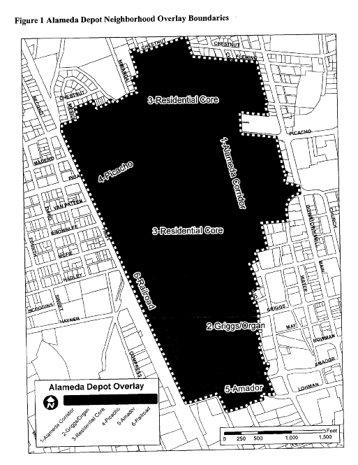
D.
Definitions. Definitions are in addition to those noted in sections 38-20, 38-21 of the LCMC:
Accessory dwelling unit: A self-contained living quarter containing independent kitchen (cooking/culinary) facilities attached to and under the same roof as the main dwelling, created by: The conversion of an existing single-family dwelling; or the addition to an existing single-family dwelling; or the incorporation of applicable areas into a new single-family dwelling design which is subsequently constructed. (also see section 38-53 of the 2001 Zoning Code as amended).
Accessory use or structure: A subordinate use or structure, the use of which is incidental to and customarily found in connection with the principal dwelling on the same property. Examples: Gazebo, greenhouse, tool shed, detached garage, guest dwelling, swimming pool, tennis court, barn, and flag pole (also see section 38-53 of the 2001 Zoning Code as amended).
Brew-pub: A brew-pub is a microbrewery which serves food or is combined with a pub. A microbrewery, or craft brewery, is a brewery which produces a limited amount of beer. The maximum amount of beer a brewery can produce and still be classed as a microbrewery in New Mexico is less than or equal to 200,000 barrels a year, according to the New Mexico Alcohol and Gaming Division.
Central business district (CBD): All properties with zoning designation of CBD according to the 2001 Zoning Code as amended.
Compatible: Capable of existing together in harmony. Parts of a whole that work well together when pieced together.
Consistent: That which is similar to, or nearly the same.
Contributing property: A property, structure or object that adds to the historical integrity or architectural qualities that make the historic area significant. In general, a contributing property is key to a historic district's historic associations, historic architectural qualities, or archaeological qualities. (A list of contributing properties in the Alameda Depot Neighborhood Overlay is available from the community development department.)
Demolition: An act that destroys or removes in whole or in part of the exterior of a building or structure on a property.
Dwelling, above ground floor: Dwelling unit(s) located above ground floor office or commercial uses.
Facade: Any exterior wall of a structure.
Guest dwelling: A detached or attached dwelling to be used for temporary occupancy only and is not to be rented or leased. A guest dwelling shall be no more than 50 percent of the main dwelling's heated/cooled square footage and shall not contain a kitchen (also see section 38-53 of the 2001 Zoning Code as amended).
Historic: Structures/buildings deemed historic are those listed as contributing on the federal and/or state historic registers.
Historic district: Area in which historic buildings and their settings are protected by public review. Historic districts comprise the city's significant historic and architectural resources. Inclusion in a historic district signifies that a property contributes to an ensemble that is worth protecting by virtue of its historic importance or architectural quality.
Infill: An area within the core of the city where land use and development policies specify provisions with incentives for development of vacant parcels. The boundaries are Interstate 25, the north boundary of the University Avenue Corridor Overlay District, Valley Drive, Hoagland Road, North Alameda Boulevard, Three Crosses and North Main Street.
LCMC: Most current edition of the Las Cruces Municipal Code.
Live/work unit: A building that may be used flexibly for living and working in the same building. A variety of uses in the buildings is encouraged. Dwelling units may be located above the ground floor, attached to the rear of a shop front, or detached and located in the rear or side yard. Work is of a commercial nature subject to business registration requirements and not a home occupation.
Manufactured home: A manufactured or modular home that is a single-family dwelling with a heated area of at least 36 feet by 24 feet and at least 864 square feet and constructed in a factory to the standards of the United States Department of Housing and Urban Development, the National Manufactured Housing Construction and Safety Standards Act of 1974 and the Housing and Urban Development Zone Code 2 or the Uniform Building Code, as amended to the date of the unit's construction, and installed consistent with the Manufactured Housing Act and with the regulations made pursuant to that Act. (article VI, section 38-57 of the 2001 Zoning Code as amended).
Mixed-use: For the purposes of this overlay, the term refers to the practice of allowing more than one type of land use category (i.e., residential, office or commercial, etc.) in a single building or set of buildings located on a single parcel. Condominium maps created and filed showing distinct sub-lots on an otherwise single parcel shall be considered as a single parcel for purposes herein stated.
Mobile home: A moveable or portable housing structure larger than 40 feet in body length, eight feet in width or 11 feet in overall height, designed for and occupied by no more than one family for living and sleeping purposes, but does not include structures built to the standards of any municipal building code and other technical codes. (article VI, section 38-57 of the 2001 Zoning Code as amended).
National Historic District: An area that the U.S. Government designates as historically important through the U.S. Department of Interior, under the auspices of the National Park Service. Federally designated historic districts are listed on the National Register of Historic Places. The Alameda Depot Neighborhood Overlay contains a National Historic District.
Outdoor plaza or space: A generally open area that may be used for active or passive purposes by one or more businesses and the public visiting the location. An example may include an outdoor seating area for a cafe or restaurant, outdoor sales and service, a landscaped plaza serving as open space for patrons and visitors alike, etc.
Overlay and special zoning district: Synonymous terms used to define boundaries around an area that has a set of unique or unusual characteristics. Overlays and special zoning districts have a special purpose as defined in an accompanying plan, and may alter general residential, office, commercial or industrial zoning districts or replace them entirely.
Performing arts center: A multi-use performance facility that is intended for use by various types of the performing arts, including dance, music and theatre.
Secondary residence: A dwelling unit that is subordinate in size and location to the main dwelling on a single property, and may be rented or leased as an independent dwelling unit. A secondary residence is different from a guest dwelling or accessory structure in that it is distinct dwelling unit containing a kitchen. Examples include a traditional guest house, apartment, cottage or converted garage.
State historic district: An area that is designated by the state as historically important and which follows criteria similar to the federal standards. State listings can have similar benefits to federal designation, such as qualification for grants and tax incentives. Designation of a district is through a review process at the state historic preservation office. New Mexico's Register of Historic Places lists districts and individual properties. The Alameda Depot Neighborhood Overlay contains a state historic district.
Step-back: In buildings with multiple stories, a reduction in the footprint of each level located successively farther from the ground. Step-backs prevent a "canyon effect," which deprives neighboring properties of sun light, and ensure that streets and yards are provided adequate light and air. In addition, they create articulation and a sense of vertical rhythm in the architecture. The space created by a step-back may be used for terraces, gardens, outdoor seating, etc.
Structure: That which is built or constructed, an edifice or building of any kind, or any place of work artificially built up or composed of parts joined together in some definite manner.
Traditional guest house: A type of secondary residence with kitchen facilities found in the Alameda Depot neighborhood as a result of adaptive reuse of existing structures on the same parcel as the primary dwelling. Historically, these units were converted from nonresidential uses, such as a coach house.
E.
Permitted uses. Permitted, conditional and special uses shall be established for each zone in this overlay district. Land uses in ADO-1, the Alameda Corridor; ADO-2, the Griggs/Organ Corridor; ADO-4, the Picacho Corridor; ADO-5, Amador Corridor; and ADO-6, the Railroad Corridor shall follow the Land Use Tables in section E.2 below. Uses in ADO-3, the North and South Residential Cores, shall be in accordance with the underlying zoning in place at the time of the adoption of this overlay (see Figure 2 above) and are listed in the Land Use Table in E.3 below.
1.
Land use definitions. Unless otherwise stated, land uses are as follows:
a)
Residential: Low and medium density residential uses in the Alameda Depot Neighborhood Overlay are intended to accommodate single-family site built/manufactured dwelling units, including patio homes and townhouses, and multifamily dwellings up to 20 per acre, with no more than four attached units each.
b)
Low-intensity office: These office uses are small-scale, and provide low-intensity service activities. No goods or merchandise are prepared or sold on the premises with the exception of those activities that serve the primary use. Access to streets that are a major local or higher designation is recommended.
c)
Low-intensity commercial: Low-intensity commercial uses are those that generate small-scale retail and service activities within a neighborhood area.
d)
Medium-intensity commercial: Medium-intensity commercial areas facilitate and encourage development of those uses which provide retail and service activities as a convenience to the general public.
e)
Public/institutional: These are uses dedicated to public or nonprofit service, such as schools, religious institutions, government and quasi-governmental agencies, libraries, etc.
f)
Low-intensity industrial: Low-intensity industrial uses are those that accommodate a wide variety of light manufacturing, commercial, processing, storage, packaging, compounding, wholesaling and distribution operations. Such uses shall be constructed and operated to ensure that there is: 1) no activity producing noise, glare or heat observable or measurable outside the building; 2) no emission of objectionable dust, fumes, odors, vapors, gases, smoke or other forms of air pollution; 3) no vibration which is discernible beyond the property lines to the human sense of feeling for three minutes or more duration in any one hour of a day.
2.
Land uses in ADO-1, the Alameda Corridor; ADO-2, the Griggs/Organ Corridor; ADO-3, the North and South Residential Cores; ADO-4, the Picacho Corridor; ADO-5, Amador Corridor; and ADO-6, the Railroad Corridor.
3.
Land uses in ADO 3. Land uses in ADO-3, the North and South Residential Cores, follow the underlying zoning designations existing as of the date of adoption of the ordinance from which this section derives, and may be found in sections 38-31—38-33 of the 2001 Zoning Code as amended, with the following modifications:
a)
Low-intensity office and commercial uses in predominantly residential areas are conditional and must include a residential component, for example, home occupation or live-work units as described in section 38-52 of the 2001 Zoning Code as amended.
b)
Secondary residences, as defined in section D above, are an allowed use in the residential cores.
c)
Industrial uses are not allowed in the residential cores.
F.
Development standards. There shall be no development or alteration of the lands, uses, or structures within the overlay zone district except as provided for by this section of the 2001 City Zoning Code from the date of its enactment and other sections of the City Zoning Code and other city codes and ordinances where applicable. Development requirements and permitted uses shall be established for the entire overlay zone district, as follows (unless otherwise indicated):
G.
Property alteration, remodel or renovation.
1.
Purpose. Property alterations, remodels or renovation standards are established for this district to maintain consistent quality for all development and may be used for the purpose of adaptive re-use of the structure. For the purposes of this section, exterior remodel, renovation, or alteration shall be defined as: Any change or rearrangement in the supporting members of an existing building, such as bearing walls, columns, beams, girders, as well as any change in roof lines, or any enlargement to or diminution of a building or structure, whether horizontally or vertically. Normal maintenance activities as verified by the city's building official or designee are exempt from this provision.
2.
Minor modifications. In most cases, expansion and/or modifications to a property must comply with the development standards of the Alameda Depot Neighborhood Overlay. However, if, through the determination of the Community Development Director or designee, said compliance would substantially create an undue burden to the property owner or create a condition whereby the expansion and compliance measure, partially applied, would be substantially out of character with the existing development, an exception may be made. In no case shall a minor modification/expansion:
a.
Equal or exceed a cumulative total of 15 percent of the gross floor area; or
b.
Equal or exceed a cumulative total of $25,000.00 in valuation; or
c.
Impact parking or landscape requirements.
3.
Any proposal meeting one or more of the above criteria shall not be considered as a minor addition and/or modification, and shall, therefore, be subject to normal review and consideration afforded development in the overlay and may be subject to nonconforming provisions that follow. The applicant must provide estimates for the cost of labor as a means of ensuring compliance with the valuation criteria. Once permission to proceed has been granted by the Community Development Director or designee, the applicant may apply for the permit. Work shall not commence until permit approval is granted. All other nonconforming use requirements are subject to sections 38-70 through 38-76 of the 2001 Zoning Code as amended.
H.
Nonconforming uses, structures, and property. Nonconforming uses, structures and property that legally existed at the time of adoption of this overlay shall be considered legal nonconforming, and shall comply with the nonconforming use provisions found below.
1.
Land uses that were legally in place at the time of adoption of this overlay and remain legal uses may continue to the extent the subject regulations allowed, but shall be required to come into compliance with current overlay standards when the following provisions take place:
a)
The property remains vacant for a period of one continuous year or greater; or
b)
Land use. A change in use occurs on the property which results in the alteration of the use intensity, e.g., low volume retail to high volume retail; use orientation, e.g., service to retail; or density, e.g., eight dwelling units to 15 dwelling units; or change in occupancy type from the building code perspective; or
c)
Right-of-way or lighting. When nonconforming features regarding access from the right-of-way or lighting are involved, these features shall be brought into compliance with current standards when any one-time or cumulative increase of 15 percent or greater to the gross square footage of building area occurs; or
d)
Signage, landscaping, walls or parking. When nonconforming features regarding signage, landscaping, walls or parking are involved, these features shall be brought into compliance with current standards when any one-time or cumulative increase of 25 percent or greater to the gross square footage of building area occurs; or
e)
Development standards. Any noncompliant issues pertaining to setbacks, number of attached units and/or maximum density of existing development shall be brought into compliance with overlay standards to the extent possible. A nonconforming certificate may be issued based on appropriate documentation. Determination of the extent of compliance shall rest with the Community Development Director or designee. Compliance with these matters shall not be triggered when a certificate has been issued as appropriate.
2.
Legal uses that existed prior to ordinance adoption (2010), that become a prohibited use with adoption may be allowed to continue to exist and may expand or enlarge (either one-time or cumulative increase) not more than 50 percent in gross square footage of lot or building area, provided that:
a)
The property has not remained vacant for a period of one continuous year or greater; or
b)
A change in use has not occurred on the property which results in the alteration of the use intensity, e.g., low volume retail to high volume retail; or use orientation e.g., service to retail.
3.
Exceptions. Regarding any of the above, any one-time or cumulative increase of less than 15 percent to the gross square footage of building area may take place without requiring compliance to any nonconforming element associated with the property. Exceptions to this provision include those matters the city requires compliance on for purposes of meeting health, safety and welfare concerns.
I.
Flexible development standards. Community development staff shall review applications for flexible development standards based on requirements cited in section 38-56 of the 2001 Zoning Code as amended.
J.
Parking requirements.
K.
Landscape requirements. The abundance of mature shade trees in the Alameda Depot neighborhood contributes to the distinct character of the area. Landscape requirements are intended to protect this verdant landscape through the careful selection of plants and the implementation of water conservation principals. Community development department staff shall review landscape plans for adherence to the landscape requirements. Landscaping shall follow section 32-266 of the LCMC, "Development standards for landscaping," with the following exceptions and specifications:
1.
Applicability: Landscaping standards apply to all new development and redevelopment in the ADO with the exception of properties that are occupied by single-family residences and duplexes. Where conflict in regulation exists, the provisions of this section shall supersede other landscaping requirements within the Municipal Code.
2.
Areas to be landscaped: The required area to be landscaped is equal to a minimum of 25 percent of the entire parcel area, excluding the main building area. Landscape consists of native or drought-tolerant species of both overstory (shade and coniferous trees) and understory plantings (ornamental trees, shrubs, cacti and perennial grasses, groundcovers and flowers).
3.
Landscape shall be defined as:
a)
A minimum of one two-inch caliper tree, 15 five-gallon shrubs and either five one-gallon shrubs or 50 square feet of groundcover plants shall be installed per each 500 square feet of provided landscape area.
b)
All plant materials shall be species native to the Chihuahuan Desert or adapted to our climate and to the location of the Alameda Depot neighborhood in the valley. This is not to say that the landscape plan needs to adhere to "zero-scaping." Rather, plants should be chosen that will survive and thrive in the local climate. Appropriate species include, but are not limited to, those in the following table. It is recommended that the applicant consult with a professional landscape architect or the Dona Ana County Master Gardeners regarding appropriate plant selection.
c)
All landscape planting should serve to enhance the architectural value of the building, ground the building in the site, create a pleasant and attractive environment for pedestrians, and mitigate environmental conditions such as excess heat, strong winds and air pollution.
d)
Trees shall include shade producing trees which achieve a mature size of at least 25 feet high and 25 feet spread and ornamental trees which have particular features such as spring blooms, fall foliage color or bark characteristics.
e)
Shrubs shall include a mix of deciduous and evergreen plants.
f)
Groundcovers shall serve to prevent soil erosion, provide color, and create an oasis feeling.
4.
Installation. The irrigation system and landscaping shall be installed before the completion of building construction and prior to the issuance of a certificate of occupancy unless a written agreement has been made with the city. Such agreements extending the time of installation will be for a maximum period of nine months, and shall be subject to temporary certificate of occupancy provisions and fees.
5.
Planting for parking lots. All new construction and adaptive reuse of properties shall require planted parking areas. Landscaping in parking areas shall follow section 32-266 of the LCMC, "Development standards for landscaping," with the following exceptions or specifications:
a)
One tree shall be planted for every five parking spaces within parking lots as they pertain to the uses listed for each area.
b)
Trees may be located between the parking lot and the building, or within the parking lot itself. In the event that the landscaped area is between the building and the lot, the area shall be no less than eight feet in width.
c)
In the event that the parking area is compliant with development standards above and remains adjacent to public right-of-way, there shall be a landscape buffer no less than eight feet wide between the building and the sidewalk or street. The buffer strip shall consist of shade trees and low shrubs or perennial flowers, which may count toward the landscape requirement specified above.
d)
Trees in parking lots shall be located in an island or planter in which the tree trunks, at mature size, shall be protected from motor vehicles. Islands and planters shall be a minimum of six feet wide, have a minimum area of 36 square feet and a raised border of at least four inches in height.
6.
Property owners wishing to install landscaping in city right-of-way (for example, parkways or medians) shall first complete a maintenance and liability agreement with the city's public works department, with the understanding that liability and maintenance shall be property owner's responsibility.
7.
In the event that a tree in city right-of-way must be removed in order to maintain or replace sidewalks, the regulations found in the Municipal Code chapter 26, article II, division 2 Repair and Replacement of Sidewalks, shall be followed.
L.
Walls and fences.
1.
Existing fences within the district shall remain in place so long as they conform to the standards stated herein. Increases in structure height, length or configuration shall require full compliance with fencing/wall requirements.
2.
Historic structures. On properties with contributing structures listed on the state or National Historic Register, new walls or fencing should complement or be in keeping with the style of the structure to the greatest extent possible demolition, removal or alteration of existing historic fences, walls, retaining walls, and steps is discouraged.
3.
Fences, walls and hedges facing the street shall adhere to clear sight triangle regulations.
4.
Fences, walls and hedges that are within the rear and side yards shall be limited to a height of eight feet.
5.
Retaining walls shall be designed in a manner limiting their height to what is absolutely necessary for the retaining purpose intended.
6.
All other provisions regarding walls and fences not noted herein shall follow those found in section 38-60 of the 2001 Zoning Code, as amended.
M.
Signs. All signage shall be of suitable materials and design so as to be compatible with the architecture of the structure and the residential character of the neighborhood. Sign permit applications shall be submitted for approval to the community development department in accordance with chapter 36 of the LCMC, unless specified below.
1.
Off-premises signs. No off-premises signs shall be allowed in the ADO except for the following:
a)
Political signs shall follow regulations stated in chapter 36-86 of the LCMC (Sign Code).
b)
Off-premises sign displays regarding community events or holidays may be permitted, if approved by the city manager or designee.
2.
On-premises freestanding signs.
a)
Ground signs shall be the only freestanding sign allowed within the ADO, and shall be no greater than 24 square feet in size and four feet in height. One sign per lot shall be permitted.
b)
On-premises freestanding signs are not permitted on parcels used for residential purposes, except for a development identification sign.
c)
Ground signs may be illuminated, and shall follow regulations stated in chapter 39 of the LCMC (Outdoor Lighting).
d)
Properties developed as business centers shall conform to the following:
i.
One ground sign identifying the name of the center is permitted, and shall be no greater than 24 square feet in size and four feet in height.
ii.
A property containing a business center sign may not have additional freestanding signs, except for temporary signage, which shall follow chapter 36 of the LCMC.
e)
Ground signs shall be placed at least five feet from the outside edge of the right-of-way, and at least five feet from adjacent property lines and not within the clear sight triangle as defined by the City of Las Cruces Design Standards. See section 32-405.
f)
Freestanding multi-use development directory signs are not permitted.
3.
On-premises attached signs.
a)
Wall signs:
i.
One square foot of signage for each linear foot of exterior wall space, not to exceed 50 square feet per wall.
ii.
The sign(s) shall be placed on the side of the building used to calculate the square footage of the sign.
iii.
Window and projecting signage shall be considered types of wall signs.
b)
Multi-use development directory sign: Exterior directory signs, with the name and location of all businesses within a multi-use development, may be wall-mounted as specified above.
c)
Home-occupation or live-work uses in residential areas shall be allowed one non-illuminated attached sign no greater than four square feet in size. Freestanding signs shall not be permitted for home-occupation or live-work uses.
d)
Projecting signage:
i.
Projecting signs shall be considered double-faced signs with each sign face of equal size. Only one side shall be used to determine the square footage.
ii.
Projecting signs shall not exceed six square feet in sign face area.
iii.
Only one projecting sign shall be allowed per business per street frontage.
iv.
Only ground floor commercial businesses shall be permitted to utilize projecting signs.
v.
Projecting signs must clear walkable areas by at least eight feet as measured from the bottom of the sign to grade and may project no more than four feet from the building or closer than two feet to the sidewalk, whichever is less.
vi.
Projecting signs shall be installed at right angles to a building front.
e)
Window signs:
i.
There shall be no more than one permanent window sign per window.
ii.
Neon signs displayed indoors constitute permanent window signs. Only one neon sign shall be permitted per business facade.
iii.
The total coverage of all permanent, neon and temporary window signs shall not exceed 25 percent of the total glass area of the window.
4.
Prohibited signs: The following signs are prohibited in the Alameda Depot Neighborhood Overlay:
a)
Variable electronic message display boards, whether temporary or permanent.
b)
Portable and pole signs, whether temporary or permanent.
c)
Permanent banners.
d)
Pennants, streamers, and other fluttering devices, whether temporary or permanent.
e)
Real estate, construction, contractor and "coming soon" signs over 12 square feet in area or over five feet tall.
f)
Billboards.
g)
All other signs as prohibited in section H of the Las Cruces Sign Code.
5.
Temporary signs: Temporary signs shall follow provisions found in the Las Cruces Sign Code, chapter 36 of the LCMC.
N.
Demolition. To preserve any contributing structure listed on the historic register (state or national) in the Alameda Depot Neighborhood Overlay, this section creates a 60-day demolition permit review process that allows time for interested parties to explore alternatives to the demolition of historic structures. Demolition for all other structures shall follow sections 30-491 and 38-63 of the LCMC.
1.
Demolition permit. Demolition permit applications shall be submitted to the community development department prior to any demolition activity taking place. Community development department staff will review the application for compliance with the LCMC. A proposal for redevelopment of the property must accompany the permit application.
2.
Posting. At the beginning of the 60-day demolition permit review process, the community development department will issue a sign that is to be posted in a conspicuous place on the property. The applicant is responsible for posting the sign and ensuring that it is in place for the entire 60-day period.
3.
At the beginning of the 60-day demolition permit review process, the community development department will inform the neighborhood associations, the New Mexico State Historic Preservation Office (SHPO) and the Dona Ana Historical Society that a demolition permit has been applied for.
4.
A demolition permit shall be issued upon the completion of the following items: 1) the completion of the 60-day period; and 2) the application meets all City Code requirements and has been approved by the community development department staff. (The applicant may use the 60-day time period to resolve any necessary Code compliance comments.) The permit application may be withdrawn by the applicant at anytime without charge.
5.
Prior to the demolition of a historic structure, the applicant shall be responsible for fully documenting the structure, both interior and exterior, to provide a permanent record, in accordance with documentation procedures as follows. The demolition permit will not be approved without submittal and approval of this documentation by community development staff.
a)
Complete the Historic Cultural Property Inventory (HCPI) forms 1 and 2, available in the community development department and online at:
http://www.nmhistoricpreservation.org/documents.php?recordnum=10b)
Photograph the historic property: Take several exterior photos of the structure to be demolished (front, rear, sides, close-up views, details, setting, etc.). Photo processing, printing and labeling shall follow the protocol established on the National Register Photo Policy Fact Sheet, available in the community development department and online at: http://www.nps.gov/history/nr/publications/guidance/Photo_Policy_final.pdf
c)
If measured drawings done by the Historic American Building Survey exist, the owner should annotate the drawings, showing changes to the property, interior and exterior, that have occurred up to the current date.
d)
If known, a short history of the property should be included, in order to document how that property fits within the historic district or community.
e)
The demolition permit will not be approved without submittal and approval of this documentation by community development staff.
6.
Compliance with the procedure set out in this section is not required if it is determined by the City of Las Cruces that the immediate demolition of a historic structure is in the best interest of public health, safety and welfare. The applicant shall be responsible for documenting the structure in accordance with the procedure above to fully demonstrate the need for demolition and to provide a historic record of the structure. In the event that entering the structure would pose a threat to the health, safety and welfare of the documenter, interior photos are not required. This documentation must accompany the memo of determination for demolition by the building official prior to the issuance of a demolition permit.
O.
Land use/zone change requests. It is possible to request an additional land use not already noted within the permitted use lists on a specific parcel within the Alameda Depot Neighborhood Overlay. Each request for an additional land use must be consistent with the Alameda Depot Neighborhood Plan and will be considered on a case-by-case basis. These requests will be processed per section 38-10 of the 2001 Zoning Code as amended.
P.
Submittal and review process. The following submittal and review procedures are established for all new development to protect persons and property in the Alameda Depot Neighborhood Overlay. The applicant shall submit at minimum, one copy of all application materials to the community development department for review. Upon submittal, staff shall review the submittal for completeness. If all the required items have been submitted, the community development department shall issue a receipt for submittal.
1.
Buildings/structures. Prior to the filing of an application for development and/or signs, a pre-application conference with community development department staff to review the proposal is strongly encouraged.
2.
Subdivisions. For submittal and review of subdivisions within the district, refer to article V, chapter 37 of the LCMC pertaining to infill subdivision procedure. The Planning and Zoning Commission has approval authority.
3.
Signs. Sign permit applications shall be submitted for approval to the community development department in accordance with chapter 36 of the LCMC and subsection "G" above.
4.
Variances. A variance shall be defined as a variation in the numerical requirements of the 2001 Zoning Code as amended or the sign code. Numerical variances to the clear sight triangle requirements shall be considered, reviewed, denied or approved by the public works director or designee, as per article III of chapter 26 of the LCMC.
Q.
Appeals. Any aggrieved person who is affected by a decision of an administrative official, commission, committee, or board in the enforcement of the Alameda Depot Neighborhood Overlay may appeal such decision in accordance with section 38-10 of the Zoning Code as amended.
R.
Enforcement of overlay zone district. Provisions to enforce this section shall be consistent with the enforcement provisions of article II of the 2001 Zoning Code as amended.
(Ord. No. 2597, § I(exh. A), 12-6-10; Ord. No. 2775, § I(Exh. A), 2-16-16)