
Leesburg City Zoning Code
ARTICLE VII
- TECHNICAL STANDARDS
DIVISION 3.1.- RESERVED[11]
Editor's note— Ord. No. 07-17, § II, adopted Feb. 12, 2007, repealed the former Div. 3.1, § 25-501, and enacted a new § 22-7 as set out in this Code. The former Div. 3.1 pertained to natural gas pipeline installation and derived from Ord. No. 06-32, § 1, 4-24-06.
Sec. 25-441.- Definitions.
The following words, terms and phrases, when used in this article, shall have the meanings ascribed to them in this section, except where the context clearly indicates a different meaning:
Plat, when used as a noun, shall mean a map depicting the division or subdivision of lands into lots, blocks, parcels, tracts or other portions thereof, however designated.
Subdivision shall include:
(1)
All divisions of real property into three (3) or more lots, blocks, parcels, tracts or other portions for the purpose of recording a plat thereof in the public records of the county;
(2)
Any division of land involving the assignment of lots to meet LDC. Where the entire tract being subdivided is to remain under one (1) ownership, the subdivision plat thereof need not be recorded in the public records of the county, but shall be made a part of the municipal records of the city and the subdivision and its plat shall conform to the requirements prescribed by this article and the adopted technical and construction standards of the city;
(3)
Any divisions of land involving the dedication of a new street or other public way or a change in existing streets, or alleys, providing, however, that public acquisition of land for streets or highway purposes shall not be deemed a subdivision.
(Ord. No. 04-27, § V(7.1), 5-10-04)
Sec. 25-442. - Declaration of purpose.
The procedures and standards for the development and subdivision of real estate and for the surveying and platting thereof, adopted and prescribed by this division are hereby found by the city commission of the city to be necessary and appropriate in order to provide for economical and sufficient streets with adequate widths and with proper alignment and grades designed to promote the public safety, health and general welfare, to provide for suitable residential neighborhoods with adequate streets and utilities and appropriate building sites, to save unnecessary expenditures of public funds by initial proper construction of streets and utilities, and to provide proper land records for the convenience of the public and for better identification and permanent location of real estate boundaries.
(Ord. No. 04-27, § V(7.2), 5-10-04)
Sec. 25-443. - Approval of subdivision plat.
(a)
Approval by city required. No subdivision of lands as defined in this division, within the city shall be made without the prior approval of a plat therefore by the city, and no such plat shall be considered finally approved until such plat has been recorded in the public records of the county, and dedication of public streets, parks and places have been accepted by the city. Approval of a subdivision plat shall be subject to its being in compliance with the provisions of this article.
(b)
Procedure for planning and zoning approval.
(1)
Plan to planning and zoning manager and planning commission. The subdivider shall present to the manager a preliminary plan which shall be prepared according to section 25-475. The manager shall schedule the preliminary plan for review of the planning commission at their earliest possible meeting and shall notify the subdivider of the time at which the plan will be considered by the planning and commission.
(2)
Approval of plan. The planning commission shall examine the plan and shall approve or disapprove the plan within forty-five (45) days from the time at which the plan was presented to the manager.
(3)
Appeal. The subdivider shall have the right of appeal to the city commission on any decision of the planning and zoning commission.
(4)
Plat to city commission. When the plan for a subdivision has been approved by the planning commission, a plat of the subdivision which has been prepared according to LDC shall be presented to the city commission for approval.
(5)
Certifications on taxes and liens. When presented to the city commission for consideration, a plat of a subdivision shall be accompanied by a certification by the appropriate official that there are not taxes on the property included in the subdivision which are delinquent. There shall also be a title opinion or certification that the subdivider has apparent record title to the land in accordance with Chapter 177.041, Florida Statutes. Should there be a mortgage or lien on the property, the subdividers shall furnish the city commission with a proper release of the streets, parks and public places from the mortgagee or lien holder, which release shall have been recorded in the public records of the county. In lieu of such release, the mortgagee or lien holder shall have executed with witnesses a joinder and consent on the plat, subscribed to before a notary public, to the dedication of the streets, parks and public places.
(Ord. No. 04-27, § V(7.3), 5-10-04)
Sec. 25-444. - Exemption of subdivision plat review.
This division shall not apply to any lot forming a part of a subdivision created and recorded prior to the effective date of this Code. Nor is it intended by this division to repeal, abrogate, annual or in any way impair or interfere with existing provisions of other laws or ordinances, except those specifically repealed by this division, or with private restrictions placed upon property by deed covenants running with the land. Where this division imposes a greater restriction upon land than is imposed or required by such existing provisions of law, ordinance, contract or deed, the provisions of this division shall control. The following types of land divisions shall be exempted from full subdivision plan review; provided, however, that any owner or the owner's authorized agent who desires to alter the dimensions, land area or boundaries of any lot, parcel or tract for the purpose of sale, lease or other transfer of interest shall first provide such plans and information to the planning and zoning division in order to assure compliance with all applicable requirements of this chapter.
(1)
Minor subdivision.
a.
This section is provided for the purpose of defining and describing an exception to the requirement to plat. When land is subdivided in such a manner that all parcels resulting from said subdivision have frontage for access along an existing paved public road, maintained by the city, county or the state, without passing over lands owned or controlled by others and, further, provided the subdivision requires no new public infracture improvements such as water, sewer, stormwater, or gas, and no new roads either public or private; it is exempt from the platting requirements and is called a minor subdivision.
b.
In order to qualify for the exemption through this minor subdivision provision, the following conditions shall apply:
c.
A completed application with surveyor's checklist for approval of the minor subdivision and exemptions to the platting requirement shall be required.
d.
Ten (10) copies showing the original parcel of land and subsequent minor subdivision of land shall be prepared by a professional land surveyor and shall include the following information:
1.
Existing legal description, boundary survey and dimensions of the lot(s) to be subdivided.
2.
Legal descriptions, boundary survey and dimensions of the created parcels (lots).
3.
A statement whether utilities such as water and/or sanitary sewer service are available to the property.
a.
All parcels so created shall meet the minimum lot frontage, area and dimensional requirements for the land use/zoning district in which they are located; however, in no case shall lots have a minimum lot width of less than fifty (50) feet.
b.
A minor subdivision shall not result in an increase in density beyond that allowed by the Leesburg Comprehensive Plan or this chapter.
c.
A minor subdivision shall comply with all other provisions of this chapter.
d.
If the proposed minor plat meets the conditions of this section and otherwise complies with all applicable laws and ordinances, the planning and zoning manager shall approve the minor plat by signing the application form.
e.
After approval by the development review committee, the applicant shall, within thirty (30) days of receipt of the signed plat, submit the approved plat to the circuit court clerk. The planning and zoning division shall be furnished with the original and two (2) blueprints of the plat of record at the time that it is presented for acceptance by the city and after the plat has been recorded in the public records of the county, the city shall be furnished one (1) stable base film reproducible copy of the plat. Such copy shall be complete including all required signatures and the plat book and page numbers of the county record in which it was entered.
(2)
Restrictions.
a.
No further division of an approved minor plat is permitted under this section, unless submitted in accordance with this section.
b.
A minor subdivision shall contain no more than twelve (12) lots.
(Ord. No. 04-27, § V(7.4), 5-10-04)
Sec. 25-445. - Preliminary plan conference.
Each subdivider of land should confer with the planning and zoning manager before preparing a preliminary subdivision plan in order to become thoroughly familiar with the subdivision requirements and with the proposals of the city plan, affecting the territory in which the proposed subdivision lies.
(Ord. No. 04-27, § V(7.5), 5-10-04)
Sec. 25-446. - Form and contents.
(a)
The preliminary plan shall be submitted to the planning commission for approval. This plan shall be accurately and legibly drawn and shall be at a scale of not less than one (1) inch equals one hundred (100) feet.
(b)
The preliminary plan shall contain the following information:
(1)
Description:
a.
Proposed name of the subdivision. The name shall not duplicate, be the same in spelling or alike in pronunciation with any other recorded subdivision in the city;
b.
Names of adjacent subdivisions and owners of adjoining parcels of unsubdivided land;
c.
Names and addresses of the subdivider, owner, land surveyor and engineer;
d.
Legal description of the property to be subdivided.
(c)
Existing conditions.
(1)
Boundaries of the subdivision indicated by a heavy line and the approximate acreage;
(2)
Location, widths, and names of existing or platted streets, railroad right-of-way, easements, parks, permanent buildings, section and corporate lines within the area of the subdivision;
(3)
Names and location of streets in the adjoining areas and within one hundred fifty (150) feet of the property;
(4)
Zoning districts, if any.
(d)
Engineering data.
(1)
Existing contours on and within fifty (50) feet of the property, with intervals of not more than one (1) foot and outline and elevations of areas to be filled or excavated. Elevations are to be based on mean sea level N.G.V.D. (formerly U.S.C. & G.S. datum);
(2)
Drainage courses, wooded areas, power transmission poles and lines, and any other significant items should be shown;
(3)
The design profiles of all streets showing natural and finished grades drawn to scale of not less than one (1) inch equals fifty (50) feet horizontal and one (1) inch equals four (4) feet vertical, together with a typical cross-section of the proposed finished streets;
(4)
Date of preparation, scale of map, north point.
(e)
Proposals. Location and principal dimensions for all proposed streets, alleys, easements, lot lines, and areas to be reserved for public use.
(f)
Other information:
(1)
Proposed covenants and restrictions;
(2)
Source of water supply;
(3)
Provisions for sewage disposal, drainage and flood control;
(4)
If any zoning changes are contemplated, the proposed zoning plan for the areas, including their legal descriptions.
(Ord. No. 04-27, § V(7.6), 5-10-04)
Sec. 25-447. - Approval of plans for improvements required.
No clearing, grading, excavating, filling or other improvements shall be made in any subdivision or upon any lot or parcel of property in the city which will alter the physical characteristics thereof so as to affect its topography, its drainage or that of abutting property, or its use, unless a preliminary plan therefore has been reviewed and approved by the city manager, or his designated representative, for the purpose of ascertaining compliance with this chapter. Approval of such preliminary plan shall be limited to allow only preliminary clearing, grading, excavating and/or filling until detailed plans for all improvements intended for the property have been approved by the city manager or his designated representative, the city planning and zoning commission and/or the city commission, as required by this chapter.
(Ord. No. 04-27, § V(7.7), 5-10-04)
Sec. 25-448. - Streets.
(a)
Relation to adjoining street system. The arrangement of streets in new subdivisions shall make provision for the continuation of the principal existing streets in adjoining areas, or their proper projection where adjoining land is not subdivided, insofar as they may be deemed necessary by the city for public requirements. The width of such streets in new subdivisions shall be not less than the minimum widths established in this section. The street and alley arrangement shall be such as not to cause a hardship to owners of adjoining property when they plat their land and seek to provide for convenient access to it. Streets obviously in alignment with existing streets shall have the names of the existing streets. The names of new streets shall be determined in accordance with section 18-83.
(b)
Width. The minimum width of streets shall be fifty (50) feet; provided, that a subdivision plan may be required to provide for only half of this width, if the location of a proposed street of the subdivision is along a boundary of the subdivision, is not necessary as a street for access to the subdivision and is so located with reference to adjacent unsubdivided property and alignment with other existing, proposed or planned streets that it would be logical that the remaining half of the street should be provided by the adjacent property when such property might be subdivided. Street widths smaller or greater than fifty (50) feet may be required by the city, if it is determined that such widths are in the best interest of the general public and the surrounding area. In the case of smaller widths, the use of alleys will be considered.
(c)
Grades. Grades on all streets and roads shall not exceed seven (7) percent nor be less than five-tenths of one (1) percent.
(d)
Horizontal curves. Where deflection angle of more than ten (10) degrees in the alignment of a street occurs, a curve of reasonably long radius shall be introduced. The center line radius or curvature shall be not less than one hundred (100) feet.
(e)
Vertical curves. All changes in grade of streets shall be connected by vertical curves of minimum length in feet equal to FDOT's Green Book.
(f)
Intersections. Street intersections shall be as nearly at right angles as is possible, and no intersection shall be at an angle of less than sixty (60) degrees.
(g)
Corner radii. There shall be a minimum radius at the property line of twenty (20) feet at all street intersections. The city may require a greater radius at the intersection of any street with an arterial street.
(h)
Dead end streets. In general, streets designed to have one (1) end permanently closed shall be avoided unless it is clear that a through street is not desirable for the street system in the area. Where such streets are used, they shall terminate in a circular area of public right-of-way having a minimum pavement diameter of one hundred twenty (120) feet with required right-of-way.
(i)
Construction. Physical construction of streets and alleys shall conform to the requirements of the adopted technical and construction standards of the city.
(Ord. No. 04-27, § V(7.8), 5-10-04)
Sec. 25-449. - Alleys.
Alleys with a minimum width of fifteen (15) feet shall be provided to the rear of lots to be used for business purposes.
(Ord. No. 04-27, § V(7.9), 5-10-04)
Sec. 25-450. - Utility easements.
Easements of at least seven and one-half (7½) feet in width shall be provided on each side of all rear lot lines and along side lot lines and fifteen (15) along all front lot lines, where necessary, for poles, wires, conduits, storm and sanitary sewers, gas, water or other mains. Easements of greater width may be required along or across lots where necessary for the extension of main sewers or other utilities or where both water and sewer lines are to be located in the same easement.
(Ord. No. 04-27, § V(7.10), 5-10-04)
Sec. 25-451. - Blocks.
(a)
Block width. Blocks, except waterfront blocks, shall be at least wide enough to allow two (2) tiers of lots of minimum depth. Half blocks may be permitted along the boundaries of the subdivision.
(b)
Block length. Blocks, except waterfront blocks, shall not exceed seven hundred (700) feet in length.
(c)
Lot dimension. The size, shape and orientation of lots shall be appropriate for the location of the proposed subdivision and for the type of development contemplated, and shall conform to the following:
(1)
Every lot or parcel of land shall about a public street;
(2)
Insofar as practical, side lot lines shall be at right angles to straight street lines or radial to curved street lines;
(3)
Every lot shall have a minimum mean lot width of fifty (50) feet, except that every corner lot shall have a minimum mean lot width of sixty (60) feet, but the minimum width, when measured along the setback line, shall not be less than fifty (50) feet on interior lots or less than sixty (60) feet on corner lots; but in no case shall the frontage upon a public street be reduced below forty (40) feet;
(4)
Every lot shall have a depth of not less than ninety (90) feet;
(5)
The minimum lot area shall in no case be less than that required by section 25-280 Table 4.2.
(Ord. No. 04-27, § V(7.9), 5-10-04)
Sec. 25-452. - Required minimum improvements.
(a)
Streets. Streets shall be constructed in accordance with this section.
(b)
Drainage:
(1)
Drainage facilities. All necessary facilities, including but not limited to underground pipe, canals, drainage ditches or grassed swales shall be installed to provide adequate disposal of surface water runoff and to preserve and maintain any natural watercourses;
(2)
Storm water control. The plan for storm water control measures to be provided for the land to be subdivided shall include the methods, works, structures, equipment, grades, falls and other necessary specifications from the origin of surface and percolating waters to final disposition. Such provisions shall be sufficient to prevent flooding, health and sanitation hazards and shall not create or increase such hazards on other lands.
(c)
Sanitary sewers. Sanitary sewers will be required when connection to the city sewer system is reasonably available. Where sanitary sewers are installed by developer, these sewers shall conform to requirements of the city, county and state agencies having jurisdiction therefore.
(d)
Water lines. Water lines installed shall comply with all regulations of the city, county and state agencies having jurisdiction therefore, and plans for same shall be approved by the city manager.
(e)
Easements. All easements as contemplated by the plan for development shall be granted for and dedicated to the purpose intended, e.g., utilities, drainage, ingress/egress, etc.
(Ord. No. 04-27, § V(7.9), 5-10-04; Ord. No. 06-32, § 2, 4-24-06; Ord. No. 06-108, § 2, 11-13-06; 07-17, §§ I, II, 2-12-07)
Sec. 25-453. - Guaranteeing improvements.
(a)
Where the required minimum improvements set forth in this section have not been completed prior to the submission of the record plat for approval, the developer of the subdivision shall, as a prerequisite to obtaining city signatures required for recording, file with the city a surety bond, in favor of the city, conditioned to secure the construction of such improvements in a satisfactory manner and within a period not to exceed two (2) years. No surety bond guaranteeing the improvements shall be accepted unless it is enforceable by and payable to the city in a sum at least equal to one hundred twenty-five (125) percent of the cost of constructing the unconstructed improvements as estimated by the design engineer of such improvements, approved by the city manager or his designated representative, and in form with security and conditions approved by the city attorney. In lieu of the surety bond, the developer may file as substitute' security, at his option, a letter of credit or cash, for one hundred ten (110) percent of the cost of the unconstructed improvements.
If at the end of the two-year period the developer has not completed the infrastructure improvements, the developer may file a request not later than ninety (90) days prior to the end of the two (2) years, seeking an extension of time. Only one (1) such request may be made, and if granted the new deadline established in response to the request for extension shall be absolute. The request shall be considered and granted or denied by the city manager or his designated representative, provided that to obtain any extension the developer must meet the following minimum standards:
(1)
Submit a title opinion from an attorney or title insurance company licensed in Florida, with an effective date no more than ten (10) days prior to the request for an extension, demonstrating that no lots within the subdivision have been sold to third party purchasers and that the developer remains the lawful owner of all such lots;
(2)
Demonstrate good cause for the failure to complete the infrastructure improvements within the original two-year period. Good cause may include, but shall not be limited to, the following: shortages of materials or labor required to construct the improvements; weather, labor strife, war, or other such tangible events wholly beyond the control of the developer; or severe general economic conditions (but not including economic or financial problems specific to the developer itself) which rendered the completion of the infrastructure improvements difficult or impossible, or which would make it difficult to market and sell the subdivision lots within a reasonable time if the infrastructure improvements were completed.
(3)
Submit an updated estimate from the design engineer of the cost to construct or complete the infrastructure improvements as of the date of the request, to be approved by the city manager or his designated representative.
(4)
Submit a letter of commitment from a surety or financial institution agreeing to issue the necessary replacement surety bond or letter of credit in the amount of the new cost estimate or such other amount as is specified by the city manager after review of the engineer's cost estimate. If the developer secured its obligations by a cash bond it shall remain in place with such adjustment upward or downward as is required to conform to the new estimate of the cost for the infrastructure improvements.
(5)
The new surety bond or letter of credit, or the appropriate amount of cash, shall be deposited with the city no later than the earlier of thirty (30) days after the city manager approves the extension, or ten (10) days prior to the date on which the original bond or letter of credit would expire by its own terms.
The granting or denial of the request for extension shall be in writing and if the decision is to deny the request, the notice of denial shall set forth the reasons for the denial. If the city manager denies the extension, the developer may appeal that denial to the city commission by filing a notice of appeal with the city manager no later than ten (10) days after the date of the denial notice, and the appeal shall be heard at the next regularly scheduled city commission meeting, provided that no appeal or other event shall extend the time for a final determination on the request past the expiration date of the original surety bond or letter of credit, and if that would be the result of an appeal then the city is authorized hereby to draw on the original bond or letter of credit in accordance with its terms.
(b)
The subdivider shall be responsible for maintenance of the subdivision improvements for a period of two (2) years following their acceptance by the city. A surety bond of fifteen (15) percent or a letter of credit or cash escrow of ten (10) percent of the cost of the subdivision improvements shall be posted with the city before their acceptance by the city to secure the performance of this maintenance.
(c)
Any letter of credit referred to above shall be irrevocable and drawn on a solvent local bank satisfactory to the city.
(Ord. No. 04-27, § V(7.11), 5-10-04; Ord. No. 09-35, § I, 7-27-09)
Sec. 25-471.- Type.
All permanent reference monuments (P.R.M.) and permanent control points (P.C.P.) shall be constructed of metal or concrete in accordance with Sections 177.031(15), and 177.031(13), Florida Statutes, respectively.
(Ord. No. 04-27, § V(7.12), 5-10-04)
Sec. 25-472. - Location.
P.R.M.'s and P.C.P.'s shall be set in accordance with Sections 177.091(7) and 177.091(8), Florida Statutes.
(Ord. No. 04-27, § V(7.13), 5-10-04)
Sec. 25-474.- Installation of electrical distribution system.
(a)
Whenever a real estate owner, promoter or developer, private or corporate, desires to develop a plot or tract of land, an apartment, a condominium, an office, housing units of two (2) or more units or other physical facility either by contracting a building or buildings of two (2) or more units thereon, or by subdividing the realty, within the electrical distribution area of the city, the city will install the electrical distribution system within the subdivision, tract or plot of land, an apartment, a condominium or office or housing units of two (2) or more units only upon the payment by the developer to the city of the total estimated cost of the installation of the electrical distribution system within the tract or plot of land, an apartment, a condominium, a subdivision or office or housing units or two (2) or more units, whether such system be underground or overhead.
(b)
The real estate owner, promoter or developer shall be reimbursed for the installation cost as residences or other buildings are built and occupied and the electricity is permanently turned on for the residences or other buildings solely for a permanent occupant for each unit, who dealt at arms length with the owner, promoter or developer. Reimbursement to the real estate owner, developer or promoter shall not be made until the city shall be assured that the normal flow of electricity to each unit shall be at a rate of kilowatt hours which shall average the approximate flow to similar units occupied for at least one (1) year and then receiving electricity from the city. The rate of reimbursement for each unit shall be determined by dividing the total number of installed meters into the sums paid by the real estate owner, developer or promoter of the city. If one (1) home or building is built in two (2) or more units, then the owner, developer or promoter shall be reimbursed accordingly. A unit is defined as a compartment, office, apartment or house as the case may be.
(c)
The reimbursement will be for the cost of the distribution system for overhead only, with the understanding that the real estate owner, developer or promoter shall pay for the cost difference between underground and overhead service. Reimbursements will be limited to a period of four (4) years following payment of the installation cost of the system by the real estate owner, developer or promoter, to the city, unless that period is extended as permitted under subsection (f) of this section. Furthermore, as to any development or project for which the four-year deadline herein established to claim the reimbursement expires on or before December 31, 2013, such deadline shall be extended automatically for a period of two (2) years after the current deadline, without action by the city commission, provided however that this extension provision shall terminate on January 1, 2014 and shall not be available for any development or project as to which the current four-year deadline expires on or after that date.
(d)
The city will install at its cost service lines and poles from the distribution line to the masthead and will not require contribution from the owner of the home desiring electric services unless such service line, in the sole opinion and discretion of the city, requires more than one (1) electrical pole, in which event the person requesting such service shall pay for the cost of such additional poles and installation thereof.
(e)
In lieu of the payment required by subsection (a) of this section, the city may, at its option, by contract approved by the city commission, allow the developer to post a bond acceptable to the city, either surety or cash, or a letter of credit acceptable to the city, which bond or letter of credit will be conditioned to pay the sums required under subsection (a) of this section less any rebates which would have been made under the terms of this article, and which bond or letter of credit will be payable four (4) years from the date same is given, or at the end of any extension granted under subsection (f) of this section if applicable. Upon the payment thereof, the developer, or surety, as the case may be, will be entitled to the pro rata reimbursement as contemplated by this article. Furthermore, as to any development or project for which the four-year deadline to draw on the bond or letter of credit expires on or before December 31, 2013, such deadline shall be extended automatically for a period of two (2) years after the current deadline, without action by the city commission, contingent on the developer placing with the city an acceptable replacement bond, cash deposit or letter of credit payable on or before two (2) years from the expiration of the deadline to draw on the initial bond or letter of credit, and provided further that this extension provision shall terminate on January 1, 2014 and shall not be available for any development or project as to which the current four-year deadline expires on or after that date.
(f)
Upon petition submitted to the city clerk by the real estate owner. promoter or developer, not later than sixty (60) days prior to the expiration of the four (4) year deadline to draw on the bond, cash deposit, or letter of credit, establishing to the satisfaction of the city commission, in its discretion, that conditions beyond the control of the developer delayed the requirements for reimbursement under this section, the city commission may extend the deadline for up but not more than two (2) additional years, or such shorter time as the city commission deems appropriate. As a condition precedent to the granting of such an extension, the issuer of the bond or letter of credit must either join in or consent to the petition, and agree to extend the bond or letter of credit to the newly established deadline, or the owner, developer or promoter must submit a new bond or letter of credit which would remain in effect throughout the entirety of the extension sought in the petition, or commit to leave the cash deposit in effect for that same period of time.
(Ord. No. 04-27, § V(7.14, 7.15), 5-10-04; Ord. No. 10-49, § I, 6-28-10; Ord. No. 12-25, § I, 3-26-12; Ord. No. 20-33, §§ I—III, 8-10-20)
Sec. 25-476.- Form.
The final plat made for recording shall conform to Section 177.091, Florida Statutes. The overall dimensions of the plat shall be twenty-two (22) inches or twenty-eight (28) inches with a three-inch border on the left end of the long dimension and shall have a one-inch border on the other three (3) sides. The scale shall be not less than one (1) inch equals one hundred (100) feet.
(Ord. No. 04-27, § V(7.16, 7.17), 5-10-04)
Sec. 25-477. - Contents.
(a)
In addition to the requirements of F.S. § 177.091, the following shall also be included on the final plat:
(1)
A form for the endorsement of the planning commission similar to the following:
"It is hereby certified that the Planning Commission of the City of Leesburg, Florida, officially approved the preliminary subdivision plan on the __________ day of __________, 20 __________.
_______
Community Development Director
_______
Secretary"
(2)
A form for the approval of the city commission which shall contain a provision that the approval of the city commission is conditioned upon the plat being filed in the office of the clerk of the circuit court of the county, within ninety (90) days from the date of such approval. The community development director may grant an additional ninety (90) days if requested by the owner or their agent in writing. The form shall be similar and contain substantially the same wording as the following:
"This certifies that this Plat was presented to the City Commission of the City of Leesburg, Lake County, Florida, and approved by the said City Commission for record, and the dedication of the streets and public places accepted for municipal purposes of said City on the __________ day of __________, 20 __________; provided that this plat is recorded in the office of the Clerk of the Circuit Court of Lake County, Florida, within ninety (90) days unless an extension is granted from the date of approval by the said commission.
CITY OF LEESBURG, FLORIDA
By _______
Mayor-Commissioner
Attest:
_______
City Clerk"
(3)
A form for certification as to approval by the commissioners of the county and for the certification by the clerk of the circuit court of the county, that the plat has been recorded in the public records of the county.
(b)
The city shall be furnished with the original and two (2) blueprints of the plat of record at the time that it is presented for approval by the city and after the plat has been recorded in the public records of the county, the city shall be furnished one (1) stable base film reproducible copy of the plat and a electronic copy. Such copy shall be complete including all required signatures and the plat book and page numbers of the county record in which it was entered.
(Ord. No. 04-27, § V(7.18), 5-10-04; Ord. No. 10-40, § I, 5-10-10)
Sec. 25-491.- Installation procedure.
Before any water lines are installed in a subdivision or a resubdivided area the following prerequisites must be met:
(1)
Streets to be surveyed and graded. All streets within the area shall be properly surveyed, marked and graded the full width of the right-of-way;
(2)
Costs of installation. Where the water distribution system is to be installed by the city, the cost of all water installations, including main and fire hydrants, must be borne by the developer, subdivider or resubdivider. Before construction of water lines is started by the city, the cost, as estimated by the design engineer and approved by the city, must be paid in cash, or a bond sufficient to cover cost must be posted by the developer. The developer must connect at the nearest available water supply and must also bear the cost from the nearest point to the subdivision.
a.
Installation by developer. The developer may at his option install his own water distribution system or contract same to be done by a reliable contracting firm, at the developer's expense. The mains and water connection shall become the property of the city after completion.
b.
Plans and specifications to be submitted. Prior to any construction of water facilities, proposed plans and specifications must be submitted to the city for preliminary approval.
c.
Inspection and approval. Before facilities are finally accepted by the city, they must be inspected and approval given by the city as to construction, and any deviation or improper construction must be corrected or replaced before facilities can be used or final approval granted. Inspections must be made before any trench may be completely filled.
(3)
Mains, lines and meters to be property of city. All water lines, mains and connections including fire hydrants, valves, water meters and boxes will be, and remain, the property of the city and the city will be responsible for the maintenance and repairs of the system.
(4)
Main line specifications. All water installations, mains, fire hydrants, valves and connections shall be installed according to the specifications of the city. Water mains that serve any area must be of size designated by the city to ensure adequate pressures and quantities.
(5)
Map of installations. A complete "as-built" map of all valves, corporation taps, curb stops, bends, tees and crosses must be prepared by the design engineer, or by the water system contractor and certified by the design engineer, as designated by the city.
(6)
Meters and meter boxes, property of city; service charges. Water meters and meter boxes will be furnished and installed by the city and will remain the property of the city. To prevent damage to curb stops and gate valves from excessive use by the consumer, a gate valve will be installed between the meter box and the building by and at the expense of the owner or builder. In any new construction, or in any case in which an existing structure is altered so as to create more than one (1) single-family dwelling or single unit therein, a meter shall be installed to serve each such single-family dwelling or single unit; no meters serving more than one (1) single, discreet unit in a building shall be allowed. Service charges for installation of meters and boxes are based on actual cost of labor and materials at time of installation for service.
(7)
Fire hydrant location specifications. In both residential areas and commercial areas, fire hydrants will be placed no farther than five hundred (500) feet from any structure in the city, and in commercial or industrial areas they shall be placed no farther than five hundred (500) feet apart from each other, such distances being measured along streets.
(Ord. No. 04-27, § V(7.19), 5-10-04)
Sec. 25-521.- Plans required for approval and acceptance of plats.
Before any subdivision or re-subdivision plat is approved for acceptance by the city, detailed construction plans approved by the city for grading, drainage, streets including curbs, gutters, and/or sidewalks where required, and utilities, must accompany the plat; and assurance of such construction, either by bond, security guarantee pursuant to this section, or written compliance, must accompany the plans. If construction has been completed, "as-built" plans shall be submitted and written certification by the design engineer that the improvements have been constructed in accordance with the plans approved by the city shall constitute written compliance.
(Ord. No. 04-27, § V(7.20), 5-10-04)
Sec. 25-522. - Inspection and approval by city required.
Prior to construction of any improvements such as grading, drainage, streets, sidewalks, curbs, gutters or utilities, proposed plans and specifications must be submitted to the city for approval and no facility will be accepted by the city until inspected by the city. Any deviation or improper construction must be corrected or replaced before final approval will be granted.
(Ord. No. 04-27, § V(7.21), 5-10-04)
Sec. 25-523. - Curbs and gutters.
Curbs and gutters shall be required for protection of streets and for drainage in all urban subdivisions with lots less than one (1) acre and shall be constructed in accordance with this chapter and the technical and construction standards adopted by the city.
(Ord. No. 04-27, § V(7.22), 5-10-04)
Sec. 25-524. - Sidewalks and driveways.
Where required due to street configurations, grades, and/or other local conditions or considerations of public safety and welfare, as shall be determined by the planning and zoning manager, sidewalks [and driveways] shall be constructed in accordance with this chapter.
(Ord. No. 04-27, § V(7.23), 5-10-04)
Sec. 25-525. - Developers must provide drainage facilities.
(a)
Whenever a real estate owner, promoter, or developer, private or corporate, desires a building permit to develop a subdivision or improve a tract of land, or to construct a housing project of three (3) or more units, or any other physical facility either by constructing a building or buildings, or by subdividing the land within the city, the developer must provide adequate storm water retention or detention facilities that retain or detain on the site the run-off of a storm with a rainfall intensity of three and one-half (3½) inches of rainfall in one (1) hour. Such storm is essentially equivalent in rainfall intensity and duration to a ten-year, Zone 7 storm as set forth in the FDOT Drainage Manual published by the Florida Department of Transportation.
(b)
In order to be issued a building, grading or surfacing permit for the foregoing purposes, the real estate owner, or developer, shall have a Florida registered professional engineer prepare plans and specifications for a suitable drainage system and/or stormwater storage facilities to comply with the foregoing subsection (a) of this section. Plans and specifications prepared in accordance with this requirement shall first be presented to the city for approval. After approval by the city, the developer shall be required to obtain the approval of the county and state agencies having jurisdiction for drainage projects. Construction of the project must be commenced within one (1) year from the date of application, otherwise plans and specifications must be resubmitted for approval by the city. The city may require the design engineer of record in the application to inspect the construction of the drainage and stormwater storage facilities of the project and provide certification to the city at project completion as to its compliance with the plans and specifications as approved.
(c)
Wherever a stormwater storage facility is required to retain or detain stormwater runoff, such storage facility shall be on the property developed. If such property is unsuitable for this purpose, the developer may construct and use a storage facility at another location, provided that all necessary easements shall be legally documented as granted at no expense to the city and such easements shall provide:
(1)
That the use of the property granted in the easement shall be solely for the purpose of providing off-site stormwater storage for the development;
(2)
That no other use can be made of the property covered by the easement unless suitable provisions are made to ensure that the volume for storage of stormwater runoff shall not be adversely affected.
Provision shall be made for overflow of stormwater storage facilities wherever possible, subject to approval by the city and such county or state agencies which may have jurisdiction, provided such overflow provisions shall not cause water to overflow on the property of another unless the required easements are first obtained.
(d)
It shall be the duty and responsibility of the owner of each and every parcel of land located within the city or keep stormwater runoff and retention or detention areas free of weeds, garbage, waste and trash, there from as often as may be reasonably necessary.
(e)
Where soil conditions on developed property or surrounding property do not allow proper percolation of stormwater and retention or detention facilities would be inoperative, another solution may be utilized if thoroughly justified by detailed design and calculations prepared by a Florida registered professional engineer and if approved by the city.
(Ord. No. 04-27, § V(7.24), 5-10-04)
Sec. 25-526. - Maintenance of certain drainage and retention facilities.
(a)
In lieu of compliance with any other provisions of this chapter pertaining to the mowing, cleaning and maintenance of stormwater drainage and retention facilities within a residential subdivision, a developer of a residential subdivision may petition the city to assume the responsibility for the maintenance of the stormwater drainage and retention areas within the subdivision.
(b)
Upon receipt of such a petition, the city may, but shall not be obligated to, accept the responsibility for the maintenance of the stormwater drainage and retention areas within the subdivision. All such facilities must be constructed to applicable standards and specifications at the expense of the developer, and approved as to design and construction by all applicable regulatory agencies, before the city will accept final maintenance responsibility.
(c)
If the city accepts the maintenance responsibility for the drainage and retention facilities within a subdivision, fee title to those facilities shall be vested in the owners of the individual lots within the subdivision, each lot owner to receive an equal, undivided ownership interest therein as tenants in common with all other lot owners. There shall be a notation on the plat of subdivision, and a provision in the recorded declaration of restrictions and covenants, to the effect that this undivided interest will pass with the title to each lot, from one (1) record owner to the next, and shall be considered to be encumbered by any mortgage or other lien against a lot, whether or not the undivided interest in the drainage and retention facilities is specifically mentioned in any deed, mortgage or other instrument affecting title to a lot. The recorded restrictive covenants for the subdivision shall also give notice of the city's right to assess fees under this section and to impose a lien against the lots for unpaid fees in accordance with the terms of this section.
(d)
If the city accepts the maintenance responsibility for the drainage and retention facilities within a subdivision, the city may levy a monthly fee against each lot within the subdivision, to pay the cost of maintenance, and such fee may be collected as an additional charge to appear on the utility bill sent to each lot owner, or in such other manner as the city may elect from time to time. The city shall establish the initial amount of the fee and may adjust the amount of the fee from time to time in order to assure that it defrays the entire cost of maintaining the drainage and retention facilities within the subdivision. The city may include in the amount of the fee a component reasonably calculated to cover any shortfall due to delinquencies or defaults in payment of the fee. Other than payment of the administrative fee provided for below, all fees collected from lot owners within a subdivision shall be used only for the maintenance of drainage and retention facilities within that subdivision.
(e)
Maintenance fees assessed against lots not yet sold by the developer shall be billed to the developer on a monthly basis. The developer shall notify the city when any lot is sold and provide the city with the name and address of the purchaser. Fees for lots sold to purchasers but not yet connected to city utilities, or disconnected from utilities once initially connected thereto, shall be billed to the lot owners on a monthly basis. It shall be the responsibility of each lot owner to notify the city of a change in ownership of the lot and until the city receives written notice of a change in ownership, including the name and address of the new owner, the previous lot owner shall remain fully liable to the city for the fees assessed under this section.
(f)
If any fees assessed under this section are not paid, the city may collect those fees in any manner provided at law or in equity for collection of debts, and in addition thereto may resort to any one (1) or more of the following remedies, and in any such case shall recover, in addition to the delinquent fees, all court costs, collection agency fees or commissions, and attorneys' fees, incurred by the city in its collection efforts:
(1)
By a civil action at law in a court of competent jurisdiction, seeking a personal judgment against all persons liable for payment of the delinquent fees;
(2)
By recording a lien against the lot in question, which shall be prior in dignity to all other liens or encumbrances including those in existence prior to the recording of the city's lien, excepting only first mortgages in favor of banks, savings and loan associations, insurance companies, or other institutional lenders, and mortgages insured or guaranteed by the Veterans Administration or the FHA, which shall take priority over the city's lien for unpaid fees. The city's lien shall have a duration of twenty (20) years from the date of recording and may be foreclosed in the same manner as a real estate mortgage. Because maintenance of the stormwater drainage and retention facilities within the subdivision insures to the benefit of the lot owner's real property, this lien shall attach even to property which has the legal status of a homestead;
(3)
By referring the unpaid fees to a commercial collection agency to be collected by that agency on behalf of the city.
(g)
No stormwater drainage and retention areas shall be accepted for maintenance by the city under this section without an affirmative vote of the city commission at a public meeting. The city commission shall establish the amount of the fees assessed against lots in a subdivision under this section, and any change in such fees, by resolution. Such fees shall be uniform within any given subdivision but need not be uniform from one (1) subdivision to the next given that the cost to maintain the facilities will differ among various subdivisions.
(h)
The city may retain, from the fees assessed and collected under this section, an administrative fee to defer the cost of collecting, retaining and administering the funds for each subdivision, the amount of which shall be set by resolution of the city commission and which shall be computed as closely as practicable to equal the cost incurred by the city in those efforts.
(Ord. No. 04-27, § V(7.25), 5-10-04)
Sec. 25-551.- Development standards.
No development shall occur unless the development has frontage or approved access to a public or private street, in conformance with the provisions of section 25-338, Access and circulation—Intent and purpose, and the following standards are met:
(1)
Streets within or adjacent to a development shall be improved in accordance with the comprehensive plan and the provisions of this article.
(2)
Development of new streets, and additional street width or improvements planned as a portion of an existing street, shall be improved in accordance with this section, and public streets shall be dedicated to the applicable city, county or state jurisdiction;
(3)
New streets and drives connected to a collector or arterial street shall be paved; and
(4)
The city may accept a future improvement guarantee [e.g., owner agrees not to object to the formation of a local improvement district in the future] in lieu of street improvements if one (1) or more of the following conditions exist:
a.
A partial improvement may create a potential safety hazard to motorists or pedestrians;
b.
Due to the developed condition of adjacent properties it is unlikely that street improvements would be extended in the foreseeable future and the improvement associated with the project under review does not, by itself, provide increased street safety or capacity, or improved pedestrian circulation;
c.
The improvement would be in conflict with an adopted capital improvement plan; or
d.
The improvement is associated with an approved land partition on property zoned residential and the proposed land partition does not create any new streets.
(Ord. No. 04-27, § V(7.26), 5-10-04)
Sec. 25-552. - Variances.
Variances to the transportation design standards in this section may be granted by means of a decision made by the city engineer with the concurrence of the city director who has responsibility to the design standard. Any appeal shall be heard by the planning commission. A variance may be granted under this provision only if a required improvement is not feasible due to topographic constraints or constraints posed by sensitive lands.
(Ord. No. 04-27, § V(7.27), 5-10-04)
Sec. 25-553. - Creation of rights-of-way for streets and related purposes.
Streets shall be created through the approval and recording of a final subdivision or partition plat; except the city may approve the creation of a street by acceptance of a deed, provided that the street is deemed essential by the city commission for the purpose of implementing the comprehensive plan, and the deeded right-of-way conforms to the standards of this chapter. All deeds of dedication shall be in a form prescribed by the city attorney and shall name "the public," as grantee.
(Ord. No. 04-27, § V(7.28), 5-10-04)
Sec. 25-554. - Creation of access easements.
The city may approve an access easement established by deed when the easement is necessary to provide for access and circulation in conformance with section 25-338, Access and circulation—Intent and purpose.
(Ord. No. 04-27, § V(7.29), 5-10-04)
Sec. 25-555. - Street location, width and grade.
Except as noted below, the location, width and grade of all streets shall conform to an approved street plan or subdivision plat. Street location, width and grade shall be determined in relation to existing and planned streets, topographic conditions, public convenience and safety, and in appropriate relation to the proposed use of the land to be served by such streets:
(1)
Street grades shall be approved by the public works department in accordance with the design standards in section 25-646, Grades and curves, below; and
(2)
Where the location of a street is not shown in an existing street plan, the location of streets in a development shall either:
a.
Provide for the continuation and connection of existing streets in the surrounding areas, conforming to the street standards of this article, or
b.
Conform to a street plan adopted by the city commission, if it is impractical to connect with existing street patterns because of particular topographical or other existing conditions of the land. Such a plan shall be based on the type of land use to be served, the volume of traffic, the capacity of adjoining streets and the need for public convenience and safety.
(Ord. No. 04-27, § V(7.30), 5-10-04)
Sec. 25-556. - Minimum rights-of-way and street sections.
Street rights-of-way and improvements shall be the widths in Table 7.31.1. Where a range of width is indicated, the width shall be determined by the development review committee based upon the following factors:
(1)
Street classification in section 25-338, Access and circulation—Intent and purpose.
(2)
Anticipated traffic generation;
(3)
On-street parking needs;
(4)
Sidewalk and bikeway requirements based on anticipated level of use;
(5)
Requirements for placement of utilities;
(6)
Street lighting;
(7)
Minimize drainage, slope, and sensitive lands impacts;
(8)
Street tree location;
(9)
Protection of significant vegetation;
(10)
Safety and comfort for motorists, bicyclists, and pedestrians;
(11)
Street furnishings (e.g., benches, lighting, bus shelters, etc.), when provided;
(12)
Access needs for emergency vehicles; and
(13)
Transition between different street widths (i.e., existing streets and new streets), as applicable.
Table 7.31.1 City of Leesburg Right-of-Way and Street Design Standards
* Illustrated in Figures 7.31.2-8.
(1)
Hardscape planting strip with tree wells shall be used in commercial and mixed-use development areas (where on-street parking is provided);
(2)
Five (5) feet sidewalk shall be installed in residential areas. Seven (7) to ten (10) feet sidewalk shall be installed in commercial areas;
(3)
Bike lanes are generally not needed on low volume (less than 3000 ADT) and/or low travel speed (less than twenty-five (25) mph) streets.
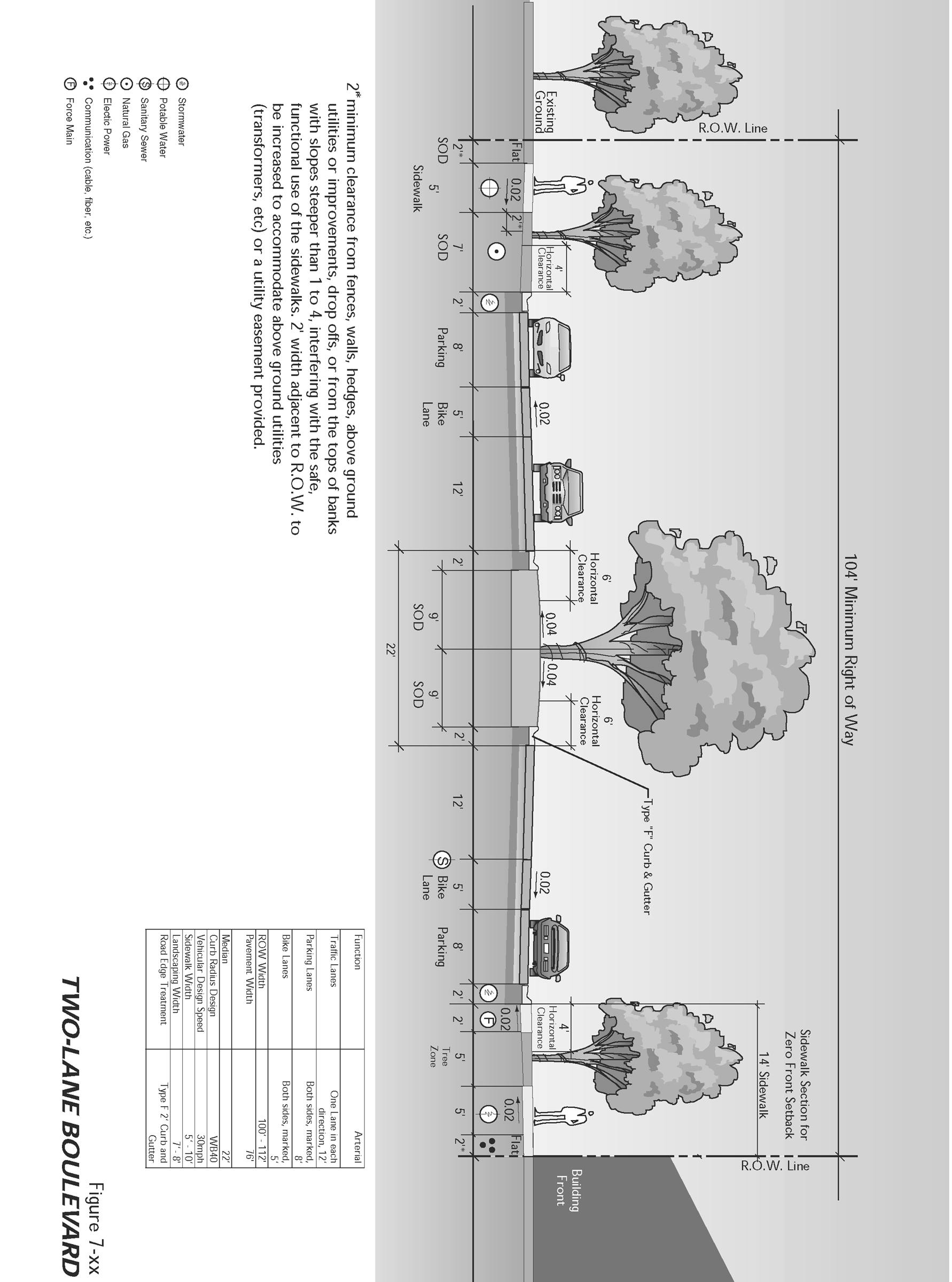
Two Lane Boulevard
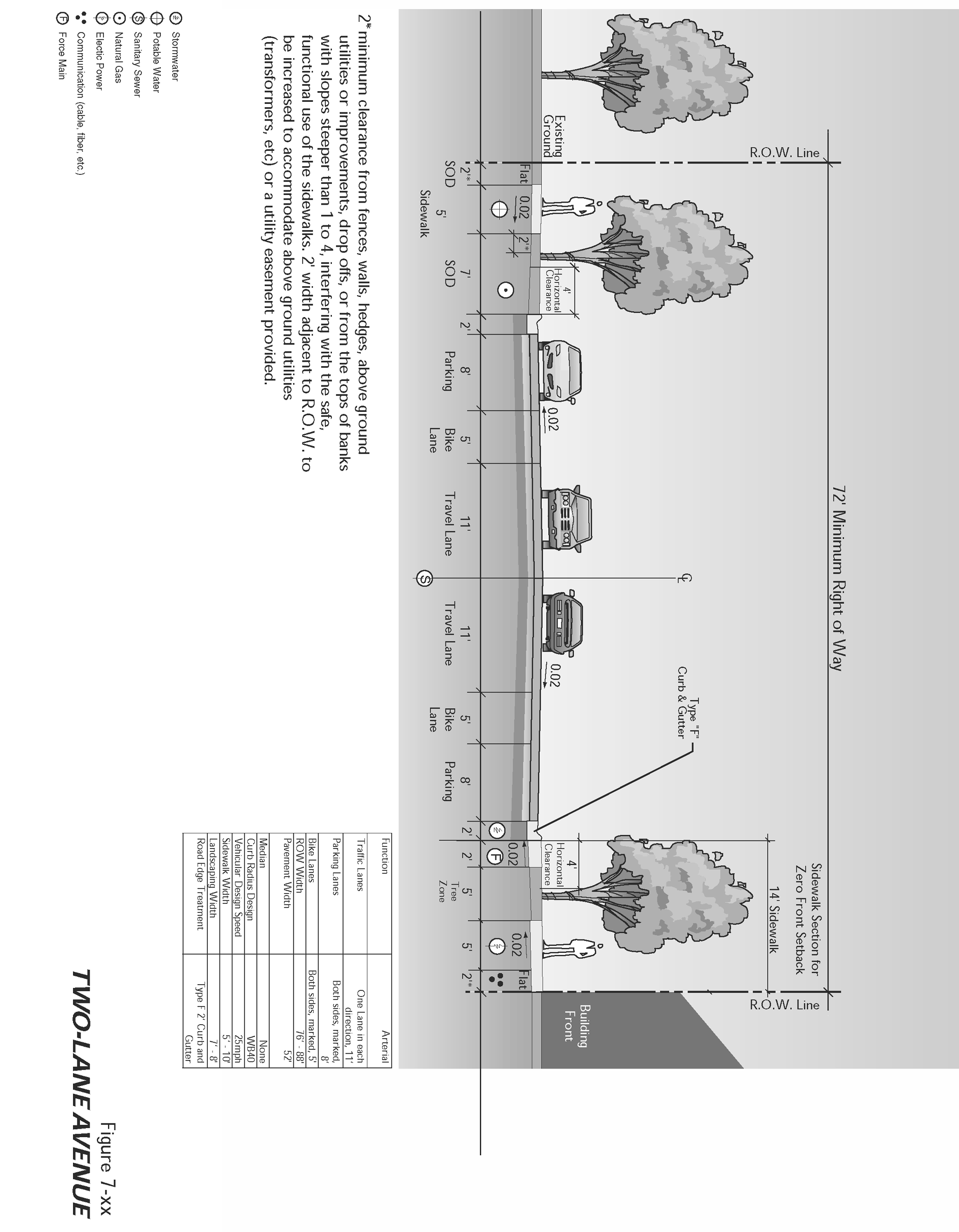
Two Lane Avenue
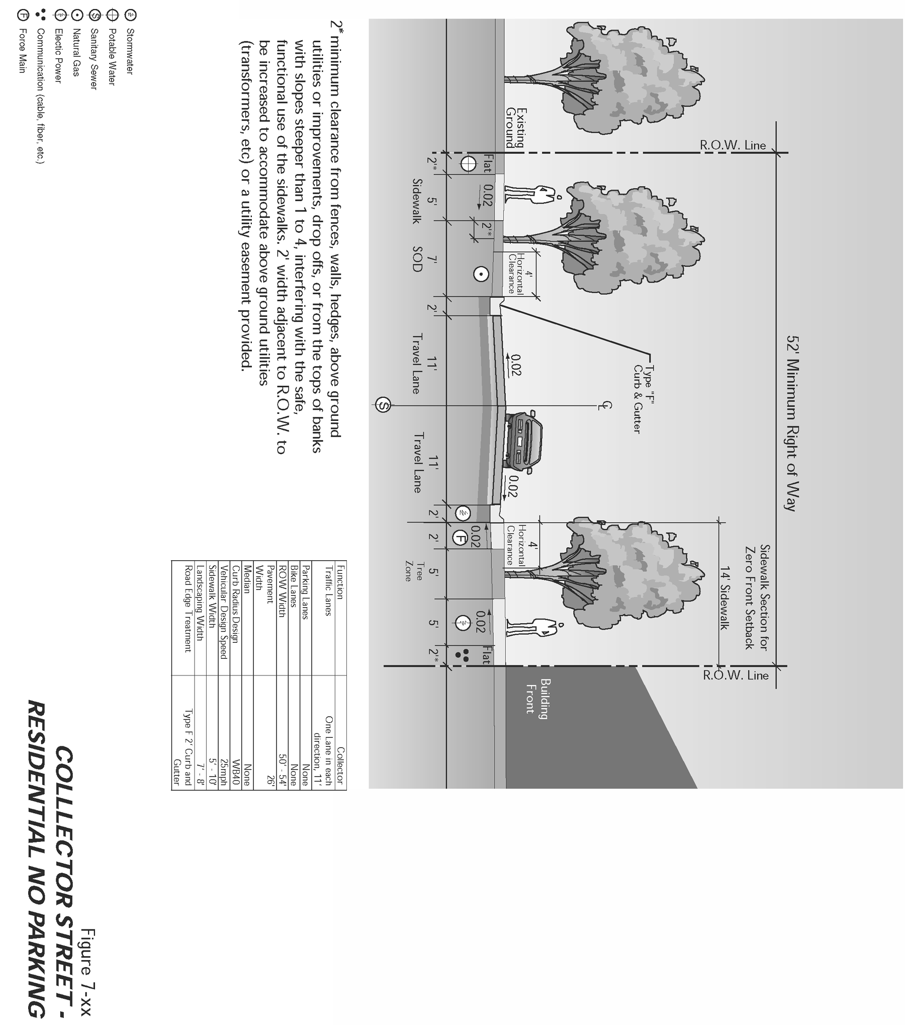
Collector Street Residential No Parking
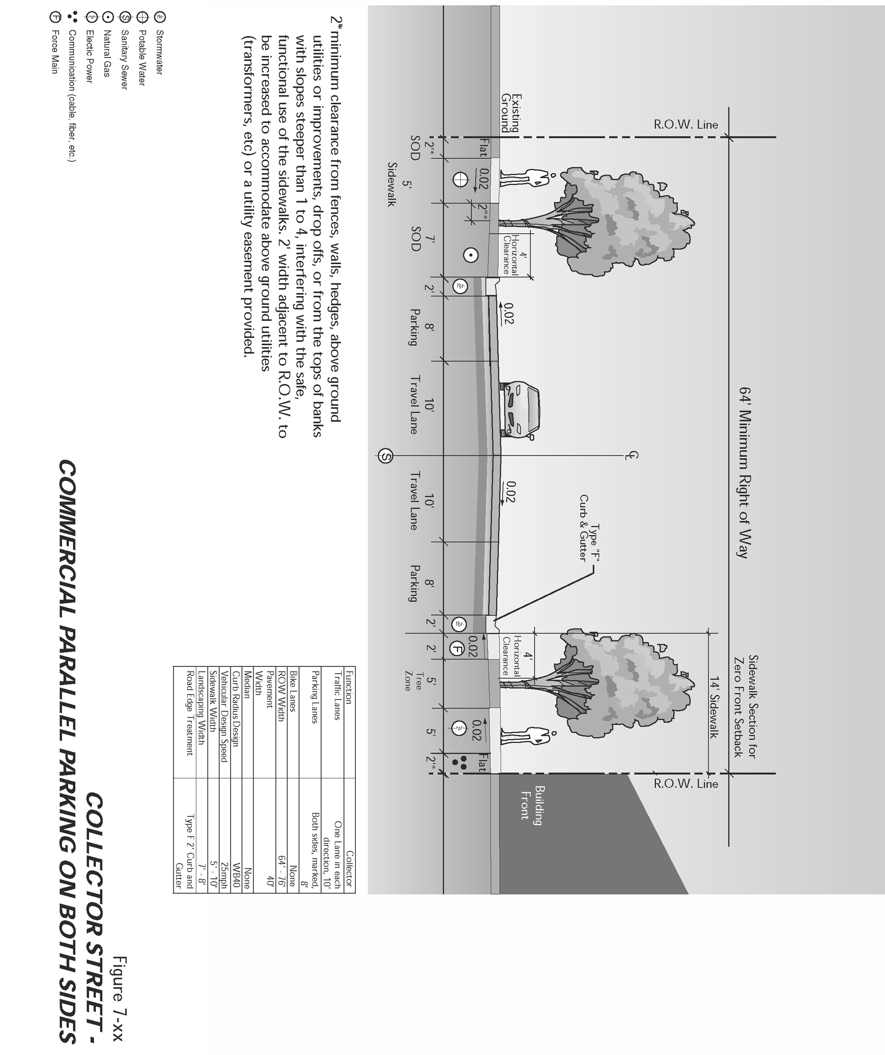
Collector Street Commercial Parallel parking on both sides
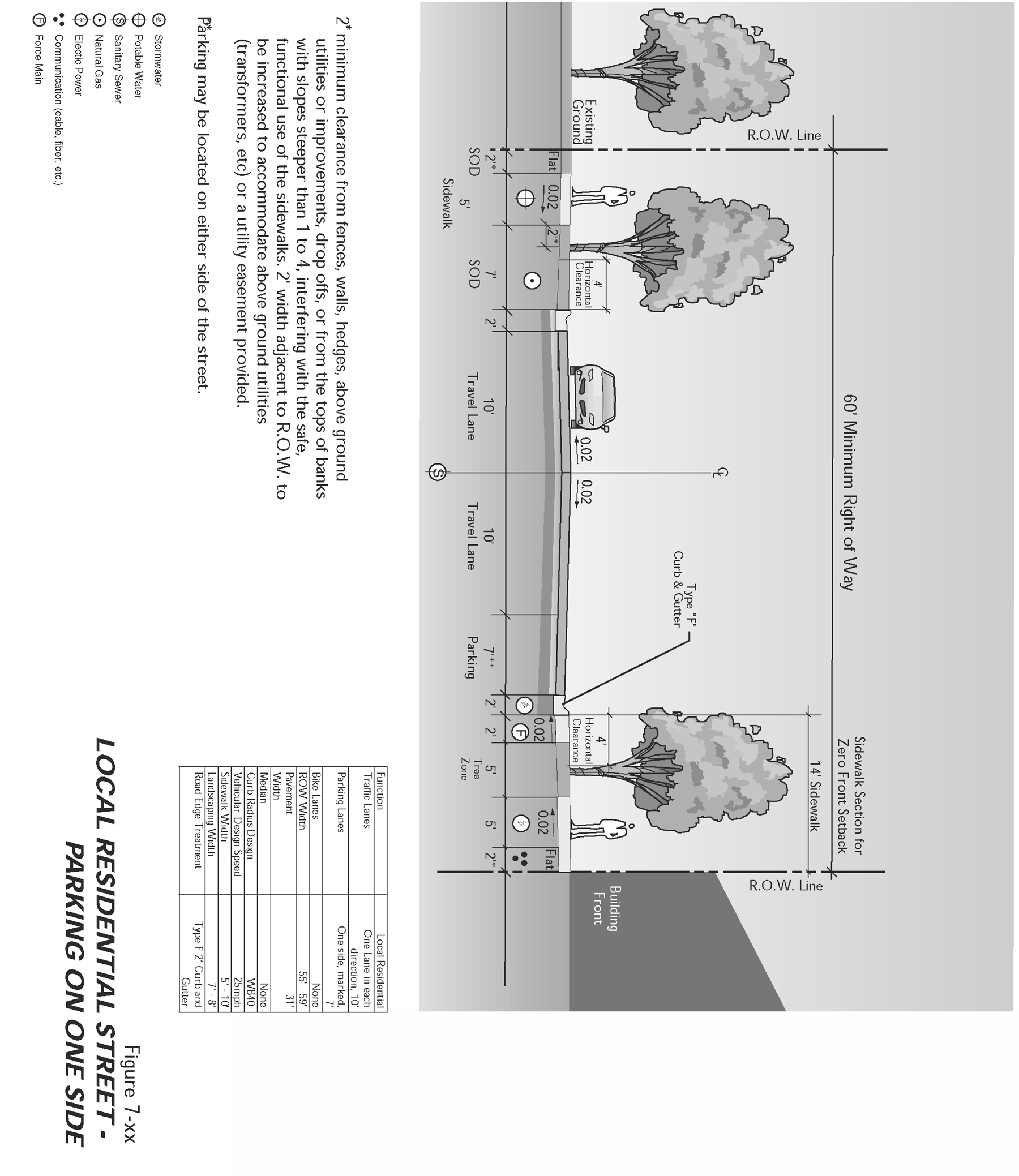
Local Residential Street Parking on One Side
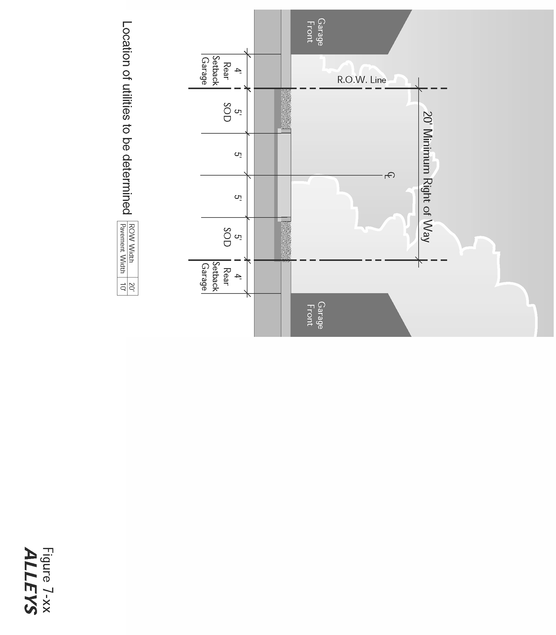
Alleys
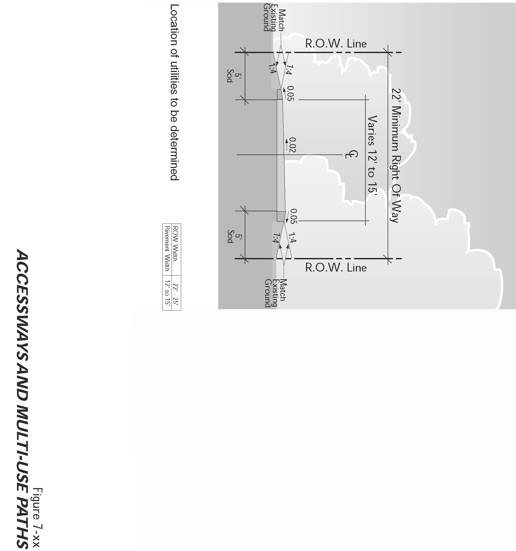
Accessways and Multi-Use Paths
(Ord. No. 04-27, § V(7.31), 5-10-04)
Sec. 25-557. - Dedicated turning lanes.
(a)
To promote mobility and accessibility, dedicated left-turn lanes shall be provided at all intersections on arterial and collector streets where they interest with arterial and collector streets. No left turns lanes are permitted on local residential streets.
(b)
On street types with medians, the median shall be narrowed to allow the left-turn lane without disrupting on-street parking and bulb-outs.
(c)
On street types with on-street parking and without medians, on-street parking shall cease a safe distance from the intersection, and travel lanes shall shift to allow for a dedicated left-turn lane.
(d)
Double left-turn lanes and dedicated right-turn lanes shall be prohibited, except in extraordinary circumstances and with permission of the development review committee.
(Ord. No. 04-27, § V(7.32), 5-10-04)
Sec. 25-558. - Traffic signals and traffic calming features.
(a)
Traffic-calming features, such as roundabouts, bulb-outs, restriping residential streets, and textured pavement may be used to slow traffic in neighborhoods and areas with high pedestrian traffic.
(1)
Roundabouts. A roundabout is a raised circular structure constructed at a three-way or four-way intersection. Urban single lane roundabouts may be installed in all areas. Roundabout design shall comply with state and federal design guidelines such as the Federal Highway Administration's Roundabouts: An Informational Guide. Urban single lane roundabouts shall be designed to minimum WB40' standards.
(2)
Bulb-outs. Bulb-outs are curb extensions at intersections that reduce roadway width curb to curb. Bulb-outs are encouraged where possible. At a safe distance from the intersection, on-street parking shall cease and the curb shall be extended to the travel lane.
(3)
Restriping. Streets can be restricted to create lanes that are nine (9) to eleven (11) feet wide. The excess space can be used to create bike lanes or marked on-street parking on one (1) or both sides. Bicycle lanes shall be four (4) feet wide minimum, and on-street parking shall be seven (7) feet wide minimum.
(4)
Textured pavement. Textured pavement such as brick streets is also an effective traffic calming measure. The advantages of a brick street area that it is aesthetically pleasing and it calms traffic better as it ages as the surface wears out. Installation costs are higher than those for asphalt roadways, but long-term maintenance costs are lower. However, textured pavement can be loud.
(b)
Traffic signals shall be required with development when traffic signal warrants are met, in conformance with the Highway Capacity Manual, and Manual of Uniform Traffic Control Devices. The location of traffic signals shall be noted on approved street plans. Where a proposed street intersection will result in an immediate need for a traffic signal, a signal meeting approved specifications shall be installed. The applicant's cost and the timing of improvements shall be included as a condition of development approval.
(Ord. No. 04-27, § V(7.33), 5-10-04)
Sec. 25-559. - Future street plan and extension of streets.
(a)
A future street plan shall be filed by the applicant in conjunction with an application for a subdivision in order to facilitate orderly development of the street system. The plan shall show the pattern of existing and proposed future streets from the boundaries of the proposed land division and shall include other parcels within five hundred (500) feet surrounding and adjacent to the proposed land division. The street plan is not binding; rather it is intended to show potential future street extensions with future development.
(b)
Streets shall be extended to the boundary lines of the parcel or tract to be developed, when the DRC determines that the extension is necessary to give street access to, or permit a satisfactory future division of, adjoining land. The point where the streets temporarily end shall conform to subsections (1) through (3), below:
(1)
These extended streets or street stubs to adjoining properties are not considered to be cul-de-sacs since they are intended to continue as through streets when the adjoining property is developed.
(2)
A barricade (e.g., fence, bollards, boulders or similar vehicle barrier) shall be constructed at the end of the street by the subdivider and shall not be removed until authorized by the city or other applicable agency with jurisdiction over the street. The cost of the barricade shall be included in the street construction cost.
(3)
Temporary turnarounds (e.g., hammerhead or bulb-shaped configuration) shall be constructed for stub streets over one hundred fifty (150) feet in length.
(Ord. No. 04-27, § V(7.34), 5-10-04)
Sec. 25-560. - Street alignment and connections.
(a)
Staggering of streets making "T" intersections at collectors and arterials shall not be designed so that jogs of less than three hundred (300) feet on such streets are created, as measured from the centerline of the street.
(b)
Spacing between local street intersections shall have a minimum separation of one hundred twenty-five (125) feet, except where more closely spaced intersections are designed to provide an open space, pocket park, common area or similar neighborhood amenity. This standard applies to four-way and three-way (off-set) intersections.
(c)
All local and collector streets which about a development site shall be extended within the site to provide through circulation unless prevented by environmental or topographical constraints, existing development patterns or compliance with other standards in this chapter. This exception applies when it is not possible to redesign or reconfigure the street pattern to provide required extensions. Land is considered topographically constrained if the slope is greater than fifteen (15) percent for a distance of two hundred fifty (250) feet or more. In the case of environmental or topographical constraints, the mere presence of a constraint is not sufficient to show that a street connection is not possible. The applicant must show why the environmental or topographic constraint precludes some reasonable street connection.
(d)
Proposed streets or street extensions shall be located to provide direct access to existing or planned commercial services and other neighborhood facilities, such as schools, shopping areas, parks, and transit facilities.
(e)
In order to promote efficient vehicular and pedestrian circulation within the traditional design overlay and the contemporary design overlay, the maximum block length, design of subdivisions and alignment of new streets in these designated areas shall conform to the standards in section 25-338, Access and circulation—Intent and purpose and section 25-385 and section 25-395 (TDO and CDO).
Exceptions to the above standards may be granted when an access way is provided at or near mid-block.
(Ord. No. 04-27, § V(7.35), 5-10-04)
Sec. 25-561. - Sidewalks, planter strips, bicycle lanes.
Sidewalks, planter strips, and bicycle lanes shall be installed in conformance with the standards in Table 7.31.1, applicable provisions of [the Transportation System Plan], the comprehensive plan, and adopted street plans. Maintenance of sidewalks, curbs, and planter strips is the continuing obligation of the adjacent property owner.
(Ord. No. 04-27, § V(7.36), 5-10-04)
Sec. 25-562. - Intersection angles.
Streets shall be laid out so as to intersect at an angle as near to a right angle as practicable, except where topography requires a lesser angle or where a reduced angle is necessary to provide an open space, pocket park, common area or similar neighborhood amenity. In addition, the following standards shall apply:
(1)
Streets shall have at least twenty-five (25) feet of tangent adjacent to the right-of-way intersection unless topography requires a lesser distance;
(2)
Intersections which are not at right angles shall have a minimum corner radius of twenty (20) feet along the right-of-way lines of the acute angle; and
(3)
Right-of-way lines at intersection with arterial streets shall have a corner radius of not less than twenty (20) feet.
(Ord. No. 04-27, § V(7.37), 5-10-04)
Sec. 25-563. - Existing rights-of-way.
Whenever existing rights-of-way adjacent to or within a tract are of less than standard width, additional rights-of-way shall be provided at the time of subdivision or development.
(Ord. No. 04-27, § V(7.38), 5-10-04)
Sec. 25-564. - Cul-de-sacs.
A dead-end street shall be no more than one thousand (1,000) feet long, shall not provide access to greater than twenty-five (25) dwelling units, and shall only be used when environmental or topographical constraints, existing development patterns, or compliance with other standards in this chapter preclude street extension and through circulation:
(1)
All cul-de-sacs shall terminate with a circular or hammer-head turnaround. Circular turnarounds shall have a pavement diameter of one hundred twenty (120) feet with required right-of-way.
(2)
The length of the cul-de-sac shall be measured along the centerline of the roadway from the near side of the intersecting street to the farthest point of the cul-de-sac.
(Ord. No. 04-27, § V(7.39), 5-10-04)
Sec. 25-565. - Curbs, curb cuts, ramps, and driveway approaches.
Concrete curbs, curb cuts, wheelchair, bicycle ramps and driveway approaches shall be constructed in accordance with standards specified in section 25-338, Access and circulation—Purpose and Intent.
(Ord. No. 04-27, § V(7.40), 5-10-04)
Sec. 25-566. - Alleys, public or private.
Alleys shall conform to the standards in Table 7.31.1. While alley intersections and sharp changes in alignment shall be avoided, the corners of necessary alley intersections shall have a radius of not less than twelve (12) feet.
(Ord. No. 04-27, § V(7.41), 5-10-04)
Sec. 25-567. - Private streets.
(a)
Design standards for private streets shall conform to the provisions of Table 7.31.1.
(b)
A road maintenance agreement, reviewed by the city attorney shall be recorded with the deed of each property to be served by a common private street. The agreement shall provide for:
(1)
A method to initiate and finance a private street and maintain that road in good condition;
(2)
A method of apportioning maintenance costs to current and future users;
(3)
A provision that the city may inspect, and if necessary, require that repairs be made to the private street to ensure that safe access is maintained for emergency vehicles. If required repairs are not made within six (6) months of date of notice, the city may make the necessary repairs and assess owners of parcels on the road for the cost of all improvements plus an administrative fee, not to exceed twenty-five (25) percent of total costs;
(4)
A provision that the majority vote of all property owners on the road shall determine how the road is maintained except in the case of emergency repairs as outlined above;
(5)
A statement that no public funds shall be used to construct repair or maintain the road;
(6)
A provision requiring mandatory upgrading of the roadway if additional parcels are added to reach the specified thresholds; and
(7)
A provision that property owners along that road are prohibited from restricting or in any manner interfering with normal ingress and egress by any other owners or persons needing to access properties with frontage on that road.
(Ord. No. 04-27, § V(7.42), 5-10-04)
Sec. 25-581.- Cutting or removing sidewalk, curb or paving, etc.—Permit required.
It shall be unlawful for any person to cut, break or remove any sidewalk, curb or paving, or any part or portion thereof or change the grade or alignment of any street or sidewalk within the corporate limits of the city without first applying to a receiving from the city a permit for such work pursuant to LDC.
(Ord. No. 04-27, § V(7.43), 5-10-04)
Sec. 25-582. - Same—Application for permit; grant or refusal.
When application is filed for a permit, the public works department will examine the street, sidewalk and curb, and if, upon such examination, he finds that the issuance of the permit will not permanently injure or damage the sidewalk, street or curb, or change the grade or alignment of the street or sidewalk to the detriment of drainage or to the hazard of the safety of the citizens of the city, he may grant such permit; but if he believes that it will permanently injure or damage the street, sidewalk or curb, or change the grade or alignment of the street, or sidewalk to the detriment of drainage or to the hazard of the safety of the citizens of the city, he will refuse a permit, and refer the application to the city commission for their approval or rejection.
(Ord. No. 04-27, § V(7.44), 5-10-04)
Sec. 25-583. - Obstructions, exception.
It shall be unlawful for any person to place, maintain or permit to be placed or maintained any obstruction of any nature whatever on the sidewalks of the city or projecting out over the sidewalk less than eight (8) feet above the sidewalk; provided, that charitable organizations or institutions of a public nature may procure a permit from the public works director, at his discretion, to erect or maintain such an obstruction on or over the sidewalks for a limited time. See CBC district, section 25-275 for exceptions to this section.
(Ord. No. 04-27, § V(7.45), 5-10-04)
Sec. 25-584. - Sidewalk construction.
Sidewalks constructed within any new development shall be constructed by the developer, at the developer's expense, when desired by the developer or required by any other portion of this chapter or by any development order issued by the city for the development, and shall be constructed according to standards set by the city. Where the city deems it necessary or desirable to construct sidewalks in areas which are already developed but lack sidewalks, the city shall have the option to construct those sidewalks at city expense, or to impose a special assessment for such construction in the manner provided by any general or special law or under the city's home rule powers.
(Ord. No. 04-27, § V(7.46), 5-10-04)
Sec. 25-585. - Sidewalk maintenance.
The following standards shall govern maintenance of sidewalks within the city limits:
(1)
Where sidewalks are in need of maintenance, repair or replacement due to age or ordinary wear and tear, the city shall bear the cost of such maintenance, repair or replacement.
(2)
Where sidewalks are damaged or destroyed, or are in need of maintenance, repair, or replacement, as a result of acts or omissions of the adjacent property owner, such as but not limited to heavy truck traffic or construction projects on the adjacent property, it shall be the duty of the adjacent property owner to maintain, repair or replace the sidewalks as necessary, at the expense of the adjacent property owner.
(Ord. No. 04-27, § V(7.47), 5-10-04)
Sec. 25-586. - Work required in new commercial construction and residential development.
(a)
When any commercial, industrial or residential property is platted within the corporate limits of the city which is contiguous to any right-of-way dedicated to the public, or said plat dedicates any right-of-way to the public, and such platted property is improved by the construction of any type of building, structure, parking facility, or any other improvement for which a building permit is required, sidewalks shall be constructed at the expense of the property owner. This section shall not apply to:
(1)
Property platted for single-family residential purposes in which all lots are one (1) acre or larger in area;
(2)
Any single-family residential property located along a dead end street or cul-de-sac which has ten (10) or fewer single-family lots or tracts along its entire length; or
(3)
Multi-family or nonresidential property which is projected by the city to have less than one hundred (100) average daily trips according to the most recent version of the Institute of Transportation Engineers Trip Generation Manual, or any similar publication used by the city.
(b)
When any commercial, industrial or residential property within the corporate limits of the city which is contiguous to any right-of-way dedicated to the public, and within which the city's sidewalk improvement program funded capital project list has designated the need for construction of a sidewalk or sidewalks, is improved by the construction, reconstruction, renovation, remodeling or repair of any type of building, structure, parking facility, or any other improvement exceeding fifteen thousand dollars ($15,000.00) in value, sidewalks shall be constructed at the expense of the property owner in accordance with this section. The exceptions listed in subsection (a) shall also apply to this section.
(c)
Sidewalks shall be constructed in the right-of-way immediately adjacent to the owner's property with a minimum separation between the sidewalk and the edge of any road or street as indicated by planting strips in Table 7.33.1. When the required planting strip is not possible, the sidewalk shall be located within an easement granted by the property owner to the city for public use and maintenance of the sidewalks, of a width sufficient to achieve the required planting strip.
(d)
All sidewalks constructed pursuant to this section shall conform to the following:
(1)
Sidewalks shall have a width as indicated in Table 7.31.1;
(2)
Concrete shall be at least Type I or 3000 p.s.i. strength;
(3)
Minimum thickness of sidewalks shall be four (4) inches, except for driveways and other traffic bearing areas, the minimum thickness shall be six (6) inches;
(4)
For sidewalks, expansion joints shall be placed every twenty (20) feet with construction joints at all other five-foot intervals. A construction joint shall mean a sawed or tooled joint at least three-fourths (¾) inches deep from the top of the sidewalk and extending across the width of the sidewalk;
(5)
All street and curb cuts shall meet any applicable laws or regulations for access by disabled persons; and
(6)
All proper site preparation, clearing and leveling shall be completed before installation of any sidewalks.
(7)
The community development director is hereby directed to withhold the certificate of occupancy or use until such sidewalks are properly constructed as provided in this section.
The community development director may approve deferment of construction or waive construction in lieu of payment of construction cost when determining when or if specific project sidewalks are currently needed. Variances to the requirements of this section may be issued by the planning commission based on the criteria set forth in article III of this chapter. In no event shall a sidewalk be constructed abutting a Miami or ribbon curb. In the case of a deferment, the property owner shall provide the city with: (1) a properly executed covenant to run with the land, which is suitable for recording, and which may be recorded, at the owner's expense, at the option of the city, and in which the property owner agrees to construct or pay the cost of constructing the sidewalk, when such construction is required by the city; and (2) financial assurances that the owner will have the ability to construct or to pay the cost of constructing the sidewalk in the future in accordance with the covenant. The financial assurances shall be of a type and in a form acceptable to the community development director or his designated representative, including, but not limited to, a performance bond, security deposit, or any other reasonable method deemed appropriate. In the case of cash payment, the property owner shall provide the city with an engineer's estimate of the cost of construction of sidewalks which will be reviewed by the city and if approved shall pay referenced cost prior to approval of the record plat or final site plan approval. Funds shall be held in a city account designated for sidewalk construction by commissioner districts and used for construction of sidewalks in the referenced district.
(Ord. No. 04-27, § V(7.48), 5-10-04; Ord. No. 10-40, § I, 5-10-10)
Sec. 25-587. - Recommendations as to repair or replacement of sidewalks.
Whenever any existing sidewalk becomes in need of maintenance, repair or replacement, the public works department may require the performance of the necessary maintenance, repair or replacement by the party made responsible therefore by section 25-584 of this chapter. Where the adjacent property owner is made responsible for maintenance, repair or replacement of the sidewalk, the public works department may require the property owner to act within a reasonable time.
(Ord. No. 04-27, § V(7.49), 5-10-04)
Sec. 25-588. - City may repair sidewalks upon failure of owner to act; costs to be assessed against property and become a lien.
If the public works department notifies a property owner that the property owner is responsible for maintenance, repair or replacement of a sidewalk, and the property owner fails to comply with the notice within the time specified by the public works department, the city may conduct the necessary maintenance, repair or replacement and the cost thereof shall be assessed against the property. Upon the recording of a notice of such assessment, certified by the city clerk/finance director, the assessment shall create a lien against the property which may be enforced in equity and which shall constitute a lien prior in dignity to any and all other liens which may then exist against the property or be created thereafter. Additionally, any property owner who fails to comply with a notice from the public works department to maintain, repair or replace the sidewalk may be subject to the penalty provided in section 1-14 of this Code or to sanctions imposed by the code enforcement hearing officer.
(Ord. No. 04-27, § V(7.50), 5-10-04)
Sec. 25-611.- Assigning address numbers.
Street address numbers for dwelling units and places of business on all public and private streets shall be assigned by the city department designated by the city manager. Street address numbers shall be assigned in accordance with administrative procedures adopted by the city manager; however, such procedures shall at a minimum include the following:
(1)
The owner, occupant or person in charge of any house or building to which a number has been assigned will be notified in writing of the number assigned;
(2)
Within thirty (30) days after the receipt of such written notification, the owner, occupant or person in charge of the house or building to which a number has been assigned shall affix the number in a conspicuous place over or near the principal entrance;
(3)
In the case of new construction, two (2) legible copies including one (1) electronic copy of approved final subdivision plats showing all lots with lot numbers and all streets with correct names, or, alternatively where no subdivision is involved, and approved final site plan shall be furnished to the reviewing department. The copies of plats or plans will be reproduced on paper not larger than twenty-two (22) inches by thirty-four (34) inches and to a scale of one (1) inch equals two hundred (200) feet. Upon completion of the street address numbering by the reviewing department, one (1) copy of the plat or plan depicting numbers assigned by the reviewing department shall be returned to the applicant.
(Ord. No. 04-27, § V(7.51), 5-10-04)
Sec. 25-612. - Standards for numbering buildings or houses.
The physical numbering of buildings or houses shall conform to the following standards:
(1)
Numbers must be arabic or block; script letters may not be used nor may the numbers be spelled. Numbers must be easily legible from the street with figures not less than three (3) inches high for residences and not less than five (5) inches high for commercial businesses;
(2)
Numbers must be in a color contrasting to the building background;
(3)
Easily legible numbers shall also be affixed to a remote mailbox serving the building or house unless such mailbox has been provided by the U.S. Postal Service at a separate location as part of a group of mailboxes serving several buildings or houses in the same general area;
(4)
Assigned numbers shall be displayed on the front entrance of each principal building and in the case of a principal building which is occupied by more than one (1) business or family dwelling unit, on each separate front entrance;
(5)
Any different numbers which might be mistaken for or confused with the number assigned by the appropriate city department shall be removed upon the display of the assigned number in accordance with the requirements of this chapter.
(Ord. No. 04-27, § V(7.52), 5-10-04)
Sec. 25-613. - Regulations for naming streets.
All public and private streets within the city shall receive names selected and/or approved by the city department designated by the city manager, pursuant to the requirements of LDC and the following:
(1)
Street names shall be chosen in a manner which relates to the classification and location of a project or street. Street names shall be pleasant sounding, easy to read and of a character which allows the public, and children in particular, to remember the name in an emergency situation.
(2)
No duplication of names is permitted. Similar sounding names shall be considered to be duplication regardless of the spelling. Street name duplications that exist as of the date of adoption of this chapter shall be corrected as part of the renumbering process in the manner specified in the administrative procedures adopted by the city manager.
(Ord. No. 04-27, § V(7.53), 5-10-04)
Sec. 25-614. - Changing street names.
Street name changes may be made where any of the following conditions exist:
(1)
Where there is an existing duplication of street names within the city;
(2)
Where a street has more than one (1) name and a street name change to a single name would be in the best interest of the public safety, health and welfare;
(3)
Where a street is unnamed;
(4)
Where a street has a similar sounding name to another street within the city;
(5)
Where the configuration of a street results in confusion in the numbering process.
(Ord. No. 04-27, § V(7.54), 5-10-04)
Sec. 25-615. - Application for street names and street name changes.
(a)
Application for street names or street name changes may be requested by any owner of property abutting the street involved. Applications shall be made to the city department designated by the city manager and shall contain the proposed name, two (2) legible copies of a current survey or plat showing the exact location of the street(s) and a general location map, and a petition or other demonstrative form of approval of the street name by a majority of the other property owners on the street, and, in the case of a private street or easement, written permission from the property owner on whose property the street name sign is to be placed, for the city to cause the installation of the sign. Applications shall be accompanied by a fee established by the city manager, which fee should reflect a reasonable cost of providing the review. The cost of materials and installation of the street name sign(s) and any traffic control devices deemed necessary by the city shall be borne by the applicant.
(b)
Street name changes requested by applicants shall be reviewed by the department designated by the city manager and a street name will be assigned where the name applied for is not duplicative of any other street within the city in which the street is located.
(Ord. No. 04-27, § V(7.55), 5-10-04)
Sec. 25-616. - Displaying official numbers.
No building permit or certificate of occupancy shall be issued for any principal building until the applicant has procured the official numbers for the premises and displayed the same in accordance with the requirements of this chapter.
(Ord. No. 04-27, § V(7.56), 5-10-04)
Sec. 25-617. - Street signs.
The city, county, or state having jurisdiction over a roadway shall install all signs for traffic control and street names except where that responsibility is allocated to another person under this section. In any new development the property owner or developer shall install all signs for traffic control and street names and the cost of the signs shall be the responsibility of the owner or developer. Street name signs shall be installed at all street, intersections. Stop signs and other traffic control signs may be required as deemed necessary for the protection of motorists, pedestrians, cyclists and others utilizing the streets. All street, traffic and signalization signs shall comply with the following standards:
(1)
Street signs.
a.
All sign blanks shall be constructed of 0.63-inch thick aluminum chemically treated to meet ATSM B449 standards pretreatment for paint or reflective sheeting. Dimensions are to be nine (9) inches high with a minimum width of thirty (30) inches and a maximum width of forty-eight (48) inches.
b.
The background shall be high intensity or greater white sheeting, with green transparent overlay film.
c.
Signs shall have a one-half-inch white border, one-half (½) inch from the edge. Street names shall be six-inch series B letters with ¾ inch to one-inch spacing between letters. Abbreviated suffixes such as "Rd.", "Ave." or "Dr." shall be three-inch series B letters.
d.
The block number shall be displayed in the lower right hand corner of the sign in three-inch series B letters.
e.
Signs shall be mounted as two (2) single-sided signs mounted back to back with the ends bolted together using a ¼ inch by ½ inch bolt, two (2) flat washers, one (1) lock washer and nut, all stainless steel, on a galvanized nine-inch twist bracket. No edge clamping style mounting blocks are to be used. Center holes shall be fastened with one-inch by 5/16 -inch bolts, two (2) 5/16 -inch flat washers, one (1) 5/16 -inch lock washer and one (1) 5/16 -inch nut all in stainless steel.
f.
The top two (2) sign blanks (aluminum only) and city logos will be provided by the City of Leesburg Public Works Department.
(2)
Regulatory and warning signs.
a.
Sign blanks shall be 0.80 gauge.
b.
With the exception of street name signs which shall have the characteristics described above, all signs shall conform in color, size, legend and logo with specifications in the Manual on Uniform Traffic Control Devices ("MUTCD").
c.
Stop signs shall be a minimum of thirty-inch by thirty-inch with high intensity sheeting or greater.
d.
Regulatory and warning signs shall be placed in accordance with the MUTCD (Sections 2A-21 through 2A-27) with respect to offset from the edge of the road, height and other placement criteria.
e.
Poles should be buried to a minimum depth of two and one-half (2.5) feet allowing seven (7) feet from the level of the traveled roadway to the bottom of the sign.
f.
Poles are to be concreted in place with forty (40) pounds of concrete. The top of the concrete shall be level with the ground.
g.
Poles shall be galvanized steel U-channel poles not less than twelve (12) feet in length (fourteen (14) or sixteen (16) feet for severe shoulder drop-offs), with a minimum weight of two (2) pounds per foot.
(Ord. No. 04-27, § V(7.57), 5-10-04; Ord. No. 09-47, § I, 9-14-09)
Sec. 25-618. - Street light standards.
Street lights shall be installed in accordance with city standards and shall have underground service connections.
(Ord. No. 04-27, § V(7.58), 5-10-04)
Sec. 25-641.- Intent.
Any persons responsible for or involved in or with planning, design and/or construction of streets, either within or without a subdivision inside the corporate limits of the city shall be governed by the ordinances of the city respecting the same, and all street grading, paving, drainage and appurtenant street improvements shall comply with or exceed the design standards, specifications and other requirements as set forth in this division.
(Ord. No. 04-27, § V(7.59), 5-10-04)
Sec. 25-642. - Permits.
(a)
Before any excavation, construction or repair work of any type is commenced for any work in, upon or under any street or right-of-way pursuant to this division or any other section of this chapter, an application for a permit therefore shall be filed with the city manager, or his designated representative, who shall determine whether the proposed work is in conformity with this chapter. If the city manager determines that the proposed work is in conformity with this chapter he shall issue a permit and he shall determine the fee for same, if any.
(b)
The permit provided for in this section shall be issued under such conditions as may be prescribed by the city manager and shall accurately describe the portion of the street or right-of-way to be affected and shall make provision for the replacement of that part of the street or right-of-way to be replaced in the same condition as when disturbed and shall state a definite time within which the permit shall be operative.
(c)
The recipient of any such permit shall agree, as condition of the issuance of the permit, to keep the city manager or his designated representative informed in advance as to the progress of such construction work and to give such advance notice to the city manager as may be specified in this division for any required inspections and/or testing.
(Ord. No. 04-27, § V(7.60), 5-10-04)
Sec. 25-643. - Rights reserved to city; conformity to standards.
(a)
The city reserves the right to specify or require material of suitable quality, equipment of adequate size and capacity, and competent labor forces and supervision thereof which are to be used in or on all such work in, upon or under any street or right-of-way in the city.
(b)
Except as modified in this division, all such work shall conform to the latest editions of the "Manual of Uniform Minimum Standards for Design, Construction and Maintenance for Streets and Highways," "Standard Specifications for Road and Bridge Construction," and "Roadway and Traffic Design Standards," prepared by the State of Florida Department of Transportation (FDOT).
(Ord. No. 04-27, § V(7.61), 5-10-04)
Sec. 25-644. - Specifications.
Construction standards shall conform to the technical and construction standards adopted by the city.
(Ord. No. 04-27, § V(7.62), 5-10-04)
Sec. 25-645. - Advance notice of construction required; inspection and testing to be performed.
(a)
The office of the city manager, or his designated representative, shall be given not less than twenty-four (24) hours' advance notice, during normal working hours, prior to any construction work being performed in, upon or under any street or right-of-way in the city; and where such work is new street construction, such notice shall be given at the following intervals, to wit:
(1)
Before grading;
(2)
Before sub-base stabilization;
(3)
Before placement of base course on sub-base;
(4)
Before application of prime coat on base. No base course shall be primed until the city manager, or his designated representative, has inspected and approved such base;
(5)
Before construction of surface pavement course.
(b)
The city reserves the right to require certification from a Florida registered professional engineer and/or an approved independent testing laboratory that the materials, in-place thickness and in-place density of the sub-base, base course, prime coat and surface pavement course comply with the specifications set forth, and to select the locations where tests shall be made for such certification. Such testing and certification shall be the responsibility of the permittee engaged in any such street construction work, whether it be new construction or street repair required as a result of any construction work in, upon or under any street or right-of-way.
(Ord. No. 04-27, § V(7.63), 5-10-04)
Sec. 25-646. - Replacing street.
Before the expiration of any permit granted by the city manager or his designee pursuant to the provisions of this chapter, the permit holder shall replace that street or part of street upon which such construction, excavation or repair work has been performed in the same condition as the street or part of street existed prior to the construction, excavation or repair work, and failure to perform such replacement work shall constitute a misdemeanor against the city by the permit holder.
(Ord. No. 04-27, § V(7.64), 5-10-04)
Sec. 25-647. - Barricades or other safety devices.
All persons performing work in, upon or under any street or right-of-way, or within an area adjacent thereto, which involves any construction, excavation, repair work or the placement of vehicles, equipment, materials or persons anywhere within such street or right-of-way, shall place, erect, light and maintain proper warning devices and/or barricades around the work site and provide such other safety measures as may be deemed necessary by the city manager, or his designated representative, to preclude injury or damage to persons and property. During that period of time between one-half (½) hour after sunset and one-half (½) hour before sunrise such warning device and/or barricades shall be provided with sufficient lights or flares which shall be properly maintained to illuminate the work site and any excavations or obstructions incidental thereto.
(Ord. No. 04-27, § V(7.65), 5-10-04)
Sec. 25-648. - Declaration, notice of construction.
(a)
Whenever it shall be determined by the city commission that any street should be constructed, paved or otherwise improved in front of any lot, block, or parcel of property along any street or part of a street within the city, the commission shall, by resolution passed at a regular meeting of the commission, declare that such street shall be so improved and prescribe the conditions thereof and the method to be used in the apportionment and assessment of the construction cost.
(b)
The city commission shall require the city clerk/finance director to issue under his hand and the seal of the city a notice of such action of the city commission and that such notice shall be served upon the owner or occupant of each lot, block or parcel of property abutting such street improvement. In case such property is unoccupied and the owner is a nonresident, then such notice required by this section shall be served on the agent of such nonresident owner.
(c)
Service of such notices shall be accomplished in person by a designated representative of the city manager, by the city police department, or by certified mail with return receipt requested.
(Ord. No. 04-27, § V(7.66), 5-10-04)
Sec. 25-649. - Assessment of cost; creation of lien.
(a)
Thirty (30) days after service of notices of intent to improve a street, the work therefore may commence, and if the owner(s) or occupant(s) of property abutting the street to be improved have not made provision to assume their portion of the cost of such improvement within sixty (60) days after service of such notices, such portion of the cost may be assessed against the affected property, and such assessment shall constitute a lien against such affected property and shall accrue interest at the maximum legal rate, pursuant to F.S. Chapter 170, from the date set forth in the resolution of the city commission establishing the assessment roll until such lien, the interest thereon and all costs in connection with filing and recording the same have been paid in full.
(b)
The city clerk/finance director shall cause such lien to be filed with the clerk of circuit court in and for the county, to be recorded in the public records thereof. When any such lien, accrued interest thereon and filing and recording costs in connection therewith shall have been paid in full, the city clerk/finance director shall cause the release of the lien to be similarly filed and recorded.
(c)
The city clerk/finance director may cause foreclosure proceedings to be instituted against any such lien in the manner prescribed by F.S., Chapter 170.
(Ord. No. 04-27, § V(7.67), 5-10-04)
Sec. 25-650. - Definitions.
The following words, terms and phrases, when used in this division, shall have the meanings ascribed to them in this section, except where the context clearly indicates a different meaning:
Pursuant to the transportation element to the Comprehensive Development Plan adopted December 2003 and subsequent amendments thereto, thoroughfares or routes in the city referred to as streets in this article are classified according to the following definitions:
Arterial shall mean a route providing service which is relatively continuous, of high traffic volume, of long average trip length, of high operating speed, and of high mobility importance. In addition, all United States numbered highways shall be arterial roads.
Collector shall mean a route providing service which is relatively of moderate average traffic volume, moderately average trip length, and moderately average operating speed. These routes also collect and distribute traffic between local roads or arterial roads and serve as a linkage between land and access and mobility needs.
Local shall mean a route providing service which is relatively of low average traffic volume, of short average trip length or minimal through-traffic movements, and of high land access for abutting property.
(Ord. No. 04-27, § V(7.68), 5-10-04)
Sec. 25-671.- Purpose and intent.
The purpose and intent of this division is to provide standards and procedures to govern permitting, construction and maintenance of crossings and other uses within the city trails system, and to govern applications for such uses, in order to achieve the following:
(1)
Provide for a continuous alternative transportation and recreational network within the Leesburg area.
(2)
Preserve the function of each trail, which is to provide a safe facility for recreation and non-motorized transportation, including but not limited to single person battery operated devices utilized by persons with disabilities.
(3)
Provide for smooth, logical traffic-flow patterns.
(4)
Reduce conflicts between trail and vehicular traffic.
(5)
Allow for the application of safe geometric-design principles.
(6)
Provide for bicyclist, pedestrian, in-line skater, and other users' safety and enjoyment, where applicable.
(7)
Provide for environmental compatibility.
(8)
Protect trail corridors from private encroachments and detrimental or disruptive uses.
(9)
Protect the city's interest in properties owned or managed by the city that have been designated as trail corridors.
(10)
Provide a mechanism for owners of private property located along the trail system to have reasonable access to enter and exit such properties.
(Ord. No. 04-27, § V(7.69), 5-10-04)
Sec. 25-672. - Authority.
The city's authority to process applications for and, in some situations, approve permits for authorized activities within the city trails system derives, in part, from the city's ownership and/or management of those corridors which form the city trails system. The trails system is comprised of corridors owned by the city.
(Ord. No. 04-27, § V(7.70), 5-10-04)
Sec. 25-673. - General procedure.
For those portions of the city trails system owned in fee by the city, or over which it has permitting authority, the permit application review and approval process shall be final upon the completion of the city's review and approval.
(Ord. No. 04-27, § V(7.71), 5-10-04)
Sec. 25-674. - Access permit application to the parks and recreation department.
(a)
Each access permit application shall be accompanied by the appropriate fee as set by resolution of the city and shall be submitted to the recreation and parks department. Trail access permits shall meet the specifications and guidelines set forth in the City Code, and all other applicable rules and regulations including design standards for trail crossings and use as determined by the recreation and parks department.
(b)
Prior to approval of a permit, an applicant must provide, at the applicant's own expense, a boundary and topographic survey within the limits of the construction area to include locations within the construction area of trees of four-inch diameter breast height (dbh) or greater, wetland delineation, if any, and locations of any known threatened or endangered species, signed and sealed by a professional surveyor/mapper and appropriate environmental specialist licensed in the state and conceptual plans of the proposed use.
(c)
Applicants must attach to the permit application any other permits which are necessary to construct the proposed access. Any permit issued shall be conditioned on the applicant's obtaining said permits.
(Ord. No. 04-27, § V(7.72), 5-10-04)
Sec. 25-675. - Application review by the parks and recreation department.
(a)
The recreation and parks department shall be responsible for administering the permitting process set forth in this division and shall make permit applications available to interested applicants.
(b)
An applicant for a permit shall submit four (4) copies of an application to the recreation and parks department or its designee. Upon receipt of the completed applications, the recreation and parks department shall schedule the application for review by the development review committee at their next regular meeting. The recreation and parks department or its designee shall inspect the proposed permit area for site specific liability issues and potential impacts to natural, cultural, historic and archeological resources, and provide comments on areas of concern.
(c)
After the development review committee has completed its review, and determined that the application meets the standards set forth in this division, the recreation and parks department shall complete a list of trail access permit conditions which shall be a part of the permit to be issued. The permittee further understands that city approval of this permit does not entitle the permittee to begin construction of any access if other permits are required.
(d)
The recreation and parks department shall prepare duplicate originals of the trail access permit for execution by the applicant prior to the recreation and parks department's execution. Upon the applicant returning the executed originals, the recreation and parks department shall execute the trail access permit on behalf of the city if the application meets the requirements set forth in this division. The recreation and parks department shall have final city approval authority over permit applications; provided, however, that an applicant may appeal the development review committee's denial or conditional approval of an application to the city manager within thirty (30) days of the date of the decision. Any appeal must be filed in writing, and must specify the basis for the appeal, to include a concise listing of the reasons the appellant believes the actions of the development review committee do not meet the standards specified in the division or are otherwise a departure from the essential requirements of law.
(e)
Following the development review committee's issuance of a permit relating to a trail corridor owned or co-owned by a state agency, both original copies of the permit application shall be forwarded to the appropriate state agency with a request for concurrence. If the state agency denies or wishes to modify the permit, the issuance of the permit will be withheld until such time as the city and the state agency can reach an agreement. No permit will be issued until all parties agree on the terms of the permit. If approved by the state agency, the agency shall retain one (1) original copy and forward the other original copy to the city for distribution to the applicant.
(Ord. No. 04-27, § V(7.73), 5-10-04)
Sec. 25-676. - Standards of review.
The recreation and parks department shall apply the following standards in determining whether to grant or deny a trail access permit application:
(1)
Acknowledged access. If an adjacent property owner has or claims more than one (1) acknowledged access, the recreation and parks department shall require the property owner to designate one (1) access which shall become the acknowledged access. Any other access points shall be closed and shall no longer be used unless permitted in accordance with this division.
(2)
Access crossings. Permits may be granted to provide access for a property when there are no reasonable access alternatives other than the proposed access. Owners of property adjacent to a designated trail corridor and on which there is a trail crossing necessary to access the property or a portion of the property who are seeking to change their land use or zoning to a more intense category than the existing comprehensive plan contemplates as of the date this division is adopted shall be required to submit plans as part of the development review process for review and discussions of crossing alternatives. The recreation and parks department shall not grant a trail access permit to any property that has reasonable alternate access elsewhere on the boundary of the property or to property that was subdivided to eliminate access to right-of-way. Adjacent properties that each have a need for one (1) or more accesses shall be encouraged to create one (1) combined access providing joint access to, from, or across the trail.
(3)
Access structures. Applications for a permanent trail access structure or installation other than driveways, i.e., footbridges or boardwalks may be approved if the following determinations are made:
a.
The proposed structure will not unreasonably impede flow on the trail corridor,
b.
The proposed structure will not have a negative impact on the public safety, welfare, or use of the trail corridor,
c.
The proposed structure will result in only minimal removal of any trees or vegetated screening materials in the trail corridor, and
d.
The proposed structure will not adversely impact or disturb flood prone areas.
e.
All approved access structures must meet Florida Accessibility Code and ADA requirements.
(4)
Utilities. Public or private utilities will be permitted to be located along designated trail corridors and to cross the trail as necessary to service properties where the designated trail corridor runs between the property and the utility. Utility crossings shall be underground, if practicable from an engineering and environmental standpoint. Appeals of a denial of permission to cross shall be made to the city manager within thirty (30) days of denial of permission by the recreation and parks department.
(5)
Historic and environmental preservation. Applications may not be approved if important historic or environmental resources within the trail corridor are determined to be adversely affected by the proposed access. Applicants may be required to complete a survey of plants and wildlife including those species designated as endangered, threatened, or species of special concern pursuant to Rules 39-27.003, 39-27.004 and 39-27.00, Florida Administrative Code, utilizing the most current wildlife methodology guidelines published by the Florida Fish and Wildlife Conservation Commission and current information from the Florida Natural Areas Inventory. If an endangered or threatened species of special concern is determined to exist on site, them development may not proceed until the applicant obtains the necessary approvals from the appropriate jurisdictional agencies. Additionally, applicants must provide documentation from the department of state identifying the presence of any listed historic or archaeological sites that may be adversely affected by the access. A site will be considered historic if it is so defined or listed under Florida Law.
(Ord. No. 04-27, § V(7.74), 5-10-04)
Sec. 25-677. - Conditions.
(a)
In addition to the conditions deemed necessary for permit approval by the recreation and parks department, each trail access permit granted by the recreation and parks department shall be deemed to include the following terms and conditions:
(1)
A new permit application shall be required if, in the determination of the recreation and parks department, there has been a change in the use of the property to which the permit provides access. These changes would include, but are not limited to, changes in zoning or land use designations controlling the property (except those initiated by governmental entities), submission of development plans to the appropriate governmental jurisdiction indicating an increase in density or intensity in the use of the property, and other similar circumstances.
(2)
The term of the permit ends upon revocation of the permit by the city; on the date specified by the state, if any; or on the termination of the lease to the city by the trustees of the internal improvement fund. Permits are revocable by the city upon damage caused by the permittee to the trail corridor or any violation of the permit agreement resulting from use of the permit area not rectified by the permittee with four (4) weeks of notification of such damage or violation by the city. Upon the recreation and parks department's written notification to the permittee, a permit is subject to cancellation and automatic termination by the city upon failure to correct the situation set forth in the written notice of damage or violation. Upon termination of a permit, unless waived by the city, the permittee shall restore, at the permittee's own cost the permit area to a condition like or better than the condition of the permit area upon the execution date of the permit. Upon termination of the permit, all authorization granted by the permit terminates. Upon a change to a more intensive land use, zoning or development (unless initiated by a governmental agency), the permittee shall be required to reapply for a new permit, and said application shall only be required to address the access issues raised by the change of use of the property.
(3)
Any construction shall be constructed at the cost and expense of the permittee, but in a manner and of materials as set forth in the Code.
(4)
Prior to construction of approved uses, the permittee must submit construction plans signed and sealed by a professional engineer licensed in the state to the recreation and parks department for approval. Plans shall include locations of trees of four-inch diameter breast height (dbh) or greater, if any, wetland delineation, and locations of any threatened or endangered species, if any.
(5)
The permittee shall perform all construction at such times and in such a manner as to interfere to the least possible extent with the public's use of the trail. At all times a through-route of a minimum eight-foot width shall be provided for trail users. All construction within the trail corridor pursuant to a permit shall be completed within thirty (30) days of commencement. There shall be a weight limit for construction vehicles of twelve thousand (12,000) pounds, unless special permission is granted by the recreation and parks department. The use of road plates for construction vehicles may be required to prevent damage to the trail.
(6)
Where the city constructs improvements to an existing trail facility or a new trail facility which impacts accesses, city shall design such improvement or new facility so as to not adversely impact the access, if practical, or to minimize the impact, if some impact is unavoidable.
(7)
Prior to construction of an approved access, the permittee shall have its surveyor mark the trail boundary line with highly visible tape and city approved signage, at the permittee's expense, to ensure that the trail corridor is not damaged.
(8)
Joint access. If adjacent property owners agree to execute a joint construction and use document, the property owners need only pay equal shares of the appropriate trail access permit fee(s) that would have been charged for the property with the highest intensity classification. Any trail access permit application fees required by the city may be waived when three (3) or more adjacent property owners agree to share one (1) access if the recreation and parks department finds and determines that the public interest is benefited thereby and that the public interest is commensurate with the granting of a fee waiver.
(Ord. No. 04-27, § V(7.75), 5-10-04)
Sec. 25-678. - Use of the permit area by a permittee.
(a)
Permit uses shall be limited to the specific activities approved by the city in the permit.
(b)
No trimming or removal of any vegetation, excluding normal grass mowing, within the trail corridor shall take place prior to permit approval or execution of a maintenance agreement.
(c)
The permittee is solely responsible for all costs related to design and development of the public or private road/driveway crossing. No development shall take place prior to written city approval of the development plan. The city retains the right to enter into the permit area for trail development and management purposes.
(d)
The permittee shall maintain the permit area in a safe and attractive manner, acceptable to the city. The permittee is fully responsible for all costs associated with the permitted use of the area.
(e)
The permittee shall save and hold harmless and indemnify the city and the state against any and all liability, claims, judgments or costs of whatsoever kind and nature for injury to or death of any person or persons and from loss or damage to any property resulting from the use, service, operation or performance of work under the terms of this permit, resulting from the negligent acts of the permittee, its contractor or invitees, or any of the employees, agents or representatives of the permittee, its contractor or invitees to the extent allowable by law. In addition, permittees shall be required to obtain and keep in force a liability policy of one million dollars ($1,000,000.00) covering death, injury or property damage arising out of use of the access to reach the property of the permittee, with the city named as an additional insured.
(f)
Permittees shall not do or permit anything to be done which purports to create a lien, encumbrance, or encroachment not identified in the permit of any nature against the trail corridor including, but not limited to, mortgages or construction liens against the trail corridor or against any interest of the city therein.
(g)
Upon the city's discovery of unpermitted encroachments on a trail corridor owned or managed by the city, the adjacent property owner(s) will be notified by certified mail of the discovery and will be permitted to submit a trail use permit application within sixty (60) days of notification. If the application process is not initiated within this time frame, the city will move forward with removal of the encroachment. Costs of encroachment removal and administration of the removal process shall be borne by the encroachment owner. If the city denies the application, the applicant must remove the encroachment within thirty (30) days of the denial date. If the applicant wishes to appeal staff's decision to deny an application to the city manager, the removal period may be extended until the city manager reaches a decision.
(h)
If an encroachment is located on a trail corridor owned or co-owned by another agency, the permittee will be required to follow any additional approval process designated by that agency.
(Ord. No. 04-27, § V(7.76), 5-10-04)
Sec. 25-679. - Oversight of trail fund.
(a)
The recreation and parks department is charged with the oversight of the trail fund. The finance department shall maintain records based on receipts and disbursement and funds will be reserved each fiscal year in the general fund. Deposits include but are not limited to the following:
(1)
All fees collected pursuant to this division.
(2)
All monies collected during the development approval process in lieu of sidewalk construction on roads abutting planned trails.
(3)
All monies collected during the development approval process for trail construction or maintenance. Fines collected pursuant to LDC are not recorded in this fund.
(Ord. No. 04-27, § V(7.77), 5-10-04)
Sec. 25-680. - Penalties.
(a)
Violations of this division shall be prosecuted in accordance with the other provisions this Code or may be referred to the special master as a code violation case.
(b)
Violations of this division are hereby declared to constitute irreparable harm, unable to be remedied at law, and therefore the city may seek injunctive relief if necessary to abate violations of this division.
(c)
Where a violation of this consists of tree damage or removal, the city may seek as a remedy that the offending party shall plant canopy trees approved by the city of a minimum four-inch diameter at breast height (dbh), at a distance as determined by the recreation and parks department. Where a violation of this division consists of damage to or removal of the vegetative buffer, the city may seek as a remedy that the offending party shall replace the vegetative buffer with mixed native evergreen species approved by the city at a distance as determined by the recreation and parks department.
(d)
In addition to the foregoing, the dumping or discarding of trash or litter upon any part of the trail system shall constitute a violation of this division, and the city shall impose a fine of up to the maximum amount permissible by law. Additionally, the city commission may from time to time impose schedules of fines for other violations of this division.
(e)
In addition to any other fines or penalties imposed, the city shall be entitled to recover from any violator of this division all costs of prosecution including but not limited to investigative expenses, certified mailing costs, publication expenses, and reasonable attorneys' fees.
(Ord. No. 04-27, § V(7.78), 5-10-04)