
Levy County Unincorporated
City Zoning Code
City Zoning Code
ARTICLE XI
SUBDIVISIONS AND LOT SPLITS13
Cross reference— Environment, ch. 34; roads and bridges, ch. 66; special districts, ch. 82; waterways, ch. 94.
State Law reference— Provisions regulating subdivision of land required, F.S. § 163.3202(2)(a); plats, F.S. ch. 177.
Sec. 50-491. - Interpretation of article.
In this article, the word "building" includes a structure and shall be construed as if followed by the phrase "or part thereof." The word "watercourse" includes channel, creek, ditch, drain, canal, dry run, springs and stream.
(1991 LDR ch. 71, art. 3)
Sec. 50-492. - Purpose.
The regulation of the subdivision of land is intended to aid in the coordination of land development in incorporated municipalities and in the county in accordance with orderly physical patterns; to discourage haphazard, premature, uneconomic or scattered land development; to ensure safe and convenient traffic control; to encourage development of economically stable and healthful communities; to ensure adequate utilities; to prevent periodic and seasonal flooding by providing protective flood control and drainage facilities; to provide public open space for recreation; to ensure land subdivision with installation of adequate and necessary physical improvements; to ensure that the citizens and taxpayers of incorporated municipalities and the county will not have to bear the costs resulting from haphazard subdivision of land and the lack of authority to require installation by the developer of adequate and necessary physical improvements; to ensure to the purchaser of land in a subdivision that necessary improvements of lasting quality have been installed; and to serve as one of the several instruments of comprehensive plan implementation authorized by F.S. ch. 163.
(1991 LDR ch. 71, art. 1)
Sec. 50-493. - Application.
The provisions contained in this article shall apply to all lands within the limits of the unincorporated portions of the county.
(1991 LDR ch. 71, § 2.01)
Sec. 50-494. - Strict accordance required.
No subdivision of any lot, tract, or parcel of land after the effective date of the ordinance from which this article is derived shall be affected; no street, sanitary sewer, storm sewer, water main or other facilities in connection therewith shall be laid out, constructed, opened, or dedicated for public use and/or travel, or the common use of occupants of buildings abutting thereon except in strict accordance with the provisions of these regulations and with F.S. ch. 163.
(1991 LDR ch. 71, § 2.03)
Sec. 50-495. - Legal status of recorded plats.
The recording of any plats made in compliance with the provisions of this article shall serve to establish the identity of all lands shown on and being part of such plats, and lands may thenceforth be conveyed by reference to such plat.
(1991 LDR ch. 71, § 2.02)
Sec. 50-496. - Reserved.
Editor's note— Ord. No. 2024-1, § 2, adopted April 2, 2024, repealed § 50-496. Former § 50-496 pertained to lineal heir homestead density exemption and derived from Ord. No. 99-3, §§ 8.1, 8.2, adopted June 22, 1999 and Ord. No. 03-05, adopted May 20, 2003.
Sec. 50-497. - Reserved.
Editor's note— Ord. No. 2024-1, § 2, adopted April 2, 2024, repealed § 50-497. Former § 50-497 pertained to variances, recordation and error and derived from 1991 LDR ch. 71, art. 7 and Ord. No. 2007-03, § 10, adopted July 17, 2007.
Sec. 50-576. - Generally.
(a)
All street criteria including width of right-of-way, horizontal and vertical alignment, grade, intersection and crossing details, and other items related to the design, construction, maintenance and operation shall be in accordance with this article and must be approved by the appropriate county department.
(b)
As a guide for street related items, the Manual of Uniform Minimum Standards for Design, Construction, and Maintenance for Streets and Highways, prepared by the state department of transportation, is hereby adopted, together with any amendments thereto. Copies of the text may be obtained from the Florida Department of Transportation, Reference Library, Burns Building, Room 380, 605 Suwannee Street, Tallahassee, Florida 32304.
(1991 LDR ch. 71, § 4.01)
Sec. 50-577. - Blocks.
(a)
The length, width and shape of blocks shall be determined with due regard to the following:
(1)
Provision of adequate sites for buildings of the type proposed.
(2)
Zoning regulations.
(3)
Topography.
(4)
Requirements for safe and convenient vehicular and pedestrian circulation.
(b)
Blocks generally shall not be less than 400 feet nor more than 1,400 feet in length, with a minimum 60-foot right-of-way. In general, no block width shall be less than twice the normal lot depth. In blocks exceeding 800 feet in length, the board of county commissioners may require the reservation of a 20-foot feet side easement through the block to provide for the crossing of underground utilities and pedestrian traffic where needed or desirable, and may further specify, at its discretion, that a four-foot wide paved footpath be included.
(c)
Pedestrian through walks may be required, where necessary, to assist circulation or provide access to community facilities. Such crosswalks shall have a width of not less than ten feet and a paved walk of not less than four feet.
(1991 LDR ch. 71, § 4.02)
Sec. 50-578. - Road requirements for specific kinds of subdivisions.
(a)
Lot sizes less than ten acres. In any subdivision where one or more lots are less than ten acres in size, all streets within or providing access to the subdivision shall be paved and shall be constructed to the county road department standards.
(b)
Lot sizes ten acres or more. In any subdivision where all lots are ten acres or more, the streets within and providing access to the subdivision shall meet the standards set forth below.
(1)
I Local streets are not required to be paved; but shall be constructed to the county road department standards,
(2)
All collector streets shall be paved.
(3)
All section line streets may be required to be paved regardless of classification based on review and recommendations made by the county road department and/or the county engineer.
(c)
Tie-ins to existing roads.
(1)
Any new unpaved street connecting to an existing paved road must be paved from the point of curvature of the radius of the new road to the edge of the pavement of the existing paved road.
(2)
Any new unpaved street connecting to a state-maintained road, arterial road, major collector road or any other road deemed necessary by the county road department may require paved acceleration and deceleration lanes based on review and recommendations made by the county road department and/or the county engineer and/or the state department of transportation. These lanes shall be built according to the specifications required by the county road department or the state department of transportation.
a.
Thresholds and design standards will be dependent upon the functional classifications of the new road and the existing road, and upon projections of trip generation from or through the subdivision being served.
b.
Turn lanes may also be required depending upon functional classifications and trip generation.
(1991 LDR ch. 71, § 3.25; Ord. No. 2007-03, § 16, 7-17-2007; Ord. No. 2007-07, § 7, 11-20-2007; Ord. No. 2022-13, § 7, 6-21-2022; Ord. No. 2023-5, § 7, 3-21-2023)
Sec. 50-579. - County-maintained streets. (See typical road sections at end of this article.)
(a)
Dedication. All streets to be constructed and proposed for dedication and acceptance into the county-maintained street system shall be designed, constructed and maintained in accordance with this article.
(b)
Expense. All rights-of-way, easements, etc., as appropriate, shall be dedicated to the county at no expense to the county.
(c)
Required improvements. (In addition to subsection 50-579(b).)
(1)
No county-maintained road, whether paved or unpaved, shall be accepted until it has been inspected at all stages of construction and approved by the county road department as conforming to the minimum requirements established in this article.
(2)
All drainage structures shall be installed in accordance with approved construction plans, or the instruction of the county road department. All material shall meet or exceed the minimum specifications set forth in the state department of transportation standard specification for road and bridge construction.
(3)
Street signs identifying streets by name or number shall be installed. All signing and materials shall meet or exceed that used by the county road department.
(4)
Warning and regulatory signs, including stop, yield, etc., shall be installed in accordance with specifications and regulations used by the county road department and must be in compliance therewith.
(5)
All cul-de-sac streets shall be marked with a sign indication "Dead End."
(d)
Maintenance of roads within proposed subdivisions.
(1)
Within any proposed subdivision as defined in this article which requires the construction of a road or street as defined in this article, there shall be created a special taxing unit, and the boundaries of such special taxing unit shall be the defined and platted boundaries of the proposed subdivisions.
(2)
The special taxing unit created under this article shall be created solely and specifically for establishing an assessment on a per lot basis to provide the funds necessary to maintain the newly constructed roads within such subdivision.
(3)
There shall be assessed against each lot within a proposed subdivision an annual amount of money necessary to pay for the annual maintenance costs of the roads within that subdivision. The amount of such assessment shall be determined by the board of county commissioners at the time the plat is submitted for final approval and shall be based upon the recommendation and estimated maintenance costs as determined by the county road department.
(4)
The amount assessed against each lot shall be reflected on the ad valorem tax bills received by the owners of each lot at the time the ad valorem tax bills are prepared by the county tax collector. The board of county commissioners shall prepare an annual budget for each special taxing unit created pursuant to this ordinance, and such budget shall be prepared at the same time as the annual county budget is prepared each year.
(5)
Upon final approval and recording of the final plat, and upon the finalization of the special taxing unit documents, the road within the proposed subdivision shall be thereafter maintained by the board of county commissioners.
(1991 LDR ch. 71, § 4.03)
Sec. 50-580. - Lots and lot sizes.
(a)
Lot size and dimensions shall be in accordance with the county zoning regulations. (See exception for cul-de-sac in subsection (g) of this section.)
(b)
The normal ratio of the depth of any lot to its width shall not be greater than 2½ to one, except as may be specified in the county zoning regulations, provided, however, for lots ten acres in size or larger, the ratio of depth to width (maximum) may be up to four to one.
(c)
Side lot lines shall be substantially at right angles or radial to street lines.
(d)
If remnants of land exist after subdividing, they shall be incorporated into existing or proposed lots, or dedicated to public use if acceptable to the county.
(e)
Depth and width of parcels laid out or reserved for nonresidential use shall be sufficient to provide satisfactory space for off-street parking and loading as required by the provisions of the zoning regulations.
(f)
When a subdivision is recorded with unpaved roads, the final plat shall contain a statement that: "No further subdivision of these lots shall be permitted without the provision of paved road access by the subdivision."
(g)
A maximum of three lots fronting on a cul-de-sac may have a lot width less than the minimum required by the county zoning ordinance, provided, however, that all other lot dimensions, setbacks and other requirements shall be met.
(1991 LDR ch. 71, § 4.04)
Sec. 50-581. - Privately owned and maintained streets.
(a)
All streets to be constructed and not proposed for dedication and acceptance into the Levy County maintained street system shall be designed, constructed and perpetually maintained in accordance with this section.
(b)
Privately owned and maintained streets shall not be allowed except in a "planned unit development" and "gated" communities to such an extent as to not interrupt or adversely affect the existing or anticipated Levy County maintained street system necessary to promote, protect and improve the public health, safety, good order, convenience and general welfare. The board of county commissioners may waive the requirements for the dedication of public streets upon finding that by reason of its location and anticipated use, the street will not serve a public interest. However, all streets must be designed and constructed in accordance with the provisions of this ordinance. All streets to be privately owned shall be dedicated to a Property Owner's Associated in compliance with Chapters 617 and 689, F.S. or other private maintenance entity acceptable to the county attorney for the ownership and maintenance.
The proposed property owners association documents must be submitted to the development department at the time of filing the preliminary plat. Said proposed documents will be forwarded to the county attorney for review and comment. A letter from the developers legal counsel shall accompany the property owner's association documents at the time of filing the final plat stating that the documents have been approved and are in accordance with Florida law. The property owner's association documents shall be recorded simultaneously with the recording of the final plat.
(c)
To qualify as a "gated" community or subdivision, an approved level of security must be provided at all points of ingress and egress as well as providing adequate fencing or decorative barriers along the entire project perimeter.
(d)
All proposed private streets shall be completely contained within the limits of the P.U.D. or gated subdivision except for that portion necessary to link to outside public streets serving the development's street network. A minimum of two connections to the public street system will be encouraged. Any proposed street system designed with less than two connections to the public street system may be denied solely on that basis if the proposed design is determined to be adverse to the public's safety and interests.
(e)
Appropriate design speed(s) shall be proposed by the developer's engineer and agreed to by the county engineer in conjunction with the street and lot layout of the subdivision. The selection of an appropriate design speed should be based upon a rational prediction of the probable maximum operating speed on the street. Topography, general roadway geometry, surrounding land use, degree of access, use of traffic calming techniques, and desired posted speed limits should be considered.
(f)
The developer and/or home owner's association shall maintain the ability; be it mechanical, electronically or attendant operated, to permit emergency vehicles immediate access to the project area at all points of ingress and egress at all times. The applicant shall provide, at a minimum, written approval or letters of no objection regarding the method proposed to accomplish this requirement from the Levy County sheriff's office, emergency medical service office, and local fire-rescue department at the time application is made for the project. There shall be a note on the plat to indicate that the streets shall be accessible to public service vehicles.
(g)
The following statement shall be placed on the plat in a prominent place: "Notice: There may be additional restrictions that are not recorded on this plat that may be found in the Public Records of this County."
(h)
No private street may, by either right-of-way or easement, connect to another private street or easement outside a proposed P.U.D. or gated subdivision.
(1991 LDR ch. 71, § 4.05; Ord. No. 01-01, § 1, 1-16-2001)
Sec. 50-582. - Storm drainage.
(a)
When deemed necessary by any department, commission or the board of county commissioners, a drainage design prepared by a state registered professional engineer may be required which will include detailed construction plans, supportive calculations and any additional information related or required therewith.
(b)
The engineer's attention is directed to the following:
(1)
Where drainage runoff comes from outside the limits of the subdivision, it shall be included in the design.
(2)
Design storm intensity-frequency data shall be taken from the state department of transportation drainage manual for this zone or may be taken from storm intensity-frequency data published by another governmental agency if approved prior to use.
(3)
Culverts shall be designed for a ten-year storm frequency and all other facilities and structures shall be designed for a 25-year frequency.
(4)
The study shall include the effect of the subdivision on all downstream owners.
(5)
Special consideration shall be given to avoid problems from concentration on all downstream properties.
(c)
Every lot platted for residential or any other use shall contain a nonfloodprone area which is adequate to accommodate all structures, drainfields and other improvements or land uses, and remain in compliance with the setbacks established by the county zoning ordinance, health department and other state agency rules, and schedule III, footnote 1 of the county zoning ordinance; unless no such lands exist on the property to be subdivided. All other floodprone areas shall be set aside for such uses, such as but not limited to public dedication as shall not be endangered by periodic or occasional inundation. All floodprone areas shall comply with article VI of this chapter. All floodprone areas shall be shown on the preliminary plat.
(1991 LDR ch. 71, § 4.06)
Sec. 50-583. - Street system layout.
(a)
The proposed street layout shall provide for the continuation of projection of existing streets in the surrounding areas unless the board of county commissioners deems such extension undesirable for specific reasons of topography or design.
(b)
Streets shall be logically related to the topography to produce usable lots and acceptable grades.
(c)
Minor streets shall be designed to discourage through traffic. However, provision for street connection and access to or from adjacent areas will generally be required.
(d)
Where a subdivision abuts or contains an existing or proposed collector or other high-service road, frontage roads, rear service alleys, reverse frontage lots or other such treatment, as required, will be provided for protection of abutting properties, to reduce the number of intersections with major streets and separate local and through traffic.
(e)
Streets shall intersect as nearly as possible at right angles. No street shall intersect another at an angle of less than 60 degrees.
(f)
Multiple intersections, involving junction of more than two streets, shall be avoided. Where this proves impossible, such intersections shall be designed with extreme care for both pedestrian and vehicular safety.
(g)
Streets entering opposite sides of another street shall either be directly opposite one another or with a minimum offset of 125 feet between centerlines.
(h)
Where a subdivision abuts or contains an existing street of inadequate right-of-way width, additional right-of-way may be required.
(i)
Cul-de-sac streets with no provision for extension shall not exceed 1,200 feet in length and shall provide access to no more than 20 lots.
(j)
Cul-de-sac rights-of-way shall have a minimum diameter of 100 feet.
(k)
Unless future extension is clearly impractical or undesirable beyond a turnaround, rights-of-way of the same width as the street shall be carried to the property line in such a way as to permit future extension of the street into the adjoining street.
(l)
To facilitate procurement of right-of-way for the future needs of the county collector roadway system, 50 feet on each side of all section lines shall be dedicated for roadway purposes.
(1)
When a development lies along one side of a section line and no road or dedicated right-of-way exists along the opposite side of the section line, the developer may, with approval of the board of county commissioners, upon recommendation of the planning commission:
a.
Dedicate the required right-of-way and install no improvements. However, no lots, tracts or parcels shall require access from such and unimproved right-of-way; or
b.
Construct a full road section on 50 feet (minimum) right-of-way and incorporate such road into street system of the development.
(2)
When a development lies along one side of a section line and there exists a previously dedicated unimproved right-of-way, the developer may, with approval of the board of county commissioners, upon recommendation of the planning commission:
a.
Dedicate the required right-of-way and install no improvements. However, no lots, tracts or parcels shall require access from such unimproved right-of-way; or
b.
Construct a full road section centered on the right-of-way centerline or as right-of-way configuration requires and incorporates such road into street system for the development.
(3)
When a development lies along a section line and there exists a roadway constructed along the opposite side of the section line, the developer may, with approval of the board of county commissioners, upon recommendation of the planning commission:
a.
Dedicate the required right-of-way and not utilize the existing roadway to serve the development; or
b.
Dedicate the required right-of-way and utilize the existing roadway or further improve such roadway to serve the development.
(m)
The street system shall connect directly to a street which is maintained by the state, county or other governmental agency.
(n)
Any new public rock road tying into an existing paved road must be paved from the point of curvature of the radius of the new road to the edge of the pavement of the existing paved road.
(o)
Any new road tying into a state-maintained road, arterial road, major collector road or any other road as deemed necessary by the county road department must have paved acceleration and deceleration lanes along the road being accessed to. These lanes shall be built according to the specifications required by the state department of transportation.
(p)
Subdivision contiguous to designated arterial roads must conform to those standards for controlled access and frontage roads as contained in the county comprehensive plan and article XII of this chapter.
(q)
If multiple-access driveways are permitted as an interim measure, the subdivision plat will clearly denote them as "temporary," and will provide for dual access by adjoining lots.
(1991 LDR ch. 71, § 4.07)
TYPICAL ROAD SECTION FOR LOCAL I & II
Surface course (if required): One and one-quarter inch minimum state department of transportation type II Asphaltic Concrete.
Base—Without Surface Course: Six-inch minimum of compacted or other suitable material, approved by the county road department; alternately may be eight inches minimum of loose limerock or other suitable material mixed with clean sand, compacted after mixing and having a compacted depth of 12 inches and 21 feet width.
Base—With Surface Course: Six-inch minimum of compacted limerock or other suitable material, approved by the county road department, and 21 feet width.
Subgrade Stabilization: When required, subgrade stabilization shall be accomplished by mixing limerock or other suitable material, approved by the county road department with clean sand; stabilized subgrade must be a minimum of eight inches—ten inches in depth and 22 feet wide and must be approved by the county road department prior to and after mixing. The road department requires four to five inspections: 1. clearing; 2. grading; 3. limerock base; 4. surface; 5. final; either by telephone request or letter, with two days' notice.
Where, in the opinion of the county road department, it is necessary, area shall be fertilized, seeded, mulched, and watered to prevent erosion.
GRAPH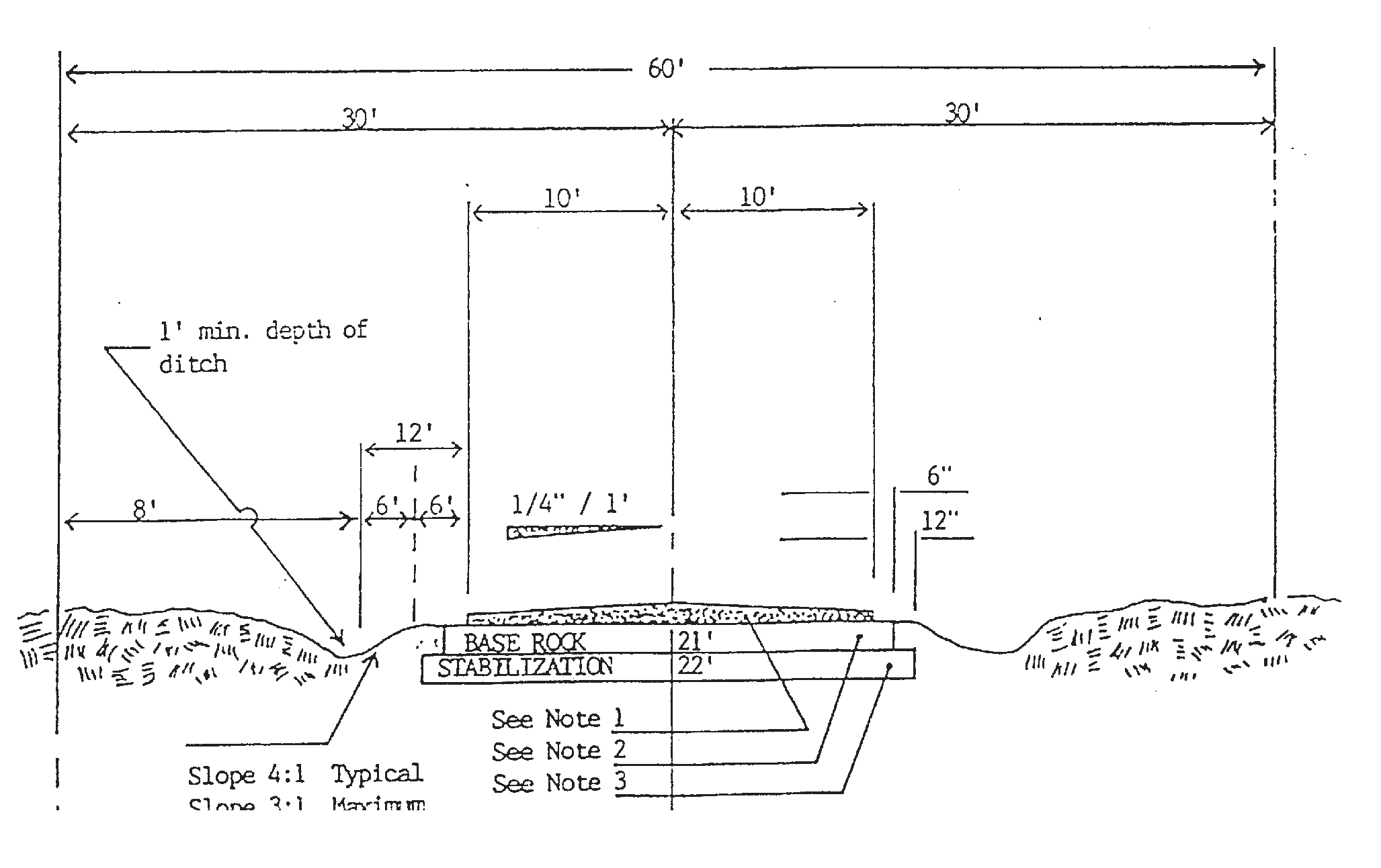
TYPICAL ROAD SECTION FOR ARTERIAL ROAD, AS ALONG A SECTION LINE
(1)
Surface course is always required: One and one-quarter inch minimum state department of transportation type II Asphaltic Concrete.
(2)
Base: Eight inches thickness minimum and 24 feet wide of compacted limerock or other suitable material, approved by the county road department.
(3)
Subgrade stabilization: When required, subgrade stabilization shall be accomplished by mixing limerock or other suitable material, approved by the county road department with clean sand; stabilized subgrade must be a minimum of 12 inches in depth and 26 feet wide and must be approved by the county road department. The road department requires four to five inspections: 1. clearing; 2. grading; 3. limerock base; 4. surface; 5. final; either by telephone request or letter, with two days' notice.
(4)
Where, in the opinion of the county road department, it is necessary, area shall be fertilized, seeded, mulched, and watered to prevent erosion.
GRAPH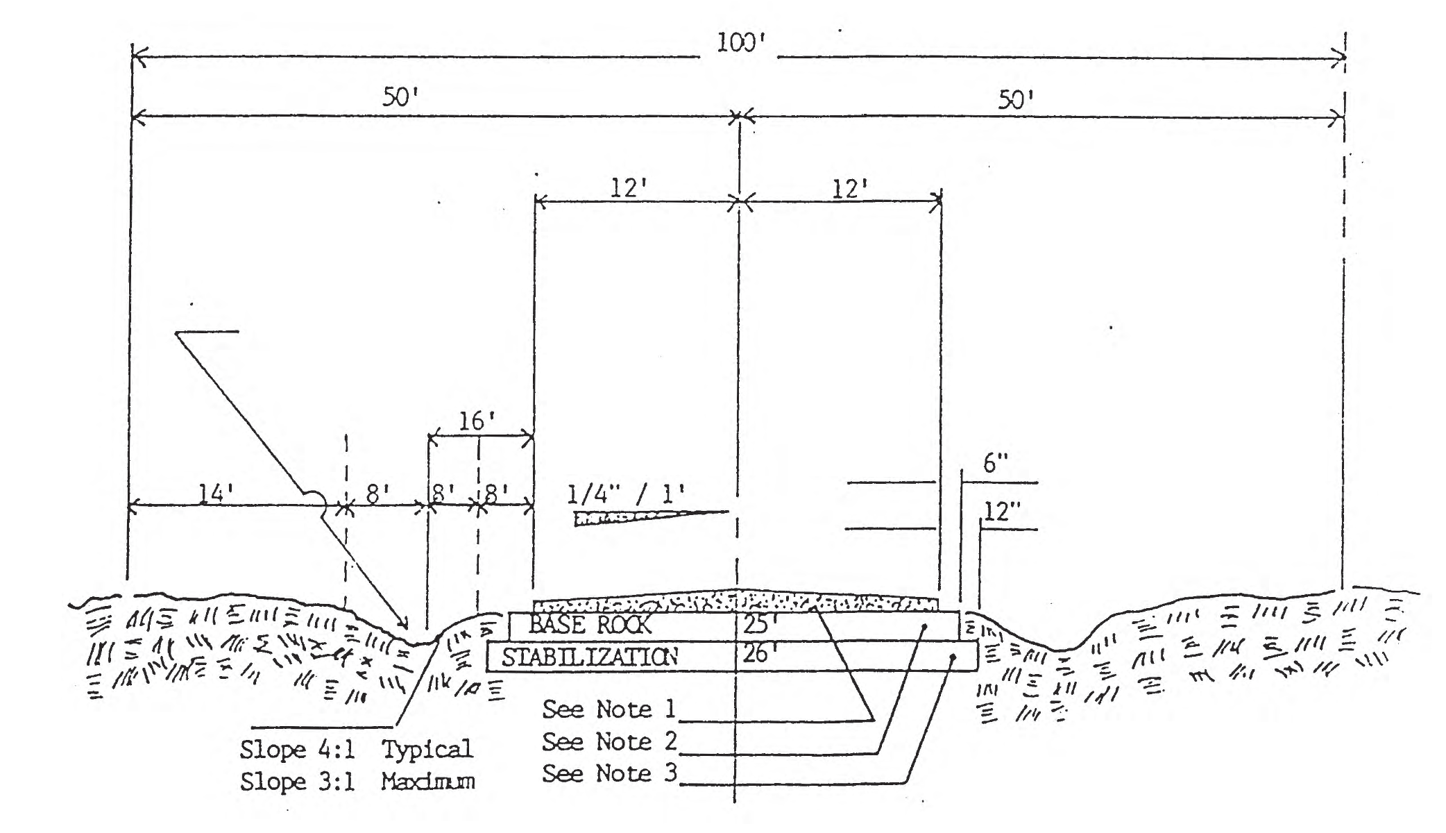
TYPICAL ROAD SECTION FOR COLLECTOR I & II
(1)
Surface course (if required): One and one-quarter inch minimum state department of transportation type II Asphaltic Concrete.
(2)
Base—Without Surface Course: Six-inch minimum of compacted or other suitable material. approved by the county road department: alternately may be eight inches minimum of loose limerock or other suitable material mixed with clean sand, compacted after mixing and having a compacted depth of 12 inches and 21 feet width.
(3)
Subgrade stabilization: When required, subgrade stabilization shall be accomplished by mixing limerock or other suitable material. approved by the county road department with clean sand: stabilized subgrade must be a minimum of eight inches - ten inches in depth and 22 feet wide and must be approved by the county road department prior to and after mixing. The road department requires four to five inspections: 1. clearing; 2. grading; 3. limerock base; 4. surface; 5. final; either by telephone request or letter, with two days' notice.
(4)
Where, in the opinion of the county road department, it is necessary, area shall be fertilized, seeded, mulched and watered to prevent erosion.
GRAPH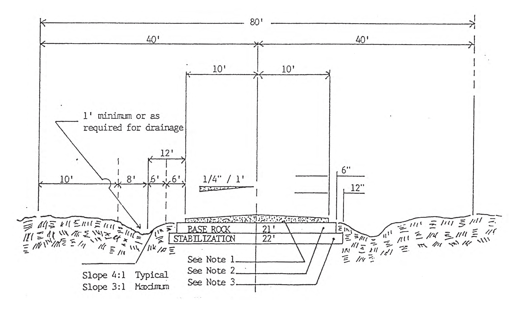
Sec. 50-600. - General requirements.
The division of land by lot split does not require platting; but must comply with the requirements set forth in this division.
(a)
General requirements. Each lot split must:
(1)
Comply with the specific requirements in section 50-601 applicable to the type of split requested;
(2)
Provide legal access to the new lot and the remnant lot by: (a) direct connection to an existing public road, or (b) direct connection to a recorded private road or recorded easement that connects directly to an existing public road. The recorded private road or recorded easement must be a minimum of 30 feet in width. The county may require that the legal access be conveyed to the county for public right-of-way. Any required driveway connection to a public road must be approved by the appropriate jurisdiction;
(3)
Identify whether the remnant lot meets all lot requirements, such as minimum lot size, width, depth and setbacks and lot coverage (as to any existing improvements) and will therefore be deemed a legal lot of record; or does not meet all such lot requirements and will therefore be deemed an unlawful lot of record; and
(4)
Comply with other applicable requirements in this Code.
(b)
Process.
(1)
First step meeting. Prior to submitting an application, the applicant or its agent must first meet with the zoning official or designee to discuss the proposed lot split and the process.
(2)
Written application. A request for a lot split must be made on the application form provided by the county and accompanied by the applicable fee in appendix B. The application must include, but is not limited to, the following:
a.
Proof of ownership. Copy of deed(s) that prove current ownership of the lot being split (the original lot) and document(s) that prove the right to use the legal access (if provided by private road or easement).
b.
Sketch or boundary survey and legal descriptions. A sketch (if the land is vacant) or boundary and location survey (if the land has improvements that appear to be located near required setbacks) prepared by a Florida licensed surveyor that depicts: the original lot, the proposed split (the new lot and the remnant of the original lot), existing and/or proposed access, above ground utilities, existing structures and flood hazard areas (if any). Legal descriptions must be provided for each lot created by the split (the new lot and the remnant of the original lot).
c.
Acknowledgement. A statement by the applicant(s) that the lot split meets or will meet all limitations, requirements, criteria, and standards for approval set forth in this Code.
d.
Additional information. Any other information required by other provisions of this Code or which the zoning official deems necessary in order to process the application.
(3)
Review; denial or approval. Upon receipt, the zoning official or designee will review the application for completeness. If additional information is needed, the zoning official or designee will inform the applicant and allow a reasonable time for the applicant to provide the additional information. Upon finding the application is complete, the zoning official or designee will review the application for compliance and will issue a written denial (with a brief statement of reasons) or approval in the section of the application reserved for that purpose.
(4)
Lot split certificate. If the application is approved, the zoning official or designee will issue a lot split certificate that, at a minimum, identifies the new lot authorized to be created by deed, identifies the remnant lot and provides notice of applicable limitations and conditions. Upon signature of the property owner, the zoning official or designee will record the lot split certificate in the public records of the county.
(c)
Application deemed withdrawn. In the event an applicant requests to pause its application at any stage in the process, the applicant will have a maximum of six months from date the application was submitted to the county to request its application be fully processed. In the event the applicant does not contact the zoning official to proceed with fully processing the application during this six month period, the application is deemed withdrawn and the applicant will be required to submit a new application and fee if they wish to pursue a lot split.
(Ord. No. 2024-1, § 4, 4-2-2024; Ord. No. 2024-4, § 1, 10-22-2024)
Sec. 50-601. - Types of lot splits.
(a)
One time split of a parent parcel. Through the process in section 50-600, a parent parcel may be split one time to create two lots that meet all lot requirements, such as minimum lot size, width, depth and setbacks and lot coverage (as to any existing improvements). Any parent parcel that was previously split one time may reconfigure that split upon application made by the current owners of both parcels.
(b)
Lot split for utilities. Through the process in section 50-600, any lot of record (legal or unlawful) may be split to create a new lot for any utilities that are allowed in that zoning district. The utilities lot is not required to meet all lot requirements, such as minimum lot size, width, depth, setbacks and lot coverage; however, such a lot will be deemed a legal lot of record solely for utilities use and may not be used or developed for any other use.
(c)
Lot split for right-of-way. Any lot of record (legal or unlawful) may be split by recorded deed (it is not required to follow the process set forth in section 50-600) that conveys land for public right-of-way to the federal, state, county or municipal government. If the remnant lot does not meet all lot requirements, the property owner may request a variance as set forth in section 50-851 to allow reasonable use of the lot.
(d)
Lot split for a family homestead. As authorized by F.S. §163.3179, the following standards implement policy 1.13 of the future land use element in the comprehensive plan. These standards authorize the creation of a family homestead lot by deed to an eligible family member who is ready to establish their homestead residence on the lot within ten years.
(1)
Eligibility standards.
a.
Eligible lot means a legal lot of record that is not within a platted subdivision, is not within a municipal service district, and has a zoning designation of F/RR, A/RR or RR.
b.
Eligible grantor means a natural person who has owned the eligible lot for three consecutive years or more.
c.
Eligible grantee means the eligible grantor's grandparent, parent, stepparent, adopted parent, sibling, child, stepchild, adopted child, or grandchild, who has not previously received a family homestead lot (or formerly a lineal heir homestead density exemption parcel) within the county.
(2)
Family homestead lot; conditions and limitations; transfer certificate.
a.
The family homestead lot is not required to meet the minimum lot size (density) required within that zoning district; however, the family homestead lot must be a minimum of two acres in a flood hazard area and one acre in a non-flood hazard area, meet the setback requirements for its zoning designation, and must have sufficient area for a permitted onsite sewage treatment and disposal system and potable water well, unless connected to a central water and wastewater system.
b.
Notwithstanding section 50-712, an accessory dwelling unit is not allowed on a family homestead lot that does not meet the minimum lot size (density) required within its zoning district.
c.
The family homestead lot is created solely for use as the homestead residence of the eligible grantee. As such, the grantee must establish a permanent residence on the lot, obtain homestead exemption from the property appraiser within ten years from the recording date of the lot split certificate, and maintain homestead exemption for a period of five consecutive years. Upon satisfying the foregoing conditions, the lot will be deemed a legal lot of record.
d.
If the grantee does not satisfy the conditions in c, the lot will be deemed an unlawful lot of record. The unlawful status may be remedied by obtaining a transfer certificate. A request for a transfer certificate must be made on the application form provided by the county and accompanied by the applicable fee in appendix B. If approved, the zoning official or designee will issue a transfer certificate and, upon property owner signature, will record the transfer certificate in the public records of the county. The zoning official or designee is authorized to issue transfer certificates that allow:
1.
Conveyance of the lot back to the original grantor, provided they still own the remnant lot. Upon such conveyance, the family homestead lot previously created is extinguished;
2.
Conveyance of the lot to an eligible grantee (of either the grantee or the original grantor) who then satisfies the conditions in c above; or
3.
Conveyance of the lot to a third party (not the original grantor or another eligible grantee), but only when the grantee established a residence on the family homestead lot and is unable to complete the homestead requirement due to documented circumstances beyond their control, such as divorce, death, or relocation due to job change.
(3)
Remnant lot; conditions and limitations.
a.
If the remnant lot meets all lot requirements, such as minimum lot size, width, depth and setbacks and lot coverage (as to existing improvements), it will be deemed a legal lot of record.
b.
If the remnant lot does not meet all lot requirements, it may be:
1.
Occupied as the homestead (as evidenced by homestead exemption) of the eligible grantor for a period of five consecutive years after the family homestead lot split, upon which it will be deemed a legal lot of record; or
2.
Conveyed (in whole or in part) as additional family homestead lots through the process in section 50-600.
(Ord. No. 2024-1, § 4, 4-2-2024)
Sec. 50-531. - Generally.
With the adoption of these regulations, there will be only one procedure for platting. The unrecorded plat recording process has been eliminated. The usual procedure for submission of a subdivision plat shall consist of the following four steps, the first of which is optional:
(1)
Presubmission conference (optional). In the case of large and complex subdivisions or conditions, the subdivider is encouraged to apply for a presubmission conference with the development department prior to submitting any preliminary plat or incurring any substantial costs.
(2)
Preliminary plat. The purpose of the preliminary plat is to enable the subdivider to submit his request and provide the planning commission, other county agencies and departments, and the board of county commissioners the opportunity to conduct a review of the preliminary proposed plan for conformance with regulations and requirements of the county or other governmental departments or agencies.
(3)
Construction permit. The purpose of the construction permit is to provide the county and any other governmental departments or agencies with the opportunity to review an applicant's proposed improvements for compliance with all applicable regulations and requirements of the county or other governmental departments or agencies, to require modifications when applicable, and to approve such improvements within a reasonable time when the improvements meet all such regulations and requirements.
(4)
Final plat. The final plat shall be submitted in a form acceptable for filling as a public record in accordance with this division. After review and recommendation by the planning commission, other county and state agencies and departments, and the board of county commissioners, and if approved thereby, it shall be accepted and filed for record into the public records of the county.
(1991 LDR ch. 71, § 5.01; Ord. No. 2007-03, § 11, 7-17-2007)
Sec. 50-532. - Submission and approval of preliminary plat.
(a)
To receive consideration, a preliminary plat application, together with other required data, shall be presented to the county development department no later than the first day of the month preceding a regular monthly meeting of the planning commission. The application shall include the application fee, and a sufficient number of copies of the following documents to supply copies of the documents to all board and planning commission members and to any county staff or county consultants that may perform a review of the application: preliminary plat, completed application form, checklist, and all other required supportive data and information. The number of copies required for an application may be adjusted by the development department director from time to time. Upon a finding by the development department director that an application is complete, the applicable county staff shall review the application. Once county staff review is complete, the application shall be scheduled for a public hearing before the planning commission at the regular monthly meeting for the month following the application deadline described in the first sentence, or, if scheduling for such regular monthly meeting is not possible due to advertising deadlines or for any other reason, the application shall be scheduled for the next planning commission meeting at which it may reasonably be heard. After planning commission review and recommendation on the application, the application shall be scheduled for a board of county commissioners meeting at which it may reasonably be heard.
(b)
The applicant, or his duly authorized representative, shall attend the planning commission meeting at which the preliminary plat is to receive consideration. The planning commission may, in its discretion, either proceed with the public hearing and consideration of an application or table the application in the event the applicant or his duly authorized representative does not appear at the planning commission meeting.
(c)
The planning commission shall study the practicability of the preliminary plat taking into consideration the requirements of the county and the best use of the land being subdivided. Particular attention shall be given arrangement, location, and width of streets, their relation to the topography of the land, water supply, sewage disposal, drainage, lot sizes and arrangement, the future development of adjoining lands as yet unsubdivided, and the requirements of the comprehensive plan, zoning ordinance, and all other applicable county ordinances and regulations. All floodprone areas shall be shown.
(d)
After a public hearing on a preliminary plat application, the planning commission shall make a recommendation to the board of county commissioners for approval, approval with conditions, or denial of the application, or shall table the application due to a request for additional information or revisions to the application or other reasonable cause. After a recommendation for approval, approval with conditions, or denial of a preliminary plat application, the application will be scheduled for a public hearing before the board of county commissioners. The board of county commissioners may approve, approve with conditions, or deny the application, or table or take other action on the application based upon reasonable cause.
(e)
Conditional approval of a preliminary plat shall not be issued when conditions, revisions or modifications are of a substantive nature which shall require the applicant to reappear before the planning commission and board of county commissioners to acquire approval. Only after board of county commissioner's approval of the preliminary plat shall a construction permit be issued.
(f)
Board of county commissioner's approval of a preliminary plat shall expire after a period of 18 months, unless extension is requested and granted by the board of county commissioners, or unless a construction permit, if required, is granted within the 18-month period and construction is performed continuously until completion with any break in construction lasting for no more than six months.
(g)
Conditional approval shall constitute approval subject to requirements as specified by the board of county commissioners.
(h)
After a preliminary plat application has been distributed to the appropriate departments for review and comment and the applicant wishes to revise the preliminary plat, the fee set forth in Appendix B—Schedule of Fees, Rates and Charges must be paid and the revised preliminary plat review will be commenced after such payment. After planning commission or board of county commissioner action on a preliminary plat application, if an applicant proposes any substantive change to the preliminary plat application, the applicant shall pay the fee set forth in Appendix B—Schedule of Fees, Rates and Charges and shall submit a new application for review as a new application.
(1991 LDR ch. 71, § 5.02; Ord. No. 2007-03, § 12, 7-17-2007; Ord. No. 2008-02, § 2, 3-4-2008; Ord. No. 2022-7, § 4, 3-8-2022)
Sec. 50-533. - Submittal and approval of construction plans.
(a)
Submittal. Prior to initiating any construction and only after receiving preliminary plat approval, the applicant shall submit three copies of the construction plans to the development department.
(b)
Timing and fee. Construction plans must be submitted for review by applicable county departments and a fee paid within 18 months following preliminary plat approval.
(c)
Preparation. Trimline sheet size for the construction plans shall be 24 inches by 36 inches. A three-quarter-inch margin shall be provided on all sides of the drawing except for the left binding side where a two-inch margin shall be provided. Multiple sheets may be used but in this event sheet number and total number of sheets must be indicated on each sheet and cross referencing between sheets must be used. Conventional methods of presentation shall be used. Details shall be shown in plan, elevation or section as required. Pictorial or isometric methods of presentation should be avoided. Abbreviations should be avoided, but if used, they should be defined in the notes. Applicable and necessary notes and symbol legends should be included. The construction plans shall make specific mention of the date of approval and assigned number of the preliminary plat of subdivision. Coloring is not permitted. The front or cover sheet shall include a location map to scale as required for the preliminary plat. Each sheet of the construction plans shall contain the subdivision name, a graphic scale, a stated scale, and a north arrow. The plan shall be drawn at the same scale as for the preliminary plat to which it refers. Roads shall be identified by number as they appear on the preliminary plat. Lots, blocks and tracts shall be numbered or otherwise properly identified.
(d)
Content. The construction plans in scope, detail and purpose shall be suitable for contracting and construction purposes. The plans shall show those subdivision improvements which are required; and which are insured by bond or improvement agreement; and which must be satisfactorily completed before the bond or escrow is released. The construction plans shall indicate location and construction details for all required subdivision improvements including, but not limited to, road construction, grading, drainage facilities, signs, grassing, and miscellaneous construction. No streetlights, private signs or similar objects shall be placed in the public rights-of-way without prior approval of the board of county commissioners. Plans shall include all necessary dimensions, elevations, details, sections and notes which are necessary and desirable in order to clearly and exactly show the work to be done and the manner in which it is to be done. Design details shall conform to applicable construction details as provided in the Florida Department of Transportation Manual of Uniform Minimum Standards for Design, Construction and Maintenance for Public Streets and Highways, and in any other applicable Florida Department of Transportation manuals, or any successor manual, as the same may be amended from time to time, and applicable requirements of this chapter. Design and scope of proposed improvements must be shown on the improvement plan.
(1)
Roads and drainage. Plan-profile presentation for road design and drainage facilities design is required showing finish grades and invert elevations.
(2)
Topography. Existing elevations must be shown by contours not to exceed two-foot intervals with consideration given to closer interval on relatively flat terrain. All floodplains shall be shown by contour with the flood elevation noted. The topographic information shown must be obtained by a registered land surveyor or, if the topographic information is obtained by aerial methods, the name of the person or firm performing the service must be indicated. Contours obtained by aerial means shall not be used for establishing finish grades, calculating cut or fill quantities, or calculating stormwater runoff quantities when there is reasonable doubt as to their accuracy due to dense ground cover or other reasons. Under such conditions, contours obtained from more reliable ground methods shall be used. The project surveyor is responsible for the reliability of topographic information shown.
(3)
Runoff and retention. Stormwater runoff from all public rights-of-way and subdivision shall be collected and disposed of within the subdivision by acceptable methods. Calculations for runoff shall consider the entire contributory watershed including areas outside of the subdivision. Ultimate use of undeveloped areas outside of the subdivision shall be assumed as being the most reasonable use of land. Adjacent public facilities may be utilized for disposal if it can be proven that capacity is sufficient. Natural disposal facilities within the subdivision may be used without further excavation if, in the opinion of the project engineer, the existing capacity is sufficient. Natural collection facilities which direct runoff from the subdivision onto adjacent properties must be perpetuated to the extent of protecting the upland owners interest, however, such facilities must not be incorporated into the drainage design for the subdivision. The collection of stormwater runoff shall be by positive gravity means without the use of siphons, pumps or similar devices. Calculations shall be as required by the appropriate water management district. The various coefficients of permeability and the areas for each shall be based on an assumption of the conditions of ultimate development of the subdivisions. Rainfall intensity must be based on the latest available intensity-duration curves for ten- and 25-year frequency storms as published by a governmental agency. The county engineer reserves the right to require the project engineer to submit storm drainage calculations for review. Format of calculations must be conventional and assumed parameters must be listed. Ditch and storm drain flow capacity shall be determined from Mannings Formula with coefficients of roughness based on an assumption of the conditions of ultimate development of the subdivision. Culvert flow capacity shall be determined for the conditions of inlet control or outlet control. Under inlet control, consideration shall be given to the cross sectional area of the culvert inlet, hydraulic efficiency of the inlet, and height of headwater. Under outlet control, additional consideration shall be given to the height of tailwater and the slope, roughness and length of the culvert. Culverts shall be designed to discharge a ten-year frequency storm without static head at the entrance and a 25-year frequency storm utilizing available head at the entrance. Entrance less coefficient (Ke) shall be taken as 0.5 for headwalls.
(4)
Percolation and soil tests. Percolation and soil test results must be shown. Soils identification must refer to the Unified Soil Classification System conforming to Military Standard MIL-STD619. Test holes shall be excavated at the location of each percolation test hole as specified in this section. Test holes shall be excavated to a six-foot depth. Test hole locations shall be shown on the improvement plan and the soil type and water table information found at each location shall be indicated in tabular form. Each print submitted shall bear the original signature and seal of the project engineer and the project surveyor, and each are responsible for information shown within their particular field of practice. Percolation test results shall be shown on the improvement plan. One such test shall be taken at the center of each proposed water retention area.
(5)
Other. The development department may require other construction plan content as necessary.
(e)
Review process. The plat review committee shall, within 30 days, review and decide to approve or disapprove the construction plans. The plat review committee will include the development department director, the county road superintendent, the county engineer, the county sanitarian and the county forester.
(f)
Construction permits. Construction permits shall be issued by the development department. In no case shall any construction be initiated until such time as both preliminary plat approval and construction plan approval have been received.
(g)
Fees. The fee schedule for construction plan review shall be set forth in Appendix B—Schedule of Fees, Rates and Charges.
(h)
Expiration. The construction permit shall expire within six months if construction has not begun.
(1991 LDR ch. 71, § 5.03; Ord. No. 2007-03, § 13, 7-17-2007; Ord. No. 2022-7, § 5, 3-8-2022)
Sec. 50-534. - Submission and approval of final plat.
(a)
Submission to planning commission.
(1)
Prior to expiration of the preliminary plat approval, and subsequent to the completion and approval of the construction of required improvements, an applicant shall submit a final plat application to the county development department no later than the first day of the month preceding a regular monthly meeting of the planning commission. The application shall include the application fee, and a sufficient number of copies of the following documents to supply copies of the documents to all board and planning commission members and to any county staff or county consultants that may perform a review of the application: proposed final plat, completed application form, checklist, and all other required supportive data and information. The number of copies required for an application may be adjusted by the development department director from time to time. Upon a finding by the development department director that an application is complete, the applicable county staff shall review the application. Once county staff review is complete, the application shall be scheduled for a public hearing before the planning commission at the regular monthly meeting for the month following the application deadline described in the first sentence, or, if scheduling for such regular monthly meeting is not possible due to advertising deadlines or for any other reason, the application shall be scheduled for the next planning commission meeting at which it may reasonably be heard. After planning commission review and recommendation on the application, the application shall be scheduled for a board of county commissioners meeting at which it may reasonably be heard.
(2)
The applicant, or his duly authorized representative shall attend the planning commission meeting at which the proposed final plat is to receive consideration. The planning commission may, in its discretion, either proceed with the public hearing and consideration of an application or table the application in the event the applicant or his duly authorized representative does not appear at the planning commission meeting.
(3)
The proposed final plat shall comply with the preliminary plat approved by the board of county commissioners and any conditions imposed thereon, and all other applicable federal, state, or county statutes, rules, requirements, codes or ordinances.
(4)
After a public hearing on a final plat application, the planning commission shall make a recommendation to the board of county commissioners for approval or denial of the application, or shall table the application due to a request for additional information or revisions to the application or other reasonable cause. The planning commission may elect to approve and sign the final plat at the same meeting at which it is considered.
(5)
The planning commission shall not approve and sign the final plat until it has been shown either in writing or by signature on the face of the plat that the requirements of the county health department and the county road department have been satisfied.
(b)
Submission to board of county commissioners.
(1)
Following a recommendation for approval or denial by the planning commission on a final plat application, the applicant may submit to the board of county commissioners the proposed final plat for approval. At this time, the board of county commissioners may require additional considerations, supportive data or improvements.
(2)
The applicant shall submit a minimum of one copy or print and the original plat to the board of county commissioners for signature.
(3)
Following consideration at the regular meeting, the board of county commissioners shall either approve, disapprove or table for a reasonable period of time the final plat, or request additional information, considerations, supportive data or improvements.
(4)
If the board of county commissioners approves the final plat, the copy or print and the original plat shall be signed by the board of county commissioners.
(c)
Filing of final plat.
(1)
Immediately following approval and signing of the final plat by the board of county commissioners, the applicant shall submit the signed original and copy thereof, both bearing original signatures by the board of county commissioners, to the clerk of the circuit court. The clerk of the circuit court shall retain the signed copy and reserve plat book and page numbers for such plat which shall be reserved for a period not to exceed one week.
(2)
Following reservation of plat book and page numbers by the clerk of the circuit court, the applicant shall within one week submit to the clerk the following:
a.
One original copy.
b.
Three reproducible copies on stable film base.
c.
Base, i.e., Mylar
d.
Five prints on paper.
(3)
The clerk of the circuit court shall, if all copies are acceptable, sign the original and all copies, file the plat in the public records of the county and distribute all copies to the appropriate county offices.
(1991 LDR ch. 71, § 5.04; Ord. No. 2007-03, § 14, 7-17-2007; Ord. No. 2008-02, § 3, 3-4-2008)
Sec. 50-535. - Penalty; refiling.
Failure by the applicant to comply with time requirements for filing appropriate documents with the clerk shall result in a penalty for each day the applicant is late. If the applicant is late for more than 20 working days the clerk shall refuse to accept the plat and advise the applicant he must refile with the board of county commissioners.
(1991 LDR ch. 71, § 5.05)
Sec. 50-536. - Vacation and annulment of plats subdividing lands.
(a)
Whenever it is discovered, after the plat has been recorded in the public records, that the developer has previously caused the lands embraced in a second plat to be differently subdivided under and by virtue of another plat of the same identical lands, and the first plat was also filed of public record at an earlier date, and no conveyance of lots by reference to the first plat so filed appears of record in such county, the board of county commissioners is authorized and directed to and shall, by resolution, vacate and annul the first plat of such lands appearing of record upon application of the owners of all lots shown and designated upon the second and subsequent plat of such lands, and the circuit court clerk of the county shall thereupon make proper notation of the annulment of such plat upon the face of such annulled plat.
(b)
Whenever it is discovered that the filing of a plat subdividing a parcel of land located in the county, the developer of the lands therein and thereby subdivided did cause such lands embraced in such plats, or a part thereof, to be again and subsequently subdivided under another plat of the same identical lands or a part thereof, which such second plat was also filed at a later date, and it is further made to appear to the board of county commissioners of the county that the filing and recording of the second plat would not materially affect the right of convenient access to lots previously conveyed under the first plat, the board of county commissioners of the county is authorized, by resolution, to vacate and annul so much of the first plat of such lands appearing of record as are included in the second plat, upon application of the owners and developer of such lands under the first plat or their successors, grantees or assignees, and the circuit court clerk of the county shall thereon make proper notation of the action of the board of county commissioners upon the face of the first plat.
(c)
The board of county commissioners may adopt resolutions vacating plats in whole or in part of subdivisions in the county returning the property covered by such plats either in whole or in part into acreage. Before such resolutions of vacating any plat either in whole or in part shall be entered by the board of county commissioners, it must be shown that the persons making application for such vacation own the fee simple title to the whole or that part of the tract covered by the plat sought to be vacated, and it must be further shown that the vacation by the board of county commissioners will not affect the ownership or right of convenient access of persons owning parts of the subdivision.
(d)
Persons making application for vacation of plats either in whole or in part shall give notice of their intention to apply to the board of county commissioners to vacate such plat by publishing legal notice in a newspaper of general circulation in the county in which the tract or parcel of land is located, in not less than two weekly issues of such paper, and must attach to the petition for vacation the proof of such publication, together with certificates showing that all state and county taxes have been paid. If such tract or parcel of land is within the corporate limits of any incorporated city or town, the board of county commissioners shall be furnished with a certified copy of resolution of the town council or city commission, as the case may be, showing that it has already by suitable resolution vacated such plat or subdivision or such part thereof sought to be vacated.
(e)
Every such resolution by the board of county commissioners shall have the effect of vacating all streets and alleys which have not become highways necessary for use by the traveling public. Such vacation shall not become effective until an original or a certified copy of such resolution has been filed in the offices of the circuit court clerk and duly recorded in the public records of such county.
(1991 LDR ch. 71, § 5.06)
Sec. 50-537. - Reversion of subdivided land to acreage.
(a)
The owner of any land subdivided into lots may file for record a plat for the purpose of showing such land as acreage. Such plat, and the procedure in connection therewith, shall conform to the requirements of F.S. chs. 163 and 177, except that:
(1)
No survey or certificate of any surveyor or engineer shall be required. However, the board of county commissioners may require a survey of the exterior boundaries of the land and the placing of suitable monuments along such boundaries if it finds that the last preceding survey of record is faulty or inadequate or that insufficient monuments are in position along such boundaries.
(2)
No improvements shall be required except such as may be necessary to provide equivalent access, as provided in this section.
(3)
No findings need be made as to the suitability of the land or as to the provision of public facilities and services for it.
(b)
The board of county commissioners may, on its own motion, order the vacation and reversion to acreage of all or any part of a subdivision within its jurisdiction, including the vacation of streets or other parcels of land dedicated for public purposed of any such streets or other parcels when:
(1)
The plat of the subdivision was recorded as provided by law not less than five years before the date of such action; and
(2)
In the subdivision or part thereof, not more than ten percent of the total subdivision area has been sold as lots by the original subdivider or his successor in title.
(c)
Such action shall be based on a finding by the board of county commissioners or by its accredited representative for the approval of subdivision plats that the proposed vacation and reversion to acreage of subdivided land conforms to the comprehensive plan of the area and that the public health, safety, economy, comfort, order, convenience and welfare will be promoted thereby. Before acting on a proposal for vacation and reversion of subdivided land to acreage, the board of county commissioners or its accredited representative shall hold public hearing thereon, with due public notice.
(d)
If land in a subdivision or part thereof is proposed for reversion to acreage either at the instance of the board of county commissioners or by filling a plat by the owner, and such land is subject to existing zoning regulations, the board of county commissioners shall, upon recommendations as to zoning, where such agency exists concurrently with the proceedings for vacation and reversion to acreage, or for consideration of an action on such plat, conduct provisable in view of the conditions that will exist subsequent to such reversion to acreage.
(e)
No owner of any parcel of land in a subdivision shall be deprived by the reversion to acreage of any part of the subdivision of reasonable access to such parcel nor of reasonable access therefrom to existing facilities to which such parcel has therefore had access. Such access remaining or provided after such vacation need not be the same as that theretofore existing, but shall be reasonably equivalent thereto.
(f)
Every such resolution or motion to vacate plat and reversion to acreage, by the board of county commissioners, shall not become effective until the original or a certified copy of such resolution or motion has been filed and recorded in the office of the clerk of the circuit court of the county, and the clerk of the circuit court shall thereupon make proper notation of such resolution or motion on such vacated plat.
(1991 LDR ch. 71, § 5.07)
Sec. 50-538. - Correction of plat errors or omissions.
As stated in F.S. §177.141, in the event an error or omission in the data shown on any plat duly recorded under the provisions of this article is detected by subsequent examination or revealed by a retracement of the original survey of the lands shown on such recorded plat, the professional surveyor and mapper or legal entity responsible for the survey and the preparation of the plat as recorded may file an affidavit confirming that such error or omission was made. If applicable, the affidavit must state that the professional surveyor and mapper or legal entity made a resurvey of the subject property in the recorded subdivision within the last ten days and that no evidence existed on the ground that would conflict with corrections as stated in the affidavit. The affidavit shall describe the nature and extent of such error or omission and the appropriate correction that in the affiant's professional opinion should be substituted for the erroneous data shown on such plat or added to the data on the plat. When such an affidavit is filed, it is the duty of the circuit court clerk to record the affidavit, and he or she must place in the margin of the recorded plat a notation that the affidavit has been filed, the date of filing, and the official book and page where it is recorded. The notation must also be placed on all copies of the plat used for reproduction purposes. The affidavit shall have no effect upon the validity of the plat.
(Ord. No. 2024-1, § 3, 4-2-2024)
Sec. 50-556. - Generally.
(a)
Approval by board of county commissioners. Before a plat is offered for recording, it shall be approved by the appropriate boards, commission, or departments as provided for in this article, and evidence of such approval shall be placed on such plat. If not approved, the board of county commissioners shall return the plat to the land surveyor. However, such examination and approval for conformity to this article by the appropriate boards, commission, departments and board of county commissioners shall not include the verification of the survey data.
(b)
Dedication and approval.
(1)
Every plat of a subdivision proposing streets must contain a dedication by the developer. The dedication shall be executed by all developers and mortgagees having a record interest in the lands subdivided, in the same manner in which deeds are required to be executed.
(2)
When a tract of land has been subdivided and a plat thereof bearing the dedication executed by the developers and mortgagees having a record interest in the lands subdivided and the approval of the board of county commissioners has been secured and recorded in compliance with this article, all streets, alleys, easements, rights-of-way, and public areas shown on such plat, unless otherwise stated, shall be deemed to have been dedicated to the public for the uses and purposes stated thereon. However, nothing in this article shall be construed as creating an obligation upon the board of county commissioners to perform any act of construction or maintenance within such dedicated areas except when the obligation is voluntarily assumed thereby.
(c)
Erection of buildings. No building shall be erected on a lot or parcel of land within the area, nor shall any building permit be issued therefor, unless the street giving access to the lot or parcel on which such building is proposed to be placed has been accepted and opened as a public street, has otherwise received the legal status of a public street, has been accepted by the board of county commissioners and is shown on a recorded subdivision plat, or is a private street approved by the board of county commissioners or available for use by the public; or is an easement as defined in section 50-1.
(d)
Multiple jurisdictions. When a plat lies within the boundaries of more than one governing body, two plats shall be prepared and each governing body shall have exclusive jurisdiction to approve the plat within its boundaries unless the governing bodies having such jurisdiction agree that one plat is mutually acceptable.
(e)
Name of subdivision. Every subdivision shall be given a name by which it shall be legally known. Such name shall not be the same or in any way so similar to any name appearing on any recorded plat in the county as to confuse the records or to mislead the public as to the identity of the subdivision by the same developer or his successors in title; except, however, that a replat of all or part of an existing plat will include the original subdivision name as a part of the title. Every subdivision's name shall have legible lettering of the same size and type, including the words "Section," "Unit," "Amended," etc., the name of the subdivision shall be shown in the dedication and shall coincide exactly with the subdivision name.
(f)
Platted street reversion. The reversion of platted streets shall be in accordance with F.S. § 177.805.
(g)
Qualifications of person making survey and plat certificates. Every subdivision of lands made within the provisions of this article shall be made under the responsible direction and supervision of a state registered land surveyor who shall certify on the plat that the plat is a true and correct representative of the lands surveyed, that the survey was made under his responsible direction and supervision, and that the survey data complies with all the requirements of F.S. ch. 177. The certification shall bear the signature, registration number, and the official seal of the land surveyor.
(h)
Title certification. Every final plat of a subdivision submitted to the county commission shall be accompanied by a title certification by an attorney-at-law licensed in the state, or a title insurance company confirming that the lands as described and shown on the plat are in it as shown on the plat and that the developer has apparent title to the lands. The title opinion or certification shall also show all mortgages not satisfied or released of records.
(1991 LDR ch. 71, § 6.01)
Sec. 50-557. - Requirements for preliminary plats.
Every preliminary plat of a subdivision offered for consideration shall conform to the following:
(1)
It shall be well made copies of a neat, legible, reproducible original prepared in a workmanlike manner.
(2)
The size of each sheet shall be 24 inches by 36 inches and shall be drawn with a marginal line completely around each sheet and placed so as to leave at least a one-half-inch margin on each of three sides and a three-inch margin on the left side of the sheet for binding purposes.
(3)
When more than one sheet must be used to accurately portray the lands subdivided, each sheet must show the particular number of that sheet and the total number of sheets included (i.e., sheet two of four sheets), as well as clearly labeled matchlines to show where other sheets match or join. Also, a master map shall be provided on the first sheet showing the relation of subsequent sheets together with all matchlines and sheet numbers.
(4)
The scale used shall be sufficient size to show all detail and shall be both stated and graphically illustrated by a graphic scale drawn on every sheet showing any portion of the land subdivided.
(5)
The name of the preliminary plat shall be shown in bold legible lettering on each sheet included.
(6)
A prominent north arrow shall be drawn on every sheet included showing any portion of the lands subdivided.
(7)
Each preliminary plat shall show the section, township, and range as applicable, or if in a land grant, it shall so state.
(8)
Each preliminary plat shall show a location map drawn to a scale no similar than one-half inch to one mile showing the relation of the plat to the surrounding area.
(9)
Each preliminary plat shall show proposed location, width and names of all streets, waterways, or other rights-of-way, as applicable.
(10)
Each preliminary plat shall show proposed location and width of easements and their intended use shall be clearly stated.
(11)
All contiguous properties shall be identified by subdivision title, plat book, and page, or if unplatted, shall be so designated, with the owner's names.
(12)
All contiguous features such as roads, lots, easements, etc., shall be shown by broken lines, dashed lines, etc., beyond the boundaries of the property within the plat as required to clearly illustrate the particular of contiguous properties.
(13)
All lots shall be numbered either by progressive numbers or, if in blocks progressively numbered or lettered, except that blocks in numbered additions shall be numbered consecutively throughout the several additions.
(14)
Sufficient distances, dimensions, angles, etc., shall be shown to clearly indicate the widths of rights-of-way, easements, building setback lines, lot size, and other such information to ensure compliance with county ordinances and regulations.
(15)
Park and recreation parcels as applicable shall be so designated. (See subsection 50-302(f) for the level of service standards.)
(16)
All interior excepted parcels shall be clearly indicated and labeled "Not a Part of This Plat."
(17)
The purpose of all areas dedicated must be clearly indicated or stated on that plat.
(18)
All floodprone areas will be shown, and shall comply with [section] 50-582 and article VI of this chapter.
(19)
Any subdivision in excess of five acres in size and located within a six-mile radius of the cities of Chiefland and Williston will identify and preserve sinkhole locations.
(20)
Article VII of this chapter requires the dedication of 100 acres of open space per 1,000 persons in policy 1.06. As a part of this dedication, on-site native vegetative communities will be protected. A minimum of one acre of upland will be preserved for each ten acres of wetland dedication.
(21)
Those portions of a subdivision which adjoin any public lands or natural reservations will provide a buffer zone to protect such lands.
(22)
Either as a part of the plat, in separate narrative or in combination, the applicant will document methods used to enhance the ability of native wildlife populations to coexist with the proposed development, and to ensure that an adequate amount of land is available to support a viable population of plant and animal species, including endangered and threatened species.
(23)
Ten acres of public park, which will include two acres of public neighborhood park, will be provided for each 1,000 residents. As defined herein, "residents" will be computed by multiplying the total number of dwelling units allowed within the subdivision, based upon zoning, multiplied times 2.5 persons per dwelling unit. Example: Eighty lot subdivision X 2.5 persons per dwelling unit = 200 persons, requires 200/1,000 × Ten Acres = Two Acres of public park.
(1991 LDR ch. 71, § 6.02; Ord. No. 2012-04, § 4, 10-16-2012)
Sec. 50-558. - Requirements for final plats.
Every plat of a subdivision offered for recording shall conform to the following:
(1)
It shall be an original drawing made with black permanent drawing ink on a good grade linen tracing cloth or with a suitable permanent black drawing ink on a stable base film, a minimum of 0.003 inches thick, coated upon completion with a suitable plastic material to prevent flaking and to ensure permanent legibility.
(2)
The size of each sheet shall be 24 inches by 36 inches and shall be drawn with a marginal line completely around each sheet and placed so as to leave a one-half-inch margin on each of three sides and a three-inch margin on the left side of the plat for binding purposes.
(3)
When more than one sheet must be used to accurately portray the lands subdivided, each sheet must show the particular number of that sheet and the total number of sheets included (i.e., sheets two of four sheets), as well as clearly labeled matchlines to show where other sheets match or join. Also, a master map shall be provided on the first sheet showing the relation of subsequent sheets together with all matchlines and sheet numbers.
(4)
The scale used shall be of sufficient size to show all detail and shall be both stated and graphically illustrated by a graphic scale drawn on every sheet showing any portion of the land subdivided.
(5)
The name of the plat shall be shown in bold legible letters. The name of the subdivision shall be shown on each sheet included.
(6)
A prominent north arrow shall be drawn on every sheet included showing any portion of the lands subdivided. The bearing or azimuth reference shall be clearly stated on the face of the plat in notes or legend.
(7)
Permanent reference monuments shall be placed at each corner or change in direction on the boundary of the lands being platted; however, permanent reference monuments need not be set closer than 310 feet (as measured along the boundary), but shall not be more than 1,400 feet apart. In all cases there shall be a minimum of four permanent reference monuments placed on the boundary of the lands being platted. Where such corners are in an inaccessible place, permanent reference monuments shall be set on a nearby offset within the boundary of the plat and such offset shall be so noted on the plat. Where corners are found to coincide with a previously set permanent reference monument, the number on the previously set permanent reference monument shall be shown on the new plat or, if unnumbered, shall so state. Permanent reference monuments shall be set before recording of the plat and this will be so stated on the surveyor's certificate on the plat. Such permanent reference monument shall be shown on the plat by an appropriate designation.
(8)
Permanent control points shall be set at the intersection of the centerline of the rights-of-way at the intersection of all streets, at points of tangency, points of compound curvature, and no more than 1,000 feet apart, on tangent, between changes of directions, or along the street right-of-way or block lines at each change of direction and no more than 1,000 feet apart. Such permanent control points shall be shown on the plat by an appropriate designation, permanent control points may be set prior to the recording of the plat and shall be set within one year of the date the plat was recorded and shall be referred to in the surveyor's certificate. It is the land surveyor's responsibility to furnish the clerk or recording officer of the county his certificate that the permanent control points have been set and the dates the permanent control points were set.
(9)
Each plat shall show the section, township and range as applicable, of, if in land grant, the plat shall so state.
(10)
The name of the city, town, village, county and state in which the land being platted is situated shall appear under the name of the plat as applicable.
(11)
Each plat shall show a description of the lands subdivided, and the description shall be the same in the title certification. The description must be so complete that from it, without reference to the plat, the starting point and boundary can be determined.
(12)
All dedications and approvals required by section 50-556 shall be provided.
(13)
The circuit court clerk's certificate and the land surveyor's certificate and seal shall be placed on the plat.
(14)
All section lines and quarter section lines occurring in the plat shall be indicated by lines drawn upon the plat, with appropriate words and figures (i.e., "Quarter Section Lines, North 00 degrees 20 minutes [00] seconds east, 25 feet"). If the description is metes and bounds, the point of beginning shall be indicated, together with all bearings and distances of the boundary lines. If the platted lands are in a land grant or are not included in the subdivision of government surveys, then the boundaries are to be defined by metes and bounds and courses. The initial point in the description shall be tied to the nearest government corner or other recorded and well-established corner.
(15)
Location, width, names of all streets and waterways or other rights-of-way shall be shown, as applicable.
(16)
Location and width of easements shall be shown on the plat or in the legend, and their intended use shall be clearly stated.
(17)
All contiguous properties shall be identified by subdivision title, plat book and page, or, if unplatted, land shall be so designated. If the subdivision platted is a resubdivision of a plat or the whole of a previously recorded subdivision, sufficient ties shall be shown to controlling lines appearing on the earlier plat to permit an overlay to be made; the fact of its being a resubdivision shall be stated as a subtitle following the name of the subdivision whenever it appears on the plat.
(18)
All lots shall be numbered either by progressive numbers, or, if in blocks, progressively numbered in each block, and the blocks progressively numbered or lettered, except that blocks in numbered additions bearing the same name may be numbered consecutively throughout the several additions.
(19)
Block corner radii dimensions shall be shown.
(20)
Sufficient survey data shall be shown to positively describe the bounds of every lot, block, street, easement and all other areas shown on the plat. When any lot or portion of the subdivision is bounded by an irregular line, the major portion of that lot or subdivision shall be enclosed by a witness line showing complete data, with distance along all lines extended beyond the enclosure to the irregular boundary shown with as much certainty as can be determined or as "more or less" if variable. Lot, block, street and all other dimensions, except to irregular boundaries, shall be shown to minimum of hundredths of feet. All measurements shall refer to horizontal plane and in accordance with the definitions of a foot or meter adopted by the United States Bureau of Standards.
(21)
Curvilinear lots shall show the radii, arc distances, and central angles or radii, chord and chord bearings, or both. Radial lines will be so designated. Direction of nonradial lines shall be indicated.
(22)
Sufficient angles, bearings or azimuths to show direction of all lines shall be shown, and all bearings, angles or azimuths shall be shown to the nearest second.
(23)
The centerline of all streets shall show, as a minimum, the following:
a.
Tangents: Distances and bearings.
b.
Curves: Arc distance, central angles, tangents, radii, chords, and chord bearings; all points of curvature, points of reverse curvature and points of compound curvature shall be so designated.
(24)
Park, recreation and school sites deemed necessary by the plat review committee, recommended by the planning commission or required by the comprehensive plan as shall be so designated.
(25)
All interior excepted parcels shall be clearly indicated and labeled "Not a Part of this Plat." The description as shown on the plat shall provide for such excepted parcels.
(26)
The purpose of all areas dedicated must be clearly indicated or stated on the plat.
(27)
When it is not possible to show curve detail information on the map, a tabular may be used.
(1991 LDR ch. 71, § 6.03; Ord. No. 2007-03, § 15, 7-17-2007)
Sec. 50-559. - Forms of certificates.
(a)
County certificates. Each plat shall on the first sheet show certificate of approval in the form as follows:
Certificates of Approval for Levy County, Florida; We, the undersigned do hereby certify
that this plat conforms to the requirements of Levy County Ordinance and Regulations
as follows:
(b)
Clerk of circuit court certificate. Each plat shall on the first sheet show clerk of the circuit court certificate in the form that follows:
Clerk of the Circuit Court Certificate: This is to certify that this plat has been filed for record in the Plat Book ________, page ________, of the public records of Levy County, Florida, this ________ day of ________, 20___A.D.
(1991 LDR ch. 71, § 6.04)